Embed Size (px)
Citation preview

Application of Land Administration Domain Model to Recognition of Indigenous Community Rights in the
Philippines: Laws Examined with Spatial Dimensions (7579)
João P. Hespanhaa (Portugal), Silvane Paixao (Canada), Tarun Ghawana (India), Jaap Zevenbergen
(Netherlands) and Andrea F.T. Carneiro (Brazil)
FIG Working Week 2015
From the Wisdom of the Ages to the Challenges of the Modern World
Sofia, Bulgaria, 17-21 May 2015
1/20
Application of Land Administration Domain Model to Recognition of
Indigenous Community Rights in the Philippines: Laws Examined with
Spatial Dimensions
João HESPANHA, Portugal; Silvane PAIXÃO, Brazil; Tarun GHAWANA, India;
Jaap ZEVENBERGEN, The Netherlands; Andrea F.T. CARNEIRO, Brazil
Keywords: Indigenous Property Rights, Land Administration Domain Modelling, Forested
Communities
SUMMARY
Given the ever growing needs of Natural Resources imposed through economic development,
particularly demanding in the last two decades, a number of environmental and socio-
economic issues have arisen. These include growing rates of deforestation, environmental
pollution of soils, air and water, and also the resettlement or even eviction of poor and / or
indigenous populations caused by changes in land use and economic reasons as mining,
lumbering, oil exploration and other uses. This is often the case in countries with multiple
ethnic groups, at different cultural development stages, and that at the same time possess rich
natural resources, namely, with significant portions of the territory covered with tropical
rainforests. In reaction to these issues, governments defined new policies, resumed in Acts,
Laws and Regulations involving a number of relevant agencies. These policies have the aim,
in general, to protect the environment and to achieve a sustainable development, through the
protection of Indigenous Peoples Land Rights.
Authors of this paper recognized the importance of these policies, proposing a first case study
for his home country, India, and the Indian Forest Rights Act from 2006 (Ghawana et al.,
2012). This was the first of two previous researches supported on a methodology which
includes a modelling approach having the Land Administration Domain Model (LADM) as its
basis. The second paper addressed the situation in Brazil, though in this case, there was no
single Act where to base the approach, and a legal framework including the Federal
Constitution, Indigenous Statute and the Indigenous Lands Demarcation Procedure was
reviewed (Paixão et al., 2013).
The consolidated approach follows thus an initial literature review, depicting the current
situation concerning Indigenous Land Rights and corresponding Indigenous Lands, and the
existing legal framework and governing organizations. A correspondence is then established
with the core LADM classes, including short descriptions of the country counterparts. The
modelling develops then in two stages: dynamic, through Use Case and Activity diagrams,
where the main actors (individual, groups or organizations) are linked to fundamental
procedures as land demarcation and adjudication; and structural, where a country profile
model is obtained, and some concrete situations are depicted via Instance Level diagrams.
This is the approach applied to the Philippines case study, developed upon the Indigenous
Peoples Rights Act of 1997 and the resulting creation of the National Commission on
Indigenous Peoples, and its role on the implementation of the corresponding policy.

Application of Land Administration Domain Model to Recognition of Indigenous Community Rights in the
Philippines: Laws Examined with Spatial Dimensions (7579)
João P. Hespanhaa (Portugal), Silvane Paixao (Canada), Tarun Ghawana (India), Jaap Zevenbergen
(Netherlands) and Andrea F.T. Carneiro (Brazil)
FIG Working Week 2015
From the Wisdom of the Ages to the Challenges of the Modern World
Sofia, Bulgaria, 17-21 May 2015
2/20
Application of Land Administration Domain Model to Recognition of
Indigenous Community Rights in the Philippines: Laws Examined with
Spatial Dimensions
João HESPANHA, Portugal; Silvane PAIXÃO, Brazil; Tarun GHAWANA, India;
Jaap ZEVENBERGEN, The Netherlands; Andrea F.T. CARNEIRO, Brazil
1. BACKGROUND
The Official Gazette of Philippines, published in March 1998 clearly states the reason for the
declaration of Indigenous Peoples Rights Act in Philippines to recognize, protect and promote
the rights of indigenous cultural communities / indigenous peoples (ICCs/IPs), creating a
national commission on indigenous peoples, establishing implementing mechanisms,
appropriating funds there for, and for other purposes. Among the rights being granted to IPs
include territorial domain, self- determination and the right to practice their customary laws,
cultural integrity and property, and consent over development interventions in their
community (Tuyor et al., 2007).
Prior the Indigenous Peoples’ Rights Act of 1997 (Republic Act 8371) or IPRA, several laws
were passed that addressed the rights of IPs, for example (Tuyor et al., 2007; CERD, 2009;
Capistrano, 2010):
In 1909 the Cariño Doutrine acknowledged the fact that indigenous people lands were
private property under customary law and had never been public property inasmuch as
they had not fallen under the control of the laws of the Spanish colonizer, which had
defined all lands as public lands under the Regalian doctrine.
In 1974 the Presidential Decree No. 410 (the Ancestral Land Law) established that all
lands occupied by national minorities were classified as “alienable and disposable”
and the individual members coming from the national minorities were asked to apply
for Torrens titles from the government.
In 1987 the Philippine Constitution was ratified and this contained several provisions
on the protection of the rights of “indigenous cultural communities” or ICCs,
mandating the State to recognize the rights of IPs/ICCs (Section 5, 6, 7 and 22).
In 1992 the National Integrated Protected Areas System (NIPAS) Act - Section 13 of
the Act prescribes that the Department of Environment and Natural Resources
(DENR) shall create rules and regulations to govern ancestral lands within protected
areas and that the DENR cannot forcibly relocating indigenous communities,
After the Indigenous Peoples’ Rights Act of 1997, other Implementing Guidelines
(Administrative Orders/Circulars) were established, such as (Corpuz, 2011):

Application of Land Administration Domain Model to Recognition of Indigenous Community Rights in the
Philippines: Laws Examined with Spatial Dimensions (7579)
João P. Hespanhaa (Portugal), Silvane Paixao (Canada), Tarun Ghawana (India), Jaap Zevenbergen
(Netherlands) and Andrea F.T. Carneiro (Brazil)
FIG Working Week 2015
From the Wisdom of the Ages to the Challenges of the Modern World
Sofia, Bulgaria, 17-21 May 2015
3/20
AO2, s. 2002 - Titling of Ancestral Domain Claims: to identify and delineate
ancestral lands and ancestral domains, to qualify individuals, families, clans or
entire indigenous communities for Certificates of Ancestral Domain Claims
(CADC) or Certificates of Ancestral Lands Claims (CALC), and to certify that
those qualified have the right to occupy and utilize the land (Molintas, 2004).
AO3, s. 2002 - Issuance of Free and Prior Informed Consent (FPIC)
AC1, s. 2003 - Rules and Procedures of Pleadings
AO1, s. 2003 - Convening of the Indigenous Peoples Consultative Body
AO1, s. 2004 -Formulation of the Ancestral Domains Sustainable Development
and Protection Plan
This paper aims to capture the land administration aspects and the spatial dimensions of
Indigenous Peoples Rights Act Philippines, 1997 as a case study under the framework of Land
Administration Domain Model (LADM).
2. INDIGENOUS PEOPLES RIGHTS ACT, 1997
It is an act to recognize and vest the forest rights and occupation in forest land in forest
dwelling Scheduled Tribes and other traditional forest dwellers who have been residing in
such forests for generations but whose rights could not be recorded; to provide for a
framework for recording the forest rights so vested and the nature of evidence required for
such recognition and vesting in respect of forest land.
The IPRA law enforces the 1987 Constitution’s mandate that the State should craft a policy
“to recognize and promote the rights of IPs/ICCs within the framework of national unity and
development”. It also seeks to delineate, recognize and, where appropriate, to provide written
titles to genuine claims over ancestral lands and domains, in this sense the IPRA provides
unequivocal recognition of customary land rights (Roy, 2005).
2.1 Definitions under Indigenous Peoples Rights Act, 1997
2.1.1 Ancestral Domains (LA_SpatialUnitGroup, LA_SpatialUnit)
Subject to Section 56 hereof, refer to all areas generally belonging to ICCs/IPs comprising
lands, inland waters, coastal areas, and natural resources there in, held under a claim of
ownership, occupied or possessed by ICCs/IPs, by themselves or through their ancestors,
communally or individually since time immemorial, continuously to the present except when
interrupted by war, force majeure or displacement by force, deceit or as a consequence of
government projects. It shall also include lands which may no longer be exclusively occupied
by ICCs/IPs but from which they traditionally had access to for their subsistence and
traditional activities, particularly the home ranges of ICCs/IPs who are still nomadic and/or
shifting cultivators.

Application of Land Administration Domain Model to Recognition of Indigenous Community Rights in the
Philippines: Laws Examined with Spatial Dimensions (7579)
João P. Hespanhaa (Portugal), Silvane Paixao (Canada), Tarun Ghawana (India), Jaap Zevenbergen
(Netherlands) and Andrea F.T. Carneiro (Brazil)
FIG Working Week 2015
From the Wisdom of the Ages to the Challenges of the Modern World
Sofia, Bulgaria, 17-21 May 2015
4/20
Basic steps for the procedure of Delineation and Titling of Ancestral Domains as defined in
(Corpuz, 2011) are:
Written Testimony of elders/leaders;
Proof of since time-immemorial possession;
Use of self-delineation in ground survey and mapping of ancestral domain boundaries;
Validation and publication of the survey plan with technical description;
Approval and registration of title.
2.1.2 Ancestral Lands (LA_SpatialUnitGroup, LA_SpatialUnit)
It refer to land occupied, possessed and utilized by individuals, families and clans who are
members of the IPs/ICCs since time immemorial, by themselves or through their
predecessors-in-interest, under claims of individual or traditional group ownership,
continuously, to the present except when interrupted by war, force majeure or displacement
by force, deceit, stealth, or as a consequence of government projects and other voluntary
dealings entered into by government and private individuals/corporations including residential
lots, rice terraces or paddies, private forests, swidden farms and tree lots (Tuyor et al., 2007).
2.1.3 People’s Organization (LA_GroupParty)
It refers to private, non-profit voluntary organization of members of an ICC/IP which is
accepted as representative of such ICCs/IPs.
2.1.4 National Commission on Indigenous Peoples (LA_Party)
It refers to the office (NCIP) created under this Act, which shall be under the office of the
President, and which shall be the primary government agency responsible for the formulation
and implementation of policies, plans and programs to recognize, protect and promote the
rights of ICCs/IPs.
Section 29 of the IPRA, describes that the Ancestral Domains Office (ADO) is responsible
for the identification, delineation, and recognition of ancestral lands/domains. It shall issue,
upon the Free and Prior Informed Consent (FPIC) of the IPs/ICCs concerned, certification
prior to the grant of any license, lease or permit for the use of natural resources affecting the
interests of IPs/ICCs in protecting the territorial integrity of all ancestral domains.
Figure 1 represents the Certification precondition (CP)/Free and Prior Informed Consent
(FPIC) Process. The The memorandum of agreement shall stipulate, among others: (i)
benefits due to the host IPs/ICCs; (ii) measures to protect the IPs’ rights and value systems;
and (iii) the responsibilities of the proponent as well as those of the host IPs/ICCs and the
NCIP (Tuyor et al. (2007).

Application of Land Administration Domain Model to Recognition of Indigenous Community Rights in the
Philippines: Laws Examined with Spatial Dimensions (7579)
João P. Hespanhaa (Portugal), Silvane Paixao (Canada), Tarun Ghawana (India), Jaap Zevenbergen
(Netherlands) and Andrea F.T. Carneiro (Brazil)
FIG Working Week 2015
From the Wisdom of the Ages to the Challenges of the Modern World
Sofia, Bulgaria, 17-21 May 2015
5/20
The Free Prior Informed Consent (FPIC) of the community should be obtained in accordance
with customary laws. This legal concept gave the indigenous peoples the right to deny or
allow entry of development projects into their ancestral domain (Capistrano, 2010).
Figure 1: Schematic Diagram of the Certification precondition (CP)/Free and Prior Informed
Consent (FPIC) Process (Tuyor et al. 2007, p.25)
Regard to ancestral domains, the NCIP is tasked to process ancestral land and domain claims
and work for the issuance of Certificates of Ancestral Domain Title (CADT) which serves as
a proof of ownership by a particular indigenous group of their domain, including all natural
resources that are found in its surface and subsurface. It cannot be sold to outsiders and is held

Application of Land Administration Domain Model to Recognition of Indigenous Community Rights in the
Philippines: Laws Examined with Spatial Dimensions (7579)
João P. Hespanhaa (Portugal), Silvane Paixao (Canada), Tarun Ghawana (India), Jaap Zevenbergen
(Netherlands) and Andrea F.T. Carneiro (Brazil)
FIG Working Week 2015
From the Wisdom of the Ages to the Challenges of the Modern World
Sofia, Bulgaria, 17-21 May 2015
6/20
in perpetuity by the ethnic group (Roy (2005), Tuyor et al. (2007)). As Institute for Autonomy
and Governance - IAG (2011) explains, CADT refers to the title formally recognizing
possessory right of IPs over their ancestral domains. CALT, on the other hand, refers to a title
formally recognizing ancestral rights.
Molintas (2004) and IAG (2011) explain that prior IPRA to be instituted a number of policies
have also been developed by government agencies such as the Department of Environment
and Natural Resources (DENR) and the Department of Agrarian Reform (DAR) in an attempt
to provide land tenure to the indigenous people. Through the DENR, Administrative Order
No. 2 tenure instruments such as Certificate of Ancestral Land Claims and Certificate of
Ancestral Domain Claims were issued. Only with the IPRA that CADT and CALT under the
NCIP replaced CALCs and CADC under the DENR. DAR provides Certificates of land
Ownership Award (CLOA), see Figure 2.
Application of Land Administration Domain Model to Recognition of Indigenous Community Rights in the
Philippines: Laws Examined with Spatial Dimensions (7579)
João P. Hespanhaa (Portugal), Silvane Paixao (Canada), Tarun Ghawana (India), Jaap Zevenbergen
(Netherlands) and Andrea F.T. Carneiro (Brazil)
FIG Working Week 2015
From the Wisdom of the Ages to the Challenges of the Modern World
Sofia, Bulgaria, 17-21 May 2015
7/20
Figure 2: Context for Indigenous Land Rights in Philippines (UML Use Case)
CADC: Certificate of Ancestral Domain Claim CADT: Certificate of Ancestral Domain Title
CALC: Certificate of Ancestral Land Claim
CALT: Certificate of Ancestral Land Title CLOA: Certificate of Land Ownership Award
ICCs: Indigenous Cultural Communities
LAMS: Land Administration and Management System
LRAD: Land Registration Authority Database
ADO: Ancestral Domains Office DAR: Department of Agrarian Reform
DENR: Department of Environment and Natural Resources NCIP: National Commission on Indigenous Peoples
LRA: Land Registration Authority

Application of Land Administration Domain Model to Recognition of Indigenous Community Rights in the
Philippines: Laws Examined with Spatial Dimensions (7579)
João P. Hespanhaa (Portugal), Silvane Paixao (Canada), Tarun Ghawana (India), Jaap Zevenbergen
(Netherlands) and Andrea F.T. Carneiro (Brazil)
FIG Working Week 2015
From the Wisdom of the Ages to the Challenges of the Modern World
Sofia, Bulgaria, 17-21 May 2015
8/20
Molintas (2004, p.292) comments “formal registration of land title has become a tool to convert
communal ancestral lands into individually titled private lands, led to the fragmentation of villages…
There are many stories told by indigenous communities of ancestral lands being fragmented and titled
through fraud or legal circumvention by individuals and corporations familiar with the Torrens
system.”
2.1.5 Indigenous Cultural Communities / Indigenous Peoples (LA_GroupParty, LA_Party)
A group of people or homogenous societies identified by self-ascription and ascription by
others, who have continuously lived as organized community on communally bounded and
defined territory. ICCs/IPs shall likewise include peoples who are regarded as indigenous on
account of their descent from the populations who inhabited the country, at the time of
conquest or colonization, or at the time of inroads of non-indigenous religions and cultures or
the establishment of present state boundaries, who retain some or all of their own social,
economic, cultural and political institutions but who may have been displaced from their
traditional domains.
As Tuyor et al. (2007), Capistrano (2010) and Cariño (2012) reported, more than 100-110
groups in the Philippines belonging to the IPs category with their population totaling around
12-15 million (10-15% of the Philippine population) and are present in 65 of the country’s 78
provinces. Also, Tuyor et al. (2007) commented that different sources reveal different
numbers and ethnic names for IPs and other ethno linguistic groups. For Cariño (2012) the
disaggregation of data for indigenous peoples in the national census has not yet been done
because of the absence of specific questions on indigenous ethnic identity in the national
census survey questionnaires.
They may be roughly classified into seven groupings (Molintas, 2004): a) Mindanao Lumad,
b) Cordillera Peoples, c) Caraballo Tribes, d) Agta and Aeta/Negrito, e) Mangyan of
Mindoro, f) Palawan hill tribes and g) Muslim Groups.
2.1.6 Land Registration Authority (LA_Party)
It is the National level organization responsible for Land Registration, according a Torrens
Title system. It manages a country wide network of Register of Deeds offices, which formerly
maintained their own localised registers. Recently, a computerization program is centralizing
all the titles in the country into a single database (LRA, 2014). This has been referred in
Figure 2 as the Land Registration Authority Database (LRAD).
It is thus the final repository for the titles obtained from the previously defined Certificates of
Ancestral Lands or Domains (CADT and CALT), and also for the titles issued from the
Certificates of Land Ownership Award (CLOA), resulting from agrarian reform programmes
which often involve IPs.
Application of Land Administration Domain Model to Recognition of Indigenous Community Rights in the
Philippines: Laws Examined with Spatial Dimensions (7579)
João P. Hespanhaa (Portugal), Silvane Paixao (Canada), Tarun Ghawana (India), Jaap Zevenbergen
(Netherlands) and Andrea F.T. Carneiro (Brazil)
FIG Working Week 2015
From the Wisdom of the Ages to the Challenges of the Modern World
Sofia, Bulgaria, 17-21 May 2015
9/20
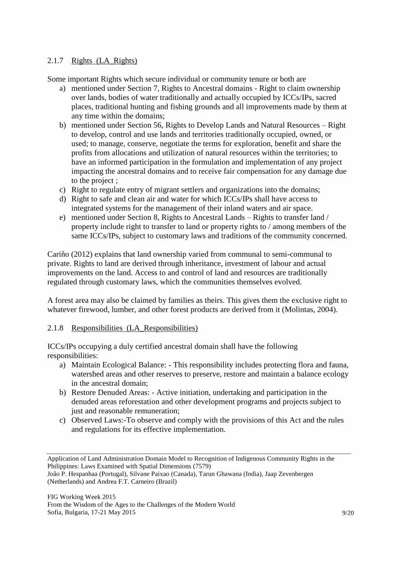
2.1.7 Rights (LA_Rights)
Some important Rights which secure individual or community tenure or both are
a) mentioned under Section 7, Rights to Ancestral domains - Right to claim ownership
over lands, bodies of water traditionally and actually occupied by ICCs/IPs, sacred
places, traditional hunting and fishing grounds and all improvements made by them at
any time within the domains;
b) mentioned under Section 56, Rights to Develop Lands and Natural Resources – Right
to develop, control and use lands and territories traditionally occupied, owned, or
used; to manage, conserve, negotiate the terms for exploration, benefit and share the
profits from allocations and utilization of natural resources within the territories; to
have an informed participation in the formulation and implementation of any project
impacting the ancestral domains and to receive fair compensation for any damage due
to the project ;
c) Right to regulate entry of migrant settlers and organizations into the domains;
d) Right to safe and clean air and water for which ICCs/IPs shall have access to
integrated systems for the management of their inland waters and air space.
e) mentioned under Section 8, Rights to Ancestral Lands – Rights to transfer land /
property include right to transfer to land or property rights to / among members of the
same ICCs/IPs, subject to customary laws and traditions of the community concerned.
Cariño (2012) explains that land ownership varied from communal to semi-communal to
private. Rights to land are derived through inheritance, investment of labour and actual
improvements on the land. Access to and control of land and resources are traditionally
regulated through customary laws, which the communities themselves evolved.
A forest area may also be claimed by families as theirs. This gives them the exclusive right to
whatever firewood, lumber, and other forest products are derived from it (Molintas, 2004).
2.1.8 Responsibilities (LA_Responsibilities)
ICCs/IPs occupying a duly certified ancestral domain shall have the following
responsibilities:
a) Maintain Ecological Balance: - This responsibility includes protecting flora and fauna,
watershed areas and other reserves to preserve, restore and maintain a balance ecology
in the ancestral domain;
b) Restore Denuded Areas: - Active initiation, undertaking and participation in the
denuded areas reforestation and other development programs and projects subject to
just and reasonable remuneration;
c) Observed Laws:-To observe and comply with the provisions of this Act and the rules
and regulations for its effective implementation.
Application of Land Administration Domain Model to Recognition of Indigenous Community Rights in the
Philippines: Laws Examined with Spatial Dimensions (7579)
João P. Hespanhaa (Portugal), Silvane Paixao (Canada), Tarun Ghawana (India), Jaap Zevenbergen
(Netherlands) and Andrea F.T. Carneiro (Brazil)
FIG Working Week 2015
From the Wisdom of the Ages to the Challenges of the Modern World
Sofia, Bulgaria, 17-21 May 2015
10/20
Cariño (2012) comments that even though the indigenous people has an attachment to
ancestral land, territory and resources, indigenous peoples in Philippines are having loss
of ancestral land due to displacement by development projects and extractive industries
including mining, dams, logging or natural causes. Environmental degradation –
destruction of forests, pollution of waters and loss of agro-biodiversity has also being a
result of impacts of extractive industries and agriculture modernization.
2.1.9 Restrictions (LA_Restrictions, Administrative Servitude)
Unauthorized and unlawful intrusion upon, or use of any portion of the ancestral domain, or
any violation of the rights hereinbefore enumerated, shall be punishable under this law.
Furthermore, the government shall take measures to prevent non-ICCs/IPs customs or lack of
understanding of laws to secure ownership, possession of land belonging to said ICCs/IPs.
2.1.10 Source (LA_SpatialSource, LA_AdministrativeSource)
LADM describes source as a document providing facts. A non-spatial source describes
document in textual format. A spatial source, on the other hand, is a source with the spatial
representation of one (part of) or more spatial units. For example, a field survey sketch, an
orthophoto or a satellite image with evidence on the location of boundaries collected from the
field.
a) Certificate of Ancestral Domain and Lands Title: It refers to a title formally
recognizing the rights of possession and ownership of ICCs / IPs over their ancestral
domains / lands identified and delineated in accordance with this law.
b) Communal Claims – It refer to claims on land, resources and rights thereon, belonging
to the whole community within a defined territory.
c) Customary Laws – It refers to a body of written and /or unwritten rules, usages,
customs and practices traditionally and continually recognized, accepted and observed
by respective ICCs/IPs.
d) Right to Claim Parts of Reservations – The claim on parts of the ancestral domains
which have been reserved for various purposes, except those reserved and intended for
common and public welfare and service.
As a required proof, Ancestral Domain Claims shall include the testimony of elders or
community under oath, and other documents directly or indirectly attesting to the
possession or occupation of the area since time immemorial by such ICCs/IPs in the
concept of owners which shall be any one of the following authentic documents:
1. Written accounts of the ICCs/IPs customs and traditions, political structure
and institution;
2. Pictures showing long term occupation such as those of old improvements,
burial grounds, sacred places and old villages;
3. Historical accounts including pacts and agreements concerning with other
ICCs/IPs;
4. Survey plan and sketch maps;
5. Anthropological data;

Application of Land Administration Domain Model to Recognition of Indigenous Community Rights in the
Philippines: Laws Examined with Spatial Dimensions (7579)
João P. Hespanhaa (Portugal), Silvane Paixao (Canada), Tarun Ghawana (India), Jaap Zevenbergen
(Netherlands) and Andrea F.T. Carneiro (Brazil)
FIG Working Week 2015
From the Wisdom of the Ages to the Challenges of the Modern World
Sofia, Bulgaria, 17-21 May 2015
11/20
6. Genealogical surveys;
7. Pictures and descriptive histories of traditional landmarks such as
mountains, rivers, creeks, ridges, hills, terraces and the like; and
8. Write-ups of names and places derived from the native dialect of the
community.
On the basis of such investigation and the findings of fact based thereon, the Ancestral
Domains office of the NCIP shall prepare a perimeter map, complete with technical
descriptions and a description of the natural features and landmarks embraced therein;
2.1.11 Systems (Packages in the Use Case Diagram)
There are two different systems, represented as packages in Figure 2, which store Certificates
for the Ancestral Domains and Lands, namelly as Claims (Land Administration and
Management System, LAMS), and latelly as Titles (Land Registration Authority Database,
LRAD). The only Use Case in the diagram represents the conversion procedure from Claims
into Titles, triggered by the Administrative Order #2 from 2002, ”Titling of Ancestral Domain
Claims”, as referred in the Background section.
As shown by the coloured connector lines in Figure 2, the LAMS (LMB, 2014) is managed by
the Department of Environment and Natural Resources (DENR), and the LRAD is managed
by the Land Registration Authority.
2.2 Spatial Dimensions of Indigenous Peoples Rights Act, 1997
The act does not explicitly mention about the spatial and temporal dimensions of the Rights
and other aspects. However, some aspects are worth of mentioning under this section:
a) Spatial dimensions gets highlighted under Right to claim ownership over lands, bodies
of water traditionally and actually occupied by ICCs/IPs, sacred places, traditional
hunting and fishing grounds and all improvements made by them at any time within
the domains; This spatially extends their claims beyond their core habitats.
b) Benefit and share the profits from allocations and utilization of natural resources
within the territories which extends rights in 3rd
spatial dimension because of
underground resources exploitation.
c) Right to access the integrated systems for the management of their inland waters and
air space and responsibility to manage the ecological balance of watershed areas and
other reserves clearly extends the spatial horizon of their activities.
d) Proofs required to support the claims for the ancestral domains/land titles require the
spatial representations of the claimed area such as pictures, survey plans and sketch
maps or perimeter maps etc.
e) For the purpose of Option to Secure Certificate of Title under Commonwealth Act 141
of Section 12, individually-owned ancestral lands, with agriculture character,
including those with a slope of eighteen percent or more are hereby classified as
alienable and disposable agriculture lands. Now, this specific mentioning of slope
percentage brings a new aspect regarding spatial dimensions inclusion in such acts and

Application of Land Administration Domain Model to Recognition of Indigenous Community Rights in the
Philippines: Laws Examined with Spatial Dimensions (7579)
João P. Hespanhaa (Portugal), Silvane Paixao (Canada), Tarun Ghawana (India), Jaap Zevenbergen
(Netherlands) and Andrea F.T. Carneiro (Brazil)
FIG Working Week 2015
From the Wisdom of the Ages to the Challenges of the Modern World
Sofia, Bulgaria, 17-21 May 2015
12/20
is not seen in some other similar acts by developing countries such as Indian Forest
Rights Act 2006.
These spatial dimensions can be extended further in LADM framework. Under Right to
Transfer Land / Property, members of the same ICCs / IPs, can transfer land or property rights
to each other, subject to customary laws and traditions. However, it is not clear whether the
Act allows the holders to raise credit against the entitled individual / community land holdings
from outsiders (institutions or individuals). This rule out the possibility of working with Case
C27 of LADM i.e. Spatial Unit with Micro Credit. However, the formal rights granted to the
holders of ownership, access and usage of resources from land and water can be considered as
a basis for raising credit. The share of the indigenous in the proceeds from the exploitation of
mineral resources and potential forms of hydraulic energy by third parties can also become a
basis of such credit rising.
Slight modification of Case C10 of LADM i.e. Mortgage on ownership (Formal Rights),
considering above mentioned formal rights equivalent to Parcel Ownership rights, will enable
credit rising for the right holders.
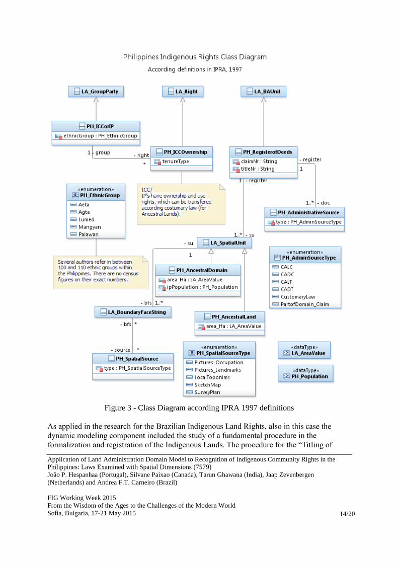
3. DERIVATION OF A LAND ADMINISTRATION SPECIALIZED MODEL
In this section, the set of correspondences established in section 2.1, from the review of the
IPRA Act of 1997, is converted into a class diagram derived from the LADM domain model.
The focus of this diagram is in the specializations which take into consideration specific
elements (classes, attributes and enumerations), which were identified in the Act itself, or
examining the information stored for the Certificate of Ancestral Domain Titles at the
(Philippine Geoportal, 2014). That is, the original LADM attributes and types are omitted, for
simplicity and to maintain focus on the specifics of the proposed Philippine specialized
model, PH_LADM. Although they should be taken into consideration in case of a future

Application of Land Administration Domain Model to Recognition of Indigenous Community Rights in the
Philippines: Laws Examined with Spatial Dimensions (7579)
João P. Hespanhaa (Portugal), Silvane Paixao (Canada), Tarun Ghawana (India), Jaap Zevenbergen
(Netherlands) and Andrea F.T. Carneiro (Brazil)
FIG Working Week 2015
From the Wisdom of the Ages to the Challenges of the Modern World
Sofia, Bulgaria, 17-21 May 2015
13/20
implementation. The LADM based UML modelling here presented was developed using
IBM’s Rational Software Architect, under an academic license.
It must be noted that this specialization is directed solely to the modeling concerning
Indigenous Land Rights, and not the “classical” realm of the cadastre, that is, formal private
property rights stored at a Land Registry, with or without a separate (Geometric) cadastre.
The diagram shows (mostly aligned at the top) the parent classes from LADM from where the
Philippines specializations are derived. Beginning with the Group Party class PH_ICCorIP
(class names here referred in italics), a new type attribute and corresponding enumeration is
defined, called PH_EthnicGroup. As referred back in section 2.1, the exact figure is polemic,
but nevertheless this is an information which must be stored with the CADT Titles.
This group of parties, representing an Indigenous Community or People, has a special type of
ownership right, with a set of definitions extracted from IPRA, including to develop, control
and use traditionally occupied lands, but also right to safe and clean air and water and the
right to transfer such ownership according customary law. Such type of right is specific to
these Group Party and thus a new specialized right should be created, to differentiate from the
classical civil law based ownership. It is interesting to note that the same solution was
proposed in the research paper for the Brazilian Indigenous Land Rights (Paixão, 2013).
Concerning LADM's Basic Administrative Unit, in the Philippines this should correspond to
the description of a record in the Register of Deeds. A specialization called
PH_RegisterofDeeds is created, having two additional attributes to store the numbers under
which the Certificate of Ancestral Domain (or Land) Claim and the resulting Certificate of
Ancestral Domain (or Land) Title where stored, which are specific to the Philippines case.
A number of documents is required in order to support the registration procedure, which are
specific to IPRA, and thus a new class and respective enumeration of types of documents are
created, named PH_AdministrativeSource and PH_AdminSourceType. Each type is defined in
section 2.1, sub-section “Source”.
On LADM's Spatial Unit package, only two specialized classes are considered, namely the
one covering the Ancestral Domains (PH_AncestralDomain), and the Ancestral Lands
(PH_AncestralLand). Specific attributes used in the corresponding data set in the Geoportal
were created, namely to store the area value in Hectare and the Indigenous People population.
Likewise, these attributes are specific and did not exist in the domain model.
Finally, a new Spatial Source and respective enumeration are created, to cover all the different
types of evidence that can be collected to document a given delineation for an ancestral
domain (or land). These received the names PH_SpatialSource and PH_SpatialSourceType.
Application of Land Administration Domain Model to Recognition of Indigenous Community Rights in the
Philippines: Laws Examined with Spatial Dimensions (7579)
João P. Hespanhaa (Portugal), Silvane Paixao (Canada), Tarun Ghawana (India), Jaap Zevenbergen
(Netherlands) and Andrea F.T. Carneiro (Brazil)
FIG Working Week 2015
From the Wisdom of the Ages to the Challenges of the Modern World
Sofia, Bulgaria, 17-21 May 2015
14/20
Figure 3 - Class Diagram according IPRA 1997 definitions
As applied in the research for the Brazilian Indigenous Land Rights, also in this case the
dynamic modeling component included the study of a fundamental procedure in the
formalization and registration of the Indigenous Lands. The procedure for the “Titling of

Application of Land Administration Domain Model to Recognition of Indigenous Community Rights in the
Philippines: Laws Examined with Spatial Dimensions (7579)
João P. Hespanhaa (Portugal), Silvane Paixao (Canada), Tarun Ghawana (India), Jaap Zevenbergen
(Netherlands) and Andrea F.T. Carneiro (Brazil)
FIG Working Week 2015
From the Wisdom of the Ages to the Challenges of the Modern World
Sofia, Bulgaria, 17-21 May 2015
15/20
Ancestral Domain Claims”, defined through NCIP's administrative order #2 from 2002 is
examined in order to achieve a context (or top) level Activity Diagram.
The resulting diagram (Figure 4), only shows the main phases of the procedure, and thus each
of the actions that is shown corresponds in fact to a structured activity. At least a second level
of detail is needed if any work-flow based system is to be derived from the UML.
Some of the actions have boxes (output pins in UML) which indicate the maximum sum of
days required to fulfill all the detailed tasks within the activity. This is a mere indication of the
total number of days required, given that some tasks do not impose an explicit time limit.
The boxes which do not define a maximum deadline (in days) refer to actual outputs from the
respective actions, that is, the Survey Plan or the Final Report.
The procedure shall start with a voluntary request presented by the representatives of the
ICC/IP's communities, that is, there is no obligation from the official nodal agencies to initiate
such procedure, but it must rely on the resolve of the involved ICC /IP community.
The preliminary action of “Recognition of original claimants” will confirm the list of
representative group members and examine if there are new members to be included in the
respective Group Party. In this way, the original list compiled for the Certificate of Ancestral
Land or Domain Claim can be updated according the present situation. All the participating
organizations are then noticed for the titling procedure through the “Information
Dissemination and Self-Delineation” action, where the ICC/IP's are the main actors in the
delineation of the boundaries of the Ancestral Domain or Land, according traditional “metes
and bounds” methods, with the desirable participation of Peoples Organizations (NGO's).
This preliminary field recognition is then to be confirmed through modern survey methods
(namely GNSS surveys), in the “Ground survey” action, where Surveyors (individual or
companies) certified by the National Mapping Agency (NAMRIA) shall be conducted
according a Survey Manual by NCIP, with all the surveyed coordinates to be expressed in the
Philippine Reference System of 1992.
The resulting Survey Plan is then validated by the Ancestral Domains Office (ADO), and if
approved, a report is sent to the Commission (NCIP), in the action referred as “Validation of
Survey & endorsement to the Commission”. These results can however be still contested by
neighboring or conflicting claimants (non-IP's), which shall be dealt through the parallel
actions “Resolution of Protests” and the “Resolution of Boundary Conflicts” (all having a
number of fixed deadlines for their conclusion).
Depending on their resolution, the request can be rejected or deferred. In the last case, there is
a final action concerning the issuance of the title certificates (CADT or CALT), which are to
be formally registered in the Register of Deeds, which concludes the conversion procedure.

Application of Land Administration Domain Model to Recognition of Indigenous Community Rights in the
Philippines: Laws Examined with Spatial Dimensions (7579)
João P. Hespanhaa (Portugal), Silvane Paixao (Canada), Tarun Ghawana (India), Jaap Zevenbergen
(Netherlands) and Andrea F.T. Carneiro (Brazil)
FIG Working Week 2015
From the Wisdom of the Ages to the Challenges of the Modern World
Sofia, Bulgaria, 17-21 May 2015
16/20
Figure 4 - Activity Diagram for the procedure of conversion from Claims into Titles

Application of Land Administration Domain Model to Recognition of Indigenous Community Rights in the
Philippines: Laws Examined with Spatial Dimensions (7579)
João P. Hespanhaa (Portugal), Silvane Paixao (Canada), Tarun Ghawana (India), Jaap Zevenbergen
(Netherlands) and Andrea F.T. Carneiro (Brazil)
FIG Working Week 2015
From the Wisdom of the Ages to the Challenges of the Modern World
Sofia, Bulgaria, 17-21 May 2015
17/20
4. CONCLUSION AND RECOMMENDATIONS
It is expected that the review of acts and regulations in the field of Indigenous Rights in
Philippines, presented here, and the LADM based modelling approach, can bring the
following benefits to involved actors:
A common understanding within the Land Administration domain, for all the
organizations involved;
Standardized models including the relations of rights, restrictions and responsibilities
to their spatial units geometries could improve administrative procedures concerning
ancestral lands and domains claims;
Clearly defined responsibilities for data maintenance can be achieved;
A common data model will allow interoperability and data sharing, avoiding
duplication and inconsistent information.
Consideration of the spatial and temporal dimensions of rights and corresponding spatial units
can contribute to further developments of the legal framework and its implementation
regarding information systems. This can be achieved through the use of any of the available
spatial and legal profiles included in the standard, namely through inclusion of 3D spatial
units to accurately depict certain types of uses like the air space (electric grid), marine waters
(aquaculture) or the underground (mineral resources exploitation).
REFERENCES
Capistrano, R.C. Indigenous peoples, their livelihoods and fishery rights in Canada and the
Philippines: paradoxes, perspectives and Lessons learned. The United Nations-Nippon
Foundation fellowship programme 2009 – 2010. Division for ocean affairs and the law of the
sea office of legal affairs, the United Nations, New york, 2010.
Cariño, J. K. Country Technical Note on Indigenous Peoples’ Issues - Republic of the
Philippines. International Fund for Agricultural Development (IFAD), 2012
CERD, Committee on the Elimination of Racial Discrimination. Philippines Indigenous
Peoples ICERD Shadow Report for the consolidated fifteenth, sixteenth, seventeenth,
eighteenth, nineteenth and twentieth Philippine ICERD periodic reports. Committee on the
Elimination of all forms of Racial Discrimination, 73rd Session, 3rd to 28th of August 2009.
www2.ohchr.org/english/bodies/cerd/docs/ngos/PIP_Philippines75.pdf
Corpuz, J. Indigenous Peoples of the Philippines. Legal Officer Tebtebba, 2011.
http://www.tebtebba.org/index.php/all-resources/category/135-participant-presentations

Application of Land Administration Domain Model to Recognition of Indigenous Community Rights in the
Philippines: Laws Examined with Spatial Dimensions (7579)
João P. Hespanhaa (Portugal), Silvane Paixao (Canada), Tarun Ghawana (India), Jaap Zevenbergen
(Netherlands) and Andrea F.T. Carneiro (Brazil)
FIG Working Week 2015
From the Wisdom of the Ages to the Challenges of the Modern World
Sofia, Bulgaria, 17-21 May 2015
18/20
Ghawana, T.; Hespanha, J.; Zevenbergen, J. Application of Land Administration Domain
Model to Recognition of Indigenous Community Rights in Indian Forests. Proceedings from
FIG Working Week 2012, Rome, Italy, 6-10 May 2012.
IAG. Institute for Autonomy and Governance. The Struggle Continues: Uphold the Rights of
Indigenous Peoples. IAG Policy Brief, 2011
LMB, Land Management Bureau. Website: http://lmb.gov.ph/tpp://... Acessed October 2014.
LRA, Land Registration Authority. Website: http://www.lra.gov.ph/ Acessed October 2014.
Molintas, J.M. The Philippine Indigenous Peoples’ struggle for land and life: challenging
legal texts. Arizona Journal of International & Comparative Law Vol 21, No. 1 2004
Paixão, S.; Hespanha, J.; Ghawana, T.; Carneiro, A.; Zevenbergen, J. Modelling Brazilian
Indigenous Tribes Land Rights with ISO 19152 LADM. Proceedings from the 5th Land
Administration Domain Model Workshop, Kuala Lumpur, Malaysia, 24-25 September 2013.
Philippine Geoportal. Online available: http://www.geoportal.gov.ph/viewer/ Accessed
October 2014.
Roy, R. D. Traditional Customary Laws and Indigenous Peoples in Asia. Minority Rights
Group International, March 2005
Tuyor, J. B.; Bautista, J.G.; Lazaro,V.F.; Padua, M.L.; Tordecilla, R.; Judd,M.; Sy,
M.C.;Castro, N.; von Amsberg, J.; Serra, M.T.; Lovei, M.; Fisiy C.; Raturi, R. Indigenous
Peoples Rights Act: Legal and Institutional Frameworks, Implementation and Challenges in
the Philippines. Discussion papers, East Asia and Pacific Region. Social Development and
Rural Development, Natural Resources and Environment Sectors. World Bank, Washington
DC, 2007.

Application of Land Administration Domain Model to Recognition of Indigenous Community Rights in the
Philippines: Laws Examined with Spatial Dimensions (7579)
João P. Hespanhaa (Portugal), Silvane Paixao (Canada), Tarun Ghawana (India), Jaap Zevenbergen
(Netherlands) and Andrea F.T. Carneiro (Brazil)
FIG Working Week 2015
From the Wisdom of the Ages to the Challenges of the Modern World
Sofia, Bulgaria, 17-21 May 2015
19/20
BIOGRAPHICAL NOTES
João Paulo Hespanha holds an MSc in Integrated Geoinformation Production at the
International Institute of Geo-Information Science and Earth Observation (ITC) in Enschede
and a PhD on the Development Methodology for an Integrated Legal Cadastre, at the Delft
University of Technology (The Netherlands). From 1997 he is an adjunct professor at the
Technology and Management Polytechnic School of Águeda, University of Aveiro, Portugal.
He has been involved in lecturing and research projects on Cadastre since adoption of project-
led education in 2001.
Silvane Paixão holds PhD in Land Administration and Land Information Management with
emphases in Brazilian Rural Cadastral System. She had published some papers about the
Brazilian land administration issues. She has worked as a GIS expert in Brazil in projects
related to the poverty, community development, health and urban planning. Dr. Paixão taught
cadastral survey at Federal University of Pernambuco (UFPE), Brazil and was teacher
assistant at University of New Brunswick (UNB) – Canada in disciplines related to Land
Administration and Land Economics. Currently, she is working as Project Coordinator and
GIS Analyst for the Faculty of Medicine – Dalhousie University.
Tarun Ghawana has an M.Sc in GIS with Specialization in natural resource management
from International Institute of Geoinformation Science and Earth Observation, The
Netherlands. He has worked as a GIS expert in India, Netherlands and Germany on natural
resources management projects with academia as well as private consultancies. His area of
interest includes land administration, spatial analysis and spatial data modeling in particular
for natural resource applications. He has worked on Indian NSDI for Department of Science
and Technology, India. Currently, he is working as external researcher with Integrated Spatial
analytics Consultants, a multidisciplinary firm which is based in India.
Andrea F.T. Carneiro is a Professor in the Land Administration at the Dept. of Cartography
Engineering at Federal University of Pernambuco (UFPE), Brazil. Her emphases are on rural
and urban cadastral systems, land registration and cadastral surveying. She also has been
participating as editorial board in Brazilian technical journal. She was member of the
development of the Law# 10.267/2001, the implementation of National Cadastre of Rural
Properties (CNIR) and development of the law to guide the urban cadastre in Brazil
committees. She have been working actively with international projects and working groups.
.
Jaap Zevenbergen is professor in land administration systems at the University of Twente,
Faculty of Geo-Information Science and Earth Observation (ITC), department of Urban and
Region Planning and Geoinformation Management in Enschede - The Netherlands. He holds
Master degrees in geodetic engineering and law and defended his PhD on systems of land
registration in 2002. He has published several articles and numerous papers about land
administration and land registration. He has studied numerous systems of land registration,
both as a researcher and as a consultant, the most recent being Ghana and Uganda. He is also
a co-chair of Commission 7 Working Group 2.

Application of Land Administration Domain Model to Recognition of Indigenous Community Rights in the
Philippines: Laws Examined with Spatial Dimensions (7579)
João P. Hespanhaa (Portugal), Silvane Paixao (Canada), Tarun Ghawana (India), Jaap Zevenbergen
(Netherlands) and Andrea F.T. Carneiro (Brazil)
FIG Working Week 2015
From the Wisdom of the Ages to the Challenges of the Modern World
Sofia, Bulgaria, 17-21 May 2015
20/20
CONTACTS
João Paulo Hespanha
University of Aveiro, ‘Escola Superior de Tecnologia e Gestão de Águeda’
Rua Comandante Pinho e Freitas, n.º 28
3750-127 Águeda –
PORTUGAL
Phone: +351 234 611500
Fax: +351 234 611540
E-mail: [email protected],
Website: http://www.ua.pt/estga/
Silvane Paixão
DMNB - Dalhousie Medicine New Brunswick
PO Box 5050 100 Tucker Park Road
Saint John, New Brunswick - E2L 4L5
CANADA
Phone: +1506 645 0391
E-mail: [email protected]
Tarun Ghawana
Integrated Spatial Analytics Consultants
A-201, Kairali Apts., Sector-3, Dwarka
New Delhi-110075
INDIA
Phone: +91-9958117758 E-mail: [email protected]
Jaap Zevenbergen
University of Twente
Faculty for Geo-Information Sciences and Earth Observation – ITC - Department of Urban
and Region Planning and Geo-Information Management
P.O. Box 217 7500 AE Enschede
THE NETHERLANDS
Phone: +31 (0)53 4874351
Fax: +31 (0)53 4874575 E-mail: [email protected]
Website: www.itc.nl
Andrea F.T. Carneiro
Federal University of Pernambuco
Cartographic Engineering Department
Av. Acad. Helio Ramos, sn – Cidade Universitária
50740-530 – Recife – PE BRAZIL
Phone: +558121268235 E-mail: [email protected]
Website: www.ufpe.br/cadastrogt