Embed Size (px)
Citation preview
American Journal of Remote Sensing 2018; 6(1): 23-28
http://www.sciencepublishinggroup.com/j/ajrs
doi: 10.11648/j.ajrs.20180601.14
ISSN: 2328-5788 (Print); ISSN: 2328-580X (Online)
Application of Remotely Sensed Data in the Estimation of Net Radiation at the Earth’s Surface in Clear Sky Conditions
Roopashree Shrivastava1, *
, Indumathi Srinivasan Iyer1, Mahabaleshwar Narayan Hegde
2,
Rajendrakumar Balkrishna Oza1
1Radiation Safety Systems Division, Bhabha Atomic Research Centre, Mumbai, India 2Environmental Survey Laboratory, Kaiga Generating Station, Karwar, India
Email address:
*Corresponding author
To cite this article: Roopashree Shrivastava, Indumathi Srinivasan Iyer, Mahabaleshwar Narayan Hegde, Rajendrakumar Balkrishna Oza. Application of
Remotely Sensed Data in the Estimation of Net Radiation at the Earth’s Surface in Clear Sky Conditions. American Journal of Remote
Sensing. Vol. 6, No. 1, 2018, pp. 23-28. doi: 10.11648/j.ajrs.20180601.14
Received: February 7, 2018; Accepted: February 25, 2018; Published: March 20, 2018
Abstract: This study focuses on the estimation of shortwave and longwave radiation utilizing measured data from the
Moderate Resolution Imaging Spectroradiometer (MODIS) instrument on the National Aeronautic and Space Administration
(NASA’s) Terra / Aqua satellites in clear sky conditions. The net radiation is the vector sum of the shortwave and longwave
radiation coming towards and going away from the Earth’s surface. The study is carried out for a tropical site Kaiga, located in
Southern India for the months of March and April representative of the warm season and the months of November and
December representative of the cold season in the year 2013. The validity of the net radiation values estimated from MODIS
data is assessed by comparing it with simultaneous ground based measurements from the Mini Boundary Layer Masts
(MBLMs). The results indicate that the net radiation values estimated by the satellite are well correlated with the ground based
measurements (R2 = 0.983). On an average, for the four months of study, the mean absolute error between the satellite and
ground based measurements is 35 W m-2
where as the RMSE is 50 W m-2
. Once validated with ground based measurements,
the satellite derived net radiation data can be used for validation of land surface energy balance predicted by atmospheric
models.
Keywords: MODIS, MBLM, Net Radiation
1. Introduction
The absorption of solar radiation and emission of
terrestrial radiation by the earth and constituents of the
atmosphere drive the general circulation in the atmosphere.
This general circulation is largely responsible for the earth’s
weather and climate. Ever since the launch of the first
meteorological satellite several decades ago, the estimation
of the earth’s radiation budget from space remains an
important application. The net radiation is the vector sum of
the shortwave and longwave radiation coming towards and
going away from the Earth’s surface. It is an important
parameter in the surface energy budget and required for
climate change studies, monitoring weather, estimation of
evapotranspiration and agricultural meteorology. Studies on
the measurement of land surface energy balance from space
have relied on geostationary as well as polar orbiting
satellites. The geostationary satellites have high temporal
resolution (~ 3 hours) but coarse spatial resolution of the
order of 20 – 250 km [9]. The polar orbiting satellites on the
other hand, have superior spatial resolution; however their
global coverage is twice a day and hence they are not very
suitable for studies on diurnal variation. Utilizing data from
multiple satellites and some interpolation techniques one can
obtain information on diurnal variation. Data from Moderate
Resolution Imaging Spectroradiometer (MODIS) have been
used to derive the net radiation in Jiangxi Province, China
24 Roopashree Shrivastava et al.: Application of Remotely Sensed Data in the Estimation of Net Radiation at the
Earth’s Surface in Clear Sky Conditions
and comparison with in situ measurements were carried out
[2]. It was seen that a good accuracy is achieved in deriving
the longwave, shortwave and net radiation from satellite data
and the satellite data are useful in the studies on heat
exchanges, environmental, hydrology and ecology research
in land areas. Data from the Along Track Scanning
Radiometer (ATSR) have also been utilized for the estimation
of net longwave and shortwave radiation [14, 15].
Measurements from the Landsat – 5 Thematic Mapper along
with a digital elevation model were used to obtain the net
shortwave radiation over a 17 km x 17 km area near
Manhattan, Kansas [16]. Several studies have utilized remote
sensing observations from the Geostationary Observational
Environmental Satellite (GOES) and the National Oceanic
and Atmospheric Administration (NOAA) - Advanced Very
High Resolution Radiometer (AVHRR) for the estimation of
shortwave and longwave radiation components [5, 6]. Even
though several studies have demonstrated the application of
satellite derived data in estimation of energy budget, due to
the several sources of error possible, like errors in the
retrieval algorithm, errors due to non-uniform field of view
of the sensor and several simplifying assumptions in the
retrieval algorithm, the satellite data should be first validated
with ground based measurements before utilizing them for
the estimation of the desired parameters. The present study
utilizes remotely sensed data from the MODIS for the
estimation of net radiation. In the first part of this study, for
estimating net radiation, a model namely Satellite Estimate of
Surface Energy Budget (SESEB) in clear sky conditions is
developed. Input data required for the model are obtained
from the MODIS satellite. The next part of this study is on
the validation of the satellite derived net radiation values
with ground based measurements. The validation is carried
out for four months namely March and April 2013, assumed
to represent the warm season in India and the months of
November and December 2013, assumed representative of
the cold season in India. The ground based measurements are
carried out at Kaiga site in Southern India. The present study
assumes clear sky conditions.
2. Materials and Methods
This paper is on the comparison of net radiation values
estimated by the satellite derived data with ground based
measurements. MODIS flies on board the National
Aeronautics and Space Administration (NASA's) Terra and
Aqua satellites and it acquires data in 36 spectral bands from
0.412 µm to 14.200 µm spanning the visible, infra – red and
thermal infra – red wavelengths. The MODIS science team
provides data in four sub disciplines namely land,
atmosphere, ocean and calibration. In this study, the MODIS
geolocation data product namely MOD03 (MYD03), the
MODIS atmospheric temperature profile MOD07 (MYD07)
and MODIS Land Surface Temperature product MOD11
(MYD11) have been utilized for the estimation of net
radiation. Here MOD refers to the data obtained from Terra
MODIS and MYD refers to the data obtained from Aqua
MODIS. The MODIS atmospheric temperature profile
product MOD07 (MYD07) provides the temperature profile
in the atmosphere in twenty vertical levels from 1000 mbar to
5 mbar. The air temperature in the lowest available pressure
level (i.e. 1000 mbar or 950 mbar) is used as a surrogate for
screen level temperature [1]. At any given location there are
two overpasses in a day, each of Terra and Aqua MODIS
providing four hours of co – located data for comparison.
The values of land surface temperature, emissivity, solar
zenith angle, air temperature obtained from Terra / Aqua
MODIS are used to estimate the surface net radiation using
the energy balance laws [1]. The exact computation of the
shortwave and longwave radiation components from satellite
requires information about the clear sky transmissivity, as
well as the fraction attenuated by uniformly mixed gases,
water vapour and aerosols. These computations require the
integration of complex radiative transfer models as well as
the information about the concentration of gaseous
constituents in the atmosphere. To avoid the use of
complicated models, several empirical equations have been
suggested in literature [3, 8, 9, 10]. The present study utilizes
empirical equations for the estimation of short and longwave
radiation components. The incoming shortwave radiation
(Rs↓) can be estimated as follows.
��↓ = 0.72 × � × cos � (1)
S0 = solar constant (1367 W m-2
)
θ = solar zenith angle
Once the incoming shortwave radiation is known, the
outgoing shortwave radiation (Rs↑) is simply the fraction
reflected by the earth’s surface. In absence of specific
measurements of albedo, it is assumed that the earth’s surface
reflects 30% of the incoming shortwave radiation. Hence the
outgoing shortwave radiation is estimated as
��↑ = −0.3 × ��↓ (2)
One of the simplest methods of estimating the incoming
longwave radiation (RL↓) from surface observations is [12,
13]
��↓ = � + �� × � × ���� (3)
c = -119 W m-2
d = 1.08
Ta = air temperature
The outgoing longwave radiation (RL↑) is given by
��↑ = −� × � × ��� (4)
ε = land surface emissivity
σ = Stefan Boltzmann constant
Tg = land surface temperature
As per the sign convention, the incoming components are
positive and the outgoing components are negative.
Finally, the net radiation (RN) is the vector sum of the four
components.
� = ��↓ +��↑ + ��↓ + ��↑ (5)
American Journal of Remote Sensing 2018; 6(1): 23-28 25
At Kaiga site, four Mini Boundary Layer Masts (MBLMs)
have been installed for continuous measurements of
meteorological parameters like wind speed, wind direction,
air temperature, relative humidity, atmospheric pressure,
rainfall and short and longwave radiation. Among the four
components of net radiation, the shortwave radiation and
incoming longwave radiation are measured at one location.
The outgoing longwave radiation is measured at a different
spatial location. These two stations are a few kilometres apart
from each other, however they are located in similar type of
soil condition. The four components are summed vectorially
to derive the net radiation. These ground based
measurements of net radiation for the corresponding time are
used to assess the accuracy of satellite derived values. The
shortwave radiation is measured using the Kipp and Zonen
CMP series pyrannometer which have a spectral range of
0.310 µm to 2.800 µm. Similarly, both the incoming and
outgoing longwave radiation components are measured using
the Kipp and Zonen CGR series pyrgeometer having a
spectral range from 4.5 µm to 42 µm. For both, the satellite
and ground based measurements, a surface albedo of 0.3 is
assumed for the computation of the outgoing shortwave
radiation from the incoming shortwave radiation.
3. Result and Discussion
Out of the 24 hours in a day, the data for four hours
namely 5 (10.30 am), 8 (1.30 pm), 17 (10.30 pm) and 20
(01.30 am) GMT (IST) where both satellite and ground based
measurements are present have been considered for
comparison. The net radiation data are estimated from the
components of short and longwave radiation. The accuracy
of the net radiation depends on how well the individual
components have been estimated. Hence in this study, as an
example, the individual components namely the incoming
shortwave radiation, incoming longwave radiation and
outgoing longwave radiation are compared for the month of
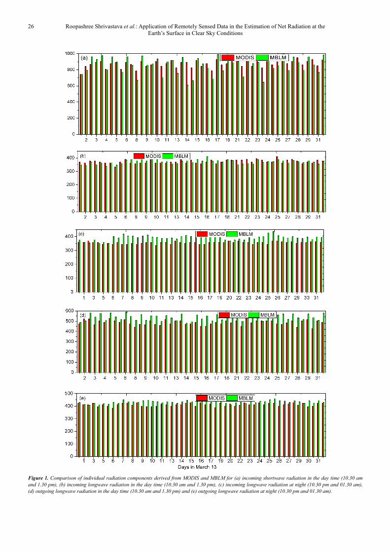
March 2013 for the times already mentioned. This
comparison is shown in Figure 1 for (a) incoming shortwave
radiation in the day time (10.30 am and 1.30 pm), (b)
incoming longwave radiation in the day time (10.30 am and
1.30 pm), (c) incoming longwave radiation at night (10.30
pm and 01.30 am), (d) outgoing longwave radiation in the
day time (10.30 am and 1.30 pm) and (e) outgoing longwave
radiation at night (10.30 pm and 01.30 am) respectively.
Since the outgoing shortwave radiation is just a fraction of
the incoming radiation it is not compared separately. As seen
from the Figure 1 (a), the satellite derived values of the short
and longwave radiation compare well with the ground based
measurements. For most of the times, the differences are
within 10%. On certain days (for example 14th
March, 2013)
where significant differences are noticed between the satellite
derived values and the ground based measurements, may be
attributed to the presence of clouds which is neglected in this
study. This study assumes clear sky conditions for this site in
the months of March, April, November and December. The
agreement between the ground based measurements and
satellite derived estimate points to the fact that this is a
reasonable assumption for most of the times. From Figures 1
(b) to 1 (e) which compare the incoming / outgoing longwave
radiation in the day and night time, it is seen that the satellite
estimates match well with the ground based measurements. It
is also emphasized that while the ground based observations
refer to a point measurement, the satellite data are areally
averaged retrievals. Several other sources of uncertainty in
the satellite retrievals are assumptions used in the retrieval
algorithm, non-uniform field of view of the sensor etc. The
validity of the empirical equations used for the determination
of net radiation also adds to the total uncertainty.
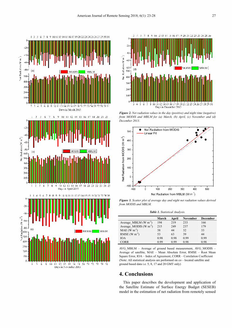
The Figures 2 (a) – 2 (d) compare the values of net
radiation in the day and night time from MODIS and MBLM
for the months of March, April, November and December
2013 respectively. The day time net radiation values are in
the range of 0 – 600 Wm-2
where as the night time values are
in the range of 0 to -80 W m-2
. All the four figures indicate
that the day time net radiation values are better estimated as
compared to the night time values. This could be because of
the fact that the daytime net radiation values are mainly
governed by the incoming shortwave radiation which has less
dependence on site characteristics. The night time net
radiation values are governed by the incoming and outgoing
longwave radiation, which are dependent on the site
characteristics, and hence critically dependent on the retrieval
algorithm used to derive these parameters from the satellite
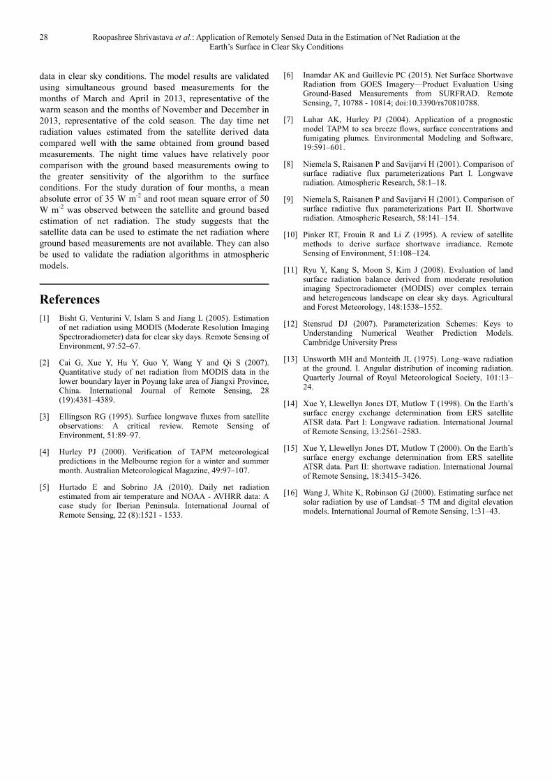
data. Finally, in Figure 3, the scatter plot of the average day
and night time values from satellite and ground based
measurements (R2= 0.98) is shown along with the best fit line
(dotted curve). This plot reveals the comparison between the
satellite and ground based measurements in spite of the
various sources of uncertainty. To evaluate the performance
of the MODIS derived net radiation values, several statistical
indices like Mean Absolute Error (MAE), Root Mean Square
Error (RMSE), Index of Agreement (IOA) and Correlation
Coefficient (CORR) have been utilized [4, 7]. The MAE,
RMSE, IOA and CORR values are given in Table – 1. From
Table – 1, it is seen that the average differences (denoted by
MAE) between MODIS derived net radiation and ground
based measurement is ~ 35 W m-2
where as the average root
mean square error is ~ 50 W m-2
. These results are in good
agreement with other studies in which MODIS has been used
to obtain net radiation for a site [11]. Both the IOA and
CORR indicate a good comparison between the satellite and
ground based measurements. This study serves to validate the
satellite derived values of net radiation using ground based
measurements. Once validated, the satellite estimates can be
used for the validation of atmospheric models for each grid
instead of a comparison with a single ground measurement.
26 Roopashree Shrivastava et al.: Application of Remotely Sensed Data in the Estimation of Net Radiation at the
Earth’s Surface in Clear Sky Conditions
Figure 1. Comparison of individual radiation components derived from MODIS and MBLM for (a) incoming shortwave radiation in the day time (10.30 am
and 1.30 pm), (b) incoming longwave radiation in the day time (10.30 am and 1.30 pm), (c) incoming longwave radiation at night (10.30 pm and 01.30 am),
(d) outgoing longwave radiation in the day time (10.30 am and 1.30 pm) and (e) outgoing longwave radiation at night (10.30 pm and 01.30 am).
American Journal of Remote Sensing 2018; 6(1): 23-28 27
Figure 2. Net radiation values in the day (positive) and night time (negative)
from MODIS and MBLM for (a) March, (b) April, (c) November and (d)
December 2013.
Figure 3. Scatter plot of average day and night net radiation values derived
from MODIS and MBLM.
Table 1. Statistical Analysis.
March April November December
Average_MBLM (W m-2) 194 219 233 166
Average_MODIS (W m-2) 215 249 237 179
MAE (W m-2) 38 44 32 33
RMSE (W m-2) 53 63 39 44
IOA 0.98 0.98 0.99 0.99
CORR 0.99 0.99 0.98 0.98
AVG_MBLM – Average of ground based measurement, AVG_MODIS –
Average of satellite, MAE – Mean Absolute Error, RMSE – Root Mean
Square Error, IOA – Index of Agreement, CORR – Correlation Coefficient
(Note: All statistical analysis are performed on co – located satellite and
ground based data i.e. 5, 8, 17 and 20 GMT only)
4. Conclusions
This paper describes the development and application of
the Satellite Estimate of Surface Energy Budget (SESEB)
model in the estimation of net radiation from remotely sensed
28 Roopashree Shrivastava et al.: Application of Remotely Sensed Data in the Estimation of Net Radiation at the
Earth’s Surface in Clear Sky Conditions
data in clear sky conditions. The model results are validated
using simultaneous ground based measurements for the
months of March and April in 2013, representative of the
warm season and the months of November and December in
2013, representative of the cold season. The day time net
radiation values estimated from the satellite derived data
compared well with the same obtained from ground based
measurements. The night time values have relatively poor
comparison with the ground based measurements owing to
the greater sensitivity of the algorithm to the surface
conditions. For the study duration of four months, a mean
absolute error of 35 W m-2
and root mean square error of 50
W m-2
was observed between the satellite and ground based
estimation of net radiation. The study suggests that the
satellite data can be used to estimate the net radiation where
ground based measurements are not available. They can also
be used to validate the radiation algorithms in atmospheric
models.
References
[1] Bisht G, Venturini V, Islam S and Jiang L (2005). Estimation of net radiation using MODIS (Moderate Resolution Imaging Spectroradiometer) data for clear sky days. Remote Sensing of Environment, 97:52–67.
[2] Cai G, Xue Y, Hu Y, Guo Y, Wang Y and Qi S (2007). Quantitative study of net radiation from MODIS data in the lower boundary layer in Poyang lake area of Jiangxi Province, China. International Journal of Remote Sensing, 28 (19):4381–4389.
[3] Ellingson RG (1995). Surface longwave fluxes from satellite observations: A critical review. Remote Sensing of Environment, 51:89–97.
[4] Hurley PJ (2000). Verification of TAPM meteorological predictions in the Melbourne region for a winter and summer month. Australian Meteorological Magazine, 49:97–107.
[5] Hurtado E and Sobrino JA (2010). Daily net radiation estimated from air temperature and NOAA - AVHRR data: A case study for Iberian Peninsula. International Journal of Remote Sensing, 22 (8):1521 - 1533.
[6] Inamdar AK and Guillevic PC (2015). Net Surface Shortwave Radiation from GOES Imagery—Product Evaluation Using Ground-Based Measurements from SURFRAD. Remote Sensing, 7, 10788 - 10814; doi:10.3390/rs70810788.
[7] Luhar AK, Hurley PJ (2004). Application of a prognostic model TAPM to sea breeze flows, surface concentrations and fumigating plumes. Environmental Modeling and Software, 19:591–601.
[8] Niemela S, Raisanen P and Savijarvi H (2001). Comparison of surface radiative flux parameterizations Part I. Longwave radiation. Atmospheric Research, 58:1–18.
[9] Niemela S, Raisanen P and Savijarvi H (2001). Comparison of surface radiative flux parameterizations Part II. Shortwave radiation. Atmospheric Research, 58:141–154.
[10] Pinker RT, Frouin R and Li Z (1995). A review of satellite methods to derive surface shortwave irradiance. Remote Sensing of Environment, 51:108–124.
[11] Ryu Y, Kang S, Moon S, Kim J (2008). Evaluation of land surface radiation balance derived from moderate resolution imaging Spectroradiometer (MODIS) over complex terrain and heterogeneous landscape on clear sky days. Agricultural and Forest Meteorology, 148:1538–1552.
[12] Stensrud DJ (2007). Parameterization Schemes: Keys to Understanding Numerical Weather Prediction Models. Cambridge University Press
[13] Unsworth MH and Monteith JL (1975). Long–wave radiation at the ground. I. Angular distribution of incoming radiation. Quarterly Journal of Royal Meteorological Society, 101:13–24.
[14] Xue Y, Llewellyn Jones DT, Mutlow T (1998). On the Earth’s surface energy exchange determination from ERS satellite ATSR data. Part I: Longwave radiation. International Journal of Remote Sensing, 13:2561–2583.
[15] Xue Y, Llewellyn Jones DT, Mutlow T (2000). On the Earth’s surface energy exchange determination from ERS satellite ATSR data. Part II: shortwave radiation. International Journal of Remote Sensing, 18:3415–3426.
[16] Wang J, White K, Robinson GJ (2000). Estimating surface net solar radiation by use of Landsat–5 TM and digital elevation models. International Journal of Remote Sensing, 1:31–43.