Embed Size (px)
Citation preview

Applying GIS in seismic hazard assessment and
data integration for disaster management
Rumiana Vatseva, Dimcho Solakov, Emilia Tcherkezova,Stela Simeonova, Petya Trifonova
National Institute of Geophysics, Geodesy and GeographyBulgarian Academy of Sciences
December 14th, 2012, Enschede, the Netherlands

OUTLINE
1. Seismic hazard
2. Case Study
3. Materials and Methods
4. Results and Discussion
5. Conclusion

Seismic hazard
Among the many kinds of natural and man‐made disasters, earthquakes dominate with regard to their socially and economically impact on the urban environment.
Seismic hazard assessment for industrial objects is of a substantial importance, because it provides valuable information for seismic safety and disaster mitigation.
Effective implementation of GIS in disaster management requires research and development in many areas, incl. collection, structuring and utilizing comprehensive spatial data

Objective
to integrate basic spatial geo‐datasets in thematic mapping products and to assess the seismic hazard using GIS techniques to provide a basis for disaster management of the Ada Tepe region in Bulgaria.
The GIS approach applied for hazard assessment is based on analysis and processing of the source‐geometry, earthquake occurrence model, characteristics and statistics of seismicity in each source, and the appropriate attenuation relations.
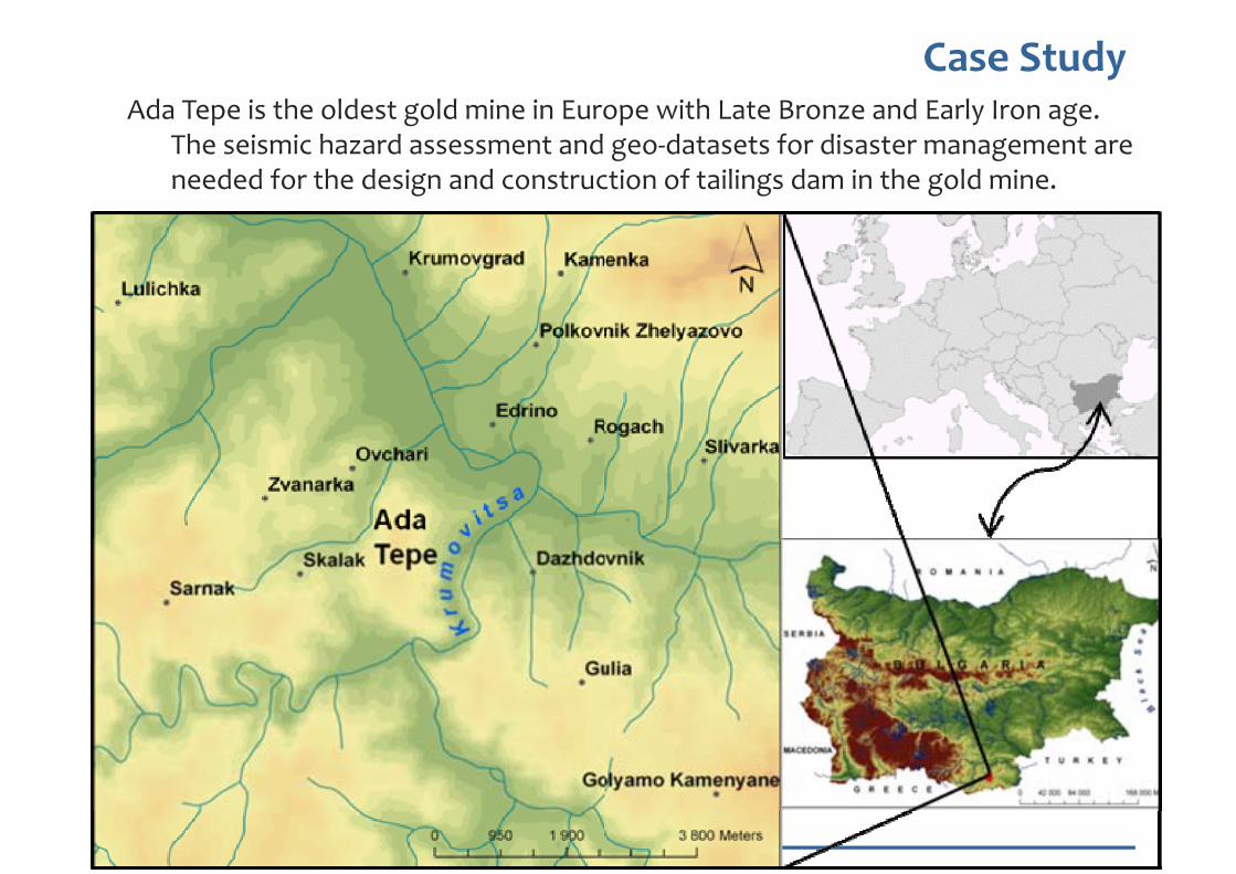
Case Study Ada Tepe is the oldest gold mine in Europe with Late Bronze and Early Iron age.
The seismic hazard assessment and geo‐datasets for disaster management are needed for the design and construction of tailings dam in the gold mine.

Data used
The geological, geophysical, and seismological data were developed at regional scale (within a radius of 200 km)
The geographical data was created at site vicinity scale (within a radius of 5 km) ‐ 10 x 10 km (100 sq. km)
Information about historical and instrumental seismicity was correlated with geological and geophysical data.

Active faults in the Ada tepe region

Total horizontal gravity gradient

Regional seismicity (historical and instrumental earthquakes)

Geographical Data & Thematic Maps
Digital topographic maps (1:50.000)
Colour digital orthophotos (year 2006)
CORINE Land Cover (CLC) 2006 database
to develop basic local geographical datasets for transportation, settlements, hydrography, elevation, land cover & land use.
DEM with resolution 30x30 m

Results ‐ Seismic source model (17 seismic sources)

Results
Seismic hazard analysis for the Ada Tepe site was performed using a combination of a logic tree and Monte Carlo approaches.
As a result a set of 192 000hazard curves was obtained.
On the base of the calculated 192 000 hazard curves were estimated mean, median, 15% and 85% values for PGA (peak ground acceleration)
Uniform hazard spectra for probability of exceedance 2.11 x 10‐3

Geo‐datasets
The basic geo‐datasets needed for disaster management at local level were collected, updated and integrated using GIS techniques for matching multi‐scale input data, combining vector and raster data, and connecting spatial databases.
The procedures for the integration of the datasets were based on data geometry, topology, semantics, or a combination of these themes.
The basic datasets consist of commonly used geographic data that are relatively “static” and can maintain before the occurrence of a disaster

Geo‐datasets

Geodatabase data model
The geodatabase data model was developed to ensure an integral and comprehensive data structure and to integrate GIS solutions in seismic hazard assessment.
It includes the following components: geo‐datasets, relationships, and seismic hazard assessment models.
A data dictionary was constructed in order to create an efficient repository of information that supports different stakeholders for disaster management.
The data dictionary contains description of all features and attributes currently used. The data layers listed in the data dictionary are captured in geodatabase format.
The geodatabase data model was implemented in a physical ArcGIS file geodatabase.

Geodatabase schema
Conclusion
A set of 192 000 hazard curves is the result from the seismic hazard analysis performed for Ada Tepe site. The hazard curves contain the information about the seismic hazard at the region.
Computation of uniform confidence response spectra is performed simultaneously with PGA evaluation using the same procedure.
The spectral characteristics of ground motion are determined according to the relative influences of the seismic source characteristics and the attenuation characteristics of the propagation path of the seismic waves.
The seismic hazard assessment results are considered in the design and construction of the tailings dam in the gold mine Ada Tepe in Bulgaria.

Conclusion
GIS data integration – main challenges:
to ensure the interoperability of data, when combining,
processing and visualizing existing heterogeneous datasets
in different formats from different sources ;
to provide appropriate disaster information not only from
existing data, but also from operational data.

Outlook
Web GIS with scalable structure is of interest to us in the future work.
Further collective efforts are needed to produce an interoperable GIS for effective decision making in disaster management. One possible way to deal with the interoperability issue is the use of ontology for overcoming heterogeneity in geospatial information, data sharing and data integration.
An ontology‐based approach for disaster management could facilitate interoperability both on data and organization of emergency services.
For enhancing interoperability it would be very beneficial to use INSPIRE data specifications as a basis for the local datasets.

Acknowledgements
The study was supported by Balkan Mineral and Mining EAD through the contract for provision of services with the National Institute of Geophysics, Geodesy and Geography – BAS.