Embed Size (px)
Citation preview
ORDINANCE NO.___________
AN ORDINANCE OF THE CITY OF FORT WORTH, TEXAS APPROVING A SERVICE AND ASSESSMENT PLAN FOR THE FORT WORTH PUBLIC IMPROVEMENT DISTRICT NO. 16 (WALSH RANCH/QUAIL VALLEY); MAKING A FINDING OF SPECIAL BENEFIT TO THE PROPERTY IN IMPROVEMENT AREA #1 OF THE DISTRICT; LEVYING SPECIAL ASSESSMENTS AGAINST PROPERTY WITHIN IMPROVEMENT AREA #1 OF THE DISTRICT; ESTABLISHING A LIEN ON SUCH PROPERTY; APPROVING AN ASSESSMENT ROLL FOR IMPROVEMENT AREA #1 OF THE DISTRICT; PROVIDING FOR THE METHOD OF ASSESSMENT AND THE PAYMENT OF THE IMPROVEMENT AREA #1 SPECIAL ASSESSMENTS; PROVIDING FOR PENALTIES AND INTEREST ON DELINQUENT ASSESSMENTS; PROVIDING FOR A SEVERABILITY CLAUSE; PROVIDING AN EFFECTIVE DATE; AND PROVIDING FOR RELATED MATTERS
WHEREAS, Chapter 372, Texas Local Government Code (the “Act”) authorizes the governing body (the “City Council”) of the City of Fort Worth, Texas (the “City”), to create a public improvement district within the corporate limits and extraterritorial jurisdiction of the City; and
WHEREAS, on September 20, 2016, the City Council conducted a public hearing to consider a petition received by the City on August 1, 2016 (the “Petition”) requesting the creation of the Fort Worth Public Improvement District No. 16 (Walsh Ranch/Quail Valley) (the “District”) to undertake the construction of certain public improvements described in the Petition (the “Authorized Improvements”); and
WHEREAS, on September 27, 2016, the City Council approved Resolution No. 4686-09-2016 (the “Authorization Resolution”), authorizing, establishing and creating the District; and
WHEREAS, on October 6, 2016 (the “Authorization Publication Date”), the City published the Authorization Resolution in the Fort Worth Star-Telegram, a newspaper of general circulation in the City and the boundaries of the District; and
WHEREAS, no written protests regarding the creation of the District from any owners of record of property within the District were filed with the City Secretary within 20 days of the Authorization Publication Date; and
WHEREAS, only a portion of the property within the District, consisting of approximately 101.7 acres (“Improvement Area #1”) will be developed initially; and
WHEREAS, on March 7, 2017, the City Council adopted Resolution No. 4578-03-2017 determining the total estimated costs of the Authorized Improvements in Improvement Area #1 of the District, directing the filing of a proposed assessment roll, authorizing the publication of
1

notice of a public hearing to consider the levying of the special assessments against the property within Improvement Area #1 of the District in a newspaper of general circulation in the City and the boundaries of the District, and directing related actions; and
WHEREAS, the City Council, pursuant to Section 372.016(b) of the PID Act, published notice on March 9, 2017 in the Fort Worth Star Telegram, a newspaper of general circulation in the City, of a public hearing to consider the proposed special assessments to be levied against property located in Improvement Area #1 of the District; and
WHEREAS, the City Council, pursuant to Section 372.016(c) of the PID Act, mailed the notice of the public hearing for the proposed special assessments to the last known address of the owners of the property liable for the special assessments; and
WHEREAS, the City Council convened the public hearing at the City Council meeting beginning at 7:00 p.m. on Tuesday, March 28, 2017, at which all persons who appeared, or requested to appear, in person or by their attorney, were given the opportunity to contend for or to contest the District Service and Assessment Plan attached hereto as EXHIBIT A (the “Service and Assessment Plan”), the Improvement Area #1 Assessment Roll in the form attached as APPENDIX A-1 to the Service and Assessment Plan (the “Assessment Roll”), and the proposed Special Assessments (as defined in the Service and Assessment Plan) to be levied against the property in Improvement Area #1 of the District, and to offer testimony pertinent to any issue presented on the amount of the Special Assessment, the apportionment of the costs of the Authorized Improvements that benefit Improvement Area #1 and which are to be funded by the Special Assessments levied in Improvement Area #1 of the District (the “Improvement Area #1 Funded Improvements”), the purpose of the Special Assessment, the special benefits accruing to the property within Improvement Area #1 of the District due to the Improvement Area #1 Funded Improvements, and the penalties and interest of annual installments and on delinquent annual installments of the Special Assessment; and
WHEREAS, the City Council finds and determines that the Assessment Roll and the Service and Assessment Plan and which is incorporated herein for all purposes, should be approved and that the Special Assessments should be levied against the property in Improvement Area #1 as provided in this Ordinance and the Service and Assessment Plan and Assessment Roll; and
WHEREAS, the City Council further finds that there were no written objections or evidence submitted to the City Secretary in opposition to the Service and Assessment Plan, the apportionment of the costs of the Improvement Area #1 Funded Improvements, the Assessment Roll, or the levy of the Special Assessments; and
WHEREAS, prior to the issuance of bonds secured by the Special Assessments, the owners (the “Majority Landowners”) of the majority of the privately-owned and taxable property located within the District, including a majority of the prviately-owned and taxable property located within Improvement Area #1 of the District, will have executed and presented to the City staff for approval and acceptance a landowner agreement (the “Majority Landowner Agreement”) in the form and substance acceptable to the City, in which the Majority
2
Landowners acknowledge and accept the Service and Assessment Plan, approve the Assessment Roll, acknowledge and accept this Ordinance and acknowledge and accept the levy of the Assessments against their property located within the District, and agree to pay the Special Assessments when due and payable; and
WHEREAS, the City Council closed the public hearing, and after considering all comments and all written and documentary evidence presented at the hearing, including all written comments and statements filed with the City, determined to proceed with the adoption of this Ordinance in conformity with the requirements of the Act; and
WHEREAS, the apportionment of the cost of the Improvement Area #1 Funded Improvements and the Annual Installment pursuant to the Service and Assessment Plan is fair and reasonable, reflects an accurate presentation of the special benefit each property will receive from the administrative services and construction of the Improvement Area #1 Funded Improvements identified in the Service and Assessment Plan, and is hereby approved; and
WHEREAS, the Service and Assessment Plan covers a period of at least five years and defines the annual indebtedness and projected costs for the Improvement Area #1 Funded Improvements and Administrative Expenses; and
WHEREAS, the Service and Assessment Plan apportions the cost of the Improvement Area #1 Funded Improvement and Administrative Expenses to be assessed against property in the District and such apportionment is made on the basis of special benefits accruing to the property because of the Improvement Area #1 Funded Improvements and Administrative Expenses; and
WHEREAS, all of the real property in the District which is being assessed in the amounts shown in the Assessment Roll will be benefitted by the services and improvements proposed to be provided through the District in the Service and Assessment Plan, and each parcel of such real property will receive special benefits in each year equal or greater than each Annual Installment and will receive special benefits during the term of the Special Assessments equal to or greater than the total amount assessed; and
WHEREAS, the method of apportionment of the cost of the Improvement Area #1 Funded Improvements, Administrative Expenses, and Annual Installments associated with the Improvement Area #1 Bonds set forth in the Service and Assessment Plan results in imposing equal shares of the costs of the Improvement Area #1 Funded Improvements and Administrative Expenses on property similarly benefitted, and results in a reasonable classification and formula for apportionment of such costs;
WHEREAS, the Service and Assessment Plan should be approved as the service plan and assessment plan for the District as described in Sections 372.013 and 372.014 of the Act; and
WHEREAS, the Assessment Roll should be approved as the assessment roll for Improvement Area #1 of the District; and
3

WHEREAS, the provisions of the Service and Assessment Plan relating to due and delinquency dates for the Special Assessments and the Annual Installments, interest and penalties on delinquent Special Assessments and Annual Installments and procedures in connection with the imposition and collection of the Special Assessments should be approved and will expedite collection of the Special Assessments in a timely manner in order to provide the services and improvements needed and required for the area within the District; and
WHEREAS, the Special Assessments herein levied and assessed are made and levied under and by virtue of the terms, powers and provisions of the Act.
NOW THEREFORE, BE IT ORDAINED BY THE CITY COUNCIL OF THE CITY OF FORT WORTH, TEXAS THAT:
Section 1. Findings.
The findings, determinations and recitations set out in the preambles of this Ordinance are found to be true and correct and they are hereby adopted by the City Council and made a part hereof for all purposes.
Section 2. Public Hearing.
The action of the City Council holding and closing the public hearing in these proceedings is hereby ratified and confirmed.
Section 3. Terms.
Terms not otherwise defined herein are defined in the Service and Assessment Plan.
Section 4. Assessment Plan.
The Service and Assessment Plan substantially in the form attached to this Ordinance is hereby accepted and approved pursuant to Sections 372.013 and 372.014 of the Act as the service and assessment plan for the District.
Section 5. Assessment Roll.
The Assessment Roll attached as APPENDIX A-1 to the Service and Assessment Plan is hereby approved as the assessment roll for Improvement Area #1 of the District.
Section 6. Levy and Payment of Special Assessments for Costs of Improvement Project.
(a) The City Council hereby levies an assessment on each tract of property located within Improvement Area #1 of the District, except for the Non-Benefitted Property, as shown and described on the Service and Assessment Plan and the Assessment Roll, in the respective amounts shown on the Assessment Roll. There is further levied and assessed against each tract of property located within Improvement Area #1 of the District, except for the Non-Benefitted
4

Property, having not paid the assessments in full, additional annual assessments for the Administrative Expenses, as described in the Service and Assessment Plan, which shall be part of the Special Assessment and the Annual Installment. The amount of the Annual Installment shall be reviewed and determined annually by the City Council following the City Council’s annual review of the Service and Assessment Plan for the District. Pursuant to Section 372.015(d), the amount of assessment for each property owner may be adjusted following the annual review of the Service and Assessment Plan.
(b) The levy of the Special Assessments shall be effective on the date of adoption of this Ordinance levying assessments and strictly in accordance with the terms of the Service and Assessment Plan and the Act.
(c) The collection of the Special Assessments shall be as described in the Service and Assessment Plan and the Act.
(d) Each Special Assessment may be paid in a lump sum or may be paid in Annual Installments pursuant to the terms of the Service and Assessment Plan.
(e) Each Special Assessment shall bear interest at the rate or rates specified in the Service and Assessment Plan.
(f) Each Annual Installment shall be collected each year in the manner set forth in the Service and Assessment Plan.
(g) The Annual Installments for Assessed Properties shall be calculated pursuant to the terms of the Service and Assessment Plan.
Section 7. Method of Assessment.
The method of apportioning the Actual Costs of the Improvement Area #1 Funded Improvements and the Administrative Expenses is set forth in the Service and Assessment Plan.
Section 8. Penalties and Interest on Delinquent Special Assessments.
Delinquent Special Assessments shall be subject to the penalties, interest, procedures, and foreclosure sales set forth in the Service and Assessment Plan and as allowed by law and such enforcement. The Special Assessments shall have lien priority as specified in the Act and the Service and Assessment Plan.
Section 9. Prepayments of Special Assessments.
As provided in subsection 372.018(f) of the Act and Section VI.E of the Service and Assessment Plan, the owner (the “Owner”) of any Assessed Property may prepay the Special Assessments levied by this Ordinance.
5

Section 10. Lien Property.
(a) The the City Council and each of the landowners in the District intend for the obligations, covenants and burdens on such landowners of the Assessed Property, including without limitation such landowner’s obligations related to payment of the Special Assessments and the Annual Installments, to constitute a covenant running with the land. The Special Assessments and the Annual Installments levied hereby shall be binding upon the landowner, the Owners, and their respective transferees, legal representatives, heirs, devisees, successors and assigns in the same manner and for the same period as such parties would be personally liable for the payment of ad valorem taxes under applicable law. Special Assessments and the Annual Installments shall have lien priority as specified in the Service and Assessment Plan and the Act.
(b) The Special Assessments and Annual Installments levied and assessed against the property within Improvement Area #1 of the District as provided in this Ordinance and the Service and Assessment Plan, together with reasonable attorney’s fees and costs of collection, if incurred, are hereby declared to be and are made a lien upon each tract of property within the District against which the same are levied and assessed, and a personal liability and charge against the real and true owners of such lot, including the successors and assigns, whether such owners be named herein or not, and said liens shall be and constitute the first enforceable lien and claim against the lot on which such assessments are levied, and shall be a first and paramount lien thereon, superior to all other liens and claims except state, county, school district and municipal ad valorem taxes. The City Council hereby authorizes enforcement of such lien in the manner set forth herein and in the Act.
Section 11. Appointment of Administrator and Collector of Assessments.
(a) MuniCap, Inc., of Columbia, Maryland, is hereby appointed and designated as the initial administrator of the Service and Assessment Plan and of Special Assessments levied by this Ordinance (the “Administrator”). The Administrator shall perform the duties of the Administrator described in the Service and Assessment Plan and in this Ordinance. The City has entered into a PID Administration Services Agreement with MuniCap, Inc. The Administrator’s fees, charges and expenses for providing such service shall be part of the Annual Installment, as further described in the Service and Assessment Plan.
(b) The Chief Financial Officer / Director of Financial Management Services of the City or his designee is hereby appointed as the temporary collector of the Special Assessments. The Chief Financial Officer / Director of Financial Management Services or designee shall serve in such capacity until such time as the City shall arrange for the collection duties to be performed by the Tarrant or Parker County Tax Assessors or any other qualified collection agent selected by the City.
Section 12. Applicability of Tax Code.
To the extent not inconsistent with this Ordinance, and not inconsistent with the Act or the other laws governing public improvement districts, the provisions of the Texas Tax Code
6

governing enforcement of ad valorem tax liens (other than with respect to property subject to agriculture use valuation, including redemption rights following a tax sale) shall be applicable to the imposition and collection of Special Assessments by the City, and the Texas Tax Code shall otherwise be applicable to the extent provided by the Act.
Section 13. Severability.
If any provision of this Ordinance or the application of any provision to any person or circumstance is held invalid, the invalidity shall not affect other provisions or applications of the Ordinance which can be given effect without the invalid provision or application, and to this end the provisions of this Ordinance are declared to be severable.
Section 14. Effective Date.
This Ordinance shall take effect, and the levy of the Improvement Area #1.
Section 15. Open Meetings.
It is hereby officially found and determined that the meeting at which this Ordinance is passed was open to the public as required and that public notice of the time, place, and purpose of said meeting was given as required by the Texas Open Meetings Act.
Section 16. Filing in Land Records.
The City Secretary is directed to cause a copy of this Ordinance, including the Service and Assessment Plan, to be recorded in the real property records of Tarrant County and Parker County, Texas. The City Secretary is further directed to similarly file each Annual Service Plan Update approved by the City Council.
AND IT IS SO ORDAINED.
APPROVED AS TO FORM AND LEGALITY: ATTEST:
_______________________________ _____________________________Senior Assistant City Attorney Mary J. Kayser, City Secretary
M&C: _________________________Adopted and Effective: _________
7

EXHIBIT ASERVICE AND ASSESSMENT PLAN
Fort Worth Public Improvement District No. 16 (Walsh Ranch/Quail Valley)Service and Assessment Plan
March 28, 2017

Table of Contents
Section IPLAN DESCRIPTION AND DEFINED TERMSSection IIPROPERTY INCLUDED IN THE PIDSection IIIDESCRIPTION OF THE AUTHORIZED IMPROVEMENTSSection IVASSESSMENT PLANSection VSERVICE PLANSection VITERMS OF THE ASSESSMENTSSection VIIASSESSMENT ROLLSSection VIIIMISCELLANEOUS PROVISIONS
1

List of Tables and Appendices
Table II-APUBLIC IMPROVEMENT DISTRICT BOUNDARIESTable II-BIMPROVEMENT AREA #1 MAPTable II-CIMPROVEMENT AREA #1 LOT BREAKDOWN BY TYPETable II-DIMPROVEMENT AREA #1 LOT LAYOUTTable II-EFUTURE IMPROVEMENT AREAS MAPTable III-AIMPROVEMENT AREA #1 AUTHORIZED IMPROVEMENTSTable III-BFUTURE IMPROVEMENT AREAS AUTHORIZED IMPROVEMENTS & LOT COUNT….Table IV-A IMPROVEMENT AREA #1 COST ALLOCATIONTable IV-BIMPROVEMENT AREA #1 ASSESSMENT ALLOCATIONTable IV-CIMPROVEMENT AREA #1 ESTIMATED VALUE TO ASSESSMENT RATIOSTable V-AIMPROVEMENT AREA #1 SOURCES AND USES OF FUNDSTable V-BSOURCES AND USES (ASSUMING FUTURE PID BOND ISSUANCE)Table V-CIMPROVEMENT AREA # 1 ANNUAL INSTALLMENTSAppendix A-1IMPROVEMENT AREA #1 ASSESSMENT ROLLAppendix BLEGAL DESCRIPTIONS FOR PARCELS WITHIN THE PID
2

Section I
PLAN DESCRIPTION AND DEFINED TERMS
A. Introduction
1. On September 27, 2016, the City Council (the "City Council") of the City of Fort Worth, Texas (the "City") approved Resolution 4686-09-2016, which authorized the creation of the Fort Worth Public Improvement District No. 16 (Walsh Ranch/Quail Valley) (the “PID”) to finance a portion of the Actual Costs of the Authorized Improvements for the benefit of certain property in the PID, all of which is located within the city limits or ETJ of the City.
2. Chapter 372 of the Texas Local Government Code (as amended, the “PID Act”), governs the creation and operation of public improvement districts within the State of Texas. This Service and Assessment Plan (this “SAP”) was prepared pursuant to the PID Act. The PID Act requires that a service plan “cover a period of at least five years and must also define the annual indebtedness and the projected costs for improvements." The PID Act also requires a service plan "be reviewed and updated annually for the purpose of determining the annual budget for improvements." The service plan for the PID is described in more detail in Section V.
3. It is anticipated that the PID will finance the Actual Costs of only a portion of the Authorized Improvements being constructed for the Property. The Property is expected to be developed in seven phases. For each phase developed, the City will levy and collect Assessments for the benefitted Property pursuant to an Assessment Ordinance specific to that phase.
4. The Assessment Rolls for the PID are attached as Appendix A-1 and are addressed in Section VII. The Assessments shown on the Assessment Rolls are based on the method for establishing and levying the Assessments described in Sections IV and VI.
5. Unless otherwise specified, references in this SAP to a "Section," a "Table," or an "Appendix" shall mean a Section of, Table in, or Appendix to this SAP for all purposes.
B. Definitions
As used in this SAP, capitalized terms shall have the meanings ascribed to them as follows:
1. “Actual Costs” means, with respect to, Authorized Improvements, the demonstrated, reasonable, allocable, and allowable costs of constructing such Authorized Improvements. Actual Costs may include (i) the costs incurred for the design, planning, financing, administration/management, acquisition, installation, construction and/or implementation of such Authorized Improvements, (ii) the costs incurred in preparing the construction plans for such Authorized Improvements, (iii) the fees paid for obtaining permits, licenses or other governmental approvals for such Authorized Improvements, (iv) the costs incurred for external professional costs, such as engineering, geotechnical, surveying, land planning, architectural
3

landscapers, appraisals, legal, accounting and similar professional services, taxes (property and franchise) related to the Authorized Improvements, (v) costs of all labor, bonds and materials, including equipment and fixtures, incurred by contractors, builders and materialmen in connection with the acquisition, construction or implementation of the Authorized Improvements, and (vi) all related permitting, zoning and authorized approval expenses; architectural, engineering, legal and consulting fees; financing charges; taxes; governmental fees and charges; insurance premiums; and miscellaneous expenses associated with the Authorized Improvements. For the avoidance of doubt, not all of the Authorized Improvements and the Actual Costs thereof are being funded through the PID. Only certain Authorized Improvements described herein, and the PID-Funded Actual Costs thereof, as defined below, are being funded through the PID.
2. “Additional Interest” means the 0.50% additional interest charged on Assessments pursuant to Section 372.018 of the PID Act to fund the Prepayment Reserve and the Delinquency Reserve pursuant to Sections IV.G, IV.H and Section IV.I.
3. “Administrative Expenses” means the administrative, organizational, maintenance and operation costs and expenses associated with, or incident to, the administration, organization, maintenance and operation of the PID, including, but not limited to, the costs of (i) legal counsel, engineers, accountants, financial advisors, investment bankers or other consultants and advisors, (ii) creating and organizing the PID and preparing the Assessment Rolls, (iii) computing, levying, collecting and transmitting the Assessments or the Annual Installments thereof, (iv) maintaining the record of Assessments, including payments, reallocations and/or cancellations of the Assessments or Annual Installments thereof, (v) investing or depositing the Assessments or other monies, (vi) complying with the PID Act with respect to the PID, (vii) paying the paying agent/registrar’s and trustee’s fees and expenses (including the fees and expenses of their respective legal counsel) related to the PID Bonds, and (viii) City costs of creating and administering the PID and administering the construction of that portion of the Authorized Improvements to be funded through the PID. Administrative Expenses shall also mean the administrative costs and expenses of issuing, making debt service payments on, and redeeming the PID Bonds, provided, however, that for the avoidance of doubt, Administrative Expenses do not include the amounts for payment of the actual principal of, redemption premium, if any, and interest on the PID Bonds. Annual Administrative Expenses collected and not expended shall be carried forward and applied to reduce Administrative Expenses in subsequent years to avoid over collection.
4. “Administrator” means an officer or employee of the City or third party designee of the City who is not an officer or employee thereof, who shall have the responsibilities provided for herein, in an Indenture relating to the PID Bonds or in any other agreement approved by the City Council relating to the PID.
5. “Annual Installment” means, with respect to the Assessed Property, each annual payment of: (i) the Assessment (including the principal of and interest thereon) as shown on the Assessment Rolls as updated each year by the Annual Service Plan Update in accordance with this SAP and calculated as provided in Section VI, (ii) Administrative Expenses as updated each year by the Annual Service Plan Update, and (iii) the Additional Interest. The Annual
4

Installment is subject to update and adjustment from time to time, including upon the issuance of PID Bonds, if any.
6. “Annual Service Plan Update” is defined in Section V.2.
7. “Assessed Property” or “Assessed Properties” means property within the PID that benefits from the Authorized Improvements and on which Assessments have been levied as shown on the Assessment Rolls and which currently includes all Parcels other than Non-Benefited Property.
8. “Assessment” means the assessment levied against a Parcel pursuant to an Assessment Ordinance and the provisions of this SAP, as shown on any Assessment Roll, subject to reallocation upon the subdivision or reduction of such Parcel according to this SAP and the PID Act.
9. “Assessment Ordinance” means each ordinance adopted by the City Council approving this SAP (including amendments or supplements) and levying the Assessments.
10. “Assessment Roll” means, as applicable, the Improvement Area #1 Assessment Roll included as Appendix A-1 as may be updated, modified or amended from time to time in accordance with the procedures set forth in this SAP and in the PID Act, including updates prepared in connection with any future issuance of PID Bonds or in connection with any Annual Service Plan Update.
11. “Authorized Improvements” means those improvements, including those listed in Section III.A and described in Section III.B, authorized by Section 372.003 of the PID Act, regardless of whether such improvements are actually funded through the PID. Only a portion of the Authorized Improvements constructed within the PID will be funded through the PID, and such improvements will be acquired, constructed or installed in accordance with this SAP, and any future updates and/or amendments.
12. “City” means the City of Fort Worth, Texas.
13. “City Council” means the duly elected governing body of the City.
14. “County” means either Parker County, Texas or Tarrant County, Texas.
15. “Delinquency Reserve” has the meaning set forth in Section IV.I.
16. “Delinquent Collection Costs” means interest, penalties and expenses incurred or imposed with respect to any delinquent Assessment, or an Annual Installment thereof, in accordance with the PID Act which includes the costs related to pursuing collection of such delinquent Assessment, or an Annual Installment thereof, and the costs related to foreclosing the lien against the Assessed Property, including attorney’s fees to the extent permitted by the PID Act
5

17. “Developer” means QUAIL VALLEY DEVCO I, LLC, a Texas limited liability company, and WALSH RANCHES LIMITED PARTNERSHIP, a Texas limited partnership, and their respective successors and assigns.
18. “ETJ” means the extraterritorial jurisdiction of the City.
19. “Future Improvement Areas” means those Future Improvement Areas to be defined and developed after Improvement Area #1 within the boundaries of the PID on that portion of the Property shown on Table II-D and described in Appendix B.
20. “Future Improvement Areas Assessed Property” means, for any year, all Parcels within the Future Improvement Areas and listed on the Future Improvement Areas Assessment Roll, other than Non-Benefited Property.
21. “Future Improvement Areas Assessment Roll” means, as applicable, the Future Improvement Areas Assessment Roll as may be updated, modified or amended from time to time in accordance with the procedures set forth in this SAP and in the PID Act, including updates prepared in connection with any future issuance of PID Bonds or in connection with any Annual Service Plan Update.
22. “Future Improvement Areas Improvements” means those Authorized Improvements which confer a special benefit on Future Improvement Areas and the costs of which are to be PID-Funded Actual Costs.
23. “Future Improvement Area Reimbursement Agreement” means any PID Reimbursement Agreement entered into with respect to any Future Improvement Area, by and between the City and the Developer, pursuant to which the Developer agrees to fund the Actual Costs of all Authorized Improvement in the applicable Future Improvement Area of the District, and the City agrees to reimburse the Developer for the PID-Funded Actual Costs of the corresponding Future Improvement Area Improvements, with interest, as permitted by the PID Act.
24. “Improvement Area #1” means that portion of the Property shown on Table II-B, and described in Appendix B.
25. “Improvement Area #1 Assessed Property” means, for any year, all Parcels within Improvement Area #1 and listed on the Improvement Area #1 Assessment Roll, other than Non-Benefited Property.
26. “Improvement Area #1 Assessment Roll” means the Assessment Roll included as Appendix A-1.
27. “Improvement Area #1 Funded Improvements” means those Authorized Improvements which confer a special benefit on Improvement Area #1 and the costs of which are to be PID-Funded Actual Costs.
6

28. “Improvement Area #1 Reimbursement Agreement” means that certain Fort Worth Public Improvement District No. 16 (Walsh Ranch/Quail Valley) Reimbursement Agreement, dated March 28, 202017, by and between the City and the Developer pursuant to which the Developer agrees to fund the Actual Costs of all Authorized Improvements in Improvement Area #1 of the District and the City agrees to reimburse the Developer for the PID-Funded Actual Costs of the Improvement Area #1 Funded Improvements, with interest, as permitted by the PID Act.
29. “Indenture” means an indenture of trust, trust agreement, ordinance or similar document between the City and the Trustee, authorizing the issuance of, and setting forth the terms and other provisions relating to the collection of annual installments for repayment of, any PID Bonds as such indenture or document may be modified, amended, and/or supplemented from time to time.
30. “Lot” means (i) for any portion of the Property for which a subdivision plat has been recorded in the official public records of a County, a tract of land described by "Lot" and "Block" in such subdivision plat, and (ii) for any portion of the Property for which a subdivision plat has not been recorded in the official public records of a County, a tract of land anticipated to be described by "Lot" and "Block" in a final recorded subdivision plat.
31. “Lot Type” means a classification of final building Lots with similar characteristics (e.g., commercial, light industrial, multifamily residential, single family residential or other uses), as determined or approved by the Administrator and confirmed by the City Council. Single family residential Lots shall be further classified based on the front footage of the Lot as determined or approved by the Administrator and confirmed by the City Council. Improvement Area #1 will have five residential lot types classified as 35 foot, 50 foot, 60 foot, 70 foot and Custom lots.
32. “Mandatory Prepayment” shall have the meaning set forth in Section VI.C.
33. “Master Reimbursement Agreement” means the Master Reimbursement Agreement entered into by and between the City and the Developer, pursuant to which the Developer agrees to fund the Actual Costs of all Authorized Improvements and the City agrees to reimburse the Developer for the PID-Funded Actual Costs, related to a portion of the Authorized Improvements, with interest, as permitted by the PID Act.
34. “Maximum Assessment per Unit” means, for each Lot Type, the Assessment per unit amounts shown in Section IV.D.2 (Table IV-B) of the SAP.
7

35. “Non-Benefited Property” means Parcels that accrue no special benefit from the Authorized Improvements being funded through the PID, including Public Property and easements that create an exclusive use for a public utility provider. Property identified as Non-Benefited Property at the time the Assessments (i) are imposed or (ii) are reallocated pursuant to a subdivision of a Parcel, is not assessed. Assessed Property converted to Non-Benefited Property, if the Assessments may not be reallocated pursuant to the provisions herein, remains subject to the Assessments and requires the Assessments to be prepaid as provided for in Section VI.C.
36. “Notice of PID Assessment Termination” is defined in Section VI.E.1.
37. “Parcel” means property within the PID that is identified by (1) a tax map identification number assigned by the Parker County Appraisal District or the Tarrant Appraisal District, as the case may be, for real property tax purposes, (2) a metes and bounds description, (3) lot and block number in a final subdivision plat recorded in the official public records of a County, or (4) any other means determined by the City Council.
38. “PID” is defined in Section I.A.2.
39. “PID Act” is defined in Section I.A.2.
40. “PID Bonds” mean bonds which may be issued by the City from time to time to finance a portion of the PID-Funded Actual Costs of a portion of the Authorized Improvements.
41. “PID-Funded Actual Costs” means the Actual Costs to be paid through the PID of a specified portion of the Authorized Improvements, as described in Section III.B.2 and as shown on Table III-A. PID-Funded Actual Costs includes all payments for Administrative Expenses.
42. “PID Reimbursement Agreement” means collectively or as applicable, the Improvement Area #1 Reimbursement Agreement and/or any Future Improvement Area Reimbursement Agreement.
43. “Prepayment Costs” means interest to the date of prepayment of any Assessment, plus expenses related to the prepayment that are allowed by the PID Act and reasonably expected to be incurred by or imposed upon the City as a result of the prepayment.
44. “Prepayment Reserve” has the meaning set forth in Section IV.H of this SAP.
45. “Property” is defined in Section II.A.
46. “Public Property” means real property, right of way and easements located within the PID owned by or irrevocably offered and accepted for dedication to the federal government, the State of Texas, the applicable County, the City, a school district, a public utility provider or any other political subdivision or public agency, whether in fee simple, through an easement, by plat or otherwise.
8

47. “SAP” is defined in Section I.A.2. The concept shall include updates, modifications, and amendments of the SAP as approved by the City Council from time to time in accordance with the procedures set forth in this SAP and in the PID Act, including updates prepared in connection with the future issuance of PID Bonds, if any, and in connection with any Annual Service Plan Update, and in connection with the approval by the City Council of each Assessment Ordinance.
48. “Trustee” means the trustee specified in an Indenture and any successor permitted by the Indenture.
9

Section II
PROPERTY INCLUDED IN THE PID
A. Property Included in the PID
The PID is comprised of the Property shown in Table II-A. Legal descriptions for all Parcels within the PID are included in Appendix B. The PID, encompassing approximately 1,703.5682 acres, is located within the corporate limits and ETJ of the City. It is anticipated that the Property will be developed in seven phases containing approximately 3,317 single family homes. Improvement Area #1 is depicted on Table II-B and will include 587 single family residential lots. Table II-C presents the breakdown of the single family residential lots by Lot Type within Improvement Area #1 and the lot layout for Improvement Area #1 is presented in Table II-D. The Future Improvement Areas are depicted on Table II-E and will include approximately 2,730 single family residential lots.
TABLE II-APublic Improvement District Boundaries
10

TABLE II-BImprovement Area #1 Map
11

Lot Type # of Lots
35 2850 23960 18270 98100 40
Total 587
Table II-CImprovement Area #1
Lot Breakdown by Type
Souce: Quail Valley Devco I, LLC and Walsh Ranches Limited Partnership
12

TABLE II-DImprovement Area #1 Lot Layout
13
TABLE II-EFuture Improvement Areas Map
14

Section III
DESCRIPTION OF THE AUTHORIZED IMPROVEMENTS
A. Authorized Improvements Overview
1. Section 372.003 of the PID Act authorizes a City to undertake the following improvements:
(i) landscaping;(ii) erection of fountains, distinctive lighting, and signs;(iii) acquiring, constructing, improving, widening, narrowing, closing, or rerouting of
sidewalks or of streets, any other roadways, or their rights-of way;(iv) construction or improvement of pedestrian malls;(v) acquisition and installment of pieces of art;(vi) acquisition, construction or improvement of libraries;(vii)acquisition, construction or improvement of off-street parking facilities;(viii) acquisition, construction, improvement or rerouting of mass transportation
facilities;(ix) acquisition, construction or improvement of water, wastewater, or drainage facilities
or improvements;(x) the establishment or improvement of parks;(xi) projects similar to those listed in Subdivisions (i)-(x);(xii)acquisition, by purchase or otherwise, of real property in connection with an
authorized improvement;(xiii) special supplemental services for improvement and promotion of the district,
including services relating to advertising, promotion, health and sanitation, water and wastewater, public safety, security, business recruitment, development, recreation and cultural enhancement;
(xiv) payment of expenses incurred in the establishment, administration and operation of the district; and
(xv)the development, rehabilitation, or expansion of affordable housing.
2. The City has determined to undertake a portion of the Authorized Improvements described in Section III.B and Section III.C. Any change to the Authorized Improvements will require the approval of the City.
B. Descriptions and Costs of Improvement Area #1 Funded Improvements
1. The Improvement Area #1 Funded Improvements are that portion of the Authorized Improvements that confer a special benefit solely on Improvement Area #1 and the costs of which are PID-Funded Actual Costs that will be financed from Assessments levied against Improvement Area #1 Assessed Property and from the proceeds of PID Bonds, if any, secured by such Assessments. For the avoidance of doubt, not all Authorized Improvements benefitting Improvement Area #1 are Improvement Area #1 Funded Improvements.
15

2. Table III-A shows the Actual Costs of all Authorized Improvement in Improvement Area #1, including the PID-Funded Actual Costs of the Improvement Area #1 Funded Improvements. The costs shown in Table III-A may be revised in Annual Service Plan Updates. The PID-Funded Actual Costs of the Improvement Area #1 Funded Improvements are to be funded from: (i) the principal portion of the Annual Installments collected from Assessments levied against Improvement Area #1 Assessed Property in accordance with the Improvement Area #1 Reimbursement Agreement; (ii) the proceeds of PID Bonds, if any, secured by Assessments levied against Improvement Area #1 Assessed Property and issued in one or more series; and (iii) at the sole discretion of the City, funds from any other lawfully available and unencumbered source.
3. The Authorized Improvements being constructed in Improvement Area #1 and the Actual Costs thereof are described in Sections 3.1 through 3.6 below. The Improvement Area #1 Funded Improvements and the PID-Funded Actual Costs thereof are described in Section 3.5 below. The PID-Funded Actual Costs of the Improvement Area #1 Funded Improvements are also shown on Table III-A below.
3.1 Earthwork & Erosion Control - The Erosion and Sedimentation Control Measures of the improvements will include stabilized construction entrances, silt fence located downstream of all disturbed area, rock berms, inlet protection, and protection of mature trees and vegetation. The Actual Costs of the Earthwork and Erosion Control improvements are $3,514,622.
3.2 Storm Drainage - The storm drainage improvements (the “Storm Drainage Improvements”) consist of the construction and installation of pipes, inlets, manholes, detention facilities, easements, encasements, and appurtenances necessary to provide storm drainage for streets and surrounding development in Improvement Area #1. The storm drain improvements will be constructed according to City standards, determined in the City’s sole discretion. The Actual Costs of the Storm Drain Improvements are $3,442,755.
3.3 Water - The water improvements (the “Water Improvements”) consist of the construction and installation of pipes, valves, blow-off and air release valves, easements, encasements, and appurtenances necessary to provide a water distribution system for Improvement Area #1. The water improvements will be constructed according to City standards, determined in the City’s sole discretion. The Actual Costs of the Water Improvements are $2,448,956.
3.4 Waste Water - The wastewater improvements (the “Wastewater Improvements”) consist of the construction and installation of pipes, service lines, manholes, force mains, lift stations, easements encasements, and appurtenances necessary to provide sanitary service for Improvement Area #1. The wastewater improvements will be constructed according to the City standards, determined in the City’s sole discretion. The Actual Costs of the Wastewater Improvements are $2,626,023.
16

3.5 Paving - The roadway improvements (the “Roadway Improvements”) consist of the construction of road and thoroughfare improvements, including related earthwork, retaining walls to support the roadways, signage, traffic signals and traffic control devices for Improvement Area #1. The road improvements will be constructed according to City standards, determined in the City’s sole discretion. The Actual Costs of the Roadway Improvements are $5,712,973. The Improvement Area #1 Funded Improvements will include Roadway Improvements and the PID-Funded Actual Costs of such improvements are $5,712,973.
3.6 Landscaping - The open space and trail improvements (the “Open Space and Trail Improvements”) consist of the construction of park facilities, playground equipment, restrooms, landscape, irrigation, and 10’ hike/bike trails to serve Improvement Area #1. The open space and trail system improvements will be constructed according to City standards, determined in the City’s sole discretion. The Actual Costs of the Open Space and Trail Improvements are $2,330,585. The Improvement Area #1 Funded Improvements will include a portion of the Open Space and Trail Improvements and the PID-Funded Actual Costs of such improvements are $637,027.
17

Description Costs
Actual Costs Reimbursed by Assessments
(1)
Actual Costs Funded by Developer
Authorized Improvements Bonds & Mobilization $ 1,054,976 $ - $ 1,054,976 Earthwork & Erosion Control 3,514,622 - 3,514,622 Storm Drainage 3,442,755 - 3,442,755 Water 2,448,956 - 2,448,956 Waste Water 2,626,023 - 2,626,023 Paving (2) 5,712,973 5,712,973 - Landscaping (2) 2,330,585 637,027 1,693,558 Project Contingency 2,773,202 - 2,773,202 Engineering 2,719,068 - 2,719,068 City Inspection & Fees 1,318,095 - 1,318,095 Professional Fees 45,266 - 45,266 Construction Fees 1,532,073 - 1,532,073
Total Authorized Improvements 29,518,594$ 6,350,000$ 23,168,594$
(1) i.e.; the PID-Funded Actual Costs of the Improvement Area #1 Funded Improvements.
Table III-AImprovement Area #1
Authorized Improvements
Note: Costs provided by Huitt-Zollars Engineers. The figures shown in Table III-A may be revised in Annual Service Plan Updates but such revisions shall not increase the principal amount of the Assessments.
(2) The Improvement Area #1 Funded Improvements consist of the Paving Improvments and a portion of the Landscaping Improvements (see Sections III.B.3.5 and 3.6 above).
18
C. Descriptions and Costs of Future Improvement Area Improvements
As Future Improvement Areas are developed and Future Improvement Area Assessments are levied, this SAP will be amended to identify the specific Future Improvement Area Improvements that confer a special benefit to the property inside each Future Improvement Area (e.g. Table III-B will be updated to reflect the costs for the specific Future Improvement Area Improvements financed within the specific Future Improvement Area being developed.)
Authorized Improvements (a) Total Improvement
Area #2 Improvement
Area #3 Improvement
Area #4 Improvement
Area #5 Improvement
Area #6 Improvement
Area #7 # of Lots 2,729 335 598 363 553 403 477
Bonds & Mobilization 5,473,689$ 592,426$ 561,845$ 1,055,327$ 1,080,501$ 939,939$ 1,243,651$ Earthwork & Erosion Control 18,235,440 1,973,651 1,871,770 3,515,792 3,599,657 3,131,380 4,143,190 Storm Drainage 17,862,561 1,933,294 1,833,496 3,443,901 3,526,052 3,067,349 4,058,469 Water 12,706,286 1,375,222 1,304,232 2,449,771 2,508,208 2,181,917 2,886,936 Waste Water 13,624,988 1,474,654 1,398,532 2,626,897 2,689,559 2,339,676 3,095,670 Paving 29,641,474 3,208,144 3,042,538 5,714,875 5,851,197 5,090,018 6,734,702 Landscaping 12,092,123 1,308,750 1,241,191 2,331,361 2,386,973 2,076,453 2,747,395 Project Contingency 14,415,802 1,559,584 1,479,573 2,780,183 2,847,053 2,472,820 3,276,589 Engineering 14,107,747 1,526,904 1,448,084 2,719,973 2,784,855 2,422,575 3,205,356 City Inspection & Fees 6,838,870 740,182 701,973 1,318,534 1,349,986 1,174,367 1,553,828 Professional Fees 506,680 48,221 50,689 105,860 113,900 60,466 127,544 Construction Fees 7,949,084 860,342 815,931 1,532,583 1,569,141 1,365,012 1,806,075
153,457,473$ 16,601,709$ 15,750,452$ 29,595,420$ 30,307,635$ 26,322,375$ 34,879,882$ Estimated Year to Levy Assessments 2021 2024 2027 2030 2033 2036Estimated Year to Issue PID Bonds 2023 2026 2029 2032 2035 2038Estimated Costs Reimbursed by PID 34,005,000$ 4,905,000$ 6,340,000$ 4,150,000$ 6,780,000$ 5,230,000$ 6,600,000$
Table III-BFuture Improvement Areas
Authorized Improvements and Lot Count
(a) Sources: Huitt Zollar Engineers and Quail Valley Devco I, LLC.
19

Section IV
ASSESSMENT PLAN
A. Introduction
1. The PID Act requires the City Council to apportion the PID-Funded Actual Costs of the Authorized Improvements to be funded through the PID based on the special benefits conferred on each Parcel from the Authorized Improvements. The PID Act provides that the PID-Funded Actual Costs may be assessed: (i) equally per front foot or square foot; (ii) according to the value of the property as determined by the governing body, with or without regard to improvements on the property; or (iii) in any other manner that results in imposing equal shares of the cost on property similarly benefited. The PID Act further provides that the City Council may establish the methods of assessing the special benefits for various classes of improvements.
2. Table IV-A details the allocation of PID-Funded Actual Costs of the Improvement Area #1 Funded Improvements to the Improvement Area #1 Assessed Property.
3. This Section IV is intended to: (1) describe the special benefit conferred upon each Parcel within Improvement Area #1 as a result of the Improvement Area #1 Funded Improvements; (2) provide the basis and justification for the determination by the City Council that these special benefits exceed the amount of the Assessments levied; and (3) explain the methodologies by which the City Council allocates and reallocates the special benefits of the Improvement Area #1 Funded Improvements to Parcels so that equal shares of the PID-Funded Actual Costs being apportioned to Parcels that are similarly benefited. The determination by the City Council of the assessment methodologies set forth in this Section IV is the result of the discretionary exercise by the City Council of its legislative authority and governmental powers, consistent with the PID Act, and is conclusive and binding on the Developer and all future owners and developers of any Assessed Property.
B. Special Benefit
1. The Assessed Property must receive a direct and special benefit from the Authorized Improvements being funded through the PID that is equal to or greater than the amount of the Assessments. The Improvement Area #1 Funded Improvements are provided solely for the benefit of the Improvement Area #1 Assessed Property, and the benefit received from such Improvement Area #1 Funded Improvements must be equal to or greater than the Assessments levied against the Improvement Area #1 Assessed Property.
20

2. At the time of the final approval of this SAP, the Developer, Drees Custom Homes, L.P., Highland Homes-Dallas, LLC, Weekley Homes, LLC, Village Homes, LP and Toll Brothers owned 100% of the Improvement Area #1 Assessed Property (collectively with the Developer, the “Owners”). The Owners: (i) have acknowledged the Improvement Area #1 Funded Improvements confer a special benefit on the Improvement Area #1 Assessed Property; and (ii) have consented to the imposition of the Assessments to pay for the PID-Funded Actual Costs of the Improvement Area #1 Funded Improvements.
3. If Lots are not platted in accordance with the approved entitlements, the Assessments for each affected Lot will be allocated in an equitable manner, but in no event will such new allocation increase the Maximum Assessment per Unit for each Parcel as identified in Table IV-B. If the Assessment for the Assessed Property prior to subdivision exceeds the sum of the Assessments for all newly divided Assessed Properties after such reallocation, the excess amount shall be prepaid as a Mandatory Prepayment as provided under Section VI.C herein.
4. The City Council determined that funding the PID-Funded Actual Costs through the PID is beneficial to the City and confers a special benefit on the Improvement Area #1 Assessed Property. The City Council has also determined that the special benefit from Improvement Area #1 Funded Improvements exceeds the amount of the Assessments levied against Improvement Area #1 Assessed Property. This conclusion is supported by the evidence, information, and testimony provided to the City Council.
C. Allocation of Actual Costs of Improvement Area #1 Funded Improvements
The Improvement Area #1 Funded Improvements will provide a special benefit to that portion of the Property, other than the Non-Benefited Property, in Improvement Area #1. The PID-Funded Actual Costs of the Improvement Area #1 Funded Improvements are, therefore, allocated entirely to the Improvement Area #1 Assessed Property as shown in Table IV-A. The costs detailed in Table IV-A are subject to revision through the Annual Service Plan Updates, but may not result in increased Assessments except as authorized by this SAP and the PID Act.
21

Authorized Improvement Total Cost (a) % Allocation (b) Share of Costs PID Funded Costs Bonds & Mobilization $ 1,054,976 0% -$ -$ Earthwork & Erosion Control 3,514,622 0% - - Storm Drainage 3,442,755 0% - - Water 2,448,956 0% - - Waste Water 2,626,023 0% - - Paving (2) 5,712,973 100.0000% 5,712,973 5,712,973 Landscaping (2) 2,330,585 27.3334% 637,027 637,027 Project Contingency 2,773,202 0% - - Engineering 2,719,068 0% - - City Inspection & Fees 1,318,095 0% - - Professional Fees 45,266 0% - - Construction Fees 1,532,073 0% - -
Total Authorized Improvements 29,518,594$ 6,350,000$ 6,350,000$
Table IV-AImprovement Area #1
Cost Allocation
(b) The % Alloction represents PID-Funded Costs.
Improvement Area #1
(a) See Table III-A for details.
D. Assessment Methodology
1. The City Council may assess the PID-Funded Actual Costs against Assessed Property so long as the special benefit conferred upon the Assessed Property by the corresponding Authorized Improvements equals or exceeds the amount of the Assessments. The PID-Funded Actual Costs may be assessed using any methodology that results in the imposition of equal shares of the PID-Funded Actual Costs on Assessed Property similarly benefited.
2. Assessment Methodology for Improvement Area #1
2.1 For purposes of this SAP, the City Council has determined that the PID-Funded Actual Costs of the portion of the Improvement Area #1 Funded Improvements shall be allocated to the Improvement Area #1 Assessed Property by spreading the entire Assessment across all Lots of Assessed Property within Improvement Area #1 based on the ratio of the estimated build out value of each Lot to the total build out value for all Parcels within Improvement Area #1. The assessment methodology described in this Section 2.1 is summarized in Table IV-B. Table IV-B also summarizes for each Lot Type of Assessed Property within Improvement Area #1: (1) the Assessment for each Lot Type; (2) the Annual Installment for each Lot Type; and (3) the equivalent tax rate for each Lot Type based on estimated finished lot value and estimated completed home price. This assessment methodology is anticipated to be used for each Future Improvement Area, subject to the approval of the City Council. Table IV-C also summarizes for each Lot Type of Assessed Property within Improvement Area #1: (1) the estimated finished lot to Assessment ratio and (2) the estimated completed home price to Assessment ratio.
2.2 Based on the PID-Funded Actual Costs for the Improvement Area #1 Funded Improvements, the City Council has determined that the benefit to the Improvement Area #1 Assessed Property from the Improvement Area #1 Funded Improvements is at least equal to the Improvement Area #1 Assessments levied on the Improvement Area #1 Assessed Property.
22

2.3 The Assessments and Annual Installments for each Lot of Assessed Property located in Improvement Area #1 are shown on the Improvement Area #1 Assessment Roll attached as Appendix A-1, and no Assessment shall be changed except as authorized by this SAP and the PID Act. Table IV-B and Table IV-C summarizes the initial allocation of the Assessment for the Improvement Area #1 Assessed Property at the time the initial Assessment Ordinance relating to the Improvement Area #1 Funded Improvements was adopted by the City Council. The information in Table IV-B and Table IV-C may be modified in a Service Plan Update approved by the City Council, subject to the terms of this SAP, the PID Act, and any other documents associated with the PID.
Lot Width Units
Estimated Finished Lot
Value
Estimated Completed
Home Value
Estimated Build Out Value
Total Assessment
Initial Year Annual
Installment
Maximum Assessment
Per Unit
Initial Year Annual
Installment Per Unit
Equivalent Tax Rate (per
$100/AV) - Finished Lot
Value
Equivalent Tax Rate (per
$100/AV) - Completed
Home Value 35 28 $ 53,410 286,900$ 8,033,200$ 192,408$ 14,466$ 6,872$ 517$ 0.97$ 0.18$ 50 239 $ 72,856 356,700$ 85,251,300$ 2,041,909$ 153,516$ 8,544$ 642$ 0.88$ 0.18$ 60 182 $ 89,479 439,000$ 79,898,000$ 1,913,688$ 143,876$ 10,515$ 791$ 0.88$ 0.18$ 70 98 $ 113,861 559,500$ 54,831,000$ 1,313,293$ 98,737$ 13,401$ 1,008$ 0.88$ 0.18$
Custom 40 $ 170,000 927,600$ 37,104,000$ 888,702$ 66,815$ 22,218$ 1,670$ 0.98$ 0.18$ Total 587 265,117,500$ 6,350,000$ 477,409$
Lot Width Units
Estimated Finished Lot
Value
Estimated Completed
Home Value
Estimated Build Out Value
Total Assessment
Initial Year Annual
Installment
Maximum Assessment
Per Unit
Initial Year Annual
Installment Per Unit
Finished Lot to Assessment
Leverage
Completed Home to
Assessment Leverage
35 28 53,410$ 286,900$ 8,033,200$ 192,408$ 14,466$ 6,872$ 517$ 7.77 41.75 50 239 72,856$ 356,700$ 85,251,300$ 2,041,909$ 153,516$ 8,544$ 642$ 8.53 41.75 60 182 89,479$ 439,000$ 79,898,000$ 1,913,688$ 143,876$ 10,515$ 791$ 8.51 41.75 70 98 113,861$ 559,500$ 54,831,000$ 1,313,293$ 98,737$ 13,401$ 1,008$ 8.50 41.75
Custom 40 170,000$ 927,600$ 37,104,000$ 888,702$ 66,815$ 22,218$ 1,670$ 7.65 41.75 Total 587 265,117,500$ 6,350,000$ 477,409$
Table IV-CImprovement Area #1
Estimated Value to Assessment Ratios
Note: Estimates based on information available as of 2/22/17. The above estimate assumes an average 6.0% interest rate for the initial two years, a 5.0%interest rate for the remaining 28 years, a 30 year term for the collection of the PID assessments, and an annual administrative expense of $45,000 increasingat 2.0% per year. This information may be modified in a Annual Service Plan Update approved by the City Council, subject to the terms of this SAP, the PIDAct, and any other documents associated with the PID.
Table IV-BImprovement Area #1
Assessment Allocation
Note: Estimates based on information available as of 2/22/17. The above estimate assumes an average 6.0% interest rate for the initial two years, a 5.0%interest rate for the remaining 28 years, a 30 year term for the collection of the PID assessments, and an annual administrative expense of $45,000 increasingat 2.0% per year. This information may be modified in a Annual Service Plan Update approved by the City Council, subject to the terms of this SAP, the PIDAct, and any other documents associated with the PID.
E. Assessment and Annual Installments
1. The Assessments for the Improvement Area #1 Funded Improvements will be levied on each Lot of Improvement Area #1 Assessed Property according to the Improvement Area #1 Assessment Roll. The Improvement Area #1 Annual Installments will be delinquent after January 31 of each year after the commencement of collection pursuant to Section V.4 and will be due in the amounts shown on the Improvement Area #1 Assessment Roll, subject to any revisions made during an Annual Service Plan Update.
23

F. Administrative Expenses
The cost of administering the PID and collecting the Annual Installments shall be paid for on a pro rata basis by each Parcel or Lot within the PID based on the amount of the outstanding Assessment remaining on such Parcel or Lot. The Administrative Expenses shall be collected as part of and in the same manner as Annual Installments in the amounts shown on the Assessment Rolls.
G. Additional Interest Rate
Pursuant to the PID Act, if PID Bonds are issued, the interest rate for Assessments may exceed the actual interest rate per annum paid on bonds issued by a PID by no more than one half of one percent (0.50%) per annum, (the “Additional Interest Rate”). Forty percent (40.0%) of the funds generated by the Additional Interest Rate (i.e. 0.20%) per annum will be dedicated to fund the Prepayment Reserve as described in Section IV.H below. The remaining sixty percent (60.0%) balance of the funds generated by the Additional Interest Rate (i.e. 0.30%) per annum is dedicated to the Delinquency Reserve as described in Section IV.I below.
H. Prepayment Reserve
As described in Section IV.G above, if PID Bonds are issued, a portion of the funds generated by the Additional Interest Rate will be allocated to fund the associated interest charged between the date of prepayment of an Assessment and the date on which related PID Bonds are actually redeemed (the "Prepayment Reserve”). If PID Bonds are issued, a Prepayment Reserve shall be funded each year until it reaches 1.5% of the par amount of the related PID Bonds, but in no event will the annual collections be more than 0.20% per annum higher than the actual interest rate paid on the related PID Bonds. If the PID Act is subsequently amended to allow a prepayment of an Assessment to include all applicable interest from the date of prepayment through and including the date of the regularly scheduled PID Bond payments to be charged upon the prepayment of the Assessment, the 0.20% per annum allocated to fund the associated interest charged between the date of prepayment of the Assessment and the date on which PID Bonds are actually prepaid may be eliminated at the election of the City. If the Prepayment Reserve requirement is so eliminated or in a given year the additional reserve is fully funded at 1.5% of the par amount of the PID Bonds, the City can allocate the Prepayment Reserve component of the Additional Interest Rate collected during that year to the Delinquency Reserve or to pay Administrative Expenses as set forth in the applicable Indenture.
24

I. Delinquency Reserve
As described in Section IV.G above, if PID Bonds are issued, a portion of the funds generated by the Additional Interest Rate will be allocated to offset any possible delinquent payments. This additional reserve (the “Delinquency Reserve”) shall be funded each year up to 4.0% of the par amount of the related PID Bonds, but in no event will the annual collection of the Delinquency Reserve be more than 0.30% per annum higher than the actual interest rate paid on the related PID Bonds. If in a given year the additional reserve is fully funded at 4.0% of the par amount of the related PID Bonds, the City can allocate the Delinquency Reserve component of the Additional Interest Rate collected during that year to the Prepayment Reserve, or to pay Administrative Expenses or to redeem PID Bonds as set forth in the applicable Indenture.
J. Levy of Assessments in Future Improvement Areas
Assessments for each Future Improvement Area of the PID will be levied on a date mutually agreed upon by the City and the Developer and will be collected as described in Section V.
25
Section V
SERVICE PLAN
1. The PID Act requires that a service plan (i) cover a period of at least five years, and (ii) define the annual projected costs and indebtedness for the Authorized Improvements undertaken within the PID during the five year period. It is anticipated that it will take approximately 12 months for the Improvement Area #1 Funded Improvements to be constructed. The timetable for Future Improvement Areas Improvements will be determined and included in future updates to this SAP.
2. The Actual Costs and PID-Funded Actual Costs for the Improvement Area #1 Authorized Improvements and payment of expenses incurred in the establishment, administration and operation of the PID are shown in Table V-A. The Service Plan shall be reviewed and updated at least annually for purposes of determining the annual budget for Administrative Expenses, updating the estimated costs of the Authorized Improvements, and updating the Assessment Rolls (“Annual Service Plan Update”).
3. Table V-A summarizes the sources and uses of funds required to construct the Authorized Improvements and establish the PID. The amounts shown in Table V-A shall be updated each year in the Annual Service Plan Update to reflect any revisions to the Actual Costs.
4. The City and the Developer acknowledge and agree that phasing of the development is necessary to respond to market conditions and demand but also acknowledge that it is the goal of the City for full development of the PID to occur as rapidly as possible. Therefore, the levy of assessments for the final phase of development must occur within twenty-five (25) years after the date on which assessments are levied for the first phase of development (the “Assessment Deadline”). To the extent any portion of the Maximum Reimbursement, as defined in the Master Reimbursement Agreement, has not been allocated to an Assessment levied on or before the Assessment Deadline, the Developer shall not be entitled to reimbursement for that portion, and the City shall not be obligated to make an Assessment for the unrecovered portion. Collection of Assessments for each Future Improvement Area may not commence until the date on which (a) all Authorized Improvements for that Future Improvement Area have been completed and accepted by the City, and (b) such Assessments can be collected in the same manner by which the City’s ad valorem taxes are collected.
26
5. At the request of the Developer, the City may, in its discretion, issue PID Bonds to accelerate and monetize some or all of the amounts payable under an applicable PID Reimbursement Agreement; provided, however, that (a) PID Bonds shall have a maturity of no more than twenty (20) years from the date of their initial issuance, and (b) the issuance of PID Bonds for a Future Improvement Area shall be conditioned on full compliance with all of the following: (i) the Developer has filed a written notice of its request that the City issue PID Bonds for that Future Improvement Area prior to the date on which an assessment ordinance for that Future Improvement Area is first adopted; (ii) the Developer has completed all Authorized Improvements required to file final plats for the entirety of that Future Improvement Area; (iii) final plats for the entire subsequent Future Improvement Area are approved filed with and approved, if necessary, by the City, (iv) the filing of such final plats is made within five (5) years from the date on which Assessments are initially collected in the Future Improvement Area for which PID Bonds are to be issued; and (v) the Developer is in full compliance with the terms of all of its Continuing Disclosure Agreements entered into with respect to any outstanding PID Bonds. Notwithstanding clauses (iii) and (iv) above, PID Bonds associated with the final Future Improvement Area may be issued as soon as collection of Assessments for that Future Improvement Area has commenced, as discussed in Section V.4 above. The same basic process outlined above shall apply to issuance of PID Bonds for Improvement Area # 1, provided, however, that no written notice of Developer’s request for bonds shall be required In the event of any conflict between the terms of Section V.4 or V.5 and the Master Reimbursement Agreement or any PID Reimbursement Agreement, the terms of the Master Reimbursement Agreement or applicable PID Reimbursement Agreement shall control.
27

Description Costs
Costs Reimbursed by
AssessmentsCosts Funded by Developer
Sources:PID Reimbursement Agreement Improvement Area #1 6,350,000$ 6,350,000$ -$ Developer Cash Contribution 23,168,594 - 23,168,594 Total Sources 29,518,594$ 6,350,000$ 23,168,594$ Uses:Authorized Improvements
Bonds & Mobilization $ 1,054,976 $ - $ 1,054,976 Earthwork & Erosion Control 3,514,622 - 3,514,622 Storm Drainage 3,442,755 - 3,442,755 Water 2,448,956 - 2,448,956 Waste Water 2,626,023 - 2,626,023 Paving 5,712,973 5,712,973 - Landscaping 2,330,585 637,027 1,693,558 Project Contingency 2,773,202 - 2,773,202 Engineering 2,719,068 - 2,719,068 City Inspection & Fees 1,318,095 - 1,318,095 Professional Fees 45,266 - 45,266 Construction Fees 1,532,073 - 1,532,073
Total Uses: 29,518,594$ 6,350,000$ 23,168,594$
Table V-AImprovement Area #1
Sources and Uses of Funds
(a) See Table III-A and IV-A for details.
6. Table V-B summarizes the sources and uses of funds assuming the completion of the planned future issuance of PID Bonds. The amounts shown in Table V-B shall be updated each year in the Annual Service Plan Update to reflect any revisions.
28
Table V-BSources and Uses
Sources of Funds Improvement Area #1Bond par amount 5,015,000$ Remainder balance - Reimbursement Agreement 1,335,000$
Total Bonds and Reimbursement Agreement 6,350,000$ Developer Cash Contribution - Authorized Improvements (a) 24,075,094$ Total Sources for Authorized Improvements 30,425,094$
Use of FundsBonds & Mobilization 1,054,976$ Earthwork & Erosion Control 3,514,622$ Storm Drainage 3,442,755$ Water 2,448,956$ Waste Water 2,626,023$ Paving 5,712,973$ Landscaping 2,330,585$ Project Contingency 2,773,202$ Engineering 2,719,068$ City Inspection & Fees 1,318,095$
Costs of issuanceCapitalized Interest (c) -$
Reserve fund (b) 405,000$ PID establishment/operation and other costs of issuance (d) 351,050$ Underwriter's discount/Underwriter's Counsel (e) 150,450$
Subtotal 906,500$ Total Uses 30,425,094$
(e) The planned PID Bonds assume a 3.0% Underwriter Discount/Underwriter Counsel Fee.
(a) Owner will initally fund all costs. Owner will be reimbursed from the Assessments in accordance with the Improvement Area #1 Reimbursement Agreement and the planned issuance of PID Bonds.
(b) The planned PID Bonds will include a debt service reserve fund equal to the Reserve Account Requirement as defined in the Indenture.
(c) The planned Improvement Area #1 PID Bonds are expected to include zero months of capitalized interest. The actual amounts of capitalized interest will be adjusted at the time of the planned issuance of the PID Bonds.(d) The estimates presented here will be adjusted to the actual costs at the time of the planned issuance of PID Bonds.
7. The projected Improvement Area #1 Annual Installments for the first six years after the approval of this SAP, assuming the issuance of PID Bonds two years after levying of the Assessments, for the PID are presented in Table V-C. The projected Annual Installments for Future Improvement Areas will be included in subsequent SAPs at the time Assessments for the Future Improvement Areas are paid in accordance with the applicable Future Improvement Area Reimbursement Agreement. The projected Annual Installments are subject to revision and shall be updated in the Annual Service Plan Update to reflect any change expected for each year.
29

Year Ending September 30,
Principal Payments
Interest Expense
Administrative Expenses
Annual PID Installments
2018 -$ -$ -$ -$ 2019 51,409 381,000 45,000 477,409 2020 53,593 377,915 45,900 477,409 2021 118,341 312,250 46,818 477,409 2022 123,322 306,333 47,754 477,409 2023 128,533 300,167 48,709 477,409 Total 423,789$ 1,296,665$ 189,182$ 1,909,635$
Improvement Area #1Table V-C
Annual Installments
Note: The projected Annual Installments are the expenditures associated with the formation of the PID, interest expense, and the administration of the PID. The reimbursements are based on a 30 year term for the PID, a 6.00% interest rate for the initial two years and a 5.0% interest rate for the remaining 28 years.
30

Section VI
TERMS OF THE ASSESSMENTS
A. Amount of Assessments and Annual Installments for Parcels Located Within
Improvement Area #1
The Assessments and Annual Installments for the Improvement Area #1 Assessed Property are shown on the Improvement Area #1 Assessment Roll. The Assessments and Annual Installments shall not be changed except as authorized by this SAP and by the PID Act and approved by City Council. The Improvement Area #1 Annual Installments shall be collected in an amount sufficient to pay principal and interest on any PID Bonds, any amounts payable pursuant to the Improvement Area #1 Reimbursement Agreement (subject to the terms thereof), to fund the Prepayment Reserve and the Delinquency Reserve, and to pay the Administrative Expenses.
B. Reallocation of Assessments for Parcels Located Within the PID
1. Upon Division Prior to Recording of Subdivision Plat
1.1 Upon the division of any Assessed Property (without the recording of subdivision plat), the Administrator shall reallocate the Assessment for the Assessed Property prior to the division among the newly divided Assessed Properties in accordance with the assessment methodology as presented in Section IV. D. 2.
1.2 If Lots are not platted in accordance with the approved entitlements, the Assessments for each affected Lot will be allocated in an equitable manner, but in no event will such new allocation increase the total Assessment for each Parcel as identified in Table IV-B.
1.3 The reallocation of an Assessment for Assessed Property that is a homestead under Texas law may not exceed the Assessment prior to the increase or reallocation. Any reallocation pursuant to this section shall be reflected in a Service and Assessment Plan Update approved by the City Council. The reallocation herein shall be considered an administrative action that will not require the City Council to issue notice and hold a public hearing.
1.4 The sum of the Assessments for all newly divided Assessed Properties shall equal the Assessment for the Assessed Property prior to subdivision. The calculation shall be made separately for each newly divided Assessed Property. Any reallocation pursuant to this section shall be reflected in an update to this Service and Assessment Plan approved by the City Council.
31

2. Upon Subdivision by a Recorded Subdivision Plat
2.1 Once a Lot has an Assessment applied to it, as shown in Table IV-B, and is then subdivided again, such newly subdivided lots will be the Assessment of the applicable lot size as set forth in Table IV-B. In no event will the new subdivision cause the sum of the Assessments for the newly subdivided Lots to be greater than the Assessment for the undivided Lot prior to its subdivision.
2.2 The allocation method used above is to insure there will not be an increase in the Assessment for each specific Parcel. If Lots are not platted in accordance with the approved entitlements, the Assessments for each affected Lot will be allocated in an equitable manner.
3. Upon Consolidation
Upon the consolidation of two or more Assessed Properties, the Assessment for the consolidated Assessed Property shall be the sum of the Assessments for the Assessed Properties prior to consolidation. The reallocation of an Assessment for an Assessed Property that is a homestead under Texas law may not exceed the Assessment for such Assessed Property prior to the reallocation. Any reallocation pursuant to this section shall be calculated by the Administrator and reflected in an update to this SAP approved by the City Council. The consolidation of any Assessed Property as described herein shall be considered an administrative action and will not require any notice or public hearing (as defined in the PID Act) by the City Council.
4. Upon Transfer between Parcels with Different Uses
4.1 Should an owner of an Assessed Property choose to transfer the intended land use between all or a portion of one or more Parcels or Lots, in no event will the transfer cause the sum of the Assessments for the affected Parcels or Lots to be greater than the Assessment for those Parcels or Lots prior to the transfer of use.
4.2 If uses are transferred among Parcels or Lots, the Assessments for each affected Parcel or Lot will be allocated in an equitable manner.
32

C. Mandatory Prepayment of Assessments
If Assessed Property or a portion thereof is transferred to a party that is exempt from the payment of the Assessment under applicable law, or if an owner causes a Parcel or portion thereof to become Non-Benefited Property, the owner of such Parcel or portion thereof shall pay to the City the full amount of the Assessment, plus all Prepayment Costs, for such Parcel or portion thereof prior to any such transfer or act (a “Mandatory Prepayment”). Should a Mandatory Prepayment of Assessments occur, the owner of such Parcel or portion thereof shall notify the City and the Administrator no later than thirty (30) days after the date of the payment of the Mandatory Prepayment. The sum of the Assessments for all newly divided Assessed Properties shall equal the Assessment for the Assessed Property prior to subdivision. If the Assessment for the Assessed Property prior to subdivision exceeds the sum of the Assessments for all newly divided Assessed Properties after such reallocation, the Parcel owner shall pay the excess Assessment amount as a Mandatory Prepayment.
D. Reduction of Assessments
1. If after all Authorized Improvements to be funded through the PID have been completed and the Actual Costs for such Authorized Improvements are less than the PID-Funded Actual Costs used to calculate the Assessments, resulting in an excess Assessment, then the City may, at its discretion, reduce the Assessment for each Assessed Property pro rata such that the sum of the resulting reduction in the Assessments for all Assessed Properties equals the excess Assessments Additionally, the City may, at the request of the Developer, use such excess Assessments to fund and/or reimburse the Developer for, and/or directly fund, additional Authorized Improvements.
2. Similarly, if the Owner does not undertake some of the Authorized Improvements to be funded through the PID, as set forth in Table III-A, resulting in excess Assessments, then the City may, at the City’s sole discretion, reduce the Assessment for each Assessed Property pro-rata to reflect only the PID-Funded Actual Costs that were expended and deposit and apply such excess Assessments as described in the paragraph immediately above.
E. Payment of Assessments
1. Payment in Full
1.1 The Assessment for any Parcel may be paid in full at any time in accordance with the PID Act. The payment shall include all Prepayment Costs, if any.
1.2 If an Annual Installment has been billed prior to payment in full of an Assessment, the Annual Installment shall be due and payable and shall be credited against the payment in full amount upon payment.
33

1.3 Upon payment in full of an Assessment and all Prepayment Costs, the City shall deposit the payment in accordance with the applicable PID Reimbursement Agreement; whereupon, the Assessment for the Parcel shall be reduced to zero, and the Parcel owner’s obligation to pay the Assessment and Annual Installments thereof shall automatically terminate. The City shall provide the owner of the affected Assessed Property a recordable “Notice of PID Assessment Termination.”
1.4 At the option of a Parcel owner, the Assessment on any Parcel may be paid in part in an amount equal to the amount of prepaid Assessments plus Prepayment Costs, if any, with respect thereto. Upon the payment of such amount for a Parcel, the Assessment for the Parcel shall be reduced by the amount of such partial payment, the Assessment Roll shall be updated to reflect such partial payment, and the obligation to pay the Annual Installment for such Parcel shall be reduced to the extent the partial payment is made.
2. Payment of Annual Installments
2.1 The PID Act provides that an Assessment for a Parcel may be paid in full at any time. If not paid in full, the PID Act authorizes the City to collect interest and collection costs on the outstanding Assessment. An Assessment for a Parcel that is not paid in full will be collected in Annual Installments, as defined in Section I.B.5, in the amounts shown on the applicable Assessment Roll, which includes interest on the outstanding Assessment and Administrative Expenses.
2.2 The Annual Installments may not exceed the amounts shown on the applicable Assessment Roll except pursuant to any amendment or update to this SAP.
2.3 The Annual Installments shall be reduced to equal the actual costs of repaying any PID Bonds, PID Reimbursement Agreement, or actual Administrative Expenses, taking into consideration any other available funds for these costs such as interest income on account balances.
2.4 The Annual Installments as listed on the Assessment Roll have been calculated as having a term of 30 years from initial collection, and assuming an interest rate of 6.0% for the initial two years or collection and 5.0% for the remaining 28 years of collection. The interest rate assumptions are in conformance with the PID Act assuming an index rate of 4.03% as provided by The Bond Buyer’s Revenue Bond Index dated February 9, 2017. The principal amounts of Annual Installments may not exceed the amounts shown on the Assessment Roll except pursuant to any amendment or update to this SAP. The interest on the Assessments or Annual Installments includes the interest generated from the Additional Interest Rate.
34

F. Collection of Annual Installments; Deferred Collection of Improvement Area #1 Annual Installments
1. The Administrator shall, no less frequently than annually, prepare and submit to the City for its approval, an Annual Service Plan Update to allow for the billing and collection of Annual Installments. Each Annual Service Plan Update shall include updated Assessment Rolls and a calculation of the Annual Installments for each Assessed Property. Administrative Expenses shall be allocated among Assessed Properties in proportion to the amount of the Annual Installments for the Assessed Property. Each Annual Installment shall be reduced by any credits applied. Annual Installments may be collected by the City (or such entity to whom the City directs) in the same manner and at the same time as ad valorem taxes. Annual Installments shall be subject to the penalties, procedures, and foreclosure sale in case of delinquencies as set forth in the PID Act. The City may provide for other means of collecting the Annual Installments to the extent permitted under the PID Act. The Assessments shall have the lien priority as specified in the PID Act.
2. Any sale of Assessed Property for nonpayment of the delinquent Annual Installments shall be subject to the lien established for the remaining unpaid Annual Installments against such Assessed Property, and such Assessed Property may again be sold at a judicial foreclosure sale if the purchaser thereof fails to make timely payment of the non-delinquent Annual Installments against such Assessed Property as they become due and payable.
3. Each Annual Installment, including the interest on the unpaid amount of an Assessment, shall be billed and collected annually. Each Annual Installment together with interest thereon shall be delinquent if not paid prior to February 1 of the following year. Delinquent Annual Installments shall incur interest, penalties, and attorney’s fees in the same manner as delinquent ad valorem taxes. Annual Installments will be due when billed.
4. Collection of the Annual Installments associated with Improvement Area #1 of the PID will be deferred pursuant to Section 372.017 of the PID Act until the first date following the completion of the Authorized Improvements in Improvement Area #1 on which such Annual Installments can be collected in the same manner by which the City collects its ad valorem taxes. Collection of the Annual Installments associated with Improvement Area #1 is anticipated to commence by October 1, 2018, with such Annual Installments being delinquent if not paid on or before January 31, 2019.
35

Section VII
ASSESSMENT ROLLS
A. Improvement Area #1 Assessment Roll
1. The City Council has evaluated each Lot in Improvement Area #1 (based on numerous factors such as the applicable zoning for developable area, the use of proposed Owners Association property, the Public Property, the types of Authorized Improvements, and other development factors deemed relevant by the City Council) to determine the amount of Assessed Property within Improvement Area #1.
2. The Improvement Area #1 Assessed Property will be assessed for the special benefits conferred upon such property by the Improvement Area #1 Funded Improvements. Table V-A summarizes the $6,350,000 in special benefit received by such property from the Improvement Area #1 Funded Improvements. The total amount of the PID-Funded Actual Costs is $6,350,000, which is equal to the benefit received by the Assessed Property. Accordingly, the total Assessment to be applied to the Improvement Area #1 Assessed Property is $6,350,000 plus annual interest and Administrative Expenses. The Assessment for each Improvement Area #1 Assessed Property is calculated based on the allocation methodologies described in Section IV.E. The Assessment Roll for Improvement Area #1 Assessed Property is attached as Appendix A-1.
B. Future Improvement Area Assessment Roll
As Future Improvement Areas are developed, this SAP will be amended to determine the Assessment for each Parcel or Lot located within such Future Improvement Area, and an appendix will be added as the Future Improvement Area Assessment Roll for such Future Improvement Area.
C. Annual Assessment Roll Updates
1. The Administrator shall, in consultation with City staff, prepare, and shall submit to the City Council for approval, updates to the Assessment Rolls and in or as part of the Annual Service Plan Updates to reflect changes such as (i) the identification of each Parcel, (ii) the Assessment for each Assessed Property, including any adjustments authorized by this SAP and the PID Act; (iii) the Annual Installments for the Assessed Property for the year (if the Assessment is payable in installments); and (iv) payments of the Assessment, if any, as provided by Section VI.A.
36

2. Annual Service Plan Updates shall reflect the actual interest of the PID Bonds, if any, or as outlined in the applicable PID Reimbursement Agreement, on which the Annual Installments shall be paid plus the Additional Interest Rate, if any, any reduction in the Assessments, any revisions in the PID-Funded Actual Costs, Assessments agreed upon in the applicable PID Reimbursement Agreement, and Developer funds.
37

Section VIII
MISCELLANEOUS PROVISIONS
A. Administrative Review
1. The City may elect to designate a third party, who is not an officer or employee of the City, to serve as Administrator of the PID. The City shall notify the property owners within the PID in writing upon appointing a third party Administrator.
2. To the extent consistent with the PID Act, if an owner of the Assessed Property claims that a calculation error has been made in an Assessment Roll, including the calculation of the Annual Installment, that owner must send a written notice describing the error to the Administrator no later than thirty (30) days after the date the invoice or other bill for the Annual Installment is received. If the owner fails to give such notice, such owner shall be deemed to have accepted the calculation of the Assessment Roll (including the Annual Installments) and to have waived any objection to the calculation. The Administrator shall, in consultation with City staff, promptly review the notice, and if necessary, meet with the Assessed Property owner, consider written and oral evidence regarding the alleged error and decide whether, in fact, such a calculation error occurred.
3. If the Administrator, in consultation with City staff, determines that a calculation error has been made and the Assessment Roll should be modified or changed in favor of the Assessed Property owner, such change or modification shall be presented to the City Council for approval, to the extent permitted by the PID Act. A cash refund may not be made for any amount previously paid by the Assessed Property owner (except for the final year during which the Annual Installment shall be collected), but an adjustment may be made in the amount of the Annual Installment to be paid in the following year. The decision of the Administrator regarding a calculation error relating to the Assessment Roll may be appealed to City Council. Any amendments made to the Assessment Roll pursuant to calculation errors shall be made pursuant to the PID Act.
B. Termination of Assessments
Each Assessment shall terminate on the date the Assessment is paid in full, including payment of any unpaid Annual Installments and Delinquent Collection Costs, if any. After the termination of the Assessment, and the collection of any delinquent Annual Installments and Delinquent Collection Costs, the City shall provide the owner of the affected Parcel a recordable Notice of the PID Assessment Termination.
C. Amendments
Amendments to this SAP may be made as permitted or required by the PID Act.
38

D. Administration and Interpretation of Provisions
The City Council shall administer (or cause the administration of) the PID in accordance with the PID Act, including all Annual Service Plan Updates.
E. Severability
1. If any provision, section, subsection, sentence, clause or phrase of this SAP, or the application of same to an Assessed Property or any person or set of circumstances is for any reason held to be unconstitutional, void or invalid, the validity of the remaining portions of this SAP or the application to all or any portion of the Property or other persons or sets of circumstances shall not be affected thereby, it being the intent of the City Council in adopting this SAP that no part thereof, or provision or regulation contained therein shall become inoperative or fail by reason of any unconstitutionality, voidness or invalidity of any other part hereof, and all provisions of this SAP are declared to be severable for that purpose.
2. If any provision of this SAP is determined by a court to be unenforceable, the unenforceable provision shall be deleted from this SAP, and the unenforceable provision shall, to the extent possible, be rewritten to be enforceable and to give effect to the intent of the City.
39

Appendix A-1Improvement Area #1 Assessment Roll
Appendix A-1Assessment by Parcel
Lot Size* Assessment Assessment Per Lot Equivalent Tax Rate35’ $192,408 $6,872 $0.18
50’ $2,041,909 $8,544 $0.18
60’ $1,913,688 $10,515 $0.18
70’ $1,313,293 $13,401 $0.18
Custom $888,702 $22,218 $0.18
Totals $6,350,000*See Table “Improvement Area #1 Address Directory” below for owners.
40
Year Ending September 30,
(a) Principal Interest
Reimbursement Agreement Cash
FlowAdministrativeExpenses (b)
Annual Installment (c)
2019 51,409$ 381,000$ 432,409$ 45,000$ 477,409$ 2020 53,593 377,915 431,509 45,900 477,409 2021 118,341 312,250 430,591 46,818 477,409 2022 123,322 306,333 429,654 47,754 477,409 2023 128,533 300,167 428,699 48,709 477,409 2024 133,985 293,740 427,725 49,684 477,409 2025 139,691 287,041 426,732 50,677 477,409 2026 145,662 280,056 425,718 51,691 477,409 2027 151,911 272,773 424,684 52,725 477,409 2028 158,452 265,178 423,630 53,779 477,409 2029 165,299 257,255 422,554 54,855 477,409 2030 172,467 248,990 421,457 55,952 477,409 2031 179,971 240,367 420,338 57,071 477,409 2032 187,828 231,368 419,197 58,212 477,409 2033 196,055 221,977 418,032 59,377 477,409 2034 204,671 212,174 416,845 60,564 477,409 2035 213,693 201,941 415,633 61,775 477,409 2036 223,142 191,256 414,398 63,011 477,409 2037 233,039 180,099 413,138 64,271 477,409 2038 243,405 168,447 411,852 65,557 477,409 2039 254,265 156,277 410,541 66,868 477,409 2040 265,640 143,563 409,204 68,205 477,409 2041 277,558 130,281 407,840 69,569 477,409 2042 290,045 116,403 406,448 70,960 477,409 2043 303,128 101,901 405,029 72,380 477,409 2044 316,837 86,745 403,582 73,827 477,409 2045 331,202 70,903 402,105 75,304 477,409 2046 346,256 54,343 400,599 76,810 477,409 2047 362,033 37,030 399,063 78,346 477,409 2048 378,567 18,928 397,496 79,913 477,409 Totals 6,350,000$ 6,146,701$ 12,496,701$ 1,825,564$ 14,322,265$
Improvement Area #1Annual Installments - All Lots
(a) The 9/30//XX dates represent the fiscal year end for the Bonds.(b) Preliminary Estimate. Assumes a 2% increase per year. The administrative charges will be revised in Annual Service Plan Updates based on actual costs.(c) Annual Installments are calculated assuming a 6% interest rate for the first 2 years and a 5% interest rate for the next 28 years plus Administrative Expenses.
41

Year Ending September 30,
(a) Principal Interest
Reimbursement Agreement Cash
FlowAdministrativeExpenses (b)
Annual Installment (c)
2019 56$ 412$ 468$ 49$ 517$ 2020 58$ 409$ 467$ 50$ 517$ 2021 128$ 338$ 466$ 51$ 517$ 2022 133$ 332$ 465$ 52$ 517$ 2023 139$ 325$ 464$ 53$ 517$ 2024 145$ 318$ 463$ 54$ 517$ 2025 151$ 311$ 462$ 55$ 517$ 2026 158$ 303$ 461$ 56$ 517$ 2027 164$ 295$ 460$ 57$ 517$ 2028 171$ 287$ 458$ 58$ 517$ 2029 179$ 278$ 457$ 59$ 517$ 2030 187$ 269$ 456$ 61$ 517$ 2031 195$ 260$ 455$ 62$ 517$ 2032 203$ 250$ 454$ 63$ 517$ 2033 212$ 240$ 452$ 64$ 517$ 2034 221$ 230$ 451$ 66$ 517$ 2035 231$ 219$ 450$ 67$ 517$ 2036 241$ 207$ 448$ 68$ 517$ 2037 252$ 195$ 447$ 70$ 517$ 2038 263$ 182$ 446$ 71$ 517$ 2039 275$ 169$ 444$ 72$ 517$ 2040 287$ 155$ 443$ 74$ 517$ 2041 300$ 141$ 441$ 75$ 517$ 2042 314$ 126$ 440$ 77$ 517$ 2043 328$ 110$ 438$ 78$ 517$ 2044 343$ 94$ 437$ 80$ 517$ 2045 358$ 77$ 435$ 81$ 517$ 2046 375$ 59$ 434$ 83$ 517$ 2047 392$ 40$ 432$ 85$ 517$ 2048 410$ 20$ 430$ 86$ 517$ Totals 6,872$ 6,652$ 13,523$ 1,976$ 15,499$
(a) The 9/30//XX dates represent the fiscal year end for the Bonds.(b) Preliminary Estimate. Assumes a 2% increase per year. The administrative charges will be revised in Annual Service Plan Updates based on actual costs.(c) Annual Installments are calculated assuming a 6% interest rate for the first 2 years and a 5% interest rate for the next 28 years plus Administrative Expenses.
Improvement Area #135' Lots - Annual Installments per Unit
42
Year Ending September 30,
(a) Principal Interest
Reimbursement Agreement Cash
FlowAdministrativeExpenses (b)
Annual Installment (c)
2019 69$ 513$ 582$ 61$ 642$ 2020 72$ 508$ 581$ 62$ 642$ 2021 159$ 420$ 579$ 63$ 642$ 2022 166$ 412$ 578$ 64$ 642$ 2023 173$ 404$ 577$ 66$ 642$ 2024 180$ 395$ 575$ 67$ 642$ 2025 188$ 386$ 574$ 68$ 642$ 2026 196$ 377$ 573$ 70$ 642$ 2027 204$ 367$ 571$ 71$ 642$ 2028 213$ 357$ 570$ 72$ 642$ 2029 222$ 346$ 569$ 74$ 642$ 2030 232$ 335$ 567$ 75$ 642$ 2031 242$ 323$ 566$ 77$ 642$ 2032 253$ 311$ 564$ 78$ 642$ 2033 264$ 299$ 562$ 80$ 642$ 2034 275$ 285$ 561$ 81$ 642$ 2035 288$ 272$ 559$ 83$ 642$ 2036 300$ 257$ 558$ 85$ 642$ 2037 314$ 242$ 556$ 86$ 642$ 2038 327$ 227$ 554$ 88$ 642$ 2039 342$ 210$ 552$ 90$ 642$ 2040 357$ 193$ 551$ 92$ 642$ 2041 373$ 175$ 549$ 94$ 642$ 2042 390$ 157$ 547$ 95$ 642$ 2043 408$ 137$ 545$ 97$ 642$ 2044 426$ 117$ 543$ 99$ 642$ 2045 446$ 95$ 541$ 101$ 642$ 2046 466$ 73$ 539$ 103$ 642$ 2047 487$ 50$ 537$ 105$ 642$ 2048 509$ 25$ 535$ 108$ 642$ Totals 8,544$ 8,270$ 16,814$ 2,456$ 19,270$
(a) The 9/30//XX dates represent the fiscal year end for the Bonds.(b) Preliminary Estimate. Assumes a 2% increase per year. The administrative charges will be revised in Annual Service Plan Updates based on actual costs.(c) Annual Installments are calculated assuming a 6% interest rate for the first 2 years and a 5% interest rate for the next 28 years plus Administrative Expenses.
Improvement Area #150' Lots - Annual Installments per Unit
43

Year Ending September 30,
(a) Principal Interest
Reimbursement Agreement Cash
FlowAdministrativeExpenses (b)
Annual Installment (c)
2019 85$ 631$ 716$ 75$ 791$ 2020 89$ 626$ 715$ 76$ 791$ 2021 196$ 517$ 713$ 78$ 791$ 2022 204$ 507$ 711$ 79$ 791$ 2023 213$ 497$ 710$ 81$ 791$ 2024 222$ 486$ 708$ 82$ 791$ 2025 231$ 475$ 707$ 84$ 791$ 2026 241$ 464$ 705$ 86$ 791$ 2027 252$ 452$ 703$ 87$ 791$ 2028 262$ 439$ 701$ 89$ 791$ 2029 274$ 426$ 700$ 91$ 791$ 2030 286$ 412$ 698$ 93$ 791$ 2031 298$ 398$ 696$ 95$ 791$ 2032 311$ 383$ 694$ 96$ 791$ 2033 325$ 368$ 692$ 98$ 791$ 2034 339$ 351$ 690$ 100$ 791$ 2035 354$ 334$ 688$ 102$ 791$ 2036 369$ 317$ 686$ 104$ 791$ 2037 386$ 298$ 684$ 106$ 791$ 2038 403$ 279$ 682$ 109$ 791$ 2039 421$ 259$ 680$ 111$ 791$ 2040 440$ 238$ 678$ 113$ 791$ 2041 460$ 216$ 675$ 115$ 791$ 2042 480$ 193$ 673$ 118$ 791$ 2043 502$ 169$ 671$ 120$ 791$ 2044 525$ 144$ 668$ 122$ 791$ 2045 548$ 117$ 666$ 125$ 791$ 2046 573$ 90$ 663$ 127$ 791$ 2047 599$ 61$ 661$ 130$ 791$ 2048 627$ 31$ 658$ 132$ 791$ Totals 10,515$ 10,178$ 20,693$ 3,023$ 23,716$
(a) The 9/30//XX dates represent the fiscal year end for the Bonds.(b) Preliminary Estimate. Assumes a 2% increase per year. The administrative charges will be revised in Annual Service Plan Updates based on actual costs.(c) Annual Installments are calculated assuming a 6% interest rate for the first 2 years and a 5% interest rate for the next 28 years plus Administrative Expenses.
Improvement Area #160' Lots - Annual Installments per Unit
44

Year Ending September 30,
(a) 51408.84 381000
Reimbursement Agreement Cash
Flow2019 108$ 804$ 913$ 95$ 1,008$ 2020 113$ 798$ 911$ 97$ 1,008$ 2021 250$ 659$ 909$ 99$ 1,008$ 2022 260$ 646$ 907$ 101$ 1,008$ 2023 271$ 633$ 905$ 103$ 1,008$ 2024 283$ 620$ 903$ 105$ 1,008$ 2025 295$ 606$ 901$ 107$ 1,008$ 2026 307$ 591$ 898$ 109$ 1,008$ 2027 321$ 576$ 896$ 111$ 1,008$ 2028 334$ 560$ 894$ 113$ 1,008$ 2029 349$ 543$ 892$ 116$ 1,008$ 2030 364$ 525$ 889$ 118$ 1,008$ 2031 380$ 507$ 887$ 120$ 1,008$ 2032 396$ 488$ 885$ 123$ 1,008$ 2033 414$ 468$ 882$ 125$ 1,008$ 2034 432$ 448$ 880$ 128$ 1,008$ 2035 451$ 426$ 877$ 130$ 1,008$ 2036 471$ 404$ 875$ 133$ 1,008$ 2037 492$ 380$ 872$ 136$ 1,008$ 2038 514$ 355$ 869$ 138$ 1,008$ 2039 537$ 330$ 866$ 141$ 1,008$ 2040 561$ 303$ 864$ 144$ 1,008$ 2041 586$ 275$ 861$ 147$ 1,008$ 2042 612$ 246$ 858$ 150$ 1,008$ 2043 640$ 215$ 855$ 153$ 1,008$ 2044 669$ 183$ 852$ 156$ 1,008$ 2045 699$ 150$ 849$ 159$ 1,008$ 2046 731$ 115$ 845$ 162$ 1,008$ 2047 764$ 78$ 842$ 165$ 1,008$ 2048 799$ 40$ 839$ 169$ 1,008$ Totals 13,401$ 12,972$ 26,373$ 3,853$ 30,225$
(a) The 9/30//XX dates represent the fiscal year end for the Bonds.(b) Preliminary Estimate. Assumes a 2% increase per year. The administrative charges will be revised in Annual Service Plan Updates based on actual costs.(c) Annual Installments are calculated assuming a 6% interest rate for the first 2 years and a 5% interest rate for the next 28 years plus Administrative Expenses.
Improvement Area #170' Lots - Annual Installments per Unit
AdministrativeExpenses (b)
Annual Installment (c)
45

Year Ending September 30,
(a) 51408.84 381000
Reimbursement Agreement Cash
Flow2019 180$ 1,333$ 1,513$ 157$ 1,670$ 2020 188$ 1,322$ 1,510$ 161$ 1,670$ 2021 414$ 1,093$ 1,507$ 164$ 1,670$ 2022 431$ 1,072$ 1,503$ 167$ 1,670$ 2023 450$ 1,050$ 1,500$ 170$ 1,670$ 2024 469$ 1,028$ 1,497$ 174$ 1,670$ 2025 489$ 1,004$ 1,493$ 177$ 1,670$ 2026 510$ 980$ 1,490$ 181$ 1,670$ 2027 532$ 954$ 1,486$ 184$ 1,670$ 2028 554$ 928$ 1,482$ 188$ 1,670$ 2029 578$ 900$ 1,478$ 192$ 1,670$ 2030 603$ 871$ 1,475$ 196$ 1,670$ 2031 630$ 841$ 1,471$ 200$ 1,670$ 2032 657$ 810$ 1,467$ 204$ 1,670$ 2033 686$ 777$ 1,463$ 208$ 1,670$ 2034 716$ 742$ 1,458$ 212$ 1,670$ 2035 748$ 707$ 1,454$ 216$ 1,670$ 2036 781$ 669$ 1,450$ 220$ 1,670$ 2037 815$ 630$ 1,445$ 225$ 1,670$ 2038 852$ 589$ 1,441$ 229$ 1,670$ 2039 890$ 547$ 1,436$ 234$ 1,670$ 2040 929$ 502$ 1,432$ 239$ 1,670$ 2041 971$ 456$ 1,427$ 243$ 1,670$ 2042 1,015$ 407$ 1,422$ 248$ 1,670$ 2043 1,061$ 357$ 1,417$ 253$ 1,670$ 2044 1,109$ 304$ 1,412$ 258$ 1,670$ 2045 1,159$ 248$ 1,407$ 263$ 1,670$ 2046 1,211$ 190$ 1,402$ 269$ 1,670$ 2047 1,267$ 130$ 1,396$ 274$ 1,670$ 2048 1,325$ 66$ 1,391$ 280$ 1,670$ Totals 22,218$ 21,506$ 43,724$ 6,387$ 50,111$
(a) The 9/30//XX dates represent the fiscal year end for the Bonds.(b) Preliminary Estimate. Assumes a 2% increase per year. The administrative charges will be revised in Annual Service Plan Updates based on actual costs.(c) Annual Installments are calculated assuming a 6% interest rate for the first 2 years and a 5% interest rate for the next 28 years plus Administrative Expenses.
Improvement Area #1Custom Lots - Annual Installments per Unit
AdministrativeExpenses (b)
Annual Installment (c)
46

Year Ending September 30, (a) Principal Interest Net Debt Service
2019 -$ -$ -$ 45,000$ -$ -$ 381,000$ 51,409$ 477,409$ 2020 -$ -$ -$ 45,900$ -$ -$ 377,915$ 53,593$ 477,409$ 2021 150,000$ 250,750$ 400,750$ 46,818$ 25,075$ -$ 4,766$ -$ 477,409$ 2022 160,000$ 243,250$ 403,250$ 47,754$ 24,325$ -$ 2,079$ -$ 477,409$ 2023 165,000$ 235,250$ 400,250$ 48,709$ 23,525$ -$ 4,924$ -$ 477,409$ 2024 175,000$ 227,000$ 402,000$ 49,684$ 22,700$ -$ 3,025$ -$ 477,409$ 2025 185,000$ 218,250$ 403,250$ 50,677$ 21,825$ -$ 1,657$ -$ 477,409$ 2026 195,000$ 209,000$ 404,000$ 51,691$ 20,900$ -$ 818$ -$ 477,409$ 2027 205,000$ 199,250$ 404,250$ 52,725$ 19,925$ -$ 509$ -$ 477,409$ 2028 215,000$ 189,000$ 404,000$ 53,779$ 18,900$ -$ 730$ -$ 477,409$ 2029 225,000$ 178,250$ 403,250$ 54,855$ 17,825$ -$ 1,479$ -$ 477,409$ 2030 235,000$ 167,000$ 402,000$ 55,952$ 16,700$ -$ 2,757$ -$ 477,409$ 2031 245,000$ 155,250$ 400,250$ 57,071$ 15,525$ -$ 4,563$ -$ 477,409$ 2032 260,000$ 143,000$ 403,000$ 58,212$ 14,300$ -$ 1,897$ -$ 477,409$ 2033 270,000$ 130,000$ 400,000$ 59,377$ 13,000$ -$ 5,032$ -$ 477,409$ 2034 285,000$ 116,500$ 401,500$ 60,564$ 11,650$ -$ 3,695$ -$ 477,409$ 2035 300,000$ 102,250$ 402,250$ 61,775$ 10,225$ -$ 3,158$ -$ 477,409$ 2036 315,000$ 87,250$ 402,250$ 63,011$ 8,725$ -$ 3,423$ -$ 477,409$ 2037 330,000$ 71,500$ 401,500$ 64,271$ 7,150$ -$ 4,488$ -$ 477,409$ 2038 350,000$ 55,000$ 405,000$ 65,557$ 5,500$ -$ 1,352$ -$ 477,409$ 2039 365,000$ 37,500$ 402,500$ 66,868$ 3,750$ -$ 4,291$ -$ 477,409$ 2040 385,000$ 19,250$ 404,250$ 68,205$ 1,925$ (405,000)$ 253,008$ 155,020$ 477,409$ 2041 -$ -$ -$ 69,569$ -$ -$ 246,432$ 161,407$ 477,409$ 2042 -$ -$ -$ 70,960$ -$ -$ 238,362$ 168,086$ 477,409$ 2043 -$ -$ -$ 72,380$ -$ -$ 229,958$ 175,072$ 477,409$ 2044 -$ -$ -$ 73,827$ -$ -$ 221,204$ 182,377$ 477,409$ 2045 -$ -$ -$ 75,304$ -$ -$ 171,014$ 231,091$ 477,409$ 2046 -$ -$ -$ 76,810$ -$ -$ 7,847$ 156,943$ 241,600$ 2047 -$ -$ -$ -$ -$ -$ -$ -$ -$ 2048 -$ -$ -$ -$ -$ -$ -$ -$ -$ Totals 5,015,000$ 3,034,500$ 8,049,500$ 1,667,304$ 303,450$ (405,000)$ 2,181,384$ 1,335,000$ 13,131,639$
Improvement Area #1Annual Installments - All Lots - Assuming Planned Issuance of PID Bonds
PID Bonds
AdministrativeExpenses (b)
Prepayment and Delinquency
ReservesDebt Service
Reserve FundAnnual
Installment (c)
(a) The 9/30//XX dates represent the fiscal year end for the Bonds.(b) Preliminary Estimate. Assumes a 2% increase per year. The administrative charges will be revised in Annual Service Plan Updates based on actual costs.(c) Annual Installments are calculated assuming a 6% interest rate for the first 2 years and a 5% interest rate for the next 28 years plus the Additional Interest plus Administrative Expenses.
Interest Payment on
Reimbursement Agreement
Principal Payment on
Reimbursement Agreement
47

Year Ending September 30, (a) Principal Interest Net Debt Service
2019 -$ -$ -$ 49$ -$ -$ 412$ 56$ 517$ 2020 -$ -$ -$ 50$ -$ -$ 409$ 58$ 517$ 2021 162$ 271$ 434$ 51$ 27$ -$ 5$ -$ 517$ 2022 173$ 263$ 436$ 52$ 26$ -$ 2$ -$ 517$ 2023 179$ 255$ 433$ 53$ 25$ -$ 5$ -$ 517$ 2024 189$ 246$ 435$ 54$ 25$ -$ 3$ -$ 517$ 2025 200$ 236$ 436$ 55$ 24$ -$ 2$ -$ 517$ 2026 211$ 226$ 437$ 56$ 23$ -$ 1$ -$ 517$ 2027 222$ 216$ 437$ 57$ 22$ -$ 1$ -$ 517$ 2028 233$ 205$ 437$ 58$ 20$ -$ 1$ -$ 517$ 2029 243$ 193$ 436$ 59$ 19$ -$ 2$ -$ 517$ 2030 254$ 181$ 435$ 61$ 18$ -$ 3$ -$ 517$ 2031 265$ 168$ 433$ 62$ 17$ -$ 5$ -$ 517$ 2032 281$ 155$ 436$ 63$ 15$ -$ 2$ -$ 517$ 2033 292$ 141$ 433$ 64$ 14$ -$ 5$ -$ 517$ 2034 308$ 126$ 434$ 66$ 13$ -$ 4$ -$ 517$ 2035 325$ 111$ 435$ 67$ 11$ -$ 3$ -$ 517$ 2036 341$ 94$ 435$ 68$ 9$ -$ 4$ -$ 517$ 2037 357$ 77$ 434$ 70$ 8$ -$ 5$ -$ 517$ 2038 379$ 60$ 438$ 71$ 6$ -$ 1$ -$ 517$ 2039 395$ 41$ 436$ 72$ 4$ -$ 5$ -$ 517$ 2040 417$ 21$ 437$ 74$ 2$ (438)$ 274$ 168$ 517$ 2041 -$ -$ -$ 75$ -$ -$ 267$ 175$ 517$ 2042 -$ -$ -$ 77$ -$ -$ 258$ 182$ 517$ 2043 -$ -$ -$ 78$ -$ -$ 249$ 189$ 517$ 2044 -$ -$ -$ 80$ -$ -$ 239$ 197$ 517$ 2045 -$ -$ -$ 81$ -$ -$ 185$ 250$ 517$ 2046 -$ -$ -$ 83$ -$ -$ 8$ 170$ 261$ 2047 -$ -$ -$ -$ -$ -$ -$ -$ -$ 2048 -$ -$ -$ -$ -$ -$ -$ -$ -$ Totals 5,427$ 3,284$ 8,711$ 1,804$ 328$ (438)$ 2,361$ 1,445$ 14,211$
(a) The 9/30//XX dates represent the fiscal year end for the Bonds.(b) Preliminary Estimate. Assumes a 2% increase per year. The administrative charges will be revised in Annual Service Plan Updates based on actual costs.(c) Annual Installments are calculated assuming a 6% interest rate for the first 2 years and a 5% interest rate for the next 28 years plus the Additional Interest plus Administrative Expenses.
Improvement Area #135' Lots - Annual Installments per Unit - Assuming Planned Issuance of PID Bonds
PID BondsAdministrative
Expenses (b)
Prepayment and Delinquency
Reserves
Debt Service Reserve Fund
Interest Payment on
Reimbursement Agreement
Principal Payment on
Reimbursement Agreement
Annual Installment (c)
48

Year Ending September 30, (a) Principal Interest Net Debt Service
2019 -$ -$ -$ 61$ -$ -$ 513$ 69$ 642$ 2020 -$ -$ -$ 62$ -$ -$ 508$ 72$ 642$ 2021 202$ 337$ 539$ 63$ 34$ -$ 6$ -$ 642$ 2022 215$ 327$ 543$ 64$ 33$ -$ 3$ -$ 642$ 2023 222$ 317$ 539$ 66$ 32$ -$ 7$ -$ 642$ 2024 235$ 305$ 541$ 67$ 31$ -$ 4$ -$ 642$ 2025 249$ 294$ 543$ 68$ 29$ -$ 2$ -$ 642$ 2026 262$ 281$ 544$ 70$ 28$ -$ 1$ -$ 642$ 2027 276$ 268$ 544$ 71$ 27$ -$ 1$ -$ 642$ 2028 289$ 254$ 544$ 72$ 25$ -$ 1$ -$ 642$ 2029 303$ 240$ 543$ 74$ 24$ -$ 2$ -$ 642$ 2030 316$ 225$ 541$ 75$ 22$ -$ 4$ -$ 642$ 2031 330$ 209$ 539$ 77$ 21$ -$ 6$ -$ 642$ 2032 350$ 192$ 542$ 78$ 19$ -$ 3$ -$ 642$ 2033 363$ 175$ 538$ 80$ 17$ -$ 7$ -$ 642$ 2034 383$ 157$ 540$ 81$ 16$ -$ 5$ -$ 642$ 2035 404$ 138$ 541$ 83$ 14$ -$ 4$ -$ 642$ 2036 424$ 117$ 541$ 85$ 12$ -$ 5$ -$ 642$ 2037 444$ 96$ 540$ 86$ 10$ -$ 6$ -$ 642$ 2038 471$ 74$ 545$ 88$ 7$ -$ 2$ -$ 642$ 2039 491$ 50$ 542$ 90$ 5$ -$ 6$ -$ 642$ 2040 518$ 26$ 544$ 92$ 3$ (545)$ 340$ 209$ 642$ 2041 -$ -$ -$ 94$ -$ -$ 332$ 217$ 642$ 2042 -$ -$ -$ 95$ -$ -$ 321$ 226$ 642$ 2043 -$ -$ -$ 97$ -$ -$ 309$ 236$ 642$ 2044 -$ -$ -$ 99$ -$ -$ 298$ 245$ 642$ 2045 -$ -$ -$ 101$ -$ -$ 230$ 311$ 642$ 2046 -$ -$ -$ 103$ -$ -$ 11$ 211$ 325$ 2047 -$ -$ -$ -$ -$ -$ -$ -$ -$ 2048 -$ -$ -$ -$ -$ -$ -$ -$ -$ Totals 6,747$ 4,083$ 10,830$ 2,243$ 408$ (545)$ 2,935$ 1,796$ 17,668$
(a) The 9/30//XX dates represent the fiscal year end for the Bonds.(b) Preliminary Estimate. Assumes a 2% increase per year. The administrative charges will be revised in Annual Service Plan Updates based on actual costs.(c) Annual Installments are calculated assuming a 6% interest rate for the first 2 years and a 5% interest rate for the next 28 years plus the Additional Interest plus Administrative Expenses.
Improvement Area #150' Lots - Annual Installments per Unit - Assuming Planned Issuance of PID Bonds
PID Bonds
AdministrativeExpenses (b)
Prepayment and Delinquency
ReservesDebt Service
Reserve Fund
Interest Payment on
Reimbursement Agreement
Principal Payment on
Reimbursement Agreement
Annual Installment (c)
49

Year Ending September 30, (a) Principal Interest Net Debt Service
2019 -$ -$ -$ 75$ -$ -$ 631$ 85$ 791$ 2020 -$ -$ -$ 76$ -$ -$ 626$ 89$ 791$ 2021 248$ 415$ 664$ 78$ 42$ -$ 8$ -$ 791$ 2022 265$ 403$ 668$ 79$ 40$ -$ 3$ -$ 791$ 2023 273$ 390$ 663$ 81$ 39$ -$ 8$ -$ 791$ 2024 290$ 376$ 666$ 82$ 38$ -$ 5$ -$ 791$ 2025 306$ 361$ 668$ 84$ 36$ -$ 3$ -$ 791$ 2026 323$ 346$ 669$ 86$ 35$ -$ 1$ -$ 791$ 2027 339$ 330$ 669$ 87$ 33$ -$ 1$ -$ 791$ 2028 356$ 313$ 669$ 89$ 31$ -$ 1$ -$ 791$ 2029 373$ 295$ 668$ 91$ 30$ -$ 2$ -$ 791$ 2030 389$ 277$ 666$ 93$ 28$ -$ 5$ -$ 791$ 2031 406$ 257$ 663$ 95$ 26$ -$ 8$ -$ 791$ 2032 431$ 237$ 667$ 96$ 24$ -$ 3$ -$ 791$ 2033 447$ 215$ 662$ 98$ 22$ -$ 8$ -$ 791$ 2034 472$ 193$ 665$ 100$ 19$ -$ 6$ -$ 791$ 2035 497$ 169$ 666$ 102$ 17$ -$ 5$ -$ 791$ 2036 522$ 144$ 666$ 104$ 14$ -$ 6$ -$ 791$ 2037 546$ 118$ 665$ 106$ 12$ -$ 7$ -$ 791$ 2038 580$ 91$ 671$ 109$ 9$ -$ 2$ -$ 791$ 2039 604$ 62$ 666$ 111$ 6$ -$ 7$ -$ 791$ 2040 638$ 32$ 669$ 113$ 3$ (671)$ 419$ 257$ 791$ 2041 -$ -$ -$ 115$ -$ -$ 408$ 267$ 791$ 2042 -$ -$ -$ 118$ -$ -$ 395$ 278$ 791$ 2043 -$ -$ -$ 120$ -$ -$ 381$ 290$ 791$ 2044 -$ -$ -$ 122$ -$ -$ 366$ 302$ 791$ 2045 -$ -$ -$ 125$ -$ -$ 283$ 383$ 791$ 2046 -$ -$ -$ 127$ -$ -$ 13$ 260$ 400$ 2047 -$ -$ -$ -$ -$ -$ -$ -$ -$ 2048 -$ -$ -$ -$ -$ -$ -$ -$ -$ Totals 8,304$ 5,025$ 13,329$ 2,761$ 502$ (671)$ 3,612$ 2,211$ 21,744$
(a) The 9/30//XX dates represent the fiscal year end for the Bonds.(b) Preliminary Estimate. Assumes a 2% increase per year. The administrative charges will be revised in Annual Service Plan Updates based on actual costs.(c) Annual Installments are calculated assuming a 6% interest rate for the first 2 years and a 5% interest rate for the next 28 years plus the Additional Interest plus Administrative Expenses.
Improvement Area #160' Lots - Annual Installments per Unit - Assuming Planned Issuance of PID Bonds
PID Bonds
AdministrativeExpenses (b)
Prepayment and Delinquency
ReservesDebt Service
Reserve Fund
Interest Payment on
Reimbursement Agreement
Principal Payment on
Reimbursement Agreement
Annual Installment (c)
50

Year Ending September 30, (a) Principal Interest Net Debt Service
2019 -$ -$ -$ 95$ -$ -$ 804$ 108$ 1,008$ 2020 -$ -$ -$ 97$ -$ -$ 798$ 113$ 1,008$ 2021 317$ 529$ 846$ 99$ 53$ -$ 10$ -$ 1,008$ 2022 338$ 513$ 851$ 101$ 51$ -$ 4$ -$ 1,008$ 2023 348$ 496$ 845$ 103$ 50$ -$ 10$ -$ 1,008$ 2024 369$ 479$ 848$ 105$ 48$ -$ 6$ -$ 1,008$ 2025 390$ 461$ 851$ 107$ 46$ -$ 3$ -$ 1,008$ 2026 412$ 441$ 853$ 109$ 44$ -$ 2$ -$ 1,008$ 2027 433$ 420$ 853$ 111$ 42$ -$ 1$ -$ 1,008$ 2028 454$ 399$ 853$ 113$ 40$ -$ 2$ -$ 1,008$ 2029 475$ 376$ 851$ 116$ 38$ -$ 3$ -$ 1,008$ 2030 496$ 352$ 848$ 118$ 35$ -$ 6$ -$ 1,008$ 2031 517$ 328$ 845$ 120$ 33$ -$ 10$ -$ 1,008$ 2032 549$ 302$ 850$ 123$ 30$ -$ 4$ -$ 1,008$ 2033 570$ 274$ 844$ 125$ 27$ -$ 11$ -$ 1,008$ 2034 601$ 246$ 847$ 128$ 25$ -$ 8$ -$ 1,008$ 2035 633$ 216$ 849$ 130$ 22$ -$ 7$ -$ 1,008$ 2036 665$ 184$ 849$ 133$ 18$ -$ 7$ -$ 1,008$ 2037 696$ 151$ 847$ 136$ 15$ -$ 9$ -$ 1,008$ 2038 739$ 116$ 855$ 138$ 12$ -$ 3$ -$ 1,008$ 2039 770$ 79$ 849$ 141$ 8$ -$ 9$ -$ 1,008$ 2040 812$ 41$ 853$ 144$ 4$ (855)$ 534$ 327$ 1,008$ 2041 -$ -$ -$ 147$ -$ -$ 520$ 341$ 1,008$ 2042 -$ -$ -$ 150$ -$ -$ 503$ 355$ 1,008$ 2043 -$ -$ -$ 153$ -$ -$ 485$ 369$ 1,008$ 2044 -$ -$ -$ 156$ -$ -$ 467$ 385$ 1,008$ 2045 -$ -$ -$ 159$ -$ -$ 361$ 488$ 1,008$ 2046 -$ -$ -$ 162$ -$ -$ 17$ 331$ 510$ 2047 -$ -$ -$ -$ -$ -$ -$ -$ -$ 2048 -$ -$ -$ -$ -$ -$ -$ -$ -$ Totals 10,584$ 6,404$ 16,988$ 3,519$ 640$ (855)$ 4,604$ 2,817$ 27,713$
(a) The 9/30//XX dates represent the fiscal year end for the Bonds.(b) Preliminary Estimate. Assumes a 2% increase per year. The administrative charges will be revised in Annual Service Plan Updates based on actual costs.(c) Annual Installments are calculated assuming a 6% interest rate for the first 2 years and a 5% interest rate for the next 28 years plus the Additional Interest plus Administrative Expenses.
Improvement Area #170' Lots - Annual Installments per Unit - Assuming Planned Issuance of PID Bonds
PID Bonds
AdministrativeExpenses (b)
Prepayment and Delinquency
ReservesDebt Service
Reserve Fund
Interest Payment on
Reimbursement Agreement
Principal Payment on
Reimbursement Agreement
Annual Installment (c)
51

Year Ending September 30, (a) Principal Interest Net Debt Service
2019 -$ -$ -$ 157$ -$ -$ 1,333$ 180$ 1,670$ 2020 -$ -$ -$ 161$ -$ -$ 1,322$ 188$ 1,670$ 2021 525$ 877$ 1,402$ 164$ 88$ -$ 17$ -$ 1,670$ 2022 560$ 851$ 1,411$ 167$ 85$ -$ 7$ -$ 1,670$ 2023 577$ 823$ 1,400$ 170$ 82$ -$ 17$ -$ 1,670$ 2024 612$ 794$ 1,407$ 174$ 79$ -$ 11$ -$ 1,670$ 2025 647$ 764$ 1,411$ 177$ 76$ -$ 6$ -$ 1,670$ 2026 682$ 731$ 1,414$ 181$ 73$ -$ 3$ -$ 1,670$ 2027 717$ 697$ 1,414$ 184$ 70$ -$ 2$ -$ 1,670$ 2028 752$ 661$ 1,414$ 188$ 66$ -$ 3$ -$ 1,670$ 2029 787$ 624$ 1,411$ 192$ 62$ -$ 5$ -$ 1,670$ 2030 822$ 584$ 1,407$ 196$ 58$ -$ 10$ -$ 1,670$ 2031 857$ 543$ 1,400$ 200$ 54$ -$ 16$ -$ 1,670$ 2032 910$ 500$ 1,410$ 204$ 50$ -$ 7$ -$ 1,670$ 2033 945$ 455$ 1,400$ 208$ 45$ -$ 18$ -$ 1,670$ 2034 997$ 408$ 1,405$ 212$ 41$ -$ 13$ -$ 1,670$ 2035 1,050$ 358$ 1,407$ 216$ 36$ -$ 11$ -$ 1,670$ 2036 1,102$ 305$ 1,407$ 220$ 31$ -$ 12$ -$ 1,670$ 2037 1,155$ 250$ 1,405$ 225$ 25$ -$ 16$ -$ 1,670$ 2038 1,225$ 192$ 1,417$ 229$ 19$ -$ 5$ -$ 1,670$ 2039 1,277$ 131$ 1,408$ 234$ 13$ -$ 15$ -$ 1,670$ 2040 1,347$ 67$ 1,414$ 239$ 7$ (1,417)$ 885$ 542$ 1,670$ 2041 -$ -$ -$ 243$ -$ -$ 862$ 565$ 1,670$ 2042 -$ -$ -$ 248$ -$ -$ 834$ 588$ 1,670$ 2043 -$ -$ -$ 253$ -$ -$ 805$ 613$ 1,670$ 2044 -$ -$ -$ 258$ -$ -$ 774$ 638$ 1,670$ 2045 -$ -$ -$ 263$ -$ -$ 598$ 809$ 1,670$ 2046 -$ -$ -$ 269$ -$ -$ 27$ 549$ 845$ 2047 -$ -$ -$ -$ -$ -$ -$ -$ -$ 2048 -$ -$ -$ -$ -$ -$ -$ -$ -$ Totals 17,547$ 10,617$ 28,164$ 5,834$ 1,062$ (1,417)$ 7,632$ 4,671$ 45,945$
(a) The 9/30//XX dates represent the fiscal year end for the Bonds.(b) Preliminary Estimate. Assumes a 2% increase per year. The administrative charges will be revised in Annual Service Plan Updates based on actual costs.(c) Annual Installments are calculated assuming a 6% interest rate for the first 2 years and a 5% interest rate for the next 28 years plus the Additional Interest plus Administrative Expenses.
Improvement Area #1Custom Lots - Annual Installments per Unit - Assuming Planned Issuance of PID Bonds
PID Bonds
AdministrativeExpenses (b)
Prepayment and Delinquency
ReservesDebt Service
Reserve Fund
Interest Payment on
Reimbursement Agreement
Principal Payment on
Reimbursement Agreement
Annual Installment (c)
52

Block Lot Size Owner Block Lot Size Owner Block Lot Size OwnerA 2 35 Quail Valley Devco I, LLC 1R 3 50 Quail Valley Devco I, LLC A 18 50 Quail Valley Devco I, LLCA 3 35 Quail Valley Devco I, LLC 1R 4 50 Quail Valley Devco I, LLC A 26 50 Quail Valley Devco I, LLCA 4 35 Quail Valley Devco I, LLC 1R 5 50 Quail Valley Devco I, LLC A 27 50 Quail Valley Devco I, LLCA 5 35 Quail Valley Devco I, LLC 1R 6 50 Quail Valley Devco I, LLC A 28 50 Quail Valley Devco I, LLCA 6 35 Quail Valley Devco I, LLC 1R 7 50 Quail Valley Devco I, LLC A 29 50 Quail Valley Devco I, LLCA 7 35 Quail Valley Devco I, LLC 1R 8 50 Quail Valley Devco I, LLC A 30 50 Quail Valley Devco I, LLCF 9 35 Quail Valley Devco I, LLC 1R 9 50 Quail Valley Devco I, LLC A 31 50 Quail Valley Devco I, LLCF 10 35 Quail Valley Devco I, LLC 1R 10 50 Quail Valley Devco I, LLC A 32 50 Quail Valley Devco I, LLCF 11 35 Quail Valley Devco I, LLC 1R 11 50 Quail Valley Devco I, LLC A 33 50 Quail Valley Devco I, LLCF 12 35 Quail Valley Devco I, LLC 1R 12 50 Quail Valley Devco I, LLC AA 2 50 Quail Valley Devco I, LLCF 13 35 Quail Valley Devco I, LLC 1R 13 50 Quail Valley Devco I, LLC AA 3 50 Quail Valley Devco I, LLCF 14 35 Quail Valley Devco I, LLC 5R 2 50 Quail Valley Devco I, LLC AA 5 50 Quail Valley Devco I, LLCL 5 35 Quail Valley Devco I, LLC 5R 3 50 Quail Valley Devco I, LLC AA 6 50 Quail Valley Devco I, LLCL 6 35 Quail Valley Devco I, LLC 5R 4 50 Quail Valley Devco I, LLC AA 7 50 Quail Valley Devco I, LLCL 7 35 Quail Valley Devco I, LLC 5R 5 50 Quail Valley Devco I, LLC AA 8 50 Quail Valley Devco I, LLCL 8 35 Quail Valley Devco I, LLC 5R 6 50 Quail Valley Devco I, LLC AB 1 50 Weekley Homes, LLCL 9 35 Quail Valley Devco I, LLC 5R 7 50 Quail Valley Devco I, LLC AB 2 50 Highland Homes-Dallas, LLCL 10 35 Quail Valley Devco I, LLC 5R 8 50 Quail Valley Devco I, LLC AB 3 50 Weekley Homes, LLCL 11 35 Quail Valley Devco I, LLC 5R 9 50 Quail Valley Devco I, LLC AB 4 50 Weekley Homes, LLCL 12 35 Quail Valley Devco I, LLC A 1 50 Quail Valley Devco I, LLC AB 5 50 Highland Homes-Dallas, LLCL 13 35 Quail Valley Devco I, LLC A 8 50 Quail Valley Devco I, LLC AB 10 50 Quail Valley Devco I, LLCL 14 35 Quail Valley Devco I, LLC A 9 50 Quail Valley Devco I, LLC AB 11 50 Quail Valley Devco I, LLCL 16 35 Quail Valley Devco I, LLC A 10 50 Quail Valley Devco I, LLC AB 12 50 Quail Valley Devco I, LLCL 17 35 Quail Valley Devco I, LLC A 11 50 Quail Valley Devco I, LLC AB 16 50 Quail Valley Devco I, LLCL 18 35 Quail Valley Devco I, LLC A 12 50 Quail Valley Devco I, LLC AC 1 50 Quail Valley Devco I, LLCL 19 35 Quail Valley Devco I, LLC A 13 50 Quail Valley Devco I, LLC AC 2 50 Quail Valley Devco I, LLCL 20 35 Quail Valley Devco I, LLC A 14 50 Quail Valley Devco I, LLC AC 3 50 Quail Valley Devco I, LLCL 21 35 Quail Valley Devco I, LLC A 15 50 Quail Valley Devco I, LLC AC 7 50 Quail Valley Devco I, LLC
1R 1 50 Quail Valley Devco I, LLC A 16 50 Quail Valley Devco I, LLC AC 8 50 Quail Valley Devco I, LLC1R 2 50 Quail Valley Devco I, LLC A 17 50 Quail Valley Devco I, LLC AC 9 50 Quail Valley Devco I, LLC
Improvement Area #1Address Directory
53

Block Lot Size Owner Block Lot Size Owner Block Lot Size OwnerAC 10 50 Quail Valley Devco I, LLC AH 13 50 Quail Valley Devco I, LLC C 6 50 Quail Valley Devco I, LLCAC 11 50 Quail Valley Devco I, LLC AH 14 50 Quail Valley Devco I, LLC C 7 50 Quail Valley Devco I, LLCAD 1 50 Quail Valley Devco I, LLC AH 18 50 Quail Valley Devco I, LLC C 8 50 Quail Valley Devco I, LLCAD 2 50 Quail Valley Devco I, LLC AH 19 50 Quail Valley Devco I, LLC C 9 50 Quail Valley Devco I, LLCAD 3 50 Quail Valley Devco I, LLC AH 20 50 Quail Valley Devco I, LLC C 10 50 Quail Valley Devco I, LLCAD 4 50 Quail Valley Devco I, LLC AH 21 50 Quail Valley Devco I, LLC C 11 50 Quail Valley Devco I, LLCAD 5 50 Quail Valley Devco I, LLC AH 22 50 Quail Valley Devco I, LLC C 12 50 Quail Valley Devco I, LLCAD 6 50 Quail Valley Devco I, LLC AH 23 50 Quail Valley Devco I, LLC C 13 50 Quail Valley Devco I, LLCAD 7 50 Quail Valley Devco I, LLC AH 24 50 Quail Valley Devco I, LLC C 14 50 Quail Valley Devco I, LLCAD 8 50 Quail Valley Devco I, LLC B 1 50 Quail Valley Devco I, LLC C 15 50 Quail Valley Devco I, LLCAF 1 50 Quail Valley Devco I, LLC B 2 50 Quail Valley Devco I, LLC C 16 50 Quail Valley Devco I, LLCAF 2 50 Quail Valley Devco I, LLC B 3 50 Quail Valley Devco I, LLC E 1 50 Quail Valley Devco I, LLCAF 3 50 Quail Valley Devco I, LLC B 4 50 Quail Valley Devco I, LLC E 2 50 Quail Valley Devco I, LLCAF 4 50 Quail Valley Devco I, LLC B 5 50 Quail Valley Devco I, LLC E 3 50 Quail Valley Devco I, LLCAF 5 50 Quail Valley Devco I, LLC B 6 50 Quail Valley Devco I, LLC E 4 50 Quail Valley Devco I, LLCAF 6 50 Quail Valley Devco I, LLC B 7 50 Quail Valley Devco I, LLC F 1 50 Quail Valley Devco I, LLCAF 8 50 Quail Valley Devco I, LLC B 8 50 Quail Valley Devco I, LLC F 2 50 Quail Valley Devco I, LLCAG 1 50 Quail Valley Devco I, LLC B 9 50 Quail Valley Devco I, LLC F 5 50 Quail Valley Devco I, LLCAG 2 50 Quail Valley Devco I, LLC B 10 50 Quail Valley Devco I, LLC F 6 50 Quail Valley Devco I, LLCAG 3 50 Quail Valley Devco I, LLC B 11 50 Quail Valley Devco I, LLC F 7 50 Quail Valley Devco I, LLCAG 5 50 Quail Valley Devco I, LLC B 12 50 Quail Valley Devco I, LLC F 8 50 Quail Valley Devco I, LLCAG 6 50 Quail Valley Devco I, LLC B 13 50 Quail Valley Devco I, LLC G 8 50 Quail Valley Devco I, LLCAG 7 50 Quail Valley Devco I, LLC B 14 50 Quail Valley Devco I, LLC G 9 50 Quail Valley Devco I, LLCAG 8 50 Quail Valley Devco I, LLC B 15 50 Quail Valley Devco I, LLC G 10 50 Quail Valley Devco I, LLCAG 9 50 Quail Valley Devco I, LLC B 16 50 Quail Valley Devco I, LLC G 11 50 Quail Valley Devco I, LLCAH 6 50 Quail Valley Devco I, LLC C 1 50 Quail Valley Devco I, LLC G 12 50 Quail Valley Devco I, LLCAH 7 50 Quail Valley Devco I, LLC C 2 50 Quail Valley Devco I, LLC G 13 50 Quail Valley Devco I, LLCAH 8 50 Quail Valley Devco I, LLC C 3 50 Quail Valley Devco I, LLC G 14 50 Quail Valley Devco I, LLCAH 9 50 Quail Valley Devco I, LLC C 4 50 Quail Valley Devco I, LLC G 16 50 Quail Valley Devco I, LLCAH 12 50 Quail Valley Devco I, LLC C 5 50 Quail Valley Devco I, LLC G 17 50 Quail Valley Devco I, LLC
Improvement Area #1Address Directory
54
Block Lot Size Owner Block Lot Size Owner Block Lot Size OwnerG 18 50 Quail Valley Devco I, LLC R 9 50 Quail Valley Devco I, LLC Y 11 50 Quail Valley Devco I, LLCG 19 50 Quail Valley Devco I, LLC R 10 50 Quail Valley Devco I, LLC Y 12 50 Quail Valley Devco I, LLCH 34 50 Quail Valley Devco I, LLC R 11 50 Quail Valley Devco I, LLC Y 13 50 Quail Valley Devco I, LLCH 35 50 Quail Valley Devco I, LLC R 12 50 Quail Valley Devco I, LLC Y 14 50 Quail Valley Devco I, LLCH 36 50 Quail Valley Devco I, LLC R 13 50 Quail Valley Devco I, LLC Y 15 50 Quail Valley Devco I, LLCH 37 50 Quail Valley Devco I, LLC R 14 50 Quail Valley Devco I, LLC Y 16 50 Quail Valley Devco I, LLCH 38 50 Quail Valley Devco I, LLC R 20 50 Quail Valley Devco I, LLC Y 17 50 Quail Valley Devco I, LLCH 39 50 Quail Valley Devco I, LLC R 21 50 Quail Valley Devco I, LLC Y 18 50 Quail Valley Devco I, LLCH 40 50 Quail Valley Devco I, LLC R 22 50 Quail Valley Devco I, LLC Y 19 50 Quail Valley Devco I, LLCJ 16 50 Quail Valley Devco I, LLC R 23 50 Quail Valley Devco I, LLC Y 20 50 Quail Valley Devco I, LLCJ 17 50 Quail Valley Devco I, LLC R 24 50 Quail Valley Devco I, LLC Y 21 50 Quail Valley Devco I, LLCJ 18 50 Quail Valley Devco I, LLC R 25 50 Quail Valley Devco I, LLC Y 22 50 Quail Valley Devco I, LLCJ 19 50 Quail Valley Devco I, LLC U 8 50 Quail Valley Devco I, LLC Z 1 50 Quail Valley Devco I, LLCM 9 50 Quail Valley Devco I, LLC U 9 50 Quail Valley Devco I, LLC Z 2 50 Quail Valley Devco I, LLCM 10 50 Quail Valley Devco I, LLC U 10 50 Quail Valley Devco I, LLC Z 3 50 Quail Valley Devco I, LLCP 1 50 Quail Valley Devco I, LLC U 11 50 Quail Valley Devco I, LLC Z 4 50 Quail Valley Devco I, LLCP 2 50 Quail Valley Devco I, LLC U 12 50 Quail Valley Devco I, LLC Z 5 50 Quail Valley Devco I, LLCP 3 50 Quail Valley Devco I, LLC X 2 50 Quail Valley Devco I, LLC Z 6 50 Quail Valley Devco I, LLCP 4 50 Quail Valley Devco I, LLC X 3 50 Quail Valley Devco I, LLC Z 7 50 Quail Valley Devco I, LLCP 5 50 Village Homes, LP X 5 50 Quail Valley Devco I, LLC Z 8 50 Quail Valley Devco I, LLCP 8 50 Quail Valley Devco I, LLC X 6 50 Quail Valley Devco I, LLC Z 9 50 Quail Valley Devco I, LLCP 9 50 Highland Homes-Dallas, LLC X 7 50 Quail Valley Devco I, LLC Z 11 50 Quail Valley Devco I, LLCP 10 50 Weekley Homes, LLC X 8 50 Quail Valley Devco I, LLC Z 12 50 Quail Valley Devco I, LLCP 11 50 Weekley Homes, LLC Y 1 50 Quail Valley Devco I, LLC Z 13 50 Quail Valley Devco I, LLCP 12 50 Quail Valley Devco I, LLC Y 2 50 Quail Valley Devco I, LLC Z 14 50 Quail Valley Devco I, LLCR 2 50 Highland Homes-Dallas, LLC Y 5 50 Quail Valley Devco I, LLC Z 15 50 Quail Valley Devco I, LLCR 4 50 Quail Valley Devco I, LLC Y 6 50 Quail Valley Devco I, LLC Z 16 50 Quail Valley Devco I, LLCR 5 50 Quail Valley Devco I, LLC Y 7 50 Quail Valley Devco I, LLC 5R 1 60 Quail Valley Devco I, LLCR 6 50 Quail Valley Devco I, LLC Y 9 50 Quail Valley Devco I, LLC A 20 60 Quail Valley Devco I, LLCR 7 50 Quail Valley Devco I, LLC Y 10 50 Quail Valley Devco I, LLC A 21 60 Quail Valley Devco I, LLC
Address DirectoryImprovement Area #1
55

Block Lot Size Owner Block Lot Size Owner Block Lot Size OwnerA 22 60 Quail Valley Devco I, LLC AH 26 60 Quail Valley Devco I, LLC G 2 60 Quail Valley Devco I, LLCA 23 60 Quail Valley Devco I, LLC AH 28 60 Quail Valley Devco I, LLC G 3 60 Quail Valley Devco I, LLCA 24 60 Quail Valley Devco I, LLC AH 29 60 Quail Valley Devco I, LLC G 4 60 Quail Valley Devco I, LLCA 25 60 Quail Valley Devco I, LLC AH 30 60 Quail Valley Devco I, LLC G 5 60 Quail Valley Devco I, LLC
AA 1 60 Quail Valley Devco I, LLC AH 31 60 Quail Valley Devco I, LLC G 6 60 Quail Valley Devco I, LLCAA 4 60 Quail Valley Devco I, LLC AH 32 60 Quail Valley Devco I, LLC G 7 60 Quail Valley Devco I, LLCAB 13 60 Quail Valley Devco I, LLC AH 33 60 Quail Valley Devco I, LLC G 20 60 Quail Valley Devco I, LLCAB 14 60 Quail Valley Devco I, LLC AJ 1 60 Quail Valley Devco I, LLC H 1 60 Quail Valley Devco I, LLCAB 6 60 Highland Homes-Dallas, LLC AJ 2 60 Quail Valley Devco I, LLC H 2 60 Quail Valley Devco I, LLCAB 7 60 Quail Valley Devco I, LLC AJ 3 60 Quail Valley Devco I, LLC H 3 60 Quail Valley Devco I, LLCAB 8 60 Quail Valley Devco I, LLC AJ 4 60 Quail Valley Devco I, LLC H 4 60 Quail Valley Devco I, LLCAB 9 60 Quail Valley Devco I, LLC AJ 5 60 Quail Valley Devco I, LLC H 6 60 Quail Valley Devco I, LLCAB 15 60 Quail Valley Devco I, LLC AJ 6 60 Quail Valley Devco I, LLC H 7 60 Quail Valley Devco I, LLCAC 4 60 Quail Valley Devco I, LLC AJ 22 60 Quail Valley Devco I, LLC H 16 60 Quail Valley Devco I, LLCAC 5 60 Quail Valley Devco I, LLC AJ 23 60 Quail Valley Devco I, LLC H 17 60 Quail Valley Devco I, LLCAC 6 60 Quail Valley Devco I, LLC AJ 24 60 Quail Valley Devco I, LLC H 18 60 Quail Valley Devco I, LLCAC 12 60 Quail Valley Devco I, LLC D 1 60 Quail Valley Devco I, LLC H 19 60 Quail Valley Devco I, LLCAC 13 60 Quail Valley Devco I, LLC D 2 60 Quail Valley Devco I, LLC H 20 60 Quail Valley Devco I, LLCAF 7 60 Quail Valley Devco I, LLC D 3 60 Quail Valley Devco I, LLC H 21 60 Quail Valley Devco I, LLCAG 10 60 Quail Valley Devco I, LLC D 4 60 Quail Valley Devco I, LLC H 22 60 Quail Valley Devco I, LLCAH 15 60 Quail Valley Devco I, LLC D 5 60 Quail Valley Devco I, LLC H 23 60 Quail Valley Devco I, LLCAH 17 60 Quail Valley Devco I, LLC D 6 60 Quail Valley Devco I, LLC H 24 60 Quail Valley Devco I, LLCAH 1 60 Quail Valley Devco I, LLC D 7 60 Quail Valley Devco I, LLC H 25 60 Quail Valley Devco I, LLCAH 2 60 Quail Valley Devco I, LLC D 8 60 Quail Valley Devco I, LLC H 26 60 Quail Valley Devco I, LLCAH 3 60 Quail Valley Devco I, LLC D 9 60 Quail Valley Devco I, LLC H 27 60 Quail Valley Devco I, LLCAH 4 60 Quail Valley Devco I, LLC D 10 60 Quail Valley Devco I, LLC H 28 60 Quail Valley Devco I, LLCAH 5 60 Quail Valley Devco I, LLC E 6 60 Quail Valley Devco I, LLC H 29 60 Quail Valley Devco I, LLCAH 10 60 Quail Valley Devco I, LLC E 7 60 Quail Valley Devco I, LLC H 30 60 Quail Valley Devco I, LLCAH 11 60 Quail Valley Devco I, LLC E 5 60 Quail Valley Devco I, LLC H 31 60 Quail Valley Devco I, LLCAH 25 60 Quail Valley Devco I, LLC G 1 60 Quail Valley Devco I, LLC H 32 60 Quail Valley Devco I, LLC
Address DirectoryImprovement Area #1
56

Block Lot Size Owner Block Lot Size Owner Block Lot Size OwnerH 33 60 Quail Valley Devco I, LLC L 30 60 Quail Valley Devco I, LLC U 3 60 Quail Valley Devco I, LLCJ 1 60 Quail Valley Devco I, LLC L 31 60 Quail Valley Devco I, LLC U 5 60 Quail Valley Devco I, LLCJ 2 60 Quail Valley Devco I, LLC L 32 60 Quail Valley Devco I, LLC U 6 60 Quail Valley Devco I, LLCJ 3 60 Quail Valley Devco I, LLC L 33 60 Quail Valley Devco I, LLC U 7 60 Quail Valley Devco I, LLCJ 4 60 Quail Valley Devco I, LLC L 34 60 Quail Valley Devco I, LLC U 13 60 Quail Valley Devco I, LLCJ 8 60 Quail Valley Devco I, LLC M 5 60 Quail Valley Devco I, LLC U 14 60 Quail Valley Devco I, LLCJ 9 60 Quail Valley Devco I, LLC M 6 60 Quail Valley Devco I, LLC U 15 60 Quail Valley Devco I, LLCJ 10 60 Quail Valley Devco I, LLC M 2 60 Toll Brothers U 16 60 Quail Valley Devco I, LLCJ 11 60 Quail Valley Devco I, LLC M 3 60 Highland Homes-Dallas, LLC U 17 60 Quail Valley Devco I, LLCJ 12 60 Quail Valley Devco I, LLC M 4 60 Highland Homes-Dallas, LLC U 18 60 Quail Valley Devco I, LLCJ 13 60 Quail Valley Devco I, LLC M 8 60 Quail Valley Devco I, LLC U 19 60 Quail Valley Devco I, LLCJ 15 60 Quail Valley Devco I, LLC P 6 60 Quail Valley Devco I, LLC U 20 60 Quail Valley Devco I, LLCJ 20 60 Quail Valley Devco I, LLC P 13 60 Drees Custom Homes, LP V 4 60 Quail Valley Devco I, LLCJ 21 60 Quail Valley Devco I, LLC P 14 60 Drees Custom Homes, LP V 5 60 Quail Valley Devco I, LLCK 1 60 Quail Valley Devco I, LLC P 15 60 Drees Custom Homes, LP V 6 60 Quail Valley Devco I, LLCK 11 60 Quail Valley Devco I, LLC P 7 60 Quail Valley Devco I, LLC V 20 60 Quail Valley Devco I, LLCK 12 60 Quail Valley Devco I, LLC Q 1 60 Toll Brothers V 21 60 Quail Valley Devco I, LLCK 13 60 Quail Valley Devco I, LLC Q 2 60 Highland Homes-Dallas, LLC V 22 60 Quail Valley Devco I, LLCK 14 60 Quail Valley Devco I, LLC Q 3 60 Highland Homes-Dallas, LLC X 1 60 Quail Valley Devco I, LLCL 1 60 Quail Valley Devco I, LLC R 1 60 Toll Brothers X 4 60 Quail Valley Devco I, LLCL 2 60 Quail Valley Devco I, LLC R 3 60 Toll Brothers X 9 60 Quail Valley Devco I, LLCL 3 60 Quail Valley Devco I, LLC R 15 60 Quail Valley Devco I, LLC X 10 60 Quail Valley Devco I, LLCL 4 60 Quail Valley Devco I, LLC R 16 60 Quail Valley Devco I, LLC X 11 60 Quail Valley Devco I, LLCL 23 60 Quail Valley Devco I, LLC R 17 60 Quail Valley Devco I, LLC Y 3 60 Quail Valley Devco I, LLCL 24 60 Quail Valley Devco I, LLC R 18 60 Quail Valley Devco I, LLC Y 4 60 Quail Valley Devco I, LLCL 25 60 Quail Valley Devco I, LLC R 19 60 Quail Valley Devco I, LLC Y 23 60 Quail Valley Devco I, LLCL 26 60 Quail Valley Devco I, LLC R 26 60 Quail Valley Devco I, LLC Z 10 60 Quail Valley Devco I, LLCL 27 60 Quail Valley Devco I, LLC R 27 60 Quail Valley Devco I, LLC Z 17 60 Quail Valley Devco I, LLCL 28 60 Quail Valley Devco I, LLC U 1 60 Quail Valley Devco I, LLC Z 18 60 Quail Valley Devco I, LLCL 29 60 Quail Valley Devco I, LLC U 2 60 Quail Valley Devco I, LLC 1R 14 70 Quail Valley Devco I, LLC
Improvement Area #1Address Directory
57

Block Lot Size Owner Block Lot Size Owner Block Lot Size Owner1R 15 70 Quail Valley Devco I, LLC H 13 70 Quail Valley Devco I, LLC S 14 70 Quail Valley Devco I, LLC7R 1 70 Quail Valley Devco I, LLC H 14 70 Quail Valley Devco I, LLC S 15 70 Quail Valley Devco I, LLCAG 11 70 Quail Valley Devco I, LLC H 15 70 Quail Valley Devco I, LLC S 16 70 Quail Valley Devco I, LLCAG 12 70 Quail Valley Devco I, LLC J 5 70 Quail Valley Devco I, LLC S 17 70 Quail Valley Devco I, LLCAH 27 70 Quail Valley Devco I, LLC J 6 70 Quail Valley Devco I, LLC S 18 70 Quail Valley Devco I, LLCAJ 7 70 Quail Valley Devco I, LLC J 22 70 Quail Valley Devco I, LLC S 19 70 Quail Valley Devco I, LLCAJ 9 70 Quail Valley Devco I, LLC J 23 70 Quail Valley Devco I, LLC S 20 70 Quail Valley Devco I, LLCAJ 10 70 Quail Valley Devco I, LLC K 2 70 Quail Valley Devco I, LLC S 21 70 Quail Valley Devco I, LLCAJ 11 70 Quail Valley Devco I, LLC K 3 70 Quail Valley Devco I, LLC S 22 70 Quail Valley Devco I, LLCAJ 12 70 Quail Valley Devco I, LLC K 4 70 Quail Valley Devco I, LLC S 23 70 Quail Valley Devco I, LLCAJ 13 70 Quail Valley Devco I, LLC K 6 70 Quail Valley Devco I, LLC S 24 70 Quail Valley Devco I, LLCAJ 14 70 Quail Valley Devco I, LLC K 7 70 Quail Valley Devco I, LLC S 25 70 Quail Valley Devco I, LLCAJ 15 70 Quail Valley Devco I, LLC K 8 70 Quail Valley Devco I, LLC V 1 70 Quail Valley Devco I, LLCAJ 16 70 Quail Valley Devco I, LLC K 9 70 Quail Valley Devco I, LLC V 2 70 Quail Valley Devco I, LLCAJ 17 70 Quail Valley Devco I, LLC K 10 70 Quail Valley Devco I, LLC V 3 70 Quail Valley Devco I, LLCAJ 18 70 Quail Valley Devco I, LLC M 1 70 Quail Valley Devco I, LLC V 8 70 Quail Valley Devco I, LLCAJ 19 70 Quail Valley Devco I, LLC Q 4 70 Drees Custom Homes, LP V 9 70 Quail Valley Devco I, LLCAJ 20 70 Quail Valley Devco I, LLC Q 5 70 Drees Custom Homes, LP V 10 70 Quail Valley Devco I, LLCAJ 21 70 Quail Valley Devco I, LLC S 3 70 Quail Valley Devco I, LLC V 11 70 Quail Valley Devco I, LLCAJ 25 70 Quail Valley Devco I, LLC S 4 70 Quail Valley Devco I, LLC V 12 70 Quail Valley Devco I, LLCAJ 26 70 Quail Valley Devco I, LLC S 5 70 Quail Valley Devco I, LLC V 13 70 Quail Valley Devco I, LLCAJ 27 70 Quail Valley Devco I, LLC S 6 70 Quail Valley Devco I, LLC V 14 70 Quail Valley Devco I, LLCAJ 28 70 Quail Valley Devco I, LLC S 7 70 Quail Valley Devco I, LLC V 15 70 Quail Valley Devco I, LLCF 3 70 Drees Custom Homes, LP S 8 70 Quail Valley Devco I, LLC V 16 70 Quail Valley Devco I, LLCF 4 70 Drees Custom Homes, LP S 9 70 Quail Valley Devco I, LLC V 17 70 Quail Valley Devco I, LLCH 8 70 Quail Valley Devco I, LLC S 2 70 Quail Valley Devco I, LLC V 18 70 Quail Valley Devco I, LLCH 9 70 Quail Valley Devco I, LLC S 10 70 Quail Valley Devco I, LLC V 19 70 Quail Valley Devco I, LLCH 10 70 Quail Valley Devco I, LLC S 11 70 Quail Valley Devco I, LLC W 1 70 Quail Valley Devco I, LLCH 11 70 Quail Valley Devco I, LLC S 12 70 Quail Valley Devco I, LLC W 2 70 Quail Valley Devco I, LLCH 12 70 Quail Valley Devco I, LLC S 13 70 Quail Valley Devco I, LLC W 3 70 Quail Valley Devco I, LLC
Address DirectoryImprovement Area #1
58

Block Lot Size Owner Block Lot Size OwnerW 4 70 Quail Valley Devco I, LLC F 1 Custom Quail Valley Devco I, LLCW 6 70 Quail Valley Devco I, LLC F 2 Custom Quail Valley Devco I, LLCW 7 70 Quail Valley Devco I, LLC F 3 Custom Quail Valley Devco I, LLCW 8 70 Quail Valley Devco I, LLC G 1 Custom Quail Valley Devco I, LLCW 5 70 Quail Valley Devco I, LLC G 2 Custom Quail Valley Devco I, LLCX 12 70 Quail Valley Devco I, LLC G 3 Custom Quail Valley Devco I, LLCX 13 70 Quail Valley Devco I, LLC G 4 Custom Quail Valley Devco I, LLCA 1 Custom Quail Valley Devco I, LLC G 5 Custom Quail Valley Devco I, LLCA 2 Custom Quail Valley Devco I, LLC G 6 Custom Quail Valley Devco I, LLCA 3 Custom Quail Valley Devco I, LLC G 7 Custom Quail Valley Devco I, LLCA 4 Custom Quail Valley Devco I, LLC G 8 Custom Quail Valley Devco I, LLCA 5 Custom Quail Valley Devco I, LLC H 1 Custom Quail Valley Devco I, LLCA 6 Custom Quail Valley Devco I, LLC J 1 Custom Quail Valley Devco I, LLCA 7 Custom Quail Valley Devco I, LLC J 2 Custom Quail Valley Devco I, LLCA 8 Custom Quail Valley Devco I, LLC J 3 Custom Quail Valley Devco I, LLCA 9 Custom Quail Valley Devco I, LLC K 1 Custom Quail Valley Devco I, LLCA 10 Custom Quail Valley Devco I, LLC K 2 Custom Quail Valley Devco I, LLCA 11 Custom Quail Valley Devco I, LLCA 12 Custom Quail Valley Devco I, LLCA 13 Custom Quail Valley Devco I, LLCC 1 Custom Quail Valley Devco I, LLCC 2 Custom Quail Valley Devco I, LLCC 3 Custom Quail Valley Devco I, LLCC 4 Custom Quail Valley Devco I, LLCC 5 Custom Quail Valley Devco I, LLCC 6 Custom Quail Valley Devco I, LLCC 7 Custom Quail Valley Devco I, LLCC 8 Custom Quail Valley Devco I, LLCC 9 Custom Quail Valley Devco I, LLCE 1 Custom Quail Valley Devco I, LLC
Address DirectoryImprovement Area #1
59

Appendix B
TRACT 1 (Quail Valley)
Being a 1,211.51 acre tract of land situated in the Houston Tap & Brazoria RR Co Survey, Abstract Number 654, the Houston Tap & Brazoria RR Co Survey, Abstract Number 647, the International & Great Northern RR Co Survey, Abstract Number 1995, the International & Great Northern RR Co Survey, Abstract Number 1996, the International & Great Northern RR Co Survey, Abstract Number 2004, G. Tandy Survey, Abstract Number 2356, the Heirs of C.H. Higbee Survey, Abstract Number 2740 and the M.C Moulton Survey, Abstract Number 934, Parker County, being part of a tract of land described in deed to Walsh Ranches Limited Partnership, as recorded in Volume 1699, Page 1765, Deed Records, Parker County, Texas (D.R.P.C.T), as previously described in deed recorded in Volume 237, Page 562, D.R.P.C.T., said 1,211.51 acre tract of land being more particularly described as follows:
COMMENCING at an aluminum TXDOT disc found for corner on the east right-of-way line of F.M. 3325 (variable width), said corner being on the north line of said Walsh Ranches Limited Partnership tract;
THENCE North 89 degrees 18 minutes 10 seconds East, along said Walsh Ranches Limited Partnership tract, a distance of 5178.11 feet to a 5/8 inch iron rod with a yellow plastic cap stamped “DUNAWAY ASSOC. LP” set for corner for the POINT OF BEGINNING;
THENCE North 89 degrees 18 minutes 10 seconds East, along said Walsh Ranches Limited Partnership tract, a distance of 49.67 feet to a 5/8 inch iron rod with yellow cap stamped "DUNAWAY ASSOC. LP" found for an ell corner of said Walsh Ranches Limited Partnership tract
THENCE North 00 degrees 33 minutes 20 seconds West, along said Walsh Ranches Limited Partnership tract, a distance of 2015.32 feet to a 5/8 inch iron rod with a yellow plastic cap stamped “DUNAWAY ASSOC. LP” set for corner near the south side of Old Weatherford Road (undedicated);
THENCE South 82 degrees 28 minutes 09 seconds East, along a fence, a distance of 120.54 feet to a railroad spike set for corner;
THENCE North 88 degrees 23 minutes 39 seconds East, along said fence, a distance of 2130.14 feet to a 5/8 inch iron rod with a yellow plastic cap stamped “DUNAWAY ASSOC. LP” set for corner;
THENCE North 89 degrees 27 minutes 38 seconds East, along said fence, a distance of 477.65 feet to a 5/8 inch iron rod with a yellow plastic cap stamped “DUNAWAY ASSOC. LP” set for corner;
60

THENCE South 03 degrees 41 minutes 11 seconds East, departing said fence, a distance of 394.47 feet to a 5/8 inch iron rod with a yellow plastic cap stamped “DUNAWAY ASSOC. LP” set for corner;
THENCE North 89 degrees 37 minutes 10 seconds East, a distance of 651.88 feet to a 5/8 inch iron rod with a yellow plastic cap stamped “DUNAWAY ASSOC. LP” set for corner;
THENCE North 00 degrees 22 minutes 50 seconds West, a distance of 594.83 feet to a 5/8 inch iron rod with a yellow plastic cap stamped “DUNAWAY ASSOC. LP” set for corner near a wire fence and the south side of Old Weatherford Road;
THENCE South 85 degrees 44 minutes 35 seconds East, along said fence, a distance of 286.37 feet to a 5/8 inch iron rod with a yellow plastic cap stamped “DUNAWAY ASSOC. LP” set for corner, said corner being on a circular curve to the left having a radius of 960.00 feet, a central angle of 22 degrees 24 minutes 34 seconds, and a chord bearing of South 76 degrees 05 minutes 43 seconds East, a distance of 343.09 feet;
THENCE South 87 degrees 18 minutes 00 seconds East, a distance of 620.89 feet to a 5/8 inch iron rod with a yellow plastic cap stamped “DUNAWAY ASSOC. LP” set for corner;
THENCE South 02 degrees 42 minutes 00 seconds West, a distance of 53.00 feet to a 5/8 inch iron rod with a yellow plastic cap stamped “DUNAWAY ASSOC. LP” set for corner;
THENCE South 87 degrees 18 minutes 00 seconds East, a distance of 146.19 feet to a 5/8 inch iron rod with a yellow plastic cap stamped “DUNAWAY ASSOC. LP” set for the point of curvature of a curve to the right having a radius of 1023.50 feet, a central angle of 31 degrees 17 minutes 49 seconds, and a chord bearing of South 71 degrees 39 minutes 05 seconds East, a distance of 552.15 feet;
THENCE with said curve to the right an arc distance of 559.07 feet to a 5/8 inch iron rod with a yellow plastic cap stamped “DUNAWAY ASSOC. LP” set for the point of reverse curvature of a curve to the left having a radius of 1076.50, a central angle of 51 degrees 45 minutes 52 seconds, and a chord bearing of South 81 degrees 53 minutes 07 seconds East, a distance of 939.83 feet;
THENCE with said curve to the left an arc distance of 972.57 feet to a 5/8 inch iron rod with a yellow plastic cap stamped “DUNAWAY ASSOC. LP” set for the point of reverse curvature of a curve to the right having a radius of 1037.00, a central angle of 11 degrees 36 minutes 01 seconds, and a chord bearing of North 78 degrees 01 minutes 58 seconds East, a distance of 209.59 feet;
THENCE with said curve to the right an arc distance of 209.95 feet to a 5/8 inch iron rod with a yellow plastic cap stamped “DUNAWAY ASSOC. LP” set for corner;
61

THENCE South 06 degrees 10 minutes 02 seconds East, a distance of 51.52 feet to a 5/8 inch iron rod with a yellow plastic cap stamped “DUNAWAY ASSOC. LP” set for corner, said corner being on a circular curve to the right having a radius of 1037.00 feet, a central angle of 02 degrees 09 minutes 38 seconds, and a chord bearing of North 81 degrees 42 minutes 27 seconds East, a distance of 39.10 feet;
THENCE with said curve to the right an arc distance of 39.10 feet to a 5/8 inch iron rod with a yellow plastic cap stamped “DUNAWAY ASSOC. LP” set for corner, said corner being on a circular curve to the right having a radius of 3154.50 feet, a central angle of 00 degrees 41 minutes 44 seconds, and a chord bearing of South 01 degrees 58 minutes 20 seconds East, a distance of 38.29 feet;
THENCE with said curve to the right an arc distance of 38.29 feet to a 5/8 inch iron rod with a yellow plastic cap stamped “DUNAWAY ASSOC. LP” set for the point of tangency;
THENCE South 01 degrees 37 minutes 29 seconds East, a distance of 132.96 feet to a 5/8 inch iron rod with a yellow plastic cap stamped “DUNAWAY ASSOC. LP” set for corner, said corner being on a circular curve to the right having a radius of 1598.00 feet, a central angle of 08 degrees 48 minutes 07 seconds, and a chord bearing of South 02 degrees 46 minutes 35 seconds West, a distance of 245.25 feet;
THENCE with said curve to the right an arc distance of 245.49 feet to a 5/8 inch iron rod with a yellow plastic cap stamped “DUNAWAY ASSOC. LP” set for corner, said corner being on a circular curve to the left having a radius of 193.00 feet, a central angle of 44 degrees 10 minutes 32 seconds, and a chord bearing of South 23 degrees 39 minutes 24 seconds West, a distance of 145.15 feet;
THENCE with said curve to the left an arc distance of 148.81 feet to a 5/8 inch iron rod with a yellow plastic cap stamped “DUNAWAY ASSOC. LP” set for the point of reverse curvature of a curve to the right having a radius of 517.00, a central angle of 18 degrees 34 minutes 00 seconds, and a chord bearing of South 10 degrees 51 minutes 08 seconds West, a distance of 166.80 feet;
THENCE with said curve to the right an arc distance of 167.53 feet to a 5/8 inch iron rod with a yellow plastic cap stamped “DUNAWAY ASSOC. LP” set for the point of reverse curvature of a curve to the left having a radius of 783.00, a central angle of 19 degrees 59 minutes 11 seconds, and a chord bearing of South 10 degrees 08 minutes 33 seconds West, a distance of 271.75 feet;
THENCE with said curve to the left an arc distance of 273.13 feet to a 5/8 inch iron rod with a yellow plastic cap stamped “DUNAWAY ASSOC. LP” set for the point of tangency;
THENCE South 00 degrees 08 minutes 58 seconds West, a distance of 257.44 feet to a 5/8 inch iron rod with a yellow plastic cap stamped “DUNAWAY ASSOC. LP” set for the point of curvature of a curve to the left having a radius of 603.00, a central angle of 32 degrees 28 minutes 53 seconds, and a chord bearing of South 16 degrees 05 minutes 29 seconds East,
62

a distance of 337.29 feet;
THENCE with said curve to the left an arc distance of 341.84 feet to a 5/8 inch iron rod with a yellow plastic cap stamped “DUNAWAY ASSOC. LP” set for the point of reverse curvature of a curve to the right having a radius of 407.00, a central angle of 34 degrees 47 minutes 54 seconds, and a chord bearing of South 14 degrees 55 minutes 58 seconds East, a distance of 243.41 feet;
THENCE with said curve to the right an arc distance of 247.19 feet to a 5/8 inch iron rod with a yellow plastic cap stamped “DUNAWAY ASSOC. LP” set for the point of reverse curvature of a curve to the left having a radius of 443.00, a central angle of 15 degrees 47 minutes 58 seconds, and a chord bearing of South 05 degrees 26 minutes 00 seconds East, a distance of 121.77 feet;
THENCE with said curve to the left an arc distance of 122.16 feet to a 5/8 inch iron rod with a yellow plastic cap stamped “DUNAWAY ASSOC. LP” set for point of reverse curvature of a curve to the right having a radius of 837.00, a central angle of 20 degrees 46 minutes 55 seconds, and a chord bearing of South 02 degrees 56 minutes 31 seconds East, a distance of 301.93 feet;
THENCE with said curve to the right an arc distance of 303.59 feet to a 5/8 inch iron rod with a yellow plastic cap stamped “DUNAWAY ASSOC. LP” set for the point of reverse curvature of a curve to the left having a radius of 453.00, a central angle of 38 degrees 38 minutes 54 seconds, and a chord bearing of South 11 degrees 52 minutes 31 seconds East, a distance of 299.81feet;
THENCE with said curve to the left an arc distance of 305.57 feet to a 5/8 inch iron rod with a yellow plastic cap stamped “DUNAWAY ASSOC. LP” set for point of reverse curvature of a curve to the right having a radius of 127.00, a central angle of 43 degrees 22 minutes 47 seconds, and a chord bearing of South 09 degrees 30 minutes 34 seconds East, a distance of 93.87 feet;
THENCE with said curve to the right an arc distance of 96.15 feet to a 5/8 inch iron rod with a yellow plastic cap stamped “DUNAWAY ASSOC. LP” set for the point of reverse curvature of a curve to the left having a radius of 193.00, a central angle of 24 degrees 51 minutes 04 seconds, and a chord bearing of South 00 degrees 14 minutes 42 seconds East, a distance of 83.06 feet;
THENCE with said curve to the left an arc distance of 83.71 feet to a 5/8 inch iron rod with a yellow plastic cap stamped “DUNAWAY ASSOC. LP” set for point of reverse curvature of a curve to the right having a radius of 200.00, a central angle of 24 degrees 05 minutes 05 seconds, and a chord bearing of South 00 degrees 37 minutes 41 seconds East, a distance of 83.45 feet;
THENCE with said curve to the right an arc distance of 84.07 feet to a 5/8 inch iron rod with a yellow plastic cap stamped “DUNAWAY ASSOC. LP” set for the point of reverse
63

curvature of a curve to the left having a radius of 100.00, a central angle of 35 degrees 28 minutes 59 seconds, and a chord bearing of South 06 degrees 19 minutes 38 seconds East, a distance of 60.94 feet;
THENCE with said curve to the left an arc distance of 61.93 feet to a 5/8 inch iron rod with a yellow plastic cap stamped “DUNAWAY ASSOC. LP” set for the point of tangency;
THENCE South 24 degrees 04 minutes 08 seconds East, a distance of 651.54 feet to a 5/8 inch iron rod with a yellow plastic cap stamped “DUNAWAY ASSOC. LP” set for corner;
THENCE South 65 degrees 20 minutes 07 seconds East, a distance of 199.81 feet to a 5/8 inch iron rod with a yellow plastic cap stamped “DUNAWAY ASSOC. LP” set for corner, said corner being on a circular curve to the right having a radius of 1018.00 feet, a central angle of 03 degrees 21 minutes 56 seconds, and a chord bearing of South 10 degrees 40 minutes 28 seconds East, a distance of 59.79 feet;
THENCE with said curve to the right an arc distance of 59.80 feet to a 5/8 inch iron rod with a yellow plastic cap stamped “DUNAWAY ASSOC. LP” set for the end of said curve and the beginning of a circular curve to the right having a radius of 988.00 feet, a central angle of 08 degrees 10 minutes 18 seconds, and a chord bearing of South 01 degrees 18 minutes 56 seconds East, a distance of 140.79 feet;
THENCE with said curve to the right an arc distance of 140.91 feet to a 5/8 inch iron rod with a yellow plastic cap stamped “DUNAWAY ASSOC. LP” set for the point of reverse curvature of a curve to the left having a radius of 612.00, a central angle of 04 degrees 23 minutes 39 seconds, and a chord bearing of South 03 degrees 49 minutes 07 seconds West, a distance of 46.92 feet;
THENCE with said curve to the left an arc distance of 46.94 feet to a 5/8 inch iron rod with a yellow plastic cap stamped “DUNAWAY ASSOC. LP” set for the point of tangency;
THENCE South 01 degrees 37 minutes 18 seconds West, a distance of 141.88 feet to a 5/8 inch iron rod with a yellow plastic cap stamped “DUNAWAY ASSOC. LP” set for the point of curvature of a circular curve to the right having a radius of 110.00 feet, a central angle of 85 degrees 58 minutes 45 seconds, and a chord bearing of South 44 degrees 36 minutes 40 seconds West, a distance of 150.01 feet;
THENCE with said curve to the right an arc distance of 165.07 feet to a 5/8 inch iron rod with a yellow plastic cap stamped “DUNAWAY ASSOC. LP” set for the point of tangency;THENCE South 87 degrees 36 minutes 03 seconds West, a distance of 13.60 feet to a 5/8 inch iron rod with a yellow plastic cap stamped “DUNAWAY ASSOC. LP” set for corner;
THENCE South 02 degrees 23 minutes 57 seconds East, a distance of 140.41 feet to a 5/8 inch iron rod with a yellow plastic cap stamped “DUNAWAY ASSOC. LP” set for corner;
THENCE North 87 degrees 36 minutes 03 seconds East, a distance of 15.09 feet to a 5/8
64

inch iron rod with a yellow plastic cap stamped “DUNAWAY ASSOC. LP” set for the point of curvature a circular curve to the right having a radius of 85.00 feet, a central angle of 94 degrees 01 minutes 15 seconds, and a chord bearing of South 45 degrees 23 minutes 20 seconds East, a distance of 124.35 feet;
THENCE with said curve to the right an arc distance of 139.48 feet to a 5/8 inch iron rod with a yellow plastic cap stamped “DUNAWAY ASSOC. LP” set for the point of tangency;
THENCE South 01 degrees 37 minutes 18 seconds West, a distance of 59.40 feet to a 5/8 inch iron rod with a yellow plastic cap stamped “DUNAWAY ASSOC. LP” set for the point of curvature a circular curve to the left having a radius of 1095.50 feet, a central angle of 17 degrees 13 minutes 58 seconds, and a chord bearing of South 06 degrees 59 minutes 41 seconds East, a distance of 328.25 feet;
THENCE with said curve to the left an arc distance of 329.49 feet to a 5/8 inch iron rod with a yellow plastic cap stamped “DUNAWAY ASSOC. LP” set for the point of curvature of a compound curve to the left having a radius of 1012.00 feet, a central angle of 06 degrees 01 minutes 18 seconds, and a chord bearing of South 18 degrees 37 minutes 19 seconds East, a distance of 106.31 feet;
THENCE with said curve to the left an arc distance of 106.36 feet to a 5/8 inch iron rod with a yellow plastic cap stamped “DUNAWAY ASSOC. LP” set for the point of tangency;
THENCE South 21 degrees 37 minutes 58 seconds East, a distance of 116.87 feet to a 5/8 inch iron rod with a yellow plastic cap stamped “DUNAWAY ASSOC. LP” set for the point of curvature a circular curve to the right having a radius of 989.60 feet, a central angle of 04 degrees 30 minutes 39 seconds, and a chord bearing of South 19 degrees 22 minutes 32 seconds East, a distance of 77.89 feet;
THENCE with said curve to the right an arc distance of 77.91 feet to a 5/8 inch iron rod with a yellow plastic cap stamped “DUNAWAY ASSOC. LP” set for the point of curvature of a compound curve to the right having a radius of 1016.50 feet, a central angle of 15 degrees 47 minutes 29 seconds, and a chord bearing of South 09 degrees 14 minutes 25 seconds East, a distance of 279.27 feet;THENCE with said curve to the right an arc distance of 280.16 feet to a 5/8 inch iron rod with a yellow plastic cap stamped “DUNAWAY ASSOC. LP” set for the point of tangency;THENCE South 01 degrees 20 minutes 41 seconds East, a distance of 133.67 feet to a 5/8 inch iron rod with a yellow plastic cap stamped “DUNAWAY ASSOC. LP” set for the point of curvature of a curve to the left having a radius of 1083.50 feet, a central angle of 28 degrees 36 minutes 02 seconds, and a chord bearing of South 15 degrees 38 minutes 42 seconds East, a distance of 535.26 feet;
THENCE with said curve to the left an arc distance of 540.85 feet to a 5/8 inch iron rod with a yellow plastic cap stamped “DUNAWAY ASSOC. LP” set for the point of reverse curvature of a curve to the right having a radius of 988.00 feet, a central angle of 17 degrees 59 minutes 08 seconds, and a chord bearing of South 20 degrees 57 minutes 08 seconds East,
65
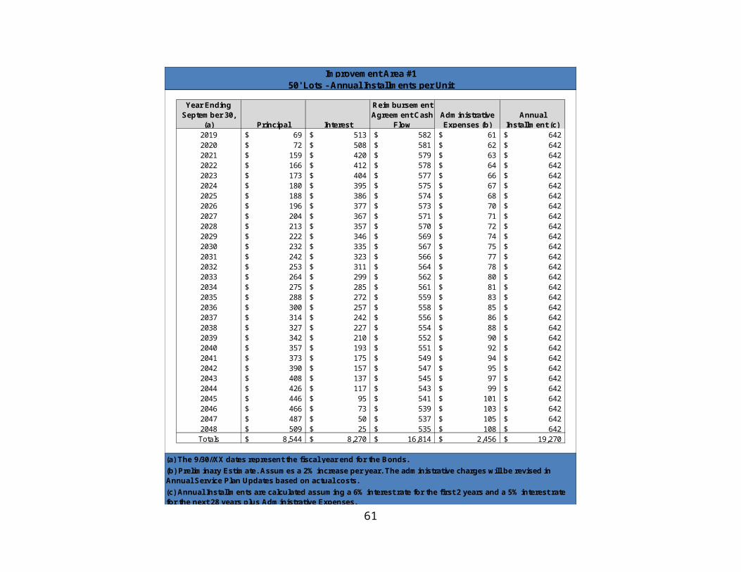
a distance of 308.87 feet;
THENCE with said curve to the right an arc distance of 310.14 feet to a 5/8 inch iron rod with a yellow plastic cap stamped “DUNAWAY ASSOC. LP” set for the point of reverse curvature of a curve to the left having a radius of 612.00 feet, a central angle of 01 degree 29 minutes 47 seconds, and a chord bearing of South 12 degrees 42 minutes 28 seconds East, a distance of 15.98 feet;
THENCE with said curve to the left an arc distance of 15.98 feet to a 5/8 inch iron rod with a yellow plastic cap stamped “DUNAWAY ASSOC. LP” set for the point of reverse curvature of a curve to the right having a radius of 1004.50 feet, a central angle of 08 degrees 27 minutes 45 seconds, and a chord bearing of South 09 degrees 13 minutes 29 seconds East, a distance of 148.23 feet;
THENCE with said curve to the right an arc distance of 148.36 feet to a 5/8 inch iron rod with a yellow plastic cap stamped “DUNAWAY ASSOC. LP” set for the point of compound curvature of a curve to the right having a radius of 138.00 feet, a central angle of 90 degrees 27 minutes 45 seconds, and a chord bearing of South 40 degrees 14 minutes 16 seconds West, a distance of 195.95 feet;
THENCE with said curve to the right an arc distance of 217.88 feet to a 5/8 inch iron rod with a yellow plastic cap stamped “DUNAWAY ASSOC. LP” set for the end of curve;
THENCE North 79 degrees 03 minutes 38 seconds West, a distance of 461.79 feet to a 5/8 inch iron rod with a yellow plastic cap stamped “DUNAWAY ASSOC. LP” set for the point of curvature of a curve to the left having a radius of 1105.00 feet, a central angle of 32 degrees 23 minutes 14 seconds, and a chord bearing of South 84 degrees 44 minutes 45 seconds West, a distance of 616.34 feet;
THENCE with said curve to the left an arc distance of 624.62 feet to a 5/8 inch iron rod with a yellow plastic cap stamped “DUNAWAY ASSOC. LP” set for the end of curve;
THENCE South 19 degrees 31 minutes 47 seconds West, a distance of 468.98 feet to a 5/8 inch iron rod with a yellow plastic cap stamped “DUNAWAY ASSOC. LP” set for the point of curvature of a curve to the left having a radius of 1806.29 feet, a central angle of 23 degrees 45 minutes 46 seconds, and a chord bearing of South 08 degrees 04 minutes 14 seconds West, a distance of 743.78 feet;
THENCE with said curve to the left an arc distance of 749.14 feet, to a 5/8 inch iron rod with a yellow plastic cap stamped “DUNAWAY ASSOC. LP” set for the point of tangency;
THENCE South 07 degrees 06 minutes 11 seconds East, a distance of 193.87 feet to a 5/8 inch iron rod with a yellow plastic cap stamped “DUNAWAY ASSOC. LP” set in the north right-of-way line of Interstate Highway 30 (a variable width right-of-way);
THENCE with the north right-of-way line of said Interstate Highway 30 and Interstate
66

Highway 20 (a variable width right-of-way) the following courses and distances:
South 87 degrees 58 minutes 15 seconds West, a distance of 544.40 feet to an aluminum TXDOT disc found;
North 79 degrees 44 minutes 29 seconds West, a distance of 102.61 feet to an aluminum TXDOT disc found;
South 87 degrees 59 minutes 03 seconds West, a distance of 199.99 feet to an aluminum TXDOT disc found;
South 75 degrees 36 minutes 14 seconds West, a distance of 102.49 feet to an aluminum TXDOT disc found;
South 88 degrees 00 minutes 36 seconds West, a distance of 78.27 feet to an aluminum TXDOT disc found for the point of curvature of a curve to the right having a radius of 1398.07 feet, a central angle of 31 degrees 36 minutes 57 seconds, and a chord bearing of North 76 degrees 10 minutes 56 seconds West, a distance of 761.70 feet;
With said curve to the right an arc distance of 771.45’, to an aluminum TXDOT disc found for the point of tangency;
North 60 degrees 16 minutes 55 seconds West, a distance of 728.27 feet to an aluminum TXDOT disc found;
North 52 degrees 51 minutes 48 seconds West, a distance of 205.86 feet to an aluminum TXDOT disc found;
North 65 degrees 36 minutes 35 seconds West, a distance of 204.62 feet to an aluminum TXDOT disc found;
North 78 degrees 21 minutes 11 seconds West, a distance of 205.92 feet to an aluminum TXDOT disc found for the point of curvature of a curve to the left having a radius of 3027.79 feet, a central angle of 07 degrees 38 minutes 27 seconds, and a chord bearing of North 75 degrees 04 minutes 32 seconds West, a distance of 403.48 feet;
With said curve to the left an arc distance of 403.78’, to an aluminum TXDOT disc found for the point of tangency;
North 78 degrees 57 minutes 26 seconds West, a distance of 1709.53 feet to an aluminum TXDOT disc found for the point of curvature of a curve to the right having a radius of 5693.90 feet, a central angle of 10 degrees 27 minutes 29 seconds, and a chord bearing of North 73 degrees 43 minutes 41 seconds West, a distance of 1037.85 feet;
67

With said curve to the right an arc distance of 1039.29’, to an aluminum TXDOT disc found for the point of tangency;
North 67 degrees 25 minutes 24 seconds West, a distance of 1369.53 feet to a 5/8 inch iron rod with a yellow plastic cap stamped “DUNAWAY ASSOC. LP” set for the point of curvature of a curve to the left having a radius of 5815.38 feet, a central angle of 03 degrees 38 minutes 25 seconds, and a chord bearing of North 69 degrees 14 minutes 36 seconds West, a distance of 369.41 feet;
With said curve to the left an arc distance of 369.48’, to a 5/8 inch iron rod with a yellow plastic cap stamped “DUNAWAY ASSOC. LP” set for the end of curve;
THENCE North 25 degrees 57 minutes 28 seconds East, a distance of 36.78 feet to a 5/8 inch iron rod with a yellow plastic cap stamped “DUNAWAY ASSOC. LP” set for the point of curvature of a curve to the right having a radius of 2050.00 feet, a central angle of 14 degrees 24 minutes 02 seconds, and a chord bearing of North 33 degrees 09 minutes 29 seconds East, a distance of 513.89 feet;
THENCE with said curve to the right an arc distance of 515.24 feet to a 5/8 inch iron rod with a yellow plastic cap stamped “DUNAWAY ASSOC. LP” set for the point of tangency;
THENCE North 40 degrees 21 minutes 30 seconds East, a distance of 652.96 feet to a 5/8 inch iron rod with a yellow plastic cap stamped “DUNAWAY ASSOC. LP” set for the point of curvature of a curve to the left having a radius of 1250.00 feet, a central angle of 14 degrees 30 minutes 52 seconds, and a chord bearing of North 33 degrees 06 minutes 04 seconds East, a distance of 315.81 feet;
THENCE with said curve to the left an arc distance of 316.66 feet to a 5/8 inch iron rod with a yellow plastic cap stamped “DUNAWAY ASSOC. LP” set for the point of tangency;
THENCE North 25 degrees 50 minutes 38 seconds East, a distance of 777.57 feet to a 5/8 inch iron rod with a yellow plastic cap stamped “DUNAWAY ASSOC. LP” set for the point of curvature of a curve to the left having a radius of 750.00 feet, a central angle of 40 degrees 20 minutes 08 seconds, and a chord bearing of North 05 degrees 40 minutes 34 seconds East, a distance of 517.16 feet;
THENCE with said curve to the left an arc distance of 527.99 feet to a 5/8 inch iron rod with a yellow plastic cap stamped “DUNAWAY ASSOC. LP” set for the point of tangency;
THENCE North 14 degrees 29 minutes 30 seconds West, a distance of 437.61 feet to a 5/8 inch iron rod with a yellow plastic cap stamped “DUNAWAY ASSOC. LP” set for the point of curvature of a curve to the right having a radius of 900.00 feet, a central angle of 34 degrees 12 minutes 30 seconds, and a chord bearing of North 02 degrees 36 minutes 45 seconds
68

East, a distance of 529.40 feet;
THENCE with said curve to the right an arc distance of 537.34 feet to a 5/8 inch iron rod with a yellow plastic cap stamped “DUNAWAY ASSOC. LP” set for the point of tangency;
THENCE North 19 degrees 43 minutes 00 seconds East, a distance of 354.73 feet to a 5/8 inch iron rod with a yellow plastic cap stamped “DUNAWAY ASSOC. LP” set;
THENCE North 00 degrees 30 minutes 14 seconds West, a distance of 213.86 feet to the POINT OF BEGINNING and containing 52,773,514 square feet or 1,211.51 acres of land more or less.
TRACT 2 (Quail Valley)
Being a 411.43 acre tract of land situated in the Houston Tap & Brazoria RR Co Survey, Abstract Number 654, the International & Great Northern RR Co Survey, Abstract Number 2004, Jonathan Burleson Survey, Abstract Number 78 and the M.C Moulton Survey, Abstract Number 934, Parker and Tarrant County, being part of a tract of land described in deed to Walsh Ranches Limited Partnership, as recorded in Volume 1699, Page 1765, Deed Records, Parker County, Texas (D.R.P.C.T), as previously described in deed recorded in Volume 237, Page 562, D.R.P.C.T., and recorded in Volume 12624, Page 92, Deed Records, Tarrant County, Texas (D.R.T.C.T), said 411.43 acre tract of land being more particularly described as follows:
COMMENCING at a steel axle found for the most easterly northeast corner of said Walsh Ranches Limited Partnership tract;
THENCE South 89 degrees 49 minutes 28 seconds West a distance of 909.63 feet to a 5/8 inch iron rod with a yellow plastic cap stamped “DUNAWAY ASSOC. LP” set for corner for the POINT OF BEGINNING, said corner being on a circular curve to the right having a radius of 1022.00 feet, a central angle of 61 degrees 31 minutes 09 seconds, and a chord bearing of South 29 degrees 01 minutes 57 seconds West, a distance of 1045.38 feet;
THENCE with said curve to the right an arc distance of 1097.33 feet to a 5/8 inch iron rod with a yellow plastic cap stamped “DUNAWAY ASSOC. LP” set for the point of reverse curvature of a curve to the left having a radius of 1022.00, a central angle of 32 degrees 17 minutes 50 seconds, and a chord bearing of South 43 degrees 38 minutes 37 seconds West, a distance of 568.50 feet;
THENCE with said curve to the left an arc distance of 576.09 feet to a 5/8 inch iron rod with a yellow plastic cap stamped “DUNAWAY ASSOC. LP” set for the point of curvature of a compound curve to the left having a radius of 2300.00, a central angle of 34 degrees 48 minutes 57 seconds, and a chord bearing of South 10 degrees 05 minutes 14 seconds West, a distance of 1376.19 feet;
69

THENCE with said curve to the left an arc distance of 1397.59 feet to a 5/8 inch iron rod with a yellow plastic cap stamped “DUNAWAY ASSOC. LP” set for the point of curvature of a circular curve to the right having a radius of 1300.00, a central angle of 26 degrees 55 minutes 47 seconds, and a chord bearing of South 06 degrees 08 minutes 39 seconds West, a distance of 605.41 feet;
THENCE with said curve to the right an arc distance of 611.01 feet to a 5/8 inch iron rod with a yellow plastic cap stamped “DUNAWAY ASSOC. LP” set for corner, said corner being on a circular curve to the left having a radius of 1855.00, a central angle of 06 degrees 19 minutes 35 seconds, and a chord bearing of North 85 degrees 25 minutes 29 seconds West, a distance of 204.72 feet;
THENCE with said curve to the left an arc distance of 204.82 feet to a 5/8 inch iron rod with a yellow plastic cap stamped “DUNAWAY ASSOC. LP” set for the point of tangency;
THENCE North 88 degrees 35 minutes 16 seconds West a distance of 734.26 feet to a 5/8 inch iron rod with a yellow plastic cap stamped “DUNAWAY ASSOC. LP” set for the point of curvature to the right having a radius of 1445.00 feet, a central angle of 08 degrees 46 minutes 19 seconds, and a chord bearing of North 84 degrees 12 minutes 07 seconds West, a distance of 221.01 feet;
THENCE with said curve to the right an arc distance of 221.23 feet to a 5/8 inch iron rod with a yellow plastic cap stamped “DUNAWAY ASSOC. LP” set for the point of tangency;THENCE North 79 degrees 48 minutes 58 seconds West a distance of 302.82 feet to a 5/8 inch iron rod with a yellow plastic cap stamped “DUNAWAY ASSOC. LP” set for the point of curvature to the left having a radius of 1555.00 feet, a central angle of 27 degrees 35 minutes 31 seconds, and a chord bearing of North 86 degrees 23 minutes 17 seconds West, a distance of 741.63 feet;
THENCE with said curve to the left an arc distance of 748.84 feet to a 5/8 inch iron rod with a yellow plastic cap stamped “DUNAWAY ASSOC. LP” set for the point of tangency;
THENCE South 72 degrees 35 minutes 31 seconds West a distance of 339.75 feet to a 5/8 inch iron rod with a yellow plastic cap stamped “DUNAWAY ASSOC. LP” set for the point of curvature to the right having a radius of 1845.00 feet, a central angle of 09 degrees 54 minutes 08 seconds, and a chord bearing of South 77 degrees 32 minutes 36 seconds West, a distance of 318.47 feet;
THENCE with said curve to the right an arc distance of 318.87 feet to a 5/8 inch iron rod with a yellow plastic cap stamped “DUNAWAY ASSOC. LP” set for the point of curvature of a compound curve to the right having a radius of 83.00, a central angle of 09 degrees 21 minutes 17 seconds, and a chord bearing of South 87 degrees 10 minutes 18 seconds West, a distance of 13.54 feet;
THENCE with said curve to the right an arc distance of 13.55 feet to a 5/8 inch iron rod
70

with a yellow plastic cap stamped “DUNAWAY ASSOC. LP” set for point of tangency;
THENCE North 88 degrees 09 minutes 03 seconds West a distance of 67.57 feet to a 5/8 inch iron rod with a yellow plastic cap stamped “DUNAWAY ASSOC. LP” set for the point of curvature to the left having a radius of 267.00 feet, a central angle of 05 degrees 58 minutes 53 seconds, and a chord bearing of South 88 degrees 51 minutes 30 seconds West, a distance of 27.86 feet;
THENCE with said curve to the left an arc distance of 27.87 feet to a 5/8 inch iron rod with a yellow plastic cap stamped “DUNAWAY ASSOC. LP” set for the point of reverse curvature of a curve to the right having a radius of 1833.00, a central angle of 02 degrees 31 minutes 51 seconds, and a chord bearing of South 87 degrees 07 minutes 59 seconds West, a distance of 80.96 feet;
THENCE with said curve to the right an arc distance of 80.97 feet to a 5/8 inch iron rod with a yellow plastic cap stamped “DUNAWAY ASSOC. LP” set for the point of tangency;
THENCE South 88 degrees 25 minutes 41 seconds West a distance of 50.60 feet to a 5/8 inch iron rod with a yellow plastic cap stamped “DUNAWAY ASSOC. LP” set for corner;
THENCE South 88 degrees 48 minutes 51 seconds West a distance of 48.15 feet to a 5/8 inch iron rod with a yellow plastic cap stamped “DUNAWAY ASSOC. LP” set for corner on a circular curve to the right having a radius of 138.00, a central angle of 28 degrees 07 minutes 19 seconds, and a chord bearing of North 61 degrees 29 minutes 46 seconds West, a distance of 67.06 feet;
THENCE with said curve to the right an arc distance of 67.73 feet to an ‘X’ cut in concrete for corner;
THENCE North 45 degrees 03 minutes 24 seconds East a distance of 10.88 feet to an ‘X’ cut in concrete for the point of curvature to the left having a radius of 107.00 feet, a central angle of 66 degrees 15 minutes 56 seconds, and a chord bearing of North 11 degrees 55 minutes 27 seconds East, a distance of 116.97 feet;
THENCE with said curve to the left an arc distance of 123.75 feet to a 5/8 inch iron rod with a yellow plastic cap stamped “DUNAWAY ASSOC. LP” set for the point of reverse curvature of a curve to the right having a radius of 193.00, a central angle of 21 degrees 16 minutes 50 seconds, and a chord bearing of North 10 degrees 34 minutes 06 seconds West, a distance of 71.27 feet;
THENCE with said curve to the right an arc distance of 71.68 feet to a 5/8 inch iron rod with a yellow plastic cap stamped “DUNAWAY ASSOC. LP” set for the point of reverse curvature of a curve to the left having a radius of 257.00, a central angle of 64 degrees 38 minutes 14 seconds, and a chord bearing of North 32 degrees 14 minutes 49 seconds West, a distance of 274.80 feet;
71

THENCE with said curve to the left an arc distance of 289.93 feet to a 5/8 inch iron rod with a yellow plastic cap stamped “DUNAWAY ASSOC. LP” set for the point of reverse curvature of a curve to the right having a radius of 253.00, a central angle of 81 degrees 13 minutes 26 seconds, and a chord bearing of North 23 degrees 57 minutes 13 seconds West, a distance of 329.37 feet;
THENCE with said curve to the right an arc distance of 358.66 feet to a 5/8 inch iron rod with a yellow plastic cap stamped “DUNAWAY ASSOC. LP” set for the point of reverse curvature of a curve to the left having a radius of 377.00, a central angle of 66 degrees 03 minutes 23 seconds, and a chord bearing of North 16 degrees 22 minutes 11 seconds West, a distance of 410.97 feet;
THENCE with said curve to the left an arc distance of 434.64 feet to a 5/8 inch iron rod with a yellow plastic cap stamped “DUNAWAY ASSOC. LP” set for the point of reverse curvature of a curve to the right having a radius of 273.00, a central angle of 56 degrees 29 minutes 27 seconds, and a chord bearing of North 21 degrees 09 minutes 09 seconds West, a distance of 258.39 feet;
THENCE with said curve to the right an arc distance of 269.17 feet to a 5/8 inch iron rod with a yellow plastic cap stamped “DUNAWAY ASSOC. LP” set for the point of reverse curvature of a curve to the left having a radius of 257.00, a central angle of 43 degrees 41 minutes 19 seconds, and a chord bearing of North 14 degrees 45 minutes 05 seconds West, a distance of 191.25 feet;THENCE with said curve to the left an arc distance of 195.96 feet to a 5/8 inch iron rod with a yellow plastic cap stamped “DUNAWAY ASSOC. LP” set for the point of reverse curvature of a curve to the right having a radius of 268.00, a central angle of 69 degrees 51 minutes 02 seconds, and a chord bearing of North 01 degrees 40 minutes 13 seconds West, a distance of 306.86 feet;
THENCE with said curve to the right an arc distance of 326.72 feet to a 5/8 inch iron rod with a yellow plastic cap stamped “DUNAWAY ASSOC. LP” set for the point of reverse curvature of a curve to the left having a radius of 307.00, a central angle of 60 degrees 52 minutes 48 seconds, and a chord bearing of North 02 degrees 48 minutes 54 seconds East, a distance of 311.07 feet;
THENCE with said curve to the left an arc distance of 326.20 feet to a 5/8 inch iron rod with a yellow plastic cap stamped “DUNAWAY ASSOC. LP” set for the point of reverse curvature of a curve to the right having a radius of 233.00, a central angle of 56 degrees 37 minutes 31 seconds, and a chord bearing of North 00 degrees 41 minutes 16 seconds East, a distance of 221.02 feet;
THENCE with said curve to the right an arc distance of 230.27 feet to a 5/8 inch iron rod with a yellow plastic cap stamped “DUNAWAY ASSOC. LP” set for the point of reverse curvature of a curve to the left having a radius of 127.00, a central angle of 106 degrees 07 minutes 38 seconds, and a chord bearing of North 24 degrees 03 minutes 48 seconds West, a distance of 203.02 feet;
72
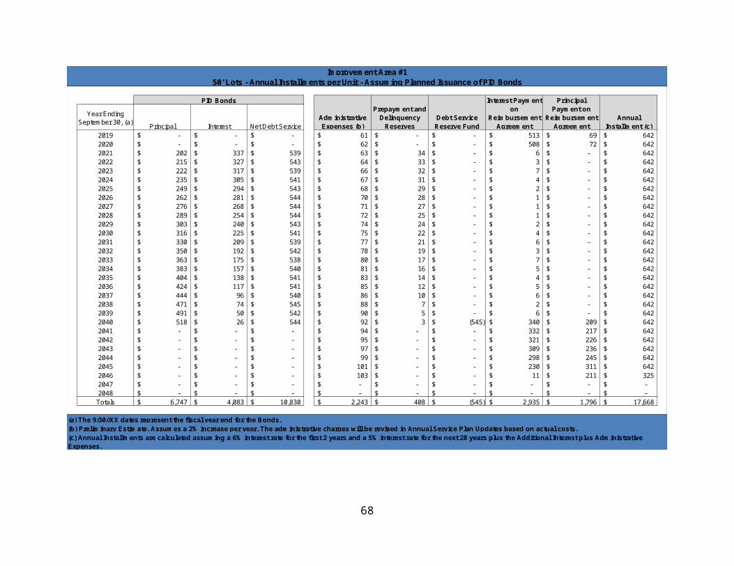
THENCE with said curve to the left an arc distance of 235.24 feet to a 5/8 inch iron rod with a yellow plastic cap stamped “DUNAWAY ASSOC. LP” set for corner;
THENCE North 26 degrees 08 minutes 54 seconds West a distance of 247.14 feet to a 5/8 inch iron rod with a yellow plastic cap stamped “DUNAWAY ASSOC. LP” set for corner;
THENCE North 71 degrees 08 minutes 54 seconds West a distance of 64.62 feet to a 5/8 inch iron rod with a yellow plastic cap stamped “DUNAWAY ASSOC. LP” set for corner;
THENCE North 26 degrees 08 minutes 54 seconds West a distance of 379.60 feet to a 5/8 inch iron rod with a yellow plastic cap stamped “DUNAWAY ASSOC. LP” set for corner;
THENCE North 28 degrees 26 minutes 20 seconds West a distance of 116.36 feet to a 5/8 inch iron rod with a yellow plastic cap stamped “DUNAWAY ASSOC. LP” set for corner;
THENCE North 16 degrees 39 minutes 10 seconds East a distance of 135.76 feet to a 5/8 inch iron rod with a yellow plastic cap stamped “DUNAWAY ASSOC. LP” set for corner;
THENCE North 28 degrees 20 minutes 50 seconds West a distance of 703.92 feet to a 5/8 inch iron rod with a yellow plastic cap stamped “DUNAWAY ASSOC. LP” set for corner;THENCE North 73 degrees 20 minutes 50 seconds West a distance of 36.77 feet to a 5/8 inch iron rod with a yellow plastic cap stamped “DUNAWAY ASSOC. LP” set for corner;
THENCE South 63 degrees 51 minutes 06 seconds West a distance of 115.61 feet to a 5/8 inch iron rod with a yellow plastic cap stamped “DUNAWAY ASSOC. LP” set for corner;
THENCE North 26 degrees 08 minutes 54 seconds West a distance of 331.47 feet to a 5/8 inch iron rod with a yellow plastic cap stamped “DUNAWAY ASSOC. LP” set for point of curvature to the right having a radius of 1018.00 feet, a central angle of 06 degrees 58 minutes 24 seconds, and a chord bearing of North 22 degrees 39 minutes 42 seconds West, a distance of 123.82 feet;
THENCE with said curve to the right an arc distance of 123.90 feet to a 5/8 inch iron rod with a yellow plastic cap stamped “DUNAWAY ASSOC. LP” set for corner;
THENCE North 70 degrees 49 minutes 30 seconds East a distance of 0.50 feet to a 5/8 inch iron rod with a yellow plastic cap stamped “DUNAWAY ASSOC. LP” set for corner, said corner being on a circular curve to the right having a radius of 1017.50 feet, a central angle of 17 degrees 33 minutes 02 seconds, and a chord bearing of North 10 degrees 33 minutes 59 seconds West, a distance of 310.46 feet;
THENCE with said curve to the right an arc distance of 311.67 feet to a 5/8 inch iron rod with a yellow plastic cap stamped “DUNAWAY ASSOC. LP” set for the point of tangency;
THENCE North 01 degrees 37 minutes 29 seconds West a distance of 1823.60 feet to a 5/8
73

inch iron rod with a yellow plastic cap stamped “DUNAWAY ASSOC. LP” set for corner, said corner being on a circular curve to the left having a radius of 15.50 feet, a central angle of 25 degrees 45 minutes 03 seconds, and a chord bearing of North 11 degrees 04 minutes 42 seconds East, a distance of 6.91 feet;
THENCE with said curve to the left an arc distance of 6.97 feet to a 5/8 inch iron rod with a yellow plastic cap stamped “DUNAWAY ASSOC. LP” set for the point of tangency;
THENCE North 01 degrees 47 minutes 49 seconds West a distance of 17.00 feet to a 5/8 inch iron rod with a yellow plastic cap stamped “DUNAWAY ASSOC. LP” set for the point of curvature of a curve to the left having a radius of 15.50 feet, a central angle of 25 degrees 36 minutes 41 seconds, and a chord bearing of North 14 degrees 36 minutes 10 seconds West, a distance of 6.87 feet;
THENCE with said curve to the left an arc distance of 6.93 feet to a 5/8 inch iron rod with a yellow plastic cap stamped “DUNAWAY ASSOC. LP” set for corner, said corner being on a circular curve to the left having a radius of 3335.00 feet, a central angle of 03 degrees 47 minutes 41 seconds, and a chord bearing of North 03 degrees 54 minutes 25 seconds West, a distance of 220.83 feet;THENCE with said curve to the left an arc distance of 220.87 feet to a 5/8 inch iron rod with a yellow plastic cap stamped “DUNAWAY ASSOC. LP” set for corner;
THENCE South 84 degrees 11 minutes 45 seconds West a distance of 152.50 feet to a 5/8 inch iron rod with a yellow plastic cap stamped “DUNAWAY ASSOC. LP” set for corner, said corner being on a circular curve to the right having a radius of 3182.50 feet, a central angle of 00 degrees 29 minutes 37 seconds, and a chord bearing of South 05 degrees 33 minutes 27 seconds East, a distance of 27.41 feet;
THENCE with said curve to the right an arc distance of 27.41 feet to a 5/8 inch iron rod with a yellow plastic cap stamped “DUNAWAY ASSOC. LP” set for corner;
THENCE South 39 degrees 59 minutes 42 seconds West a distance of 34.41 feet to a 5/8 inch iron rod with a yellow plastic cap stamped “DUNAWAY ASSOC. LP” set for corner;
THENCE North 55 degrees 36 minutes 07 seconds West a distance of 7.05 feet to a 5/8 inch iron rod with a yellow plastic cap stamped “DUNAWAY ASSOC. LP” set for the point of curvature of a curve to the left having a radius of 207.00 feet, a central angle of 62 degrees 22 minutes 05 seconds, and a chord bearing of North 86 degrees 47 minutes 09 seconds West, a distance of 214.36 feet;
THENCE with said curve to the left an arc distance of 225.33 feet to a 5/8 inch iron rod with a yellow plastic cap stamped “DUNAWAY ASSOC. LP” set for the point of reverse curvature of a curve to the right having a radius of 218.00, a central angle of 69 degrees 49 minutes 51 seconds, and a chord bearing of North 83 degrees 03 minutes 16 seconds West, a distance of 249.55 feet;
74

THENCE with said curve to the right an arc distance of 265.69 feet to a 5/8 inch iron rod with a yellow plastic cap stamped “DUNAWAY ASSOC. LP” set for the point of reverse curvature of a curve to the left having a radius of 207.00, a central angle of 59 degrees 22 minutes 57 seconds, and a chord bearing of North 77 degrees 49 minutes 49 seconds West, a distance of 205.07 feet;THENCE with said curve to the left an arc distance of 214.54 feet to a 5/8 inch iron rod with a yellow plastic cap stamped “DUNAWAY ASSOC. LP” set for the point of tangency;THENCE South 72 degrees 28 minutes 42 seconds West a distance of 78.56 feet to a 5/8 inch iron rod with a yellow plastic cap stamped “DUNAWAY ASSOC. LP” set for the point of curvature of a curve to the right having a radius of 143.00 feet, a central angle of 50 degrees 42 minutes 13 seconds, and a chord bearing of North 82 degrees 10 minutes 11 seconds West, a distance of 122.46 feet;
THENCE with said curve to the right an arc distance of 126.55 feet to a 5/8 inch iron rod with a yellow plastic cap stamped “DUNAWAY ASSOC. LP” set for the point of reverse curvature of a curve to the left having a radius of 427.00, a central angle of 36 degrees 59 minutes 24 seconds, and a chord bearing of North 75 degrees 18 minutes 47 seconds West, a distance of 270.91 feet;
THENCE with said curve to the left an arc distance of 275.67 feet to a 5/8 inch iron rod with a yellow plastic cap stamped “DUNAWAY ASSOC. LP” set for the point of reverse curvature of a curve to the right having a radius of 593.00 feet, a central angle of 36 degrees 45 minutes 17 seconds, and a chord bearing of North 75 degrees 25 minutes 53 seconds West, a distance of 373.90 feet;
THENCE with said curve to the right an arc distance of 380.39 feet to a 5/8 inch iron rod with a yellow plastic cap stamped “DUNAWAY ASSOC. LP” set for the point of reverse curvature of a curve to the left having a radius of 207.00, a central angle of 58 degrees 39 minutes 22 seconds, and a chord bearing of North 86 degrees 22 minutes 58 seconds West, a distance of 202.78 feet;
THENCE with said curve to the left an arc distance of 211.91 feet to a 5/8 inch iron rod with a yellow plastic cap stamped “DUNAWAY ASSOC. LP” set for the point of reverse curvature of a curve to the right having a radius of 93.00 feet, a central angle of 26 degrees 50 minutes 37 seconds, and a chord bearing of South 77 degrees 42 minutes 40 seconds West, a distance of 43.17 feet;
THENCE with said curve to the right an arc distance of 43.57 feet to a 5/8 inch iron rod with a yellow plastic cap stamped “DUNAWAY ASSOC. LP” set for the point of tangency;
THENCE North 88 degrees 52 minutes 02 seconds West a distance of 21.21 feet to a 5/8 inch iron rod with a yellow plastic cap stamped “DUNAWAY ASSOC. LP” set for corner, said corner being on a circular curve to the right having a radius of 60.00 feet, a central angle of 40 degrees 01 minutes 07 seconds, and a chord bearing of North 17 degrees 18 minutes 33 seconds West, a distance of 41.06 feet;
75

THENCE with said curve to the right an arc distance of 41.91feet to a 5/8 inch iron rod with a yellow plastic cap stamped “DUNAWAY ASSOC. LP” set for the point of tangency;
THENCE North 02 degrees 42 minutes 00 seconds East a distance of 35.97 feet to a 5/8 inch iron rod with a yellow plastic cap stamped “DUNAWAY ASSOC. LP” set for the point of curvature of a circular curve to the right having a radius of 65.00 feet, a central angle of 53 degrees 30 minutes 46 seconds, and a chord bearing of North 29 degrees 27 minutes 23 seconds East, a distance of 58.53 feet;
THENCE with said curve to the right an arc distance of 60.71 feet to a 5/8 inch iron rod with a yellow plastic cap stamped “DUNAWAY ASSOC. LP” set for corner near the south side of Old Weatherford Road (undedicated);
THENCE North 72 degrees 21 minutes 50 seconds East, near a wire fence along the south side of said Old Weatherford Road, a distance of 328.98 feet to a 5/8 inch iron rod with yellow cap stamped "DUNAWAY ASSOC. LP" set near the west end of a bridge for corner;
THENCE North 83 degrees 23 minutes 06 seconds East, near said bridge and said Old Weatherford Road, a distance of 59.65 feet to the approximate centerline of Mary’s Creek;
THENCE along the approximate centerline of Mary’s Creek the following courses and distances:
South 55 degrees 36 minutes 16 seconds East, a distance of 79.20 feet to a point for corner;
South 78 degrees 55 minutes 26 seconds East, a distance of 98.53 feet to a point for corner;
South 87 degrees 17 minutes 32 seconds East, a distance of 78.41 feet to a point for corner;
North 87 degrees 23 minutes 48 seconds East, a distance of 95.05 feet to a point for corner;
South 63 degrees 48 minutes 53 seconds East, a distance of 92.77 feet to a point for corner;
South 70 degrees 42 minutes 53 seconds East, a distance of 72.59 feet to a point for corner;
South 83 degrees 45 minutes 43 seconds East, a distance of 60.03 feet to a point for corner;
North 65 degrees 28 minutes 24 seconds East, a distance of 45.32 feet to a point for corner;
76

North 51 degrees 48 minutes 31 seconds East, a distance of 138.31 feet to a point for corner;
South 78 degrees 47 minutes 12 seconds East, a distance of 46.06 feet to a point for corner;
South 49 degrees 50 minutes 11 seconds East, a distance of 203.84 feet to a point for corner;
South 66 degrees 19 minutes 25 seconds East, a distance of 73.83 feet to a point for corner;
South 85 degrees 53 minutes 12 seconds East, a distance of 59.42 feet to a point for corner;
North 59 degrees 52 minutes 11 seconds East, a distance of 197.53 feet to a point for corner;
North 64 degrees 16 minutes 04 seconds East, a distance of 98.27 feet to a point for corner;
North 60 degrees 39 minutes 19 seconds East, a distance of 178.82 feet to a point for corner;
North 70 degrees 49 minutes 25 seconds East, a distance of 73.88 feet to a point for corner;
North 57 degrees 57 minutes 58 seconds East, a distance of 104.85 feet to a point for corner on the east line of said Walsh Ranches Limited Partnership tract and the west line of a tract of land described in deed to Donald L. Pengelly and Joan Pengelly, as recorded in Volume 1448, Page 483, D.R.P.C.T.;
THENCE South 00 degrees 46 minutes 40 seconds East, along the east line of said Walsh Ranches Limited Partnership tract, passing a railroad spike found at a distance of 627.00 feet for the southwest corner of said Pengelly tract, passing a 1/2 inch iron rod found at a distance of 2235.76 feet for the northwest corner of a tract (Tract I) of land described in deed to W.C. Weeden, Trustee, as recorded in Volume 1505, Page 743, D.R.P.C.T., continuing a total distance of distance of 2700.06 feet to a stone found for an ell corner of said Walsh Ranches Limited Partnership tract;
THENCE North 89 degrees 27 minutes 32 seconds East, along said Walsh Ranches Limited Partnership tract, a distance of 3530.15 feet to a stone found for an ell corner of said Walsh Ranches Limited Partnership tract;
THENCE South 00 degrees 43 minutes 04 seconds East, along said Walsh Ranches Limited
77

Partnership tract, a distance of 1251.87 feet to a fence corner post found for an ell corner of said Walsh Ranches Limited Partnership tract;
THENCE North 89 degrees 49 minutes 28 seconds East a distance of 2473.87 feet to the POINT OF BEGINNING and containing 17,922,035 square feet or 411.43 acres of land more or less.
TRACT 3 (Old Weatherford Road)
Being a 7.210 acre tract of land situated in the International & Great Northern RR Co Survey, Abstract Number 2004, the Heirs of C.H. Higbee Survey, Abstract Number 2740, and the M.C Moulton Survey, Abstract Number 934, Parker County, being part of the tract of land described in the deed to Walsh Ranches Limited Partnership, recorded in Volume 1699, Page 1765, Deed Records, Parker County, Texas, said 7.210 acre tract of land being more particularly described as follows:
COMMENCING at a stone found for the southwest corner of the John Kelsey Survey, Abstract Number 782, a re-entrant corner of the International & Great Northern RR Co Survey, Abstract Number 2004;
THENCE with an east line of said Walsh Ranches tract and the west lines of the tract of land described in the deed to John and Mary Lowery, recorded in Volume 1540, Page 1666, Deed Records, Parker County, Texas, the tract of land described in the deed to Debra Faye Johnson Head, recorded in Volume 1410, Page 829, Deed Records, Parker County, Texas, and the tract of land described in the deed to Mary's Creek Properties, recorded in Volume 1848, Page 1466, Deed Records, Parker County, Texas North 00°46'53” West a distance of 2022.31 feet to a point from which a 1 inch iron rod found for the point of commencing of Tract II in the deed to John and Mary Lowery and the called northwest corner of the John Kelsey Survey bears North 00°46'53” West a distance of 737.21 feet;
THENCE departing said east and west lines South 89°13'07” West a distance of 284.77 feet to a 5/8 inch iron rod with a yellow plastic cap stamped “DUNAWAY ASSOC. LP” set for the point of curvature of a non-tangent curve to the left having a radius of 1037.00 feet, a central angle of 11°36'01”, and a chord bearing and distance of South 78°01'58” West 209.59 feet, and the POINT OF BEGINNING;
THENCE with said non-tangent curve to the left an arc distance of 209.95 feet to a 5/8 inch iron rod with a yellow plastic cap stamped “DUNAWAY ASSOC. LP” set for the point of reverse curvature of a curve to the right having a radius of 1076.50 feet, a central angle of 51°45'52”, and a chord bearing and distance of North 81°53'07” West 939.83 feet;
THENCE with said reverse curve to the right an arc distance of 972.57 feet to a 5/8 inch iron rod with a yellow plastic cap stamped “DUNAWAY ASSOC. LP” set for the point of reverse curvature of a curve to the left having a radius of 1023.50 feet, a central angle of
78

31°17'49”, and a chord bearing and distance North 71°39'05” West 552.15 feet;
THENCE with said reverse curve to the left an arc distance of 559.07 feet to a 5/8 inch iron rod with a yellow plastic cap stamped “DUNAWAY ASSOC. LP” set for the point of tangency;
THENCE North 87°18'00” West a distance of 146.19 feet to a 5/8 inch iron rod with a yellow plastic cap stamped “DUNAWAY ASSOC. LP” set; THENCE North 02°42'00” East a distance of 53.00 feet to a 5/8 inch iron rod with a yellow plastic cap stamped “DUNAWAY ASSOC. LP” set;
THENCE South 87°18'00” East a distance of 13.00 feet to a 5/8 inch iron rod with a yellow plastic cap stamped “DUNAWAY ASSOC. LP” set for the point of curvature of a curve to the left having a radius of 17.00 feet, a central angle of 90°00'00”, and a chord bearing and distance of North 47°42'00” East 24.04 feet;
THENCE with said curve to the left an arc distance of 26.70 feet to a 5/8 inch iron rod with a yellow plastic cap stamped “DUNAWAY ASSOC. LP” set for the point of tangency;
THENCE North 02°42'00” East a distance of 50.38 feet to a 5/8 inch iron rod with a yellow plastic cap stamped “DUNAWAY ASSOC. LP” set for the point of curvature of a curve to the left having a radius of 65.00 feet, a central angle of 77°04'41”, and a chord bearing and distance of North 35°50'20” West 81.00 feet;
THENCE with said curve to the left an arc distance of 87.44 feet to a 5/8 inch iron rod with a yellow plastic cap stamped “DUNAWAY ASSOC. LP” set for the end of curve in the occupied southerly line of Old Weatherford Road;
THENCE with the occupied southerly line of Old Weatherford Road, North 82°36'43” East a distance of 122.71 feet to a 5/8 inch iron rod with a yellow plastic cap stamped “DUNAWAY ASSOC. LP” set for the beginning of a non-tangent curve to the left having a radius of 65.00 feet, a central angle of 53°30'46”, and a chord bearing and distance of South 29°27'23” West 58.53 feet;
THENCE departing the occupied southerly line of Old Weatherford Road, with said non-tangent curve to the left an arc distance of 60.71 feet to a 5/8 inch iron rod with a yellow plastic cap stamped “DUNAWAY ASSOC. LP” set for the point of tangency;
THENCE South 02°42'00” West a distance of 35.97 to a 5/8 inch iron rod with a yellow plastic cap stamped “DUNAWAY ASSOC. LP” set for the point of curvature of a curve to the left having a radius of 60.00 feet, a central angle of 40°01'07”, and a chord bearing and distance of South 17°18'33” East 41.06 feet;
THENCE with said curve to the left an arc distance of 41.91 feet to a 5/8 inch iron rod with a yellow plastic cap stamped “DUNAWAY ASSOC. LP” set for the end of curve;
THENCE South 88°52'02” East a distance of 20.21 feet to a 5/8 inch iron rod with a yellow
79

plastic cap stamped “DUNAWAY ASSOC. LP” set for the point of curvature of a curve to the left having a radius of 93.00 feet, a central angle of 26°50'37”, and a chord bearing and distance of North 77°42'40” East 43.17 feet;
THENCE with said curve to the left an arc distance of 43.57 feet to a 5/8 inch iron rod with a yellow plastic cap stamped “DUNAWAY ASSOC. LP” set for the point of reverse curvature of a curve to the right having a radius of 207.00 feet, a central angle of 58°39'22”, and a chord bearing and distance of South 86°22'58” East 202.78 feet;
THENCE with said reverse curve to the right an arc distance of 211.91 feet to a 5/8 inch iron rod with a yellow plastic cap stamped “DUNAWAY ASSOC. LP” set for the point of reverse curvature of a curve to the left having radius of 593.00 feet, a central angle of 36°45'12”, and a chord bearing and distance of South 75°25'53” East 373.90 feet;
THENCE with said reverse curve to the left an arc distance of 380.39 feet to a 5/8 inch iron rod with a yellow plastic cap stamped “DUNAWAY ASSOC. LP” set for the point of reverse curvature of a curve to the right having radius of 427.00 feet, a central angle of 36°59'24”, and a chord bearing and distance of South 75°18'47” East 270.91 feet;
THENCE with said reverse curve to the right an arc distance of 275.67 feet to a 5/8 inch iron rod with a yellow plastic cap stamped “DUNAWAY ASSOC. LP” set for the point of reverse curvature of a curve to the left having radius of 143.00 feet, a central angle of 50°42'13”, and a chord bearing and distance of South 82°10'11” East 122.46 feet;
THENCE with said reverse curve to the left an arc distance of 126.55 feet to a 5/8 inch iron rod with a yellow plastic cap stamped “DUNAWAY ASSOC. LP” set for the point of tangency;
THENCE North 72°28'42” East a distance of 78.56 feet to a 5/8 inch iron rod with a yellow plastic cap stamped “DUNAWAY ASSOC. LP” set for the point of curvature of a curve to the right having a radius of 207.00 feet, a central angle of 59°22'57”, and a chord bearing and distance of South 77°49'49” East 205.07 feet;
THENCE with said curve to the right an arc distance of 214.54 feet to a 5/8 inch iron rod with a yellow plastic cap stamped “DUNAWAY ASSOC. LP” set for the point of reverse curvature of a curve to the left having radius of 218.00 feet, a central angle of 69°49'51”, and a chord bearing and distance of South 83°03'16” East 249.55 feet;
THENCE with said reverse curve to the left an arc distance of 265.69 feet to a 5/8 inch iron rod with a yellow plastic cap stamped “DUNAWAY ASSOC. LP” set for the point of reverse curvature of a curve to the right having radius of 207.00 feet, a central angle of 62°22'05”, and a chord bearing and distance of South 86°47'09” East 214.36 feet;
THENCE with said reverse curve to the right an arc distance of 225.33 feet to a 5/8 inch iron rod with a yellow plastic cap stamped “DUNAWAY ASSOC. LP” set for the point of tangency;
80
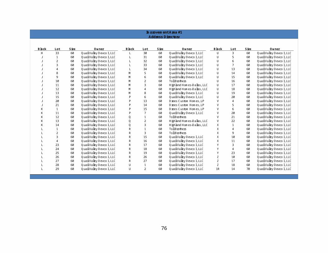
THENCE South 55°36'07” East a distance of 7.05 feet to a 5/8 inch iron rod with a yellow plastic cap stamped “DUNAWAY ASSOC. LP” set;THENCE South 39°59'42” West a distance of 47.89 feet to a 5/8 inch iron rod with a yellow plastic cap stamped “DUNAWAY ASSOC. LP” set;
THENCE South 83°49'58” West a distance of 14.46 feet to a 5/8 inch iron rod with a yellow plastic cap stamped “DUNAWAY ASSOC. LP” set;
THENCE South 06°10'02” East a distance of 57.00 feet to the POINT OF BEGINNING.
Containing a computed area of 314,077 square feet or 7.210 acres of land.
TRACT 4 (Walsh Ranch Parkway)
Being a 93.178 acre tract of land situated in the Houston Tap & Brazoria RR Co Survey, Abstract Number 654, the International & Great Northern RR Co Survey, Abstract Number 2004, the Heirs of C.H. Higbee Survey, Abstract Number 2740, and the M.C Moulton Survey, Abstract Number 934, Parker County, being part of Tract A described in the deed recorded in Volume 2072, Page 983, Deed Records, Parker County, Texas, also being part of the tract of land described in the deed to Walsh Ranches Limited Partnership, recorded in Volume 1699, Page 1765, Deed Records, Parker County, Texas, said 93.178 acre tract of land being more particularly described as follows:
COMMENCING at a 5/8 inch iron rod with a yellow plastic cap stamped “DUNAWAY ASSOC. LP” set at the intersection of the northerly right-of-way line of Interstate Highway 30 (a variable width right-of-way) and the Tarrant County and Parker County line;
THENCE with the northerly right-of-way line of Interstate Highway 30 the following courses and distances:
South 89°34'23” West a distance of 384.74 feet to a 5/8 inch iron rod with a yellow plastic cap stamped “DUNAWAY ASSOC. LP” set;
North 61°50'37” West a distance of 67.00 feet to a 5/8 inch iron rod with a yellow plastic cap stamped “DUNAWAY ASSOC. LP” set;
North 88°21'37” West a distance of 198.31 feet to a Texas Department of Transportation monument found;
South 68°32'23” West a distance of 54.63 feet to a Texas Department of Transportation monument found;
North 87°42'45” West a distance of 1100.00 feet to a Texas Department of Transportation monument found;
81

North 63°57'37” West a distance of 54.63 feet to a Texas Department of Transportation monument found;
North 87°10'37” West a distance of 148.10 feet;
South 70°28'23” West a distance of 53.84 feet to a Texas Department of Transportation monument found;
North 84°10'52” West a distance of 71.36 feet to a Texas Department of Transportation monument found;
North 83°27'51” West a distance of 200.00 feet to a Texas Department of Transportation monument found for the beginning of a non-tangent curve to the left having a radius of 1947.86 feet, a central angle of 4°17'47” and a chord bearing and distance of North 85°36'17” West 146.03 feet;
With said non-tangent curve to the left an arc distance of 146.07 feet to the end of curve;
THENCE departing the northerly right-of-way line of Interstate Highway 30, North 02°13'26” East a distance of 121.47 feet to a 5/8 inch iron rod with a yellow plastic cap stamped “DUNAWAY ASSOC. LP” set for the POINT OF BEGINNING;
THENCE West a distance of 175.00 feet to a 5/8 inch iron rod with a yellow plastic cap stamped “DUNAWAY ASSOC. LP” set;
THENCE North a distance of 106.00 feet to a 5/8 inch iron rod with a yellow plastic cap stamped “DUNAWAY ASSOC. LP” set for the point of curvature of a tangent curve to the right having a radius of 612.00 feet, a central angle of 01°59'46”, and a chord bearing and distance of North 00°59'53” East 21.32 feet;
THENCE with said tangent curve to the right an arc distance of 21.32 feet to a 5/8 inch iron rod with a yellow plastic cap stamped “DUNAWAY ASSOC. LP” set for the point of reverse curvature of a curve to the left having a radius of 988.00, a central angle of 17°51'20”, and a chord bearing and distance of North 06°55'54” West 306.65 feet;
THENCE with said reverse curve to the left an arc distance of 307.90 feet to a 5/8 inch iron rod with a yellow plastic cap stamped “DUNAWAY ASSOC. LP” set for the point of tangency;
THENCE North 15°51'34” West a distance of 93.20 feet to a 5/8 inch iron rod with a yellow plastic cap stamped “DUNAWAY ASSOC. LP” set for the point of curvature of a curve to the right having a radius of 1083.50, a central angle of 14°15'22”, and a chord bearing and distance of North 08°43'53” West 268.90 feet;
THENCE with said curve to the right an arc distance of 269.59 feet to a 5/8 inch iron rod with a yellow plastic cap stamped “DUNAWAY ASSOC. LP” set for the point of reverse curvature of a curve to the left having a radius of 238.00, a central angle of 65°41'31”, and a
82

chord bearing and distance of North 34°26'58” West 258.17 feet;
THENCE with said reverse curve to the left an arc distance of 272.88 feet to a 5/8 inch iron rod with a yellow plastic cap stamped “DUNAWAY ASSOC. LP” set for the end of curve;
THENCE North 79°03'38” West a distance of 58.53 feet to a 5/8 inch iron rod with a yellow plastic cap stamped “DUNAWAY ASSOC. LP” set;
THENCE North 10°56'22” East a distance of 122.00 feet to a 5/8 inch iron rod with a yellow plastic cap stamped “DUNAWAY ASSOC. LP” set;
THENCE South 79°03'38” East a distance of 70.31 feet to a 5/8 inch iron rod with a yellow plastic cap stamped “DUNAWAY ASSOC. LP” set for the point of curvature of a non-tangent curve to the left having a radius of 138.00, a central angle of 90°27'45”, and a chord bearing and distance of North 40°14'16” East 195.95 feet;
THENCE with said non-tangent curve to the left an arc distance of 217.88 feet to a 5/8 inch iron rod with a yellow plastic cap stamped “DUNAWAY ASSOC. LP” set for the point of compound curvature of a curve to the left having a radius of 1004.50 feet, a central angle of 08°27'45”, and a chord bearing and distance of North 09°13'29” West 148.23 feet;
THENCE with said compound curve to the left an arc distance of 148.36 feet to a 5/8 inch iron rod with a yellow plastic cap stamped “DUNAWAY ASSOC. LP” set for the point of reverse curvature of a curve to the right having a radius of 612.00, a central angle of 01°29'47”, and a chord bearing and distance of North 12°42'28” West 15.98 feet;
THENCE with said reverse curve to the right an arc distance of 15.98 feet to a 5/8 inch iron rod with a yellow plastic cap stamped “DUNAWAY ASSOC. LP” set for the point of reverse curvature of a curve to the left having a radius of 988.00, a central angle of 17°59'08”, and a chord bearing and distance of North 20°57'08” West 308.87 feet;THENCE with said reverse curve to the left an arc distance of 310.14 feet to a 5/8 inch iron rod with a yellow plastic cap stamped “DUNAWAY ASSOC. LP” set for the point of reverse curvature of a curve to the right having a radius of 1083.50, a central angle of 28°36'02”, and a chord bearing and distance of North 15°38'42” West 535.26 feet;
THENCE with said reverse curve to the right an arc distance of 540.85 feet to a 5/8 inch iron rod with a yellow plastic cap stamped “DUNAWAY ASSOC. LP” set for the point of tangency;
THENCE North 01°20'41” West a distance of 133.67 feet to a 5/8 inch iron rod with a yellow plastic cap stamped “DUNAWAY ASSOC. LP” set for the point of curvature of a curve to the left having a radius of 1016.50, a central angle of 15°47'29”, and a chord bearing and distance of North 09°14'25” West 279.27 feet;
THENCE with said curve to the left an arc distance of 280.16 feet to a 5/8 inch iron rod with a yellow plastic cap stamped “DUNAWAY ASSOC. LP” set for the point of compound
83

curvature of a curve to the left having a radius of 989.60, a central angle of 04°30'39”, and a chord bearing and distance of North 19°22'32” West 77.89 feet;
THENCE with said compound curve to the left an arc distance of 77.91 feet to a 5/8 inch iron rod with a yellow plastic cap stamped “DUNAWAY ASSOC. LP” set for the end of curve;
THENCE North 21°37'58” West a distance of 116.87 feet to a 5/8 inch iron rod with a yellow plastic cap stamped “DUNAWAY ASSOC. LP” set for the point of curvature of a curve to the right having a radius of 1012.00, a central angle of 06°01'18”, and a chord bearing and distance of North 18°37'19” West 106.31 feet;
THENCE with said curve to the right an arc distance of 106.36 feet to a 5/8 inch iron rod with a yellow plastic cap stamped “DUNAWAY ASSOC. LP” set for the point of compound curvature of a curve to the right having a radius of 1095.50, a central angle of 17°13'58”, and a chord bearing and distance of North 06°59'41” West 328.25 feet;
THENCE with said compound curve to the right an arc distance of 329.49 feet to a 5/8 inch iron rod with a yellow plastic cap stamped “DUNAWAY ASSOC. LP” set for the point of tangency;
THENCE North 01°37'18” East a distance of 59.40 feet to a 5/8 inch iron rod with a yellow plastic cap stamped “DUNAWAY ASSOC. LP” set for the point of curvature of a curve to the left having a radius of 85.00 feet; a central angle of 94°01'15”, and a chord bearing and distance of North 45°23'20” West 124.35 feet;
THENCE with said curve to the left an arc distance of 139.48 feet to a 5/8 inch iron rod with a yellow plastic cap stamped “DUNAWAY ASSOC. LP” set for the point of tangency;THENCE South 87°36'03” West a distance of 15.09 feet to a 5/8 inch iron rod with a yellow plastic cap stamped “DUNAWAY ASSOC. LP” set;
THENCE North 02°23'57” West a distance of 140.41 feet to a 5/8 inch iron rod with a yellow plastic cap stamped “DUNAWAY ASSOC. LP” set;
THENCE North 87°36'03” East a distance of 13.60 feet to a 5/8 inch iron rod with a yellow plastic cap stamped “DUNAWAY ASSOC. LP” set for the point of curvature of a curve to the left having a radius of 110.00 feet; a central angle of 85°58'45”, and a chord bearing and distance of North 44°36'40” East 150.01 feet;
THENCE with said curve to the left an arc distance of 165.07 feet to a 5/8 inch iron rod with a yellow plastic cap stamped “DUNAWAY ASSOC. LP” set for the point of tangency;
THENCE North 01°37'18” East a distance of 141.88 feet to a 5/8 inch iron rod with a yellow plastic cap stamped “DUNAWAY ASSOC. LP” set for the point of curvature of a curve to the right having a radius of 612.00 feet; a central angle of 04°23'39”, and a chord bearing and distance of North 03°49'07” East 46.92 feet;
84

THENCE with said curve to the right an arc distance of 46.94 feet to a 5/8 inch iron rod with a yellow plastic cap stamped “DUNAWAY ASSOC. LP” set for the point of reverse curvature of a curve to the left having a radius of 988.00 feet, a central angle of 08°10'18”, and a chord bearing and distance North 01°18'56” West 140.79 feet;
THENCE with said reverse curve to the left an arc distance of 140.91 feet to a 5/8 inch iron rod with a yellow plastic cap stamped “DUNAWAY ASSOC. LP” set for the point of compound curvature of a curve to the left having a radius of 1018.00 feet, a central angle of 03°21'56”, and a chord bearing and distance of North 10°40'28” West 59.79 feet;
THENCE with said compound curve to the left an arc distance of 59.80 feet to a 5/8 inch iron rod with a yellow plastic cap stamped “DUNAWAY ASSOC. LP” set for the end of curve;
THENCE North 65°20'07” West a distance of 199.81 feet to a 5/8 inch iron rod with a yellow plastic cap stamped “DUNAWAY ASSOC. LP” set;
THENCE North 24°04'08” West a distance of 651.54 feet to a 5/8 inch iron rod with a yellow plastic cap stamped “DUNAWAY ASSOC. LP” set for the point of curvature of a curve to the right having a radius of 100.00 feet, a central angle of 35°28'59”, and a chord bearing and distance of North 06°19'38” West 60.94 feet;
THENCE with said curve to the right an arc distance of 61.93 feet to a 5/8 inch iron rod with a yellow plastic cap stamped “DUNAWAY ASSOC. LP” set for the point of reverse curvature of a curve to the left having a radius of 200.00 feet, a central angle of 24°05'05”, and a chord bearing and distance of North 00°37'41” West 83.45 feet;
THENCE with said reverse curve to the left an arc distance of 84.07 feet to a 5/8 inch iron rod with a yellow plastic cap stamped “DUNAWAY ASSOC. LP” set for the point of reverse curvature of a curve to the right having a radius of 193.00 feet, a central angle of 24°51'04”, and a chord bearing and distance of North 00°14'42” West 83.06 feet;
THENCE with said reverse curve to the right an arc distance of 83.71 feet to a 5/8 inch iron rod with a yellow plastic cap stamped “DUNAWAY ASSOC. LP” set for the point of reverse curvature of a curve to the left having a radius of 127.00 feet, a central angle of 43°22'47”, and a chord bearing and distance of North 09°30'34” West 93.87 feet;
THENCE with said reverse curve to the left an arc distance of 96.15 feet to a 5/8 inch iron rod with a yellow plastic cap stamped “DUNAWAY ASSOC. LP” set for the point of reverse curvature of a curve to the right having a radius of 453.00 feet, a central angle of 38°38'54”, and a chord bearing and distance of North 11°52'31” West 299.81 feet;
THENCE with said reverse curve to the right an arc distance of 305.57 feet to a 5/8 inch iron rod with a yellow plastic cap stamped “DUNAWAY ASSOC. LP” set for the point of reverse curvature of a curve to the left having a radius of 837.00 feet, a central angle of 20°46'55”, and a chord bearing and distance of North 02°56'31” West 301.93 feet;
85
THENCE with said reverse curve to the left an arc distance of 303.59 feet to a 5/8 inch iron rod with a yellow plastic cap stamped “DUNAWAY ASSOC. LP” set for the point of reverse curvature of a curve to the right having a radius of 443.00 feet, a central angle of 15°47'58”, and a chord bearing and distance of North 05°26'00” West 121.77 feet;
THENCE with said reverse curve to the right an arc distance of 122.16 feet to a 5/8 inch iron rod with a yellow plastic cap stamped “DUNAWAY ASSOC. LP” set for the point of reverse curvature of a curve to the left having a radius of 407.00 feet, a central angle of 34°47'54”, and a chord bearing and distance of North 14°55'58” West 243.41 feet;
THENCE with said reverse curve to the left an arc distance of 247.19 feet to a 5/8 inch iron rod with a yellow plastic cap stamped “DUNAWAY ASSOC. LP” set for the point of reverse curvature of a curve to the right having a radius of 603.00 feet, a central angle of 32°28'53”, and a chord bearing and distance of North 16°05'29” West 337.29 feet;
THENCE with said reverse curve to the right an arc distance of 341.84 feet to a 5/8 inch iron rod with a yellow plastic cap stamped “DUNAWAY ASSOC. LP” set for the point of tangency;
THENCE North 00°08'58” East a distance of 257.44 feet to a 5/8 inch iron rod with a yellow plastic cap stamped “DUNAWAY ASSOC. LP” set for the point of curvature of a curve to the right having a radius of 783.00 feet, a central angle of 19°59'11”, and a chord bearing and distance of North 10°08'33” East 271.75 feet;
THENCE with said curve to the right an arc distance of 273.13 feet to a 5/8 inch iron rod with a yellow plastic cap stamped “DUNAWAY ASSOC. LP” set for the point of reverse curvature of a curve to the left having a radius of 517.00 feet, a central angle of 18°34'00”, and a chord bearing and distance of North 10°51'08” East 116.80 feet;
THENCE with said reverse curve to the left an arc distance of 167.53 feet to a 5/8 inch iron rod with a yellow plastic cap stamped “DUNAWAY ASSOC. LP” set for the point of reverse curvature of a curve to the right having a radius of 193.00 feet, a central angle of 44°10'32”, and a chord bearing and distance of North 23°39'24” East 145.15 feet;
THENCE with said reverse curve to the right an arc distance of 148.81 feet to a 5/8 inch iron rod with a yellow plastic cap stamped “DUNAWAY ASSOC. LP” set for the beginning of a non-tangent curve to the left having a radius of 1598.00 feet, a central angle of 08°48'07”, and a chord bearing and distance of North 02°46'35” East 245.25 feet;
THENCE with said non-tangent curve to the left an arc distance of 245.49 feet to a 5/8 inch iron rod with a yellow plastic cap stamped “DUNAWAY ASSOC. LP” set for the point of tangency;
THENCE North 01°37'29” West a distance of 132.96 feet to a 5/8 inch iron rod with a yellow plastic cap stamped “DUNAWAY ASSOC. LP” set for the point of curvature of a curve to the left having a radius of 3154.50 feet, a central angle of 00°41'44”, and a chord bearing
86
and distance of North 01°58'20” West 38.29 feet;
THENCE with said curve to the left an arc distance of 38.29 feet to a 5/8 inch iron rod with a yellow plastic cap stamped “DUNAWAY ASSOC. LP” set for the point of curvature of a curve to the left having a radius of 1037.00 feet, a central angle of 02°09'38”, and a chord bearing and distance of South 81°42'27” West 39.10 feet;
THENCE with said curve to the left an arc distance of 39.10 feet to a 5/8 inch iron rod with a yellow plastic cap stamped “DUNAWAY ASSOC. LP” set for the end of curve;
THENCE North 06°10'02” West a distance of 108.52 feet to a 5/8 inch iron rod with a yellow plastic cap stamped “DUNAWAY ASSOC. LP” set;
THENCE North 83°49'58” East a distance of 14.46 feet to a 5/8 inch iron rod with a yellow plastic cap stamped “DUNAWAY ASSOC. LP” set;
THENCE North 39°59'42” East a distance of 82.30 feet to a 5/8 inch iron rod with a yellow plastic cap stamped “DUNAWAY ASSOC. LP” set for the beginning of a non-tangent curve to the left having a radius of 3182.50 feet, a central angle of 00°29'37”, and a chord bearing and distance of North 05°33'27” West 27.41 feet;
THENCE with said non-tangent curve to the left an arc distance of 27.41 feet to a 5/8 inch iron rod with a yellow plastic cap stamped “DUNAWAY ASSOC. LP” set for the end of curve;
THENCE North 84°11'45” East a distance of 152.50 feet to a 5/8 inch iron rod with a yellow plastic cap stamped “DUNAWAY ASSOC. LP” set for the beginning of a non-tangent curve to the right having a radius of 3335.00 feet, a central angle of 03°47'41”, and a chord bearing and distance of South 03°54'25” East 220.83 feet;
THENCE with said non-tangent curve to the right an arc distance of 220.87 feet to a 5/8 inch iron rod with a yellow plastic cap stamped “DUNAWAY ASSOC. LP” set for the beginning of a non-tangent curve to the right having a radius of 15.50 feet, a central angle of 25°36'41”, and a chord bearing and distance of South 14°36'10” East 6.87 feet;
THENCE with said non-tangent curve to the right an arc distance of 6.93 feet to a 5/8 inch iron rod with a yellow plastic cap stamped “DUNAWAY ASSOC. LP” set for the point of tangency;
THENCE South 01°47'49” East a distance of 17.00 feet to a 5/8 inch iron rod with a yellow plastic cap stamped “DUNAWAY ASSOC. LP” set for the point of curvature of a curve to the right having a radius of 15.50 feet, a central angle of 25°45'03”, and a chord bearing and distance of South 11°04'42” West 6.91 feet;
THENCE with said curve to the right an arc distance of 6.97 feet to a 5/8 inch iron rod with a yellow plastic cap stamped “DUNAWAY ASSOC. LP” set for the end of curve;
87

THENCE South 01°37'29” East a distance of 1823.60 feet to a 5/8 inch iron rod with a yellow plastic cap stamped “DUNAWAY ASSOC. LP” set for the point of curvature of a curve to the left having a radius of 1017.50 feet, a central angle of 17°33'02”, and a chord bearing and distance of South 10°23'59” East 310.46 feet;
THENCE with said curve to the left an arc distance of 311.67 feet to a 5/8 inch iron rod with a yellow plastic cap stamped “DUNAWAY ASSOC. LP” set for the end of curve;
THENCE South 70°49'30” West a distance of 0.50 feet to a 5/8 inch iron rod with a yellow plastic cap stamped “DUNAWAY ASSOC. LP” set for the beginning of a non-tangent curve to the left having a radius of 1018.00 feet, a central angle of 06°58'24”, and a chord bearing and distance of South 22°39'42” East 123.82 feet;
THENCE with said curve to the left an arc distance of 123.90 feet to a 5/8 inch iron rod with a yellow plastic cap stamped “DUNAWAY ASSOC. LP” set for the point of tangency;
THENCE South 26°08'54” East a distance of 331.47 feet to a 5/8 inch iron rod with a yellow plastic cap stamped “DUNAWAY ASSOC. LP” set;
THENCE North 63°51'06” East a distance of 115.61 feet to a 5/8 inch iron rod with a yellow plastic cap stamped “DUNAWAY ASSOC. LP” set;
THENCE South 73°20'50” East a distance of 36.77 feet to a 5/8 inch iron rod with a yellow plastic cap stamped “DUNAWAY ASSOC. LP” set;
THENCE South 28°20'50” East a distance of 703.92 feet to a 5/8 inch iron rod with a yellow plastic cap stamped “DUNAWAY ASSOC. LP” set;
THENCE South 16°39'10” West a distance of 135.76 feet to a 5/8 inch iron rod with a yellow plastic cap stamped “DUNAWAY ASSOC. LP” set;
THENCE South 28°26'20” East a distance of 116.36 feet to a 5/8 inch iron rod with a yellow plastic cap stamped “DUNAWAY ASSOC. LP” set;
THENCE South 26°08'54” East a distance of 379.60 feet to a 5/8 inch iron rod with a yellow plastic cap stamped “DUNAWAY ASSOC. LP” set;
THENCE South 71°08'54” East a distance of 64.62 feet to a 5/8 inch iron rod with a yellow plastic cap stamped “DUNAWAY ASSOC. LP” set;
THENCE South 26°08'54” East a distance of 247.14 feet to a 5/8 inch iron rod with a yellow plastic cap stamped “DUNAWAY ASSOC. LP” set for the beginning of a non-tangent curve to the right having a radius of 127.00 feet, a central angle of 106°07'38”, and a chord bearing and distance of South 24°03'48” East 203.02 feet;
THENCE with said non-tangent curve to the right an arc distance of 235.24 feet to a 5/8
88

inch iron rod with a yellow plastic cap stamped “DUNAWAY ASSOC. LP” set for the point of reverse curvature of a curve to the left having a radius of 233.00 feet, a central angle of 56°37'31”, and a chord bearing and distance of South 00°41'16” West 221.02 feet;
THENCE with said reverse curve to the left an arc distance of 230.27 feet to a 5/8 inch iron rod with a yellow plastic cap stamped “DUNAWAY ASSOC. LP” set for the point of reverse curvature of a curve to the right having a radius of 307.00 feet, a central angle of 60°52'48”, and a chord bearing and distance of South 02°48'54” West 311.07 feet;
THENCE with said reverse curve to the right an arc distance of 326.20 feet to a 5/8 inch iron rod with a yellow plastic cap stamped “DUNAWAY ASSOC. LP” set for the point of reverse curvature of a curve to the left having a radius of 268.00 feet, a central angle of 69°51'02”, and a chord bearing and distance of South 01°40'13” East 306.86 feet;
THENCE with said reverse curve to the left an arc distance of 326.72 feet to a 5/8 inch iron rod with a yellow plastic cap stamped “DUNAWAY ASSOC. LP” set for the point of reverse curvature of a curve to the right having a radius of 257.00 feet, a central angle of 43°41'19”, and a chord bearing and distance of South 14°45'05” East 191.25 feet;
THENCE with said reverse curve to the right an arc distance of 195.96 feet to a 5/8 inch iron rod with a yellow plastic cap stamped “DUNAWAY ASSOC. LP” set for the point of reverse curvature of a curve to the left having a radius of 273.00 feet, a central angle of 56°29'27”, and a chord bearing and distance of South 21°09'09” East 258.39 feet;
THENCE with said reverse curve to the left an arc distance of 269.17 feet to a 5/8 inch iron rod with a yellow plastic cap stamped “DUNAWAY ASSOC. LP” set for the point of reverse curvature of a curve to the right having a radius of 377.00 feet, a central angle of 66°03'23”, and a chord bearing and distance of South 16°22'11” East 410.97 feet;
THENCE with said reverse curve to the right an arc distance of 434.64 feet to a 5/8 inch iron rod with a yellow plastic cap stamped “DUNAWAY ASSOC. LP” set for the point of reverse curvature of a curve to the left having a radius of 253.00 feet, a central angle of 81°13'26”, and a chord bearing and distance of South 23°57'13” East 329.37 feet;
THENCE with said reverse curve to the left an arc distance of 358.66 feet to a 5/8 inch iron rod with a yellow plastic cap stamped “DUNAWAY ASSOC. LP” set for the point of reverse curvature of a curve to the right having a radius of 257.00 feet, a central angle of 64°38'14”, and a chord bearing and distance of South 32°14'49” East 274.80 feet;
THENCE with said reverse curve to the right an arc distance of 289.93 feet to a 5/8 inch iron rod with a yellow plastic cap stamped “DUNAWAY ASSOC. LP” set for the point of reverse curvature of a curve to the left having a radius of 193.00 feet, a central angle of 21°16'50”, and a chord bearing and distance of South 10°34'06” East 71.27 feet;
THENCE with said reverse curve to the left an arc distance of 71.68 feet to a 5/8 inch iron rod with a yellow plastic cap stamped “DUNAWAY ASSOC. LP” set for the point of reverse
89

curvature of a curve to the right having a radius of 107.00 feet, a central angle of 66°15'56”, and a chord bearing and distance of South 11°55'27” West 116.97 feet;
THENCE with said reverse curve to the right an arc distance of 123.75 feet to a 5/8 inch iron rod with a yellow plastic cap stamped “DUNAWAY ASSOC. LP” set for the point of tangency;
THENCE South 45°03'24” West a distance of 10.88 feet to a 5/8 inch iron rod with a yellow plastic cap stamped “DUNAWAY ASSOC. LP” set for the beginning of a non-tangent curve to the left having a radius of 138.00 feet, a central angle of 28°07'19”, and a chord bearing and distance of South 61°29'46” East 67.06 feet;
THENCE with said non-tangent curve to the left an arc distance of 67.73 feet to a 5/8 inch iron rod with a yellow plastic cap stamped “DUNAWAY ASSOC. LP” set for the end of curve;
THENCE North 88°48'51” East a distance of 48.15 feet to a 5/8 inch iron rod with a yellow plastic cap stamped “DUNAWAY ASSOC. LP” set;
THENCE South 01°53'58” East a distance of 122.00 feet to a 5/8 inch iron rod with a yellow plastic cap stamped “DUNAWAY ASSOC. LP” set for the beginning of a non-tangent curve to the right having a radius of 2055.00 feet, a central angle of 04°06'49”, and a chord bearing and distance of North 89°50'33” West 147.51 feet;
THENCE with said non-tangent curve to the right distance of 147.54 feet to a 5/8 inch iron rod with a yellow plastic cap stamped “DUNAWAY ASSOC. LP” set for the end of curve;
THENCE South 48°03'01” West a distance of 28.56 feet to a 5/8 inch iron rod with a yellow plastic cap stamped “DUNAWAY ASSOC. LP” set;
THENCE South 03°36'26” West a distance of 13.81 feet to a 5/8 inch iron rod with a yellow plastic cap stamped “DUNAWAY ASSOC. LP” set;
THENCE North 86°23'34” West a distance of 87.00 feet to a 5/8 inch iron rod with a yellow plastic cap stamped “DUNAWAY ASSOC. LP” set;
THENCE North 03°36'26” East a distance of 2.38 feet to a 5/8 inch iron rod with a yellow plastic cap stamped “DUNAWAY ASSOC. LP” set;
THENCE North 40°27'49” West a distance of 28.74 feet to a 5/8 inch iron rod with a yellow plastic cap stamped “DUNAWAY ASSOC. LP” set for the beginning of a non-tangent curve to the right having a radius of 2067.00 feet, a central angle of 00°02'39”, and a chord bearing and distance of North 84°14'06” West 1.59 feet;
THENCE with said non-tangent curve to the right an arc distance of 1.59 feet to a 5/8 inch iron rod with a yellow plastic cap stamped “DUNAWAY ASSOC. LP” set for the beginning of a non-tangent curve to the left having a radius of 119.00 feet, a central angle of 22°22'37”,
90

and a chord bearing and distance of South 79°49'37” West 46.18 feet;
THENCE with said non-tangent curve to the left an arc distance of 46.48 feet to a 5/8 inch iron rod with a yellow plastic cap stamped “DUNAWAY ASSOC. LP” set for the point of reverse curvature of a curve to the right having a radius of 157.00 feet, a central angle of 23°32'18”, and a chord bearing and distance of South 80°24'28” West 64.05 feet;
THENCE with said reverse curve to the right an arc distance of 64.50 feet to a 5/8 inch iron rod with a yellow plastic cap stamped “DUNAWAY ASSOC. LP” set for the point of reverse curvature of a curve to the left having a radius of 93.00 feet, a central angle of 78°12'12”, and a chord bearing and distance of South 53°04'31” West 117.31 feet;
THENCE with said reverse curve to the left an arc distance of 126.94 feet to a 5/8 inch iron rod with a yellow plastic cap stamped “DUNAWAY ASSOC. LP” set for the point of reverse curvature of a curve to the right having a radius of 132.00 feet, a central angle of 48°43'44”, and a chord bearing and distance of South 38°20'17” West 108.91 feet;
THENCE with said reverse curve to the right an arc distance of 112.26 feet to a 5/8 inch iron rod with a yellow plastic cap stamped “DUNAWAY ASSOC. LP” set for the point of reverse curvature of a curve to the left having a radius of 268.00 feet, a central angle of 84°38'01”, and a chord bearing and distance of South 20°23'08” West 360.85 feet;
THENCE with said reverse curve to the left an arc distance of 395.87 feet to a 5/8 inch iron rod with a yellow plastic cap stamped “DUNAWAY ASSOC. LP” set for the point of reverse curvature of a curve to the right having a radius of 257.00 feet, a central angle of 38°58'12”, and a chord bearing and distance of South 02°26'46” East 171.45 feet;
THENCE with said reverse curve to the right an arc distance of 174.80 feet to a 5/8 inch iron rod with a yellow plastic cap stamped “DUNAWAY ASSOC. LP” set for the point of reverse curvature of a curve to the left having a radius of 168.00 feet, a central angle of 47°18'47”, and a chord bearing and distance of South 06°37'04” East 134.81 feet;
THENCE with said reverse curve to the left an arc distance of 138.73 feet to a 5/8 inch iron rod with a yellow plastic cap stamped “DUNAWAY ASSOC. LP” set for the point of reverse curvature of a curve to the right having a radius of 106.00 feet, a central angle of 14°17'17”, and a chord bearing and distance of South 23°07'49” East 26.37 feet;
THENCE with said reverse curve to the right an arc distance of 26.43 feet to the POINT OF BEGINNING.
Containing a computed area of 4,058,831 square feet or 93.178 acres of land.
SAVE AND EXCEPT (AISD School Site)
91
BEING situated in the International & Great Northern R.R. Co. Survey, Abstract No. 1996, Parker County, Texas, and being a portion of a tract of land as described in deed to Walsh Ranches Limited Partnership, a Texas Limited Partnership having a General Partner named Walsh North Star Company, a Texas corporation as recorded in Volume 1699, Page 1765 of the Deed Records of Parker County, Texas (D.R.P.C.T.), and being more particularly described as follows: COMMENCING at a 5/8 inch iron rod found with cap stamped “DUNAWAY ASSOC. LP” at the northwest corner of the intersection of the westerly right of way line of southbound Walsh Ranch Parkway(a variable width right of way) and the northerly right of way line of Walsh Creek Boulevard, as shown on the final plat of Walsh Ranch Parkway, an addition to the City of Fort Worth, Parker County, Texas, (unrecorded as of this date); THENCE, along the westerly right of way line of said southbound Walsh Ranch Parkway the following courses:
North 87 degrees 36 minutes 03 seconds East, a distance of 13.60 feet to a 5/8 inch iron rod found with cap stamped “DUNAWAY ASSOC. LP”, and being the beginning of a curve to the left having a central angle of 85 degrees 58 minutes 45 seconds, a radius of 110.00 feet, subtended by a 150.01 foot chord which bears North 44 degrees 36 minutes 40 seconds East;
Along said curve to the left an arc distance of 165.07 feet to a 5/8 inch iron rod found with cap stamped “DUNAWAY ASSOC. LP”;
North 01 degrees 37 minutes 18 seconds East, a distance of 141.88 feet to a 5/8 inch iron rod found with cap stamped “DUNAWAY ASSOC. LP”, and being the beginning of a curve to the right having a central angle of 04 degrees 23 minutes 39 seconds, a radius of 612.00 feet, subtended by a 46.92 foot chord which bears North 03 degrees 49 minutes 07 seconds East;
Along said curve to the right an arc distance of 46.94 feet to a 5/8 inch iron rod found with cap stamped “DUNAWAY ASSOC. LP”, and being the beginning of a reverse curve to the left having a central angle of 08 degrees 10 minutes 18 seconds, a radius of 988.00 feet, subtended by a 140.79 foot chord which bears North 01 degrees 18 minutes 56 seconds West;
Along said curve to the left an arc distance of 140.91 feet to a 5/8 inch iron rod found with cap stamped “DUNAWAY ASSOC. LP”, and being the beginning of a compound curve to the left having a central angle of 03 degrees 21 minutes 56 seconds, a radius of 1018.00 feet, subtended by a 59.79 foot chord which bears North 10 degrees 40 minutes 28 seconds West;
Along said curve to the left an arc distance of 59.80 feet to a 5/8 inch iron rod found
92
with cap stamped “DUNAWAY ASSOC. LP” at the south corner of Private Open Space Lot 7X, as shown on said final plat of Walsh Ranch Parkway;
THENCE, departing the westerly line of said southbound Walsh Ranch Parkway, and along the westerly line of said Private Open Space Lot 7X the following courses:
North 65 degrees 20 minutes 07 seconds West, a distance of 199.81 feet to a 5/8 inch iron rod found with cap stamped “DUNAWAY ASSOC. LP”;
North 24 degrees 04 minutes 08 seconds West, a distance of 651.54 feet to a 5/8 inch iron rod found with cap stamped “DUNAWAY ASSOC. LP”, and being the beginning of a curve to the right having a central angle of 35 degrees 28 minutes 59 seconds, a radius of 100.00 feet, subtended by a 60.94 foot chord which bears North 06 degrees 19 minutes 38 seconds West;
Along said curve to the right an arc distance of 61.93 feet to a 5/8 inch iron rod found with cap stamped “DUNAWAY ASSOC. LP”, and being the beginning of a reverse curve to the left having a central angle of 24 degrees 05 minutes 05 seconds, a radius of 200.00 feet, subtended by a 83.45 foot chord which bears North 00 degrees 37 minutes 41 seconds West;
Along said curve to the left an arc distance of 84.07 feet to a 5/8 inch iron rod found with cap stamped “DUNAWAY ASSOC. LP”, and being the beginning of a reverse curve to the right having a central angle of 24 degrees 51 minutes 04 seconds, a radius of 193.00 feet, subtended by a 83.06 foot chord which bears North 00 degrees 14 minutes 42 seconds West;
Along said curve to the right an arc distance of 83.71 feet to a 5/8 inch iron rod found with cap stamped “DUNAWAY ASSOC. LP”, and being the beginning of a reverse curve to the left having a central angle of 43 degrees 22 minutes 47 seconds, a radius of 127.00 feet, subtended by a 93.87 foot chord which bears North 09 degrees 30 minutes 34 seconds West;
Along said curve to the left an arc distance of 96.15 feet to a 5/8 inch iron rod found with cap stamped “DUNAWAY ASSOC. LP”, and being the beginning of a reverse curve to the right having a central angle of 23 degrees 50 minutes 05 seconds, a radius of 453.00 feet, subtended by a 187.09 foot chord which bears North 19 degrees 16 minutes 55 seconds West;
Along said curve to the right an arc distance of 188.45 feet to a 5/8 inch iron rod set with plastic cap stamped "Huitt-Zollars";
THENCE, South 82 degrees 00 minutes 00 seconds West, departing the westerly line of Private Open Space Lot 7X, a distance of 205.63 feet to a 5/8 inch iron rod set with plastic cap stamped "Huitt-Zollars", and being the beginning of a curve to the right having a central
93

angle of 12 degrees 20 minutes 32 seconds, a radius of 1053.00 feet, subtended by a 226.39 foot chord which bears North 88 degrees 10 minutes 16 seconds West; THENCE, along said curve to the right an arc distance of 226.83 feet to a 5/8 inch iron rod set with plastic cap stamped "Huitt-Zollars"; THENCE, North 04 degrees 20 minutes 32 seconds East, a distance of 3.00 feet to a 5/8 inch iron rod set with plastic cap stamped "Huitt-Zollars", and being the beginning of a non-tangent curve to the right having a central angle of 8 degrees 00 minutes 48 seconds, a radius of 1050.00 feet, subtended by a 146.73 foot chord which bears North 81 degrees 39 minutes 04 seconds West; THENCE, along said curve to the right an arc distance of 146.85 feet to a 5/8 inch iron rod set with plastic cap stamped "Huitt-Zollars"; THENCE, South 12 degrees 21 minutes 20 seconds West, a distance of 3.00 feet to a 5/8 inch iron rod set with plastic cap stamped "Huitt-Zollars", and being the beginning of a non-tangent curve to the right having a central angle of 9 degrees 38 minutes 40 seconds, a radius of 1053.00 feet, subtended by a 177.04 foot chord which bears North 72 degrees 49 minutes 20 seconds West; THENCE, along said curve to the right an arc distance of 177.25 feet to a 5/8 inch iron rod set with plastic cap stamped "Huitt-Zollars"; THENCE, North 68 degrees 00 minutes 00 seconds West, a distance of 355.64 feet to a 5/8 inch iron rod set with plastic cap stamped "Huitt-Zollars", and being the beginning of a curve to the left having a central angle of 47 degrees 19 minutes 24 seconds, a radius of 867.00 feet, subtended by a 695.91 foot chord which bears South 88 degrees 20 minutes 18 seconds West; THENCE, along said curve to the left an arc distance of 716.10 feet to a 5/8 inch iron rod set with plastic cap stamped "Huitt-Zollars", and being the beginning of a reverse curve to the right having a central angle of 24 degrees 50 minutes 45 seconds, a radius of 1553.00 feet, subtended by a 668.18 foot chord which bears South 77 degrees 05 minutes 59 seconds West; THENCE, along said curve to the right an arc distance of 673.44 feet to a 5/8 inch iron rod set with plastic cap stamped "Huitt-Zollars"; THENCE, South 46 degrees 00 minutes 26 seconds West, a distance of 21.66 feet to a 5/8 inch iron rod set with plastic cap stamped "Huitt-Zollars", and being the beginning of a non-tangent curve to the right having a central angle of 49 degrees 33 minutes 56 seconds, a radius of 180.00 feet, subtended by a 150.90 foot chord which bears South 29 degrees 23 minutes 10 seconds West;
94

THENCE, along said curve to the right an arc distance of 155.72 feet to a 5/8 inch iron rod set with plastic cap stamped "Huitt-Zollars", and being the beginning of a reverse curve to the left having a central angle of 53 degrees 12 minutes 42 seconds, a radius of 213.00 feet, subtended by a 190.78 foot chord which bears South 27 degrees 33 minutes 47 seconds West; THENCE, along said curve to the left an arc distance of 197.82 feet to a 5/8 inch iron rod set with plastic cap stamped "Huitt-Zollars"; THENCE, North 89 degrees 02 minutes 34 seconds West, a distance of 60.00 feet to a 5/8 inch iron rod set with plastic cap stamped "Huitt-Zollars" for the POINT OF BEGINNING; THENCE, South 84 degrees 40 minutes 28 seconds West, a distance of 624.92 feet to a 5/8 inch iron rod set with plastic cap stamped "Huitt-Zollars"; THENCE, North 81 degrees 01 minutes 12 seconds West, a distance of 547.98 feet to a 5/8 inch iron rod set with plastic cap stamped "Huitt-Zollars"; THENCE, North 00 degrees 51 minutes 28 seconds West, a distance of 567.71 feet to a 5/8 inch iron rod set with plastic cap stamped "Huitt-Zollars", and being the beginning of a non-tangent curve to the right having a central angle of 33 degrees 28 minutes 50 seconds, a radius of 1247.00 feet, subtended by a 718.36 foot chord which bears South 80 degrees 25 minutes 09 seconds East; THENCE, along said curve to the right an arc distance of 728.68 feet to a 5/8 inch iron rod set with plastic cap stamped "Huitt-Zollars", and being the beginning of a reverse curve to the left having a central angle of 23 degrees 28 minutes 38 seconds, a radius of 1553.00 feet, subtended by a 631.91 foot chord which bears South 75 degrees 25 minutes 03 seconds East; THENCE, along said curve to the left an arc distance of 636.35 feet to a 5/8 inch iron rod set with plastic cap stamped "Huitt-Zollars"; THENCE, South 42 degrees 21 minutes 01 seconds East, a distance of 21.18 feet to a 5/8 inch iron rod set with plastic cap stamped "Huitt-Zollars", and being the beginning of a non-tangent curve to the right having a central angle of 47 degrees 51 minutes 12 seconds, a radius of 120.00 feet, subtended by a 97.34 foot chord which bears South 30 degrees 14 minutes 32 seconds West; THENCE, along said curve to the right an arc distance of 100.22 feet to a 5/8 inch iron rod set with plastic cap stamped "Huitt-Zollars", and being the beginning of a reverse curve to the left having a central angle of 53 degrees 12 minutes 42 seconds, a radius of 273.00 feet, subtended by a 244.53 foot chord which bears South 27 degrees 33 minutes 47 seconds West;
95

THENCE, along said curve to the left an arc distance of 253.54 feet to the POINT OF BEGINNING and CONTAINING 14.51 acres of land, more or less.
SAVE AND EXCEPT (Quail Valley Lemons Overlap)Being a 0.4130 acre tract of land situated in the International & Great Northern RR Co Survey, Abstract Number 2004, Parker County, Texas and being part of a tract of land described in deed to Walsh Ranches Limited Partnership, as recorded in Volume 1699, Page 1765, Deed Records, Parker County, Texas (D.R.P.C.T), as previously described in deed recorded in Volume 237, Page 562, D.R.P.C.T., and recorded in Volume 12624, Page 92, Deed Records, Tarrant County, Texas (D.R.T.C.T), said tract also being a part of a tract of land described in deed to Keith D. Lemons and Pamela J. Lemons, as recorded in Volume 1552, Page 1381, D.R.P.C.T., said 0.4130 acre tract of land being more particularly described as follows:
BEGINNING at stone found for an ell corner of said Walsh Ranches Limited Partnership tract, said corner being on the south line of said Lemons tract;
THENCE South 87 degrees 24 minutes 33 seconds West, along the south line of said Lemons tract, a distance of 988.78 feet to a 5/8 inch iron rod found for the southwest corner of said Lemons tract and the southeast corner of a tract of land described in deed to John and Stacy Reding, as recorded in Instrument Number 201412020, D.R.P.C.T.,
THENCE North 40 degrees 08 minutes 24 seconds West, along the west line of said Lemons tract and the east line of said Reding tract, a distance of 45.90 feet to a point for corner on the north line of said Walsh Ranches Limited Partnership tract, from which an ell corner of said Walsh Ranches Limited Partnership tract and a point on the west line of said Reding tract bears South 89 degrees 27 minutes 32 seconds West, a distance of 2512.74 feet;
THENCE North 89 degrees 27 minutes 32 seconds East, along said Walsh Ranches Limited Partnership tract, a distance of 1017.41 feet to the POINT OF BEGINNING and containing 17,989 square feet or 0.4130 acres of land more or less.
SAVE AND EXCEPT (Quail Valley Reding Overlap)
Being a 4.8368 acre tract of land situated in the International & Great Northern RR Co Survey, Abstract Number 2004, Parker County, Texas and being part of a tract of land described in deed to Walsh Ranches Limited Partnership, as recorded in Volume 1699, Page 1765, Deed Records, Parker County, Texas (D.R.P.C.T), as previously described in deed recorded in Volume 237, Page 562, D.R.P.C.T., and recorded in Volume 12624, Page 92, Deed Records, Tarrant County, Texas (D.R.T.C.T), said tract also being a part of a tract of land described in deed to John and Stacy Reding, as recorded in Instrument Number 201412020, D.R.P.C.T., said 4.8368 acre tract of land being more particularly described as follows:
96

BEGINNING at stone found for an ell corner of said Walsh Ranches Limited Partnership tract, said corner being on the west line of said Reding tract;
THENCE North 89 degrees 27 minutes 32 seconds East, along said Walsh Ranches Limited Partnership tract, a distance of 2512.74 feet to a point for corner from which a stone found for an ell corner of said Walsh Ranches Limited Partnership tract bears North 89 degrees 27 minutes 32 seconds East, a distance of 1017.41 feet, said corner being on the east line of said Reding tract and the west line of a tract of land described in deed to Keith D. Lemons and Pamela J. Lemons, as recorded in Volume 1552, Page 1381, D.R.P.C.T.;
THENCE South 40 degrees 08 minutes 24 seconds East, along the east line of said Reding tract and the west line of said Lemons tract, a distance of 45.90 feet to a 5/8 inch iron rod found for the southeast corner of said Reding tract and the southwest corner of said Lemons tract;
THENCE South 87 degrees 18 minutes 27 seconds West, along the south line of said Reding tract, a distance of 2542.86 feet to a 1/2 inch iron rod found for the southwest corner of said Reding tract;
THENCE North 00 degrees 56 minutes 45 seconds West, along the west line of said Reding tract, a distance of 130.83 feet to the POINT OF BEGINNING and containing 210,690 square feet or 4.8368 acres of land more or less.
97