Embed Size (px)
Citation preview

April 2008April 2008
Christopher M. Hill Patrick J. Fitzpatrick Valentine G. AnantharajChristopher M. Hill Patrick J. Fitzpatrick Valentine G. AnantharajMississippi State UniversityMississippi State University
Lars-Peter RiishojgaardLars-Peter RiishojgaardGlobal Modeling and Assimilation Office / NASAGlobal Modeling and Assimilation Office / NASA
Joint Center for Satellite Data AssimilationJoint Center for Satellite Data Assimilation
An Observing System Simulation An Observing System Simulation Experiment to Evaluate ATMS and Experiment to Evaluate ATMS and
CrIS ObservationsCrIS Observations
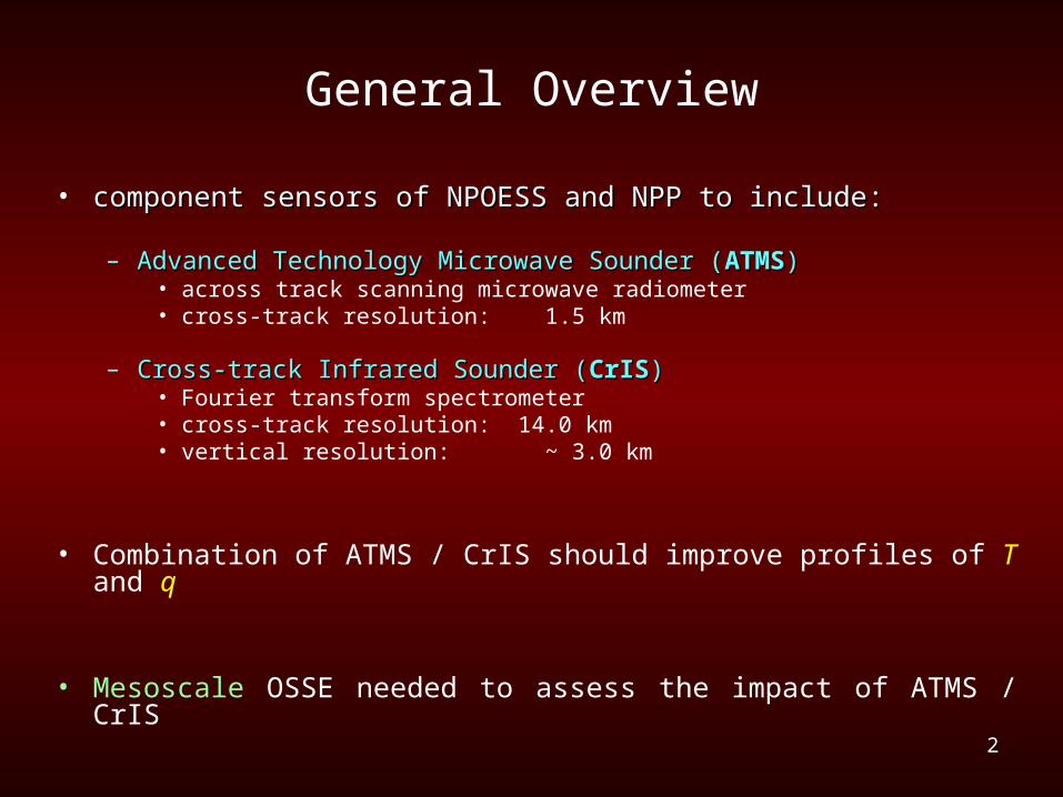
General Overview
• component sensors of NPOESS and NPP to include:component sensors of NPOESS and NPP to include:
– Advanced Technology Microwave Sounder (Advanced Technology Microwave Sounder (ATMSATMS))• across track scanning microwave radiometer• cross-track resolution: 1.5 km
– Cross-track Infrared Sounder (Cross-track Infrared Sounder (CrISCrIS))• Fourier transform spectrometer • cross-track resolution: 14.0 km• vertical resolution: ~ 3.0 km
• Combination of ATMS / CrIS should improve profiles of T and q
• Mesoscale OSSE needed to assess the impact of ATMS / CrIS
22
3
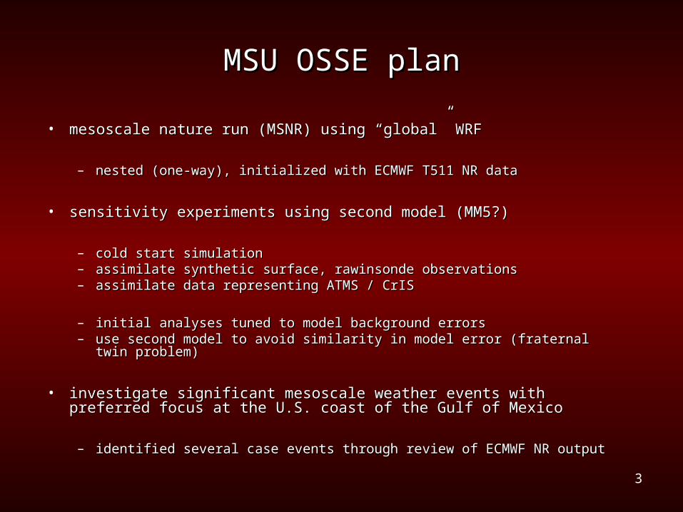
MSU OSSE planMSU OSSE plan
• mesoscale nature run (MSNR) using “global” WRFmesoscale nature run (MSNR) using “global” WRF
– nested (one-way), initialized with ECMWF T511 NR datanested (one-way), initialized with ECMWF T511 NR data
• sensitivity experiments using second model (MM5?)sensitivity experiments using second model (MM5?)
– cold start simulationcold start simulation– assimilate synthetic surface, rawinsonde observationsassimilate synthetic surface, rawinsonde observations– assimilate data representing ATMS / CrISassimilate data representing ATMS / CrIS
– initial analyses tuned to model background errorsinitial analyses tuned to model background errors– use second model to avoid similarity in model error (fraternal twin problem)use second model to avoid similarity in model error (fraternal twin problem)
• investigate significant mesoscale weather events with preferred focus at investigate significant mesoscale weather events with preferred focus at the U.S. coast of the Gulf of Mexicothe U.S. coast of the Gulf of Mexico
– identified several case events through review of ECMWF NR outputidentified several case events through review of ECMWF NR output

4
Case events identified from ECMWF T799 NRCase events identified from ECMWF T799 NR
May 2-4: squall line affecting all points along US Gulf coastMay 2-4: squall line affecting all points along US Gulf coast
May 7-8: decaying squall line over TXMay 7-8: decaying squall line over TX Oct 10-11: squall line / tropical waveOct 10-11: squall line / tropical wave
MSLP (hPa)MSLP (hPa) 3-h convective precipitation (mm) 3-h convective precipitation (mm) .
5
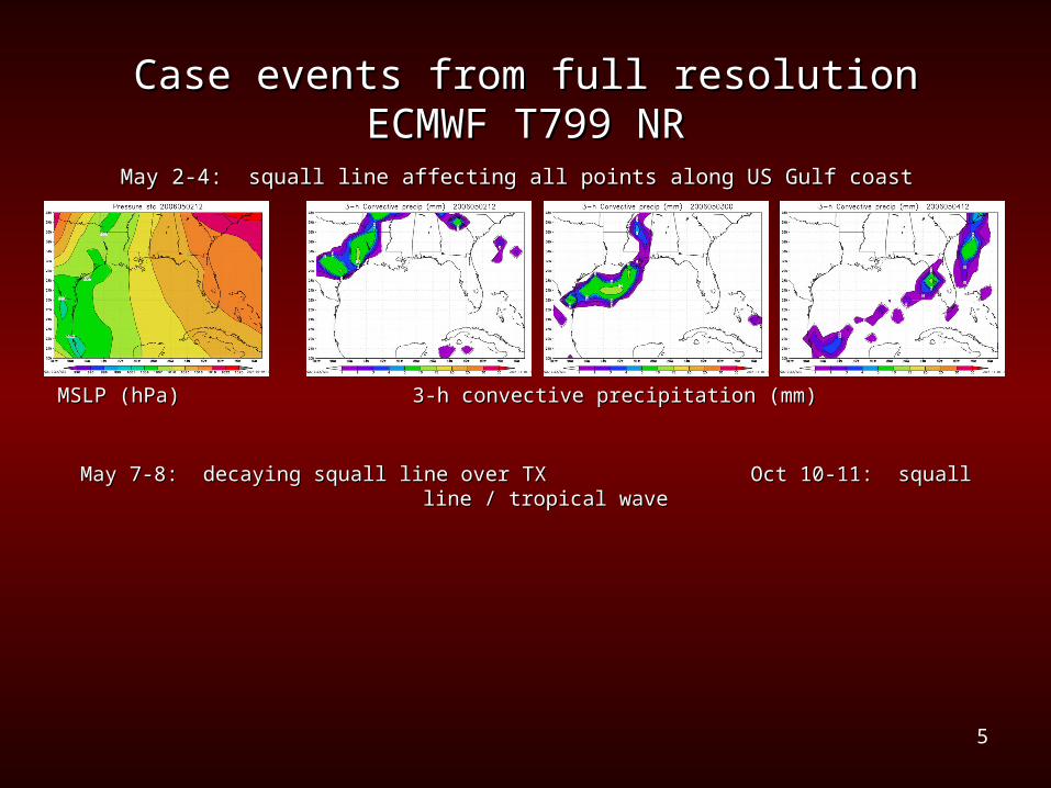
Case events from full resolution ECMWF T799 NRCase events from full resolution ECMWF T799 NR
May 2-4: squall line affecting all points along US Gulf coastMay 2-4: squall line affecting all points along US Gulf coast
May 7-8: decaying squall line over TXMay 7-8: decaying squall line over TX Oct 10-11: squall line / tropical waveOct 10-11: squall line / tropical wave
MSLP (hPa)MSLP (hPa) 3-h convective precipitation (mm) 3-h convective precipitation (mm) .
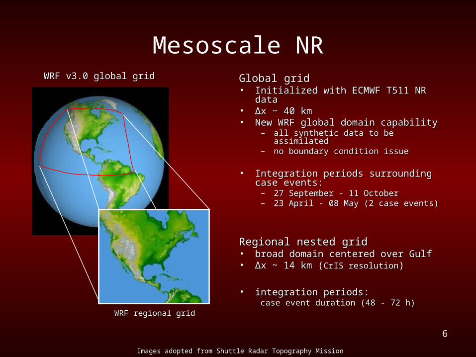
Mesoscale NRWRF v3.0 global gridWRF v3.0 global grid Global gridGlobal grid
• Initialized with ECMWF T511 NR dataInitialized with ECMWF T511 NR data• ∆∆x ~ 40 kmx ~ 40 km• New WRF global domain capabilityNew WRF global domain capability
– all synthetic data to be assimilatedall synthetic data to be assimilated– no boundary condition issueno boundary condition issue
• Integration periods surrounding case Integration periods surrounding case events:events:
– 27 September - 11 October27 September - 11 October– 23 April - 08 May (2 case events)23 April - 08 May (2 case events)
Regional nested gridRegional nested grid• broad domain centered over Gulfbroad domain centered over Gulf• ∆∆x ~ 14 km (x ~ 14 km (CrIS resolutionCrIS resolution))
• integration periods:integration periods:case event duration (48 - 72 h)case event duration (48 - 72 h)
Images adopted from Shuttle Radar Topography MissionImages adopted from Shuttle Radar Topography Mission
WRF regional gridWRF regional grid
6
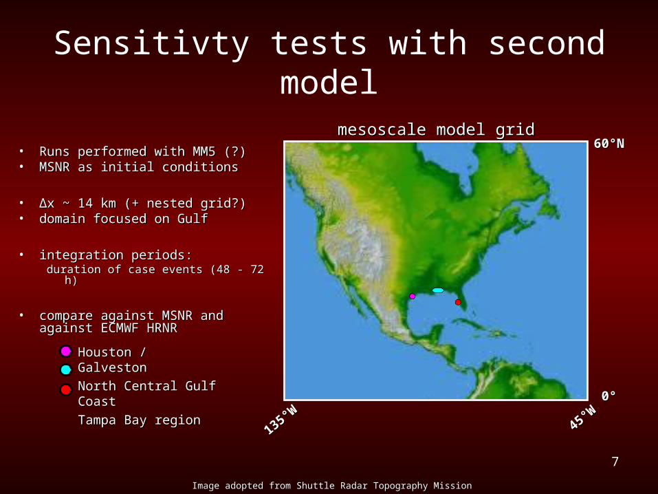
Sensitivty tests with second model
Image adopted from Shuttle Radar Topography MissionImage adopted from Shuttle Radar Topography Mission
mesoscale model gridmesoscale model grid
135135°W°W
4545°W°W
6060°N°N
00°°
• Runs performed with MM5 (?)Runs performed with MM5 (?)• MSNR as initial conditionsMSNR as initial conditions
• ∆∆x ~ 14 km (+ nested grid?)x ~ 14 km (+ nested grid?)• domain focused on Gulfdomain focused on Gulf
• integration periods:integration periods:duration of case events (48 - 72 h)duration of case events (48 - 72 h)
• compare against MSNR and compare against MSNR and against ECMWF HRNRagainst ECMWF HRNR
Houston / GalvestonHouston / Galveston
North Central Gulf North Central Gulf CoastCoast
Tampa Bay regionTampa Bay region
7

8
Status of MSU OSSE
• Progress to dateProgress to date– HRNR data ready for OSSEHRNR data ready for OSSE
– HRNR assessment yields casesHRNR assessment yields cases
• Requirements for OSSERequirements for OSSE– synthetic observationssynthetic observations
– simulated ATMS / CrIS datasimulated ATMS / CrIS data
– generate synthetic data with CRTM?generate synthetic data with CRTM?
• Next step is to conduct MSNRNext step is to conduct MSNR
(ATMS / CrIS)(ATMS / CrIS)MM5/WRFMM5/WRF
MSNRMSNR

![005014899 00138€¦ · 252 WILLS AND FITZPATRICK Catherine. Effects £485. FITZPATRICK Daniel. £79 15B. ti561 FITZPATRICK Edward. Effects £318 IOS. 118] FITZPATRICK Jane,](https://img.pdfslide.net/doc/110x75/6059be5bdbe04d125f77fe02/005014899-252-wills-and-fitzpatrick-catherine-effects-485-fitzpatrick-daniel.jpg)


![Silence [becca fitzpatrick]](https://img.pdfslide.net/doc/110x75/5559bd13d8b42aaa6f8b4ca5/silence-becca-fitzpatrick-55849e329a513.jpg)