Embed Size (px)
Citation preview

A summary of the April 2016 TRRP Plan updates (Change 25) is as follows:
Part 3 – Reporting Requirements
• Added data elements from Change 24, 24.1, and 25 • Added section VI – Multiplier factors for Newly Mapped and PRP policies.
Part 4 – Data Dictionary
• Data Dictionary Table of Contents – added new data elements Exterior Water
Depth – Appurtenant, Exterior Water Depth – Main, Interior Water Depth – Appurtenant, Interior Water Depth – Main, Newly Mapped Multiplier, Newly Mapped/PRP Base Premium, and Pre-FIRM Subsidy Eligibility Indicator.
• Current Map Info – Base Flood Elevation: revised notation regarding reporting
requirement. • Current Map Info – Community Identification Number: revised notation
regarding reporting requirement. • Current Map Info – Flood Risk Zone: revised notation regarding reporting
requirement. • Current Map Info – Map Panel Number: revised notation regarding reporting
requirement. • Current Map Info – Map Panel Suffix: revised notation regarding reporting
requirement. • Grandfathering Type Code: revised notation regarding reporting requirement. • Newly Mapped Multiplier: New data element • Newly Mapped/PRP Base Premium: New data element • Pre-FIRM Subsidy Eligibility Indicator: New data element
Part 5 - Codes
• Added Pre-FIRM Subsidy Eligibility Indicator codes.
Part 6 – Record Layouts
• Revised Policy TRRP transaction record layouts to include new data
elements. .
Part 7 – Instructions for Formatting Data Elements and Revising Data Elements Values
• Added new data elements.

A summary of the April 2016 TRRP Plan updates (Change 25) - continued:
Appendix C - Error Reporting
• Added new data elements.

NATIONAL FLOOD INSURANCE PROGRAM
TRANSACTION RECORD REPORTING AND PROCESSING (TRRP) PLAN for the
WRITE YOUR OWN (WYO) PROGRAM
Revision 1 ........................... January 1, 1992
Revision 2 ............................. March 1, 1995 Revision 3 ........................... October 1, 1997 Revision 4 ........................... October 1, 2001 Changes 1 & 2 .......................... May 1, 2002 Change 3 .......................... October 1, 2002 Change 4 .............................. May 1, 2003 Change 5 .......................... October 1, 2003 Change 6 .............................. May 1, 2004 Change 6.1 ....................... February 1, 2005 Changes 7 & 7 (Revised) ................ May 1, 2005
Changes 8 & 8.1 .................... October 1, 2005 Change 9 .............................. May 1, 2006
Changes 10, 11 & 12 .................... May 1, 2008 Changes 13, 13.1 & 13.2 ............ October 1, 2009
Change 14 ......................... January 1, 2011 Change 15 ......................... October 1, 2011 Change 16 ............................. May 1, 2012 Change 17 ......................... October 1, 2012 Change 18 ......................... January 1, 2013 Change 19, 19.1, 19.2 & 19.3.. October 1, 2013 Change 20 ............................ June 1, 2014 Change 21 ......................... October 1, 2014 Change 22 ......................... January 1, 2015 Change 23, 23.1, 23.2, 23.3 ......... April 1, 2015 Change 24, 24.1 .................. November 1, 2015 Change 25 ........................... April 1, 2016


DISSEMINATION CHANGES TO THE TRRP PLAN Complete printings are called "Revisions" and replacement pages are called "Changes." All pages of the present revision are marked to show both the edition of the manual (“Revision 4”) and also the effective dates of the policies and procedures described. For example, pages that include material effective 5/1/98 in the present revision are identified as: Revision 4 (10/1/01) Effective 5/1/98 As replacement pages are issued in the future, they will be labeled Change 1, Change 2, Change 3, etc. The next time a complete document is published, it will be Revision 5.

ii Revision 4 (10/1/01) Effective 10/1/03
This page is intentionally left blank.

iii Revision 4 (10/1/01) Change 7 Effective 5/1/05
TRANSACTION RECORD REPORTING AND PROCESSING (TRRP) PLAN
TABLE OF CONTENTS PART PAGE 1 INSTRUCTIONS .......................................... 1-1 2 NFIP/WYO SYSTEM FUNCTIONS AND PRIMARY DATA FILES ...... 2-1 3 REPORTING REQUIREMENTS ................................ 3-1 4 DATA DICTIONARY ....................................... 4-1 5 CODES ................................................. 5-1 6 RECORD LAYOUTS ........................................ 6-1 7 INSTRUCTIONS FOR FORMATTING DATA ELEMENTS AND REVISING DATA ELEMENT VALUES .......................... 7-1 8 MONTHLY PROCESSING OF TRRP PLAN DATA .................. 8-1 9 DATA SUBMISSION MONITORING ............................ 9-1
10 NFIP/WYO SYSTEM ARCHIVING ............................ 10-1 APPENDIX A TRANSACTION PROCESSING DICTIONARY APPENDIX B COMMUNITY INFORMATION APPENDIX C ERROR REPORTING APPENDIX D NFIP/WYO SYSTEM DATA DICTIONARY APPENDIX E QUICK CLAIM REPORTING APPENDIX F REPETITIVE LOSS TARGET GROUP POLICIES APPENDIX G.INSPECTION PROCEDURE APPENDIX H.CONDOMINIUM INSPECTION PROGRAM NOTE: In addition to the TRRP Plan, the following resource
documents are available to assist in understanding the WYO Program requirements:
• WYO Edit Specifications • Financial Control Plan Requirements and Procedures • Accounting Procedures Manual • Accounting Training Manual • NFIP Flood Insurance Manual • Operational Overview • Financial Assistance/Subsidy Arrangement
To obtain copies of these documents and/or obtain additional information/clarification of Program requirements, contact your WYO Program Coordinator.

Part 1 1-i Revision 4 (10/1/01) Change 8 Effective 10/1/05
PART 1 - INSTRUCTIONS
TABLE OF CONTENTS Page INTRODUCTION................................................ 1-1 I. SCOPE OF THE PLAN..................................... 1-1 A. Background Information............................ 1-1 B. Purposes of the Plan.............................. 1-1 C. Recording of Data................................. 1-2 D. Data Record Keys - WYO Prefix Code, Policy Numbers, and Claim Numbers........................ 1-2 E. Special Data Requirements......................... 1-2 1. Insured Property Address...................... 1-2 2. Insured Mailing Address....................... 1-2 3. Identification of Policyholder................ 1-3 4. Special Loss Information...................... 1-3 F. Reporting Transactions............................ 1-3 G. Data Quality and Financial Reconciliation......... 1-3 II. GENERAL INFORMATION................................... 1-4 A. Coverages......................................... 1-4 B. Premiums.......................................... 1-4 C. Minimum Premium................................... 1-4 D. Expense Constant.................................. 1-5 E. Amounts of Insurance.............................. 1-5 F. Policy Term....................................... 1-5 G. Catastrophe Losses................................ 1-5 H. Deductible Amount................................. 1-5 I. Geographical Division: Community Number, Flood Risk Zone......................................... 1-5

Part 1 1-ii Revision 4 (10/1/01) Change 12 Effective 5/1/08
Page
J. Classification.................................... 1-5 1. Building Occupancy............................ 1-6 2. Building Type................................. 1-6 3. Basement/Enclosure/Crawlspace Type............ 1-6 4. Special Ownership Type........................ 1-6 5. Special Building Status Type.................. 1-6 6. Obstruction Type.............................. 1-6 7. Lowest Floor Elevation Relative to the Base Flood Elevation or Base Flood Depth........... 1-7 8. Special Certifications........................ 1-7 9. Program Status................................ 1-7 K. Effective Dates and Expiration Dates.............. 1-7 L. Changes in Policies by Endorsement................ 1-8 M. Adjustments....................................... 1-8 N. Accounting Date (WYO Transaction Date)............ 1-8 III. SPECIAL DEFINITIONS................................... 1-8 A. Number of Claims.................................. 1-8 B. Losses............................................ 1-9 C. Allocated Loss Adjustment Expenses................ 1-9 D. Unallocated Loss Adjustment Expenses............. 1-10 E. Deductible Amounts............................... 1-10 F. Amounts of Insurance............................. 1-11 G. Policies-In-Force Statistics..................... 1-11

Part 1 1-1 Revision 4 (10/1/01) Change 19 Effective 10/1/13
PART 1 - INSTRUCTIONS INTRODUCTION This section presents an overview of the TRRP Plan and the requirements for reporting financial and statistical information by WYO Companies. For assistance on utilizing this document and understanding/complying with the specifications, contact your NFIP Legacy Systems Services (LSS) Business Analyst. I. SCOPE OF THE PLAN A. Background Information
The TRRP Plan defines the reporting requirements applicable to the writing and servicing of policies issued by the property and casualty companies participating in the Write Your Own (WYO) Program. The WYO companies have a Financial Assistance/Subsidy Arrangement with the Federal Insurance and Mitigation Administration (FIMA). The "Arrangement" enables the companies to receive an expense allowance for policies written and claims processed while the Federal Government retains responsibility for underwriting losses. The WYO Program operates within the auspices of the National Flood Insurance Program (NFIP). As a result, the WYO Program is subject to the same rules and regulations established for the "Direct side" of the business. The federally promulgated operational standards govern the processing of the coverages included in the three forms of the NFIP’s Standard Flood Insurance Policy (Dwelling Form, General Property Form, and Residential Condominium Building Association Policy).
This Plan contains detailed specifications for the recording and compiling of insurance application data; Elevation Certificate data; recertification data; reinspection data; endorsements; cancellations; claims data; allocated loss adjustment expenses; and community flood insurance study data.
B. Purposes of the Plan
This Plan is primarily designed as a tool for maintaining financial and program control in the WYO Program. Transaction detail provided under the Plan is reconciled each month with monthly financial statements submitted by the companies. The information is used to create Policy and Claims Master Files in the NFIP/WYO System, which allows the System to relationally edit policy and claims information for conformance with NFIP rules and regulations and to verify that premium calculations are correct. The NFIP/WYO System data files provide Federal and WYO company managers and the WYO Standards Committee with information necessary to

Part 1 1-2 Revision 4 (10/1/01) Change 8 Effective 10/1/05
maintain control of the WYO Program and to monitor company performance under the Financial Control Plan. These data are used to direct Federal resources to problem areas and respond to data requests from Congress, GAO, state, and local government officials, and other Federal agencies.
Information submitted under this Plan and processed to the NFIP/WYO System is also fed into the NFIP's Actuarial Information System. This system is used for compiling and analyzing the insurance experience for actuarial and other risk assessment and loss reduction research purposes.
C. Recording of Data
The WYO company must adopt the requirements outlined in this Plan to ensure accuracy in the recording and compilation of data. Every reporting unit shall record its data, in the detail required, on forms or other media approved for such reporting.
D. Data Record Keys - WYO Prefix Code, Policy Numbers, and
Claim Numbers
All insurance policy information reported under this Plan will be recorded in and retrievable from the NFIP/WYO System by: (1) the company's WYO Prefix Code (NAIC number) and (2) the company policy identification number or the claim number in the case of a loss transaction. The claim number used in the NFIP/WYO System is the policy number suffixed by the date of loss.
E. Special Data Requirements 1. Insured Property Address This information is required on each issued policy
so that the NFIP can maintain loss histories by property location for underwriting and risk assessment purposes. These data also make it possible to develop risk directories pertinent to rating information, thus reducing the necessity of referring to the Flood Insurance Rate Maps when rating a policy.
2. Insured Mailing Address This information is required on any new business,
renewal, or reinstatement submitted after September 30, 2005. The data will be added to an NFIP mailing address database to be used in the mailing of the acknowledgement letter/property loss history information and the claims handbook to NFIP policyholders.

Part 1 1-3 Revision 4 (10/1/01) Change 10 Effective 5/1/08
3. Identification of Policyholder
This Plan requires, for each policy, the submission of the insured's name on policies effective on or after April 30, 1996. The submission of the insured’s social security number will no longer be required on policies. The identification of the policyholder prevents duplication of benefits between the NFIP and other Federal programs and satisfies other Federal legal requirements. Should the insured receive disaster assistance in the event of a declared disaster, the insured’s assigned case file number will also be used as identification of the policyholder.
4. Special Loss Information
In addition to loss payment data, the submission of information concerning amounts of damage (as opposed to payment), property value, and depths of water experienced in the building during the loss are required. This information is pertinent to the NFIP's models used to compute insurance rates. It also contributes to the important floodplain management research efforts and in assessing loss reduction and prevention alternatives.
F. Reporting Transactions
The transactions available in this Plan for reporting by WYO companies have been developed to accommodate the processing and detailed editing needs of the NFIP in using the information for financial and program control purposes and to accommodate, as well, processing considerations of the various systems used by companies to record and report the data. Companies will find that there are certain flexibilities in how the transactions can be used and that a company may not need to employ all the available transaction types. Information about the use of the reporting transactions is contained in Appendix A.
G. Data Quality and Financial Reconciliation
Part 2 of the WYO Financial Control Plan Requirements and Procedures contains critical information about the reconciliation of policy and claim data submitted under this Plan with the monthly financial reports and about how this Plan's data will be edited. The WYO Edit Specifications document is also necessary in order to have a complete understanding of reporting requirements.
Because of the need for timely financial reconciliation, transactions submitted under this Plan are rejected from the NFIP/WYO System only when money fields cannot be read or when it is unclear how the System can process the transaction. Otherwise, the information is posted to the data base and erred data elements are flagged for later correction.

Part 1 1-4 Revision 4 (10/1/01) Change 7 Effective 5/1/05
II. GENERAL INFORMATION The following information indicates how data will be
recorded and treated in the NFIP/WYO System. A. Coverages The experience is recorded on the basis of: 1. Building Coverage 2. Contents Coverage 3. Increased Cost of Compliance (ICC) Coverage ICC coverage is afforded under the Standard Flood
Insurance Policy for the increased cost to rebuild, or otherwise alter, a flood-damaged structure to bring it into conformance with State or local floodplain management ordinances or laws.
B. Premiums Premium writings will be recorded in the NFIP/WYO
System in complete policy detail. Therefore, a separate premium entry will be calculated by the NFIP/WYO System for basic limits and additional limits for each coverage.
Total Calculated Premium (or Total Prepaid Premium)
will include the Increased Cost of Compliance (ICC) premium. The ICC premium is not subject to deductible factors, but the CRS discount will apply. ICC coverage is not available, and therefore not charged, on the following four categories of business:
- Policies in Emergency Program communities - Individual condominium unit owner coverage written
under the Dwelling Form - Contents-only policies - Group Flood Insurance policies Only the total written premium including Expense
Constant, ICC premium, and, if appropriate, community probation surcharge must be reported by the WYO company.
C. Minimum Premium When a minimum premium is charged, only the total
written premium indicated under (B) above must be entered into the policy record reported by the WYO company.
Part 1 1-5 Revision 4 (10/1/01) Change 4 Effective 10/1/03
D. Expense Constant The Expense Constant in effect as of the effective date
of the policy term is to be included in the written premium on a per policy basis. Effective May 1, 2003, the Expense Constant will be zero dollars.
E. Amounts of Insurance Total amounts of insurance must be reported for each of
the three coverages separately (building, contents, and ICC). The basic limits and additional limits for building and contents, and the ICC coverage limit, will be determined and recorded separately by the NFIP/WYO System.
F. Policy Term WYO companies may offer a 1-year policy term. The
policy term is to be recorded on a per-policy basis according to the policy effective date. No mid-term endorsement of the policy can change the policy term.
G. Catastrophe Losses Under the NFIP, there are at present two catastrophe
designations. These are: 1. FICO designation 2. FEMA Disaster Declaration Each loss shall be identified by the proper catastrophe
designation, when applicable, in addition to other recording requirements. WYO companies will report only the FICO designation that is provided to them.
H. Deductible Amount Each policy must be identified by the appropriate
deductible amount applicable to the insurance policy. I. Geographical Division: Community Number, Flood Risk
Zone The appropriate coding shall be recorded on all policy
transactions. Information regarding a community's status in the NFIP and valid flood risk zones is provided to WYO companies.
J. Classification The appropriate classification data shall be recorded
on all policy transactions. The classification data are to be reported unless the data element is
Part 1 1-6 Revision 4 (10/1/01) Change 25 Effective 4/1/16
designated as optional (N) or is not listed in Part 3, Section A, of this Plan. The classification criteria under the NFIP are:
1. Building Occupancy a. Single family b. 2-4 family c. Other residential d. Other Nonresidential e. Nonresidential Business 2. Building Type a. One floor b. Two floors c. Three or more floors d. Split level e. Manufactured (mobile) home or travel trailer on
foundation f. Townhouse/Rowhouse with three or more floors
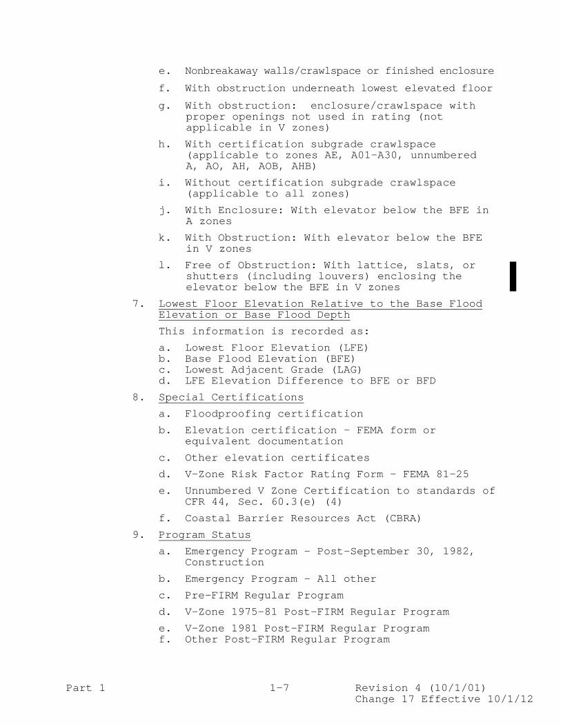
(RCBAP Low-rise only) 3. Basement/Enclosure/Crawlspace Type a. Finished basement/enclosure b. Unfinished basement/enclosure c. None d. Crawlspace e. Subgrade Crawlspace 4. Special Ownership Type a. Condominiums - unit or association b. State government 5. Special Building Status Type a. Building in course of construction b. Primary residence 6. Obstruction Type (combinations are possible) a. Free of obstruction underneath elevated lowest
floor b. With obstruction: less than 300 sq. ft. with
breakaway walls or finished enclosure underneath the lowest elevated floor
c. With obstruction: 300 sq. ft. or more with
breakaway walls or finished enclosure underneath the lowest elevated floor
d. With obstruction: machinery or equipment
attached to the building and located underneath the lowest elevated floor
Part 1 1-7 Revision 4 (10/1/01) Change 17 Effective 10/1/12
e. Nonbreakaway walls/crawlspace or finished enclosure
f. With obstruction underneath lowest elevated floor
g. With obstruction: enclosure/crawlspace with proper openings not used in rating (not applicable in V zones)
h. With certification subgrade crawlspace (applicable to zones AE, A01-A30, unnumbered A, AO, AH, AOB, AHB)
i. Without certification subgrade crawlspace (applicable to all zones)
j. With Enclosure: With elevator below the BFE in A zones
k. With Obstruction: With elevator below the BFE in V zones
l. Free of Obstruction: With lattice, slats, or shutters (including louvers) enclosing the elevator below the BFE in V zones
7. Lowest Floor Elevation Relative to the Base Flood Elevation or Base Flood Depth
This information is recorded as:
a. Lowest Floor Elevation (LFE) b. Base Flood Elevation (BFE) c. Lowest Adjacent Grade (LAG) d. LFE Elevation Difference to BFE or BFD
8. Special Certifications
a. Floodproofing certification
b. Elevation certification - FEMA form or equivalent documentation
c. Other elevation certificates
d. V-Zone Risk Factor Rating Form - FEMA 81-25
e. Unnumbered V Zone Certification to standards of CFR 44, Sec. 60.3(e) (4)
f. Coastal Barrier Resources Act (CBRA)
9. Program Status
a. Emergency Program – Post-September 30, 1982, Construction
b. Emergency Program - All other
c. Pre-FIRM Regular Program
d. V-Zone 1975-81 Post-FIRM Regular Program
e. V-Zone 1981 Post-FIRM Regular Program f. Other Post-FIRM Regular Program

Part 1 1-8 Revision 4 (10/1/01) Change 15 Effective 10/1/11
K. Effective Dates and Expiration Dates
On premium entries for new business and renewals, the policy effective and expiration dates are recorded.
On endorsements changing premiums, amounts of insurance, previously recorded policy classification, and/or geographical division information, the policy effective date, policy expiration date, and effective date of change must be reported.
L. Changes in Policies by Endorsement
Changes to the policy records can be made by endorsement. Each endorsement must bear the effective date of the policy and the effective date of the change, as well as the transaction date to facilitate the assignment of exposure, amount of insurance, premium and loss to the proper classification, risk zone, community, and program type in the NFIP Actuarial Information System. This level of detail allows for reconciliation with WYO company financial reports for financial control purposes.
M. Adjustments
Adjustment of errors in the original entries reported are to be made by the use of the appropriate correction transaction or in some cases by the use of a different transaction type.
The NFIP/WYO System requires that all adjustments to the
policy and claims record be reconciled. Special care must be given to ensure changes to classification, geo-graphical division, premiums, amount of insurance, and all claims-related data elements are processed correctly as they have a direct bearing on the information used to maintain financial control of the WYO Program.
N. Accounting Date (WYO Transaction Date)
The date on which a policy, loss, or loss adjustment related transaction was recorded on the books of the insurer shall be recorded to facilitate the updating of experience compilations.
III. SPECIAL DEFINITIONS
A. Number of Claims
In the NFIP, cases, claims, and closed without payments are counted by coverage. The number of losses is counted by policy. Thus, up to three cases, claims, or closed without payments (one for each of the building, contents, and ICC coverages) may be associated with one policyholder loss. Each loss under a policy is identified in this Plan by a date of loss.

Part 1 1-9 Revision 4 (10/1/01) Effective 10/1/03
A case is established by the recording of a loss notice for loss reserve purposes. Reserves are established by coverage. One loss notice can establish up to two cases.
A case involving a loss payment or the establishment of
a reserve is counted as a claim. No case shall be counted as a claim if it involves only loss adjustment expenses.
A closed without payment is counted as a case, but is
not counted as a claim. A claim on which more than one payment is made shall be
counted only once. B. Losses The term "number of losses" refers to the number of
loss occurrences. These are identified by a date of loss associated with a policy. The term "losses" refers to claims payments and/or reserves less amounts recovered.
The status of a loss is either “paid” or “pending”
under the NFIP System. Losses on claims on which final payments have been made
are in a paid status. Losses on claims on which a case reserve has been
established and no payment has been made are in a pending status.
Losses on claims part paid and part on reserve are in a
pending status. C. Allocated Loss Adjustment Expenses Allocated loss adjustment expenses under the NFIP are: 1. Fees paid pursuant to the Arrangement for adjusting
the loss on a specific case. (No transaction report is required.)
2. Special engineering expenses incurred by the claims
department to adjust a specific case. (Special allocated loss adjustment transaction is required.)
3. Other special costs incurred to establish coverage
or property value on a specific case or to facilitate the adjustment including litigation expense on cases coordinated with FIMA. (Special allocated loss adjustment transaction is required.)

Part 1 1-10 Revision 4 (10/1/01) Effective 10/1/03
4. Legal expenses. (Special allocated loss adjustment transaction is required.)
5. Costs of appraisals under the Standard Flood
Insurance Policy. (Special allocated loss adjustment transaction is required.)
The following shall not be included as allocated loss
adjustment expenses: 1. Salaries and other operating expenses of the claims
department, FICO offices, or catastrophe office. 2. Overhead. 3. Subrogation expense other than types of expenses
listed under 2, 3, 4, and 5 above. 4. Cost of loss adjuster training or workshops. D. Unallocated Loss Adjustment Expenses Unallocated loss adjustment expenses are those expenses,
other than allocated loss adjustment expenses, incurred in providing claims service to policyholders. Under the Arrangement, these expenses are a specific percentage of incurred losses.
E. Deductible Amounts Under the NFIP, standard and optional deductible amounts
are applied separately to building and contents coverages. For specific information about deductible amounts, refer to either the Flood Insurance Manual or the deductible definitions in this Plan.
Also, for claims associated with policies effective prior
to January 1, 1987, a special deductible amount of $50 is applied to reasonable expenses incurred, pursuant to the Standard Flood Insurance Policy, for the temporary removal of an insured manufactured home or insured personal property from the described premises and away from the peril of flood. For policies effective on or after January 1, 1987, no deductible is applied to these expenses.
Effective 12/31/2000, Property Removed to Safety Coverage
will pay up to $1,000 for the temporary removal of a travel trailer without wheels, built on a chassis and affixed to a permanent foundation, that is considered a building by the community’s floodplain management and building ordinances or laws. The policy will pay up to $1,000, including the value of work, at the Federal minimum wage, performed by the insured or household members, for the reasonable expenses to move insured

Part 1 1-11 Revision 4 (10/1/01) Change 20 Effective 6/1/14
property, including contents and/or a moveable home, to a location above ground level or outside the SFHA. The move must be to protect the property from flood or the imminent danger of flood. This coverage does not increase the Coverage A or Coverage B Limit of Liability.
F. Amounts of Insurance The basic and additional limits of insurance as of June
1, 2014, are listed below:
Building Coverage
Basic Limits
Additional Limits
Total
Single Family $ 60,000 $190,000 $250,000 2-4 Family $ 60,000 $190,000 $250,000 Other Residential $175,000 $325,000 $500,000 Nonresidential $175,000 $325,000 $500,000
The Residential Condominium Building Association Policy has coverage available for the entire building not to exceed the single family unit amount for total coverage times the total number of units.
Effective May 1, 2003, Increased Cost of Compliance (ICC) coverage is $30,000 on all policies that have building coverage except for Emergency Program policies, Group Flood Insurance policies, and condominium unit policies.
Contents Coverage (Per Unit)
Residential $ 25,000 $ 75,000 $100,000 Nonresidential $ 150,000 $350,000 $500,000
For details on the amount of insurance required by
statute, the maximum amount of insurance available, and subsidized amounts of insurance, refer to the Flood Insurance Manual of the NFIP.
G. Policies-In-Force Statistics An in-force policy is a policy that is in force or in an
active term as of the reporting date. A policy term is defined as the period from the policy effective date to, but not including, the policy expiration date.
Any future-dated new applications, or endorsements, will
not be included with the in-force statistics. Any cancelled or expired policy (including a policy's
expiration date) is considered a policy not in force. Premium reporting for 3-year policies will include the
entire 3-year premium. Statistics on this basis will be labeled "Policies-in-Force." This will apply to Group Flood policies.


Part 3 3-i Revision 4 (10/1/01) Change 25 Effective 04/1/16
PART 3 - REPORTING REQUIREMENTS
TABLE OF CONTENTS Page INTRODUCTION................................................ 3-1 I. DATA ELEMENT REQUIREMENTS FOR WRITE YOUR OWN.......... 3-2 II. SAMPLE NFIP FORMS.................................... 3-11 III. REPORTING REQUIREMENTS FOR NEW/ROLLOVER/TRANSFER INDICATOR............................................ 3-17 IV. PRE-FIRM RATING HIERARCHY TABLE (BW-12, HFIAA)....... 3-22 V. RATE TABLE CODES (EFFECTIVE NOVEMBER 1, 2015)..........................3-23 VI. MULTIPLIER FACTORS (EFFECTIVE APRIL 1, 2016).............................3-27

Part 3 3-2 Revision 4 (10/1/01) Change 24 Effective 11/1/15
I. DATA ELEMENT REQUIREMENTS FOR WRITE YOUR OWN
DATA ELEMENT
REQ.
DATA DICTIONARY
PAGE
SOURCE POLICY TRANSACTIONS Additional Building Rate WYO
Y 4-4 Application – Coverage and Rating
Additional Contents Rate WYO
Y 4-5 Application – Coverage and Rating
Additions/Extensions Indicator
Y 4-5A Application – Part 2. Section I
Agricultural Structure Indicator
Y 4-5C Application - Building
Application Date Y 4-6A Application - Signature
Area below Elevated Floor – Elevators
Y 4-6B Application – Elevated Buildings
Area below Elevated Floor – Enclosed Finished Area
Y 4-6C Application – Elevated Buildings
Area below Elevated Floor – Garage Indicator
Y 4-6D Application – Elevated Buildings
Area below Elevated Floor – M/E Indicator
Y 4-6E Application – Elevated Buildings
Area below Elevated Floor – M/E Value Amount
Y 4-6F Application – Elevated Buildings
Area below Elevated Floor – M/E Value Indicator
Y 4-6G Application – Elevated Buildings
Area below Elevated Floor – Number of Flood Openings
Y 4-6H Application – Elevated Buildings
Area below Elevated Floor – Washer/Dryer Indicator
Y 4-6I Application – Elevated Buildings
Area below Elevated Floor – Washer/Dryer Value Amount
Y 4-6J Application – Elevated Buildings
Area below Elevated Floor – Washer/Dryer Value Ind.
Y 4-6K Application – Elevated Buildings
Base Flood Elevation (Rating Map Information)
Y 4-7 Application – Elevation Data
Basement/Enclosure/
Crawlspace Type Y 4-8 Application - Building
Basic Building Rate WYO Y 4-9 Application – Coverage
and Rating

Part 3 3-3 Revision 4 (10/1/01) Change 24.1 Effective 11/1/15
I. DATA ELEMENT REQUIREMENTS FOR WRITE YOUR OWN (Cont'd.)
DATA ELEMENT
REQ.
DATA DICTIONARY
PAGE
SOURCE POLICY TRANSACTIONS (Cont’d.)
Basic Contents Rate WYO Y 4-10 Application –
Coverage and Rating
Building Construction Date Type
Y 4-12A Application – Construc- tion Information
Building in Course of Construction Indicator
Y 4-14 Application - Building
Building over Water Type Y 4-14A Application – Building Building Purpose Type Y 4-14C Application - Building Building Use Type Y 4-14D Application – Part 2.
Section I Building Walled/Roofed Indicator
Y 4-14G Application - Building
Cancellation/Voidance Reason
Y 4-15 Cancellation/Nullifica-tion Request Form
Case File Number for Disaster Assistance
Y 4-44A Application – Disaster Assistance
Community Identification Number (Rating Map Information
Y 4-55 Application – Community (Rating Map Information)
Condominium Form of Ownership Indicator
Y 4-55B Application - Building
Condominium Indicator Y 4-56 Application - Building Condominium Master Policy Units
Y 4-60 Application - Building
Coverage Required for Disaster Assistance
Y 4-64 Application – Disaster Assistance
CRS Classification Credit Percentage
Y 4-65 Application – Coverage and Rating
Current Map Date Y 4-66N Application - Building Current Map Info – Base Flood Elevation
Y 4-66O Application – Community (Grandfathering Information)
Current Map Info – Community Identification Number
Y 4-66P Application – Community (Grandfathering Information)
Current Map Info – Flood Risk Zone
Y 4-66Q Application – Community (Grandfathering Information)

Part 3 3-4 Revision 4 (10/1/01) Change 24 Effective 11/1/15
I. DATA ELEMENT REQUIREMENTS FOR WRITE YOUR OWN (Cont'd.)
DATA ELEMENT
REQ.
DATA DICTIONARY
PAGE
SOURCE POLICY TRANSACTIONS (Cont’d.)
Current Map Info – Map Panel Number
Y 4-66R Application – Community (Grandfathering Information)
Current Map Info – Map Panel Suffix
Y 4-66S Application – Community (Grandfathering Information)
Current Map Info – Prior Policy No. (renamed)
Y 4-66T See “Prior Policy Number”
Deductible - Building Y 4-76 Application – Coverage
and Rating Deductible - Contents Y 4-78 Application – Coverage
and Rating Deductible Percentage WYO Y 4-80 Application – Coverage
and Rating
Diagram Number1 N 4-81 Application – Elevation Data
Elevated Building
Indicator Y 4-84 Application - Building
Elevating Foundation Type Y 4-84A Application –
Elevated Buildings Elevation Certificate Indicator
Y 4-85
Elevation Certification
Date1 Y 4-87 Application –
Elevation Data Elevation Difference Y 4-88 Application –
Elevation Data; Elevation Certificate
Enclosure Size Y 4-88C Application – Elevated
Buildings Enclosure Material Type Y 4-88B Application – Elevated
Buildings Enclosure Type Y 4-88D Application – Part 2.
Section II Enclosure Use Indicator Y 4-88E Application – Elevated
Buildings Endorsement Effective Date Y 4-89

Part 3 3-5 Revision 4 (10/1/01) Change 24 Effective 11/1/15
I. DATA ELEMENT REQUIREMENTS FOR WRITE YOUR OWN (Cont'd.)
DATA ELEMENT
REQ.
DATA DICTIONARY
PAGE
SOURCE POLICY TRANSACTIONS (Cont’d.)
Endorsement Premium Amount
Y 4-90
Engineered Flood Openings Indicator
Y 4-90A Application – Elevated Buildings
Entire Building Coverage Indicator
Y 4-90B Application - Building
Expense Constant Y 4-91
Federal Policy Fee Y 4-97 Application –
Coverage and Rating Federal Policy Fee – Refunded
Y 4-98
First Lender City2 N 4-102 Application -
1st Mortgagee First Lender Loan Number2 N 4-103 Application –
1st Mortgagee First Lender Name2 N 4-104 Application –
1st Mortgagee
First Lender State2 N 4-105 Application – 1st Mortgagee
First Lender Street Address2
N 4-106 Application – 1st Mortgagee
First Lender ZIP Code2 N 4-107 Application –
1st Mortgagee Flood Risk Zone (Rating Map Information)
Y 4-110 Application – Community (Rating Map Information)
Floodproofed Indicator Y 4-112 Application –
Elevation Data Flood Openings Indicator Y 4-109A Application – Elevated
Buildings Floor Below Grade Indicator
Y 4-112A Application – Elevated Buildings
Garage Flood Openings Indicator
Y 4-115A Application – Elevated Buildings
Garage Indicator Y 4-115B Application – Elevated
Buildings Garage M/E Indicator Y 4-115C Application – Elevated
Buildings

Part 3 3-6 Revision 4 (10/1/01) Change 24.1 Effective 11/1/15
I. DATA ELEMENT REQUIREMENTS FOR WRITE YOUR OWN (Cont'd.)
DATA ELEMENT
REQ.
DATA DICTIONARY
PAGE
SOURCE POLICY TRANSACTIONS (Cont’d.) Garage – Number of Flood Openings
Y 4-115D Application – Elevated Buildings
Garage Total Net Area Y 4-115E Application – Elevated
Buildings
Garage Use Indicator Y 4-115F Application – Elevated Buildings
Grandfathering Type Code Y 4-115A Application – Community
(Grandfathering Information
HFIAA Indicator N 4-115C HFIAA Surcharge HFIAA Surcharge – Refunded
N N
4-115E 4-115F
House Worship Indicator Y 4-115M Application – All Buildings
ICC Premium WYO Y 4-122 Application –
Coverage and Rating
Insured First Name3 Y 4-127 Application – Insured Information
Insured Last Name3 Y 4-128 Application – Insured
Information Lender Indicator Y 4-128A Application - Insured Location of Contents Indicator
Y 4-129 Application - Contents
Lowest Adjacent Grade1 N 4-130 Application –
Elevation Data 1Refer to Part 3 – Reporting Requirements, III. Reporting Requirements for New/Rollover/Transfer Indicator, to determine whether this data element is required based on reported New/Rollover/Transfer Indicator. 2This data element is required for policies expired more than 120 days. 3This data element is required for policies with a policy effective date on or after April 30, 1996. Prior to this date, either Insured Name or Taxpayer ID was reported.

Part 3 3-7 Revision 4 (10/1/01) Change 25 Effective 04/1/16
I. DATA ELEMENT REQUIREMENTS FOR WRITE YOUR OWN (Cont'd.)
DATA ELEMENT
REQ.
DATA DICTIONARY
PAGE
SOURCE POLICY TRANSACTIONS (Cont’d.)
Lowest Floor Elevation Y 4-131 Application –
Elevation Data; Elevation Certificate
Mailing City Y 4-131A Application – Insured
Information Mailing State Y 4-131B Application – Insured
Information Mailing Street Address Y 4-131C Application – Insured
Information Mailing ZIP Code Y 4-131D Application – Insured
Information Mandatory Purchase Indicator
Y 4-131F Application - Insured
Map Panel Number1 (Rating Map Information)
Y 4-132 Application – Community (Rating Map Information)
Map Panel Suffix (Rating Map Information)
Y 4-133 Application – Community (Rating Map Information)
Mitigation Offer Indicator Y 4-133A Name Format Indicator Y 4-134 Name or Descriptive Information Indicator
Y 4-135
New Policy Number Y 4-138 New/Rollover/Transfer Indicator
Y 4-139 Application –New/ Renewal/Transfer Box
Newly Mapped Date Y 4-139A Application - Building Newly Mapped Multiplier
Y
4-139A-1
Application - Building
Newly Mapped/PRP Base Premium Non_Profit Entity Indicator
Y Y
4-139A-2 4-139B
Application - Building Application - Building
Number of Elevators Y 4-139A Application – Part 2.
Section II Number of Floors (Including Basement)/ Building Type
Y 4-140 Application - Building
Obstruction Type Y 4-141 Application - Building Occupancy Type Y 4-143 Application - Building

Part 3 3-8 Revision 4 (10/1/01) Change 25 Effective 04/1/16
I. DATA ELEMENT REQUIREMENTS FOR WRITE YOUR OWN (Cont'd.)
DATA ELEMENT
REQ.
DATA DICTIONARY
PAGE
SOURCE POLICY TRANSACTIONS (Cont’d.) Old Policy Number Y 4-146 Original Construction Date/Substantial Improvement Date
Y 4-147 Application – Construction Information
Original Submission Month Y 4-149 Policy Effective Date Y 4-152 Application – Policy
Period Policy Assignment Type Y 4-151A General Change Endorse-
ment - Assignment Policy Expiration Date Y 4-154 Application – Policy
Period Policy Number Y 4-155 Policy Term Indicator Y 4-156 Policy Termination Date Y 4-157 Post-FIRM Construction Indicator
Y 4-158 Application – Elevation Data
Pre-FIRM SFHA – Community Reinstatement Date
Y 4-158A Application – Building
Pre-FIRM SFHA – Community Reinstatement Indicator
Y 4-158B Application – Building
Pre-FIRM SFHA – Community Suspension Date
Y 4-158C Application – Building
Pre-FIRM SFHA – Lender Required under Mandatory Purchase Indicator
Y 4-158D Application - Building
Pre-FIRM SFHA – Prior Policy Lapsed Policy Indicator
Y 4-158E Application - Building
Pre-FIRM SFHA – Prior Policy Lapsed Result of Community Suspension Indicator
Y 4-158F Application - Building
Pre-FIRM Subsidy Eligibility Indicator
Y
4-158G
Premium Payment Indicator Y 4-159 Application – Coverage and Rating
Premium Receipt Date Y 4-159A Primary Residence Indicator Y 4-160 Application – Building

Part 3 3-9 Revision 4 (10/1/01) Change 24 Effective 11/1/15
I. DATA ELEMENT REQUIREMENTS FOR WRITE YOUR OWN (Cont'd.)
DATA ELEMENT
REQ.
DATA DICTIONARY
PAGE
SOURCE POLICY TRANSACTIONS (Cont’d.) Prior Policy Number Y 4-160A Application – New/
Renewal/Transfer Box Probation Surcharge Amount WYO
Y 4-161 Application – Coverage and Rating
Property Beginning Street Number
Y 4-162 Application – Property Location
Property City Y 4-163 Application – Property
Location 4This data element is required for new business and renewals on or after May 1, 2000. Prior to this date, it was optional.

Part 3 3-10 Revision 4 (10/1/01) Change 24 Effective 11/1/15
I. DATA ELEMENT REQUIREMENTS FOR WRITE YOUR OWN (Cont'd.)
DATA ELEMENT
REQ.
DATA DICTIONARY
PAGE
SOURCE POLICY TRANSACTIONS (Cont’d.) Property Purchase Date Y 4-163A Application – Policy
Period Property Purchase Indicator
Y 4-163B Application – Policy Period
Property State Y 4-164 Application – Property
Location Property Street Address Y 4-165 Application – Property
Location Property ZIP Code Y 4-168 Application – Property
Location Rate Table Code Y 4-168A
Rated Map Date Y 4-168B
Regular/Emergency Program Indicator
Y 4-169 Application - Community
Reinstatement Federal Policy Fee
Y 4-170
Reinstatement Premium Y 4-171 Reinstatement Reserve Fund Assessment
Y 4-171A
Reinstatement HFIAA Surcharge
Y 4-170A
Rejected Transaction Control Number
Y 4-172
Rental Property Indicator Y 4-172A Application - Building
Repetitive Loss ID Number5
Y 4-173
Repetitive Loss Target Group Indicator5
Y 4-174
Replacement Cost1 Y 4-175 Application – Coverage
and Rating 1Refer to Part 3 – Reporting Requirements, III. Reporting Requirements for New/Rollover/Transfer Indicator, to determine whether this data element is required based on reported New/Rollover/Transfer Indicator. 5This data element is required only as of May 1, 2000, and only from the NFIP Direct Servicing Agent. Effective October 1, 2013, this data element has been renamed ‘SRL Property Indicator’.

Part 3 3-11 Revision 4 (10/1/01) Change 24 Effective 11/1/15
I. DATA ELEMENT REQUIREMENTS FOR WRITE YOUR OWN (Cont'd.)
DATA ELEMENT
REQ.
DATA DICTIONARY
PAGE
SOURCE POLICY TRANSACTIONS (Cont’d.) Reserve Fund Assessment Y 4-179A Application – Coverage
and Rating Reserve Fund Assessment - Refunded
Y 4-179B
Risk Rating Method Y 4-180 Application –
Coverage and Rating
Second Lender City2 N 4-184 Application – 2nd Mortgagee/Other
Second Lender Loan Number2
N 4-185 Application – 2nd Mortgagee/Other
Second Lender Name2 N 4-186 Application – 2nd
Mortgagee/Other
Second Lender State2 N 4-187 Application – 2nd Mortgagee/Other
Second Lender Street Address2
N 4-188 Application – 2nd Mortgagee/Other
Second Lender ZIP Code2 N 4-189 Application – 2nd
Mortgagee/Other Small Business Indicator Y 4-189A Application -
Building Sort Sequence Key Y 4-190 SRL Property Indicator Y 4-193A Application -
Building State-Owned Property Y 4-194 Application -
Building Subsidized Rated Indicator
Y 4-196A
Substantial Improvement Date
Y 4-196B
Taxpayer Identification Number6
N 4-198
Tenant Building Coverage Indicator
Y 4-198A Application - Building
2This data element is required for policies expired more than 120 days. 6Effective May 1, 2008, the Social Security Number for the insured is no longer required.

Part 3 3-12 Revision 4 (10/1/01) Change 24 Effective 11/1/15
I. DATA ELEMENT REQUIREMENTS FOR WRITE YOUR OWN (Cont'd.)
DATA ELEMENT
REQ.
DATA DICTIONARY
PAGE
SOURCE POLICY TRANSACTIONS (Cont’d.) Tenant Indicator Y 4-198B Application -
Building Total Amount of Insurance – Building
Y 4-199 Application – Coverage and Rating
Total Amount of Insurance – Contents
Y 4-201 Application – Coverage and Rating
Total Area of Garage Flood Openings
Y 4-201C Application – Elevated Building
Total Area of Permanent Flood Openings
Y 4-201D Application – Elevated Building
Total Calculated Premium (excludes Expense Constant)
Y 4-204 Application – Coverage and Rating
Total Premium Refund Y 4-208 Valid Policy Indicator Y 4-210A Waiting Period Type Y 4-213A Application – Policy
Period WYO Prefix Code Y 4-216 WYO Transaction Code Y 4-217 WYO Transaction Date Y 4-219 1981 Post-FIRM V Zone Certification Indicator
Y 4-220

Part 3 3-27 Revision 4 (10/1/01) Change 25 Effective 04/1/16
VI. MULTIPLIER FACTORS These multiplier factors will be used to calculate premium for all Newly Mapped policies (risk rating method ‘R’) effective on or after April 1, 2016. Format should be a number to the thousands with a decimal point, i.e. ‘1.150’. A new multiplier table will be added to the Flood Insurance Manual to determine which specific multiplier to be use for premium calculation. The multiplier table will be updated annually.
NEWLY MAPPED POLICIES - MULTIPLIER FACTORS
Newly Mapped Policies effective April 1, 2016 through December 31, 2016
Newly Mapped Effective Date
Eligible Transaction Multiplier
Oct. 2008 – Dec. 2014
1. Renewal of a policy rated, in its prior term, as a Newly Mapped policy
1.000
Jan. 2015 – Dec. 2015
1. New business, if policy effective date is
within 12 months of map effective date. 2. Renewal of a policy rated, in its prior
term, as a Newly Mapped policy. 3. Renewal of a policy written, in its prior
term, as a PRP.
1.000
Jan. 2016 – Dec. 2016
1. New business. 2. Renewal of a policy written, in its
previous term, as a PRP.
1.000

Part 3 3-28 Revision 4 (10/1/01) Change 25 Effective 04/1/16
VI. MULTIPLIER FACTORS (Cont’d.)
NEWLY MAPPED POLICIES - MULTIPLIER FACTORS
Newly Mapped Policies effective January 1, 2017 through December 31, 2017
Newly Mapped Effective Date
Eligible Transaction Multiplier
Oct. 2008 – Dec. 2014
1. Renewal of a policy rated, in its prior term, as a Newly Mapped policy.
1.150
Jan. 2015 – Dec. 2015
1. Renewal of a policy rated, in its prior term, as a Newly Mapped policy.
1.150
Jan. 2016 – Dec. 2016
1. New business, if policy effective date is
within 12 months of map effective date. 2. Renewal of a policy written, in its prior
term, as a PRP. 3. Renewal of a policy written, in its prior
term, as a Newly Mapped policy.
1.000
Jan. 2017 – Dec. 2017
1. New business, if policy effective date is
within 12 months of map effective date. 2. Renewal of a policy rated, in its prior
term, as a PRP.
1.000


Part 4 4-i Revision 4 (10/1/01)
Change 25 Effective 04/1/16
PART 4 - DATA DICTIONARY
TABLE OF CONTENTS Page INTRODUCTION................................................4-1 Actual Salvage Recovery .......................................... 4-2 Actual Salvage Recovery Date ..................................... 4-3 Additional Building Rate WYO ..................................... 4-4 Additional Contents Rate WYO ..................................... 4-5 Additions/Extensions Indicator ................................... 4-5A Agricultural Structure Indicator ................................. 4-5C Alteration Date .................................................. 4-6 Application Date ................................................. 4-6A Area below Elevated Floor - Elevators ............................ 4-6B Area below Elevated Floor – Enclosed Finished Area Indicator ..... 4-6C Area below Elevated Floor – Garage Indicator ..................... 4-6D Area below Elevated Floor – M/E Indicator ........................ 4-6E Area below Elevated Floor – M/E Value Amount ..................... 4-6F Area below Elevated Floor – M/E Value Indicator .................. 4-6G Area below Elevated Floor – Number of Flood Openings ............. 4-6H Area below Elevated Floor – Washer/Dryer Indicator ............... 4-6I Area below Elevated Floor – Washer/Dryer Value Amount ............ 4-6J Area below Elevated Floor – Washer/Dryer Value Indicator ......... 4-6K Base Flood Elevation (Rating Map Information) .................... 4-7 Basement/Enclosure/Crawlspace Type ............................... 4-8 Basement M/E Indicator ........................................... 4-8B Basement M/E Value Amount ........................................ 4-8C Basement M/E Value Indicator ..................................... 4-8D Basement Washer/Dryer Indicator .................................. 4-8E Basement Washer/Dryer Value Amount ............................... 4-8F Basement Washer/Dryer Value Indicator ............................ 4-8G Basic Building Rate WYO .......................................... 4-9 Basic Contents Rate WYO .......................................... 4-10 Building Claim Payment (ACV or RCV as applicable) ................ 4-11 Building Claim Payment Recovery .................................. 4-12 Building Construction Date Type .................................. 4-12A Building Damage Subject to Policy Exclusions (ACV) ............... 4-13 Building Description Type ........................................ 4-13A Building in Course of Construction Indicator ..................... 4-14 Building on Federal Land Indicator ............................... 4-14A Building over Water Type ......................................... 4-14B Building Purpose Type ............................................ 4-14C Building Purpose Type Percentage ................................. 4-14E Building Walled/Roofed Indicator ................................. 4-14G Cancellation/Voidance Reason ..................................... 4-15 Case File Number for Disaster Assistance ......................... 4-44A Catastrophe Number ............................................... 4-45 Cause of Loss .................................................... 4-46 Claim/Loss Closed Date ........................................... 4-49 Claim/Loss Reopen Date ........................................... 4-50 Claim Closed Without Payment Reason - Building ................... 4-51 Claim Closed Without Payment Reason - Contents ................... 4-52 Claim Closed Without Payment Reason - ICC ........................ 4-53 Coinsurance Claim Settlement Indicator ........................... 4-54

Part 4 4-ii Revision 4 (10/1/01)
Change 25 Effective 04/1/16
PART 4 – DATA DICTIONARY Table of Contents (Cont’d.) Page Community Identification Number (Rating Map Information) ......... 4-55 Condominium Form of Ownership Indicator .......................... 4-55B Condominium Indicator ............................................ 4-56 Condominium Master Policy Units .................................. 4-60 Contents Claim Payment (ACV) ..................................... 4-61 Contents Claim Payment Recovery .................................. 4-62 Contents Damage Subject to Policy Exclusions (ACV) ............... 4-63 Coverage Required for Disaster Assistance ........................ 4-64 CRS Classification Credit Percentage ............................. 4-65 Current Map Date ................................................. 4-66N Current Map Info – Base Flood Elevation .......................... 4-66O Current Map Info – Community Identification Number ............... 4-66P Current Map Info - Flood Risk Zone ............................... 4-66Q Current Map Info – Map Panel Number .............................. 4-66R Current Map Info – Map Panel Suffix .............................. 4-66S Current Map Info – Prior Policy Number ........................... 4-66T Damage - Appurtenant (ACV) ....................................... 4-67 Damage - Main (ACV) .............................................. 4-68 Damage to Contents - Appurtenant (ACV) ........................... 4-69 Damage to Contents - Main (ACV) .................................. 4-70 Date of Loss ..................................................... 4-71 Deductible - Applicable to Building Claim Payment ................ 4-72 Deductible - Applicable to Contents Claim Payment ................ 4-74 Deductible - Building ............................................ 4-76 Deductible - Contents ............................................ 4-78 Deductible Percentage WYO ........................................ 4-80 Diagram Number ................................................... 4-81 Duration Building Will Not Be Habitable .......................... 4-82 Duration of Flood Waters in the Building ......................... 4-83 Elevated Building Indicator ...................................... 4-84 Elevating Foundation Type ........................................ 4-84A Elevation Certificate Indicator .................................. 4-85 Elevation Certification Date ..................................... 4-87 Elevation Difference ............................................. 4-88 Enclosure Material Type .......................................... 4-88B Enclosure Size ................................................... 4-88C Enclosure Type ................................................... 4-88D Enclosure Use Indicator .......................................... 4-88E Endorsement Effective Date ....................................... 4-89 Endorsement Premium Amount ....................................... 4-90 Engineered Flood Openings Indicator .............................. 4-90A Entire Building Coverage Indicator ............................... 4-90B Expense Constant ................................................. 4-91 Expense of Contents Removal ...................................... 4-92 Expense of Manufactured (Mobile) Home Removal .................... 4-93 Exterior Wall Structure Type ..................................... 4-94 Exterior Wall Surface Treatment .................................. 4-95 Exterior Water Depth - Appurtenant ............................... 4-95A Exterior Water Depth - Main ...................................... 4-95B

Part 4 4-iii Revision 4 (10/1/01)
Change 25 Effective 04/1/16
PART 4 – DATA DICTIONARY Table of Contents (Cont’d.) Page Factors Related to Cause of Loss ................................. 4-96 Federal Policy Fee ............................................... 4-97 Federal Policy Fee - Refunded .................................... 4-98 Final Payment Indicator - Building ............................... 4-99 Final Payment Indicator - Contents ............................... 4-100 Final Payment Indicator - ICC .................................... 4-101 First Lender City ................................................ 4-102 First Lender Loan Number ......................................... 4-103 First Lender Name ................................................ 4-104 First Lender State ............................................... 4-105 First Lender Street Address ...................................... 4-106 First Lender ZIP Code ............................................ 4-107 Flood Characteristics ............................................ 4-108 Flood Openings Indicator ......................................... 4-109A Flood Risk Zone (Rating Map Information) ......................... 4-110 Floodproofed Indicator ........................................... 4-112 Floor Below Grade Indicator ...................................... 4-112A Foundation Type .................................................. 4-113 Garage Flood Openings Indicator .................................. 4-115A Garage Indicator ................................................. 4-115B Garage M/E Indicator ............................................. 4-115C Garage – Number of Flood Openings ................................ 4-115D Garage Total Net Area ............................................ 4-115E Garage Use Indicator ............................................. 4-115F Grandfathering Type Code ......................................... 4-115G HFIAA Indicator .................................................. 4-115H HFIAA Loss Indicator ............................................. 4-115I HFIAA Surcharge .................................................. 4-115J HFIAA Surcharge - Refunded ....................................... 4-115K House Worship Indicator .......................................... 4-115L ICC Actual Expense ............................................... 4-116 ICC Claim Indicator .............................................. 4-117 ICC Claim Payment ................................................ 4-118 ICC Claim Payment Recovery ....................................... 4-119 ICC Flood Damage Amount - Prior .................................. 4-120 ICC Mitigation Indicator ......................................... 4-121 ICC Premium WYO .................................................. 4-123 ICC Property Value - Current ..................................... 4-124 ICC Property Value - Prior ....................................... 4-125 Insurance to Value Ratio Indicator ............................... 4-126 Insured First Name ............................................... 4-127 Insured Last Name ................................................ 4-128 Interior Water Depth - Appurtenant ............................... 4-128A Interior Water Depth - Main ...................................... 4-128B Lender Indicator ................................................. 4-128A Location of Contents Indicator ................................... 4-129 Lowest Adjacent Grade ............................................ 4-130 Lowest Floor Elevation ........................................... 4-131 Mailing City ..................................................... 4-131B Mailing State .................................................... 4-131C Mailing Street Address ........................................... 4-131D Mailing ZIP Code ................................................. 4-131E Mandatory Purchase Indicator ..................................... 4-131F Map Panel Number (Rating Map Information) ........................ 4-132 Map Panel Suffix (Rating Map Information) ........................ 4-133

Part 4 4-iv Revision 4 (10/1/01) Change 25 Effective 04/1/16
PART 4 – DATA DICTIONARY Table of Contents (Cont’d.) Page Mitigation Offer Indicator ....................................... 4-133A Name Format Indicator ............................................ 4-134 Name or Descriptive Information Indicator ........................ 4-135 New Date of Loss ................................................. 4-136 New Payment Date ................................................. 4-137 New Policy Number ................................................ 4-138 New/Rollover/Transfer Indicator .................................. 4-139 Newly Mapped Date ................................................ 4-139A Newly Mapped Multiplier .......................................... 4-139A-1 Newly Mapped/PRP Base Premium .................................... 4-139A-2 Non-Profit Entity Indicator ...................................... 4-139B Number of Elevators .............................................. 4-139C Number of Floors (Including Basement)/Building Type .............. 4-140 Obstruction Type ................................................. 4-141 Occupancy Type ................................................... 4-143 Old Date of Loss ................................................. 4-144 Old Payment Date ................................................. 4-145 Old Policy Number ................................................ 4-146 Original Construction Date ....................................... 4-147 Original Submission Month ........................................ 4-149 Payment Date ..................................................... 4-150 Payment Recovery Date ............................................ 4-151 Policy Assignment Type ........................................... 4-151A Policy Effective Date ............................................ 4-152 Policy Expiration Date ........................................... 4-154 Policy Number .................................................... 4-155 Policy Term Indicator ............................................ 4-156 Policy Termination Date .......................................... 4-157 Post-FIRM Construction Indicator ................................. 4-158 Pre-FIRM SFHA – Community Reinstatement Date ..................... 4-158A Pre-FIRM SFHA – Community Reinstatement Indicator ................ 4-158B Pre-FIRM SFHA – Community Suspension Date ........................ 4-158C Pre-FIRM SFHA - Lender Required under Mandatory Purchase Ind. .... 4-158D Pre-FIRM SFHA – Prior Policy Indicator ........................... 4-158E Pre-FIRM SFHA – Prior Policy Lapsed Policy Indicator ............. 4-158F Pre-FIRM SFHA – Prior Policy Lapsed Result of Community Susp. Ind 4-158G Pre-FIRM Subsidy Eligibility Indicator ........................... 4-158H Premium Payment Indicator ........................................ 4-159 Premium Receipt Date ............................................. 4-159A Primary Residence Indicator ...................................... 4-160 Prior Policy Number .............................................. 4-160A Probation Surcharge Amount WYO ................................... 4-161 Property Beginning Street Number ................................. 4-162 Property City .................................................... 4-163 Property Purchase Date ........................................... 4-163A Property Purchase Indicator ...................................... 4-163B Property State ................................................... 4-164 Property Street Address .......................................... 4-165 Property Value - Appurtenant (ACV) ............................... 4-166 Property Value - Main (ACV) ...................................... 4-167 Property ZIP Code ................................................ 4-168 Rate Table Code .................................................. 4-168A Rated Map Date ................................................... 4-168B Regular/Emergency Program Indicator .............................. 4-169

Part 4 4-v Revision 4 (10/1/01) Change 25 Effective 04/1/16
PART 4 – DATA DICTIONARY Table of Contents (Cont’d.) Page Reinstatement Federal Policy Fee ................................. 4-170 Reinstatement HFIAA Surcharge .................................... 4-170A Reinstatement Premium ............................................ 4-171 Reinstatement Reserve Fund Assessment ............................ 4-171A Rejected Transaction Control Number .............................. 4-172 Rental Property Indicator ........................................ 4-172A Repetitive Loss ID Number ........................................ 4-173 Repetitive Loss Target Group Indicator ........................... 4-174 Replacement Cost ................................................. 4-175 Replacement Cost Indicator ....................................... 4-176 Reserve - Building ............................................... 4-177 Reserve - Contents ............................................... 4-178 Reserve – ICC .................................................... 4-179 Reserve Fund Assessment .......................................... 4-179A Reserve Fund Assessment – Refunded ............................... 4-179B Risk Rating Method ............................................... 4-180 Second Lender City ............................................... 4-184 Second Lender Loan Number ........................................ 4-185 Second Lender Name ............................................... 4-186 Second Lender State .............................................. 4-187 Second Lender Street Address ..................................... 4-188 Sml-Business Indicator ........................................... 4-189A Subsidized Rated Indicator ....................................... 4-196A Substantial Improvement Date ..................................... 4-196B Substantial Improvement Indicator ................................ 4-197 Taxpayer Identification Number ................................... 4-198 Tenant Building Coverage Indicator ............................... 4-198A Tenant Indicator ................................................. 4-198B Total Amount of Insurance - Building ............................. 4-199 Total Amount of Insurance - Contents ............................. 4-201 Total Area of Flood Openings ..................................... 4-201C Total Area of Garage Flood Openings .............................. 4-201D Total Building Damages - Main and Appurtenant (ACV) .............. 4-202 Total Building Damages - Main and Appurtenant (RCV) .............. 4-203 Total Calculated Premium ......................................... 4-204 Total Damage to Contents - Main and Appurtenant (ACV) ............ 4-205 Total Damage to Contents - Main and Appurtenant (RCV) ............ 4-206 Total Expense of Temporary Flood Protection ...................... 4-207 Total Premium Refund ............................................. 4-208 Total Property Value - Main and Appurtenant (ACV) ................ 4-209 Total Property Value - Main and Appurtenant (RCV) ................ 4-210 Valid Policy Indicator ........................................... 4-210A Value of Building Items Subject to Policy Exclusions (ACV) .......... 4-211 Value of Contents (ACV) .......................................... 4-212 Value of Contents Items Subject to Policy Exclusions (ACV) .......... 4-213 Waiting Period Type .............................................. 4-213A Water Depth - Relative to Main Building .......................... 4-214 WYO Prefix Code .................................................. 4-216 WYO Transaction Code ............................................. 4-217 WYO Transaction Date ............................................. 4-219 1981 Post-FIRM V Zone Certification Indicator .................... 4-220

Part 4 4-66N Revision 4 (10/1/01) Change 25 Effective 04/1/16
DATA ELEMENT: Current Map Info - Base Flood Elevation ALIAS: None ACRONYM: WYO (PMF) CMI-BASE-FLOOD FILE: Policy Master (PMF) DESCRIPTION: The current map Base Flood Elevation (BFE) for the property. Note: This data element is not used for rating. EDIT CRITERIA: Numeric - may be positive or negative LENGTH: 6 with an implied decimal of one position DEPENDENCIES: Information is obtained from the Flood Insurance
Application. SYSTEM FUNCTION: Underwriting REPORTING REQUIREMENT: Required NOTE:
• Policies with original new business dates on or after April 1, 2016 are required to report the CMI-Base Flood Elevation, regardless of the Grandfathering Type code.
• Policies with original new business dates prior to April 1,
2016 but the policy effective date is on or after October 1, 2016, the CMI-Base Flood Elevation is required regardless of the Grandfathering Type code.
• Group Flood, MPPP, Provisional and Tentative rated policies can report the default (9999.0) or blank.
• The CMI – Base Flood Elevation can be reported as 9999.0 only if the Current Map Info – Flood Risk Zone is Unnumbered A, A/AR, AO, AO/AR, AR, A99, B, C, D, Unnumbered V, or X.

Part 4 4-66O Revision 4 (10/1/01) Change 25 Effective 04/1/16
DATA ELEMENT: Current Map Info – Community Identification Number ALIAS: None ACRONYM: WYO (PMF) CMI-COMM-ID FILE: Policy Master (PMF) DESCRIPTION: The current map Community ID Number for the property. This data element is not used for rating. EDIT CRITERIA: Alphanumeric – if numeric, must be 6 digits LENGTH: 6 DEPENDENCIES: Information is obtained from the Flood Insurance
Application. SYSTEM FUNCTION: Underwriting REPORTING REQUIREMENT: Required NOTE:
• Policies with original new business dates on or after April 1, 2016 are required to report the CMI-Community Identification Number, regardless of the Grandfathering Type code.
• Policies with original new business dates prior to April 1,
2016 but the policy effective date is on or after October 1, 2016, the CMI-Community Identification Number must be reported regardless of the Grandfathering Type code.
• Group Flood, MPPP, Provisional and Tentative rated policies can report a valid community number or blank.
• If the CMI - Community Identification Number is not blank,
it must be reported with a valid community number.

Part 4 4-66P Revision 4 (10/1/01) Change 25 Effective 04/1/16
DATA ELEMENT: Current Map Info – Flood Risk Zone ALIAS: None ACRONYM: WYO (PMF) CMI-FLOOD-ZONE FILE: Policy Master (PMF) DESCRIPTION: The current map FIRM zone for the property. This data element is not used for rating. EDIT CRITERIA: Alphanumeric, Acceptable Values:
A - Special Flood with no Base Flood Elevation on FIRM
AE, A1-A30 - Special Flood with Base Flood
Elevation on FIRM
A99 - Special Flood with Protection Zone
AH, AHB* - Special Flood with Shallow Ponding
AO, AOB* - Special Flood with Sheet Flow
X, B - Moderate Flood from primary water source. Pockets of areas subject to drainage problems
X, C - Minimal Flood from primary water
source. Pockets of areas subject to drainage problems
D - Possible Flood
V - Velocity Flood with no Base Flood
Elevation on FIRM
VE, V1-V30 - Velocity Flood with Base Flood Elevation on FIRM
AE, VE, X - New zone designations used on new maps
starting January l, l986, in lieu of A1-A30, V1-V30, and B and C
AR - A Special Flood Hazard Area that
results from the decertification of a previously accredited flood protection system that is determined to be in the process of being restored to provide base flood protection

Part 4 4-66Q Revision 4 (10/1/01) Change 25 Effective 04/1/16
DATA ELEMENT: Current Map Info – Flood Risk Zone (Cont'd.) EDIT CRITERIA: (Cont'd.)
AR Dual Zones – Areas subject to flooding from failure (AR/AE, AR/A1-A30, of the flood protection system (Zone AR/AH, AR/AO, AR) which also overlap an existing AR/A) Special Flood Hazard Area as a dual
zone. Dual zones must be converted to a three-character designation and reported as follows:
• ARE* - converted from AR/AE
- converted from AR/A1-A30
• ARH* - converted from AR/AH • ARO* - converted from AR/AO • ARA* - converted from AR/A
* AHB, AOB, ARE, ARH, ARO, and ARA are not risk zones shown on a map, but are acceptable values for rating purposes.
LENGTH: 3 DEPENDENCIES: Information is obtained from the Flood Insurance
Application. SYSTEM FUNCTION: Underwriting REPORTING REQUIREMENT: Required NOTE:
• Policies with original new business dates on or after April 1, 2016 are required to report the CMI-Flood Risk Zone, regardless of the Grandfathering Type code.
• Policies with original new business dates prior to April 1, 2016
but the policy effective date is on or after October 1, 2016, the CMI-Flood Risk Zone must be reported regardless of the Grandfathering Type code.
• Group Flood, MPPP, Provisional and Tentative rated policies can
report a valid flood zone or blank. • If the CMI - Flood Risk Zone is not blank, it must be reported
with a valid flood zone.
Part 4 4-66R Revision 4 (10/1/01) Change 25 Effective 04/1/16
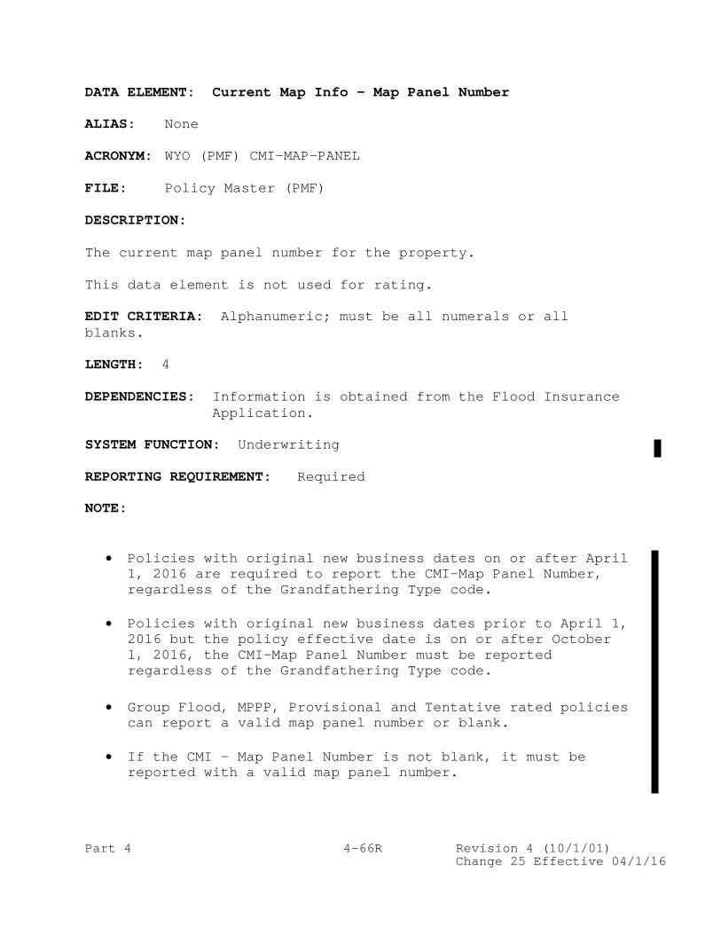
DATA ELEMENT: Current Map Info – Map Panel Number ALIAS: None ACRONYM: WYO (PMF) CMI-MAP-PANEL FILE: Policy Master (PMF) DESCRIPTION: The current map panel number for the property. This data element is not used for rating. EDIT CRITERIA: Alphanumeric; must be all numerals or all blanks. LENGTH: 4 DEPENDENCIES: Information is obtained from the Flood Insurance
Application. SYSTEM FUNCTION: Underwriting REPORTING REQUIREMENT: Required NOTE:
• Policies with original new business dates on or after April 1, 2016 are required to report the CMI-Map Panel Number, regardless of the Grandfathering Type code.
• Policies with original new business dates prior to April 1,
2016 but the policy effective date is on or after October 1, 2016, the CMI-Map Panel Number must be reported regardless of the Grandfathering Type code.
• Group Flood, MPPP, Provisional and Tentative rated policies can report a valid map panel number or blank.
• If the CMI – Map Panel Number is not blank, it must be
reported with a valid map panel number.
Part 4 4-66S Revision 4 (10/1/01) Change 25 Effective 04/1/16
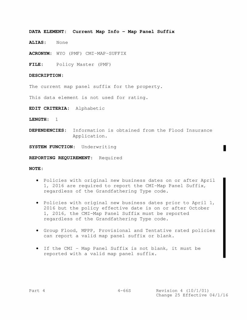
DATA ELEMENT: Current Map Info – Map Panel Suffix ALIAS: None ACRONYM: WYO (PMF) CMI-MAP-SUFFIX FILE: Policy Master (PMF) DESCRIPTION: The current map panel suffix for the property. This data element is not used for rating. EDIT CRITERIA: Alphabetic LENGTH: 1 DEPENDENCIES: Information is obtained from the Flood Insurance
Application. SYSTEM FUNCTION: Underwriting REPORTING REQUIREMENT: Required NOTE:
• Policies with original new business dates on or after April 1, 2016 are required to report the CMI-Map Panel Suffix, regardless of the Grandfathering Type code.
• Policies with original new business dates prior to April 1,
2016 but the policy effective date is on or after October 1, 2016, the CMI-Map Panel Suffix must be reported regardless of the Grandfathering Type code.
• Group Flood, MPPP, Provisional and Tentative rated policies
can report a valid map panel suffix or blank.
• If the CMI - Map Panel Suffix is not blank, it must be reported with a valid map panel suffix.

Part 4 4-115A Revision 4 (10/1/01) Change 23 Effective 4/1/15
DATA ELEMENT: Grandfathering Type Code ALIAS: None ACRONYM: WYO (PMF) GRANDFATHER-TYPE FILE: Policy Master (PMF) DESCRIPTION: This code identifies if the insured has opted to grandfather the map information, such as flood risk zone, BFE, map panel number, and map panel suffix. Buildings may be grandfathered if they meet either of the following conditions:
• Insured property was built in compliance with the building code in effect as of the map effective date (Grandfathering Built to Code). Grandfathering Built to Code must have an original construction date that is on or after the community map effective date for the grandfathered flood zone.
• Insured property has Grandfathering Continuous Coverage – it may
continue to use the map information that was effective at the time the policy was initially issued as long as there is no gap in coverage.
EDIT CRITERIA: Alphanumeric, Acceptable values:
1 – No Grandfathering 2 - Grandfathering Built to Code 3 - Grandfathering Continuous Coverage
LENGTH: 1 DEPENDENCIES: Information is obtained from the Flood Insurance Application. The application provides fields for the ‘Rating Map Information’ and the ‘Current Map Information’. The Rating Map Information is used for rating. When there is no grandfathering, the Rating Map Information is obtained from the FIRM in effect on the date of the application. When the built-in-compliance grandfathering rule applies, the Rating Map Information will be obtained from the FIRM in effect at the time of construction. When the continuous-coverage grandfathering rules are applied, the Rating Map Information is obtained from the previous policy.

Part 4 4-115B Revision 4 (10/1/01) Change 25 Effective 04/1/16
DATA ELEMENT: Grandfathering Type Code (Cont’d.) DEPENDENCIES: (Cont’d.) The Current Map Information must be obtained from the FIRM in effect on the date of application or policy renewal. SYSTEM FUNCTION: Grandfathering information REPORTING REQUIREMENT: Required No Grandfathering: For policies with original new business date on or after April 1, 2016, report the ‘Rating Map Information’ and the ‘Current Map Information’. For policies with original new business date prior to April 1, 2016, and the policy effective date is on or after October 1, 2016, report the ‘Rating Map Information’ and ‘Current Map Information’. Grandfathering Built to Code: Report the ‘Rating Map Information’ and ‘Current Map Information’. The ‘Rating Map Information’ fields will contain the information that was in effect on the date of construction, and this will be used to calculate the premium. The ‘Current Map Information’ fields will contain the data from the FIRM in effect at the time of the most recent transaction effective date. Grandfathering Continuous Coverage: For new business transfer or rollover where a producer indicates grandfathering due to continuous coverage, report the ‘Rating Map Information’ and ‘Current Map Information’. The ‘Rating Map Information’ fields will contain the information that is reflected at the time of application, and this will be used to calculate the premium. The ‘Current Map Information’ fields will contain the data from the FIRM in effect at the time of the most recent transaction effective date. When grandfathering, it is acceptable to have the same community number and panel number in both the Rating Map Information and Current Map Information fields. The suffix should be different, and either the zone or BFE should differ, OR both the zone and BFE will differ. When there is no BFE in one of the BFE fields, 9999.0 should be used. NOTE:
• Preferred Risk, Group Flood, MPPP, Leased Federal Property,
Alternative, Provisional, and Tentative policies are not eligible for Grandfathering – report ‘1’ or blank.
• Policies with New/Rollover/Transfer indicator ‘R’ or ‘Z’ can be
reported with ‘1’, ‘2’, ‘3’, or blanks regardless of the original new business date.

Part 4 4-139A-1 Revision 4 (10/1/01) Change 25 Effective 04/1/16
DATA ELEMENT: Newly Mapped Multiplier ALIAS: None ACRONYM: WYO (PMF) NM-MULTI FILE: Policy Master (PMF) DESCRIPTION: A value applied to the Base Premium for Newly Mapped and Preferred Risk Policies to calculate the premium. The Newly Mapped Multiplier for a Newly Mapped policy is based on the Newly Mapped Date and the Policy Effective Date. It can be referenced in a multiplier table in the Flood Insurance Manual. The Newly Mapped Multiplier is required for all Newly Mapped and Preferred Risk policies. For Preferred Risk policies, the multiplier value is always 1.000. EDIT CRITERIA: Alphanumeric – must be 4 digits with an imbedded decimal point; otherwise will be blank. LENGTH: 5 (Format should be reported with thousands and a decimal point. Example: 1.000) DEPENDENCIES: Information is obtained from the Flood Insurance
Manual. SYSTEM FUNCTION: Premium calculation REPORTING REQUIREMENT: Required for Preferred Risk policies and Newly Mapped policies.
• Required for policies with Risk Rating method ‘R’ (Newly Mapped) and ‘7’ (Preferred Risk) with an effective date on or after April 1, 2016.
• Policies with Risk Rating method ‘R’ (Newly Mapped) must report a valid value based on the Multiplier table.
• Policies with Risk Rating method ‘7’ (Preferred Risk) must report ‘1.000’.
NOTE: As part of the premium calculation, the multiplier will be applied to data element ‘Newly Mapped/PRP Base Premium’.

Part 4 4-139A-2 Revision 4 (10/1/01) Change 25 Effective 04/1/16
DATA ELEMENT: Newly Mapped/PRP Base Premium ALIAS: None ACRONYM: WYO (PMF) NM-PRP-BASE-PREM FILE: Policy Master (PMF) DESCRIPTION: The base premium for Preferred Risk and Newly Mapped policies with an effective date on or after 4/1/2016. The base premium contains the initial premium amount before applying the ICC premium, Newly Mapped Multiplier, Reserve Fund Assessment, HFIAA Surcharge, Probation Surcharge and Federal Policy Fee. The base premium amount can be obtained from the Preferred Risk and Newly Mapped Premium tables located in the Flood Insurance Manual. EDIT CRITERIA: Signed numeric in whole dollars. LENGTH: 7 DEPENDENCIES: Information is obtained from the Flood Insurance
Application. SYSTEM FUNCTION: Premium calculation REPORTING REQUIREMENT: Required for Newly Mapped and Preferred Risk and Newly Mapped policies.
• Required for policies with Risk Rating method ‘R’ (Newly Mapped) and ‘7’ (Preferred Risk) with an effective date on or after April 1, 2016. All remaining Risk Rating methods must report blank.
• Policies with Risk Rating method ‘R’ (Newly Mapped) and ‘7’
(Preferred Risk) must report a valid value based on the premium tables in the Flood Insurance Manual.

Part 4 4-158H Revision 4 (10/1/01) Change 25 Effective 04/1/16
DATA ELEMENT: Pre-FIRM Subsidy Eligibility Indicator ALIAS: None ACRONYM: WYO (PMF) PF-SUB-ELIG FILE: Policy Master (PMF) DESCRIPTION: This indicator determines if a Pre-FIRM policy is eligible to use Pre-FIRM subsidized rates for selected flood zones. If a policy is not eligible for Pre-FIRM subsidized rates, full-risk rates must be used. EDIT CRITERIA: Alphanumeric. Acceptable values: N, Y, blank LENGTH: 1 DEPENDENCIES: Information is obtained from the Flood Insurance
Application. SYSTEM FUNCTION: Rating information REPORTING REQUIREMENT: Required for all Pre-FIRM policies (Post-FIRM indicator is ‘N’) and with original new business date on or after April 1, 2016. NOTE:
• Group Flood, MPPP, and Provisional rated policies can be reported with blanks.
• If the Pre-FIRM Subsidy Eligibility Indicator is not blank,
then it must be reported with either ‘N’ or ‘Y’.
• If Post-FIRM is ‘N’ and the Pre-FIRM Subsidy Eligibility Indicator is ‘N’, policies rated with zones Unnumbered A, AE, A1-A30, AH, AO, V, VE, V1-V30 and D cannot be rated using Pre-FIRM subsidized rates (Rate Tables 2A, 2B, 2C, or 2D in Rating Section of the Flood Insurance manual (FIM), or Rate Tables 3A (Pre-FIRM only), 3B, 4A (Pre-FIRM only), 4B, 4C in the Condominium Section of the FIM). Instead, these policies must be rated using full risk rating (those reported with zones Unnumbered A, AE, A1-A30, VE, V1-V30 cannot have default elevation difference).


PART 5 - CODES Table of Contents
Part 5 5-i Revision 4 (10/1/01) Change 24.1 Effective 11/1/15
PART 5 - CODES
TABLE OF CONTENTS Page INTRODUCTION..................................................5-1 Additions/Extensions Indicator................................5-1 Agricultural Structure Indicator..............................5-1 Area below Elevated Floor - Elevators.........................5-1 Area below Elevated Floor – Enclosed Finished Area Indicator..5-1 Area below Elevated Floor – Garage Indicator..................5-1 Area below Elevated Floor – M/E Indicator.....................5-1 Area below Elevated Floor – M/E Value Indicator...............5-2 Area below Elevated Floor – Washer/Dryer Indicator............5-2 Area below Elevated Floor – Washer/Dryer Value Indicator......5-2 Basement M/E Indicator........................................5-2 Basement M/E Value Indicator..................................5-2 Basement Washer/Dryer Indicator...............................5-2 Basement Washer/Dryer Value Indicator.........................5-2 Basement/Enclosure/Crawlspace Type............................5-3 Building Construction Date Type...............................5-3 Building Damage Subject to Policy Exclusions (ACV)............5-3 Building Description Type.....................................5-3 Building in Course of Construction Indicator..................5-4 Building on Federal Land Indicator............................5-4 Building over Water Type......................................5-4 Building Purpose Type.........................................5-4 Building Walled/Roofed Indicator..............................5-4 Business Property Indicator...................................5-4 Cancellation/Voidance Reason..................................5-5 Cause of Loss.................................................5-5 Claim Closed Without Payment Reason - Building................5-6 Claim Closed Without Payment Reason - Contents................5-6 Claim Closed Without Payment Reason - ICC.....................5-6 Claim Status Indicator........................................5-6 Coinsurance Claim Settlement Indicator........................5-7 Community Identification Number (Rating Map Information)......5-7 Condominium Form of Ownership Indicator.......................5-7 Condominium Indicator.........................................5-7

PART 5 - CODES Table of Contents
Part 5 5-ii Revision 4 (10/1/01) Change 24.1 Effective 11/1/15
Contents Damage Subject to Policy Exclusions (ACV)............5-7 Coverage Required for Disaster Assistance.....................5-7 Current Map Info – Community Identification Number............5-7 Deductible - Applicable to Building Claim Payment.............5-8 Deductible - Applicable to Contents Claim Payment.............5-8 Deductible - Building.........................................5-9 Deductible - Contents.........................................5-9 Diagram Number...............................................5-10 Duration Building Will Not Be Habitable......................5-10 Elevated Building Indicator..................................5-10 Elevating Foundation Type....................................5-10 Elevation Certificate Indicator..............................5-10 Enclosure Material Type......................................5-11 Enclosure Type...............................................5-11 Enclosure Use Indicator......................................5-11 Engineered Flood Openings Indicator..........................5-11 Entire Building Coverage Indicator...........................5-11 Exterior Wall Structure Type.................................5-12 Exterior Wall Surface Treatment..............................5-12 Factors Related to Cause of Loss.............................5-12 Final Payment Indicator - Building...........................5-12 Final Payment Indicator - Contents...........................5-13 Final Payment Indicator - ICC................................5-13 Flood Characteristics........................................5-13 Flood Openings Indicator.....................................5-13 Floodproofed Indicator.......................................5-13 Floor Below Grade Indicator..................................5-13 Foundation Type..............................................5-14 Garage Flood Openings Indicator..............................5-14 Garage Indicator.............................................5-14 Garage M/E Indicator.........................................5-14 Garage Use Indicator.........................................5-14 Grandfathering Type Code.....................................5-15 HFIAA Indicator..............................................5-15 HFIAA Loss Indicator.........................................5-15 House Worship Indicator......................................5-15 ICC Claim Indicator..........................................5-15 ICC Mitigation Indicator.....................................5-15

PART 5 - CODES Table of Contents (Cont’d.)
Part 5 5-iii Revision 4 (10/1/01) Change 25 Effective 04/1/16
Page Insurance to Value Ratio Indicator...........................5-16 Lender Indicator.............................................5-16 Location of Contents Indicator...............................5-16 Mandatory Purchase Indicator.................................5-16 Mitigation Offer Indicator...................................5-16 Name Format Indicator........................................5-16 Name or Descriptive Information Indicator....................5-17 New/Rollover/Transfer Indicator..............................5-17 Non-Profit Entity Indicator..................................5-17 Number of Floors (Including Basement)/Building Type..........5-17 Obstruction Type.............................................5-17 Occupancy Type...............................................5-19 Policy Assignment Type.......................................5-19 Policy Status Indicator......................................5-19 Policy Term Indicator........................................5-20 Post-FIRM Construction Indicator.............................5-20 Pre-FIRM SFHA – Community Reinstatement Indicator............5-20 Pre-FIRM SFHA – Lender Required under Mandatory Purchase Indicator....................................................5-20 Pre-FIRM SFHA – Prior Policy Lapsed Policy Indicator.........5-20 Pre-FIRM SFHA – Prior Policy Lapsed Result of Community Suspension Indicator.........................................5-20 Pre-FIRM Subsidy Eligibility Indicator.......................5-20 Premium Payment Indicator....................................5-21 Primary Residence Indicator..................................5-21 Property Purchase Indicator..................................5-21 Regular/Emergency Program Indicator..........................5-21 Rental Property Indicator....................................5-21 Repetitive Loss Target Group Indicator.......................5-21 Replacement Cost Indicator...................................5-21 Risk Rating Method...........................................5-22 Sml-Business Indicator.......................................5-22 Special Expense Type.........................................5-22 SRL Property Indicator.......................................5-22 State-Owned Property.........................................5-23 Subsidized Rated Indicator...................................5-23 Substantial Improvement Indicator............................5-23 Tenant Building Coverage Indicator...........................5-23 Tenant Indicator.............................................5-23 Valid Policy Indicator.......................................5-23 Value of Building Items Subject to Policy Exclusions (ACV)...5-24 Value of Contents Items Subject to Policy Exclusions (ACV)...5-24 Waiting Period Type..........................................5-24 WYO Transaction Code.........................................5-24 1981 Post-FIRM V Zone Certification Indicator................5-25

Part 5 5-1 Revision 4 (10/1/01) Change 24.1 Effective 11/1/15
PART 5 - CODES INTRODUCTION This section documents the coding scheme used to record NFIP/WYO insurance information.
ADDITIONS/EXTENSIONS INDICATOR DESCRIPTION CODE None N Building includes Additions/Extensions I Building excludes Additions/Extensions X Building is Addition/Extension A
AGRICULTURAL STRUCTURE INDICATOR DESCRIPTION CODE Yes Y No N
AREA BELOW ELEVATED FLOOR - ELEVATORS DESCRIPTION CODE Yes Y No N
AREA BELOW ELEVATED FLOOR – ENCLOSED FINISHED AREA INDICATOR DESCRIPTION CODE Yes Y No N
AREA BELOW ELEVATED FLOOR – GARAGE INDICATOR DESCRIPTION CODE Adjacent to the elevated floor A Beneath the elevated floor B No garage N
AREA BELOW ELEVATED FLOOR – M/E INDICATOR DESCRIPTION CODE Yes Y No N

Part 5 5-2 Revision 4 (10/1/01) Change 24.1 Effective 11/1/15
AREA BELOW ELEVATED FLOOR – M/E VALUE INDICATOR DESCRIPTION CODE $0 to $10,000 1 $10,001 to $20,000 2 Over $20,000 3
AREA BELOW ELEVATED FLOOR – WASHER/DRYER INDICATOR DESCRIPTION CODE Yes Y No N
AREA BELOW ELEVATED FLOOR – WASHER/DRYER VALUE INDICATOR DESCRIPTION CODE $0 to $5,000 1 $5,001 to $10,000 2 Over $10,000 3
BASEMENT M/E INDICATOR DESCRIPTION CODE Yes Y No N
BASEMENT M/E VALUE INDICATOR DESCRIPTION CODE $0 to $10,000 1 $10,001 to $20,000 2 Over $20,000 3
BASEMENT WASHER/DRYER INDICATOR DESCRIPTION CODE Yes Y No N
BASEMENT WASHER/DRYER VALUE INDICATOR DESCRIPTION CODE $0 to $5,000 1 $5,001 to $10,000 2 Over $10,000 3

Part 5 5-3 Revision 4 (10/1/01) Change 24.1 Effective 11/1/15
BASEMENT/ENCLOSURE/CRAWLSPACE TYPE
DESCRIPTION CODE None 0 Finished Basement/Enclosure 1 Unfinished Basement/Enclosure 2 Crawlspace 3 Subgrade Crawlspace 4
BUILDING CONSTRUCTION DATE TYPE DESCRIPTION CODE Building Permit Date 1 Date of Construction 2 Substantial Improvement Date 3 Manufactured (Mobile) Homes located in a Mobile Home Park 4 or Subdivision: Construction Date of Mobile Home Park or Subdivision Facilities Manufactured (Mobile) Homes located outside a Mobile Home 5 Park or Subdivision: Date of Permanent Placement
BUILDING DAMAGE SUBJECT TO POLICY EXCLUSIONS (ACV) DESCRIPTION CODE Less than $1,000 1 $1,000 - $2,000 2 $2,001 - $5,000 3 $5,001 - $10,000 4 $10,001 - $20,000 5 More than $20,000 6
BUILDING DESCRIPTION TYPE DESCRIPTION CODE Main House 01 Detached Guest House 02 Detached Garage 03 Agricultural Building (prior to 11/1/2015) 04 Warehouse 05 Poolhouse, Clubhouse, Recreation Building 06 Tool/Storage Shed 07 Other 08 Barn 09 Apartment Building 10 Apartment - Unit 11 Cooperative Building 12 Cooperative - Unit 13

Part 5 5-4 Revision 4 (10/1/01) Change 24.1 Effective 11/1/15
BUILDING IN COURSE OF CONSTRUCTION INDICATOR DESCRIPTION CODE Yes Y No N
BUILDING ON FEDERAL LAND INDICATOR DESCRIPTION CODE Yes Y No N
BUILDING OVER WATER TYPE DESCRIPTION CODE Not over Water 1 Partially over Water 2 Fully/Entirely over Water 3
BUILDING PURPOSE TYPE DESCRIPTION CODE Mixed Use M Non-Residential (100%) N Residential (100%) R
BUILDING WALLED/ROOFED INDICATOR DESCRIPTION CODE Yes Y No N
BUSINESS PROPERTY INDICATOR DESCRIPTION CODE No N Yes Y

Part 5 5-5 Revision 4 (10/1/01) Change 24.1 Effective 11/1/15
CANCELLATION/VOIDANCE REASON Building Sold or Removed 01 Contents Sold or Removed (contents-only policy) 02 Policy Cancelled and Rewritten to Establish a Common Expiration Date with Other Lines of Insurance 03 Duplicate Policies (NFIP) 04 Non-Payment 05 Ineligible Risk 06 No Insurable Interest 08 PMR (Physical Map Revision) or LOMR with Lender Release 09 Closed Basin Lake (ineligible) 10 FEMA Letter of Determination with Lender Release 16 Duplicate Policies from Sources Other Than NFIP (no longer valid 11/1/15) 17 LOMA with Lender Release 20 SRL Written with Incorrect Insurer 21 Cancel/Rewrite Due to Misrating 22 Fraud 23 Cancel/Rewrite to PRP after Map Revision 24 Cancel/Rewrite to Process HFIAA Refund 25 Certain Condominium Units Covered by Dwelling Policy and by RCBAP 45 Policy Required by Mortgagee in Error 50 Mortgage Paid Off 52 Voidance Prior to Effective Date 60 Voidance Due to Credit Card Error (no longer valid 11/1/15) 70
CAUSE OF LOSS DESCRIPTION CODE Other Causes 0 Tidal Water Overflow 1 Stream, River, or Lake Overflow 2 Alluvial Fan Overflow 3 Accumulation of Rainfall or Snowmelt 4 Erosion – Demolition 7 Erosion – Removal 8 Earth Movement, Landslide, Land Subsidence, Sinkholes, etc. 9 Closed Basin Lake A Expedited Claim Handling Process Without Site Inspection B Expedited Claim Handling Process Follow-up Site Inspection C Expedited Claim Handling Process by Adjusting Process Pilot Program D

Part 5 5-6 Revision 4 (10/1/01) Change 24.1 Effective 11/1/15
CLAIM CLOSED WITHOUT PAYMENT REASON - BUILDING CLAIM CLOSED WITHOUT PAYMENT REASON - CONTENTS
DESCRIPTION CODE Claim denied that was less than deductible 01 Seepage 02 Backup drains 03 Shrubs not covered 04 Sea wall 05 Not actual flood 06 Loss in progress 07 Failure to pursue claim 08 Debris removal only 09 Fire 10 Fence damage 11 Hydrostatic pressure 12 Drainage clogged 13 Boat piers 14 Not insured, damage before inception of policy 15 Not insured, wind damage 16 Type of erosion not included in definition of flood or flooding 17 Landslide 18 Type of mudflow not included in definition of flood or flooding 19 No demonstrable damage 20 Other 97 Error-delete claim (no assignment) 98 Erroneous assignment 99
CLAIM CLOSED WITHOUT PAYMENT REASON - ICC
DESCRIPTION CODE Flood-related portion of damage less than 50% of property value 01 No record of previous loss payment for a repetitive loss ICC claim 02 Other 97 Error-delete claim (no assignment) 98 Erroneous assignment 99
CLAIM STATUS INDICATOR DESCRIPTION CODE Open A Closed With Payment C Closed Without Payment X

Part 5 5-7 Revision 4 (10/1/01) Change 24.1 Effective 11/1/15
COINSURANCE CLAIM SETTLEMENT INDICATOR
DESCRIPTION CODE RCBAP coinsurance penalty applied Y No RCBAP coinsurance penalty N or Blank
COMMUNITY IDENTIFICATION NUMBER (RATING MAP INFORMATION) See Community Status Book or Community Master File.
CONDOMINIUM FORM OF OWNERSHIP INDICATOR DESCRIPTION CODE Yes (condo) Y No (not condo) N
CONDOMINIUM INDICATOR DESCRIPTION CODE Not a Condominium N Individual Condominium Unit insured by a unit owner or by an association U Condominium Association A Condominium Master Policy (RCBAP) – High-Rise H Condominium Master Policy (RCBAP) – Low-Rise L
CONTENTS DAMAGE SUBJECT TO POLICY EXCLUSIONS (ACV) DESCRIPTION CODE Less than $1,000 1 $1,000 - $2,000 2 $2,001 - $5,000 3 $5,001 - $10,000 4 $10,001 - $20,000 5 More than $20,000 6
COVERAGE REQUIRED FOR DISASTER ASSISTANCE
DESCRIPTION CODE Not Required 0 SBA 1 FEMA 2 FHA 3 HHS (canceled, effective October 1, 2009) 4 Other Agency 5
CURRENT MAP INFO – COMMUNITY IDENTIFICATION NUMBER See Community Status Book or Community Master File.

Part 5 5-8 Revision 4 (10/1/01) Change 24.1 Effective 11/1/15
DEDUCTIBLE - APPLICABLE TO BUILDING CLAIM PAYMENT DESCRIPTION CODE $ 500 0 $ 1,000 1 $ 2,000 2 $ 3,000 3 $ 4,000 4 $ 5,000 5 $ 6,000 6 $ 8,000 7 $10,000 8 $ 750 9 $ 1,500 A $ 1,250 B $ 1,750 C $ 2,250 D $ 3,250 E $ 4,250 F $ 5,250 G $ 6,250 H $ 8,250 I $10,250 J $10,000 K $15,000 L $20,000 M $25,000 N $50,000 P $30,000 Q $40,000 R $100,000 S
DEDUCTIBLE - APPLICABLE TO CONTENTS CLAIM PAYMENT DESCRIPTION CODE $ 500 0 $ 1,000 1 $ 2,000 2 $ 3,000 3 $ 4,000 4 $ 5,000 5 $ 6,000 6 $ 8,000 7 $10,000 8 $ 750 9 $ 1,500 A $ 1,250 B $ 1,750 C $ 2,250 D $ 3,250 E $ 4,250 F $ 5,250 G $ 6,250 H $ 8,250 I $10,250 J

Part 5 5-9 Revision 4 (10/1/01) Change 24.1 Effective 11/1/15
DEDUCTIBLE - APPLICABLE TO CONTENTS CLAIM PAYMENT (cont.) $10,000 K $15,000 L $20,000 M $25,000 N $50,000 P $30,000 Q $40,000 R $100,000 S
DEDUCTIBLE - BUILDING DESCRIPTION CODE $ 500 0 $ 1,000 1 $ 2,000 2 $ 3,000 3 $ 4,000 4 $ 5,000 5 $ 750 9 $10,000 A $15,000 B $20,000 C $25,000 D $50,000 E $ 1,250 F $ 1,500 G
DEDUCTIBLE - CONTENTS DESCRIPTION CODE $ 500 0 $ 1,000 1 $ 2,000 2 $ 3,000 3 $ 4,000 4 $ 5,000 5 $ 750 9 $10,000 A $15,000 B $20,000 C $25,000 D $50,000 E $ 1,250 F $ 1,500 G

Part 5 5-10 Revision 4 (10/1/01) Change 24.1 Effective 11/1/15
DIAGRAM NUMBER Refer to the Flood Insurance Manual – Lowest Floor Guide Section. DESCRIPTION CODE Build Diagram #1 (includes Diagrams 1A and 1B to distinguish 1 raised slabs or stem walls from standard slab on grade) Building Diagram #2 2 Building Diagram #3 3 Building Diagram #4 4 Building Diagram #5 5 Building Diagram #6 6 Building Diagram #7 7 Building Diagram #8 8 Building Diagram #9 (subgrade crawlspace) 9
DURATION BUILDING WILL NOT BE HABITABLE DESCRIPTION CODE 0-2 days 1 3-7 days 2 2-4 weeks 3 1-2 months 4 More than 2 months 5
ELEVATED BUILDING INDICATOR DESCRIPTION CODE Elevated Building Y Not Elevated Building N
ELEVATING FOUNDATION TYPE DESCRIPTION CODE Piers, Posts or Piles 1 Reinforced Masonry Piers or Concrete Piers or Columns 2 Reinforced Concrete Shear Walls 3 Wood Shear Walls (not approved for elevating in V zones) 4 Solid Foundation Walls (not approved for elevating in V zones) 5
ELEVATION CERTIFICATE INDICATOR DESCRIPTION CODE Post-FIRM Zone A Rate Tables:
No Elevation Certificate, original effective date prior to October 1, 1982, with no break in insurance coverage 1 No Elevation Certificate, original effective date on or after October 1, 1982, with no break in

Part 5 5-11 Revision 4 (10/1/01) Change 24.1 Effective 11/1/15
insurance coverage 2 Elevation Certificate with BFE 3 Elevation Certificate without BFE 4
Provisionally Rated Post-FIRM Zone AE (A1-A30) or Post-FIRM Zone A Where the Community Provides BFEs:
Basement or Subgrade Crawlspace A Fill or Crawlspace B Piles, Piers, or Columns with Enclosure C Piles, Piers, or Columns without Enclosure D Slab on Grade E
ENCLOSURE MATERIAL TYPE DESCRIPTION CODE Insect Screening 1 Light Wood Lattice 2 Solid Wood Frame Walls 3 Solid Wood Frame Walls (Non-Breakaway) 4 Masonry Walls 5 Masonry Walls (Non-Breakaway) 6 Other 7
ENCLOSURE TYPE
DESCRIPTION CODE Fully F None N Partially P
ENCLOSURE USE INDICATOR DESCRIPTION CODE Yes Y No N
ENGINEERED FLOOD OPENINGS INDICATOR DESCRIPTION CODE Yes Y No N
ENTIRE BUILDING COVERAGE INDICATOR DESCRIPTION CODE Yes Y No N

Part 5 5-12 Revision 4 (10/1/01) Change 24.1 Effective 11/1/15
EXTERIOR WALL STRUCTURE TYPE DESCRIPTION CODE Reinforced Concrete 1 Concrete Block 2 Wood Stud 3 Steel and Glass 4 Brick or Stone 5 Other 6
EXTERIOR WALL SURFACE TREATMENT DESCRIPTION CODE Unfinished 1 Stone/Brick Veneer 2 Stucco 3 Sheathing/Siding Wood 4 Metal 5 Vinyl 6 Other 7
FACTORS RELATED TO CAUSE OF LOSS DESCRIPTION CODE Improper Building A Improper Grading B Improper Water Diversion C Debris Accumulation D Inadequate Storm Drain System E Negligent Maintenance of Storm Drain System F Failure to Use Pumps G Inadequate Pumps H Pump Failure I Dam Failure J Excessive Water Release from Dam K Excessive Water Release from Other Source L Failure of Other Flood Control Measures M Other Violation of Floodplain Management Regulations N Other Factor That Identifies a Responsible Party of Act O
FINAL PAYMENT INDICATOR - BUILDING
DESCRIPTION CODE Closed Case/Final Payment Y Open Case/Not Final Payment N No Case/Not Applicable A

Part 5 5-13 Revision 4 (10/1/01) Change 24.1 Effective 11/1/15
FINAL PAYMENT INDICATOR - CONTENTS
DESCRIPTION CODE Closed Case/Final Payment Y Open Case/Not Final Payment N No Case/Not Applicable A
FINAL PAYMENT INDICATOR - ICC DESCRIPTION CODE Closed Case/Final Payment Y Open Case/Not Final Payment N No Case/Not Applicable A
FLOOD CHARACTERISTICS
DESCRIPTION CODE Velocity Flow 1 Low-Velocity Flow or Ponding 2 Wave Action 3 Mudflow 4 Erosion 5
FLOOD OPENINGS INDICATOR DESCRIPTION CODE Yes Y No N
FLOODPROOFED INDICATOR DESCRIPTION CODE Floodproofed Y Not Floodproofed N
FLOOR BELOW GRADE INDICATOR DESCRIPTION CODE Yes Y No N
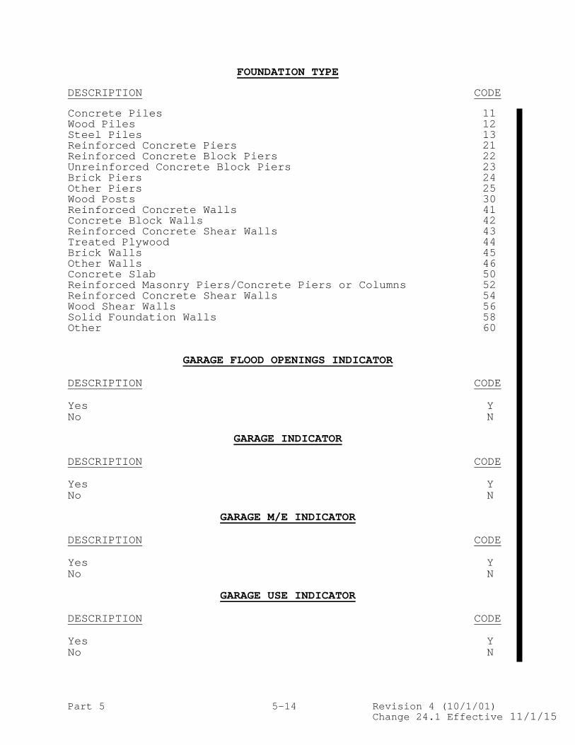
Part 5 5-14 Revision 4 (10/1/01) Change 24.1 Effective 11/1/15
FOUNDATION TYPE DESCRIPTION CODE Concrete Piles 11 Wood Piles 12 Steel Piles 13 Reinforced Concrete Piers 21 Reinforced Concrete Block Piers 22 Unreinforced Concrete Block Piers 23 Brick Piers 24 Other Piers 25 Wood Posts 30 Reinforced Concrete Walls 41 Concrete Block Walls 42 Reinforced Concrete Shear Walls 43 Treated Plywood 44 Brick Walls 45 Other Walls 46 Concrete Slab 50 Reinforced Masonry Piers/Concrete Piers or Columns 52 Reinforced Concrete Shear Walls 54 Wood Shear Walls 56 Solid Foundation Walls 58 Other 60
GARAGE FLOOD OPENINGS INDICATOR DESCRIPTION CODE Yes Y No N
GARAGE INDICATOR DESCRIPTION CODE Yes Y No N
GARAGE M/E INDICATOR DESCRIPTION CODE Yes Y No N
GARAGE USE INDICATOR DESCRIPTION CODE Yes Y No N

Part 5 5-15 Revision 4 (10/1/01) Change 24.1 Effective 11/1/15
GRANDFATHERING TYPE CODE DESCRIPTION CODE No Grandfathering 1 Grandfathering Built to Code 2 Grandfathering Continuous Coverage 3
HFIAA INDICATOR DESCRIPTION CODE Yes Y Blank (Not a HFIAA policy) Blank
HFIAA LOSS INDICATOR DESCRIPTION CODE Yes Y Blank (Loss not associated with a HFIAA policy) Blank
HOUSE WORSHIP INDICATOR DESCRIPTION CODE Yes Y No N
ICC CLAIM INDICATOR DESCRIPTION CODE Not an ICC Claim N or Blank Repetitive Loss ICC Claim R Substantial Damage ICC Claim S
ICC MITIGATION INDICATOR DESCRIPTION CODE Demolition D Elevation E Other O Relocation R Floodproof F
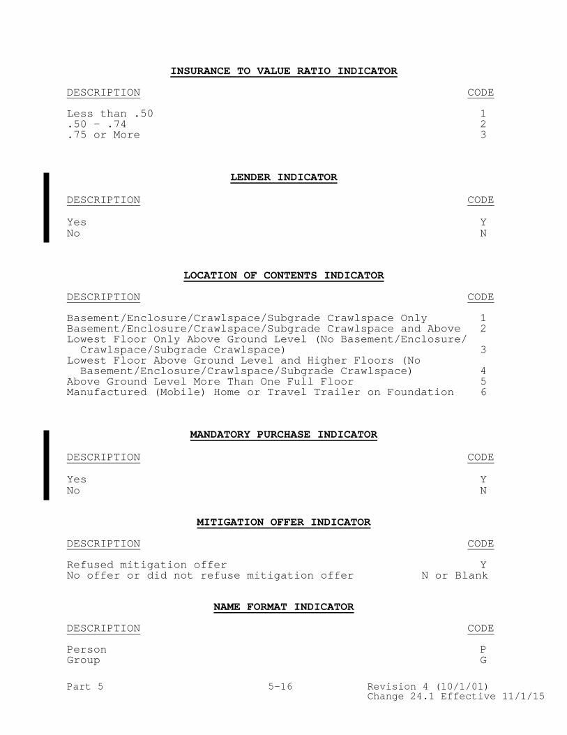
Part 5 5-16 Revision 4 (10/1/01) Change 24.1 Effective 11/1/15
INSURANCE TO VALUE RATIO INDICATOR DESCRIPTION CODE Less than .50 1 .50 - .74 2 .75 or More 3
LENDER INDICATOR DESCRIPTION CODE Yes Y No N
LOCATION OF CONTENTS INDICATOR DESCRIPTION CODE Basement/Enclosure/Crawlspace/Subgrade Crawlspace Only 1 Basement/Enclosure/Crawlspace/Subgrade Crawlspace and Above 2 Lowest Floor Only Above Ground Level (No Basement/Enclosure/ Crawlspace/Subgrade Crawlspace) 3 Lowest Floor Above Ground Level and Higher Floors (No Basement/Enclosure/Crawlspace/Subgrade Crawlspace) 4 Above Ground Level More Than One Full Floor 5 Manufactured (Mobile) Home or Travel Trailer on Foundation 6
MANDATORY PURCHASE INDICATOR DESCRIPTION CODE Yes Y No N
MITIGATION OFFER INDICATOR
DESCRIPTION CODE Refused mitigation offer Y No offer or did not refuse mitigation offer N or Blank
NAME FORMAT INDICATOR DESCRIPTION CODE Person P Group G

Part 5 5-17 Revision 4 (10/1/01) Change 24.1 Effective 11/1/15
NAME OR DESCRIPTIVE INFORMATION INDICATOR DESCRIPTION CODE Name N Descriptive D Legal Address L
NEW/ROLLOVER/TRANSFER INDICATOR DESCRIPTION CODE New Issue N Rollover/Renewal R Rollover/Renewal with Elevation Certification Date Prior to October 1, 1997 (effective May 1, 2005, code no longer valid) E Rewritten for TRRP Cancellation Reason Codes 22, 24 and 25 Z Transfer T
NON-PROFIT ENTITY INDICATOR DESCRIPTION CODE Yes Y No N
NUMBER OF FLOORS (INCLUDING BASEMENT)/BUILDING TYPE DESCRIPTION CODE One Floor 1 Two Floors 2 Three or More Floors 3 Split-Level 4 Manufactured (Mobile) Home or Travel Trailer on Foundation 5 Townhouse/Rowhouse with three or more floors (RCBAP Low-rise only) 6
OBSTRUCTION TYPE DESCRIPTION CODE Free of obstruction 10 With obstruction: enclosure/crawlspace with proper openings not used for rating (not applicable in V zones) 15
With obstruction: less than 300 sq. ft. with breakaway walls, but no machinery or equipment attached to building below lowest elevated floor, or elevation of machinery/equipment is at or above Base Flood Elevation 20

Part 5 5-18 Revision 4 (10/1/01) Change 24.1 Effective 11/1/15
OBSTRUCTION TYPE (cont’d.) DESCRIPTION CODE With obstruction: less than 300 sq. ft. with breakaway walls or finished enclosure and with machinery or equipment attached to building below lowest elevated floor, and elevation of machinery/equipment is below Base Flood Elevation 24
With obstruction: 300 sq. ft. or more with breakaway walls, but no machinery or equipment attached to building below the Base Flood Elevation 30
With obstruction: 300 sq. ft. or more with breakaway walls or finished enclosure and with machinery or equipment attached to building below the Base Flood Elevation 34
With obstruction: no walls, but the elevation of machinery or equipment attached to building is below Base Flood Elevation (NOTE: Use Obstruction Type “10” and Without Obstruction Rate Table if the elevation of machinery/ equipment is at or above Base Flood Elevation.) 40
With obstruction: nonbreakaway walls/crawlspace or finished enclosure with no machinery or equipment attached to building below lowest elevated floor 50
With obstruction: nonbreakaway walls/crawlspace or finished enclosure with machinery or equipment attached to building below lowest elevated floor 54
With obstruction 60 With Certification subgrade crawlspace (AE, A01-A30, unnumbered A, AO, AH, AOB, AHB zones) 70 Without Certification subgrade crawlspace (all zones) 80 With Enclosure: Elevated buildings with elevator below the BFE in A zones. No other enclosure below the BFE. 90 Free of Obstruction: Elevated buildings with lattice, slats, or shutters (including louvers) enclosing the elevator
below the BFE in V zones. No other obstruction or machinery and equipment (M&E) servicing the building located below the BFE. The building will be rated free of obstruction with the V zone elevator loading added to the building basic limit. 91
With Enclosure: Elevated buildings with elevator below the BFE in A zones. Enclosure below the BFE has no proper openings, is finished, or is used for other than parking, building access, or storage. 92 With Obstruction: Elevated buildings with elevator below the BFE in V zones. No other obstruction or machinery and equip- ment (M&E) servicing the building located below the BFE. 94

Part 5 5-19 Revision 4 (10/1/01) Change 24.1 Effective 11/1/15
OBSTRUCTION TYPE (cont’d)
DESCRIPTION CODE With Obstruction: Elevated buildings with elevator below the BFE in V zones. Breakaway wall obstruction is unfinished and elevator and obstruction are located below the BFE, but no machinery and equipment (M&E) servicing the building is located below the BFE. 95 With Obstruction: Elevated buildings with elevator below the BFE in V zones. Breakaway wall obstruction is finished or is used for other than parking, building access, or storage. 96 With Obstruction: Elevated buildings with elevator below the BFE in V zones. No other obstruction, but has M&E servicing the building located below the BFE. 97
With Obstruction: Elevated buildings with elevator below the BFE in V zones. Breakaway walls obstruction and M&E servicing the building are located below the BFE. 98
OCCUPANCY TYPE DESCRIPTION CODE Single-Family 1 Two- to Four-Family 2 Other Residential 3 Other Non Residential 4 Non Residential - Business 6
POLICY ASSIGNMENT TYPE DESCRIPTION CODE No assignment N or Blank Assignment due to new purchase P Other Assignment O
POLICY STATUS INDICATOR DESCRIPTION CODE In force as of the reporting month A Future effective as of the reporting month B Cancelled before the reporting month C Cancelled during or after the reporting month D Expired more than 120 days before the reporting month E Expired before the reporting month less than 29 days F Expired before the reporting month more than 29 days but less than 120 days G Reinstated within the latest term month R

Part 5 5-20 Revision 4 (10/1/01) Change 25 Effective 04/1/16
POLICY TERM INDICATOR DESCRIPTION CODE 1 Year 1 3 Years (only for policies effective prior to May 1, 1999) 3 Other (between 1 and 3 years) 9
POST-FIRM CONSTRUCTION INDICATOR
DESCRIPTION CODE Post-FIRM Construction Y Pre-FIRM Construction N
PRE-FIRM SFHA – COMMUNITY REINSTATEMENT INDICATOR DESCRIPTION CODE Yes Y No N
PRE-FIRM SFHA – LENDER REQUIRED UNDER MANDATORY PURCHASE INDICATOR
DESCRIPTION CODE Yes Y No N
PRE-FIRM SFHA – PRIOR POLICY LAPSED POLICY INDICATOR DESCRIPTION CODE Yes Y No N
PRE-FIRM SFHA – PRIOR POLICY LAPSED RESULT OF COMMUNITY SUSPENSION INDICATOR
DESCRIPTION CODE Yes (due to community suspension) Y No N
PRE-FIRM SUBSIDY ELIGIBILITY INDICATOR DESCRIPTION CODE Eligible for Pre-FIRM subsidized rates Y Not eligible for Pre-FIRM subsidized rates N or Blank

Part 5 5-21 Revision 4 (10/1/01) Change 24.1 Effective 11/1/15
PREMIUM PAYMENT INDICATOR DESCRIPTION CODE Credit Card C Cash/Check Blank
PRIMARY RESIDENCE INDICATOR DESCRIPTION CODE Primary Residence of Insured Y Non-Primary Residence N
PROPERTY PURCHASE INDICATOR DESCRIPTION CODE No N Yes Y
REGULAR/EMERGENCY PROGRAM INDICATOR DESCRIPTION CODE Emergency Program E Regular Program R
RENTAL PROPERTY INDICATOR DESCRIPTION CODE No N Yes Y
REPETITIVE LOSS TARGET GROUP INDICATOR (cancelled effective October 1,2013 – renamed to SRL Property Indicator) DESCRIPTION CODE Repetitive Loss Target Group Policy Y Not a Repetitive Loss Target Group Policy N or Blank
REPLACEMENT COST INDICATOR DESCRIPTION CODE Replacement Cost Basis R Actual Cash Value Basis A

Part 5 5-22 Revision 4 (10/1/01) Change 24.1 Effective 11/1/15
RISK RATING METHOD DESCRIPTION CODE Manual 1 Specific 2 Alternative 3 V-Zone Risk Factor Rating Form 4 Underinsured Condominium Master Policy 5 Provisional 6 Preferred Risk Policy 7 Tentative 8 MPPP Policy 9 Optional Post-1981 V Zone A Pre-FIRM Elevation Rated Flood Insurance Manual B FEMA Pre-FIRM Special Rates E Leased Federal Properties F Group Flood Insurance Policy G Preferred Risk Policy (A PRP issued in the 1st year of PRP Eligibility under the PRP Eligibility Extension) P Preferred Risk Policy (subsequent renewals beginning with 2nd year of PRP Eligibility under the PRP Eligibility Extension) Q Newly Mapped into SFHA R FEMA Special Rates S Severe Repetitive Loss Properties (effective October 1, 2013, code no longer valid) T Pre-FIRM Elevation Rated Specific Rates W
SML-BUSINESS INDICATOR DESCRIPTION CODE No N Yes Y
SPECIAL EXPENSE TYPE DESCRIPTION CODE Engineering expense 1 Cost to establish coverage or property value 2 Legal expense 3 Cost of appraisal 4
SRL PROPERTY INDICATOR DESCRIPTION CODE No N Yes Y

Part 5 5-23 Revision 4 (10/1/01) Change 24.1 Effective 11/1/15
STATE-OWNED PROPERTY DESCRIPTION CODE State-Owned Y Not State-Owned N
SUBSIDIZED RATED INDICATOR DESCRIPTION CODE Not Subsidized N Emergency Program (based on program type) E Pre-FIRM subsidized P
SUBSTANTIAL IMPROVEMENT INDICATOR
DESCRIPTION CODE Repair, reconstruction, or improvement costs equaled or exceeded 50 percent of market value of building before it was damaged or improved Y
No alterations meeting criterion above N
TENANT BUILDING COVERAGE INDICATOR DESCRIPTION CODE No N Yes Y
TENANT INDICATOR
DESCRIPTION CODE No N Yes Y
VALID POLICY INDICATOR DESCRIPTION CODE Default 0 No Duplicate policy 1 No PRP Repetitive Loss property 2 No SRL property 3

Part 5 5-24 Revision 4 (10/1/01) Change 24.1 Effective 11/1/15
VALUE OF BUILDING ITEMS SUBJECT TO POLICY EXCLUSIONS (ACV)
DESCRIPTION CODE Less than $1,000 1 $1,000 - $2,000 2 $2,001 - $5,000 3 $5,001 - $10,000 4 $10,001 - $20,000 5 More than $20,000 6
VALUE OF CONTENTS ITEMS SUBJECT TO POLICY EXCLUSIONS (ACV)
DESCRIPTION CODE Less than $1,000 1 $1,000 - $2,000 2 $2,001 - $5,000 3 $5,001 - $10,000 4 $10,001 - $20,000 5 More than $20,000 6
WAITING PERIOD TYPE DESCRIPTION CODE Loan Closing C Map Revision M No Waiting Period N Standard S
WYO TRANSACTION CODE DESCRIPTION CODE Premium Transactions New Business – required 11A Policy Reinstatement without Policy Changes – required 14A Policy Reinstatement with Policy Changes – required 15A Renewal – required 17A Endorsement – required 20A Policy Correction – required 23A Cancellation – required 26A
Cancellation Correction – required 29A Loss Transactions Open Claim/Loss - Initial Reserve – required 31A Open Claim/Loss - Initial Reserve – optional 31B Reopen Claim/Loss - required 34A Change Reserve – required 37A Partial Payment – required 40A Close Claim/Loss – required 43A

Part 5 5-25 Revision 4 (10/1/01) Change 24.1 Effective 11/1/15
WYO TRANSACTION CODE (cont’d) DESCRIPTION CODE Close Claim/Loss – optional 43B Close Claim/Loss Without Payment – required 46A Addition to Final Payment – required 49A Addition to Final Payment – optional 49B Recovery After Final Payment – required 52A Recovery After Final Payment – optional 52B
Loss Correction Transactions General Claim/Loss Correction – required 61A General Claim/Loss Correction – optional 61B Claim Payment Correction – required 64A Recovery Correction – required 67A
Special Allocated Loss Adjustment Expense – required 71A Special Allocated Loss Adjustment Expense Correction – required 74A
Change Keys Change Policy Number Key – required 81A Change Date of Loss Key – required` 84A Change Claim Payment Key – required 87A Lender Data (Expired Policy Notification) - required 99A Mailing Address Data – required 12A
1981 POST-FIRM V ZONE CERTIFICATION INDICATOR DESCRIPTION CODE Yes, Certification Provided Y No, Certification Not Provided N

Part 6 6-10 Revision 4 (10/1/01) Change 23 Effective 4/1/15
11 New Business Field Record Record A Length Position Transaction Code (11A) 3 1-3 Transaction Date 8 4-11 WYO Prefix Code 5 12-16 Policy Number 10 17-26 Policy Effective Date 8 27-34 Policy Expiration Date 8 35-42 Name or Descriptive Information Indicator 1 43 Property Beginning Street Number 10 44-53 Property Address 1 50 54-103 Property Address 2 50 104-153 Property City 30 154-183 Property State 2 184-185 Property ZIP Code 9 186-194 Case File Number for Disaster Assistance 9 195-203 Coverage Required for Disaster Assistance 1 204 Community Identification Number (Rating Map Info.) 6 205-210 Map Panel Number (Rating Map Info.) 4 211-214 Map Panel Suffix (Rating Map Info.) 1 215 Regular/Emergency Program Indicator 1 216 Flood Risk Zone (Rating Map Info.) 3 217-219 Occupancy Type 1 220 Number of Floors (Including Basement)/ Building Type 1 221 Basement/Enclosure/Crawlspace Type 1 222 Condominium Indicator 1 223 State-Owned Property 1 224 Building in Course of Construction Indicator 1 225 Deductible - Building 1 226 Deductible - Contents 1 227 Elevated Building Indicator 1 228 Obstruction Type 2 229-230 Location of Contents Indicator 1 231 Original Construction Date 8 232-239 Post-FIRM Construction Indicator 1 240 Elevation Difference 4 241-244 Floodproofed Indicator 1 245 Total Amount of Insurance - Building 8 246-253 Total Amount of Insurance - Contents 5 254-258 Total Calculated Premium 7 259-265 Risk Rating Method 1 266 Policy Term Indicator 1 267 Premium Payment Indicator 1 268 New/Rollover/Transfer Indicator 1 269 Filler 8 270-277 Insurance to Value Ratio Indicator 1 278 Elevation Certificate Indicator 1 279 1981 Post-FIRM V Zone Certification Ind. 1 280 The Taxpayer Identification Number has been removed from the TRRP transaction, effective May 1, 2008.

Part 6 6-11 Revision 4 (10/1/01) Change 20 Effective 6/1/14
11 New Business (Cont’d.) Field Record Record A (Cont’d.) Length Position Filler 3 281-283 Insured Last Name 25 284-308 Insured First Name 25 309-333 Name Format Indicator 1 334 CRS Classification Credit Percentage 2 335-336 Filler 3 337-339 Expense Constant 3 340-342 Primary Residence Indicator 1 343 Replacement Cost 10 344-353 Lowest Floor Elevation (LFE) 6 354-359 Base Flood Elevation (BFE) (Rating Map Info.) 6 360-365 SRL Property Indicator 1 366 Lowest Adjacent Grade 6 367-372 Diagram Number 1 373 Elevation Certification Date 8 374-381 Basic Building Rate WYO 5 382-386 Additional Building Rate WYO 5 387-391 Basic Contents Rate WYO 5 392-396 Additional Contents Rate WYO 5 397-401 ICC Premium WYO 3 402-404 Probation Surcharge Amount WYO 3 405-407 Deductible Percentage WYO 4 408-411 Repetitive Loss ID Number 7 412-418 Reserved for NFIP Use 39 419-457 Original Submission Month 6 458-463 Rejected Transaction Control Number 6 464-469 Sort Sequence Key 1 470 Reserved for WYO Company Use 30 471-500 Building Construction Date Type 1 501 Building over Water Type 1 502 Condominium Form of Ownership Indicator 1 503 Building Description Type 2 504-505 Grandfathering Type Code 1 506 Current Map Info – Community ID Number 6 507-512 Current Map Info – Map Panel Number 4 513-516 Current Map Info - Map Panel Suffix 1 517 Current Map Info – Flood Risk Zone 3 518-520 Current Map Info – BFE (Base Flood Elevation) 6 521-526 Prior Policy Number 10 527-536 Condominium Master Policy Units 5 537-541 Federal Policy Fee 5 542-546 Additions/Extensions Indicator 1 547 Application Date 8 548-555 Building Purpose Type 1 556 Business Property Indicator 1 557 Enclosure Type 1 558 Number of Elevators 2 559-560 Premium Receipt Date 8 561-568 Property Purchase Date 8 569-576

Part 6 6-11A Revision 4 (10/1/01) Change 24 Effective 11/1/15
11 New Business (Cont’d.) Field Record Record A (Cont’d.) Length Position Property Purchase Indicator 1 577 Rental Property Indicator 1 578 Reserve Fund Assessment 8 579-586 Filler 1 587 Tenant Indicator 1 588 Tenant Building Coverage Indicator 1 589 Waiting Period Type 1 590 Mitigation Offer Indicator 1 591 Policy Assignment Type 1 592 Subsidized Rated Indicator 1 593 Valid Policy Indicator 1 594 HFIAA Indicator 1 595 HFIAA Surcharge 8 596-603 Agricultural Structure Indicator 1 604 Area Below Elevated Floor - Elevators 1 605 Area Below Elevated Floor – Enclosed Finished Area Indicator 1 606 Area Below Elevated Floor – Garage Indicator 1 607 Area Below Elevated Floor – M/E Indicator 1 608 Area Below Elevated Floor – M/E Value Amount 6 609-614 Area Below Elevated Floor – M/E Value Indicator 1 615 Area Below Elevated Floor – Number of Flood Openings 3 616-618 Area Below Elevated Floor – W/D Indicator 1 619 Area Below Elevated Floor – W/D Value Amount 6 620-625 Area Below Elevated Floor – W/D Value Indicator 1 626 Basement M/E Indicator 1 627 Basement M/E Value Amount 6 628-633 Basement M/E Value Indicator 1 634 Basement W/D Indicator 1 635 Basement W/D Value Amount 6 636-641 Basement W/D Value Indicator 1 642 Building on Federal Land 1 643 Building Purpose Type Percent 2 644-645 Building Walled/Roofed Indicator 1 646 Current Map Date 8 647-654 Elevating Foundation Type 1 655 Enclosure Material Type 1 656 Enclosure Size 6 657-662 Enclosure Use Indicator 1 663 Engineered Flood Openings Indicator 1 664 Entire Building Coverage Indicator 1 665 Flood Openings Indicator 1 666 Floor Below Grade Indicator 1 667 Garage Flood Openings Indicator 1 668 Garage Indicator 1 669 Garage M/E Indicator 1 670

Part 6 6-11B Revision 4 (10/1/01) Change 25 Effective 04/1/16
11 New Business (Cont’d.) Field Record Record A (Cont’d.) Length Position Garage – Number of Flood Openings 3 671-673 Garage Total Net Area 6 674-679 Garage Use Indicator 1 680 House of Worship Indicator 1 681 Lender Indicator 1 682 Mandatory Purchase Indicator 1 683 Newly Mapped Date 8 684-691 Non-Profit Entity Indicator 1 692 Pre-Firm SFHA – Community Reinstatement Date 8 693-700 Pre-Firm SFHA – Community Reinstatement Indicator 1 701 Pre-Firm SFHA – Community Suspension Date 8 702-709 Pre-Firm SFHA – Lender Required Under Mandatory Purchase Indicator 1 710 Pre-Firm SFHA – Prior Policy Indicator 1 711 Pre-Firm SFHA – Prior Policy Lapsed Policy Indicator 1 712 Pre-Firm SFHA – Prior Policy Lapsed Result of Community Suspension Indicator 1 713 Rate Table Code 3 714-716 Rated Map Date 8 717-724 Substantial Improvement Date 8 725-732 Small Business Building Indicator 1 733 Total Area of Flood Openings 6 734-739 Total Area Garage Flood Openings 6 740-745 Pre-FIRM Subsidy Eligibility Indicator 1 746 Newly Mapped Multiplier 5 747-751 Newly Mapped/PRP Base Premium 7 752-758 Reserved for NFIP Use2 242 759-1000

Part 6 6-11C Revision 4 (10/1/01) Change 25 Effective 04/1/16
This page is intentionally left blank.

Part 6 6-12 Revision 4 (10/1/01) Change 24 Effective 11/1/15
12 Mailing Address Data Field Record Record A Length Position Transaction Code (12A) 3 1-3 Transaction Date 8 4-11 WYO Prefix Code 5 12-16 Policy Number 10 17-26 Name or Descriptive Information Indicator 1 27 Mailing Address 1 50 28-77 Mailing Address 2 50 78-127 Mailing City 30 128-157 Mailing State 2 158-159 Mailing ZIP Code 9 160-168 HFIAA Indicator 1 169 Reserved for NFIP Use 288 170-457 Original Submission Month 6 458-463 Rejected Transaction Control Number 6 464-469 Sort Sequence Key 1 470 Reserved for WYO Company Use 30 471-500 Reserved for NFIP Use2 500 501-1000 NOTE: This transaction must be submitted with any new business (11A),
renewal (17A), or reinstatement transaction (14A,15A) OR when the mailing address information has been updated by the WYO company.

Part 6 6-13 Revision 4 (10/1/01) Change 24 Effective 11/1/15
14 Policy Reinstatement Without Policy Changes Field Record Record A Length Position Transaction Code (14A) 3 1-3 Transaction Date 8 4-11 WYO Prefix Code 5 12-16 Policy Number 10 17-26 Policy Effective Date 8 27-34 Policy Expiration Date 8 35-42 HFIAA Indicator 1 43 Reserved for NFIP Use 414 44-457 Original Submission Month 6 458-463 Rejected Transaction Control Number 6 464-469 Sort Sequence Key 1 470 Reserved for WYO Company Use 30 471-500 Reserved for NFIP Use2 500 501-1000 NOTE: If changes to policy record are needed, the WYO company must
either submit an Endorsement transaction (20) with this transaction, or submit a Policy Reinstatement with Policy Changes transaction (15) in lieu of this transaction.

Part 6 6-14 Revision 4 (10/1/01) Change 23 Effective 4/1/15
15 Policy Reinstatement With Policy Changes Field Record Record A Length Position Transaction Code (15A) 3 1-3 Transaction Date 8 4-11 WYO Prefix Code 5 12-16 Policy Number 10 17-26 Policy Effective Date 8 27-34 Policy Expiration Date 8 35-42 Name or Descriptive Information Indicator 1 43 Property Beginning Street Number 10 44-53 Property Address 1 50 54-103 Property Address 2 50 104-153 Property City 30 154-183 Property State 2 184-185 Property ZIP Code 9 186-194 Case File Number for Disaster Assistance 9 195-203 Coverage Required for Disaster Assistance 1 204 Community Identification Number (Rating Map Info.) 6 205-210 Map Panel Number (Rating Map Info.) 4 211-214 Map Panel Suffix (Rating Map Info.) 1 215 Regular/Emergency Program Indicator 1 216 Flood Risk Zone (Rating Map Info.) 3 217-219 Occupancy Type 1 220 Number of Floors (Including Basement)/ Building Type 1 221 Basement/Enclosure/Crawlspace Type 1 222 Condominium Indicator 1 223 State-Owned Property 1 224 Building in Course of Construction Indicator 1 225 Deductible - Building 1 226 Deductible - Contents 1 227 Elevated Building Indicator 1 228 Obstruction Type 2 229-230 Location of Contents Indicator 1 231 Original Construction Date 8 232-239 Post-FIRM Construction Indicator 1 240 Elevation Difference 4 241-244 Floodproofed Indicator 1 245 Total Amount of Insurance - Building 8 246-253 Total Amount of Insurance - Contents 5 254-258 Reinstatement Premium 9 259-267 Risk Rating Method 1 268 Policy Term Indicator 1 269 Premium Payment Indicator 1 270 New/Rollover/Transfer Indicator 1 271 Endorsement Effective Date 8 272-279 Insurance to Value Ratio Indicator 1 280 Elevation Certificate Indicator 1 281 1981 Post-FIRM V Zone Certification Ind. 1 282 Filler 3 283-285 The Taxpayer Identification Number has been removed from the TRRP transaction, effective May 1, 2008.

Part 6 6-15 Revision 4 (10/1/01) Change 20 Effective 6/1/14
15 Policy Reinstatement With Policy Changes (Cont’d.) Field Record Record A (Cont’d.) Length Position Insured Last Name 25 286-310 Insured First Name 25 311-335 Name Format Indicator 1 336 CRS Classification Credit Percentage 2 337-338 Filler 5 339-343 Expense Constant 3 344-346 Primary Residence Indicator 1 347 Replacement Cost 10 348-357 Lowest Floor Elevation (LFE) 6 358-363 Base Flood Elevation (BFE) (Rating Map Info.) 6 364-369 SRL Property Indicator 1 370 Lowest Adjacent Grade 6 371-376 Diagram Number 1 377 Elevation Certification Date 8 378-385 Basic Building Rate WYO 5 386-390 Additional Building Rate WYO 5 391-395 Basic Contents Rate WYO 5 396-400 Additional Contents Rate WYO 5 401-405 ICC Premium WYO 3 406-408 Probation Surcharge Amount WYO 3 409-411 Deductible Percentage WYO 4 412-415 Repetitive Loss ID Number 7 416-422 Reserved for NFIP Use 35 423-457 Original Submission Month 6 458-463 Rejected Transaction Control Number 6 464-469 Sort Sequence Key 1 470 Reserved for WYO Company Use 30 471-500 Building Construction Date Type 1 501 Building over Water Type 1 502 Condominium Form of Ownership Indicator 1 503 Building Description Type 2 504-505 Grandfathering Type Code 1 506 Current Map Info – Community ID Number 6 507-512 Current Map Info – Map Panel Number 4 513-516 Current Map Info - Map Panel Suffix 1 517 Current Map Info – Flood Risk Zone 3 518-520 Current Map Info – BFE (Base Flood Elevation) 6 521-526 Prior Policy Number 10 527-536 Condominium Master Policy Units 5 537-541 Reinstatement Federal Policy Fee 7 542-548 Additions/Extensions Indicator 1 549 Application Date 8 550-557 Building Purpose Type 1 558 Business Property Indicator 1 559 Enclosure Type 1 560 Number of Elevators 2 561-562 Premium Receipt Date 8 563-570 Property Purchase Date 8 571-578 Property Purchase Indicator 1 579

Part 6 6-15A Revision 4 (10/1/01) Change 24 Effective 11/1/15
15 Policy Reinstatement With Policy Changes (Cont’d.) Field Record Record A (Cont’d.) Length Position Rental Property Indicator 1 580 Reinstatement Reserve Fund Assessment 10 581-590 Filler 1 591 Tenant Indicator 1 592 Tenant Building Coverage Indicator 1 593 Waiting Period Type 1 594 Mitigation Offer Indicator 1 595 Policy Assignment Type 1 596 Subsidized Rated Indicator 1 597 Valid Policy Indicator 1 598 HFIAA Indicator 1 599 Reinstatement HFIAA Surcharge 10 600-609 Agricultural Structure Indicator 1 610 Area Below Elevated Floor - Elevators 1 611 Area Below Elevated Floor – Enclosed Finished Area Indicator 1 612 Area Below Elevated Floor – Garage Indicator 1 613 Area Below Elevated Floor – M/E Indicator 1 614 Area Below Elevated Floor – M/E Value Amount 6 615-620 Area Below Elevated Floor – M/E Value Indicator 1 621 Area Below Elevated Floor – Number of Flood Openings 3 622-624 Area Below Elevated Floor – W/D Indicator 1 625 Area Below Elevated Floor – W/D Value Amount 6 626-631 Area Below Elevated Floor – W/D Value Indicator 1 632 Basement M/E Indicator 1 633 Basement M/E Value Amount 6 634-639 Basement M/E Value Indicator 1 640 Basement W/D Indicator 1 641 Basement W/D Value Amount 6 642-647 Basement W/D Value Indicator 1 648 Building on Federal Land 1 649 Building Purpose Type Percent 2 650-651 Building Walled/Roofed Indicator 1 652 Current Map Date 8 653-660 Elevating Foundation Type 1 661 Enclosure Material Type 1 662 Enclosure Size 6 663-668 Enclosure Use Indicator 1 669 Engineered Flood Openings Indicator 1 670 Entire Building Coverage Indicator 1 671 Flood Openings Indicator 1 672 Floor Below Grade Indicator 1 673 Garage Flood Openings Indicator 1 674 Garage Indicator 1 675 Garage M/E Indicator 1 676 Garage – Number of Flood Openings 3 677-679

Part 6 6-15B Revision 4 (10/1/01) Change 25 Effective 04/1/16
15 Policy Reinstatement With Policy Changes (Cont’d.) Field Record Record A (Cont’d.) Length Position Garage Total Net Area 6 680-685 Garage Use Indicator 1 686 House of Worship Indicator 1 687 Lender Indicator 1 688 Mandatory Purchase Indicator 1 689 Newly Mapped Date 8 690-697 Non-Profit Entity Indicator 1 698 Pre-Firm SFHA – Community Reinstatement Date 8 699-706 Pre-Firm SFHA – Community Reinstatement Indicator 1 707 Pre-Firm SFHA – Community Suspension Date 8 708-715 Pre-Firm SFHA – Lender Required Under Mandatory Purchase Indicator 1 716 Pre-Firm SFHA – Prior Policy Indicator 1 717 Pre-Firm SFHA – Prior Policy Lapsed Policy Indicator 1 718 Pre-Firm SFHA – Prior Policy Lapsed Result of Community Suspension Indicator 1 719 Rate Table Code 3 720-722 Rated Map Date 8 723-730 Substantial Improvement Date 8 731-738 Small Business Building Indicator 1 739 Total Area of Flood Openings 6 740-745 Total Area Garage Flood Openings 6 746-751 Pre-FIRM Subsidy Eligibility Indicator 1 752 Newly Mapped Multiplier 5 753-757 Newly Mapped/PRP Base Premium 7 758-764 Reserved for NFIP Use2 236 765-1000

Part 6 6-15C Revision 4 (10/1/01) Change 25 Effective 04/1/16
This page is intentionally left blank.

Part 6 6-16 Revision 4 (10/1/01) Change 23 Effective 4/1/15
17 Renewal Field Record Record A Length Position Transaction Code (17A) 3 1-3 Transaction Date 8 4-11 WYO Prefix Code 5 12-16 Policy Number 10 17-26 Policy Effective Date 8 27-34 Policy Expiration Date 8 35-42 Name or Descriptive Information Indicator 1 43 Property Beginning Street Number 10 44-53 Property Address 1 50 54-103 Property Address 2 50 104-153 Property City 30 154-183 Property State 2 184-185 Property ZIP Code 9 186-194 Case File Number for Disaster Assistance 9 195-203 Coverage Required for Disaster Assistance 1 204 Community Identification Number (Rating Map Info.) 6 205-210 Map Panel Number (Rating Map Info.) 4 211-214 Map Panel Suffix (Rating Map Info.) 1 215 Regular/Emergency Program Indicator 1 216 Flood Risk Zone (Rating Map Info.) 3 217-219 Occupancy Type 1 220 Number of Floors (Including Basement)/ Building Type 1 221 Basement/Enclosure/Crawlspace Type 1 222 Condominium Indicator 1 223 State-Owned Property 1 224 Building in Course of Construction Indicator 1 225 Deductible - Building 1 226 Deductible - Contents 1 227 Elevated Building Indicator 1 228 Obstruction Type 2 229-230 Location of Contents Indicator 1 231 Original Construction Date 8 232-239 Post-FIRM Construction Indicator 1 240 Elevation Difference 4 241-244 Floodproofed Indicator 1 245 Total Amount of Insurance - Building 8 246-253 Total Amount of Insurance - Contents 5 254-258 Total Calculated Premium 7 259-265 Risk Rating Method 1 266 Policy Term Indicator 1 267 Premium Payment Indicator 1 268 Filler 9 269-277 Insurance to Value Ratio Indicator 1 278 Elevation Certificate Indicator 1 279 1981 Post-FIRM V Zone Certification Ind. 1 280 Filler 3 281-283 The Taxpayer Identification Number has been removed from the TRRP transaction, effective May 1, 2008.

Part 6 6-17 Revision 4 (10/1/01) Change 24 Effective 11/1/15
17 Renewal (Cont’d.) Field Record Record A (Cont’d.) Length Position Insured Last Name 25 284-308 Insured First Name 25 309-333 Name Format Indicator 1 334 CRS Classification Credit Percentage 2 335-336 Filler 3 337-339 Expense Constant 3 340-342 Primary Residence Indicator 1 343 Replacement Cost 10 344-353 Lowest Floor Elevation (LFE) 6 354-359 Base Flood Elevation (BFE) (Rating Map Info.) 6 360-365 SRL Property Indicator 1 366 Lowest Adjacent Grade 6 367-372 Diagram Number 1 373 Elevation Certification Date 8 374-381 Basic Building Rate WYO 5 382-386 Additional Building Rate WYO 5 387-391 Basic Contents Rate WYO 5 392-396 Additional Contents Rate WYO 5 397-401 ICC Premium WYO 3 402-404 Probation Surcharge Amount WYO 3 405-407 Deductible Percentage WYO 4 408-411 Repetitive Loss ID Number 7 412-418 Reserved for NFIP Use 39 419-457 Original Submission Month 6 458-463 Rejected Transaction Control Number 6 464-469 Sort Sequence Key 1 470 Reserved for WYO Company Use 30 471-500 Building Construction Date Type 1 501 Building over Water Type 1 502 Condominium Form of Ownership Indicator 1 503 Building Description Type 2 504-505 Grandfathering Type Code 1 506 Current Map Info – Community ID Number 6 507-512 Current Map Info – Map Panel Number 4 513-516 Current Map Info - Map Panel Suffix 1 517 Current Map Info – Flood Risk Zone 3 518-520 Current Map Info – BFE (Base Flood Elevation) 6 521-526 Prior Policy Number 10 527-536 Condominium Master Policy Units 5 537-541 Federal Policy Fee 5 542-546 Additions/Extensions Indicator 1 547 Application Date 8 548-555 Building Purpose Type 1 556 Business Property Indicator 1 557 Enclosure Type 1 558 Number of Elevators 2 559-560 Premium Receipt Date 8 561-568 Property Purchase Date 8 569-576 Property Purchase Indicator 1 577 Rental Property Indicator 1 578 Reserve Fund Assessment 8 579-586

Part 6 6-17A Revision 4 (10/1/01) Change 24 Effective 11/1/15
17 Renewal (Cont’d.) Field Record Record A (Cont’d.) Length Position Filler 1 587 Tenant Indicator 1 588 Tenant Building Coverage Indicator 1 589 Waiting Period Type 1 590 Mitigation Offer Indicator 1 591 Policy Assignment Type 1 592 Subsidized Rated Indicator 1 593 Valid Policy Indicator 1 594 HFIAA Indicator 1 595 HFIAA Surcharge 8 596-603 Agricultural Structure Indicator 1 604 Area Below Elevated Floor - Elevators 1 605 Area Below Elevated Floor – Enclosed Finished Area Indicator 1 606 Area Below Elevated Floor – Garage Indicator 1 607 Area Below Elevated Floor – M/E Indicator 1 608 Area Below Elevated Floor – M/E Value Amount 6 609-614 Area Below Elevated Floor – M/E Value Indicator 1 615 Area Below Elevated Floor – Number of Flood Openings 3 616-618 Area Below Elevated Floor – W/D Indicator 1 619 Area Below Elevated Floor – W/D Value Amount 6 620-625 Area Below Elevated Floor – W/D Value Indicator 1 626 Basement M/E Indicator 1 627 Basement M/E Value Amount 6 628-633 Basement M/E Value Indicator 1 634 Basement W/D Indicator 1 635 Basement W/D Value Amount 6 636-641 Basement W/D Value Indicator 1 642 Building on Federal Land 1 643 Building Purpose Type Percent 2 644-645 Building Walled/Roofed Indicator 1 646 Current Map Date 8 647-654 Elevating Foundation Type 1 655 Enclosure Material Type 1 656 Enclosure Size 6 657-662 Enclosure Use Indicator 1 663 Engineered Flood Openings Indicator 1 664 Entire Building Coverage Indicator 1 665 Flood Openings Indicator 1 666 Floor Below Grade Indicator 1 667 Garage Flood Openings Indicator 1 668 Garage Indicator 1 669 Garage M/E Indicator 1 670 Garage – Number of Flood Openings 3 671-673 Garage Total Net Area 6 674-679 Garage Use Indicator 1 680

Part 6 6-17B Revision 4 (10/1/01) Change 25 Effective 04/1/16
17 Renewal (Cont’d.) Field Record Record A (Cont’d.) Length Position House of Worship Indicator 1 681 Lender Indicator 1 682 Mandatory Purchase Indicator 1 683 Newly Mapped Date 8 684-691 Non-Profit Entity Indicator 1 692 Pre-Firm SFHA – Community Reinstatement Date 8 693-700 Pre-Firm SFHA – Community Reinstatement Indicator 1 701 Pre-Firm SFHA – Community Suspension Date 8 702-709 Pre-Firm SFHA – Lender Required Under Mandatory Purchase Indicator 1 710 Pre-Firm SFHA – Prior Policy Indicator 1 711 Pre-Firm SFHA – Prior Policy Lapsed Policy Indicator 1 712 Pre-Firm SFHA – Prior Policy Lapsed Result of Community Suspension Indicator 1 713 Rate Table Code 3 714-716 Rated Map Date 8 717-724 Substantial Improvement Date 8 725-732 Small Business Building Indicator 1 733 Total Area of Flood Openings 6 734-739 Total Area Garage Flood Openings 6 740-745 Pre-FIRM Subsidy Eligibility Indicator 1 746 Newly Mapped Multiplier 5 747-751 Newly Mapped/PRP Base Premium 7 752-758 Reserved for NFIP Use2 242 759-1000

Part 6 6-17C Revision 4 (10/1/01) Change 25 Effective 04/1/16
This page is intentionally left blank.

Part 6 6-18 Revision 4 (10/1/01) Change 23 Effective 4/1/15
20 Endorsement Field Record Record A Length Position Transaction Code (20A) 3 1-3 Transaction Date 8 4-11 WYO Prefix Code 5 12-16 Policy Number 10 17-26 Policy Effective Date 8 27-34 Policy Expiration Date 8 35-42 Name or Descriptive Information Indicator 1 43 Property Beginning Street Number 10 44-53 Property Address 1 50 54-103 Property Address 2 50 104-153 Property City 30 154-183 Property State 2 184-185 Property ZIP Code 9 186-194 Case File Number for Disaster Assistance 9 195-203 Coverage Required for Disaster Assistance 1 204 Community Identification Number (Rating Map Info.) 6 205-210 Map Panel Number (Rating Map Info.) 4 211-214 Map Panel Suffix (Rating Map Info.) 1 215 Regular/Emergency Program Indicator 1 216 Flood Risk Zone (Rating Map Info.) 3 217-219 Occupancy Type 1 220 Number of Floors (Including Basement)/ Building Type 1 221 Basement/Enclosure/Crawlspace Type 1 222 Condominium Indicator 1 223 State-Owned Property 1 224 Building in Course of Construction Indicator 1 225 Deductible - Building 1 226 Deductible - Contents 1 227 Elevated Building Indicator 1 228 Obstruction Type 2 229-230 Location of Contents Indicator 1 231 Original Construction Date 8 232-239 Post-FIRM Construction Indicator 1 240 Elevation Difference 4 241-244 Floodproofed Indicator 1 245 Total Amount of Insurance - Building 8 246-253 Total Amount of Insurance – Contents 5 254-258 Endorsement Premium Amount 7 259-265 Risk Rating Method 1 266 Policy Term Indicator 1 267 Premium Payment Indicator 1 268 New/Rollover/Transfer Indicator 1 269 Endorsement Effective Date 8 270-277 Insurance to Value Ratio Indicator 1 278 Elevation Certificate Indicator 1 279 1981 Post-FIRM V Zone Certification Ind. 1 280 Filler 3 281-283 The Taxpayer Identification Number has been removed from the TRRP transaction, effective May 1, 2008.

Part 6 6-19 Revision 4 (10/1/01) Change 24 Effective 11/1/15
20 Endorsement (Cont’d.) Field Record Record A (Cont’d.) Length Position Insured Last Name 25 284-308 Insured First Name 25 309-333 Name Format Indicator 1 334 CRS Classification Credit Percentage 2 335-336 Filler 3 337-339 Expense Constant 3 340-342 Primary Residence Indicator 1 343 Replacement Cost 10 344-353 Lowest Floor Elevation (LFE) 6 354-359 Base Flood Elevation (BFE) (Rating Map Info.) 6 360-365 SRL Property Indicator 1 366 Lowest Adjacent Grade 6 367-372 Diagram Number 1 373 Elevation Certification Date 8 374-381 Basic Building Rate WYO 5 382-386 Additional Building Rate WYO 5 387-391 Basic Contents Rate WYO 5 392-396 Additional Contents Rate WYO 5 397-401 ICC Premium WYO 3 402-404 Probation Surcharge Amount WYO 3 405-407 Deductible Percentage WYO 4 408-411 Repetitive Loss ID Number 7 412-418 Reserved for NFIP Use 39 419-457 Original Submission Month 6 458-463 Rejected Transaction Control Number 6 464-469 Sort Sequence Key 1 470 Reserved for WYO Company Use 30 471-500 Building Construction Date Type 1 501 Building over Water Type 1 502 Condominium Form of Ownership Indicator 1 503 Building Description Type 2 504-505 Grandfathering Type Code 1 506 Current Map Info – Community ID Number 6 507-512 Current Map Info – Map Panel Number 4 513-516 Current Map Info - Map Panel Suffix 1 517 Current Map Info – Flood Risk Zone 3 518-520 Current Map Info – BFE (Base Flood Elevation) 6 521-526 Prior Policy Number 10 527-536 Condominium Master Policy Units 5 537-541 Federal Policy Fee 5 542-546 Additions/Extensions Indicator 1 547 Application Date 8 548-555 Building Purpose Type 1 556 Business Property Indicator 1 557 Enclosure Type 1 558 Number of Elevators 2 559-560 Premium Receipt Date 8 561-568 Property Purchase Date 8 569-576 Property Purchase Indicator 1 577 Rental Property Indicator 1 578 Reserve Fund Assessment 8 579-586

Part 6 6-19A Revision 4 (10/1/01) Change 24 Effective 11/1/15
20 Endorsement (Cont’d.) Field Record Record A (Cont’d.) Length Position Filler 1 587 Tenant Indicator 1 588 Tenant Building Coverage Indicator 1 589 Waiting Period Type 1 590 Mitigation Offer Indicator 1 591 Policy Assignment Type 1 592 Subsidized Rated Indicator 1 593 Valid Policy Indicator 1 594 HFIAA Indicator 1 595 HFIAA Surcharge 8 596-603 Agricultural Structure Indicator 1 604 Area Below Elevated Floor - Elevators 1 605 Area Below Elevated Floor – Enclosed Finished Area Indicator 1 606 Area Below Elevated Floor – Garage Indicator 1 607 Area Below Elevated Floor – M/E Indicator 1 608 Area Below Elevated Floor – M/E Value Amount 6 609-614 Area Below Elevated Floor – M/E Value Indicator 1 615 Area Below Elevated Floor – Number of Flood Openings 3 616-618 Area Below Elevated Floor – W/D Indicator 1 619 Area Below Elevated Floor – W/D Value Amount 6 620-625 Area Below Elevated Floor – W/D Value Indicator 1 626 Basement M/E Indicator 1 627 Basement M/E Value Amount 6 628-633 Basement M/E Value Indicator 1 634 Basement W/D Indicator 1 635 Basement W/D Value Amount 6 636-641 Basement W/D Value Indicator 1 642 Building on Federal Land 1 643 Building Purpose Type Percent 2 644-645 Building Walled/Roofed Indicator 1 646 Current Map Date 8 647-654 Elevating Foundation Type 1 655 Enclosure Material Type 1 656 Enclosure Size 6 657-662 Enclosure Use Indicator 1 663 Engineered Flood Openings Indicator 1 664 Entire Building Coverage Indicator 1 665 Flood Openings Indicator 1 666 Floor Below Grade Indicator 1 667 Garage Flood Openings Indicator 1 668 Garage Indicator 1 669 Garage M/E Indicator 1 670 Garage – Number of Flood Openings 3 671-673 Garage Total Net Area 6 674-679 Garage Use Indicator 1 680

Part 6 6-19B Revision 4 (10/1/01) Change 25 Effective 04/1/16
20 Endorsement (Cont’d.) Field Record Record A (Cont’d.) Length Position House of Worship Indicator 1 681 Lender Indicator 1 682 Mandatory Purchase Indicator 1 683 Newly Mapped Date 8 684-691 Non-Profit Entity Indicator 1 692 Pre-Firm SFHA – Community Reinstatement Date 8 693-700 Pre-Firm SFHA – Community Reinstatement Indicator 1 701 Pre-Firm SFHA – Community Suspension Date 8 702-709 Pre-Firm SFHA – Lender Required Under Mandatory Purchase Indicator 1 710 Pre-Firm SFHA – Prior Policy Indicator 1 711 Pre-Firm SFHA – Prior Policy Lapsed Policy Indicator 1 712 Pre-Firm SFHA – Prior Policy Lapsed Result of Community Suspension Indicator 1 713 Rate Table Code 3 714-716 Rated Map Date 8 717-724 Substantial Improvement Date 8 725-732 Small Business Building Indicator 1 733 Total Area of Flood Openings 6 734-739 Total Area Garage Flood Openings 6 740-745 Pre-FIRM Subsidy Eligibility Indicator 1 746 Newly Mapped Multiplier 5 747-751 Newly Mapped/PRP Base Premium 7 752-758 Reserved for NFIP Use2 242 759-1000

Part 6 6-19C Revision 4 (10/1/01) Change 25 Effective 04/1/16
This page is intentionally left blank.

Part 6 6-20 Revision 4 (10/1/01) Change 23 Effective 4/1/15
23 Policy Correction Field Record Record A Length Position Transaction Code (23A) 3 1-3 Transaction Date 8 4-11 WYO Prefix Code 5 12-16 Policy Number 10 17-26 Policy Effective Date 8 27-34 Policy Expiration Date 8 35-42 Name or Descriptive Information Indicator 1 43 Property Beginning Street Number 10 44-53 Property Address 1 50 54-103 Property Address 2 50 104-153 Property City 30 154-183 Property State 2 184-185 Property ZIP Code 9 186-194 Case File Number for Disaster Assistance 9 195-203 Coverage Required for Disaster Assistance 1 204 Community Identification Number (Rating Map Info.) 6 205-210 Map Panel Number (Rating Map Info.) 4 211-214 Map Panel Suffix (Rating Map Info.) 1 215 Regular/Emergency Program Indicator 1 216 Flood Risk Zone (Rating Map Info.) 3 217-219 Occupancy Type 1 220 Number of Floors (Including Basement)/ Building Type 1 221 Basement/Enclosure/Crawlspace Type 1 222 Condominium Indicator 1 223 State-Owned Property 1 224 Building in Course of Construction Indicator 1 225 Deductible - Building 1 226 Deductible - Contents 1 227 Elevated Building Indicator 1 228 Obstruction Type 2 229-230 Location of Contents Indicator 1 231 Original Construction Date 8 232-239 Post-FIRM Construction Indicator 1 240 Elevation Difference 4 241-244 Floodproofed Indicator 1 245 Total Amount of Insurance - Building 8 246-253 Total Amount of Insurance - Contents 5 254-258 Premium (incremental adjustment to Total Calculated Premium or Endorsement Premium) 7 259-265 Risk Rating Method 1 266 Policy Term Indicator 1 267 Premium Payment Indicator 1 268 New/Rollover/Transfer Indicator 1 269 Endorsement Effective Date 8 270-277 Insurance to Value Ratio Indicator 1 278 Elevation Certificate Indicator 1 279 1981 Post-FIRM V Zone Certification Ind. 1 280 Filler 3 281-283 The Taxpayer Identification Number has been removed from the TRRP transaction, effective May , 2008

Part 6 6-21 Revision 4 (10/1/01) Change 24 Effective 11/1/15
23 Policy Correction (Cont’d.) Field Record Record A (Cont’d.) Length Position Insured Last Name 25 284-308 Insured First Name 25 309-333 Name Format Indicator 1 334 CRS Classification Credit Percentage 2 335-336 Filler 3 337-339 Expense Constant 3 340-342 Primary Residence Indicator 1 343 Replacement Cost 10 344-353 Lowest Floor Elevation (LFE) 6 354-359 Base Flood Elevation (BFE) (Rating Map Info.) 6 360-365 SRL Property Indicator 1 366 Lowest Adjacent Grade 6 367-372 Diagram Number 1 373 Elevation Certification Date 8 374-381 Basic Building Rate WYO 5 382-386 Additional Building Rate WYO 5 387-391 Basic Contents Rate WYO 5 392-396 Additional Contents Rate WYO 5 397-401 ICC Premium WYO 3 402-404 Probation Surcharge Amount WYO 3 405-407 Deductible Percentage WYO 4 408-411 Repetitive Loss ID Number 7 412-418 Reserved for NFIP Use 39 419-457 Original Submission Month 6 458-463 Rejected Transaction Control Number 6 464-469 Sort Sequence Key 1 470 Reserved for WYO Company Use 30 471-500 Building Construction Date Type 1 501 Building over Water Type 1 502 Condominium Form of Ownership Indicator 1 503 Building Description Type 2 504-505 Grandfathering Type Code 1 506 Current Map Info – Community ID Number 6 507-512 Current Map Info – Map Panel Number 4 513-516 Current Map Info - Map Panel Suffix 1 517 Current Map Info – Flood Risk Zone 3 518-520 Current Map Info – BFE (Base Flood Elevation) 6 521-526 Prior Policy Number 10 527-536 Condominium Master Policy Units 5 537-541 Federal Policy Fee 5 542-546 Additions/Extensions Indicator 1 547 Application Date 8 548-555 Building Purpose Type 1 556 Business Property Indicator 1 557 Enclosure Type 1 558 Number of Elevators 2 559-560 Premium Receipt Date 8 561-568 Property Purchase Date 8 569-576 Property Purchase Indicator 1 577 Rental Property Indicator 1 578 Reserve Fund Assessment 8 579-586

Part 6 6-21A Revision 4 (10/1/01) Change 24 Effective 11/1/15
23 Policy Correction (Cont’d.) Field Record Record A (Cont’d.) Length Position Filler 1 587 Tenant Indicator 1 588 Tenant Building Coverage Indicator 1 589 Waiting Period Type 1 590 Mitigation Offer Indicator 1 591 Policy Assignment Type 1 592 Subsidized Rated Indicator 1 593 Valid Policy Indicator 1 594 HFIAA Indicator 1 595 HFIAA Surcharge 8 596-603 Agricultural Structure Indicator 1 604 Area Below Elevated Floor - Elevators 1 605 Area Below Elevated Floor – Enclosed Finished Area Indicator 1 606 Area Below Elevated Floor – Garage Indicator 1 607 Area Below Elevated Floor – M/E Indicator 1 608 Area Below Elevated Floor – M/E Value Amount 6 609-614 Area Below Elevated Floor – M/E Value Indicator 1 615 Area Below Elevated Floor – Number of Flood Openings 3 616-618 Area Below Elevated Floor – W/D Indicator 1 619 Area Below Elevated Floor – W/D Value Amount 6 620-625 Area Below Elevated Floor – W/D Value Indicator 1 626 Basement M/E Indicator 1 627 Basement M/E Value Amount 6 628-633 Basement M/E Value Indicator 1 634 Basement W/D Indicator 1 635 Basement W/D Value Amount 6 636-641 Basement W/D Value Indicator 1 642 Building on Federal Land 1 643 Building Purpose Type Percent 2 644-645 Building Walled/Roofed Indicator 1 646 Current Map Date 8 647-654 Elevating Foundation Type 1 655 Enclosure Material Type 1 656 Enclosure Size 6 657-662 Enclosure Use Indicator 1 663 Engineered Flood Openings Indicator 1 664 Entire Building Coverage Indicator 1 665 Flood Openings Indicator 1 666 Floor Below Grade Indicator 1 667 Garage Flood Openings Indicator 1 668 Garage Indicator 1 669 Garage M/E Indicator 1 670 Garage – Number of Flood Openings 3 671-673 Garage Total Net Area 6 674-679 Garage Use Indicator 1 680

Part 6 6-21B Revision 4 (10/1/01) Change 25 Effective 04/1/16
23 Policy Correction (Cont’d.) Field Record Record A (Cont’d.) Length Position House of Worship Indicator 1 681 Lender Indicator 1 682 Mandatory Purchase Indicator 1 683 Newly Mapped Date 8 684-691 Non-Profit Entity Indicator 1 692 Pre-Firm SFHA – Community Reinstatement Date 8 693-700 Pre-Firm SFHA – Community Reinstatement Indicator 1 701 Pre-Firm SFHA – Community Suspension Date 8 702-709 Pre-Firm SFHA – Lender Required Under Mandatory Purchase Indicator 1 710 Pre-Firm SFHA – Prior Policy Indicator 1 711 Pre-Firm SFHA – Prior Policy Lapsed Policy Indicator 1 712 Pre-Firm SFHA – Prior Policy Lapsed Result of Community Suspension Indicator 1 713 Rate Table Code 3 714-716 Rated Map Date 8 717-724 Substantial Improvement Date 8 725-732 Small Business Building Indicator 1 733 Total Area of Flood Openings 6 734-739 Total Area Garage Flood Openings 6 740-745 Pre-FIRM Subsidy Eligibility Indicator 1 746 Newly Mapped Multiplier 5 747-751 Newly Mapped/PRP Base Premium 7 752-758 Reserved for NFIP Use2 242 759-1000

Part 6 6-21C Revision 4 (10/1/01) Change 25 Effective 04/1/16
This page is intentionally left blank.

Part 6 6-22 Revision 4 (10/1/01) Change 24 Effective 11/1/15
26 Cancellation Field Record Record A Length Position Transaction Code (26A) 3 1-3 Transaction Date 8 4-11 WYO Prefix Code 5 12-16 Policy Number 10 17-26 Policy Termination Date 8 27-34 Cancellation/Voidance Reason 2 35-36 Total Premium Refund 9 37-45 Federal Policy Fee - Refunded 7 46-52 Reserve Fund Assessment – Refunded 10 53-62 HFIAA Indicator 1 63 HFIAA Surcharge – Refunded 10 64-73 Reserved for NFIP Use 384 74-457 Original Submission Month 6 458-463 Rejected Transaction Control Number 6 464-469 Sort Sequence Key 1 470 Reserved for WYO Company Use 30 471-500 Reserved for NFIP Use2 500 501-1000 29 Cancellation Correction Field Record Record A Length Position Transaction Code (29A) 3 1-3 Transaction Date 8 4-11 WYO Prefix Code 5 12-16 Policy Number 10 17-26 Policy Termination Date 8 27-34 Cancellation/Voidance Reason 2 35-36 Total Premium Refund 9 37-45 Federal Policy Fee - Refunded 7 46-52 Reserve Fund Assessment – Refunded 10 53-62 HFIAA Indicator 1 63 HFIAA Surcharge – Refunded 10 64-73 Reserved for NFIP Use 384 74-457 Original Submission Month 6 458-463 Rejected Transaction Control Number 6 464-469 Sort Sequence Key 1 470 Reserved for WYO Company Use 30 471-500 Reserved for NFIP Use2 500 501-1000


Part 7 7-2 Revision 4 (10/1/01)
Change 24.1 Effective 11/1/15
III. LISTING OF DATA ELEMENTS WITH REPORTING SPECIFICATIONS
$¢4 R1 $5 Data Element I2 S3 $/1006 Picture
Actual Salvage Recovery I S $¢ 9(10)V99 Actual Salvage Recovery Date R - - 9(8)YYYYMMDD Additional Building Rate WYO R - - 9(2)V999 Additional Contents Rate WYO R - - 9(2)V999 Additions/Extensions Indicator R - - X Agricultural Structure Indicator R - - X Alteration Date R - - 9(8)YYYYMMDD Application Date R - - 9(8)YYYYMMDD Area Below Elevated Floor - Elevators R - - X Area Below Elevated Floor - Enclosed Finished Area Indicator R - - X Area Below Elevated Floor - Garage Indicator R - - X Area Below Elevated Floor – M/E Indicator R - - X Area Below Elevated Floor – M/E Value Amount R - - 9(6) Area Below Elevated Floor – M/E Value Indicator R - - X Area Below Elevated Floor – Number of Flood Openings R - - 9(3) Area Below Elevated Floor – W/D Indicator R - - X Area Below Elevated Floor – W/D Value Amount R - - 9(6) Area Below Elevated Floor – W/D Value Indicator R - - X Base Flood Elevation (BFE) (Rating Map Info.) R S - S9(5)V9 Basement/Enclosure/Crawlspace Type R - - X Basement M/E Indicator R - - X Basement M/E Value Amount R - - 9(6) Basement M/E Value Indicator R - - X Basement W/D Indicator R - - X Basement W/D Value Amount R - - 9(6) Basement W/D Value Indicator R - - X Basic Building Rate WYO R - - 9(2)V999 Basic Contents Rate WYO R - - 9(2)V999 Building Claim Payment (ACV or RCV) I S $¢ S9(10)V99 Building Claim Payment Recovery I S $¢ S9(10)V99 Building Construction Date Type R - - X Building Damage Subject to Policy Exclusions (ACV) R - - X Building in Course of Construction Indicator R - - X Building on Federal Land Indicator R - - X Building over Water Type R - - X Building Purpose Type R - - X Building Purpose Type Percent R - - 9(2) Building Description Type R - - XX Building Walled/Roofed Indicator R - - X Business Property Indicator R - - X Cancellation/Voidance Reason R - - XX Case File Num. for Disaster Assistance R - - X(9) Catastrophe Number R - - 9(3) Cause of Loss R - - X
1R - Replacement Value 2I - Incremental Value 3S - Signed Data Element 4$¢ - Dollars and Cents 5$ - Whole Dollars 6$/100 - Hundreds of Dollars

Part 7 7-3 Revision 4 (10/1/01)
Change 24.1 Effective 11/1/15
III. LISTING OF DATA ELEMENTS WITH REPORTING SPECIFICATIONS (Cont’d.) $¢4 R1 $5 Data Element I2 S3 $/1006 Picture Closed Date R - - 9(8)YYYYMMDD Claim/Loss Reopen Date R - - 9(8)YYYYMMDD Claim Closed w/o Pymt. Reason - Bldg. R - - XX Claim Closed w/o Pymt. Reason - Cont. R - - XX Claim Closed w/o Pymt. Reason – ICC R - - XX Coinsurance Claim Settlement Indicator R - - X Community Identification Number (Rating Map Info.) R - - X(6) Condominium Form of Ownership Indicator R - - X Condominium Indicator R - - X Condominium Master Policy Units R - - 9(5) Contents Claim Payment (ACV) I S $¢ S9(7)V99 Contents Claim Payment Recovery I S $¢ S9(7)V99 Contents Damage Subj. to Policy Exclusions (ACV) R - - X Coverage Req. for Disaster Assistance R - - X CRS Classification Credit Percentage R - - 9(2) Current Map Date R - - 9(8)YYYYMMDD Current Map Info - Base Flood Elevation (BFE) R S - S9(5)V9 Current Map Info - Community Identification Number R - - X(6) Current Map Info - Flood Risk Zone R - - X(3) Current Map Info - Map Panel Number R - - X(4) Current Map Info - Map Panel Suffix R - - X Current Map Info – Prior Policy Number (renamed) R - - X(10) Damage - Appurtenant (ACV) R - $ 9(7) Damage - Main (ACV) R - $ 9(10) Damage to Contents - Appurtenant (ACV) R - $ 9(7) Damage to Contents - Main (ACV) R - $ 9(7) Date of Loss Key - - 9(8)YYYYMMDD Deductible - App. to Bldg. Claim Pymt. R - - X Deductible - App. to Cont. Claim Pymt. R - - X Deductible – Building R - - X Deductible – Contents R - - X Deductible Percentage WYO R - - 9V999 Diagram Number R - - X Duration Bldg. Will Not Be Habitable R - - X Duration of Flood Waters in Bldg. R - - 9(3) Hours Elevated Bldg. Indicator R - - X Elevating Foundation Type R - - X Elevation Certificate Indicator R - - X Elevation Certification Date R - - 9(8)YYYYMMDD Elevation Difference R S - S9(4) Enclosure Material Type R - - X Enclosure Size R - - 9(6) Enclosure Type R - - X Enclosure Use Indicator R - - X Endorsement Effective Date R - - 9(8)YYYYMMDD Endorsement Premium Amount I S $ S9(7) Engineered Flood Openings Indicator R - - X Entire Building Coverage Indicator R - - X Expense Constant R - $ 9(3) Expense of Contents Removal R - $ 9(4)
1R - Replacement Value 2I - Incremental Value 3S - Signed Data Element 4$¢ - Dollars and Cents 5$ - Whole Dollars 6$/100 - Hundreds of Dollars

Part 7 7-4 Revision 4 (10/1/01)
Change 25 Effective 4/1/16
III. LISTING OF DATA ELEMENTS WITH REPORTING SPECIFICATIONS (Cont’d.) $¢4 R1 $5 Data Element I2 S3 $/1006 Picture Expense of Manufactured (Mobile) Home Removal R - $ 9(4) Exterior Wall Structure Type R - - X Exterior Wall Surface Treatment R - - X Exterior Water Depth - Appurtenant R S - S9(4) Exterior Water Depth - Main R S - S9(4) Factors Related to Cause of Loss R - - X Federal Policy Fee I S $ S9(5) Federal Policy Fee - Refunded I S $¢ S9(5)V99 Final Payment Indicator - Bldg. R - - X Final Payment Indicator - Cont. R - - X Final Payment Indicator - ICC R - - X First Lender City R - - X(30) First Lender Loan Number R - - X(15) First Lender Name R - - X(30) First Lender State R - - X(2) First Lender Street Address R - - X(50) First Lender ZIP Code R - - 9(9) Flood Characteristics R - - X Flood Openings Indicator R - - X Flood Risk Zone (Rating Map Info.) R - - X(3) Floodproofed Indicator R - - X Floor Below Grade Indicator R - - X Foundation Type R - - XX Garage Flood Openings Indicator R - - X Garage Indicator R - - X Garage M/E Indicator R - - X Garage – Number of Flood Openings R - - 9(3) Garage Total Net Area R - - 9(6) Garage Use Indicator R - - X Grandfathering Type Code R - - X HFIAA Indicator R - - X HFIAA Loss Indicator R - - X HFIAA Surcharge I S $ S9(8) HFIAA Surcharge – Refunded I S $¢ S9(8)V99 House of Worship Indicator R - - X ICC Actual Expense R - - 9(10) ICC Claim Indicator R - - X ICC Claim Payment I S $¢ S9(5)V99 ICC Claim Payment Recovery I S $¢ S9(5)V99 ICC Flood Damage Amount - Prior R - - 9(10) ICC Mitigation Indicator R - - X ICC Premium WYO R - $ 9(3) ICC Prior Date of Loss R - - 9(8)YYYYMMDD ICC Property Value - Current R - - 9(10) ICC Property Value - Prior R - - 9(10) Insurance to Value Ratio Indicator R - - X Insured First Name R - - X(25) Insured Last Name R - - X(25) Interior Water Depth - Appurtenant R S - S9(4) Interior Water Depth - Main R S - S9(4) Lender Indicator R - - X Location of Contents Indicator R - - X
1R - Replacement Value 2I - Incremental Value 3S - Signed Data Element 4$¢ - Dollars and Cents 5$ - Whole Dollars 6$/100 - Hundreds of Dollars

Part 7 7-4A Revision 4 (10/1/01)
Change 25 Effective 04/1/16
III. LISTING OF DATA ELEMENTS WITH REPORTING SPECIFICATIONS (Cont’d.) $¢4 R1 $5
Data Element I2 S3 $/1006 Picture Lowest Adjacent Grade R S - S9(5)V9 Lowest Floor Elevation R S - S9(5)V9 Mailing City R - - X(30) Mailing State R - - X(2) Mailing Street Address R - - X(50) Mailing ZIP Code R - - 9(9) Mandatory Purchase Indicator R - - X Map Panel Number (Rating Map Info.) R - - X(4) Map Panel Suffix (Rating Map Info.) R - - X Mitigation Offer Indicator R - - X Name Format Indicator R - - X Name or Descriptive Information Indicator R - - X New Date of Loss Key - - 9(8)YYYYMMDD New Payment Date Key - - 9(8)YYYYMMDD New Policy Number Key - - X(10) New/Rollover/Transfer Indicator R - - X Newly Mapped Date R - - 9(8)YYYYMMDD Newly Mapped Multiplier R - - 9.999 Newly Mapped/PRP Base Premium I S $ S9(7) Non-Profit Entity Indicator R - - X Number of Elevators R - - X(2) Number of Floors (Including Basement)/ Building Type R - - X Obstruction Type R - - XX Occupancy Type R - - X Old Date of Loss Key - - 9(8)YYYYMMDD Old Payment Date Key - - 9(8)YYYYMMDD Old Policy Number Key - - X(10) Original Construction Date R - - 9(8)YYYYMMDD Original Submission Month Key - - 9(6)YYYYMM Payment Date Key - - 9(8)YYYYMMDD Payment Recovery Date R - - 9(8)YYYYMMDD Policy Assignment Type R - - X Policy Effective Date R - - 9(8)YYYYMMDD Policy Expiration Date R - - 9(8)YYYYMMDD Policy Number Key - - X(10) Policy Term Indicator R - - X Policy Termination Date R - - 9(8)YYYYMMDD Post-FIRM Construction Indicator R - - X Pre-Firm SFHA – Community Reinstatement Date R - - 9(8)YYYYMMDD Pre-Firm SFHA – Community Reinstatement Indicator R - - X Pre-Firm SFHA – Community Suspension Date R - - 9(8)YYYYMMDD Pre-Firm SFHA – Lender Required Under Mandatory Purchase Indicator R - - X Pre-Firm SFHA – Prior Policy Indicator R - - X Pre-Firm SFHA – Prior Policy Lapsed Policy Indicator R - - X 1R - Replacement Value 2I - Incremental Value 3S - Signed Data Element 4$¢ - Dollars and Cents 5$ - Whole Dollars 6$/100 - Hundreds of Dollars

Part 7 7-4B Revision 4 (10/1/01)
Change 24.1 Effective 11/1/15
III. LISTING OF DATA ELEMENTS WITH REPORTING SPECIFICATIONS (Cont’d.) $¢4 R1 $5
Data Element I2 S3 $/1006 Picture Pre-Firm SFHA – Prior Policy Lapsed Result of Community Suspension Indicator R - - X Pre-FIRM Subsidy Eligibility Indicator R - - X Premium Payment Indicator R - - X Premium Receipt Date R - - 9(8)YYYYMMDD Primary Residence Indicator R - - X Prior Policy Number R - - X(10) Probation Surcharge Amount WYO R - $ 9(3) Property Beginning Street Number R - - X(10) Property City R - - X(30) Property Purchase Date R - - 9(8)YYYYMMDD Property Purchase Indicator R - - X Property State R - - X(2) Property Street Address R - - X(50) Property Value - Appurtenant (ACV) R - $ 9(7) Property Value - Main (ACV) R - $ 9(10) Property ZIP Code R - - 9(9) Rate Table Code R - - X(3) Rated Map Date R - - 9(8)YYYYMMDD Regular/Emergency Program Indicator R - - X 1R - Replacement Value
2I - Incremental Value 3S - Signed Data Element 4$¢ - Dollars and Cents 5$ - Whole Dollars 6$/100 - Hundreds of Dollars

Part 7 7-4C Revision 4 (10/1/01)
Change 19 Effective 10/1/13
This page is intentionally left blank.

Part 7 7-5 Revision 4 (10/1/01)
Change 24 Effective 11/1/15
III. LISTING OF DATA ELEMENTS WITH REPORTING SPECIFICATIONS (Cont’d.)
$¢4 R1 $5 Data Element I2 S3 $/1006 Picture Reinstatement Federal Policy Fee I S $¢ S9(5)V99 Reinstatement Premium I S $¢ S9(7)V99 Reinstatement Reserve Fund Assessment I S $¢ S9(8)V99 Reinstatement HFIAA Surcharge I S $¢ S9(8)V99 Rejected Transaction Control Number Key - - 9(6) Rental Property Indicator R - - X Repetitive Loss ID Number R - - 9(7) **Repetitive Loss Target Group Indicator R - - X Replacement Cost R - - 9(10) Replacement Cost Indicator R - - X Reserve – Building R - $¢ 9(10)V99 Reserve – Contents R - $¢ 9(7)V99 Reserve - ICC R - $¢ 9(5)V99 Reserve Fund Assessment I S $ S9(8) Reserve Fund Assessment – Refunded I S $¢ S9(8)V99 Risk Rating Method R - - X Second Lender City R - - X(30) Second Lender Loan Number R - - X(15) Second Lender Name R - - X(30) Second Lender State R - - X(2) Second Lender Street Address R - - X(50) Second Lender ZIP Code R - - 9(9) Small Business Building Indicator R - - X Sort Sequence Key Key - - X Special Expense Amount I S $¢ S9(7)V99 Special Expense Date R - - 9(8)YYYYMMDD Special Expense Type R - - X SRL Property Indicator R - - X State-Owned Property R - - X Subrogation I S $¢ S9(10)V99 Subrogation Recovery Date R - - 9(8)YYYYMMDD Subsidized Rated Indicator R - - X Substantial Improvement Date R - - 9(8)YYYYMMDD Substantial Improvement Indicator R - - X **Taxpayer Identification Number R - - X(9) Tenant Building Coverage Indicator R - - X Tenant Indicator R - - X Total Amt. of Insurance – Building R - $/100 9(8) Total Amt. of Insurance – Contents R - $/100 9(5) Total Area Flood Openings R - - 9(6) Total Area Garage Flood Openings R - - 9(6) Total Bldg. Damages - Main and Appurtenant (ACV) R - $ 9(10) Total Bldg. Damages - Main and Appurtenant (RCV) R - $ 9(10) Total Calculated Premium R S $ S9(7) Total Damage to Contents - Main and Appurtenant (ACV) R - $ 9(7)
1R - Replacement Value 2I - Incremental Value 3S - Signed Data Element 4$¢ - Dollars and Cents 5$ - Whole Dollars 6$/100 - Hundreds of Dollars **The Taxpayer Identification Number has been removed from the TRRP transaction, effective May 1, 2008. **The Repetitive Loss Target Group Indicator has been renamed to SRL Property Indicator, effective October 1, 2013.

Part 7 7-6 Revision 4 (10/1/01)
Change 20 Effective 6/1/14
III. LISTING OF DATA ELEMENTS WITH REPORTING SPECIFICATIONS (Cont’d.)
$¢4 R1 $5 Data Element I2 S3 $/1006 Picture Total Damage to Contents - Main and Appurtenant (RCV) R - $ 9(7) Total Expense of Temp. Flood Protection R - $ 9(4) Total Premium Refund I S $¢ S9(7)V99 Total Property Value - Main and Appurtenant (ACV) R - $ 9(10) Total Property Value - Main and Appurtenant (RCV) R - $ 9(10) Valid Policy Indicator R - - X Value of Bldg. Items Subj. to Pol. Exclusions (ACV) R - - X Value of Contents (ACV) R - $ 9(7) Value of Contents Subj. to Pol. Exclusions (ACV) R - - X Waiting Period Type R - - X Water Depth - Relative to Main Bldg. R S - S9(3) WYO Prefix Code Key - - 9(5) WYO Transaction Code Key - - X(3) WYO Transaction Date R - - 9(8)YYYYMMDD 1981 Post-FIRM V Zone Certification Indicator R - - X
1R - Replacement Value 2I - Incremental Value 3S - Signed Data Element 4$¢ - Dollars and Cents 5$ - Whole Dollars 6$/100 - Hundreds of Dollars


Appendix C C-14 Revision 4 (10/1/01)
Change 23 Effective 4/1/15
RECORD LAYOUT Record Length Position WYO Prefix Code* 5 1-5 Policy Number* 10 6-15 Policy Effective Date 8 16-23 Policy Expiration Date 8 24-31 Endorsement Effective Date 8 32-39 Transaction Code 2 40-41 Transaction Date 8 42-49 Name or Descriptive Information Indicator* 1 50 Property Beginning Street Number* 10 51-60 Property Address 1* 50 61-110 Property Address 2* 50 111-160 Property City* 30 161-190 Property State* 2 191-192 Property ZIP Code* 9 193-201 Case File Number for Disaster Assistance 9 202-210 Coverage Required for Disaster Assistance 1 211 Community Identification Number (Rating Map Info.) 6 212-217 Map Panel Number (Rating Map Info.) 4 218-221 Map Panel Suffix (Rating Map Info.) 1 222 Regular/Emergency Program Indicator 1 223 Flood Risk Zone (Rating Map Info.) 3 224-226 Occupancy Type 1 227 Number of Floors (Including Basement)/ Building Type 1 228 Basement/Enclosure/Crawlspace Type 1 229 Condominium Indicator 1 230 State-Owned Property 1 231 Building in Course of Construction Indicator 1 232 Deductible – Building 1 233 Deductible – Contents 1 234 Elevated Building Indicator 1 235 Obstruction Type 2 236-237 Location of Contents Indicator 1 238 Original Construction Date 8 239-246 Post-FIRM Construction Indicator 1 247 Elevation Difference 4 248-251 Floodproofed Indicator 1 252 Total Amount of Insurance – Building 8 253-260 Total Amount of Insurance – Contents 8 261-268 Total Calculated Premium 7 269-275 Endorsement Premium Amount 7 276-282 Risk Rating Method 1 283 Policy Term Indicator 1 284 New/Rollover/Transfer Indicator 1 285 Insurance to Value Ratio Indicator 1 286 Premium Payment Indicator 1 287 * Data Elements that are stored only once per policy record and not by policy term. The Taxpayer Identification Number has been removed from the TRRP transaction, effective May 1, 2008.

Appendix C C-15 Revision 4 (10/1/01)
Change 24 Effective 11/1/15
Record Layout (cont’d.) Record Length Position Elevation Certificate Indicator 1 288 1981 Post-FIRM V Zone Certification Indicator 1 289 Insured Last Name 25 290-314 Insured First Name 25 315-339 Primary Residence Indicator 1 340 Replacement Cost 9 341-349 Lowest Floor Elevation (LFE) 6 350-355 Base Flood Elevation (BFE) (Rating Map Info.) 6 356-361 Expense Constant 3 362-364 Name Format Indicator 1 365 Condominium Master Policy Units 5 366-370 Reserved for WYO Company Use 30 371-400 Policy Termination Date* 8 401-408 Cancellation/Voidance Reason* 2 409-410 Total Premium Refund* 9 411-419 CRS Classification Credit Percentage 2 420-421 Federal Policy Fee 5 422-426 Federal Policy Fee – Refunded* 7 427-433 Diagram Number 1 434 Filler 1 435 Lowest Adjacent Grade 6 436-441 Elevation Certification Date 8 442-449 Basic Building Rate WYO 5 450-454 Additional Building Rate WYO 5 455-459 Basic Contents Rate WYO 5 460-464 Additional Contents Rate WYO 5 465-469 ICC Premium WYO 3 470-472 Probation Surcharge Amount WYO 3 473-475 Deductible Percentage WYO 4 476-479 SRL Property Indicator 1 480 Reserved for NFIP Use 7 481-487 NFIP Activity Date* 8 488-495 NFIP Policy Status Indicator* 1 496 NFIP Basic Limit Amount of Insurance – Building 8 497-504 NFIP Basic Limit Rate – Building 5 505-509 NFIP Additional Limit Amount of Insurance – Building 8 510-517 NFIP Additional Limit Rate – Building 5 518-522 NFIP Basic Limit Amount of Insurance – Contents 8 523-530 NFIP Basic Limit Rate – Contents 5 531-535 NFIP Additional Limit Amount of Insurance – Contents 8 536-543 NFIP Additional Limit Rate – Contents 5 544-548 NFIP Total Premium Refund* 9 549-557 NFIP CRS Classification Credit Percentage 2 558-559 NFIP Federal Policy Fee 5 560-564 NFIP Federal Policy Fee – Refunded* 7 565-571 NFIP Community Probation Surcharge Amount 3 572-574 NFIP Deductible Discount Percentage 5 575-579 *Data Elements that are stored only once per policy record and not by policy term.
Data elements containing NFIP calculated values are provided to assist WYO companies in determining what conditions caused the error.

Appendix C C-16 Revision 4 (10/1/01)
Change 24 Effective 11/1/15
Record Layout (cont’d.) Record Length Position NFIP Deductible Discount Amount 9 580-588 NFIP Property ZIP* 9 589-597 NFIP Expense Constant 3 598-600 NFIP Policy Term 1 601 NFIP ICC Premium 7 602-608 NFIP ICC Coverage 5 609-613 NFIP Reserve Fund Assessment – Refunded* 10 614-623 NFIP Reserve Fund Assessment 8 624-631 NFIP HFIAA Surcharge – Refunded* 10 632-641 NFIP HFIAA Surcharge 8 642-649 Error Code 1 8 650-657 Error Code Date 1 8 658-665 Error Code 2 8 666-673 Error Code Date 2 8 674-681 Error Code 3 8 682-689 Error Code Date 3 8 690-697 Error Code 4 8 698-705 Error Code Date 4 8 706-713 Error Code 5 8 714-721 Error Code Date 5 8 722-729 Error Code 6 8 730-737 Error Code Date 6 8 738-745 Error Code 7 8 746-753 Error Code Date 7 8 754-761 Error Code 8 8 762-769 Error Code Date 8 8 770-777 Error Code 9 8 778-785 Error Code Date 9 8 786-793 Error Code 10 8 794-801 Error Code Date 10 8 802-809 Error Code 11 8 810-817 Error Code Date 11 8 818-825 Error Code 12 8 826-833 Error Code Date 12 8 834-841 Error Code 13 8 842-849 Error Code Date 13 8 850-857 Error Code 14 8 858-865 Error Code Date 14 8 866-873 Error Code 15 8 874-881 Error Code Date 15 8 882-889 Error Code 16 8 890-897 Error Code Date 16 8 898-905 Error Code 17 8 906-913 Error Code Date 17 8 914-921 Error Code 18 8 922-929 Error Code Date 18 8 930-937 * Data Elements are stored only once per policy record and not by policy term. Data elements containing NFIP calculated values are provided to assist WYO companies in determining what conditions caused the error.

Appendix C C-17 Revision 4 (10/1/01)
Change 24 Effective 11/1/15
Record Layout (cont’d.) Record Length Position Error Code 19 8 938-945 Error Code Date 19 8 946-953 Error Code 20 8 954-961 Error Code Date 20 8 962-969 Error Code 21 8 970-977 Error Code Date 21 8 978-985 Error Code 22 8 986-993 Error Code Date 22 8 994-1001 Error Code 23 8 1002-1009 Error Code Date 23 8 1010-1017 Error Code 24 8 1018-1025 Error Code Date 24 8 1026-1033 Error Code 25 8 1034-1041 Error Code Date 25 8 1042-1049 Building Construction Date Type 1 1050 Building over Water Type 1 1051 Condominium Form of Ownership Indicator 1 1052 Building Description Type 2 1053-1054 Grandfathering Type Code 1 1055 Current Map Info – Community ID Number 6 1056-1061 Current Map Info – Map Panel Number 4 1062-1065 Current Map Info – Map Panel Suffix 1 1066 Current Map Info – Flood Risk Zone 3 1067-1069 Current Map Info – Base Flood Elevation (BFE) 6 1070-1075 Prior Policy Number 10 1076-1085 Additions/Extensions Indicator 1 1086 Application Date 8 1087-1094 Building Purpose Type 1 1095 Business Property Indicator 1 1096 Enclosure Type 1 1097 Number of Elevators 2 1098-1099 Premium Receipt Date 8 1100-1107 Property Purchase Date 8 1108-1115 Property Purchase Indicator 1 1116 Rental Property Indicator 1 1117 Reserve Fund Assessment 8 1118-1125 Filler 1 1126 Tenant Indicator 1 1127 Tenant Building Coverage Indicator 1 1128 Waiting Period Type 1 1129 Mitigation Offer Indicator 1 1130 Policy Assignment Type 1 1131 Reserve Fund Assessment – Refunded* 10 1132-1141 Subsidized Rated Indicator 1 1142 Valid Policy Indicator 1 1143 HFIAA Indicator 1 1144 HFIAA Surcharge 8 1145-1152 HFIAA Surcharge – Refunded* 10 1153-1162 Agricultural Structure Indicator 1 1163 Area Below Elevated Floor - Elevators 1 1164 Area Below Elevated Floor – Encl Finish Area Ind 1 1165 Area Below Elevated Floor – Garage Indicator 1 1166 Area Below Elevated Floor – M/E Indicator 1 1167 *Data Elements that are stored only once per policy record - not by policy term.

Appendix C C-17A Revision 4 (10/1/01)
Change 25 Effective 04/1/16
Record Layout (cont’d.) Record Length Position Area Below Elevated Floor – M/E Value Amount 6 1168-1173 Area Below Elevated Floor – M/E Value Indicator 1 1174 Area Below Elevated Floor – Number of Flood Openings 3 1175-1177 Area Below Elevated Floor – W/D Indicator 1 1178 Area Below Elevated Floor – W/D Value Amount 6 1179-1184 Area Below Elevated Floor – W/D Value Indicator 1 1185 Basement M/E Indicator 1 1186 Basement M/E Value Amount 6 1187-1192 Basement M/E Value Indicator 1 1193 Basement W/D Indicator 1 1194 Basement W/D Value Amount 6 1195-1200 Basement W/D Value Indicator 1 1201 Building on Federal Land 1 1202 Building Purpose Type Percent 2 1203-1204 Building Walled/Roofed Indicator 1 1205 Current Map Date 8 1206-1213 Elevating Foundation Type 1 1214 Enclosure Material Type 1 1215 Enclosure Size 6 1216-1221 Enclosure Use Indicator 1 1222 Engineered Flood Openings Indicator 1 1223 Entire Building Coverage Indicator 1 1224 Flood Openings Indicator 1 1225 Floor Below Grade Indicator 1 1226 Garage Flood Openings Indicator 1 1227 Garage Indicator 1 1228 Garage M/E Indicator 1 1229 Garage – Number of Flood Openings 3 1230-1232 Garage Total Net Area 6 1233-1238 Garage Use Indicator 1 1239 House of Worship Indicator 1 1240 Lender Indicator 1 1241 Mandatory Purchase Indicator 1 1242 Newly Mapped Date 8 1243-1250 Non-Profit Entity Indicator 1 1251 Pre-Firm SFHA – Community Reinstatement Date 8 1252-1259 Pre-Firm SFHA – Community Reinstatement Indicator 1 1260 Pre-Firm SFHA – Community Suspension Date 8 1261-1268 Pre-Firm SFHA – Lender Req Under Mandatory Purch Ind 1 1269 Pre-Firm SFHA – Prior Policy Indicator 1 1270 Pre-Firm SFHA – Prior Policy Lapsed Policy Indicator 1 1271 Pre-Firm SFHA – Prior Pol Laps Result Comm Susp Ind 1 1272 Rate Table Code 3 1273-1275 Rated Map Date 8 1276-1283 Substantial Improvement Date 8 1284-1291 Small Business Building Indicator 1 1292 Total Area of Flood Openings 6 1293-1298 Total Area Garage Flood Openings 6 1299-1304 Pre-FIRM Subsidy Eligibility Indicator 1 1305 Newly Mapped Multiplier 5 1306-1310 Newly Mapped/PRP Base Premium 7 1311-1317 NFIP Newly Mapped Multiplier 5 1318-1322 NFIP Newly Mapped/PRP Base Premium 7 1323-1329 Reserved for NFIP Use2 70 1330-1399 *Data Elements that are stored only once per policy record - not by policy term.

Appendix C C-18 Revision 4 (10/1/01)
Change 12 Effective 5/1/08
RECORD LAYOUT - COBOL Output – Policy Information and Error Extract FD Output – File Label Records are Standard Block Contains 32 Records Recording Mode is F Data Record is Output–Record 01 Output - Record
05 OP-WYO-Prefix-Code PIC X(5). 05 OP-Policy-No* PIC X(10). 05 OP-Pol-Effective-Date PIC 9(8). 05 OP-Pol-Expiration-Date PIC 9(8). 05 OP-End-Effective-Date PIC 9(8). 05 OP-Transaction-Code PIC X(2). 05 OP-Transaction-Date PIC 9(8). 05 OP-Name-Desc-Info* PIC X(1). 05 OP-Begin-Street-Number* PIC X(10). 05 OP-Address1* PIC X(50). 05 OP-Address2* PIC X(50). 05 OP-City* PIC X(30). 05 OP-State* PIC X(2). 05 OP-ZIP* PIC X(9). 05 OP-Case-File-Number-DA PIC X(9). 05 OP-Disaster-Assist PIC X(1). 05 OP-Community-Number PIC 9(6). 05 OP-Map-Panel-Number PIC X(4). 05 OP-Map-Panel-Suffix PIC X(1). 05 OP-Regular-Emergency PIC X(1). 05 OP-Flood-Risk-Zone PIC X(3). 05 OP-Occupancy PIC X(1). 05 OP-Building-Type PIC X(1). 05 OP-Basement PIC X(1). 05 OP-Condominium PIC X(1). 05 OP-State-Own PIC X(1). 05 OP-Course-Construction PIC X(1).
05 OP-Deductible-Building PIC X(1). 05 OP-Deductible-Contents PIC X(1). 05 OP-Elevated-Building PIC X(1). 05 OP-Obstruction PIC X(2). 05 OP-Location-of-Contents PIC X(1). 05 OP-Original-Construction PIC 9(8). 05 OP-Post-Firm PIC X(1). 05 OP-Elevation-Difference PIC S9(4).
05 OP-Flood-Proof PIC X(1). 05 OP-Total-Coverage-Building PIC 9(8). 05 OP-Total-Coverage-Contents PIC 9(8). 05 OP-Total-Calc-Premium PIC S9(7). 05 OP-Endorsement-Premium PIC S9(7). 05 OP-Risk-Rating-Method PIC X(1). *Data Elements that are stored only once per policy record - not by policy term.

Appendix C C-19 Revision 4 (10/1/01)
Change 24 Effective 11/1/15
Record Layout (cont’d.) 05 OP-Policy-Term PIC X(1). 05 OP-New-Rollover-Ind PIC X(1). 05 OP-Insurance-To-Value PIC X(1). 05 OP-Premium-Pay PIC X(1). 05 OP-Elevation-Certificate PIC X(1). 05 OP-Post-1981-Certificate PIC X(1). 05 OP-Insured-Last-Name PIC X(25). 05 OP-Insured-First-Name PIC X(25). 05 OP-Primary-Residence PIC X(1). 05 OP-Replacement-Cost PIC X(9). 05 OP-Low-Floor PIC S9(5)V9. 05 OP-Base-Floor PIC S9(5)V9. 05 OP-Expense-Constant PIC 9(3). 05 OP-Name-Format PIC X(1). 05 OP-Condo-Master-Units PIC 9(5). 05 OP-WYO-Cmpy-Use PIC X(30). 05 OP-Termination-Date PIC 9(8). 05 OP-Cancel-Reason PIC X(2). 05 OP-Total-Refund PIC S9(7)V99. 05 OP-CRS-Class-Perc PIC 9(2). 05 OP-Federal-Policy-Fee PIC S9(5). 05 OP-Federal-Policy-Fee-Refund PIC S9(5)V99. 05 OP-Diagram-Number PIC X(1). 05 Filler PIC X(1). 05 OP-Lowest-Adjacent-Grade PIC S9(5)V9. 05 OP-Elev-Certification-Date PIC 9(8). 05 OP-Base-Building-Rate-WYO PIC 9(2)V999. 05 OP-Additional-Building-Rate-WYO PIC 9(2)V999. 05 OP-Base-Contents-Rate-WYO PIC 9(2)V999. 05 OP-Additional-Contents-Rate-WYO PIC 9(2)V999. 05 OP-ICC-Premium-Rate-WYO PIC 9(3). 05 OP-Probation-Amount-WYO PIC 9(3). 05 OP-Deductible-Percentage-WYO PIC S9V999. 05 OP-SRL-Prop-Ind PIC X(1). 05 Filler PIC X(13).
05 OP-NFIP-Activity-Date* PIC 9(8). 05 OP-NFIP-Policy-Status* PIC X(1).
05 OP-NFIP-Basic-Cov-Building PIC 9(8). 05 OP-NFIP-Basic-Rate-Building PIC 9(2)V999. 05 OP-NFIP-Add-Cov-Building PIC 9(8). 05 OP-NFIP-Add-Rate-Building PIC 9(2)V999. 05 OP-NFIP-Basic-Cov-Contents PIC 9(8). 05 OP-NFIP-Basic-Rate-Contents PIC 9(2)V999. 05 OP-NFIP-Add-Cov-Contents PIC 9(8). 05 OP-NFIP-Add-Rate-Contents PIC 9(2)V999. 05 OP-NFIP-Total-Refund* PIC S9(7)V99. 05 OP-NFIP-CRS-Class-Perc PIC 9(2). 05 OP-NFIP-Policy-Service-Fee* PIC S9(5). 05 OP-NFIP-Policy-Service-Fee-Refund* PIC S9(5)V99. 05 OP-NFIP-Comm-Prob-Surcharge PIC 9(3). 05 OP-NFIP-DED-Discount-Perc PIC 9(2)V999. 05 OP-NFIP-DED-Discount-Amt PIC 9(9). 05 OP-NFIP-Property-ZIP* PIC X(9). 05 OP-NFIP-Expense-Constant PIC 9(3). 05 OP-NFIP-Policy-Term PIC X(1). 05 OP-NFIP-ICC-Premium PIC 9(07). 05 OP-NFIP-ICC-Coverage PIC 9(05). *Data Elements that are stored only once per policy record - not by policy term.

Appendix C C-19A Revision 4 (10/1/01)
Change 24 Effective 11/1/15
Record Layout (Cont’d.) 05 OP-NFIP-Res-Fund-Asmnt-Refund* PIC S9(8)V99. 05 OP-NFIP-Res-Fund-Asmnt PIC S9(8). 05 OP-NFIP-HFIAA-Surcharge-Refund* PIC S9(8)V99. 05 OP-NFIP-HFIAA-Surcharge PIC S9(8). 05 OP-Error-Codes-Out. 10 Error-CDEX Occurs 25 Times. 15 Error-Code PIC X(8). 15 Error-Date PIC 9(8). 05 OP-Bldg-Const-Date-Type PIC X. 05 OP-Bldg-over-Water PIC X. 05 OP-Condo-Form-Own-Ind PIC X. 05 OP-Bldg-Desc-Type PIC X(2). 05 OP-Grandfathering-Type PIC X. 05 OP-CMI-Comm-Number PIC X(6). 05 OP-CMI-Map-Panel-No PIC X(4). 05 OP-CMI-Map-Panel-Suffix PIC X. 05 OP-CMI-Flood-Zone PIC X(3). 05 OP-CMI-BFE PIC X(6). 05 OP-Prior-Polnum PIC X(10). 05 OP-Additions-Extensions-Ind PIC X(1). 05 OP-Application-Date PIC X(8). 05 OP-Building-Purpose-Type PIC X(1). 05 OP-Business-Property-Ind PIC X(1). 05 OP-Enclosure-Type PIC X(1). 05 OP-Number-of-Elevators PIC X(2). 05 OP-Premium-Receipt-Date PIC X(8). 05 OP-Property-Purchase-Date PIC X(8). 05 OP-Property-Purchase-Ind PIC X(1). 05 OP-Rental-Property-Ind PIC X(1). 05 OP-Reserve-Fund-Assessment PIC S9(8). 05 Filler PIC X(1). 05 OP-Tenant-Indicator PIC X(1). 05 OP-Tenant-Building-Cov-Ind PIC X(1). 05 OP-Waiting-Period-Type PIC X(1). 05 OP-Mitigation-Offer-Ind PIC X(1). 05 OP-Policy-Assign-Type PIC X(1). 05 OP-Reserve-Fund-Asmnt-Refund PIC S9(8)V99. 05 OP-Subsidized-Rated-Ind PIC X(1). 05 OP-Valid-Policy-Ind PIC X(1). 05 OP-HFIAA-Ind PIC X(1). 05 OP-HFIAA-Surcharge PIC S9(8). 05 OP-HFIAA-Surch-Refund PIC S9(10. 05 OP-Agriculture-Struct-Ind PIC X(1). 05 OP-Area-Bel-Elev-Flr-Elevators PIC X(1). 05 OP-Area-Bel-Elev-Flr-Encl-Fin-Area PIC X(1). 05 OP-Area-Bel-Elev-Flr-Garage-Ind PIC X(1). 05 OP-Area-Bel-Elev-Flr-ME-Ind PIC X(1). 05 OP-Area-Bel-Elev-Flr-ME-Val-Amt PIC 9(6). 05 OP-Area-Bel-Elev-Flr-ME-Val-Ind PIC X(1). 05 OP-Area-Bel-Elev-Flr-Num-Fld-Opn PIC 9(3). 05 OP-Area-Bel-Elev-Flr-WD-Ind PIC X(1). 05 OP-Area-Bel-Elev-Flr-WD-Val-Amt PIC 9(6). 05 OP-Area-Bel-Elev-Flr-WD-Val-Ind PIC X(1). 05 OP-Bsmt-ME-Ind PIC X(1). 05 OP-Bsmt-ME-Val-Amt PIC 9(6). 05 OP-Bsmt-ME-Val-Ind PIC X(1). *Data Elements that are stored only once per policy record - not by policy term.

Appendix C C-20 Revision 4 (10/1/01)
Change 25 Effective 04/1/16
Record Layout (Cont’d.) 05 OP-Bsmt-WD-Ind PIC X(1). 05 OP-Bsmt-WD-Val-Amt PIC 9(6). 05 OP-Bsmt-WD-Val-Ind PIC X(1). 05 OP-Bldg-Fed-Land PIC X(1). 05 OP-Bldg-Purp-Type-Pct PIC 9(2). 05 OP-Bldg-Walled-Roofed-Ind PIC X(1). 05 OP-Curr-Map-Date PIC 9(8). 05 OP-Elev-Found-Type PIC X(1). 05 OP-Encl-Material-Type PIC X(1). 05 OP-Encl-Size PIC 9(6). 05 OP-Encl-Use-Ind PIC X(1). 05 OP-Engineer-Fld-Opn-Ind PIC X(1). 05 OP-Entirer-Bldg-Cov-Ind PIC X(1). 05 OP-Flood-Openings-Ind PIC X(1). 05 OP-Floor-Below-Grade-Ind PIC X(1). 05 OP-Garage-Fld-Opn-Ind PIC X(1). 05 OP-Garage-Ind PIC X(1). 05 OP-Garage-ME-Ind PIC X(1). 05 OP-Garage-Num-Fld-Opn PIC 9(3). 05 OP-Garage-Tot-Net-Area PIC 9(6). 05 OP-Garage-Use-Ind PIC X(1). 05 OP-House-Worship-Ind PIC X(1). 05 OP-Lender-Ind PIC X(1). 05 OP-Mandatory-Purch-Ind PIC X(1). 05 OP-Newly-Mapped-Date PIC 9(8). 05 OP-Non-Profit-Ind PIC X(1). 05 OP-Pref-SFHA-Comm-Rein-Date PIC 9(8). 05 OP-Pref-SFHA-Comm-Rein-Ind PIC X(1). 05 OP-Pref-SFHA-Comm-Susp-Date PIC 9(8). 05 OP-Pref-SFHA-Lender-Req-Ind PIC X(1). 05 OP-Pref-SFHA-Prior-Policy-Ind PIC X(1). 05 OP-Pref-SFHA-Prior-Pol-Lapse-Ind PIC X(1). 05 OP-Pref-SFHA-Pr-Pol-Laps-Comm-Susp PIC X(1). 05 OP-Rate-Table-Code PIC X(3). 05 OP-Rated-Map-Date PIC 9(8). 05 OP-Substantial-Improve-Date PIC 9(8). 05 OP-Small-Business-Bldg-Ind PIC X(1). 05 OP-Total-Area-Flood-Openings PIC 9(6). 05 OP-Total-Area-Garage-Flood-Opn PIC 9(6). 05 OP-Pref-Subsidy-Elig-Ind PIC X(1). 05 OP-Newly-Mapped-Multiplier PIC X(5). 05 OP-Newly-Mapped-Base-Premium PIC 9(7). 05 OP-NFIP-Newly-Mapped-Multiplier PIC X(5). 05 OP-NFIP-Newly-Mapped-Base-Premium PIC 9(7). 05 OP-Reserved-NFIP-Use2 PIC X(70). *Data Elements that are stored only once per policy record - not by policy term.