Embed Size (px)
Citation preview

April Raulerson, FPEM
Kate HardieSeptember 27th, 2011
LIFE @ UCF

Emergency PreparednessLocal Emergency Planning Committee
(LEPC) for Hazardous MaterialsPublic Safety Training Exercises Statewide Regional Evacuation Study (SRES)
Program

What is an LEPC?LEPCs support the Emergency Planning
Community Right-to-Know ActBroad based membershipCompliance AssistanceFirst responder
training programHazMat exercisesPublic education

Creation of LEPCsBhopal Incident – December 1984
Methyl isocyanate Union Carbide PlanKilled at least 10,000More than 500,000 survivors with medical
problemsEPCRA - 1986SERCLEPC

EPCRAEmergency Planning and Community Right-to-Know
Act (EPCRA) of 1986 (EPCRA) was created to help communities plan for emergencies involving hazardous substances
The Act establishes requirements for federal, state and local governments, Indian tribes, and industry regarding emergency planning and "Community Right-to-Know" reporting on hazardous and toxic chemicals
The Community Right-to-Know provisions help increase the public's knowledge and access to information on chemicals at individual facilities, their uses, and releases into the environment.
There are four major provisions of EPCRA: Emergency Planning (Sections 301 – 303) Emergency Release Notification (Section 304) Hazardous Chemical Storage Reporting (Sections 311 – 312) Toxic Chemical Release Inventory (Section 313)

SERCEstablishing procedures for receiving and
processing public requests for information collected under EPCRA
Reviewing local emergency response plansDesignating local emergency planning
districtsAppointing a Local Emergency Planning
Committees (LEPC) for each districtSupervising the activities of the LEPC

LEPCLEPCs must develop an emergency response plan, review it at least annually Provide information about chemicals in the
community to citizensThe LEPC membership must include (at a
minimum): Elected state and local officialsPolice, fire, civil defense, and public health
professionalsEnvironment, transportation, and hospital officialsFacility representativesRepresentatives from community groups and the
media

Compliance AssistanceHow to Comply WorkshopsTier 2 Forms and Annual RegistrationReporting Spills – most common violationRisk Management Program – 112r

HazMat TrainingFirst Responder HazMat TrainingRefresher courses

Shelter in Place EducationPublic EducationWhat to do during a chemical emergency

ExercisesWhat are exercises?
Discussion-basedOperation-based
Why do we have exercises?Improve coordinationDevelop plans and policiesTest procedures, equipment

Planning ExercisesPlanning team
Determines objectives, scenario, and participating agencies
Who else is involved in exercises?ActorsFacilitatorsControllersEvaluatorsObserversPlayers

HazMat ExerciseLEPC completes a biannual exercise to test
and update our planning documentMost recent exercise in April 2011 in
Seminole County

Public Safety ExerciseCDC Community Reception Center Drill – July
2011

Public Safety ExerciseTri County VOAD Whole Community Exercise –
June 2011

Statewide Regional Evacuation StudyStudy began in 2007Completed August 30th, 20108 Volume Study

Statewide CoordinationFlorida Division of Emergency Management11 Regional Planning CouncilFlorida Department of Community AffairsFlorida Department of TransportationNOAA/NHCNational Weather Service

Regional CoordinationEast Central Florida Regional Planning
CouncilBrevard, Lake, Orange, Osceola, Seminole,
Volusia County Emergency Management and GIS Departments
FDOT District 5Metroplan OrlandoSpace Coast TPOVolusia MPONational Weather Service – Melbourne Office

PurposeStatewide Consistency in data, format,
and methodologyUpdated Behavioral Survey Update Transportation Analysis and
Clearance times – Wilbur Smith AssociatesNew Lidar Data/New SLOSH BasinConsistent Storm Tide Analysis modelNew Digital Storm Tide AtlasesDashboard User Interface - TIME

VolumesVol. 1 - Technical Data ReportVol. 2 – Regional Behavioral AnalysisVol. 3 – Behavioral Survey Report (Kerr and
Downs)Vol. 4 – Evacuation Transportation AnalysisVol. 5 – Evacuation Transportation Supplemental
Data ReportVol. 6 – Emergency Management Evacuation Tool
KitVol. 7 – Storm Tide AtlasVol. 8 – Methodology of Evacuation
Transportation Modeling

Vol. 1 – Technical Data ReportExecutive SummaryDemographics and Land UseHazards AnalysisBehavioral AnalysisVulnerability AnalysisShelter AnalysisEvacuation Transportation Analysis
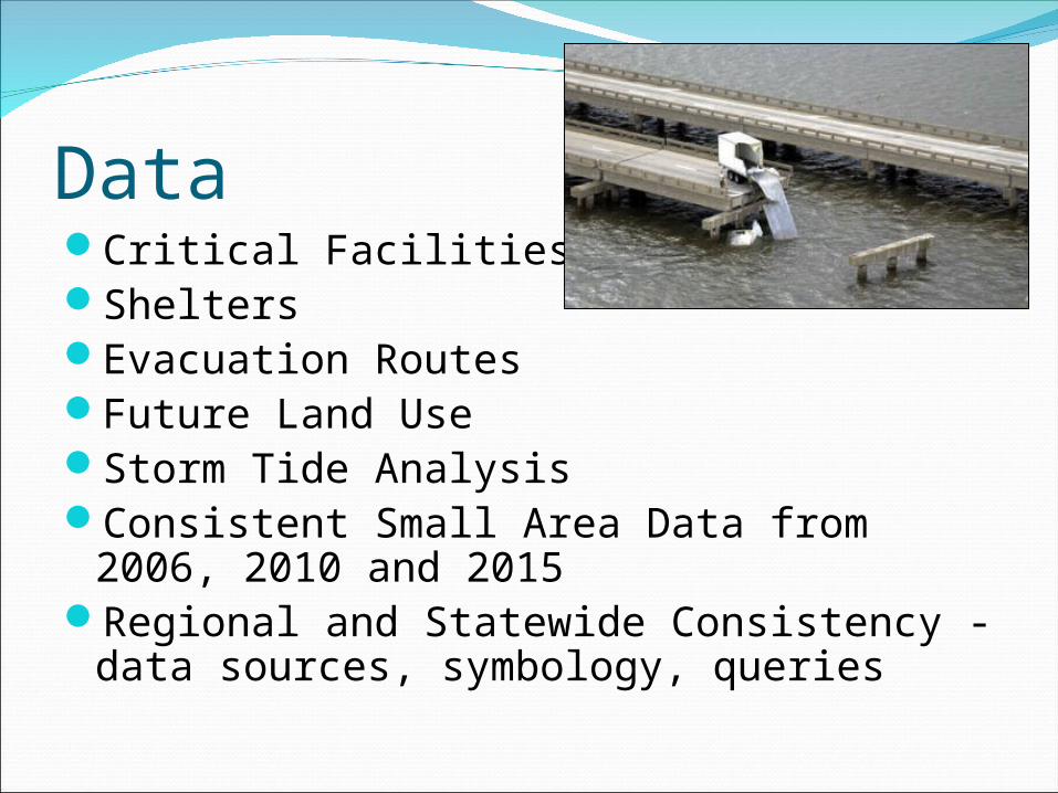
DataCritical FacilitiesSheltersEvacuation Routes Future Land Use Storm Tide AnalysisConsistent Small Area Data from 2006,
2010 and 2015Regional and Statewide Consistency -
data sources, symbology, queries

LiDARLight Detection and Ranging

SLOSHCape Canaveral SLOSH Basin
A computerized model developed by the National Weather Service (NWS) to estimate storm surge heights and winds resulting from historical, hypothetical, or predicted hurricanes.

Surge Zones

Vols. 2 &3 – Behavioral Study and AnalysisStatewide SurveysBehavioral AssumptionsEvacuation Participation RateEvacuation TimingEvacuation RefugeEvacuation DestinationVehicle Use

Behavioral Study

Behavioral Study

BehavioralStudy


Behavioral Study

Vol. 4 - Evacuation Transportation AnalysisExisting and Future Networks Base and Operational ScenariosClearance Times
To ShelterIn-CountyOut-of-CountyRegional
Vol. 5 – Evacuation Transportation Supplemental Data Report
Prepared by Wilbur Smith and Associated, contains the model run inputs and outputs and serves as the source data for the Evacuation Transportation Analysis


Vol. 6 – Emergency Management Evacuation Tool KitLocally Selected Data, Tables, Charts, MapsQuick Reference Guide

New Clearance Times – 2010Evacuation
Level A Base
Scenario
Evacuation Level BBase
Scenario
Evacuation Level CBase
Scenario
Evacuation Level D
Base Scenario
Evacuation Level EBase
ScenarioClearance Time to ShelterBrevard County 13.0 13.0 13.0 13.0 17.5Lake County 13.0 13.0 13.5 14.5 16.5Orange County 12.5 12.5 12.5 13.0 17.0Osceola County 12.5 12.5 12.5 13.0 17.0Seminole County 12.5 12.5 12.5 12.5 14.0Volusia County 13.0 13.0 13.0 13.0 16.5In-County Clearance TimeBrevard County 13.0 13.0 13.0 13.5 17.5Lake County 13.5 13.5 14.0 15.0 17.0Orange County 13.0 13.0 13.0 13.5 17.5Osceola County 13.0 13.0 13.0 13.5 17.5Seminole County 13.0 13.0 13.0 13.0 14.5Volusia County 14.0 14.0 14.5 15.5 18.0Out of County Clearance TimeBrevard County 13.5 14.0 14.0 14.0 17.5Lake County 13.0 14.5 14.5 15.5 22.0Orange County 12.5 14.0 14.0 14.0 18.0Osceola County 12.0 14.0 14.0 14.5 18.0Seminole County 12.0 13.5 13.5 14.0 17.5Volusia County 14.0 14.5 14.5 15.5 24.0Regional Clearance Time
ECFRPC 14.5 14.5 14.5 15.5 24.0

Vol. 7 – Storm Tide Atlas
Digital/Hard CopyGeopdf enabled with links and dataText and Points of Reference Table

Vol. 8 – Methodology of Evacuation Transportation ModelingMethodologies Model Assumptions Transportation Interface for Modeling
Evacuations (TIME)

Thank you!Questions
April Raulerson and Kate HardieEast Central Florida Regional Planning
CouncilAltamonte Springs, Florida
(407) 262-7772