Embed Size (px)
Citation preview

ArcGIS
® and Land Administration An Esri® White Paper December 2013
Copyright © 2013 Esri All rights reserved. Printed in the United States of America. The information contained in this document is the exclusive property of Esri. This work is protected under United States copyright law and other international copyright treaties and conventions. No part of this work may be reproduced or transmitted in any form or by any means, electronic or mechanical, including photocopying and recording, or by any information storage or retrieval system, except as expressly permitted in writing by Esri. All requests should be sent to Attention: Contracts and Legal Services Manager, Esri, 380 New York Street, Redlands, CA 92373-8100 USA. The information contained in this document is subject to change without notice. Esri, the Esri globe logo, ArcGIS, esri.com, and @esri.com are trademarks, service marks, or registered marks of Esri in the United States, the European Community, or certain other jurisdictions. Other companies and products or services mentioned herein may be trademarks, service marks, or registered marks of their respective mark owners.

J10238
Esri White Paper i
ArcGIS and Land Administration
An Esri White Paper Contents Page
Introduction ........................................................................................... 1
Land Administration ............................................................................. 1 A Foundation for Stability and Prosperity ...................................... 1
Global Challenges in Land Administration .......................................... 2 Legacy ............................................................................................. 2 Data Management ........................................................................... 2 New Products .................................................................................. 2 Delivering Land Administration Services, Data, and
Products........................................................................................ 3
Land Administration 2.0 ....................................................................... 3 ArcGIS—The Platform for Land Administration ........................... 3
The Land Administration Solution ....................................................... 4
Land Administration Operations........................................................... 5
Collect ................................................................................................... 6 Collect Survey, Geographic, Cadastral Data .................................. 6
Process .................................................................................................. 7 Process Survey, Geographic, Cadastral Data .................................. 7
Produce ................................................................................................. 8 Produce Land Administration Products .......................................... 8
Manage .................................................................................................. 8 Managing the Enterprise ................................................................. 8
Share ..................................................................................................... 9 Sharing Data Seamlessly................................................................. 9
Summary ............................................................................................... 9

J10238
Esri White Paper
ArcGIS and Land Administration
Introduction Land administration agencies are facing new challenges. As countries expand participation in the global economy, expectations and requirements both internally and externally evolve. The rapid economic and social transformation over the last several years to a more modern society with complex infrastructures has increased the demand for establishing modern twenty-first century land administration systems that harmonize authoritative information and provide modern land information products to government users and citizens alike. The lack of available, standardized, high-quality, and usable land administration data represents a significant obstacle for success for many economic sectors. This white paper presents how ArcGIS® is the foundation of a successful land administration system and its components—ownership, value, planning, and use. Implementation of a national land administration solution is supported by the adoption of geospatial data standards that meet unique local and regional requirements while benefiting from international standards and best practices. A standards-based, consistently applied land administration solution, which is grounded in a legal and institutional framework, is critical to coordinating the effective allocation of municipal, national, and private-sector resources. It is also essential in supporting the standard functions of a modern government, such as providing e-government services, property valuation and tax, census, transparent operations, and urban and regional planning activities. Geographic information system (GIS) technology has been an essential component of successful land administration and cadastral agencies for many years. ArcGIS, the world-leading GIS, provides a comprehensive land administration technology platform to enable land administration organizations to modernize and meet new challenges by providing efficient, well-managed workflows; rigorous systems that manage data integrity and security; and capabilities that deliver modern information products to stakeholders.
Land Administration
A Foundation for
Stability and Prosperity
It is well understood that a successful economy requires a good land administration system. The United Nations Economic Commission for Europe (UNECE) Working Party on Land Administration (WPLA) defines land administration as the process of
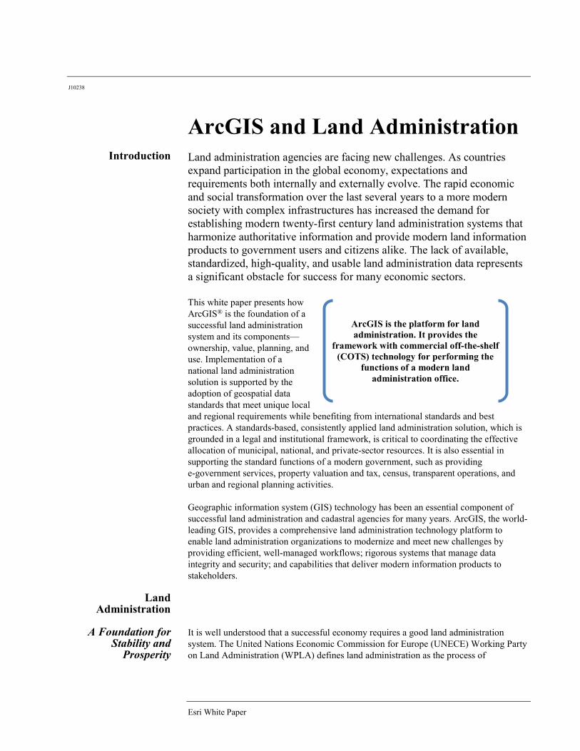
ArcGIS is the platform for land administration. It provides the
framework with commercial off-the-shelf (COTS) technology for performing the
functions of a modern land administration office.

ArcGIS and Land Administration
J10238
December 2013 2
"recording and disseminating information about the ownership, value, and use of land and its associated resources." An effective land administration system guarantees ownership and tenure security, ensures equitable and transparent land and property taxation, provides security for credit, and supports an efficient land and property market. It also contributes to sustainable land management and key initiatives such as e-government, national spatial data infrastructure (NSDI), and sustainable land-use planning. A well-functioning land administration system is one that supports policy and land management activities at both national and local levels by enabling users to determine, record, and share information such as landownership, value, and use. Such a system is multipurpose: it provides transparent operations and data, engages the citizenry, and allows data access on a variety of devices and platforms. Modern land administration systems are built on GIS technology. GIS incorporates all types of land and geographic information to enable land administration professionals to make informed decisions. Leveraging geodatabase technology, open standards, cloud computing, extensive worldwide data and high-resolution imagery, global map libraries, and mobile technology, GIS provides the essential infrastructure backbone for successful land administration systems.
Global Challenges in Land
Administration
There are many challenges within a modern land administration solution—keeping authoritative land information current, complete, accurate, and secure while providing access to data across multiple networks to multiple stakeholders in a system that is sustainable both from an information technology (IT) and geographic data perspective.
Legacy Legacy technology puts up barriers that inhibit access to data across ministries, departments, and municipal and national offices. Complex, highly customized workflows can be cumbersome, inefficient, and costly to maintain. Relying on third-party service providers can slow technology and organizational capacity development. Multiple, incomplete address systems; incomplete geographic reference systems; and dated indexing methodologies all contribute to the growing challenges for land professionals in developing a modern solution to land administration. Hard coded, custom systems are very costly to maintain, update, and sustain and are vulnerable to security breaches.
Data Management Managing vast amounts of vector, survey, and imagery data in the past has required several separate technology systems. Connecting to other business systems and integrating data in a single enterprise system have been long-standing goals but seldom realized. Without an enterprise data management solution, duplicate data and duplicated efforts result in systems out of sync, poor quality, and outdated data. Managing data in a well-designed, structured geodatabase with permission control ensures data integrity. Implementing ArcGIS with modern data publishing technologies, such as web services, relieves many legacy data management challenges.
New Products New demands, new products, and new technologies create new challenges for land administration organizations. New information products are requested and desired by a broader user base, new integration capabilities are necessary, and new types of sharing are required. Coordination with this expanding user base requires timely and accurate land administration information delivered on modern systems, and these demands often require that information be captured and processed in a more timely manner than it may have traditionally been in the past. Fulfilling these increasing demands with limited resources places additional strains on land administration organizations.
ArcGIS and Land Administration
J10238
Esri White Paper 3
Delivering Land Administration
Services, Data, and Products
Citizens expect easy access to current and relevant land information and information products on a variety of devices. The ongoing development of mobile technology continues to evolve public expectations. Clear, accessible, and easy-to-use information from government websites, combined with e-government initiatives and increased citizen expectations for engagement, transparency, and service-level agreements, gives land administration professionals new challenges. This also provides new opportunities to deliver better and more services for citizens and officials. Land administration professionals need a platform for deploying maps, applications, data, and information products to citizens, businesses, and other government departments for use on the web, smartphones, and tablets.
In addition to managing parcels, property values, titles, and survey data, land administration organizations manage and publish information and products on land rights, restrictions, tenure, addresses, leases, use, and other land-related information.
Land Administration 2.0
Historically, land administration functions have been top-down from the government serving other ministries, departments, and the citizenry. As an example, the initial version of the Internet (Web 1.0) was more one directional with sharing of information and not accessible to many. Now the Internet (Web 2.0) has been described as an environment that allows users to interact and collaborate, contributing data and information, not just receiving it. Smartphones are increasingly growing to the Internet, access data, and information.
Land administration agencies can benefit from the ArcGIS supported 2.0 technology environment. An example of this is the ability for a landowner to enter, correct, or update his/her address. This is not to say that the citizen-entered data becomes the authoritative data without review, scrutiny, and editing by officials, but it enables the environment to contribute citizen-generated data to support land administration functions. Not only are smartphones and other mobile devices changing the way land administration agencies are distributing data, they are also contributing to the way land administration agencies can collect, evaluate, and ground truth data.
Landowners themselves are important users of landownership and parcel information. With information available publicly 24 hours a day, citizens are scrutinizing online cadastral data. There are new expectations and new requirements for transparency. The data on government GIS websites is generally accepted as authoritative, particularly when compared to other aggregated online mapping data. For agency credibility, it has become important to maintain property characteristics and positional accuracy that overlay correctly on high-quality basemaps. Providing authoritative information limits disputes and wasted time that evolve from misinformation and poor-quality data.
ArcGIS—The Platform for Land
Administration
ArcGIS provides the technology platform for land administration activities from surveying boundary features to registration, recording rights, restrictions and responsibilities, feature extraction from imagery, digitizing legacy cadastral documents, and addressing along with modern dissemination and sharing capabilities. It provides the framework with commercial off-the-shelf technology for performing the functions of a modern land administration office for today's requirements and is extensible for emerging needs. This integrated solution continues to provide a return on technology investment by delivering new capabilities with core technology features to meet new requirements as they emerge.
ArcGIS and Land Administration
J10238
December 2013 4
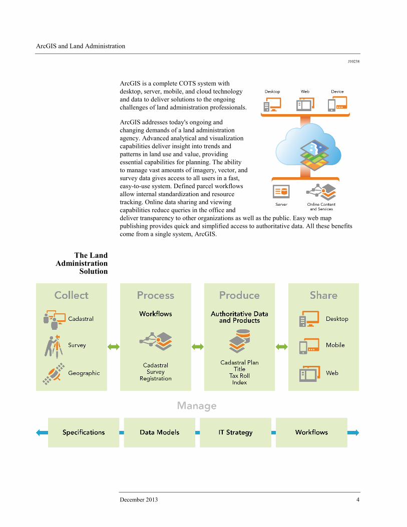
ArcGIS is a complete COTS system with desktop, server, mobile, and cloud technology and data to deliver solutions to the ongoing challenges of land administration professionals. ArcGIS addresses today's ongoing and changing demands of a land administration agency. Advanced analytical and visualization capabilities deliver insight into trends and patterns in land use and value, providing essential capabilities for planning. The ability to manage vast amounts of imagery, vector, and survey data gives access to all users in a fast, easy-to-use system. Defined parcel workflows allow internal standardization and resource tracking. Online data sharing and viewing capabilities reduce queries in the office and deliver transparency to other organizations as well as the public. Easy web map publishing provides quick and simplified access to authoritative data. All these benefits come from a single system, ArcGIS.
The Land Administration
Solution
ArcGIS and Land Administration
J10238
Esri White Paper 5
ArcGIS provides a highly configurable COTS technology framework that allows for the deployment of solutions with minimal custom software development or non-industry-standard components. Built on the Land Administration Domain Model (LADM, ISO 19152:2012), this provides land administration agencies with access to the latest technology to meet the standard. This allows vendors and Esri partners to build configurable applications that run on the ArcGIS platform with limited custom software development. This enables the latest core ArcGIS technology platform to be used at all times and does not lock the agency into old, custom technology and applications. The solution manages the entire land administration workflow—data collection, processing, production, and sharing workflows. It allows the agency to define and track data process, production and management workflows delivering an executive view (or dashboard) of work status, QA/QC, production levels, and bottlenecks. It gives the executive a real-time view into operations of the organization. These managed workflows ensure consistency across the organization, secure domain expertise, expedite training and technical transfer, and allow production leads to capture and share procedures for an optimized balance of automation and human interaction with the data. Work can be assigned and tracked by production leads or managers through web-based production management portals. This supports highly configurable status reporting, maps, messaging services, and executive-level views.
Land Administration
Operations
ArcGIS is a fully integrated enterprise system for creating, managing, and delivering geospatial data and information products. The solution for land administration can be segmented into five themes:
■ Collect—This is the beginning of the data process, where all data, whether collected
from cadastral survey with modern land surveying instruments and GPS, digitized from documents, or through feature extraction from aerial photography and satellite imagery, is brought together in a coordinated set of workflows and managed in a modern enterprise geodatabase. ArcGIS supports input of all geographic data types and interoperability with other systems utilizing open standard formats.
■ Process—This includes processing collected data; managing parcel and lot
information from splits, conveyances, subdivisions, mergers, and other boundary changes; and integrating with other spatial and textural data efficiently with defined, structured workflows as well as tracking and managing production, quality, output, and resources with managed workflows.
■ Produce—Many outputs can be configured with data processed and managed
including titles, tax rolls, cadastral plans, map books, master address tables, and up-to-date websites that deliver only the data users want to deliver, securely.
■ Manage—A well-constructed land administration system provides functionality for
managing all the land administration workflows and ensuring accurate and timely data, quality inspection, and reporting, along with strict enforcement to

ArcGIS and Land Administration
J10238
December 2013 6
organizational IT standards, data formats, and output/sharing specifications. All this with an executive view into the status and quality metrics for the entire operation.
■ Share—A modern land administration organization interacts in new ways, serving
the citizens through web-based technologies such as portals and mobile apps. Within government agencies and ministries, data is shared through services, eliminating redundant data maintenance tasks and costly infrastructure.
Collect
Collect Survey,
Geographic, Cadastral Data
Data in land administration organizations comes from many sources with varying quality, currencies, and accuracies. Data can come from field survey, GPS, raster images and scanned maps, satellite imagery, orthophotography, vector maps, plans, and text documents. Managing the metadata associated with each type of data is important not just for internal land administration functions but for publishing to the public so data is used as fit for purpose. Processing and validating collected data and then centralizing its access are necessary prior to use and publishing/sharing. ArcGIS supports all geographic data types for input and many for processing. For example, ArcGIS provides imagery quickly after acquisition with dynamic mosaicking and on-the-fly processing in different projections, formats, and pixel sizes. This minimizes data duplication while maximizing the amount of imagery products that can be created because image processing and serving have been combined. This also removes the reliance on static mosaic datasets and allows users to request custom imagery with controllable parameters. Additionally, when using lidar, users can connect to LAS datasets directly without import or conversion. Survey data is managed in purpose-built geodatabase technology. The parcel editing tools are specifically designed to collect parcel-based data using survey methodologies and techniques and manage survey data integrity while maintaining parcel history. This allows parcel managers to edit and maintain parcels from ArcGIS using specifically designed efficient workflows. This provides parcel editing functions such as split by area, parcel merge, and traverse. In addition to editing performance, users may optionally benefit from the unique ability to support positional accuracy management of an entire GIS through least-squares adjustment of the parcel network and associated data.
ArcGIS and Land Administration
J10238
Esri White Paper 7
Process
Process Survey, Geographic,
Cadastral Data
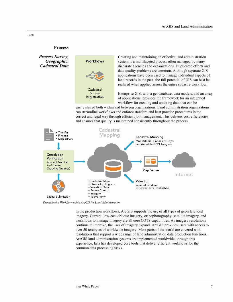
Creating and maintaining an effective land administration system is a multifaceted process often managed by many disparate agencies and organizations. Duplicated efforts and data quality problems are common. Although separate GIS applications have been used to manage individual aspects of land records in the past, the full potential of GIS can best be realized when applied across the entire cadastre workflow. Enterprise GIS, with a geodatabase, data models, and an array of applications, provides the framework for an integrated workflow for creating and updating data that can be
easily shared both within and between organizations. Land administration organizations can streamline workflows and enforce standard and best practice procedures in the correct and legal way through efficient job management. This delivers cost efficiencies and ensures that quality is maintained consistently throughout the process.
Example of a Workflow within ArcGIS for Land Administration
In the production workflows, ArcGIS supports the use of all types of georeferenced imagery. Current, low-cost oblique imagery, orthophotography, satellite imagery, and workflows to manage imagery are all core COTS capabilities. As imagery resolutions continue to improve, the uses of imagery expand. ArcGIS provides users with access to over 50 terabytes of worldwide imagery. Most parts of the world are covered with resolutions that support a wide range of land administration data production functions. ArcGIS land administration systems are implemented worldwide; through this experience, Esri has developed core tools that deliver efficient workflows for the common data processing tasks.
ArcGIS and Land Administration
J10238
December 2013 8
Produce
Produce Land Administration
Products
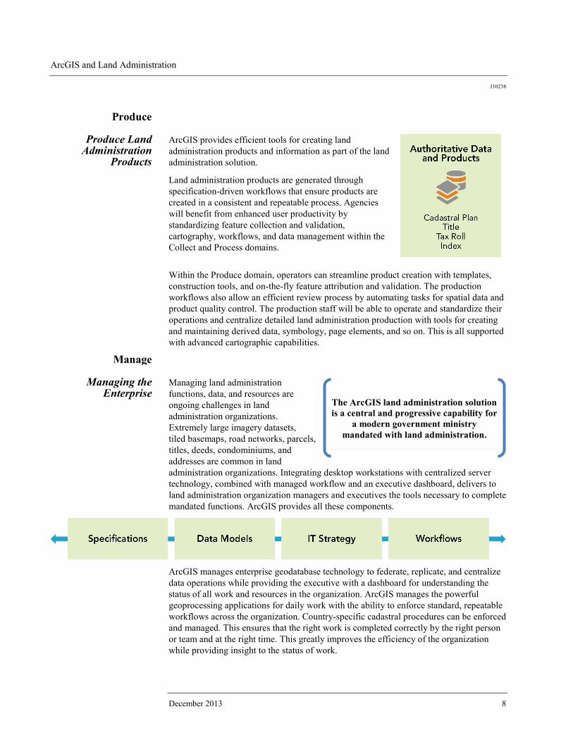
ArcGIS provides efficient tools for creating land administration products and information as part of the land administration solution.
Land administration products are generated through specification-driven workflows that ensure products are created in a consistent and repeatable process. Agencies will benefit from enhanced user productivity by standardizing feature collection and validation, cartography, workflows, and data management within the Collect and Process domains.
Within the Produce domain, operators can streamline product creation with templates, construction tools, and on-the-fly feature attribution and validation. The production workflows also allow an efficient review process by automating tasks for spatial data and product quality control. The production staff will be able to operate and standardize their operations and centralize detailed land administration production with tools for creating and maintaining derived data, symbology, page elements, and so on. This is all supported with advanced cartographic capabilities.
Manage
Managing the Enterprise
Managing land administration functions, data, and resources are ongoing challenges in land administration organizations. Extremely large imagery datasets, tiled basemaps, road networks, parcels, titles, deeds, condominiums, and addresses are common in land administration organizations. Integrating desktop workstations with centralized server technology, combined with managed workflow and an executive dashboard, delivers to land administration organization managers and executives the tools necessary to complete mandated functions. ArcGIS provides all these components.
ArcGIS manages enterprise geodatabase technology to federate, replicate, and centralize data operations while providing the executive with a dashboard for understanding the status of all work and resources in the organization. ArcGIS manages the powerful geoprocessing applications for daily work with the ability to enforce standard, repeatable workflows across the organization. Country-specific cadastral procedures can be enforced and managed. This ensures that the right work is completed correctly by the right person or team and at the right time. This greatly improves the efficiency of the organization while providing insight to the status of work.
The ArcGIS land administration solution is a central and progressive capability for
a modern government ministry mandated with land administration.

ArcGIS and Land Administration
J10238
Esri White Paper 9
This workflow management capability improves individual user productivity by automating common activities and reducing repetitive production procedures. This also helps ensure standardization and consistency by easily creating workflows with simple visual tools and centralizing workflow management with COTS tools. This can be implemented across a dispersed work force, and users can integrate other activities such as document recording and fee collection.
Share
Sharing Data Seamlessly
Sharing geographic data is more than posting data on a website. It is providing an intuitive experience for discovering what data is available and the quality and source of the data and delivering the data in formats that other applications can consume with web services. Data sharing technology reduces or eliminates redundant data, provides for maintaining data integrity by allowing organizations access to the authoritative version, and enables easy search and discovery of existing geospatial data and services. ArcGIS provided cloud-based technology for sharing and collaborating. It empowers land administration organizations to create interactive maps and applications and share them within and outside the organization. This delivers to the organization new opportunities to gain insight into data and provide these capabilities to the citizenry. In addition to providing a technology platform for sharing, ArcGIS provides organizations with the use of terabytes of basemap and imagery data that covers the globe. This cloud-based technology can be implemented as a private cloud behind the firewall or in combination with the public cloud, creating a hybrid environment. These customized configurations give land administration organizations access to modern, powerful technology while respecting local laws and customs. For organizations that prefer not to use cloud technology, ArcGIS can provide the same functionality behind a firewall.
Summary This paper presents ArcGIS as the platform for a modern land administration solution with the geodatabase, data management workflows, applications, and data sharing solution for land administration and cadastral agencies. The ArcGIS land administration solution is a central and progressive capability for a modern government ministry as it plans for and provides the enterprise geographic data management needs of the future. ArcGIS delivers to the organization the ability to address existing and emerging land administration requirements. It enables the organization to update legacy land administration systems, consolidate multiple data centers, and streamline operations on a single platform while delivering new capabilities with flexible, purpose-built technology. ArcGIS is a COTS solution reducing IT and system maintenance costs. The ArcGIS land administration solution will put organizations on a path to take full advantage of modern sustainable IT, establish an enterprise data architecture to meet the needs of the broader geospatial community, and enable the government to meet new and ever-changing land administration demands.

Printed in USA
Contact Esri
380 New York Street Redlands, California 92373-8100 usa
1 800 447 9778 t 909 793 2853 f 909 793 5953 [email protected] esri.com
Offices worldwide esri.com/locations
Esri inspires and enables people to positively impact their future through a deeper, geographic understanding of the changing world around them.
Governments, industry leaders, academics, and nongovernmental
organizations trust us to connect them with the analytic knowledge
they need to make the critical decisions that shape the planet. For
more than 40 years, Esri has cultivated collaborative relationships
with partners who share our commitment to solving earth’s most
pressing challenges with geographic expertise and rational resolve.
Today, we believe that geography is at the heart of a more resilient
and sustainable future. Creating responsible products and solutions
drives our passion for improving quality of life everywhere.