Embed Size (px)
Citation preview
Greenville County GIS Department Page 1 6/7/2016
PHYSICAL DATABASE DESIGN
ArcGIS Database Design
Greenville County,
South Carolina
Greenville County GIS Department Page 2 6/7/2016
Table of Contents
BND_GVCNTY ....................................................................................................................................... 3
BND_MUNICIPAL_P ............................................................................................................................ 4
CAD_MISC_L ......................................................................................................................................... 6
CAD_PARCEL_MP ............................................................................................................................... 7
CAD_SUBDIV ....................................................................................................................................... 15
DIS_CNTYCN ....................................................................................................................................... 17
DIS_FIRE .............................................................................................................................................. 19
DIS_SANITATION ............................................................................................................................... 20
DIS_SCHOOL ....................................................................................................................................... 21
DIS_SCHOUSE ..................................................................................................................................... 23
DIS_SCSEN ........................................................................................................................................... 25
DIS_SEWER ......................................................................................................................................... 27
DIS_TAX_P ........................................................................................................................................... 28
DIS_VOTEPRE ..................................................................................................................................... 29
PLN_BUILD_P...................................................................................................................................... 30
PLN_HYDRO_L ................................................................................................................................... 32
PLN_HYDRO_P ................................................................................................................................... 34
PLN_MISC_P ........................................................................................................................................ 36
PLN_PARKING .................................................................................................................................... 38
POI_CEMETERY ................................................................................................................................ 41
POI_GOLFCOURSE............................................................................................................................ 43
POI_PARK ............................................................................................................................................ 45
POI_POLLSITE.................................................................................................................................... 47
TOP_CONTOUR .................................................................................................................................. 49
TOP_SPOT_X ....................................................................................................................................... 51
TRA_ADDPNT...................................................................................................................................... 53
TRA_AIRPORT .................................................................................................................................... 61
TRA_PAVEDGE ................................................................................................................................... 63
TRA_RAILROAD ................................................................................................................................ 65
TRA_STREETCL ................................................................................................................................. 67
UTL_TOWER ....................................................................................................................................... 77
ZON_ZONING ...................................................................................................................................... 79
Greenville County GIS Department Page 3 6/7/2016
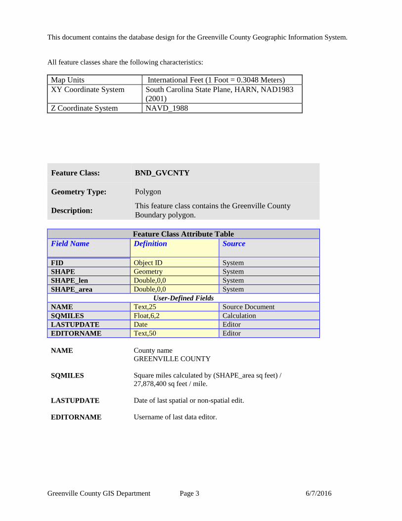
This document contains the database design for the Greenville County Geographic Information System.
All feature classes share the following characteristics:
Map Units International Feet (1 Foot = 0.3048 Meters)
XY Coordinate System South Carolina State Plane, HARN, NAD1983
(2001)
Z Coordinate System NAVD_1988
Feature Class: BND_GVCNTY
Geometry Type: Polygon
Description: This feature class contains the Greenville County
Boundary polygon.
Feature Class Attribute Table
Field Name Definition
Source
FID Object ID System
SHAPE Geometry System
SHAPE_len Double,0,0 System
SHAPE_area Double,0,0 System
User-Defined Fields
NAME Text,25 Source Document
SQMILES Float,6,2 Calculation
LASTUPDATE Date Editor
EDITORNAME Text,50 Editor
NAME County name
GREENVILLE COUNTY
SQMILES Square miles calculated by (SHAPE_area sq feet) /
27,878,400 sq feet / mile.
LASTUPDATE Date of last spatial or non-spatial edit.
EDITORNAME Username of last data editor.
Greenville County GIS Department Page 4 6/7/2016
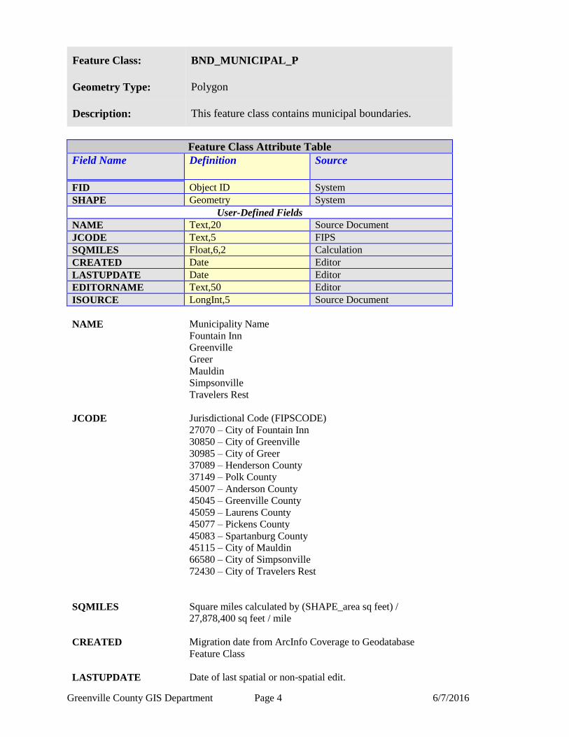
Feature Class: BND_MUNICIPAL_P
Geometry Type: Polygon
Description: This feature class contains municipal boundaries.
Feature Class Attribute Table
Field Name Definition
Source
FID Object ID System
SHAPE Geometry System
User-Defined Fields
NAME Text,20 Source Document
JCODE Text,5 FIPS
SQMILES Float,6,2 Calculation
CREATED Date Editor
LASTUPDATE Date Editor
EDITORNAME Text,50 Editor
ISOURCE LongInt,5 Source Document
NAME Municipality Name
Fountain Inn
Greenville
Greer
Mauldin
Simpsonville
Travelers Rest
JCODE Jurisdictional Code (FIPSCODE)
27070 – City of Fountain Inn
30850 – City of Greenville
30985 – City of Greer
37089 – Henderson County
37149 – Polk County
45007 – Anderson County
45045 – Greenville County
45059 – Laurens County
45077 – Pickens County
45083 – Spartanburg County
45115 – City of Mauldin
66580 – City of Simpsonville
72430 – City of Travelers Rest
SQMILES Square miles calculated by (SHAPE_area sq feet) /
27,878,400 sq feet / mile
CREATED Migration date from ArcInfo Coverage to Geodatabase
Feature Class
LASTUPDATE Date of last spatial or non-spatial edit.

Greenville County GIS Department Page 5 6/7/2016
EDITORNAME Username of last data editor.
ISOURCE Information Source of Feature
30 - 3D Imaging/Spectrum NC
31 - Analytical Surveys, INC
32 - City of Greenville
33 - Greenville County
34 - Other agency
35 - Kucera
Greenville County GIS Department Page 6 6/7/2016
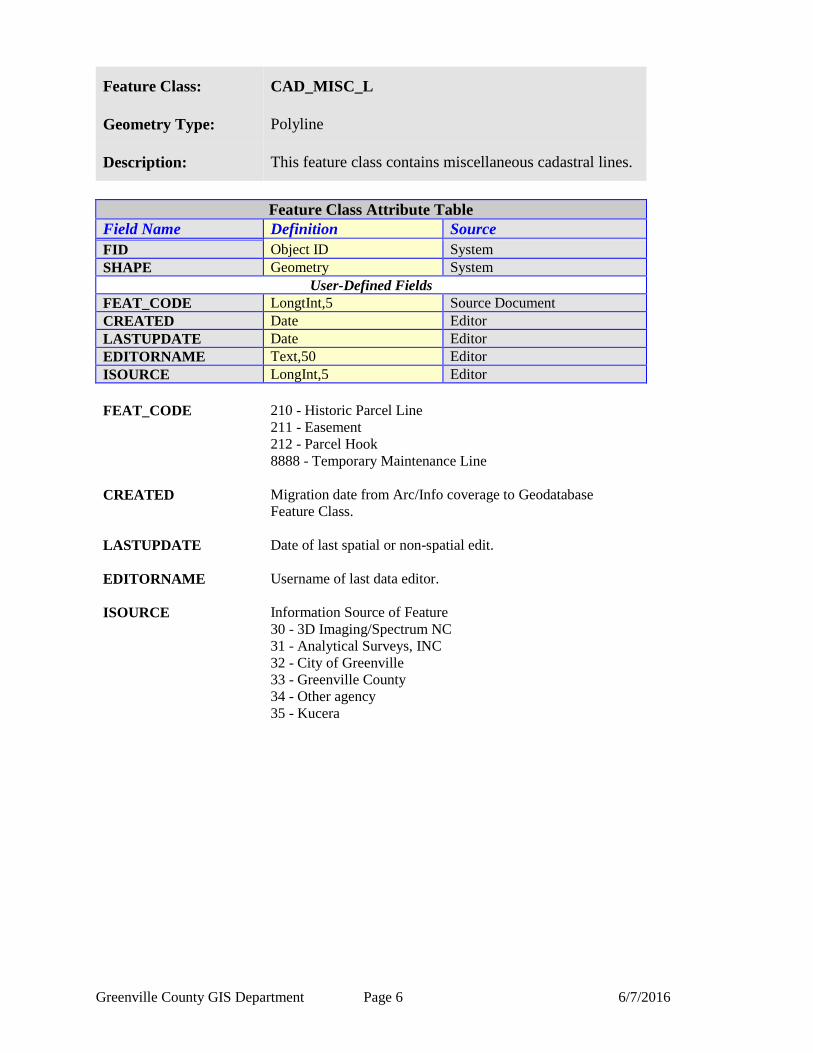
Feature Class: CAD_MISC_L
Geometry Type: Polyline
Description: This feature class contains miscellaneous cadastral lines.
Feature Class Attribute Table
Field Name Definition Source
FID Object ID System
SHAPE Geometry System
User-Defined Fields
FEAT_CODE LongtInt,5 Source Document
CREATED Date Editor
LASTUPDATE Date Editor
EDITORNAME Text,50 Editor
ISOURCE LongInt,5 Editor
FEAT_CODE 210 - Historic Parcel Line
211 - Easement
212 - Parcel Hook
8888 - Temporary Maintenance Line
CREATED Migration date from Arc/Info coverage to Geodatabase
Feature Class.
LASTUPDATE Date of last spatial or non-spatial edit.
EDITORNAME Username of last data editor.
ISOURCE Information Source of Feature
30 - 3D Imaging/Spectrum NC
31 - Analytical Surveys, INC
32 - City of Greenville
33 - Greenville County
34 - Other agency
35 - Kucera
Greenville County GIS Department Page 7 6/7/2016
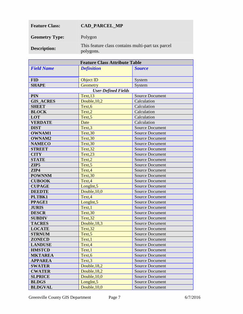
Feature Class: CAD_PARCEL_MP
Geometry Type: Polygon
Description: This feature class contains multi-part tax parcel
polygons.
Feature Class Attribute Table
Field Name Definition
Source
FID Object ID System
SHAPE Geometry System
User-Defined Fields
PIN Text,13 Source Document
GIS_ACRES Double,10,2 Calculation
SHEET Text,6 Calculation
BLOCK Text,2 Calculation
LOT Text,5 Calculation
VERDATE Date Calculation
DIST Text,3 Source Document
OWNAM1 Text,30 Source Document
OWNAM2 Text,30 Source Document
NAMECO Text,30 Source Document
STREET Text,32 Source Document
CITY Text,23 Source Document
STATE Text,2 Source Document
ZIP5 Text,5 Source Document
ZIP4 Text,4 Source Document
POWNNM Text,30 Source Document
CUBOOK Text,4 Source Document
CUPAGE LongInt,5 Source Document
DEEDTE Double,10,0 Source Document
PLTBK1 Text,4 Source Document
PPAGE1 LongInt,5 Source Document
JURIS Text,1 Source Document
DESCR Text,30 Source Document
SUBDIV Text,32 Source Document
TACRES Double,18,3 Source Document
LOCATE Text,32 Source Document
STRNUM Text,5 Source Document
ZONECD Text,1 Source Document
LANDUSE Text,4 Source Document
HMSTCD Text,1 Source Document
MKTAREA Text,6 Source Document
APPAREA Text,3 Source Document
SWATER Double,18,2 Source Document
CWATER Double,18,2 Source Document
SLPRICE Double,10,0 Source Document
BLDGS LongInt,5 Source Document
BLDGVAL Double,10,0 Source Document
Greenville County GIS Department Page 8 6/7/2016
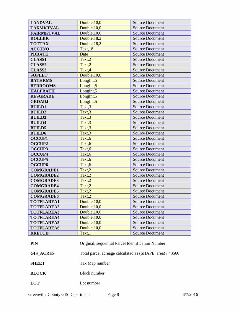
LANDVAL Double,10,0 Source Document
TAXMKTVAL Double,10,0 Source Document
FAIRMKTVAL Double,10,0 Source Document
ROLLBK Double,18,2 Source Document
TOTTAX Double,18,2 Source Document
ACCTNO Text,18 Source Document
PDDATE Date Source Document
CLASS1 Text,2 Source Document
CLASS2 Text,2 Source Document
CLASS3 Text,4 Source Document
SQFEET Double,10,0 Source Document
BATHRMS LongInt,5 Source Document
BEDROOMS LongInt,5 Source Document
HALFBATH LongInt,5 Source Document
RESGRADE LongInt,5 Source Document
GRDADJ LongInt,5 Source Document
BUILD1 Text,3 Source Document
BUILD2 Text,3 Source Document
BUILD3 Text,3 Source Document
BUILD4 Text,3 Source Document
BUILD5 Text,3 Source Document
BUILD6 Text,3 Source Document
OCCUP1 Text,6 Source Document
OCCUP2 Text,6 Source Document
OCCUP3 Text,6 Source Document
OCCUP4 Text,6 Source Document
OCCUP5 Text,6 Source Document
OCCUP6 Text,6 Source Document
COMGRADE1 Text,2 Source Document
COMGRADE2 Text,2 Source Document
COMGRADE3 Text,2 Source Document
COMGRADE4 Text,2 Source Document
COMGRADE5 Text,2 Source Document
COMGRADE6 Text,2 Source Document
TOTFLAREA1 Double,10,0 Source Document
TOTFLAREA2 Double,10,0 Source Document
TOTFLAREA3 Double,10,0 Source Document
TOTFLAREA4 Double,10,0 Source Document
TOTFLAREA5 Double,10,0 Source Document
TOTFLAREA6 Double,10,0 Source Document
RRETCD Text,1 Source Document
PIN Original, sequential Parcel Identification Number
GIS_ACRES Total parcel acreage calculated as (SHAPE_area) / 43560
SHEET
Tax Map number
BLOCK
Block number
LOT
Lot number
Greenville County GIS Department Page 9 6/7/2016
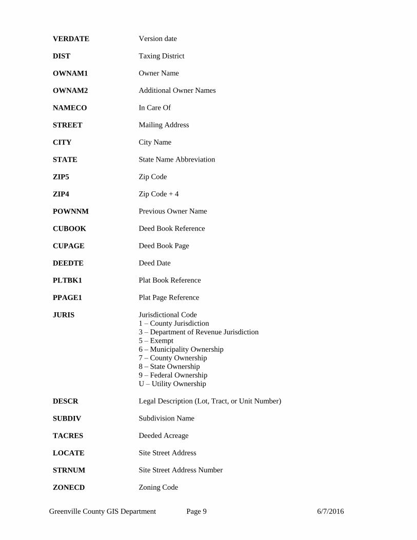
VERDATE Version date
DIST Taxing District
OWNAM1 Owner Name
OWNAM2 Additional Owner Names
NAMECO In Care Of
STREET Mailing Address
CITY City Name
STATE State Name Abbreviation
ZIP5 Zip Code
ZIP4 Zip Code + 4
POWNNM Previous Owner Name
CUBOOK Deed Book Reference
CUPAGE Deed Book Page
DEEDTE Deed Date
PLTBK1 Plat Book Reference
PPAGE1 Plat Page Reference
JURIS Jurisdictional Code
1 – County Jurisdiction
3 – Department of Revenue Jurisdiction
5 – Exempt
6 – Municipality Ownership
7 – County Ownership
8 – State Ownership
9 – Federal Ownership
U – Utility Ownership
DESCR Legal Description (Lot, Tract, or Unit Number)
SUBDIV Subdivision Name
TACRES Deeded Acreage
LOCATE Site Street Address
STRNUM Site Street Address Number
ZONECD Zoning Code
Greenville County GIS Department Page 10 6/7/2016
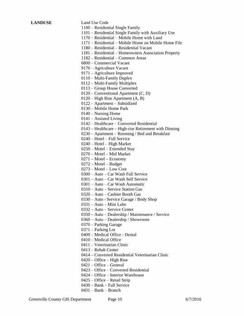
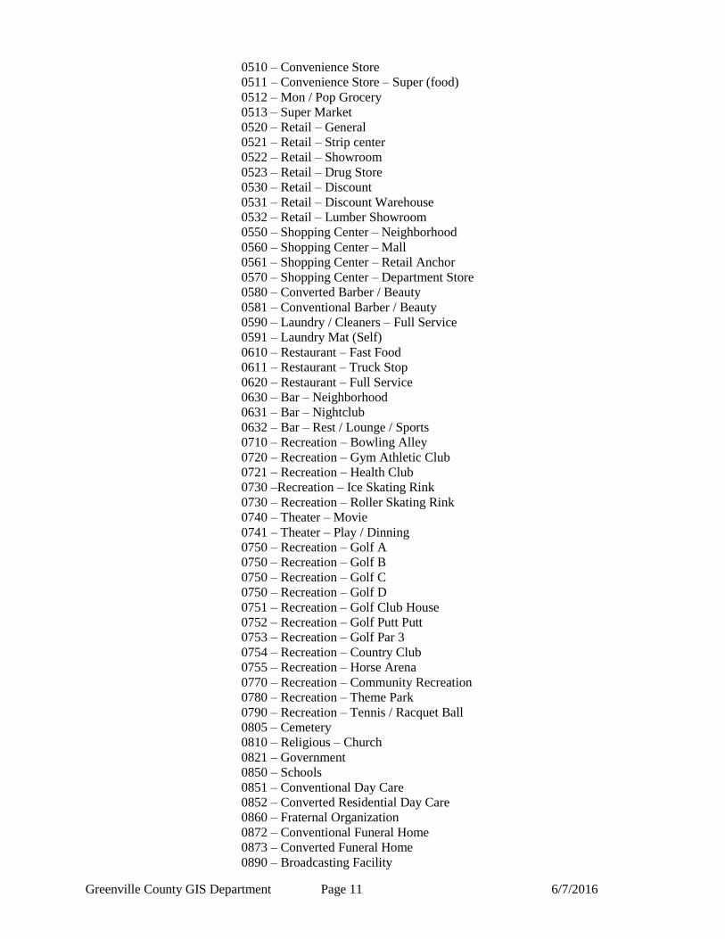
LANDUSE Land Use Code
1100 – Residential Single Family
1101 – Residential Single Family with Auxiliary Use
1170 – Residential – Mobile Home with Land
1171 – Residential – Mobile Home on Mobile Home File
1180 – Residential – Residential Vacant
1181 – Residential – Homeowners Association Property
1182 – Residential – Common Areas
6800 – Commercial Vacant
9170 – Agriculture Vacant
9171 – Agriculture Improved
0110 – Multi-Family Duplex
0112 – Multi-Family Multiplex
0113 – Group House Converted
0120 – Conventional Apartment (C, D)
0120 – High Rise Apartment (A, B)
0122 – Apartment – Subsidized
0130 – Mobile Home Park
0140 – Nursing Home
0141 – Assisted Living
0142 – Healthcare – Converted Residential
0143 – Healthcare – High-rise Retirement with Dinning
0230 – Apartment – Rooming / Bed and Breakfast
0240 – Hotel – Full Service
0240 – Hotel – High Market
0250 – Motel – Extended Stay
0270 – Motel – Mid Market
0271 – Motel – Economy
0272 – Motel – Budget
0273 – Motel – Low Cost
0300 – Auto – Car Wash Full Service
0301 – Auto – Car Wash Self Service
0301 – Auto – Car Wash Automatic
0310 – Auto – Service Station Gas
0320 – Auto – Cashier Booth Gas
0330 – Auto - Service Garage / Body Shop
0331 – Auto – Mini Lube
0332 – Auto – Service Center
0350 – Auto – Dealership / Maintenance / Service
0360 – Auto – Dealership / Showroom
0370 – Parking Garage
0371 – Parking Lot
0409 – Medical Office - Dental
0410 – Medical Office
0411 – Veterinarian Clinic
0413 – Rehab Center
0414 – Converted Residential Veterinarian Clinic
0420 – Office – High Rise
0421 – Office – General
0423 – Office – Converted Residential
0424 – Office – Interior Warehouse
0425 – Office – Retail Strip
0430 – Bank – Full Service
0431 – Bank – Branch
Greenville County GIS Department Page 11 6/7/2016
0510 – Convenience Store
0511 – Convenience Store – Super (food)
0512 – Mon / Pop Grocery
0513 – Super Market
0520 – Retail – General
0521 – Retail – Strip center
0522 – Retail – Showroom
0523 – Retail – Drug Store
0530 – Retail – Discount
0531 – Retail – Discount Warehouse
0532 – Retail – Lumber Showroom
0550 – Shopping Center – Neighborhood
0560 – Shopping Center – Mall
0561 – Shopping Center – Retail Anchor
0570 – Shopping Center – Department Store
0580 – Converted Barber / Beauty
0581 – Conventional Barber / Beauty
0590 – Laundry / Cleaners – Full Service
0591 – Laundry Mat (Self)
0610 – Restaurant – Fast Food
0611 – Restaurant – Truck Stop
0620 – Restaurant – Full Service
0630 – Bar – Neighborhood
0631 – Bar – Nightclub
0632 – Bar – Rest / Lounge / Sports
0710 – Recreation – Bowling Alley
0720 – Recreation – Gym Athletic Club
0721 – Recreation – Health Club
0730 –Recreation – Ice Skating Rink
0730 – Recreation – Roller Skating Rink
0740 – Theater – Movie
0741 – Theater – Play / Dinning
0750 – Recreation – Golf A
0750 – Recreation – Golf B
0750 – Recreation – Golf C
0750 – Recreation – Golf D
0751 – Recreation – Golf Club House
0752 – Recreation – Golf Putt Putt
0753 – Recreation – Golf Par 3
0754 – Recreation – Country Club
0755 – Recreation – Horse Arena
0770 – Recreation – Community Recreation
0780 – Recreation – Theme Park
0790 – Recreation – Tennis / Racquet Ball
0805 – Cemetery
0810 – Religious – Church
0821 – Government
0850 – Schools
0851 – Conventional Day Care
0852 – Converted Residential Day Care
0860 – Fraternal Organization
0872 – Conventional Funeral Home
0873 – Converted Funeral Home
0890 – Broadcasting Facility
Greenville County GIS Department Page 12 6/7/2016
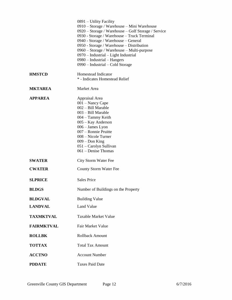
0891 – Utility Facility
0910 – Storage / Warehouse – Mini Warehouse
0920 – Storage / Warehouse – Golf Storage / Service
0930 - Storage / Warehouse – Truck Terminal
0940 - Storage / Warehouse – General
0950 - Storage / Warehouse – Distribution
0960 – Storage / Warehouse – Multi-purpose
0970 – Industrial – Light Industrial
0980 – Industrial – Hangers
0990 – Industrial – Cold Storage
HMSTCD Homestead Indicator
* - Indicates Homestead Relief
MKTAREA Market Area
APPAREA Appraisal Area
001 – Nancy Cape
002 – Bill Marable
003 – Bill Marable
004 – Tammy Keith
005 – Kay Anderson
006 – James Lyon
007 – Ronnie Pruitte
008 – Nicole Turner
009 – Don King
051 – Carolyn Sullivan
061 – Denise Thomas
SWATER City Storm Water Fee
CWATER County Storm Water Fee
SLPRICE Sales Price
BLDGS Number of Buildings on the Property
BLDGVAL Building Value
LANDVAL Land Value
TAXMKTVAL Taxable Market Value
FAIRMKTVAL Fair Market Value
ROLLBK Rollback Amount
TOTTAX Total Tax Amount
ACCTNO Account Number
PDDATE Taxes Paid Date
Greenville County GIS Department Page 13 6/7/2016
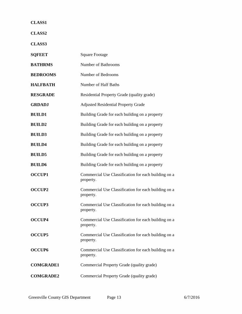
CLASS1
CLASS2
CLASS3
SQFEET Square Footage
BATHRMS Number of Bathrooms
BEDROOMS Number of Bedrooms
HALFBATH Number of Half Baths
RESGRADE Residential Property Grade (quality grade)
GRDADJ Adjusted Residential Property Grade
BUILD1 Building Grade for each building on a property
BUILD2 Building Grade for each building on a property
BUILD3 Building Grade for each building on a property
BUILD4 Building Grade for each building on a property
BUILD5 Building Grade for each building on a property
BUILD6 Building Grade for each building on a property
OCCUP1 Commercial Use Classification for each building on a
property.
OCCUP2 Commercial Use Classification for each building on a
property.
OCCUP3 Commercial Use Classification for each building on a
property.
OCCUP4 Commercial Use Classification for each building on a
property.
OCCUP5 Commercial Use Classification for each building on a
property.
OCCUP6 Commercial Use Classification for each building on a
property.
COMGRADE1 Commercial Property Grade (quality grade)
COMGRADE2 Commercial Property Grade (quality grade)
Greenville County GIS Department Page 14 6/7/2016
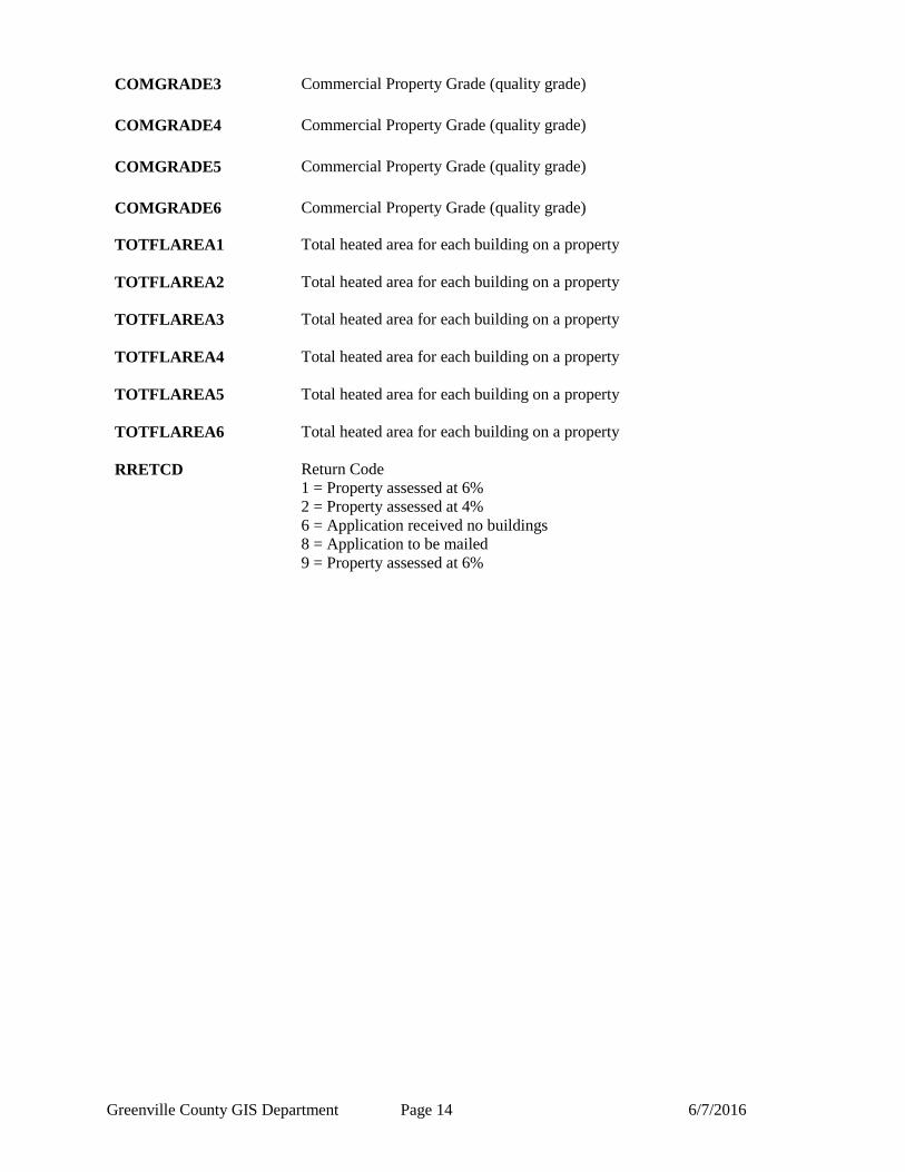
COMGRADE3 Commercial Property Grade (quality grade)
COMGRADE4 Commercial Property Grade (quality grade)
COMGRADE5 Commercial Property Grade (quality grade)
COMGRADE6 Commercial Property Grade (quality grade)
TOTFLAREA1 Total heated area for each building on a property
TOTFLAREA2 Total heated area for each building on a property
TOTFLAREA3 Total heated area for each building on a property
TOTFLAREA4 Total heated area for each building on a property
TOTFLAREA5 Total heated area for each building on a property
TOTFLAREA6 Total heated area for each building on a property
RRETCD Return Code
1 = Property assessed at 6%
2 = Property assessed at 4%
6 = Application received no buildings
8 = Application to be mailed
9 = Property assessed at 6%
Greenville County GIS Department Page 15 6/7/2016
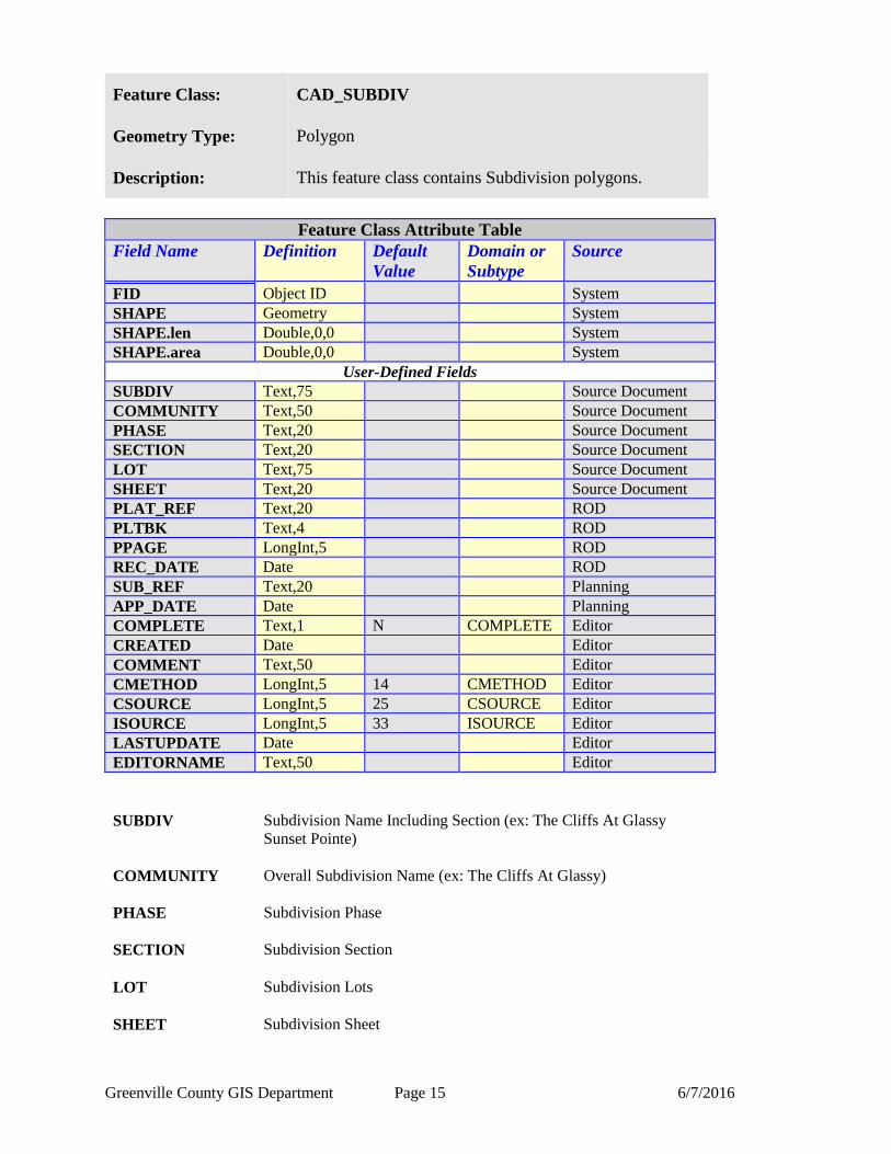
Feature Class: CAD_SUBDIV
Geometry Type: Polygon
Description: This feature class contains Subdivision polygons.
Feature Class Attribute Table
Field Name Definition
Default
Value
Domain or
Subtype
Source
FID Object ID System
SHAPE Geometry System
SHAPE.len Double,0,0 System
SHAPE.area Double,0,0 System
User-Defined Fields
SUBDIV Text,75 Source Document
COMMUNITY Text,50 Source Document
PHASE Text,20 Source Document
SECTION Text,20 Source Document
LOT Text,75 Source Document
SHEET Text,20 Source Document
PLAT_REF Text,20 ROD
PLTBK Text,4 ROD
PPAGE LongInt,5 ROD
REC_DATE Date ROD
SUB_REF Text,20 Planning
APP_DATE Date Planning
COMPLETE Text,1 N COMPLETE Editor
CREATED Date Editor
COMMENT Text,50 Editor
CMETHOD LongInt,5 14 CMETHOD Editor
CSOURCE LongInt,5 25 CSOURCE Editor
ISOURCE LongInt,5 33 ISOURCE Editor
LASTUPDATE Date Editor
EDITORNAME Text,50 Editor
SUBDIV Subdivision Name Including Section (ex: The Cliffs At Glassy
Sunset Pointe)
COMMUNITY Overall Subdivision Name (ex: The Cliffs At Glassy)
PHASE Subdivision Phase
SECTION Subdivision Section
LOT Subdivision Lots
SHEET Subdivision Sheet
Greenville County GIS Department Page 16 6/7/2016
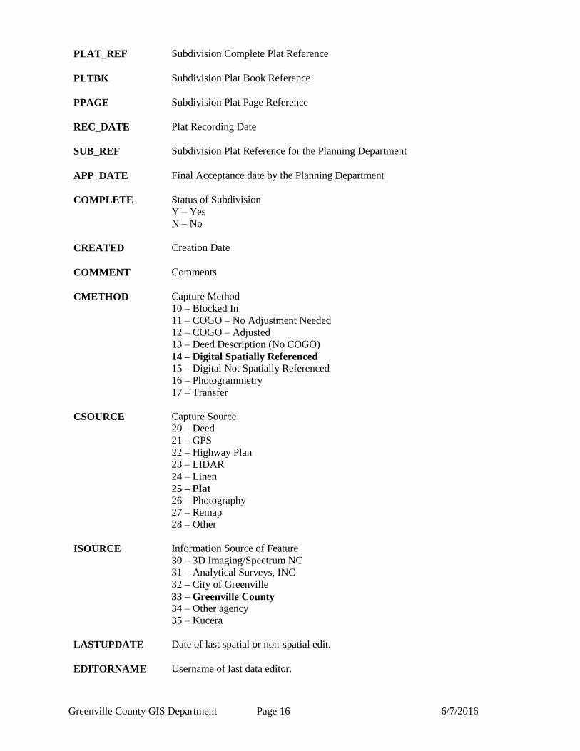
PLAT_REF Subdivision Complete Plat Reference
PLTBK Subdivision Plat Book Reference
PPAGE Subdivision Plat Page Reference
REC_DATE Plat Recording Date
SUB_REF Subdivision Plat Reference for the Planning Department
APP_DATE Final Acceptance date by the Planning Department
COMPLETE Status of Subdivision
Y – Yes
N – No
CREATED Creation Date
COMMENT Comments
CMETHOD Capture Method
10 – Blocked In
11 – COGO – No Adjustment Needed
12 – COGO – Adjusted
13 – Deed Description (No COGO)
14 – Digital Spatially Referenced
15 – Digital Not Spatially Referenced
16 – Photogrammetry
17 – Transfer
CSOURCE Capture Source
20 – Deed
21 – GPS
22 – Highway Plan
23 – LIDAR
24 – Linen
25 – Plat
26 – Photography
27 – Remap
28 – Other
ISOURCE Information Source of Feature
30 – 3D Imaging/Spectrum NC
31 – Analytical Surveys, INC
32 – City of Greenville
33 – Greenville County
34 – Other agency
35 – Kucera
LASTUPDATE Date of last spatial or non-spatial edit.
EDITORNAME Username of last data editor.
Greenville County GIS Department Page 17 6/7/2016
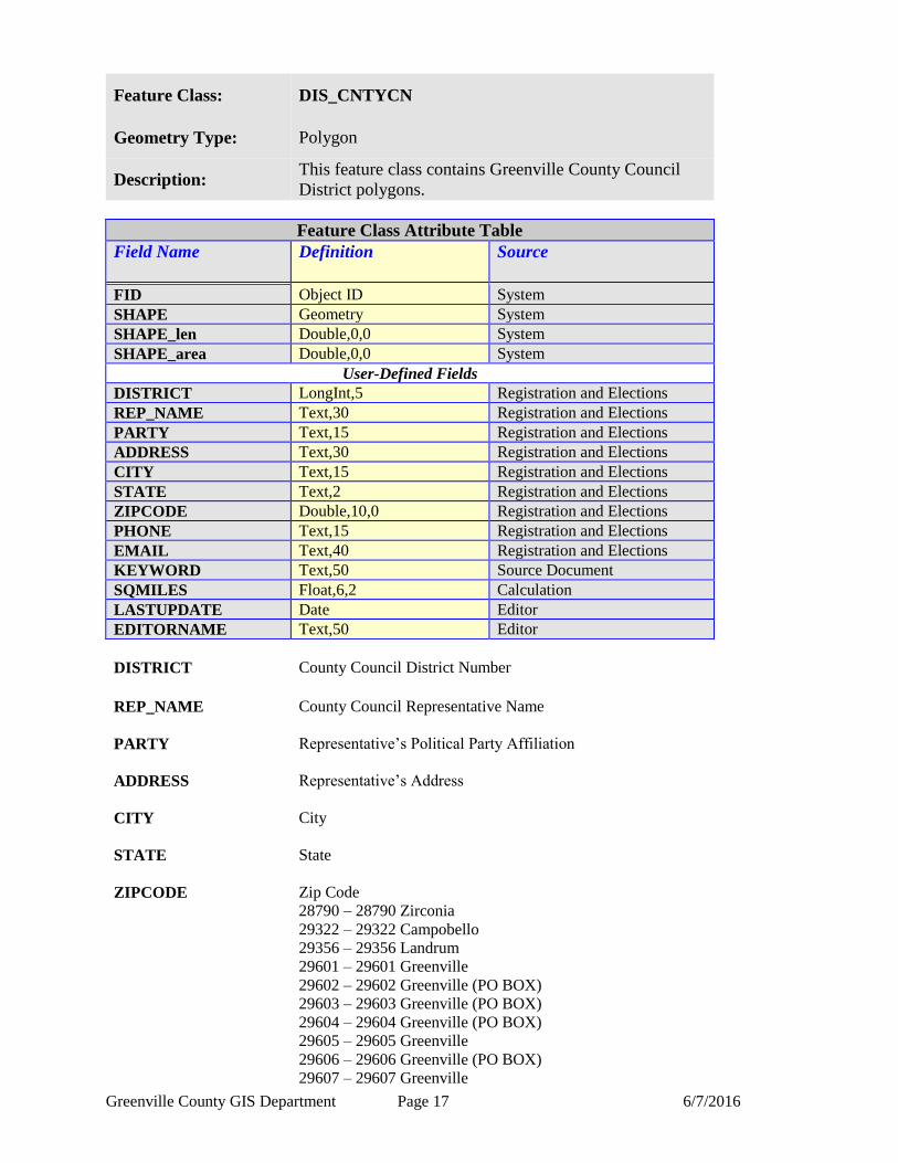
Feature Class: DIS_CNTYCN
Geometry Type: Polygon
Description: This feature class contains Greenville County Council
District polygons.
Feature Class Attribute Table
Field Name Definition
Source
FID Object ID System
SHAPE Geometry System
SHAPE_len Double,0,0 System
SHAPE_area Double,0,0 System
User-Defined Fields
DISTRICT LongInt,5 Registration and Elections
REP_NAME Text,30 Registration and Elections
PARTY Text,15 Registration and Elections
ADDRESS Text,30 Registration and Elections
CITY Text,15 Registration and Elections
STATE Text,2 Registration and Elections
ZIPCODE Double,10,0 Registration and Elections
PHONE Text,15 Registration and Elections
EMAIL Text,40 Registration and Elections
KEYWORD Text,50 Source Document
SQMILES Float,6,2 Calculation
LASTUPDATE Date Editor
EDITORNAME Text,50 Editor
DISTRICT County Council District Number
REP_NAME County Council Representative Name
PARTY Representative’s Political Party Affiliation
ADDRESS Representative’s Address
CITY City
STATE State
ZIPCODE Zip Code
28790 – 28790 Zirconia
29322 – 29322 Campobello
29356 – 29356 Landrum
29601 – 29601 Greenville
29602 – 29602 Greenville (PO BOX)
29603 – 29603 Greenville (PO BOX)
29604 – 29604 Greenville (PO BOX)
29605 – 29605 Greenville
29606 – 29606 Greenville (PO BOX)
29607 – 29607 Greenville
Greenville County GIS Department Page 18 6/7/2016
29609 – 29609 Greenville
29610 – 29610 Greenville (PO BOX)
29611 – 29611 Greenville
29612 – 29612 Greenville (PO BOX)
29613 – 29613 Greenville (UNIQUE)
29614 – 29614 Greenville (UNIQUE)
29615 – 29615 Greenville
29616 – 29616 Greenville (PO BOX)
29617 – 29617 Greenville
29627 – 29627 Belton
29635 – 29635 Cleveland
29636 – 29636 Conestee (PO BOX)
29644 – 29644 Fountain Inn
29645 – 29645 Gray Court
29650 – 29650 Greer
29651 – 29651 Greer
29652 – 29652 Greer (PO BOX)
29654 – 29654 Honea Path
29661 – 29661 Marietta
29662 – 29662 Mauldin
29669 – 29669 Pelzer
29673 – 29673 Piedmont
29680 – 29680 Simpsonville
29681 – 29681 Simpsonville
29683 – 29683 Slater (PO BOX)
29687 – 29687 Taylors
29688 – 29688 Tigerville
29690 – 29690 Travelers Rest
29698 – 29698 Greenville (UNIQUE)
PHONE Representative’s Phone Number
EMAIL Representative’s E-mail Address
KEYWORD Keywords for use with IMS Applications
DISTIRCT COUNTY COUNCIL POLITICAL
SQMILES Square miles calculated by (SHAPE_area sq feet) /
27,878,400 sq feet / mile.
LASTUPDATE Date of last spatial or non-spatial edit.
EDITORNAME Username of last data editor.
Greenville County GIS Department Page 19 6/7/2016
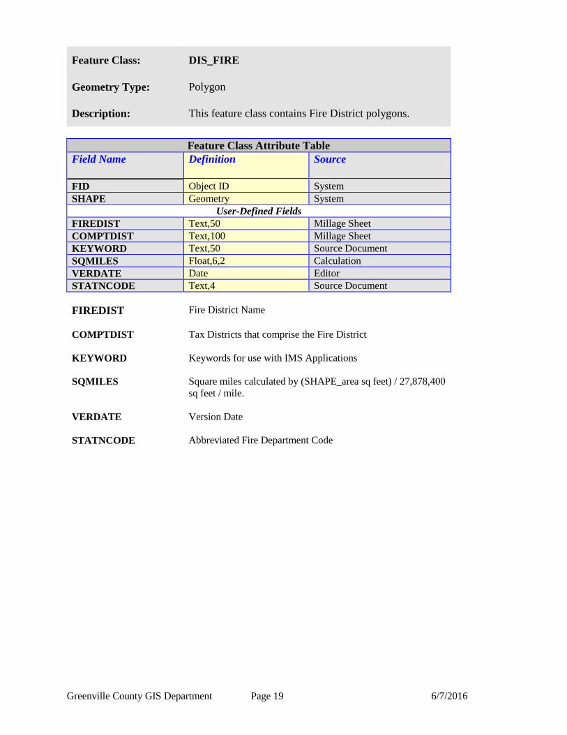
Feature Class: DIS_FIRE
Geometry Type: Polygon
Description: This feature class contains Fire District polygons.
Feature Class Attribute Table
Field Name Definition
Source
FID Object ID System
SHAPE Geometry System
User-Defined Fields
FIREDIST Text,50 Millage Sheet
COMPTDIST Text,100 Millage Sheet
KEYWORD Text,50 Source Document
SQMILES Float,6,2 Calculation
VERDATE Date Editor
STATNCODE Text,4 Source Document
FIREDIST Fire District Name
COMPTDIST Tax Districts that comprise the Fire District
KEYWORD Keywords for use with IMS Applications
SQMILES Square miles calculated by (SHAPE_area sq feet) / 27,878,400
sq feet / mile.
VERDATE Version Date
STATNCODE Abbreviated Fire Department Code
Greenville County GIS Department Page 20 6/7/2016
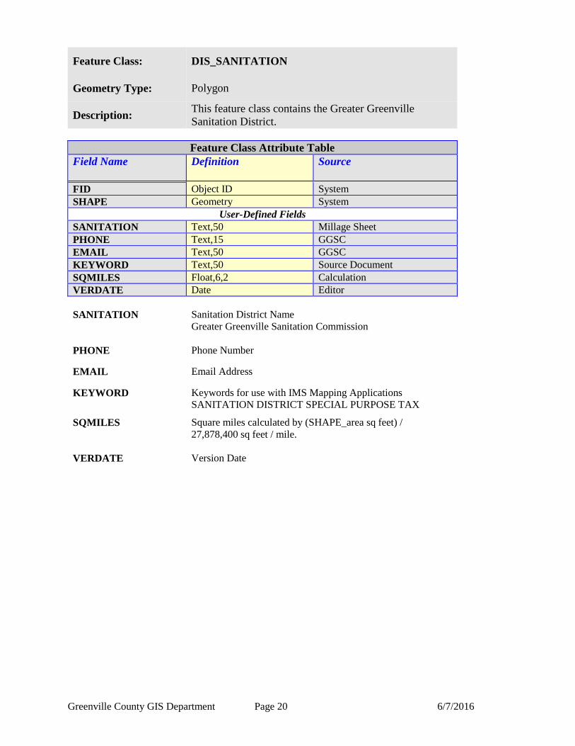
Feature Class: DIS_SANITATION
Geometry Type: Polygon
Description: This feature class contains the Greater Greenville
Sanitation District.
Feature Class Attribute Table
Field Name Definition
Source
FID Object ID System
SHAPE Geometry System
User-Defined Fields
SANITATION Text,50 Millage Sheet
PHONE Text,15 GGSC
EMAIL Text,50 GGSC
KEYWORD Text,50 Source Document
SQMILES Float,6,2 Calculation
VERDATE Date Editor
SANITATION Sanitation District Name
Greater Greenville Sanitation Commission
PHONE Phone Number
EMAIL Email Address
KEYWORD Keywords for use with IMS Mapping Applications
SANITATION DISTRICT SPECIAL PURPOSE TAX
SQMILES Square miles calculated by (SHAPE_area sq feet) /
27,878,400 sq feet / mile.
VERDATE Version Date
Greenville County GIS Department Page 21 6/7/2016
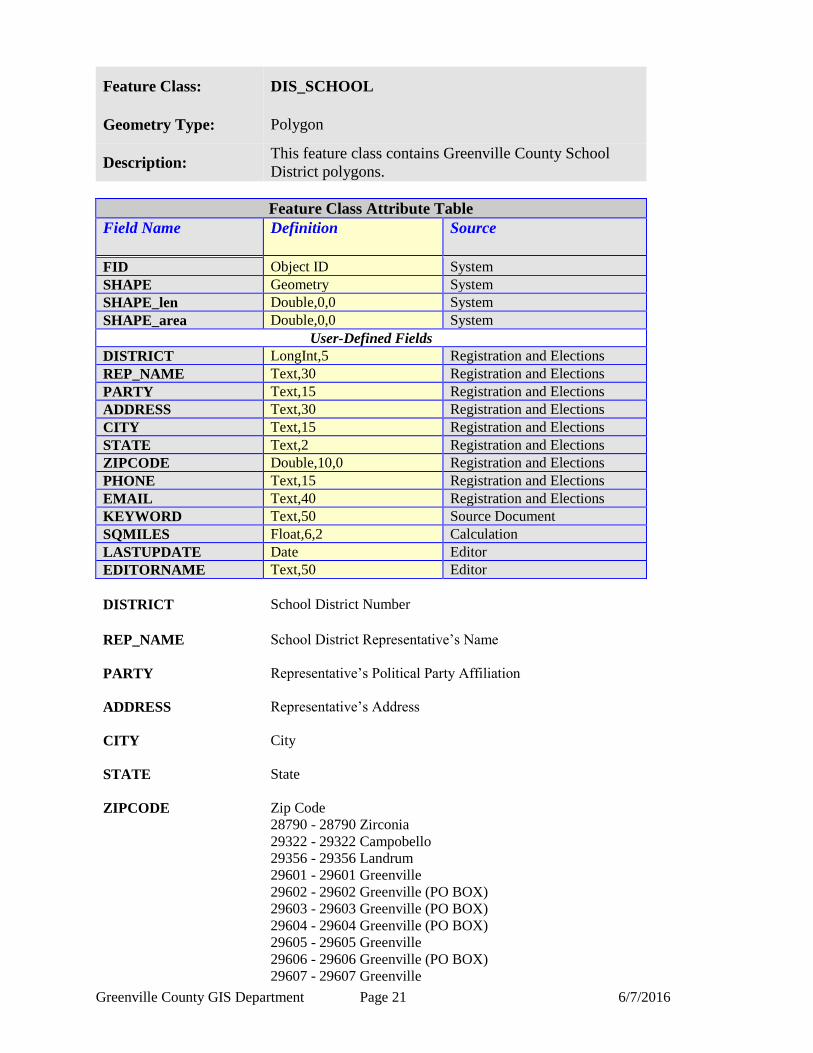
Feature Class: DIS_SCHOOL
Geometry Type: Polygon
Description: This feature class contains Greenville County School
District polygons.
Feature Class Attribute Table
Field Name Definition
Source
FID Object ID System
SHAPE Geometry System
SHAPE_len Double,0,0 System
SHAPE_area Double,0,0 System
User-Defined Fields
DISTRICT LongInt,5 Registration and Elections
REP_NAME Text,30 Registration and Elections
PARTY Text,15 Registration and Elections
ADDRESS Text,30 Registration and Elections
CITY Text,15 Registration and Elections
STATE Text,2 Registration and Elections
ZIPCODE Double,10,0 Registration and Elections
PHONE Text,15 Registration and Elections
EMAIL Text,40 Registration and Elections
KEYWORD Text,50 Source Document
SQMILES Float,6,2 Calculation
LASTUPDATE Date Editor
EDITORNAME Text,50 Editor
DISTRICT School District Number
REP_NAME School District Representative’s Name
PARTY Representative’s Political Party Affiliation
ADDRESS Representative’s Address
CITY City
STATE State
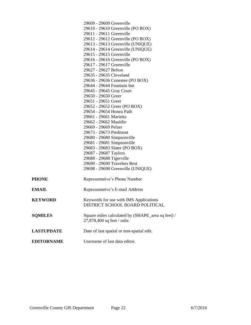
ZIPCODE Zip Code
28790 - 28790 Zirconia
29322 - 29322 Campobello
29356 - 29356 Landrum
29601 - 29601 Greenville
29602 - 29602 Greenville (PO BOX)
29603 - 29603 Greenville (PO BOX)
29604 - 29604 Greenville (PO BOX)
29605 - 29605 Greenville
29606 - 29606 Greenville (PO BOX)
29607 - 29607 Greenville
Greenville County GIS Department Page 22 6/7/2016
29609 - 29609 Greenville
29610 - 29610 Greenville (PO BOX)
29611 - 29611 Greenville
29612 - 29612 Greenville (PO BOX)
29613 - 29613 Greenville (UNIQUE)
29614 - 29614 Greenville (UNIQUE)
29615 - 29615 Greenville
29616 - 29616 Greenville (PO BOX)
29617 - 29617 Greenville
29627 - 29627 Belton
29635 - 29635 Cleveland
29636 - 29636 Conestee (PO BOX)
29644 - 29644 Fountain Inn
29645 - 29645 Gray Court
29650 - 29650 Greer
29651 - 29651 Greer
29652 - 29652 Greer (PO BOX)
29654 - 29654 Honea Path
29661 - 29661 Marietta
29662 - 29662 Mauldin
29669 - 29669 Pelzer
29673 - 29673 Piedmont
29680 - 29680 Simpsonville
29681 - 29681 Simpsonville
29683 - 29683 Slater (PO BOX)
29687 - 29687 Taylors
29688 - 29688 Tigerville
29690 - 29690 Travelers Rest
29698 - 29698 Greenville (UNIQUE)
PHONE Representative’s Phone Number
EMAIL Representative’s E-mail Address
KEYWORD Keywords for use with IMS Applications
DISTRICT SCHOOL BOARD POLITICAL
SQMILES Square miles calculated by (SHAPE_area sq feet) /
27,878,400 sq feet / mile.
LASTUPDATE Date of last spatial or non-spatial edit.
EDITORNAME Username of last data editor.

Greenville County GIS Department Page 23 6/7/2016
Feature Class: DIS_SCHOUSE
Geometry Type: Polygon
Description: This feature class contains South Carolina State House
District polygons.
Feature Class Attribute Table
Field Name Definition
Source
FID Object ID System
SHAPE Geometry System
SHAPE_len Double,0,0 System
SHAPE_area Double,0,0 System
User-Defined Fields
DISTRICT LongInt,5 Registration and Elections
REP_NAME Text,30 Registration and Elections
PARTY Text,15 Registration and Elections
ADDRESS Text,30 Registration and Elections
CITY Text,15 Registration and Elections
STATE Text,2 Registration and Elections
ZIPCODE Double,10,0 Registration and Elections
PHONE Text,15 Registration and Elections
EMAIL Text,40 Registration and Elections
KEYWORD Text,50 Source Document
SQMILES Float,6,2 Calculation
LASTUPDATE Date Editor
EDITORNAME Text,50 Editor
DISTRICT State House District Number
REP_NAME House District Representative Name
PARTY Representative’s Political Party Affiliation
ADDRESS Representative’s Address
CITY City
STATE State
ZIPCODE Zip Code
28790 - 28790 Zirconia
29322 - 29322 Campobello
29356 - 29356 Landrum
29601 - 29601 Greenville
29602 - 29602 Greenville (PO BOX)
29603 - 29603 Greenville (PO BOX)
29604 - 29604 Greenville (PO BOX)
29605 - 29605 Greenville
29606 - 29606 Greenville (PO BOX)
29607 - 29607 Greenville

Greenville County GIS Department Page 24 6/7/2016
29609 - 29609 Greenville
29610 - 29610 Greenville (PO BOX)
29611 - 29611 Greenville
29612 - 29612 Greenville (PO BOX)
29613 - 29613 Greenville (UNIQUE)
29614 - 29614 Greenville (UNIQUE)
29615 - 29615 Greenville
29616 - 29616 Greenville (PO BOX)
29617 - 29617 Greenville
29627 - 29627 Belton
29635 - 29635 Cleveland
29636 - 29636 Conestee (PO BOX)
29644 - 29644 Fountain Inn
29645 - 29645 Gray Court
29650 - 29650 Greer
29651 - 29651 Greer
29652 - 29652 Greer (PO BOX)
29654 - 29654 Honea Path
29661 - 29661 Marietta
29662 - 29662 Mauldin
29669 - 29669 Pelzer
29673 - 29673 Piedmont
29680 - 29680 Simpsonville
29681 - 29681 Simpsonville
29683 - 29683 Slater (PO BOX)
29687 - 29687 Taylors
29688 - 29688 Tigerville
29690 - 29690 Travelers Rest
29698 - 29698 Greenville (UNIQUE)
PHONE Representative’s Phone Number
EMAIL Representative’s E-mail Address
KEYWORD Keywords for use with IMS Applications
DISTRICT HOUSE POLITICAL
SQMILES Square miles calculated by (SHAPE_area sq feet) /
27,878,400 sq feet / mile.
LASTUPDATE Date of last spatial or non-spatial edit.
EDITORNAME Username of last data editor.
Greenville County GIS Department Page 25 6/7/2016
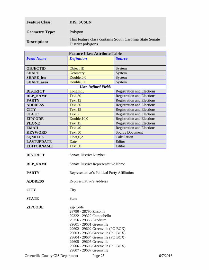
Feature Class: DIS_SCSEN
Geometry Type: Polygon
Description: This feature class contains South Carolina State Senate
District polygons.
Feature Class Attribute Table
Field Name Definition
Source
OBJECTID Object ID System
SHAPE Geometry System
SHAPE_len Double,0,0 System
SHAPE_area Double,0,0 System
User-Defined Fields
DISTRICT LongInt,5 Registration and Elections
REP_NAME Text,30 Registration and Elections
PARTY Text,15 Registration and Elections
ADDRESS Text,30 Registration and Elections
CITY Text,15 Registration and Elections
STATE Text,2 Registration and Elections
ZIPCODE Double,10,0 Registration and Elections
PHONE Text,15 Registration and Elections
EMAIL Text,40 Registration and Elections
KEYWORD Text,50 Source Document
SQMILES Float,6,2 Calculation
LASTUPDATE Date Editor
EDITORNAME Text,50 Editor
DISTRICT Senate District Number
REP_NAME Senate District Representative Name
PARTY Representative’s Political Party Affiliation
ADDRESS Representative’s Address
CITY City
STATE State
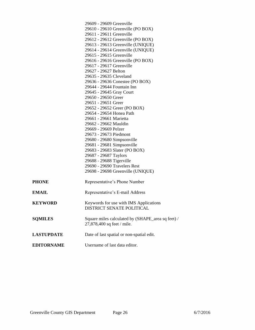
ZIPCODE Zip Code
28790 - 28790 Zirconia
29322 - 29322 Campobello
29356 - 29356 Landrum
29601 - 29601 Greenville
29602 - 29602 Greenville (PO BOX)
29603 - 29603 Greenville (PO BOX)
29604 - 29604 Greenville (PO BOX)
29605 - 29605 Greenville
29606 - 29606 Greenville (PO BOX)
29607 - 29607 Greenville
Greenville County GIS Department Page 26 6/7/2016
29609 - 29609 Greenville
29610 - 29610 Greenville (PO BOX)
29611 - 29611 Greenville
29612 - 29612 Greenville (PO BOX)
29613 - 29613 Greenville (UNIQUE)
29614 - 29614 Greenville (UNIQUE)
29615 - 29615 Greenville
29616 - 29616 Greenville (PO BOX)
29617 - 29617 Greenville
29627 - 29627 Belton
29635 - 29635 Cleveland
29636 - 29636 Conestee (PO BOX)
29644 - 29644 Fountain Inn
29645 - 29645 Gray Court
29650 - 29650 Greer
29651 - 29651 Greer
29652 - 29652 Greer (PO BOX)
29654 - 29654 Honea Path
29661 - 29661 Marietta
29662 - 29662 Mauldin
29669 - 29669 Pelzer
29673 - 29673 Piedmont
29680 - 29680 Simpsonville
29681 - 29681 Simpsonville
29683 - 29683 Slater (PO BOX)
29687 - 29687 Taylors
29688 - 29688 Tigerville
29690 - 29690 Travelers Rest
29698 - 29698 Greenville (UNIQUE)
PHONE Representative’s Phone Number
EMAIL Representative’s E-mail Address
KEYWORD Keywords for use with IMS Applications
DISTRICT SENATE POLITICAL
SQMILES Square miles calculated by (SHAPE_area sq feet) /
27,878,400 sq feet / mile.
LASTUPDATE Date of last spatial or non-spatial edit.
EDITORNAME Username of last data editor.
Greenville County GIS Department Page 27 6/7/2016
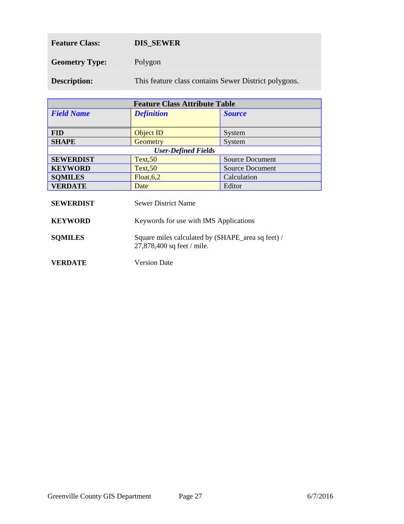
Feature Class: DIS_SEWER
Geometry Type: Polygon
Description: This feature class contains Sewer District polygons.
Feature Class Attribute Table
Field Name Definition
Source
FID Object ID System
SHAPE Geometry System
User-Defined Fields
SEWERDIST Text,50 Source Document
KEYWORD Text,50 Source Document
SQMILES Float,6,2 Calculation
VERDATE Date Editor
SEWERDIST Sewer District Name
KEYWORD Keywords for use with IMS Applications
SQMILES Square miles calculated by (SHAPE_area sq feet) /
27,878,400 sq feet / mile.
VERDATE Version Date
Greenville County GIS Department Page 28 6/7/2016
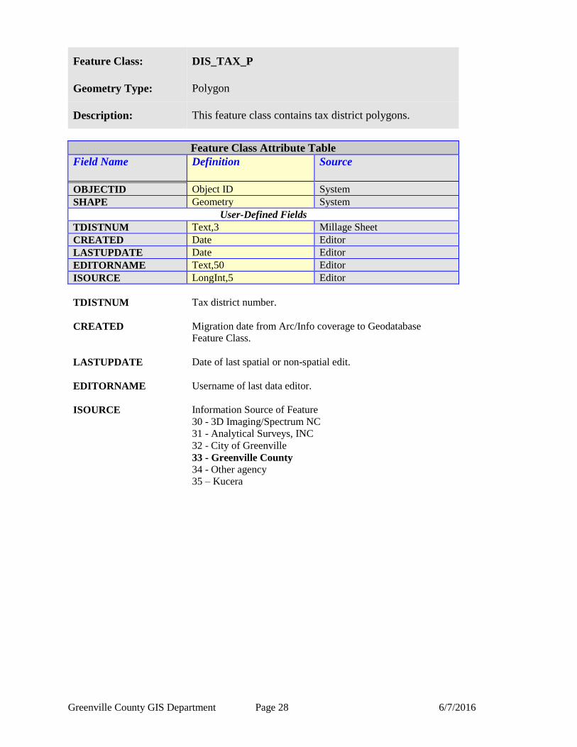
Feature Class: DIS_TAX_P
Geometry Type: Polygon
Description: This feature class contains tax district polygons.
Feature Class Attribute Table
Field Name Definition
Source
OBJECTID Object ID System
SHAPE Geometry System
User-Defined Fields
TDISTNUM Text,3 Millage Sheet
CREATED Date Editor
LASTUPDATE Date Editor
EDITORNAME Text,50 Editor
ISOURCE LongInt,5 Editor
TDISTNUM Tax district number.
CREATED Migration date from Arc/Info coverage to Geodatabase
Feature Class.
LASTUPDATE Date of last spatial or non-spatial edit.
EDITORNAME Username of last data editor.
ISOURCE Information Source of Feature
30 - 3D Imaging/Spectrum NC
31 - Analytical Surveys, INC
32 - City of Greenville
33 - Greenville County
34 - Other agency
35 – Kucera
Greenville County GIS Department Page 29 6/7/2016
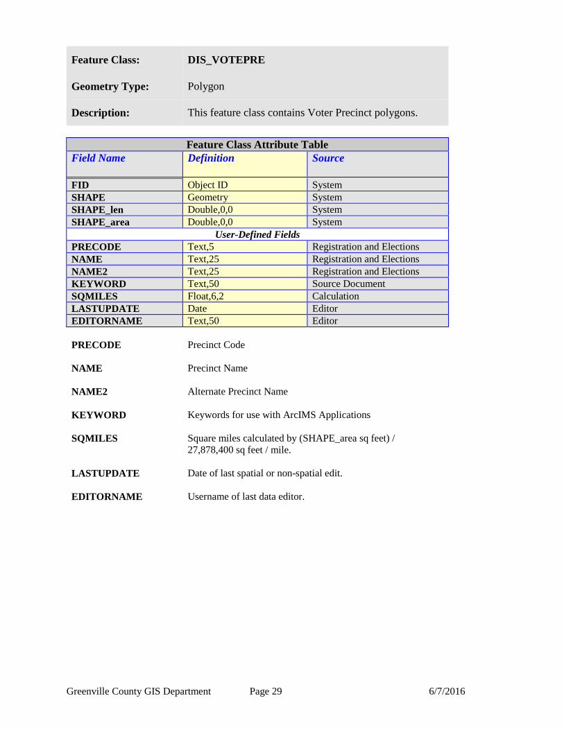
Feature Class: DIS_VOTEPRE
Geometry Type: Polygon
Description: This feature class contains Voter Precinct polygons.
Feature Class Attribute Table
Field Name Definition
Source
FID Object ID System
SHAPE Geometry System
SHAPE_len Double,0,0 System
SHAPE_area Double,0,0 System
User-Defined Fields
PRECODE Text,5 Registration and Elections
NAME Text,25 Registration and Elections
NAME2 Text,25 Registration and Elections
KEYWORD Text,50 Source Document
SQMILES Float,6,2 Calculation
LASTUPDATE Date Editor
EDITORNAME Text,50 Editor
PRECODE Precinct Code
NAME Precinct Name
NAME2 Alternate Precinct Name
KEYWORD Keywords for use with ArcIMS Applications
SQMILES Square miles calculated by (SHAPE_area sq feet) /
27,878,400 sq feet / mile.
LASTUPDATE Date of last spatial or non-spatial edit.
EDITORNAME Username of last data editor.

Greenville County GIS Department Page 30 6/7/2016
Feature Class: PLN_BUILD_P
Geometry Type: Polygon
Description: This feature class contains building polygons. Buildings
greater than or equal to 300 square feet are captured.
Feature Class Attribute Table
Field Name Definition
Source
FID Object ID System
SHAPE Geometry System
SHAPE_len Double,0,0 System
SHAPE_area Double,0,0 System
User-Defined Fields
FEAT_CODE LongInt,5 Orthophotography
TOPELEV Double,12,1 KUCERA
BASEELEV Double,12,1 KUCERA
BUILDHGT Double,12,1 KUCERA
LASTUPDATE Date Editor
EDITORNAME Text,50 Editor
CMETHOD LongInt,5 Editor
CSOURCE LongInt,5 Editor
ISOURCE LongInt,5 Editor
FEAT_CODE Type of Feature
810 – Commercial / Industrial
811 – Residential (multi-unit)
812 – Residential
813 – School
814 – Parking Structure
815 – Accessory Structure
816 – Foundation Under Construction
817 – Courtyard
818 – Church
TOPELEV Predominant elevation of building roof or top of church
steeple
BASEELEV Elevation of building foundation at lowest point
BUILDHGT Total Height
EDITORNAME Username of last data editor.
CMETHOD Capture Method
10 - Blocked In
11 - COGO - No Adjustment Needed
12 - COGO – Adjusted
13 - Deed Description (No COGO)
14 - Digital Spatially Referenced
15 - Digital Not Spatially Referenced
Greenville County GIS Department Page 31 6/7/2016
16 - Photogrammetry
17 - Transfer
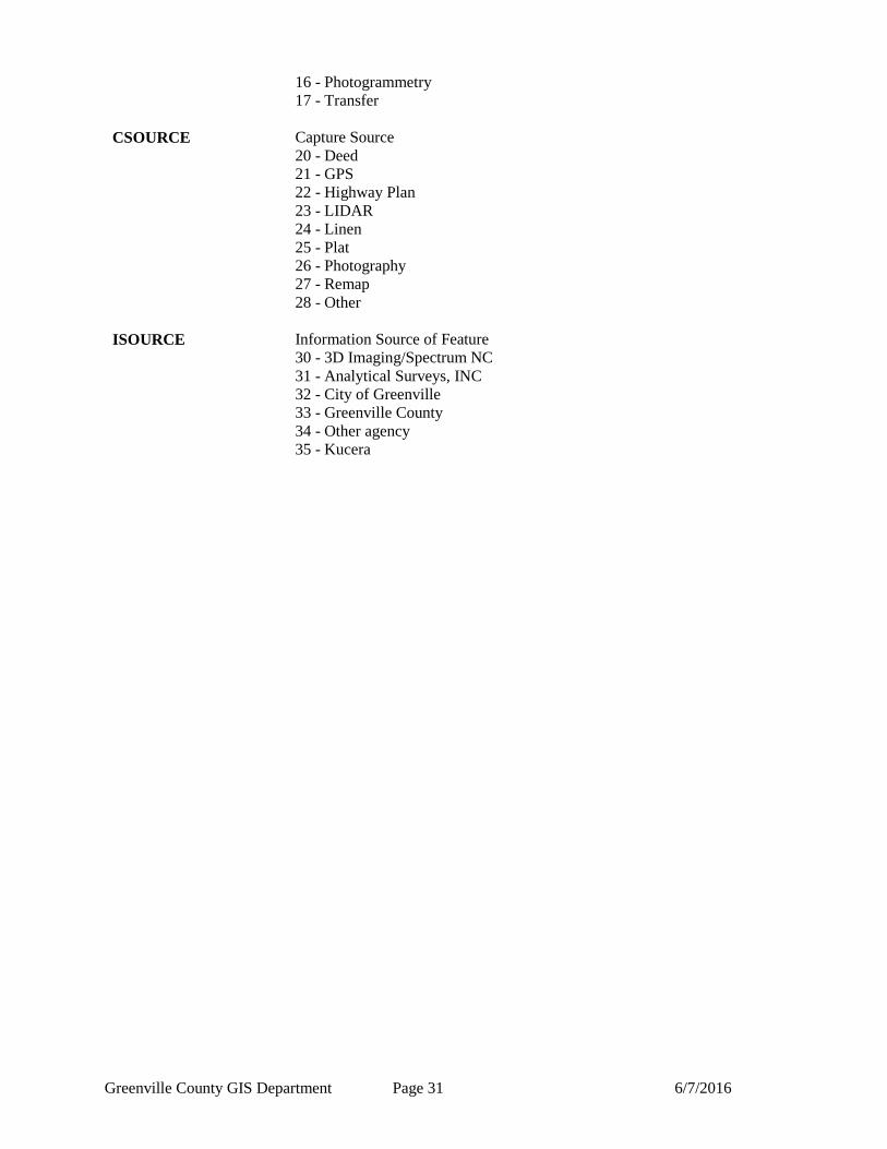
CSOURCE Capture Source
20 - Deed
21 - GPS
22 - Highway Plan
23 - LIDAR
24 - Linen
25 - Plat
26 - Photography
27 - Remap
28 - Other
ISOURCE Information Source of Feature
30 - 3D Imaging/Spectrum NC
31 - Analytical Surveys, INC
32 - City of Greenville
33 - Greenville County
34 - Other agency
35 - Kucera
Greenville County GIS Department Page 32 6/7/2016
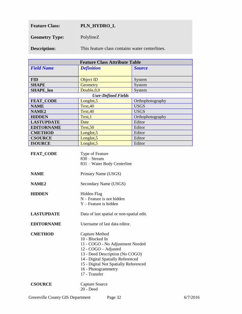
Feature Class: PLN_HYDRO_L
Geometry Type: PolylineZ
Description: This feature class contains water centerlines.
Feature Class Attribute Table
Field Name Definition
Source
FID Object ID System
SHAPE Geometry System
SHAPE_len Double,0,0 System
User-Defined Fields
FEAT_CODE LongInt,5 Orthophotography
NAME Text,40 USGS
NAME2 Text,40 USGS
HIDDEN Text,1 Orthophotography
LASTUPDATE Date Editor
EDITORNAME Text,50 Editor
CMETHOD LongInt,5 Editor
CSOURCE LongInt,5 Editor
ISOURCE LongInt,5 Editor
FEAT_CODE Type of Feature
830 – Stream
831 – Water Body Centerline
NAME Primary Name (USGS)
NAME2 Secondary Name (USGS)
HIDDEN Hidden Flag
N – Feature is not hidden
Y – Feature is hidden
LASTUPDATE Data of last spatial or non-spatial edit.
EDITORNAME Username of last data editor.
CMETHOD Capture Method
10 - Blocked In
11 - COGO - No Adjustment Needed
12 - COGO – Adjusted
13 - Deed Description (No COGO)
14 - Digital Spatially Referenced
15 - Digital Not Spatially Referenced
16 - Photogrammetry
17 - Transfer
CSOURCE Capture Source
20 - Deed

Greenville County GIS Department Page 33 6/7/2016
21 - GPS
22 - Highway Plan
23 - LIDAR
24 - Linen
25 - Plat
26 - Photography
27 - Remap
28 - Other
ISOURCE Information Source of Feature
30 - 3D Imaging/Spectrum NC
31 - Analytical Surveys, INC
32 - City of Greenville
33 - Greenville County
34 - Other agency
35 - Kucera
Greenville County GIS Department Page 34 6/7/2016
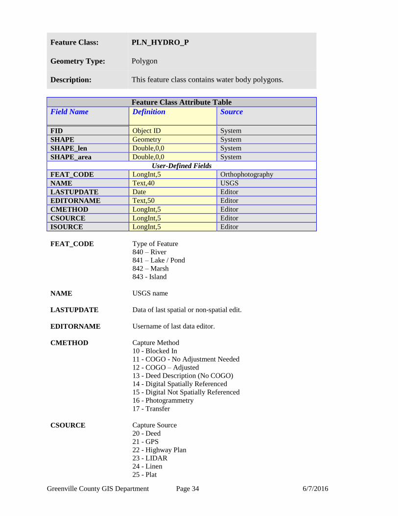
Feature Class: PLN_HYDRO_P
Geometry Type: Polygon
Description: This feature class contains water body polygons.
Feature Class Attribute Table
Field Name Definition
Source
FID Object ID System
SHAPE Geometry System
SHAPE_len Double,0,0 System
SHAPE_area Double,0,0 System
User-Defined Fields
FEAT_CODE LongInt,5 Orthophotography
NAME Text,40 USGS
LASTUPDATE Date Editor
EDITORNAME Text,50 Editor
CMETHOD LongInt,5 Editor
CSOURCE LongInt,5 Editor
ISOURCE LongInt,5 Editor
FEAT_CODE Type of Feature
840 – River
841 – Lake / Pond
842 – Marsh
843 - Island
NAME USGS name
LASTUPDATE Data of last spatial or non-spatial edit.
EDITORNAME Username of last data editor.
CMETHOD Capture Method
10 - Blocked In
11 - COGO - No Adjustment Needed
12 - COGO – Adjusted
13 - Deed Description (No COGO)
14 - Digital Spatially Referenced
15 - Digital Not Spatially Referenced
16 - Photogrammetry
17 - Transfer
CSOURCE Capture Source
20 - Deed
21 - GPS
22 - Highway Plan
23 - LIDAR
24 - Linen
25 - Plat

Greenville County GIS Department Page 35 6/7/2016
26 - Photography
27 - Remap
28 - Other
ISOURCE Information Source of Feature
30 - 3D Imaging/Spectrum NC
31 - Analytical Surveys, INC
32 - City of Greenville
33 - Greenville County
34 - Other agency
35 - Kucera
Greenville County GIS Department Page 36 6/7/2016
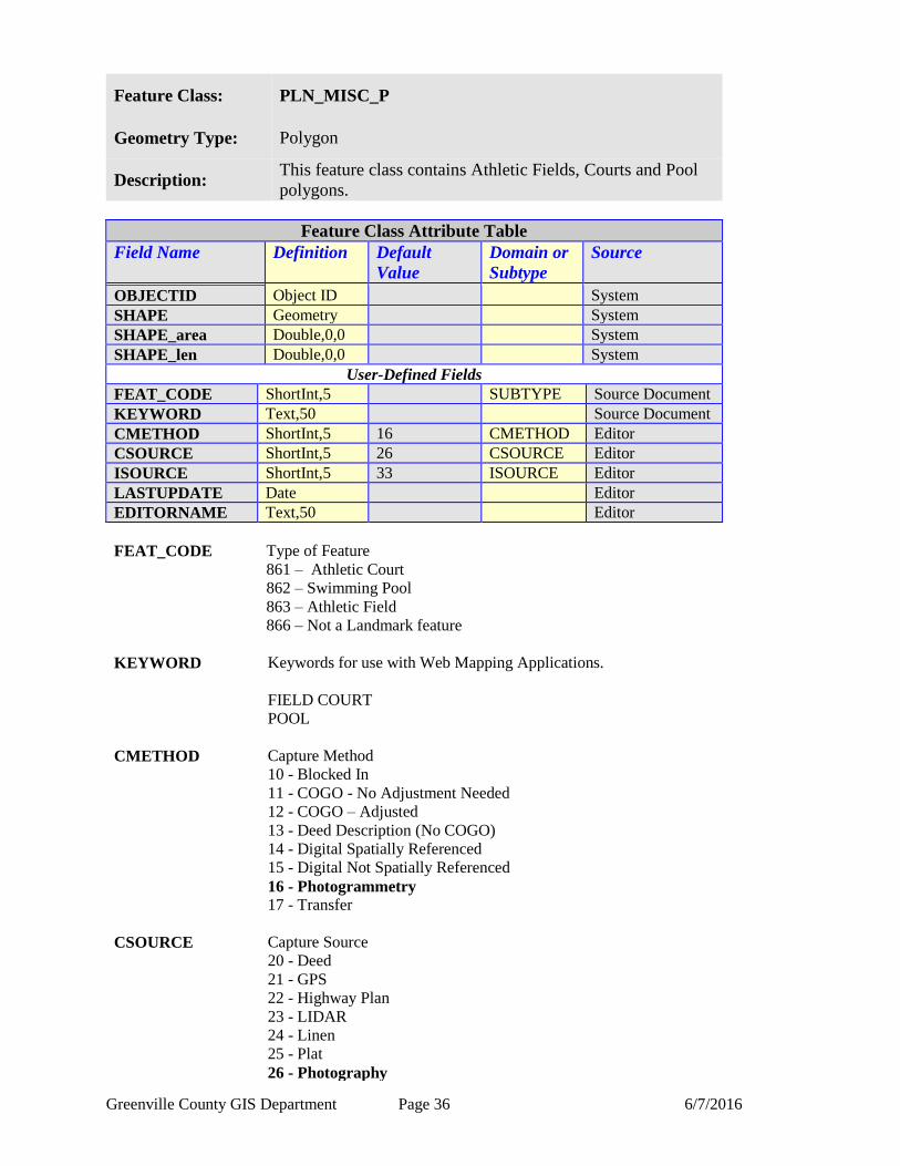
Feature Class: PLN_MISC_P
Geometry Type: Polygon
Description: This feature class contains Athletic Fields, Courts and Pool
polygons.
Feature Class Attribute Table
Field Name Definition
Default
Value
Domain or
Subtype
Source
OBJECTID Object ID System
SHAPE Geometry System
SHAPE_area Double,0,0 System
SHAPE_len Double,0,0 System
User-Defined Fields
FEAT_CODE ShortInt,5 SUBTYPE Source Document
KEYWORD Text,50 Source Document
CMETHOD ShortInt,5 16 CMETHOD Editor
CSOURCE ShortInt,5 26 CSOURCE Editor
ISOURCE ShortInt,5 33 ISOURCE Editor
LASTUPDATE Date Editor
EDITORNAME Text,50 Editor
FEAT_CODE Type of Feature
861 – Athletic Court
862 – Swimming Pool
863 – Athletic Field
866 – Not a Landmark feature
KEYWORD Keywords for use with Web Mapping Applications.
FIELD COURT
POOL
CMETHOD Capture Method
10 - Blocked In
11 - COGO - No Adjustment Needed
12 - COGO – Adjusted
13 - Deed Description (No COGO)
14 - Digital Spatially Referenced
15 - Digital Not Spatially Referenced
16 - Photogrammetry
17 - Transfer
CSOURCE Capture Source
20 - Deed
21 - GPS
22 - Highway Plan
23 - LIDAR
24 - Linen
25 - Plat
26 - Photography
Greenville County GIS Department Page 37 6/7/2016
27 - Remap
28 - Other
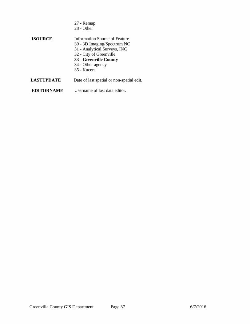
ISOURCE Information Source of Feature
30 - 3D Imaging/Spectrum NC
31 - Analytical Surveys, INC
32 - City of Greenville
33 - Greenville County
34 - Other agency
35 - Kucera
LASTUPDATE Date of last spatial or non-spatial edit.
EDITORNAME Username of last data editor.
Greenville County GIS Department Page 38 6/7/2016
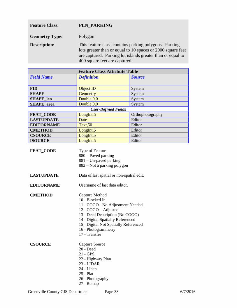
Feature Class: PLN_PARKING
Geometry Type: Polygon
Description: This feature class contains parking polygons. Parking
lots greater than or equal to 10 spaces or 2000 square feet
are captured. Parking lot islands greater than or equal to
400 square feet are captured.
Feature Class Attribute Table
Field Name Definition
Source
FID Object ID System
SHAPE Geometry System
SHAPE_len Double,0,0 System
SHAPE_area Double,0,0 System
User-Defined Fields
FEAT_CODE LongInt,5 Orthophotography
LASTUPDATE Date Editor
EDITORNAME Text,50 Editor
CMETHOD LongInt,5 Editor
CSOURCE LongInt,5 Editor
ISOURCE LongInt,5 Editor
FEAT_CODE Type of Feature
880 – Paved parking
881 – Un-paved parking
882 – Not a parking polygon
LASTUPDATE Data of last spatial or non-spatial edit.
EDITORNAME Username of last data editor.
CMETHOD Capture Method
10 - Blocked In
11 - COGO - No Adjustment Needed
12 - COGO – Adjusted
13 - Deed Description (No COGO)
14 - Digital Spatially Referenced
15 - Digital Not Spatially Referenced
16 - Photogrammetry
17 - Transfer
CSOURCE Capture Source
20 - Deed
21 - GPS
22 - Highway Plan
23 - LIDAR
24 - Linen
25 - Plat
26 - Photography
27 - Remap
Greenville County GIS Department Page 39 6/7/2016
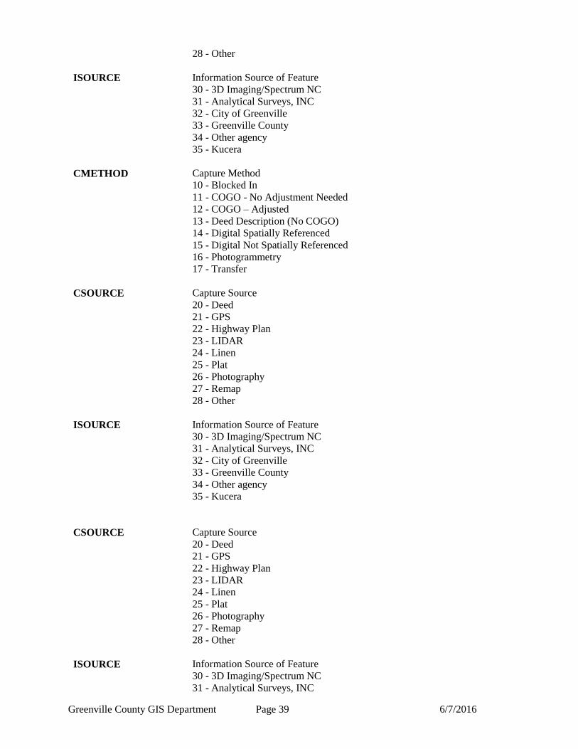
28 - Other
ISOURCE Information Source of Feature
30 - 3D Imaging/Spectrum NC
31 - Analytical Surveys, INC
32 - City of Greenville
33 - Greenville County
34 - Other agency
35 - Kucera
CMETHOD Capture Method
10 - Blocked In
11 - COGO - No Adjustment Needed
12 - COGO – Adjusted
13 - Deed Description (No COGO)
14 - Digital Spatially Referenced
15 - Digital Not Spatially Referenced
16 - Photogrammetry
17 - Transfer
CSOURCE Capture Source
20 - Deed
21 - GPS
22 - Highway Plan
23 - LIDAR
24 - Linen
25 - Plat
26 - Photography
27 - Remap
28 - Other
ISOURCE Information Source of Feature
30 - 3D Imaging/Spectrum NC
31 - Analytical Surveys, INC
32 - City of Greenville
33 - Greenville County
34 - Other agency
35 - Kucera
CSOURCE Capture Source
20 - Deed
21 - GPS
22 - Highway Plan
23 - LIDAR
24 - Linen
25 - Plat
26 - Photography
27 - Remap
28 - Other
ISOURCE Information Source of Feature
30 - 3D Imaging/Spectrum NC
31 - Analytical Surveys, INC

Greenville County GIS Department Page 40 6/7/2016
32 - City of Greenville
33 - Greenville County
34 - Other agency
35 - Kucera
Greenville County GIS Department Page 41 6/7/2016
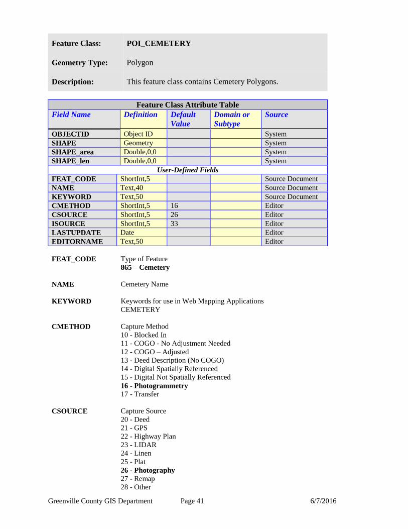
Feature Class: POI_CEMETERY
Geometry Type: Polygon
Description: This feature class contains Cemetery Polygons.
Feature Class Attribute Table
Field Name Definition
Default
Value
Domain or
Subtype
Source
OBJECTID Object ID System
SHAPE Geometry System
SHAPE_area Double,0,0 System
SHAPE_len Double,0,0 System
User-Defined Fields
FEAT_CODE ShortInt,5 Source Document
NAME Text,40 Source Document
KEYWORD Text,50 Source Document
CMETHOD ShortInt,5 16 Editor
CSOURCE ShortInt,5 26 Editor
ISOURCE ShortInt,5 33 Editor
LASTUPDATE Date Editor
EDITORNAME Text,50 Editor
FEAT_CODE Type of Feature
865 – Cemetery
NAME Cemetery Name
KEYWORD Keywords for use in Web Mapping Applications
CEMETERY
CMETHOD Capture Method
10 - Blocked In
11 - COGO - No Adjustment Needed
12 - COGO – Adjusted
13 - Deed Description (No COGO)
14 - Digital Spatially Referenced
15 - Digital Not Spatially Referenced
16 - Photogrammetry
17 - Transfer
CSOURCE Capture Source
20 - Deed
21 - GPS
22 - Highway Plan
23 - LIDAR
24 - Linen
25 - Plat
26 - Photography
27 - Remap
28 - Other

Greenville County GIS Department Page 42 6/7/2016
ISOURCE Information Source of Feature
30 - 3D Imaging/Spectrum NC
31 - Analytical Surveys, INC
32 - City of Greenville
33 - Greenville County
34 - Other agency
35 - Kucera
LASTUPDATE Date of last spatial or non-spatial edit.
EDITORNAME Username of last data editor.
Greenville County GIS Department Page 43 6/7/2016
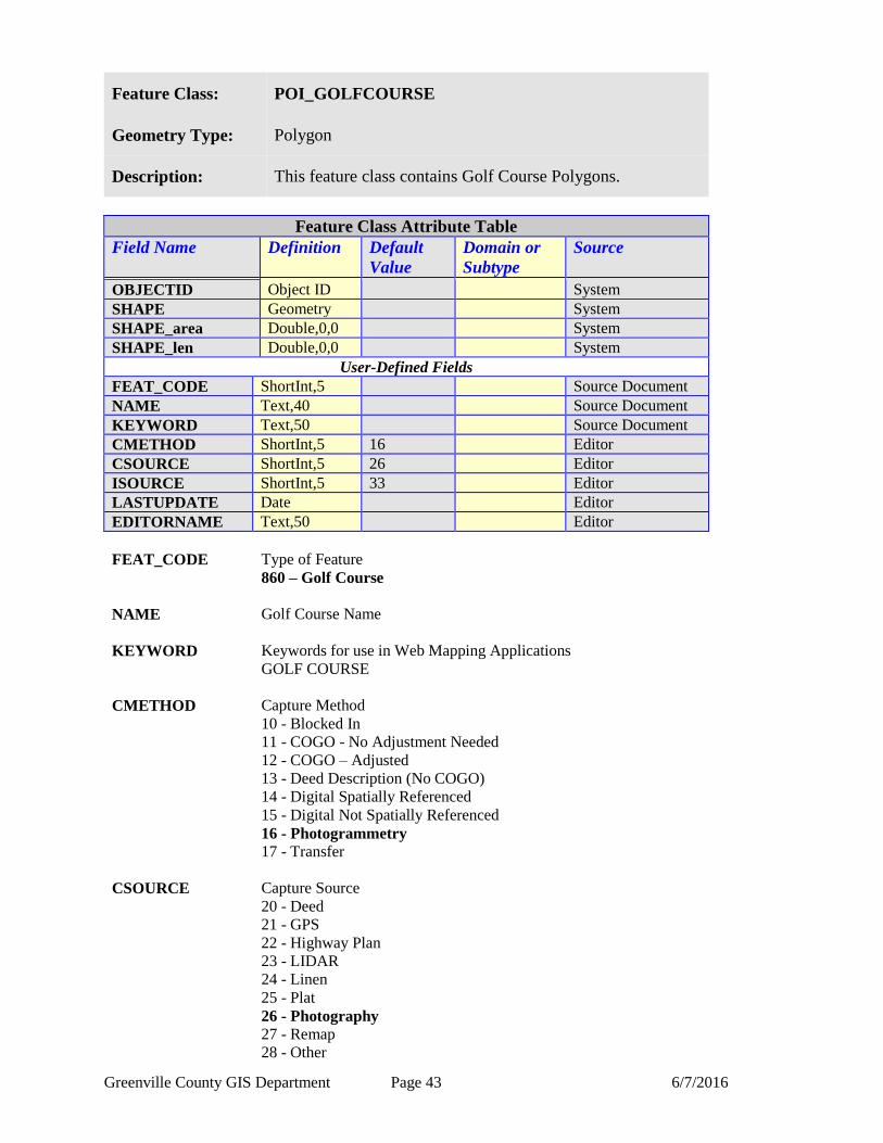
Feature Class: POI_GOLFCOURSE
Geometry Type: Polygon
Description: This feature class contains Golf Course Polygons.
Feature Class Attribute Table
Field Name Definition
Default
Value
Domain or
Subtype
Source
OBJECTID Object ID System
SHAPE Geometry System
SHAPE_area Double,0,0 System
SHAPE_len Double,0,0 System
User-Defined Fields
FEAT_CODE ShortInt,5 Source Document
NAME Text,40 Source Document
KEYWORD Text,50 Source Document
CMETHOD ShortInt,5 16 Editor
CSOURCE ShortInt,5 26 Editor
ISOURCE ShortInt,5 33 Editor
LASTUPDATE Date Editor
EDITORNAME Text,50 Editor
FEAT_CODE Type of Feature
860 – Golf Course
NAME Golf Course Name
KEYWORD Keywords for use in Web Mapping Applications
GOLF COURSE
CMETHOD Capture Method
10 - Blocked In
11 - COGO - No Adjustment Needed
12 - COGO – Adjusted
13 - Deed Description (No COGO)
14 - Digital Spatially Referenced
15 - Digital Not Spatially Referenced
16 - Photogrammetry
17 - Transfer
CSOURCE Capture Source
20 - Deed
21 - GPS
22 - Highway Plan
23 - LIDAR
24 - Linen
25 - Plat
26 - Photography
27 - Remap
28 - Other

Greenville County GIS Department Page 44 6/7/2016
ISOURCE Information Source of Feature
30 - 3D Imaging/Spectrum NC
31 - Analytical Surveys, INC
32 - City of Greenville
33 - Greenville County
34 - Other agency
35 - Kucera
LASTUPDATE Date of last spatial or non-spatial edit.
EDITORNAME Username of last data editor.
Greenville County GIS Department Page 45 6/7/2016
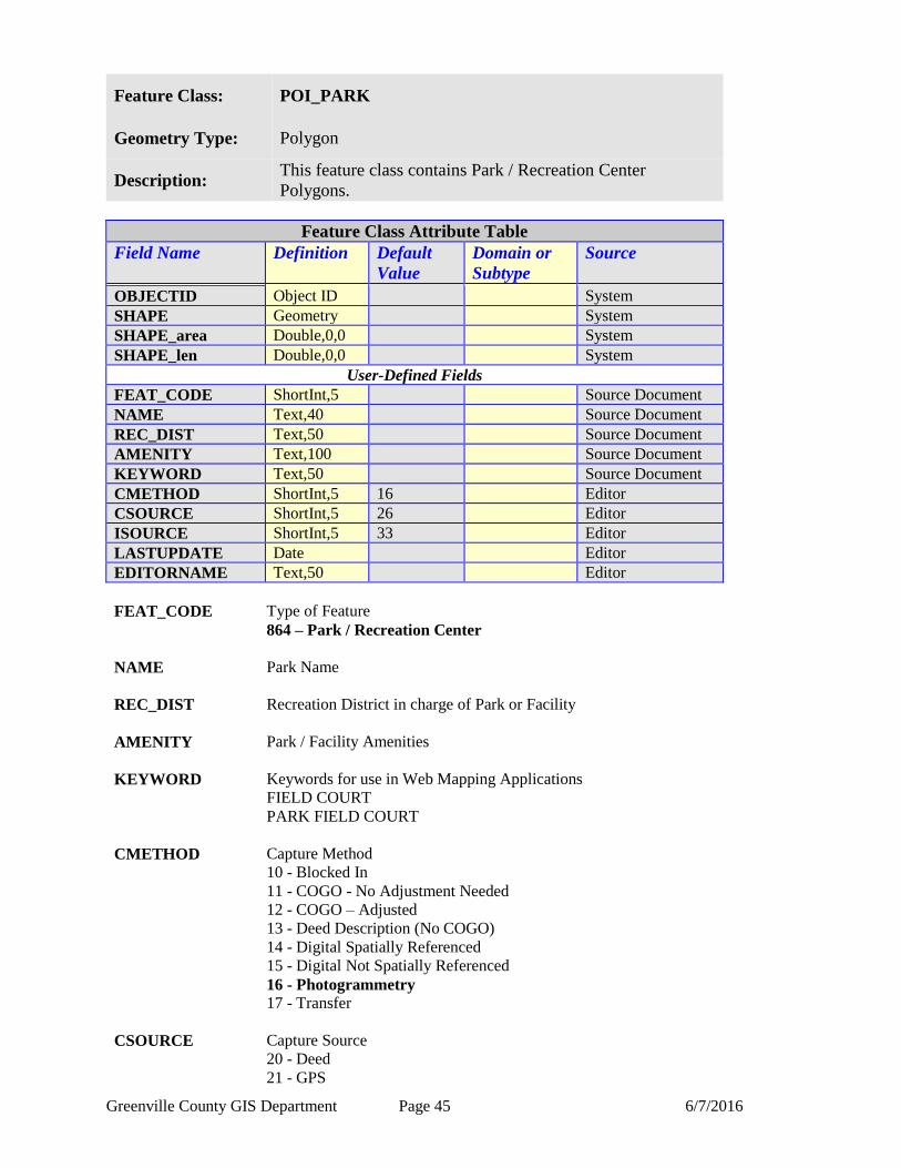
Feature Class: POI_PARK
Geometry Type: Polygon
Description: This feature class contains Park / Recreation Center
Polygons.
Feature Class Attribute Table
Field Name Definition
Default
Value
Domain or
Subtype
Source
OBJECTID Object ID System
SHAPE Geometry System
SHAPE_area Double,0,0 System
SHAPE_len Double,0,0 System
User-Defined Fields
FEAT_CODE ShortInt,5 Source Document
NAME Text,40 Source Document
REC_DIST Text,50 Source Document
AMENITY Text,100 Source Document
KEYWORD Text,50 Source Document
CMETHOD ShortInt,5 16 Editor
CSOURCE ShortInt,5 26 Editor
ISOURCE ShortInt,5 33 Editor
LASTUPDATE Date Editor
EDITORNAME Text,50 Editor
FEAT_CODE Type of Feature
864 – Park / Recreation Center
NAME Park Name
REC_DIST Recreation District in charge of Park or Facility
AMENITY Park / Facility Amenities
KEYWORD Keywords for use in Web Mapping Applications
FIELD COURT
PARK FIELD COURT
CMETHOD Capture Method
10 - Blocked In
11 - COGO - No Adjustment Needed
12 - COGO – Adjusted
13 - Deed Description (No COGO)
14 - Digital Spatially Referenced
15 - Digital Not Spatially Referenced
16 - Photogrammetry
17 - Transfer
CSOURCE Capture Source
20 - Deed
21 - GPS
Greenville County GIS Department Page 46 6/7/2016
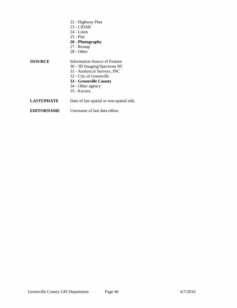
22 - Highway Plan
23 - LIDAR
24 - Linen
25 - Plat
26 - Photography
27 - Remap
28 - Other
ISOURCE Information Source of Feature
30 - 3D Imaging/Spectrum NC
31 - Analytical Surveys, INC
32 - City of Greenville
33 - Greenville County
34 - Other agency
35 - Kucera
LASTUPDATE Date of last spatial or non-spatial edit.
EDITORNAME Username of last data editor.
Greenville County GIS Department Page 47 6/7/2016
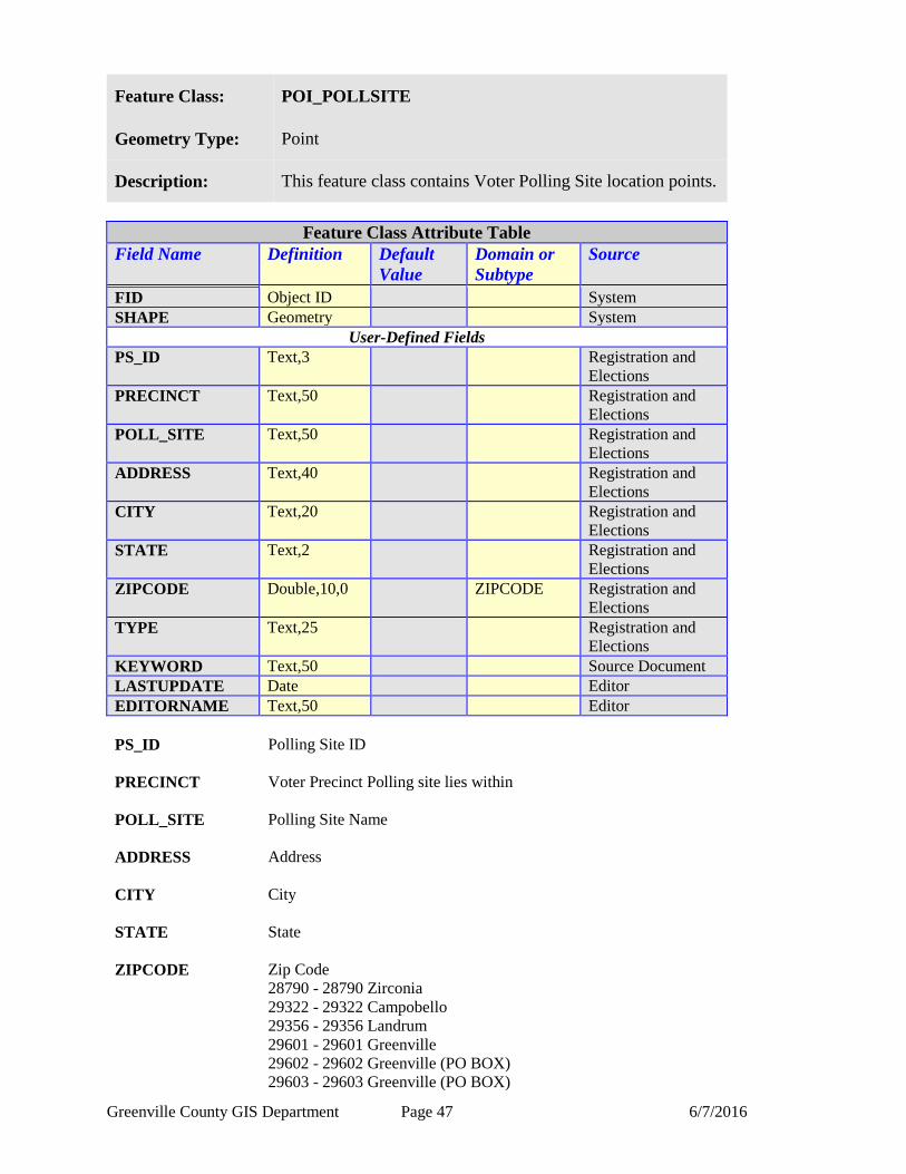
Feature Class: POI_POLLSITE
Geometry Type: Point
Description: This feature class contains Voter Polling Site location points.
Feature Class Attribute Table
Field Name Definition
Default
Value
Domain or
Subtype
Source
FID Object ID System
SHAPE Geometry System
User-Defined Fields
PS_ID Text,3 Registration and
Elections
PRECINCT Text,50 Registration and
Elections
POLL_SITE Text,50 Registration and
Elections
ADDRESS Text,40 Registration and
Elections
CITY Text,20 Registration and
Elections
STATE Text,2 Registration and
Elections
ZIPCODE Double,10,0 ZIPCODE Registration and
Elections
TYPE Text,25 Registration and
Elections
KEYWORD Text,50 Source Document
LASTUPDATE Date Editor
EDITORNAME Text,50 Editor
PS_ID Polling Site ID
PRECINCT Voter Precinct Polling site lies within
POLL_SITE Polling Site Name
ADDRESS Address
CITY City
STATE State
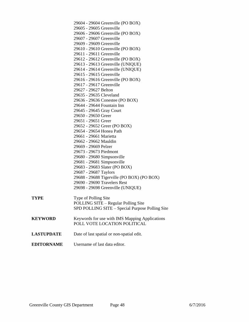
ZIPCODE Zip Code
28790 - 28790 Zirconia
29322 - 29322 Campobello
29356 - 29356 Landrum
29601 - 29601 Greenville
29602 - 29602 Greenville (PO BOX)
29603 - 29603 Greenville (PO BOX)
Greenville County GIS Department Page 48 6/7/2016
29604 - 29604 Greenville (PO BOX)
29605 - 29605 Greenville
29606 - 29606 Greenville (PO BOX)
29607 - 29607 Greenville
29609 - 29609 Greenville
29610 - 29610 Greenville (PO BOX)
29611 - 29611 Greenville
29612 - 29612 Greenville (PO BOX)
29613 - 29613 Greenville (UNIQUE)
29614 - 29614 Greenville (UNIQUE)
29615 - 29615 Greenville
29616 - 29616 Greenville (PO BOX)
29617 - 29617 Greenville
29627 - 29627 Belton
29635 - 29635 Cleveland
29636 - 29636 Conestee (PO BOX)
29644 - 29644 Fountain Inn
29645 - 29645 Gray Court
29650 - 29650 Greer
29651 - 29651 Greer
29652 - 29652 Greer (PO BOX)
29654 - 29654 Honea Path
29661 - 29661 Marietta
29662 - 29662 Mauldin
29669 - 29669 Pelzer
29673 - 29673 Piedmont
29680 - 29680 Simpsonville
29681 - 29681 Simpsonville
29683 - 29683 Slater (PO BOX)
29687 - 29687 Taylors
29688 - 29688 Tigerville (PO BOX) (PO BOX)
29690 - 29690 Travelers Rest
29698 - 29698 Greenville (UNIQUE)
TYPE Type of Polling Site
POLLING SITE – Regular Polling Site
SPD POLLING SITE – Special Purpose Polling Site
KEYWORD Keywords for use with IMS Mapping Applications
POLL VOTE LOCATION POLITICAL
LASTUPDATE Date of last spatial or non-spatial edit.
EDITORNAME Username of last data editor.
Greenville County GIS Department Page 49 6/7/2016
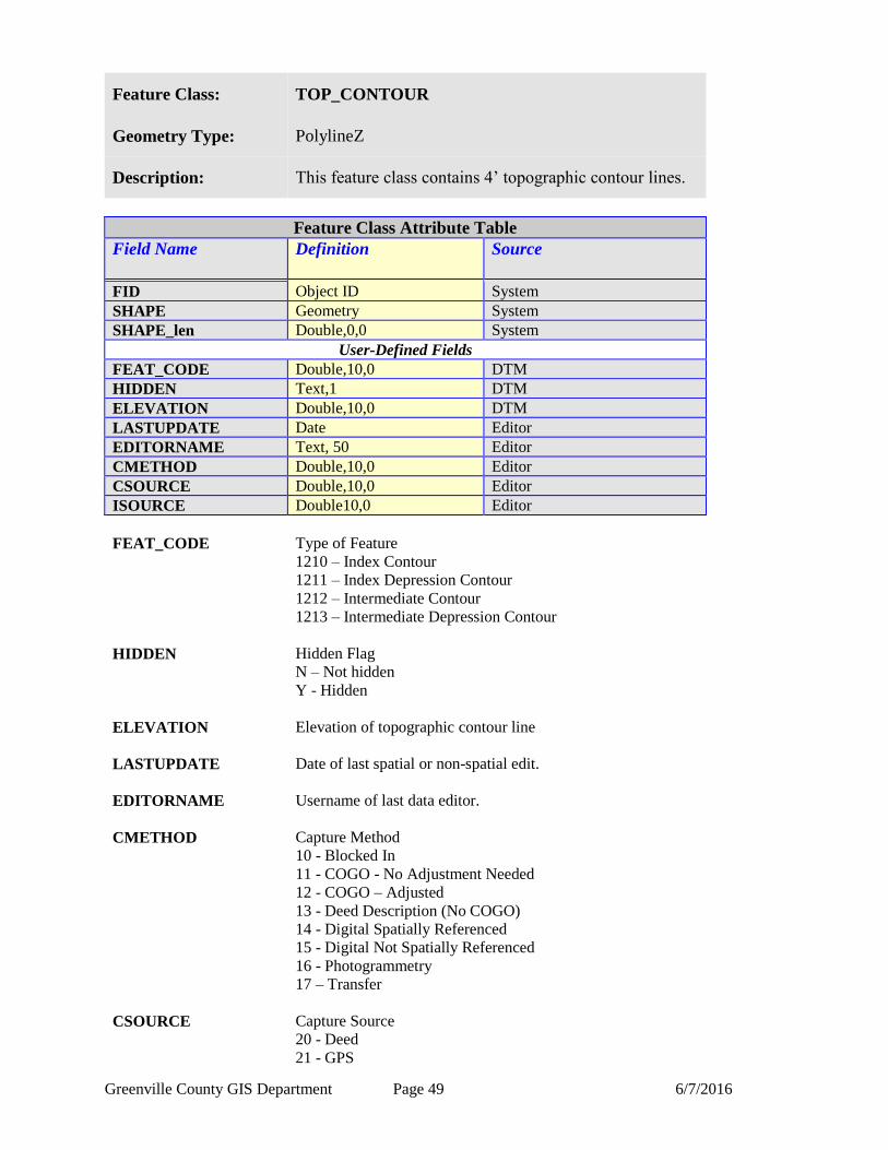
Feature Class: TOP_CONTOUR
Geometry Type: PolylineZ
Description: This feature class contains 4’ topographic contour lines.
Feature Class Attribute Table
Field Name Definition
Source
FID Object ID System
SHAPE Geometry System
SHAPE_len Double,0,0 System
User-Defined Fields
FEAT_CODE Double,10,0 DTM
HIDDEN Text,1 DTM
ELEVATION Double,10,0 DTM
LASTUPDATE Date Editor
EDITORNAME Text, 50 Editor
CMETHOD Double,10,0 Editor
CSOURCE Double,10,0 Editor
ISOURCE Double10,0 Editor
FEAT_CODE Type of Feature
1210 – Index Contour
1211 – Index Depression Contour
1212 – Intermediate Contour
1213 – Intermediate Depression Contour
HIDDEN Hidden Flag
N – Not hidden
Y - Hidden
ELEVATION Elevation of topographic contour line
LASTUPDATE Date of last spatial or non-spatial edit.
EDITORNAME Username of last data editor.
CMETHOD Capture Method
10 - Blocked In
11 - COGO - No Adjustment Needed
12 - COGO – Adjusted
13 - Deed Description (No COGO)
14 - Digital Spatially Referenced
15 - Digital Not Spatially Referenced
16 - Photogrammetry
17 – Transfer
CSOURCE Capture Source
20 - Deed
21 - GPS

Greenville County GIS Department Page 50 6/7/2016
22 - Highway Plan
23 - LIDAR
24 - Linen
25 - Plat
26 - Photography
27 - Remap
28 - Other
ISOURCE Information Source of Feature
30 - 3D Imaging/Spectrum NC
31 - Analytical Surveys, INC
32 - City of Greenville
33 - Greenville County
34 - Other agency
35 - Kucera
Greenville County GIS Department Page 51 6/7/2016
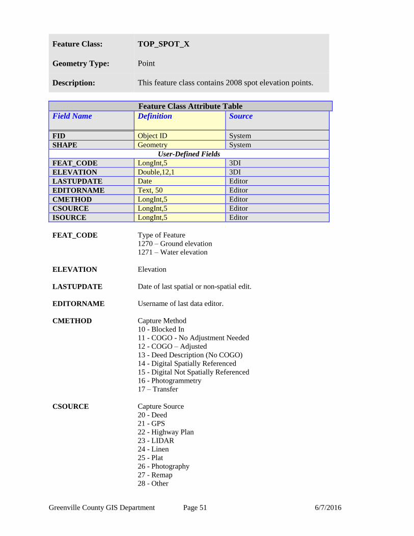
Feature Class: TOP_SPOT_X
Geometry Type: Point
Description: This feature class contains 2008 spot elevation points.
Feature Class Attribute Table
Field Name Definition
Source
FID Object ID System
SHAPE Geometry System
User-Defined Fields
FEAT_CODE LongInt,5 3DI
ELEVATION Double,12,1 3DI
LASTUPDATE Date Editor
EDITORNAME Text, 50 Editor
CMETHOD LongInt,5 Editor
CSOURCE LongInt,5 Editor
ISOURCE LongInt,5 Editor
FEAT_CODE Type of Feature
1270 – Ground elevation
1271 – Water elevation
ELEVATION Elevation
LASTUPDATE Date of last spatial or non-spatial edit.
EDITORNAME Username of last data editor.
CMETHOD Capture Method
10 - Blocked In
11 - COGO - No Adjustment Needed
12 - COGO – Adjusted
13 - Deed Description (No COGO)
14 - Digital Spatially Referenced
15 - Digital Not Spatially Referenced
16 - Photogrammetry
17 – Transfer
CSOURCE Capture Source
20 - Deed
21 - GPS
22 - Highway Plan
23 - LIDAR
24 - Linen
25 - Plat
26 - Photography
27 - Remap
28 - Other

Greenville County GIS Department Page 52 6/7/2016
ISOURCE Information Source of Feature
30 - 3D Imaging/Spectrum NC
31 - Analytical Surveys, INC
32 - City of Greenville
33 - Greenville County
34 - Other agency
35 - Kucera
Greenville County GIS Department Page 53 6/7/2016
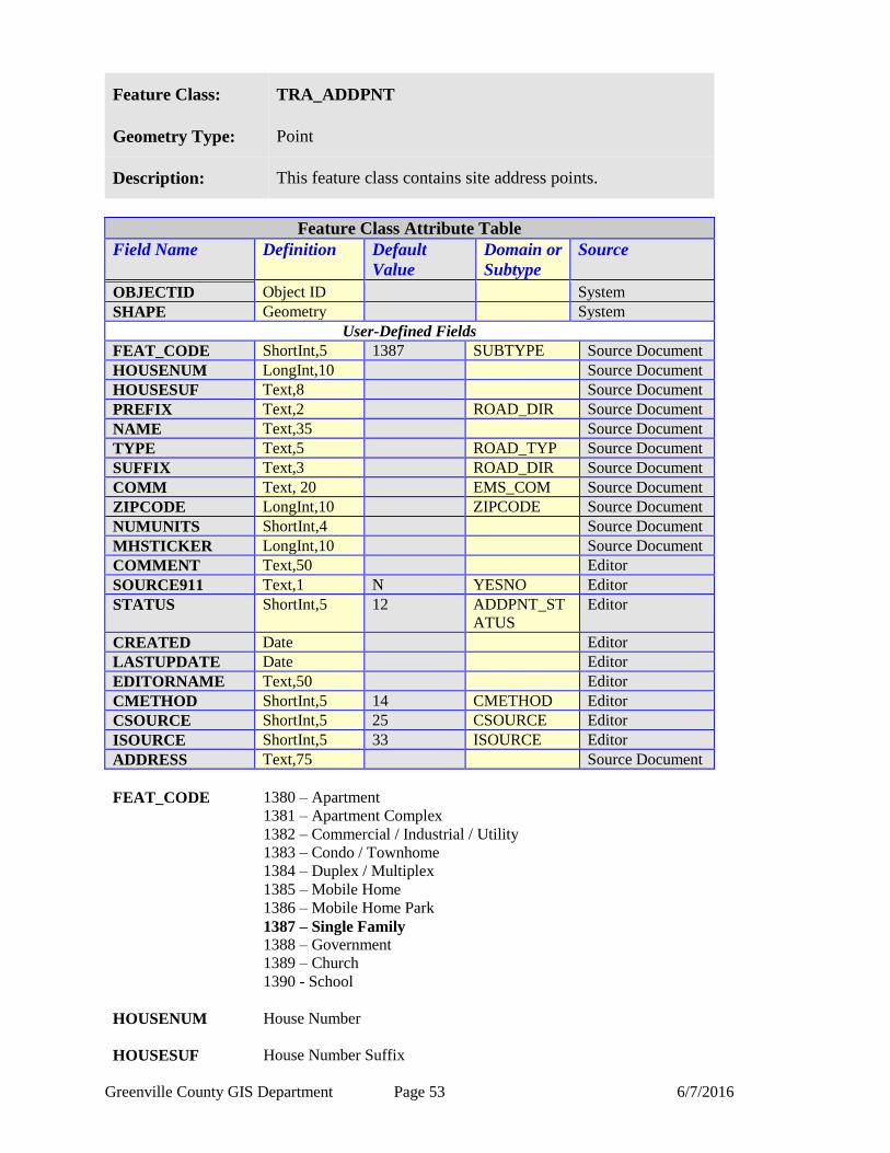
Feature Class: TRA_ADDPNT
Geometry Type: Point
Description: This feature class contains site address points.
Feature Class Attribute Table
Field Name Definition
Default
Value
Domain or
Subtype
Source
OBJECTID Object ID System
SHAPE Geometry System
User-Defined Fields
FEAT_CODE ShortInt,5 1387 SUBTYPE Source Document
HOUSENUM LongInt,10 Source Document
HOUSESUF Text,8 Source Document
PREFIX Text,2 ROAD_DIR Source Document
NAME Text,35 Source Document
TYPE Text,5 ROAD_TYP Source Document
SUFFIX Text,3 ROAD_DIR Source Document
COMM Text, 20 EMS_COM Source Document
ZIPCODE LongInt,10 ZIPCODE Source Document
NUMUNITS ShortInt,4 Source Document
MHSTICKER LongInt,10 Source Document
COMMENT Text,50 Editor
SOURCE911 Text,1 N YESNO Editor
STATUS ShortInt,5 12 ADDPNT_ST
ATUS
Editor
CREATED Date Editor
LASTUPDATE Date Editor
EDITORNAME Text,50 Editor
CMETHOD ShortInt,5 14 CMETHOD Editor
CSOURCE ShortInt,5 25 CSOURCE Editor
ISOURCE ShortInt,5 33 ISOURCE Editor
ADDRESS Text,75 Source Document
FEAT_CODE
1380 – Apartment
1381 – Apartment Complex
1382 – Commercial / Industrial / Utility
1383 – Condo / Townhome
1384 – Duplex / Multiplex
1385 – Mobile Home
1386 – Mobile Home Park
1387 – Single Family
1388 – Government
1389 – Church
1390 - School
HOUSENUM House Number
HOUSESUF House Number Suffix

Greenville County GIS Department Page 54 6/7/2016
PREFIX Prefix Directional
E – East
N – North
NE – Northeast
NW – Northwest
S – South
SE – Southeast
SW – Southwest
W - West
NAME Road Name
TYPE Road Type
ALY - ALLEY
ANX - ANNEX
ARC - ARCADE
AVE - AVENUE
BCH - BEACH
BG - BURG
BGS - BURGS
BLF - BLUFF
BLFS - BLUFFS
BLVD - BOULEVARD
BND - BEND
BR - BRANCH
BRG - BRIDGE
BRK - BROOK
BRKS - BROOKS
BTM - BOTTOM
BYP - BYPASS
BYU - BAYOU
CIR - CIRCLE
CIRS - CIRCLES
CLB - CLUB
CLF - CLIFF
CLFS - CLIFFS
CMN - COMMON
CMNS - COMMONS
COR - CORNER
CORS - CORNERS
CP - CAMP
CPE - CAPE
CRES - CRESCENT
CRK - CREEK
CRSE - COURSE
CRST - CREST
CSWY - CAUSEWAY
CT - COURT
CTR - CENTER
CTRS - CENTERS
CTS - COURTS
CURV - CURVE
CV - COVE

Greenville County GIS Department Page 55 6/7/2016
CYN - CANYON
DL - DALE
DM - DAM
DR - DRIVE
DRS - DRIVES
DV - DIVIDE
EST - ESTATE
ESTS - ESTATES
EXPY - EXPRESSWAY
EXT - EXTENSION
EXTS - EXTENSIONS
FALL - FALL
FLD - FIELD
FLDS - FIELDS
FLS - FALLS
FLT - FLAT
FLTS - FLATS
FRD - FORDS
FRG - FORGE
FRGS - FORGES
FRK - FORK
FRKS - FORKS
FRST - FOREST
FRY - FERRY
FT - FORT
FWY - FREEWAY
GDN - GARDEN
GDNS - GARDENS
GLN - GLEN
GLNS - GLENS
GRN - GREEN
GRNS - GREENS
GRV - GROVE
GRVS - GROVES
GTWY - GATEWAY
HBR - HARBOR
HBRS - HARBORS
HL - HILL
HLS - HILLS
HOLW - HOLLOW
HTS - HEIGHTS
HVN - HAVEN
HWY - HIGHWAY
INLT - INLET
IS - ISLAND
ISLE - ISLE
ISS - ISLANDS
JCT - JUNCTION
JCTS - JUNCTIONS
KNL - KNOLL
KNLS - KNOLLS
KY - KEY
KYS - KEYS
LAND - LAND

Greenville County GIS Department Page 56 6/7/2016
LCK - LOCK
LCKS - LOCKS
LDG - LODGE
LF - LOAF
LGT - LIGHT
LGTS - LIGHTS
LK - LAKE
LKS - LAKES
LN - LANE
LNDG - LANDING
LOOP - LOOP
MALL - MALL
MDW - MEADOW
MDWS - MEADOWS
MEWS - MEWS
ML - MILL
MLS - MILLS
MNR - MANOR
MNRS - MANORS
MSN - MISSION
MT - MOUNT
MTN - MOUNTAIN
MTNS - MOUNTAINS
MTWY - MOTORWAY
NCK - NECK
OPAS - OVERPASS
ORCH - ORCHARD
OVAL - OVAL
PARK - PARK
PASS - PASS
PATH - PATH
PIKE - PIKE
PKWY - PARKWAY
PL - PLACE
PLN - PLAIN
PLNS - PLAINS
PLZ - PLAZA
PNE - PINE
PNES - PINES
PR - PRAIRIE
PRT - PORT
PRTS - PORTS
PSGE - PASSAGE
PT - POINT
PTS - POINTS
RADL - RADIAL
RAMP - RAMP
RD - ROAD
RDG - RIDGE
RDGS - RIDGES
RDS - ROADS
RIV - RIVER
RNCH - RANCH
ROW - ROW

Greenville County GIS Department Page 57 6/7/2016
RPD - RAPID
RPDS - RAPIDS
RST - REST
RTE - ROUTE
RUE - RUE
RUN - RUN
SHL - SHOAL
SHLS - SHOALS
SHR - SHORE
SHRS - SHORES
SKWY - SKYWAY
SMT - SUMMIT
SPG - SPRING
SPGS - SPRINGS
SPUR - SPUR
SQ - SQUARE
SQS - SQUARES
ST - STREET
STA - STATION
STRA - STRAVENUE
STRM - STREAM
STS - STREETS
TER - TERRACE
TPKE - TURNPIKE
TRAK - TRACK
TRCE - TRACE
TRFY - TRAFFICWAY
TRL - TRAIL
TRLR - TRAILER
TRWY - THROUGHWAY
TUNL - TUNNEL
UN - UNION
UNS - UNIONS
UPAS - UNDERPASS
VIA - VIADUCT
VIS - VISTA
VL - VILLE
VLG - VILLIAGE
VLGS - VILLIAGES
VLY - VALLEY
VLYS - VALLEYS
VW - VIEW
VWS - VIEWS
WALK - WALK
WALL - WALL
WAY - WAY
WAYS - WAYS
WLS - WELL
XING - CROSSING
XRD - CROSSROAD
XRDS - CROSSROADS
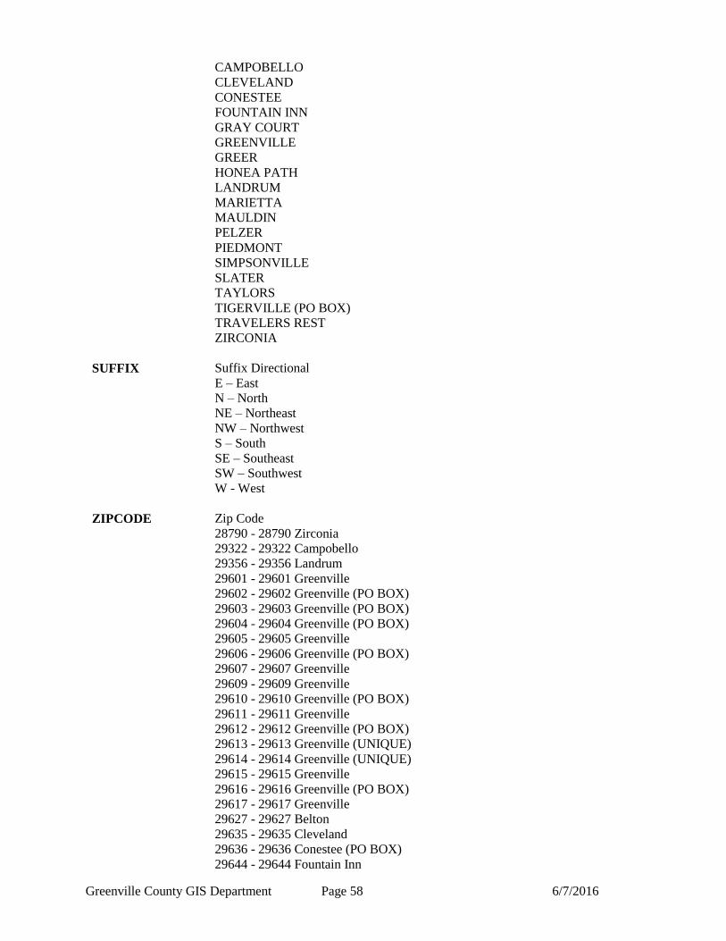
COMM Community Identifier
BELTON
Greenville County GIS Department Page 58 6/7/2016
CAMPOBELLO
CLEVELAND
CONESTEE
FOUNTAIN INN
GRAY COURT
GREENVILLE
GREER
HONEA PATH
LANDRUM
MARIETTA
MAULDIN
PELZER
PIEDMONT
SIMPSONVILLE
SLATER
TAYLORS
TIGERVILLE (PO BOX)
TRAVELERS REST
ZIRCONIA
SUFFIX Suffix Directional
E – East
N – North
NE – Northeast
NW – Northwest
S – South
SE – Southeast
SW – Southwest
W - West
ZIPCODE Zip Code
28790 - 28790 Zirconia
29322 - 29322 Campobello
29356 - 29356 Landrum
29601 - 29601 Greenville
29602 - 29602 Greenville (PO BOX)
29603 - 29603 Greenville (PO BOX)
29604 - 29604 Greenville (PO BOX)
29605 - 29605 Greenville
29606 - 29606 Greenville (PO BOX)
29607 - 29607 Greenville
29609 - 29609 Greenville
29610 - 29610 Greenville (PO BOX)
29611 - 29611 Greenville
29612 - 29612 Greenville (PO BOX)
29613 - 29613 Greenville (UNIQUE)
29614 - 29614 Greenville (UNIQUE)
29615 - 29615 Greenville
29616 - 29616 Greenville (PO BOX)
29617 - 29617 Greenville
29627 - 29627 Belton
29635 - 29635 Cleveland
29636 - 29636 Conestee (PO BOX)
29644 - 29644 Fountain Inn
Greenville County GIS Department Page 59 6/7/2016
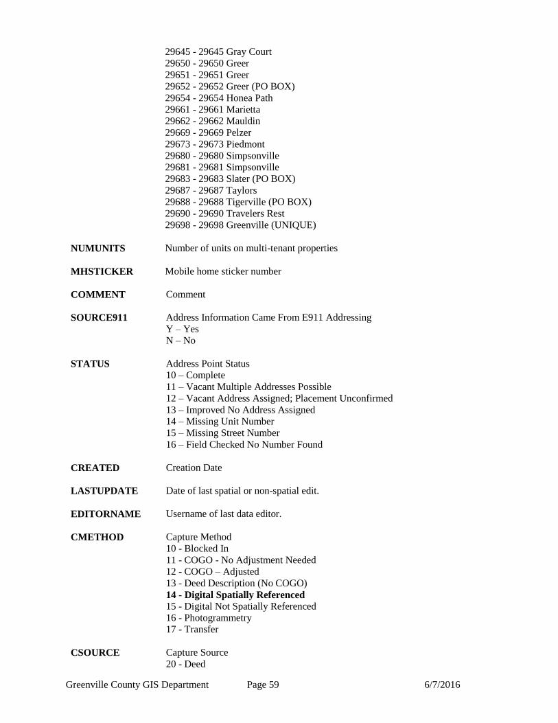
29645 - 29645 Gray Court
29650 - 29650 Greer
29651 - 29651 Greer
29652 - 29652 Greer (PO BOX)
29654 - 29654 Honea Path
29661 - 29661 Marietta
29662 - 29662 Mauldin
29669 - 29669 Pelzer
29673 - 29673 Piedmont
29680 - 29680 Simpsonville
29681 - 29681 Simpsonville
29683 - 29683 Slater (PO BOX)
29687 - 29687 Taylors
29688 - 29688 Tigerville (PO BOX)
29690 - 29690 Travelers Rest
29698 - 29698 Greenville (UNIQUE)
NUMUNITS Number of units on multi-tenant properties
MHSTICKER Mobile home sticker number
COMMENT Comment
SOURCE911 Address Information Came From E911 Addressing
Y – Yes
N – No
STATUS Address Point Status
10 – Complete
11 – Vacant Multiple Addresses Possible
12 – Vacant Address Assigned; Placement Unconfirmed
13 – Improved No Address Assigned
14 – Missing Unit Number
15 – Missing Street Number
16 – Field Checked No Number Found
CREATED Creation Date
LASTUPDATE Date of last spatial or non-spatial edit.
EDITORNAME Username of last data editor.
CMETHOD Capture Method
10 - Blocked In
11 - COGO - No Adjustment Needed
12 - COGO – Adjusted
13 - Deed Description (No COGO)
14 - Digital Spatially Referenced
15 - Digital Not Spatially Referenced
16 - Photogrammetry
17 - Transfer
CSOURCE Capture Source
20 - Deed

Greenville County GIS Department Page 60 6/7/2016
21 - GPS
22 - Highway Plan
23 - LIDAR
24 - Linen
25 - Plat
26 - Photography
27 - Remap
28 - Other
ISOURCE Information Source of Feature
30 - 3D Imaging/Spectrum NC
31 - Analytical Surveys, INC
32 - City of Greenville
33 - Greenville County
34 - Other agency
35 - Kucera
ADDRESS Concatenated Address. Consist of HOUSENUM, HOUESSUF,
PREFIX, NAME, TYPE, and SUFFIX.
Greenville County GIS Department Page 61 6/7/2016
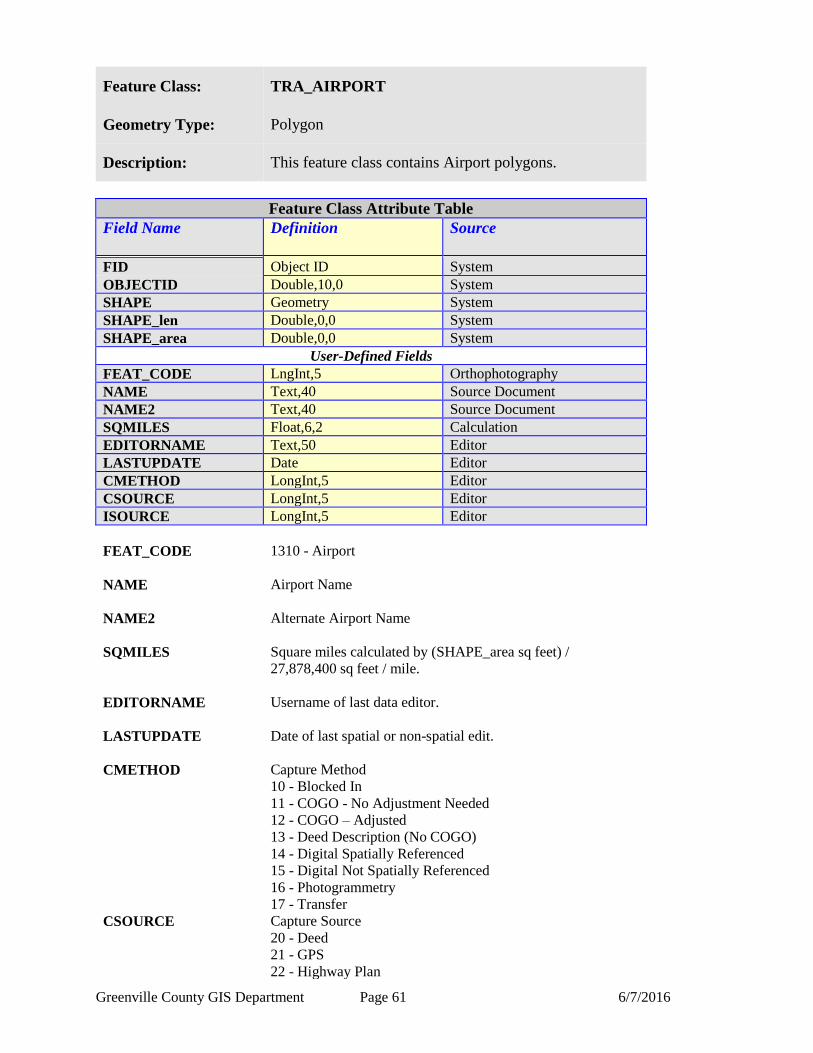
Feature Class: TRA_AIRPORT
Geometry Type: Polygon
Description: This feature class contains Airport polygons.
Feature Class Attribute Table
Field Name Definition
Source
FID Object ID System
OBJECTID Double,10,0 System
SHAPE Geometry System
SHAPE_len Double,0,0 System
SHAPE_area Double,0,0 System
User-Defined Fields
FEAT_CODE LngInt,5 Orthophotography
NAME Text,40 Source Document
NAME2 Text,40 Source Document
SQMILES Float,6,2 Calculation
EDITORNAME Text,50 Editor
LASTUPDATE Date Editor
CMETHOD LongInt,5 Editor
CSOURCE LongInt,5 Editor
ISOURCE LongInt,5 Editor
FEAT_CODE 1310 - Airport
NAME Airport Name
NAME2 Alternate Airport Name
SQMILES Square miles calculated by (SHAPE_area sq feet) /
27,878,400 sq feet / mile.
EDITORNAME Username of last data editor.
LASTUPDATE Date of last spatial or non-spatial edit.
CMETHOD Capture Method
10 - Blocked In
11 - COGO - No Adjustment Needed
12 - COGO – Adjusted
13 - Deed Description (No COGO)
14 - Digital Spatially Referenced
15 - Digital Not Spatially Referenced
16 - Photogrammetry
17 - Transfer
CSOURCE Capture Source
20 - Deed
21 - GPS
22 - Highway Plan

Greenville County GIS Department Page 62 6/7/2016
23 - LIDAR
24 - Linen
25 - Plat
26 - Photography
27 - Remap
28 - Other
ISOURCE Information Source of Feature
30 - 3D Imaging/Spectrum NC
31 - Analytical Surveys, INC
32 - City of Greenville
33 - Greenville County
34 - Other agency
35 - Kucera
Greenville County GIS Department Page 63 6/7/2016
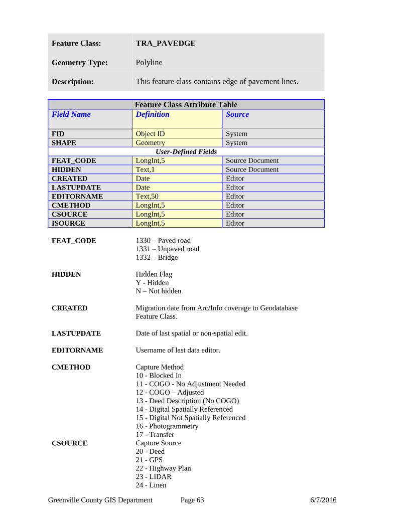
Feature Class: TRA_PAVEDGE
Geometry Type: Polyline
Description: This feature class contains edge of pavement lines.
Feature Class Attribute Table
Field Name Definition
Source
FID Object ID System
SHAPE Geometry System
User-Defined Fields
FEAT_CODE LongInt,5 Source Document
HIDDEN Text,1 Source Document
CREATED Date Editor
LASTUPDATE Date Editor
EDITORNAME Text,50 Editor
CMETHOD LongInt,5 Editor
CSOURCE LongInt,5 Editor
ISOURCE LongInt,5 Editor
FEAT_CODE 1330 – Paved road
1331 – Unpaved road
1332 – Bridge
HIDDEN Hidden Flag
Y - Hidden
N – Not hidden
CREATED Migration date from Arc/Info coverage to Geodatabase
Feature Class.
LASTUPDATE Date of last spatial or non-spatial edit.
EDITORNAME Username of last data editor.
CMETHOD Capture Method
10 - Blocked In
11 - COGO - No Adjustment Needed
12 - COGO – Adjusted
13 - Deed Description (No COGO)
14 - Digital Spatially Referenced
15 - Digital Not Spatially Referenced
16 - Photogrammetry
17 - Transfer
CSOURCE Capture Source
20 - Deed
21 - GPS
22 - Highway Plan
23 - LIDAR
24 - Linen

Greenville County GIS Department Page 64 6/7/2016
25 - Plat
26 - Photography
27 - Remap
28 - Other
ISOURCE Information Source of Feature
30 - 3D Imaging/Spectrum NC
31 - Analytical Surveys, INC
32 - City of Greenville
33 - Greenville County
34 - Other agency
35 - Kucera
Greenville County GIS Department Page 65 6/7/2016
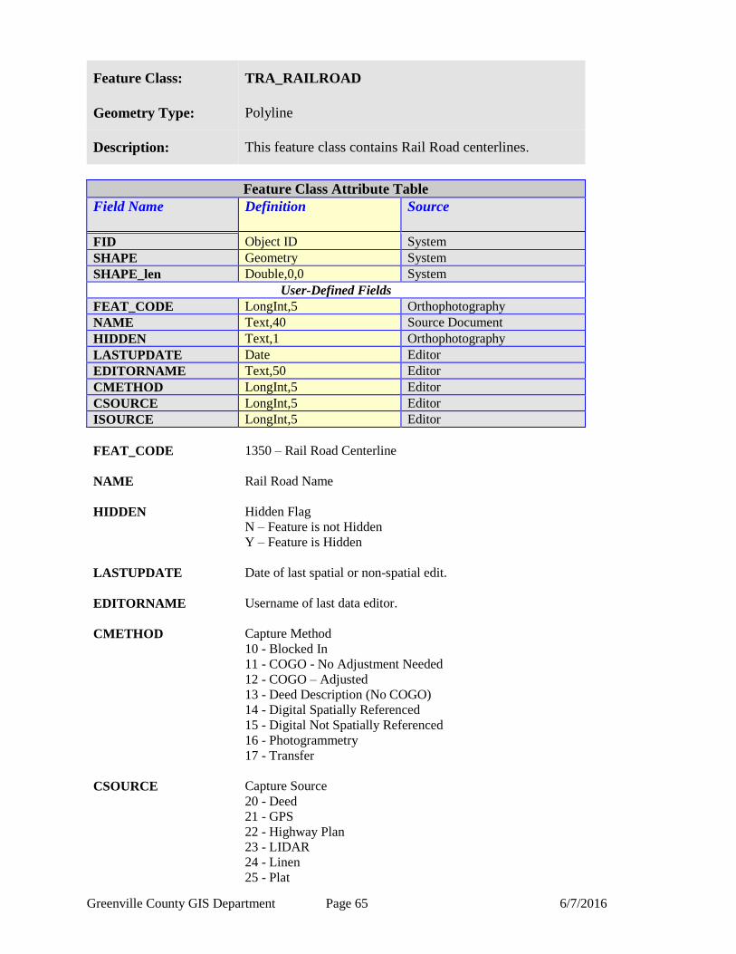
Feature Class: TRA_RAILROAD
Geometry Type: Polyline
Description: This feature class contains Rail Road centerlines.
Feature Class Attribute Table
Field Name Definition
Source
FID Object ID System
SHAPE Geometry System
SHAPE_len Double,0,0 System
User-Defined Fields
FEAT_CODE LongInt,5 Orthophotography
NAME Text,40 Source Document
HIDDEN Text,1 Orthophotography
LASTUPDATE Date Editor
EDITORNAME Text,50 Editor
CMETHOD LongInt,5 Editor
CSOURCE LongInt,5 Editor
ISOURCE LongInt,5 Editor
FEAT_CODE 1350 – Rail Road Centerline
NAME Rail Road Name
HIDDEN Hidden Flag
N – Feature is not Hidden
Y – Feature is Hidden
LASTUPDATE Date of last spatial or non-spatial edit.
EDITORNAME Username of last data editor.
CMETHOD Capture Method
10 - Blocked In
11 - COGO - No Adjustment Needed
12 - COGO – Adjusted
13 - Deed Description (No COGO)
14 - Digital Spatially Referenced
15 - Digital Not Spatially Referenced
16 - Photogrammetry
17 - Transfer
CSOURCE Capture Source
20 - Deed
21 - GPS
22 - Highway Plan
23 - LIDAR
24 - Linen
25 - Plat

Greenville County GIS Department Page 66 6/7/2016
26 - Photography
27 - Remap
28 - Other
ISOURCE Information Source of Feature
30 - 3D Imaging/Spectrum NC
31 - Analytical Surveys, INC
32 - City of Greenville
33 - Greenville County
34 - Other agency
35 - Kucera
Greenville County GIS Department Page 67 6/7/2016
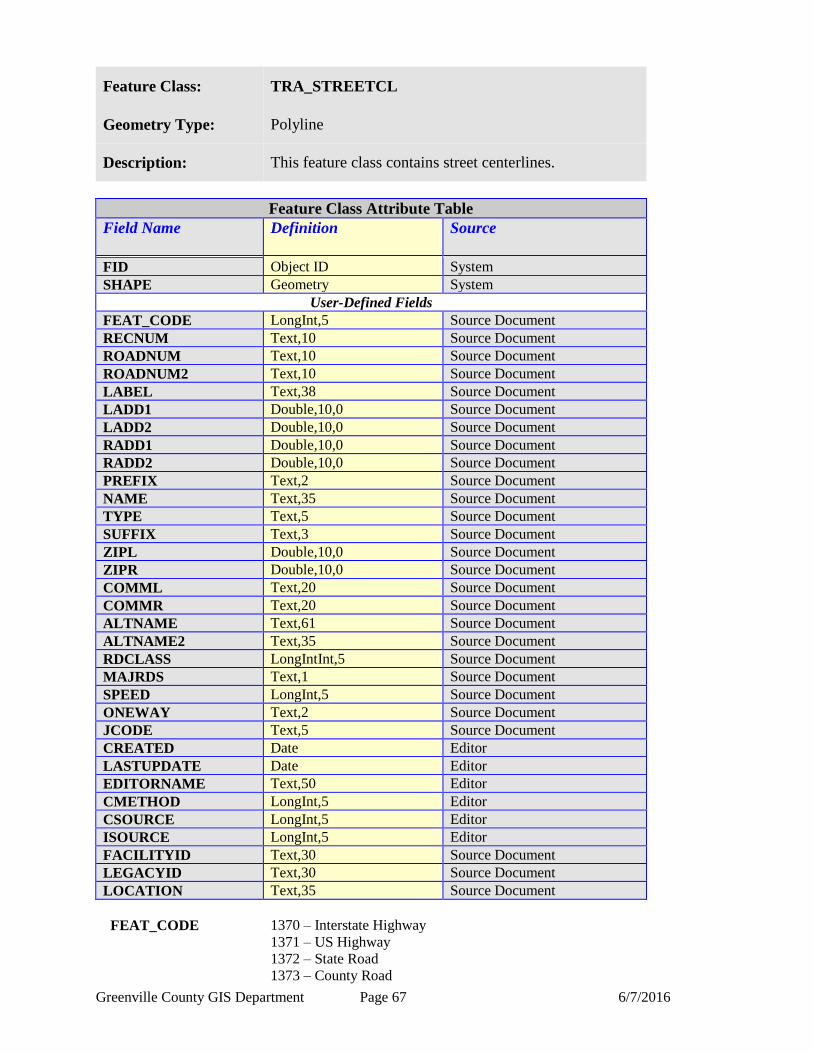
Feature Class: TRA_STREETCL
Geometry Type: Polyline
Description: This feature class contains street centerlines.
Feature Class Attribute Table
Field Name Definition
Source
FID Object ID System
SHAPE Geometry System
User-Defined Fields
FEAT_CODE LongInt,5 Source Document
RECNUM Text,10 Source Document
ROADNUM Text,10 Source Document
ROADNUM2 Text,10 Source Document
LABEL Text,38 Source Document
LADD1 Double,10,0 Source Document
LADD2 Double,10,0 Source Document
RADD1 Double,10,0 Source Document
RADD2 Double,10,0 Source Document
PREFIX Text,2 Source Document
NAME Text,35 Source Document
TYPE Text,5 Source Document
SUFFIX Text,3 Source Document
ZIPL Double,10,0 Source Document
ZIPR Double,10,0 Source Document
COMML Text,20 Source Document
COMMR Text,20 Source Document
ALTNAME Text,61 Source Document
ALTNAME2 Text,35 Source Document
RDCLASS LongIntInt,5 Source Document
MAJRDS Text,1 Source Document
SPEED LongInt,5 Source Document
ONEWAY Text,2 Source Document
JCODE Text,5 Source Document
CREATED Date Editor
LASTUPDATE Date Editor
EDITORNAME Text,50 Editor
CMETHOD LongInt,5 Editor
CSOURCE LongInt,5 Editor
ISOURCE LongInt,5 Editor
FACILITYID Text,30 Source Document
LEGACYID Text,30 Source Document
LOCATION Text,35 Source Document
FEAT_CODE 1370 – Interstate Highway
1371 – US Highway
1372 – State Road
1373 – County Road
Greenville County GIS Department Page 68 6/7/2016
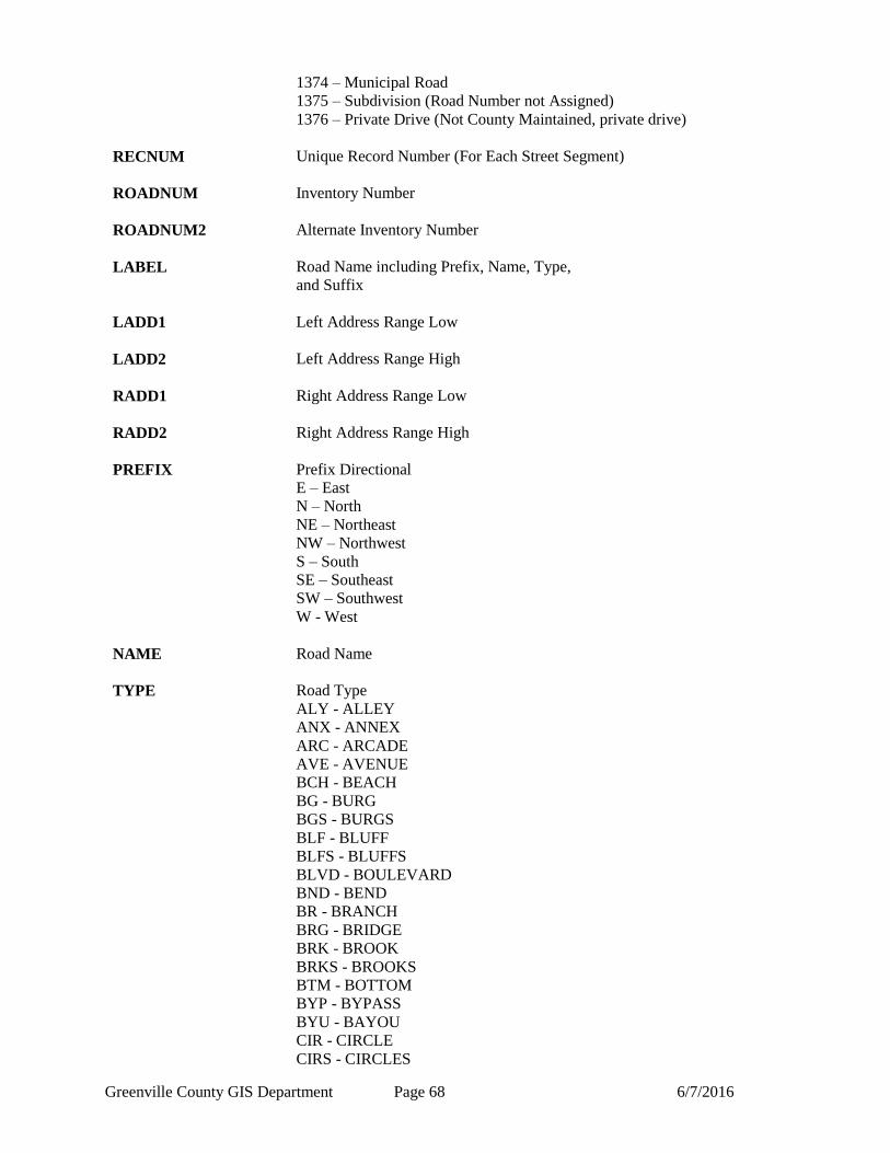
1374 – Municipal Road
1375 – Subdivision (Road Number not Assigned)
1376 – Private Drive (Not County Maintained, private drive)
RECNUM Unique Record Number (For Each Street Segment)
ROADNUM Inventory Number
ROADNUM2 Alternate Inventory Number
LABEL Road Name including Prefix, Name, Type,
and Suffix
LADD1 Left Address Range Low
LADD2 Left Address Range High
RADD1 Right Address Range Low
RADD2 Right Address Range High
PREFIX Prefix Directional
E – East
N – North
NE – Northeast
NW – Northwest
S – South
SE – Southeast
SW – Southwest
W - West
NAME Road Name
TYPE Road Type
ALY - ALLEY
ANX - ANNEX
ARC - ARCADE
AVE - AVENUE
BCH - BEACH
BG - BURG
BGS - BURGS
BLF - BLUFF
BLFS - BLUFFS
BLVD - BOULEVARD
BND - BEND
BR - BRANCH
BRG - BRIDGE
BRK - BROOK
BRKS - BROOKS
BTM - BOTTOM
BYP - BYPASS
BYU - BAYOU
CIR - CIRCLE
CIRS - CIRCLES

Greenville County GIS Department Page 69 6/7/2016
CLB - CLUB
CLF - CLIFF
CLFS - CLIFFS
CMN - COMMON
CMNS - COMMONS
COR - CORNER
CORS - CORNERS
CP - CAMP
CPE - CAPE
CRES - CRESCENT
CRK - CREEK
CRSE - COURSE
CRST - CREST
CSWY - CAUSEWAY
CT - COURT
CTR - CENTER
CTRS - CENTERS
CTS - COURTS
CURV - CURVE
CV - COVE
CYN - CANYON
DL - DALE
DM - DAM
DR - DRIVE
DRS - DRIVES
DV - DIVIDE
EST - ESTATE
ESTS - ESTATES
EXPY - EXPRESSWAY
EXT - EXTENSION
EXTS - EXTENSIONS
FALL - FALL
FLD - FIELD
FLDS - FIELDS
FLS - FALLS
FLT - FLAT
FLTS - FLATS
FRD - FORDS
FRG - FORGE
FRGS - FORGES
FRK - FORK
FRKS - FORKS
FRST - FOREST
FRY - FERRY
FT - FORT
FWY - FREEWAY
GDN - GARDEN
GDNS - GARDENS
GLN - GLEN
GLNS - GLENS
GRN - GREEN
GRNS - GREENS
GRV - GROVE
GRVS - GROVES

Greenville County GIS Department Page 70 6/7/2016
GTWY - GATEWAY
HBR - HARBOR
HBRS - HARBORS
HL - HILL
HLS - HILLS
HOLW - HOLLOW
HTS - HEIGHTS
HVN - HAVEN
HWY - HIGHWAY
INLT - INLET
IS - ISLAND
ISLE - ISLE
ISS - ISLANDS
JCT - JUNCTION
JCTS - JUNCTIONS
KNL - KNOLL
KNLS - KNOLLS
KY - KEY
KYS - KEYS
LAND - LAND
LCK - LOCK
LCKS - LOCKS
LDG - LODGE
LF - LOAF
LGT - LIGHT
LGTS - LIGHTS
LK - LAKE
LKS - LAKES
LN - LANE
LNDG - LANDING
LOOP - LOOP
MALL - MALL
MDW - MEADOW
MDWS - MEADOWS
MEWS - MEWS
ML - MILL
MLS - MILLS
MNR - MANOR
MNRS - MANORS
MSN - MISSION
MT - MOUNT
MTN - MOUNTAIN
MTNS - MOUNTAINS
MTWY - MOTORWAY
NCK - NECK
OPAS - OVERPASS
ORCH - ORCHARD
OVAL - OVAL
PARK - PARK
PASS - PASS
PATH - PATH
PIKE - PIKE
PKWY - PARKWAY
PL - PLACE

Greenville County GIS Department Page 71 6/7/2016
PLN - PLAIN
PLNS - PLAINS
PLZ - PLAZA
PNE - PINE
PNES - PINES
PR - PRAIRIE
PRT - PORT
PRTS - PORTS
PSGE - PASSAGE
PT - POINT
PTS - POINTS
RADL - RADIAL
RAMP - RAMP
RD - ROAD
RDG - RIDGE
RDGS - RIDGES
RDS - ROADS
RIV - RIVER
RNCH - RANCH
ROW - ROW
RPD - RAPID
RPDS - RAPIDS
RST - REST
RTE - ROUTE
RUE - RUE
RUN - RUN
SHL - SHOAL
SHLS - SHOALS
SHR - SHORE
SHRS - SHORES
SKWY - SKYWAY
SMT - SUMMIT
SPG - SPRING
SPGS - SPRINGS
SPUR - SPUR
SQ - SQUARE
SQS - SQUARES
ST - STREET
STA - STATION
STRA - STRAVENUE
STRM - STREAM
STS - STREETS
TER - TERRACE
TPKE - TURNPIKE
TRAK - TRACK
TRCE - TRACE
TRFY - TRAFFICWAY
TRL - TRAIL
TRLR - TRAILER
TRWY - THROUGHWAY
TUNL - TUNNEL
UN - UNION
UNS - UNIONS
UPAS - UNDERPASS
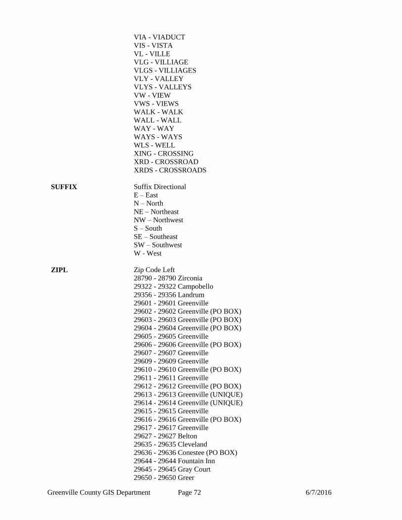
Greenville County GIS Department Page 72 6/7/2016
VIA - VIADUCT
VIS - VISTA
VL - VILLE
VLG - VILLIAGE
VLGS - VILLIAGES
VLY - VALLEY
VLYS - VALLEYS
VW - VIEW
VWS - VIEWS
WALK - WALK
WALL - WALL
WAY - WAY
WAYS - WAYS
WLS - WELL
XING - CROSSING
XRD - CROSSROAD
XRDS - CROSSROADS
SUFFIX Suffix Directional
E – East
N – North
NE – Northeast
NW – Northwest
S – South
SE – Southeast
SW – Southwest
W - West
ZIPL Zip Code Left
28790 - 28790 Zirconia
29322 - 29322 Campobello
29356 - 29356 Landrum
29601 - 29601 Greenville
29602 - 29602 Greenville (PO BOX)
29603 - 29603 Greenville (PO BOX)
29604 - 29604 Greenville (PO BOX)
29605 - 29605 Greenville
29606 - 29606 Greenville (PO BOX)
29607 - 29607 Greenville
29609 - 29609 Greenville
29610 - 29610 Greenville (PO BOX)
29611 - 29611 Greenville
29612 - 29612 Greenville (PO BOX)
29613 - 29613 Greenville (UNIQUE)
29614 - 29614 Greenville (UNIQUE)
29615 - 29615 Greenville
29616 - 29616 Greenville (PO BOX)
29617 - 29617 Greenville
29627 - 29627 Belton
29635 - 29635 Cleveland
29636 - 29636 Conestee (PO BOX)
29644 - 29644 Fountain Inn
29645 - 29645 Gray Court
29650 - 29650 Greer
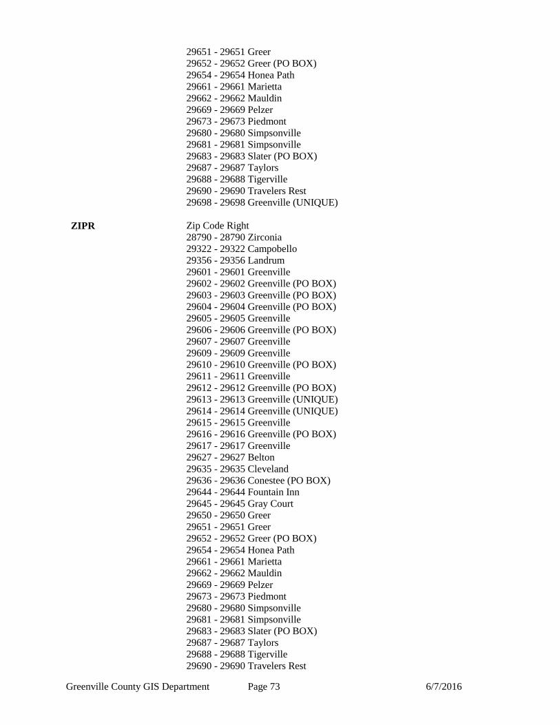
Greenville County GIS Department Page 73 6/7/2016
29651 - 29651 Greer
29652 - 29652 Greer (PO BOX)
29654 - 29654 Honea Path
29661 - 29661 Marietta
29662 - 29662 Mauldin
29669 - 29669 Pelzer
29673 - 29673 Piedmont
29680 - 29680 Simpsonville
29681 - 29681 Simpsonville
29683 - 29683 Slater (PO BOX)
29687 - 29687 Taylors
29688 - 29688 Tigerville
29690 - 29690 Travelers Rest
29698 - 29698 Greenville (UNIQUE)
ZIPR Zip Code Right
28790 - 28790 Zirconia
29322 - 29322 Campobello
29356 - 29356 Landrum
29601 - 29601 Greenville
29602 - 29602 Greenville (PO BOX)
29603 - 29603 Greenville (PO BOX)
29604 - 29604 Greenville (PO BOX)
29605 - 29605 Greenville
29606 - 29606 Greenville (PO BOX)
29607 - 29607 Greenville
29609 - 29609 Greenville
29610 - 29610 Greenville (PO BOX)
29611 - 29611 Greenville
29612 - 29612 Greenville (PO BOX)
29613 - 29613 Greenville (UNIQUE)
29614 - 29614 Greenville (UNIQUE)
29615 - 29615 Greenville
29616 - 29616 Greenville (PO BOX)
29617 - 29617 Greenville
29627 - 29627 Belton
29635 - 29635 Cleveland
29636 - 29636 Conestee (PO BOX)
29644 - 29644 Fountain Inn
29645 - 29645 Gray Court
29650 - 29650 Greer
29651 - 29651 Greer
29652 - 29652 Greer (PO BOX)
29654 - 29654 Honea Path
29661 - 29661 Marietta
29662 - 29662 Mauldin
29669 - 29669 Pelzer
29673 - 29673 Piedmont
29680 - 29680 Simpsonville
29681 - 29681 Simpsonville
29683 - 29683 Slater (PO BOX)
29687 - 29687 Taylors
29688 - 29688 Tigerville
29690 - 29690 Travelers Rest
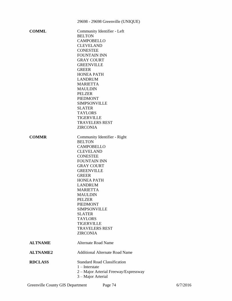
Greenville County GIS Department Page 74 6/7/2016
29698 - 29698 Greenville (UNIQUE)
COMML Community Identifier - Left
BELTON
CAMPOBELLO
CLEVELAND
CONESTEE
FOUNTAIN INN
GRAY COURT
GREENVILLE
GREER
HONEA PATH
LANDRUM
MARIETTA
MAULDIN
PELZER
PIEDMONT
SIMPSONVILLE
SLATER
TAYLORS
TIGERVILLE
TRAVELERS REST
ZIRCONIA
COMMR Community Identifier - Right
BELTON
CAMPOBELLO
CLEVELAND
CONESTEE
FOUNTAIN INN
GRAY COURT
GREENVILLE
GREER
HONEA PATH
LANDRUM
MARIETTA
MAULDIN
PELZER
PIEDMONT
SIMPSONVILLE
SLATER
TAYLORS
TIGERVILLE
TRAVELERS REST
ZIRCONIA
ALTNAME Alternate Road Name
ALTNAME2 Additional Alternate Road Name
RDCLASS Standard Road Classification
1 – Interstate
2 – Major Arterial Freeway/Expressway
3 – Major Arterial
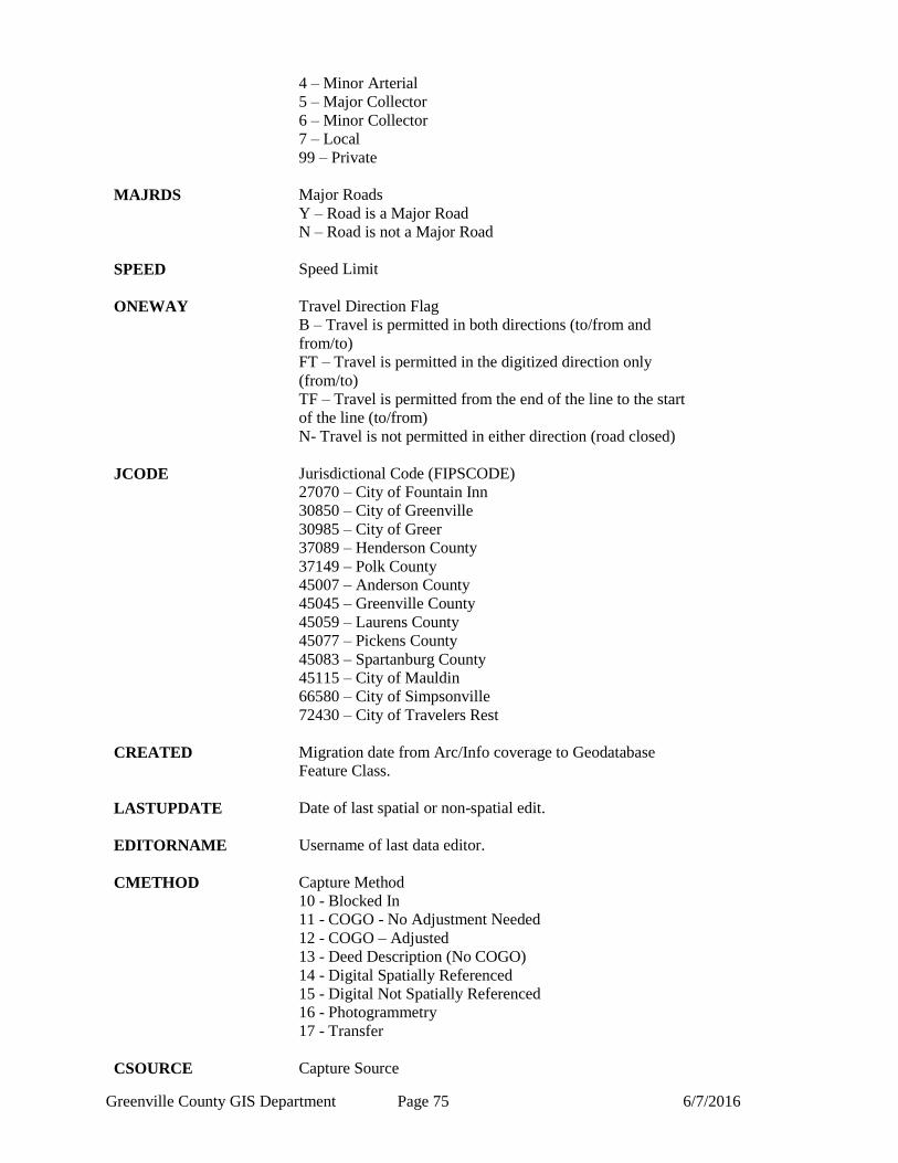
Greenville County GIS Department Page 75 6/7/2016
4 – Minor Arterial
5 – Major Collector
6 – Minor Collector
7 – Local
99 – Private
MAJRDS Major Roads
Y – Road is a Major Road
N – Road is not a Major Road
SPEED Speed Limit
ONEWAY Travel Direction Flag
B – Travel is permitted in both directions (to/from and
from/to)
FT – Travel is permitted in the digitized direction only
(from/to)
TF – Travel is permitted from the end of the line to the start
of the line (to/from)
N- Travel is not permitted in either direction (road closed)
JCODE Jurisdictional Code (FIPSCODE)
27070 – City of Fountain Inn
30850 – City of Greenville
30985 – City of Greer
37089 – Henderson County
37149 – Polk County
45007 – Anderson County
45045 – Greenville County
45059 – Laurens County
45077 – Pickens County
45083 – Spartanburg County
45115 – City of Mauldin
66580 – City of Simpsonville
72430 – City of Travelers Rest
CREATED Migration date from Arc/Info coverage to Geodatabase
Feature Class.
LASTUPDATE Date of last spatial or non-spatial edit.
EDITORNAME Username of last data editor.
CMETHOD Capture Method
10 - Blocked In
11 - COGO - No Adjustment Needed
12 - COGO – Adjusted
13 - Deed Description (No COGO)
14 - Digital Spatially Referenced
15 - Digital Not Spatially Referenced
16 - Photogrammetry
17 - Transfer
CSOURCE Capture Source
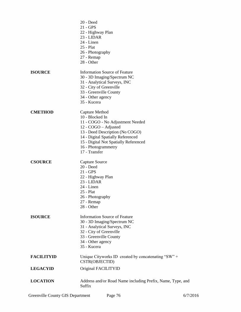
Greenville County GIS Department Page 76 6/7/2016
20 - Deed
21 - GPS
22 - Highway Plan
23 - LIDAR
24 - Linen
25 - Plat
26 - Photography
27 - Remap
28 - Other
ISOURCE Information Source of Feature
30 - 3D Imaging/Spectrum NC
31 - Analytical Surveys, INC
32 - City of Greenville
33 - Greenville County
34 - Other agency
35 - Kucera
CMETHOD Capture Method
10 - Blocked In
11 - COGO - No Adjustment Needed
12 - COGO – Adjusted
13 - Deed Description (No COGO)
14 - Digital Spatially Referenced
15 - Digital Not Spatially Referenced
16 - Photogrammetry
17 - Transfer
CSOURCE Capture Source
20 - Deed
21 - GPS
22 - Highway Plan
23 - LIDAR
24 - Linen
25 - Plat
26 - Photography
27 - Remap
28 - Other
ISOURCE Information Source of Feature
30 - 3D Imaging/Spectrum NC
31 - Analytical Surveys, INC
32 - City of Greenville
33 - Greenville County
34 - Other agency
35 - Kucera
FACILITYID Unique Cityworks ID created by concatenating “SW” +
CSTR(OBJECTID)
LEGACYID Original FACILITYID
LOCATION Address and/or Road Name including Prefix, Name, Type, and
Suffix
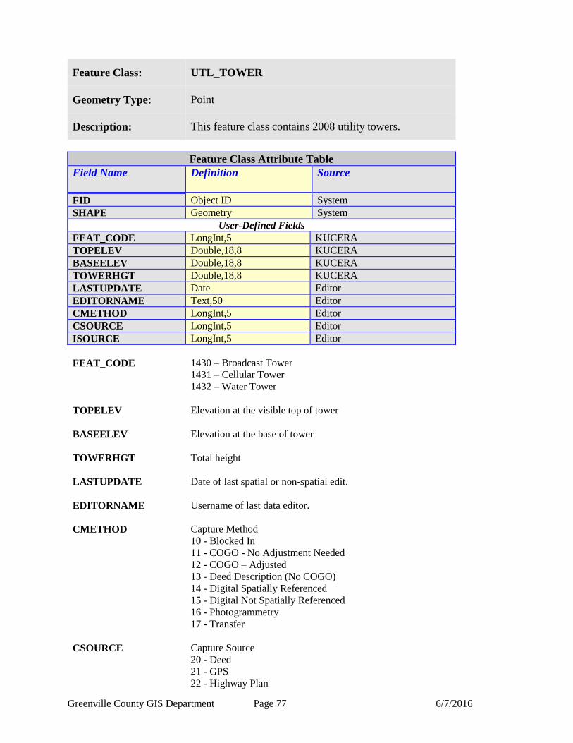
Greenville County GIS Department Page 77 6/7/2016
Feature Class: UTL_TOWER
Geometry Type: Point
Description: This feature class contains 2008 utility towers.
Feature Class Attribute Table
Field Name Definition
Source
FID Object ID System
SHAPE Geometry System
User-Defined Fields
FEAT_CODE LongInt,5 KUCERA
TOPELEV Double,18,8 KUCERA
BASEELEV Double,18,8 KUCERA
TOWERHGT Double,18,8 KUCERA
LASTUPDATE Date Editor
EDITORNAME Text,50 Editor
CMETHOD LongInt,5 Editor
CSOURCE LongInt,5 Editor
ISOURCE LongInt,5 Editor
FEAT_CODE 1430 – Broadcast Tower
1431 – Cellular Tower
1432 – Water Tower
TOPELEV Elevation at the visible top of tower
BASEELEV Elevation at the base of tower
TOWERHGT Total height
LASTUPDATE Date of last spatial or non-spatial edit.
EDITORNAME Username of last data editor.
CMETHOD Capture Method
10 - Blocked In
11 - COGO - No Adjustment Needed
12 - COGO – Adjusted
13 - Deed Description (No COGO)
14 - Digital Spatially Referenced
15 - Digital Not Spatially Referenced
16 - Photogrammetry
17 - Transfer
CSOURCE Capture Source
20 - Deed
21 - GPS
22 - Highway Plan

Greenville County GIS Department Page 78 6/7/2016
23 - LIDAR
24 - Linen
25 - Plat
26 - Photography
27 - Remap
28 - Other
ISOURCE Information Source of Feature
30 - 3D Imaging/Spectrum NC
31 - Analytical Surveys, INC
32 - City of Greenville
33 - Greenville County
34 - Other agency
35 - Kucera
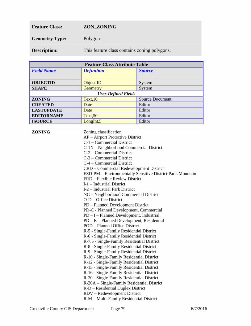
Greenville County GIS Department Page 79 6/7/2016
Feature Class: ZON_ZONING
Geometry Type: Polygon
Description: This feature class contains zoning polygons.
Feature Class Attribute Table
Field Name Definition
Source
OBJECTID Object ID System
SHAPE Geometry System
User-Defined Fields
ZONING Text,10 Source Document
CREATED Date Editor
LASTUPDATE Date Editor
EDITORNAME Text,50 Editor
ISOURCE LongInt,5 Editor
ZONING Zoning classification
AP – Airport Protective District
C-1 – Commercial District
C-1N – Neighborhood Commercial District
C-2 – Commercial District
C-3 – Commercial District
C-4 – Commercial District
CRD – Commercial Redevelopment District
ESD-PM – Environmentally Sensitive District Paris Mountain
FRD – Flexible Review District
I-1 – Industrial District
I-2 – Industrial Park District
NC – Neighborhood Commercial District
O-D – Office District
PD – Planned Development District
PD-C - Planned Development, Commercial
PD – I – Planned Development, Industrial
PD – R – Planned Development, Residential
POD – Planned Office District
R-5 - Single-Family Residential District
R-6 - Single-Family Residential District
R-7.5 - Single-Family Residential District
R-8 - Single-Family Residential District
R-9 - Single-Family Residential District
R-10 - Single-Family Residential District
R-12 - Single-Family Residential District
R-15 - Single-Family Residential District
R-16 - Single-Family Residential District
R-20 - Single-Family Residential District
R-20A – Single-Family Residential District
R-D – Residential Duplex District
RDV – Redevelopment District
R-M – Multi-Family Residential District
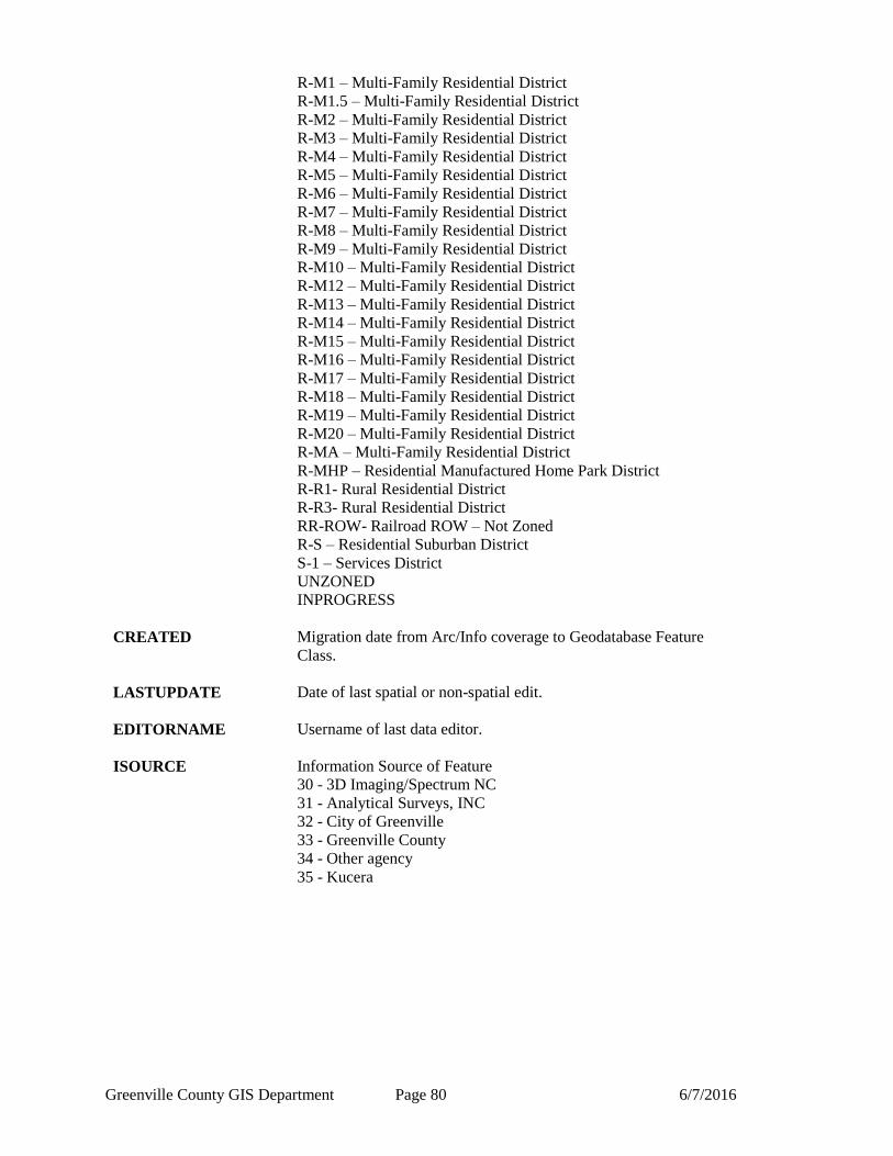
Greenville County GIS Department Page 80 6/7/2016
R-M1 – Multi-Family Residential District
R-M1.5 – Multi-Family Residential District
R-M2 – Multi-Family Residential District
R-M3 – Multi-Family Residential District
R-M4 – Multi-Family Residential District
R-M5 – Multi-Family Residential District
R-M6 – Multi-Family Residential District
R-M7 – Multi-Family Residential District
R-M8 – Multi-Family Residential District
R-M9 – Multi-Family Residential District
R-M10 – Multi-Family Residential District
R-M12 – Multi-Family Residential District
R-M13 – Multi-Family Residential District
R-M14 – Multi-Family Residential District
R-M15 – Multi-Family Residential District
R-M16 – Multi-Family Residential District
R-M17 – Multi-Family Residential District
R-M18 – Multi-Family Residential District
R-M19 – Multi-Family Residential District
R-M20 – Multi-Family Residential District
R-MA – Multi-Family Residential District
R-MHP – Residential Manufactured Home Park District
R-R1- Rural Residential District
R-R3- Rural Residential District
RR-ROW- Railroad ROW – Not Zoned
R-S – Residential Suburban District
S-1 – Services District
UNZONED
INPROGRESS
CREATED Migration date from Arc/Info coverage to Geodatabase Feature
Class.
LASTUPDATE Date of last spatial or non-spatial edit.
EDITORNAME Username of last data editor.
ISOURCE Information Source of Feature
30 - 3D Imaging/Spectrum NC
31 - Analytical Surveys, INC
32 - City of Greenville
33 - Greenville County
34 - Other agency
35 - Kucera