Embed Size (px)
Citation preview

ArcGIS for Local Government Scott Oppmann
Esri Software Products
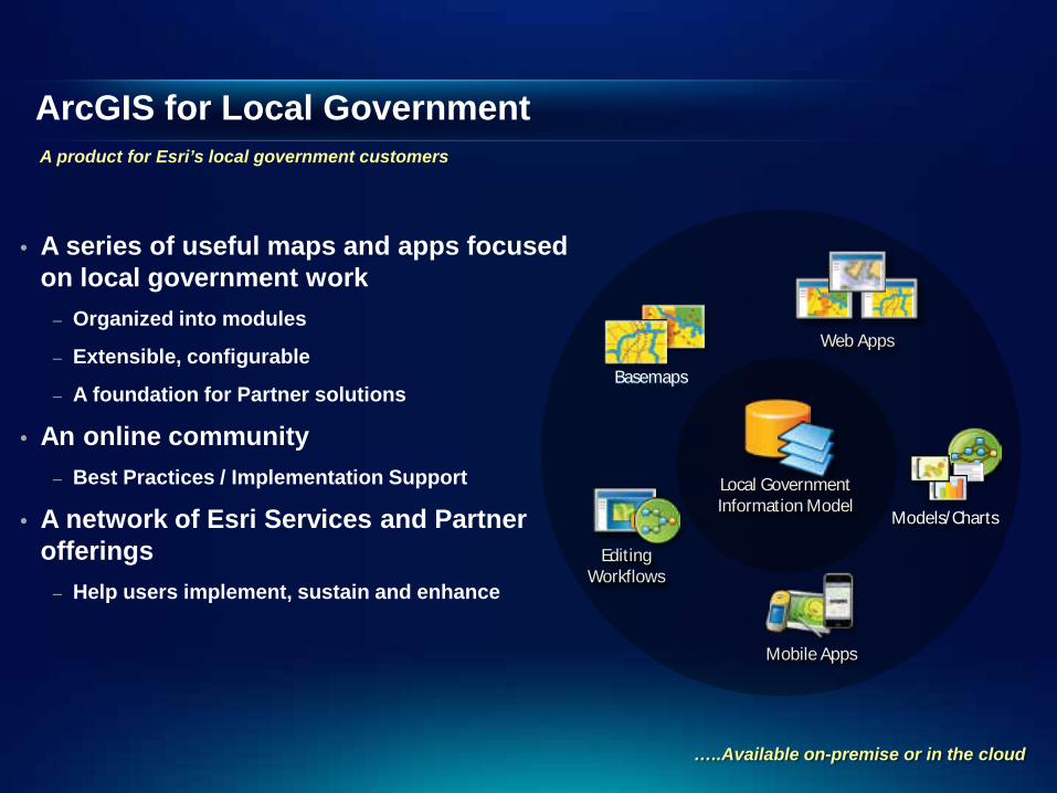
ArcGIS for Local Government
• A series of useful maps and apps focused on local government work
– Organized into modules
– Extensible, configurable
– A foundation for Partner solutions
• An online community – Best Practices / Implementation Support
• A network of Esri Services and Partner offerings
– Help users implement, sustain and enhance
Web Apps
Editing Workflows
Mobile Apps
Basemaps
Models/Charts
Local Government Information Model
A product for Esri’s local government customers
…..Available on-premise or in the cloud
Our Mission
• Make it easier to deploy ArcGIS - Deliver applications quickly throughout your organization - Stay current with future releases / avoid legacy technology - Create a platform of geospatial data that can be leveraged by many
• Address common constraints in local government - Size and skills of staff - Budget and time available to implement
• Empower the community to contribute - Users - Partners
Help increase the value of GIS in local government organizations
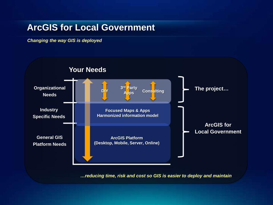
ArcGIS for Local Government
Your Needs
General GIS Platform Needs
Industry Specific Needs
Organizational Needs
ArcGIS Platform (Desktop, Mobile, Server, Online)
Changing the way GIS is deployed
The project…
Focused Maps & Apps Harmonized information model
DIY 3rd Party
Apps Consulting
ArcGIS for Local Government
…reducing time, risk and cost so GIS is easier to deploy and maintain
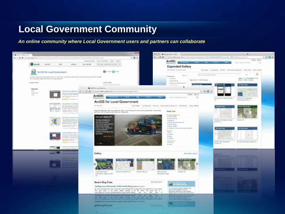
Local Government Community
An online community where Local Government users and partners can collaborate
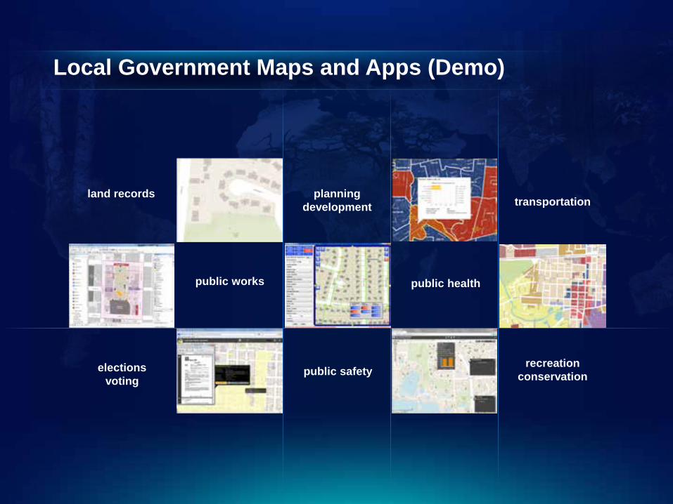
Local Government Maps and Apps (Demo)
land records planning development
public safety
public works
elections voting
public health
recreation conservation
transportation
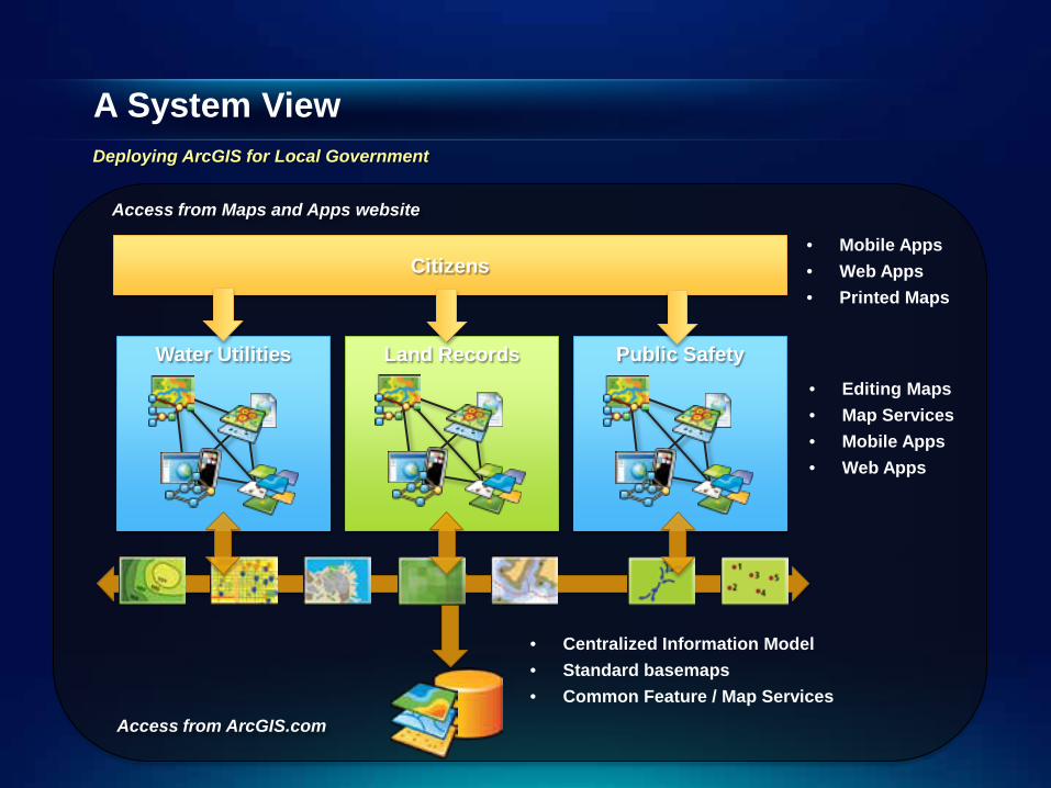
A System View
• Centralized Information Model • Standard basemaps • Common Feature / Map Services
Land Records Water Utilities Public Safety • Editing Maps • Map Services • Mobile Apps • Web Apps
Access from ArcGIS.com
Citizens • Mobile Apps • Web Apps • Printed Maps
Access from Maps and Apps website
Deploying ArcGIS for Local Government
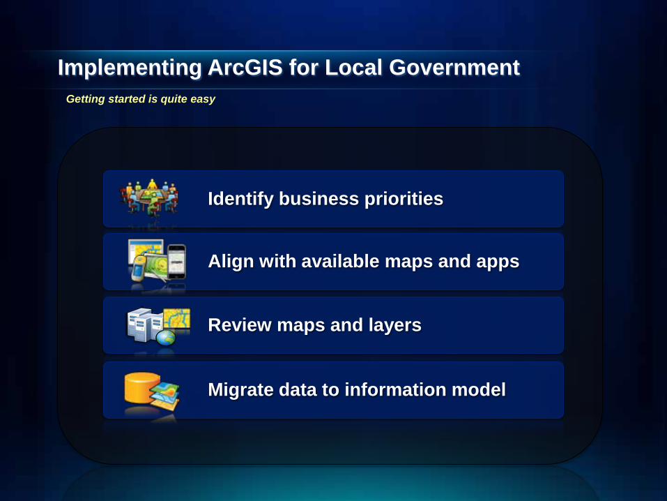
Implementing ArcGIS for Local Government
Identify business priorities
Align with available maps and apps
Migrate data to information model
Review maps and layers
Getting started is quite easy

Tim
e
Cost
Benefits
• Implement quickly
• Easy to add new features
• Simple to maintain
• Easy to extend
Configure vs. Customize
…..your feedback affects future releases
Reduce cost, time and risk
Configuration Patterns
• Influential factors - COTS and configurable solutions strategy - Deployment time - Technical expertise
• Three configuration patterns - Complete system adoption - Publish and adopt - Sample code and customize
• Where do you start? - With your business requirements (NOT the GDB!) - Align them with maps and apps - Review system configuration patterns
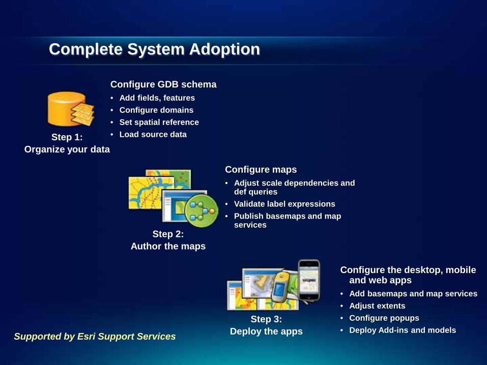
Complete System Adoption
Configure GDB schema • Add fields, features • Configure domains • Set spatial reference • Load source data
Step 1:
Organize your data
Step 2: Author the maps
Configure maps • Adjust scale dependencies and
def queries • Validate label expressions • Publish basemaps and map
services
Step 3: Deploy the apps
Configure the desktop, mobile and web apps
• Add basemaps and map services • Adjust extents • Configure popups • Deploy Add-ins and models
Supported by Esri Support Services

Publish and Adopt
Configure GDB schema • Add fields, features • Configure domains • Set spatial reference
Step 1: Create publication database
Step 3: Author the maps
Configure maps • Adjust scale dependencies and
def queries • Validate label expressions • Publish basemaps and map
services
Step 4: Deploy the apps
Configure the mobile and web apps
• Add basemaps and map services • Adjust extents • Configure popups
Step 2: Load production data
Create ETL Scripts • Set source / target • Schedule scripts • Migrate production data
Supported by Esri Support Services

Sample Code and Customize
Configure your GDB schema • Add fields, features
Step 1: Use your GDB Schema
Step 2: Repair the maps
Configure maps • Repair map layers (source and symbology) • Adjust scale dependencies and def queries • Validate label expressions • Publish basemaps and map services • Or, just try to use your maps…
Step 3: Customize the apps
Publish your own mobile and web apps
• Customize/re-compile the apps • Add basemaps and map services • Adjust extents • Configure popups
NOT supported by Esri Support Services
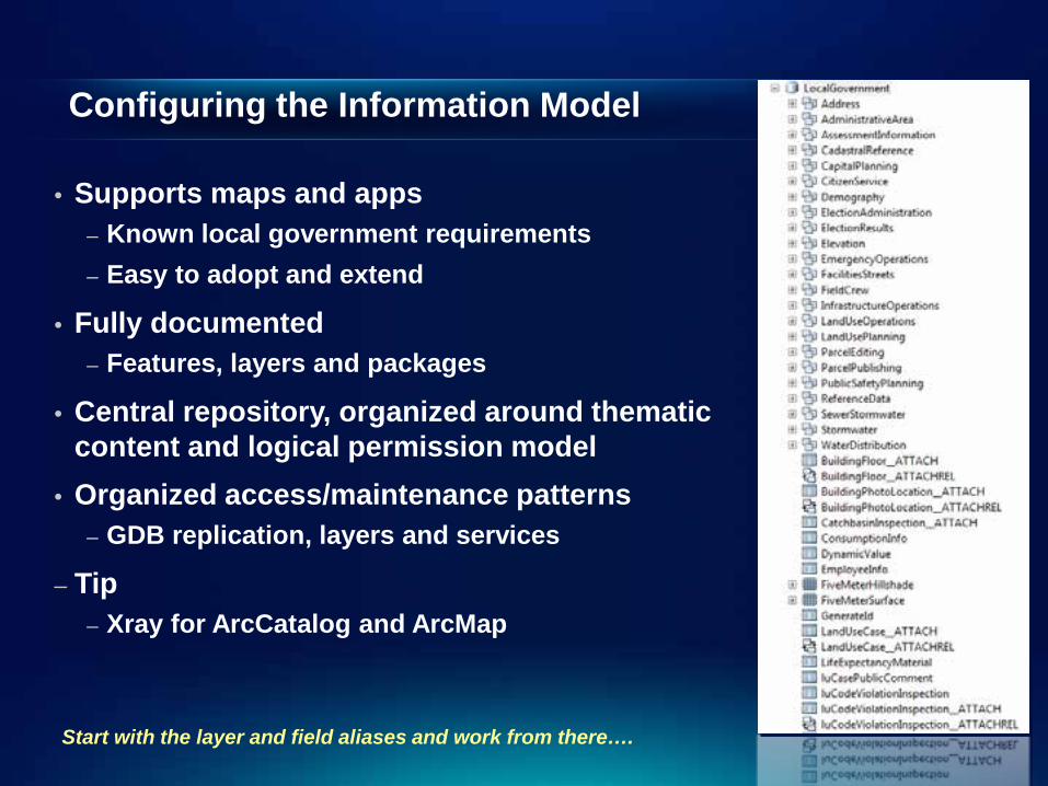
Configuring the Information Model
• Supports maps and apps – Known local government requirements – Easy to adopt and extend
• Fully documented – Features, layers and packages
• Central repository, organized around thematic content and logical permission model
• Organized access/maintenance patterns – GDB replication, layers and services
– Tip – Xray for ArcCatalog and ArcMap
Start with the layer and field aliases and work from there….

What’s Next Additional maps and apps
• Public Works / Water Utilities – Stormwater Assessment – Sign Inspection for iOS – Capital Planning
• Planning & Development – Address Crowdsourcing – Well / Septic Permitting – Site Selection Analysis – Operations Dashboard
• Land Records – Operations Dashboard – Tax Parcel Viewer (v.2) – Field Assessment
• Public Safety – Flood Response Planning – Fire Run Books / Station Wall Maps – Pre-Fire Planning – Fire Incident Command – EM COP (v.2)
• Management – Executive Dashboard

What’s Next
• Quarterly release schedule • Online Help documentation • On-premise offering
- Simple to install and configure
• Cloud offering - Synchronized w/ 10.1 Release
• Complimentary Partner offerings - ArcGIS for Local Government Partner Specialty
Productizing the ArcGIS for Local Government system

Summary
• Our Goals • Deliver a “local government GIS” that enables your success • Evolve and grow the collection of apps • Provide a platform for partners to deploy their solutions
• We want your participation and involvement • Download the maps and apps • Provide feedback on existing content • Identify opportunities for new content