Embed Size (px)
Citation preview
ARCHAEOLOGICAL FIELD NOTEBOOK 2005
A RECORD OF THE PROJECTS OF THEBRIGHTON AND HOVE ARCHAEOLOGICAL
SOCIETY FIELD UNIT
CONTENTSEXCAVATIONS
1) Rocky Clump, Stanmer, Brighton-A Romano-British Farmstead-Interim Report 2004
2) Nanson Road-Coldean
3) Malling Hill-Lewes
FIELD WALKING
1) Woodingdean-South field
GEOPHYSICS
1) Bushy Bottom-South of Edburton Hill
2) Beacon Hill-Rottingdean
3) Hollingbury hill-fort
4) Edburton Hill
Surveying
1) Millbank Wood, Stanmer-The paddock to the south east of Millbank Wood
MISCELLANEOUS
1) Earthworks-Falmer Hill
ARCHAEOLOGICAL WATCHING BRIEFS
1) 90 The Highway, Moulsecombe
2) 26 Gorham Avenue, Rottingdean
3) 16 St. Martyns Close, Ovingdean
4) St Dunstans, Ovingdean
5) 2 Petworth Road, Hollingbury
6) 23 Roedean Crescent I
7) 23 Roedean Crescent II
8) St Marys Hall, Eastern Road
9) 30 Nanson Road
BHAS Field Unit Attendance Record
Acknowledgements
Introduction
2005 once again proved to be a very eventful year for the Brighton and HoveArchaeological Society Field Unit. A total of 76 people attended the group activities and659 days were worked in the field. The unit conducted training in all aspects ofarchaeological excavation techniques including planning, section drawing, levelling,contour surveying and resistivity surveying. The team was joined a by a number of newpeople including a group from Cambridge and a new girl from London. The site was onceagain visited by the Young Archaeologist Club. This year the Society has been working inconjunction with the Brighton and District Metal Detecting Club. New projects of both fieldwalking and geophysics will now include the facility to record any metal finds found withinthe same grids.
The year consisted of a number of research projects including field walking atWoodingdean. Field walking is now being restricted due to the time span between cropremoval and re-ploughing, which is now often carried out in the same week. Some setaside fields are accessible but the stubble and weed growth make the exercise verydifficult and limits the type of finds found.
The geophysics team worked on a number of interesting new sites some notably close toand within the scheduled sites of Hollingbury hill-fort and the Edburton Hill motte andbailey complex. Both projects were conducted with the permission of English Heritage. Anumber of research projects included a large scale investigation at Bushy Bottom, nearShoreham and Beacon Hill, Rottingdean. A contour survey was made of the open field atMillbank in Stanmer.
The excavations this year were focused on the main site at Rocky Clump. Rocky Clumpcontinues to be used as a good site for training purposes and student activity. A smallscale excavation was conducted in the garden of a house at Nanson Road, Coldean.Coldean produced a number of finds in the 1950’s among which were Roman ditches anda possible Iron Age round house. The excavation at Nanson Road was conducted prior tothe construction of another house being built in part of the garden. The most importantexcavation this season was at Malling Hill, Lewes where a number of burials wereexcavated as a result of human bone eroding out of rabbit burrowing on the east side ofthe hill. The BHAS Field Unit had been asked for support by the County Archaeologist DrAndrew Woodcock.
The specialist groups have continued their good work with Carol White, Maria Gardinerand Averil Huggins, and on occasions Ali Bullough, producing excellent bone reports.Keith Edgar is examining the pottery from Rocky Clump and has partially reconstructedsome of the pottery from the site. Dot McBrien is now studying soil samples with a view toproducing reports on the seed, pollen and snails for environmental evidence.
During the summer a number of the team joined the Mid-Sussex Archaeological Team withtheir excavations at Barcombe. In the autumn members of the BHAS Field Unit joinedGreg Chuter at Arlington. A small scale assessment excavation examined the location of aRoman road and sought evidence for a possible settlement along the road side.
Finds processing was conducted at the Victoria Rooms, Stanmer and we are indebted tothe Stanmer Preservation Society for allowing us access to the room. The pottery has nowbeen passed to Keith Edgar and the bone to Carol White.
Day schools in 2005 were organised by the Society education officer Maria Gardiner andincluded geology with Stewart Ullyott, Bones studies with Lucy Siburn and a metal findsday with Liz Wilson the Finds Liaison officer for Sussex.
This year has seen the involvement of the society in a number of watching briefs, usuallyconducted by officers Steve and Eva Corbett and Bill Santer. The watching briefs arebecoming more frequent and there is a need for more members to be trained in thisprocess to ensure that adequate recording is conducted on these sites.
The new season for 2006 is already being planned with excavations at Rocky Clump andOvingdean. Research programmes of field walking and geophysics will continue in anumber of locations depending upon the farmers and their crop and ploughing regimes.Training will be available to anyone who wishes to become conversant with more detailedand specialised tasks. The new season looks to be as eventful as this years programmeand will enhance the knowledge of archaeology for the Brighton and Hove areas.
Hard copies of this report are passed to Mr G.Bennett at Brighton and Hove PlanningDepartment, Casper Johnson, the County Archaeologist, Brighton Museum, BarbicanHouse, the East Sussex Records Office and the National Monuments Records Office atSwindon. CD-Rom copies are produced by the society’s web master Mr Martin Devereuxand are made available to the field unit members and others who desire a copy.
John Funnell 26th December 2006
1
EXCAVATIONS AT ROCKY CLUMP, STANMER 2005(An interim report)
Introduction
The 2005 season of excavations at Rocky Clump, Stanmer began in April and continuedthrough to December (Fig. 1). The excavations, in the early part of the season, wererunning simultaneously with the excavations at Woodingdean which were in the finishingstages. The numbers attending the excavations this season were slightly down on 2004with 76 people coming along to dig. However, the total days digging for the 2005 seasonwas up being 659 days in the field.
Once again training of personnel was part of the seasons programme with severalmembers being taught both planning and section drawing. A number of the group havebeen involved with bone identification and Carol White, the team leader, now has MariaGardiner and Averil Huggins as regular participants and Ali Bullough, who has othercommitments, visiting on a less regular basis.
Rocky Clump played host once again to the Young Archaeologist Club (Y.A.C.) and thisyear were joined by the Brighton and District Metal Detecting Club who metal detectedaround the fields at Rocky Clump and as part of the field walking project at Woodingdean.The metal finds have not been too productive with only marginally interesting finds beingrecovered. The B&DMS did a major metal detecting survey in the field to the west ofRocky Clump called Iron Square and they can confirm that it is aptly named.
2
3
The Excavations
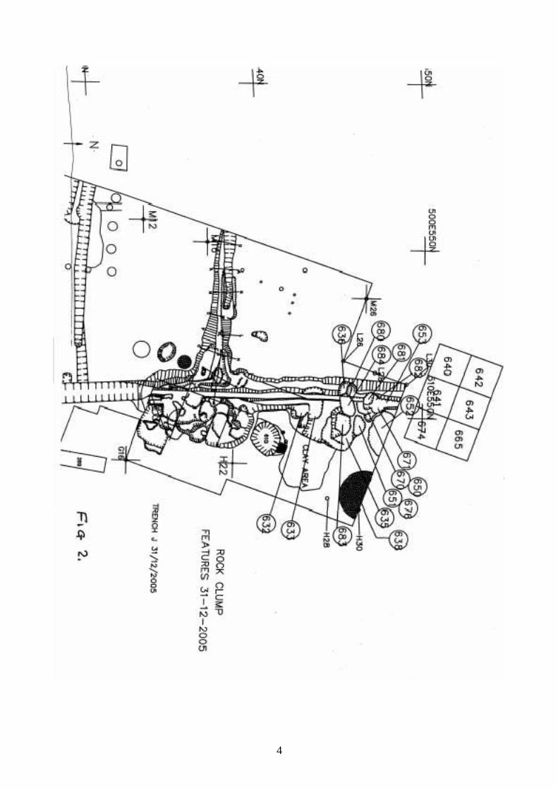
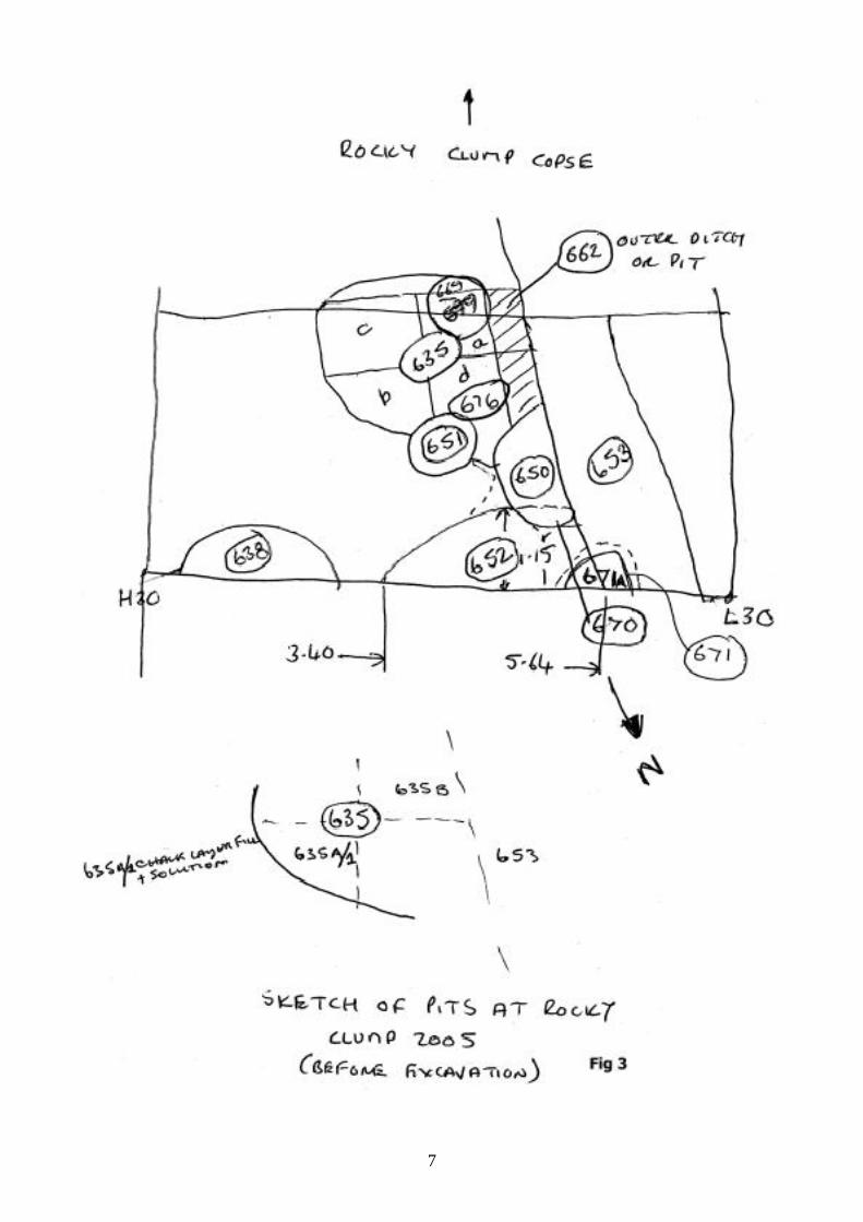
The 2005 season of excavations has focused very much on the remaining un-investigatedsection in trench J. (Fig.2) A large part of this trench had already been completed in 2004producing further evidence of the large ditch running north/south from a terminus just northof the copse of Rocky Clump. A terrace (context 627) was partially revealed during the2004 season which lies on the east side of the large ditch. There is trace of a similar, butmuch smaller, terrace on the west side of the ditch. The previous season at Rocky Clumphad been excavated using intermittent sectioning of the ditch at 1 metre intervals. Thismethod of excavation had been useful in producing numerous ditch sections but in theprocess had failed to realise the complex inter-cutting of pits at greater depths. Notably alarge pit which had cut into the natural chalk walls on either side of the ditch (Context 633)had been removed as part of the north/south ditch fill. It was now impossible to determinewhich feature cut which and provide a chronological sequence for these particularfeatures. The north end of the 2004 excavations had revealed a number of pits on both theeast and west side of the ditch (Fig.3 and Fig. 4), and pit (context 636) had been partiallyexcavated, but in this case the section was recorded and it was obvious that it was anearlier pit cut by the later north/south ditch.
The number of people attending and working on the excavations allowed a second largetrench to be opened further north. A baulk of 1 metre width was left between the northboundary of trench J and the new north trench. The new section was programmed toexamine the north/south ditch once again with a view to continuing an examination of thebone deposition in this feature. A similar exercise was planned for the remaining section intrench J. The new section measured 6 metres from west to east, and 4 metres from southto north. A total of 6 plough soil contexts numbered 640, 641, 642, 643 and later 2additional areas 665 and 674.
The third area of investigation was to focus on the ‘shrine’ area and to the east of theshrine out in the field. The object of these excavations was to seek evidence to determinewhether the possible shrine, is alternatively, a Roman aisled building. The new sectionswithin the trees allowed an examination of the shrine ‘interior’ which had never beenexcavated in previous years due to the location of a rotting Beech tree. The tree hadbecome dangerous and had now been cut down and removed away from the area ofinterest, which allowed excavation of one of the most important features at Rocky Clump.The third section in the trees was used primarily as an overspill area for the excavationsdepending upon number attending and can be observed by the sequence of plough soilcontext numbers 647, 648, 672 and 673. The shrine area contexts were 649, 654, 655,657, 663 and 664.
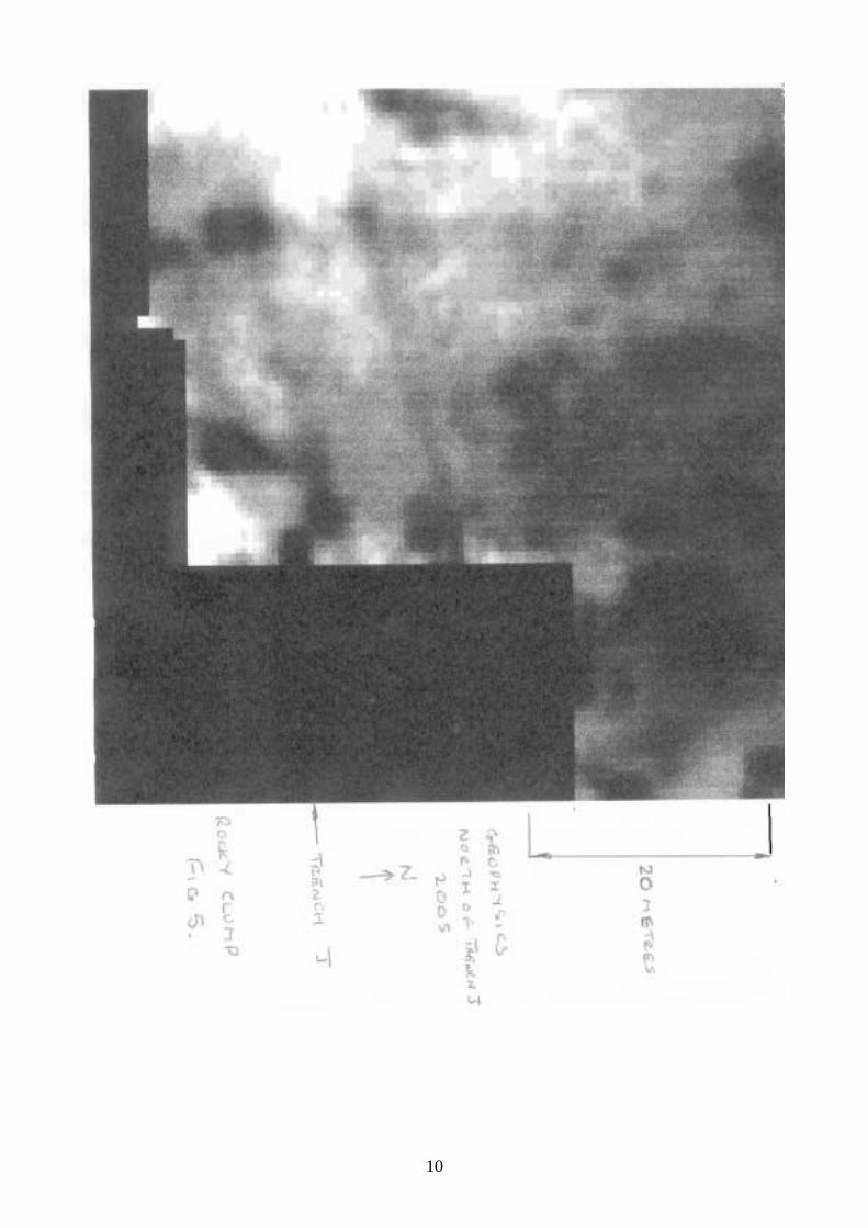
This year’s programme included further geophysics of the area surrounding theexcavation. The resistivity survey examined an area to the west and north of the existingtrench. The results show very little on the west side, but to the north the large north/southditch appears to expand into a huge circular feature? (Fig.5).
4
5
The Features
Trench J Detailed Pits and Ditch Sections
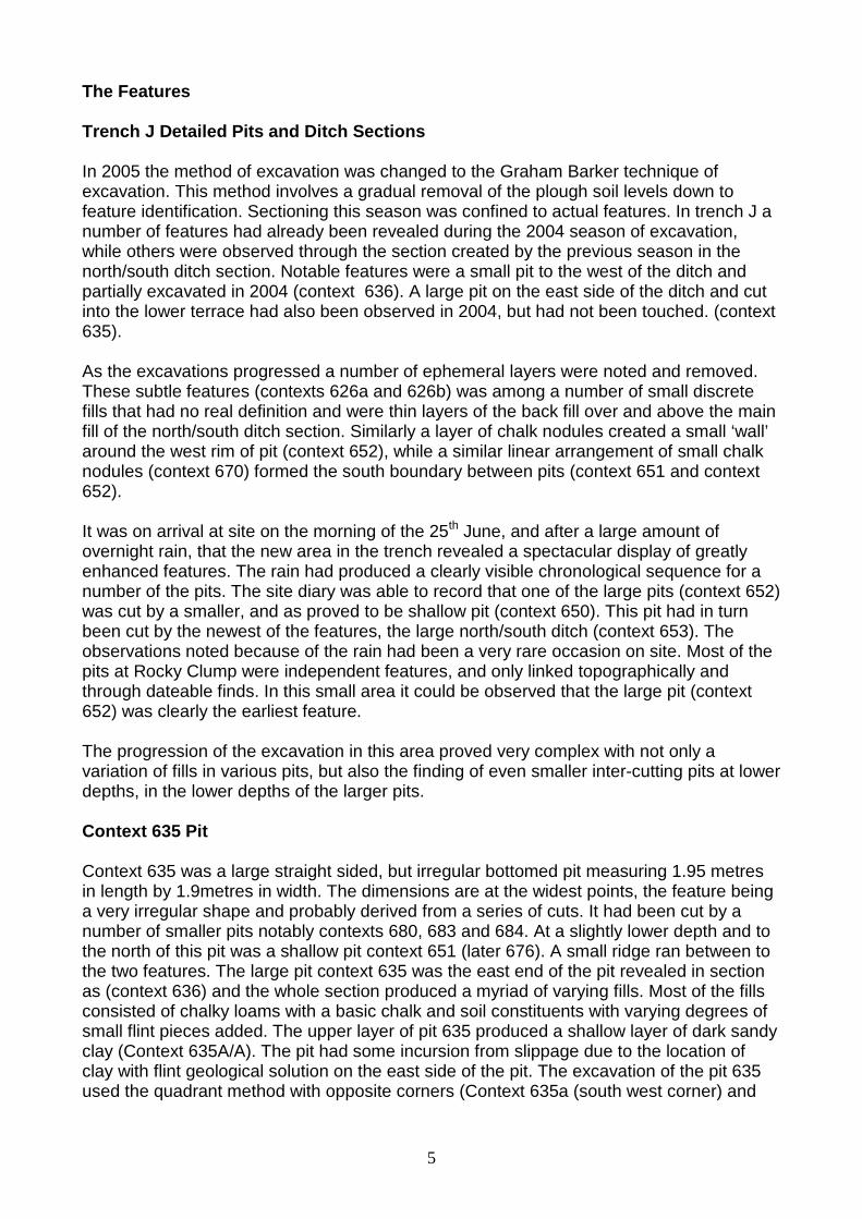
In 2005 the method of excavation was changed to the Graham Barker technique ofexcavation. This method involves a gradual removal of the plough soil levels down tofeature identification. Sectioning this season was confined to actual features. In trench J anumber of features had already been revealed during the 2004 season of excavation,while others were observed through the section created by the previous season in thenorth/south ditch section. Notable features were a small pit to the west of the ditch andpartially excavated in 2004 (context 636). A large pit on the east side of the ditch and cutinto the lower terrace had also been observed in 2004, but had not been touched. (context635).
As the excavations progressed a number of ephemeral layers were noted and removed.These subtle features (contexts 626a and 626b) was among a number of small discretefills that had no real definition and were thin layers of the back fill over and above the mainfill of the north/south ditch section. Similarly a layer of chalk nodules created a small ‘wall’around the west rim of pit (context 652), while a similar linear arrangement of small chalknodules (context 670) formed the south boundary between pits (context 651 and context652).
It was on arrival at site on the morning of the 25th June, and after a large amount ofovernight rain, that the new area in the trench revealed a spectacular display of greatlyenhanced features. The rain had produced a clearly visible chronological sequence for anumber of the pits. The site diary was able to record that one of the large pits (context 652)was cut by a smaller, and as proved to be shallow pit (context 650). This pit had in turnbeen cut by the newest of the features, the large north/south ditch (context 653). Theobservations noted because of the rain had been a very rare occasion on site. Most of thepits at Rocky Clump were independent features, and only linked topographically andthrough dateable finds. In this small area it could be observed that the large pit (context652) was clearly the earliest feature.
The progression of the excavation in this area proved very complex with not only avariation of fills in various pits, but also the finding of even smaller inter-cutting pits at lowerdepths, in the lower depths of the larger pits.
Context 635 Pit
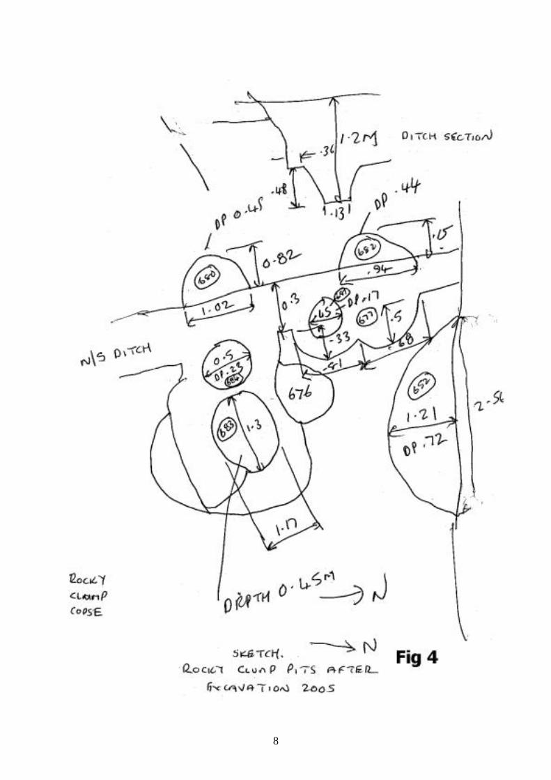
Context 635 was a large straight sided, but irregular bottomed pit measuring 1.95 metresin length by 1.9metres in width. The dimensions are at the widest points, the feature beinga very irregular shape and probably derived from a series of cuts. It had been cut by anumber of smaller pits notably contexts 680, 683 and 684. At a slightly lower depth and tothe north of this pit was a shallow pit context 651 (later 676). A small ridge ran between tothe two features. The large pit context 635 was the east end of the pit revealed in sectionas (context 636) and the whole section produced a myriad of varying fills. Most of the fillsconsisted of chalky loams with a basic chalk and soil constituents with varying degrees ofsmall flint pieces added. The upper layer of pit 635 produced a shallow layer of dark sandyclay (Context 635A/A). The pit had some incursion from slippage due to the location ofclay with flint geological solution on the east side of the pit. The excavation of the pit 635used the quadrant method with opposite corners (Context 635a (south west corner) and

6
635b (north east corner) being removed first for section drawing. The pit had been cut bythe north/south ditch and soft silty ditch fill lay in the west section of the pit (context 662).
7
8
9
Flint Circle Context 638
Context 638 was a semi-circular feature on the north east corner of trench J. It consistedof large to medium flint nodules. The feature was sectioned in what would have been onequadrant and was found to a geological solution hole. Below the upper layer of flintnodules was a fill of hard orange clay. The feature was excavated for only a fewcentimetres and then abandoned.
Pit Context 650
Context 650 was a shallow pit containing soft silty soil. It measured 860 millimetres inlength and 560 millimetres in width. It was only 50 millimetres in depth. The pit wastruncated on the west side where it was cut by the north/south ditch. The pit cut into theupper fill of large pit context 652.
Pit Context 651/676
Pit 651 was a small pit located north of the large pit 635. A small chalk ridge marked theboundary between the two features. The pit was flat bottomed. The fill was of light chalkloam. It measured 1.1 metres in length and .65 metres in width.
Pit Context 652
This second very large pit was straight sided and flat bottomed. It measured 2.56 metre inlength and 1.21 metres in width. The pit was only partially excavated as only half of thefeature was exposed, the remaining half being under the baulk to the north. The fill of thislarge pit had several layers, but all were in varying degrees chalk loam with greater orsmaller concentrations of flint nodule inclusions.
Ditch Context 653
This section of the north/south ditch measured 4 metres in length and lies betweenlocations L26 and L30 and H26 and H30. The ditch measures 1.6 metres at its widest partat the top. The ditch contains basically 3 different fills. The upper fill is of a soft, dark siltysoil. It is in this upper context that most of the finds have been recovered. The majority ofbone finds come from the lower levels of this fill. Below this is a fill of chalk loam, withsmall amounts of small flint nodules. The deepest fill is within a vertical sided cut at thebottom of the ditch, measuring 0.3 metres in both width and depth and with a fill of smallchalk pieces.
Pit/Layer Context 670
On the east side of the ditch and at its northern extremity were noted a number of distinctlydifferent but ephemeral layers. Context 670 was such a feature which originally appearedto be a possible pit cutting into the larger pit 652, but which disappeared very quickly whenexcavated down to the firm natural chalk of the large pit side.
As the excavation progressed to a greater depth new pits were noted. At the bottom of thelarge pit 635 were 2 smaller pits.
10
11
Terrace Context 677
Context 677 was a small, deeper ledge, cut into the larger terrace on the east side of theditch. The terrace had been cut by the large ditch. The shape was of a double curved edgeon the east side of this ledge and measured 1.49 metres in length and between 0.5 and0.33 metres at maximum width. Cutting into this small ledge was another pit context 681.
Pit Context 680
This feature was part of a small pit that had been severely truncated by the north/southditch. It measured 1.02 metres in remaining length and 0.82 metres in width. The fill wasremoved as part of the large ditch fill.
Pit Context 681
This was a small pit cutting into the small ledge that had been cut into the terrace on theeast side of the large ditch. The feature measured 0.45 metres in diameter and was 0.17metres deep. The fill was of chalky loam.
Pit Context 682
This pit was further to the north of pit context 689 and had a similar shape as it also hadbeen cut by the large ditch. This feature measured 0.15 metres in remaining length and0.94 metres in width. Again the fill had been removed as part of the large ditch.
Pit Context 683
The elongated pit that is context 683 was one of two small pits that lay at the bottom of thelarge 635. This pit measured 1.3 metres in length and was 1.17 metres wide. It had a quitedistinct edge, but as wit the majority of the large pit fill with a chalky loam. The pit wasround bottomed.
Pit Context 684
The second of the pits that lay at the bottomed of large pit 635 was to the west of pitcontext 683 and was a circular cut measuring 0.5 metres in diameter and 0.23 metres indepth. The fill was similar to that of context 683 and was chalky loam.
New Trench north of Trench J
Originally this area was planned to study in detail the deposition of the bone being found inthe north/south ditch. The complexity and manpower required to excavate and record thecomplex series of pits just south of this new area meant that only surplus personnel wereable to move to this new location. The contexts excavated 640, 641, 642, 643, 665 and674 were originally top soil contexts but as some considerable depth has now beenreached with no sign of any chalk natural new questions are being asked. The latercontexts 665 and 674 were added to try and pick up vestiges of the large pit 652. No traceof any chalk has yet been found and it must be assumed that the pit terminates under the1 metre wide baulk. The new area has produced some interesting pieces of pottery andthe large ditch western edge has been located cutting into an area of clay. The east side ofthe ditch has yet to be revealed. A 1 metre wide section was cut into the south east side ofthis new area in attempt to seek the chalk natural revealed natural clay with flint. It is
12
uncertain as to whether this new feature is a large geological configuration or a very largearchaeological pit? However, as yet there is no trace of the large ditch edge to the east orthe soft dark, silty fill associated with the ditch.
Excavations within the Shrine Area
The removal of a large tree stump and base by the Brighton Rangers has allowed accessto a previous untouched section of the ‘Shrine’ area defined by Walter Gorton in hisbooklet (Gorton). The post holes of this structure had been excavated in the seasons 1947to 1986, but the interior of the building was covered by a large Beech tree which has nowbeen removed. The area of scrub was cleaned back, as was the sawdust from the treestump. The area investigated measured 4 metres by 4 metres, with a small extensiontowards the large sarsen stone on the west. The excavation is limited in a southerlydirection as both Charlie Yeates and his wife are buried in this part of Rocky Clump.
The excavations removed an overburden of leaf mould and bark which revealed a lowerlevel of chalk that had been heavily disturbed by both tree root activity and burrowinganimals. The main contexts 655, 649, 654 and 657 were areas of disturbed chalk rubble.There was, however, a very well defined edge that ran along the centre of southerncontexts 649 and 654. To the south of this defined ridge was located a large post hole,context 658, and this proved to be one of the post holes excavated by the Gorton andYeates, their context PH1.
The post hole 1 (context 658) was re-excavated to check dimensions and proved to be alarge flat bottomed pit/post hole. Walter Gorton report that these large features didproduce post pipes. The re-excavated fill consisted of large amounts of flint nodules, butalso a number of pieces of dressed stone. A number of pieces of dressed chalk were alsorecovered from the interior of the shrine contexts 655 and 657. The interior of the buildingproduce very few other finds of either shell or pottery and no metal work.
A very useful feature also revealed was the edge of another of Gorton’s post holes hiscontext PH2 and the associated edge of grave cut GII. The grave proved to be a veryshallow cut. The new features excavated this season allow additional dimensional checksfor a comparison between the data of both the earlier and later excavations. This isplanned for the 2006 season. Additional features found in the new area included a flatbottomed, straight sided post hole (context 664) located north of the large post hole 658.The new post hole is considerable smaller than context 658 and very much disturbed bytree root action. The investigations in 2005 were planned and recorded and the area willbe extended northwards in the 2006 season to examine more of the interior of thissubstantial structure.
A second trench was opened up east of the shrine area. This new trench is to seekevidence for the possible location of post holes associated with a Roman aisled building ,this being a possible alternative to the shrine theory considered by Walter Gorton. In 1994a small trench had been cut to the east of the trees. This trench was in alignment with theknown post holes and was measured in at the regular spacing of the post holes noted inthe old site plan. The trench came down onto a post hole, but it was much smaller than theshrine post holes within the trees. The location of this new post hole was noted, but it wasnever excavated.
The first feature to be revealed in the new area was a section of the ditch surroundingRocky Clump and still proving to be a problem with dating. The section revealed this
13
season is an area that was investigated by a series of 4 trenches in the 1960’s by CliveSkeggs, but never published. It is anticipated that the edge of any of sections cut bySkeggs will be observed and should not require any re-investigation. The ditch sectionrevealed was given context 656. This trench was later extended to include context 666, thearea between trench contexts 647, 672 and 648.
As digging progressed in this area it became apparent that there was a lighter fillassociated with a cut into the ditch surrounding the Clump (Context 668). The size andshape of this feature resembled a possible grave cut. A small section was cut into thefeature, but it only produced a soft chalk loam fill and no finds. This investigation wastemporary abandoned until the following season.
Discussion
The digging at Rocky Clump has once again produced some very interestingarchaeological finds and features. The continuing investigations along the course of thenorth/south ditch have raised some very interesting questions about the purpose of theRoman site at Rocky Clump. This question was only partially answered by previouspublications (Gorton) and (Gilkes). Is the site at Rocky Clump purely a simple ruralfarmstead or does it have ritually associated structures, this question still has to beanswered with hard and indisputable evidence. The earlier publication in the SussexArchaeological Collections (Gilkes) suggested the site was dated to the 2nd/3rd centuryA.D. The finds of pottery from the large north/south ditch are clearly from the 1st centuryA.D. (pers comm.. M.Lyne) A coin of the Republic has been recovered from the ditch fillsuggesting an even earlier date for this ditch. Rocky Clump has several phases covering alarge span of the Roman period. The excavations have revealed a new series of pits thatindicate some form of rural activity from the earliest known phase of Roman Rocky Clump.
The series of pits cut into a shallow terrace on the east side of the large ditch is confidentlythe earliest phase of Romano-British activity at the site, and may even be Iron Age. A largepit found in 1994 within the trees (Context 14) may be an earlier dating, possibly to eitherthe Late Bronze Age or early Iron Age. (Pers. Comm. Malcolm Lyne). Finds from the pitshave been very few, but will be an important factor in determining the date of this earlyphase. Several large pits were cut by the ditch going northwards and may betopographical features. The chronological sequence shown by the rain soaked featuresnoted shows that there was a continuation of activities in this area. The question isessentially what was the purpose for this proliferation of large pits?
The pits are another phase showing that there is some complexity with regards Romanrural activity. In earlier excavations at Rocky Clump the various ditches tend to suggestsome form of water coursing arrangements, but as has been proved in very heavy rainfallthere is very little problem associated with drainage from any part of the site. The ditchesretain very little vestiges of rain water. A question was raised as to whether the terrace andpits were possibly some form of sluice. The lack of any water retention other than on theoccasional clay pocket areas makes this very unlikely. It has been suggested that thevarious ditches are field boundaries (Gilkes) but are very substantial for this purpose.
It is possible that the series of pits are a succession of cess pits and the reason for suchcomplex back filling. It is possible that the ditch running northwards is a drain for cess. Thelarge pit to the north, hinted at by the geophysics, and which the limited excavation thisseason tends to support, may produce answers to this theory.
14
The tenant farmer David West was asked for opinion as to why a farmer would want tocreate such a series of pits. David West could only suggest that it could be part of atanning or dyeing processing plant. Tanning and dyeing were processes carried out inRoman times and the smell of this industry would have justified the location of suchmanufacturing plants well away from major settlements. The pits at Rocky Clump aresubstantial and relate in size to similar pits found in ancient industries still maintained.These processes can still observed in locations in North Africa in both Tunisia andMorocco. The tanning or dyeing process could be considered if some hint or evidence ofstaining could be found within the chalk walled sides of the pits and cuts. The excavationsfound no evidence for any staining or discolouring in any of the pits. The purpose of thisseries of pits must remain unknown at this time.
The new trench being opened north of trench J has produced a few sherds of Romanpottery and the depth which is now below the plough soil would tend to suggest that it iseither a very large pit or a geological feature. There is no conclusive evidence at this timefrom the 2005 excavations.
The area of most significance in 2005 was the interior of the ‘shrine’. The excavationrevealed a very disturbed platform of chalk. The amount of disturbance made it difficult todetermine where the original natural surface may have been. Running through theexcavated area was a ridge of chalk about 60 centimetres in depth, but it was irregular inshape. The ridge was in alignment with the large shrine post hole context 658 and ran eastto west across the excavation. The interior of the shrine had a small incursion in the northwest corner which could have been a smaller post hole, but was too disturbed to certain.The whole area produced virtually no finds of any description except for some pieces ofwhat appears to be dressed chalk. It was quite a distinct platform of chalk that could be avery disturbed elevated floor level, or even possibly a fallen chalk wall? It is too early atthis to make a confident assessment and more work needs to be done.
The pieces of dressed chalk, along with the other pieces of dressed stone found when re-excavating the large post hole context 658, hint at some form of structure, but these findsalong with small fragments of Roman roofing tile found in previous seasons tend tosuggest that they may have originated from another site close by which is still to belocated.
The small trench to the east of the trees found nothing to substantiate the theory thatRocky Clump may have been the site of a Roman aisled building, but the interestingnumber of anomalies and pits warrant further investigation. An extension to this trench isplanned for 2006.
Rocky Clump is gradually revealing its secrets. This is a very rare opportunity toinvestigate a ‘low’ status site of the Romano-British period, and quite different from theusual villas sites often excavated. During past seasons a random number of unintelligiblepost holes eventually produced, through continuing excavation, the clear configuration of anew building or structure. This new structure is in alignment with the ‘shrine’ located withinthe trees. It is highly possible that the continuing excavation will produce similar results forour current unintelligible pits in the north. At present the collection of pits and ditches to thenorth of Rocky Clump are evidence for some form of activity during the Roman periods asyet unknown. It is possible that the pits are rubbish pits or cess pits. If the pits are for cess,being continual filled in as they were re-cut, this could explain the paucity of finds. The pitsappear to be in a regular sequence going northwards and on the same alignment as thelater large north/south ditch. It is possible that when the ditch was cut through the earlier
15
features they were still visible and that the diggers of the ditch knew that the digging wouldhave been easier than through natural chalk.
The lower fills of the north/south ditch have produced a limited number of finds. The mainmaterial comprising bone, marine shell and pottery comes from the lower section of theupper fill of dark, silty soil. It has been suggested that activities at Rocky Clump wereconducted over a number of phases and that there was not a continuity of occupation atthe site. The pits and ditches at the north of the site do tend to confirm this with a distinctdating between finds from the interior of the new structure found in earlier seasons and thelower silty fills of the large ditch. The question now arises as to the chronological sequenceat Rocky Clump. It has already been noted through pottery and coin finds that the ditch ismuch earlier than the new building. If the ditch, which is confidently dated to the firstcentury, it must imply that the pits that it cuts are earlier and possibly even Iron Age. Itmust be stated that there are at present few finds of Iron Age pottery to confirm this. Findsprocessing and an examination of the few pottery finds from the pits may provided vitalevidence. The small terrace or platform cut to the east of the ditch is equally difficult toexplain, although a shallow ridge to the west of the ditch could have provided a platformfor some form of plank covering, but again there is no real explanation as to the purpose ofsuch a requirement.
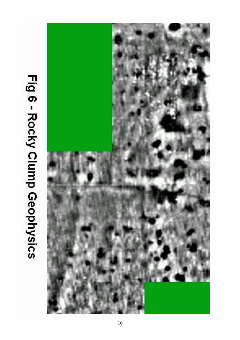
Rocky Clump continues to intrigue and enthral the excavators with so many unansweredquestions. It is obvious that various indeterminate activities were taking place at this copseof trees but as yet we are unable to confirm exactly what these were. The excavationshave focused on the north field and it is possible that the real site or occupation may lie tothe south. Recent excavations at Downsview (Rudling) and Varley Halls (Greig) have allrevealed south east facing terraces, dated to the later Bronze Age cut into the side of thehill. It is possible that people during the Iron Age and Romano-British periods still preferredtheir houses in this location and orientation. A geophysical study, (Fig. 6), conducted in thesouth field a number of years ago shows a proliferation of small areas of low resistanceand many of these may relate to Iron Age round houses. It is a logical thought that if thepits and ditches being revealed at present are rubbish or cess pits then the naturalinclination would have been to place them on the other side of the hill.
The excavations at Rocky Clump will continue in 2006 and the main thrust of theexcavation will lie within the copse of trees. The investigations will continue within theinterior of the ‘shrine’, the east trench will be expanded to investigate the new featuresrevealed and a small area in the known cemetery, previously unexcavated will seekevidence for a new untouched grave cut, which could produce vital carbon 14 dating forthe burials. The examination of the north/south ditch in the large circular feature to thenorth will be used as an overspill area if required.
Trench J has now been back filled to preserve the archaeological features and make thearea safe for members of the public visiting the site during the winter months.
16
17
Post Excavation
Every season post excavation work is undertaken between January and March. Findswashing is conducted by Bob Crowhurst throughout the year with finds marking andcataloguing being undertaken during the post Christmas period. BHAS now has a numberof specialists working on the material from both Rocky Clump and the excavations atOvingdean. The bones team, led by Carol White, have been examining all of the bonematerial found from the 1999 season onwards. Geraldine Slater a student at SouthamptonUniversity had completed a bone study on bone finds up to 1999 and this was published inan earlier field notebook. Keith Edgar has taken on the role of pottery identification, takingover from Richard Pulley who is now studying elsewhere. Keith has so far managed topieces together 4 pots from Rocky clump, some almost complete vessels. A student fromSurrey University has examined all of the flint work recovered up to the 2004 season. Thestudent based her dissertation on the patination of the flint finds. The report is unpublishedand unavailable to the Society but her findings show very little variation in patinationbetween finds found in plough soil and those recovered from sealed contexts. Dot McBrienanother member of the BHAS Field Unit is now beginning to study environmental evidencefrom Rocky Clump. She is examining both seed and snail evidence. Support has beenpromised for this venture from Mike Allen of Wessex Archaeology. Barbara McNee whohas joined the Society and is a prehistoric pottery specialist will taking over the role ofprehistoric pottery specialist and will be taking over the examination of the Pudding BagWood and Stanmer Great Wood pottery analysis from Sue Hamilton who is obviouslymuch too busy. She will also examine the pottery from pit (context 14) that is deemed tobe prehistoric.
Small Finds
No. Type Context No Location72 Spindle Whorl 630A North/South silty fill layer73 Coin 665 Top soil area
Acknowledgements:-
The author would like to thank Mr G.Bennett of Brighton and Hove City Council and MrD.West for their encouragement and allowing access to their lands, Mr and Mrs Jim Driverfor their continuing support with the storage of the tools and equipment, Mr D.LarkinBrighton Countryside Ranger for back filling and removal of trees and for all the membersof the BHAS Field Unit for their endeavours and support during this season. The authorwould also like to thank The Stanmer Preservation society for allowing access to theVictoria Rooms at Stanmer for finds processing, Mr D. Staveley for leading the geophysicsteam, Mr N.Phippard the Archaeological Secretary, and Mr S.Corbett and Mr M.Gillinghamfor editing the reports.
18
References:-
Gilkes O.J. 1997 ‘Excavtions at Rocky Clump, Stanmer Park, Brighton, 1951-1981 Sussex Arch Colls. 135, 113-25
Gorton W.C.L. 1988 ‘Rocky Clump, Stanmer, A Forgotten Shrine?’
Greig I. 1997 ‘ Excavations of a Bronze Age settlement at Varley Halls ,Coldean, Coldean Lane, Brighton’. Sussex Arch Colls. 135, 7-59
Rudling D.R. et al 2002 ‘Downland Settlement and Land-Use, The Archaeology of theBrighton Bypass’. Archetype Publications.
Author:- John Funnell 1st January 2007
19
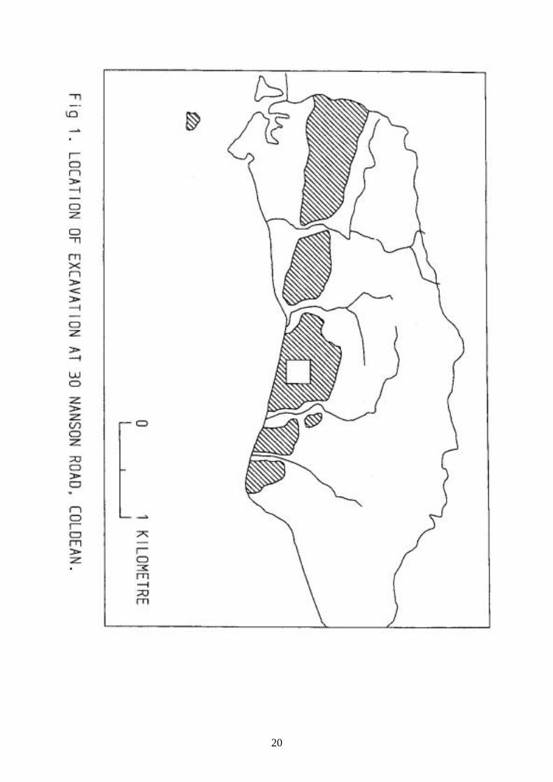
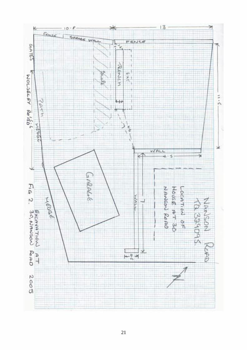
Excavations at 30, Nanson Road, Coldean, Brighton.
Site Topography and Geology
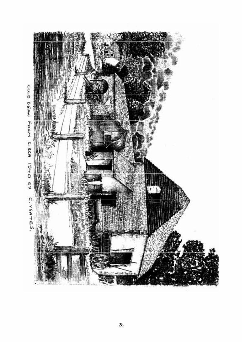
The Coldean housing estate is located in a small valley which is part of the South Downs.(TQ328088). (Figs.1 & 2.) The east end of the valley opens out onto a junction withanother valley along which runs the Brighton to Lewes road. This valley was created bythe Winterbourne stream that emanates from Falmer down into the town of Brighton. Thename Coldean is confirming the nature of the environment “cold valley” and is remarkablefor spawning “Warmdene” in the next valley westward (Coates). The valley has a plateaufocused around Ingham Drive, Nanson Road and the south section of Hawkhurst Road.The plateau drops down into a secluded basin to the north which is the location of ColdeanSchool and the old Cold Dean farm. A stream used to run through the lower part ofStanmer Great Wood close to the old Cold Dean farm (Pers. Comm. Mr David West). Thesite being developed lies on the plateau on a slight incline towards the south west cornerof the valley.(TQ32850850). The geology is chalk loam overlying a bed rock of upper andmiddle chalk.
Historical and Archaeological Background
The Coldean area of north Brighton has, over the past five decades, been subject to themost intensive archaeological investigation of the whole of the Brighton and Hove cityarea. A number of discrete finds and several major excavations have produced evidencefor occupation and settlement over much of antiquity.
The housing estate was a post Second World War development constructed during the1950’s. During the house building workmen uncovered a number of archaeologicalfeatures while digging trenches for house footings. The Brighton and Hove ArchaeologicalSociety, who were excavating a tumulus along the Ditchling Road at the time (Yeates),were invited to investigate the features and produced evidence for Romano-British ditchesand Iron Age round houses. The finds from these excavations included a gold stater(Funnell forthcoming).
The investigations prior to the construction of the Brighton bypass produced evidence for asignificant Middle to Late Bronze Age Settlement on a location close to the old DownsviewSchool (Rudling et al). The site was located on the steep sided hill that lies to the west ofColdean Lane. Excavations at Varley Halls, also on the east side of the valley, produced anumber of round houses and a ditch that may relate to another similar Bronze Agesettlement (Greig). Field walking of the lands surrounding the Coldean valley hasproduced finds of Neolithic and Late Bronze Age flint work, fire cracked flint and potterydated to the Iron Age and Roman periods (Funnell) & (Hartridge et al). A Roman corndrying oven was found close to the Ditchling Road and a gas pipe line cutting in the 1990’ssuggested that a Roman site is located somewhere close to Old Boat Corner. However itis possible that this site was destroyed when the old Ditchling Road was relocated to itsnewer and wider location.
20
21
22
During 2000 excavations at Pudding Bag Wood and Stanmer Great Wood examined twolinear earthworks. The features proved to be of Late Neolithic to early Bronze Age date(Pudding Bag Wood) and Iron Age (Stanmer Great Wood). A geophysical study at VarleyHalls clearly indicates that the Bronze Age settlement site continues upwards andnorthwards beyond the previously excavated area. However, watching briefs conducted ona number of developments in Ashburnham Drive and Hawkhurst Road failed to find eitherarchaeological artifacts or features. A watching brief of a gas pipe line at the bottom of theColdean Lane in 2005, noted deep colluvial deposits and only finds from the upper layersof contemporary ceramics and building debris.
The Excavations
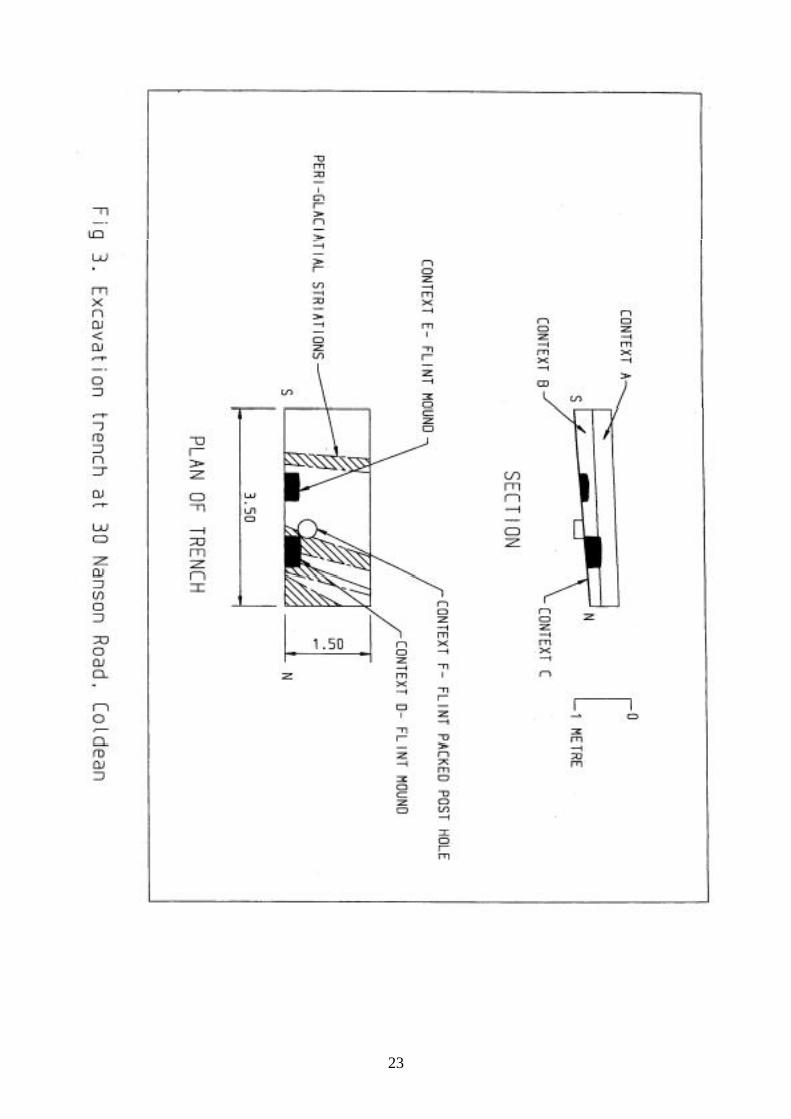
The BHAS who had been asked to conduct a watching brief at 30 Nanson Road,approached Mr Clive Voller, the land owner for consent to undertake a small excavationwithin the garden area. The society then conducted a small excavation prior to thecommencement of the development works. The garden had been terraced in a number ofplaces and the west side consisted of large quantities of contemporary soil from possibletipping. The BHAS Field Unit excavated a small trench in an area which appeared toretain the original land surface and which appeared untouched by later garden activities.The trench measured 3.5M x 1.5M and 1.4M in depth. (Fig. 3)
Stratigraphy and Contexts
The garden area was covered by scrub and brambles and this was cleared prior to thebeginning of excavation. The upper layer of humus was removed using a mattock andshovel, while the lower fills were removed using trowels. The excavation produced a seriesof well defined archaeological layers. The trench, which was 1 metre in width, was laterwidened by 0.5M in an easterly direction.
Context A-The top layer was a very dark layer of humus varying from 310mm in depth atthe north end of the section to 330mm in depth at the south. The dark layer produced aquantity of finds, mainly contemporary. These included modern ceramics and pieces ofclay pipe.
Context B-The layer below the humus consisted of a light beige chalky loam. The fillcontained quantities of small flint nodules. The finds from this layer included Iron Agepottery and struck flint flakes. The thickness of this deposit varied from 200mm at the northend to 330mm at the east end.
Context C-The deepest layer was a thin intermediate vestige of beige sandy loam, locatedbetween the chalk bedrock and the thicker chalky loam above. This sandy layer measuredonly a few millimetres in depth. A solitary flint flake was recovered from this lower level.
Context D-This context consisted of a small, rectangular shaped, collection of small flintnodules measuring 570mm wide, 250mm deep and protruding from the section by 280mm.(Fig 3.). The mound of flint was removed and was found to lie directly above the chalkbedrock with no incursions having been made into the chalk. The mound appears to havebeen a localized feature as no flint was observed in the section after excavation.
23
24
Context E-This context was a smaller mound of small flint nodules and lay to the east ofcontext D. The excavation of the mound of nodules showed, as in context D, that noincursion had been made into the chalk, and after excavation no trace was visible in thesection of the trench.
Context F-Context F was a flint packed post hole measuring 330mm in diameter and207mm deep. The flint packing in the post hole was concentrated on the east side of thefeature.
A number of linear features crossed the trench from west to east and are probably peri-glacial striations. These features were sectioned in a number of places and were found tobe, with some minor variations, approximately 100mm in depth. The features had a soft fillof beige/white chalky loam and none of the sections cut produced any archaeologicalfinds.
The Finds
The Pottery
The trench produced 11 sherds of pottery. The pottery consists of a number of fabrics andthe style and inclusions tend to suggest that they are Iron Age.
Fabric A
The largest group of pottery sherds, 8 pieces in total, consisted of a reduced ware with flintinclusions measuring from 0.5mm to 7mm in length. The sherds were quite small and nodiagnostic pieces were found.
Fabric B
There were 2 sherds of grog tempered East Sussex Ware. This pottery was a commonstyle of manufacture throughout the Iron Age and the Roman and Saxon periods.Fabric C
Fabric C was a single sherd of coarse sand tempered ware, well fired and oxidized.
The Flint Work
The collection of struck flint totalled 30. They were all hard hammer struck with 58% stillretaining vestiges of cortex indicating that they were primary struck flakes. The patinationvaried from white in 14 flakes (45%) to blue in 17 flakes (55%). No flint tools were found. Atotal of 6 pieces of fire-cracked flint were also found with a combined weight of 219gms.
Context No of Flakes Fire-cracked FlintA 6 1 (56gms)B 21 3 (106gms)C 0D 2 2 (57gms)E 1
Totals 30 6
25
Molluscs
The excavation produced a number of marine molluscs comprising scallop (80%), oyster(16%) and limpet (4%)
Mollusc Context No. of Pieces Scallop A 14 Scallop B 4 Oyster A 3 Oyster B 1 Limpet A 1
Total 23
Clay Pipe
The trench produced 2 pieces of clay pipe stem, one piece had an undecorated bowl stillpartially attached. The stems both measured 6mm in diameter and may be part of thesame pipe. The measurements tend to suggest a 19th century date (Atkinson).
Miscellaneous Items
The site produced a number of items of contemporary dating including numerous pieces ofglass from a number of vessels, roofing slate, glazed ceramics, flower pot sherds and twometal straps.
Conclusions
The small excavation at 30 Nanson Road has provided further evidence to indicate thatthe small valley at Coldean was part of a possible settlement during the Iron Age. Thepottery found in the excavation lies close to the features found during the 1950’s. Thesingle flint packed post hole may be part of a structure or a fence line, but the solitary flintflake found within the post hole is not sufficient evidence to suggest that it was createdduring the late Neolithic period. The flint mounds found in close proximity to the post holecould be associated features but, again, there is no supportive evidence other than flintflakes to confirm this. A number of the round houses at the Downsview site did possesshearth features that were cut into the chalk bedrock and were packed with fire-crackedflint. However, the flint mounds at Nanson Road were rough flint nodules and had not beenfired. The flint mounds were found lying on top of the chalk bedrock and so are highlyunlikely to have been Bronze Age hearth areas. The concentration of flint nodules doessuggest that they may have been stored for some prehistoric use, as yet unknown,although they could have been deposited at any period.
The excavation confirms that the area of archaeological interest at Coldean does extendtowards the west of the valley. The lack of finds from recent watching briefs and the valleybottom gas pipe line trenches does tend to suggest that the main focus of the Iron Age andRomano-British phase is along the Hawkhurst Road/ Ingham Drive area. This part of theestate is the upper plateau section of Coldean. The earlier Bronze Age phase appears tobe focused upon the steep sided east valley sides with the cemetery possibly located onthe west side of the valley. However, the upper reaches of the east valley side do containa number of tumuli, which does suggest a number of phases during the Bronze Age or anumber of small nucleated farmsteads. However, the Downsview excavations confirm that
26
the focus of Middle to Late Bronze Age settlement continued in the same section of thevalley. The funerary finds of both tumuli on the east side of the valley and cremation pitburials on the west side of the valley has a very interesting perspective which requiresfurther investigation.
The few local finds of Neolithic material at Marquee Brow and Pudding Bag Wood indicatethat this valley was a possible shelter to people in early antiquity. The settlement sites atDownsview and Varley Hall and the discrete burial sites around the valley show that thisland was widely exploited during the Bronze Age. Field walking has provided finds ofpottery to show activity during both Iron Age and Roman periods with the ditches foundduring the house building suggesting that there is an associated settlement. The shallowtrackway that crosses the valley side on the west side links a number of medievalfarmsteads. One medieval farmstead is known at Patchway field and there is a welldocumented manor at Piddingworth (Christie et al).The trackway was sectioned andexamined during the Brighton bypass excavations, but no dating evidence was found(Rudling et al).
The excavation at Nanson Road was an opportunity to view just a tiny fragment of theancient archaeological record, and it provided evidence to show that many gardens in thispart of Coldean should be regarded as probable archaeological sites. Any futureopportunities to dig in this area may provide important new finds that will help bringtogether, and enhance, the fragments that we presently hold and may eventually producea clearer vision of the various settlements that have nestled in this tiny valley.
Even with so much archaeology revealed over the past four or five decades, it could beconsidered that investigations in any valley along the South Downs are likely to revealsimilar strands of archaeology to that found at Coldean.
Acknowledgements:-
I would like to thank Mr Clive Voller for allowing access to the site and to all members ofthe BHAS Field Unit who conducted the excavation.
27
References:-
Atkinson D.R. ‘Sussex Clay Tobacco Pipes and the Pipemakers’ Crain, Eastbourne.
Coates R. 1980 ‘Studies and Observations on Sussex Place Names’ SussexArch. Colls. 118, 309-329
Christie M.E., Hill A., Johnston B. & Pepler H.D.C. 1937 ‘Ditchling’ St Dominic’s Press,Ditchling, Hassocks Sussex.
Greig I. 1997 ‘ Excavations of a Bronze Age settlement at Varley Halls ,Coldean, Coldean Lane, Brighton’. Sussex Arch Colls. 135, 7-59
Funnell J. 2002 ‘Fieldwalking at Varley Halls and Marquee Brow, Stanmer,Brighton’ Sussex Arch Colls. 140, 144-148
Funnell J. 2000 ‘Excavations at Pudding Bag Wood and Stanmer Great Wood’Brighton & Hove Field Unit Notebook 2000
Funnell J. (Forthcoming) ‘Excavations at Coldean, Brighton’.
Hartridge, R., Holgate, R. & Kenward, R. 1989, Fieldwalking along the Route of theBrighton Bypass, Sussex Arch. Colls. 127, 241-3.
Rudling D.R. et al 2002 ‘Downland Settlement and Land-Use, The Archaeology of theBrighton Bypass’. Archetype Publications.
Yeates C. 1950 ‘Prehistoric Man in the Cold Dean Area’ Sussex CountyMagazine Volume 35, 337-80
John Funnell (President Brighton & Hove Archaeological Society)
24th May 2005
28
29
A MASS GRAVE AT MALLING HILL, LEWES
In early May 2005 the BHAS Field Unit responded to a request from the CountyArchaeologist and Greg Chuter for help with a site on Malling Down. The Lewes Rangershad been scrub cleaning and when bushes had been removed found that rabbit burrowinghad been disturbing human remains. Over a bleak week-end of intermittent drizzle andrain members of the unit conducted an excavation on a small platform area on the steep,scarp, west facing side of Malling Down. Two small trenches were cut and the excavationsproduced a total of 9 burials. The site was immediately adjacent to an earlier trench thathad been cut in the 1970’s that had produced 12 burials.
It soon became apparent that these were no ordinary burials, from a total of 9 bodies in thenew excavation only 1 head was recovered. As the dig progressed the people who hadbeen buried were observed to have had their hands tied behind their backs. There was asmall area between the old and new excavations that was free of any skeletal remains.
It would appear that the burials were execution victims. It would seem that the young men,our bones team who are examining the remains trend to confirm this, were marched up thehill and then beheaded, their bodies being thrown into a number of shallow pits. A solitarybuckle was found at the junction of one of the leg and feet bones. They were executed onthis elevated spot no doubt to make a point to those watching in the valley below.
It was a poignant thought that as we stood on Malling Down and looked towards LewesCastle, and the medieval churches of Hamsey and Barcombe, that this was the last viewthat these poor wretches may have seen just before their tragic ends.
Greg Chuter will be producing a full report for the Sussex Archaeological Collections. CarolWhite and the BHAS bones team produced a report on the bones and this was passedalong with the human remains to English Heritage at Fort Cumberland in October of 2005.
John Funnell 21st December 2005
Appendage
Since the original draft of this note was written subsequent examination of the humanremains by English Heritage have raised some interesting questions. The bodies wereoriginally assumed to be soldiers associated with the battle of Lewes in 1264, and theirexecution regarded as a vengeance for being on the wrong side. There was somespeculation that the executions could be a Saxon/Norman event for reasons unknown.English Heritage have now completed a carbon 14 dating for the bones and have come upwith a date of 810-910AD for the remains, which raises some very fascinating questions asto what was happening in Lewes prior to the Norman conquest.
John Funnell 28th December 2006
1
Woodingdean Project
Phase 1
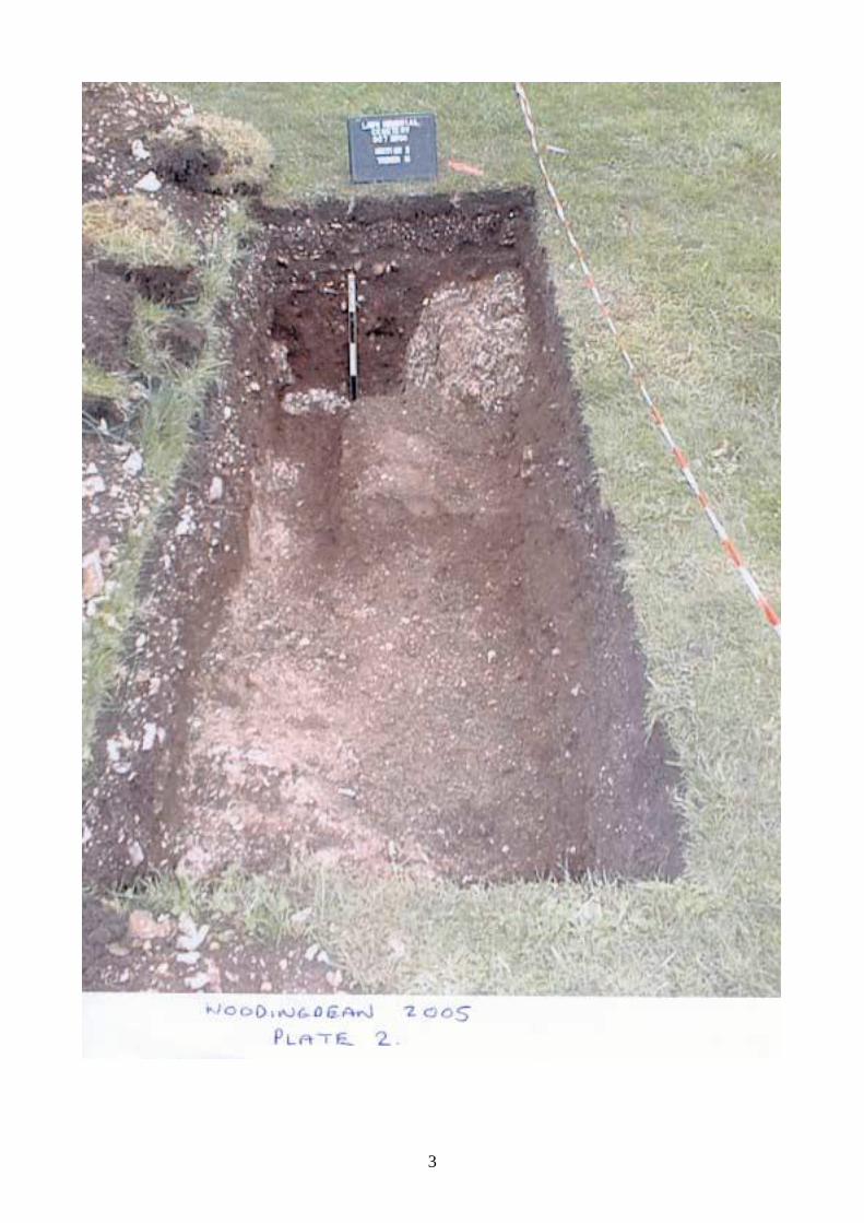
The Woodingdean Cemetery Project was reopened during the later part of March 2005.The investigation involve a further three trenches, (P) (R) (S) being opened in an attemptto identify possible ancient activity. (TQ350054). The location of these trenches wasgoverned by the visual topography of the land at the borders of the cemetery. Excavatedtrenches were recorded by planning and photography while artefacts extracted during theexcavation were collected for post-excavation analysis. Trench P was placed to cut anexisting compacted track way. The materials that made up the track way dated the trackway to the 20th Century, (Plate 1.) while the raised platform of soil it lay on contained someworked flint tools and flint flakes. Further analysis of the flint work will be required to placethese items into a more detailed date range. Trench R was positioned across a possibleancient field boundary, (Plate 2.) while Trench S was placed at the bottom of the hill slopeto see if the bottom of the slope had previously been a wetland area and how muchancient worked material had collected at the bottom, due to natural soil movement overtime. The investigation trenches were backfilled during May 2005.
Phase 2
Phase 2 consisted of a geophysical survey of the field to the west of the cemetery.(TQ348052). It is known that ancient bronze objects had been found in this field. A smallgeophysical survey was conducted which revealed a circular area of low resistance, whichmay be some form of enclosure. (Fig 2.) Further work will have to be carried out beforeany useful data, with regard the type of feature and what date it is can be, can establishwhether it is an ancient or modern feature.
Phase 3
Phase three consisted of field walking the field which lay to the south of the cemetery site(Fig 1.) where aerial photographs clearly show a collection of ancient field boundaries.(TQ353052). A base line was set out using the north boundary of the field. The fieldwalking consisted of lines set at 20 metres apart and the lines walked were divided into 20metre long transects. The fields were walked north to south going down the hill, the fieldunit paired off into two’s, and they walked a total of fifteen lines. Unfortunately the field hadnot been ploughed and was full of weed and scrub, which made walking difficult to carryout and also reduced the amount of artefacts collected. The unploughed surface reducedthe amount of researchable data. The artefacts that were collected at the end of each 20mgrid will be collated and recorded to allow any potential hot spots of possible ancientactivity to be recorded.
Norman Phippard

2
3

4

5
Page 1
Bushy Bottom, Shoreham
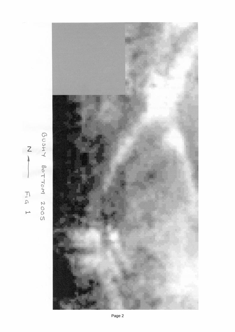
Introduction
In the latter part of 2004 the BHAS Field Unit received a request from a student atWinchester for help in conducting a major resistivity survey on earthworks at BushyBottom, north of Shoreham. The earthworks lie south of the television mast located on topof Truleigh Hill (TQ228097). The earthworks are at a considerable distance from the maintrack way which is the South Downs Way. It may this isolation that has preserved them.The Society is unaware as to whether ploughing has taken place on the fields in the past,but the state of preservation appears to suggest that the hill side has been purely used forpastoral purposes. The valley bottom was being ploughed during the survey.
The earthworks consist of a large curving bank that appears to be some form of enclosure(Fig 1.) Within this feature are a number of linear banks which are probably field systems.The survey was a project to seek geophysical evidence for a chronological sequence forthe interlinking features between the enclosure boundary and the field systems locatedwithin. The survey did not include plans for any subsequent excavation to confirm anyhypotheses formulated as a result of the surveying.
The enclosure is close to and east of the Iron Age hill-fort at Thundersbarrow Hill. Theearthworks at Bushy Bottom are just one of many earthworks observed and recorded inthis area over the past century. Very few of these earthworks have been investigatedthrough excavation. The features are considered to be relatively safe from destruction orerosion while they are being maintained as fields for grazing.
The survey was the subject of a project by Paul Clements, a student studying atWinchester. (The report is appended to this note). The majority of the extensive surveywas conducted by Paul aided by his mother Beth. The Society assisted at week-ends. Theequipment from Winchester initially had a number of technical problems which caused alarge part of the survey having to be undertaken a second time.
The survey began along the bottom of the hill and gradually extended eastwards andupwards from the valley bottom. (Fig 2.) The survey continued for a number of weeksduring January and early February of 2005.
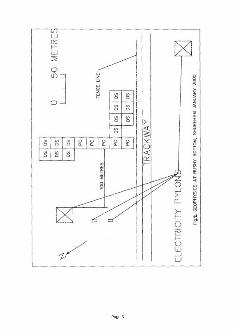
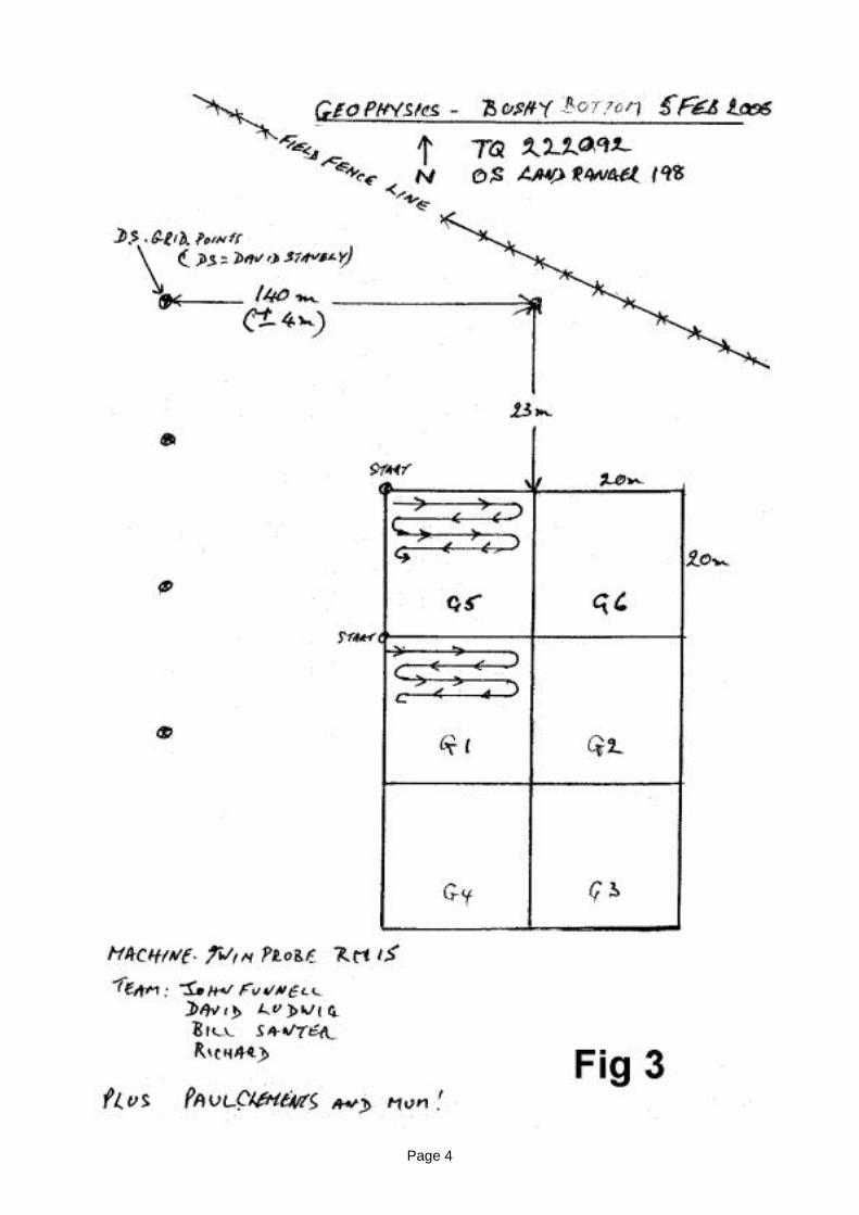
Methodology
The area to be surveyed was divided into a series of 20 metre square grids. A base linewas set up parallel to the fence line running north/south along the valley bottom and thesurvey moved eastwards and up the hill, examining both the enclosure ramparts, fieldsystem and surrounding area. (Fig.2)
The machines used were a four prong RM15 from Winchester and a TR Systems machinewas used by the BHAS Field Unit. The measurements were taken at 1 metre intervals andthe measurements recorded in Ohms. Both machines were used at a ‘minimum’ distanceof 40 metres between them to avoid any disruption and interference with the datacollection. During previous surveys, when two machines were used, confusing data wasnoted when the two machines were used within 40 metres of each other.
Page 2
Page 3
Page 4
Page 5
Results
The results of the survey produced some very interesting anomalies. The discussion aboutthe survey images and results are entirely the work of Paul Clements and his publisheddissertation. BHAS had no input for the dissertation producing only part of the datacollection. During the surveying a number of anomalies were observed in the landscape.The features appeared, possibly due to the low sun, as extended shadow marks and arelocated on the hill to the east of the valley. It is possible that the upper reaches of the hillside contain a number of subtle platforms. It would be very presumptuous to suggest thatthese ephemeral features are the sites of prehistoric house terraces, but evidence fromprehistoric sites at Downsview (Rudling) and Varley Halls, Coldean (Greig) do have astriking resemblance. It is possible that further surveying may provide evidence to confirmthe location of a settlement associated with the field systems examined.
Acknowledgements
The author would like to thank those members of the BHAS Field Unit who assisted in thesurveying. David Staveley who led the team comprising M.Greening, S.Corbett, E.Corbett,D.McBrien, D.Ludwig, R.Symonds, W.Santer and B. Collins.
References:-
Greig, I, 1997. ‘Excavations of a Bronze Age Settlement at Varley Halls, ColdeanLane, Brighton, East Sussex’, Sussex Archaeological Collections,135 pp7-58.
Rudling, D R, 2002 Forthcoming. ‘Downland Settlement and Land Use: theArchaeology of the Brighton ByPass’. UCL Field Archaeology UnitMonograph No.1, Institute of Archaeology, University College London
Page 6
PAUL CLEMENTS
GEOPHYSICAL SURVEY AND EARTHWORK SURVEYOF BUSHY BOTTOM, SUSSEX
January 2005
Page 7
ACKNOWLEDGEMENTS
I would like to acknowledge the help received from the people helped me with this project.First of all the National Trust and Brian Harris, the land owners, who kindly grantedpermission to carry out the work.
Keith Watson of West Sussex and Greg Chuter of East Sussex County Council CountyCouncil for taking time to sort out SMR data for me.
I would like to thank John Funnell and David Stavely of Brighton and Hove ArchaeologySociety and the others members who came out to help me with the resistivity survey.
John and Beth Clements who also spent time in the field helping with the geophysics.
Alex Turner for helping me with the geophysics equipment and the results.
Simon Roffey who helped with supervision over this report.
SYNOPSIS
The site of Bushy Bottom is located on top of the South Downs at NOR 523219 109481.Aerial photography of the area shows old field boundaries and another enclosure whichappears to be placed over these earlier field boundaries. From looking at the aerialphotography the earlier boundaries look to be part of a prehistoric coaxial network of fields.Further east their looks to be more of these prehistoric field systems. The later enclosurehas been suggested to be Roman. A map, c. 1870 of the area has a Roman Encampmentmarked on it (NGR 524511, 109615), about a mile east, which on modern maps is nowmarked as field systems. About one mile northeast of the site is the medieval village ofPerching, and to the north of the medieval village the remains of Fulking Castle, theremains of a Motte and Bailey. Also dotted around the area are barrows none of whichcome into the area of earthworks which I plan to study. Maps show that about half of thearea is owned by the National Trust and the other half privately owned. At present writtenpermission is still pending, but when received Brighton and Hove Archaeology Societyhave said that they will be willing to help with any practical work carried out there. At thesite I am planning to do a Geophysical survey of the area using both resistivity. This will becombined with a topography survey looking at the earthworks and recording them.
Page 8
CONTENTS
• Introduction• Historical Background• Site Topography And Geology• Aerial Photography• Enclosed Settlements Of Sussex• Settlements From England• Earthwork Survey• Resistivity Results• Conclusion• Appendix• Bibliography
ILLUSTRATIONS
Figure 1 Location Map 1:10000 (Multimap.com)Figure 2 Holleyman’s Results (Curwen, 1954, figure 89)Figure 3 Woodward’s 1904 Sussex Geology Map, figure 2Figure 4 1947 RAF Aerial PhotographyFigure 5 1988 Aerial Photography, West Sussex County CouncilFigure 6 1997 Aerial Photography, West Sussex County CouncilFigure 7, 2001 Aerial Photography, (GetMapping)Figure 8 Tollard Royal, Bowen and Forwler, Figure 2Figure 9 Groundwell Farm (Cunliffe, 1991, figure 12.11)Figure 10 Tollard Royal (Cunliffe, 1991, Figure 12.7)Figure 11 Carloggas (Thomas, 1966, figure 5)Figure 12 Truleigh Hill enclosureFigure 13 Geophysics of north west cornerFigure 14 Geophysics of Southern sectionFigure 15 Entrance GeophysicsFigure 16 Western Side of The EnclosureFigure 17 Resistivity Results on Map
Page 9
INTRODUCTION
Peasant farmsteads are common in Sussex, their locations tend to be on hilltops and inareas considered to be poor farming land. The Romanisation of Britain would have made adifference to the lives of the wealthier people of the society, but the people on the peasantfarms, it has been argued, would have noticed this to a much less extent (Millet,2003,186). Possibly due to being on the fringes of society or in more remote areas awayfrom centres of trade that would have helped with the spread of Roman ideas.Archaeological evidence has shown that they would have continued to farm the same landas their ancestors before them, using the same field systems. It also shows that the mainchange that they would have seen would have been an influx in the mass producedRoman pottery. Evidence of this is shown at Park Brow and Charleston Brow whichshowed that the local pottery was gradually replaced with the Roman wares (Curwen,1952, 222).
Early Iron Age settlements can fall into a variety of categories. The majority are notdefensive, but just defined by a bank and ditch to mark out the perimeter of the site,sometimes also with a stockade. The area enclosed varies a lot and can range from 0.5acres up to 10 acres or more. Generally smaller enclosures tend to have one single hut,but the larger enclosure do not, as would be expected, contain many huts forming a smallvillage. It should also be noted that not all settlements in the Iron Age were enclosed.Other sites, such as, Crannings Cross in Wiltshire and Slonk Hill in Sussex, were notdefined by any type of boundary, and these are known as open settlements (Harding,1974,21).
As Harding (1974, 21) points out, it is good to acknowledge that there is “always a dangerin assuming... .that enclosure ditches necessarily mark the outer limits of a settlement;conceivably such a boundary could delimit only the nucleus of the occupation.”
Page 10
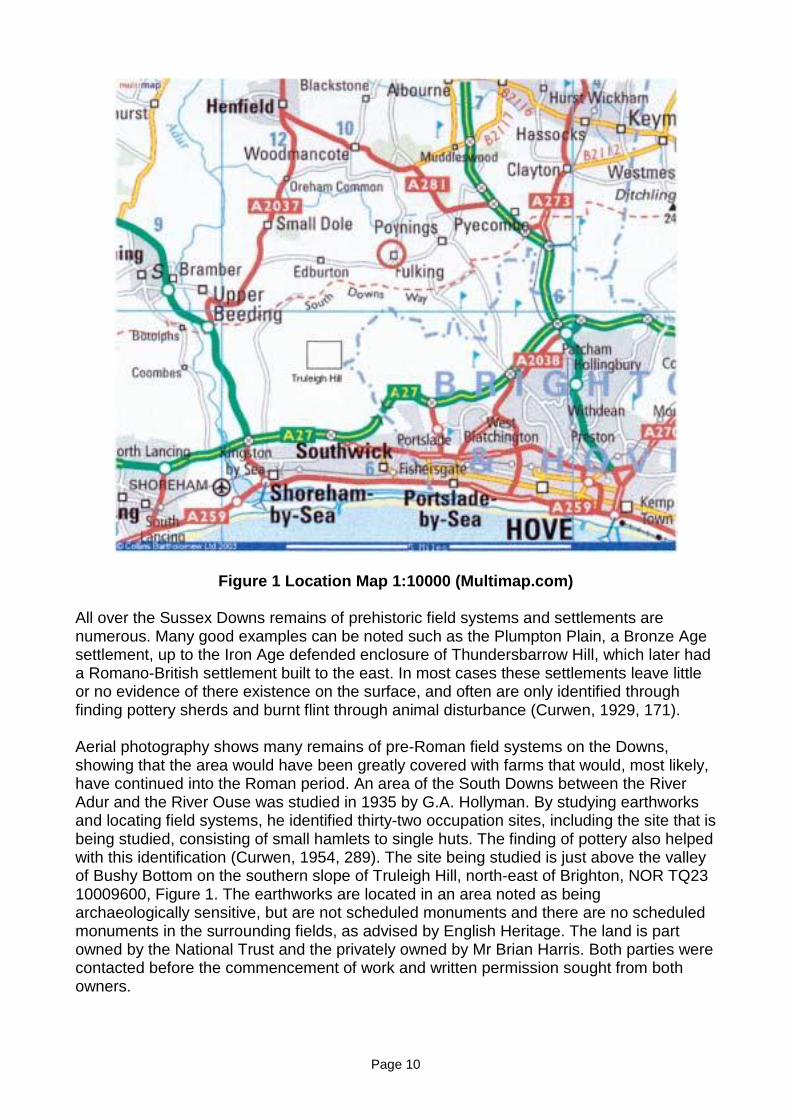
Figure 1 Location Map 1:10000 (Multimap.com)
All over the Sussex Downs remains of prehistoric field systems and settlements arenumerous. Many good examples can be noted such as the Plumpton Plain, a Bronze Agesettlement, up to the Iron Age defended enclosure of Thundersbarrow Hill, which later hada Romano-British settlement built to the east. In most cases these settlements leave littleor no evidence of there existence on the surface, and often are only identified throughfinding pottery sherds and burnt flint through animal disturbance (Curwen, 1929, 171).
Aerial photography shows many remains of pre-Roman field systems on the Downs,showing that the area would have been greatly covered with farms that would, most likely,have continued into the Roman period. An area of the South Downs between the RiverAdur and the River Ouse was studied in 1935 by G.A. Hollyman. By studying earthworksand locating field systems, he identified thirty-two occupation sites, including the site that isbeing studied, consisting of small hamlets to single huts. The finding of pottery also helpedwith this identification (Curwen, 1954, 289). The site being studied is just above the valleyof Bushy Bottom on the southern slope of Truleigh Hill, north-east of Brighton, NOR TQ2310009600, Figure 1. The earthworks are located in an area noted as beingarchaeologically sensitive, but are not scheduled monuments and there are no scheduledmonuments in the surrounding fields, as advised by English Heritage. The land is partowned by the National Trust and the privately owned by Mr Brian Harris. Both parties werecontacted before the commencement of work and written permission sought from bothowners.
Page 11
The first part of the work consisted of an earthwork survey of the lynchets forming the fieldsystem. This will be done in sketch plan format to a scale of 1cm: 25 metres A geophysicalsurvey of Resistivity will be done concentrating on the area of the enclosure. Thegeophysics will only look at some of the interior and the enclosure ditches, but notspecifically aimed at looking outside of the enclosure (method Appendix 1.)
The main aim of the survey is to look for any signs of human activity and possiblesettlement, and to use the data collected to make comparisons with other sites todetermine a possible use and date of the site.
HISTORICAL BACKGROUND
No excavation has been done on the site but has several mentions in documents. The firstwas in the 1929 version of The Journal of Roman Studies part two, page 210 when it says‘Dr. E. C. Curwen observed much pottery in a pitted area surrounded by characteristiclynchets, indicating a Romano-British village.’ The same details are given in his bookPrehistoric Sussex, but also adds that he was following an ancient track way (1929, 94).The West Sussex SMR record for the site (SMR Number 4365 -WS875) also mentionsthese details and includes that ‘A bivallate Celtic road runs N and S up the hill withbranches to left and right: It also notes that the pottery found by Curwen has now beenlost, so this can not be looked at again to see if it was Iron Age. Assuming that the sitecontinued to be used into the Roman period it would be thought that some Roman potterywould have been found as well.
The nearest, main, Iron Age site is the settlement on Thundersbarrow Hill. This locatedabout 1 mile south of the enclosure. Thundersbarrow Hill was occupied from the Iron Agewith a small defended enclosure. A later Romano-British settlement was then located tothe east of the enclosure. Looking north from this point it is possible to see some of thefield systems on Truleigh Hill and the enclosure.
The Thundersbarrow farm settlement is the centre point of the large area of lynchets,containing roads that link it to other farms in the area (Curwen, 1952, 291). Containingseveral huts it also has its own corn drying kilns and may suggest that the site on thesouthern slope of Truleigh Hill may have been controlled by this settlement or at least thatthis could have been the main storing area of grain for a few settlements in the locality,based on its Iron Age history which the people may still of had links with.
Page 12
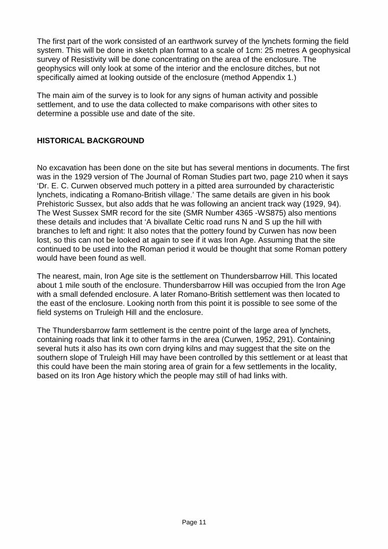
Figure 2 Holleyman’s Results (Curwen, 1954, figure 89)
When looking at the results collected by Holleyman (Figure 2) you can see how thefarmsteads in this area can be grouped together. Looking at the group containing the site Iam looking at, it is in a group of 7 settlements. One settlement is located in the centre ofthis group and this one is Thundersbarrow with Truleigh Hill to the north.
This may be coincidence with the way the sites have been grouped, but with its Iron Agedefenses and the only one known to have corn dryers it would be viable that this could bea central point for the farms grouped in this area. It is clear to see that the Sussex chalkDown lands supported a dense distribution of non villa settlements (Hingley, 1989, 56).
Several early Roman villas can be found within the area. The nearest villa to the site is inthe Southwick area of Brighton about 5 miles south-east. It is also possible that thesefarmsteads, as thought by some people, could be linked with villas. These smallfarmsteads working parts of the land for these wealthier people. No extensive work hasbeen done on these links and a problem looking at it in this way is that there is no real wayto identify which land would have been owned by which villa or landowner. There is alsothe possibility of overseas absentee landowners who are known of in the Roman Empire,but in Britain only one is known about (Millett, 1990, 189). Four villas in total are known ofin this area, all are in the lower regions of the downs. As with villas generally, they arelocated near to roads, these where it is thought a road would have gone from Brighton toLewes, and as such it not possible to gain much information on their links with thefarmsteads. From the distances between these two types of settlement, it would suggestthat they are separate from the villas but most likely worked in small groups of settlementsworking areas of land that were deemed to be bad farming
Page 13
SITE TOPOGRAPHY AND GEOLOGY
The site consists of a series of lynchets forming a prehistoric field system, with apresumed later enclosure, possibly of Roman date. Located on the South facing slope ofTruleigh Hill the enclosure measures c.220 metres from the fence at the eastern edge tothe western lynchet, and c. 160 metres from the most southerly edge to the northernlynchet. The shape of the enclosure is of a rounded triangle shape, but the eastern tip isnot visible beyond the later fence that cuts it. The lynchets of the enclosure, althoughflattened slightly by ploughing, are still c. 50cm up to c. 1 metre high along the northernedge. The field itself had been ploughed, but this stopped in1989.
The lynchets forming the field systems are clearly visible from the ground. Flintconcentrations, more so on the lynchets of the enclosure, can be seen through the grass.This is most noticeable On the northern and western lynchets. It has also resulted in thegrass being lighter than that that surrounds it. The flint banks are seen at other sites in thelocal area, which are discussed below.
Within the enclosure lynchets running east-west of the fields systems can be seen to enterit. A double lynchet feature also appears on the aerial photography, entering at thesouthern edge. The enclosure and the associated field systems have no major animaldisturbance, only a few small holes no more than 10cm deep with no finds disturbed.
North of the site in the same field earthworks are also visible. These appear more liketerraces and extend from the far north of the field, to the field systems and the enclosureand will be mentioned more in the aerial photography.
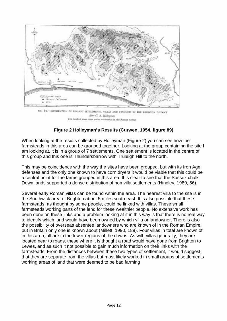
The geology of the site chalk with flint, as shown below.
Figure 3 Woodward’s 1904 Sussex Geology Map, figure 2
Page 14
MAPS
The earliest map of the site is the first edition Ordnance Survey map of 1874/5 (Appendix4). This map shows the western edge of the later enclosure and eastern extent of the fieldsystems running in a northern direction. The north-western corner of the enclosure isclearly visible and appears to be shown joining with the south running lynchet of thewestern most field. This section is clearly shown as a bank with hatchets in oppositedirections showing it to be a quite substantial earthwork. One other item of interest is thelocation of a barrow immediately to the north. The 1898 second edition OS map has noextra information or features. The maps of 1912 and 1947 still show the same earthworksand described as mounds. From the 1960’s OS maps the tumulus shown at the top of thehill is no longer mentioned and today is not a scheduled monument. The 1968 map showsthe north and south earthworks of the enclosure, but now leaves out the western side. Italso show the approximate boundary of the enclosure as being fenced off as a black line.In the 1972 OS map it shows no earthworks in the area. Other comparisons with theearlier 1968 map show that it just less detailed. One last point to note is that no earthworksare shown for the north of the field, where earthworks are visible in aerial photography.
AERIAL PHOTOGRAPHY
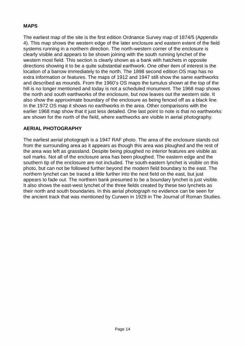
The earliest aerial photograph is a 1947 RAF photo. The area of the enclosure stands outfrom the surrounding area as it appears as though this area was ploughed and the rest ofthe area was left as grassland. Despite being ploughed no interior features are visible assoil marks. Not all of the enclosure area has been ploughed. The eastern edge and thesouthern tip of the enclosure are not included. The south-eastern lynchet is visible on thisphoto, but can not be followed further beyond the modern field boundary to the east. Thenorthern lynchet can be traced a little further into the next field on the east, but justappears to fade out. The northern bank presumed to be a boundary lynchet is just visible.It also shows the east-west lynchet of the three fields created by these two lynchets astheir north and south boundaries. In this aerial photograph no evidence can be seen forthe ancient track that was mentioned by Curwen in 1929 in The Journal of Roman Studies.
Page 15
Figure 4 1947 RAF Aerial Photography
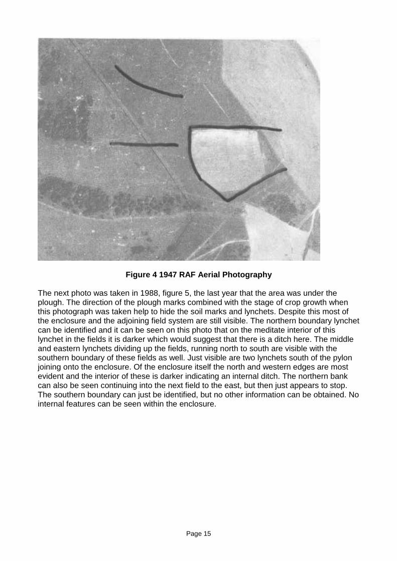
The next photo was taken in 1988, figure 5, the last year that the area was under theplough. The direction of the plough marks combined with the stage of crop growth whenthis photograph was taken help to hide the soil marks and lynchets. Despite this most ofthe enclosure and the adjoining field system are still visible. The northern boundary lynchetcan be identified and it can be seen on this photo that on the meditate interior of thislynchet in the fields it is darker which would suggest that there is a ditch here. The middleand eastern lynchets dividing up the fields, running north to south are visible with thesouthern boundary of these fields as well. Just visible are two lynchets south of the pylonjoining onto the enclosure. Of the enclosure itself the north and western edges are mostevident and the interior of these is darker indicating an internal ditch. The northern bankcan also be seen continuing into the next field to the east, but then just appears to stop.The southern boundary can just be identified, but no other information can be obtained. Nointernal features can be seen within the enclosure.
Page 16
Figure 5 1988 Aerial Photography, West Sussex County Council
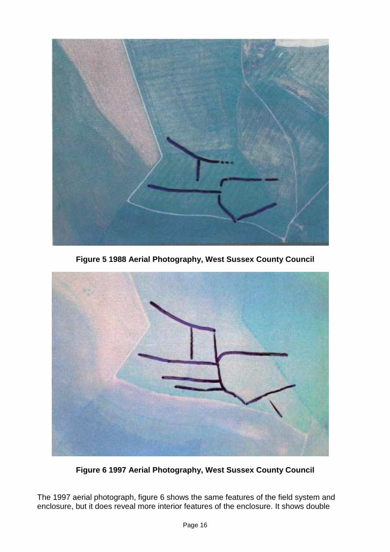
Figure 6 1997 Aerial Photography, West Sussex County Council
The 1997 aerial photograph, figure 6 shows the same features of the field system andenclosure, but it does reveal more interior features of the enclosure. It shows double
Page 17
lynchet feature entering the enclosure from the south-east, this likely to be the ancienttrack way mentioned by Curwen. It appears as though the track joins with the southernmost east-west field lynchet, and also continues in an arc shape north. The track can notbe followed further south than the edge of the modern field. The north western corner ofthe enclosure appears to show a continuation of the field system lynchet indicating thatthis part of the field predates the enclosure.
The most modern aerial photograph was taken around 2001, figure 7. This photographshows the enclosure and field systems clearly and adds extra features to the interior of thesite. The track way again is clearly shown and seen to pass the enclosure bank. North ofthis point a double lynchet feature can be seen by the field edge and may well be part ofthe track way, that on the SMR describes it as branching east and west. To the west of theenclosure interior is a semi circular feature, but it is not clear how it relates to otherfeatures from the photograph.
Figure 7, 2001 Aerial Photography, (GetMapping)
Page 18
ENCLOSED SITES IN SUSSEX
Plumpton Plain is an area which hosts the site a Bronze Age settlement (Curwen, 1929,92) located on a southern spur of Down land. The site contains two settlements bothdating to the Late Bronze Age, although in use at separate times. Each of the enclosureswere approached by a track way which runs directly past all of the enclosures. Three ofthe enclosures on the site were excavated in 1934 by Brighton and Hove Archaeologicalsociety under G. A. Holleyman and E Curwen (Curwen, 1954, 175). The soil was removeddown to the natural chalk. Many postholes were found to have been dug into the chalk, butwere now filled with flint. A total of three round huts were identified from the postholes,measuring about 6 metres in diameter. The second area of settlement, Settlement B, wasexcavated at the same time, although there were no major earthworks at this area,postholes were found which showed three more huts.
Another good example of Bronze Age settlement can be seen at New Barn Down. Thissite was excavated in 1933. It showed evidence of two huts and along the southern bankevidence of some type of palisade, with postholes found about 90 cm apart. (Curwen,1954, 179). The New Barn site was located on the south eastern spur of Harrow Hill. Theenclosure was approached by a double lynchet track way from the west, which then ransouth through the field systems. New Barn consisted of two enclosures, compared withthat at Plumpton Plain , which had 3 contemporary huts aligned along a track way. ItfordHill seven or eight conjoined enclosures, not all contemporary, were found with threeseparate huts scattered further away. It is evident that some settlements were individualfarmsteads and others could have taken the form of small hamlets or villages (Cunliffe,1991, 44).
More recently other excavations, conducted during the construction of the Brighton bypassbetween 1989 and 1990 (Rudling, 2002, xix), have been carried out on other Bronze agesites around the edge of Brighton.
One notable site being that of Eastwick Barn. This area had many large lynchets that hadsurvived well due to the lack of modern cultivation. The site was located in the bottom of adry valley (Rudling, 2002, 107). The field system lynchets were constructed of banks offlints randomly placed into lose soil, and has been suggested that these flints were part offield clearance. Many of the lynchets when excavated revealed Iron Age to Romano-Britishpot sherds, and Later Bronze Age pottery sherds were also found (Rudling, 2002, 110).
At Park Brow, near Sompting, one mile north of Cissbury, there were traces of fieldsystems and evidence of a succession of settlements dating from the late Bronze Agethrough to latter part of Roman period (Curwen, 1929, 171). A short distance from theBronze Age site is an early Iron Age settlement (Drewet, Rudling, Gardiner, 1988,133). Onthe South downs continuity of settlements appears to have occurred from the Bronze Agethrough to the Roman period and this is evident at Park Brow through the three distinctsettlement areas (Hingley, 1989, 129).
Closer to the site on Truleigh Hill, only about two miles south-east, were excavations atMile Oak Farm in 1989 as part of the bypass excavations. Very shallow lynchets werevisible and were presumed to be iron age to Romano-British in date. The excavationsrevealed three round house structures, of middle Bronze Age date, which may have beencontemporary or a succession of buildings. An early Bronze Age henge monument wasalso uncovered during these excavations. Evidence of later Bronze Age metal working wasalso uncovered. Very few finds dating to the Iron Age and Romano British period were
Page 19
found, with only pot sherds from the top soil, although a dolphin brooch, made of copperalloy, of the mid second century, and a silver Iron Age coin of Verica were found (Rudling,2002, 80).
Hollingbury and Park Brow in Sussex both have trenches for use with a rectangularpalisaded enclosure. At Park Brow around 30 metres was uncovered, whereas atHollingbury only one side, 46m long was uncovered with a central entrance point. Lack ofexcavation within the enclosures and palisade trenches means identifying the use isdifficult and may have been specialised structures, and possibly not settlements (Cunliffe,1991, 216).
The typical Roman site consists of a settlement enclosure and associated track ways andlinear boundaries (Hingley, 1989, 56). Rural settlements vary greatly in size. The bestresearched area is the Fenlands of Cambridgshire, Norfolk and Lincolnshire (Hingley,1989, 75). Single farm settlements are more common on the north and west, whereas insouthern Britain these tend to be less common (Hingley, 1989, 76).
Black Patch is slightly different. Here terraces for the huts are scattered amongst the fieldsystems. One of the terraces was fully excavated and revealed five circular houses withina fenced enclosure. The plans suggested that they were all of very similar date withoccupation of around 30-50 years. Studies of the artifacts found on the floors of the hutsgave an indication of there uses. It revealed hut 1 was used mainly for food production, hut3 for craftwork and storage while hut 4 showed evidence of both uses. Little evidencesurvived in huts 2 and 4. This one terrace can be seen as an independent settlement, butit is not fully known how it would relate to the other terraces in the area (Cunliffe, 1991,29).
Itford Hill is a series of embanked earthworks terraced into the hill side dating to the LaterBronze Age (Russell, 2002,102) and shows a dense nucleation of enclosures (Cunliffe,1991, 30) as shown in figure Russell 102. The main fenced enclosure revealed elevenhuts, now thought to have constructed over four separate phases (Russell, 2002,103).
From these sites it can be seen that in general they were located on south facing spurs ofDownland and typically had some continuity in use from the Bronze Age through to the lateIron Age and Romano British periods.
Page 20
SETTLEMENTS FROM ENGLAND
SETTLEMENT ON THE CHALKLANDS
The basic structure of the enclosure on the chalk lands of southern Britain tends to be ofsub rectangular shape of various combinations of banks, ditches and palisades. (Cunliffe,1991, 28)
Shearplace Hill in Dorset is a settlement enclosed by a ‘U’ shaped ditch c.3m wide, with aninternal bank which may been constructed with a palisade. (Cunliffe, 1991, 28) In Sussex,however, at Cock Hill the bank and palisade are on the outside of a c.2m wide ditch(Cunliffe, 1991, 28).
At all of these examples evidence of postholes within the enclosures show that theyenclosed circular huts c.6-7.5m in diameter. New Barn contained at least two, ShearplaceHill contained three, Cock Hill had at least five and Thorny Down contained up to ninehuts, but these may not have been in use at the same time. (Cunliffe, 1991, 28). With thenumber of buildings and size of the enclosures Cunliffe (1991, 29) says they “would havebeen ideally suited to a social group of family or extended family size.”
Mother type of enclosure in the same area and of similar date, are banked enclosures withthe ditch on the outside, but show little evidence of any habitation. South Down Lodge andMartin Down Camp are two examples of this type of enclosure, both from CranbourneChase and both excavated by Pitt Rivers. Both are rectilinear in shape. South Lodge hasone entrance and Martin Down has two, but appears to have an undefended. Theexcavations of Pitt Rivers revealed the interiors to be void of any features, except for a fewpits which were undated. The re-excavation of South Lodge revealed that it wasconstructed within an existing field system and the interior contained evidence for tworound huts, and also other single pits and post holes. (Cunliffe, 1991, 41)
In these areas settlements were generally enclosed by a bank and sometimes with apalisade or thick hedge set into it, and with some type of gate entrance. The enclosuresaverage 0.4- 0.8 ha, within them one or possibly more simple round hut, arranged leavingenough space for other domestic activities.
Shearplace Hill in Dorset consisted of substantial ditch with a bank on the interior, but hadno evidence of a palisade. Ditches can also be seen at Boscombe Down East, Wiltshireand at numerous sites on the Marlborough Downs. The sites in Sussex which have ditchesappear to be a minor part of the enclosure, with the focus on the palisade in the bank. Thismay be a regional development rather than chronological one, but from the seventhcentury to the around the third century BC the favour tends to have been with a palisadeinstead of the Bank (Cunliffe, 1991, 214).
The most extensively excavated pallisaded site in Britain is that at Little Woodbury, inWiltshire. Two phases of continuous activity can be seen. The first phase saw the farmenclosed by a palisade only on the eastern side where the main entrance into the site, afour post gate, was found. Within the enclosure was a circular hut 13.7 m in diameter withentrance aligned with the gate. How far the palisade extended is unknown, but the ditch itwas replaced with enclosed an area of 1.6 ha, which can be used estimate the originalpalisaded area. Domestic activities also left there mark within the enclosure. A largeirregular working hollow where grain parching and cooking may have taken place, behindthe hut was uncovered. The earliest phase of occupation can not be dated with precision,
Page 21
but based on the earliest pottery assemblages, their styles date from the fifth to sixthcenturies BC, but a few sherds of the Kimmeridge-Caburn ware would date it to possiblyearly sixth century BC (Cunliffe, 1991, 215).
Little Woodbury, Meon Hill and the Caburn all had their palisades replaced byearthen banks and ditches. They can be dated to be around the fourth to first century BC,based on the finding of Saucepan Pots which were in use at around that time (Cunliffe,1991, 218).
Excavations at Little Woodbury have shown that the palisade was replaced with ditch 14metres wide and 2 metres deep (Harding, 1974, 22) and would have had a bank of thechalk that was dug from it (Cunliffe, 1991,218). It would have enclosed a circular area of1.6 ha. and had one wide entrance but no gate structure was found (Cunliffe, 1991,218).The earthwork would have enclosed houses, granaries, pits and working hollows. The sizeof the ditches Harding (1974,22) suggests would best function “as a protective boundaryagainst intruders or wild animals at night.” Antennae ditches leading from the easternentrance of the enclosure were possibly used to funnel animals into the centre (Harding,1974, 23) suggesting that the enclosure was used as an animal corral as well. About 500metres away is Greater Woodbury was excavated at the same time. A section was dugthrough the ditch of the enclosure. This was significantly larger, being 7 metres wide andalmost 4 metres deep (Harding, 1974, 23).
Swallowcliff, in Wiltshire, started off like Little Woodbury, with a palisade, and it initial usecontemporary with Little Woodbury. Although it was excavated before modern methodsand apart from pits not much else was of significance was identified (Cunliffe, 1991, 215).
At Gussage All Saints, in Wiltshire, there are two phases of activity. The first phase datesto around the fifth century BC based on C14 dating and other artifacts. A ditch 1.2 metreswide and 0.8 metres deep enclosed an area of around 1.2 ha with a bank on the outside.Like Little Woodbury there are also antennae ditches, to guide animals into the enclosure(Harding, 1974, 22).Within the enclosure were lots of pits, and possible evidence of fourpost granary structures, but no signs of houses (Cunliffe, 1991, 218). During the secondphase a more substantial ditch was dug, 2.2 metres wide and 1.4 metres deep andgenerally followed the same alignment as the first ditch. The entrance was now served bya timber gateway. Pits continued to be dug within the enclosure and circular gulliessuggest the locations of huts. Radiocarbon dating gave an occupation period from the thirdcentury to first century BC, towards the end of this occupation there is evidence of bronzefoundry activity (Cunliffe, 1991,219).
Also found in the South is another type of settlement, but more extensive. Worthy Downand Owslebury, in Hampshire and Casterley Camp in Wiltshire, are all characterised bytheir complex series of ditches defining various size and shapes of enclosures. Some werebeing used for living, and others, like Owsiebury, were used for burial. It is presumed thatothers would have been used for keeping animals (Cunliffe, 1991, 226).
On the South Downs in the area of Chalton, in Hampshire, a detailed study has beencarried out and has shown the density of settlements in this area, all linked to their fieldsand to each other by a series of trackways. In an area 5km2 eleven settlements wereidentified all less than 500 metres from their neighbor (Cunliffe, 1991, 227) showing that allof the South Downs would have been densely populated.
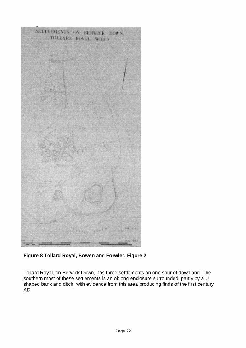
Page 22
Figure 8 Tollard Royal, Bowen and Forwler, Figure 2
Tollard Royal, on Berwick Down, has three settlements on one spur of downland. Thesouthern most of these settlements is an oblong enclosure surrounded, partly by a Ushaped bank and ditch, with evidence from this area producing finds of the first centuryAD.
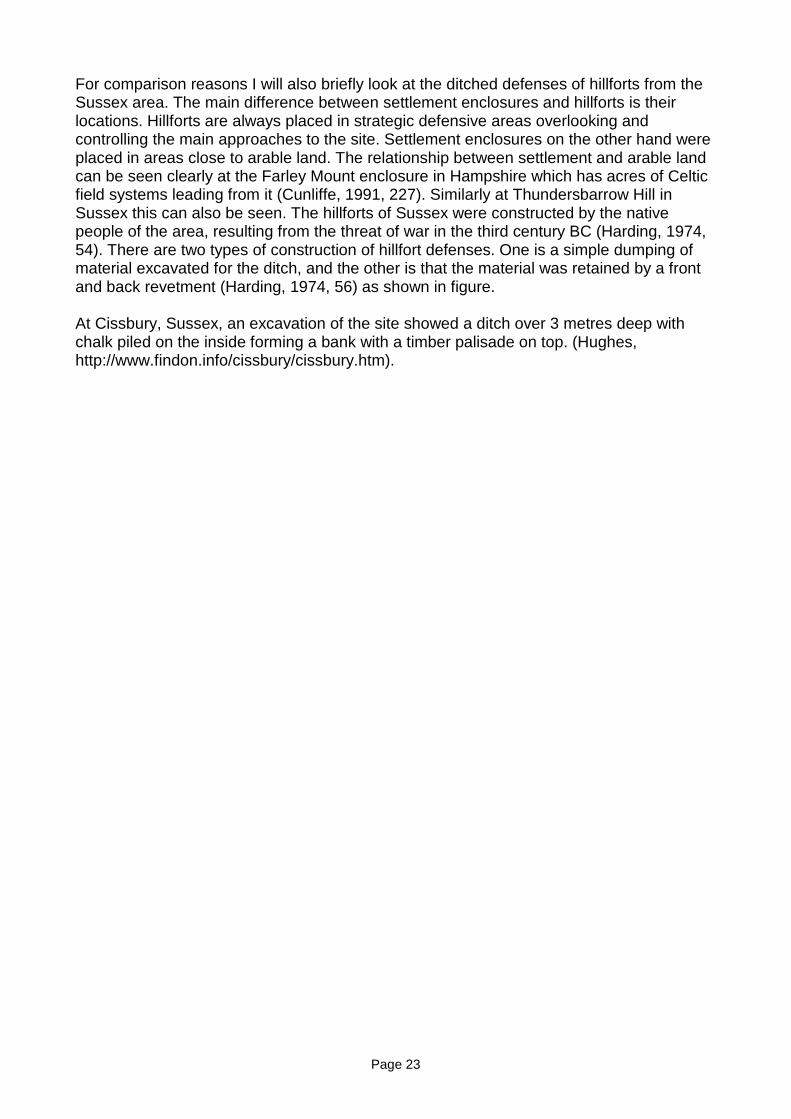
Page 23
For comparison reasons I will also briefly look at the ditched defenses of hillforts from theSussex area. The main difference between settlement enclosures and hillforts is theirlocations. Hillforts are always placed in strategic defensive areas overlooking andcontrolling the main approaches to the site. Settlement enclosures on the other hand wereplaced in areas close to arable land. The relationship between settlement and arable landcan be seen clearly at the Farley Mount enclosure in Hampshire which has acres of Celticfield systems leading from it (Cunliffe, 1991, 227). Similarly at Thundersbarrow Hill inSussex this can also be seen. The hillforts of Sussex were constructed by the nativepeople of the area, resulting from the threat of war in the third century BC (Harding, 1974,54). There are two types of construction of hillfort defenses. One is a simple dumping ofmaterial excavated for the ditch, and the other is that the material was retained by a frontand back revetment (Harding, 1974, 56) as shown in figure.
At Cissbury, Sussex, an excavation of the site showed a ditch over 3 metres deep withchalk piled on the inside forming a bank with a timber palisade on top. (Hughes,http://www.findon.info/cissbury/cissbury.htm).
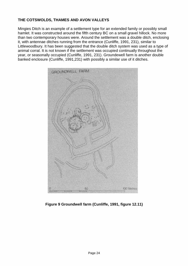
Page 24
THE COTSWOLDS, THAMES AND AVON VALLEYS
Mingies Ditch is an example of a settlement type for an extended family or possibly smallhamlet. It was constructed around the fifth century BC on a small gravel hillock. No morethan two contemporary houses were. Around the settlement was a double ditch, enclosingit, with antennae ditches running from the entrance (Cunliffe, 1991, 231), similar toLittlewoodbury. It has been suggested that the double ditch system was used as a type ofanimal corral. It is not known if the settlement was occupied continually throughout theyear, or seasonally occupied (Cunliffe, 1991, 231). Groundewell farm is another doublebanked enclosure (Cunliffe, 1991,231) with possibly a similar use of it ditches.
Figure 9 Groundwell farm (Cunliffe, 1991, figure 12.11)
Page 25
EARTHWORK SURVEY
The earthwork survey was carried out over the whole area of the enclosure and theadjoining field systems. As with the aerial photographs, the possible boundary lynchet, tothe north, is still clearly visible from the ground. It virtually follows the contour of the hilleast-west. The north side of this lynchet on the west has been flattened and is only justvisible from this side although the eastern area is identifiable from the north. The threefield system boundaries that divide the fields south of this lynchet all clearly show up onthe later aerial photography. From the ground the only one that can be seen in full is thecentre lynchet, and this one is clearer towards the north. The southern two thirds graduallyget shallower until it can not be seen, just before the southern boundary. The westernmost bank can only be identified about halfway between the northern and southern banksmaking up the field. The eastern lynchet of these three fields, from the ground, joins withnorthern boundary and this area is very clear, but does again very quickly become low anddisappears before reaching the corner of the enclosure. The northern boundary lynchetcontinues for a few metres past the top of this bank on a similar alignment, but from theaerial photography it shows that this is different and not part of the boundary lynchet, partof an earlier series of lynchets.
Marking the southern edge of these fields, an east-west lynchet, very much destroyed, isvisible as a small bank dropping away on the southern side. It can be traced from themodern day field boundary at the western side through to the enclosure. How it relatesexactly with the enclosure can not be exactly inferred, but from what can be seen from theground it most likely butts against the enclosure. South, below the pylon, is a bank whichruns east-west along to the enclosure and can be traced to the south-west corner of themodern field, although by this time it is very shallow and not well defined. Where it meetsthe enclosure it can be seen to continue for about 3-5 metres inside the enclosure, but hasbeen flattened inside. South of this lynchet is an east-west bank, just above the telegraphpoles, within the modern field. Just past these it is destroyed and can not be followed anyfurther west. Eastwards it can followed, almost, to the enclosure, with a 3-4 metre gap, butthen continues within the enclosure. This is the most notable of the features inside theenclosure, defined by a large bank dropping away southwards, continuing in the east-westdirection. At the eastern end of this lynchet it becomes lower, and can be seen to curvenorthwards, but then can not be seen where it continues to. This feature can be seen onthe modern aerial photography and looks to be earlier than the enclosure.
The area between the lynchet south of the pylon and the lynchet above the telegraphpoles is flatter than the general slope of the hill and possibly part of a track way. The trackidentified from the aerial photography can be seen on the ground in very low lynchets. Justbarely visible in the south-east corner of the field one side can be seen just above the fieldboundary. It is cut by another shallow feature, which from aerial photography and themaps, no feature can be seen on these to identify what it is as it does not continue farenough to link with any other features. When looking from the top of the hill to this cornerof the field a line can be seen from the southern field boundary moving north-east to joinup, almost, with the modem tracks going north and north-east. The 1947 aerialphotography shows a track coming down off of the hill opposite and crossing this area, sothis is part of the old footpath that went through here before the modern field boundaries.
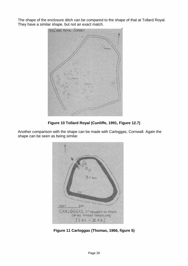
Page 26
The shape of the enclosure ditch can be compared to the shape of that at Tollard Royal.They have a similar shape, but not an exact match.
Figure 10 Tollard Royal (Cunliffe, 1991, Figure 12.7)
Another comparison with the shape can be made with Carloggas, Cornwall. Again theshape can be seen as being similar.
Figure 11 Carloggas (Thomas, 1966, figure 5)
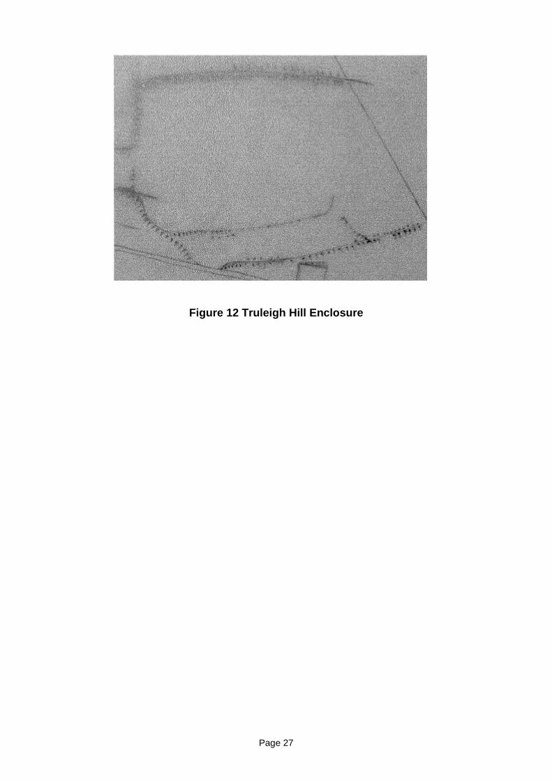
Page 27
Figure 12 Truleigh Hill Enclosure
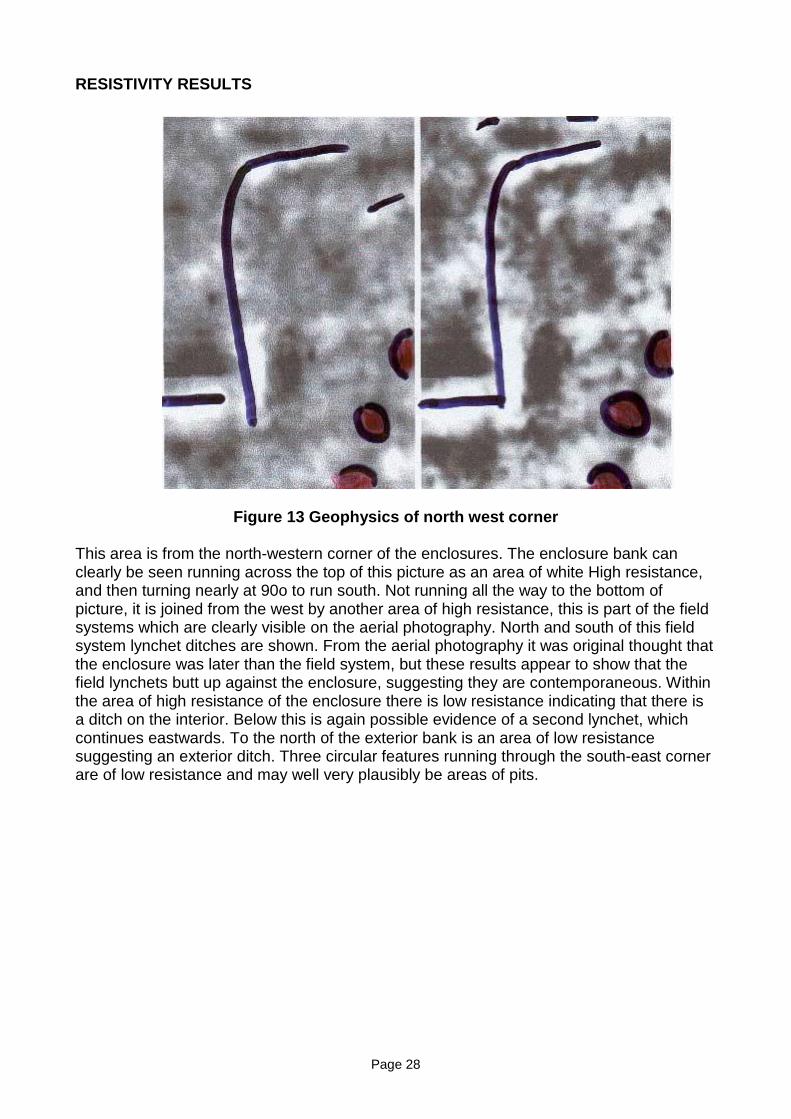
Page 28
RESISTIVITY RESULTS
Figure 13 Geophysics of north west corner
This area is from the north-western corner of the enclosures. The enclosure bank canclearly be seen running across the top of this picture as an area of white High resistance,and then turning nearly at 90o to run south. Not running all the way to the bottom ofpicture, it is joined from the west by another area of high resistance, this is part of the fieldsystems which are clearly visible on the aerial photography. North and south of this fieldsystem lynchet ditches are shown. From the aerial photography it was original thought thatthe enclosure was later than the field system, but these results appear to show that thefield lynchets butt up against the enclosure, suggesting they are contemporaneous. Withinthe area of high resistance of the enclosure there is low resistance indicating that there isa ditch on the interior. Below this is again possible evidence of a second lynchet, whichcontinues eastwards. To the north of the exterior bank is an area of low resistancesuggesting an exterior ditch. Three circular features running through the south-east cornerare of low resistance and may well very plausibly be areas of pits.
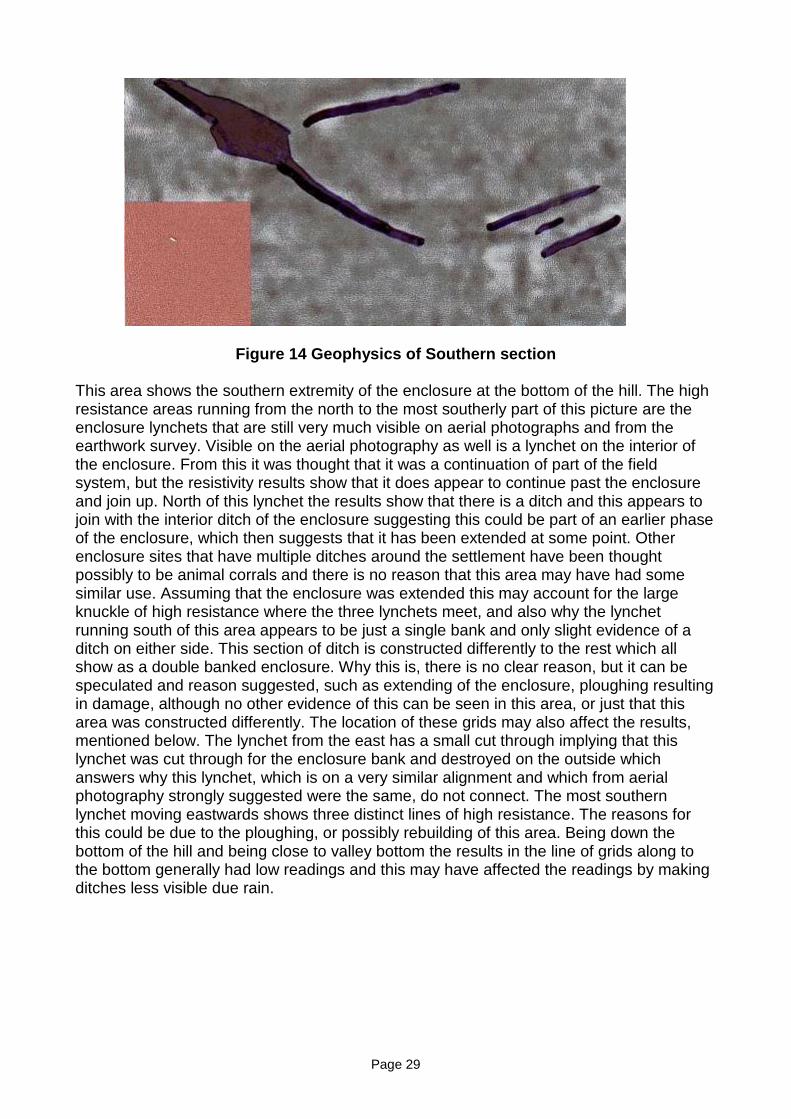
Page 29
Figure 14 Geophysics of Southern section
This area shows the southern extremity of the enclosure at the bottom of the hill. The highresistance areas running from the north to the most southerly part of this picture are theenclosure lynchets that are still very much visible on aerial photographs and from theearthwork survey. Visible on the aerial photography as well is a lynchet on the interior ofthe enclosure. From this it was thought that it was a continuation of part of the fieldsystem, but the resistivity results show that it does appear to continue past the enclosureand join up. North of this lynchet the results show that there is a ditch and this appears tojoin with the interior ditch of the enclosure suggesting this could be part of an earlier phaseof the enclosure, which then suggests that it has been extended at some point. Otherenclosure sites that have multiple ditches around the settlement have been thoughtpossibly to be animal corrals and there is no reason that this area may have had somesimilar use. Assuming that the enclosure was extended this may account for the largeknuckle of high resistance where the three lynchets meet, and also why the lynchetrunning south of this area appears to be just a single bank and only slight evidence of aditch on either side. This section of ditch is constructed differently to the rest which allshow as a double banked enclosure. Why this is, there is no clear reason, but it can bespeculated and reason suggested, such as extending of the enclosure, ploughing resultingin damage, although no other evidence of this can be seen in this area, or just that thisarea was constructed differently. The location of these grids may also affect the results,mentioned below. The lynchet from the east has a small cut through implying that thislynchet was cut through for the enclosure bank and destroyed on the outside whichanswers why this lynchet, which is on a very similar alignment and which from aerialphotography strongly suggested were the same, do not connect. The most southernlynchet moving eastwards shows three distinct lines of high resistance. The reasons forthis could be due to the ploughing, or possibly rebuilding of this area. Being down thebottom of the hill and being close to valley bottom the results in the line of grids along tothe bottom generally had low readings and this may have affected the readings by makingditches less visible due rain.
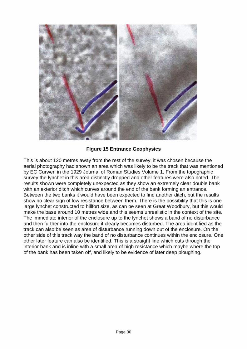
Page 30
Figure 15 Entrance Geophysics
This is about 120 metres away from the rest of the survey, it was chosen because theaerial photography had shown an area which was likely to be the track that was mentionedby EC Curwen in the 1929 Journal of Roman Studies Volume 1. From the topographicsurvey the lynchet in this area distinctly dropped and other features were also noted. Theresults shown were completely unexpected as they show an extremely clear double bankwith an exterior ditch which curves around the end of the bank forming an entrance.Between the two banks it would have been expected to find another ditch, but the resultsshow no clear sign of low resistance between them. There is the possibility that this is onelarge lynchet constructed to hillfort size, as can be seen at Great Woodbury, but this wouldmake the base around 10 metres wide and this seems unrealistic in the context of the site.The immediate interior of the enclosure up to the lynchet shows a band of no disturbanceand then further into the enclosure it clearly becomes disturbed. The area identified as thetrack can also be seen as area of disturbance running down out of the enclosure. On theother side of this track way the band of no disturbance continues within the enclosure. Oneother later feature can also be identified. This is a straight line which cuts through theinterior bank and is inline with a small area of high resistance which maybe where the topof the bank has been taken off, and likely to be evidence of later deep ploughing.
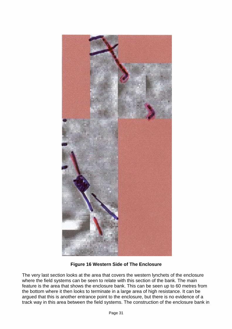
Page 31
Figure 16 Western Side of The Enclosure
The very last section looks at the area that covers the western lynchets of the enclosurewhere the field systems can be seen to relate with this section of the bank. The mainfeature is the area that shows the enclosure bank. This can be seen up to 60 metres fromthe bottom where it then looks to terminate in a large area of high resistance. It can beargued that this is another entrance point to the enclosure, but there is no evidence of atrack way in this area between the field systems. The construction of the enclosure bank in
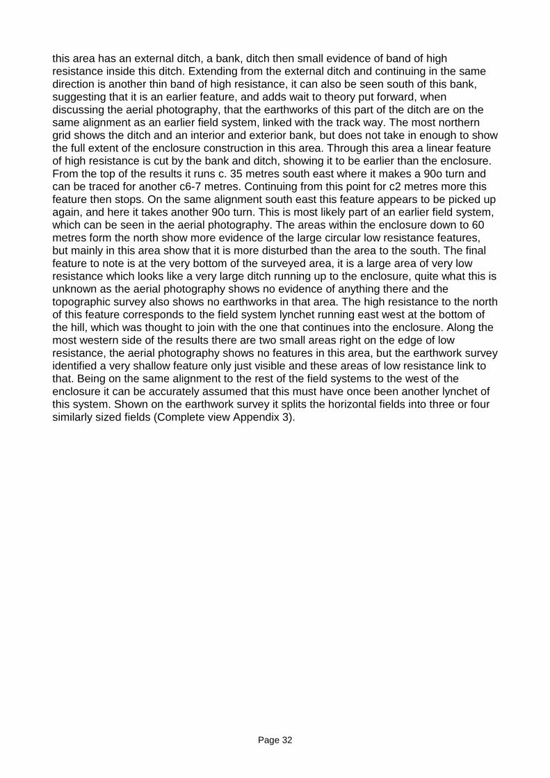
Page 32
this area has an external ditch, a bank, ditch then small evidence of band of highresistance inside this ditch. Extending from the external ditch and continuing in the samedirection is another thin band of high resistance, it can also be seen south of this bank,suggesting that it is an earlier feature, and adds wait to theory put forward, whendiscussing the aerial photography, that the earthworks of this part of the ditch are on thesame alignment as an earlier field system, linked with the track way. The most northerngrid shows the ditch and an interior and exterior bank, but does not take in enough to showthe full extent of the enclosure construction in this area. Through this area a linear featureof high resistance is cut by the bank and ditch, showing it to be earlier than the enclosure.From the top of the results it runs c. 35 metres south east where it makes a 90o turn andcan be traced for another c6-7 metres. Continuing from this point for c2 metres more thisfeature then stops. On the same alignment south east this feature appears to be picked upagain, and here it takes another 90o turn. This is most likely part of an earlier field system,which can be seen in the aerial photography. The areas within the enclosure down to 60metres form the north show more evidence of the large circular low resistance features,but mainly in this area show that it is more disturbed than the area to the south. The finalfeature to note is at the very bottom of the surveyed area, it is a large area of very lowresistance which looks like a very large ditch running up to the enclosure, quite what this isunknown as the aerial photography shows no evidence of anything there and thetopographic survey also shows no earthworks in that area. The high resistance to the northof this feature corresponds to the field system lynchet running east west at the bottom ofthe hill, which was thought to join with the one that continues into the enclosure. Along themost western side of the results there are two small areas right on the edge of lowresistance, the aerial photography shows no features in this area, but the earthwork surveyidentified a very shallow feature only just visible and these areas of low resistance link tothat. Being on the same alignment to the rest of the field systems to the west of theenclosure it can be accurately assumed that this must have once been another lynchet ofthis system. Shown on the earthwork survey it splits the horizontal fields into three or foursimilarly sized fields (Complete view Appendix 3).
Page 33
Figure 17 Resistivity Results on Map
Page 34
CONCLUSION
It is clear that from the Bronze Age through to the Roman period, especially the Iron Age,the Downlands of Sussex supported a dense network of settlements (Hingley, 1989, 56),and this can be seen from Hollingwood’s study of Romano British peasant farmsteads.From his results, shown in figure 2, they also appear to be in small groups of settlementsall within easy access of each other and some, such as Truleigh Hill to ThundersbarrowHill are in view of each other. E.C. Curwen, in 1929, found what, he said, was Iron Agepottery and burnt flint in the mole hills of the site, but with these lost they can not be usedto help with the dating of the site. The area of the enclosure is large compared with othersin the local area, but when looking at sites further away, such as Little Woodbury, itappears to an average size for an earthwork enclosure. The attached field systemscomprise of five to six fields all linked close together over an area of 170 metres by about400m. Other sites of similar date like Park Brow are much larger covering an area ofaround 1000 metres by about 600 metres, and so show that the settlement on Truleigh Hillwas much smaller and therefore only really likely to have been for one family unit.
To the north of the main enclosure, as shown on the aerial photography, further fieldsystems exist. These are of a different type of construction being cut into the hill ratherthan lynchets constructed much like those at New Barn Down. Although these earthworksare outside of the area of study it is important that they are mentioned as they continuefrom the north of the modern field down to the south and connect with the lynchets that arebeing studied. These lynchets, from aerial photography, appear to show that they havebeen constructed over some of these other earthworks, most notably what has beencalled, in this work, the boundary lynchet. At the eastern end a shallower lynchet visible onthe aerial photography, less so from the ground, on the earthworks survey, is on a slightlydifferent alignment and can be traced on aerial photography, and possibly be still seen inthe field systems. This can be seen again in the resistivity results where a linear featurecan be seen running south-east and then begins to turn 90 degrees. This feature has beencut by the enclosure bank and ditch, again showing that these features are earlier. Thereis also one probable other example of this, although less convincing. The geophysics, onthe western enclosure lynchet, show a thinner area of high resistance that again appearsto go under the earthworks, extending further north and slightly further south than theenclosure bank, but are on the same alignment, suggesting that when the enclosure andfield systems were constructed they used a similar alignment to the fields that werealready there. It also helps to date the enclosure to post Bronze Age and shows, like othersites, such as Park Brow and Plumpton Plain that there is a succession of settlementmovement southwards.
The Devils Dyke hillfort is a late Iron Age Construction. It was built due to some fear of warin the area. The enclosure bank from aerial photography and the earthwork surveyindicated that it was just a simple single bank and ditch enclosure. The resisitivity surveyconducted over the area of the track way revealed that this part of the enclosure was adouble bank with exterior ditch. This is very much a defensive construction, butconstructed near the valley bottom. The fact that this is the entrance way, as there are noother definitive features to suggest any other point of entry, may mark out the need forsome kind of defensive structure at this part of the enclosure. With no real definiteevidence of a ditch between the two banks, this is not what would be expected. The twobanks cover an area of about 10 metres in width and it seems very unlikely that this is onedefense constructed in the box format, but is just a double banked section. And justconstructed differently to the rest of the enclosure. The other part of this section of thebank can be seen as three just visible linear features, but not as clear as the section by the
Page 35
entrance. The double banked area shows a clear boundary of no activity and within theenclosure very disturbed ground showing occupation. There are no clear indications ofhuts, but several areas that may be pits indicating that the enclosure was used forsettlement. This can also be supported by the results from the North-west corner. Herethere are possibly three pits in line.
The aerial photography indicated that the enclosure was built over the adjoining fieldsystems, but the resistivity results from this area show that the fields join with theenclosure and there is no evidence that they continue within it. This is true apart from thesouthern most lynchet of the fields. It appears to join with a lynchet that runs within theenclosure, but the restivity results and earthwork survey show that they do not join, but areon the same alignment. Aerial photography indicates that it could join with the track waythat enters the enclosure. This is one of the two lynchets that, as said above, create a tripthat is shallower than the slope of the hill.
The shape of the enclosure can be seen to be much like that at Tollard Royal, in Wiltshire.This site has been dated to the first century AD and would fit in with the date range givenby Curwen. It can be said that being on a south facing slope would have been seen as anadvantage, much like a south facing home today, giving warmth from the sun andprotection from northerly winds, all good for crop growth. This is also similar to TollardRoyal, in which the Romano-British Settlement moved own hill for its sheltered nature(Bowen and Fowler, 1966,46).
The modern aerial photography shows, what looks to be a circular feature in the middle ofthe enclosure. This was not covered by any of the geophysics as the feature is not visiblefrom the ground, and must be assumed to be part of an earlier phase.
From the earthwork survey and geophysics results there is no definite evidence as to whatthe site was used for. From the other sites discussed it would appear to be used forsettlement and as an animal corral. The size of the site strongly suggests that it was asmall family unit settlement, with close contact with other settlements in the area. Whetheror not it was controlled or dominated by any of the larger farmsteads, like ThundersbarrowHill can not be said.
Over all the site has been occupied since the late Bronze Age and continued in usethrough to the late Iron Age to early Romano-British period. The latter periods being whenthe field system and enclosure were constructed. The most probable use of the enclosurewould have been for settlement activity and as an animal corral, like other sites in thesouth.
Page 36
APPENDIX 1
METHOD
The first part of the survey to be done was an earthwork survey. This was started onWednesday 22nd December. The weather conditions were light cloud with sunny intervals,which meant that it was not to dark to do the survey. 25m squares had been plotted onto amap of the site. This was placed under a sheet permitrace as a guide for drawing on theearthworks. Starting in the south-eastern corner the grids were paced out and any featuresnoted were drawn in. Large earthworks and lynchets that were shown using lines to markthe top of the feature and hashes to show the direction of the direction of the slope.Features that were only slight and only visible during light conditions wee marked on asjust lines. The earthwork survey has been taken the site each time as the varying lightconditions make different features visible. The earthwork survey will also play apart indeciding which other areas to look at with a geophysical survey.
20m grids were laid out the day before the commencement of the geophysical survey thaton Friday 7th January so that a full day could be given to collecting data. The grid waspositioned to run eastwards to be certain to take in the southern lynched features, but themain feature it was intended to take in the survey, was the western lynched of theenclosure, as this area links closely with the earthworks of the field systems. This wouldshow if these earthworks once continued to where the enclosure now is. To be able to linkthe grids into the Ordnance Survey map the base point is located on a bend on the fieldboundary to the south. Measurements from pylons could also be used. The rest of the gridpoints were marked out using pegs. There were no features within the area of surveywhere grid points could not be placed exactly 20m, but one slight problem with measuringover the earthworks which caused small discrepancies with point locations, but re-measuring fixed these problems. Two machines were used to collect data. Both wereGeoscan RM15’s with one difference on the machine from University College Winchester,which was fitted with a multiplexer, meaning that this machine will take two readingsacross a metre instead of one.
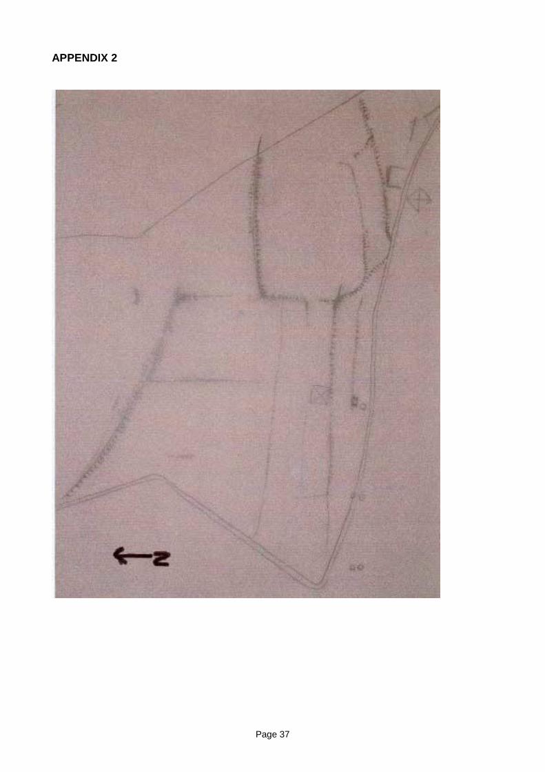
Page 37
APPENDIX 2
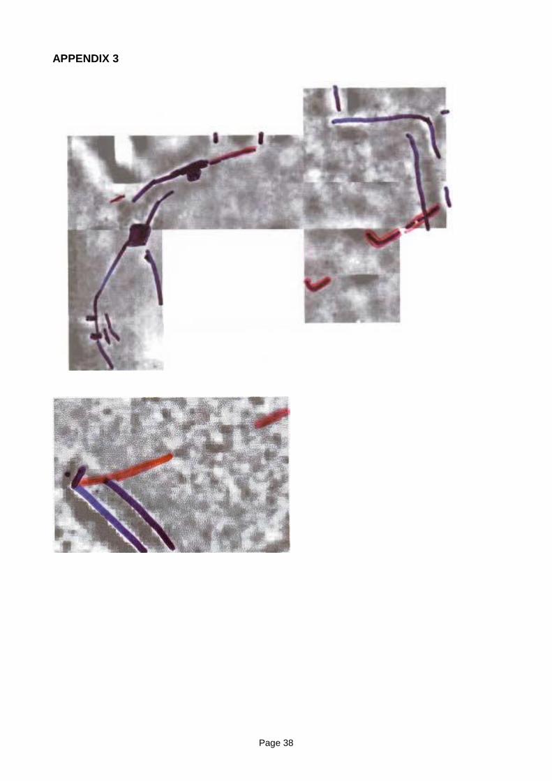
Page 38
APPENDIX 3
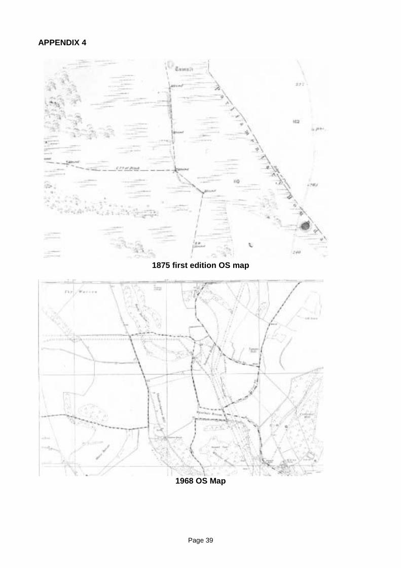
Page 39
APPENDIX 4
1875 first edition OS map
1968 OS Map
Page 40
BIBLIOGRAPHY
Bowen, H.C. and Fowler, P.J. “Romano-British Rural Settlements in Dorset andWiltshire” in C. Thomas (ed.) 1966 CBA Research Report 7: Rural Settlement in RomanBritain (H. B. Warne ltd)
Cunliffe, B. 1991 Iron Age Communities In Britain (Routledge)
Curwen, B.C. 1930 Prehistoric Sussex (Methuen)
Curwen, E.C. 1954 The Archaeology of Sussex (Methuen)
Drewett, P. Rudling, D. Gardiner, M. 1988 The South-East To AD 1000 (Longman)
Harding, D.W. 1974 The Iron Age In Lowland Britain (Routledge and Keegan Paul)
Hingley, R. 1989 Rural Settlement in Roman Britain (Seaby London)
Hughes, R. http://www.findon.info/cissbury/cissbury.htm
Millett, M. 2003 The Romanisation of Britain (Cambridge University Press)
Russell, M. “Excavations at Mile Oak Farm” in D. Rudling (ed.) 2002 DownlandSettlement and Land- Use The Archaeology of The Brighton Bypass (ArchtypePublications)
Russell, M. 2002 Prehistoric Sussex (Tempus)
Taylor, M.V. and Collingwood, R.G. Roman Britain in 1929 in The Journal of RomanStudies Volume XIX 1929 Part Two Page 210
Thomas, C. “The Character and Origins of Roman Dumnonia” in C. Thomas (ed.) 1966CBA Research Report 7: Rural Settlement in Roman Britain (H. E. Warne ltd)
Anon http://www.roman-britain.org/places/celtic/rough_tor.htm
Anonhttp://www.multimap.comlmap/browse.cgi?client=print&X=525000.0762 I 984&Y110000.268670413&gride=524882.07621984&gridn=1 11601.268670413&scale=l00000&coordsys=gb&addrl=&addr2=&addr3=&pc=&place=Fulking,West%2OSussex& width=600&height=500&db=freegaz
Page 41
BEACON HILL ROTTINGDEAN
Introduction
In December of 2004 a visit was made to Beacon Hill, Rottingdean to examine someearthworks. Crispin Kirkpatrick, one the Brighton Rangers, had noted a number ofearthworks after the hill had been mown. The hill which is noted both for the windmill andthe mini-golf course is now part of a local nature reserve. The hill possesses two Neolithiclong barrows, a windmill and a dew pond. The features noted in December of 2004included a platform cut into the west facing side of the hill and a number of circularfeatures on the summit of the hill close to site of one of the long barrows.
In late August 2005 the geophysical team of the BHAS Field Unit, led by David Staveley,conducted small survey of the features noted to try and determine the nature and possibledate of the earthworks. Although Beacon Hill has Neolithic features and prehistoric activityother events have affected this swathe of downland. When the windmill was beingconstructed in the 19th century a burial was found, but is of indeterminate date. The recordcalls the burial as being a ‘warrior’ which does suggest that it may have been Saxon.Saxon burials are often accompanied by finds which include spears, swords and daggers.The elevation at Beacon Hill is similar to the Eastbourne College of Technology and landsclose to the Booth museum along the Dyke Road, Brighton which are known as being thesite of Saxon cemeteries. Apparently this part of Beacon Hill is very popular withunauthorised metal detecting.
The hill being close to the coast may also have had any number of Second World Waranti-invasion devices. While the survey was being conducted we were visited by Mr JohnCummin, a local counsellor, who informed us that in the past the hill was the location foran important beacon location. The ‘beacon’ on Beacon Hill apparantly managed to sendmessages off in not one, but two different directions. Another local told the team about adepression that was regarded as a gun emplacement. During the Napoleonic war there isdocumentary evidence for a signal station that may have included a substantial brick builtstructure. (Pers Comm. W.Santer, Barbican House museum)
Methodology
A base line was set out running parallel to the north boundary of the golf course. The areabeing surveyed included the earthworks noted in 2004 by Crispin Fitzpatrick.(TQ36450255). The grids were 20 metres square, the measurements take at 1 metreintervals, and the readings measured in Ohms. The machine used was a TR Systemsmachine. The data was downloaded using ‘snuffler’ technology and the subsequentimages produced by David Staveley. A total of 4 grid squares were examined on this partof the hill.
A second survey examined a large depression on the west side of the hill, just north/eastof St Dunstans. (TQ36250281). In this location the same methodology was used, withagain 4 squares investigating the depression which was focused in the centre of the 4squares.
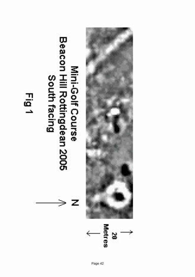
Page 42
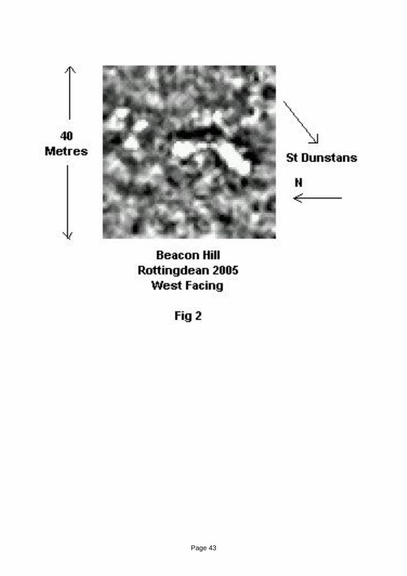
Page 43
Page 44
The Results
The results of the surveying proved very interesting. The platform cut into the side of thehill does consist of an area of very high resistance, but it has no distinctive or regularconfiguration. The survey on the top of the hill, however (see files attached), has producedevidence for a number of features. The main earthwork to the east has a very largecircular area of high resistance with a clearly visible ‘tail’. David believes that the circularfeature with an associated tail may be the location of another, earlier windmill. The centralarea produced a number of interesting anomalies including a ditch. The ditch appears torun towards the location of the Neolithic long barrow located on this part of the hill.
Beacon Hill is going to be the subject of a major survey by the BHAS Field Unit. As the hillappears to have remained relatively unscathed by modern ploughing it is possible thatvestiges of prehistoric activity associated with the long barrows may remain. The burialrecorded and the various interesting anomalies revealed by the resistivity survey clearlyindicate that a larger survey would prove beneficial. A larger survey would hopefullyproduce evidence for activities over a number of periods. It is probable that uponcompletion of the survey small trenches may have to be cut into the features found toproduce dating evidence. A permit has been received from Brighton & Hove City Councilto conduct a geophysical survey over the whole of Beacon Hill, but additional permissionwill need to be sought to survey the long barrow to the north of the golf course and for anysubsequent excavations.
The survey has been a very useful research project and Beacon Hill will now become partof a larger investigation to be conducted over a number of seasons.
John Funnell 28th December 2006
Page 45
GEOPHYSICS AT HOLLINGBURY 2005
Introduction
In the latter part of October 2005 members of the BHAS Field Unit led by David Staveleyconducted a resistivity survey within the confirms of the Scheduled Ancient Monument thatis Hollingbury Iron Age hill fort. The survey was organised by Dr Matthew Pope fromUniversity College London, and permission for the survey was granted by EnglishHeritage. The lands within the hill fort are being cleared of gorse as part of a plannedrestoration, renovation and preservation programme for the interior of the hill fort. Thework is being carried out by Brighton and Hove City Council and led by the BrightonRanger service.
Dr Pope has observed that during the autumnal equinox the sun rises in alignment with theeastern or postern gate of the hill fort. During excavations in the 1960’s (Holmes) thedirector of the excavations apparently intimated that the presence of a Roman temple atHollingbury would not be inappropriate, with Chantonctonbury Ring and Lancing being asstriking parallel locations. The elevation and visibility of such a structure would fit very wellinto a Roman landscape with a number of other Roman site locations, notably villas alongthe south coast. The excavation during the 1960’s found very little evidence to supportsuch an idea.
The removal of much of the gorse and scrub from within the hill-fort allowed a considerablearea to be surveyed. The focus of the survey included, and was extended west of theknown barrows recorded by both H.S Toms and the Curwen’s during their work atHollingbury. (Fig 1).
Methodology
A series of 20 X 20 metre square grids were set out. 6 squares were examined in total.The grids were set out using the tumuli within the hill fort as point locations. The readingswere taken at 1 metre intervals and the readings measured in Ohms. The data was downloaded using ‘snuffler’ technology and the images produced by David Staveley.
Results
The resistivity survey produced some interesting but inconclusive results. The large areaexamined produced very little evidence for internal features within the Iron Age hill fort,although readings taken at smaller intervals may be worthwhile considering for futureendeavours. It is possible that post holes and small pits may be present in this location buttoo small to register on the 1 metre intervals.
The survey did produce one area of interest on the south west corner of the investigation.It was in this area that a series of high resistance readings tend to indicate the location ofsomething substantial, but as yet undefined. It is possible that the features noted aregeological, pockets of clay with flint are frequently found on the tops of hill sides in thispart of the South Downs.The resistivity survey in 2005 found very little evidence to support the evidence for apossible Roman structure. The unusual presence of high readings does warrant anextension to the survey in that location to examine the possibility for some form of building
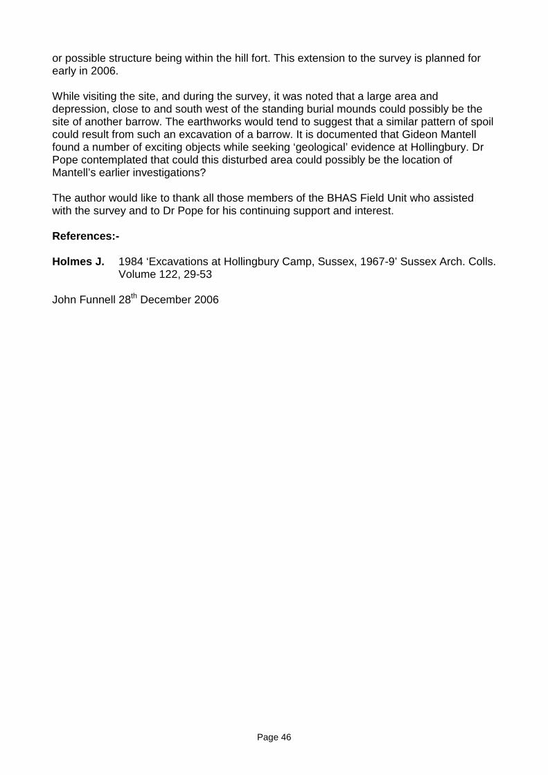
Page 46
or possible structure being within the hill fort. This extension to the survey is planned forearly in 2006.
While visiting the site, and during the survey, it was noted that a large area anddepression, close to and south west of the standing burial mounds could possibly be thesite of another barrow. The earthworks would tend to suggest that a similar pattern of spoilcould result from such an excavation of a barrow. It is documented that Gideon Mantellfound a number of exciting objects while seeking ‘geological’ evidence at Hollingbury. DrPope contemplated that could this disturbed area could possibly be the location ofMantell’s earlier investigations?
The author would like to thank all those members of the BHAS Field Unit who assistedwith the survey and to Dr Pope for his continuing support and interest.
References:-
Holmes J. 1984 ‘Excavations at Hollingbury Camp, Sussex, 1967-9’ Sussex Arch. Colls.Volume 122, 29-53
John Funnell 28th December 2006
Page 47
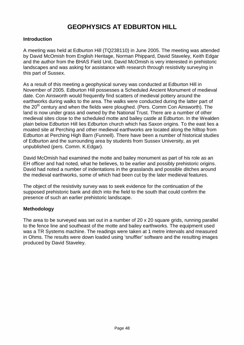
Page 48
GEOPHYSICS AT EDBURTON HILL
Introduction
A meeting was held at Edburton Hill (TQ238110) in June 2005. The meeting was attendedby David McOmish from English Heritage, Norman Phippard, David Staveley, Keith Edgarand the author from the BHAS Field Unit. David McOmish is very interested in prehistoriclandscapes and was asking for assistance with research through resistivity surveying inthis part of Sussex.
As a result of this meeting a geophysical survey was conducted at Edburton Hill inNovember of 2005. Edburton Hill possesses a Scheduled Ancient Monument of medievaldate. Con Ainsworth would frequently find scatters of medieval pottery around theearthworks during walks to the area. The walks were conducted during the latter part ofthe 20th century and when the fields were ploughed. (Pers. Comm Con Ainsworth). Theland is now under grass and owned by the National Trust. There are a number of othermedieval sites close to the scheduled motte and bailey castle at Edburton. In the Wealdenplain below Edburton Hill lies Edburton church which has Saxon origins. To the east lies amoated site at Perching and other medieval earthworks are located along the hilltop fromEdburton at Perching High Barn (Funnell). There have been a number of historical studiesof Edburton and the surrounding area by students from Sussex University, as yetunpublished (pers. Comm. K.Edgar).
David McOmish had examined the motte and bailey monument as part of his role as anEH officer and had noted, what he believes, to be earlier and possibly prehistoric origins.David had noted a number of indentations in the grasslands and possible ditches aroundthe medieval earthworks, some of which had been cut by the later medieval features.
The object of the resistivity survey was to seek evidence for the continuation of thesupposed prehistoric bank and ditch into the field to the south that could confirm thepresence of such an earlier prehistoric landscape.
Methodology
The area to be surveyed was set out in a number of 20 x 20 square grids, running parallelto the fence line and southeast of the motte and bailey earthworks. The equipment usedwas a TR Systems machine. The readings were taken at 1 metre intervals and measuredin Ohms. The results were down loaded using ‘snuffler’ software and the resulting imagesproduced by David Staveley.
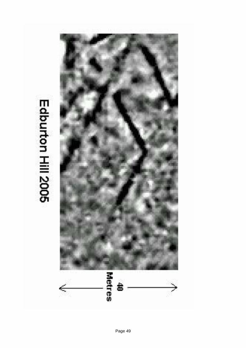
Page 49
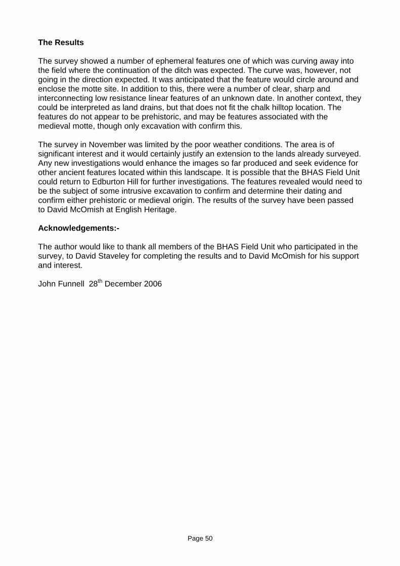
Page 50
The Results
The survey showed a number of ephemeral features one of which was curving away intothe field where the continuation of the ditch was expected. The curve was, however, notgoing in the direction expected. It was anticipated that the feature would circle around andenclose the motte site. In addition to this, there were a number of clear, sharp andinterconnecting low resistance linear features of an unknown date. In another context, theycould be interpreted as land drains, but that does not fit the chalk hilltop location. Thefeatures do not appear to be prehistoric, and may be features associated with themedieval motte, though only excavation with confirm this.
The survey in November was limited by the poor weather conditions. The area is ofsignificant interest and it would certainly justify an extension to the lands already surveyed.Any new investigations would enhance the images so far produced and seek evidence forother ancient features located within this landscape. It is possible that the BHAS Field Unitcould return to Edburton Hill for further investigations. The features revealed would need tobe the subject of some intrusive excavation to confirm and determine their dating andconfirm either prehistoric or medieval origin. The results of the survey have been passedto David McOmish at English Heritage.
Acknowledgements:-
The author would like to thank all members of the BHAS Field Unit who participated in thesurvey, to David Staveley for completing the results and to David McOmish for his supportand interest.
John Funnell 28th December 2006

1
Woodingdean Project
Phase 1
The Woodingdean Cemetery Project was reopened during the later part of March 2005.The investigation involve a further three trenches, (P) (R) (S) being opened in an attemptto identify possible ancient activity. (TQ350054). The location of these trenches wasgoverned by the visual topography of the land at the borders of the cemetery. Excavatedtrenches were recorded by planning and photography while artefacts extracted during theexcavation were collected for post-excavation analysis. Trench P was placed to cut anexisting compacted track way. The materials that made up the track way dated the trackway to the 20th Century, (Plate 1.) while the raised platform of soil it lay on contained someworked flint tools and flint flakes. Further analysis of the flint work will be required to placethese items into a more detailed date range. Trench R was positioned across a possibleancient field boundary, (Plate 2.) while Trench S was placed at the bottom of the hill slopeto see if the bottom of the slope had previously been a wetland area and how muchancient worked material had collected at the bottom, due to natural soil movement overtime. The investigation trenches were backfilled during May 2005.
Phase 2
Phase 2 consisted of a geophysical survey of the field to the west of the cemetery.(TQ348052). It is known that ancient bronze objects had been found in this field. A smallgeophysical survey was conducted which revealed a circular area of low resistance, whichmay be some form of enclosure. (Fig 2.) Further work will have to be carried out beforeany useful data, with regard the type of feature and what date it is can be, can establishwhether it is an ancient or modern feature.
Phase 3
Phase three consisted of field walking the field which lay to the south of the cemetery site(Fig 1.) where aerial photographs clearly show a collection of ancient field boundaries.(TQ353052). A base line was set out using the north boundary of the field. The fieldwalking consisted of lines set at 20 metres apart and the lines walked were divided into 20metre long transects. The fields were walked north to south going down the hill, the fieldunit paired off into two’s, and they walked a total of fifteen lines. Unfortunately the field hadnot been ploughed and was full of weed and scrub, which made walking difficult to carryout and also reduced the amount of artefacts collected. The unploughed surface reducedthe amount of researchable data. The artefacts that were collected at the end of each 20mgrid will be collated and recorded to allow any potential hot spots of possible ancientactivity to be recorded.
Norman Phippard
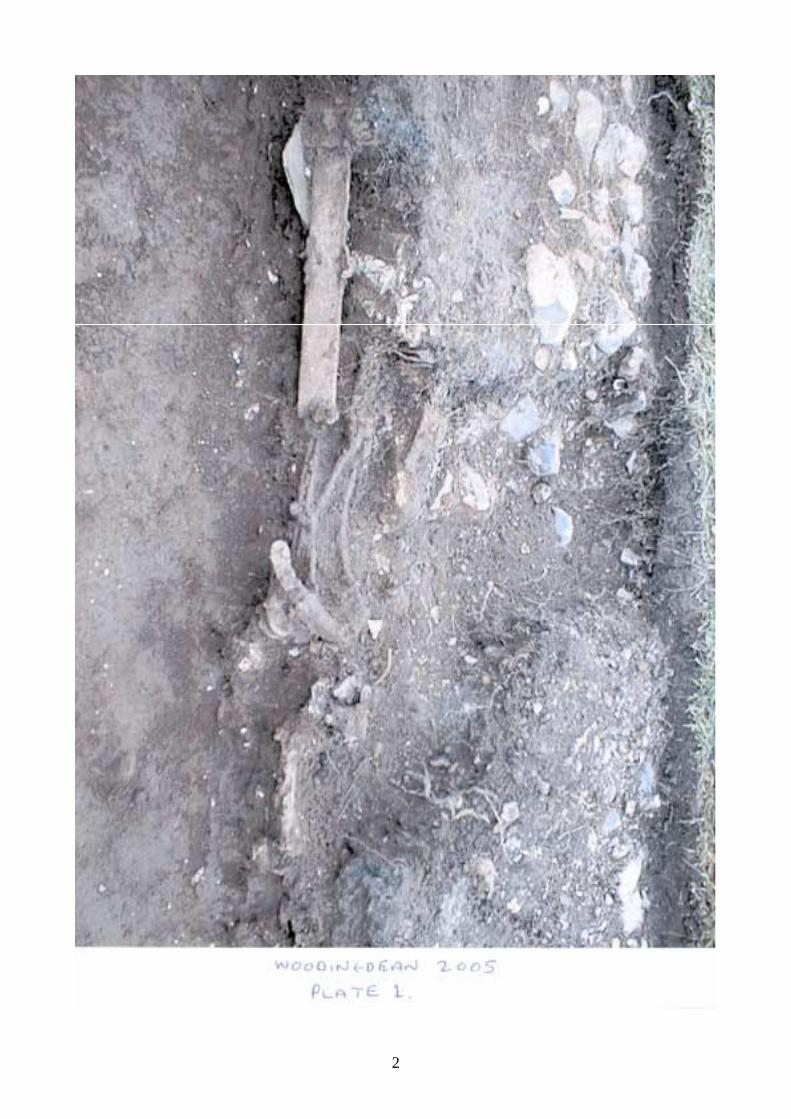
2

3
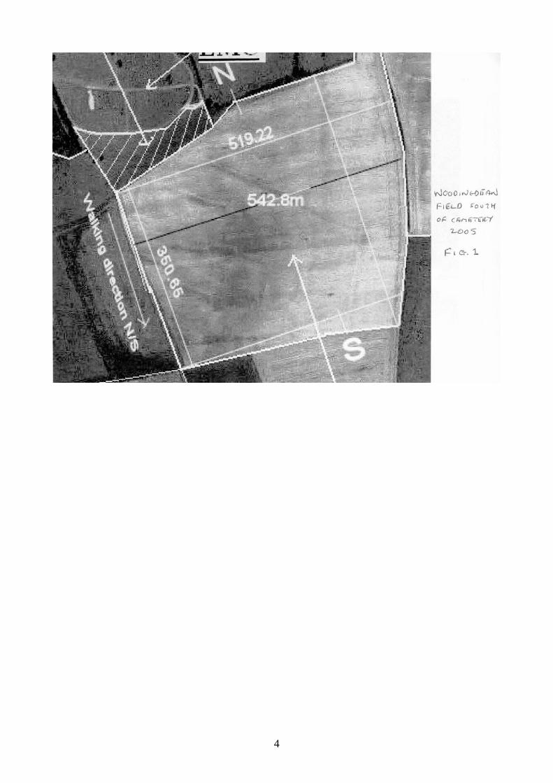
4
5
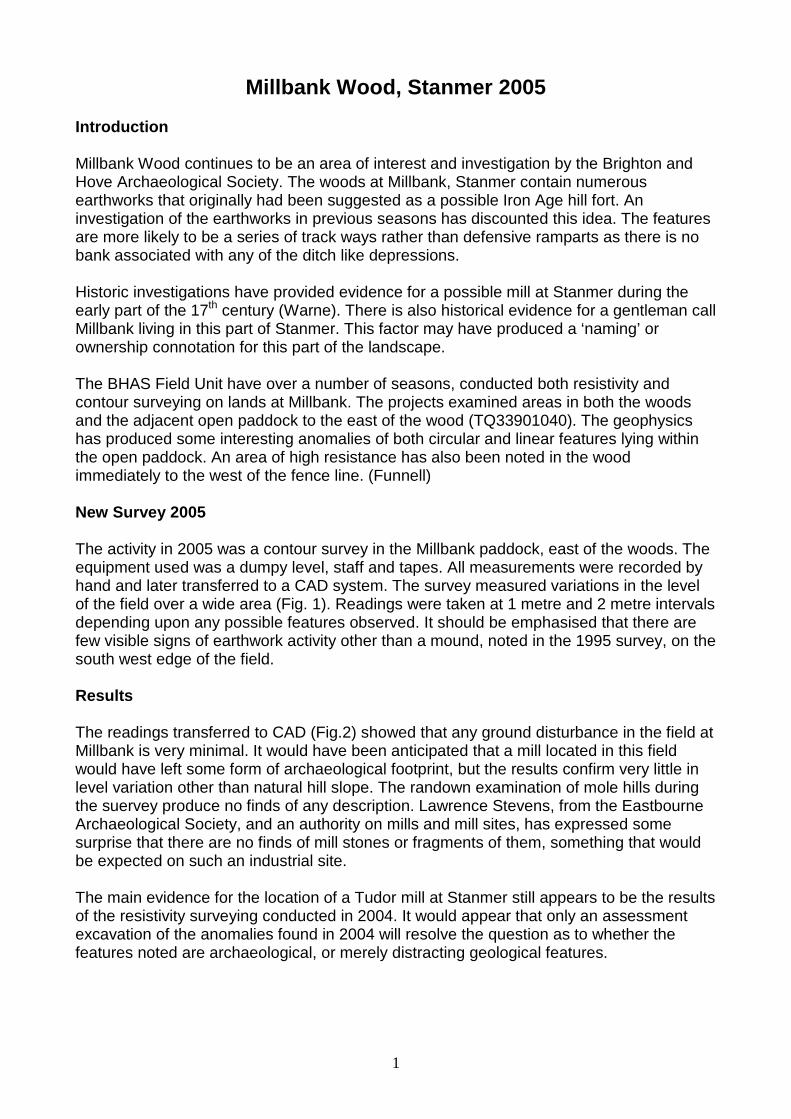
1
Millbank Wood, Stanmer 2005
Introduction
Millbank Wood continues to be an area of interest and investigation by the Brighton andHove Archaeological Society. The woods at Millbank, Stanmer contain numerousearthworks that originally had been suggested as a possible Iron Age hill fort. Aninvestigation of the earthworks in previous seasons has discounted this idea. The featuresare more likely to be a series of track ways rather than defensive ramparts as there is nobank associated with any of the ditch like depressions.
Historic investigations have provided evidence for a possible mill at Stanmer during theearly part of the 17th century (Warne). There is also historical evidence for a gentleman callMillbank living in this part of Stanmer. This factor may have produced a ‘naming’ orownership connotation for this part of the landscape.
The BHAS Field Unit have over a number of seasons, conducted both resistivity andcontour surveying on lands at Millbank. The projects examined areas in both the woodsand the adjacent open paddock to the east of the wood (TQ33901040). The geophysicshas produced some interesting anomalies of both circular and linear features lying withinthe open paddock. An area of high resistance has also been noted in the woodimmediately to the west of the fence line. (Funnell)
New Survey 2005
The activity in 2005 was a contour survey in the Millbank paddock, east of the woods. Theequipment used was a dumpy level, staff and tapes. All measurements were recorded byhand and later transferred to a CAD system. The survey measured variations in the levelof the field over a wide area (Fig. 1). Readings were taken at 1 metre and 2 metre intervalsdepending upon any possible features observed. It should be emphasised that there arefew visible signs of earthwork activity other than a mound, noted in the 1995 survey, on thesouth west edge of the field.
Results
The readings transferred to CAD (Fig.2) showed that any ground disturbance in the field atMillbank is very minimal. It would have been anticipated that a mill located in this fieldwould have left some form of archaeological footprint, but the results confirm very little inlevel variation other than natural hill slope. The randown examination of mole hills duringthe suervey produce no finds of any description. Lawrence Stevens, from the EastbourneArchaeological Society, and an authority on mills and mill sites, has expressed somesurprise that there are no finds of mill stones or fragments of them, something that wouldbe expected on such an industrial site.
The main evidence for the location of a Tudor mill at Stanmer still appears to be the resultsof the resistivity surveying conducted in 2004. It would appear that only an assessmentexcavation of the anomalies found in 2004 will resolve the question as to whether thefeatures noted are archaeological, or merely distracting geological features.
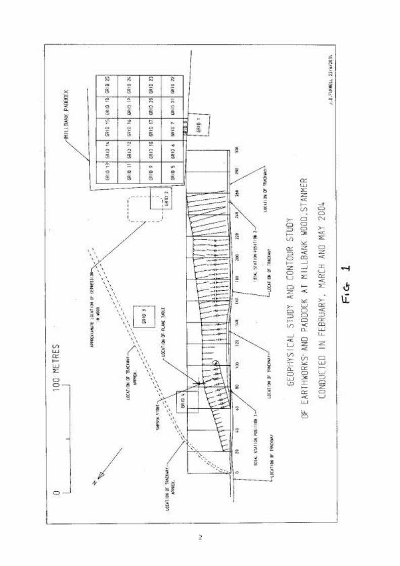
2
3

4
Acknowledgements:-
The author would like to thank all those members of the BHAS Field Unit who assistedwith the surveying and to Mr G.Bennett of Brighton & Hove City Council and the tenantfarmer David West for allowing access to his lands.
References:-
Funnell J.D. 2004 ‘Millbank Wood Surveying’ in ‘Brighton and Hove Archaeological FieldNotebook 2004’
Warne H. 1989 ‘Stanmer: A Restructured Settlement’ Suss. Arch. Colls. 127, 189-210
1
Earthworks at Falmer
During 2005 visits were made to a number of earthworks within the region of Falmer.Falmer has a Scheduled Ancient Monument, which consists of an extremely largeenclosure, located on the side and around a deep valley to the east of the village.(TQ365080). The enclosure has not been investigated and remains undated. A featurewhich appears to be an ancient sunken trackway runs parallel to the Falmer toWoodingdean road before veering off northwards towards Newmarket Plantation.(TQ35750760). It is not certain whether the trackway and enclosure are connected.
During the hot summer of 2005 the Brighton and Hove Archaeological Society werecontacted by Mr Bob Burtenshaw from Brighton who had observed what he believed to besubtle features and earthworks in Falmer. The author and Mr Greg Chuter of East SussexCounty Council joined Mr Burtenshaw for an investigation of the features that he hadnoted. The earthworks lie around and within Newmarket Plantation, (TQ36750800) andconsist of banks, ditches and depressions. A number of banks lie within the trees andthere appears to be a bank on the south/west side of the trees. Other ditches ordepressions lie to the east of the trees and may be vestiges of earlier track ways that mayhave linked Lewes and Brighton, via the Lower Bevendean valley. The NewmarketPlantation appears to be a focus or meeting place for a number of tracks.
The earthworks within the trees have not been investigated and it would be a very usefulproject for someone to survey and record the features. The results of a survey mayproduce some inclination as to their purpose, and if the project were extended couldproduce a very interesting panoramic overview of this very intriguing landscape.
In 2005 a visit was also made to Newmarket Hill. David Larkin, the Brighton countrysideranger, had noted an earthwork on top of the hill that appears to be unrecorded. Thelocation of the feature is close to the junction of two track ways that cross Newmarket Hill.The very large mound is actually crossed by one of the footpaths. (TQ363071). Thenorth/east side of the mound is being eroded by ploughing. It is possible that this largecircular feature is a tumulus or barrow. David Larkin believes that it may be a filled in dewpond.
The mound on Newmarket Hill justifies further investigation and will be the subject of aBHAS research project in an attempt to try and determine an identity for the feature. If theresults of the project confirm that it is a burial mound then the Society will endeavour toeither have the fence line moved or suggest an archaeological rescue package to recordthe area being eroded. A geophysical survey could identify any associated ditch. As thepossible burial mound is being destroyed by ploughing a small excavation may be useful inproviding some dateable material. The project will be added to the current list of BHASresearch investigations.
John Funnell 12th January 2007
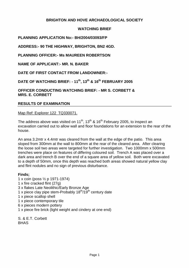
Page 1
BRIGHTON AND HOVE ARCHAEOLOGICAL SOCIETY
WATCHING BRIEF
PLANNING APPLICATION No:- BH/2004/03093/FP
ADDRESS:- 90 THE HIGHWAY, BRIGHTON, BN2 4GD.
PLANNING OFFICER:- Ms MAUREEN ROBERTSON
NAME OF APPLICANT:- MR. N. BAKER
DATE OF FIRST CONTACT FROM LANDOWNER:-
DATE OF WATCHING BRIEF: - 11th, 13th & 16th FEBRUARY 2005
OFFICER CONDUCTING WATCHING BRIEF: - MR S. CORBETT &MRS. E. CORBETT
RESULTS OF EXAMINATION
Map Ref: Explorer 122 TQ330071.
The address above was visited on 11th, 13th & 16th February 2005, to inspect anexcavation carried out to allow wall and floor foundations for an extension to the rear of thehouse.
An area 3.2mtr x 4.4mtr was cleared from the wall at the edge of the patio. This areasloped from 300mm at the wall to 800mm at the rear of the cleared area. After clearingthe loose soil two areas were targeted for further investigation. Two 1000mm x 500mmtrenches were place on features of differing coloured soil. Trench A was placed over adark area and trench B over the end of a square area of yellow soil. Both were excavatedto a depth of 50mm, once this depth was reached both areas showed natural yellow clayand flint nodules and no sign of previous disturbance.
Finds;1 x coin (poss ½ p 1971-1974)1 x fire cracked flint (27g)3 x flakes Late Neolithic/Early Bronze Age1 x piece clay pipe stem-Probably 18th/19th century date1 x piece scallop shell1 x piece contemporary tile6 x pieces modern pottery1 x piece fire brick (light weight and cindery at one end)
S. & E.T. CorbettBHAS
Page 2
A visit was made to the site on Friday 25th February 2005 after the footings had been dug,No features were noted. It was observed that the depth of colluvial material wasapproxiamately 1.8M deep. A small deeper section, of a possible old soakaway, did revealchalk or combe deposits at the greater depth.
Signed on behalf of Brighton and Hove Archaeological Society
John Funnell (President)
Page 3
BRIGHTON AND HOVE ARCHAEOLOGICAL SOCIETY
WATCHING BRIEF
PLANNING APPLICATION No:-BH2004/02019/FP
ADDRESS:-26 GORHAM AVENUE, ROTTINGDEAN
PLANNING OFFICER:-MS M. ROBERTSON
NAME OF APPLICANT:- Mr and Mrs John Smith
DATE OF FIRST CONTACT FROM CONTRACTOR:- October 2005
DATE OF WATCHING BRIEF:- 27th October 2005
BHAS OFFICER CONDUCTING WATCHING BRIEF:- W.SANTER________________________________________________________________
Mr W.Santer visited Gorham Avenue on Thursday 27th October. Mr Smith had informedthe Society that he had terraced the garden which is the development area at some distanttime in the past. Any possible archaeological features would have been removed at thattime. Mr Santer confirmed that the previous works on the garden had probably removedany features if they ever existed. However, Mr Santer did return to the site when the workhad been carried out found no finds or features of archaeological interest.
John Funnell 30th October 2005
Page 4
BRIGHTON AND HOVE ARCHAEOLOGICAL SOCIETY
WATCHING BRIEF
PLANNING APPLICATION No:- BH2003/00422/FP
ADDRESS:-16 Martyn’s Close, Ovingdean, Brighton
PLANNING OFFICER:- Ms Cushlar Barfoot
NAME OF APPLICANT:- Dr S.G. Sripuram (Contractor ) Mr Bishop, 45, WestfieldAvenue, Patcham
DATE OF FIRST CONTACT FROM CONTRACTOR:- 18th July 2005
DATE OF WATCHING BRIEF:- 20th-21st July 2005
BHAS OFFICER CONDUCTING WATCHING BRIEF:- Mr W.Santer
RESULTS OF EXAMINATION
Ref (TQ361037) OS Explorer 122 1:25 000 Scale
Conclusions
The site was visited twice once on the 20th July and again on the 21st July. The site is asmall extension to the south of an existing building. The development consisted of a shortfoundation trench for a wall required at the side of the house. The trench created passedthrough a thick layer of old building debris, half bricks, mortar etc derived from the originalbuilding construction. The remaining excavation produced only natural chalk.
No archaeological features were observed and no artefacts were recovered.
(Based on a report compiled by W.Santer)
John Funnell (BHAS Field Unit)
Page 5
Watching Brief at Ovingdean after the relocation of bunding at the roundaboutopposite and to the west of St. Dunstans.
In late February of 2005 Bill Santer of the BHAS Field Unit conducted a survey of theearthworks that had originally been created for a construction depot with regard work onthe undercliff at Ovingdean. (TQ360026). The survey was conducted after the bundingsurrounding the site had been redispersed into the field.
The Finds
Flint Flakes 4- Very crude and rough pieces, no retouch but only 1 piece retaining cortex.
Fire-cracked 1 piece 33gms
Oyster Shell I piece
Page 6
BRIGHTON AND HOVE ARCHAEOLOGICAL SOCIETY
WATCHING BRIEF
PLANNING APPLICATION No:-
ADDRESS:- 2 Petworth Road
PLANNING OFFICER:-
NAME OF APPLICANT:- Mr Jeff Moyne
DATE OF FIRST CONTACT FROM LANDOWNER:- October 2004
DATE OF WATCHING BRIEF:- 14th March-21st March 2005
OFFICER CONDUCTING WATCHING BRIEF:- MR S. CORBETT &MRS. E. CORBETT & MR W SANTER
RESULTS OF EXAMINATION
History
The development at Petworth Road is close to a number of known archaeological sites.The Patcham Fawcett School, which was to the north west of the development, was thelocation of a large Bronze Age tumulus that produced a number of burials. When theschool playing field was examined during an archaeological excavation, prior to a housingdevelopment, it produced evidence for a Bronze Age settlement with a number of roundhouses and a collard urn cremation burial.
During the 1950’2 a pair of Roman burials were found close to the development area.
Map Ref: Explorer 122 TQ 316088
The above address was visited on a number of occasions from 14th March to the 21st
March 2005. This area had been unused for many years, and it is now to be used to buildgarages on the land.
The vegetation had been removed prior to the watching brief. The top soil was removedover an area of 12.7x 10.5 metres. The depth of soil varied from 1 metre at the rear of theplot to only a few centimetres along the wall at the pavement edge. Once the natural chalkwas exposed, a change of texture and colour could be seen that resembled a ditch (seeplan).
A section was cut through the ditch and it proved to be a modern soakaway.
No other features were observed and an examination of the surrounding soil and spoilheap produced no finds of antiquity
S. & E.T. CorbettBHAS
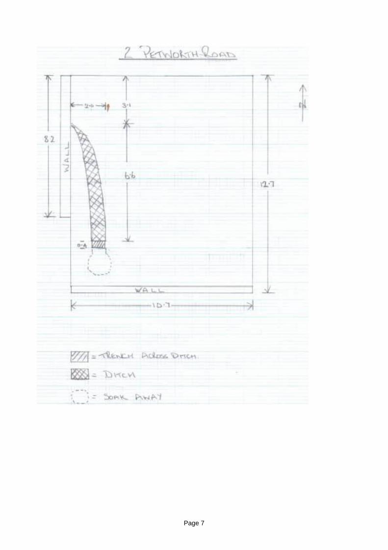
Page 7
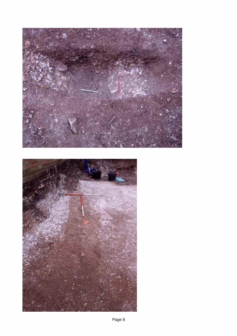
Page 8
Page 9
An Archaeological Watching Brief at23, Roedean Crescent,
Roedean, Brighton,East Sussex.
TQ 345036(OS Pathfinder 1307 TQ 20/30)
by W.L.Santer and J. MacGregor
Planning Application No BH 2004/01331/FP
Between 11th and 17th February 2005
BRIGHTON and HOVEARCHAEOLOGICAL SOCIETY
FIELD UNIT
Page 10
On the 10th February 2005 the Brighton and Hove Archaeological Society Field Unit(BHAS) received a request to assist in providing an archaeological watching brief duringlandscaping in the rear garden of 23, Roedean Crescent, Roedean, Brighton, with thegeneral objective of monitoring excavation of groundwork to ensure that any feature orartefact revealed of archaeological or historical interest should be recorded.
The site is located within an area of intense archaeological sensitivity, nearby finds havebeen made of burials dating from the Neolithic and Bronze Age periods, and the location ofa Roman coffin burial.
Other recent discoveries include Roman coins and pottery found in the garden of a housein Roedean Crescent, and a large underground chamber, possibly associated with RoyalNavy activity during the Second World War.
The Roedean Estate which was developed from the mid 1930’s, is located to the East ofBrighton and is now one of the areas most exclusive residential districts. Development wasinterrupted by WW II and No. 23 Roedean Crescent appears to have been built in the early1950’s. The house is a large building-22m x 15m approx- standing on a platform terracedinto the slope of the Downs, looking South towards the Channel. The ground rises to theNorth, and the rear boundary fence, approximately 26 metres from the rear wall, is almostlevel with the upper windows of the house. In the fence there is a gate opening onto theperimeter of the East Brighton Golf Club.
The planned landscaping consists of forming a terrace at ground-floor level to contain acovered swim-pool and patio adjacent to the rear wall, with another two terraces forgardens both having brick or stone retaining walls. The topsoil is to be retained, andexcavated chalk building debris removed from site.
Work had commenced before BHAS could attend on the 11th February when it wasdiscovered that topsoil had been removed to form a spoil heap and a mechanical diggerwith a 1m. toothed bucket had started removing chalk eventually down to a depth of 1m.Discussion with the digger driver and subsequent observation of the spoil heap revealedthat the majority of the topsoil had probably come from the excavations for the houseduring its construction.
Exploration of the spoil heap led to the recovery of: Five struck flints, 20th century potterysherds, Clay pipe stems, a small glass bottle-probably for perfume, slate, broken brick,glass, nails, screws and typical modern building debris.
CONCLUSION:
Nothing of archaeological or ancient historical significance was seen.
Contacts: Contractor, Craig Howard (digger driver and site contractor)Owner (?) Mrs Kellinda Foolheea, 23, Roedean Crescent, Roedean,Brighton, BN2 5RG Tel. 685414 - To whom a copy of report should be sent
Addenda:In the North wall of the excavation for the lower terrace a cutting was seen which turnedout to be a “dunny” having newspaper and other material in it, possibly a campsite facility
or the 1950 house builders?
Page 11
BRIGHTON AND HOVE ARCHAEOLOGICAL SOCIETY
WATCHING BRIEF
PLANNING APPLICATION No:- BH2004/01331/FP
ADDRESS:- 23 ROEDEAN CRESCENT, BRIGHTON.
PLANNING OFFICER:-Mr PETE JOHNSON
NAME OF APPLICANT:- Mr B. FOOLHEEA
DATE OF FIRST CONTACT FROM CONTRACTOR:- 10TH FEBRUARY 2005
DATE OF WATCHING BRIEF:- 10TH-17TH FEBRUARY 2005
BHAS OFFICER CONDUCTING WATCHING BRIEF:-Mr W.SANTER & Ms J.MACGREGOR
RESULTS OF EXAMINATION
Ref TQ 345036 (OS Pathfinder 1307 TQ 20/30)
On the 10th February 2005 the Brighton and Hove Archaeological Society Field Unit(BHAS) received a request to assist in providing an archaeological watching brief duringlandscaping in the rear garden of 23, Roedean Crescent, Roedean, Brighton. The generalobjective was the monitoring of the excavation of groundwork and to ensure that anyfeature or artefact revealed of archaeological or historical interest should be recorded.Thesite is located within an area of intense archaeological sensitivity, nearby finds have beenmade of burials dating from the Neolithic and Bronze Age periods, and the location of aRoman coffin burial.
Other recent discoveries include Roman coins and pottery found in the garden of a housein Roedean Crescent, and a large underground chamber, possibly associated with RoyalNavy activity during the Second World War found at 9, Roedean Crescent.
The Roedean Estate which was developed from the mid 1930’s, is located to the East ofBrighton and is now one of the areas most exclusive residential districts. Development wasinterrupted by WW II and No. 23 Roedean Crescent appears to have been built in the early1950’s. The house is a large building-22m x 15m approx- standing on a platform terracedinto the slope of the Downs, looking South towards the Channel. The ground rises to theNorth, and the rear boundary fence, approximately 26 metres from the rear wall, is almostlevel with the upper windows of the house. In the fence there is a gate opening onto theperimeter of the East Brighton Golf Club where in 2003 there was a find druing anarchaeological watching brief of a burial dated to the Early Bronze Age.
The planned landscaping consists of forming a terrace at ground-floor level to contain acovered swim-pool and patio adjacent to the rear wall, with another two terraces forgardens both having brick or stone retaining walls. The topsoil is to be retained, andexcavated chalk building debris removed from site.
Page 12
Work had commenced before BHAS could attend on the 11th February when it wasdiscovered that topsoil had been removed to form a spoil heap and a mechanical diggerwith a 1m. toothed bucket had started removing chalk eventually down to a depth of 1m.Discussion with the digger driver and subsequent observation of the spoil heap revealedthat the majority of the topsoil had probably come from the excavations for the houseduring its construction.
Exploration of the spoil heap led to the recovery of: 5 struck flints, probably of LateNeolithic/Early Bronze Age date, 20th century pottery sherds, Clay pipe stems, a smallglass bottle-probably for perfume, slate, broken brick, glass, nails, screws and typicalmodern building debris.
Finds
4 Flint flakes, 3 flakes with a white patination and 1 with a blue.grey patination, all boretraces of cortex and no sign of retouch. Late Neolithic/Early Bronze Age date
5 Clay pipe stems- very small sections 6-7mm in diameter probably of late 18th/19th
century dating.
1 Piece of butchered and knawed bone
6 ceramic pieces of contemporary or 19th century vessels
2 Glass vessels of unknown date
Conclusions:
Other than a few flint flakes nothing of archaeological or ancient historical significance wasobserved.
Signed on behalf of Brighton & Hove Archaeological Society
John Funnell (President)
Page 13
BRIGHTON AND HOVE ARCHAEOLOGICAL SOCIETY
WATCHING BRIEF
PLANNING APPLICATION No:-BH2004/03570/FP
ADDRESS:-ST MARY’S HALL, EASTERN ROAD, BRIGHTON
PLANNING OFFICER:-MS M. ROBERTSON
NAME OF APPLICANT:- MILLER BOURNE PARTNERSHIP
DATE OF FIRST CONTACT FROM CONTRACTOR:- JANUARY 2005
DATE OF WATCHING BRIEF:- 7TH-8TH April 2005
BHAS OFFICER CONDUCTING WATCHING BRIEF:- W.SANTER & J.FUNNELL________________________________________________________________
History of site
St Mary’s Hall was opened in 1836 as a boarding school for the daughters of clergymen.(Carder 1990). The construction of this large Victorian house would have removed anyarchaeological features in that part of the south facing slope of the South Downs.
A number of excavations between 1905 and 1922 produced finds of both features andartefacts dated to the Iron Age and Roman periods. One large pit contained a hypocaust,suggesting that a significant site may be located somewhere in the area. (Gilkes 1989).
RESULTS OF EXAMINATION
The development at St Mary’s Hall was confined to the demolition of an existing flintconstructed storage shed. The shed, and numerous other developments within the StMary’s complex, had over the past century, included substantial terracing. The shedconstruction and terracing would have destroyed any archaeology and no archaeologicalfeatures were noted during the visits to the site. However, the road leading into St Mary’sis probably along the original contour of the hill and untouched areas to the north of thetennis courts could be considered as having the potential for archaeological features.
References:-
Carder T. 1990 ‘The Encyclopedaedia of Brighton’ Item 168
Gilkes O. 1989 ‘Iron Age and Roman Features at Kemp Town’ SAC Vol 127 236-240
John Funnell (President Brighton & Hove Archaeological Society)
13th April 2005
Page 14
BRIGHTON AND HOVE ARCHAEOLOGICAL SOCIETY
WATCHING BRIEF
PLANNING APPLICATION No:-BH
ADDRESS:- 30 Nanson Road, Coldean, Brighton
PLANNING OFFICER:-MR David Vickers
NAME OF APPLICANT:- MR Clive Voller
DATE OF FIRST CONTACT FROM CONTRACTOR:- 4TH April 2005
DATE OF WATCHING BRIEF:- 16TH APRIL-19TH APRIL 2005
BHAS OFFICER CONDUCTING WATCHING BRIEF:- W.Santer, S. & E. Corbett,J.MacGregor & J.Funnell________________________________________________________________
SITE TOPOGRAPHY AND GEOLOGY
The Coldean housing estate is located in a small valley which is part of the South Downs.The east end of the valley opens out onto the junction of the Brighton to Lewes road. Thehouse site being developed lies on a slight incline towards the south west corner of thisvalley. The geology is predominantly chalk loam overlying a bed rock of upper and middlechalk.
HISTORICAL AND ARCHAEOLOGICAL BACKGROUND
The Coldean housing estate was constructed during the 1950’s. During the house buildingworkman uncovered a number of archaeological features. The Brighton and HoveArchaeological Society, who were excavating a tumulus along the Ditchling Road close by,were invited to investigate the features.
It became quite evident that Coldean is an extremely archaeologically sensitive area asfeatures examined included Roman ditches and an Iron Age round house. Finds includeda Roman gold ‘stater’ and a Bronze Age collared urn.
The archaeological investigations prior to the construction of the Brighton bypassproduced evidence for a significant Middle to Late Bronze Age Settlement. The site waslocated on the steep sided hill that lay to the west of Coldean Lane. Another excavation atVarley Halls, on the east side of the valley produced a number of Bronze Age roundhouses that may relate to another settlement. Field walking the fields around the Coldeanarea has produced finds of Neolithic and Late Bronze Age flint work, fire cracked flint andpottery dated to the Iron Age and Roman periods.
Page 15
RESULTS OF EXAMINATION
The Brighton and Hove Archaeological Society approached the land owner, Mr CliveVoller, with regard conducting a small excavation within the garden of 30 Nanson Road,prior to the commencement of the development. The garden had been terraced in anumber of places and the west side consisted of large quantities of contemporary soildeposits from possible dumping. With Mr Vollers approval the BHAS Field Unit excavateda trench measuring 3.5M x 1.5M and 1.4M in depth. The section produced three distinctlayers producing contemporary finds in the upper fill with worked flint and Iron Age potteryin the lower fills. A single, flint packed, post hole was revealed and two small concentrateddeposits of small flint nodules.
A watching brief conducted after the trenches had been cut for the construction footingsfailed to reveal any additional features or finds.
A complete report of the excavation and finds will be compiled and sent to the appropriatebodies.
Acknowledgements:-
I would like to thank Mr Voller for allowing access to the garden area and to all themembers of the BHAS Field Unit who conducted the excavation.
References:-
Yeates C. 1951 ‘Prehistoric Man in the Cold Dean Area’ Sussex CountyMagazine Volume 25 Number 8
D.Rudling el al 2002 ‘Downland Settlement and Land-Use, The Archaeology of theBrighton Bypass’. Archetype Publications.
Greig I. 1997 ‘ Excavations of a Bronze Age settlement at Varley Halls ,Coldean, Coldean Lane, Brighton’. Sussex Arch Colls. 135, 7-59
John Funnell (President Brighton & Hove Archaeological Society)
28th April 2005
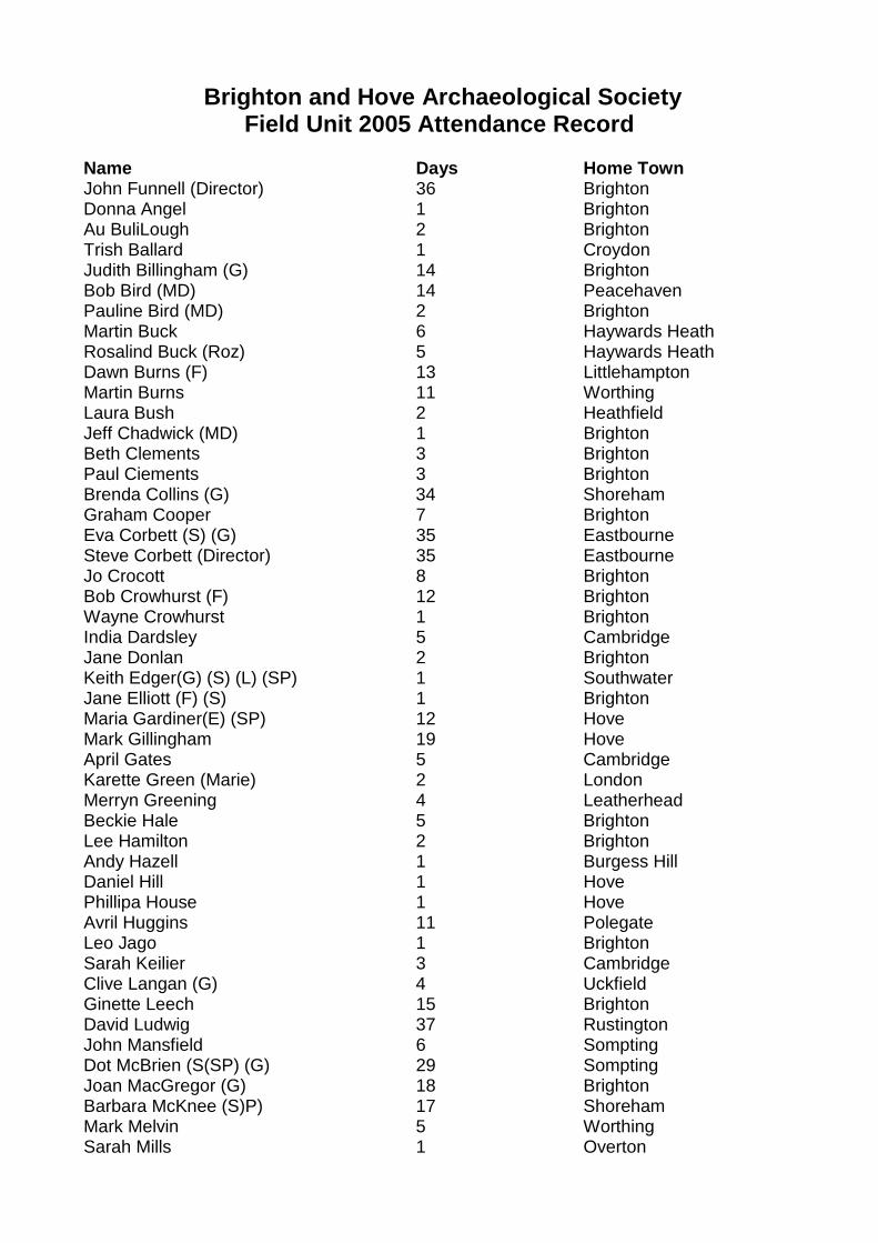
Brighton and Hove Archaeological SocietyField Unit 2005 Attendance Record
Name Days Home TownJohn Funnell (Director) 36 BrightonDonna Angel 1 BrightonAu BuliLough 2 BrightonTrish Ballard 1 CroydonJudith Billingham (G) 14 BrightonBob Bird (MD) 14 PeacehavenPauline Bird (MD) 2 BrightonMartin Buck 6 Haywards HeathRosalind Buck (Roz) 5 Haywards HeathDawn Burns (F) 13 LittlehamptonMartin Burns 11 WorthingLaura Bush 2 HeathfieldJeff Chadwick (MD) 1 BrightonBeth Clements 3 BrightonPaul Ciements 3 BrightonBrenda Collins (G) 34 ShorehamGraham Cooper 7 BrightonEva Corbett (S) (G) 35 EastbourneSteve Corbett (Director) 35 EastbourneJo Crocott 8 BrightonBob Crowhurst (F) 12 BrightonWayne Crowhurst 1 BrightonIndia Dardsley 5 CambridgeJane Donlan 2 BrightonKeith Edger(G) (S) (L) (SP) 1 SouthwaterJane Elliott (F) (S) 1 BrightonMaria Gardiner(E) (SP) 12 HoveMark Gillingham 19 HoveApril Gates 5 CambridgeKarette Green (Marie) 2 LondonMerryn Greening 4 LeatherheadBeckie Hale 5 BrightonLee Hamilton 2 BrightonAndy Hazell 1 Burgess HillDaniel Hill 1 HovePhillipa House 1 HoveAvril Huggins 11 PolegateLeo Jago 1 BrightonSarah Keilier 3 CambridgeClive Langan (G) 4 UckfieldGinette Leech 15 BrightonDavid Ludwig 37 RustingtonJohn Mansfield 6 SomptingDot McBrien (S(SP) (G) 29 SomptingJoan MacGregor (G) 18 BrightonBarbara McKnee (S)P) 17 ShorehamMark Melvin 5 WorthingSarah Mills 1 Overton
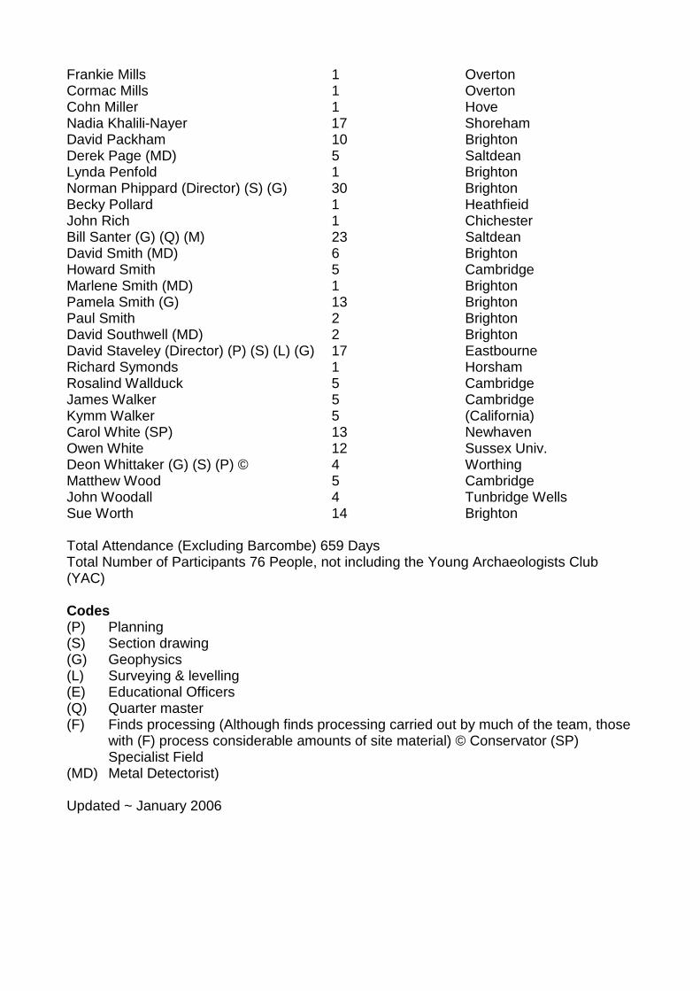
Frankie Mills 1 OvertonCormac Mills 1 OvertonCohn Miller 1 HoveNadia Khalili-Nayer 17 ShorehamDavid Packham 10 BrightonDerek Page (MD) 5 SaltdeanLynda Penfold 1 BrightonNorman Phippard (Director) (S) (G) 30 BrightonBecky Pollard 1 HeathfieidJohn Rich 1 ChichesterBill Santer (G) (Q) (M) 23 SaltdeanDavid Smith (MD) 6 BrightonHoward Smith 5 CambridgeMarlene Smith (MD) 1 BrightonPamela Smith (G) 13 BrightonPaul Smith 2 BrightonDavid Southwell (MD) 2 BrightonDavid Staveley (Director) (P) (S) (L) (G) 17 EastbourneRichard Symonds 1 HorshamRosalind Wallduck 5 CambridgeJames Walker 5 CambridgeKymm Walker 5 (California)Carol White (SP) 13 NewhavenOwen White 12 Sussex Univ.Deon Whittaker (G) (S) (P) © 4 WorthingMatthew Wood 5 CambridgeJohn Woodall 4 Tunbridge WellsSue Worth 14 Brighton
Total Attendance (Excluding Barcombe) 659 DaysTotal Number of Participants 76 People, not including the Young Archaeologists Club(YAC)
Codes(P) Planning(S) Section drawing(G) Geophysics(L) Surveying & levelling(E) Educational Officers(Q) Quarter master(F) Finds processing (Although finds processing carried out by much of the team, those
with (F) process considerable amounts of site material) © Conservator (SP)Specialist Field
(MD) Metal Detectorist)
Updated ~ January 2006
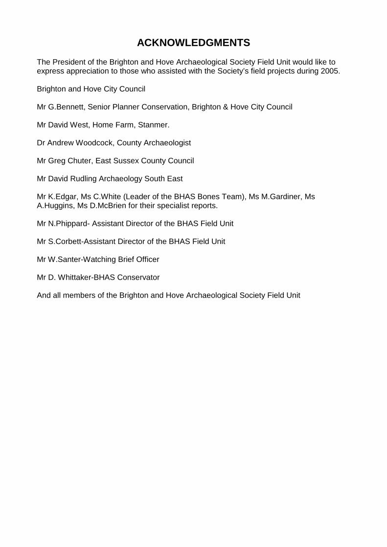
ACKNOWLEDGMENTS
The President of the Brighton and Hove Archaeological Society Field Unit would like toexpress appreciation to those who assisted with the Society’s field projects during 2005.
Brighton and Hove City Council
Mr G.Bennett, Senior Planner Conservation, Brighton & Hove City Council
Mr David West, Home Farm, Stanmer.
Dr Andrew Woodcock, County Archaeologist
Mr Greg Chuter, East Sussex County Council
Mr David Rudling Archaeology South East
Mr K.Edgar, Ms C.White (Leader of the BHAS Bones Team), Ms M.Gardiner, MsA.Huggins, Ms D.McBrien for their specialist reports.
Mr N.Phippard- Assistant Director of the BHAS Field Unit
Mr S.Corbett-Assistant Director of the BHAS Field Unit
Mr W.Santer-Watching Brief Officer
Mr D. Whittaker-BHAS Conservator
And all members of the Brighton and Hove Archaeological Society Field Unit