Embed Size (px)
Citation preview
Rec. West. Aust. Mus., 1976,4(3)
ARCHAEOLOGICAL INVESTIGATIONS IN THENORTHCLIFFE DISTRICT, WESTERN AUSTRALIA
C.E. DORTCH*
and
G.GARDNERt
[Received 13 July 1976. Accepted 20 July 1976. PubUshed 16 October 1976.]
ABSTRACT
Traditional Aboriginal land use and subsistence in the Northcliffe district,Western Australia was probably similar to that recorded in other southwestern coastal districts during the 19th century. Examination of prehistoricAboriginal campsites in the vicinity of Northcliffe and on the coastal plainreveals that Aboriginal stone workers used local chert, silcrete, quartz, andother stone. They quarried silcrete extensively at an outcrop near Northcliffefrom before 6780 years BP until at least 3000 years BP. Area stoneartifact assemblages contain diverse retouched tools made on flakes andblades, notably geometric microliths.
A wooden fish trap on a freshwater creek near Point d'Entrecasteauxsuggests that traditional freshwater fishing methods were highly developed.Marine mollusc shells at archaeological sites in coastal dunes aroundMalimup are tentatively interpreted as food remains. The scarcity of bioticmaterial in known archaeological deposits at present prevents definitiveassessment of prehistoric Aboriginal subsistence and land use.
INTRODUCTION
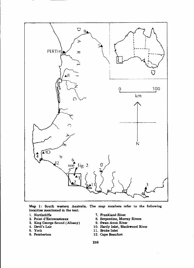
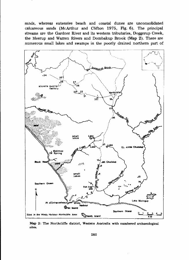
For the past few years Mr A. Jackson and ourselves have recordedarchaeological sites in the area around the town of Northcliffe, W.A. and onthe coastal plain between Northcliffe and Point d'Entrecasteaux 25 km tothe south (Maps 1, 2). In this account we describe some of these sites and
*Archaeology Department, W.A. Museum, Francis Street, Perth, W.A. 6000.
tNorthcliffe, W.A. 6262.
257
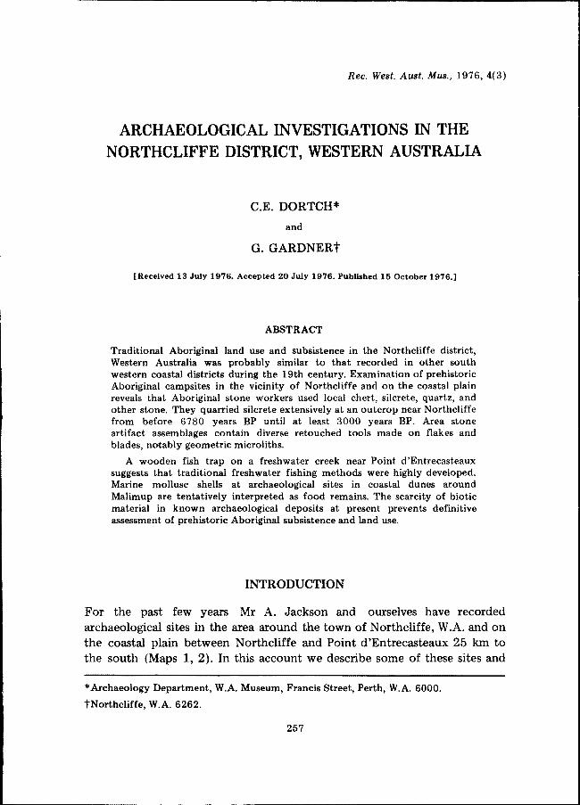
6..see fig. 2.
o!
km
N
100!
Map 1: South western Australia.localities mentioned in the text.1. Northcliffe2. Point d'Entrecasteaux3.. King George Sound (Albany)4. Devil's Lair5. York6. Pemberton
The map numbers refer to the following
7. Frankland River8. Serpentine, Murray Rivers9. Swan-Avon River'
10. Hardy Inlet, Blackwood River11. Broke Inlet12. Cape Beaufort
258
archaeological material collected from them and assess traditional Aboriginaleconomy in the district.
Prior to the early 1920s the Northcliffe district had not been settled byEuropeans. At that time the district began to be farmed by British migrantsof the group settlement scheme, and timbering became important, the maintrees exploited being karri (Eucalyptus diversicolor) and jarrah (E. marginata).The coastal plain to the south has never been occupied or used by Europeanson a year-round basis, and except for a small summer resort at WindyHarbour one km east of Point d'Entrecasteaux, the coastal plain remainsunsettled. The Malimup Spring area (Map 2) was used by pastbralists forsummer cattle grazing as early as the 1880s and for several decades following.Traditional Aboriginal culture disappeared on the south coast during the19th century, and the last visits to the Northcliffe district by small groupsof culturally disoriented south western Aborigines took place in the1920s.
THE AREA
The study area comprises the zones of forest, woodland and open plainbetween Dombakup Brook and Point d'Entrecasteaux (Map 2). The GardnerRiver forms the area's eastern boundary; its western boundary is a lineextending from the junction of Dombakup Brook and the Warren Riversouthward to Malimup Spring. The climate here is of a very wetMediterranean type with an annual rainfall average exceeding 1400 mm(McArthur and Clifton 1975: Fig. 1, Table 2) and a nine month growingseason. Periods of summer drought are not usually prolonged. Frost is rareand the winter is characterised by drizzle, rain and occasional periods ofhigh winds.
In broadest terms area stratigraphy comprises leached sands of Quaternaryage overlying a Pre-Cambrian basement of igneous and metamorphicrocks (Western Australia, Geological Survey 1975). Siliceous stone ofprobable Tertiary age outcrops locally though until now these have notbeen described, and their stratigraphical positions are not fully resolved.Formations of Quaternary limestone occur along the coast, the mostdominant of these being the 105 m high headland of Point d'Entrecasteaux.The soils of the district consist very largely of podzols and podzolisedsands. There are also smaller areas of gravelly red earths and patches oflaterite (McArthur and Clifton 1975). The coastal plain, particularly thesouthern part, is covered by extensive marshes separated by east-westoriented low sand ridges. Further to the north west are massive inland sandhills (notably the Yeagerup Dunes) which encroach on a vast area of heathland and scrub. These sand hills consist of undifferentiated white siliceous
259
-------------
-----~-_ ..._-
sands, whereas extensive beach and coastal dunes are unconsolidatedcalcareous sands (McArthur and Clifton 1975, Fig. 6). The principalstreams are the Gardner River and its western tributaries, Doggerup Creek,the Meerup and Warren Rivers and Dombakup Brook (Map 2). There arenumerous small lakes and swamps in the poorly drained northern part of
Southern Ocean
Pt d'Entrecastaauxl~~~~~~=~;:;""..._
OAst Island Harbour
Sites in the Windy Harbour-Northcliffe Area I'f'l::l.~Sandy Island
'.\
Southern Ocean
WLake Maringup
2 3 4 5KM
Map 2: The Northcliffe district, Western Australia with numbered archaeologicalsites.
260

the coastal plain. The southern part of the plain is drained by severaltributaries of the Gardner River, the most important of these beingBlackwater Creek.
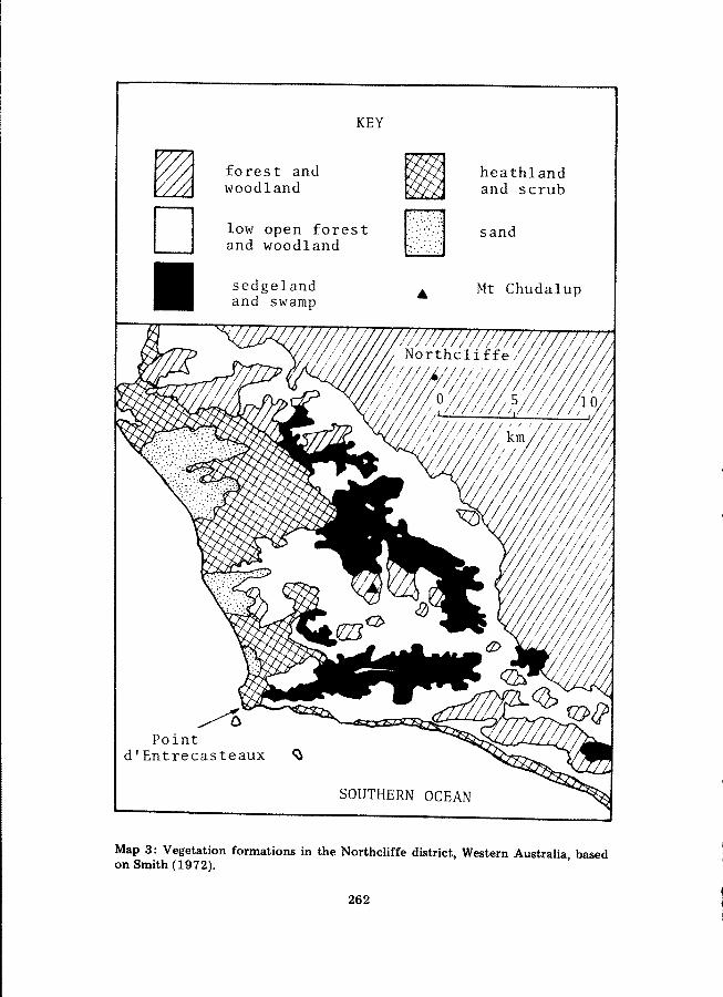
The headland of Point d'Entrecasteaux and coastal dunes to the northwest are covered with heath vegetation and stunted trees, principallybanksias (Banksia spp.), peppermints (Agonis flexuosa) and acacias (Acaciadecipiens) (McArthur and Clifton 1975; Smith 1972). Malimup, a complexof heath covered dunes and interdunal woodland and swamps, is notable forits abundant freshwater springs and caves developed in the limestonesubstrate. The northern part of the sandy coastal plain is interspersed withnumerous outcrops of Pre-Cambrian granite with Mt Chudalup, the highest(185 m a.s.!.) and most conspicuous of these, occupying a central position(Maps 2, 3). The soils derived from the granite outcrops support stands ofeucalypt forest and woodland of the same species which are found aroundNorthcliffe. The sand ridges and some well drained sandy soils of thecoastal plain support eucalypts (Eucalyptus spp.), banksias , acacias,(Acacia spp.), peppermints and occasional Christmas trees (Nuytsiafloribunda). Large trees do not occur on the plain except in the wellsheltered interdunal swales at Malimup, on the granitic outcrops in theMt Chudalup area, and on the timber islands of the northern part of theplain. The chief tree species in the swamps are paperbarks (Melaleuca spp.),Banksia littoralis and Warren River cedar (Agonis juniperina). Smith(1972, pp. 13-14) lists the species of rushes, sedges, herbs and shrubs whichdominate the swamps and sedgelands.
Uncleared areas in the sandy soils around Northcliffe support forest andwoodland dominated by five species of eucalypts: jarrah, karri, marri (E.calophylla), blackbutt (E. patens) and bullich (E. megacarpa). Other trees,including understorey forms, are peppermints, banksias, sheoaks (Casuarinasp.), acacias and blackboys (Xanthorrhoea preissii). North of DombakupBrook (Map 2) there are extensive stands of high karri forest growing onsoils developed on the Pre-Cambrian country rocks. Karri forest extendsover the whole of the dissected plateau around Pemberton 30 km northwest of Northcliffe.
Thus a north-south transect of this area (Maps 2, 3) begins with karri orjarrah-marri forest or woodland formations which about eight km south ofNorthcliffe give way to the sedgeland, swamps, small lakes, low sandridges and timber islands of the northern or upper part of the coastalplain. South of Mt Chudalup the lower part of the plain with its east-westoriented sand ridges and broad areas of swamp, sedgeland, heathland, scruband low open woodland extends to the coastal dunes.
261
~D11
KEY
forest andwoodland
low open forestand woodland
sedgelandand swamp .to
heathlandand scrub
sand
Mt Chudalup
SOUTHERN OCEAN
Map 3: Vegetation formations in the Northcliffe district, Western Australia, basedon Smith (1972).
262
ABORIGINAL ECONOMY
Meagher (1974) and Hallam (1975) have used the abundant ethnohistoricalsources available to infer Aboriginal land use and subsistence patterns in thesouth west (Map 1) at the end of traditional times. In broadest terms theseseem to be that the economy was based on the systematic and to a verylarge extent seasonal exploitation of a very wide variety of food resources ofcoastal and adjacent inland districts; that economic activities often requiredco-ordinated group effort within a system of group land tenure; and thatregular burning, used in vegetation management and animal drives, was asignificant controlling device.
Hallam (1975) shows that Aboriginal economic activities as observed atKing George Sound (Albany) 160 km east of Northcliffe (Map 1) weremuch the same as those recorded in the Perth district and other parts ofthe Swan (or western) Coastal Plain. The similarities in economy, and alsoin the food resources and environments of the Swan Coastal Plain and theSouth Coast, suggest to us that traditional Aboriginal economy and land usein the Northcliffe district was little different from that recorded ethnohistorically in the above mentioned districts. Therefore in the following wehave used this body of ethnohistorical data in inferring some aspects oftraditional land use and economy in the area round Northcliffe.
Ethnohistorical data for the Northcliffe district are minimal. Virtuallythe only published observation of Aboriginai activities here was recorded inApril 1831 by a British naval party who before stranding their boat west ofPoint d'Entrecasteaux had 'heard the natives and saw their fires about amile up the river.' (Anon. 1833, p. 116.) There is no indication whetherthese Aborigines were engaged in fishing, burning off the vegetation, orother likely autumn economic activities. The river referred to is theGardner (Map 2).
A number of ethnohistorical accounts (for detailed references see Hallam1975; Meagher 1974) suggest that to the south western Aborigines the foodand other resources of the coastal plains were at least as important as thoseof adjacent inland districts (e.g. the Darling Scarp). Ethnohistorical accounts,notably Grey (1841, vol. 2, pp. 258-299) and Moore (1884), emphasise thevariety of the coastal plain food resources which included not only marineand freshwater fish but also many terrestrial and freshwater plant and animalfoods. Certainly many of the latter were available both on the coastal plainsand in the interior, including most genera of mammals, many species ofreptiles and amphibians and some of the same plant foods. However thewetlands of the coastal plains have a much more varied component ofplant species with edible roots such as herbs, rushes and sedges, orchids,
263

lilies and lily-like species (Erickson et al. 1973), and some of these arerecorded by Grey (1841, vo!. 2), Moore (1884), Nind (1831) and othersas being regular items of diet. Meagher, in her detailed account of southwestern foods writes:
'Roots, bulbs and tubers appear to have been the main sourcesof vegetable food, some of which were available thorughout theyear. Those collected and eaten by the Aborigines included speciesof Caesia, Dioscorea, Haemodorum, Platysace, Prasophyllum,and Typha.' (1974, pp. 24-25.)
Most of these genera occur in the coastal plain south of Northcliffe or inswamps and streams in the eucalypt forest and woodland around Northcliffe.The notable exception is Dioscorea (D. hastifolia) which is confined tosoils on and east of the Darling Scarp (Erickson et al. 1973).
Other plants with edible parts which occur in the area are zamia palms(Macrozamia riedlei) the fruit of which was processed to remove toxins andthen eaten raw or roasted by south' western Aborigines (Grey 1841, vo!. 2,p.296; Hammond 1933, p.28). Moore (1884, p.3) reports that part of thecrowns of blackboys (Xanthorrhoea preissii) and gum from (the flowerstalks of) these plants were eaten. The fruits of several plants, e.g. those ofthe 'emu plum' (Podocarpus drouynianus) , were eaten by south westernAborigines (for references see Meagher 1974). Eucalypt and banksia nectarwas a favourite food, and acacia seeds and gum were in some districtsseasonal staples (Hammond 1933; Moore 1884). The Aborigines also ateseveral species of fungi (Meagher 1974, p.26). One of these, 'blackfellows'bread' (Polyporus mylittae), appears in quantity following burning in thekarri forests, including those occurring in the Northcliffe district, andthis fungus may have been commonly eaten during the summer andautumn months (pers. comms T. Macfarlane, D. Phillips-Jones). Plantgenera with edible parts which may have been eaten in the Northcliffedistrict but have not been clearly identified in the south westernethnohistorical sources (cf. Meagher 1974, Appendix 4) include severalspecies of aquatic herbs (e.g. Triglochin sp.), some of the sedges (e.g. Scirpussp.), some of the lily-like plants (e.g. Anigozanthos flavida), and fruits orberries of Leucopogon sp., Persoonia sp. and other shrubs.
Animal foods of the coastal swamps, streams and marshes includedseveral species of fish and water fowl, freshwater crayfish, frogs and tortoises. Grey (1841, vo!. 2, pp. 280-284, 287-88) provides detailed accountsof the snaring or gathering of these animals. He observed that the streams,lagoons and marshes were utilised most in summer when their waters wereshallow or dried up and the animals most easily obtained. Freshwater and
264

estuarine fish were taken in quantity especially during summer and autumnaccording to sources quoted above and others listed in Meagher (1974).Freshwater and marine molluscs abound in the waters of the district, yeteVidence of Grey (1841, voL 1, pp. 292-7; voL 2, pp. 263, 288), Moore
. (1884, p.51) and Nind (1831, p.34) suggests that south western Aboriginesdid not eat these animals. The coast below Northcliffe has no largeestuaries such as Hardy or Broke Inlets (Map 1), and it is debatable whetherthe open coast was ever fished. Possibly Aborigines were able to spear ortrap fish in the relatively sheltered waters of Windy Harbour (Map 2).Evidence for freshwater fishing is provided by an Aboriginal fish trap locatedon Blackwater Creek (Map 2; see below).
Meagher (1974) provides a comprehensive ethnohistorical source listand summary of hunting methods used by south western Aborigines, andwe assume that many of these methods were used by Aborigines of theNorthcliffe district in hunting game both large and smalL Large game, suchas emu or kangaroo, was usually speared either following stalking byindividual hunters, or during the course of various kinds of large scalehunts in which numbers of people co-operated in driving animals intoambushes or various kinds of traps. In summer fire drives were commonlycarried out (Grey 1841, voL 2, pp. 270-1, 290-1; Nind 1831, p.28). Noanimal traps are known in the Northcliffe district.. However kangaroo trapsconsisting of narrow trenches or small pits have been .recorded by Miss S.J.Meagher near the Frankland River some 70 km to the north east (Map 1;.pers. comm. S.J. Meagher), and others have been reported from the districteast of Hardy Inlet (Map 1; pers. comm. M. Ellis). Some of the smallermarsupials which were probably eaten by Aborigines of the Northcliffedistrict are small wallabies, including quokkas (Setonix brachyurus) ,bandicoots, possums, rat-kangaroos and native cats. Native rats (moods),various kinds of game birds (particularly water fowl), snakes, large lizards,frogs and freshwater crayfish were also probably eaten.
With the potential exception of the fish trap described below we have noarchaeological data which can be related to specific seasons of occupation ofthe coastal plain. However summer and autumn was the time when manyplant and animal foods of the coastal plain were in season or most easilyavailable. This was also the time when controlled burning could be carriedout to facilitate game drives and the gathering of some wetland plant foodssuch as sedge roots, to maintain control over the vegetation, and to enableease of movement.
Several ethnohistorical accounts relating to Aboriginal land use andeconomy suggest that the south western Aborigines congregated on the
265
coastal plains during the summer and autumn and roamed the inland areasduring the winter. Scott Nind, a medical officer at the British settlement atKing George Sound (Map 1) during the late 1820s, records this in thefollowing:
'During the winter and early spring they are very much scattered;but as summer advances they assemble [on the coast] in greaternumbers.' (Nind 1831, p.28.)
He states further:
'They begin to return to the coast about September or Octoberand at this season they chiefly subsist on roots. In calm weather,however, they procure a few fish.... I believe that during thewinter they are in small parties and much scattered [in theinterior], living upon possums, bandicoots, kangaroos, etc.'(ibid., p.36.)
Stirling (1827) recorded a similar seasonal pattern in the Swan Riverdistrict (Map 1).
Summer and autumn occupation of the coastal plain below Northcliffeseems particularly plausible when one compares the very pleasant conditionsprevailing there in these seasons with the high winds, heavy rain, cold andfloods which characterise the winter, and which at times would certainlyhave .made the area unattractive for human occupation. This fact, in additionto the above ethnohistorical observations which suggest that the southwestern coastal plains were predominately occupied during summer andautumn, could lead one to conclude that this was probably the case, atleast for as long as climate and other environmental factors were the sameas or similar to those of the present. However in the Northcliffe district itseems unnecessary to envisage a clear division between seasonal inland andcoastal occupation such as may have existed in the Swan Coastal Plain andmuch more arid adjacent inland districts, or inland and coastal areas aroundKing George Sound. Instead traditional occupation patterns aroundNorthcliffe and other parts of the high rainfall zone of the extreme southwest (McArthur and Clifton 1975, Fig. 1) could have been loose-knit andsubject more to a variety of ephemeral economic and environmental factorsthan to a strict adaptation to the seasonal availability of water and associatedresources. We suggest then- that advantages of topography and availability ofresources, especially 'plentiful water, enabled many IQcalities, either coastalor inland, within and on the margin of the high rainfall zone to be occupiedat any season.
266
ARCHAEOLOGmALSURVEY
Site location an~ stratigraphy
We have recorded 30 archaeological sites or site complexes in theNorthcliffe-Point d'Entrecasteaux area (Map 2). Nearly all of the sites havebeen identified through the presence of stone artifacts exposed in roadsections or scattered on recently bulldozed surfaces of limited size (Le. fourto 700 square m). Most sites contain less than 20 artifacts though in mostcases it is probable that only a small part of the site is exposed. Howeverhundreds of artifacts, including many retouched tools, have been collected atsites 1 and 2, located immediately east of Point d'Entrecasteaux, and at site28, a silcrete quarry-factory (Map 2, Tables 1,2). An exceptional site notdesignated by a number is the Blackwater Creek fish trap (Map 2; Figs 3,4).
Very thick understorey vegetation and ground cover in most parts of thearea effectively prevents intensive;' systematic archaeological survey. Oursurvey then is essentially a compilation of sites in the better cleared areasaround Point d'Entrecasteaux, the Northcliffe town site, and the road whichconnects them. At present we know very little about the distribution ofsites in the district as a whole, and even in the above areas there areprobably a number of surface sites not recorded.
It is likely that many of the known sites are broadly contemporaneous,and stratigraphical and typological considerations suggest that all areHolocene in age. This is substantiated by two radiocarbon dates relating tothe stone industrial sequence identified in a test excavation in an undisturbedpodzol at the silcrete quarry-factory described below. The only site ofpost-European age is the Blackwater Creek fish trap.
All of the stone artifacts recovered from horizontal graded exposures orroad cuttings had been covered by 20-100 cm of undisturbed sandy soil.Most specimens found in situ in road cuttings occur in the leached zones orA2 horizons of the podzols which predominate in the district (McArthurand Clifton 1975). Similarly the horizontal exposures containing artifacts(e.g. site 1) are either the leached zones of podzols or leached, undifferentiated dune sands. Thus there has been wholesale deposition and no or onlyminimal deflation or erosion since the sites were occupied.
It is possible that the general inhumation of prehistoric occupation surfaces in the district is the result of sand movement within the unstable phaseof a periodic soil cycle such as conceived by Butler (1959). The soil profiledevelopment which now characterises the coastal plain and sandy areas aroundNorthcliffe may represent a stable phase, though movements of massive sandhills to the north west and natural erosion of coastal dunes at Malimup (Map2) could perhaps equally be interpreted as the beginning of a new cycle.
267
Our survey suggests that the most typical sites on the coastal plain southof Northcliffe are located on dune ridges or sandy hummocks overlookingextensive marshes and small lakes which, as noted above, harbour a varietyof plant and animal foods. It seems reasonable to infer that these sites arethe remains of open camps used by bands of hunter gatherers engaged in theexploitation of varied wetland resources. Scatters of stone artifacts in firebreaks and other modern exposures in the forest and woodland aroundNorthcliffe can also be interpreted as open camping places, though here thesites seem smaller in area and artifacts are generally few in number andinclude few retouched tools, suggesting that occupation may have been lessintensive and of a more'transitory nature.
Relatively few sites (Map 2) have been identified in the vicinity of MtChudalup. There is a large rock shelter near the hill which could have beenoccupied though it shows no signs of use. A few artifacts have been found incracks in horizontal granite outcrops in the Chudalup area, and it is possiblethat people used these as camping areas.
Campsites in coastal calcareous dunes have until now been identified onlyat Malimup (see below). The limestone headland of Point d'Entrecasteauxseems devoid of archaeological sites, including such potential features as alarge cave and a line of shallow shelters along the 'inland cliff' on the eastface.
Stone resources
The great majority of artifacts from sites in the Northcliffe district aremade of local stone. The four most important of these are silcrete, whosesource we describe below, gneiss, quartz and a form of fossiliferous chertsimilar in several respects to that found in artifact assemblages fromDevil's Lair (Map 1;' Glover 1974) and numerous sites on the Swan CoastalPlain '(Glover and Cockbain 1971; Glover 1975). Two small outcrops of thischert located in swampy, thickly vegetated areas within the karri forest tento 15 km east of Northcliffe may have been sources used by prehistoricAborigines. However we have not yet discovered signs of quarrying or anyarchaeological material at either outcrop.
Most of the chert used for artifacts is soft, porous and opaque grey.Nodules of this stone often contain inclusions of much finer grained chertwith a flinty appearance, and sometimes this grades into opal (pers. comm.J. Glover). A number of opal artifacts have been recovered from local sites,particularly sites 1 and 2. Silicified sponge remnants (spongolite) and spiculeswhich are sometimes incorporated in nodules of fossiliferous chert are alsofound on archaeological sites. (In Table 2 opal and spongolite artifacts and
268
sponge spicules are listed under chert artifacts.) We have also noted threeartifacts (e.g. Fig. 8:15) made of a form of banded chert which may comefrom Cape Beaufort 60 km to the north west (Map 1).
Clear and milky white quartz was quarried from veins in the Pre-Cambrianrocks of the district, or collected as pebbles from the beaches. Clear quartzcrystals and a form of translucent quartz with a yellow tinge are also foundon archaeological sites. The Aborigines made use of local gneiss, either in theform of beach pebbles or fragments taken from outcrops, and including aform of highly siliceous gneiss resembling quartzite. Other stone used fortools includes amphibolite which occurs in the Archean metamorphic rocksin the north and east of the district (J. Clarke, pers. comm.), and a blackglossy rock similar to obsidian which is found as vein filling in the basaltexposed at Cape Beaufort (Map 1). There are relatively rare basalt artifacts,the nearest known source of this being Cape Beaufort. We have also collecteda few pebbles and fragments of a whitish-grey quartzite which probablycomes from local Pre-Cambrian rocks.
Table 2 shows that at sites 1 and 2 silcrete, quartz and chert were allused extensively whereas there is a very marked preponderance of silcreteartifacts at sites within a few km of the silcrete quarry-factory and at thissite itself (Table 1).
Tlhe silcrete quarry-factory (site 28)
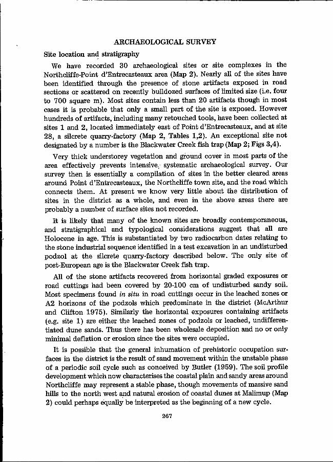
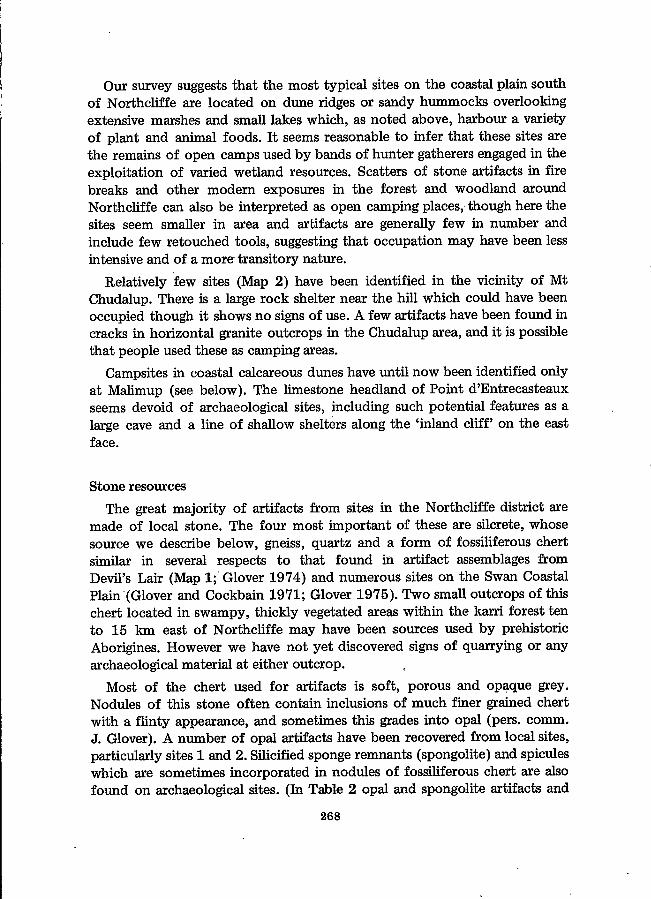
Until now we have carried out only one systematic test excavation in thedistrict. This was made in the face of a bulldozer cutting in a sandy soiloverlying a silcrete formation (site 28) 11.5 km west north west ofNorthcliffe (Map 2). The excavation (Trench 1) and the finds, mostlysilcrete artifacts, are described in more detail in Dortch (1975); and the latterare listed in Table 1. We estimate that the silcrete formation is at least 15hectares in area. The stratigraphy of the site is not fully resolved; however,in exposures the silcrete, probably of Tertiary age, is only about 30 cmthick, and it overlies brown clayey sediments whose upper part containssome limonitic concretions. We interpret site 28 as a quarry-factory and thesource of the numerous silcrete artifacts found throughout the district. Tworadiocarbon dates based on charcoal samples taken in the Trench 1excavation (Table 1; Fig. 1) show that the quarry-factory was in operationfrom before 6780 years BP until at least 3000 years BP.
Mr W.M. McArthur, Land Resources Management, CSIRO, Perth hasidentified the archaeological deposit as an iron humus podzol in which thereis no evidence of sand movement after profile differentiation (pers. comm.W.M. McArthur). Thus, barring possible minor dislodgement by animal
269
Table 1: Distribution of stone artifacts in Trench 1, Northcliffe quarry-factory site, Western Australia (based on Dortch 1975: Table 2).
Silcrete artifacts Artifacts of other stone
s
Radiocarbon Depth Geometric Notched Blades Bladelets Flakes Chips2 Cores Debrisdates in in cm microliths1 flakes and
years BP. below other re-datum touched
tools
ANU-1131 46·51 23080.±. 75
51-53 2 8 6+53-57 1 atypical 1 3 39 47+57-59 2 atypical 2 2 48 57+59·60 2 6 57 110+ 1 quartz chip60·62 3 2 2 76 50+ 262·64 2 1 1 54 50+ 2 quartz chips
1 quartz flake64-66 2 6 5 81 50+ 3 1 quartz bladelet66-70 6, 2 atypical 2 3 11 149 250+70-72 4, 1 atypical 2 4 2 106 250+ 2 6 quartz flakes and fragment72-74 2 4 5 1 97 250+ 5 3 quartz fragments74-78 1 atypical 3 1 11 112 250+ 4 1 2 quartz fragments
1 fragment of gneiss78-82 3 1 38 100+ 182-85 1 1 14 20+ 8 quartz chips
SUA-379 85-90 2 20+ 1 1 1 quartz fragment6780.±.120 90·96 1 5 2+ 1 1 quartz flake
96·98 5 9+ 1 quartz core1 quartz flake
98-103 7 1+ 1 quartz bladelet2 quartz flakes2 quartz fragments
103-c,120 5 4+ 2 1 quartz fragment2 quartz flakes2 chert flakes
18 typical 25 22
1 atypical indicates irregular or partly retouched specimens.
46 903 1526+ 12 11 39 (Artifact total 2609+)
2 + indicates that total chips were not recovered.
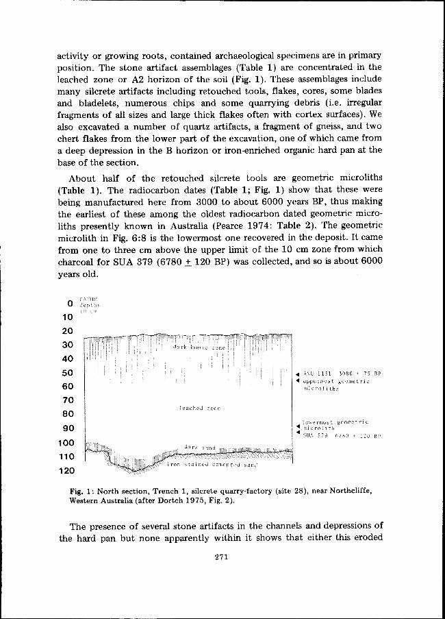
activity or growing roots, contained archaeological specimens are in primaryposition. The stone artifact assemblages (Table 1) are concentrated in theleached zone or A2 horizon of the soil (Fig. 1). These assemblages includemany silcrete artifacts including retouched tools, flakes, cores, some bladesand bladelets, numerous chips and some quarrying debris (Le. irregularfragments of all sizes and large thick flakes often with cortex surfaces). Wealso excavated a number of quartz artifacts, a fragment of gneiss, and twochert flakes from the lower part of the excavation, one of which came froma deep depression in the B horizon or iron-enriched organic hard pan at thebase of the section.
About half of the retouched silcrete tools are geometric microliths(Table 1). The radiocarbon dates (Table 1; Fig. 1) show that these werebeing manufactured here from 3000 to about 6000 years BP, thus makingthe earliest of these among the oldest radiocarbon dated geometric microliths presently known in Australia (Pearce 1974: Table 2). The geometricmicrolith in Fig. 6:8 is the lowermost one recovered in the deposit. It camefrom one to three cm above the upper limit of the 10 cm zone from whichcharcoal for SUA 379 (6780.±. 120 BP) was collected, and so is about 6000years old.
o10
20
30
40
50
60
7080
90
100
110
120
DATUM
1 n
leached zone
• ANU 1131 3080 + 7S BP.... uppermost geometric
microl i ths
lowermost geometrIC
• ith• SUA 6780 + 120 BP
Fig. 1: North section, Trench 1, silcrete quarry-factory (site 28), near Northcliffe,Western Australia (after Dortch 1975, Fig. 2).
The presence of several stone artifacts in the channels and depressions ofthe hard pan but none apparently within it shows that either this eroded
271

surface was actually occupied or that the artifacts dropped down to itfollowing the stripping away of the A horizons of an earlier soil. In eithercase the presence of the artifacts in this position and the eroded conditionof the hard pan surface shows that it had been exposed before the presentsoil accumulated. Thus at least one full cycle of soil destruction, depositionand soil profile development began here more than 6780 years ago and wascompleted sometime after 3000 years BP.
Four pollen samples collected at different depths in Trench 1 (Fig. 1)were submitted to Dr B.E. Balme of the Geology Department, Universityof Western Australia for analysis. His report (pers. comm. B.E. Balme)states that a sample from a depth of 47 cm contained pollen grains, thedominant species being Eucalyptus calophylla and E. diversicolor thoughsome grains 'of E. marginata-type were also fairly common.' A sample from68 cm contained a similar plant microfossil assemblage though a sample from87 cm contained no pollen. The lowermost sample from the dark sand restingon the hard pan (depth 121 cm) contained pollen grains of the three aboveEucalyptus species with E. diversicolor appearing to be 'relatively moreabundant' than in higher samples.
These three Eucalyptus species are at present dominant in the district(McArthur and Clifton 1975; Smith 1972); the pollen analysis suggeststhen that local climate was at various times during the Holocene perhapsmuch the same as it is at present. In his recent study Churchill (1968,p. 146) shows that 'the climate [of the lower south west] from 4000 to3000 B.C. was favourable for E. diversicolor'. The stratigraphical position ofthe lowermost pollen sample within the radiocarbon dated deposit describedhere suggests that conditions were favourable for E. diversicolor even earlierduring the Holocene. (Note: There is an incorrect passage in the Abstract ofDortch [1975, p.59] which, in referring to E. diversicolor, E. calophyllaand E. marginata, states that 'the two former species and possibly the latterwere present at times since [6780 years B.P.] '. In fact as noted aboveE. marginata pollen does occur in both samples dated less than 6780 yearsB.P.)
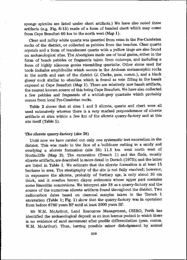
Silcrete artifacts are scattered in ploughed ground or bulldozer cuttingsthroughout the vicinity of the silcrete formation. In 1973 one of us (G.G.)found a recently uprooted blackbutt (Eucalyptus patens) stump locatednear Trench 1 which has numerous silcrete artifacts in the mass of sandysoil adhering to its base and roots (Fig. 2). The artifacts occur in twodistinct layers, both of which could be seen in 'section' and one of which isseen in 'plan' at the base of the stump (Fig. 2). It is apparent that a largeamount of archaeological deposit was brought up when the tree wasbulldozed over.
272

Fig. 2: End view of base of uprooted tree stump (Eucalyptus patens) at silcretequarry-factory (site 28) near Northcliffe, Western Australia. Numbers of silcreteartifacts are visible in the sandy soil adhering to the roots. The range pole ismarked in 10 cm units.
273
Two marine shells have been collected from archaeological horizons atthe quarry-factory. The first of these is a turban shell (Turbo sp.) found insand exposed when the blackbutt stump described above was uprooted. Thesecond shell, a giant creeper (Campanile symbolicum, Iredale: pers. comm.G.W. Kendrick) was found 20 cm below the surface in undisturbed sandoverlying silcrete in another part of the site.
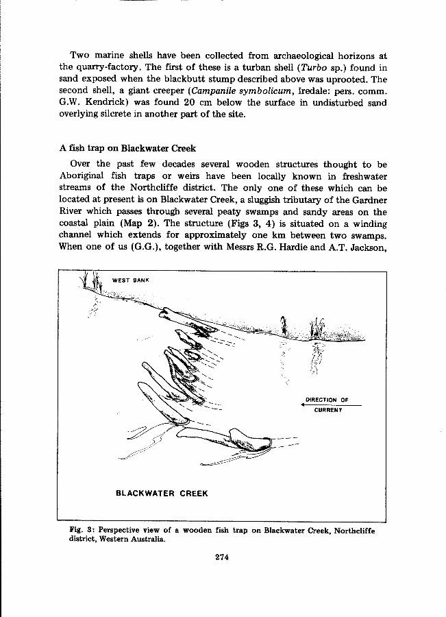
A fish trap on Blackwater Creek
Over the past few decades several wooden structures thought to beAboriginal fish traps or weirs have been locally known in freshwaterstreams of the Norlhcliffe district. The only one of these which can belocated at present is on Blackwater Creek, a sluggish tributary of the GardnerRiver which passes through several peaty swamps and sandy areas on thecoastal plain (Map 2). The structure (Figs 3, 4) is situated on a windingchannel which extends for approximately one km between two swamps.When one of us (G.G.), together with Messrs R.G. Hardie and A.T. Jackson,
DIRECTION OF..CURRENT
BLACKWATER CREEK
Fig. 3: Perspective view of a wooden fish trap on Blackwater Creek, Northcliffedistrict, Western Australia.
274
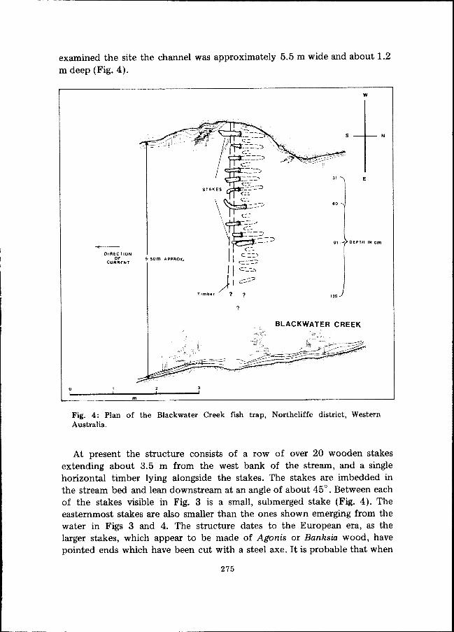
examined the site the channel was approximately 5.5 m wide and about 1.2m deep (Fig. 4).
w
275
Ns
91 - DEPTH IN cm
31 E
60
125
?
m
-+-DIRECTION
OFCURRENT
Fig. 4: Plan of the Blackwater Creek fish trap, Northcliffe district, WesternAustralia.
oI
At present the structure consists of a row of over 20 wooden stakesextending about 3.5 m from the west bank of the stream, and a singlehorizontal timber lying alongside the stakes. The stakes are imbedded inthe stream bed and lean downstream at an angle of about 45° . Between eachof the stakes visible in Fig. 3 is a small, submerged stake (Fig. 4). Theeasternmost stakes are also smaller than the ones shown emerging from thewater in Figs 3 and 4. The structure dates to the European era, as thelarger stakes, which appear to be made of Agonis or Banksia wood, havepointed ends which have been cut with a steel axe. It is probable that when

in use the stakes extended right across the channel in an unbroken row, andthat the channel shown in Fig. 4 is wider than it was when the trap was inuse.
We interpret the Blackwater Creek structure as a fish trap or weir thoughit seems to be somewhat different in concept from one on the SerpentineRiver near Barragup (Map 1), described and illustrated by Hammond (1933,pp. 46, 47), and other south western traps observed by Armstrong (1871)and Paterson (1896). According to Hammond the main feature of theBarragup trap was a 'wicker fence' containing a central race or gap. Peoplestanding on platforms positioned on each side of the gap were able tosnatch fish as they passed through the race. The anthropology collection,Western Australian Museum contains a c. 1900 photograph of a trap on theMurray River (Map 1) of this kind. A line drawing based on this photographis illustrated in Fig. 5, and clearly shows the central gap.
Fig. 5: Sketch of a wooden fish trap on the Murray River, Western Australia, basedon a c. 1900 photograph in the anthropology collection, Western AustralianMuseum.
We do not at present know how the Blackwater Creek fish trap was used,or which fish species or other animals were caught in it. Nor do we know ifthe trap was used during particular seasons. The construction is solid, and itis obvious that the trap was intended to last for a long time. The woodenstakes are all submerged during the high water levels of winter, and thetrap would have been unusable then, unless there were upright sticks whichenabled a mesh of sticks and brush to be raised above the stakes.
Hammond reports that the Barragup fish trap was used 'at the commencement of winter to catch the fish that were forced down the stream bythe fresh water' (1933, p. 46). Paterson (1896, p. 280) writing of fish trapson the Serpentine and Murray Rivers (Map 1) also noted that they were usedmost extensively at the beginning of winter. Blackwater Creek is always
276
fresh or only slightly brackish at the trap site, and so the trap described herewas not used in the same way as those observed on the Murray River and theSerpentine. At no time does Blackwater Creek have a high velocity waterflow. Therefore some agency other than changes in salinity ,or water currentseems to have been necessary to force fish or other animals into the trap.It is likely that fish were driven into the trap by people creating a disturbanceat the downstream end, or perhaps either end of the channel in which thetrap is centred. A clue to the trap's lik~ly function is the way in which thestakes are angled downstream. Mr R.G. Hardie suggests that fish weredriven into the trap from downstream; and that they were speared frombetween the angled stakes by fishermen standing on the horizontal timber(pers. comm. R.G. Hardie).
A review of the fish species likely to be living in Blackwater Creek(pers. comms R. Lenanton, R. McKay; Lenanton 1974) suggests that thereare a number of different species which may have been caught, and thatthere are various seasons during which the trap could have been used. Furtherfield analyses of these problems, including detailed study of the aquaticfauna of Blackwater Creek, re-examination of the trap's structure, and testsof stream salinity and water flow during different seasons will be necessarybefore the trap's function and mode of use can be defined clearly. Ethnographic inquiries and examination of other archaeological sites in thelocality could also provide significant data.
Malimup Spring
The coastal area around Malimup Spring (Map 2) is environmentally andgeomorphologically probably the most diverse in the district. Stoneartifacts and sparse scatters of edible marine molluscs occur in blow outs.in the calcareous coastal dunes, showing that either the present blow outswere occupied or that occupation took place on aggrading surfaces whichhave been subsequently exposed. The chief significance of these sites is thatthey show that people camped in coastal dunes, and that their subsistencemay have been in part based on the exploitation of marine molluscs.(At present the Malimup sites are designated by a single number -'29.)
One of the Malimup archaeological sites is a cluster of stone artifacts andmarine molluscs in a blowout, discovered by Mr G.W. Kendrick of theWestern Australian Museum. The site consists of several flaked stoneartifacts, several gneiss beach pebbles or boulders, and a cluster of severaledible marine molluscs including 11 shells of Nerita atramentosa Reeve, oneabalone shell (Haliotis rolli Gray), one limpet shell (Patella laticostata) andone shell of Dicathais orbita. This small cluster of shells hardly constitutesa shellfish midden, yet Mr Kendrick tentatively interprets this site as
277
the remains of an Aboriginal meal (pers. comm. G.W. Kendrick:. The shellsare registered in the Western Australian Museum palaeontological collection70.906-70.909.). This site is thus one of the veri few known in the southwest (cf. Dortch 1974, p. 205) whose evidence does not agree withethnohistorical records (Grey. 1841, vol. 2, p. 288; Moore 1884 p. 51) whichsuggest that molluscs were not eaten by south western Aborigines.
The Malimup site complex is notable also for the relative abundance ofpebble tools made of gneiss or amphibolite (Figs 9: 12 and 13; see below).These tools may be evidence for special activities (e.g. cracking molluscshells); or they may simply reflect these sites' proximity to abundant beachpebbles.
A series of limestone caves in the neighbourhood of Malimup Springhave potential archaeological value as they may contain occupationdeposits.
STONE ARTIFACT ASSEMBLAGES
The stone artifact assemblages collected from sites in the N.orthcli,ffedistrict feature a dominant flake technology. There is a small blade andbladelet element, and a smaller still but clearly characterised pebble toolcomponent. The evidence for stone grinding is limited to a few grindstonesand a single edge-ground aXe. We have identified no tools shaped by hammerdressing (pecking) or polishing.
No more than 5 to 7% of the stone artifacts from any site are retouchedor otherwise shaped, and thus classifiable as 'formal tools'. However theassemblages from the three most prolific sites, the silcrete quarry-factoryand sites 1 and 2 (Tables 1, 2) include, in addition to retouched tools, largenumbers of very small flakes and chips (Le. flakes with maximum dimension<1 cm) showing that tools were being manufactured in quantity.
The stone artifact assemblages excavated from Trench 1 at the silcretequarry-factory make up the only systematic samples for the area, and theyare also the only large assemblages which have not been mixed by ploughingor bulldozing. The assemblages from sites 1 and 2 are simply very extensivecollections' of artifacts exposed on two artificially truncated sandyhummocks. Each exposure is almost certain to consist of portions of severalold surfaces, and so these must be regarded as mixed assemblages. Nevertheless the tool and by-product (debitage) cat~gories listed for each in Table2 give some idea of the likely composition of tyi>ical stone artifact assemblages in the 10weJ: part of the coastal plain.
278

TABLE 2Classification of stone artifacts from Sites 1 and 2,
Point d'Entrecasteaux, Western Australia.Site 2 - 1013
silcrete chert quartz other stone
site 1 site 2 site 1 site 2 site 1 site 2 site 1 site 2
( 7 segments 5 segments 1 triangle (opal) 5 segments 2 segments(geometric 2 trapezes 1 trapeze 3 trapezes 1 trapeze
backed ( 1 rectanglemicroliths (
( other 1 asymmetric point 2 asymmetric points 2 irregular5 irregular 2 irregular 12 irregular
( 1 adze-like scraper 1 adze-like scraper( adze-like 2 flat adze 1 flat adze
flake (scrapers ( non-adze 1 end-scraper 3
2 blades 11 flakes 21 flakes 9 flakes 7 flakesnotched pieces 3 bladelets 3 bladelets
16 flakes
denticulated pieces 13 flakes 4 flakes 6 flakes 5 flakes 7 flakes
6 retouched flakes 1 retouched flake 5 retouched flakes 1 retouched flake 2 very small 1 retouched flake 1 basalt edge-groundother retouched tools 8 ahruptly 6 abruptly retouched 1 abruptly retouched flakes axe
retouched flakes flakes retouched flake1 dihedral burin 1 very small 'core-
scraper'
blades 12 9 1 1 3 2
bladelets 24 16 4 6 9 9
flakes, chips and 416 358 275 222 864 285 6 flakes and fragments 4 flakes of blackfragments made of black glossy glossy rock (Black
rock (vein filling in Point?)Black Point basalt?)
2 bipolar (scalar)4 bipolar (scalar) 8 bipolar (scalar) 7 bipolar (scalar) 22 bipolar (scalar) 2 bipolar (scalar) 1 discoidal core made
7 single platformflake 3 discoidal 2 discoidal 4 amorphous 2 single platform 6 amorphous of black glossy rock
2 double platform 1 bladelet 1 multi-platform flake (Black Point?)cores flake flake 2 double platform
2 multi-platform 4 multi-platform flake
flake flake 27 amorphous flake
1 bladelet
2 crested bladelets 4 Levallois flakes? 1 flake with use- 1 flake, from 2 split pebbles 2 crystals 1 gneiss hammerstone 2 gneiss fragments1 Levallois flake? 6 flakes, from smoothed edge discoidal core? 2 crystals (manuports) 5 gneiss pebble
other stone artifacts 2 flakes with use- discoidal cores? (manuports) fragmentssmoothed edges
TOTALSretouched tools 69 33 36 18 39 6blades and bladelets 36 25 5 7 12 11cores 14 8 15 11 53 8total artifacts 540 434 332 259 972 312 12 8
A rtifact totalsSite 1 - 1856
The following brief description of major tool types, cores and otherby-products is based on the examination which one of us (CED) has madeof all the assemblages known from the district. Specimens considered to bediagnostic and in most cases typical are illustrated in Figs 6-9. These piecescome from a number of different sites though the majority are from sites1,2 and 28.
Backed microliths
Backed microliths as described in Australia by Campbell and Noone(1943); Glover and Lampert (1969, pp. 224-5); McCarthy (1967, pp. 40-45);and Mulvaney (1961, pp. 79-80) are tools made on small flakes, bladelets orparts of blades whose diagnostic features are very small size; and backing orabrupt retouch, sometimes bipolar, along part of their margins. All of theNorthcliffe backed microliths conform to this definition, and nearly allhave maximum dimensions of less than three cm.
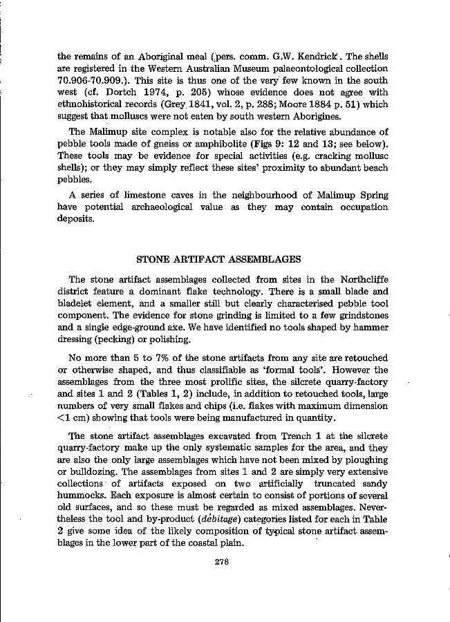
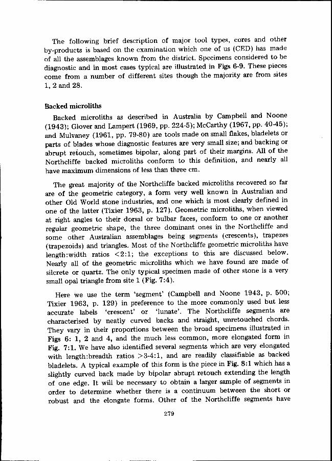
The great majority of the Northcliffe backed microliths recovered so farare of the geometric category, a form very well known in Australian andother Old World stone industries, and one which is most clearly defined inone of the latter (Tixier 1963, p. 127). Geometric microliths, when viewedat right angles to their dorsal or bulbar faces, conform to one or anotherregular geometric shape, the three dominant ones in the Northcliffe andsome other Australian assemblages being segments (crescents), trapezes(trapezoids) and triangles. Most of the Northcliffe geometric microliths havelength:width ratios <2:1; the exceptions to this are discussed below.Nearly all of the geometric microliths which we have found are made ofsilcrete or quartz. The only typical specimen made of other stone is a verysmall opal triangle from site 1 (Fig. 7:4).
Here we use the term 'segment' (Campbell and Noone 1943, p. 500;Tixier 1963, p. 129) in preference to the more commonly used but lessaccurate labels 'crescent' or 'lunate'. The Northcliffe segments arecharacterised by neatly curved backs and straight, unretouched chords.They vary in their proportions between the broad specimens illustrated inFigs 6: 1, 2 and 4, and the much less common, more elongated form inFig. 7:1. We have also identified several segments which are very elongatedwith length:breadth ratios >3-4:1, and are readily classifiable as backedbladelets. A typical example of this form is the piece in Fig. 8:1 which has aslightly curved back made by bipolar abrupt retouch extending the lengthof one edge. It will be necessary to obtain a larger sample of segments inorder to determine whether there is a continuum between the short orrobust and the elongate forms. Other of the Northcliffe segments have
279
asymmetric surved backs and are similar to the 'rudder-like' segments ofCampbell and Noone (1943: Figs 82-84).
The trapezes are simply double obliquely truncated pieces. As with thetrapezes of many Australian and other Old World microlithic assemblagesthe Northcliffe specimens can be divided between those in which the shorter
2
~;
- - :.,>~
-
o 2I
cm -d17 I~
-8
~-,~,
13
Fig. 6: Geometric microliths and other silcrete artifacts from the Northcliffedistrict, Western Australia.
280
lateral edge between the two oblique truncations has been abruptly retouched(Figs 6:9, 12, 14, 15); and those in which this is left unretouched (Figs6: 5·7). In the latter form then the retouched 'back' is confined to thetruncated extremities. We have collected only one elongated trapeze, anexceptionally large piece from the Malimup site complex (Fig. 8:8).
1 3 4'----'
1cm1:1/1:2
Fig. 7: Geometric microliths and an obliquely truncated bladelet from Site 1,Point d'Entrecasteaux, Western Australia.
The Northcliffe assemblages also contain a few obliquely truncatedbladelets (i.e. pieces with only one extremity truncated by abrupt retouch);a minute example is the quartz specimen in Fig. 7:2.
Triangles (Figs 6:11; 7:4) are much less common than the two previousforms. Intermediate forms between the three occur frequently, and it isunrealistic to draw too fine distinctions between the differences in shape.For instance the specimen in Fig. 6:8 is illustrated in Dortch (1975, Fig. 3b)and is described there as an example of the crescentic form (ibid., p. 61).However it is perhaps more accurate to regard this specimen as intermediatebetween the crescentic (or segment) and triangular forms. Figures 6:3 and10 are similarly intermediate between triangles and segments, and Fig. 6:13between the segments and trapezes.
A special feature of some Northcliffe silcrete geometric microliths of allthree forms is the marked incurving of the proximal and distal retouchededges. Two specimens with very clearly incurving edges are illustrated inFigs 6:11 and 14; and Figs 6:7,9 and 10 are examples with one incurvingedge.
Many of the silcrete geometric microliths appear to be made on obliquelyor transversely snapped blades or bladelets. The local silcrete is very brittleand thin blades of this stone can easily be snapped or fractured obliquely ortransversely between one's fingers. A blade which was probably snappedmanually is illustrated in Fig. 6:16. The transverse fracture at the lower end
281

of the piece consists of two fracture surfaces, and though we have beenunable to replicate this fracture experimentally, we suggest that it wasproduced by snapping. A number of other possibly deliberately snappedblades or bladelets have been identified.
1 2 3
8
I
~
7
3.ii5:ii1
cm
6
ot
(/j!?
5I
4~
Fig. 8: Selected flaked stone artifacts from the Northcliffe district, WesternAustralia.
The quartz geometric microliths include far fewer typical specimens thandoes the sUcrete group. They are also generally smaller in size than the
282
silcrete specimens; some are extremely small as shown by the tiny trapezein Fig. 7:3.
We have identified three atypical but no typical asymmetrical backedpoints of 'bondi' form (McCarthy 1967, p. 40). There are no rectilinearbacked bladelets, as occur in some of the Pilbara assemblages in thearchaeology collection, Western Australian Museum (e.g. B3020), and asGlover (1967, p. 419) notes in Newall's Millstream collection. Again a largersample of the very elongated segments (Fig. 8:1) may show that thesemerge into a rectilinear form.
There are a number of atypical or irregular specimens among both thequartz and the silcrete geometric microliths. These are numerically important(Tables 1, 2) though they cannot be dealt with in detail here. However allare similar in size and proportions to the more regular forms.
Other small retouched tools
The Northcliffe assemblages contain a variety of other small retouchedtools made on flakes or blades, usually quite small with maximum dimensionsin the range 2-5 cm. In the following we describe briefly the most numericallyimportant and clearly defined of these.
notched pieces - These are perhaps the most common form of retouchedtool in the area. Most are simple flakes of sUcrete, chert or quartz with oneor more small retouched notches. Some have larger notches, produced by asingle blow with the hammerstone, sometimes described as 'Clactoniannotches' (encoches clactoniennes: Bordes 1961, p. 35). The silcrete flakein Fig. 9:2 has both kinds of the above notches. It has several small retouchednotches on its right lateral edge and a single inverse 'Clactonian notch' on itsleft proximal corner.
denticulated pieces - These differ from the above only in that they featurea number of very small, closely adjacent notches sometimes resulting in asaw-like or serrated edge. Most of the Northcliffe denticulates are ratherirregular and poorly made. There are also numbers of flakes with series ofextremely small notches sometimes resembling very fine denticulation.These are likely to be the result of accidental edge-damage or use rather thanretouch.
scrapers - The present sample of scrapers, Le. tools usually made on smallflakes or fragments and having robust retouched working edges which incontour are rounded, straight or irregular, comprise a relatively numerousand varied group. It is useful here to divide the scrapers into two categories.The first consists of pieces whose working edges resemble those of adze
283

flakes, Le. flake scrapers used as hafted woodworking tools; the second iscomposed .of pieces whose working edges do not have the characteristicfeatures of adze flake edges. In broadest terms Australian adze flakes aresmall flake scrapers which have relatively steep angles (600 to 800
) between.the planes of the flaking face and the lower (generally bulbar) surface; andworking edges whose dia~ostic features result from a combination of useand resharpening. These features include marked crushing or rounding alongthe periphery of the working edge and undercutting (som.etimes referred toas 'step-flaking') coming from the working edge and encroaching more orless over the flaking face (cf. Gould, Koster and Sontz 1971; Hayden andKamminga 1973). Such characteristic wear features must be present toenable purely archaeological specimens such as these here (Le. specimens forwhich no direct historical or ethnohistorical functional data exist) to beclassified as probable adze flakes, and not simply as scrapers. We have beenable then to classify only a minimum number of specimens as the former.Many pieces which we regard here as flake scrapers may well have· beenintended for use as adzes, or were used in woodworking tasks which involvedlittle re-sharpening and left few signs of wear.- For example two flakescrapers, the first of which is made of quartz and the second of silcrete, areillustrated in Figs 8:10 and 9:4. Each is of the approximate size andproportion of many known adze flakes; however neither shows thecharacteristic adze flake use wear patterns on its working edge which wouldenable it to be ·classified as a probable adze flake.
We have not identified adze flakes of tula form (Mulvaney 1969,pp. 71-74) in our 'Present sample. The pieces classifiable as probable adzeflakes are mostly irregular; most are made on chert or silcrete flakes orfragments. The only typologically distinctive probable adze flake which wehave identified is a small flattened form, very similar to the 'flat adze' ofGould and Quilter (1972). The best Northcliffe example of this form isFig. 8:3. The piece has opposed concave working edges typical of the.formwhich Gould and Quilter (ibid., p. 5) describe as 'strangulated' or of. 'hourglass shape'. These authors note that flat adzes are known from sites atWalynunga and South Bullsbrook near Perth, and other parts of the southwest. The Northcliffe specimens help to strengthen tlleir conclusion thatthese tools are a standard part of south western assemblages.
Likely adze flakes include the small silcrete specimen in Fig. 6:17 whichhas a very heavily crushed and undercut concave flaking face. There are alsothe chert specimens in Figs 8:9 and 9:14. These two come from site 2, andthe latter is similar to probable adze flakes made of chert which have beenidentified at Devil's Lair (Map 1; Dortch 1974; Dortch and Merrllees1973). .
284
j-2 3
11
6
15
o 4~--......J-'"'oI
cm
285
9
8
Fig. 9: Selected flaked stone artifacts from the Northcliffe district, WesternAustralia.
4
We have collected two end-scrapers on bladelets. There are also a fewcore-like pieces on thick flakes the peripheries of whose flaking faces havesecondary chipping resembling that found on scraper working edges. Someof these 'core-scrapers' are made of quartz or gneiss; others are made ofsilcrete. One of the latter is illustrated in Fig. 9: 7. The piece has a flakingface resembling that of a core though the periphery of this has beenregularised by retouch, suggesting that it has been used as a tool. The pieceis one of several from the district which closely resemble the carinatedscraper (grattoir carene) of the European and Middle East Aurignacian(Movius and Brooks 1972).
Most of the cores which we have recovered (e.g. Fig. 9:5; see below) lacksecondary retouch along the periphery of their flaking faces, suggesting thatcores or pieces resembling cores were not usually used as tools. We havefound no horsehoof cores (McCarthy 1967, p. 18) though these occur instone artifact assemblages from other parts of the south west (e.g. in theSwan-Avon valley between Perth and York, Map 1). The well known eloueraof eastern Australia (McCarthy 1967, p. 26; Mulvaney 1969, p. 81) alsoseems absent; however one of the microlithic segments is very robust, andif it were found in an eastern assemblage it would probably be classified asan elouera.
We have identified several burins in our sample, including a few ontruncation and one dihedral burin. Abruptly retouched flakes are fairlycommon (Table 2) though it is not certain whether the abrupt edge chippingis in fact retouch or the result of heavy use. We have also identified a fewflakes with edges worn smooth through use.
Pebble tools, an axe, grindstones and hammerstones
We have relatively few pebble tools in our present sample. Because of thisit is difficult to delineate the likely major types of forms among them,except by referring to those described in syntheses of regional or continentalstone tool forms (e.g. Davidson and McCarthy 1957; McCarthy 1967;Mulvaney 1961; 1969). A number of gneiss, quartz or amphibolite pebbleshave one end or one side removed by flaking, so enabling them to be definedas 'pebble choppers' in the sense of Movius (1944, pp. 10-11), thoughequally they could have been cores.
Two specimens from Malimup (Figs 9:12 and 13), respectively made ofamphibolite and gneiss, have each been multi-convergently flaked over thewhole of one face, leaving the opposing face an unmodified pebble surface.Unifacially flaked pebbles such as these have been collected on KangarooIsland (Cooper 1943, Figs 66-75), in other parts of Australia (McCarthy
286

1967, pp. 19-20), and also in Indonesia (van Heekeren 1957, p. 73; pI. 20)and elsewhere in south eastern Asia. McCarthy (1940), Matthews (1966),Movius (1944) and Mulvaney (1961; 1969) discuss the distribution andsignificance of Australian and south east Asian pebble tools.
We have recovered only one stone axe in the district. This specimen isbifacially flaked and has a bifacially ground cutting edge. Davidson andMcCarthy (1957, Fig. 7) considered that axes of this kind did not occur inthe south west, but Ride (1958) and more recently Akerman (1973)showed that this is not the case. The Northcliffe specimen comes from site 2and is made of basalt whose origin, as noted above, may be Cape Beaufort(Map 1).
Some of the Northcliffe sites contain simple grindstones, upper or lower;and hammerstones, most of which are simply gneiss beach pebbles orfragments of silcrete which have become rounded or abraded through use.
We have also collected a few percussion/grindstones, a form of multipurpose tool which is a common feature of south western assemblages.These are squat, cylindrical pieces with grinding surfaces or percussion pitson one or both flat faces. Davidson and McCarthy (1957, p. 441) state thatsome of these tools were used as 'hammer, anvil and muller'. Theseartifacts are one of the most characteristic south western stone tools thoughunfortunately their specific functions were never recorded ethnographically.The Northcliffe specimens are made of gneiss or amphibolite.
Cores and other by-products
There are a variety of cores in the Northcliffe assemblages. The mostcommon kinds are multi-platformed, usually amorphous or globular, andbipolar or 'scalar' cores (Dortch and Merrilees 1973; White 1968). Singleplatform flake cores are common and are sometimes made on thick flakes(Fig. 9:5 is a sUcrete specimen).
Discoidal cores are well represented as are flakes probably produced ondiscoidal cores (e.g. Fig. 9:10). The pieces in Figs 9:1 and 6 are bifaciallyflaked discoidal cores respectively made of silcrete and chert. The very smallunifacially flaked discoidal core in Fig. 9:15 is made of a banded chert whosepossible source of Cape Beaufort is noted above. A few sUcrete cores (e.g.Fig. 9:3) resemble Levallois flake cores, and there are numbers of silcreteflakes (Figs 9:8, 9) which are very similar to Levallois flakes. However thepresent sample is too small to enable us to determine with certainty whethera Levallois technique of flake production (Bordes 1961) was used in thedistrict.
287
The silcrete artifacts provide by far the best evidence for blade andbladelet production. (We divide blades and bladelets on the basis of size andproportions, following Tixier 1963, Fig. 7. A silcrete bladelet is illustratedin Fig. 8:5, and a small quartz blade in Fig. 8:6.) Blade or bladelet('prismatic') cores are rare though some silcrete cores of all kinds haveflake scar facets showing where bladelets or blades were removed along withflakes. Figure 9:11 shows a silcrete bladelet core which has been workeddown to a very small size.
There are a few unilaterally flaked crested blades or bladeletS made ofsilcrete (e.g. Figs 8:L,l, 7) in the Northcliffe assemblages. We interpret theseas the principal preparatory pieces (lames a crete: Barnes and Cheynier
. 1936) removed from the flaking faces of bladelet or blade cores. We havefound no bilaterally flaked crested blades; however, the tabular silcrete usedin blade and bladelet production can be broken into sharp-edged fragmentswhich require little or no flaking to prepare them for successive bladeremoval. Bordes and Crabtree (1968, p. 3) point out that only 'slight, .
modification or unifacial trimming' is necessary when using 'angular'material.
We have found no chert blade or bladelet cores; chert blades are absent;and the very few chert bladelets so far identified, all from sites 1 and 2(Table 2), are irregular. Furthermore the only chert cores which seemtypical in our present sample are bipolar (scalar) and discoidal cores. All ofthe others seem to be casual fragments from which a few flakes wererandomly removed from convenient corners. It should. be emphasisedthat chert nodules from the two outcrops east of Northcliffe are small,irregular, full of spongolite masses or spicules, or chalky inclusions, and arethus unsuited for blade or bladelet production. However as noted abovethese nodules contain small masses of very fine grained chert grading intoopal. Assuming that the local chert was quarried we suggest then that it wasvalued by stone workers largely because of the presence of small quantitiesof high quality stone. It seems likely, drawing on analogies from ethnographically recorded Aboriginal quarrying methods (notably Tindale 1965,pp. 140-1), that chert nodules were simply split or smashed into pieces andthe more valuable bits collected. These then could be flaked by more formaltechniques.
It is clear that the raw material has had a very marked influence on toolforms and stone working techniques in the Northcliffe assemblages. Silcretewas favoured for blade and bladelet production whereas chert was used onlyfor flake production. Quartz seems to have been the main stone used inbipolar production of flakes, and sometimes small blades and bladelets,judging by the blade-like (lamellar) form of the flake scar facets on some of
288

the quartz bipolar cores; and by the bipolar dorsal flake scar facets on a fewquartz small blades or bladelets (e.g. Fig. 8:6).
We regard these assemblages as the product of three interacting influences:raw material, functional need and cultural (or typological) modes. Thesethree working together combine to give these assemblages their specialcharacter. For example the marked predominance of geometric forms amongthe silcrete microliths may be as much due to the limitations of the brittlematerial, in which bladelets often snap, as to any cultural or functionalcriteria. Detailed quantitive analyses of more representative samples than arepresently available should enable these findings to be developed in moredetail.
TABLE 3
A. Western Australian Museum registration numbers of artifact samplesfrom the Northcliffe district.
A17370 -75 A21916 -27 B1042 - 65 Bl714·26A17410 -19 A22053 - 55 B1682 - 86 B1730 - 34A21840 - 46 B295 B1689 - 90 B1765 - 67A21901- 02 B298 - 99 B1692 -1710 B2400 - 23
B. Western Australian Museum registration numbers of artifacts illustratedin Figs 6·9.
Fig. 61 B1053 5 B2409 9 B2405 1~ B10592 A219101 6 B2409 10 A21846 14 B24133 B2407 7 A21842 11 B2113 15 B16924 A21842 8 B2414 12 B2410 16 B1683
17 B1044
Fig. 71 B1059 2 B1059 3 B1059 4 B1059
Fig. 81 A21901 4 B1683 7 B2409 9 A218462 A21901 5 B2409 8 B1723 10 A218463 21901 6 B1696
Fig. 91 B2412 5 B1043 9 B1683 13 B16902 A21844 6 A21901 10 A17413 14 B16943 B1683 7 B2412 11 A17375 15 B10514 B1058 8 B1683 12 B1694
289

SUMMARY
Here we have used ethnohistorical and environmental data to outlinetentatively. some aspects of Aboriginal land use and subsistence in theNorthcliffe district, and to assess the functions of some archaeological sitesanq assemblages. Archaeological investigations in this district are only intheir early stages, yet already present data are of considerable value inevaluating various aspects of prehistoric cultural ecology. These can besummarised as follows.
1. Site function. The known archaeological sites are located within exploitative range (Le. within two km) of a number of diverse vegetationformations or topographical features offering varying suites of food andother resources (Maps 2, 3). The functions of most of these sites and thestone artifacts by which they were identified cannot, in the almost totalabsence of other associated classes of archaeological material, be interpretedspecifically at this stage. However we believe that some of the larger andmore diverse assemblages, notably those from sites 1 and 2, representcampsites where people were employed in stone tool manufacture and otherdomestic tasks such as food preparation and woodworking. These two andother sites located on the edges of freshwater swamps may have beenoccupied by groups whose sUbsistence was b~sed on the wetland foodsnoted above.
2. The silcrete quarry-factory. We interpret this site as a long establishedcentre for the dispersal of an economically important commodity, and onewhich may have had far reaching influences upon group movement,economy, and intergroup contact.
3. Malimup. The presence of some marine molluscs and stone artifacts atseveral coastal sites around Malimup suggests that on this coast Aboriginesoccasionally ate shellfish. This proposition should be tested in fieldinvestigations in the Malimup area and other undisturbed south westerncoastal districts before all coastal dunes become contaminated by modemdevelopment.
4. The fish trap on Blackwater Creek. This site shows that the freshwatercreeks were fished, and that fishing may have involved a relatively highdegree of long term planning and co-operative effort. Food yields from trapssuch as these may have been sufficiently high to have enabled quite largegroups of people to remain here for prolonged periods.(cf. Hammond 1933,p.46).
5. Environmental data. It is not clear at this stage whether the soil periodicityfor which there is evidence in this district results from instability brought onby Aboriginal firing of the countryside (see Hallam 1975), naturally caused
290
bushfires or other localised natural phenomena, climatic change or anycombination of these. The preliminary pollen studies resulting from theinvestigations at the silcrete quarry-factory mark an important first step inreconstructing the vegetational history of this area.
More systematic field investigations will be necessary for the recovery ofarchaeological and other material, particularly biotic remains, which can beused in formulating and testing hypotheses concerned mainly with ecological,aspects of prehistoric Aboriginal culture in this district.
ACKNOWLEDGEMENTS
We wish to thank Messrs A.T. Jackson and R.G. Hardie for their help inlocating and sampling archaeological sites, and Messrs G.W. Kendrick,R.C.J. Lenanton, R. McKay and B.G. Muir for their advice on biologicalproblems. We thank all those listed in, the text as having given personalcommunications for their information. We also wish to thank Miss S.J.Meagher of the Western Australian Museum for her advice on ethnographicalmatters, and Mr W.M. McArthur, Land Resources Management, CSIRO,Perth for his very kind help in many ways and for many useful discussions.Last we sincerely thank all those Western Australian Museum staff whoco-operated in the preparation and publication of this paper.
REFERENCES
AKERMAN, K. (1973)-Further evidence of the manufacture and use of ground-edgedaxes in south western Australia. West. Aust. Nat. 12: 40-54.
ANON. (1833)-Report of an excursion in a whale boat, from six miles to the eastwardof Rame Point to six miles to the N.W. of Point d'Entrecasteaux, and from thence tothe' Murray River by land. In Cross, J., ed. Journals of several expeditions made inWestern Australia during the years 1829, 1831, and 1832; under the sanction of theGovernor, Sir James Stirling, containing the latest authentic information relative tothat country. London: J. Cross.
ARMSTRONG, F.F. (1871)-Information respecting the habits and customs of theAboriginal inhabitants of Western Australia compiled form various sources. Votes andProceedings of the Legislative Council during the second session of 1871. Paper No. 2:27-28.
BARNES, A.S. & CHEYNIER, A. (1935 )-Etude sur les techniques de debitage du silex.et en particulier des nuclei prismatiques. Bull. Soc. prehist_ fr. 32: 288-299.
BORDES, F. (1961)-Typologie du paleolithique ancien et moyen. Mem. Inst. Prehist.Univ. Bordeaux no. 1.
BORDES, F. & CRABTREE, D. (1968)-The corbiac blade technique and otherexperiments. Tebiwa 12: 1-21.
BUTLER, B.E. (1959)-Periodic phenomena in landscapes as a basis for soil studies.Soil Publ. C.S.I.R.O. Aust. no. 14.
291

CAMPBELL, T.D. & NOONE, H.V.V. (1943)-South Australian microlithic stoneimplements. Rec. S. Aust. Mus. 7: 281-307.
CHURCHILL, D.M. (1968)-The' distribution and prehistory of Eucalyptus diversicolorF. Muell., E. marginata Donn ex Sm., and E. calophylla R. Br. in relation to rainfall.Aust. J. Bot. 16: 125-151.
COOPER, H.M. (1943)-Large stone implements from South Australia. Rec. S. Aust.Mus. 7: 343-370.
DAVIDSON, D.F. & McCARTHY, F.D. (1957)-The distribution and chronology ofsome important types of stone implements in Western Australia. Anthropos 52:389-458.
DORTCH, C.E. (1974)-A twelve thousand year old occupation floor in Devil's Lair,Western Australia. Mankind 9: 195-205.
DORTCH, C.E. (1975)-Geometric microliths from a dated archaeological deposit nearNorthcliffe, Western Australia. J. Proc. R. Soc. West. Aust. 58: 59-63.
DORTCH, C.E. & MERRILEES, D. (1973)-Human occupation of Devil's Lair, WesternAustralia during the Pleistocene. Archaeol. phys. Anthrop. Oceania 8: 89-115.
ERICKSON, R., GEORGE, AS., MARCHANT, N.G. & MORCOMBE, M.K. (1973)Flowers and plants of Western Australia. Sydney: AH. & AW. Reed.
GLOVER, I.C. (1967)-Stone implements from Millstream Station, Western Australia:Newall's collection re-analysed. Mankind 6: 415-425.
GLOVER, I.C. & LAMPERT, R.J. (1969)-Puntutjarpa rockshelter excavations byR.A Gould: a critical review. Archaeol. phys. Anthrop. Oceania 4: 222·228.
GLOVER, J.E. (1974)-Petrology of chert artifacts from Devil's Lair, WesternAustralia. J. Proc. R. Soc. West. Aust. 57: 51-53.
GLOVER, J.E. (1975)-Aboriginal chert artifacts probably from quarries on theContinental Shelf, Western Australia. Search 6: 392-394. .
GLOVER, J.E. & COCKBAIN, AE. (1971)-Transported Aboriginal artefact material,Perth Basin, Western Australia. Nature, Lond. 234: 545-546.
GOULD, R.A, KOSTER, D.A & SONTZ, A.H.L. (1971)-The lithic assemblages of thewestern desert Aborigines of Australia. A: Antiq. 36: 149-169.
GOULD, R.A. & QUILTER, J. (1972)-Flat adzes - a class of flaked stone tools fromsouth western Australia. Am. Mus. Novit. no. 2502.
GREY, G. (1841)-Journals of two expeditions of discovery in northwest and westernAustralia, during the years 1837, 38 and 39. London: Boone, 2 vols.
HALLAM, S.J. (1975)-Fire and hearth. Aust. Aborig. Stud. no. 58.
HAMMOND, J.E" (1933)-Winjan's people: the story of the south-west AustralianAborigines. Perth: Imperial Print.
HAYDEN, B. & KAMMINGA, J. (1973)-Gould, Koster and Sontz on 'microwear': acritical review. Newsl. lithic Technol. 2: 3-8. .
HEEKEREN, H.R. van (1957)-The Stone Age of Indonesia. The Hague: MartinusNijhoff. .
LENANTON, R.C.a. (1974)-Fish and Crustacea of the Western Australian South Coastrivers and estuaries. Fish. Res. Bull. West. Aust. no. 13. .
McARTHUR, W.M. & CLIFTON, AL. (1975)-Forestry and agriculture in relation tosoils in the Pemberton area of Western Australia. Soils Land Use Ser. C.S.I.R.O. Aust.no. 54..
292

McCARTHY, F.D. (1940)-A comparison of the prehistory of Australia with that ofIndo-China, the Malay Peninsula and Archipelago. Proc. 3. Congo Prehist. Far East:30-50.
McCARTHY, F.D. (1967)-Australian Aboriginal stone implements. Sydney: Trustees ofthe Australian Museum.
MATTHEWS, J.M. (1966)-The Hoabinhian affinities of some Australian assemblages.Archaeol. phys. Anthrop. Oceania 1: 5-22.
MEAGHER, S.J. (1974)-The food resources of the Aborigines of the south-west ofWestern Australia. Rec. West. Aust. Mus. 3: 14-65.
MOORE, G.F. (1884)-A descriptive vocabulary of the language in common useamongst the aborigines of Western Australia. 2nd ed. Supplement to Diary of an earlysettler in Western Australia, 1830-1841. Sydney: G.F. Moore.
MOVIUS, H.L. (1944)-Early man and Pleistocene stratigraphy in southern and easternAsia. Pap. Peabody Mus. 19: 1-125.
MOVIUS, H.L. & BROOKS, A.S. (1971)-The analysis of certain major classes of UpperPalaeolithic tools: Aurignacian scrapers. Proc. prehist. Soc. '37: 253-273.
MULVANEY, D.J. '(1961)-The stone age of Australia. Proc. prehist. Soc. 27: 56-107.
MULVANEY, D.J. (1969)-The Prehistory of Australia. London: Thames and Hudson.
NIND~ S. (1831)-Description of the natives of King George's Sound (Swan RiverColony) and adjoining country. Jl R. geogr. Soc. 1: 21-5l.
PATERSON, C.A. (1896)-Notes about the tribes inhabiting the coastal district fromGeraldton to Albany, and those of territories nearest adjoining them. Trans. R. Soc.S. Aust. 16: 288-29l.
PEARCE, R.H. (1974)-Spatial and temporal distribution of Australian backed blades.Mankind 9: 300-309.
RIDE, W.D.L. (1958)-The edge-ground axes of south-western Australia. West. Aust.Nat. 6: 162-179.
SMITH, F.G. (1972)-Vegetation map of Pemberton and Irwin Inlet. Vegetation Surveyof Western Australia, Western Australian Department of Agriculture, Perth.
STIRLING, J. (1827 MS. date)-A report on the part of the western coast of NewHolland explored by H.M. ship Success. Battye Library manuscripts HA/12, 25 pp.
TINDALE, N.B. (1965)-Stone implement making among the Nakako, Ngadadjara andPitjandjara of the great western desert. Rec. S. Aust. Mus. 15: 131-164.
TIXIER, J. (1963)-Typologie de l'epipaleolithique du Maghreb. Mem. Cent. Rech.Anthrop. Prehist. Ethnogr. Alger. no. 2.
WESTERN AUSTRALIA, GEOLOGICAL SURVEY (1975)-Geology of WesternAustralia. Mem. geol. Surv. West. Aust. no. 2.
WHITE, J.P. (1968)-Fabricators, outils ecailles or scalar cores? Mankind 6: 658-666.
293