Embed Size (px)
Citation preview
Archaeological Monitoring
Caville Hall Farm
Burland
Holme Road
Howden
East Yorkshire
Archaeological monitored evaluation (strip, map and record) for the erection of a farm
manager’s dwelling, followed by watching brief of foundation and service trenches.
Prepared on behalf of:
Mr. J. Longthorp (LKL Farming)
Planning Ref: DC/13/01720/PLF/WESTWW
HSMR Ref: PA/CONS/18479
National Grid Ref: SE76859 30616
Site Code: 2014.005.CHB
PastSearch
25 Chestnut Drive
Holme-upon-Spalding Moor
YORK
YO43 4HW
K.Adams, July 2014 PastSearch Report No: 004
Archaeological monitoring at Caville Hall Farm, Burland, Howden, 2014 Page 1
Contents
1. Summary ....................................................................................................3
2. Introduction ...............................................................................................4
3. Planning Background ..............................................................................4
4. Archaeological Background .....................................................................5
5. Historical Background .............................................................................6
6. Site Location and Geology .......................................................................6
7. Methodology ..............................................................................................7
8. Results ........................................................................................................7
9. Specialists Reports....................................................................................11
9.1 Environmental ........................................................................................11
9.2 Ceramic Building Material ....................................................................22
9.3 The Daub/Fired Clay and Faunal Remains (Animal Bone) ...........................25
10. The Recorded Find ...................................................................................28
11. The Other Finds .......................................................................................29
12. Discussion .................................................................................................32
13. Recommendations.......................................................................................33
14. Acknowledgements ....................................................................................33
15. Archive ......................................................................................................34
16. Bibliography .............................................................................................34
17. On-Line Sources ........................................................................................36
18. Appendices .................................................................................................37
Context Register .........................................................................................37
At End of Report:
Written Scheme of Investigation (Approved: 22 January 2014)
Figures
Plate
Archaeological monitoring at Caville Hall Farm, Burland, Howden, 2014 Page 2
List of Figures (at end of report)
Figure 1: Site Location Plan
Figure 2: Plan of Archaeological Features and Crop Marks
Figure 3: Overall Plan of Areas 1 & 2, and Foundation Trenches
Figure 4: Plan of Area 1
Figure 5: Plan of Area 2 and Foundation Trenches
Figure 6: Sections 1 - 5
Figure 7: Sections 6 - 10
List of Plates (at end of report)
Plate 1: Development Site, Pre-excavation, 9 January 2014, Looking South.
Plate 2: Area 1, Machine Stripped, Pre-targeted Excavation, Looking Northwest.
Scale: 1m x 2.
Plate 3: Area 2, Machine Stripped, Pre-targeted Excavation, Looking Southeast.
Plate 4: Foundation Trenches, Looking Southeast.
Plate 5: Area 1, Ditch [119], Looking East. Scale: 20cm.
Plate 6: Area 1, Ditch [117] Truncated by Ditch [115], Looking East. Scale: 20cm
Plate 7: Area 1, Stake Hole [121], Looking North. Scale: 20cm.
Plate 8: Area 1, Ditch [113], Looking North. Scale: 50cm.
Plate 9: Area 1, Outer Enclosure Ditch [111], Looking Southeast. Scale: 1m.
Plate 10: Area 2, Inner Enclosure Ditch [221], Looking Southwest. Scale: 50cm.
Plate 11: Area 2, Inner Enclosure Ditch [224], Looking East. Scale: 1m.
Plate 12: Area 2, Pit [205], Looking south. Scale: 1m.
Plate 13: Area 2/Foundation Trench, Pit [226], Looking North. Scale: 1m.
Plate 14: Area 2, Post-hole [207], Looking North. Scale: 50cm.
Plate 15: Area 2/Foundation Trench, Pond [214], Looking West. Scale: 1m.
Plate 16: Area 2, Brick-lined Water Containing Pit [210], Looking West. Scale: 50cm.
Plate 17: Area 1, Service Trench [104], Looking North. Scale: 1m.
Plate 18: New Water Pipe Laid Under Hardcore, No Service Trench Dug.
Plate 19: New Electric Duct Laid Under Hardcore, No Service Trench Dug.
Plate 20: High Water Table Levels Restricted Depth of Targeted Excavation.
Plate 21: Test pit 1, Looking West, Scale: 1m
Plate 22: Test pit 2, Looking South, Scale: 1m.
Archaeological monitoring at Caville Hall Farm, Burland, Howden, 2014 Page 3
1. Summary
An archaeological monitored evaluation topsoil strip, map and record, followed by
watching brief of foundation trenches was undertaken over a period of six days between
17th
– 21st March and 3
rd April 2014, on pasture scrub land to the west of Holme Road
(A614) at Caville Hall Farm, Burland, Holme Road, Howden, East Yorkshire.
Monitoring of service trenches was not required as the ducts and pipe for electricity and
water were laid under the hardcore of the access road to join the original service
trenches, therefore no further digging was carried out (Plates: 18 & 19).
It was hoped that the continuation of linear features previously recorded during
monitoring by Humber Field Archaeology in 2008, in an area approx. 122m x 70m to
the northeast of the current development site (Fig: 2) would be observed. In particular,
ditches A-B, H and I, two of which (A and B) had been recorded as trackway ditches.
However, no direct corresponding relationship could be determined between those and
the features encountered during the current monitoring.
Aerial photographs have recorded a number of crop marks within the immediate
vicinity, including a double ditch square enclosure (moated site). The northwestern end
of Area 1 and Area 2 were located over part of this crop mark. An approx. 4m length of
the eastern outer enclosure ditch was encountered, along with approx. 7m of the
northern arm and 17m of the eastern arm of the inner enclosure ditch during monitoring.
Targeted excavation revealed that both enclosure ditches had probably been sealed in
the 19th
/20th
century, as seen on the 1890 and 1909 OS maps.
Three pits and a post-hole were encountered, which may be associated with the inner
area of the enclosure ditches. The post-hole contained 11th
to 12th
century pottery with
sooting, and daub/fired clay fragments with heat discoloration/post breakage burning.
Four further ditches, to the east, were encountered, whose functions could not be
determined, also one possible stake hole.
Later features included a brick-lined water containing pit, which had been constructed of
re-used 14th
to 16th
century bricks, two ponds, which truncated the northern arm of the
inner enclosure ditch and a number of land drains.
The depth for targeted excavation of archaeological features had been restricted due to
the high water table caused by heavy rain fall over the previous months. Therefore,
particularly concerning the enclosure ditches, only the top fills were monitored. The
lower fills have been preserved in-situ.
Archaeological monitoring at Caville Hall Farm, Burland, Howden, 2014 Page 4
2. Introduction
This report presents the results of monitored evaluation topsoil strip map and record,
followed by watching brief of foundation trenches was undertaken over a period of six
days between 17th
-21st March and 3rd April 2014, at Caville Hall Farm, Burland, Holme
Road, Howden, East Yorkshire, (NGR: SE76859 30616). The machine excavation of
the monitored topsoil stripping of the two areas for the dwelling house and the new
access road, and the watching brief of the foundation and service trenches was
monitored on behalf of Mr. J. Longthorp of LKL Farming, in response to a planning
condition (Reference: DC/13/01720/PLF/WESTWW) issued by East Riding of
Yorkshire Council on the 13th
November 2013.
Monitoring of service trenches was not required as the ducts and pipe for electricity and
water were laid under the hardcore of the access road to join the original service
trenches, therefore no further digging was carried out (Plates: 18 & 19).
The archaeological monitoring was undertaken to identify and record the
presence/absence of any archaeological features identified in the written scheme of
investigation produced and previously submitted to HMSR by PastSearch, and approved
by them on 22nd
January 2014.
3. Planning background
Permission for this development was granted on the 13th
November 2013 subject to an
archaeological condition. The condition was imposed to comply with the provisions of
Section 91 of the Town and Country Planning Act 1990:
“The Scheme shall provide for:
i) the proper identification and evaluation of the extent,
character and significance of archaeological remains within the
application area;
ii) an assessment of the impact of the proposed development
on the archaeological remains;
iii) proposals for the preservation in situ, or for the investigation,
recording and recovery of archaeological remains and the publishing of
the findings, it being understood that there shall be a presumption in
favour of their preservation in situ wherever feasible;
iv) sufficient notification and allowance of time to archaeological
contractors nominated by the developer to ensure that archaeological
fieldwork as proposed in pursuance of (i) and (iii) above is completed
prior to the commencement of permitted development in the area of
archaeological interest; and
v) notification in writing to the Curatorial Officer of the Humber
Archaeology Partnership of the commencement of archaeological works
and the opportunity to monitor such works." (HSMR 8 July 2013)
Archaeological monitoring at Caville Hall Farm, Burland, Howden, 2014 Page 5
The recommendation of a programme of staged observation, investigation and recording
during all below ground works has been requested as
“The site overlies the crop-marks of the historic deserted hamlet of
Caville, and the new building would be sited directly over the remains of
a medieval moated site within that hamlet. The request for this condition
is in line with the policy set out in paragraph 141 of the NPPF, and also
with Policy ENV7 of the JSP.” (HSMR 8 July 2013)”
4. Archaeological background
A monitored watching brief was carried out in 2008 by Humber Field Archaeology on
an area approx. 122m x 70m to the northeast of the current below ground works. The
results of which were summarised as follows:
“The monitoring has revealed evidence of substantial occupation deposits dating from
the medieval period. During the site strip and land reduction at the site, deposits
appearing to represent a drove/trackway or road ran north/south bisecting the area. The
eastern half showed the survival of settlement remains consisting of seven possible
structures with post-holes and associated pits. The western half consisted of a small
pond in addition to further pits and to the northwest linear arrangements which may
reflect plot or other, divisions of land. The pottery obtained from the upper fills of some
of the features during surface collection dates mainly from the late 12th to the mid 14th
century.
The excavation of the main access road to the south-east demonstrated the continued
presence of archaeological deposits in the form of spreads and ditches possibly forming
enclosures. Although no dating evidence was recovered it is more than likely that these
are also medieval in date. The excavation of a constructor’s access road to the east of the
main site revealed only a single pit which is also probably associated with the
settlement.
In addition, a small number of animal burials were encountered; however it is the
opinion of the author that these remains are in fact a remnant of the current use of the
farm as a piggery, with the remains belonging to selective culling and burial of those
animals.
A further positive result from the work is that the entirety of the archaeological site
remains almost wholly intact (in-situ), lying beneath a 0.50m thick layer of compacted
chalk hardcore. Following the stripping and the laying of the chalk mat, the only
excavations of note were 57 square foundation pits for the new portal framed building
which only disturbed recently re-deposited subsoil and the overlying chalk.
Overall, the monitoring at the site for the new grain store has demonstrated the existence
of medieval occupation in this area during the 12th to mid 14th century. It is probably
part of Caville deserted medieval village (DMV), associated with Caville Hall, formerly
a manor of some standing. The extents of this have not as yet been ascertained.” (D.
Jobling; HFA Watching Brief Report 1118, 2009).
Archaeological monitoring at Caville Hall Farm, Burland, Howden, 2014 Page 6
5. Historical background
(Provided by the HSMR, 8th
July 2013. Ref: HSMR: PA/CONS/18479)
“The site of this proposed development overlies the site of the deserted medieval
settlement of Caville, which survived as earthworks until 1959, and are now represented
by prominent crop-marks visible on aerial photographs. Caville was a hamlet, which
also incorporates the remains of at least two, and possibly three moated sites: one of
these moats lies directly beneath the site of the proposed new dwelling. The former
earthworks suggest that the hamlet comprised at least six tofts (or building platforms)
ranged along an east-west track or hollow-way, with the moats situated towards the
eastern end of the settlement. Caville was first mentioned in a charter of AD 959, and takes its name from the Old
English for "tract of land where jackdaws are found". In 1086, the Domesday Book
records that the Bishop of Durham held 2 carucates and 3 bovates in Chewede [Cavil],
as part of his holdings in Howden and distrct. In a separate entry in Domesday Book,
the Bishop of Durham is recorded as holding 2 carucates and 2 bovates in Cavil. In
the 1334 Lay Subside, Cayvill [Cavil] paid £1 2s 5d, as part of the Liberty of Howden
(a similar amount to Leconfield). The 1377 Poll Tax records 25 tax-payers here. The
site of Cavell is marked on Speed's Map of 1610. This is presumably a post-medieval desertion, under either the Monkton or Galway
families. The lordship of Cavil, which included the hamlet of Cavil, was conveyed by
the Cavil family to Robert Monkton on his marriage in 1454. It passed to the
Viscounts Galway on the elevation of John Monkton (1695-1751) to that title in the
early is" century. The medieval Cavil Hall was demolished in the 18th century, and a
new hall was built on part of the old moated site. That hall subsequently suffered from
subsidence, and was demolished in 1969.”
“The lower part of the original hall was built of brick, while the upper part was of
wood and plaster, and the roof made up of large flat tiles. In front there were two
porches, one of 15 feet and the other of 6 feet square; it was defended by two moats
and two drawbridges.” (cavillconnections).
The Ordnance Survey map of 1890 indicates that the inner enclosure ditch of a moated
site in the development area was visible with an interior island. Only the northeast
corner and a small length of the eastern and northern arms of the outer ditch were
visible and partially open at this time. By 1909 both ditches of the moated site have
been completely filled. Only marshland/pond is indicated on the OS map of that date.
6. Site location and geology
The site is located on NGR: SE76859 30616 and lies on agricultural land to the west of
Holme Road (A614) at Caville Hall Farm, Burland, Holme Road, Howden, East
Yorkshire.
The underlying solid geology of the site is Mercia Mudstone Group - Mudstone.
Sedimentary Bedrock formed approximately 200 to 251 million years ago in the Triassic
Period. Local environment previously dominated by hot deserts. Superficial deposits of
Hemingbrough Glaciolacustrine Formation - Clay, Silty. Superficial Deposits formed up
Archaeological monitoring at Caville Hall Farm, Burland, Howden, 2014 Page 7
to 2 million years ago in the Quaternary Period. Local environment previously
dominated by ice age conditions.
7. Methodology
All work carried out by PastSearch was undertaken by a qualified archaeologist in
accordance with IFA standards and guidelines (IFA 2008 a; b) and the Written Scheme
of Investigation submitted by PastSearch and approved by East Riding Council Planning
office 22 January 2014.
Areas for the dwelling house and new access road were stripped by a tracked 360
excavator using a straight-edged toothless bucket approx. 1.50m wide. Foundation
trenches were excavated by a mechanical excavator using a straight-edged toothless
bucket, approx. 080m and 0.30m wide.
All archaeological features were cleaned and recorded on pro forma sheets using the
PastSearch context recording system. A written record was made of each deposit,
including a description and dimensions.
Plans of the trenches were produced at scales of 1:100. Sections were drawn at a scale of
1:50, 1:20 and 1:10.
A digital photographic record was made of all trenches. Black and white and colour
photographs were taken of selected features.
The excavated material (spoil) was visually examined for archaeological artefacts during
and after excavation.
8. Results
Areas 1, 2 and foundation trenches (Fig: 2-5; Plates: 2-17)
The site was recorded as two separate areas: Area 1 – Access Road (101-121); Area 2 –
Dwelling House, Car Parking and Foundations (201-227). For the purpose of this report
however, they will be combined to maintain stratigraphic order.
The access road (Area 1) measured approx. 60m x 4m, aligned roughly northwest-
southeast with a couple of gentle bends. The area for the dwelling house and the car
parking (Area 2) was approx. 21m (n-s) x 25m (e-w) and was situated at the north-
western end of the access road. The foundation trenches for the dwelling house were
later excavated at the west end of this initial stripped area, the outer trenches measured
0.80m wide, and those for the partition wall trenches 0.30m.
Archaeological monitoring at Caville Hall Farm, Burland, Howden, 2014 Page 8
The initial stripping had reduced both areas by between 0.30m and 0.50m below ground
level (BGL). Within the limits of the foundation trenches the western side of Area 2
was reduced by a further 0.30m to 0.50m. Lower fills of enclosure ditches were
revealed but not fully removed, therefore remain preserved in-situ for future monitoring.
At the time of monitoring the water table was encountered at a high level due to the
amount of rain fall over the previous months. Therefore, where feature profiles
extended below approx. 0.60m BGL, targeted excavation was limited and base levels
not achieved.
The natural subsoil (103=203) ranged from light yellow sand to orange-yellow sandy
clay and changed regularly throughout the two areas.
Phase 1- Iron Age? to Medieval? (Figs: 4 & 6; Plates: 5 – 8)
The natural subsoil was truncated in Area 1 by four ditches, each over 4m long,
extending beyond the excavated limits. The southernmost was [119] (Figs: 4 & 6; Plate:
5), aligned northeast-southwest, with gradual sides and slightly concaved base
encountered at 0.60BGL. Width: 0.90m; Depth: 0.32m, having a single fill (118) of mid
grey silty sandy clay with moderate iron pan. Approx. 10m to the northwest was ditch
[117] (Figs: 4 & 6; Plate: 6) on an almost east-west alignment with gradual sides and
concave base encountered 0.64m BGL. Width: 1m; Depth: 0.34m The northern side of
this ditch had been re-cut by ditch [115] of similar profile, both having single fills (116)
and (114) respectively of mid grey silty sandy clay with moderate iron pan, 114 also had
occasional charcoal fragments. Width: 1.10m; Depth: 0.32m.
Between ditches [119] and [117], was a possible stake hole [121] (Figs; 4 & 6 Plate: 7),
0.20m diam., depth: 0.07m, with gradual sides and concave base, having a single fill of
grey silty sand.
The northernmost ditch [113] (Figs: 4 & 6; Plate: 8), located approx. 4m from [115],
was aligned northnorteast-southsouthwest with gradual sides and flat base encountered
0.88m BGL and a single fill (112) of mid grey silty sandy clay with moderate iron pan,
contained: daub/fired clay. Width: 1.74m; Depth: 0.32m. Between ditches [113] and
[115] was a layer of possible flooding (102) similar to the fills of these two ditches, up
to 0.10m thick, contained: pottery (Iron Age?, Roman & 13th
/14th
century); daub/fired
clay. The 13th
/14th
century pottery may be intrusive from the topsoil during machine
excavation.
These ditches may pre-date or may be contemporary with the moated site (see below),
the limits of the development area did not allow relationship between them to be
determined.
Phase 2 – Medieval Moated Site (Figs: 4 – 6; Plates: 9 – 14)
At the western end of Area 1and the eastern end of Area 2 were two ditches, [111] and
[221] set 11.20m apart, which formed a double ditch enclosure (moated site), as seen in
crop marks on aerial photographs. These ditches were probably originally dug in the
medieval period (late 12th
to early 17th
century), however the pottery and vessel glass
retrieved during targeted excavation were of 19th
/20th
century, and probably relates to
the disuse and filling of these features, as seen on the 1890 and 1909 OS maps (Table 5).
Archaeological monitoring at Caville Hall Farm, Burland, Howden, 2014 Page 9
The easternmost of these ditches (the outer ditch) was [111] (Figs: 4 & 6; Plate: 9), on
an almost north-south alignment, having three known fills. The lowest (110) of mid grey
silty sandy clay, over 0.70m thick, contained: pottery (19th
century); RF1. Over which
was (109) of organic sandy clay, over 0.20m thick, contained: CBM (15th
to 19th
century); animal bone; vessel glass (late 19th
/early 20th
century). This was sealed by
upper fill (108) of silty sand, 0.30m thick. (Length: >4m; Width: 5.40m; Depth:
<0.40m)
To the west, and running parallel to [111], was [221] (the inner ditch) (Figs: 5 & 7;
Plate: 10), having two known fills. The lowest (220) of very dark grey silty sandy clay
with moderate iron pan, over 0.20m thick, contained: pottery (19th
/20th
century); CBM
(modern), and upper, sealing fill (219) of mottled grey/orange sandy clay (possibly re-
deposited natural) up to 0.20m thick. (Length: <17m; Width: 2.60m; Depth: ,0.20m).
This ditch probably turned westward after 17m, to become [224] (Figs: 5 & 7; Plate:
11). Only one fill (223) of mid grey silty sandy clay, which contained animal bone with
vivinite, was encountered at this point, possibly mainly due to a large pond and flooding
activity removing upper fills.
Features which may have been associated with the area enclosed by ditch [221]/[224]
were pits [205], [212] and [226], and post-hole [207] (Figs: 5 & 7; Plates: 12-14)
Pit [205] was located to the southeast and extended beyond the excavation limits, having
gradual sides and concave base 0.90m BGL, with a single fill (204) of mid grey silty
sandy clay. Diam: 1.60m; Depth: 0.50m.
Approx. 4.20m to the northwest was pit [212] sub-rectangular with rounded corners and
vertical sides and flat base. Having a single fill (211) of mid grey silty sandy clay.
Length: 2.70m; Width: 1.70m; Depth: 0.30m. Seven metres to the north of which was
pit [226], poss. circular, encountered during excavation of foundation trenches. One fill
(225) was encountered over 0.30m thick. Width: 0.80m; Depth: <0.30m. It had also
been disturbed by a later pond and flooding.
Circular post-hole [207] 0.60m diam. and 0.20m deep, with vertical sides and flat base
encountered at 0.40m BGL, had a single fill (206) of mottled silty sandy clay, contained:
pottery (late 11th
to early 12th
century: daub/fired clay.
Phase 3 – Modern (Figs: 5 & 7; Plates: 15 – 17)
Two large ponds (Figs: 5 & 7; Plate: 15) were encountered at the northern end of Area
two, (213) <5m (n-s) x <6m (e-w) at the northeast corner, and (214) 7m (n-s) x <7m (e-
w) at the eastern edge and extending beyond the excavated limits. Between the two was
a layer of flooding (202) up to 0.20m thick, each having organic sandy clay fills. Pond
214 was further excavated by the foundation trenches, to a depth of 1.50m BGL,
however the base of this feature was not encountered.
At the southeastern corner of Area 2 a small brick-lined pit [210] was encountered (Fig:
5; Plates: 16), probably for water collection and storage, with bedding sand (209), brick
lining (208) was constructed of re-used 15th
/ 16th
century brick, which had probably
been associated with the former Caville Hall building. The bricks measured ? x 130mm
x 50-54mm. There did not appear to be a brick base, and after disuse had been filled
with brick and stone rubble (222). The majority of this feature was removed during the
excavation of foundation trenches. Diam: 1m; Depth: < 0.20m.
Archaeological monitoring at Caville Hall Farm, Burland, Howden, 2014 Page 10
The archaeological features were sealed in both areas by topsoil (101=201) of loam
sandy clay silt 0.20-0.40m thick, contained: pottery (13th
/14th
& late 18th
to 20th
century); vessel glass (late 19th
/early 20th
century); CBM (14th
to 21st century);
daub/fired clay. This layer was truncated by eight land drains, each containing circular
ceramic pipes. Three were located in Area 1: (105) aligned east-west, (106) aligned
north-south, and possibly joined (105). (122) aligned east-west. Five were located in
Area 2: (215) aligned northwest-southeast and truncated pond (214) and pit (212), (216)
(217) and (227) aligned northeast-southwest and truncated pond (213). Land drain
(216) was also connected to (218) on an almost north-south alignment.
Two modern services trenches were located in Area 1 (Fig: 4; Plates: 17), (104) water,
and (107) electricity, which served the buildings to the northeast, and into which ducts
would be laid from the proposed dwelling house.
Test pits (Figs: 1 & 2 Plates: 21& 22)
Two test pits were machine dug to locate the course of two land drains. Test pit 1 was
located 7m to the west of Area 2, measuring approx. 2m sq. to a depth of 1m, the
continuation of land drain 215 was encountered. Test pit 2 was located 23m to the north
of Area 2, measuring approx. 3m x 2m to a depth of 0.80m, which located the second
land drain. No archaeological features were encountered in these test pits.
Archaeological monitoring at Caville Hall Farm, Burland, Howden, 2014 Page 11
9. Specialist Reports
9.1 Environmental
By John Carrot
Palaeoecology Research Services Ltd
PRS 2014/18
Summary
Fourteen sediment samples (from which six were selected for processing), recovered from
deposits encountered during a monitored watching brief at Caville Hall Farm, Burland, Holme
Road, Howden, East Riding of Yorkshire, were submitted for an assessment of their
bioarchaeological potential. The works were undertaken in advance of a residential
development and encountered ditches, pits, post/stake-holes and two large areas provisionally
interpreted as ponds, together with modern land drains and service trenches. Artefactual dating
evidence was scarce and restricted to post-medieval and modern material; some features may
have had an earlier, medieval, origin, however.
The two samples from the access road area of the development gave only very small quantities
of organic remains which appeared to be predominantly modern intrusions or contaminants,
with macrofossil remains likely to be of ‘ancient’ origin restricted to traces of indeterminate
charcoal and bone of no interpretative value and a dearth of useful microfossil and artefactual
remains.
Three of the samples from the area of the proposed dwelling itself gave small assemblages of
waterlogged plant and invertebrate remains indicating temporary standing water and
predominantly wet ground presumably reflecting seasonal variations within the ditches and
expansion/contraction of one of the ?pond areas. Full analysis of the plant and invertebrate
assemblages from these deposits would allow a more detailed reconstruction of the depositional
environment and past habitats of the site but this would only be of value if reliable and relatively
precise dates can be obtained and that these are of archaeological/palaeoecological interest.
The fourth sample from this area yielded a small assemblage of charred plant remains which
was dominated by grasses but also included occasional cereal grains; this was too small for
detailed analysis, however. All four of the samples also contained modern intrusive/contaminant
remains and microfossil and artefactual evidence was minimal.
None of the assessed deposits gave significant concentrations of remains indicative of human
activities or waste disposal and their fine-grained nature suggests essentially ‘natural’ infilling
of the features in low energy environments.
KEYWORDS: CAVILLE HALL FARM; BURLAND; HOLME ROAD; HOWDEN; EAST RIDING OF
YORKSHIRE; ASSESSMENT; ?MEDIEVAL; POST-MEDIEVAL; PLANT REMAINS; CHARRED PLANT
REMAINS; CHARCOAL; CHARRED CEREAL GRAINS; INVERTEBRATE REMAINS; WATER FLEAS
(CLADOCERA); CADDIS FLIES (TRICHOPTERA); BEETLES (COLEOPTERA); VERTEBRATE REMAINS
(INDETERMINATE AND TRACE LEVELS ONLY – SOME CALCINED); MICROFOSSILS; POLLEN
GRAINS/SPORES; DIATOMS
Introduction
An archaeological monitored watching brief was undertaken by PastSearch
(Archaeological Services), at Caville Hall Farm, Burland, Holme Road, East Riding of
Yorkshire (centred on NGR SE 76859 30616), on the 17th
to 21st of March and the 3
rd of
April 2014. The works were undertaken in advance of a residential development.
Archaeological monitoring at Caville Hall Farm, Burland, Howden, 2014 Page 12
The site was recorded as two areas designated as Area 1 for the access road (Contexts
101-121) and Area 2 for the dwelling, car parking and foundations (Contexts 201-227).
Features in Area 1 comprised several ditches (all of which extended beyond the
excavation area) and a single possible stakehole, together with modern land drains and
service trenches. Area 2 revealed ditches, pits (including a brick-lined possible water
storage pit), a post-hole and two large areas provisionally interpreted as ponds, together
with modern land drains. The westernmost ditch in Area 1 and the easternmost in Area 2
may have formed a double ditch enclosure (the Area 1 ditch being the outer). Artefactual
dating evidence from both areas was scarce and restricted to post-medieval and modern
material; some features may have had an earlier, medieval, origin, however. At the time
of monitoring, the water table was high and prevented base levels being achieved for
some features.
Fourteen sediment samples (‘GBA’/‘BS’ sensu Dobney et al. 1992), six of which were
selected for processing (in consultation with the excavator), were submitted to
Palaeoecology Research Services Limited, Kingston upon Hull, for an assessment of
their bioarchaeological potential.
Methods
All fourteen of the sediment samples were inspected and their lithologies recorded,
using a standard pro forma, prior to the processing of six (selected in consultation with
the excavator) for the recovery of organic macrofossils (and artefactual remains) broadly
following the techniques of Kenward et al. (1980).
Three of the washovers contained uncharred organic material and were kept wet for
examination for macrofossils using a low-power microscope (x7 to x45 magnification).
The three remaining washovers were mostly mineral in nature or of charred plant
remains (although uncharred organic material was present this was clearly, or very
probably, intrusive/contaminant) and were dried prior to examination.
The residues were primarily mineral in nature and were dried prior to the recording of
their components. All of the residues were small and were recorded in their entirety;
sorting for artefactual remains was to 4 mm, however. The residue fractions were
scanned for magnetic material.
All of the components of the washovers and residues were recorded using a five-point
semi-quantitative scale. The abundance scale employed was: 1 – few/rare, up to 3
individuals/items or a trace level component of the whole; 2 – some/present, 4 to 20
items or a minor component; 3 – many/common, 21 to 50 or a significant component; 4
– very many/abundant, 51 to 200 or a major component; and 5 – super-abundant, over
200 items/individuals or a dominant component of the whole. The abundance of
recovered organic and other remains within the sediments as a whole may be judged by
comparing the washover weights/volumes and the quantities of remains recovered from
the residue with the size of the processed sediment samples.
Plant and invertebrate macrofossil remains were identified by comparison with modern
reference material (where possible), and the use of published works (e.g. Cappers et al.
2006; Jacomet 2006; Harde 1984). Remains were identified to the lowest taxon possible
or necessary to achieve the aims of the project (within the constraints of an assessment).
Nomenclature for wild plant taxa follows Stace (1997), whereas cereals follow Jacomet
(2006) in which nomenclature follows van Zeist (1984), and beetles follow Kloet and
Hincks (1964-77).
Archaeological monitoring at Caville Hall Farm, Burland, Howden, 2014 Page 13
Charcoal identifications were attempted for a small number of larger fragments (all over
4 mm). The fragments were broken to give clean cross-sectional surfaces and the
anatomical structures were initially examined using a low-power binocular microscope
(x7 to x45) and subsequently (where necessary) at higher magnifications (x60 to x600).
Identifications were made by comparison with modern reference material, where
possible, and with reference to published works (principally Hather 2000 and Schoch et
al. 2004); in the event, no identifications to species or even genus level were possible,
however.
Microfossil ‘squash’ subsamples (~5 ml) from five of the deposits were examined using the ‘squash’
technique of Dainton (1992). Originally designed specifically to investigate the content of eggs of
intestinal parasitic nematodes, this method routinely reveals the presence of other microfossils, such as
pollen and diatoms, and, where present, these other classes of remains were also recorded. The slide was
scanned at x150 magnification and at x600 where necessary.
During recording, consideration was given to the suitability of any macrofossil remains
for submission for radiocarbon dating by standard radiometric technique or accelerator
mass spectrometry (AMS).
Results
Notes from the initial inspection of all of the samples collected are shown in Table 1.
The results from the processing and assessment of the selected samples are presented
below in context number order by area.
Archaeological information, provided by the excavator, is given in square brackets. A
brief summary of the processing method and an estimate of the remaining volume of
unprocessed sediment follows (in round brackets) after the sample numbers.
Area 1 – Access Road
Context 110 [Primary fill of outer enclosure ditch [111]; undated – Context 109,
secondary fill of ditch [111], provisionally post-medieval]
Sample 3/T (6.5 kg/5 litres sieved to 300 microns with washover and microfossil
‘squash’; only ~5 ml of unprocessed sediment remains)
Just moist, mostly light/mid to mid grey (mid red-brown areas common – probable
decayed root trace), brittle to crumbly (working soft and somewhat plastic), clay silt.
Modern rootlet was present.
The tiny dry washover (7.0 g/15 ml) was mostly modern rootlet (abundance score 5),
with sand and small sediment concretions (to 5 mm but almost all to 2 mm) common
(both score 3). Other records comprised a little fine indeterminate charcoal (to 2 mm;
score 2) and coal (to 2 mm; score 2) and traces of beetle sclerites (score 2; including a
pronotum and a head fragments representing two different species of weevil
(Curculionidae)) – probably modern) and ‘seed’ fragments (score 2; including elder
(Sambucus nigra L.) fruits (score 2) – also probably modern).
The tiny residue (dry weight 142.5 g/140 ml) was mostly sand (abundance score 5) and
small lumps of undisaggregated indurated sediment (to 8 mm but mostly less than
Archaeological monitoring at Caville Hall Farm, Burland, Howden, 2014 Page 14
4 mm; score 5), with a trace of very poorly preserved indeterminate bone (to 11 mm;
score 2). No magnetic material was present.
The ‘squash’ subsample was mostly inorganic, with a little organic detritus. A few
fungal hyphae were noted but no parasite eggs or other identifiable microfossils were
present.
Context 118 [Fill of ditch [119]; undated]
Sample 6/T (7.9 kg/6 litres sieved to 300 microns with washover and microfossil
‘squash’; only ~5 ml of unprocessed sediment remains)
Moist, light to mid brown/grey-brown and mid grey (occasionally mid red-brown –
probable decayed root trace), crumbly (working somewhat soft), silty sand/sandy silt.
No obvious inclusions.
The minute dry washover (4.8 g/3 ml) was mostly fine sediment concretions (to 1 mm;
score 5) and indeterminate charcoal (to 3 mm but almost all less than 2 mm; score 4),
with some sand (score 3), modern rootlet (score 3), coal (to 2 mm; score 2), modern
‘seeds’ (score 2; almost all of which were provisionally identified as water-pepper
(Persicaria hydropiper (L.) Spach)) and a single small stone (to 4 mm).
The very small residue (dry weight 298.2 g/240 ml) was mostly sand (score 5) and small
lumps of undisaggregated indurated sediment (to 17 mm but mostly less than 4 mm;
score 5). Minor components comprised a little indeterminate silted charcoal (to 9 mm;
score 2 – the two largest fragments crumbled when species identification was
attempted), occasional small stones (to 4 mm; score 1) and a trace of calcined (to white)
indeterminate bone (to 4 mm; score 1). The trace level magnetic component (score 1;
<0.1 g) was all ?heat-affected sediment lumps and was returned to the residue.
The ‘squash’ subsample was mostly inorganic, with a little organic detritus (including
some microscopic ?charcoal). Some fungal hyphae were noted but no parasite eggs or
other identifiable microfossils were present.
Area 2 – Dwelling, car parking and foundations
Context 206 [Fill of post-hole [207]; undated]
Sample 7/T (7 kg/6 litres sieved to 300 microns with washover and microfossil ‘squash’;
no unprocessed sediment remains)
Just moist, mostly mid grey (with patches of light and light/mid brown and mid orange),
crumbly to unconsolidated (working soft), sandy clay silt, with some lumps of light
brown (buff) and mid orange clay. No obvious inclusions.
The small dry washover (20.2 g/40 ml) was mostly charcoal (to 8 mm but mostly less
then 2 mm; score 5), with some sand (score 3) and small sediment concretions (to 2 mm;
score 3), modern rootlet (score 2), earthworm egg capsules (score 1), a trace of calcined
indeterminate bone (to 3 mm; score 1), charred ‘grains’ (score 3; including fragments),
other indeterminate charred ‘seeds’ (score 1) and a single charred culm node. Charcoal
preservation was poor and none of the seven larger fragments examined could be
identified closely – two crumbled, one remained indeterminate and two were of a
Archaeological monitoring at Caville Hall Farm, Burland, Howden, 2014 Page 15
diffuse-porous species; there were also two charred twig fragments of approximately 6
and 3 years growth but these could only be identified as ?ring-porous and ?diffuse-
porous, respectively. The charred ‘grains’ were mostly of grass (Poaceae; score 3) but
with an occasional wheat (Triticum) caryopsis (score 1) and a few (score 1) possibly of
rye (cf. Secale cereale L.) or brome (cf. Bromus).
The very small residue (dry weight 217.7 g/170 ml) was mostly sand (score 5) and small
lumps of undisaggregated indurated sediment (to 17 mm but mostly less than 4 mm;
score 5). There was a trace of largely indeterminate silted charcoal (to 9 mm; 0.4 g)
which included a single charred twig fragment (to 8 mm and approximately 2 mm in
diameter – identification was attempted but the fragment was rather vitrified in
appearance and could only be tentatively identified as of a ?diffuse-porous species; only
a single year of wood growth was represented). Burnt pieces of daub/fired clay (S.
Tibbles pers. comm.) were common (score 3) and the five largest (to 28 mm; 11.4 g)
were separated for submission to the appointed finds specialist (together with the rest of
the residue) for assessment. No magnetic material was present.
Context 213 [Fill of ?pond; post-medieval]
Sample 9/T (7.5 kg/6 litres sieved to 300 microns with washover and microfossil
‘squash’; only ~5 ml of unprocessed sediment remains)
Moist, mostly mid to dark grey (with dark red-brown remnants from organic decay
common – perhaps all from decayed root and some certainly so, i.e. root trace), brittle to
crumbly (working soft), silt, with small patches of light to mid grey, soft (working soft
and sticky) clay silt. Modern rootlet was present.
The small wet washover (70 ml) was mostly rootlet and plant detritus (both score 5; the
former probably intrusive, of modern origin and forming the bulk of the washover).
Plant macrofossils likely to be preserved remains contemporary with deposit formation
were abundant (score 5), however, and exhibited highly variable preservation (from very
poor to very good). Identifiable (at least in part) plant remains included abundant rush
(Juncus) capsules and stinging nettle (Urtica dioica L.) achenes (both score 4), with
grass (Poaceae) caryopses common (score 3) and other taxa (some of which would be
identifiable to more detailed study) also noted (score 3). Invertebrate remains were also
abundant (score 5) and exhibited more consistent preservation (which was generally
recorded as ‘good’). The invertebrate assemblage was dominated by cladoceran (water
flea – most, if not all, Daphnia) ephippia (‘resting eggs’; score 5), but beetle
(Coleoptera) sclerites were also numerous (score 4) and included elytra (wing cases)
from at least two species of weevil and also rove beetles (Staphylinidae). Other
invertebrate remains noted were caddis fly (Trichoptera) larval cases (score 3), puparia
(score 2) and numerous earthworm egg capsules (score 4; these last almost certainly
representing modern intrusions).
The minute residue (dry weight 42.5 g/40 ml) was mostly small sediment concretions (to
5 mm; score 5), most of which appeared to be mineralised root/root trace, and sand
(score 5). Minor components comprised small stones (to 6 mm; score 2), coal (to 2 mm;
score 1), earthworm egg capsules (score 1) and a small number of mineralised and
sediment encrusted indeterminate ‘seeds’ (score 2). There was also a trace of fine ?slag
(to 2 mm; <0.1 g; score 2) which formed the entirety of the magnetic material present.
Archaeological monitoring at Caville Hall Farm, Burland, Howden, 2014 Page 16
The ‘squash’ subsample was mostly organic detritus but approximately one third
inorganic. Some fungal hyphae and well preserved diatoms (of at least two forms) were
recorded. No parasite eggs were present.
Context 220 [?Primary fill of inner enclosure ditch [221]; post-medieval]
Sample 10/T (5 kg/4 litres sieved to 300 microns with washover and microfossil
‘squash’; only ~5 ml of unprocessed sediment remains)
Moist, varicoloured (mostly light and light/mid brown and light to mid grey, with light
to mid yellow-brown and mid grey – colours rather jumbled), brittle to crumbly
(working soft), silt., with occasional very dark grey/black ?humic patches. Modern
rootlet was present.
The small wet washover (75 ml) was very similar in general composition and relative
abundances of remains to that from the preceding sample (Sample 9, Context 213 –
above) although plant macrofossil preservation was markedly better (generally recorded
as ‘good’ and occasionally ‘very good’), no beetle sclerites or puparia were noted and
caddis fly larval cases were less numerous (score 2). Here most of the remains of grasses
were fruits of a Glyceria species (which are wetland/aquatic taxa).
The minute residue (dry weight 42.5 g/40 ml) was, again, mostly small sediment
concretions (to 6 mm; score 5), most of which appeared to be mineralised root/root trace
and some of which were orange in colour (presumably rich in iron oxides), and sand
(score 5). Lesser components comprised small stones (to 18 mm but mostly less than 4
mm; score 3), coal (to 2 mm; score 2), earthworm egg capsules (score 3), indeterminate
silted charcoal (to 6 mm but largely less than 2 mm – two larger fragments were
examined more closely but crumbled and remained unidentified), caddis fly larval cases
(score 2) and a single small piece of brick (to 17 mm; 0.1g – forwarded to the appointed
finds specialist, S. Tibbles). No magnetic material was present.
The ‘squash’ subsample was approximately equal parts organic detritus and inorganic. A
few fungal hyphae and poorly preserved (severely crumpled) ?pollen grains/spores
(none could be identified) were noted but no parasite eggs were present.
Context 223 [Fill of ditch [224]; undated]
Sample 13/T (4.75 kg/3.5 litres sieved to 300 microns with washover and microfossil
‘squash’; only ~5 ml of unprocessed sediment remains)
Just moist, mostly light to mid grey-brown (with patches of light brown and light grey-
brown), unconsolidated with occasional crumbly lumps (working somewhat soft),
?slightly clay, silty sand/sandy silt. No obvious inclusions.
The small wet washover (65 ml) was mostly modern rootlet and plant detritus (both
score 5), with waterlogged plant macrofossils again numerous (score 4), though rather
poorly preserved in comparison to those from Contexts 213 and 220 (above), and
including rush capsules (score 3), grass ‘seeds’ (score 3) and ?dock (cf. Rumex) achenes
(score 2) but dominated by elder fruits (score 4), small sediment concretions (to 2 mm;
score 3) and a trace of indeterminate charcoal (to 5 mm; score 1 – fragments smeared
when identification was attempted). Invertebrate remains were also numerous (score 4),
Archaeological monitoring at Caville Hall Farm, Burland, Howden, 2014 Page 17
with earthworm egg capsules (score 3; almost certainly from modern intrusions),
cladoceran (mostly Daphnia) ephippia (score 3), caddis fly larval cases (score 2) and
beetles sclerites (score 3) recorded. The last included weevil pronota and elytra (score 2;
representing at least two species), ground beetle (Carabidae) elytra and heads (score 2)
and water scavenger beetle (Hydrophilidae) elytra (score 1; almost certainly either
Cercyon analis (Paykull) or Megasternum obscurum (Marsham)). Sclerotia (fruiting
bodies) of a soil-dwelling fungus (cf. Cenococcum geophilum Fr.) were also common
(score 3); probably of recent origin.
The minute residue (dry weight 36.7 g/25 ml) was mostly sand (score 5), with a little
sediment concretion (to 10 mm but most less than 4 mm; score 2 – predominantly
mineralised root/root trace), occasional stones (to 12 mm; score 1), a trace of charcoal
(to 5 mm; score 1 – the single fragment over 4 mm crumbled when identification was
attempted) and a single small piece of rotted wood or woody root (to 11 mm –
indeterminate to species). No magnetic material was present.
The ‘squash’ subsample was mostly inorganic, with some organic detritus (~15%). A
few fungal hyphae were noted and there were also a few poorly preserved (severely
crumpled) pollen grains/spores (only one could be tentatively identified as birch – cf.
Betula).
Discussion and statement of potential
The very small quantities of organic remains recovered from the two samples from Area
1 which were processed (from Contexts 110 and 118 – both ditch fills) appeared to be
predominantly modern intrusions or contaminants (e.g. rootlet, ‘seeds’ and, from
Context 110, occasional beetle sclerites). Macrofossil remains likely to be of ‘ancient’
origin were restricted to traces of indeterminate charcoal and bone (calcined in Context
118) of no interpretative value and useful microfossil and artefactual remains were
absent.
The sample from Context 207 (fill of post-hole [206]) in Area 2 was processed primarily
for potential artefact recovery to provide dating evidence. Such material was restricted
to a little daub/fired clay (forwarded to the appointed specialist) but a small assemblage
of charred plant remains was also recovered. The latter was primarily charcoal, none of
which could be identified to species, together with a small charred ‘grain’ assemblage
dominated by remains of grasses. There were also occasional charred cereal grains,
however, including wheat (Triticum) and possible rye (cf. Secale cereale L.) and/or
brome (cf. Bromus). The charred cereal remains could provide sufficient suitable
material for radiocarbon dating (via AMS) – there were also three small charred twig
fragments (indeterminate to species but each of only a few years of wood growth) which
could be submitted – but the assemblage was too small for any detailed interpretation.
Some modern intrusive remains (rootlet, earthworm egg capsules) were also present so
the possibility of bioturbation would need to be considered should dating of the deposit
as a whole be attempted via radiocarbon assay of the charred plant remains.
The three other samples processed from deposits in Area 2 (Contexts 213, 220 and 223)
each gave small assemblages of waterlogged plant and invertebrate remains likely to be
contemporary with deposit formation; although the bulk of the material recovered was
Archaeological monitoring at Caville Hall Farm, Burland, Howden, 2014 Page 18
intrusive rootlet in each case (earthworm egg capsules were also recorded from all three
deposits). The general characters of the macrofossil assemblages were very similar with
wetland and aquatic taxa indicating saturated ground and standing water (rush capsules
– Juncus; Glyceria sp. fruits; cladoceran ephippia; caddis fly (Trichoptera) larval cases)
and lesser numbers of plant remains (e.g. stinging nettle, elder and ?dock) suggesting
drier waste ground. Overall, the assemblages suggested temporary standing water and
wet ground presumably reflecting seasonal variations within ditches [221] and [224]
(Contexts 220 and 223) and expansion/contraction of ?pond 213. Charred plant remains
were restricted to traces of indeterminate charcoal of no interpretative value and
artefactual material recovered confined to a trace of fine ?slag (Context 213) and a
single small piece of brick (Context 220). Microfossil remains were few and
consequently of no significant interpretative value but occasional diatoms from Context
213 provided a little additional evidence for aquatic deposition and there was a single
pollen grain from Context 223 which could be tentatively identified as birch (Betula).
Waterlogged remains from all three of these deposits could provide sufficient material
for AMS dating, although some care would need to be taken in the selection of plant
remains to avoid the possibility of bias from ‘reservoir effect’ (if aquatic carbon transfer
has occurred during periods of increased water levels); given the presence of intrusive
rootlet, the possibility of bioturbation of the deposits should also be considered.
None of the assessed deposits gave significant concentrations of remains indicative of
human activities or waste disposal and their fine-grained nature (relatively little material
remained after processing to 300 microns; hand-collected remains were also few – K.
Adams pers. comm.) suggests essentially ‘natural’ infilling of the features in low energy
environments (e.g. still or very slow moving water).
Recommendations
No interpretatively valuable concentrations of ‘ancient’ organic remains were recovered
from the samples of deposits in Area 1 which were processed for the assessment. The
corresponding assemblages from assessed deposits in Area 2 were of more interest,
notably those with waterlogged preservation (Contexts 213, 220 and 223). Full analysis
of the plant and invertebrate assemblages from these deposits would allow a more
detailed reconstruction of the depositional environment and past habitats of the site but
this would only be of value if reliable and relatively precise dates can be obtained
(perhaps by radiocarbon dating – see below) and that these are of
archaeological/palaeoecological interest. The small charred plant assemblage from the
fill of post-hole 207 (Context 206) in Area 2 was too small to warrant any further study.
If radiocarbon dating is considered desirable then charred cereal remains from Context
207 and waterlogged plant and/or invertebrate remains from Contexts 213, 220 and 223,
could be submitted for AMS; subject to the caveats expressed above.
Retention and disposal
All of the recovered remains and the unprocessed sediment samples should be retained
for the present pending a decision regarding dating of the deposits/features and the
desirability of more detailed study to provide information on the past environments of
the site.
Archaeological monitoring at Caville Hall Farm, Burland, Howden, 2014 Page 19
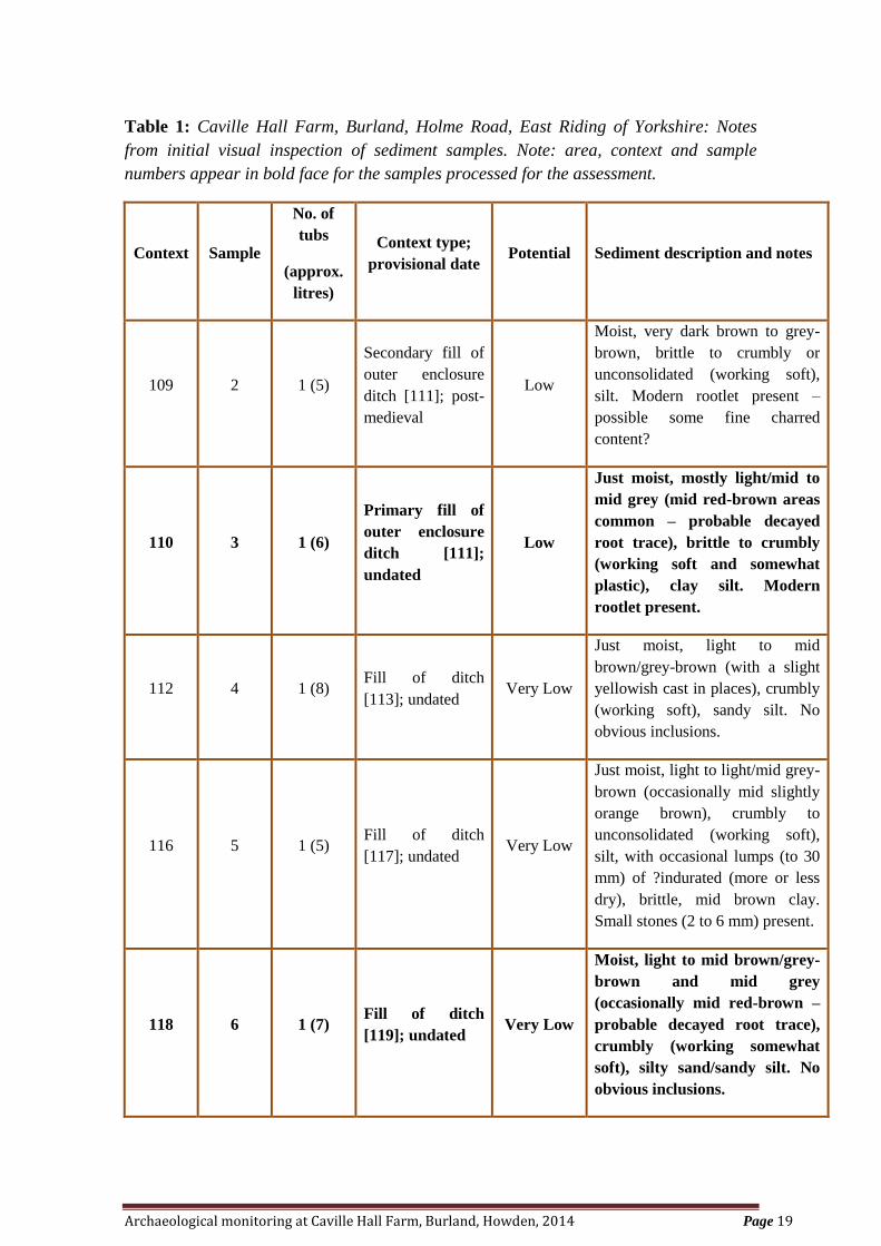
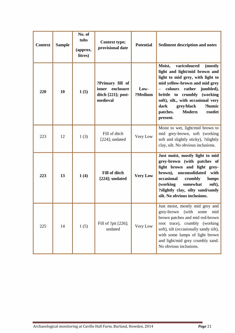
Table 1: Caville Hall Farm, Burland, Holme Road, East Riding of Yorkshire: Notes
from initial visual inspection of sediment samples. Note: area, context and sample
numbers appear in bold face for the samples processed for the assessment.
Context Sample
No. of
tubs
(approx.
litres)
Context type;
provisional date Potential Sediment description and notes
109 2 1 (5)
Secondary fill of
outer enclosure
ditch [111]; post-
medieval
Low
Moist, very dark brown to grey-
brown, brittle to crumbly or
unconsolidated (working soft),
silt. Modern rootlet present –
possible some fine charred
content?
110 3 1 (6)
Primary fill of
outer enclosure
ditch [111];
undated
Low
Just moist, mostly light/mid to
mid grey (mid red-brown areas
common – probable decayed
root trace), brittle to crumbly
(working soft and somewhat
plastic), clay silt. Modern
rootlet present.
112 4 1 (8) Fill of ditch
[113]; undated Very Low
Just moist, light to mid
brown/grey-brown (with a slight
yellowish cast in places), crumbly
(working soft), sandy silt. No
obvious inclusions.
116 5 1 (5) Fill of ditch
[117]; undated Very Low
Just moist, light to light/mid grey-
brown (occasionally mid slightly
orange brown), crumbly to
unconsolidated (working soft),
silt, with occasional lumps (to 30
mm) of ?indurated (more or less
dry), brittle, mid brown clay.
Small stones (2 to 6 mm) present.
118 6 1 (7) Fill of ditch
[119]; undated Very Low
Moist, light to mid brown/grey-
brown and mid grey
(occasionally mid red-brown –
probable decayed root trace),
crumbly (working somewhat
soft), silty sand/sandy silt. No
obvious inclusions.
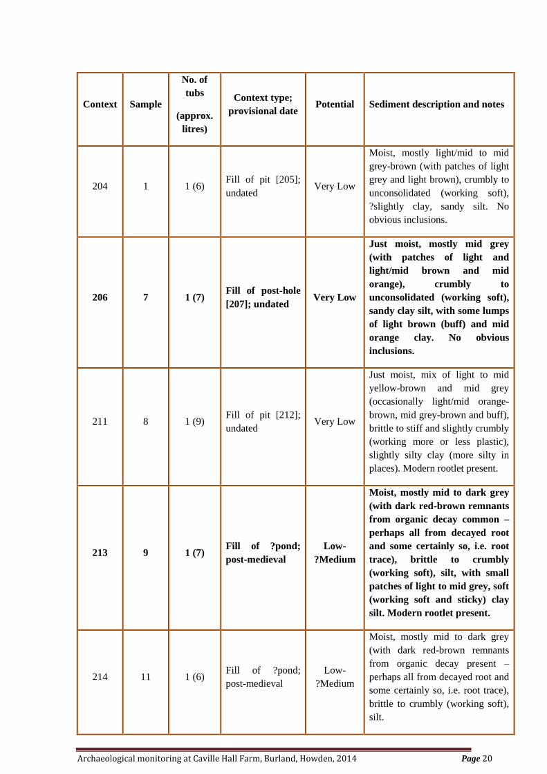
Archaeological monitoring at Caville Hall Farm, Burland, Howden, 2014 Page 20
Context Sample
No. of
tubs
(approx.
litres)
Context type;
provisional date Potential Sediment description and notes
204 1 1 (6) Fill of pit [205];
undated Very Low
Moist, mostly light/mid to mid
grey-brown (with patches of light
grey and light brown), crumbly to
unconsolidated (working soft),
?slightly clay, sandy silt. No
obvious inclusions.
206 7 1 (7) Fill of post-hole
[207]; undated Very Low
Just moist, mostly mid grey
(with patches of light and
light/mid brown and mid
orange), crumbly to
unconsolidated (working soft),
sandy clay silt, with some lumps
of light brown (buff) and mid
orange clay. No obvious
inclusions.
211 8 1 (9) Fill of pit [212];
undated Very Low
Just moist, mix of light to mid
yellow-brown and mid grey
(occasionally light/mid orange-
brown, mid grey-brown and buff),
brittle to stiff and slightly crumbly
(working more or less plastic),
slightly silty clay (more silty in
places). Modern rootlet present.
213 9 1 (7) Fill of ?pond;
post-medieval
Low-
?Medium
Moist, mostly mid to dark grey
(with dark red-brown remnants
from organic decay common –
perhaps all from decayed root
and some certainly so, i.e. root
trace), brittle to crumbly
(working soft), silt, with small
patches of light to mid grey, soft
(working soft and sticky) clay
silt. Modern rootlet present.
214 11 1 (6) Fill of ?pond;
post-medieval
Low-
?Medium
Moist, mostly mid to dark grey
(with dark red-brown remnants
from organic decay present –
perhaps all from decayed root and
some certainly so, i.e. root trace),
brittle to crumbly (working soft),
silt.
Archaeological monitoring at Caville Hall Farm, Burland, Howden, 2014 Page 21
Context Sample
No. of
tubs
(approx.
litres)
Context type;
provisional date Potential Sediment description and notes
220 10 1 (5)
?Primary fill of
inner enclosure
ditch [221]; post-
medieval
Low-
?Medium
Moist, varicoloured (mostly
light and light/mid brown and
light to mid grey, with light to
mid yellow-brown and mid grey
– colours rather jumbled),
brittle to crumbly (working
soft), silt., with occasional very
dark grey/black ?humic
patches. Modern rootlet
present.
223 12 1 (3) Fill of ditch
[224]; undated Very Low
Moist to wet, light/mid brown to
mid grey-brown, soft (working
soft and slightly sticky), ?slightly
clay, silt. No obvious inclusions.
223 13 1 (4) Fill of ditch
[224]; undated Very Low
Just moist, mostly light to mid
grey-brown (with patches of
light brown and light grey-
brown), unconsolidated with
occasional crumbly lumps
(working somewhat soft),
?slightly clay, silty sand/sandy
silt. No obvious inclusions.
225 14 1 (5) Fill of ?pit [226];
undated Very Low
Just moist, mostly mid grey and
grey-brown (with some mid
brown patches and mid red-brown
root trace), crumbly (working
soft), silt (occasionally sandy silt),
with some lumps of light brown
and light/mid grey crumbly sand.
No obvious inclusions.
Archaeological monitoring at Caville Hall Farm, Burland, Howden, 2014 Page 22
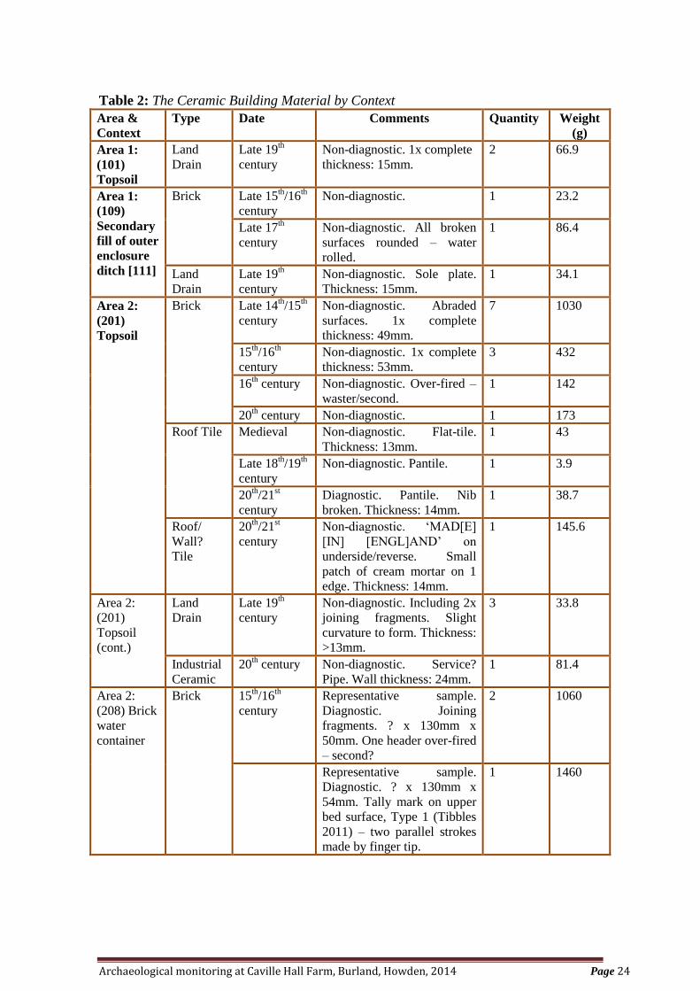
9.2 Ceramic Building Material
S.E. Tibbles
Cert. Arch. Dip Arch
Introduction and Methodology
The assemblage of ceramic building material (hereafter CBM) comprised thirteen
complete and part pieces, with a total weight of 7854.5 grams. Five forms were
identified: brick, roof tile, land drain, roof/wall tile and industrial ceramic (Table 2).
The assemblage was subject to basic quantification (count and weight) and information
regarding dimensions, form and type was recorded and catalogued accordingly. The
presence of original surfaces was taken into consideration to aid identification. The
CBM was classified adopting a best-fit policy based on surviving dimensions and
general characteristics.
It should be noted that the diversity of size and colour within bricks and tiles caused
during the manufacturing process, must be taken into consideration when comparing
examples within collected assemblages and local typologies. The varying sizes and
colours can be attributed to the variation in the clays used, shrinkage during drying,
firing within the kiln or clamp and the location of the brick/tile within the kiln. The
dating of brick and tile can be highly contentious due to its re-usable nature, therefore
the date range given is that of known dates where material has been recorded.
The Assemblage
The assemblage of CBM was recovered from six contexts including samples of a brick
water container (see Table 2 for details). A ‘chip’ of CBM from the processing of
environmental sample 10 was not identifiable by form or type.
Brick
The brick assemblage comprised seventeen part samples (Table 2), with a total weight
of 4406.6 grams. The majority of the bricks (88%) were medieval, dated between the
14th
and 16th
centuries. The remainder of the assemblage was of post-medieval (6%) and
modern (6%) date.
Sixteen fragments of medieval CBM were recovered from three contexts: secondary fill
(109) of outer enclosure ditch [111], topsoil within Area 2 (201) and brick water
container (208).
The three brick samples from water container (208), had complete width and thickness
dimensions of 130mm and 50-54mm (5 1/8” x 2”– 2 1/8”). Two joining fragments formed
c. half a brick, which was a second, with an over-fired header. The other sample had a
Type 1 tally mark (Tibbles 2011, 129) on the upper bed surface, two parallel strokes
made by a finger tip. Both bricks were of 15th
/16th
century date.
Of the remaining medieval bricks, two had complete thicknesses of 49mm and 53mm.
Abraded surfaces were recorded on seven fragments and a further over-fired second was
noted from topsoil (201).
Archaeological monitoring at Caville Hall Farm, Burland, Howden, 2014 Page 23
The post-medieval brick fragment from fill (109) displayed abraded broken surfaces,
indicative of water-rolled material. No complete dimensions were recorded. The modern
brick from topsoil (201) was also non-diagnostic, with no complete dimensions.
Roof tile
Two types of roof tile were identified, flat-tile and pantile, one and two fragments
respectively. All were recovered from topsoil Area 2 (201). The medieval flat-tile had a
reduced core, a thickness of 13mm and a weight of 43 grams. No diagnostic features
such as means of suspension were present.
Of the two fragments of pantile, one had a compete thickness of 14mm with a partial
suspension nib, recently broken. This tile was of modern date. The remaining fragment
was of late 18th
/19th
century date with no complete dimensions. The pantiles had a
combined weight of 42.6 grams.
Roof tile/wall? Tile
Topsoil within Area 2 (201) produced a fragment of machine-moulded roof/wall? tile of
20th
/21st century date. The tile had a thickness of 14mm and a weight of 145.6 grams. A
small patch of cream mortar was recorded on one edge with ‘MAD[E] [IN]
[ENGL]AND’ on the underside/reverse.
Land drain
The assemblage of land drain was recovered from four contexts, (101, 109, 201 and 215)
(Table 2), with a combined weight of 3134.8 grams. One diagnostic sample from (215)
had complete dimensions of length 305mm, diameter 135mm and wall thickness 17mm,
identified as a Type 5d (Tibbles, in prep). The remainder of the assemblage was
fragmentary, with only complete wall thicknesses recorded on four fragments, between
>13mm to 15mm. The land drain assemblage was dated from the late 19th
to 20th
century.
Industrial ceramic
One fragment from topsoil Area 2 (201) was identified as industrial ceramic, probably a
service pipe. The fragment had a weight of 81.4 grams and a wall thickness of 24mm.
No distinguishing features were recorded.
Not identifiable
The processing of environmental sample 10 produced a small ‘chip’ with a weight of 0.5
grams. The ‘chip’ was not identifiable by form or type, however, the fabric was of early
modern date.
Archaeological monitoring at Caville Hall Farm, Burland, Howden, 2014 Page 24
Table 2: The Ceramic Building Material by Context
Area &
Context
Type Date Comments Quantity Weight
(g)
Area 1:
(101)
Topsoil
Land
Drain
Late 19th
century
Non-diagnostic. 1x complete
thickness: 15mm.
2 66.9
Area 1:
(109)
Secondary
fill of outer
enclosure
ditch [111]
Brick Late 15th/16
th
century
Non-diagnostic. 1 23.2
Late 17th
century
Non-diagnostic. All broken
surfaces rounded – water
rolled.
1 86.4
Land
Drain
Late 19th
century
Non-diagnostic. Sole plate.
Thickness: 15mm.
1 34.1
Area 2:
(201)
Topsoil
Brick Late 14th/15
th
century
Non-diagnostic. Abraded
surfaces. 1x complete
thickness: 49mm.
7 1030
15th/16
th
century
Non-diagnostic. 1x complete
thickness: 53mm.
3 432
16th century Non-diagnostic. Over-fired –
waster/second.
1 142
20th century Non-diagnostic. 1 173
Roof Tile Medieval Non-diagnostic. Flat-tile.
Thickness: 13mm.
1 43
Late 18th/19
th
century
Non-diagnostic. Pantile. 1 3.9
20th/21
st
century
Diagnostic. Pantile. Nib
broken. Thickness: 14mm.
1 38.7
Roof/
Wall?
Tile
20th/21
st
century
Non-diagnostic. ‘MAD[E]
[IN] [ENGL]AND’ on
underside/reverse. Small
patch of cream mortar on 1
edge. Thickness: 14mm.
1 145.6
Area 2:
(201)
Topsoil
(cont.)
Land
Drain
Late 19th
century
Non-diagnostic. Including 2x
joining fragments. Slight
curvature to form. Thickness:
>13mm.
3 33.8
Industrial
Ceramic
20th century Non-diagnostic. Service?
Pipe. Wall thickness: 24mm.
1 81.4
Area 2:
(208) Brick
water
container
Brick 15th/16
th
century
Representative sample.
Diagnostic. Joining
fragments. ? x 130mm x
50mm. One header over-fired
– second?
2 1060
Representative sample.
Diagnostic. ? x 130mm x
54mm. Tally mark on upper
bed surface, Type 1 (Tibbles
2011) – two parallel strokes
made by finger tip.
1 1460
Archaeological monitoring at Caville Hall Farm, Burland, Howden, 2014 Page 25
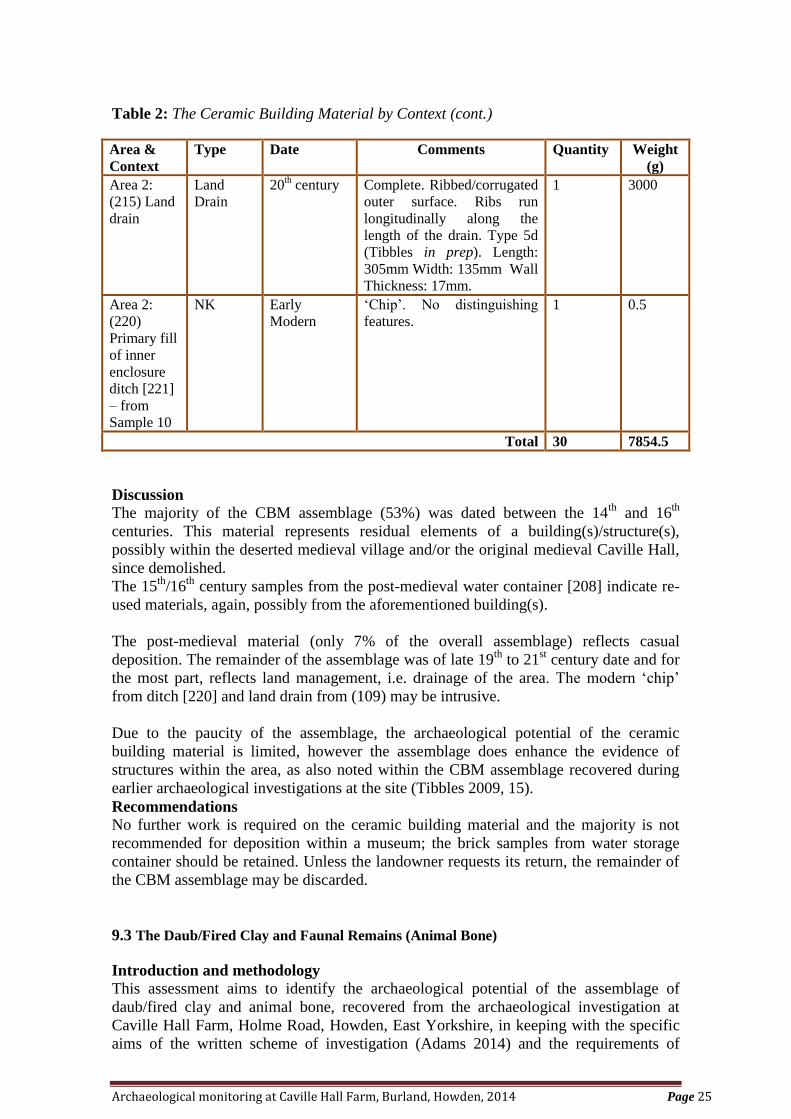
Table 2: The Ceramic Building Material by Context (cont.)
Area &
Context
Type Date Comments Quantity Weight
(g)
Area 2:
(215) Land
drain
Land
Drain
20th century Complete. Ribbed/corrugated
outer surface. Ribs run
longitudinally along the
length of the drain. Type 5d
(Tibbles in prep). Length:
305mm Width: 135mm Wall
Thickness: 17mm.
1 3000
Area 2:
(220)
Primary fill
of inner
enclosure
ditch [221]
– from
Sample 10
NK Early
Modern
‘Chip’. No distinguishing
features.
1 0.5
Total 30 7854.5
Discussion
The majority of the CBM assemblage (53%) was dated between the 14th
and 16th
centuries. This material represents residual elements of a building(s)/structure(s),
possibly within the deserted medieval village and/or the original medieval Caville Hall,
since demolished.
The 15th
/16th
century samples from the post-medieval water container [208] indicate re-
used materials, again, possibly from the aforementioned building(s).
The post-medieval material (only 7% of the overall assemblage) reflects casual
deposition. The remainder of the assemblage was of late 19th
to 21st century date and for
the most part, reflects land management, i.e. drainage of the area. The modern ‘chip’
from ditch [220] and land drain from (109) may be intrusive.
Due to the paucity of the assemblage, the archaeological potential of the ceramic
building material is limited, however the assemblage does enhance the evidence of
structures within the area, as also noted within the CBM assemblage recovered during
earlier archaeological investigations at the site (Tibbles 2009, 15).
Recommendations
No further work is required on the ceramic building material and the majority is not
recommended for deposition within a museum; the brick samples from water storage
container should be retained. Unless the landowner requests its return, the remainder of
the CBM assemblage may be discarded.
9.3 The Daub/Fired Clay and Faunal Remains (Animal Bone)
Introduction and methodology
This assessment aims to identify the archaeological potential of the assemblage of
daub/fired clay and animal bone, recovered from the archaeological investigation at
Caville Hall Farm, Holme Road, Howden, East Yorkshire, in keeping with the specific
aims of the written scheme of investigation (Adams 2014) and the requirements of
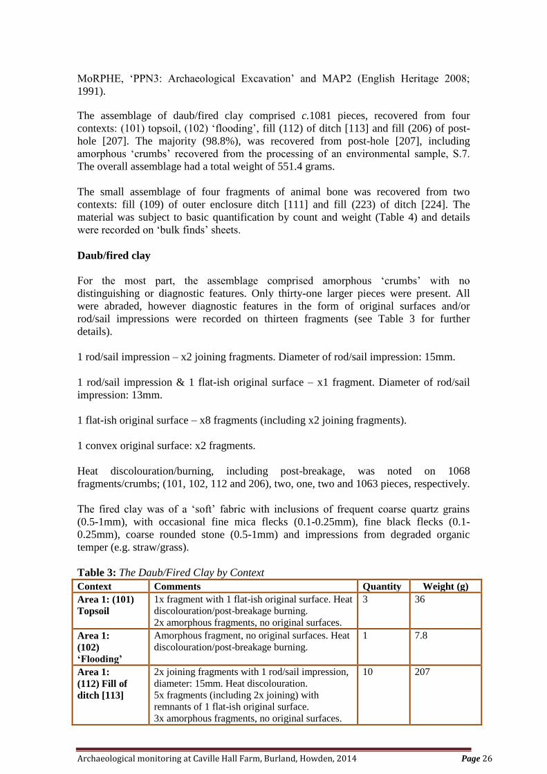
Archaeological monitoring at Caville Hall Farm, Burland, Howden, 2014 Page 26
MoRPHE, ‘PPN3: Archaeological Excavation’ and MAP2 (English Heritage 2008;
1991).
The assemblage of daub/fired clay comprised c.1081 pieces, recovered from four
contexts: (101) topsoil, (102) ‘flooding’, fill (112) of ditch [113] and fill (206) of post-
hole [207]. The majority (98.8%), was recovered from post-hole [207], including
amorphous ‘crumbs’ recovered from the processing of an environmental sample, S.7.
The overall assemblage had a total weight of 551.4 grams.
The small assemblage of four fragments of animal bone was recovered from two
contexts: fill (109) of outer enclosure ditch [111] and fill (223) of ditch [224]. The
material was subject to basic quantification by count and weight (Table 4) and details
were recorded on ‘bulk finds’ sheets.
Daub/fired clay
For the most part, the assemblage comprised amorphous ‘crumbs’ with no
distinguishing or diagnostic features. Only thirty-one larger pieces were present. All
were abraded, however diagnostic features in the form of original surfaces and/or
rod/sail impressions were recorded on thirteen fragments (see Table 3 for further
details).
1 rod/sail impression – x2 joining fragments. Diameter of rod/sail impression: 15mm.
1 rod/sail impression & 1 flat-ish original surface – x1 fragment. Diameter of rod/sail
impression: 13mm.
1 flat-ish original surface – x8 fragments (including x2 joining fragments).
1 convex original surface: x2 fragments.
Heat discolouration/burning, including post-breakage, was noted on 1068
fragments/crumbs; (101, 102, 112 and 206), two, one, two and 1063 pieces, respectively.
The fired clay was of a ‘soft’ fabric with inclusions of frequent coarse quartz grains
(0.5-1mm), with occasional fine mica flecks (0.1-0.25mm), fine black flecks (0.1-
0.25mm), coarse rounded stone (0.5-1mm) and impressions from degraded organic
temper (e.g. straw/grass).
Table 3: The Daub/Fired Clay by Context
Context Comments Quantity Weight (g)
Area 1: (101)
Topsoil
1x fragment with 1 flat-ish original surface. Heat
discolouration/post-breakage burning.
2x amorphous fragments, no original surfaces.
3 36
Area 1:
(102)
‘Flooding’
Amorphous fragment, no original surfaces. Heat
discolouration/post-breakage burning.
1 7.8
Area 1:
(112) Fill of
ditch [113]
2x joining fragments with 1 rod/sail impression,
diameter: 15mm. Heat discolouration.
5x fragments (including 2x joining) with
remnants of 1 flat-ish original surface.
3x amorphous fragments, no original surfaces.
10 207
Archaeological monitoring at Caville Hall Farm, Burland, Howden, 2014 Page 27
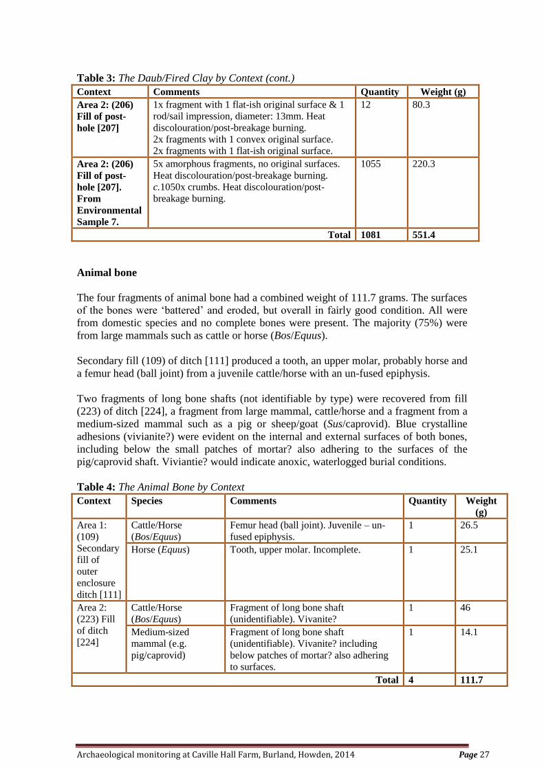
Table 3: The Daub/Fired Clay by Context (cont.)
Context Comments Quantity Weight (g)
Area 2: (206)
Fill of post-
hole [207]
1x fragment with 1 flat-ish original surface & 1
rod/sail impression, diameter: 13mm. Heat
discolouration/post-breakage burning.
2x fragments with 1 convex original surface.
2x fragments with 1 flat-ish original surface.
12 80.3
Area 2: (206)
Fill of post-
hole [207].
From
Environmental
Sample 7.
5x amorphous fragments, no original surfaces.
Heat discolouration/post-breakage burning.
c.1050x crumbs. Heat discolouration/post-
breakage burning.
1055 220.3
Total 1081 551.4
Animal bone
The four fragments of animal bone had a combined weight of 111.7 grams. The surfaces
of the bones were ‘battered’ and eroded, but overall in fairly good condition. All were
from domestic species and no complete bones were present. The majority (75%) were
from large mammals such as cattle or horse (Bos/Equus).
Secondary fill (109) of ditch [111] produced a tooth, an upper molar, probably horse and
a femur head (ball joint) from a juvenile cattle/horse with an un-fused epiphysis.
Two fragments of long bone shafts (not identifiable by type) were recovered from fill
(223) of ditch [224], a fragment from large mammal, cattle/horse and a fragment from a
medium-sized mammal such as a pig or sheep/goat (Sus/caprovid). Blue crystalline
adhesions (vivianite?) were evident on the internal and external surfaces of both bones,
including below the small patches of mortar? also adhering to the surfaces of the
pig/caprovid shaft. Viviantie? would indicate anoxic, waterlogged burial conditions.
Table 4: The Animal Bone by Context
Context Species Comments Quantity Weight
(g)
Area 1:
(109)
Secondary
fill of
outer
enclosure
ditch [111]
Cattle/Horse
(Bos/Equus)
Femur head (ball joint). Juvenile – un-
fused epiphysis.
1 26.5
Horse (Equus) Tooth, upper molar. Incomplete. 1 25.1
Area 2:
(223) Fill
of ditch
[224]
Cattle/Horse
(Bos/Equus)
Fragment of long bone shaft
(unidentifiable). Vivanite?
1 46
Medium-sized
mammal (e.g.
pig/caprovid)
Fragment of long bone shaft
(unidentifiable). Vivanite? including
below patches of mortar? also adhering
to surfaces.
1 14.1
Total 4 111.7
Archaeological monitoring at Caville Hall Farm, Burland, Howden, 2014 Page 28
Discussion and recommendations
The paucity of diagnostic features and fragmentary nature of the assemblage of
daub/fired clay, inhibits an interpretation as to original use. The material could have
served a multitude of functions, for example material from an oven or hearth, wall or
partition. Although some of the material may represent objects such as loomweights, no
conclusive indicators for potential occupational activities were present.
Based on the rod/sail impression and flat original surfaces, the material recovered from
post-hole [207] was most likely re-used as packing. As to whether this material was re-
used broken objects or fragmented structural material, is inconclusive.
Overall, the daub/fired clay assemblage is probably of medieval date and indicates the
presence of structures, including free-standing and/or potentially, individual objects
reflecting occupation within the immediate vicinity.
The assemblage of animal bone is too small to be of any archaeological significance. All
of the faunal remains were from domestic species, with both medium-sized mammals
(such as pig, caprovid) and large mammals (cattle/horse) present. No evidence was
recorded to suggest activities such as bone-working. The assemblage most likely
represents residual elements of domestic waste.
No further work is considered necessary. Unless the land owner requests its return, the
animal bone and daub/fired clay (with the exception of the amorphous crumbs from
Sample 7) is recommended for retention as part of the site archive, but this would be at
the recipient museum’s discretion.
10. The Recorded Find
S.E. Tibbles
Cert. Arch. Dip Arch
Introduction and methodology
This assessment aims to identify the archaeological potential of the recorded find
recovered during the archaeological investigation at Caville Hall Farm, Holme Road,
Howden, East Yorkshire, in keeping with the specific aims of the written scheme of
investigation (Adams 2014) and the requirements of MoRPHE, ‘PPN3: Archaeological
Excavation’ and MAP2 (English Heritage 2008; 1991).
One recorded find, a fragment of worked stone, was recovered from the primary fill
(110) of outer enclosure ditch [111]. Details were recorded on a ‘recorded find’ sheet as
part of the site archive.
The quern/millstone?
The worked stone was in fair condition, however, it was incomplete. Although no
evidence of the working/grinding surface was present, the remnants of a roughly pecked
upper?/lower? surface was recorded.
Archaeological monitoring at Caville Hall Farm, Burland, Howden, 2014 Page 29
Quern/Millstone?
Incomplete. Gritstone. Remnants of one original upper?/lower? surface, roughly pecked.
No remains of working/grinding surface. Maximum dimensions: Length: 115m Width:
17mm to 53mm Thickness: >82mm
RF No.1 Context: (110) Area 1. Primary fill of outer enclosure ditch [111].
Discussion
On its own the recorded find is of limited archaeological potential. It probably reflects
residual elements of domestic waste pertaining to occupation of the area, possibly during
the medieval or post-medieval periods.
Recommendations
No further work is considered necessary on the recorded find. The quern/millstone?
should be retained and deposited within the appropriate museum, unless the land owner
requests its return.
11. The Other Finds
Karen Adams
Pottery identification by Peter Didsbury
Aims and objectives
This assessment, which is in keeping with the specific aims of the Written Scheme of
Investigation (Adams 2014) and the requirements of MoRPHE, ‘PPN3: Archaeological
Excavation’ and compliant with MAP2 requirements (English Heritage 2008; 1991),
aims to identify the archaeological potential of the finds assemblage recovered from the
archaeological investigation on pasture scrub land to the west of Holme Road (A614) at
Caville Hall Farm, Burland, Holme Road, Howden, East Yorkshire.
Introduction and methodology
The finds assemblage comprised of two material categories: pottery and vessel glass,
having been retrieved from contexts (101) topsoil, Area 1; (102) ‘flooding’; (107) fill of
service trench; (109) fill of outer enclosure ditch; (110) fill of outer enclosure ditch;
(201) topsoil, Area 2; (206) fill of post-hole; (220) fill of inner enclosure ditch.
All material types were subject to basic quantification by count and weight, the details
of which were recorded on ‘bulk’ and ‘finds context’ sheets, where applicable. The
assemblage was appropriately packed for long term storage.
Condition of the assemblage
All of the material categories were stable and in good condition.
Quantification of the assemblage
Pottery: 28 sherds
Vessel glass: 4 shards
Archaeological monitoring at Caville Hall Farm, Burland, Howden, 2014 Page 30
Catalogue by material type
11.1 Pottery
Fabric terms compatible for those in use for Hull and Beverley typologies, or follow
those of Watkins 1987.
Code Common Name
GREG Green Glazed Earthernware
HM Handmade
INDCER Industrial Ceramics
LBLAK Late Black Ware
MED Medieval
MODSW Modern Stoneware
OW Orange Ware
PIMP Pimply Ware
RG Roman Grey
STAFFS Staffordshire
UNAT Unattributed
A total of 28 sherds of pottery, with a combined weight of 629.10g; having an average
sherd weight (ASW) of 22.47g was retrieved from seven contexts(101) topsoil, Area 1;
(102) ‘flooding’; (107) fill of service trench; (110) fill of outer enclosure ditch; (201)
topsoil, Area 2; (206) fill of post-hole; (220) fill of inner enclosure ditch.
The majority of the assemblage was of late 18th
to early 20th
century date, however
possible Iron Age sherds along with Roman and 13th
/14th
century sherd were retrieved
from flooding layer 102, indicating possible activity during those periods in the vicinity.
Some 13th
/14th
century sherds were also collected from the topsoil of both areas, and
late 11th
to 12th
century from post-hole fill 206, which may be associated with the
former Caville Hall building.
The assemblage is consistent with domestic waste and background agricultural scatter.
Table 5: The Pottery Assemblage by Context.
Context
No.
Fabric
Code
Date Description Quantity Weight
(g)
101
Area 1
Topsoil
OW 13th/14
th
century
Body sherd, jug, with rod handle
stump, copper glaze over white slip.
1 45.3
GREG Post-
Medieval
1 21.2
LBLAK Late 18th to
early 20th
century
Open form (bowl) sherd. 1 21.9
TPWW Mid 19th to
early 20th
century
Body sherd 2.9
INDCER 19th to 20
th
century
Sanitary ware, heavy duty stoneware
type ceramics.
3 221.3
Archaeological monitoring at Caville Hall Farm, Burland, Howden, 2014 Page 31
Table 5: The Pottery Assemblage by Context (cont.)
Context
No.
Fabric
Code
Date Description Quantity Weight
(g)
102
‘Flooding'
Layer
HM Iron Age? 1 basal sherd,
6 body sherd, same vessel
7 32.5
RG Roman Joining body sherds 2 21.5
OW 13th/14
th
century
From different vessels 2 21.3
UNAT Not Known Unattributed 1 6.5
107
Fill of
Service
Trench
LBLAK Late 18th to
early 20th
century
Body sherd 1 4.6
110
Fill of
Outer
Enclosure
Ditch
[111]
GREB 19th century 1 2.0
201
Area 2
Topsoil
OW? 13th/14
th
century?
1 body sherd, green lead glaze,
1 basal angle.
2 21.0
STAFFS? 18th century
onwards
Body sherd, light coloured fabric
with rich brown glaze
1 1.1
206
Fill of
Post -hole
[207]
UNAT Not Known Body sherd, worn, sandy/gritty fabric 1 8.2
PIMP Late 11th to
12th century
Basal sherd, general sooting 1 14.5
MED Medieval Body sherd, splash glaze 1 4.7
220
Fill of
Inner
Enclosure
Ditch
[221]
MODSW 19th/20
th
century
1 bottle basal sherd,
1 flanged open form
2 178.6
Total 28 629.10
11.2 The Glass Assemblage
A total of four shards of glass, having a combined weight of 790.80g was retrieved from
two contexts: (101) topsoil, Area 1; (109) fill of outer enclosure ditch.
The assemblage was of late 19th
to early 20th
century date, and consistent with domestic
waste.
Table 6: The Glass Assemblage by Context.
Context
No.
Form Date Description Quantity Weight
(g)
101
Area 1
Topsoil
Rim/Neck Late 19th/Early
20th century
Pale green/blue 1 12
109
Fill of
Outer
Enclosure
Ditch
[111]
Basal Late 19th/Early
20th century
Joining shards, pale green/
blue.
2 171.8
Body Late 19th/Early
20th century
Pale green/blue 1 6.7g
Total 4 790.80
Archaeological monitoring at Caville Hall Farm, Burland, Howden, 2014 Page 32
Discussion and recommendations
With the exception of seven sherds of Iron Age?, two sherds of Romano-British, one
sherd of 11th
to 12th
century and five sherds of 13th
/14th
century pottery, the assemblage
is of relatively recent date and of limited archaeological potential. The assemblage is
consistent with normal domestic waste and background agricultural scatter.
No further work is considered necessary. Unless the land owner requests its return, the
finds assemblage is not recommended for retention, although the Iron Age?, Romano-
British, 11th
to 12th
century and 13th
/14th
century pottery sherds may be considered for
deposition within the relative museum.
12. Discussion
A monitored watching brief (HFA 2009) located to the northeast of the proposed site
encountered a substantial amount of archaeological activity dating to the medieval
period. It was hoped that the continuation of some of the linear features from this site
would be observed, in particular that which had been identified as a drove
road/trackway. However, no direct corresponding relationship could be determined.
Aerial photographs have recorded a number of crop marks within the immediate
vicinity, three of which being probable moated sites, including a double ditch square
enclosure, over which part of the proposed site had been located. Another similar
cropmark is located on the opposite side of the A614.
There are 114 identified moated sites within the Vale of York and within this part of the
East Riding of Yorkshire further examples can be found at Portington, Welham Bridge,
Holme-upon-Spalding Moor, Newland and Storwood. Those at Portington and
Storwood are listed on the English Heritage database for Scheduled Monuments.
A moated site is usually defined as “an area of ground , often occupied by a dwelling or
associated structure, bounded or partly bounded by a wide ditch, which in most cases
was intended to be filled with water” (CC Taylor – CBA Report No. 17). They are often
square or rectangular in plan and may have other features such as fish ponds or leats
associated with them.
The aerial photograph for the moated site, partially located in the developments area,
indicated that the interior island would be approx. 25m² (dimensions taken from Google
Maps).
An approx. 4m length of the western outer ditch was encountered, along with approx.
7m of the northern arm and 17m of the western arm of the inner ditch. The northern arm
and north eastern corner of the inner enclosure ditch had been disturbed by later ponds.
Targeted excavation revealed that both enclosure ditches had probably been sealed in
the 19th
/20th
century, as seen on the 1890 and 1909 OS maps. The eastern side of the
outer ditch had also been truncated by a modern service trench.
The development site is located in an area which is prone to standing water (Plate 1),
and close to the known wetlands area (P. Halkon). Therefore, although environmental
samples from the lowest encountered fills of these ditches included grasses indicating
Archaeological monitoring at Caville Hall Farm, Burland, Howden, 2014 Page 33
wetland/aquatic taxa, it could not be determined if they were directly associated with the
ditches or from general surrounding area or the later ponds which had truncated them.
The lowest fills of both the inner and outer ditches have been preserved in-situ.
Within the enclosed area of the inner ditch, were three pits and a post-hole. The post-
hole contained 11th
to 12th
century pottery with sooting, which may suggest use for
cooking. Also daub/fired clay fragments which may have originated from wall surfaces
or have been objects such as loom-weights and re-used as post-packing.
Four further ditches, to the east, were encountered, whose functions could not be
determined, may be contemporary/associated with the moated site, or pre-date it. The
limits of the development area did not allow relationship between them to be
determined. One possible stake hole was also encountered in area 1.
Later features included a brick-lined water containing pit, which had been constructed of
re-used 14th
to 16th
century bricks, two ponds, and a number of land drains.
13. Recommendations
The monitoring of this site has encountered further archaeological activity of the
medieval period, which is probably part of the deserted medieval village (DMV) of
Cavill. In particular part of a double ditch square enclosure (moated site) was
encountered which appears to have been sealed in the 19th
/20th
century. The lowest fills
of these ditches have not been fully excavated and the majority of the enclosure (as
recorded in aerial photographs) has been preserved in-situ.
Further ditches were located to the east of the enclosure and may be associated with it or
of archaeological activity of an earlier period.
No further work is recommended for the proposed site, however it is recommended that
monitoring be carried out for future work within the vicinity.
Unless the land owner requests its return, the majority of the finds assemblage is not
recommended for retention, although the Iron Age?, Romano-British, 11th
to 12th
century and 13th
/14th
century pottery sherds, animal bone, daub/fired clay,
quern/millstone fragment and the brick example from 208 may be considered for
deposition within the relative museum.
14. Acknowledgements
PastSearch would like to thank Mr. J. Longthorp (LKL Farming) for his invaluable
assistance and co-operation throughout the duration of the monitoring, and machine
driver Terry.
The on-site recording was undertaken and the figures were reproduced by Karen Adams.
PRS are grateful to Karen Adams, of PastSearch, for providing the material and the
archaeological information.
Archaeological monitoring at Caville Hall Farm, Burland, Howden, 2014 Page 34
15. Archive
The archive consists of:
A context register, context sheets, a plan and section register, plan and section drawings,
contact sheets of digital photographs, black and white photographs and colour slides, a
hard and digital copy of the report.
Following the completion of the archaeological monitoring, an ordered and indexed
archive has been compiled in accordance with English Heritage guidelines (1991). The
archive will be deposited within the relevant museum.
16. Bibliography
Adams, K.. (2014)
Caville Hall Farm, Burland, Howden, East Yorkshire. Written scheme of investigation
by archaeological evaluation (strip, map and record) for the erection of a farm
manager’s dwelling. (Unpublished)
Blakeman, A. (2002)
Bottles and Pot Lids, A Collector’s Guide
Cappers, R. T. J., Bekker, R. and Jans J. E. A. (2006).
Digitale Zadenatlas van Nederland. Groningen Archaeological Studies 4. Groningen:
Barkhuis Publishing and Groningen University Library.
Council for British Archaeology, (1978)
Research Report No 17: Medieval Moated Sites
Dainton, M. (1992)
A quick, semi-quantitative method for recording nematode gut parasite eggs from
archaeological deposits. Circaea, the Journal of the Association for Environmental
Archaeology 9, 58-63.
Dobney, K., Hall, A. R., Kenward, H. K. and Milles, A. (1992)
A working classification of sample types for environmental archaeology. Circaea, the
Journal of the Association for Environmental Archaeology 9 (for 1991), 24-6.
East Riding of Yorkshire Council (2005)
Land Character Type 7 – Humberhead Level, Foulness Open Farmland
English Heritage (1991)
Management of Archaeological Projects (MAP2)
Halkon, P., 2013
The Parisi. Britons and Romans in Eastern Yorkshire. (Gloucester)
Archaeological monitoring at Caville Hall Farm, Burland, Howden, 2014 Page 35
Harde, K. W. (1984).
A field guide in colour to beetles. London: Octopus Books.
Hather, J. G. (2000).
The identification of the Northern European Woods: a guide for archaeologists and
conservators. London: Archetype Publications.
Hedges, A. A. C. (1975)
Bottles and Bottle Collecting, Shire Album 6
Humber Field Archaeology (2009), Jobling, D
Archaeological Observation Investigation and Recording on Land North of Caville Hall
Farm, Holme Road, Eastrington, Report No. 1118, July 2009.
Institute of Field Archaeologists ( 2008a)
Standard and Guidelines for Archaeological Excavation, September 1995, Revised
October 2008
Institute of Field Archaeologists (2008b)
Standard and Guidelines for an Archaeological Watching Brief, October 1994, Revised
October 2008
Jacomet, S. (2006)
Identification of cereal remains from archaeological sites – 2nd
edition. Basel: IPAS,
Basel University.
Kenward, H. K., Hall, A. R. and Jones, A. K. G. (1980)
A tested set of techniques for the extraction of plant and animal macrofossils from
waterlogged archaeological deposits. Science and Archaeology 22, 3-15.
Kloet, G. A. and Hincks, W. D. (1964-77)
A checklist of British insects, second edition. London: Royal Entomological Society.
Lee, J. (2011)
Excavations at Blanket Row, Hull, 1997-2003, East Riding Archaeologist Vol.13. East
Riding Archaeological Society (Hull).
Schoch, W. H., Heller, I., Schweingruber, F. H. and Kienast, F. (2004)
Wood anatomy of central European species. Online version: www.woodanatomy.ch
Stace, C. (1997).
New flora of the British Isles: 2nd
edition. Cambridge: Cambridge University Press.
Tibbles, J. (2011)
‘Ceramic and Other Building Materials from BWH97 and BWH98’ in J. Lee, 2011.
126-134.
Tibbles, J. (in prep)
The History, Manufacture and Usage of Ceramic Land Drains.
Archaeological monitoring at Caville Hall Farm, Burland, Howden, 2014 Page 36
Tibbles, S. (2009)
‘The Finds (Other Than Pottery)’ in D. Jobling, 2009. 15-16.
van Zeist, W. A. (1984)
List of names of wild and cultivated cereals. Bulletin on Sumerian Agriculture 1, 8-16.
17. On-line Recources
British Geological Survey, 2012
Geology of Britain Viewer, www.mapapps.bgs.ac.uk [Accessed 09/01/2014]
Cavill Connections
www.cavillconnections.co.uk [Accessed: 20/06/2014]
Domeday Book: www. domesdaymap.co.uk [Accessed: 24/03/2014]
Ordnance Survey Map (2014)
www.ukmapcentre.com/index.html [Accessed: 09/06/2014]
Old-maps
www.old-maps.co.uk/maps.html [Accessed: 24/3/2014]
Scheduled Moated Sites
www.english-heritage.org.uk [Accessed: 14/7/2014]
Wetlands Heritage of the Vale of York
www2.hull.ac.uk/science/waerc/origins/vale_of_york.aspx [Accessed: 14/7/2014]
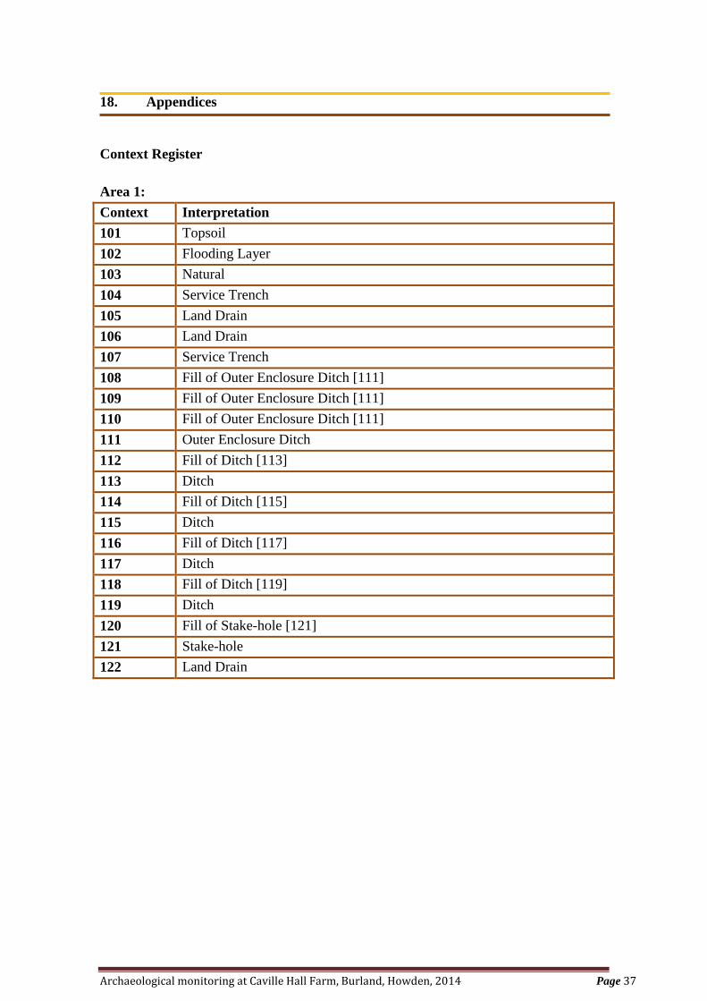
Archaeological monitoring at Caville Hall Farm, Burland, Howden, 2014 Page 37
18. Appendices
Context Register
Area 1:
Context Interpretation
101 Topsoil
102 Flooding Layer
103 Natural
104 Service Trench
105 Land Drain
106 Land Drain
107 Service Trench
108 Fill of Outer Enclosure Ditch [111]
109 Fill of Outer Enclosure Ditch [111]
110 Fill of Outer Enclosure Ditch [111]
111 Outer Enclosure Ditch
112 Fill of Ditch [113]
113 Ditch
114 Fill of Ditch [115]
115 Ditch
116 Fill of Ditch [117]
117 Ditch
118 Fill of Ditch [119]
119 Ditch
120 Fill of Stake-hole [121]
121 Stake-hole
122 Land Drain
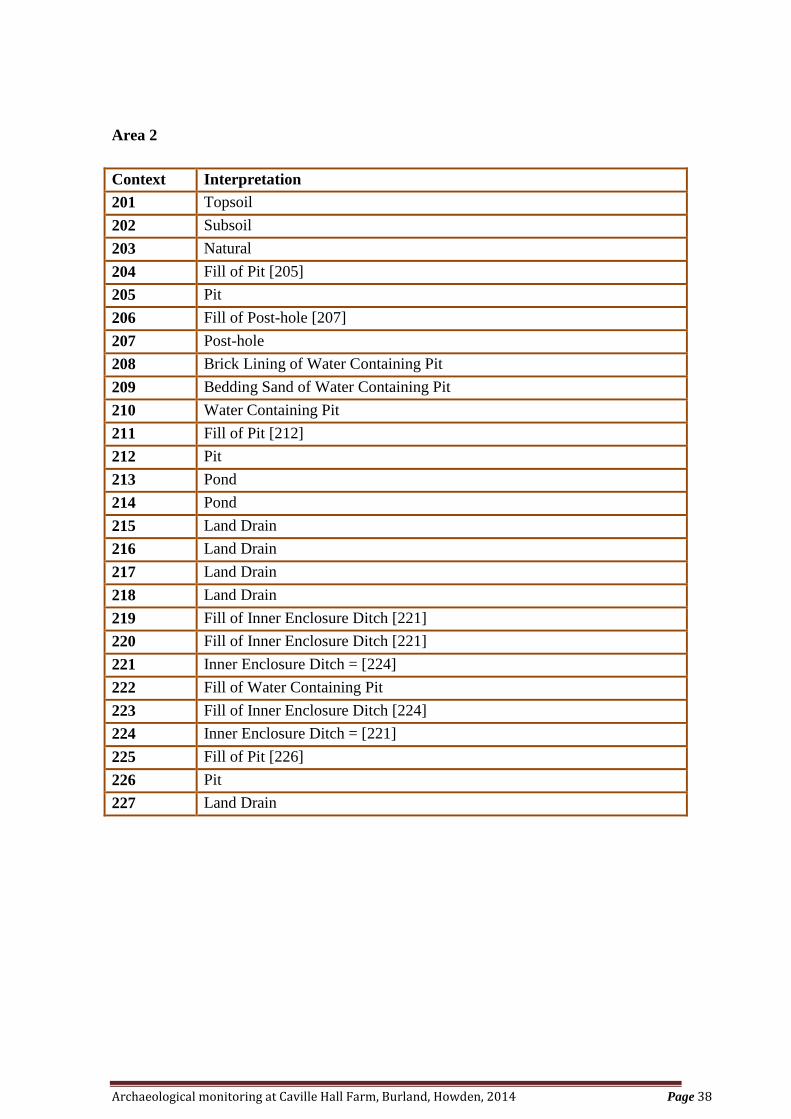
Archaeological monitoring at Caville Hall Farm, Burland, Howden, 2014 Page 38
Area 2
Context Interpretation
201 Topsoil
202 Subsoil
203 Natural
204 Fill of Pit [205]
205 Pit
206 Fill of Post-hole [207]
207 Post-hole
208 Brick Lining of Water Containing Pit
209 Bedding Sand of Water Containing Pit
210 Water Containing Pit
211 Fill of Pit [212]
212 Pit
213 Pond
214 Pond
215 Land Drain
216 Land Drain
217 Land Drain
218 Land Drain
219 Fill of Inner Enclosure Ditch [221]
220 Fill of Inner Enclosure Ditch [221]
221 Inner Enclosure Ditch = [224]
222 Fill of Water Containing Pit
223 Fill of Inner Enclosure Ditch [224]
224 Inner Enclosure Ditch = [221]
225 Fill of Pit [226]
226 Pit
227 Land Drain
Caville Hall Farm
Burland
Holme Road
Howden
East Yorkshire
Written scheme of investigation by archaeological evaluation (strip, map and record)
for the erection of a farm manager’s dwelling
Prepared on behalf of:
Mr. J Longthorp
LKL Farming Ltd
Planning Ref: DC/13/01720/PLF/WESTWW
HSMR Ref: PA/CONS/18479
National Grid Ref: SE76859 30616
Site Code: 2014.005.CHB
PastSearch
25 Chestnut Drive
Holme-upon-Spalding Moor
YORK
YO43 4HW
K.Adams
January 2014
WSI for Caville Hall Farm, Burland, Howden, East Yorkshire Page 1
Contents
1 Summary..................................................................................................2
2 Introduction.............................................................................................2
3 Aims and Objectives................................................................................4
4 Methodology............................................................................................5
5 Timetable and Staffing.................................................................................11
6 References......................................................................................................12
Appendix 1 – Location Plan............................................................................14
Figure 1: Proposed Site Plan (not to scale – supplied Brian Scott Designs).............14
Appendix 2 – Photographs..............................................................................15
Plate 1: Aerial Photograph (Bing Maps 2014 )..........................................................15
Plate 2: Area for Dwelling (facing northwest)............................................................15
Plate 3: Area for New Access Road (facing east).......................................................16
Plate 4: General Site Photograph (facing northwest)..................................................16
WSI for Caville Hall Farm, Burland, Howden, East Yorkshire Page 2
1 SUMMARY
The purpose of this written scheme of investigation is to present an archaeological strategy in
support for the below ground works associated with the erection of a Farm Manager’s
dwelling at Caville Hall Farm, Burland, Goole. (NGR: SE76859 30616). Application
number: DC/13/01720/PLF/WESTWW, HSMR Ref PA/CONS/18479.
The ground works are expected to be undertaken over a period of days in February 2014.
2 INTRODUCTION
Site archaeological background
The following information has been provided by the HSMR (8 July 2013).
“The site of this proposed development overlies the site of the deserted medieval
settlement of Caville, which survived as earthworks until 1959, and are now represented by
prominent crop-marks visible on aerial photographs. Caville was a hamlet, which also
incorporates the remains of at least two, and possibly three moated sites: one of these moats
lies directly beneath the site of the proposed new dwelling. The former earthworks suggest
that the hamlet comprised at least six tofts (or building platforms) ranged along an east-
west track or hollow=way, with the moats situated towards the eastern end of the settlement. Caville was first mentioned in a charter of AD 959, and takes its name form the Old
English for "tract of land where jackdaws are found". In 1086, the Domesday Book records
that the Bishop of Durham held 2 carucates and 3 bovates in Chewede [Cavil], as part of his
holdings in Howden and distrct. In a separate entry in Domesday Book, the Bishop of
Durham is recorded as holding 2 carucates and 2 bovates in Cavil. In the 1334 Lay
Subside, Cayvill [Cavil] paid £1 2s 5d, as part of the Liberty of Howden (a similar amount
to Leconfield). The 1377 Poll Tax records 25 tax-payers here. The site of Cavell is marked
on Speed's Map of 1610. This is presumably a post-medieval desertion, under either the Monkton or Galway
families. The lordship of Cavil, which included the hamlet of Cavil, was conveyed by the
Cavil family to Robert Monkton on his marriage in 1454. It passed to the Viscounts
Galway on the elevation of John
Monkton (1695-1751) to that title in the early is" century. The medieval Cavil Hall was
demolished in the 18th century, and a new hall was built on part of the old moated site.
That hall subsequently suffered from subsidence, and was demolished in 1969.”
Site location and geology
The site is located on NGR: SE76859 30616 and lies on agricultural land to the west of
Holme Road (A614) at Caville Hall Farm, Burland, Howden, East Yorkshire.
WSI for Caville Hall Farm, Burland, Howden, East Yorkshire Page 3
The underlying solid geology of the site is Mercia Mudstone Group - Mudstone. Sedimentary
Bedrock formed approximately 200 to 251 million years ago in the Triassic Period. Local
environment previously dominated by hot deserts. Superficial deposits of Hemingbrough
Glaciolacustrine Formation - Clay, Silty. Superficial Deposits formed up to 2 million years
ago in the Quaternary Period. Local environment previously dominated by ice age conditions.
Planning background
Permission for this development was granted on the 13 November 2013 subject to various
conditions including an archaeological condition that:
“The Scheme shall provide for:
i) the proper identification and evaluation of the extent,
character and significance of archaeological remains within the
application area;
ii) an assessment of the impact of the proposed development on
the archaeological remains;
iii) proposals for the preservation in situ, or for the investigation,
recording and recovery of archaeological remains and the publishing of the
findings, it being understood that there shall be a presumption in favour of their
preservation in situ wherever feasible;
iv) sufficient notification and allowance of time to archaeological
contractors nominated by the developer to ensure that archaeological fieldwork
as proposed in pursuance of (i) and (iii) above is completed prior to the
commencement of permitted development in the area of archaeological
interest; and
v) notification in writing to the Curatorial Officer of the Humber
Archaeology Partnership of the commencement of archaeologicalworks and the
opportunity to monitor such works." (HSMR 8 July 2013)
The recommendation of a programme of staged observation, investigation and recording
during all below ground works has been requested as
“The site overlies the crop-marks of the historic deserted hamlet of Caville,
and the new building would be sited directly over the remains of a medieval
moated site within that hamlet. The request for this condition is in line with
the policy set out in paragraph 141 of the NPPF, and also with Policy ENV7
of the JSP.” (HSMR 8 July 2013)”
WSI for Caville Hall Farm, Burland, Howden, East Yorkshire Page 4
3 AIMS AND OBJECTIVES
The HSMR has recommended a staged scheme to preserve or record the archaeological
deposits which should include the following provisions :
“1. Evaluation
Topsoil strip, followed by detailed cleaning and recording of the exposed surfaces. If
archaeological deposits and features are shown to survive, then these should be
sampled by targeted excavation, in order to determine the depth, date, nature, extent,
quality of survival and importance of any remains.
The results of this preliminary stage should enable the impact of the proposed
development on any archaeological deposits to be fully assessed. An informed and
reasonable decision can then be taken regarding the future treatment of the remains.
2. Further Work
Should the evaluation show that the site contains significant archaeological features,
mitigation measures should be explored to achieve physical or in situ preservation of the
remains. If destruction is unavoidable, detailed excavation of selected areas, followed by
post-excavation analysis and publication of results, should take place in order to achieve
preservation by record.” (HSMR 8 July 2013)
This written scheme of investigation is for the first stage – that of evaluation (strip, map
and record).
The aim of this archaeological evaluation shall be to
N Establish the presence/absence, nature, date, depth, quality and importance of and
archaeological features and deposits, including burials.
N Enable an assessment of the potential and significance of the archaeology of the site to
be made, and the impact which development will have upon them.
N An informed decision can then be taken regarding the future treatment of the
remains and any mitigatory measures appropriate either in advance of and/or during
development.
The current knowledge of the site and its environs suggests that archaeological remains of
medieval date might be present. The objective of the archaeological investigation will
therefore be to:
N Identify and record all archaeological features and artefacts exposed during the below
ground works;
N Establish the sequence of archaeological deposits;
N Determine the form and function of any archaeological features identified;
N Retrieve dating and palaeoecological evidence from archaeological features;
WSI for Caville Hall Farm, Burland, Howden, East Yorkshire Page 5
N Identify the spatial distribution of activity.
The results will be presented in appropriate detail in a post-excavation assessment report.
Assessment of the results of the fieldwork will also aim to provide recommendations as to the
need, or otherwise, for further research on any of the excavated material and will determine
the appropriate methods for dissemination of the results should they be of any archaeological
significance.
All archaeological work will be carried out to a sufficient standard to satisfy the aims of the
project and the requirements of HSMR, as outlined in their Notes for archaeological
contractors proposing to work in the area covered by the Humber SMR (Evans 1999); the
work will also conform to the standards promoted in the Institute of Field Archaeologists’
Standards and Guidance for archaeological excavation (IFA 2008a; b).
4 METHODOLOGY
4.1 Strip, Map and Recording of Areas for Dwelling and New Access Roads
(Fig:1, Plates 1- 4)
The evaluation (strip, map and record) shall comprise of the stripping of all topsoil from the
areas for the dwelling (approx. 930m²) and new access roads (approx. 365m²) using an
appropriate mechanical excavator (eg: JCB) with a toothless bucket down to the required
levels.
The exposed surface will then be thoroughly cleaned, in order to assist the identification of
any features. The monitoring will involve identifying, planning and photographing features
to a standard acceptable to HSMR. Should a number of such features be located, HSMR will
be notified and a decision will be made whether to sample-excavate them there and then as
part of this initial phase of work. Should more extensive or significant features be exposed, a
meeting will be convened between the contractor, the client and HSMR to determine further
strategy. This could involve further archaeological recording and excavation (‘preservation
by record’).
[If the construction programme is to be excavated in phased stages, then the archaeological
work may be similarly phased, but the basic approach and methodology will remain the
same].
Excavation
A sufficient sample of any archaeological features and deposits revealed will be excavated in an
archaeologically controlled and stratigraphic manner, in order to establish the aims of the
evaluation (see 3 above). The complete excavation of features is not regarded as necessary; a
sufficient sample should be investigated to understand the full stratigraphic sequence in each
trench, down to naturally occurring deposits. The following categories of features will be
examined as follows:
WSI for Caville Hall Farm, Burland, Howden, East Yorkshire Page 6
N A 100% sample of all stake holes.
N A 50% sample of all post holes, and of pits with a diameter of up to 1.50m.
N A minimum 25% of pits with a diameter over 1,50m; including a complete section
across the pit to recover its full profile.
N A minimum 20% sample of all linear features, up to 5m in length; and a 10% sample
for featured greater than 5m in length.
Where features of archaeological interest are present, recording procedures will be those
generally used on archaeological excavations. Plans will be completed at an appropriate
scale (e.g. 1:20 or 1:50). Sections will also be drawn at an appropriate scale (e.g. 1:10), and
written context description will be compiled. 35mm format photographs in monochrome
print film and colour slide will be taken using a Nikon FG-20 SLR camera and digital
photographs will be taken using a Fuji Finepix XP50, 14 mega pixel resolution. The level of
features or deposits relative to Ordnance Datum will be determined where possible.
Any artefacts recovered will be bagged according to their context. The recovery and
processing of the finds will be undertaken in accordance with IFA and ULIC standards and
guidlines (2008d; Watkinson and Neal 1998). Soil samples will be taken from features or
deposits deemed likely to have palaeoenviromental potential (see below). The environmental
sampling and subsequent assessment and/or analysis (if required) will be in line with the
recommendations of English Heritage policy guidance (2011 2nd
edition).
If finds or archaeological remains of special significance are encountered, negotiations
between the client, PastSearch and HSMR should take place to determine appropriate
procedures.
Finds Strategy
Finds encountered will be recorded to professional standards; in line with IFA and MoRPHE
guidelines and also compliant with specifications of MAP2 (IFA 2008c; English Herutage
2008; ibid 1991) using recognised procedures and numbering systems compatible with the
accessioning system employed by the recipient museum. Recording, marking and storage
materials will be of archive quality. Finds of particular interest – ie. Those other than bulk
finds such as animal bone, pottery or ceramic building materials – will be allocated a
Recorded Find number and their description will be entered onto an appropriate pro forma
sheet. A site-specific accession number will be agreed with the Museum Service.
The analysis/conservation of any finds from the site will be dealt with as follows: after
quantification of any such material, the clients will be provided with cost estimates for any
necessary work so that funding can be agreed – contingency sums only will be included in
any cost estimates.
Artefacts such as gold or silver, as defined under the categories of ‘treasure’ in accordance
with Section C of The Treasure Act 1996 Code of Practice, will be reported to the Coroner.
WSI for Caville Hall Farm, Burland, Howden, East Yorkshire Page 7
Human Remains
If human burials are encountered, they will be recorded in situ and removed in accordance
with the conditions set out in a license for the removal of Human Remains, issued by the
Ministry of Justice. PastSearch will contact the Ministry on the client’s behalf.
Human remains will be treated with due respect and adequately recorded using recording
forms designed specifically for such use, in line with procedures outlined in IFA Guidelines
to the Standards for Recording Human Remains (Brickley and McKinley 2004) ans Engkish
Heritage guidelines (2004; 2005). Any skeletal material will be lifted and arrangements
made for storage, unless licence specifies reburial or cremation.
Strategy for the recovery and sampling of biological remains
Environmental samples to be taken from any identifiable archaeological features; the
sampling and subsequent assessment and/or analysis will be in line with the recommendations
of English Heritage policy guidance (2011 2nd
edition).
When the material has been quantified, estimates for the assessment (and where necessary,
subsequent analysis) will be passed to the client to arrange funding; only indicative
allowances for this work will be included in any initial cost estimates.
The aim of sediment sampling within the context of this evaluation will be to gather
sufficient material for analysis of biological remains within archaeological features and to
assess their bio-archaeological potential. To this end a number of samples will be taken from
excavated features. It is not intended to introduce an extensive blanket sampling policy
involving the routine sampling of features; rather, a range of dated and undated contexts will
be targeted, combining judgement with systematic sampling where this is appropriate. These
may include burnt deposits and those with visible preserved organic material from specific
types of features e.g. pit fills, ditch fills, occupation deposit/floor silts (if clearly
uncontaminated, i.e. separated from modern soils, sealed beneath other clay floors).
A selection will also be made of deposits with no visible potential. The exceptions will be
deposits which are unstratified, unsealed (liable to contamination), ground makeups or other
deposits which are likely to have been imported and contain residual or intrusive material,
except where specific questions are posed. This is in line with the recommendations of
English Heritage policy guidance (2011 2nd
edition).
An initial examination of all collected environmental samples will be carried out by a
representative of Palaeoecology Research Services (PRS). In light of this examination and
the results of the fieldwork, suitable material will be sent to PRS, based in Hull, for
assessment, the results and recommendations of which will be included in the report.
Spot/ID samples
A small number of spot samples, such as concentrations of small bones, seeds etc. might be
taken, as may sample of wood for identification.
WSI for Caville Hall Farm, Burland, Howden, East Yorkshire Page 8
Animal Bones
Animal bones will be hand-collected from all excavated features, and will be bagged and
labelled according to their excavated context. Where deposits are noted to contain dense
concentrations of bones, then these will be sampled as BS samples as described in the English
Heritage policy guidance (2011, 2nd
edition). Collected bones will be examined by PRS.
Specialist dating
Specialist dating may be considered in certain circumstances, normally where contexts or
features cannot be dated by other ‘conventional’ methods (e.g. pottery, artifacts,
documentary). There are three main types which may be considered, broadly:
dendrochronological sampling of preserved timbers; archaeo-magnetic assay of slow-
accumulated waterlain silts and hearth/kiln structures; radiocarbon/accelerator mass
spectroscopy (AMS) dating of organic material recovered either from GBA/BS samples or
taken as Spot/ID samples (e.g. bone, shell, organic sediments). Costs for such analyses will
be approved with the client before expenditure
Off-site works
Upon completion of the evaluation, the artefacts, soil samples, and written and drawn
information will be retained for assessment which will comply with IFA and MoRPHE
guidelines and also compliant with specifications of MAP 2 (IFA 2008c; English Heritage 2008;
ibid 1991). At which time its full potential and significance can be properly assessed. The site
records will be indexed and assessed, leading to the production of a detailed report; this will
include the discussion of each excavation area in turn, with a unified phasing structure based
on the stratigraphic sequence.
All finds will be examined, catalogued and prepared for the archive. Any finds recovered
will be cleaned and examined; recording, marking and storage materials will be of archive
quality.
Collected material will be sent to the appropriate sub-contracted specialist for assessment, the
results and recommendations of which will be integrated into the report and the site phasing
checked for consistency.
Provision will be made for the radiography of stratified metal finds and the assessment of the
conservation needs of the whole finds assemblage by a recognized specialist, such as the
York Archaeological Trust (YAT) conservation laboratory. A sum will be allocated to allow
for initial conservation or stabilization of artefacts found. If applicable, a report will be
produced by the conservator on the results of this assessment for inclusion in the main
evaluation report.
The pottery will be assessed by a sub-contracted pottery specialist with experience of
regional ceramic forms and fabrics.
Soil samples will be sent to an environmental specialist following an initial selection process
for more detailed examination, including paraffin flotation for the recovery of insect remains
WSI for Caville Hall Farm, Burland, Howden, East Yorkshire Page 9
in necessary. Arrangements will also be made to assess specialist samples where these have
been taken.
The animal bones and any human bones will be assessed by suitably qualified specialists.
Artefacts requiring radiocarbon, dendrochronology or species identification will also be
selected for specialist analysis.
Archive preparation and deposition (including finds retention/disposal)
The archive will be prepared(including finds retention/disposal) in accordance with our usual
procedures which are in line with those recommended by English Heritage (2008) and the
IFA (2008c; Brown 2007). The site archive, including finds and environmental material,
subject to the permission of the relevant landowners, will be labelled, conserved and stored
according to the United Kingdom Institute for Conservation (UKIC) (Walker 1990) and the
Museums and Galleries Commission (MGC 1992).
It is intended that the site archive will be deposited with a suitable repository which meets the
criteria for the storage of archaeological material, they will be contacted at an early stage in
the project. Finds remain the property of the landowner until such time as they may grant
title to a museum.
Upon completion of post-excavation work, the ownership of the finds can be transferred to
the museum, with the written archive also being transferred by the archaeological contractor.
All recorded finds would be deposited as a matter of course, but discussions would need to
take place upon completion of post-excavation work to determine which bulk finds were of
sufficient importance to be deposited as per the recipient museums guidelines. An allowance
will be made as a contribution to the recipient museum towards the long-term curation and
storage of materials.
Report production
Within 6 weeks of the completion of the work, a report will be produced by the archaeologist
and submitted to the developer, the local Planning Authority and the HSMR.
The final report will include the following (as appropriate)
N A summary (non-technical) of the results of the evaluation.
N A description of the background to the project, including site/project code, planning
reference, SMR casework number, national grid reference, dates of fieldwork, and the
historical and archaeological background of the site.
N A written description and analysis of the methods and results of the archaeological
fieldwork, including in the context of the known archaeology of the area. There will
be phasing and interpretation of the site sequence which will be supported by figures:
a location plan with scale, a plan of the developer's plan showing the area monitored
(i.e. the footprint of the new dwelling and any associated ground-works), indicating
WSI for Caville Hall Farm, Burland, Howden, East Yorkshire Page 10
the position of archaeological features in relation to the foundations etc. with scale,
section and plan drawings (where archaeological deposits are exposed), with ground
level, Ordnance Datum and vertical and horizontal scales. The report will also contain
a number of photographs where significant archaeological deposits or artifacts are
encountered, also general photographs to show the prevailing condition of the site at
the time of the fieldwork.
N Specialist artefact and environmental reports, as necessary, which will take account of
an assessment of the long-term conservation and storage needs of the objects, and a
view to the potential for subsequent study of both the environmental samples and
artefacts.
N Recommendations for the future treatment of archaeological remains on the site, the
potential impact of the proposed development, and the need for further post-
excavation and publication work.
N Appendices, as appropriate, including a copy of the specification and/or project
design and indexes of contexts.
N A summary of the material held in the site archive, and details of the archive location
and destination.
N References and bibliography of all sources used.
N Acknowledgments.
Digital copies of the reports (in PDF format) will be supplied to the client, the HSMR and to
the Local Planning Authorities. A hard copy will also be submitted to the HSMR and if
requested, to the client.
Copyright, confidentiality and publicity
Unless the client wishes to state otherwise, the copyright of any written, graphic or
photographic records and reports rests with the originating body; that is the archaeological
organization undertaking the fieldwork and analysis.
The results of the work will remain confidential, initially being distributed only to the clients,
their agents, and HSMR, and will remain so until such time as it is submitted in support of a
planning application and is then deemed to have entered the public domain. All aspects of
publicity will be agreed at the outset of the project between the client and HSMR.
A brief note on the findings will be submitted for publication in a local or regional
archaeological journal. However, the findings may be of insufficient importance to merit
more detailed publication. Recommendations as to the need or otherwise for additional post-
excavation works to produce a published report, will be identified in the assessment reports.
Health and Safety, insurance
Health and Safety will take priority over archaeological matters. Under the terms of the
Management of Health and Safety Regulations 1992, PastSearch prepare a Risk Assessment
for any excavations undertaken. Overall policy is in line with recommendations set out by
SCAUM Manual Health and Safety in Field Archaeology (Allen and St. John Holt 2006).
WSI for Caville Hall Farm, Burland, Howden, East Yorkshire Page 11
Members of staff are given a Health and Safety induction at commencement of all projects.
PastSearch is fully covered by a Public Liability Insurance Policy.
Monitoring
The work will be monitored by HSMR to ensure that it is carried out to the required standard.
This working scheme of investigation has been submitted to them for approval. The
opportunity will be afforded for them to visit the site and to inspect and comment upon the
excavation and recording procedures.
5 TIMETABLE AND STAFFING
Timetable for the work
The works expected to be undertaken over a period of days in February 2014. The on-site
work will be followed by a post-excavation period, during which the assessment report will
be produced, including (as appropriate) any specialist assessments.
Project Team, Staff Experience and Technical Expertise
The on-site monitoring will be carried out by a Project Officer. Subsequent hand-cleaning
and investigation, recording or surveying, will require the assistance of Site Assistants.
The off-site team will comprise the Project Officer, Finds Officer and an Illustrator, with the
assessment of any pottery and ceramic building material being undertaken by a specific sub-
contracted specialist, and contributions from other artefact and environmental specialists as
required. The above will be under the overall direction of the Project Officer. The project
team includes the following, with expertise drawn as necessary from the external specialists
listed.
Project Manager K. Adams – Extensive professional experience in archaeological fieldwork since 1986, on
excavations covering a large range of archaeological periods, in particular Iron Age and
Romano-British. Also finds processing in accordance with MAP2 and MoRPHE
requirements.
Site/Finds Assistants Experienced staff who have who have worked in the region on numerous projects.
Finds Analysis
S. Tibbles, Cert. Arch. (Hull) & Dip. Arch. (Hull) – has extensive experience in finds
assessments and publications.
WSI for Caville Hall Farm, Burland, Howden, East Yorkshire Page 12
Pottery Specialists
P. Didsbury, MPhil, Cert.Ed. – who has extensive experience of pottery research on material
from the region, and in particular, has published reports on Saxon, medieval and post-
medieval regional assemblages.
T. Manby - has extensive experience of prehistoric pottery from the region and has published
report on regional assemblages.
Ceramic Building Materials
J. Tibbles, BA (Hons), Cert.Arch. (Hull), Dip.H.E, AIFA. – has extensive experience in CBM
assessments and publication reports for all periods. Has also developed the regional typology
for CBM over recent years.
S. Tibbles, Cert. Arch. (Hull) & Dip. Arch. (Hull) – has extensive experience in CBM
assessments and publications. Has developed the regional Romano-British tegula typology.
Lithics P. Makey, Lithics/R.H. Lithics.
Worked Stone
S. Harrison, Ryedale Archaeological Services.
Environmental Specialists Palaeoecology Research Services (biological remains).
Soil Specialists
Wetlands Archaeology and Environments Research Centre, University of Hull.
Conservation
York Archaeological Trust Conservation Laboratory (conservation, specialist reports on
wood and leather).
Archaeomagnetics
Archaeomagnetics, Division of Archaeological, Geographical & Environmental Sciences,
University of Bradford
Geophysics
GSB Prospection Ltd
Human Remains
York Osteoarchaeology
Dendrochronology
I. Tyers, Dendrochronological Consultancy Ltd.
Radiocarbon/AMS Beta Analytic.
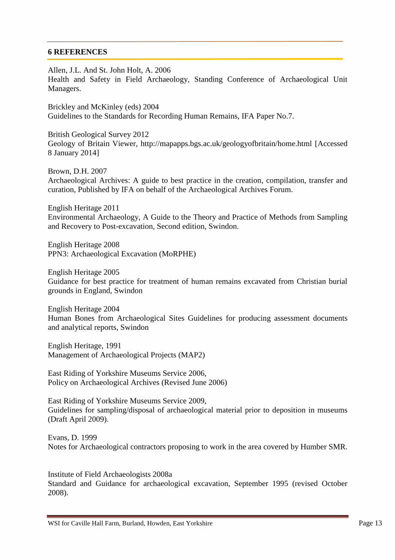
WSI for Caville Hall Farm, Burland, Howden, East Yorkshire Page 13
6 REFERENCES
Allen, J.L. And St. John Holt, A. 2006
Health and Safety in Field Archaeology, Standing Conference of Archaeological Unit
Managers.
Brickley and McKinley (eds) 2004
Guidelines to the Standards for Recording Human Remains, IFA Paper No.7.
British Geological Survey 2012
Geology of Britain Viewer, http://mapapps.bgs.ac.uk/geologyofbritain/home.html [Accessed
8 January 2014]
Brown, D.H. 2007
Archaeological Archives: A guide to best practice in the creation, compilation, transfer and
curation, Published by IFA on behalf of the Archaeological Archives Forum.
English Heritage 2011
Environmental Archaeology, A Guide to the Theory and Practice of Methods from Sampling
and Recovery to Post-excavation, Second edition, Swindon.
English Heritage 2008
PPN3: Archaeological Excavation (MoRPHE)
English Heritage 2005
Guidance for best practice for treatment of human remains excavated from Christian burial
grounds in England, Swindon
English Heritage 2004
Human Bones from Archaeological Sites Guidelines for producing assessment documents
and analytical reports, Swindon
English Heritage, 1991
Management of Archaeological Projects (MAP2)
East Riding of Yorkshire Museums Service 2006,
Policy on Archaeological Archives (Revised June 2006)
East Riding of Yorkshire Museums Service 2009,
Guidelines for sampling/disposal of archaeological material prior to deposition in museums
(Draft April 2009).
Evans, D. 1999
Notes for Archaeological contractors proposing to work in the area covered by Humber SMR.
Institute of Field Archaeologists 2008a
Standard and Guidance for archaeological excavation, September 1995 (revised October
2008).
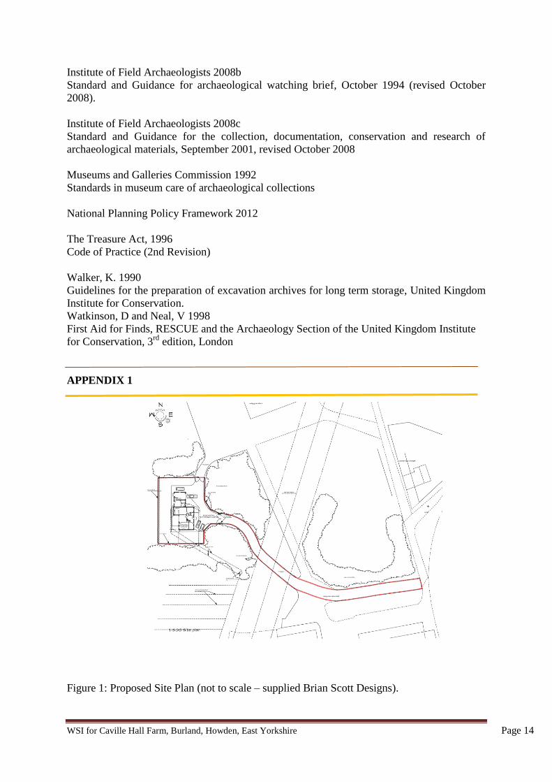
WSI for Caville Hall Farm, Burland, Howden, East Yorkshire Page 14
Institute of Field Archaeologists 2008b
Standard and Guidance for archaeological watching brief, October 1994 (revised October
2008).
Institute of Field Archaeologists 2008c
Standard and Guidance for the collection, documentation, conservation and research of
archaeological materials, September 2001, revised October 2008
Museums and Galleries Commission 1992
Standards in museum care of archaeological collections
National Planning Policy Framework 2012
The Treasure Act, 1996
Code of Practice (2nd Revision)
Walker, K. 1990
Guidelines for the preparation of excavation archives for long term storage, United Kingdom
Institute for Conservation.
Watkinson, D and Neal, V 1998
First Aid for Finds, RESCUE and the Archaeology Section of the United Kingdom Institute
for Conservation, 3rd
edition, London
APPENDIX 1
Figure 1: Proposed Site Plan (not to scale – supplied Brian Scott Designs).
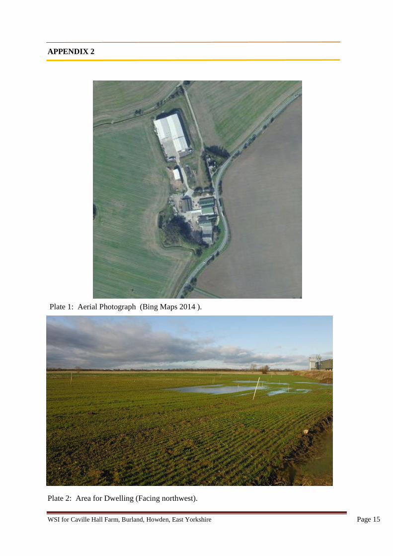
WSI for Caville Hall Farm, Burland, Howden, East Yorkshire Page 15
APPENDIX 2
Plate 1: Aerial Photograph (Bing Maps 2014 ).
Plate 2: Area for Dwelling (Facing northwest).
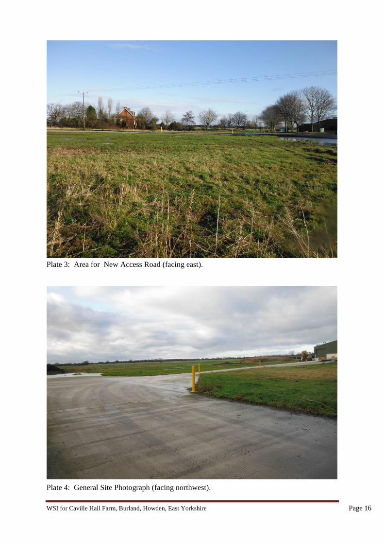
WSI for Caville Hall Farm, Burland, Howden, East Yorkshire Page 16
Plate 3: Area for New Access Road (facing east).
Plate 4: General Site Photograph (facing northwest).
Figure 1: Site Location Plan
1:100010 0
Metres
20
N
Crown copyright. All rights reserved. Licence number 100048957 PastSearch 2014cc
6.4m
Caville Hall Cottages
4768
50
4769
00
4769
50
430600
430650
430700
HullHowden
East Yorkshire
NorthLincolnshire
North Yorkshire
@A4
Figure 2: P
lan of Archaeological F
eatures
1:100010
0Metres
20
A
B
C
D
E
F
G
H
I
Key
A - W
est Side of Trackw
ayB
- East Side of Trackw
ayC
- Ditch
D - D
itchE
- Spread
F - SpreadG
- Spread
2008 Monitored A
rea (HFA)
H - D
itchI - D
itch2014 Monitored Area
2014 Foundation TrenchesC
ropmarks as O
bserved on Aerial Photos (HSM
R)
N
PastS
earch 2014c
Proposed tree planting
Proposed tree planting
Proposed tree planting
Proposed tree planting
After Brian S
cott Designs LLP
TP1
TP2
@A3
and Crop M
arks
Figure 3:O
verall Plan of A
reas 1 & 2,
1:2001
0Metres
5
N
PastS
earch 2014c
@A3
and Foundation Trenches
Figure 4: P
lan of Area 1 N
Metres
1:1001
0.50
2
105
122
106
119
121
117
113
107
111
115
109
108
109110
104S
.4
S.1
S.2
S.3
S.5
103102
103
103
103
103
103103
103
PastS
earch 2014c
@A3
Figure 5: P
lan of Area 2
N
Metres
1:1001
0.50
2
213
214
203221
212
210
224207
205
227
226
216
217
218S.6
S.7
S.8
S.10
215
S.9
202
PastS
earch 2014c
and Foundation Trenches
@A3
1:40
Metres
0.50 1
1:10
Metres
.10 0 .50
Figure 6: Sections 1-5
S.1
S.2 S.3
S.4
S.5
113
115 117
119
121
111
107 101
108109 110109
112
101 114 116
118
120
103
103103
E W
W
NW
W
E N S
SE
E
@A4
@A4
PastSearch 2014c
Figure 7: Section 6 - 10
1:40Metres
0.50 1
1:10
Metres
.10 0 .50
S.6 S.7
S.8
205
221
212
204
201
220219
201
211215
E W E W
W E
S.9W E
207206
@A4
201
214
224223203
203
S.10S N
1:50
Metres
.50 0 1
@A4
PastSearch 2014c
Plate 1: Development Site, pre-excavation, 9 January 2014, Looking South.
Plate 2: Area 1, Machine Stripped, Pre-targeted Excavation, Looking Northwest. Scale: 1m x 2.
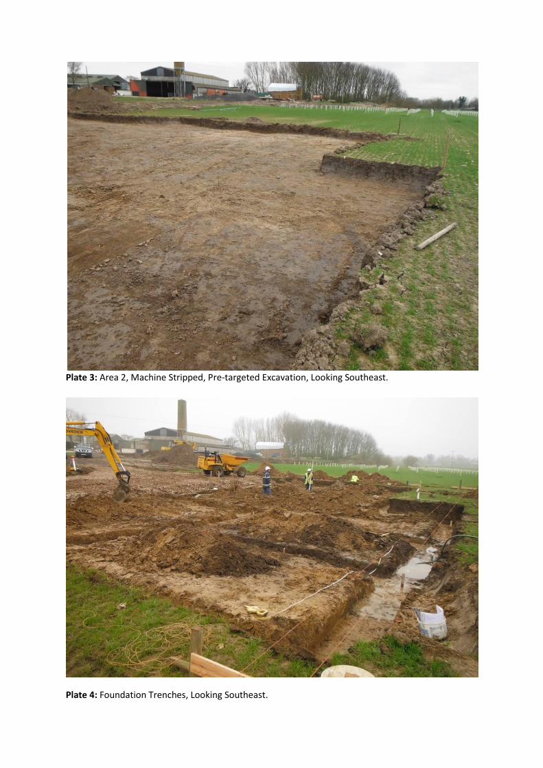
Plate 3: Area 2, Machine Stripped, Pre-targeted Excavation, Looking Southeast.
Plate 4: Foundation Trenches, Looking Southeast.
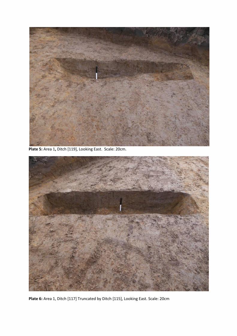
Plate 5: Area 1, Ditch [119], Looking East. Scale: 20cm.
Plate 6: Area 1, Ditch [117] Truncated by Ditch [115], Looking East. Scale: 20cm
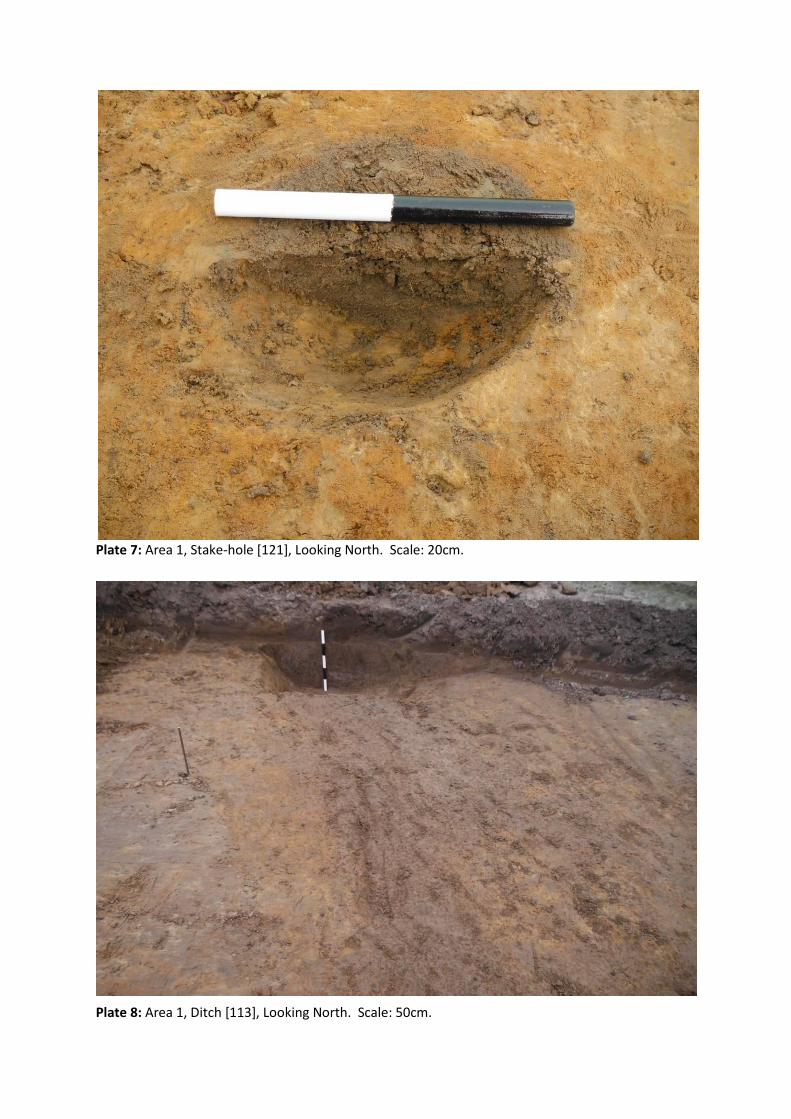
Plate 7: Area 1, Stake-hole [121], Looking North. Scale: 20cm.
Plate 8: Area 1, Ditch [113], Looking North. Scale: 50cm.
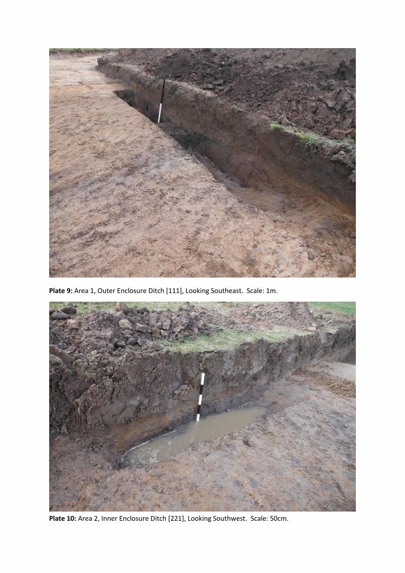
Plate 9: Area 1, Outer Enclosure Ditch [111], Looking Southeast. Scale: 1m.
Plate 10: Area 2, Inner Enclosure Ditch [221], Looking Southwest. Scale: 50cm.
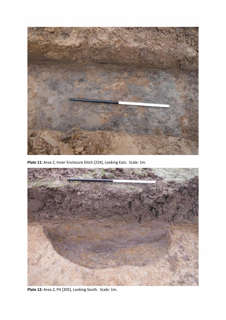
Plate 11: Area 2, Inner Enclosure Ditch [224], Looking East. Scale: 1m.
Plate 12: Area 2, Pit [205], Looking South. Scale: 1m.
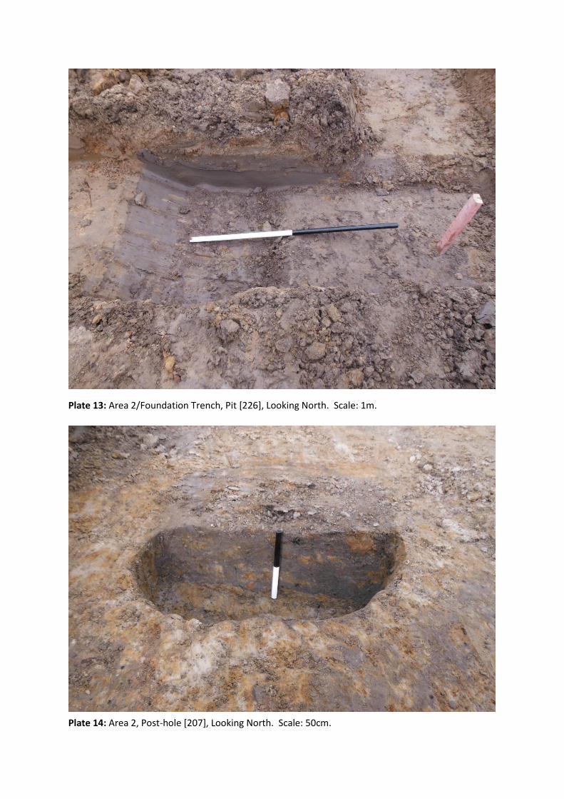
Plate 13: Area 2/Foundation Trench, Pit [226], Looking North. Scale: 1m.
Plate 14: Area 2, Post-hole [207], Looking North. Scale: 50cm.
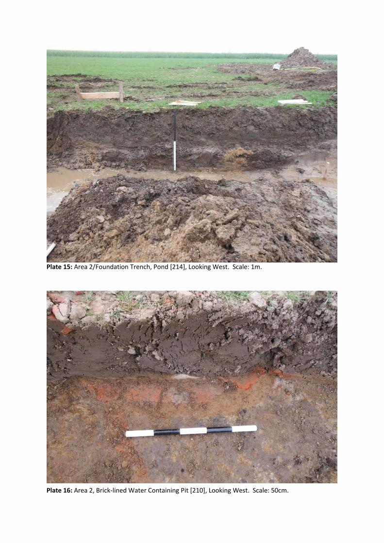
Plate 15: Area 2/Foundation Trench, Pond [214], Looking West. Scale: 1m.
Plate 16: Area 2, Brick-lined Water Containing Pit [210], Looking West. Scale: 50cm.
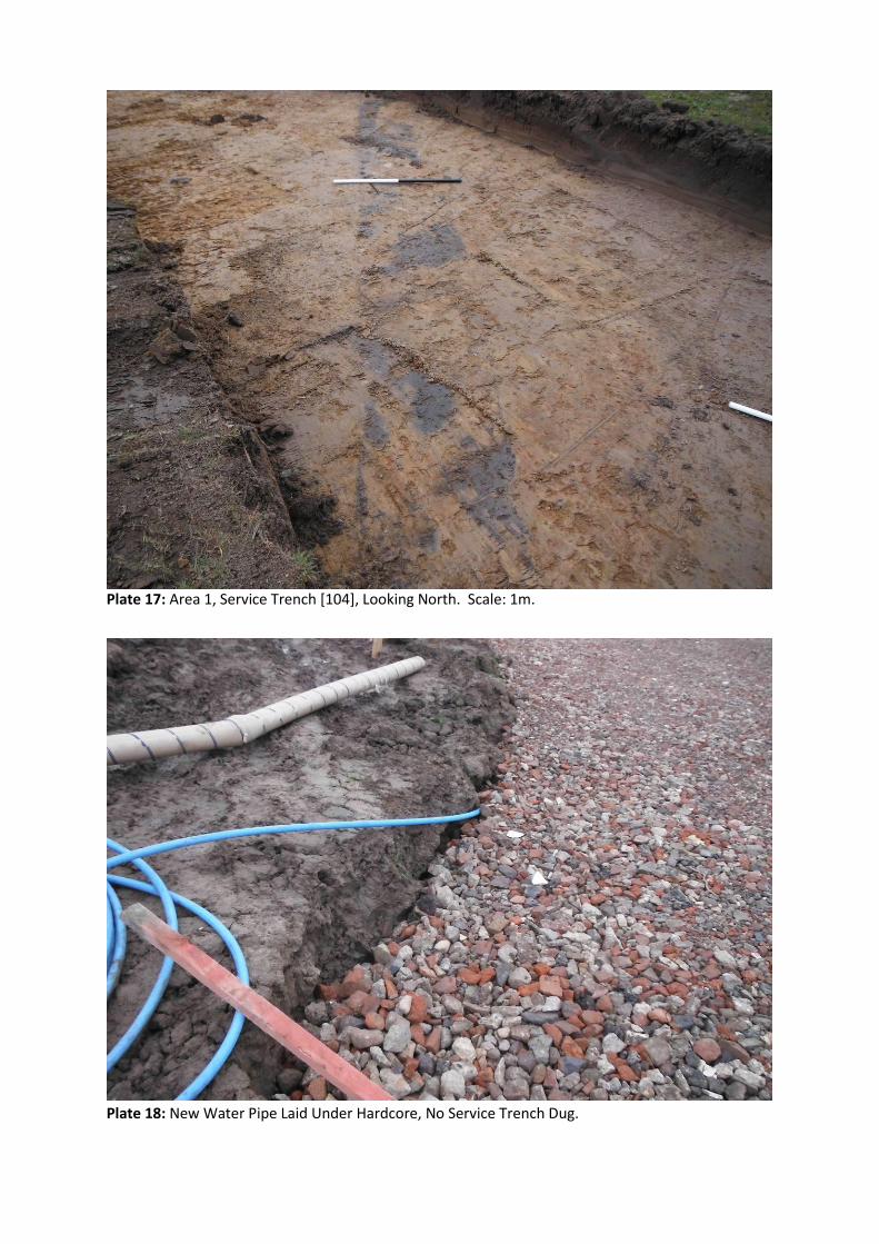
Plate 17: Area 1, Service Trench [104], Looking North. Scale: 1m.
Plate 18: New Water Pipe Laid Under Hardcore, No Service Trench Dug.
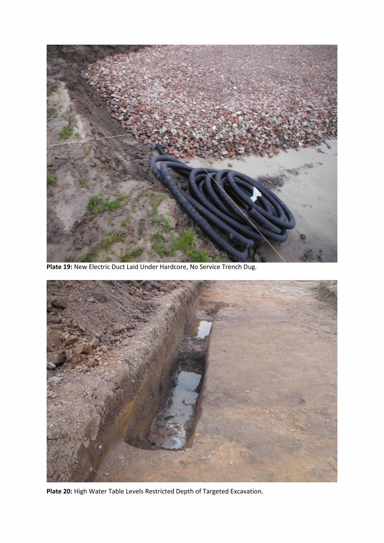
Plate 19: New Electric Duct Laid Under Hardcore, No Service Trench Dug.
Plate 20: High Water Table Levels Restricted Depth of Targeted Excavation.
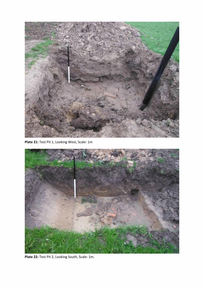
Plate 21: Test Pit 1, Looking West, Scale: 1m
Plate 22: Test Pit 2, Looking South, Scale: 1m.