Embed Size (px)
Citation preview


Archaeology in the Park
Excavations at Jennett’s Park,
Bracknell, Berkshire
by Andrew Simmonds, Sharon Cook, Edward Biddulph
and David Score
with contributions by
Paul Blinkhorn, Lisa Brown, Dana Challinor, Luke Howarth, Elizabeth Huckerby, Hugo Lamdin-Whymark, Richard Macphail, Cynthia Poole, Ian Scott,
Lena Strid, Ruth Shaffrey and Wendy Smith
Illustrations by
Julia Moxham, Ros Lorimer, Sarah Lucas, Mark Gridley, Magdalena Wachnik and Mark Littlewood
Oxford Archaeology
Occasional Paper Number 18
2009

Archaeology in the ParkExcavations at Jennett’s Park, Bracknell, Berkshire
The publication of this volume was generously funded by the Jennett’s Park Consortium, comprising Redrow Homes (Southern) Ltd and Persimmon Homes Ltd.
Edited by Edward Biddulph and Paul Booth
Front cover:The Iron Age settlement at Jennett’s Park. Drawing by Mark Gridley.
Back cover:Roman field boundary ditch 504173 at the western edge of Area 9 during excavation
ISBN 978-0-904220-58-2© 2009 Oxford Archaeological Unit
www.thehumanjourney.net
Designed by Oxford Archaeology Graphics OfficeTypeset by Production Line, Oxford
Printed in Great Britain by Information Press, Eynsham, Oxford

Contents
iii
List of Figures . . . . . . . . . . . . . . . . . . . . . . . . . . . . . . . . . . . . . . . . . . . . . . . . . . . . . . . . . . . . . . . . . . . . . . . . . . . . iv
List of Plates . . . . . . . . . . . . . . . . . . . . . . . . . . . . . . . . . . . . . . . . . . . . . . . . . . . . . . . . . . . . . . . . . . . . . . . . . . . . . . v
List of Tables . . . . . . . . . . . . . . . . . . . . . . . . . . . . . . . . . . . . . . . . . . . . . . . . . . . . . . . . . . . . . . . . . . . . . . . . . . . . . vi
Summary. . . . . . . . . . . . . . . . . . . . . . . . . . . . . . . . . . . . . . . . . . . . . . . . . . . . . . . . . . . . . . . . . . . . . . . . . . . . . . . . . vii
Acknowledgements . . . . . . . . . . . . . . . . . . . . . . . . . . . . . . . . . . . . . . . . . . . . . . . . . . . . . . . . . . . . . . . . . . . . . . viii
Introduction . . . . . . . . . . . . . . . . . . . . . . . . . . . . . . . . . . . . . . . . . . . . . . . . . . . . . . . . . . . . . . . . . . . . . . . . . . . . . . . . . 1
Archaeological Description . . . . . . . . . . . . . . . . . . . . . . . . . . . . . . . . . . . . . . . . . . . . . . . . . . . . . . . . . . . . . . . . . . . . 8
The Finds . . . . . . . . . . . . . . . . . . . . . . . . . . . . . . . . . . . . . . . . . . . . . . . . . . . . . . . . . . . . . . . . . . . . . . . . . . . . . . . . . . 37 The pottery by Edward Biddulph, Paul Blinkhorn and Lisa Brown . . . . . . . . . . . . . . . . . . . . . . . . . . . . . . . . . . 37Worked flint by Hugo Lamdin-Whymark . . . . . . . . . . . . . . . . . . . . . . . . . . . . . . . . . . . . . . . . . . . . . . . . . . . . . . . 48Fired clay by Cynthia Poole . . . . . . . . . . . . . . . . . . . . . . . . . . . . . . . . . . . . . . . . . . . . . . . . . . . . . . . . . . . . . . . . . . 54Ceramic building material by Cynthia Poole . . . . . . . . . . . . . . . . . . . . . . . . . . . . . . . . . . . . . . . . . . . . . . . . . . . 57Worked stone by Ruth Shaffrey . . . . . . . . . . . . . . . . . . . . . . . . . . . . . . . . . . . . . . . . . . . . . . . . . . . . . . . . . . . . . . 57Slag by Luke Howarth . . . . . . . . . . . . . . . . . . . . . . . . . . . . . . . . . . . . . . . . . . . . . . . . . . . . . . . . . . . . . . . . . . . . . . . 58Other finds by Ian Scott . . . . . . . . . . . . . . . . . . . . . . . . . . . . . . . . . . . . . . . . . . . . . . . . . . . . . . . . . . . . . . . . . . . . 58
The Environmental Evidence . . . . . . . . . . . . . . . . . . . . . . . . . . . . . . . . . . . . . . . . . . . . . . . . . . . . . . . . . . . . . . . . . 58Animal bone by Lena Strid . . . . . . . . . . . . . . . . . . . . . . . . . . . . . . . . . . . . . . . . . . . . . . . . . . . . . . . . . . . . . . . . . . 58Charred plant remains by Wendy Smith . . . . . . . . . . . . . . . . . . . . . . . . . . . . . . . . . . . . . . . . . . . . . . . . . . . . . . . 59Charcoal by Dana Challinor . . . . . . . . . . . . . . . . . . . . . . . . . . . . . . . . . . . . . . . . . . . . . . . . . . . . . . . . . . . . . . . . . . 60Pollen from waterhole 505122 by Elizabeth Huckerby . . . . . . . . . . . . . . . . . . . . . . . . . . . . . . . . . . . . . . . . . . . 62Soil micromorphology by Richard Macphail . . . . . . . . . . . . . . . . . . . . . . . . . . . . . . . . . . . . . . . . . . . . . . . . . . . 63
Discussion: From Wildwood to Parkland . . . . . . . . . . . . . . . . . . . . . . . . . . . . . . . . . . . . . . . . . . . . . . . . . . . . . . 64
Appendix. Soil Micromorphology: Detailed descriptions and interpretations . . . . . . . . . . . . . . . . . . . . . . 73
Bibliography . . . . . . . . . . . . . . . . . . . . . . . . . . . . . . . . . . . . . . . . . . . . . . . . . . . . . . . . . . . . . . . . . . . . . . . . . . . . . . . . 76

iv
1 Site location . . . . . . . . . . . . . . . . . . . . . . . . . . . . . . . . . . . . . . . . . . . . . . . . . . . . . . . . . . . . . . . . . . . . . . . . . . . . .2 2 Location of the excavation areas and evaluation trenching . . . . . . . . . . . . . . . . . . . . . . . . . . . . . . . . . . . .4 3 Plan of all archaeological features in areas 1 to 5 and evaluation Trench 44 . . . . . . . . . . . . . . . . . . . . . . 54 Plan of all archaeological features in Area 6 . . . . . . . . . . . . . . . . . . . . . . . . . . . . . . . . . . . . . . . . . . . . . . . . .6 5 Plan of all archaeological features in areas 7 to 10 . . . . . . . . . . . . . . . . . . . . . . . . . . . . . . . . . . . . . . . . . . . .7 6 Section through the soil sequence exposed in the baulk at the eastern end of Area 10 . . . . . . . . . . . . .8 7 Location of buried soil layer 505200 containing the Mesolithic flint scatter . . . . . . . . . . . . . . . . . . . . . . .9 8 Plan of Bronze Age features in areas 9 and 10 . . . . . . . . . . . . . . . . . . . . . . . . . . . . . . . . . . . . . . . . . . . . . . 109 Plan of burnt mound 404032 . . . . . . . . . . . . . . . . . . . . . . . . . . . . . . . . . . . . . . . . . . . . . . . . . . . . . . . . . . . . . 1110 Plan of burnt mound 505128/505154, showing underlying features exposed in the intervention . . .12 11 Section through burnt mound 505128/505154 and underlying features . . . . . . . . . . . . . . . . . . . . . . . .13 12 Section through burnt mound 505273/505275 and associated colluvial layers . . . . . . . . . . . . . . . . . . .14 13 Sections through Bronze Age features: waterholes 505104 and 505122 and pits 504048
and 504051 . . . . . . . . . . . . . . . . . . . . . . . . . . . . . . . . . . . . . . . . . . . . . . . . . . . . . . . . . . . . . . . . . . . . . . . . . . .15 14 Plan of Bronze Age pit 4409 and other features in evaluation Trench 44 . . . . . . . . . . . . . . . . . . . . . . . .16 15 Plan of the Iron Age settlement . . . . . . . . . . . . . . . . . . . . . . . . . . . . . . . . . . . . . . . . . . . . . . . . . . . . . . . . . . .18 16 Detailed plans of the Iron Age structures . . . . . . . . . . . . . . . . . . . . . . . . . . . . . . . . . . . . . . . . . . . . . . . . . . .19 17 Plan of Iron Age features in Area 6 . . . . . . . . . . . . . . . . . . . . . . . . . . . . . . . . . . . . . . . . . . . . . . . . . . . . . . . .22 18 Plan of Iron Age features in Area 6 . . . . . . . . . . . . . . . . . . . . . . . . . . . . . . . . . . . . . . . . . . . . . . . . . . . . . . . .24 19 Sections across ditches of the Iron Age field system . . . . . . . . . . . . . . . . . . . . . . . . . . . . . . . . . . . . . . . . .25 20 Plan of the Roman field system and other features . . . . . . . . . . . . . . . . . . . . . . . . . . . . . . . . . . . . . . . . . .26 21 Sections across ditches of the Roman field system . . . . . . . . . . . . . . . . . . . . . . . . . . . . . . . . . . . . . . . . . . .27 22 Plan of the medieval field system in areas 1-5 . . . . . . . . . . . . . . . . . . . . . . . . . . . . . . . . . . . . . . . . . . . . . .30 23 Plan of medieval features in Area 3 . . . . . . . . . . . . . . . . . . . . . . . . . . . . . . . . . . . . . . . . . . . . . . . . . . . . . . . 3124 Plan of medieval features in Area 1 . . . . . . . . . . . . . . . . . . . . . . . . . . . . . . . . . . . . . . . . . . . . . . . . . . . . . . . .32 25 Plan of medieval features in Area 2 . . . . . . . . . . . . . . . . . . . . . . . . . . . . . . . . . . . . . . . . . . . . . . . . . . . . . . . .33 26 Plan of probable limekiln 405003 . . . . . . . . . . . . . . . . . . . . . . . . . . . . . . . . . . . . . . . . . . . . . . . . . . . . . . . . . .34 27 Section of probable limekiln 405003 . . . . . . . . . . . . . . . . . . . . . . . . . . . . . . . . . . . . . . . . . . . . . . . . . . . . . . .35 28 Prehistoric pottery . . . . . . . . . . . . . . . . . . . . . . . . . . . . . . . . . . . . . . . . . . . . . . . . . . . . . . . . . . . . . . . . . . . . . .39 29 Inter-site comparison of functional groups of Roman pottery . . . . . . . . . . . . . . . . . . . . . . . . . . . . . . . . .43 30 Late Iron Age and Roman pottery . . . . . . . . . . . . . . . . . . . . . . . . . . . . . . . . . . . . . . . . . . . . . . . . . . . . . . . . .44 31 Medieval pottery . . . . . . . . . . . . . . . . . . . . . . . . . . . . . . . . . . . . . . . . . . . . . . . . . . . . . . . . . . . . . . . . . . . . . . .47 32 Length to breadth scatter diagram for complete unretouched flint flakes over 10 mm2 . . . . . . . . . . .50 33 Worked flint . . . . . . . . . . . . . . . . . . . . . . . . . . . . . . . . . . . . . . . . . . . . . . . . . . . . . . . . . . . . . . . . . . . . . . . . . . . .53 34 Triangular oven bricks/loomweights from fill 502081 of ditch 502080 and fill 502005 of
pit 502004 . . . . . . . . . . . . . . . . . . . . . . . . . . . . . . . . . . . . . . . . . . . . . . . . . . . . . . . . . . . . . . . . . . . . . . . . . . .56
A1 Photomicrographs of the micromorphological thin sections . . . . . . . . . . . . . . . . . . . . . . . . . . . . . . . .74–5
List of Figures

1 Stripping topsoil from Area 8 . . . . . . . . . . . . . . . . . . . . . . . . . . . . . . . . . . . . . . . . . . . . . . . . . . . . . . . . . . . . . .8 2 The soil sequence exposed in the baulk at the western end of Area 10, showing Mesolithic
buried soil 505200 buried beneath colluvium 505169. Total depth of section = 1.3 m . . . . . . . . . . . . . . .9 3 Slot excavated across burnt mound 505128/505154. Scale = 2 m . . . . . . . . . . . . . . . . . . . . . . . . . . . . . . . 114 Bronze Age waterhole 505122 . . . . . . . . . . . . . . . . . . . . . . . . . . . . . . . . . . . . . . . . . . . . . . . . . . . . . . . . . . . .14 5 Roman field boundary ditch 504173 at the western edge of Area 9 during excavation . . . . . . . . . . . 256 Excavating test pits through Roman buried soil 502171 . . . . . . . . . . . . . . . . . . . . . . . . . . . . . . . . . . . . . .28 7 View of probable limekiln 405003 from the north-west, along the flue. Scales = 2 m and 0.5 m . . . . . .36 8 Limekiln 405003 after machine excavation of the lower fills . . . . . . . . . . . . . . . . . . . . . . . . . . . . . . . . . .36 9 Hafted and utilised flake sf 678 from burnt mound 505285 . . . . . . . . . . . . . . . . . . . . . . . . . . . . . . . . . . .51
v
List of Plates

1 Radiocarbon dates . . . . . . . . . . . . . . . . . . . . . . . . . . . . . . . . . . . . . . . . . . . . . . . . . . . . . . . . . . . . . . . . . . . . . .37 2 Prehistoric pottery fabrics . . . . . . . . . . . . . . . . . . . . . . . . . . . . . . . . . . . . . . . . . . . . . . . . . . . . . . . . . . . . . . . .38 3 Quantification of late Iron Age and Roman fabrics . . . . . . . . . . . . . . . . . . . . . . . . . . . . . . . . . . . . . . . . . .40 4 Chronological summary of context groups . . . . . . . . . . . . . . . . . . . . . . . . . . . . . . . . . . . . . . . . . . . . . . . . .41 5 Quantification of late Iron Age forms and fabrics by EVE . . . . . . . . . . . . . . . . . . . . . . . . . . . . . . . . . . . .41 6 Quantification of early Roman forms and fabrics by EVE . . . . . . . . . . . . . . . . . . . . . . . . . . . . . . . . . . . .42 7 The flint assemblage . . . . . . . . . . . . . . . . . . . . . . . . . . . . . . . . . . . . . . . . . . . . . . . . . . . . . . . . . . . . . . . . . . . .49 8 Comparison of length/breadth index values for unretouched flakes 20 mm or more in length . . . .50 9 Technological attributes of flakes: dorsal extent of cortex . . . . . . . . . . . . . . . . . . . . . . . . . . . . . . . . . . . . .50 10 Technological attributes of flakes: flake type . . . . . . . . . . . . . . . . . . . . . . . . . . . . . . . . . . . . . . . . . . . . . . . .50 11 Technological attributes of flakes: termination type . . . . . . . . . . . . . . . . . . . . . . . . . . . . . . . . . . . . . . . . . .50 12 Summary of fired clay data . . . . . . . . . . . . . . . . . . . . . . . . . . . . . . . . . . . . . . . . . . . . . . . . . . . . . . . . . . . . . .55 13 Triangular oven bricks: range of sizes . . . . . . . . . . . . . . . . . . . . . . . . . . . . . . . . . . . . . . . . . . . . . . . . . . . . . .55 14 Charred plant remains from Roman field boundary ditch fill 19013 . . . . . . . . . . . . . . . . . . . . . . . . . . . .59 15 Charcoal from Bronze Age burnt mound layers 505154 and 505275 and waterhole 505104 . . . . . . . .60 16 Charcoal from Iron Age features . . . . . . . . . . . . . . . . . . . . . . . . . . . . . . . . . . . . . . . . . . . . . . . . . . . . . . . . . .61 17 Charcoal from Roman features . . . . . . . . . . . . . . . . . . . . . . . . . . . . . . . . . . . . . . . . . . . . . . . . . . . . . . . . . . .61 18 Results of the pollen assessment from /waterhole 505122 . . . . . . . . . . . . . . . . . . . . . . . . . . . . . . . . . . . .62 19 Soil micromorphology of thin section samples . . . . . . . . . . . . . . . . . . . . . . . . . . . . . . . . . . . . . . . . . . . . . .64
vi
List of Tables

In 2006 and 2007 Oxford Archaeology undertook aprogramme of archaeological investigations in advanceof construction of the urban village of Jennett’s Park inan area of former farmland belonging to Peacock Farm,Bracknell, Berkshire. These investigations revealed thatthe site had been witness to a series of contrastingepisodes of occupation and activity over a period ofseveral thousand years.
The earliest occupation comprised the small, tempo-rary camp of a band of Mesolithic hunter-gatherers atthe top of the southern slope of Jennett’s Hill, most likelytaking advantage of the elevated position of this knolloverlooking an area of wetland to the south-west. Theremains of the camp consisted of a concentration ofworked flint recovered from a buried topsoil, and therange of tools present indicated that a variety of activi-ties were carried out here including the processing ofhides. The view may have been enhanced by deliberateclearance of trees, the resulting erosion of soil leading tothe formation of a colluvial deposit that buried theancient soil.
After a hiatus of activity during the Neolithic period,when the site appears to have been little visited, activityrecommenced in the middle Bronze Age. Features of this date comprised three burnt mounds, two waterholes,two trough-like pits and a possible cremation burial or deliberately-placed pot, as well as a number of smallpits or postholes buried beneath two of the burnt mounds. Calibrated radiocarbon dates of 1630–1490 BC/
1480–1450 BC and 1420–1260 BC were obtained for twoof the burnt mounds.
Jennett’s Park was first used for permanent settle-ment during the middle Iron Age, when a smallfarmstead was established. The settlement was occupiedinto the late Iron Age but was abandoned before the startof the Roman period. An agricultural landscape definedby a complex of field boundary ditches was establishedtowards the end of the late Iron Age, but it is not certainwhether this was associated with the final phase of thesettlement or replaced it. The field system continued inuse into the Roman period, when the boundaries were re-organised and new ditches dug before being abandoned,apparently during the early 2nd century.
Evidence was found at the northern end of the investi-gations for two definite and one possible curvilinearstock enclosures dating from the late 11th-late 12thcenturies, which were superseded by a system of fieldsand enclosures that were in use until the mid 14thcentury. These features may be associated with aposited settlement beyond the limits of the excavation,and their abandonment may have been associated withthe enclosure of part of the area during the creation ofEasthampstead Park. A post-medieval kiln, probablyfor limeburning, was excavated. This may havesupplied lime for the construction during the 17thcentury of the first Easthampstead Park House, whichhas since been demolished and replaced at a differentlocation.
vii
Summary

The archaeological investigation was instructedand funded by the Jennett’s Park Consortium,which comprises Persimmon Homes Ltd andRedrow Homes (Southern) Ltd. David Thomason,then of Berkshire Archaeology, the archaeologicaladvisor to Bracknell Forest Borough Council, alsoplayed an important role in ensuring that theproject proceeded smoothly. The fieldwork wasdirected by Katrina Anker and was managedinitially by Melanie Pomeroy-Kellinger, then byDavid Score. The post-excavation work wasmanaged by Edward Biddulph. Support wasprovided by Leigh Allen (finds management), PaulBackhouse (graphics management), Matt Bradley(geomatics management), Rebecca Nicholson(environmental management) and Nicola Scott(archives management). Mark Littlewood digitisedthe site plans, Julia Moxham drafted the site figuresand sections, Ros Lorimer prepared the drawingsof the pottery, Sarah Lucas drew the worked
flint, and Magdalena Wachnik produced thephotographs and cross-sections of the triangularoven bricks/loomweights. The reconstruction ofthe Iron Age settlement was drawn by MarkGridley. Elizabeth Huckerby would like to thankthe geography department of Lancaster Universityfor the use of its laboratories. The radiocarbondeterminations were provided by Philip Naysmithof the Scottish Universities EnvironmentalResearch Centre (SUERC). Oxford Archaeologywould like to thank the following for their signifi-cant contribution to the project during and afterfieldwork: R Bailey, R Bashford, A Brown, R Brown,I Cook, J Ford, P Gane, M Gibson, J Haigh, N Lambert, A Langlands, P Leader, F Mazzilli, B McAndrew, J Mcleish, D McNicol, S Oates, L Offord, R Peacock, L Philpott, D Reay, I Sparkes-Santos, S Thomson, A Tizzard, S Weaver, and H Webb. The report was edited for publication byPaul Booth and Edward Biddulph.
viii
Acknowledgements

INTRODUCTION
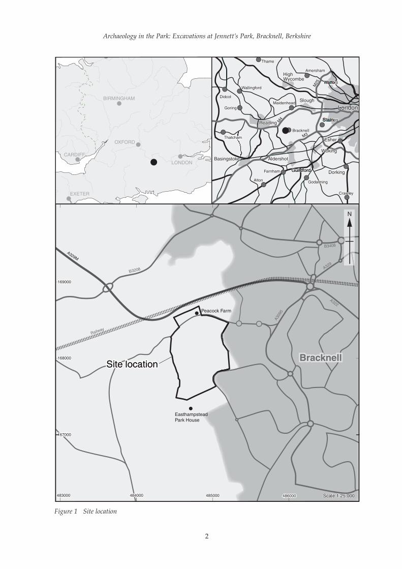
Project background (Fig. 1)
This report describes and analyses the results of aprogramme of archaeological excavation carried outby Oxford Archaeology in May 2006 and from Aprilto July 2007 at Jennett’s Park (formerly PeacockFarm), Bracknell, Berkshire (NGR 4850 1680; Fig. 1).These investigations were designed to mitigate theeffects of the construction of Jennett’s Park, an ‘urbanvillage’ comprising 1300-1500 homes, a businesspark, recreational facilities and a park-and-ridefacility. The development encompassed a total area of116 hectares on an area of former grasslandbelonging to Peacock Farm. The Listed farm build-ings have been retained and converted into a bar andrestaurant. The investigations comprised a total of 10discrete areas of ‘strip, map and sample excavation’,targeted on areas of archaeological potential identi-fied by a previous geophysical survey and trenchevaluation of the entire development area. The workwas commissioned by the Jennett’s Park Consortiumin accordance with a condition attached to theplanning permission for the development byBracknell Forest Borough Council.
Location, topography and geology
Bracknell is located in East Berkshire, to the south ofa northern loop of the River Thames betweenReading and Windsor. Jennett’s Park lies west of thetown, south of the Bracknell to Wokingham railwayline and immediately to the east of the boundarybetween the parishes of Bracknell and WokinghamWithout (Fig. 1). It originally lay within the north-ernmost part of Easthampstead Park, but prior tothe excavation was agricultural land belonging toPeacock Farm. The most notable feature of thelandscape is Jennett’s Hill, a knoll located in thesouth-eastern part of the area under developmentthat rises to a maximum height of c 80 m aboveOrdnance Datum (OD). From this point, the terrainslopes gently down to the north and west andsomewhat more steeply to the south to more levelground. The lowest lying part of the site is situatedto the south-west, with a level of c 67 m OD.
Geologically, East Berkshire lies at the northernedge of the western part of the London Basin. Thisis a vast, roughly triangular concavity in the under-lying chalk between the Chilterns and MarlboroughDowns to the north and the North Downs to thesouth, which extends as far west as Newbury and isin-filled with later deposits of sand and clay. Thechalk outcrops to the north, within the loop of theThames between Reading and Windsor, with mostof the area to the south composed of London Clay.The site lay predominantly on London Clay, withthe exception of Jennett’s Hill, which is composed ofthe gravelly sand of the Bagshot Beds. The clayareas of the site were poorly drained, and the south-western part, between Jennett’s Hill andEasthampstead Park College, was observed during
the excavation to be prone to flooding and standingwater and is likely to have been marshland prior tomodern drainage. Evidence from the excavationalso indicated that colluviation had occurred on thelower part of the southern slope of the hill. Prior tothe excavation the area had a mixed usagecomprising arable cultivation and grassland, andcontained an area of woodland, Tarman’s Copse, tothe north of Jennett’s Hill.
Archaeological background
The archaeological background of the site was thesubject of a desk-based assessment (OAU 1993)undertaken as an initial phase of the archaeologicalmitigation of the development. A summary of theresults of the assessment is presented here.
Evidence for archaeological remains earlier thanthe medieval period was little known until the publi-cation of the East Berkshire archaeological survey(Ford 1987a), which documented a programme ofextensive fieldwalking carried out in 1987. Thesurvey recorded limited evidence for prehistoricactivity within the area of development in the formof a number of low density surface flint scatters.These contained both flint tools and waste flakesindicative of on-site flint manufacture and perhapsassociated occupation. The earliest activity wasrepresented by a significant scatter of Mesolithictools immediately to the west of the present devel-opment area. These finds are significant within thegeneral context of East Berkshire as the majority ofMesolithic remains in this area come from rivervalley gravels, and it is rare to find such material onLondon Clay. A background scatter of small quanti-ties of worked flint of Neolithic or Bronze Age datewas also recorded.
Other prehistoric activity in the vicinity is repre-sented by a bowl barrow located approximately 1km south-east of the site and by Caesar’s Camp, theonly known Iron Age hillfort in East Berkshire,which is located c 2.5 km to the south-east of the site.
The settlement pattern in Berkshire during theRoman period was dominated by the civitascapital of Calleva Atrebatum at Silchester (inHampshire), south of Reading. Jennett’s Park issituated c 21 km east of Silchester, and 3 km northof the Roman road linking the town with theprovincial capital at London. No evidence forRoman activity had been identified within the siteitself prior to the evaluation, although the EastBerkshire survey recorded two scatters of pottery1 km to the west. As with remains of the prehis-toric period, Roman sites are poorly-representedon areas of London Clay and Bagshot Beds in EastBerkshire. Despite the low levels of pottery recov-ered, these scatters may be significant indicatorsfor the presence of settlement activity, since inves-tigations undertaken at Binfield in 1989 and 1990revealed a Roman settlement that was representedon the surface by only a small handful of sherds ofpottery (Roberts 1995, 123).
1
Archaeology in the Park: Excavations at Jennett’s Park, Bracknell, Berkshire
2
Figure 1 Site location

During the medieval period the area nowoccupied by Jennett’s Park formed part of the royalhunting lodge of Easthampstead Park. Scatters ofmedieval pottery have been recorded within the areaof the investigation, one of which coincided with anarea of ridge and furrow identified from cropmarkson aerial photographs taken during 1961.
Previous archaeological investigations
Archaeological watching briefs were carried outwithin the area of the development by OxfordArchaeology during November 2003 and August2005. The former investigation was undertakenduring the excavation of a telecommunicationstrench that crossed the hollow-way of BurnthouseRide. A section through the deposits forming thehollow-way was recorded, but no artefacts wererecovered that might have confirmed its presumedmedieval origin. The second watching brief wasundertaken during the digging of a total of 115geotechnical test pits distributed across the devel-opment area. No archaeological features wereidentified, although fragments of Saxon or earlymedieval pottery were retrieved from the subsoil inone trench.
The fieldwork
The evaluation
Geophysical investigationThe site was subject to a programme of geophysicalinvestigation comprising a combination of exten-sive magnetic susceptibility survey conducted overmuch of the development area, followed by selec-tive detailed magnetometry survey of areas thatproduced significant readings (Bartlett 1998). Anarea at the centre of the site designated for openspace was excluded from the survey along with anarea to the north of Peacock Lane which at the timewas unavailable for survey.
The results of the magnetic susceptibility surveyidentified fourteen areas that showed increasedlevels of magnetic enhancement potentially indica-tive of significant archaeological activity. A detailedmagnetometry survey was undertaken in allfourteen areas in order to more fully determine thepotential presence/absence of below-groundarchaeological features. A number of minor highreadings indicated by the initial survey proved to bedevoid of obvious features when scanned in detail,and several areas of probable modern disturbancewere also identified. Areas with the highest poten-tial for significant archaeological deposits includedareas on either side of Burnthouse Ride, Jennett’sHill, and the site of a possible post-medievalbuilding to the south-west of Tarman’s Copse.Overall, however, the detailed survey only identi-fied a small number of probable features withsignificant archaeological potential.
Evaluation trenching (Fig. 2)
Evaluation of the development area took place intwo phases between January and March 2006 (OA2006a and 2006b). The trenching strategy was basedaround the combined results of the geophysicalsurvey and the fieldwalking undertaken as part ofthe East Berkshire archaeological survey (Ford1987a), while also achieving a representativecoverage of trenches across the entire developmentarea. A total of 358 trenches were excavated,providing a 6% sample of areas indicated to have ahigh archaeological potential and a 4% sample of theremainder of the site (Fig. 2). Two areas of the site,one located on Jennett’s Hill and the other in thecentral western part of the development, were notevaluated as they were to be retained as public openspaces and so would not be subject to any impactfrom the development. The evaluation revealed aconcentration of field and possible settlement enclo-sure ditches and associated features of late Iron Ageand Roman date to the west of Jennett’s Hill and acomplex of field boundary ditches of uncertain dateon either side of Burnthouse Ride and besidePeacock Lane. In addition to this, a group of IronAge pits containing metalworking debris wasrecorded in Trench 156, and a post-medievallimekiln in Trench 76. A possible cremation burial ofBronze Age date was uncovered in Trench 44; as aresult, the trench was extended to form a small areaof strip-, map- and sample-excavation measuring 30x 20 m, but few further features, and none of thisdate, were identified.
Excavation methodology (Figs 3, 4 and 5; Plate 1)
A total of ten discrete areas of strip, map andsample excavation were investigated in twophases, areas 1–5 being excavated in May 2006 andareas 6–10 between April and June 2007 (Fig. 2). Itshould be noted that at the time of the excavationareas 6–10 were designated as sites 1–5, but for thispublication they have been re-numbered for thesake of clarity. At the same time as the 2007 phaseof excavation, a further phase of evaluationtrenching (in Area 11, originally designated as Site6) was also carried out at the western end of thesummit of Jennett’s Hill, but no significant archae-ological remains were identified (OA 2007). Thelocations of the excavation areas were targeted onconcentrations of archaeological features identifiedby the evaluation. Areas 1 to 5 were targeted on theprobable limekiln and complexes of boundaryditches recorded in the northern part of the site,Area 6 on the pits in Trench 156, and Areas 7 to 10on the features recorded to the west and south ofJennett’s Hill. Areas 7 and 11 were divided fromAreas 8, 9 and 10 by a strip of scrubby woodlandthat was to be retained by the development. In eacharea a two-stage methodology was implemented.The initial stage of work consisted of the strippingof overburden and planning of archaeologicalfeatures. This was then followed by the detailed
OA Occasional Paper Number 18
3

Archaeology in the Park: Excavations at Jennett’s Park, Bracknell, Berkshire
4
Figure 2 Location of the excavation areas and evaluation trenching

OA Occasional Paper Number 18
5
Figu
re 3
P
lan
of a
ll ar
chae
olog
ical
feat
ures
in a
reas
1 t
o 5
and
eval
uati
on T
renc
h 44

excavation of a sample of the revealed archaeolog-ical features according to a strategy agreed withDave Thomason, then of Berkshire Archaeology.This methodology was designed to allow a flexibleapproach and the implementation of an appro-priate strategy for the sampling, excavation andrecording of features.
The overburden was stripped under archaeolog-ical supervision using a 360° tracked mechanicalexcavator with a toothless ditching bucket (Plate 1).Machine excavation continued until either archaeo-logical deposits or the natural geology wereencountered. A provisional pre-excavation plan ofthe stripped area was produced digitally using atotal station, and hand excavation of the archaeo-logical features then followed. All discrete featureswere half-sectioned, while a sufficient proportion ofeach ditch or gully was excavated to characteriseand date the feature. A buried soil layer in Area 10was investigated by the excavation of 21 test pits,each measuring 1 m square, forming a transect ofnine test pits extending across the deposit, with afurther transect of 12 test pits extending from thisline to the western limit of the deposit. A soil layerat the south-western corner of Area 7 was investi-gated by excavation of a similar transect of seven
test pits. All recording followed procedures detailedin the OA fieldwork manual (Wilkinson 1992).Damage to Area 7 caused by dirt bikes necessitatedre-stripping of this area, and is likely to haveresulted in some truncation of archaeologicalfeatures.
No above-ground archaeology survived on thesite, but features cut into the natural geology wereidentified in all ten excavation areas (Figs 3, 4 and5). The distribution of these remains correlatedclosely with variations in the nature of the under-lying geological deposits, the greatest concentrationof features being located on the sandy substrate ofJennett’s Hill. The parts of the site located onLondon Clay, specifically Areas 1 to 6, the northernend of Area 7, the south-western half of Area 8 andthe part of Area 10 south of the public footpath thatbisected this area, were characterised by a lesserdensity of remains, many of which comprised post-medieval drainage features.
Location of the archive
The finds, paper record and digital archive are to bedeposited at Reading Museum and Art Galleryunder accession codes REDMG 2006.38 and 2007.39.
Archaeology in the Park: Excavations at Jennett’s Park, Bracknell, Berkshire
6
Figure 4 Plan of all archaeological features in Area 6

OA Occasional Paper Number 18
7
Figu
re 5
P
lan
of a
ll ar
chae
olog
ical
feat
ures
in a
reas
7 t
o 10

ARCHAEOLOGICAL DESCRIPTION
Phase 1: Mesolithic activity (Figs 6 and 7; Plate 2)
A sequence of buried soils and colluvial layers wasexposed in the baulk at the eastern end of Area 10, ata break of slope near the top of the southern slope ofJennett’s Hill (Fig. 6; Plate 2). The earliest of theselayers, directly overlying the natural sand (505002),was a thin and intermittent deposit of slightlyorganic brown sand, interpreted as a buried collu-vial soil (505292). This was sealed by a second collu-vial deposit of loose whitish yellow sand 0.15 mthick (505291), above which was a buried topsoil(505058/505200). The latter layer extended acrossthe top of the slope as a tongue of material some 37m long and 8.3 m wide (Fig. 7). A total of 21 test pitswas excavated through this layer, resulting in therecovery of an assemblage of worked flint ofMesolithic date. The flint formed a coherent assem-blage dating from the early Mesolithic, andconsisted largely of flakes with a smaller componentof blades, as well as ten cores and three completeand two broken microliths. The material was in freshcondition, indicating that it is unlikely to havemoved far from its original place of deposition.
Phase 2: Middle Bronze Age (1700–1200 BC) (Figs 8 and 9)
The evidence for activity dating from the middleBronze Age comprised three spreads of burnt flint(404032, 505128/505154, 505275), interpreted as theplough-levelled remains of burnt mounds, twowaterholes (505104, 505122), a pair of inter-cuttingsub-rectangular pits or troughs (504048, 504051),and a pit containing a deliberately placed pot thatmay be the truncated remains of a cremation burial
(4409). Groups of features sealed beneath two ofthe burnt mounds may have been contempora-neous in date. Features of this period were mostlyconcentrated at the southern end of the site, inareas 9 and 10 (Fig. 8), although burnt mound404032 and the possible cremation burial werelocated further north, in evaluation Trench 44 andArea 4 respectively.
Features sealed beneath the burnt mounds (Figs 9-11; Plate 3)
Each of the burnt flint spreads was sampled bymeans of a single hand-dug trench excavated acrossthe feature and associated colluvial layers (Plate 3).These trenches exposed shallow pits beneathmounds 404032 and 505128/505154, and it ispossible that these features played some role in theactivities associated with the mounds and are thusalso of middle Bronze Age date, although nonecontained datable artefacts. A single feature(404033) was identified beneath burnt mound404032 (Fig. 9), and three shallow pits (505152,505208, 505210) were exposed in the trench dugacross burnt flint spread 505128/505154.
Pit 404033 was oval in plan and measured 0.63 x0.43 m (Fig. 9). It was filled with a single deposit ofburnt flint (404034). This material was identical tothat from the overlying mound, indicating that thepit was open at the time that the burnt flint formingthe mound was accumulating, and therefore wasassociated with the activities that resulted in thecreation of the mound.
All three pits (505152, 505208, 505210) beneathburnt mound 505128/5055154 were roughly oval inshape with irregular profiles and measured up to1.10 m across and 0.12–0.30 m deep (Figs 10 and 11).
Archaeology in the Park: Excavations at Jennett’s Park, Bracknell, Berkshire
8
Plate 1 Stripping topsoil from Area 8
OA Occasional Paper Number 18
9
Figure 6 Section through the soil sequence exposed in the baulk at the eastern end of Area 10
Figure 7 Location of buried soil layer 505200containing the Mesolithic flint scatter
484880484880
Plate 2 The soil sequence exposed in the baulk at the western end of Area 10, showing Mesolithic buried soil505200 buried beneath colluvium 505169. Total depth of section = 1.3 m

Archaeology in the Park: Excavations at Jennett’s Park, Bracknell, Berkshire
10
N
Figu
re 8
P
lan
of B
ronz
e A
ge fe
atur
es in
are
as 9
and
10

OA Occasional Paper Number 18
11
Figu
re 9
P
lan
of b
urnt
mou
nd 4
0403
2
Pla
te 3
Sl
otex
cava
ted
acro
ssbu
rnt
mou
nd50
5128
/505
154.
Scal
e =
2 m

Each pit was filled with a single deposit of darkgrey silty sand (505153, 505209 and 505211 respec-tively), but none contained any artefactual material.A thin layer of light grey sand (505155) 0.10 m thicklay over pits 505208 and 505210, and was in turnsealed by the material of the burnt mound, whichdirectly overlay pit 505152. Excavation of the trenchacross the burnt mound also exposed a possibleditch or gully (505239) beneath colluvial material tothe north of the spread, and it is possible that thisfeature was also associated with the mound.Interpretation of this feature was hampered by thefact that a length of only 1 m was exposed within
the trench, but it appeared to extend approximatelyeast-west, passing 1.6 m from the northern edge ofthe mound. The feature had a regular U-shapedprofile and was 0.65 m wide and 0.20 deep with asingle fill (505240) composed of grey silty sand.
Burnt mounds 505128/505154, 505273/505275 and 404032 (Figs 9-12; Plate 3)
The remains of three burnt mounds were identifiedin the form of spreads of burnt flint pebbles andcharcoal. Burnt mounds 505128/505154 and505273/505275 were located on the lower slopes of
Archaeology in the Park: Excavations at Jennett’s Park, Bracknell, Berkshire
12
Figure 10 Plan of burnt mound 505128/505154, showing underlying features exposed in the intervention

the southern side of Jennett’s Hill. Mound 404032lay in Area 4, on more low-lying, level ground in thenorthern part of the site.
Burnt flint spreads 505128 and 505154 were only 2m apart and are likely to have originated as a singlemound, subsequently divided by later agricultureand the digging of post-medieval ditches. Spread505154 was irregular in shape and measured approx-imately 7 m east-west by 3.8 m north-south. It had aslightly domed profile with a maximum thickness of0.40 m (Fig. 11), and petered out against the slope ofthe hill to both the north and south. The moundconsisted of sandy silt and burnt and fire-crackedflint pebbles, and appeared to comprise a singlehomogeneous deposit with no evidence for internalstratigraphy. A radiocarbon determination of1420–1260 BC (SUERC–20260, calibrated at 2 sigma)was obtained from a sample of alder roundwoodcharcoal from within the mound. Colluvial layer505201 had built up against the northern, up-slopeedge of the spread, which must therefore have stillsurvived as an upstanding mound when the collu-vium formed. Burnt flint spread 505128 wasidentical in composition to layer 505154; it measuredc 10.5 x 4.5 m and was 0.18 m thick.
Burnt mound 505273/505275 (Fig. 8) was locatedc 15 m from mound 55128/505154. It overlay a thinlayer of light orange grey silty sand (505274/505277) that may be the result of disturbance of thenatural sand associated with the activities involved
in the creation of the mound, or could be a deposit ofcolluvial material of earlier date. A certain amount ofmixing had occurred between the upper part of thislayer and material from the burnt mound itself,creating an intervening band of grey sand (505276).The burnt mound comprised a layer of black,charcoal-rich soil and burnt flint pebbles, extendingover an irregular area measuring 16.5 x 6.6 m. It hada maximum thickness of 0.20 m, thinning andpetering out to north and south (Fig. 12). At itssouthern end it was sealed by a deposit of colluvialmaterial (505272). A sample of alder roundwoodproduced a calibrated radiocarbon determination of1630–1490 BC/1480–1450 BC (SUERC–21051). Thecentral part of the mound was cut by a post-medieval ditch (505278).
Burnt mound 404032 was located at the westernend of Area 4 and was the least well preserved ofthese features. Whereas the mounds in the southernpart of the site were located at the foot of thesouthern slope of Jennett’s Hill and become buriedbeneath colluvial deposits that had protected themfrom later disturbance, this feature lay on levelground and had clearly suffered from the truncatingeffects of ploughing, and survived as a spread ofmaterial only 0.05 m thick. The spread extendedacross an area measuring 13.5 x 7.5 m, and consistedof an irregular layer of sandy silt and burnt flint,sealing pit 404033. The spread was cut by a laterditch of uncertain date (404008).
OA Occasional Paper Number 18
13
Figure 11 Section through burnt mound 505128/505154 and underlying features

Waterholes 505104 and 505122 (Figs. 8 and 13;Plate 4)
A pair of waterholes (505104, 505122) wasexcavated at the foot of the southern slope ofJennett’s Hill, a little over 20 m north-west ofburnt mound 505128/505154 in Area 10 (Fig. 8).Waterhole 505122 (Plate 4; Fig. 13, section 505037)measured 2.6 m in diameter and 1.10 m deep, withconvex sides and a flat base. The lower part of thefeature was filled with a sequence of alternatingdeposits of dark silty sand (505162, 505164,505166) and light silty sand (505163, 505165).These layers, characteristic of deposition instanding water, accumulated to a total depth of0.50 m. There was then a clear change in the
character of deposition. The subsequent fillsmostly appeared to be the result of natural siltingafter the feature had fallen out of use, the earliestof these deposits (505170) yielding a singleceramic sherd probably from a middle Bronze Ageglobular urn. Another fill (505171) was a dark,charcoal-rich deposit that is likely to have been adump of domestic waste.
Waterhole 505104 (Fig. 8) was larger and moreoval in shape, measuring 5 m x 3.4 m and 1.4 mdeep. Following some initial slumping of the sidesof the feature (505247, 505266), the basal fills(505232, 505253) consisted of dark clay depositswith flecks of organic material; these were consis-tent with deposition in standing water (Fig. 13,
Archaeology in the Park: Excavations at Jennett’s Park, Bracknell, Berkshire
14
Figure 12 Section through burnt mound 505273/505275 and associated colluvial layers
Plate 4 Bronze Age waterhole 505122
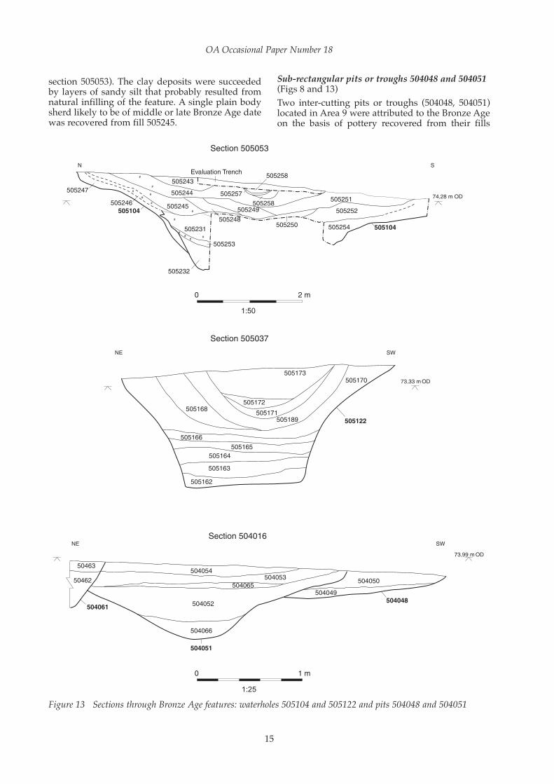
section 505053). The clay deposits were succeededby layers of sandy silt that probably resulted fromnatural infilling of the feature. A single plain bodysherd likely to be of middle or late Bronze Age datewas recovered from fill 505245.
Sub-rectangular pits or troughs 504048 and 504051(Figs 8 and 13)
Two inter-cutting pits or troughs (504048, 504051)located in Area 9 were attributed to the Bronze Ageon the basis of pottery recovered from their fills
OA Occasional Paper Number 18
15
Figure 13 Sections through Bronze Age features: waterholes 505104 and 505122 and pits 504048 and 504051

Archaeology in the Park: Excavations at Jennett’s Park, Bracknell, Berkshire
16
Figure 14 Plan of Bronze Age pit 4409 and other features in evaluation trench 44

(Fig. 8). Both pits were relatively large and sub-rectangular in shape. Pit 504048 was 5.2 m long andrather shallow, the surviving southern part beingonly 0.38 m deep with a fairly flat base. It was filledwith two deposits of grey sand, both of which weresimilar to the surrounding natural and may repre-sent deliberate back-filling. A single rim sherd froman urn of probable middle Bronze Age date wasrecovered from the lower fill. The northern side ofthis pit had been cut away by the digging of pit504051. This feature was very similar to the first pit,being of identical shape and measuring 6.6 m x 3.1m. The base was flat near the sides, but droppedinto a concave trough in the centre, with amaximum depth of 0.85 m (Fig. 13, section 504016).The lower part of the pit was filled with deposits ofnear-sterile sand (504052, 504065, 504066), theearliest of which contained a body sherd in a fabricidentical to that of the sherd recovered from pit504048. A thin lens of soil with a high charcoalcontent – mainly hazel and birch – separated thesefills from the upper fills (504053, 504054), whichwere darker in colour and siltier in composition.The character of these fills suggest that the pit siltedup once it had served its function. No firm evidencewas found as to what this function was, but the pitsare noticeably different from the contemporaneouswaterholes and the later, Iron Age, pits, andpresumably served a different purpose.
Pit 4409 (Figs 3 and 14)
Pit 4409 was an isolated feature recorded in Trench44 of the evaluation (Figs 3 and 14). The pit wascircular in plan, measuring 0.29 m in diameter, andwas heavily truncated, surviving to a depth of only0.05 m. It contained the base of a large middleBronze Age urn that appeared to have been deliber-ately set within the pit. Although the soil filling thisvessel was reasonably rich in charcoal, most of thismaterial was too comminuted to be identifiable.This feature may represent the remains of atruncated cremation burial, although no crematedbone was present in the surviving, lower part of thefeature. The trench was subsequently expanded toencompass an area of 30 x 20 m in order to investi-gate the area around this feature and to search forfurther such features. The only features exposedthat may be of Bronze Age date were a pit (4406)that contained a substantial quantity of charcoaland burnt flint, and an elongated pit or ditchterminal (4413). The natural clay around pit 4406had been baked red indicating that the burntmaterial within it was the result of in situ burning.
Phase 3: The Iron Age and Roman period (400/300 BC–early 2nd century AD)
The Iron Age settlement (Fig. 15)
An Iron Age settlement, comprising seven circularstructures, at least two four-post structures and
associated pits and postholes, extended across thenorthern part of Area 8 and the southern end ofArea 7 (Fig. 15). The features of this settlementwere divided into two broad sub-phases based onthe dating of pottery recovered from their fills. A total of four circular structures, the two four-post structures and two discrete pits were attrib-uted to the middle Iron Age, while two circularstructures, six pits and a posthole were ascribed to the late Iron Age. A single circular structure,two possible two-post structures, a pit and anumber of postholes did not produce evidencethat would enable them to be attributed to eithersub-phase but were clearly associated with thesettlement. A group of pits representing a secondarea of contemporaneous activity was recorded inArea 6.
Sub-phase 3a: Middle Iron Age (400/300–50 BC)
Circular structures (Fig. 16)
Structure 1 (Fig. 16) was the best preserved of thesefeatures, consisting of an annular gully (503288)that surrounded a partially surviving inner gully(503289) and a number of internal pits andpostholes. Although little datable material wasrecovered from the internal features to demonstratethat they were contemporary with the structure, thefact that such features were only present within theinner gully suggests that this was the case. Theouter gully (503288) was roughly circular andmeasured 14 m in diameter. It was generally c 1 mwide and 0.24 m deep, although on the south-western side the width was reduced to only 0.58 m,presumably due to greater plough truncation ofthis part. The sides were sloping, but slightly irreg-ular, the inner side having a less steep gradientthan the outer. An assemblage of 52 sherds ofpottery (384 g) originating from a minimum of twovessels datable to the middle Iron Age and 25pieces (59 g) of fired clay from a hearth or ovenwere recovered from an intervention excavatedacross the eastern part of the drip gully, adjacent toa probable entrance through the inner gully. Onlytwo sherds of pottery (20 g) were recovered fromelsewhere within the gully. The inner gully (503289)comprised a semi-circular arc defining the northernhalf of a circle c 9.5 m in diameter. It is uncertainwhether the southern half had been destroyed bysubsequent truncation, or whether the structurehad been semi-circular in form. Certainly it wasless substantial than the outer gully, with a width of0.20 m and a depth of only 0.10 m, and would havebeen more vulnerable to the effects of laterploughing. The gully was slightly polygonal inform, appearing to consist of four or five fairlystraight segments. The eastern end of the gullyended in a posthole (503111) which may havesupported a post forming the north side of an east-facing doorway into the building. The posthole wasoval in shape with a width of 0.60 m and asurviving depth of 0.11 m.
OA Occasional Paper Number 18
17

Archaeology in the Park: Excavations at Jennett’s Park, Bracknell, Berkshire
18
Figu
re 1
5 P
lan
of t
he I
ron
Age
set
tlem
ent

OA Occasional Paper Number 18
19
Figure 16 Detailed plans of the Iron Age structures

Four pits and a further fourteen postholes, six ofwhich were sampled by excavation, were identifiedwithin the structure. All four pits (503153, 503132,503183, 503198) were oval in shape with steep sides,the sides of pit 503153 being slightly undercut. Thepits ranged from 0.76 m x 0.48 m to 1.18 m x 0.87 mand up to 0.40 m deep. All but 503153 had a singlefill containing occasional fragments of burnt flint, inaddition to which pits 503153 and 503132 alsocontained a small amount of burnt clay. An assem-blage of thirteen sherds of pottery datable to themiddle Iron Age was recovered from the second offour fills within pit 503153, and a single sherd ofpottery datable broadly to the Iron Age came fromthe only fill (503199) of pit 503198. It is possible thatthese were small internal storage pits which wereused for dumping refuse after they had fallen out ofuse. The postholes within the structure ranged from0.18 m to 0.50 m across and between 0.05 m and 0.18m in depth and were all slightly oval in shape. Theyformed no coherent pattern but are likely either tohave been structural in origin or to have supportedinternal partitions or perhaps temporary structuressuch as looms.
Structure 2 (Fig. 16) was situated 8.5 m east ofStructure 1 and consisted of a penannular gully(503290) 14 m in diameter with an east facingentrance, and two internal postholes. There was notrace of an internal foundation trench like that ofStructure 1. The ring gully measured 1 m wide and0.24 m deep, and was concave in shape with theinner edge cut at a steep angle while the outer edgehad a more gentle gradient. A total of 89 sherds ofpottery (781 g) and two large pieces of triangularoven brick were recovered from the gully. Themajority of this material, comprising 65 sherds (601g) from at least three vessels, was recovered fromthe fill of the terminus defining the southern side ofthe entrance, and was the largest single group ofpottery, by weight, from any feature of this period.
The two postholes (503012, 503079) were locatedwithin the eastern side of the structure. Althoughthey were both located close to the entrance theirpositions were not symmetrical and there is noreason to assume that they were associated with theentrance. Both were circular, 0.17 m in diameter,although posthole 503012 survived to a depth of0.21 m while posthole 503079 was only 0.05 m deep.Four other features investigated within the struc-ture proved to be tree-throw holes, and a fifth tree-throw hole was left unexcavated.
Structure 8 (Fig. 16) was located immediatelysouth of structures 1 and 2, and was representedonly by an arc of curving gully (503291) 5.5 m longand up to 0.18 m deep, cut at its eastern end by thering gully of Structure 3. No datable material wasrecovered from this feature, but it has been attrib-uted to the middle Iron Age due to its relationshipwith the latter feature. The curvature of the gullyindicated that it had a diameter similar to those of structures 1 and 2 rather than the smallerStructure 3.
Structure 3 (Fig. 16) was smaller than the othercircular structures, at only 7 m in diameter. Itconsisted of a ring gully (503292) with no survivinginternal features, and the western side had beendestroyed, most likely by modern ploughing. Aterminus defining the southern side of an entrancewas excavated on the east side of the structure, butany evidence for a corresponding terminus on thenorthern side of the entrance had been destroyed bylate Iron Age pit 503215. The terminus defining thesouthern side of the entrance contained an assem-blage of 67 sherds of pottery originating from atleast five vessels. It is unclear whether this structurewas a smaller roundhouse or an ancillary building,but pottery from within the gully fill dated it to thesame period as the other, larger, roundhouses.
Structure 6 (Fig. 16) was located in the southernpart of Area 7, c 50 m north-west of the contempo-raneous structures in Area 8. Approximately 12 m indiameter, this structure comprised the northern partof a presumably circular gully (502228). A break inthe central part of the surviving half of the gully islikely to be due to truncation rather than repre-senting an original entrance, as the gully was seento peter out at this point rather than ending in adeliberate terminus. This truncation exposed aposthole (502069) in the base of the gully. MiddleIron Age pottery recovered from the base of lateIron Age ditch 502231 and gully 502229 (Fig. 18)probably derives from this structure.
Six post-holes were associated with Structure 6,four of which were excavated, although no datingevidence was recovered from them. The fourexcavated post holes (502044, 502067, 502069,502071) were associated with the northern side ofthe gully. Posthole 502067 was located just outsidethe structure and the others were within it. Withflattened bases and steep sides the profiles of thesepostholes were very similar. They had, like thegully, suffered truncation; posthole 502069 was theleast affected at 0.10 m deep, while posthole 502067survived only to a depth of 0.04 m. In addition twofurther postholes to the south of the surviving arc ofring gully may have formed part of the structure.An extrapolation of the structure based on thesurviving portion indicates that postholes 502115and 502117 would have been positioned eitherwithin or on the circumference of the ring gully.Both postholes were similar to those alreadydescribed, and a single piece of early Iron Agepottery was recovered from the fill of posthole502115.
Four-post structures
Two four-post structures (503295, 503296) wereidentified among a scatter of undated postholes tothe north-east of Structure 2 (Fig. 15). The structureswere slightly irregular in shape; Structure 603295measured 2.0 m x 2.5 m, while Structure 603296measured 2.1 m x 2.6 m. The two postholes sampledfrom Structure 603296 survived to a depth of only0.04 m, the larger diameter being 0.39 m. The only
Archaeology in the Park: Excavations at Jennett’s Park, Bracknell, Berkshire
20

posthole sampled from 503295 was more substantialwith a depth of 0.18 m and a diameter of 0.96 m.While no dating evidence was recovered fromStructure 603295, three fragments of pottery datingfrom the middle Iron Age were recovered fromStructure 603296.
Pits within the settlement
Three pits associated with the middle Iron Agephase of the settlement were recorded in Area 8(Fig. 15). Two were situated south-east of Structure3. The earlier of these was a large sub-rectangularpit (503238) measuring 4.05 x 2.20 m and 1.04 mdeep with two largely sterile fills composed ofredeposited sands with small quantities of charcoal.This was cut by a smaller sub-circular pit (503211)with a diameter of 1.6 m and a total depth of 0.56 m.Pit 503211 was filled with two layers of re-depositedsand and an upper fill that contained a largeamount of charcoal and fired clay, which may repre-sent a dump of domestic debris. Eight large piecesof middle Iron Age pottery were recovered from thefinal deposit.
Some 10 m to the west was pit 503075, roughlycircular in plan, 1.8 m across and 0.56 m deep witha rounded profile. The middle fill contained a highproportion of burnt flint and oak charcoal (seeChallinor below) while the upper fill produced alittle middle Iron Age pottery.
Sub-phase 3b: The late Iron Age (50 BC–mid 1st century AD)
Circular structures (Fig. 16)
Structure 5 (Fig. 16) was located to the south ofmiddle Iron Age structures 1–3 in Area 8, appar-ently at the southern limit of the settlement. Thestructure consisted of a ring gully (503293) with nosurviving internal features. The gully was heavilytruncated and survived as three segments. Thelargest surviving segment comprised almost threequarters of the whole circumference of the structure.The remaining two segments on the southern sideof the structure were short, measuring up to 4.2 min length. The width of the surviving portions of thegully was only 0.60 m and the depth was 0.20 m.The diameter measured 15 m, making this structureslightly larger than those that preceded it. Theeastern end of the largest surviving segment endedin a terminus, most likely defining the northern sideof an east-facing entrance into the structure. Twentypieces of late Iron Age pottery as well as a quantityof worked flint were recovered from the terminus.No pottery was recovered from the interventionsdug on the north-eastern and south-western sides ofthe structure.
Structure 7 (Fig. 16) was located north of struc-tures 1 and 2, the surviving elements comprising acurving segment of gully 6 m long (503287) andthree postholes. The gully, which measured 0.60 mwide and 0.20 m deep, was uncovered at thenorthern edge of the area and was probably part of
a structure that extended beyond the edge of theexcavation. Posthole 503136, which was located 0.20m beyond the western terminus of the gully, mayhave formed the southern side of a west-facingentrance to the structure. The posthole measured0.50 x 0.28 m and 0.18 m deep and had a flat baseand steep regular sides. Two further postholes(503059, 503063) within the structure were alsoinvestigated. Five large pieces of late Iron Agepottery were recovered from fill of the terminus atthe eastern end of the gully.
Pits within the settlement
Features dated to the late Iron Age included a totalof seven pits, one in Area 7, four in Area 8 and twoin Area 9, as well as two discrete postholes (Fig. 15).Within Area 8, pit 503113 was located a shortdistance west of Structure 7. This was a large sub-circular pit measuring 2.4 x 2.2 m, with a depth of0.96 m. It contained a sequence of six fills of siltysands and clays not dissimilar in composition to thenatural geology, the uppermost of which (503119)yielded sixteen pieces of pottery. Pit 503101 waslocated immediately adjacent to the west side of thedrip gully of Structure 5. The pit was circular andmeasured 2.5 m in diameter and 0.52 m deep, witha gentle profile and a concave base. A total ofeighteen large sherds of late Iron Age pottery wererecovered from the earliest fill (503108) of threewithin this feature, including a substantial part of asingle vessel. The upper fills, composed of re-deposited natural sand, contained no artefacts,although small quantities of charcoal were present.Pit 503215 cut the eastern side of middle Iron AgeStructure 3. It was approximately square in planwith an irregular profile and measured 1.9 m wideand 0.3 m deep. An assemblage of 34 large pieces ofpottery dating to the late Iron Age was recoveredfrom the upper of its two fills (503219). A smallposthole (503217) was located immediately adjacentto the pit, though this cannot be closely datedwithin the Iron Age.
Pit 502024 was located in the southern part ofArea 7. It was circular with steep sides and aflattened base and measured 0.84 m in diameter and0.30 m deep. Four large pieces of pottery datingfrom the late Iron Age were recovered from theupper (502025) of its two fills.
Pits 504012 and 504055 were situated in thewestern part of Area 9. They were both oval inshape and had similar steep profiles with flattenedbases; pit 504012 was the larger at 1.5 x 1.86 m and0.60 m deep, while pit 504055 measured 0.91 x 1.76m and 0.74 m deep. Both pits contained sandy clayfills with some charcoal inclusions and smallquantities of late Iron Age pottery.
Other features within the settlementStructure 4 (Fig. 16) was a circular structureconsisting of a ring gully (503294) at the eastern edgeof the excavation area. Only part of the western sidewas exposed within the area of investigation, with
OA Occasional Paper Number 18
21

the majority of the structure lying beyond the sitelimits. The 0.3 metre-wide gully was extremelytruncated, surviving only to a depth of 0.05 m. Noartefacts were recovered from this structure to enableit to be attributed to a specific sub-phase, although itsform suggested that it dated to the Iron Age.
Two possible two-post structures were identifiedbetween structures 4 and 5 (Fig. 15). They eachcomprised a pair of postholes 1.3–1.8 m apart, but
yielded no dating evidence. A scatter of at least 14postholes was located to the north-east of Structure2 (Fig. 15). With the exception of the two four-poststructures described above, these features could notbe resolved into coherent structures, and none wassampled by excavation.
Scattered postholes of this period were encoun-tered in the southern part of Area 7. Posthole502113, south-west of Structure 6, contained a single
Archaeology in the Park: Excavations at Jennett’s Park, Bracknell, Berkshire
22
Figure 17 Plan of Iron Age features in Area 6

piece of late Iron Age pottery. Further south anotherposthole (502174) containing three small sherds oflate Iron Age pottery was exposed in one of the testpits excavated through Roman buried soil layer502171. This may hint at the existence of structuressealed beneath that deposit.
Iron Age activity in Area 6 (Fig. 17)
A group of five pits dating from the Iron Age wasrecorded in Area 6, some 200 m north of the area ofthe contemporaneous settlement, and may repre-sent a separate focus of activity (Fig. 17). All the pitswere shallow, measuring no more than 0.24 m deep,and contained charcoal and small fragments ofpottery. Three pits (501017, 501019, 501027)produced pottery dating from the middle Iron Age,pit 501027 in particular producing 26 largefragments of pottery. Pit 501024, which yielded nodating evidence during the full excavation, hadbeen sampled during the evaluation phase as pit15613 and produced pottery dating to the middleIron Age and four fragments of slag, including apossible furnace base weighing 423 g. A fifth pit hadbeen sampled during the evaluation phase (identi-fied as 15610), and produced large fragments of slagweighing 3155 g, and four small pieces of late IronAge pottery.
The late Iron Age and Roman agricultural landscape
The establishment of the field system during thelate Iron Age (Figs 18 and 19)
During the late Iron Age the landscape was dividedby a complex of ditched enclosures and field bound-aries that extended across areas 7, 8 and 9 in thesouthern part of the site, east of the Iron Age settle-ment (Fig. 18). It is uncertain whether these featureswere contemporary with the late Iron Age phase ofthe settlement or post-dated its abandonment.Although the common orientation and similarmorphology of the ditches defining these enclosuressuggest that these features were part of a singlesystem, detailed correlation of features betweenareas was difficult due to the intervening unexca-vated areas. The features were all attributed to thelate Iron Age on the basis of stratigraphic relation-ships and pottery recovered from their fills. Theditches typically had slightly irregular steep profileswith uneven bases, and measured 0.52–1.50 m wideand 0.12–0.55 m deep (Fig. 19).
A pair of conjoined enclosures cut the ring gullyof middle Iron Age Structure 6 in the south part ofArea 7. The western enclosure was defined by ditch502230 and lay mostly beyond the western edge ofthe excavated area. The south-west corner of thisenclosure may have been defined by ditch 503300,part of which was exposed at the north end of Area8. Ditch 502231 extended from ditch 502230 to formthe northern side of a second enclosure, whichcontinued with ditch 502037. It is likely that ditches502231 and 502037 were originally a single feature,but the intervening section probably had been
removed by truncation from later ploughing; inves-tigation of the end of ditch 502037 demonstratedthat it became progressively shallower and peteredout, rather than ending in a deliberate terminus.Ditches 502080 and 502195 appeared to define athird enclosure, although its east side had beendestroyed by a later ditch when the field systemwas re-modelled in the Roman period (see below). Itis unclear whether the interruption of ditch 502080on the northern side was an entrance or a result oftruncation.
Ditch 502232 extended NE-SW to the east of theseenclosures and may have defined the edge of atrackway. The ditch appears to have had twophases; in the first phase the ditch curved towardsthe north-east, while in the second phase itcontinued northwards.
The field system continued into Area 9, whereditch 504168 was on the same alignment as ditch502230 in Area 7. Ditch 504169 was set at rightangles to 504168, extending eastward across the sitebefore turning north and continuing beyond theedge of excavation to form the southern and easternsides of an enclosure also defined by ditch 504168.
A group of ditches located to the east and south-east of these boundaries produced no datablematerial, but their alignment and morphologicalsimilarity to the ditches of the late Iron Age fieldsystem suggest that they were part of this complex.Ditches 504058 and 504175 were aligned roughlynorth-south and largely parallel to ditch 504168,although ditch 504175 curved to the south-west inits southern part, while ditch 504176 extended fromditch 504175 at right angles. It is possible that thisboundary originally joined the southern end ofditch 504168, although much of its length wassubsequently destroyed by the creation of Romanditch 504173 (see below).
To the east of these features, a group of fivecurving ditches following the contour of the foot ofJennett’s Hill at the east end of Area 9 appear torepresent successive re-definitions of a singleboundary. A small quantity of late Iron Age potterywas recovered from two of these ditches, but it isuncertain whether they date from this phase orwhether the pottery was residual and the ditcheslater in date.
A group of ditches at the northern end of Area 7appeared to define at least two sub-rectangularenclosures, possibly divided by a trackway alignednorth-south. These enclosures lay on a slightlydifferent alignment to the boundaries to the southand produced no diagnostically late Iron Agematerial, but they are likely to be attributable to thisphase as the western enclosure is cut by theputatively early Roman ditch 502225. Five smallpieces of middle Iron Age pottery were recoveredfrom ditch 502224, but these were badly abradedand likely to be residual.
Ditch terminus 502176, which was exposed inone of the test pits excavated through Romanburied soil layer 502171, appeared to lie on the same
OA Occasional Paper Number 18
23

Archaeology in the Park: Excavations at Jennett’s Park, Bracknell, Berkshire
24

alignment as the late Iron Age ditches to the northand had a similar profile, although only a length of0.38 m was revealed. As this feature contained threesherds of pottery dating from the late Iron Age, it islikely to have formed part of the field system.
Ditch 503297 extended east-west across Area 8and cut across structures 1, 3 and 4. However, it isuncertain whether the ditch formed part of the lateIron Age field system or its Roman successor, as itseastern end, which might have joined ditch 504168or 504171 (a later Roman ditch to the east, see Fig.20) lay beyond the excavated area. Two substantial(104 g) sherds of late Iron Age pottery were recov-
ered from the upper fill but these may be residual,deriving from earlier settlement activity in this area.
The re-organisation of the field system (Figs 20 and 21; Plate 5)
The field systems and enclosures of the late IronAge were superseded by further ditched bound-aries during the early part of the Roman period (Fig.20). Although the ceramic evidence from the fills ofthe new boundary ditches contained post-conquestpottery, none of this material need date from laterthan the end of the 1st century or the early part ofthe 2nd century, suggesting that the re-organised
OA Occasional Paper Number 18
25
Figure 18 (facing page) Plan of Iron Age features in Area 6
Figure 19 Sections across ditches of the Iron Age field system
Plate 5 Roman field boundary ditch 504173 at the western edge of Area 9 during excavation

Archaeology in the Park: Excavations at Jennett’s Park, Bracknell, Berkshire
26

OA Occasional Paper Number 18
27
Figure 20 (facing page) Plan of the Roman field system and other features
Figure 21 Sections across ditches of the Roman field system

field system may not have been long lived. Whilesimilar in alignment these ditches were on thewhole far more substantial in nature than those theyreplaced (Plate 5). As with the Iron Age fieldsystems, these Roman field systems were onlypresent in areas 7, 8 and 9 in the southern part of thesite, indicating continuity of occupation. Like thoseof the late Iron Age, the ditches typically hadslightly irregular profiles, but were more substan-tial, measuring 1.50–4.25 m wide and 0.44–0.95 mdeep (Fig. 21).
Ditches 502225 and 502226 replaced the earlierIron Age land divisions in Area 7, and formed thebasis of two large enclosures. Ditch 502225 datedfrom the early Roman period and represented achange from the use of small enclosures to largerones. Cutting and replacing ditch 502195, itenclosed much of the south-western part of Area 7.Ditch 502226 branched off the western side of ditch502225 to form a subdivision of the area enclosed bythe latter. It extended towards the north-west beforeturning at right angles to the south-west and contin-uing beyond the edge of the excavation. It containeda few pieces of Bronze Age and middle Iron Agepottery which appear to be residual, as theremainder of the finds recovered from this ditchwere securely Roman in date.
Ditch 502167 was much narrower than the otherRoman enclosure ditches. Situated at the southernedge of Area 7, this probably represents a subdivi-sion of the larger enclosure formed by ditches502225 and 502226. A ditch terminal recorded at thesouthernmost extreme of Area 7 (502189) may be the
northern end of ditch 504171, which was recorded inArea 9 (see below), and may also be associated withditch 502225, which lies on the same alignment.
The new field system continued into Area 9.Ditch 504171 was on the same alignment as ditch502225 in Area 7 and may have terminated as502189. Ditch 504172 was roughly parallel with andeast of 504171, but did not correspond to any featurein Area 7 and may have terminated between theareas of excavation. Ditch 504173 branched off from504172, extending westward across the site beforecontinuing beyond the edge of excavation. Thethree ditches appear to define four rectangularenclosures in Area 9. Discrete dumps of concretedindustrial waste, comprising a conglomeration offragments of slag, fired clay and ash as well as burntand unburnt stones, were recovered from the fills ofditches 504171 and 504172.
Within Area 8 one ditch (503298) was identifiedas belonging to the early Roman period. Ditch503298 extended across the thin, central part of thearea. Although the small assemblage of potteryrecovered from this feature contained no demon-strably post-conquest types, the native types foundwere in use until AD 70 and are therefore not incon-sistent with a date in the early part of the Romanperiod. It was more substantial than most of theditches dating from the Iron Age, and would appearto be a continuation of early Roman ditch 504173recorded in Area 9. It may be evidence for an exten-sion of the field system, as represented by theboundary ditches, into the area formerly used forsettlement.
Archaeology in the Park: Excavations at Jennett’s Park, Bracknell, Berkshire
28
Plate 6 Excavating test pits through Roman buried soil 502171

Roman pits and topsoil layer in Area 7 (Fig. 20; Plate 6)
Three pits (502004, 502077, 502135) dated to theRoman period were located inside the enclosures inArea 7 (Fig. 20). All three were sub-circular in shapeand ranged from 0.74 x 0.74 m to 1.36 x 1.24 m insize and 0.17 m to 0.45 m in depth. The fillsconsisted of greyish silty sand containing charcoalinclusions, with the exception of two fills in pit502135, which were layers of charcoal. There is noevidence of in situ burning and these probablyrepresent dumps of hearth debris, suggesting thepresence of a nearby settlement.
A large spread of brownish grey silt rich inorganic material, pottery and fired clay wasexposed at the south-western corner of Area 7(502171; Fig. 20; Plate 6). The layer measured at least13 m x 9 m and up to 0.16 m deep, and extendedbeyond the limits of the excavated area to the southand the west. It was noted that both this layer andthe underlying part of the natural sand were moresilty than the natural geology across the rest of thesite, and did not drain well after rain storms. It istherefore possible that the deposit formed throughpoaching of the soil in a relatively boggy area.Pottery recovered from this layer indicated that ithad formed during the early part of the Romanperiod, before AD 70.
Phase 4: The medieval period (Fig. 22)
The main evidence for medieval activity comprisedan arrangement of enclosures and field boundarieslocated in areas 1–5, in the northern part of the site(Fig. 22). These features were divided into threesub-phases (sub-phases 4a, 4b and 4c) on the basisof stratigraphic relationships and ceramic datingevidence, although sub-phase 4b was representedonly by a single pit.
Sub-phase 4a: late 11th – late 12th century
Curvilinear enclosures 403120, 403087 and 403065 andassociated features (Fig. 23)
A possible horseshoe-shaped enclosure (403120)was located in the south-eastern part of Area 3. Itssouthern half extended beyond the southern edgeof the excavation (Fig. 23). The enclosure measured12 m long and more than 4 m wide and was open tothe south-west. It was defined by a gully 0.5 m wideand 0.2 m deep with a shallow regular profile whichsuggests that the feature was a palisade trenchrather than, say, a drainage or boundary ditch. Fourlarge sherds of coarse, unglazed pottery was recov-ered from its fill. The enclosure was cut by one ofthe boundary ditches attributed to sub-phase 4c(403086).
Curvilinear ditch 403087, located in the westernpart of Area 3, may have formed the eastern side ofa second enclosure, the rest of which did notsurvive. The ditch extended for a distance of 10 m
and measured 0.6 m in width and was 0.25 m deep,except at the northern end where the depthdecreased to 0.10 m. It was unclear whether this endof the ditch represented an original terminus ordisappeared due to later ploughing. The end of theditch was cut by a shallow posthole (403102), whichhad a diameter of 0.62 m and depth of 0.22 m. It ispossible that the presence of a post at the ditchterminal was associated with an entrance throughthe enclosure ditch.
A possible third enclosure was represented by acurving ditch (403065) located in the northern partof Area 3. The majority of the feature had beendestroyed by later ditches 403082, 403083 and403084, and only two short segments of the ditchsurvived between them.
Gully 403119 lay parallel to the north side ofenclosure 403120 and may be associated with it. Thegully was 0.4 m wide and up to 0.1 m deep, and hada shallow U-shaped profile with a concave base.Gully 403118 was similarly insubstantial and islikely to be of a similar date as it lay on a parallelorientation. Two further linear gullies (403004,403117) contained pottery dating from the late11th–late 12th century. They lay on the same align-ment and it is possible that they represent parts of asingle boundary. Both were cut by the ditches of thesub-phase 4c field system. Two pits in this area(403002, 403090) also contained pottery dating fromthis phase.
Enclosure ditches (Fig. 24)
A group of ditches that may have formed part of anenclosure or complex of field boundaries waslocated in Area 1 and produced pottery belongingto this phase (Fig. 24). The eastern side of the enclo-sure, or the eastern limit of the field system, wasdefined by boundary ditch 401052, which extendedacross the area on a NNE-SSW orientation and wasthe most substantial of the ditches attributed to thisperiod. The ditch was steep sided with a flat base,0.6 m deep. Its width varied from c 1.3 m to c 3.4 min the northern part of the excavated area, where itwas not sectioned. No features were found to theeast of this boundary, and those on its western sideappeared to respect it.
Ditch 401030 may have formed a boundary atright angles to ditch 401052, with ditch 401056 repre-senting a return to the north. These ditches were nomore than 0.10 m deep and it is unclear whether thebreak between them was an original entrance to theenclosure or whether they were originally a single,continuous feature that had been partially ploughedaway. If an entrance existed here, it was closed whenthese ditches were replaced by a continuous,somewhat more curvilinear ditch (401055). Theenclosed area was subdivided by ditches 401059 and401016 and by an L-shaped gully (401058) furtherwest. Several of these ditches extended beyond thearea exposed by the excavation.
A single ditch in Area 2 (Fig. 25) could also beattributed to this sub-phase. Ditch 402058 contained
OA Occasional Paper Number 18
29

Archaeology in the Park: Excavations at Jennett’s Park, Bracknell, Berkshire
30
Figu
re 2
2 P
lan
of t
he m
edie
val f
ield
sys
tem
in a
reas
1-5

no datable material but was cut by pit 402044,which dated from sub-phase 4b. It is possible thatother, undated ditches in this area also belonged inthis sub-phase, but in the absence of ceramic datingevidence or stratigraphic relationships this couldnot be proved.
PitsA total of ten isolated pits attributable to the late11th–late 12th century on ceramic grounds wereidentified in locations scattered across the site,including two pits in Area 3 (403002, 403090) thatmay have been associated with the enclosures inthis area. These ten features each contained smallgroups of pottery and no specific function could beascribed to any of them.
Sub-phase 4b: late 12th – mid 13th century
Sub-phase 4b comprised a single pit (402044) andwas defined on the basis of the ceramic assemblagethat was clearly chronologically distinct from sub-phases 4a and 4c (Blinkhorn, this volume). The pitwas located in the western part of Area 2 (Fig. 25)and was large, measuring 3.70 m x 2.70 m and 0.63
m deep with moderately sloping sides and aconcave base. It contained a single fill from which23 sherds of pottery were recovered.
Sub-phase 4c: mid 13th – mid 14th century (Figs 23-25)
The sub-phase 4a enclosures in Area 3 were super-seded, probably during the 13th century, by anarrangement of rectilinear enclosures and linearboundary ditches, which also extended into areas 1and 2. The southern part of Area 3 was enclosed byditch 403085, which extended SW-NE across Area 3before returning towards the south-east and contin-uing beyond the area of investigation (Fig. 23). Theenclosure was sub-divided by ditch 403086, whichextended parallel with the eastern arm of 403085 todefine two areas, one being 11 m wide and the otherat least 30 m wide. Ditch 403086 measured 0.6 mwide and 0.3 m deep and cut across the eastern partof sub-phase 4a enclosure 403120.
A pair of ditches (403082, 403084) ran NE-SWacross the northern part of the area, parallel with403085. Ditch 403082, the more northerly of the two,was 0.6 m wide and 0.2 m deep with a single fill,
OA Occasional Paper Number 18
31
Figure 23 Plan of medieval features in Area 3

while ditch 403084 was more substantial, measuring1.05 m wide and 0.34 m deep. An assemblage of 25sherds (1526 g) of pottery from the latter ditch datedit to this sub-phase. The ditches were 5 m apart andmay have been drainage ditches flanking atrackway. They were both cut by a ditch (403083)that produced post-medieval pottery in the evalua-tion. The corridor between this trackway and theenclosures in the southern part of the area may alsohave been used for moving animals. Two gullies(403032, 403105) projecting northward from ditch403085 and a third (403038) that projected south-wards from ditch 403084 may have been part of amechanism to control movement through thiscorridor.
An L-shaped arrangement of postholes (403122)may represent the remains of a rectangular fencedenclosure adjoining the southern side of ditch403084 and cutting across the earlier enclosure403087. The enclosure measured 12 x 6 m and wasopen to the north-west, unless this side was enclosed
by hurdles or similar structures that left no archaeo-logical evidence, or was completed by postholes thathave been destroyed by subsequent truncation.
A group of ditches exposed in Area 2 containedno datable material but lay on the same orienta-tions as the ditches in Area 3, and may thus havebeen part of the same complex of boundaries (Fig.25). Ditches 402013 and 402011, aligned NW-SE, ranroughly parallel to each other and 20 m apart. Ditch402013 measured 24 m in length and 0.86 m in widewith a depth of 0.38 m. Ditch 402011 measured 0.7m wide and 0.24 m in depth; both features hadsimilar irregular U-shaped profiles. A third unexca-vated ditch ran parallel to these features 8 m to theeast of 402011 (Fig. 25). Ditches 402015 and 402038extended transversely between 402013 and 402011sub-dividing the area into rectilinear fields orenclosures.
A curving ditch (4402) recorded in evaluationTrench 44 and also traced in Trenches 41 and 43 maybe a continuation of one of the ditches of the
Archaeology in the Park: Excavations at Jennett’s Park, Bracknell, Berkshire
32
Figure 24 Plan of medieval features in Area 1
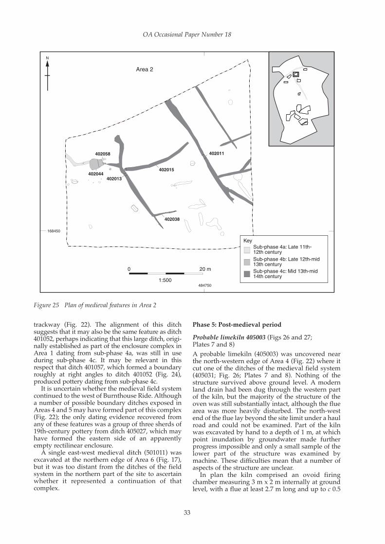
trackway (Fig. 22). The alignment of this ditchsuggests that it may also be the same feature as ditch401052, perhaps indicating that this large ditch, origi-nally established as part of the enclosure complex inArea 1 dating from sub-phase 4a, was still in useduring sub-phase 4c. It may be relevant in thisrespect that ditch 401057, which formed a boundaryroughly at right angles to ditch 401052 (Fig. 24),produced pottery dating from sub-phase 4c.
It is uncertain whether the medieval field systemcontinued to the west of Burnthouse Ride. Althougha number of possible boundary ditches exposed inAreas 4 and 5 may have formed part of this complex(Fig. 22); the only dating evidence recovered fromany of these features was a group of three sherds of19th-century pottery from ditch 405027, which mayhave formed the eastern side of an apparentlyempty rectilinear enclosure.
A single east-west medieval ditch (501011) wasexcavated at the northern edge of Area 6 (Fig. 17),but it was too distant from the ditches of the fieldsystem in the northern part of the site to ascertainwhether it represented a continuation of thatcomplex.
Phase 5: Post-medieval period
Probable limekiln 405003 (Figs 26 and 27; Plates 7 and 8)
A probable limekiln (405003) was uncovered nearthe north-western edge of Area 4 (Fig. 22) where itcut one of the ditches of the medieval field system(405031; Fig. 26; Plates 7 and 8). Nothing of thestructure survived above ground level. A modernland drain had been dug through the western partof the kiln, but the majority of the structure of theoven was still substantially intact, although the fluearea was more heavily disturbed. The north-westend of the flue lay beyond the site limit under a haulroad and could not be examined. Part of the kilnwas excavated by hand to a depth of 1 m, at whichpoint inundation by groundwater made furtherprogress impossible and only a small sample of thelower part of the structure was examined bymachine. These difficulties mean that a number ofaspects of the structure are unclear.
In plan the kiln comprised an ovoid firingchamber measuring 3 m x 2 m internally at groundlevel, with a flue at least 2.7 m long and up to c 0.5
OA Occasional Paper Number 18
33
Figure 25 Plan of medieval features in Area 2

Archaeology in the Park: Excavations at Jennett’s Park, Bracknell, Berkshire
34
Figure 26 Plan of probable limekiln 405003

m wide extending from the north-western side. Thestructure had a brick lining, constructed from hand-made bricks set end-on to the edge of the chamber.The structure of the chamber survived to a depth ofc 1.8 m. Its profile was roughly ovoid, with arounded offset c 1 m below the extant top. Althoughit is not certain, this seems to correspond to the baseof the brick lining, below which, although heavilyburnt, there was no clear evidence for brickwork.The base of the chamber was therefore presumablymade simply of very heavily fired clay subsoil. Itwas slightly concave in profile. There is no evidencefor the relative levels of the chamber floor and thebase of the flue at the point where they met. Thestructural bricks measured between 210 x 106 x 55mm and 225 x 110 x 65 mm, and were datable fromtheir size and quality to the late 16th-17th century.The interior faces of the bricks were very heavilyfired, resulting in a thick green vitrified surface, andthe surrounding natural clay was discoloured as aresult of the heat produced by the kiln. This charac-teristic means that it was impossible to tell if thechamber walls were set against the edges of aconstruction cut, or whether this cut was originallylarger.
Details of the construction of the flue are uncer-tain. It extended at least 2.7 m from the inner face ofthe chamber, but its outer end could not be located.The flue through the chamber wall was c 0.35 mwide, broadening slightly to the north. On the westside vitrified brick extended 1.6 m from the innerface of the chamber and the east face of the flue wassimilarly lined. The flue appears to have been 0.8 m
deep, but it is not certain that this was its totaldepth, and the nature of its base is unknown,though it was perhaps unlined.
There was a thin deposit of reduced chalk(405029) above the heavily-burnt clay base theprimary fill of the chamber. Above this a layer ofvery heavily burnt and vitrified brick (405026) up to0.14 m thick may have been the remains of asecondary floor to the chamber. This was overlainby another thin layer of crumbly off-whitechalk/lime (405025), in turn sealed by a deposit ofgrey silty clay (405020) up to 0.19 m thick whichmay represent the disuse of the structure. Abovethis was a sequence of backfill deposits,commencing with 405015 which consisted entirelyof brick rubble and crushed brick. The subsequentfills were mostly of silty clay incorporating greateror lesser amounts of brick rubble. Chalk/limefragments and flecks were prominent in most ofthese deposits. The main fill of the flue, 405024, wasalso of this character.
The interpretation of structure 405003 as alimekiln is based on general characteristics of sizeand form, and in particular the evidence for intenseheating. The present structure is broadly compa-rable to features described as field kilns and knownfrom adjacent counties (Williams 2004, 12-13), butthe location on level ground, requiring the excava-tion of a (probably) deep stokehole rather thanexploiting a steep slope or bank, is less typical. Theinternal ledge of structure 405003 is characteristic ofthese kilns, however, although the ovoid profile ofthe structure is also reminiscent of that of many ice-
OA Occasional Paper Number 18
35
Figure 27 Section of probable limekiln 405003

Archaeology in the Park: Excavations at Jennett’s Park, Bracknell, Berkshire
36
Plate 7 View of probable limekiln 405003 from the north-west, along the flue. Scales = 2 m and 0.5 m
Plate 8 Limekiln 405003 after machine excavation of the lower fills

houses (eg Beamon and Roaf 1990, 5 and 57). Forthis reason, the lack of certainty about the nature ofthe bases of the chamber and ‘flue’, and theirrelationship, is unfortunate. But while burning hasoccasionally been noted as a treatment of ice-houseinteriors (ibid., 120), the extreme heat evidenced instructure 405003 is consistent with the temperaturesrequired to calcine chalk or limestone (in excess of900° C). The narrow flue would have allowed someaccess to the firing chamber, but to be most effectiveits base should have been at the same level as that ofthe chamber. It is not clear if this was the case. Eitherway, removal of the calcined chalk and its raising upto carts or pack animals would have been laborious.
19th- and 20th-century drainage features
The features exposed in the south-western part ofArea 8 and the southern half of Area 10 exclusivelycomprised a network of drainage features associ-ated with modern agriculture.
Radiocarbon dating
Two samples of charcoal from burnt mounds505154 and 505275 were submitted to ScottishUniversities Environmental Research Centre(SUERC) AMS Facility, Glasgow. The results areshown in Table 1. They are presented as conven-tional radiocarbon ages. The calibrations of theseresults, which relate the radiocarbon measurementsdirectly to the calendrical time scale, were calcu-lated using the OxCal3 calibration programme(Bronk Ramsey 1995; 2001). The calibrated dateranges cited within the text are those for the 95%confidence level (2 sigma).
THE FINDS
The pottery by Edward Biddulph, Paul Blinkhorn, andLisa Brown
Introduction
An assemblage of pottery weighing c 21 kg wasrecovered from the evaluation and subsequentexcavation. The pottery belonged mainly to the IronAge and medieval periods, with smaller amounts ofRoman material and occasional post-medievalpieces also recorded. The condition of the potterywas mixed. The prehistoric and Roman pottery wasgenerally in poor condition, and represented mainlyby small, undiagnostic body sherds, although larger
sherds were also present. The medieval pottery wasin much better condition, and a number of near-complete vessels broken into relatively few pieceswere recorded.
The prehistoric and Roman pottery was sortedinto fabrics within context groups, and furthersorted into ‘sherd-families’, for example rimsbelonging to the same vessel, or the mass of undiag-nostic body sherds within a fabric-group. Eachsherd-family was recorded by sherd count, weightin grammes, and, where a rim was present, vesselcount (MV) and estimated vessel equivalents (EVE).Forms and fabrics were identified using OxfordArchaeology’s standard recording guidelines forIron Age and Roman pottery (Booth nd) with refer-ence to local assemblages, for example from Binford(Booth 1995) and Bray (Cleal 1995). The medievaland post-medieval pottery was sorted into context-groups, and each group weighed and counted, withrims being quantified by EVE.
Prehistoric pottery by Lisa Brown
IntroductionSome 479 sherds of prehistoric pottery weighing 4.1kg were recovered from the site, 339 sherds (2.6 kg)from the excavation and 140 sherds (1.4 kg) from theevaluation stage. Most of the pottery dates from themiddle Iron Age but middle to late Bronze Agematerial was also present, including 124 sherds(1.27 kg) belonging to a single vessel recoveredduring the evaluation. The condition of the prehis-toric pottery was generally moderate to poor,consisting for the most part of small, undiagnosticbody sherds. Pottery associated with the middleIron Age roundhouses and industrial pits wasparticularly abraded. However, some of the coarseflint-tempered wares were relatively robust andwell preserved.
FabricsTwenty-five prehistoric fabrics were identifiedwithin four broad ware groups based on principalinclusion type (Booth nd; PCRG 1997): sand, flint,shell and flint/shell (Table 2). Sandy wares, ofwhich a proportion were glauconitic, were mostimportant overall, representing 59% of the total bysherd count (48% by weight), followed by flint (35%by count, 46% by weight). Shelly wares formed only6% by count (5% by weight).
The site lies on London Clay and the BagshotBeds sand and gravel of Jennett’s Hill, which could
OA Occasional Paper Number 18
37
Table 1 Radiocarbon dates
Lab ID Sample ID Material Radiocarbon age (BP) Calibrated date (95% confidence)
SUERC-20260 (GU-172452) BRPEAC07 512 Alnus roundwood 3060 ± 30 1420–1260 BC
SUERC– 21051 (GU-17682) BRPEAC07 505275 Alnus roundwood 3275 ± 30 1630–1490 BC, 1480–1450 BC

have provided the clay sources for some of the non-glauconitic sandy wares. Other fabrics would nothave been procurable in the immediate locality asthe closest sources of flint temper and flinty claysare along the Upper Chalk of the North Downssome 15 km to the south of the site, and glauconiticsand would have derived from greensand forma-tions, either a similar distance to the south orfurther to the west within the Reading Beds (Morrisand Mepham 1995, 79).
Bronze Age Coarse flint and shell/flint were evidently compo-nents of the Bronze Age pottery, suggesting thatvessels were not produced in the immediate area ofthe site. The truncated, fragmented base of a largemiddle Bronze Age vessel (Fig. 28.1) set in apurpose-dug feature, 4409, possibly a votivedeposit, was exposed during the 2006 evaluation ofthe site. The vessel, in fabric F3, was most likely alarge urn of some sort. A few sherds in the samefabric from ditches 18308 and 22514, also from theevaluation, are probably of the same date.
Additional Bronze Age pottery recovered fromthe excavation provides evidence of activity on thesite during this period. Pit 505122 produced a smallsherd in fabric AF3, probably from a middle BronzeAge globular urn; Weir Bank Stud Farm, Bray (Cleal1995, 27-31) produced comparative Bronze Age
material. Waterhole 505104 produced a single plainbody sherd in mixed flint and shell temper.Although nothing can be said of the vessel form, itis likely to be of middle or late Bronze Age date onthe basis of fabric and general appearance.
Sub-rectangular pit 504048 yielded anotherprobable urn sherd (Fig. 28.2), decorated with adouble horizontal row of fingernail impressionsimmediately below the rim above a vertical ridge.The sherd, in fabric FA4, is very well fired and inrelatively fresh condition. Although somewhatunusual, it is likely to date to the middle Bronze Age(A Barclay and M Leivers, pers. comm.). The pit wascut by a second sub-rectangular pit, 504051, whichproduced a body sherd in an identical fabric,indicating that they were probably contempora-neous. Small body sherds, also in FA4, one fromtree-throw hole 362011, the other from a generaldeposit of colluvium (504134), may represent thesame phase of activity. It is also possible that somesherds in similar flint-tempered fabrics recovered insmall numbers from middle Iron Age pits and lateIron Age and Roman ditches are residual middle orlate Bronze Age pottery.
Early and middle Iron AgeOne probable early Iron Age sherd was identified –a shouldered jar with an upright expanded anddecorated rim (Fig. 28.3). It came from the fill of
Archaeology in the Park: Excavations at Jennett’s Park, Bracknell, Berkshire
38
Table 2 Prehistoric pottery fabrics
Fabric Summary description Date Range Nos Wt (g)
A1 Fine grade quartz sand E-MIA 10 67
A2 Fine/moderate grade quartz sand MIA 4 9
A3 Moderate grade quartz sand MIA 87 666
A4 Moderate/coarse grade quartz sand MIA 1 14
AB2 Fine/moderate grade quartz sand and glauconite MIA 1 1
AB3 Moderate grade quartz sand and glauconite MIA 15 124
AF2 Fine/moderate grade quartz sand with fine/moderate grade flint inclusions MIA 2 11
AF3 Fine/moderate grade quartz sand with moderate grade flint inclusions MIA 12 25
AF4 Fine/moderate grade quartz sand with coarse flint inclusions E-MIA 7 76
AM2 Slightly micaceous fine/moderate grade quartz sand MIA 50 286
AM3 Slightly micaceous moderate grade quartz sand MIA 47 289
AS3 Fine grade quartz sand with moderate size fossil shell inclusions E-MIA 1 17
AV3 Fine grade quartz sand with leached vegetable matter Undated 1 83
BF3 Glauconitic sand with moderate grade flint inclusions MIA 44 284
F2 Fine smooth clay with fine grade flint inclusions M-LIA 3 33
F3 Fine smooth clay with moderate/coarse grade flint inclusions M-LBA 128 1333
FA1 Slightly sandy clay with rare fine grade flint inclusions M-LIA 1 3
FA2 Slightly sandy clay with sparse fine/moderate grade flint inclusions MIA 2 26
FA3 Slightly sandy clay with common moderate grade flint inclusions MBA-MIA 23 83
FA4 Slightly sandy clay with common coarse flint inclusions M-LBA 7 254
FM3 Slightly micaceous clay with sparse/common moderate grade flint inclusions MIA 5 140
SA2 Fine quartz sand and fine/moderate fossil shell E-MIA 16 113
SA3 Fine/moderate quartz sand and moderate size fossil shell E-MIA 2 25
SF3 Fine smooth clay with moderate/coarse fossil shell and flint inclusions M-LBA 1 24
SP3 Fine smooth clay with moderate fossil shell and argillaceous pellets E-MIA 8 39
Total 479 4049

middle Iron Age pit 503211 and could be residualfrom early Iron Age activity in the area, althoughno features dating from that period were identified.The rim of the jar was decorated, apparently by arepeated squeezing action between thumb andforefinger, creating a sort of ‘pleating’ effect.Although this specific device is unusual, it resem-bles the finger-impressed decoration common toearly Iron Age jars from this and the much widerregion, and probably represents a variation of this
treatment. The jar was made in fabric AF4, essen-tially a sandy ware with sparse, ill-assortedcalcined flint inclusions, some of which werereddened by heating. Apart from the decoration,treatment of the surface was minimal. A few bodysherds in the same fabric were recovered from thesame pit, and also from gully 503049 of Structure 2,as well as late Iron Age pit 503101 and Roman ditch502226. It is possible that this jar is an example of anearly Iron Age decorative technique continuing
OA Occasional Paper Number 18
39
Figure 28 Prehistoric pottery

into the middle Iron Age. However, it appears tocorrespond more closely to the early Iron Age tradi-tion both of the Reading/Newbury area to the westof the site (Morris and Mepham 1995) and theSurrey/Middlesex region some 10-15 km to thenorth-east at Heathrow (Jones forthcoming).
The middle Iron Age pottery assemblage wasdominated by sand-tempered fabrics. These variedin terms of texture—both fine and coarse fabricswere recorded—and composition. Fabrics alsoincluded in lesser quantities glauconitic (black)sand, flint, mica, and shell. Of these variants, sandand mica or sand alone were most significant. Flint-tempered fabrics and shell-tempered fabrics mademuch smaller contributions to the middle Iron Ageassemblage. Again, the fabrics contained otherinclusions, typically sand, and could be both coarseand fine.
Only 18 middle Iron Age vessels were identifi-able by form, and only two profiles could bereconstructed (Fig 28.4 and 7). However, the rangeof forms allows some comparison with contempo-raneous sites in the region, including DunstonPark, Thatcham (Morris and Mepham 1995),Thames Valley Park, Reading (Mepham 1997a),Brimpton (Timby 1999) and Heathrow (Jonesforthcoming).
Vessel forms included slack-bodied jars with ahint of shoulder and ovoid jars with elongated rimsor short out-turned rims, suggesting proto-beadrims. The latter form continued into the late IronAge as form CB (see Biddulph, below). This rangeof forms closely resembles the small assemblage
recently recovered during the Heathrow Terminal 5excavations (Jones forthcoming). A globular bowlform was also tentatively identified although rimfragments were too fragmentary to be certain thatthese were ovoid jars with simple rims.
Five slack-bodied jars in fabric AM2 (Fig. 28.5)were recovered, three from the penannular gully ofStructure 2, close to its northern entrance. A fourthcame from late Iron Age ditch 502231, which cut thegully of Structure 6, the pottery probably origi-nating from the roundhouse. Another came fromindustrial pit 501027 in Area 6. A similar vessel infabric A3 came from the terminal of Structure 2 andanother in fabric AM3 was residual in Roman ditch504171.
Several jars with more rounded or ovoid shapeswere directly associated with the middle Iron Ageroundhouses. These included four in fabric A2 fromthe southern part of the gully of Structure 3 (Fig.28.7), two in fabric A3 from the south terminal of thegully of Structure 2 (Fig. 28.4) and a third in A3 froma late Iron Age ditch cutting Structure 6. Gully503288, the outer gully of Structure 1, produced anovoid jar in glauconitic/flint fabric BF3. A numberof similar forms were residual in later features,including two in fabric FM3 from late Iron Ageditch 504108 (Fig. 28.9) and one in AM2 fromRoman ditch 504171 (Fig. 28.8).
Four examples of globular shaped vessels,possibly bowls, were recovered. A rare shell-tempered (SA2) example came from the gullyterminal of Structure 2 (context 503049) and anotherwith shell inclusions (AS3) from late Iron Age ditch
Archaeology in the Park: Excavations at Jennett’s Park, Bracknell, Berkshire
40
Table 3 Quantification of late Iron Age and Roman fabrics (MV = minimum number of vessels based on rim count; EVE = estimated vessel equivalence based on rims)
Fabric Count Weight (g) MV EVE
E20 – Late Iron Age/early Roman fine sand-tempered ware 110 626 7 1.03
E30 – Late Iron Age/early Roman medium sand-tempered ware 87 580 4 0.48
E40 – Late Iron Age/early Roman fine shell-tempered ware 4 44
E60 – Late Iron Age/early Roman fine flint-tempered ware 77 1636 12 1.42
E80 – Late Iron Age/early Roman grog-tempered ware 155 2189 12 1.72
O10 – Fine oxidised ware 14 45 1 0.15
O20 – Sandy oxidised ware 64 172 3 0.22
O80 – Coarse-tempered oxidised ware 56 759 2 0.1
Q10 – Fine white-slipped oxidised ware 16 6
R10 – Fine grey ware 8 85
R20 – Sandy grey ware 68 315 2 0.18
R30 – Medium sandy grey ware 114 744 10 1.86
R50 – Black-surfaced ware 24 246 4 0.47
R90 – Coarse-tempered reduced ware 9 195 1 0.08
S20 – South Gaulish samian ware 2 6
W10 – Fine white ware 3 2
W20 – Sandy white ware 29 332 2 0.57
W21 – Verulamium-region white ware 16 82
W30 – North Gaulish fine white ware 34 73
Total 890 8137 60 8.28

502231 that cut Structure 6. A third in micaceoussandy ware AM2 came from the outer gully ofStructure 1 (Fig. 28.6) and another in fabric AF2from pit 503153, within the same roundhouse.
Catalogue of illustrated pottery (Fig. 28)
1. Base of Bronze Age urn. Fabric F3. Context4410, pit 4409.
2. Middle Bronze Age urn with two bands offingertip impressions immediately below rim.Context 504049, pit 50404.
3. Shouldered jar with expanded, fingertipimpressed rim. Fabric AF4. Context 503212, Pit503213.
4. Small shouldered jar/bowl with upright,slightly expanded rim and flat, slightlyprotruding base. Fabric A3. Context 503050,the terminus defining the southern side of theentrance through ring gully 503290, MIAStructure 2.
5. Jar with slight shoulder and simple uprightrim. Fabric AM2. Context 503068, just north ofentrance through ring gully 503290, Structure 2.
6. Simple barrel-shaped (ovoid) jar. Fabric AM2.Context 503152, ring gully 503288, Structure 1.
7. Ovoid jar with elongated, slightly hollowedrim. Fabric A2. Context 503182, ring gully503292, Structure 3.
8. Ovoid jar with elongated rim. Fabric AM2.Context 504086, ditch 504178.
9. Ovoid jar with short out-turned rim. FabricFM3. Context 504108, ditch 504178.
Late Iron Age and Roman pottery by Edward Biddulph
Assemblage compositionSome 900 sherds weighing 8 kg— c 38% of the entirepottery assemblage by weight—were assigned tothe late Iron Age or Roman period (Table 3). Muchof the pottery was no later than the early Romanperiod and essentially belonged to a single ceramicphase starting from the end of the 1st century BCand continuing to the later 1st/early 2nd centuryAD (Table 4). Nevertheless, context groups were,where possible, assigned to one of two phases—lateIron Age or early Roman—based on the presence orabsence of certain forms; groups containing no post-conquest (AD 43) pottery, for example, were placedin the late Iron Age. The resulting ceramic phases,though broadly drawn, give an indication ofchanging pottery supply and use during the transi-tion from Iron Age to Roman and provide a basis forcomparison with other sites in the region.
The late Iron Age assemblage was dominated bypottery of late Iron tradition, which emerged by thelate 1st century BC (Table 5). Grog-tempered ware(E80) was among the best-represented fabrics. Arelatively wide range of forms was available, withbead-rimmed jars (CH) and barrel-shaped jars (CB)being most common (Table 5). The latter was avail-able in the middle Iron Age and points to a transi-tional period when potters employing the newfabrics retained the old forms. Curving-sided bowlsand lids were also recorded. Sand-tempered wares(E20 and E30) were less important in the assemblage,although high-shouldered necked jars (CE), notrecorded in E80, were available in these fabrics. Flint,so common in earlier Iron Age fabrics, continued tobe incorporated in 1st-century wares; flint-temperedfabrics (E60) were relatively poorly-represented bysherd count, but more numerous in terms of vesselsrepresented. Globular jars (CG), bead-rimmed jarsand barrel-shaped jars were present in the fabric. It isvery likely that a proportion of this fabric groupincludes Silchester ware, current during the mid 1stcentury AD (Fulford 1984, 135), but other sourcesalong the North Downs are also no doubt repre-sented. Shell-tempered ware (E40) was recorded insmall quantity. No forms were identified.
OA Occasional Paper Number 18
41
Table 4 Chronological summary of late Iron Age andRoman context groups
Ceramic phase % EVE
Late 1st century BC-mid 1st century AD 40%
Early-mid 1st century AD 5%
Mid 1st century AD 45%
Mid-late 1st century AD 4%
Late 1st-mid 2nd century AD 5%
Mid 2nd-mid 3rd century AD 1%
Total EVE 8.14
Table 5 Quantification of late Iron Age forms and fabrics by EVE (C jars, CB barrel-shaped jars, CE high-shouldered necked jars,
CG globular jars, CH bead-rimmed jars, CI everted rim jars, HC curving-sided bowls, L lids)
Fabric C CB CB/CE CE CG CH CI HC L Total % Total
E20 0.05 0.23 0.39 0.67 21%
E30 0.38 0.38 12%
E60 0.08 0.18 0.32 0.05 0.29 0.92 29%
E80 0.19 0.23 0.75 0.03 0.04 1.24 39%
Total 0.24 0.31 0.23 0.39 0.18 1.45 0.05 0.03 0.33 3.21 -
% Total 7% 10% 7% 12% 6% 45% 2% 1% 10% - -

The early Roman period saw the introduction ofa range of wheel-thrown sandy fabrics (Table 6).However, the range of forms available during thistime was little different from that of the late IronAge. The persistence, too, of grog-tempered wareand other pre-conquest fabrics suggests that pottersmaintained the older traditions for a decade or twoafter AD 43 as the new fabrics were established.Sandy grey wares (R20/R30) replaced grog-tempered ware as the dominant fabric. The greywares cannot be attributed to source with certainty,but the pottery was of a uniformly sandy fabric withiron oxide inclusions and probably largely from thesame area. A fabric of similar description wasrecorded at Binfield (fabric R21; Booth 1995, 110).Forms encountered in the fabric at Jennett’s Parkalso find their matches at Binfield, particularlymedium-mouthed oval bodied jars (CD) and high-shouldered necked jars (CE). Globular, bead-rimmed, and wide-mouthed jars (CM) were alsopresent. Storage jars (CN) were available in coarse-tempered (usually grog) reduced and oxidisedwares (R90 and O80). An oxidised equivalent ofsandy grey ware was recorded (O20) and repre-sented by a medium-mouthed jar. Sandy whitewares, some from the Verulamium region (W21),and a North Gaulish fine fabric (W30) were alsorepresented. Jars were seen in the sandy fabrics andthe imported fine ware was available as a beaker,though no rim was found; in any case, a datearound AD 50 or perhaps a decade or two later isreasonable. Two fragments of South Gaulish samian(S20) dating to the mid 1st or early 2nd centurywere collected, but it was not possible to identifytheir forms.
Just one piece was certain to date after c AD 130.A bead-rimmed dish in sandy grey ware recoveredfrom a gully fill was deposited in the mid Romanperiod, but it is chronologically isolated. Some of
the pottery broadly identified as coarse-temperedoxidised ware (O80) was close in description topink-grogged ware from Buckinghamshire, dated tothe mid 2nd to 4th century, but accompanyingmaterial always confined deposition to the earlyRoman period and the sherds are better identifiedas a local storage jar fabric.
DiscussionThe ceramics suggest that the site was occupiedduring the late Iron Age and the early Romanperiod. The overlap of forms at key transitionalperiods hints at continuous occupation from themiddle Iron Age to the early 2nd century, althoughthe mid 1st century AD saw the strongest period ofpottery deposition. The chronology makes Jennett’sPark contemporary with the settlement at ParkFarm, Binfield (Roberts 1995), some 4 km to north.The pottery assemblage there was twice as largeand consequently included a greater range offorms and fabrics, including mortaria andimported finewares (Booth 1995, 107-110). Still, theJennett’s Park pottery would not have been out ofplace at Binfield and it is reasonable to suggest thatpottery supply to both sites drew on the sameproducers or clay sources. The Jennett’s Parkassemblage did not include wasters or otherevidence of on-site pottery production, but twoclay fire bars recovered from the site may wellhave formed part of a pottery kiln located nearby(C Poole, below).
Patterns of pottery deposition at Jennett’s Parkappeared to be fairly uniform across the site. Theoverall mean sherd weight was 9 g, while onaverage 14% of each vessel’s rim survived. Thesepoint to a generally fragmented assemblagecomposed of small pieces identified to type at onlya basic level. Most pottery was collected fromditches and gullies, with lesser amounts coming
Archaeology in the Park: Excavations at Jennett’s Park, Bracknell, Berkshire
42
Table 6 Quantification of early Roman forms and fabrics by EVE (C jars, CD medium-mouthed oval-bodied necked jars,
CE high-shouldered necked jars, CG globular jars, CH bead-rimmed jars, CI everted rim jars, CM wide-mouthed jars, CN storage jars,
HC curving-sided bowls, JC platters, L lids)
Fabric C CD CE CG CH CI CM CN HC JC L Total % Total
E20 0.07 0.06 0.18 0.31 6%
E60 0.21 0.15 0.14 0.5 10%
E80 0.25 0.17 0.06 0.48 10%
O10 0.15 0.15 3%
O20 0.07 0.12 0.03 0.22 5%
O80 0.1 0.1 2%
R20 0.13 0.13 3%
R30 0.18 0.15 0.85 0.17 0.16 0.35 1.86 38%
R50 0.36 0.11 0.47 10%
R90 0.08 0.08 2%
W20 0.57 0.57 12%
Total 0.18 1.43 0.98 0.32 0.72 0.29 0.35 0.18 0.15 0.18 0.09 4.87 -
% Total 4% 29% 20% 7% 15% 6% 7% 4% 3% 4% 2% - -

from pits and layers. The mean sherd weight ofpottery from linear features and pits was identicalto the site mean, confirming that the pottery was inthe same condition regardless of where it wasdeposited. This suggests that the pottery had under-gone similar processes of disturbance and reloca-tion (for example being moved with organicmaterial from household or communal middens tomanuring spreads) before terminal deposition inthe cut features, and that the focus of settlement waselsewhere; there were no groups, for instance, ofnear-complete pottery finally deposited soon afterinitial breakage and discard. The exception to thegeneral condition of the pottery is an organic-richlayer 502171 in the southern part of Area 7, whichcontained a relatively large group with a meansherd weight of 15 g. The figure suggests that thegroup saw fewer or different episodes of redeposi-tion compared with the pottery from pits andditches. It may also suggest that this deposit laycloser to the settlement centre and the area ofpottery use, perhaps serving as a settlementmidden, though the group’s still fragmented rims,averaging 8% per vessel, to some extent arguesagainst this. Despite the apparent redeposition,residuality—the occurrence of pottery dating earlierthan the context-groups in which it was found—was low overall. Out of 179 late Iron Age or earlyRoman context-groups, just five contained residualmiddle or early Iron Age pottery (given thecontinued currency of pre-conquest fabrics in theearly Roman period, it was not possible to confi-dently identify residual late Iron Age pottery incontext-groups dating after AD 43). One explana-tion for this is that areas of late Iron Age and earlyRoman activity did not impinge on the areas ofearlier occupation; settlement shifted over time.
Comparative assemblages apart from Binfieldare somewhat limited. Few other sites aroundBracknell have been investigated in any detail;fieldwalking revealed scatters of Roman-periodoccupation material at Cabbage Hill 4 km or so tothe north-east of Jennett’s Park and Ashridge Wood4 km to the north-west (Roberts 1995, 123). AtBroadwater, slightly further afield at c 8 km north-west of Jennett’s Park, settlement spanned the lateIron Age to 3rd or 4th centuries AD, but the paucityof key indicators like Silchester ware suggestssomething of a break in occupation during the mid1st century (Walker 1993, 105), a time of relativelyintense activity at Jennett’s Park. The Roman townof Silchester provides much pottery data, but herethe differences in pottery supply are very muchclearer. Despite the limitations of the data, potteryfrom the sites can contribute to the question of sitestatus and help to place Jennett’s Park within itsregion. Turning first to wares, we may usefullyemploy Paul Booth’s approach to ordering sites.Examining sites from the Upper Thames Valley, hefound that in the early Roman period the propor-tion of fine and specialist wares (amphorae,finewares, samian, white-slipped wares, and white
wares) tended to increase with site status (Booth2004). On this basis, Jennett’s Park, with 11% fineand specialist wares by sherd count, fell mid-waybetween Silchester (25% by EVE) and Broadwater(2%). Binfield received a modest 5%. The highfigure provided by Silchester is to be expected. Itspre-Flavian assemblage contained importedfinewares in addition to the still very well repre-sented grog-, sand-, and flint-tempered coarse-wares (Fulford 1984, table 4). Jennett’s Park lackedthe imported finewares, of course, but receivedwhite wares and white-slipped oxidised wares.These were present at Binfield in smaller amounts,though that site did have fractionally more samian(Booth 1995, table 39). Broadwater was almostdevoid of fine and specialist wares (Walker 1993,table 2). Forms give a similar picture. JeremyEvans’ view that basic rural sites were jar-dominated, with the proportions of eating anddrinking forms increasing with site status (Evans2001), has resonance with the data from theBracknell region (Fig. 29). Ninety per cent of theJennett’s Park assemblage by EVE were jars (seeTables 5 and 6); Broadwater had a greater propor-tion of jars (100% by sherd count), but Binfield hadfewer (85%), as did Silchester (61%). The rankingsuggested by the jars was maintained by the eating-related forms (bowls and platters); Jennett’s Parkenjoyed a proportion of 5%, compared with 10% atBinfield and 29% at Silchester. Drinking vesselforms, not represented at Broadwater or Jennett’sPark except as body sherds, were recorded atBinfield and Silchester.
Taken together, these measures identify Jennett’sPark as a low-status rural settlement. Supply linksrarely extended beyond local networks and thesettlement may have depended on sites like Binfieldwith a greater trading pull for supplying theoccasional exotica. There was little change in therange of forms available as the late Iron Age settle-ment moved into the Roman period. The oddplatter and samian give a hint of continental-stylecooking and dining, but pre-conquest Britishdomestic habits died hard.
OA Occasional Paper Number 18
43
Figure 29 Inter-site comparison of functional groupsof Roman pottery

Apart from vessel form, there was little evidenceof pottery use. A grog-tempered jar had soot exter-nally underneath the rim and had probably beenused for cooking on a hearth. Burnt deposits wererecorded within a white ware vessel and a sandyreduced ware vessel, which had obviously seenheat, but without a form, this adds little to ourunderstanding of pottery use.
Catalogue of illustrated pottery (Fig. 30)
Context 19013, fill of ditch 19003, group 502225,evaluation Trench 190. Early-mid 1st century AD1. Bead-rimmed jar (type CH), fabric E30. 2. Bead-rimmed jar (type CH), fabric E30.3. Bead-rimmed jar (type CH), fabric E60.4. Bead-rimmed jar (type CH), fabric E80.5. Lid (type L), fabric E60
Layer 502171, Area 7. AD 43-706. Bead-rimmed jar (type CH), fabric E60. 7. Bead-rimmed jar (type CH), fabric R30.
Context 504132, fill of ditch 504129, group 504173,Area 9. AD 50-708. Medium-mouthed necked jar (type CD), fabric
W20. 9. Medium-mouthed necked jar (type CD), fabric
W20. The form and fabric recalls aVerulamium-region ware product, thoughneither the standard jar from that industry (cf.Davies et al. 1994, fig. 37.179) nor the fabricoffer an exact match.
10. Storage jar (type CN), fabric O80.11. Medium-mouthed necked jar (type CD), fabric
R30 with additional iron oxides.12. High-shouldered necked jar (type CE), fabric
R30 with additional iron oxides.13. Wide-mouthed jars (type CM), fabric R30 with
additional iron oxides.
Context 12603, fill of gully 12601, evaluationTrench 126. AD 120-20014. Flat-rimmed, curving-sided dish (type JB),
fabric R20.
Archaeology in the Park: Excavations at Jennett’s Park, Bracknell, Berkshire
44
Figure 30 Late Iron Age and Roman pottery

Medieval and post-medieval pottery by Paul Blinkhorn
The medieval and post-medieval pottery assem-blage comprised 396 sherds with a total weight of8900 g. The estimated vessel equivalent (EVE) bysummation of surviving rim-sherd circumferenceswas 4.64. The assemblage comprised a range ofwares from relatively local sources which indicatesthat there was activity at the site from the later 11thto mid 14th century. The assemblage appearsentirely domestic in nature.
FabricsThe following fabrics were noted.
Poly-tempered wares (Jones 1998)
F1: Coarse Sandy ware. ?Late 11th–?14th century.Moderate to dense sub-angular quartz up to 1 mm.Rare angular white flint up to 2 mm. 208 sherds,2936 g, EVE = 1.18.
F2: Fine quartz. ?Late 11th–?14th century. Moderate –dense quartz, less than 0.5 mm. Rare sub-rounded redironstone up to 2 mm. 49 sherds, 1195 g, EVE = 0.58.
F3: Fine quartz. ?Late 11th–?14th century. Moderatesub-angular quartz up to 5 mm. Sparse to moderatesub-angular ironstone up to 1 mm. Rare roundedchalk up to 1 mm. 18 sherds, 203 g, EVE = 0.
F4: Coarse quartz. ?Late 11th–?14th century.Moderate to dense sub-angular quartz up to 1 mm.Sparse rounded quartz up to 4 mm. Rare redironstone up to 3 mm. 5 sherds, 1076 g, EVE = 0.29.
F5: Fine quartz. ?Late 11th–?14th century. Moderateto dense sub-angular quartz up to 0.5 mm. Sparse tomoderate flint less than 2 mm. Occasional limestonefragments up to 2 mm. 32 sherds, 522 g, EVE = 0.39.
F10: Sandy Glazed ware. Late 12th–13th century.Sparse to moderate quartz, less than 1 mm. Sub-rounded red ironstone up to 1 mm. Rare flint andlimestone up to 1 mm. Sparse, poor quality greenglaze. 1 sherd, 110 g, EVE = 0.12.
Other wares
F330: Shelly Ware. Late 11th–13th century. Moderateto dense shell platelets up to 100 mm. Sparserounded red ironstone up to 1 mm, rare flint up to 5mm. Some sherds show evidence of surface-wiping.Equivalent to Jones’ Surrey fabric S2 (Jones 1998,230). The calcareous inclusions have largely beenleached out in all the sherds at this site. 10 sherds,115 g, EVE = 0.07.
F356: Surrey Whiteware. Mid 13th–mid 15th century(Pearce and Vince 1988). A range of sandy white-wares from several sources in Surrey, includingKingston and Cheam. Range of vessel forms whichchanges over time, but the earlier assemblages are
dominated by glazed jugs, some with slipped,incised and plastic decoration. The ware occurs on alarge number of sites in the Thames Valley and itshinterland (ibid. 1988, figs 2–4). 61 sherds, 2,229 g,EVE = 2.11.
F425: Red Earthenware. 17th–19th century. Finesandy earthenware, usually with a brown or greenglaze, occurring in a range of utilitarian forms. Such‘country pottery’ was first made in some areas inthe 16th century, and in some areas continued in useuntil the 19th century. There is evidence for produc-tion of such pottery at Inkpen, 10 km to the west ofNewbury, while a coarser variety has been sourcedat Ashton Keynes in the Upper Thames Valley(Vince et al. 1997, 65), and it is likely that there are asyet more local Berkshire sources. Nettlebed in SouthOxfordshire, where kilns have been detected(Mellor 1994, 156), is less than 24 km distant to thenorth-west. 6 sherds, 213 g.
F1000: Miscellaneous 19th and 20th century wares. 3sherds, 36 g.
The range of fabric types is largely typical of thisarea of the Thames Valley hinterland, with potteryfrom probably fairly local sources used, althoughthe lack of a county ceramic type-series forBerkshire means that much of the identification anddating of the pottery from this site is based on thetypologies established for Surrey (Jones 1998), andfor the Surrey Whiteware pottery known fromLondon (Pearce and Vince 1988).
The poly-tempered wares, fabrics F1–F5 and F10,have inclusions which are generally variations onsand, flint, calcareous material and/or ironstone,and appear to have many similarities with Jones’‘poly-tempered sandy wares’ (Jones 1998, 231),which have the same range of minor inclusions.Such pottery was noted by him as being common atsites near to Bracknell, particularly Staines andChertsey. Jones noted that ‘their precise classifica-tion…is usually difficult’ (ibid. 1998, 217), and theauthor agrees with his statement. Some of the poly-tempered vessels from Surrey have distinctivevertical combing on the body, and are also knownas ‘M40 Ware’, due to first being noted at sitesexcavated along the line of the M40 motorway(Hinton 1973). Sherds with combing were not notedamongst the assemblage from this site, but thefabrics are otherwise very similar.
Sand-tempered wares are found along a consid-erable length of the middle Thames Valley and itshinterland, and the problem of differentiatingbetween the numerous different wares has beennoted in the past (Mellor 1994, 84). For example,Mellor identified at least four different quartz-tempered fabrics in southern Oxfordshire and itsenvirons, with centres such as Henley-on-Thamesand Maidenhead producing very similar quartztempered wares, and sand-based fabrics have beenidentified at numerous places near Bracknell, such
OA Occasional Paper Number 18
45

as Windsor (Mepham 1993; Blinkhorn 2005),Reading (Blinkhorn 2005) and Eton (Blinkhorn2000). Historical sources indicate that there werepotters in Henley during the 13th and 14thcenturies, and also perhaps Reading (Mellor 1994,208 and 210). The medieval kiln at Ashampstead(Mepham and Heaton 1995) is another source.Sandy wares with flint and limestone inclusions arealso known from kilns at Camley Gardens nearMaidenhead (Pike 1965), Newbury (Mepham1997b), and Denham in Buckinghamshire (Mellor1994, 86). Reading has produced Newbury-typesware (eg Underwood-Keevill 2005, 22; Blinkhornforthcoming) and small quantities of ‘M40’ typeware (Mellor 1994, 86), and sand-and-flint CamleyGardens-types coarsewares akin to Jones’ poly-tempered wares are known from Windsor and Eton(Mepham 1993, 43; Blinkhorn 2000, 20). Combedsherds are known from Reading, Windsor and Etonand the sites mentioned above, and their absencefrom this site suggests that there may be a differentsource for the pottery to those places, although theirabsence may simply be due to the vagaries ofarchaeological sampling, as Jones notes thepresence of scored pottery at both Staines andChertsey (Jones 1998, 231). The poly-temperedfabrics here are all therefore likely to be from asimilar, if not the same, source, and thus have asimilar chronology, but uncertainty will always be afactor in the identification and accurate dating ofpottery of this type in Berkshire until such time thata county ceramic type-series is established andavailable for study.
ChronologyThe main period of activity at the site, in terms ofpottery deposition, was during the late 11th–mid14th centuries. The pattern of pottery consumptionover time is fairly typical of sites in the area, withthe earlier phases being dominated by the poly-tempered wares, along with small quantities ofShelly ware, and Surrey Whitewares becomingmore common in the 13th century. The presence of aSurrey Whiteware bowl or skillet with a pulled lipfrom context 403012 is good evidence that activitycarried on until close to the middle of the 14thcentury; Pearce and Vince (1988, fig. 42) date suchvessels to the second quarter of that century. Thatactivity had ended by the later 14th century is verystrongly suggested by the complete absence ofSurrey/Hampshire ‘Tudor Green’ wares, despitetheir being common in the region, including at sitesfurther to the west such as Reading. Similarly, themore specialist medieval pottery vessel forms of themid-late 14th century and beyond, specifically thoseassociated with the storage, preparation, servingand consumption of food and drink, are almostentirely absent. Finally, Coarse Border Ware, whichdominates Surrey Whiteware assemblages fromaround the middle of the 14th century onwards(Pearce and Vince 1988, 16-17), is also entirelyabsent from this site.
The potteryAll the fabric types were local wares, and the rangeof vessel types is restricted. Imported wares, despitebeing known from other sites in the region such asEton (Blinkhorn 2000), Windsor (Mepham 1993) andReading (Blinkhorn forthcoming) are entirelyabsent, as are common late medieval wares, partic-ularly Surrey/Hampshire ‘Tudor Green’ types.Many of the jars have evidence of sooting and/orscorching, and it appears in every way an ordinarydomestic assemblage. The assemblage can be sub-divided into three sub-phases:
Sub-phase 4a (late 11th–late 12th century)
The assemblage from this phase comprised 139sherds with a total weight of 2279 g (EVE = 1.38),and is made up entirely of unglazed wares, withpoly-tempered wares comprising 97.1% of theassemblage by weight. The only other pottery typeis Shelly ware, which comprises 2.9% of the phaseassemblage. The sherds were mostly relativelysmall and fragmented. A total of 14 rim sherds werenoted, all from jars in poly-tempered fabrics withsimple profiles (eg Fig. 31.1), apart from a singleshelly example. Two of these vessels was survivedto a full profile (Fig. 31.9 and 12).
Sub-phase 4b (late 12th–mid 13th century)
The assemblage from this phase comprised 23sherds with a total weight of 611 g (EVE = 0.22), andall the pottery from this ceramic phase was from thesame context (402045). The group is made up almostentirely of unglazed wares, with poly-temperedwares comprising 91.5% of the assemblage byweight, the rest of the material being Shelly ware. Asingle sherd from the rim and neck of a poly-tempered glazed jug was also noted (Fig. 31.2). Thefabric of the vessel has the same basic range ofinclusions as the other poly-tempered fabrics, and isdoubtless from a similar source. Jones (1998, 217)noted the presence of glazed jugs amongst theassemblage of poly-tempered wares from Staines.The jug from this ceramic phase is the only rimapart from one other, from a jar (Fig. 31.3).
Sub-phase 4c (mid 13th–mid 14th century)
This was the largest ceramic phase assemblage fromthe site, comprising 224 sherds with a total weightof 5730 g (EVE = 3.14), with many well-preservedvessels present. The bulk of the assemblagecomprised poly-tempered wares (61.1%), but SurreyWhitewares were also well-represented, making up38.9% of the assemblage. The bulk of the rim assem-blage comprised jars (59.9%, EVE = 1.88), mainly inpoly-tempered wares (eg Fig. 31.8 and 11), althoughSurrey Whiteware examples were also present (EVE= 0.85; eg Fig. 31.6, 7 and.9). The rest of the rimassemblage comprised a Surrey Whiteware jug(EVE = 0.91) and two bowls in the same fabric (EVE= 0.30). One of the latter had a pouring lip (Fig.31.5), and may be a fragment of a skillet rather thana bowl, although both bowls and skillets with lips
Archaeology in the Park: Excavations at Jennett’s Park, Bracknell, Berkshire
46

OA Occasional Paper Number 18
47
Figure 31 Medieval pottery

are known from the Surrey Whiteware tradition(Pearce and Vince 1988, 47). In either case, suchvessels date to around the second quarter of the14th century. None of the other Surrey Whitewarevessels from the site is closely dateable.
Catalogue of illustrated pottery (Fig. 31)
1. Context 403005, fabric F2. Jar rim. Light greyfabric with reddish-brown inner surface.
2. Context 402045, fabric F10. Rim and upperpart of a jug. Light grey fabric with greyish-orange surfaces, splashes of poor-qualitygreen glaze on the outer body and handle.
3. Context 402045, fabric F5. Jar rim. Light greyfabric with darker surfaces.
4. Context 403011, fabric F356. Large fragment ofjug. Pale buff fabric with mottled green glazeon outer surface.
5. Context 403012, fabric F356. Full profile ofshallow bowl or skillet. Pale grey fabric withbrowner surfaces, olive green glaze on innersurface.
6. Context 403011, fabric F356. Large fragment ofjar. Pale buff fabric, extensive sooting on lowerbody.
7. Context 403012, fabric F356. Large fragment ofjar. Pale buff fabric, extensive sooting on outersurface, small area of green glaze on innersurface.
8. Context 403011, fabric F4. Large fragment ofjar. Pale grey fabric with reddish-brownsurfaces, extensive sooting on outer lowerbody.
9. Context 403026, fabric F1. Full profile of smalljar. Grey fabric with brown inner surface,outer surface very thickly sooted.
10. Context 403011, fabric F356. Rim and upperbody of jar. Uniform pinkish-buff fabric,sooting on lower outer body.
11. Context 403012, fabric F1. Rim and upperbody of jar. Grey fabric with reddish-brownsurfaces, light, even sooting on outer surface.
12. Context 503228, fabric F1. Full profile of jar.Grey fabric with light reddish-brown surfaces.Base pad scorched red with thick black residueon the inner surface.
Worked flint by Hugo Lamdin-Whymark
Introduction
An assemblage of 235 flints was recovered, themajority of which came from the buried soil in Area10 (Table 7). In addition to this deposit, a fewMesolithic flints were recovered from the rest of theexcavation area, although these were very sparselydistributed, and a small number of later prehistoricflints, including a later Neolithic Levallois core,were recovered from locations scattered widelyacross the area. Although the assemblage wasmodest in size, these artefacts provide an opportu-nity to consider the function of the Mesolithic site.
The flint assemblage has therefore been subject todetailed analysis to reveal the technological attrib-utes of the debitage and typological affinities of theartefact forms. This has allowed consideration ofactivities undertaken at this location and compar-isons to be made with other Mesolithic sites inBerkshire, Surrey and further afield.
Methodology
The flints were catalogued according to broaddebitage/artefact types, with retouched piecesclassified according to standard morphologicaldescriptions (Bamford 1985, 72-77; Healy 1988, 48-49; Bradley 1999, 211-227; Butler 2005). Additionalinformation on condition was also recorded.Technological attributes were recorded for all flakesand tools, excluding later prehistoric flints recov-ered away from the main focus of the scatter in Area10. Attributes recorded include butt type (Inizan etal. 1992), extent of dorsal cortex, termination type,flake type (after Harding 1990), hammer mode(Onhuma and Bergman 1982), and the presence ofplatform-edge abrasion and dorsal blade scars. Themetrical attributes of 126 complete flakes weremeasured using standard methods for recordinglength, breadth and thickness (Saville 1980).
Raw material and condition
The raw material exploited was a mid to darkbrown flint with an abraded, or partly abraded,light whitish brown cortex. The flint containsoccasional thermal fractures, but is generally ofgood flaking quality. This raw material wasimported to the site from a secondary flint source,such as river gravels or clay-with-flints. A singleflake was manufactured on flint from the BullheadBed at the base of the Reading Beds (Dewey andBromehead 1921).
The majority of the flint assemblage was in freshcondition, including the flint from buried soil505058/505200. Occasional flints had slight edge-damage or were rolled; these flints were generallyrecovered as residual finds in later archaeologicalcontexts. The majority of the assemblage was freefrom surface cortication, but occasional flints had alight white surface cortication. Approximately halfof the flints had light to dark orange iron-staining.
The assemblage
The majority of the flint was recovered from Area10 with a small number of additional flints recov-ered from areas 8 and 9; eighteen of the flints fromthe evaluation were also recovered from thisgeneral area. These flints form a coherent assem-blage dating from the early Mesolithic, with theexception of a later Neolithic discoidal core fromArea 8 (503273) and a late Neolithic/early BronzeAge knife from Area 10 (505184). The flint assem-blage was recovered from a variety of contexts, but
Archaeology in the Park: Excavations at Jennett’s Park, Bracknell, Berkshire
48

the majority of pieces were recovered from buriedsoil 505058/505200 or as unstratified finds in itsvicinity. The flints from buried soil 505058/505200were in fresh condition indicating that they areunlikely to have moved far from their originalplace of deposition. The colluvium overlying theburied soil contained few flints, indicating that theflint scatter did not extend significantly upslope. Inthis respect it is also notable that only a single flintwas recovered from the evaluation of Area 11, onthe northern slope and top of Jennett’s Hill. Themain area of Mesolithic activity was, therefore, onthe southern slope of Jennett’s Hill, with a focus ofactivity near the top of the slope. It is not possibleto consider the distribution of the flints further asonly a limited proportion of the buried soil washand-excavated, and this only within the westernhalf of the deposit.
The density of flint across the rest of the extensiveevaluation and excavation areas around Jennett’sPark was remarkably low and only sixteen flintswere recovered apart from the main concentration.These artefacts were widely distributed and includeboth Mesolithic and Neolithic/early Bronze Ageflints; the only diagnostic artefact was an edge-blunted point with inverse basal retouch fromevaluation Trench 58, in the area later excavated asArea 3.
FlakesThe flake component of the assemblage includes asignificant proportion of thin and narrow flakes(Fig. 32; Table 8). However, only 22 complete flakesare of blade proportions (> 2:1 length to breadthratio), representing 17.4% of the flake assemblage.This proportion is comparatively low for the
OA Occasional Paper Number 18
49
Table 7 The flint assemblage from Jennett's Park
Evaluation Excavation TotalCategory type Area 3 Area 4 Area 7 Area 8 Area 9 Area 10
Flake 17 1 1 3 7 94 123
Blade 6 1 1 2 25 35
Bladelet 5 5
Blade-like 2 12 14
Irregular waste 3 3 6
Chip 7 7
Micro burin 2 2
Rejuvenation flake core face/edge 1 1
Rejuvenation flake other 3 3
Single platform blade core 2 2
Bipolar (opposed platform) blade core 1 1
Tested nodule/bashed lump 2 2
Single platform flake core 1 2 3
Multi-platform flake core 1 2 3
Levallois/other discoidal flake core 1 1
Core on a flake 1 1
Unclassifiable/fragmentary core 1 1
Microlith 1 4 5
End scraper 1 1 3 5
End and side scraper 1 1 1 3
Awl 1 1
Piercer 2 2
Spurred piece 2 2
Notch 3 3
Backed knife 1 1
Retouched flake 1 1 1 3
Total 31 1 1 1 7 16 178 235
No. of burnt flints (%)* 1 1 11 13
(14.3) (6.3) (6.4) (5.7)
No. of broken flints (%)* 4 1 3 49 57
(12.9) (14.3) (18.8) (28.7) (25)
No. of retouched flints (%)* 3 2 3 17 25
(9.7) (28.6) (18.8) (9.9) (11)
* Percentage excludes chips

Mesolithic, as on average one might expect morethan 33% of flakes to reach blade proportions (Ford1987b). Blades are, therefore, under-represented, anassertion supported by the presence of dorsal bladescars on 29% of all flakes. The under-representationof blades, however, cannot be accounted for bybreakage, for example during the manufacture oftools (ie microliths), as consideration of brokenblade fragments would only increase the proportionof blades to 22% of the flake assemblage. Bladesmay, therefore, have been manufactured at thislocation, but removed for use or adaptationelsewhere. The maximum blade length was 73 mm,with an average blade measuring 42.8 mm long by17 mm wide and 5.3 mm thick. The average dimen-sions of flakes were 33.4 mm long by 24.8 mm wideand 6.3 mm thick.
The flake debitage further reflects the prepara-tion and working of cores. The raw material mayhave been imported as partly prepared nodules, ascortical flakes are under-represented at 6.5% of all
flakes. However, these nodules are unlikely to havebeen extensively dressed, as 54.8% of flakes boresome cortex, although the cortex frequently covereda small proportion of the dorsal surface only; 32.7%of flakes exhibited cortex on between 1% and 25% ofthe dorsal surface (Table 9). The presence of a highproportion of side-trimming flakes (19.1%) mayfurther indicate that nodules were not extensivelyprepared and that cortex was removed once aplatform had been established (Table 10). Bladeproduction was initiated by the removal of a crestedblade. Three unifacial crested blades are present,measuring 40 mm, 57 mm and 60 mm in length andprovide an indication of the maximum length ofblades manufactured (Fig. 33.1). A single corerejuvenation flake was present in the assemblage.The dominance of plain platforms may suggest thatplatforms were maintained by the removal of corerejuvenation tablets, but none was recovered. Thehigh proportion of plunging flake terminations(18.6%) may, however, indicate that the platformangle was maintained by the removal of a plungingflake rather than tablet rejuvenation (Table 11).Flakes were carefully removed from cores, with52.1% of flakes showing platform-edge abrasion.Plain platforms were most commonly encountered
Archaeology in the Park: Excavations at Jennett’s Park, Bracknell, Berkshire
50
Figure 32 Length to breadth scatter diagram forcomplete unretouched flint flakes over 10 mm2
Table 8 Comparison of length/breadth index values for unretouched flakes 20 mm or more in length
Length to breadth value BackgroundNo %
<0.6 0
0.6-1.0 25 23.4
1.1-1.5 36 33.7
1.6-2.0 28 26.2
2.1-2.5 11 10.3
2.6-3.0 3 2.8
3.1-3.5 2 1.9
3.6-4.0 2 1.9
Table 9 Extent of cortex on dorsal part of flakes
Dorsal extent Total
0 90 (45.2%)
1-25% 65 (32.7%)
26-50% 14 (7%)
51-75% 17 (8.6%)
76-99% 12 (6%)
100% 1 (0.5%)
Table 10 Flake types
Flake type Total
Preparation 13 (6.5%)
Side trim 38 (19.1%)
Distal trim 22 (11.1%)
Misc. trim 31 (15.6%)
Non-cortical 95 (47.7%)
Rejuvenation 4 (2%)
Table 11 Flake termination types
Termination type Total
Hinge 16 (9.6%)
Step 8 (4.8%)
Plunging 31 (18.6%)
Feather 112 (67.1%)
Other 0

(43.7%), but punctiform and linear butts were alsorecorded (20.6% and 10.9% respectively). The latterbutt types are most commonly associated withblade production. The proportion of cortical butts issurprisingly high at 11.5%, but this may reflect thefact that the abraded cortical surfaces do not signif-icantly hinder knapping. The hammer mode wasdifficult to determine with any degree of confi-dence, but it is apparent that both hard and softhammer percussion was employed. The dataset,although small (56 pieces), indicates that corticalflakes were more frequently detached with a hardhammer (75% hard hammer: 25% soft hammer),whilst non-cortical flakes were detached using bothhard and soft hammers (50% hard hammer: 50%soft hammer).
CoresThirteen cores were present in the assemblage(excluding the discoidal core), representing a highcore to flake ratio of 1:17.5. The number of cores andratio of flakes further indicate that flint knappingwas undertaken at this location. Two tested noduleswere present including a large quartered block,weighing 425 g with a maximum dimension of 110mm, which exhibited a few removals and anattempt to create a crest. This piece may be repre-sentative of the form of raw materials imported tothe site. The extensively worked cores include two
single platform blade cores (Fig 33.2 and 3) and anopposed platform blade core (Fig. 33.4), but flakecores dominate, with three single platform (Fig. 33.5)and three multi-platform flake cores. The flake coreswould have produced good blanks for the scraperspresent in the assemblage. These cores have beenworked until exhausted and weigh between 12 gand 77 g, with an average weight of 41 g.
Retouched artefactsRetouched artefacts form 11% of the combinedartefact assemblage, and include a broad range oftools, such as microliths, scrapers, piercers, notchedflakes and edge-retouched flakes. This total isrelatively high and a variety of activities are repre-sented. Three complete and two broken microlithsare present. The forms are not readily classifiableusing Jacobi’s system (1978), but are broadly compa-rable to Clark’s classification (1934); all forms arebroad-blade and comparable to early Mesolithicindustries. Four microliths were recovered fromArea 10, with one recovered from evaluation Trench58. In Area 10, a single microlith exhibited a simpledistal oblique truncation, but may not represent afinished artefact as the bulb has not been removedand the tip was broken during manufacture (Fig.33.6). A second microlith has a long straight trunca-tion with additional edge retouch along the oppositeside and forming a rounded base (Fig. 33.7). This
OA Occasional Paper Number 18
51
Plate 9 Hafted and utilised flake sf 678 from burnt mound 505285

microlith is most comparable to Clark’s B4. The twoother microliths are broken and unclassifiable, butboth have oblique truncations with additionallateral retouch (Fig. 33.8 and 9). The microlith fromevaluation Trench 58 is most comparable to Clark’sType E points (Fig. 33.10). The flint has a straighttruncation along the right hand side, with slightinverse oblique truncation at the distal end. Themanufacture of microliths is attested by thepresence of two micro-burins. One example repre-sents a failed attempt, as the blade snapped in themiddle rather than through the notch.
Eight scrapers are present in the assemblage,including five end scrapers and three end-and-sidescrapers. The scrapers have all been manufacturedon flakes and have semi-abrupt to abrupt edgeretouch. Area 10 yielded three end scrapers, whilstareas 8 and 9 each yielded an end scraper and aside-and-end scraper (Fig. 33.11 and 12); theremaining scraper was recovered from evaluationTrench 232, located c 15 m from the Mesolithicscatter in Area 10. These scrapers are considered torelate to the Mesolithic activity, but as the artefactform is essentially not diagnostic it is possible thatsome examples date from the Neolithic-earlyBronze Age. Piercing tools are particularly common,with an awl (Fig. 33.13), two piercers (Fig. 33.14),and two spurred pieces (Fig. 33.15). The awl hasbeen manufactured on a flake and has abruptretouch along two sides converging to a point. Thedistal retouch appears to be in fresher conditionthan the rest of the flint and may result fromreworking after a period of use. The assemblagealso contains three notched flakes and two flakeswith slight edge retouch. A well utilised andprobably hafted flake was also recorded (Plate 9).The blade-like flake has a heavy gloss and roundingon the ridges on the left hand side of the dorsalsurface, with a slight gloss on the ventral surface;the right hand edge also has considerable damage,presumably from use. In contrast, the right handside of the flint, on both the ventral and dorsalsurface, is free from gloss and the edge is in freshcondition. This strongly indicates that the righthand side of the flint was protected within a haft,while the left hand side of the flint was subjected toconsiderable use.
Discussion
The excavation identified a distinct scatter of earlyMesolithic flint within a buried soil at the top of thesouthern slope of Jennett’s Hill, and also recovereda small number of Mesolithic and later Neolithic/early Bronze Age flints in the wider landscape. Thescatter represents the focus of activity in the localarea, although the recovery of worked flint fromareas 8 and 9 and the evaluation trenches to thesouth demonstrates the presence of some peripheralactivity. The original scale of the site is difficult todetermine as the buried soil extends to the eastbeyond the limits of excavation. Only 8.4% of the
buried soil was excavated, and so the assemblage of235 flints does not represent the entire original sizeof the scatter, although the scatter is unlikely tohave comprised many thousands of flints.
Jennett’s Park lies outside the typical distributionof Mesolithic activity in the region. The majority ofMesolithic sites are located either in the main rivervalleys, for example along the Kennet and Thames(Wymer 1977), or on the greensand in Surrey andSussex (Rankine 1949). The claylands of East Berk-shire have yielded comparatively few Mesolithicscatters and isolated flints, but this to some degreerepresents comparatively limited fieldwork. TheEast Berkshire archaeological survey (Ford 1987a)significantly enhanced the archaeological recordand demonstrated by fieldwalking the presence ofboth isolated artefacts and flint scatters on theclaylands. These include scatters to the north ofBracknell at Park Farm, Binfield (Ford 1987a;Roberts 1995) and one scatter located less than akilometre to the west (Site 340—Ford 1987a, 60).These scatters all occupy similar slightly elevatedlocations to Jennett’s Hill. The scatter to the westand the current scatter are both situated on isolatedoutcrops of the Bagshot Beds in a predominatelyLondon Clay landscape, although the scatters atPark Farm are both located on clay. These scattersprovide good evidence for the exploitation ofclayland resources, but the function of these scattersand temporal patterns of occupation are open todebate.
The scatter on Jennett’s Hill and the other flintscatters on the claylands are of moderate propor-tions and comparably sized assemblages are knownfrom sites on the greensand in Surrey (Rankine1949). These assemblages are, however, notablysmaller than those from many of the sites along themain rivers, commonly interpreted as base camps.Indeed, it has been suggested that some of the green-sand sites represent the location of short episodes ofhabitation, perhaps for the performance of specifictasks. The scatter Kettlebury 1, located on the lowergreensand in Surrey, yielded a small assemblage offlint comprising 381 pieces, including 18 scrapers,four microliths and two micro-burins (Rankine1949). Mellars classified this scatter as a ‘scraper-dominated’ assemblage and interpreted Kettlebury1 as a short term habitation site with a particularfocus on the preparation of hides (Mellars 1976).
The scatters on the claylands around Bracknell,including Jennett’s Park, are, or at least would havebeen, considerably larger than Kettlebury 1 anddistributed over a more substantial area. They alsocontain a more diverse range of tools. This mayindicate that the scatters around Bracknell resultfrom the performance of a broad range of activitiesand reflect a considerable period of habitationrather than the performance of specific task. It is,however, notable that scrapers are more commonthan microliths at both Jennett’s Hill and the twoscatters at Park Farm (Roberts 1995, 126). This maysuggest that although other activities were
Archaeology in the Park: Excavations at Jennett’s Park, Bracknell, Berkshire
52

OA Occasional Paper Number 18
53
Figure 33 Worked flint
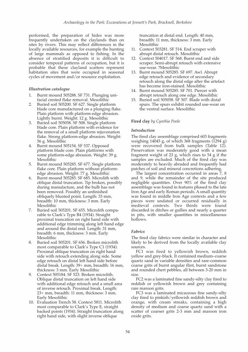
performed, the preparation of hides was morefrequently undertaken on the claylands than onsites by rivers. This may reflect differences in thelocally available resources, for example the huntingof large mammals as opposed to fishing. In theabsence of stratified deposits it is difficult toconsider temporal patterns of occupation, but it isprobable that these clayland scatters representhabitation sites that were occupied in seasonalcycles of movement and/or resource exploitation.
Illustration catalogue
1. Burnt mound 505288. SF 731. Plunging uni-facial crested flake removal. Mesolithic
2. Buried soil 505200. SF 627. Single platformblade core manufactured on a plunging flake.Plain platform with platform-edge abrasion.Lightly burnt. Weight: 12 g. Mesolithic
3. Buried soil 505058. SF 508. Single platformblade core. Plain platform with evidence forthe removal of a small platform rejuvenationflake. Strong platform-edge abrasion. Weight:56 g. Mesolithic
4. Burnt mound 505154. SF 537. Opposedplatform blade core. Plain platforms withsome platform-edge abrasion. Weight: 39 g.Mesolithic
5. Burnt mound 505285. SF 677. Single platformflake core. Plain platform without platform-edge abrasion. Weight: 77 g. Mesolithic
6. Burnt mound 505285. SF 685. Microlith withoblique distal truncation. Tip broken, possiblyduring manufacture, and the bulb has notbeen removed. Possibly an unfinishedobliquely blunted point. Length: 33 mm,breadth: 10 mm, thickness: 3 mm. EarlyMesolithic
7. Buried soil 505201. SF 655. Microlith compa-rable to Clark’s Type B4 (1934). Straightproximal truncation on right hand side withadditional edge trimming along left hand edgeand around the distal end. Length: 31 mm,breadth: 6 mm, thickness: 3 mm. EarlyMesolithic
8. Buried soil 505201. SF 656. Broken microlithmost comparable to Clark’s Type C1 (1934).Proximal oblique truncation on right handside with retouch extending along side. Someedge retouch on distal left hand side beforedistal break. Length: 39+ mm, breadth: 16 mm,thickness: 3 mm. Early Mesolithic
9. Context 505184. SF 523. Broken microlith.Oblique distal truncation on left hand sidewith additional edge retouch and a small areaof inverse retouch. Proximal break. Length:23+ mm, breadth: 11 mm, thickness: 3 mm.Early Mesolithic
10. Evaluation Trench 58. Context 5811. Microlithmost comparable to Clark’s Type E, straightbacked points (1934). Straight truncation alongright hand side, with slight inverse oblique
truncation at distal end. Length: 40 mm,breadth: 11 mm, thickness: 3 mm. EarlyMesolithic
11. Context 503281. SF 514. End scraper withabrupt distal retouch. Mesolithic
12. Context 504017. SF 568. Burnt end and sidescraper. Semi-abrupt retouch with extensiveuse-wear. ?Mesolithic
13. Burnt mound 505285. SF 697. Awl. Abruptedge retouch and evidence of secondaryretouch along the distal edge after the artefacthas become iron-stained. Mesolithic
14. Burnt mound 505285. SF 701. Piercer withabrupt retouch along one edge. Mesolithic
15. Buried soil 505058. SF 507. Blade with distalspurs. The spurs exhibit rounded use-wear onthe ventral surface. Mesolithic
Fired clay by Cynthia Poole
Introduction
The fired clay assemblage comprised 603 fragmentsweighing 14045 g, of which 368 fragments (1294 g)were recovered from bulk samples (Table 12).Preservation was moderately good with a meanfragment weight of 23 g, which rises to 54 g if thesamples are excluded. Much of the fired clay wasmoderately to heavily abraded and frequently hadpatches of soil and mineral concretions adhering.
The largest concentration occurred in areas 7, 8and 9, while the remainder of the site producednegligible quantities. Over 90% of the fired clayassemblage was found in features phased to the lateIron Age and early Roman periods. A small quantitywas found in middle Iron Age contexts and a fewpieces were undated or occurred residually inmedieval contexts. Two thirds were founddiscarded in ditches or gullies and nearly a quarterin pits, with smaller quantities in miscellaneoushollows.
Fabrics
The fired clay fabrics were similar in character andlikely to be derived from the locally available claysources.
FC1 was fired to yellowish brown, reddishyellow and grey-black. It contained medium–coarsequartz sand in variable densities and rare-commoncoarse grits of burnt angular flint, burnt sandstoneand rounded chert pebbles, all between 3-20 mm insize.
FC2 was a laminated fine sandy-silty clay fired toreddish or yellowish brown and grey containingrare maroon grits.
FC3 was a laminated micaceous fine sandy-siltyclay fired to pinkish/yellowish reddish brown andorange, with cream streaks, containing a highdensity of medium and coarse quartz sand with ascatter of coarser grits 2-3 mm and maroon ironoxide grits.
Archaeology in the Park: Excavations at Jennett’s Park, Bracknell, Berkshire
54

FC4 was a fine clay fired to reddish browncontaining many voids 0.5-2 mm, apparently fromleached shell.
Forms
Apart from a small red bead, all the fired clay wasidentified as oven structure or furniture. Themajority from both the evaluation and excavationwas triangular oven brick, whilst the remainingmaterial included a limited range of forms: ovenplate, fire bar, pedestal and oven wall. Fragmentswhich retained some surface indicating they hadbeen shaped have been designated as ‘utilised’, whileentirely amorphous fragments have been recorded as‘unidentified’. Both categories are likely to havederived from ovens, hearths or oven furniture.
Oven structure One fragment with a plano-convex surface fromRoman soil layer 502171 may be part of a stoke-holearch or vent in the oven wall. Another fragment, fromlate Iron Age ditch 502230, had interwoven wattleimpressions measuring c 13 and 15 mm in diameteron one side and a plain surface on the other, and wasprobably part of the upper oven wall or domeconstructed over a supporting wattle framework.
Oven furniture (Fig. 34)
Triangular oven bricks (traditionally referred to asloomweights) accounted for 77% of the assemblageby weight. None was complete, but some weresufficiently complete (ie c 60-80%) to obtain lengthand width measurements, which indicated that arange of sizes were present (Table 13). The sizesfound during both the evaluation and excavationare similar and indicate that some very largeexamples, possibly up to 2.5 kg weight, may havebeen used. The defining characteristic was thepresence of a perforation piercing the brickcorner(s) laterally. It was clear from one examplewith only two perforations that all three cornerswere not necessarily pierced. An additional featurethat occurred on several pieces was an externalshallow groove across the corner, measuringbetween 15 and 30 mm wide. These characteristicsare common features on triangular bricks, which arein use throughout the Iron Age and into the earlyRoman period but it is unclear whether particularcharacteristics have any relationship to phase,regional designs or function.
A group of pedestal fragments from ditch 502232may be part of a triangular brick or possibly arectangular pedestal 90 mm wide.
OA Occasional Paper Number 18
55
Table 12 Summary of fired clay data
Nos Nos % Wt (g) Wt % Fabrics
Triangular Oven Brick 141 23.4 10878 77.45 FC:1, FC:2, FC:3
Pedestal 8 1.4 458 3.3 FC: 2
Fire bar 3 0.5 231 1.64 FC:2, FC:3
Oven plate 19 3.2 814 5.8 FC:2, FC:3
Oven structure 2 0.3 59 0.42 FC:3
Utilised 83 13.8 1282 9.1 FC:1, FC:2, FC:3, FC:4
Unidentified 345 57.2 318 2.26 FC:1, FC:2, FC:3
Bead 1 0.15 0.5 + ~
Total 603 14044.5
Table 13 Triangular oven bricks: range of sizes
Comment Length mm Thickness mm Est. total wt (g) Perforations
Large corner fragment c 200-250 (>90 mm) 84-93 c. 2500 1 perforation: 15 mm
c 70-80% complete 170 50 c. 1550 2 perforations
c 60% complete 135 50 c. 1055 2 perforations: 9 mm
Central body >60 56 2 perforations: 13 and 15 mm
Corner fragment >100 70
Corner fragment c 200+ (>90) 70
Corner fragment with finger c 200+ (>85) 76 1perforation: 12 mm
groove 15 mm
Min. no.: 1 50-55 1 perforation: 16 mm
Min. no.: 3 c 70 10 mm, 11 mm x2; 12 mm, 13 mm,
14 mm x2; 14x9 mm; 18 mm
Min. no.: 3 c 80-85 4 (11, 12, 14 mm x2, 16 mm, 21 mm)
Min. no.: 1 c 100 15 mm

Archaeology in the Park: Excavations at Jennett’s Park, Bracknell, Berkshire
56
Figure 34 Triangular oven bricks/loomweights from fill 502081 of ditch 502080 and fill 502005 of pit 502004

Three examples of perforated oven plate wererecovered: one from Roman soil layer 502171 andtwo from Roman ditch 504172. The two pieces fromthe ditch were rectangular or polygonal in form.These were 42 and 55 mm thick and were pieced byvertical circular perforations, c 35 mm diameter andc 60 mm in diameter.
Two examples of fire bars, both very fragmentary,were found. One appeared to be part of a taperingcigar-shaped variety (though the end did notsurvive) measuring 40-50 mm by 34-40 mm wide.The second was from one end of a fire bar withsquare cross-section and flat end measuring 40 x 40mm increasing to over 48x46 mm towards thecentre, indicating that this too was a tapered form.
Small objectBead: circular disc with convex edges. Colour: red.Central perforation: 1.5 mm diameter. Thickness: 3mm. Diameter: 6 mm. Weight: < 1 g. Date: possiblyprehistoric, though from early Roman ditch 504172.
Discussion
The identifiable structural fired clay all derivesfrom hearths or ovens, being either part of the floor,lining wall or superstructure, or associatedportable oven/hearth furniture. The evidence forsuperstructure is sparse and the assemblage isdominated by portable hearth or oven furniture, ofwhich the triangular oven bricks form the maincomponent.
These objects were ubiquitous throughout theIron Age and continued in use into the early Romanperiod, being found on a wide variety of settlementtypes from hillforts to smaller enclosed andunenclosed rural settlements. Their continued usein the early Roman period indicates the continua-tion of a native British tradition. The majority at thissite was found in late Iron Age and early Romancontexts, though examples were also present in themiddle Iron Age phase. Their use as oven furniture,as an alternative to the traditional function ofloomweights, has been discussed in relation tothose found at Danebury in Hampshire (Poole 1995)and there is increasing evidence from other sites toindicate an association with ovens or similar struc-tures. An early reference to an Iron Age kiln nearGuildford describes the kiln as being lined withtriangular bricks (Lowther 1935) and at Dagenhama group was found mixed with kiln pedestalsprobably from a kiln uncovered at this site (Poole2007). Those found during the evaluation atJennett’s Park in ditch fill 19013 were associatedwith a tip of charcoal and burnt flint, whichcommonly formed the primary layers in the base ofIron Age ovens. A large group of fragments wasfound in pit 502004, dating from the 1st century AD;this took the form a shallow sub-circular hollowwith charcoal fragments in its fill and although noin situ burning was observed, such a feature couldtypically form the base of a hearth or oven. Two
further hollows similar in form and fill couldindicate the presence of further hearth or ovenbases.
There is a range in the size of the bricks in allperiods, which suggests that they were associatedwith a variety of structures of differing sizes or thattheir function may have depended on size, with thepossibility of their being used as oven or hearthflooring, wall lining or pedestals.
Other varieties of oven furniture were confinedto the Roman phase of occupation. The presence offire bars and perforated oven plate may indicatechanges in design introduced in the Roman periodin relation to ovens, or possibly kilns. Perforatedoven plates, however, were found in both the IronAge and Roman periods. During the later periodthey were more commonly associated with potterykilns, possibly because their domestic function wassuperseded in the Roman period by iron gridirons.Similarly the fire bars are of a Roman typecommonly associated with pottery kilns (Swan1984, 62-64). However, in the absence of firmevidence for pottery production, a domesticfunction is more likely.
Ceramic building material by Cynthia Poole
A total of 189 fragments of ceramic buildingmaterial weighing 21053 g were recovered fromthe evaluation and excavation. These were almostexclusively of medieval and post-medieval date,apart from a few Roman pieces. The lattercomprised four fragments of tegulae recoveredfrom buried soil layer 502171 and two brickfragments, one from the fill of medieval ditch403085 and the other from the fill of a tree-throwhole of uncertain date (504073). Medieval andpost-medieval building material was recoveredfrom all ten excavation areas and appears to repre-sent material scattered over a wide area in lowdensities, except for material from probablelimekiln 405003. Two complete bricks from thestructure of the kiln were taken as samples. Thesemeasured 225 x 110 x 65 mm (9 x 4 3/8 x 2 5/8 ins) and210 x 106 x 55–60 mm (8 1/4 x 4 1/2 x 2 1/4–2 1/2 ins),and their size and quality suggest a date in the late16th-17th centuries. It is likely that the remainderof the building material became incorporated intothe features and layers from which it was recov-ered as a result of manuring or other casual activi-ties, rather than representing evidence forbuildings standing within or close to the areasunder investigation.
Worked stone by Ruth Shaffrey
A small chunk of greensand, possibly Lodsworthstone, was recovered from the upper fill of Romanfield boundary ditch 502258 in evaluation Trench189. The piece has one pecked and smoothedsurface and may be a fragment from a rotary quern.
OA Occasional Paper Number 18
57
Slag by Luke Howarth
An assemblage of 11.82 kg of metalworking debriswas recovered from the evaluation and excavation.The material was collected both by hand duringexcavation and from environmental samples,although the latter was of limited value due to thesmall size of the fragments obtained, which derivedentirely from contexts from which hand-retrievedmaterial had already been recovered. The materialwas recovered exclusively from the fills of pits andditches, there being no hearths or furnaces identi-fied on the site. No hammerscale or similar metal-working wastes were identified. The assemblagewas derived mostly from features dating from theIron Age and Roman period, with only threefragments (82 g) from later features and 28fragments (2193 g) from undated contexts.
Middle Iron Age
Approximately half the assemblage derived fromcontexts attributed to the middle Iron Age (5105 g,47 fragments). Most of this material is offurnace/smithing hearth bottom. Most of thefragments are relatively amorphous but all have amedium to coarse crystalline texture with impres-sions of charcoal. Along with this were a fewfragments that may be part of a slag cake, producedduring smithing. In addition there was one lowdensity lump of silt sand with an ‘ashy’ colour andfeel, presumably relating to some other industrialprocess, since it lacked slag or hammerscale.
Late Iron Age
The material from this phase (534 g, 10 fragments)falls into three categories. The first is an iron-richslag with impressions of charcoal. The textureindicates slow cooling, probably in situ, thoughirregular deformation of the vesicles makes it diffi-cult to be certain. The second group consists ofpartially vitrified or baked fragments of clay andbuilding fabric, incorporating some pieces of slagand slagged ceramic building material. The thirdcategory comprises a single fragment which is of alower density, and has a series of overlapping runson the surface. Overall this assemblage is probablysuggestive of primary smithing.
Roman period
The majority of the material from this phase (2361 g,35 fragments) is made up of partially vitrifiedfragments of building material along with whatlooks like dumps of industrial wastes, not neces-sarily from smelting or metalworking, characterisedby a poorly-sorted silty sand matrix of a pale greyashy colour, occurring with inclusions of burnt flintpebbles and patches of possible iron oxide. Theappearance of this material as solid lumps probablyresults from post-depositional cementation. Most ofthe diagnostic material recovered is suggestive of
primary smithing. One particular fragment, c 100mm across at most and with a coarse crystallinetexture characteristic of slow cooling, is likely tohave been formed by working on a small hearth.
Discussion
There is evidence for smithing and possiblysmelting occurring at the site associated with theIron Age settlement and the ditches of the late IronAge and Roman-period field systems. The largestconcentrations of material come from a group ofpits in Area 6, dating from the Iron Age and locatedabout 200 m north of the contemporaneous settle-ment. This material consists mostly of smithingbottoms, and is likely to have resulted from thedumping of debris from hearths located nearby. Theabsence of hammerscale, however, indicates that thepits were not located particularly close to theworking area.
Other finds by Ian Scott
Metal finds
The metalwork assemblage comprises seven ironobjects (10 fragments) recovered from the evalua-tion and excavation. All the objects are poorlypreserved and heavily encrusted with corrosionproducts. A heavily encrusted rod or bar was recov-ered from late Iron Age pit/posthole 503217. Thepiece measured 105 x 13 mm and is of unknownfunction. The fill of medieval pit 501031 contained awhittle tang knife. This could well be a medievalform, but is heavily encrusted and broken into threepieces. The remainder of the assemblage consistedof individual finds of nails, either complete orfragmentary.
Glass
Four pieces of glass were recovered, comprisingtwo joining fragments from the base of a cylindricalwine bottle, probably 19th century or later in date, aflat sherd from the side of a cough mixture or tonicbottle with the letters ‘SG’ embossed on it, and asherd probably from a modern milk bottle.
THE ENVIRONMENTAL EVIDENCE
Animal bone by Lena Strid
The animal bone assemblage consisted of 47fragments (27 g) from features dating from the earlyIron Age to the medieval period. Preservation waspoor, because of acidic soil conditions, and as a resultonly two fragments could be identified to species,while no butchery marks or pathological conditionscould be identified. The identifiable elements wereboth teeth, one from an adult bovine and the secondfrom a juvenile or sub-adult pig; the remainder of theassemblage consisted of burnt bone, teeth and burnt
Archaeology in the Park: Excavations at Jennett’s Park, Bracknell, Berkshire
58

bone being the two most resilient categories of anarchaeological bone assemblage.
Charred plant remains by Wendy Smith
A total of 42 bulk samples were collected in thecourse of the various phases of evaluation andexcavation for the recovery of charcoal and othercharred plant remains. Following assessment of allthe samples, it was found that only one sample wassufficiently rich to be interpretable (OA 2008). Thevast majority of samples collected did not containcharred plant remains other than charcoal, and forthis reason their flots were not recorded beyondassessment level. The one exception was a sampletaken during the evaluation phase from an ash lens(19013) rich in indeterminate glume wheat (Triticumdicoccum Schübl./ spelta L.) chaff within ditch502225 of the Roman field system.
Methodology
The author assessed and identified charred plantremains using a low-power binocular microscope atmagnifications between x12 and x40. Moderncomparative material in the Oxford Archaeologycollection was consulted for the identifications offully analysed plant remains. Nomenclature foreconomic plants follows Zohary and Hopf (2000)and nomenclature for indigenous taxa follows Stace(1997). The traditional binomial system for thecereals has been maintained here, following Zoharyand Hopf (2000, tables 3 and 5).
Results
The fully quantified charred plant remains recov-ered from sample 19, context 19013, are presented inTable 14. This assemblage was almost entirelycomposed of indeterminate emmer/spelt (Triticumdicoccum Schübl./spelta L.) glume bases and a fewspikelet forks. Much of the chaff was extremelyabraded and broken quite low on the glume, near toor just above the abscission scar, so identification tospecies level was not possible in most cases. A fewidentifiable glumes were recovered, and emmer andspelt were identified in equal number. In total 98.6%of all identifications were glume bases or spikeletforks of emmer or spelt. A few indeterminatecereal/large grass (POACEAE) caryopses fragmentswere also recovered, along with one charred bud,possibly from a tree or shrub.
Discussion
The earliest evidence for spelt (Triticum spelta L.) inEngland dates to the middle Bronze Age, forexample at Dartford, Kent and Yarnton, Oxfordshire(Pelling 2003a), and spelt is believed to have beenwidely adopted in England by the Iron Age. Emmer(Triticum dicoccum Schübl.) has been recovered fromLate Iron Age—Roman-period deposits at Bray(Clapham 1995, 36), although spelt wheat was thedominant cereal there. Campbell and Straker (2003,18) have identified the middle Bronze Age—lateIron Age as the period when there appears to havebeen a gradual change from the cultivation of
OA Occasional Paper Number 18
59
Table 14 Charred plant remains from Roman field boundary ditch fill 19013
Sample Number 19
Context Number 19013
Context Description within ditch Ash lens
Period Roman
Sample Volume (l.) 10
Flot Volume (ml) 30
Proportion of flot sorted 100%
Seeds per litre 43.7
Latin Binomial English Common Name
Cereal Grain
Cereal/ POACEAE – indeterminate caryopsis 5* Indeterminate Cereal/ Large Grass
Cereal Chaff
Triticum dicoccum Schübl. – glume base 5 Emmer
Triticum dicoccum Schübl. – spikelet fork (gb + r) 3 (4gb + 0r) Emmer
Triticum dicoccum Schübl./ spelta L. - gb 381 Emmer/ Spelt
Triticum dicoccum Schübl./ spelta L. – spikelet fork (gb + r) 37 (42gb + 0r) Emmer/ Spelt
Triticum dicoccum L. – glume base 5 Spelt
Other Plant Remains
Unidentified - bud 1 Unidentified bud
Total (using glume base scores for spikelets) 437
* estimate count from fragments

emmer wheat to the cultivation of spelt. However,recent results from Kent suggest that emmer wheatwas not completely abandoned in some areas ofEngland, and continued in cultivation even into theSaxon period (Pelling 2003b; Pelling and Robinson2001). The presence of both emmer and spelt atJennett’s Park suggests that both were cultivated.However, with the vast majority of glume bases andspikelet fragments so poorly preserved, it is notpossible to suggest whether emmer and spelt weregrown as a maslin (an intentionally mixed crop) orone was merely a contaminant of the other crop. Inthe absence of other samples from the sitecontaining interpretable assemblages of charredplant remains, it is difficult to interpret this singlerich, and remarkably pure sample. The limitednumber of taxa within this sample is unlikely to befully representative of the range of agriculturalactivities carried out at the site.
Charcoal by Dana Challinor
Introduction
Charcoal from twelve bulk samples collected in thecourse of the excavation was examined; threemiddle Bronze Age, five Iron Age and four of theRoman period. None of these assemblages camefrom features that could be associated directly withspecific activities, and so the aim of the analysis wasto provide an overview species list for each period,from which a general characterisation of wood fueluse and changes in local woodland resources couldbe considered.
Methodology
Two approaches to the analysis were undertaken;the first was to analyse key contexts in full and thesecond was to rapidly scan the whole sample andselect twenty fragments for identification. The burntmound samples contained abundant charcoal and apercentage of the sample was examined. Wherethere were large quantities of oak present in thesample, non-oak pieces were deliberately chosen for
identification. This method ensures that a range oftaxa are identified, but it does not necessarily repre-sent the full species list or quantities of each taxonin the sample. Where possible, the maturity of thecharcoal was recorded. Classification and nomen-clature follow Stace (1997).
Results
Nine taxa were positively identified: Ulmus sp.(elm), Quercus sp. (oak), Alnus glutinosa (alder),Corylus avellana (hazel), Populus/Salix (poplar/willow), cf. Prunus sp. (cherry/blackthorn),Maloideae (hawthorn, apple, pear, service), Acercampestre (field maple) and Fraxinus excelsior (ash).The condition of the charcoal was generally fair topoor, friable and heavily encrusted, which obscuredsome anatomical characteristics. Consequently, itwas not always possible to distinguish betweenAlnus and Corylus, and the single fragment ofprobable Prunus could not be confirmed.Identifications have been given to species levelwhere a single native species is the most likelysource of the wood. The recognition of tyloses(which indicate the presence of heartwood in oak,ash etc.) was not always possible given the encrus-tation of the charcoal, so the evidence for maturitywas limited to a few cleaner fragments. Somesmaller roundwood was indicated by the curvatureof the growth rings, but there were no whole stemsin the samples.
Middle Bronze AgeCharcoal samples from two burnt mound deposits(505154 and 505275) and from waterhole 505104were analysed (Table 15). The sample from mound505154 was dominated by alder, while that frommound 505275 contained roughly equal quantitiesof oak and alder. The assemblage from waterhole505104 was rapidly analysed, but appeared to havea similar composition. The similarity between thisassemblage and the burnt mound samples suggestsan affinity between them. It is particularly strikingbecause the regional review for southern woodrevealed a paucity of alder charcoal in the archaeo-
Archaeology in the Park: Excavations at Jennett’s Park, Bracknell, Berkshire
60
Table 15 Charcoal from Bronze Age burnt mound layers 505154 and 505275 and waterhole 505104
Sample number 512 523 516
Context number 505154 505275 505231
Feature number - - 505104
Feature type Burnt mound Burnt mound Waterhole
% flot identified 50 25 -
Quercus sp. oak 4 55h 9rh
Alnus glutinosa Gaertn. alder 90r 50r 11
Alnus/Corylus alder/hazel 6
Fraxinus excelsior L. ash 1
Indeterminate 2
r=roundwood; s=sapwood; h=heartwood

logical record for the Bronze Age and earlierperiods (Smith 2002). Smith discusses severalreasons for this, including environmental (alderprefers damp soil conditions such as riversides),burning properties (alder does not make a goodwood fuel unless well seasoned) and selection ofalder for other uses (alder is often found in water-logged wooden structures).
Alder is not uncommon in burnt mound assem-blages, and predominated in similar deposits suchas at Anslow’s Cottages, Burghfield (Gale 1992) andCox Bank Farm, Uttoxeter (Gale 2007). These siteswere located in proximity to wetland environmentsin which alder would have flourished. The alderfrom Jennett’s Park may provide evidence for asimilar environment in the low-lying areas to thesouth-west of Jennett’s Hill. Although alder doesnot make a good wood fuel, it does make a goodcharcoal fuel (Edlin 1949), which may have beenbeneficial for some activities, such as steam baths,although it would probably not have been worththe effort and cost of converting the wood tocharcoal for general domestic purposes. There is,
however, considerable variability in the charcoalassemblages from burnt mound deposits, many ofwhich contain more diverse assemblages (forexample, Reading Business Park (Gale 2004), EtonRowing Lake (Challinor, forthcoming)), perhapsindicating different functions.
Iron AgeThe four samples analysed from the Iron Age settle-ment came from the ring gully of Structure 2(context 50368), the trench of Structure 3 (context503182), pit 503075 and pit 503211 (Table 16). All theassemblages were dominated by oak. The fullanalysis of context 503182 revealed the presence ofhazel and field maple, and further analysis on theother samples might have extended the species listfurther. However, it was apparent that the primaryfuelwood was oak. Some mature oak was evident inpit 503075. The pit assemblages may have derivedfrom domestic or industrial waste, as the ring gullysamples were similar.
The single sample from an Iron Age pit from Area6 (501027) had a diverse assemblage of elm, oak,
OA Occasional Paper Number 18
61
Table 16 Charcoal from Iron Age features
Sample number 502 504 505 506 511
Context number 501028 503077 503182 503068 503214
Feature number 501027 503075 503181 503067 503211
Group number n/a n/a 503292 503290 n/a
Feature type Pit Posthole Ring gully Ring gully Pit
% flot identified 100 - 100 - -
Ulmus sp. elm 22
Quercus sp. oak 10 20hs 53r 19 20
Alnus glutinosa Gaertn. alder 1
Corylus avellana L. hazel 45r 4r
Alnus/Corylus alder/hazel 2 4
Acer campestre L. field maple 2 1
Fraxinus excelsior L. ash 6
Indeterminate 4 8
r=roundwood; s=sapwood; h=heartwood
Table 17 Charcoal from Roman features
Sample number 528 531 514 19
Context number 502137 502139 504027 19013
Feature number 502135 502135 504028 19003
Group number n/a n/a 504173 502225
Feature type Pit Pit Ditch Ditch
Quercus sp. oak 20 19 10rs 14
Alnus glutinosa Gaertn. alder 9r
Populus/Salix poplar/willow 5
cf. Prunus sp. cherry type 1
Maloideae hawthorn, pear, apple 1
Fraxinus excelsior L. ash 1
r=roundwood; s=sapwood; h=heartwood

hazel, field maple and ash, in contrast to the assem-blages from Area 8. Interestingly, oak only forms12% of the assemblage, compared with 52% hazeland 25% elm. A number of the hazel fragmentsappeared to be from small diameter roundwood.The function/origin of the charcoal is unknown butthe use of multiple species suggests that no specialselection applied to the fuel.
Roman periodFour samples dating to the Roman period weresubjected to rapid analysis (Table 17). The twosamples from pit 502135 were clearly dominated byoak. The ditches produced more diverse assem-blages, including oak, alder, willow/poplar,hawthorn group and ash. The alder andwillow/poplar indicate that wood growing in adamp environment was still in use in this period.Although these samples cannot be associated withspecific activities, a comment may be made on thenature of the context types. Ditch samplesfrequently exhibit greater diversity of charcoal taxathan pits, possibly because ditches are likely to havebeen open longer, or received mixed assemblages.Nonetheless, oak appears to be the most importantcomponent of the fuelwood selection in all features.
Discussion
The analysis of charcoal from fuel debris canprovide a rough indication of woodland composi-tion, but biases were introduced into the record bydeliberate selection for economic uses. The specieslist from Jennett’s Park is limited and consequentlydirect extrapolation to the environment is difficult.Suffice to say that the named taxa could have grownlocally. Oak may have formed the dominantwoodland, with the lower-lying areas supportingalder and willow and/or poplar, although the use ofthe latter species was fairly limited. There is littleevidence for hedgerow or scrub species. There isthus some contrast between the fuelwood collectionstrategies employed in different periods, the BronzeAge burnt mounds being typified by the use of acombination of oak and alder, perhaps in the formof charcoal, whereas the Iron Age and Romansamples are largely characterised by a dominance ofoak. However, the dataset is admittedly limited andit is likely that in practice a more diverse range ofmaterial was used, perhaps determined by thefunction of individual fires.
Pollen by Elizabeth Huckerby
A soil monolith was taken through the fills of water-hole 505122 (Fig. 13) for palynological analysis. Sub-samples from the three lower fills (505164, 505163,and 505162) of the waterhole were subjected to anassessment level of analysis. A decision was takennot to proceed with full analysis because of the lowfrequency of the pollen and spores and their poorpreservation, although it is still possible to draw
some conclusions regarding the contemporaneousenvironment. The samples were prepared using astandard chemical procedure (method B ofBerglund and Ralska-Jasiewiczowa 1986) andmounted on slides. Slides were examined at amagnification of 400x (1000x for critical examina-tion) by ten equally-spaced traverses across at leasttwo slides to reduce the possible effects of differen-tial dispersal on the slides. Pollen identification wasmade following the keys of Moore et al. (1991),Faegri and Iversen (1989), and a small modern refer-ence collection. Andersen (1979) was followed forthe identification of cereal grains. Indeterminablepollen was also recorded as an indication of thestate of pollen preservation. Plant nomenclaturefollows Stace (1997).
Archaeology in the Park: Excavations at Jennett’s Park, Bracknell, Berkshire
62
Table 18: Results of the pollen assessment from waterhole 505122
Context number 505164 505163 505162
Total Trees + Shrubs 26 13 146
Total Herbs 2 3 27
Total Heather 1
Total Ferns 56 29 8
Pollen sum (total) 84 35 172
Trees and shrubs
Betula - birch 4
Quercus - oak 2 4 45
Alnus - alder 9 4 33
Fraxinus excelsior - ash 1
Tilia - lime 1 1 4
Corylus avellana-type - hazel 14 4 59
Heather
Calluna vulgaris - heather 1
Herbs
Asteraceae undiff - daisy family 1
Taraxacum-type - dandelion-type 1 1
Caryophyllaceae - pink family 1
Chenopodiaceae - goosefoot family 1
Poaceae - grasses 6 1 22
Potentilla - cinquefoils 1
Rubiaceae - bedstraw family 1
Sinapis -mustards 1 1
Unknown herbs 1 1
Ferns, mosses and liverworts
Sphagnum - sphagnum moss 2 1
Polypodium - polypody 42 21 2
Pteridium aquilinum - bracken 3 2 1
Pteridopsida (monolete) - monolete ferns 16 6 5
Anthoceros - hornwort 2
Indeterminate grains 19 6 72
Charcoal sum (total) ++ ++ ++
Lycopodium marker spores 206 181 57

Pollen preservation was poor in the threesamples assessed. There were very few pollengrains in contexts 505164 and 505163, but theconcentration of grains in the lowest fill (505162)was high, although the grains were very poorlypreserved. Abundant fragments of microscopiccharcoal were identified in the three samples.
Results
Fill 505162The pollen assemblage from this sample wasdominated by tree pollen mainly from oak, hazeland alder with some lime. Pollen from herbaceoustaxa was also recorded and was largely from grasseswith occasional grains from other taxa includingdaisy and dandelion type. There were only a fewfern spores in this fill.
Fill 505163Very few pollen grains and fern spores wererecorded in this fill. However, of the pollen avail-able, fern spores (polyploidy and bracken) were themore abundant.
Fill 505164The concentration of pollen and spores in this fillwas again relatively low and the assemblage wasdominated by fern spores (polyploidy and undiffer-entiated). An interesting find is of a spore ofhornwort (Anthoceros), a liverwort-like taxon foundgrowing on damp soils probably around the edge ofthe waterhole.
Discussion
As only an assessment level analysis was under-taken, the interpretation of the data is extremelytentative. However, the pollen data from theprimary fill (505162) suggests that the landscapewas quite wooded, with a mixed woodland of oak,hazel, alder and some lime present. Undoubtedlythere had been some clearance of the woodland,which had become quite open in character, and thewaterhole may have been sited in a clearing. Thevery limited data from the other two fills (505163and 505164) suggest that the woodland becameprogressively more open with ferns becomingincreasingly dominant in the understorey.
The presence of lime pollen (2% of the total landpollen and spores) in fill 505162 suggests that it maydate to before the so-called ‘Tilia decline’. This isthought to be associated with anthropogenic forestclearance and its date varied at different sites, but inthis part of the country it generally occurred about1700–1000 BC (Greig 1991; Devoy 1979).
Soil micromorphology by Richard Macphail
Two thin sections from monolith column samplestaken from the potential Mesolithic buried soil werestudied (Fig. 6, Plate 2, Appendix). The two 0.25 m-
long monoliths (532 and 533) were sub-sampled forthin sections across the two relatively dark colouredcontexts (505200 and 505292). Thin section samplesalso included material from the very base of theoverlying colluvium (505269), the interleavedwhitish yellow sand (505291) and underlyingnatural (505002).
The two thin section sub-samples were impreg-nated with a clear polyester resin-acetone mixture;samples were then topped up with resin, ahead of curing and slabbing for 75 x 50 mm-size thinsection manufacture by Spectrum Petrographics,Vancouver, Washington, USA (Goldberg andMacphail 2006; Murphy 1986). Thin sections werefurther polished with 1,000 grit papers andanalysed using a petrological microscope underplane polarised light, crossed polarised light,oblique incident light and using fluorescentmicroscopy, at magnifications ranging from x1 tox200/400. Thin sections were described, ascribedsoil microfabric types and microfacies types (Table19 and Appendix), and counted according to estab-lished methods (Bullock et al. 1985; Courty 2001;Courty et al. 1989; Goldberg and Macphail 2006;Macphail and Cruise 2001; Stoops 2003).
Discussion
The situation at Jennett’s Park is not simple. The soilprofile records a complicated soil and colluvialhistory, comprising periods of erosion and soilstabilisation. Context 505002 seems to be an in situweathered bedrock, but the presence of dusty voidcoatings suggests that the overlying contexts maybe colluvial in origin. Sandy soils are notoriouslyunstable even during Mesolithic times (Barton 1992;Macphail 2006; Mellars and Dark 1998; Simmons1975). Contexts 505292 and 505291 are likely to becolluvial layers. Moreover, context 505269 alsocontains fragments of eroded ‘Btg’ horizon,suggesting the erosion of a former soil horizon.
Context 505200 also represents a phase of topsoilformation. This Holocene argillic soil was partiallyformed in colluvial sand, and was exposed to topsoilformation processes as a result of truncation, asindicated by broad humic burrows, rooting, andsubangular, blocky structure development. It is alsolikely to have been impacted upon locally by humanoccupation—hence the presence of a probable flintflake. It is not known whether the possible sand-sizeflint fragments that occur lower down are in realityartefacts, and/or record general human activity in thearea over millennia; the flint flake is sealed within theargillic soil microfabric. Lastly, most of the humic soilassociated with the occupation of the 505200 substrateseems to have been eroded, followed by burial bycontext 505269, and hence this discontinuous layer ismainly only recorded by humic burrows.
It is likely that the palaeosol originally may havebeen considered a typical argillic brown earth(Fyfield 4 soil series) before Holocene leaching. Theburied soil is a palimpsest and has been truncated
OA Occasional Paper Number 18
63

by further erosion. Soils derived from Tertiarysands, being already partly weathered and derivedfrom earlier geological formations, are inherentlyinfertile and highly prone to leaching (eg Jarvis et al.1984, 196-9), leading to the loss of fine matrix soil;one relict patch of micaceous fine soil likely recordsthe nature of the early Holocene brown loamy soilprofile. The second (and penecontemporaneous)pedogenic impact was translocation of clay from theupper profile, and this produced clay void andgrain coatings throughout this ‘subsoil’, withconcentrations in well-developed Bt horizons, bestexpressed in context 505292.
The development of these argillic brown earths andpodzols during the Holocene is well-understood, andfollows the trend of ‘lessived soils’ – ‘acid lessivedsoils’ – podzols (eg Duchaufour 1982, 114, 287).Podzols can develop on an acid substrate such asTertiary sands. These can form under oak woodlandwithout any clearance or other human impact(Dimbleby and Gill 1955; Mackney 1961). In thesubsoils of some podzols, illuvial sesquioxides andhumus coatings can be found sealing earlier-formedclay coatings; this was recorded at Hengistbury Head,Hampshire where podzols had formed under an oakwoodland cover by the late Bronze Age/early IronAge (Macphail 1992; Scaife 1992).
Conclusion
The soils testify to a history of erosion and periodsof soil formation associated with human activity.The main phase of early Mesolithic activity identi-fied on the site appears to be associated with theupper palaeosoil (505200), although the presence ofangular flint fragments and overlying colluivummay suggest an earlier phase of activity associatedwith the lower truncated soil (505292). It can beinferred that periods of erosion and colluviationmay have been the result of the Mesolithic activityand potentially woodland clearance associationwith the buried soils. This could have also led topodzolisation of these buried soils as a secondaryimpact of clearance.
DISCUSSION: FROM WILDWOOD TOPARKLAND
The Mesolithic camp
The earliest evidence for the presence of people atJennett’s Park dates from the Mesolithic period, andis likely to represent a small, temporary camp. Theremains of this camp consisted of a concentration ofworked flint recovered from a buried topsoil
Archaeology in the Park: Excavations at Jennett’s Park, Bracknell, Berkshire
64
Table 19: Description and interpretation of thin-section samples
Thin-section 533 (lower buried soil)Context Description Interpretation
505002 This is a well sorted mainly medium sand, predominantly composed of Weathered bedrock
quartz/quartzite, with few weathered glauconite. It is massive with open
void space and trace amounts of very thin clay grain coatings, and there
is also an example of fine sandy loam soil containing mica and capped
by very dusty clay void coatings. There are possible trace amounts of
angular coarse possible flint flakes.
505292 This medium sandy soil continues upwards, but here it is characterised Heavily truncated buried soil. A thin
by very abundant iron-stained clay void and grain coatings and void sandy ‘Bt(g)’ soil horizon 25 mm thick,
infills (‘ferriargillans’). This layer also contains rare iron-manganese where Fe-Mn mottling is probably
cemented fine mottles and many thin burrows. picking out relict fine rooting.
505291 This is also composed of leached sands, and like 505002 has very thin clay
grain coatings as well as rare patches of clay coatings and Fe-Mn mottling. Colluvial layer
Thin-section 532 (upper buried soil)Context Description Interpretation
505200 This layer is a heterogeneous, partially-burrow, mixed and moderately A buried soil that contains humus and
weakly clay-coated sand. It is characterised by weakly humic, broad very fine charcoal. There are also rare
burrow in-fills, a subangular blocky structure and fine root traces. traces of fine charcoal and a single 1.5
mm long flint flake is present. This
subsoil was possibly truncated/exposed
and allowed ephemeral topsoil forma-
tion (broad burrows and structures,
and possible associated root traces) and
mixing of humic fine soil containing
fine charred organic matter.
505269 Sandy colluvium Colluvial layer

(505200) on Jennett’s Hill. The full extent of thecamp was not established, as the layer extendedbeyond the eastern edge of the area exposed by theexcavation. This situation was compounded by theexcavation strategy, as the test pits excavated intothis layer sampled only 8.4% of the exposed area,and were located exclusively in the western half. Itis consequently not possible to be certain of theextent of the flint scatter, and the assemblage recov-ered can only be regarded as a sample of the totalmaterial present.
Although few diagnostic forms were present, thefive microliths recovered were of broad-blade typeand are likely to indicate a date during the earlypart of the period. The site is one of a small numberof such modestly sized sites known on the claylandsof East Berkshire, including two scatters at ParkFarm, Binfield, 4 km north of Jennett’s Park (Roberts1995, 124-132) and site 340 of the East Berkshirearchaeological survey less than a kilometre to thewest (Ford 1987a, 60). These sites were somewhatlarger, and produced more varied flint assemblages,than some of the small, ‘task-specific’ sites locatedon the greensand to the south, which weredominated by a single tool type, such as Kettlebury1 (Rankine 1949). At both Jennett’s Park and ParkFarm, scrapers were more numerous thanmicroliths, suggesting that processing of hides wasa significant activity, but unlike at single-task sites,a range of other tools was also present, indicatingthat this was only one of a suite of activities under-taken.
Mesolithic occupation of Berkshire and thesurrounding counties appears to have beendominated by dense settlement in the Thames andKennet valleys, where the size and density of settle-ments led Bradley (1978, 98) to posit the possibilityof a semi-sedentary population. The East BerkshireArchaeological Survey has demonstrated that awayfrom the river valleys these base camps weresupplemented by smaller sites that are likely tohave been the locations of more short-term camps,perhaps occupied temporarily during expeditionsinto the forest beyond the valleys to gatherfoodstuffs and other resources available there. Thelocation of the site at the top of the southern slope ofJennett’s Hill is typical of the camps in EastBerkshire, which are generally found on suchelevated positions; the scatters at Park Farm, forexample, are located on a spur overlooking a streamin a small valley. These locations may have beenselected in order to provide a vantage point over thesurrounding area, and at Jennett’s Hill the viewmay have been enhanced by deliberate clearance ofany existing tree cover, causing the erosion thatproduced the colluvial sequence associated with theburied soil. The area to the south-west of Jennett’sHill, beyond Area 8, is relatively low-lying and wasobserved during the excavation to be prone toflooding and standing water. No environmentalevidence dating from the Mesolithic period wasrecovered, but evidence dating from the Bronze Age
indicated a wooded environment with some wetterground, and it is likely that these were theprevailing conditions throughout most of prehis-tory. It is probable that Mesolithic people wereattracted to this location by the presence of thiswetland, and the range of animal and plantresources associated with it.
The Neolithic hiatus
After the visits by groups of Mesolithic people,Jennett’s Park does not appear to have beenoccupied again until the middle Bronze Age. Theonly evidence for a human presence during theintervening years was a later Neolithic discoidalcore and a late Neolithic/early Bronze Age knife,most likely representing no more than brief visits tothe area. This is typical of the clay areas of EastBerkshire, south of the outcrop of chalk in the loopof the River Thames between Reading and Windsor;the East Berkshire survey, for example, was able tofind very little evidence for activity dating from theNeolithic or Bronze Age in this part of the county,and concluded that the area may not have beenpermanently colonised until the Bronze Age (Ford1987a). The heavy soils of this region may have beeninimical to cultivation with the simple ards in use atthe time, and while the Thames Valley to the northwas substantially cleared of woodland andrelatively intensively settled (Lambrick, forth-coming), this part of the county may still have beensubstantially wooded. It seems that for a consider-able period of time this part of the landscape was aforgotten backwater.
Fire and water: middle Bronze Age activity
People returned during the middle Bronze Age, butin a different location—at the base of Jennett’sHill—and their activities took a very different form,although the environment that attracted them mayhave been quite similar. The features dating fromthis period are numerically small, but they nonethe-less include a considerable variety of differenttypes, including three burnt flint mounds, twowaterholes, two trough-like pits and a possiblecremation burial or deliberately placed pot, as wellas a number of small pits or postholes buriedbeneath two of the burnt mounds. Clearly thesefeatures represent a range of activities, albeitperhaps associated with each other.
The burnt mounds, comprising deposits of largequantities of burnt and heat-shattered flint pebbles,are examples of a somewhat enigmatic class ofmonuments that have long been known in the northand west of Britain (Buckley 1990; O’Kelly 1954),but which are increasingly being recognised in theMidlands (Beamish and Ripper 2000; Hodder 1990)and the south of England (Ford 2007, 2-3). Althoughevidence for the use of heated stones in cooking isubiquitous on later prehistoric settlements(Lambrick, forthcoming), the much greater volumes
OA Occasional Paper Number 18
65

of stones at burnt mound sites, and the absence ofany other forms of domestic refuse, clearly indicatethat they are not the product of normal domesticactivity. Several burnt mounds have been recordedwithin the loop of the Thames to the north and westof Jennett’s Park, for example at Barkham Square,Wokingham (Torrance and Ford 2003, 88-97, fig.3.6). The radiocarbon determinations of 1630–1490BC/1480–1450 BC and 1420–1260 BC that wereobtained for two of the mounds at Jennett’s Park aretypical of dates obtained for such featureselsewhere. Although some burnt mounds haveproduced dates from as early as the Neolithicperiod (Williams 1990, 137), most date from the laterBronze Age (Bradley 2007, 214). To date, all theexamples from Berkshire for which radiocarbondates have been obtained have been found to dateto between the 15th and 9th centuries BC (Ford2007), and similar dates are also predominant forsites in the Thames Valley (Lambrick, forthcoming).The ‘classic’ burnt mound is usually described as acrescentic or horseshoe-shaped mound of heat-affected stones and charcoal, usually encircling atrough capable of holding water and located closeto a water source (Raymond 1987). At Jennett’sPark, the nearby waterholes may have served as thewater source, although it is also possible that therewere springs located on Jennett’s Hill, as during theexcavation land drains here were observed tocontinue to flow constantly even during dryweather. The coincidence of burnt mounds or otherdeposits of burnt flint with waterholes has beenpointed out elsewhere, most notably at Perry Oaks,Heathrow (Framework Archaeology 2006, 145) andat Bradley Fen, Cambridgeshire (Parker Pearson2005, 97). The mounds are generally thought to beformed from stones discarded after being used toheat water in the accompanying trough, possibly tocook large pieces of meat (O’Kelly 1954; Barber1990), an interpretation that may receive somesupport from the site at Anslows Cottages,Burghfield, where the burnt mound was associatedwith a large quantity of deer bones (Butterfield andLobb 1992, 165-6). Unfortunately the acidic soilconditions at Jennett’s Park precluded the survivalof bone, and so it is not known whether a similarassociation prevailed here. Other suggestions forthe activities that resulted in the accumulation ofburnt mounds have included a role in theprocessing of fleeces (Jeffrey 1991) or salt produc-tion (Barfield 1991, 62), or the creation of largeamounts of steam for use in sweat lodges like thoseused by some North American cultures (Barfieldand Hodder 1987).
The details of the activities represented by thefeatures at Jennett’s Park are difficult to interpret.No evidence was found for troughs associated withthe burnt mounds, but this is not unusual, and inthis case it is possible that the troughs had becomeburied beneath the mounds. The excavation of themounds was not extensive, consisting of a singletrench excavated across each feature, and so it is
possible that a trough thus buried could have beenmissed. The trough-like pits recorded in Area 9 arelocated some 140 m away from the burnt moundsand are not obviously associated with them. Thefeatures found beneath the mounds, which mayhave been contemporary with the activities associ-ated with the formation of the mounds, providelittle useful evidence, particularly as only thosefeatures within the footprint of the interventionexcavated across each mound were revealed.Consequently the full range and number of featurespresent are unknown, as is their distribution. Theabsence of heat-affected flint or other burnt materialfrom their fills indicates that the features were notdirectly associated with the heating or use of theflint. Perhaps they were the pits and postholes ofstructures that stood around the mounds.
The size and extent of the burnt mounds clearlyindicate that they accumulated as a result of large-scale, recurrent activities. However, the artefactualassemblages associated with these and the othermiddle Bronze Age features were minimal, andcertainly did not represent the quantity and rangeof artefacts that might be expected of a permanentsettlement. It seems therefore more likely that theremains here are the result of repeated visits bypeople who for the most of the time were residentelsewhere. Some evidence for the episodic nature ofthe activities at the site is also provided by the otherfeatures. The lower silts of waterhole 505122,consisting of alternating layers of dark and lightmaterial, may represent the cycles of occupationand abandonment of the site; the darker layers mayhave formed during periods of occupation, whenactivities in the vicinity of the waterhole resulted inthe deposition of more charcoal and organicmaterial giving the soil its darker colour, while theintervening, more sterile layers, containing lessevidence for anthropogenic influence, may haveaccumulated during periods when the site wasabandoned. Indeed, the very presence of two water-holes adjacent to each other suggests that one wasdug as a replacement for its predecessor, a situationthat may have only become necessary because, inthe absence of a permanent population to ensure itsmaintenance, the original waterhole silted up. In theloose, sandy soil into which the features were dug,it would be entirely feasible for this to occur in afairly short space of time. Similarly trough-like pit504048, though its precise function is unknown,seems to have been back-filled at the end of its use,and subsequently replaced in the same location bythe identical pit 504051, perhaps representing thedecommissioning of the first pit at the end of oneoccupation of the site and its replacement with anidentical feature during a subsequent visit.
If the remains at Jennett’s Park were the result ofepisodic visits to this locale, whether seasonal,annual or at some other interval, how did this fitinto the occupation of the broader landscape? Thesite appears to be rather isolated in relation to themain areas of middle Bronze Age settlement known
Archaeology in the Park: Excavations at Jennett’s Park, Bracknell, Berkshire
66

in the region, which are concentrated in the ThamesValley where the fields and boundaries of a fullyagricultural landscape were developing (Lambrick,forthcoming; Yates 2007). In contrast to this domes-ticated landscape, the evidence of the pollen fromwaterhole 505122 indicates that the environmentaround Jennett’s Park was characterised bywoodland, and the charcoal assemblages fromburnt mound 505128/505154 were dominated byalder, which characteristically grows in dampenvironments, suggesting that marsh still predomi-nated in the low-lying areas around Jennett’s Hill;the charcoal from the other two burnt mounds wasof alder and oak in approximately equal quantities.One possibility is that the periodic visits to Jennett’sPark formed part of a pattern of ‘residentialmobility’. In contrast to earlier theories thatassumed that the adoption of cultivars around 4000BC necessarily led to a sedentary lifestyle based onpermanent settlements that were occupied all yearround (eg Holgate 1988), it is now widely acceptedthat the early farming communities of the Neolithicand the early Bronze Age had a more mobilelifestyle, more akin to that of their hunter-gatherforebears, with no permanent home base (Barrett1994, 136-146; Brück 1999). The earliest evidence forthe adoption of a sedentary lifestyle in this part ofBritain occurs during the middle Bronze Age in theThames Valley (Lambrick, forthcoming) with thedevelopment of more readily identified permanentsettlements and domestic architecture, such as thatat Weir Bank Stud Farm, Bray (Barnes and Cleal1995). Outside the valley, however, occupation sitesare rarer, and those that are known are often repre-sented only by isolated groups of pits, as atAldermaston Wharf and Knight’s Farm, Burghfield(Bradley et al. 1980, 224, 258, 260) and Dunston Park,Bray (Fitzpatrick et al. 1995, 72), and are similar tothe evidence from the temporary camps of earlierperiods. It is possible that this reflects a continua-tion of a mobile lifestyle in these areas (Ford 2007, 1-2), and that the activity at Jennett’s Park is oneelement of such a pattern of activity, indicating thatthe development of the communities in this part ofthe landscape took a markedly different trajectoryfrom that of their contemporaries in the ThamesValley. Alternatively, the remains at Jennett’s Parkmay be the result of periodic visits from members ofthe sedentary communities based in the valley.Either way, the presence of the waterholes andburnt mounds is clearly evidence for a very specificand circumscribed range of activities that wereparticular to this location, and which appear to havediffered from those typical of most permanentsettlements or more temporary camps, even if wecannot be certain of their details.
The gatherings that took place at Jennett’s Parkmay have had more than a purely mundanepurpose. Bradley (2000) has drawn attention to theimportance of natural locations to pre-industrialcommunities. He has emphasised that the use ofthe landscape by prehistoric societies was not
limited to settlement and monument sites, but wasfar more extensive, involving many locations thatwere not physically modified in any deliberate ordetectable way, and many of which may have beenattributed unique symbolic significance. In asimilar vein, Levy (1982, 56-7) has argued fromethnographic evidence that certain classes of ritualactivity were undertaken in special locations awayfrom settlement, and with only a restricted elementof the community participating. It is thereforepossible that the isolated location of Jennett’s Parkwas significant in the choice of this place for theactivities that generated the burnt mounds. Itsdistance from the main areas of settlement and itswild character, dominated by marsh and woodlandin contrast to the more domesticated landscape ofthe Thames Valley, may have resulted in it beingneutral territory, communally controlled orperhaps even believed to have some specialcharacter. Its proximity to the watery landscape ofthe adjacent marsh may also have been significant,as traditions of ritualised deposition in wateryplaces—such as rivers, lakes and bogs—were long-lived in northern Europe from the Neolithic periodonward (Bradley 1990). Some form of ritual activitymay be hinted at by the urn set into the ground inpit 4409. Most of the pit, and all but the base of theurn, had been destroyed by modern ploughing,and it is possible that the feature was a cremationburial from which the cremated bone had been lostdue to this truncation, but enough of the soil fillingthe vessel was preserved to expect at least somebone to have survived. The absence of any bonesuggests that it is more likely that the feature wasnot a cremation burial, but that the pot and itsunknown contents represent some form of delib-erate deposit, perhaps as some form of votiveoffering. Jennett’s Park may therefore have beenperceived as a suitable location for some part of thecommunity to remove themselves from the rest ofthe population, or for members of differentcommunities to come together in activities thatincluded cooking, feasting or bathing, These servedto re-affirm community ties, and perhaps involvedsuch practices as negotiating access to resources,assigning marriage partners or enacting rites ofpassage.
Settling down: the Iron Age and Roman period
Jennett’s Park was first used for permanent settle-ment during the middle Iron Age, when a smallfarmstead was established at the foot of the westernslope of Jennett’s Hill. How this location was chosenis not known, although the small assemblage ofearly Iron Age pottery recovered from the fills oflater features indicates that people were alreadyusing this land before the settlement was estab-lished, and although the evidence does not suggestthat they were living here, it is possible that theyhad already cleared some of the woodland foragricultural purposes. The local geology may also
OA Occasional Paper Number 18
67

have been a factor in choosing this location, as thesettlement was situated on an area of sand, whereasthe geology of most of the land to the north, westand south was clay and would have been moreprone to flooding. The only contemporaneous sitesin the area currently known are at Fairclough Farm,on the northern outskirts of Bracknell, and ParkFarm, Binfield, 4 km north of Jennett’s Park; thesesettlements are both similarly situated on localiseddeposits of sand or gravel.
The settlement comprised a group of round-houses and associated features including ancillarybuildings and various pits and postholes. Theevidence from the pottery assemblage indicatesthat it was occupied continuously from the middleIron Age (400/300–50 BC) until the end of the lateIron Age, around the middle of the 1st century AD.Its full extent was not established with anycertainty, but it extended over an area covering atleast 125 m NE-SW and 60 m NW-SE. The settle-ment was not enclosed; the ditches recordedaround its southern and eastern sides dated to theRoman period after the settlement had beenabandoned. It is not possible to be certain from theexcavated evidence whether the buildings wereoccupied contemporaneously, forming a smallvillage, or whether they represent a sequence ofmore short-lived structures occupied at differenttimes during the life of the settlement. There wassome evidence that the structures were not allcontemporaneous, as structures 1, 2, 3, 6 and 8produced pottery of middle Iron Age type, whereasthe pottery from structures 5 and 7 dated from afterthe introduction of late Iron Age forms and grog-tempered fabrics during the later 1st century BC. Inaddition to this, Structure 3 was clearly later thanStructure 8, since the former was constructed on thesite of the latter, and the curvature of the ring gullyof Structure 8 suggested that it was also notcontemporary with Structure 1, as their ring gullieswould have intersected. Pope (2008, 18) hassuggested that due to decay of the earth-fasttimbers, roundhouses were unlikely to last formore than a generation. Whether or not that isrelevant in the present case (see below), it isprobably more likely that the settlement at Jennett’sPark comprised no more than two or three housesat any one time, representing a farmstead occupiedby an extended family. No evidence was found forrepairs to extend the use of the buildings, andpresumably as each roundhouse reached the end ofits usefulness a replacement was built at a newlocation nearby, perhaps resulting in some degreeof settlement shift between generations, albeitwithin a fairly circumscribed area.
The structures themselves were generally repre-sented by circular gullies, with only the occasionalposthole surviving, the remainder of the structuralfeatures having presumably been destroyed bysubsequent ploughing. The open, generally V-shaped profiles of these gullies indicates that theyare likely to be the drip gullies beneath the eaves of
the buildings, designed to catch rainwater runningoff the roof, although being relatively substantial,the gullies of structures 1 and 2 could also haveserved as soakaways, a function proposed for theequally substantial ring gullies at Orsett, Essex(Carter 1998, 121). In any case, the gullies are lesslikely to have functioned as foundation trenches forthe walls, as the these would generally be morestraight-sided. The best preserved of these build-ings, Structure 1, provides some additional detailsof their construction. The outer gully encircled afoundation trench for the wall of the building. Thiswas slightly polygonal in form, comprising four orfive relatively straight sections. Although noevidence was found for timbers set within thetrench, it is likely that the main structural postswere located at the junctions between thesesections, with the straight sections in-filled withwattle and daub panels or a solid wall of splittimbers. The main posts would have been linked atthe top by a ring-beam, which supported theprincipal rafters of the roof. The pits and postholeswithin Structure 1 formed no coherent pattern, butit is possible that some may have been the postholesof internal partitions, or perhaps the framework foran attic (Pope 2008, 18). The posthole at the easternend of the foundation trench is likely to have heldthe post supporting one side of the doorway, whichfaced in the same easterly direction as the entrancesthrough the drip gullies of structures 2, 3 and 5. Thering gully around Structure 1 was continuous, withno break at the entrance, and was presumablycrossed by means of planks. The burnt flint andfired clay recovered from pits inside the structureare likely to derive from hearths or ovens possiblywithin the building (C Poole, above), although therewas no direct evidence for these features survivingin situ. Further fired clay was recovered from the fillof the drip gully, while fragments of triangular ovenbricks or loomweights were collected from the dripgully of Structure 2. The smaller size of Structure 3,on the other hand, suggests that it may be an ancil-lary structure rather than domestic in use. Noevidence was found to indicate its function, but itmay have been used for craft activities or to stallanimals. The possible segmented construction of thedrip gully of Structure 5 is paralleled by Structure 1at Fairclough Farm (Torrance and Durden 2003, fig.4.2), and while it could be attributed to the effects ofmodern ploughing, this arrangement could alsoindicate that these buildings had one or moreentrances.
The artefactual assemblage from the round-houses was not large, and the range of items wasfairly limited. This is typical of such structures,and may be evidence that the occupants took theirpossessions with them when they abandoned eachbuilding, leaving them bare (Pope 2008, 18). Thecorollary of this is that some of the objects thatwere found may have been placed deliberately, assome form of act of closure to mark the end of thebuilding’s use (Pope 2008, 18-19). The largest
Archaeology in the Park: Excavations at Jennett’s Park, Bracknell, Berkshire
68

assemblages of pottery, recovered from the gullyterminals at the entrances to structures 2 and 3,and from an intervention excavated across theouter gully of Structure 1 next to the doorway, maybe the remains of such deposits, placed at theformer entrances of the buildings as part of ritesassociated with their abandonment. Unfortunately,excavation of the rest of the circumference of thesegullies was minimal, and was not sufficient todemonstrate conclusively that the terminals hadbeen treated differently from other parts of thestructure. A similar instance was recorded atFairclough Farm, where the gully terminalsdefining the entrance into one of the roundhouseswere filled with rich, humic soil containing sherdsof pottery, some of which may have originally beencomplete vessels, in contrast to the sterile sandfilling the rest of the gully (Torrance and Durden2003, 104-5). Similar deposits of artefacts associ-ated with the entrances to roundhouses have alsobeen recorded at several sites in the Thames Valley(Lambrick, forthcoming).
The evidence for structures within the settlementis completed by two four-post and two two-poststructures. The former is usually interpreted asgrain storage structures raised on four posts tokeep the contents dry and safe from mice or otherpredators (Bersu 1940, 97-8), and this suggestionhas received some support from charred grainfound in association with examples that have burntdown (eg Stanwick, Northamptonshire—Neal1989, 156). In practice, however, the function ofsuch structures is far from certain, and square,post-built structures could have had a range offorms and functions. No evidence was recovered inassociation with the examples at Jennett’s Park toconfirm their purpose. The two-post structurespresumably comprised pairs of upright posts thatsupported some form of superstructure ofunknown form. They could have served any one ofa number of functions, from mangers to frames onwhich skins or textiles were suspended for dryingor other treatment.
The features recorded in Area 6 seem to haverevealed part of a separate area of activity, some 200m from the main area of settlement. Some of the pitsin this area contained slag, including material fromthe bases of furnaces or smithing hearths, andalthough no such installations were found in situ, itis likely that the pits were located on the peripheryof an area given over to metalworking. These activ-ities may have been confined to this isolatedlocation because the smoke they produced and therisk of fire were undesirable within the settlement,but perhaps also due to more cosmologicalconcerns. Hingley (1997) has suggested, on the basisof a survey of the locations where metalworkingwas carried out and of ethnographic evidence, thatthe process of transforming natural ore intomanufactured tools was imbued with symbolicsignificance, requiring it to take place in specificlocations away from purely domestic activities.
Evidence for the settlement’s economy wassparse, not least because the acidic nature of the soildid not permit the preservation of animal bone, aphenomenon that also affected the other sites in thearea. Settlements of this type are usually assumed tobe small, mixed-economy farmsteads by analogywith sites on the chalklands of Wessex or in theThames Valley (Roberts 1995, 122). However, thepaucity of charred plant remains from settlementsin East Berkshire may indicate that arable produc-tion was not a major part of the economy in thisarea. At Jennett’s Park, most of the soil samplesassociated with the Iron Age settlement proved tocontain no charred plant remains. Similarly none ofthe Iron Age samples at Park Farm containedcarbonized remains (Robinson 1995, 118), andalthough wheat, oat and barley were all present atFairclough Farm they were each represented byonly a single grain (Letts 2003, 104, table 4.1). It ispossible that the economy in this area was primarilypastoral, with arable production at each settlementlimited to meeting the needs of the inhabitants. Thebone assemblage from a contemporaneous enclo-sure at Wood Lane, Cippenham, although admit-tedly small, was dominated by cattle (Rielly 2003),as was the only context at Thames Valley Park,Reading, that produced any significant quantity ofbone (Barnes et al. 1997, 70). This perhaps indicatesthat the local economy was typified by an emphasison cattle husbandry, but with animal bone rarelysurviving this can be no more than a tentativesuggestion. Such specialisation is unlikely to havebeen practised in isolation, and presumablyindicates that these settlements were integrated intowider exchange networks through which they wereable to dispose of their surplus produce and gainaccess to that of other settlements.
The ceramic evidence indicates that the settle-ment was occupied into the late Iron Age, whenstructures 5 and 7 were in use, but was abandonedbefore the start of the Roman period. The fieldsystem was established during the late Iron Age,but it is not possible to be certain whether thisoccurred during the occupation of the settlement,representing fields and paddocks encircling theeastern and northern sides of the farmstead, orwhether the settlement was already abandoned andthe whole area given over to agricultural use. Thedigging of the ditches that defined the field systemwas obviously a significant investment in the infra-structure of the agricultural economy, and presum-ably replaced either a system based on landdivisions that had no archaeologically detectablemanifestation, such as hurdles or hedgelines, or apattern of open grazing without physical bound-aries. The establishment of this new complex ofboundaries may have represented an intensificationof farming practices, combining a drainage functionwith facilitating a more efficient management ofgrazing resources, as stock could be periodicallyexcluded from specific enclosed areas to preventthem becoming over-grazed. Although the original
OA Occasional Paper Number 18
69

field boundaries were replaced with new, moresubstantial boundary ditches during the earlyRoman period, the persistence of pre-conquestfabrics among the pottery assemblage suggests thatthis was not associated with a break in occupation.The apparently direct replacement of some of theboundaries of the original field system and themaintenance of its NNE-SSW orientation also arguefor this being a re-organisation of the existingboundaries rather than a wholesale replacement.Some limited evidence survived for the cropsgrown at the site during the Roman period in theform of charred remains of emmer and spelt recov-ered from a dump in boundary ditch 502225. It isunfortunate that only this single sample from theexcavation produced sufficient remains for analysis,and that the majority of the remains could not beidentified to species. As a consequence, it is notpossible to be certain whether the two were grownas a single mixed crop, or whether one was a conta-minant of the other. That crop processing wascarried out at the site is also demonstrated by thefragment of quern found in the fill of one of theboundary ditches. The discovery of dumps ofindustrial waste within the fills of the fieldboundary ditches in Area 9 indicates that someprocess was being carried out among the fields inaddition to their agricultural use. These depositscomprised conglomerations of fragments of slag,fired clay and ash, as well as burnt and unburntstones, that clearly derived from some process thatgenerated very high temperatures, although in theabsence of hammerscale it is not possible toattribute them definitely to metalworking. Theymay have derived from a number of differentprocesses, perhaps including pottery manufacture,as fire bars and perforated oven plates were recov-ered, both of which may be associated with kilnstructures (Poole, above). No settlement belongingto the late Iron Age and Roman period was discov-ered, but the people farming the land presumablylived nearby. That settlement must lie either in thearea in the central western part of the developmentarea where no evaluation trenches were dug orbeyond the area of the development, as no evidencefor it was uncovered during the evaluation phase ofthe investigation.
The two identified episodes of landscape re-organisation form part of a wider pattern ofincreased agricultural production across southernBritain during the late Iron Age and the early part ofthe Roman period. This is evidenced by an expan-sion of farming onto previously uncultivated land,changes in the crops grown, increasing specialisa-tion, and, as at Jennett’s Park, the re-organisation ofthe exploitation of existing farmland (van der Veenand O’Connor 1998). The stimulus for this explo-sion in agricultural activity is likely to have arisenfrom the increasing social stratification andemergence of tribal kingdoms during the late IronAge (Cunliffe 1991, 120-129; Hill 2007), and thedemands of the Roman state after the conquest
(Mattingly 2006, 353-363, 494-6). These develop-ments entailed a significant increase in the propor-tion of the population that was not directly involvedin agriculture, resulting in the need for foodproducers to generate a surplus, which was thencollected as tax or tribute. This may have compelledfarmers who had previously practised subsistencefarming regime to adopt a more intensive strategyin order to increase yields sufficiently to meet theseincreased fiscal demands.
During this period, integrated field systemswere constructed across large areas of thelandscape (Dark and Dark 1997, 93-104), withparticularly well documented examples on theBerkshire Downs (Bowden et al. 1993) and in theupper Thames Valley (Benson and Miles 1974).However, a different pattern of landuse may havebeen current in the eastern part of the county. TheEast Berkshire archaeological survey recordedonly a low density of pottery on the areas ofLondon Clay, and concluded that this reflected alimited use of manuring in this area, implying thata much larger proportion of the landscape wasgiven over to pasture or woodland (Ford 1987a,95). Similarly, little evidence has been found forextensive field systems in the middle ThamesValley despite a number of large scale excavationshaving been carried out, and Ford (2003, 163) hassuggested that large-scale organisation of thelandscape may have been lacking, with settlementin this area being ‘self-contained and individual-istic’. It is possible therefore that this part of thecounty was typified by large areas of woodland orrough grazing, with widely scattered individualsettlements, each with its own small area ofenclosed fields and paddocks. The extent of thefield system at Jennett’s Park was not establishedwith any certainty. Ditches that are likely to befield boundaries were recorded in evaluationtrenches extending across most of the area of thedevelopment, but very few produced datable findsand consequently it is difficult to attribute them toa specific period, particularly as medieval andpost-medieval ditches are known to be present inaddition to the late Iron Age and Roman examples.The presence of Iron Age pottery as residualmaterial in some of the medieval ditches in areas 1to 5 suggests that activity of this date extended atleast this far north, and it is therefore possible thatthe majority of the undated ditches belong to thelate Iron Age/Roman field system.
The ultimate fate of the field system and theunlocated settlement from which it was farmedduring the Roman period is not known. The latestmaterial recovered from the ditch fills dates from nolater than the early 2nd century. However, in orderfor the boundaries to be stock-proof it is likely thatthe ditches were accompanied by hedges, and thesemay have continued to grow—and remainfunctional—long after the ditches had silted up. Afragment of a dish recovered from an evaluationtrench was deposited during the 2nd century or
Archaeology in the Park: Excavations at Jennett’s Park, Bracknell, Berkshire
70

later, but this is insufficient to point to later Romansettlement in the immediate area.
From forest to park
After the early Roman field system passed out ofuse, the area of Jennett’s Park seems to have beenabandoned again until the medieval period. In theabsence of proper management, the landscapewould have reverted to heath and woodland, whichcharacterised much of eastern Berkshire during themedieval period. Certainly the evidence of theDomesday Book shows that large parts of thecounty were covered by woodland (VCH 1907, 341).Jennett’s Park and the surrounding countryside laywithin Windsor Forest from shortly beforeDomesday until the early 14th century (WindsorForest is one of the few instances where a forest isexpressly mentioned as already existing inDomesday (VCH 1907, 341)). Forest in this senserefers not specifically to a wooded area, but to landthat was subject to forest law, a system of law thatwas designed to preserve large areas of land and theanimals therein, particularly deer, for hunting bythe king (Rackham 1980, 175-7). In addition tohunting, forests were an important source of incomeas the the king controlled all the natural resources ofthe forest and often granted local nobles or otherresidents the right to hunt or collect timber,firewood, hay and suchlike in return for a fee. Theland in a forest would typically include a range oflandscapes, including woodland, heath andwetland. The large areas designated as forest wouldalso have included settlements, and the featuresrecorded in areas 1 to 5 may be the boundaries offields and paddocks associated with a farm locatedbeyond the limits of the investigation. The earliestof these features at Jennett’s Park appears to repre-sent a group of curvilinear stockades dating fromthe late 11th–12th century, associated with parts oflinear ditches. The ditches may have had a functionrelated to the control of the movement of animals,perhaps as part of a complex of boundaries thatfunnelled them into the stockades. These enclosuresmay have been used either to corral stock belongingto a nearby farm, or related to management of thedeer that lived in the forest. During the mid-13thcentury the enclosures were replaced by a series ofmore rectilinear boundaries, which may also havebeen associated with stock management. Thepossible trackway in Area 3, defined by ditches403082 and 403084, and the possible corridorbetween this and the enclosures to the south mayhave been designed to control and direct themovement of animals while keeping them out of theadjacent enclosures, which, along with those inareas 1, 2, 4 and 5, may have enclosed areas ofpasture, arable or horticulture. Aerial photographstaken in 1961 show the cropmarks of an area ofridge-and-furrow to the south of the extant fieldboundary between Area 8 and the other excavationareas, and this is likely to be contemporary with the
features in areas 1 to 5 as medieval potteryincluding the rim of a 13th-14th century storage jarhad previously been recovered from the same area.Forest law severely curtailed the rights of those wholived in the forest to hunt game or exploit the othernatural resources in the forest, and the potteryassemblage recovered from these features, which islimited in range and comprises only locally madewares, would be typical of such an impoverishedsettlement.
The area west of Burnthouse Ride was enclosedduring the early 14th century when EasthampsteadPark was created, and it is probably no coincidencethat the trackways and enclosures of the earliersettlement were abandoned at about the same time.Whereas areas subject to forest law contained settle-ments and other areas of privately owned land, apark was reserved exclusively for the deer, and wasentirely enclosed. This was a more efficient way ofmanaging deer, as they could be located and caughtmore easily. Parks were most commonly stockedwith fallow deer, which were more easily controlledthan the native red deer, and Easthampstead Park isrecorded as having contained between 200 and 300of the creatures, as well as 60 red deer (Harl. MS.3749, cited in VCH 1923, 78). The boundaries of thepark during the medieval period are likely to be thesame as those preserved in John Norden’s 1607 mapof Windsor Forest, which shows the park asteardrop-shaped, with the junction of Peacock Laneand Burnthouse Ride forming the northernmostpoint. A sloping bank, c 4–5 m wide, nearly a metrehigh and extending alongside Burnthouse Ride tothe south of Tarman’s Copse, is likely to be theremains of part of the park boundary. The creationof the park would have entailed the expulsion of theinhabitants of the settlement from the land whichthey had formerly farmed. Since the trackway andenclosure boundaries to the east of BurnthouseRide, and therefore outside the park, were alsoabandoned at this time it is likely that the loss of theland enclosed by the park rendered the settlementuneconomic to farm and resulted in its abandon-ment.
Whereas forests belonged to the king, a parkcould be owned by anyone who could afford tomaintain one, although in the case ofEasthampstead Park the owner was the Crown.Hunting formed an important part of the chivalric,feudal system of medieval England, the consump-tion of venison being reserved for the nobility. Anumber of kings are recorded as having hunted atEasthampstead, including Edward III, Richard II,Henry VIII and James I (VCH 1923, 78). The parkeventually passed into private hands in 1629, whenCharles I granted it to William Trumbull on condi-tion that the stock of deer should be maintained forthe king and future monarchs to hunt (VCH 1923,78-9). However, during the turbulent times of theCivil War, poaching and the destruction of parkpales became commonplace, and all the deer atEasthampstead were killed. This phenomenon was
OA Occasional Paper Number 18
71

widespread at the time, resulting in a scarcity ofdeer. It was not possible to re-stock the park, and itbecame purely ornamental and remained so to themodern day.
The medieval hunting lodge, which was locatedsome distance to the south of the developmentarea, was incorporated into a newly built mansionshortly before the death of William Trumbull in1635. The date attributed to the bricks of the kilnrecorded in Area 5 suggests that the kiln wasclosely contemporary with the construction of themansion. The kiln itself presents a number ofproblems as a result of the incomplete nature of therecord, but it is most likely to have been for burninglime for mortar and may therefore be associatedwith the construction of the 17th-century house.The kiln had been used intensively, but it is notknown if this was over a short period related to the
17th-century building, or whether it remained inuse over a longer period. A secondary use,producing lime for agricultural use, is possible. Theraw material was presumably chalk, which couldhave been obtained from sources to the north,where the Upper Chalk is found no more than 10km distant from the site.
This first mansion was demolished during the1860s and replaced on a different site by the currentEasthampstead Park House, built in the Jacobeanstyle. The historic maps of the area show that theboundary of the park has changed on severaloccasions since the 17th century, the area ofJennett’s Park being finally excluded during the19th century, perhaps following the construction ofthe new mansion, and it is likely to have been at thistime that it was incorporated into the holdings ofPeacock Farm.
Archaeology in the Park: Excavations at Jennett’s Park, Bracknell, Berkshire
72

APPENDIX: SOIL MICROMORPHOLOGY—DETAILED DESCRIPTIONS AND INTERPRETATIONS
73
Table A1 (Fig. A1)
Microfacies type (MFT)/ Sample Depth (relative depth) Interpretation and CommentsSoil microfabric type (SMT) No. Soil Micromorphology
75-160mm
SM: Heterogeneous with SMT 1a, 1b and 3a (burrows);
fragments of SMT 1b in SMT 1a of 505269;
Microstructure: massive with weakly formed subangular
blocky, 30-40% voids, simple packing voids and channels
and chambers; Coarse Mineral: as 505002; Coarse Organicand Anthropogenic: traces of fine roots; example of fine
charcoal (600 µm), example of 1.5mm size flint flake; FineFabric: SMT 3a: dusty very dark brown (PPL), very low
interference colours (coated and bridged grain, speckled
b-fabric, XPL), brownish (OIL); thin humic staining and
occasional fine amorphous organic matter, rare traces of
charred OM; Pedofeatures: Textural: abundant thin clay
void coatings; Amorphous: rare traces of Fe-Mn fine
mottling; Fabric: many thin and broad burrows;
Excrements: rare very thin organo-mineral excrements.
175-190 mm (505291)
SM: As 505002; with very few SMT 1b and rare Fe-Mn
mottling.
190-215 mm (505292)
SM: Homogeneous (SMT 1b); Microstructure: massive
with relict subangular blocky(?); 30% voids CoarseMineral: as 505002; C:F, 80:20 (includes grain coatings,
otherwise 95:05); Coarse Organic and Anthropogenic: as
505002; Fine Fabric: SMT 1b: dark to very dark yellowish
brown (PPL), isotropic (coated grain and bridged grain,
undifferentiated b-fabric, XPL), yellowish orange to
orange (OIL); Pedofeatures: Textural: very abundant
poorly birefringent iron-stained clay void and grain
coatings (25 µm) and void infills (75-100 µm); Amorphous:
rare fine patches of grains cemented by iron-manganese
(mottling); Fabric: many thin burrows.
215-250 mm (505002)
SM: Homogeneous (SMT 1a – example of SMT 2a);
Microstructure: massive with coarse (‘sampling’) fissures;
mainly simple packing voids, 35% voids; Coarse Mineral:C:F (Coarse:Fine limit at 10 µm), 95:05; well sorted
medium (with fine and few coarse) sand size subangular
quartz/quartzite (with flint, feldspar, opaques and
weathering glauconite); Coarse Organic and Anthropogenic:
trace of possible angular coarse sand-size flint
fragments? in burrow; Fine Fabric: SMT 1a: yellowish
brown (PPL), isotropic (coated grain, undifferentiated
b-fabric, XPL), pale yellowish brown (OIL); very thin
weakly iron-stained grain coatings; SMT 2a: dusty pale
brown (PPL), moderate interference colours (close
porphyric, speckled (with mica) with weakly grano-
and recticulate striate b-fabric), pale yellow (OIL);
Pedofeatures: Textural: trace of very thin (10-15 µm) clay
grain coatings, and example of very dusty clay coatings
forming pan-like capping over SMT 2a – relict soil
fragment(?); Fabric: many thin (<1mm) burrows.
(505269) 505200 (505291)
Loose sand (505269) containing
fragments of SMT 1b (‘Bt’) part-
burrow mixed and over moderately
weakly clay coated sands which are
characterised by weakly humic
burrowing and subangular blocky
structure formation, with fine root
traces; burrowed soil contains
humus and very fine charcoal; rare
traces of fine charcoal and a 1.5 mm
long flint flake is present.
Sandy subsoil with history of iron andclay translocation (Bt(g) layer),possibly truncated/exposed toephemeral topsoil formation (broadburrows and structures, possibleassociated root traces) and mixing ofhumic fine soil containing fine charredorganic matter; examples of finecharcoal and flint flake indicative ofpossible local Mesolithic activity (asfound locally).
505291
As 505002; with very few SMT 1b
and rare Fe-Mn mottling.
Leached sands – as 505002 – with rarepatches of clay coatings and Fe-Mnmottling.
505292
As below, but with very abundant
iron-stained clay void and grain
coatings and void infills; rare iron-
manganese cemented fine mottles;
many thin burrows.
Thin sandy ‘Bt(g)’ horizon; Fe-Mnpicking out relict fine rooting?
505002
Well sorted mainly medium sand-
size quartz with weathered
glauconite; massive with open void
space and trace amounts of very
thin clay grain coatings; possible
trace of angular coarse sand-size
flint flakes; example of fine sandy
loam containing mica and capped
by very dusty clay void coatings.
Moderately strongly leached well sorted‘glauconitic’ sands (yellowish fieldcolour) with example of relict patchbrown micaceous loam soil; possibletrace/examples of flint in burrow.
MFT A4/SMT 1a, 1b, 3a 532
MFT A3/SMT 1a(1b) 533
MFT A2/SMT 1b
MFT A1/SMT 1a (2a)

Archaeology in the Park: Excavations at Jennett’s Park, Bracknell, Berkshire
74
Figure 1: Scan of M532. Yellowish brown Context 505200 is characterised by a burrowed subangular blocky structure.Width is ~50mm.
Figure 2: Scan of M533. Yellowish brown Context 505292between whitish yellow sands 505292 (Natural) and 50529.Width is ~50mm.
Figure 3: Photomicrograph of M533 (Context 505002 –‘Natural’; see Fig 2), showing relict area of loamy (L)micaceous soil; very dark dusty clay void coatings (arrows)occur above; a possible fine flint fragment is noted (F). Plane polarised light (PPL), width is ~2.38mm.
Figure 4: As Fig 3, under crossed polarised light (XPL); note speckled (micaceous) birefringence fabric of this patch of loam (relict unleached fine soil).
Figure 5: Photomicrograph of M533 (Context 505292; see Fig 2); strongly iron-stained clay void and grain coatings(‘ferri-argillans’) of Bt(g) horizon; note included long thinangular possible flint flake. PPL, width is ~2.38mm. Figure 6: Detail of Fig 5, showing iron-stained clay coatings andinfills, and possible flint flake. PPL, width is ~0.90mm.
Figure 6: Detail of Fig 5, showing iron-stained clay coatingsand infills, and possible flint flake. PPL, width is ~0.90mm.

OA Occasional Paper Number 18
75
Figure 7: As Fig 6, under XPL. Faint interference colours of oriented clay coatings (mainly obscured by iron staining).
Figure 8: Photomicrograph of M532 (Context 505200; see Fig 1); note broad ‘humic’ burrow through weakly iron andclay-coated sands. PPL, frame width is ~4.62mm.
Figure 9: Detail of Fig 8, showing humic fine soil in burrow.PPL, width is ~0.90mm
Figure 10: As Fig 9, under oblique incident light (OIL), illustrating humic soil in comparison to iron-clay graincoatings.
Figure 11: As Fig 8, showing angular, probable flint flake(arrow), associated with weakly humic burrow. PPL, width is ~4.62mm.
Figure 12: As Fig 11, under OIL
Figure A1 Photomicrographs of the micromorphological thin sections (and previous page)

Andersen, S T, 1979 Identification of wild grassesand cereal pollen, Danmarks GeologiskeUndersogelse Årbog 1978, 69-92
Bamford, H, 1985 Briar Hill: excavation 1974-1978,Northampton Development CorporationArchaeological Monograph 3, Northampton
Barber, J, 1990 Scottish burnt mounds: variationson a theme, in Buckley (ed.) 1990, 98-104
Barfield, L, 1991 Hot stones: hot food or hot baths?,in Burnt Mounds and Hot Stone Technology (eds MA Hodder and L H Barfield), SandwellMetropolitan Borough Council, Sandwell, 59-67
Barfield, L and Hodder, M, 1987 Burnt mounds assaunas and the prehistory of bathing, Antiquity61, 370-9
Barnes, I and Cleal, J M C, 1995 Neolithic andBronze Age settlement at Weir Bank Stud Farm,Bray, in Barnes et al. 1995, 1-51
Barnes, I, Boismier, W A, Cleal, J M C, Fitzpatrick,A P, and Roberts, M R, 1995 Early settlement inBerkshire: Mesolithic-Roman occupation sites in theThames and Kennet Valleys, Wessex Archaeol Rep6, Salisbury
Barnes, I, Butterworth, C A, Hawkes, J W andSmith, L, 1997 Excavations at Thames Valley Park,Reading, Berkshire, 1986–88, Wessex Archaeol Rep14, Salisbury
Barrett, J C, 1994 Fragments from antiquity: an archae-ology of social life in Britain, 2900-1200 BC,Blackwell, Oxford
Bartlett, A D H, 1998 Peacock Farm, Bracknell,Berkshire: report on the archaeogeophysicalsurvey 1998, unpublished client report byBartlett-Clark Consultancy
Barton, R N E, 1992 Hengistbury Head, Dorset.Volume 2: The late Upper Palaeolithic and earlyMesolithic sites, Oxford University Committee forArchaeology Monogr 34, Oxford
Beamish, M and Ripper, S, 2000 Burnt mounds inthe East Midlands, Antiquity 74, 27-8
Beamon, S P and Roaf, S, 1990 The ice-houses ofBritain, Routledge, London
Benson, D and Miles, D, 1974 The Upper ThamesValley: an archaeological survey of the river gravels,Oxford Archaeological Unit Survey 2, Oxford
Berglund, B E, and Ralska-Jasiewiczowa, M, 1986Pollen analysis and pollen diagrams, inHandbook of Holocene palaeoecology and palaeohy-drology (ed. B E Berglund), Wiley, Chichester
Bersu, G, 1940 Excavations at Little Woodbury:part 1, Proc Prehist Soc 6, 30-111
Blinkhorn, P W, 2000 The pottery in Excavation ofthe medieval waterfront at King Stable Street, Eton,Berkshire (P W Blinkhorn and G Pugh), OAUOccasional Paper 7, Oxford
Blinkhorn, P W, 2005 The post-Roman pottery ofReading and Windsor, in Preston 2005, 173-6
Blinkhorn, P W, forthcoming Medieval pottery, inThe medieval and post-medieval development of theKennet waterfront at Reading, Berks: Excavations atthe Oracle site 1997-1998 (B Ford, D Poore, RShaffrey and D R P Wilkinson), Oxford Archaeo-logy Thames Valley Landscapes Monograph 23
Booth, P, 1995 Iron Age and Romano-Britishpottery, in Barnes et al. 1995, 106-117
Booth, P, 2004 Quantifying status: some potterydata from the Upper Thames Valley, J RomanPottery Stud 11, 39-52
Booth, P, nd Oxford Archaeology Roman potteryrecording system: an introduction, unpublished(revised June 2007)
Bowden, M, Ford, S and Mees, G, 1993 The date ofthe ancient fields on the Berkshire Downs,Berkshire Archaeol J 74, 109-33
Bradley, P, 1999 The worked flint, in Excavations atBarrow Hills, Radley, Oxfordshire (A Barclay and CHalpin), OAU Thames Valley LandscapesMonogr 11, 211-227
Bradley, R, 1978 The prehistoric settlement of Britain,Routledge, London
Bradley, R, 1990 The passage of arms: an archaeologicalanalysis of prehistoric hoards and votive deposits,Cambridge University Press, Cambridge
Bradley, R, 2000 An archaeology of natural places,Routledge, London and New York
Bradley, R, 2007 The prehistory of Britain and Ireland,Cambridge University Press, Cambridge
Bradley, R J, Lobb, S, Richards, J and Robinson, M,1980 Two late Bronze Age settlements on theKennet gravels: excavations at AldermastonWharf and Knight’s Farm, Burghfield, Berkshire,Proc Prehist Soc 46, 217-95
Bronk Ramsey, C, 1995 Radiocarbon calibrationand analysis of stratigraphy: the OxCalprogram, Radiocarbon 37(2), 425-430
Bronk Ramsey, C, 2001 Development of the radio-carbon program OxCal, Radiocarbon 43(2A), 355-363
Brück, J, 1999 What’s in a settlement? Domesticpractice and residential mobility in early BronzeAge southern England, in Making places in theprehistoric world (J Brück and M Goodman), UCLPress, London, 52-75
Buckley, V (ed.), 1990 Burnt offerings: internationalcontributions to burnt mound archaeology,Wordwell Ltd, Dublin
Bullock, P, Fedoroff, N, Jongerius, A, Stoops, G andTursina, T, 1985 Handbook for soil thin-sectiondescription, Waine Research, Albrighton
Butler, C, 2005 Prehistoric flintwork, Tempus, StroudButterfield, C A and Lobb, S J, 1992 Archaeological
investigations at Anslows Cottages, Burghfield,in Excavations in the Burghfield Area, Berkshire (CA Butterfield and S J Lobb), Wessex ArchaeolRep 1, Salisbury, 79-169
76
BIBLIOGRAPHY

Campbell, G and Straker, V, 2003 Prehistoric crophusbandry and plant use in southern England:development and regionality, in Robson Brown2003, 14-30
Carter, G A, 1998 Excavations at the Orsett ‘Cock’enclosure, Essex, 1976, East Anglian Archaeology86, Chelmsford
Challinor, D, forthcoming The wood charcoal, inOpening the wood, marking the land: the Mesolithicto early Bronze Age (T Allen and A Barclay),Oxford Archaeology Monograph
Clapham, A, 1995 Plant remains, in Neolithic andBronze Age settlement at Weir Bank Stud Farm,Bray (I Barnes and R M J Cleal), in Barnes et al.1995, 35-45
Clark, J G D, 1934 The classification of a microlithicculture: the Tardenoisian of Horsham,Archaeological Journal 90, 52-77
Cleal, R M J, 1995 Pottery, in Barnes et al. 1995, 25-33
Courty, M A, 2001 Microfacies analysis assistingarchaeological stratigraphy, in Earth sciences andarchaeology (eds P Goldberg, V T Holliday and RC Ferring), Humanity Books, Amherst, 205-239
Courty, M A, Goldberg, P and Macphail, R I, 1989Soils and micromorphology in archaeology,Cambridge, Cambridge University Press
Cunliffe, B, 1991 Iron Age communities in Britain, 3edn, Routledge, London
Dark, K and Dark, P, 1997 The landscape of RomanBritain, Sutton, Stroud
Davies, B, Richardson, B and Tomber, R, 1994 Adated corpus of early Roman pottery from the City ofLondon, CBA Res Rep 98, London
Devoy, R J N, 1979 Flandrian sea-level changes andvegetation history of the lower Thames estuary,Phil Trans R Soc B 248, 355-407
Dewey, H and Bromehead, C E N, 1921 The geologyof south London, H M Stationery Office, London
Dimbleby, G W and Gill, J M, 1955 The occurrenceof podzols under deciduous woodland in theNew Forest, Forestry 28, 95-106
Duchaufour, P, 1982 Pedology, Allen and Unwin,London
Edlin, H L, 1949 Woodland crafts in Britain: anaccount of the traditional uses of trees and timbers inthe British countryside, Batsford, London
Evans, J, 2001 Material approaches to the identifi-cation of different Romano-British sites types, inBritons and Romans: advancing an archaeologicalagenda (eds S James and M Millett), CBA ResRep 125, York, 26-35
Faegri, K and Iversen, J, 1989 Textbook of pollenanalysis, 4 edn, Wiley, Chichester
Fitzpatrick, A P, Barnes, I and Cleal, R M J, 1995 Anearly Iron Age settlement at Dunston Park,Thatcham, in Barnes et al. 1995, 65-92
Ford, S, 1987a East Berkshire archaeological survey,Berkshire County Council, Reading
Ford, S, 1987b Chronological and functionalaspects of flint assemblages, in Lithic analysis and later British prehistory: some problems andapproaches (A G Brown and M R Edmonds), BAR Brit Ser 162, Oxford, 67-81
Ford, S, 2003 Excavations at Cippenham, Slough,Berkshire, 1995-7, TVAS Monogr 3, Reading
Ford, S, 2007 Solent Thames Research Framework:Later Bronze Age and Iron Age Berkshire,http://thehumanjourney.net/pdf_store/sthames/Berkshire%20LBA%20and%20Iron%20Age.pdf
Framework Archaeology, 2006 Landscape Evolutionin the Middle Thames Valley: Heathrow Terminal 5Excavations Volume 1, Perry Oaks, FrameworkArchaeology Monogr 1, Salisbury and Oxford
Fulford, M, 1984 Silchester: excavation on the defences1974-80, Britannia Monogr 5, London
Gale, R, 1992 Charcoal, in Butterworth and Lobb1992, 65-68 and 158-159
Gale, R, 2004 The wood charcoal in Green Park(Reading Business Park) Phase 2 Excavations 1995:Neolithic and Bronze Age sites (A Brossler, R Earlyand C Allen), Thames Valley LandscapesMonogr 19, Oxford, 113-6
Gale, R 2007 Cox Bank Farm burnt mound. CBF 6:charcoal, http://www.stokearchaeologysociety.org.uk/coxbank/pdf/CoxBankFarmBurntMoundWoodReport.pdf
Goldberg, P and Macphail, R I, 2006 Practical andtheoretical geoarchaeology, Blackwell, Oxford
Greig, J, 1991 From lime forest to heathland: fivethousand years of change at West Heath Spa,Hampstead as shown by the plant remains, inExcavations at the Mesolithic site on West HeathHampstead 1976-1981 (eds D Collins and DLorimer), BAR Brit Ser 217, Oxford, 89-99
Harding, P, 1990 The worked flint, in TheStonehenge environs project (J C Richards), EnglishHeritage, London
Healy, F, 1988 The Anglo-Saxon cemetery at SpongHill, North Elmham. Part VI: Occupation in theseventh to second millennia BC, East AnglianArchaeology 39, Dereham
Hill, J D, 2007 The dynamic of social change inlater Iron Age eastern and south-easternEngland c 300 BC–AD 43, in The later Iron Age inBritain and beyond (C Haselgrove and T Moore),Oxbow Books, Oxford
Hingley, R, 1997 Iron, ironworking and regenera-tion: a study of the symbolic meaning of metal-working in Iron Age Britain, in ReconstructingIron Age Societies (eds A Gwilt and C Haselgrove,Oxbow Monogr 71, 9-18
Hinton, D A, 1973 M.40 ware, Oxoniensia 38, 181-3
Hodder, M A, 1990 Burnt mounds in the EnglishWest Midlands in Buckley (ed.) 1990, 106-11
Holgate, R, 1988 Neolithic settlement of the Thamesbasin, BAR Brit Series 194, Oxford
OA Occasional Paper Number 18
77

Inizan, M-L, Roche, H and Tixier, J, 1992 Technologyof knapped stone, CREP
Jacobi, R, 1978 The Mesolithic of Sussex, inArchaeology in Sussex to AD 1500 (P L Drewett),CBA Res Rep 29, London, 15-22
Jarvis, M G, Allen, R H, Fordham, S J, Hazleden, J,Moffat, A J and Sturdy, R G, 1983 Soils of Englandand Wales, sheet 6: South East England, BritishSociety of Soil Science, Southampton
Jarvis, M G, Allen, R H, Fordham, S J, Hazleden, J,Moffat, A J and Sturdy, R G, 1984 Soils and theiruse in South-East England, Soil Survey of Englandand Wales Bulletin 15, Harpenden
Jeffrey, S, 1991 Burnt mounds, fulling and earlytextiles, in Hodder and Barfield 1991, 97-108
Jones, G, forthcoming The pottery, in Landscapeevolution in the Middle Thames Valley: HeathrowTerminal 5 excavations, volume 2 (FrameworkArchaeology), Framework Archaeology Monogr 3
Jones, P, 1998 Towards a type series of medievalpottery in Surrey to c AD1700, Surrey ArchaeolCollections 85, 215-38
Lambrick, G, forthcoming The Thames through time.The archaeology of the Upper and Middle ThamesValley, volume 2: The first foundations of modernsociety in the Thames Valley 1500 BC– AD 50,Oxford Archaeology
Letts, J, 2003 Carbonized plant remains, inTorrance and Durden 2003, 104
Levy, J E, 1982 Social and religious organisation inBronze Age Denmark: an analysis of ritualhoard finds, BAR Int Ser 124, Oxford
Lowther, A W G, 1935 An early Iron Age oven at St Martha’s Hill, near Guildford, Surrey ArchaeolCollections 43, 113-5
Mackney, D, 1961 A podzol development sequencein oakwoods and heath in central England,Journal of Soil Science 12, 23-40
Macphail, R I, 1992 Late Devensian and Holocenesoil formation, in Barton 1992, 44-51
Macphail, R I, 2006 Star Carr (VP05): soil micro-morphology assessment, unpublished report,London
Macphail, R I and Cruise, G M, 2001 The soilmicromorphologist as a team player: a multi-analytical approach to the study of Europeanmicrostratigraphy, in Earth sciences and archae-ology (eds P Goldberg, V T Holliday and R CFerring), Kluwer Academic, New York, 241-267
Mattingly, D, 2006 An imperial possession: Britain inthe Roman empire, 54 BC-AD 409, Penguin,London
Mellars, P, 1976 Settlement patterns and industrialvariability in the British Mesolithic, in Problemsin economic and social archaeology (G de GSieveking, I H Longworth, K E Wilson and GClark), Duckworth, London, 375-399
Mellars, P and Dark, P, 1998 Star Carr in context:new archaeological and palaeoecological investiga-tions at the early Mesolithic site of Star Carr, NorthYorkshire, McDonald Institute for ArchaeologicalResearch, Cambridge
Mellor, M, 1994 Oxford pottery: a synthesis ofmiddle and late Saxon, medieval and early post-medieval pottery in the Oxford Region,Oxoniensia 59, 17-217
Mepham, L, 1993 Pottery in A closed-shaft garderobeand associated medieval structures at Jennings Yard,Windsor, Berkshire (J W Hawkes and M J Heaton),Wessex Archaeol Rep 3, Salisbury
Mepham, L, 1997a Iron Age and Romano-Britishpottery, in Barnes et al. 1997, 48-66
Mepham, L, 1997b Pottery in Vince et al. 1997, 45-67
Mepham, L and Heaton, M J, 1995 A Medievalpottery kiln at Ashampstead, Berkshire, MedievalCeramics 19, 29-44
Moore, P D, Webb, J A and Collinson, M E, 1991Pollen analysis, 2 edn, Blackwell, Oxford
Morris, E L and Mepham, L N, 1995 Pottery, inBarnes et al. 1995, 77-84
Murphy, C P, 1986 Thin section preparation of soilsand sediments, A B Academic, Berkhamsted
Neal, D S, 1989 The Stanwick villa, Northants: aninterim report on the excavations of 1984-88,Britannia 20, 149-168
OA, 2006a Peacock Farm, Bracknell, Berkshire,Phase 1A, 1B and the Commercial Area: archaeological evaluation report, unpublishedclient report by Oxford Archaeology
OA, 2006b, Peacock Farm, Bracknell, Berkshire,Phases 2, 3 and 4: Archaeological EvaluationReport, unpublished client report, OxfordArchaeology
OA, 2007 Peacock Farm, Bracknell, Berkshire, Site 6–Jennett’s Hill play area: archaeologicalevaluation report, unpublished client report,Oxford Archaeology
OA, 2008 Peacock Farm, Bracknell, Berkshire: post-excavation assessment and updated projectdesign, unpublished client report, OxfordArchaeology
OAU, 1993 An archaeological appraisal of develop-ment at Peacock Farm, Bracknell, unpublishedclient report, Oxford Archaeological Unit
O’Kelly, M J, 1954 Excavations and experiments inancient Irish cooking-places, J Roy Soc Antiq Ir84, 105-155
Onhuma, K and Bergman, C A, 1982 Experimentalstudies in the determination of flake mode,Bulletin of the Institute of Archaeology London 19,161-171
Parker Pearson, M, 2005 Bronze Age Britain, B TBatsford, London
PCRG, 1997 The study of later prehistoric pottery:general policies and guidelines for analysis and
Archaeology in the Park: Excavations at Jennett’s Park, Bracknell, Berkshire
78

publication, Prehistoric Ceramics Research GroupOccasional Papers 1 and 2, revised edition,Oxford
Pearce, J and Vince, A, 1988 A dated type-series ofLondon Medieval Pottery. Part 4: SurreyWhitewares, London and Middlesex Archaeol SocSpecial Paper 10, London
Pelling, R, 2003a Charred plant remains, in Ritualand riverside settlement: a multi-period site atPrinces Road, Dartford (ed. P Hutchings),Archaeol Cantiana 123, 73-6
Pelling, R, 2003b Early Saxon cultivation of emmerwheat in the Thames Valley and its culturalimplications, in Robson Brown 2003, 103-9
Pelling, R and Robinson, M, 2001 Saxon emmerwheat from the Upper and Middle ThamesValley, England, Environmental Archaeology 5,117–119
Pike, G, 1965 A medieval pottery kiln site on theCamley Gardens Estate, Maidenhead, BerkshireArchaeol J 62, 22-33
Poole, C, 1995 Loomweights versus oven bricks, inDanebury: an Iron Age hillfort in Hampshire.Volume 6: A hillfort community in perspective (BCunliffe), CBA Res Rep 102, York, 285-6
Poole, C, 2007 Fired Clay, in Beam Washlands,Dagenham, Greater London: Post-excavationassessment and updated project design (OA),unpublished client report by OxfordArchaeology
Pope, R, 2008 Roundhouses: 3,000 years of prehis-toric design, Current Archaeology 222, 14-21
Preston, S (ed.), 2003 Prehistoric, Roman and Saxonsites in eastern Berkshire, TVAS Monogr 2,Reading
Preston, S (ed.), 2005 Reading and Windsor, Old andNew, TVAS Monogr 7, Reading
Rackham, O, 1980 Ancient woodland: its history,vegetation and uses in England, Edward Arnold,London
Rankine, W F, 1949 A Mesolithic survey of the WestSurrey greensand, Surrey Archaeological Society,Guildford
Raymond, F, 1987 Monuments protection programmesingle monument class description: burnt mounds,English Heritage, London
Rielly, K, 2003 Faunal remains, in The Wood Lanesite: excavation of middle Iron Age and earlyRoman enclosures and field systems,early/middle Bronze Age cremation cemeteryand Neolithic and middle Bronze Age deposits(R Entwistle, K Taylor, S Ford), in Ford 2003, 90-92
Roberts, M R, 1995 Excavations at Park Farm,Binfield, Berkshire, 1990: An Iron Age andRomano-British settlement and two Mesolithicflint scatters, in Barnes et al. 1995, 93-132
Robinson, M, 1995 Carbonised plant remains, inRoberts 1995, 118-9
Robson Brown, K A (ed.), 2003 Archaeologicalsciences 1999: Proceedings of the archaeological
sciences conference, University of Bristol, 1999, BARInt Ser 1111, Oxford
Saville, A, 1980 On the measurement of struckflakes and flake tools, Lithics 1, 16-20
Scaife, R G, 1992 The vegetation history, in Barton1992, 51-59
Simmons, I G, 1975 The ecological setting ofMesolithic man in the highland zone, in TheEffects of man on the landscape: the Highland Zone(eds J G Evans, S Limbry and H Cleere), CBARes Rep 11, London, 57-63
Smith, W, 2002 A review of archaeological woodanalyses in southern England, English HeritageCentre for Archaeology Report, London
Stace, C, 1997 New flora of the British Isles, 2 edn,Cambridge, Cambridge University Press
Stoops, G, 2003 Guidelines for analysis and descriptionof soil and regolith thin sections, Madison,Wisconsin
Swan, V, 1984 The pottery kilns of Roman Britain,RCHM Supplementary Series 5, London
Timby, J R, 1999 The pottery, in Excavations atLarkwhistle Farm, Brimpton, Berkshire (A Hardyand C Cropper), OA Occasional Paper 2, Oxford,9-11
Torrance, L J, and Durden, T, 2003 A middle IronAge settlement at Fairclough Farm, Bracknell,1994, in Preston (ed.) 2003, 99-106
Torrance, L, and Ford, S, 2003 A late Bronze Ageburnt mound at Barkham Square, Wokingham1992, in Preston (ed.) 2003, 87-97
Underwood-Keevill, C, 2005 Pottery, in Excavationon the medieval frontage of Friar St, Reading (SFord and B Ford), in Preston 2005, 21-7
van der Veen, M and O’Connor, T, 1998 The expan-sion of agricultural production in late Iron Ageand Roman Britain, in Science in archaeology: anagenda for the future (ed. J Bayley), EnglishHeritage, London, 127-44
VCH, 1907 The Victoria History of the Counties ofEngland: A history of Berkshire, vol. 2, St CatherinePress, London
VCH, 1923 The Victoria History of the Counties ofEngland: A history of Berkshire, vol. 3, St CatherinePress, London
Vince, A G, Lobb, S J, Richards, J C and Mepham,L, 1997 Excavations at Newbury, Berkshire, 1979-1990, Wessex Archaeol Rep 13, Salisbury
Walker, K E, 1993 Pottery, in Archaeological excava-tions at Broadwater, Hurst (I Barnes and J WHawkes), Berkshire Archaeol J 74 (1991-3), 95-108
Wilkinson, D (ed.), 1992 OAU fieldwork manual,Oxford Archaeology unpublished document
Williams, G, 1990 Burnt mounds in south-westWales, in Buckley 1990, 129-40
Williams, R, 2004 Limekilns and limeburning, 2 edn,Shire, Princes Risborough
OA Occasional Paper Number 18
79

Wymer, J, (ed.), 1977 Gazetteer of Mesolithic sites inEngland and Wales, Geo Abstracts and theCouncil for British Archaeology, London
Yates, D T, 2007 Land, power and prestige: Bronze Agefield systems in southern England, Oxbow, Oxford
Zohary, D and Hopf, M, 2000 Domestication ofplants in the Old World: The origin and spread ofcultivated plants in West Asia, Europe and the NileValley, 3 edn, Clarendon Press, Oxford
Archaeology in the Park: Excavations at Jennett’s Park, Bracknell, Berkshire
80