Embed Size (px)
Citation preview

15
Archeologia e CalcolatoriSupplemento 10, 2018, 15-28
RECOVERING THE ARCHITECTURAL PATRIMONY OF SOUTH ITALY: THE MEDIEVAL KINGDOM
OF SICILY IMAGE DATABASE*
1. Project overview: the significance of the database and the historical material it covers
We experience buildings of the medieval past through the filter of re-pairs, restoration, and reconstruction. This may be particularly true for the monuments of the historic Kingdom of Sicily, which have been subjected to damage from earthquakes, volcanic eruptions and the aerial bombardments of World War II. In addition, South Italian monuments, like those everywhere in Italy, were usually once covered by Baroque decoration in the seventeenth and eighteenth centuries, much of which was later removed during a period of “remedievalization” after the unification of Italy. Urban growth, especial-ly after the middle of the twentieth century, has transformed the visual and symbolic role of these representational monuments, their relation to the urban and natural landscape, and their importance for the visual cultures of Europe and the Mediterranean.
So what do we actually see when we look at a medieval monument? Whose “Middle Ages” are we actually experiencing? Are there ways to come closer to the appearance of a site prior to all the changes and modifications described above?
The Medieval Kingdom of Sicily Image Database (Fig. 1), freely accessi-ble online since October 2016 (http://kos.aahvs.duke.edu/), is an attempt to respond to this question by collecting visual documents (drawings, paintings, photographs, prints) that illustrate the appearance of, and changes to, the medi-eval monuments of South Italy (roughly 10th-15th centuries) (Bruzelius 2016; Bruzelius, Vitolo 2016; Vitolo 2017a, 20107b). The database makes acces-sible a large body of information, only partially published as the illustrations of scholarly texts and travel accounts (Tuzet 1988; Scamardi 1998; Cometa 1999; De Seta 2001, 2006, 2007; Mangone 2002; Giuffrè et al. 2006; Smec-ca 2006; Cianciolo Cosentino 2007; Gringeri Pantano 2009; Maglio 2009) in Italian, European and American collections and online databases of museums and cultural institutions. It is a compendium, or virtual museum, of thousands of images produced by artists, travelers, and even soldiers, from the Middle Ages through the mid-twentieth century. It collects material widely
* This article is co-authored by Caroline Bruzelius (sections 1, 2, 5) and Paola Vitolo (section 3), and both as authors of section 4.

16
C. Bruzelius, P. Vitolo
dispersed in museums, archives, and libraries in Europe, the United Kingdom, and the United States to enhance an understanding of the architectural legacy of the Norman, Hohenstaufen, and Angevin rulers. As no single individual could hope to retrieve all the images pertinent to a specific monument, the database was designed to help researchers, travelers, and local residents in understanding the history of the important medieval sites of South Italy.
Through the aggregation of large quantities of visual documentation, The Medieval Kingdom of Sicily Image Database, recently described as an «essential
Fig. 1 – The Medieval Kingdom of Sicily Image Database: homepage.
17
The Medieval Kingdom of Sicily Image Database
resource for scholars of the Italian South» (Nobile 2017, 17), allows users to identify patterns and relationships not otherwise evident, and to view monu-ments prior to multiple changes. With the completion of new features in 2018, viewers will also be able to visualize patterns of patronage, the locations of religious orders, the itineraries of travelers and artists, and architectural features on interactive maps that show images and sites in relation to networks of roads, ports, and the natural topography. The algorithm underlying the prototype of the database and website will also permit their application to other disciplines and research areas. Indeed, as a way to remember and record the past, our database could be considered an example of how to document destroyed or at-risk sites, and is a reminder of the fragility of our collective human patrimony.
South Italian monuments ranged in style from Byzantine and Islamic, to the Romanizing city gate of Capua, to the austere Gothic of the late thirteenth and fourteenth centuries styles. Many were representational state monuments, such as the Cappella Palatina in Palermo or Frederick II’s triumphal city gate in Capua. South Italian buildings and their decoration were also often early in-stances of technical, structural, and iconographic innovation, such as the pointed arch and rib vault, features that migrated from the Mediterranean basin north to Europe. In the Renaissance and afterwards, these monuments inspired the artists and architects of many periods: Arts and Crafts artists studied the mosaics and the inlaid pavements of Norman churches, stage designers (such as Louis-Jean Desprez) searched for gloomy theatrical settings in castles hanging on cliff-sides, and lovers of the picturesque attracted by the dramatic landscapes at Baia and Cefalù. Our database is therefore not only about the monuments of the Middle Ages, but also about the encounter of later periods with these monuments.
The project was initiated by Caroline Bruzelius, and initially funded by The National Endowment for the Humanities (USA) with a Collaborative Research Grant (2011-2014); it is part of the research activities of the Wired! Lab (http://www.dukewired.org/) at Duke University (NC, USA). The database and website are presently directed by Bruzelius and Paola Vitolo (University “Federico II” of Naples, Italy), with Joseph Williams (University of Maryland, MD, USA) as project manager, David Tremmel (Duke University) as data manager and database & web developer, William Broom (Duke University) as project coordinator, John Taormina (Duke University) as metadata and image management consultant. A group of scholars at different stages of their academic careers have been involved over the years: the PhD researchers Gabriella Cinaciolo Cosentino, Francesco Gangemi, Alba Irollo, Ruggero Lon-go, Luciana Mocciola, and a group of students at Duke University (Michael O’Sullivan, Zhuyan Zhang and Jessica Williams) 1.
1 The complete list of collaborators and consultants is available on http://kos.aahvs.duke.edu/index.php.

18
C. Bruzelius, P. Vitolo
The project is partially hosted by the Bibliotheca Hertziana (Max-Planck-Gesellschaft für Kunstgeschichte) in Rome which offers a work area and meeting spaces and makes available its rare books and photographs.
2. Methodology and database structure
The technical infrastructure and scientific expertise for this project is provided by Duke University’s Information Technology office in Trinity Technology Services (TTS), which has offered a commitment of on-going technical expertise and infrastructure support. This includes a sustainability plan to allow the website to be an open access online repository that can grow and evolve as new information is found and becomes accessible.
At the beginning of this initiative the research, cataloguing and tech-nology teams created a master list of roughly 800 geo-referenced sites, de-veloped the database structure, and established the criteria for the selection and cataloguing of images. The heterogeneous nature of the documents led us to develop a procedure that resulted in a sufficiently flexible structure to permit us to include extensive information for each kind of image.We created a Digital Asset Management Advisory Committee to develop a data collection template in accordance with VRA Core and Dublin Core meta-data guidelines for each component of the project in order to ensure the integrity and usability of the data. The metadata templates were created to maintain consistency, guide data collection, and provide a framework for describing and contextualizing the visual representations of evidence. The project followed the cataloguing guidelines developed for the SAHARA project of The Society of Architectural Historians (http://www.sah.org/pub-lications-and-research/sahara/); for art historical terminology, we referred to the Getty Art&Architecture Thesaurus (http://www.getty.edu/research/tools/vocabularies/aat/).
The database was designed with standard web technologies (HTML, PHP, CSS, Javascript) with File Maker as the data source, and using standard relational database techniques. This facilitates making relationships within the data, and their standardization during data entry. To streamline data entry and avoid duplication, lists of standard entries are maintained for the following data elements:– Repositories, including metadata about the city, province and country where they are located;– Creators and Patrons, including metadata about their nationality, gender, office and dates;– Keywords;– Bibliographic entries, including metadata dependant on type (book, book chapter, journal article, etc.) and based on standards used in EndNote software.

19
The Medieval Kingdom of Sicily Image Database
The database consists of two linked parts: the Images (the historical im-ages) and the Works (the monuments and sites). For each image, data records include five specific types of information: Overview (description and basic information on chronology, title, image type, notes and analysis), the Image (a reproduction of the image with information on format and resolution), Creation (artist’s name and dates, date of image, technique, measurements), Location (Repository), Research (bibliography and links to Google search and Books). Images entries are cross-referenced to the related Works entries. As many images are now available online, we also provide links to the online collections of many European and American institutions – for example the Italian Istituto Centrale per il Catalogo e la Documentazione database (http://www.iccd.beniculturali.it/), the British School at Rome Digital Collections (http://www.bsr.ac.uk/library/digital-collections/) – or to online databases of research projects as the CIRICE (Centro Interdipartimentale di Ricerca sull’Iconografia della Città Europea) project (http://www.iconografiacitta europea.unina.it/). Each image can be enlarged in order to examine details. In cases where we have not received permission to reproduce an image, we offer a detailed description.
Given the variety of the material collected and catalogued, the acquisition of image rights and copyright fees for the database was assisted by Kevin Smith and David Hansen, directors of the Office of Copyright and Scholarly Commu-nication at the Duke University. Images are always published in low resolution, not downloadable, and for research purposes only, in fulfillment of “fair use” standards. Copyright of all images lies in any case with the named individual or institution, and permission to reproduce part or all of the images must be requested from the relevant source. During our experience we discovered, however, that a number of institutions have been willing to allow us to use the images without a fee: these have included for example, the British and American Academies in Rome, the Architekturmuseum der Technischen Universität, the Residenzmuseum, the Bayerische Staatsbibliothek and Staatliche Graphische Sammlung in München, the Städel Museum and the Graphische Sammlung in Frankfurt am Main, the Architekturmuseum der Technischen Universität in Berlin, the Museumslandschaft in Hessen, the Graphische Sammlung in Kassel, and the Bibliothèque de l’Institut national d’histoire de l’art in Paris.
In the Works entries we provide abbreviated information on creation date, patronage, artistic and architectural features, condition, restoration and refurbishment. As this is above all a database of historical images, the information in Works is extremely brief. Works entries are cross-referenced to the related Image/Images entry/entries, listed with the following synthetic information: image view, type, description, thumbnail image. It is also possible to visualize Images as slides (clicking on “View as Slide”), where each Image is accompanied by title, creator and creation date.

20
C. Bruzelius, P. Vitolo
The database is thus intended to function on multiple levels as:– a geo-located image resource for historic monuments;– a list of archives, museums and libraries with useful collections for research;– a searchable tool for basic information on the artists who produced the images, with their dates and nationalities;– a searchable tool of patrons and builders, as well as of specific stylistic features (such as domes and towers).
In order to disseminate the information in the database to a broad audience, we have been developing a searchable website. Searches can be made through:
– Collections (listed in a drop-down menu);– Cities/Sites (alphabetically listed) with related lists of monuments;– Creators (alphabetically listed);– Advanced search (through image title, image type, creator nationality, ma-terials, date, keywords …).
The database includes a crowdsourcing component for involving users in identifying images, adding information or comments about monuments/sites or images, or inform us about collections relevant to the project.
3. An example of the database in action: the use of historic images in case studies of the Cathedral and the Castello Ursino in Catania
The material collected in the database allows scholars to find images that shed light on the history of individual monuments, sites and cities. The database structure has the potential to recreate historical itineraries through the images, permitting users to reconstruct changes to monuments/sites, or their relation to the surrounding context over time.
For example, the volcanic eruption in 1669 and the earthquake in 1693 radically changed the appearance of the Cathedral and the Castello Ursino in Catania, both built in different historical periods as symbols of political power and control over the region. The Cathedral of Catania was founded in 1091 by Count Roger of Hauteville as a monastery-cathedral, and a Norman monk, Ansger, was appointed bishop-abbot. Ansger erected a monumental cathedral that loomed over the city and the port. The great scale of the church was a function of the new wealth and jurisdictional power bestowed upon the bishop, who governed the southeast corner of Sicily, assuming the authority of its former Muslim ruler, Ibn ath-Thumnah. The vast hulk of the cathedral, built in the dark volcanic stone from nearby Mount Etna, was thus a powerful symbol of Norman rule over a mostly Muslim population.
The cathedral was also intended to impress travelers or traders who approached the city by sea. A city view by an anonymous artist for bishop

21
The Medieval Kingdom of Sicily Image Database
Angelo Rocca in 1584 (today in the Biblioteca Angelica in Rome, BSNS 56/80) shows the cathedral with its imposing mass emerging above the coast along with the Castello Ursino. Both monuments dominated the urban landscape as well as the view of the city from the sea (Fig. 2; database entry nr. 10906).
Catania Cathedral was badly damaged, however, by the earthquake in 1693, as shown in the painting Catania dal tremuoto del 1669 al 1708 (Private collection; database entry nr. 10902): the roof, the inner walls and piers col-lapsed. The cathedral was largely rebuilt in the early eighteenth century, although some parts of the eleventh century structure survive. Along with archaeological excavations and a series of important historic views – for example the early fifteenth century carved reliefs of the tomb or Mary of Aragon, in the cathedral (Vitolo, forthcoming): database entry nr. 10901 (Fig. 3) – the evidence indicates that it has a distinctly Norman and semi-fortified style, with the walls topped by crennelations (Gandolfo 2007; Bruzelius 2014; Bella 2017).
Along with the eighteenth century reconstruction of the cathedral, the surrounding urban environment has been transformed over the centuries.
Fig. 2 – View of Catania (1584), detail with the Cathedral (A) and the Ursino Castle (B). Rome, Biblioteca Angelica, BSNS 56/80.

22
C. Bruzelius, P. Vitolo
A view of the city, The City of Catania and Mount Etna, Sicily, created by William Leighton Leitch and W.R. Smith and published by Clément Pellé in 1840 (Pellé 1840; database entry nr. 10320) illustrates the beginning of the modern urban expansion of the coast, with new buildings erected on the remains of the sixteenth century city walls. The height of the new buildings reduced, de facto, the “out of scale” dimensions of the Norman cathedral in relation to the urban environment. Some years later, a print published in Gu-stavo Chiesi’s La Sicilia illustrata nella storia, nell’arte, nei paesi (Milan 1892, 233) illustrates the newly constructed railway bridge that caused, together with the expansion of the harbour area, the distancing of the cathedral from the port (database entry nr. 10214).
The thirteenth century Castello Ursino was erected by emperor Fred-erick II Hohenstaufen as part of a general re-organization of the defensive structures of the region, including the restoration of the Norman fortresses and the erection of new castles (in Catania, Syracuse and Augusta: Maurici 1997, 155-191; Cadei 1998; Di Blasi 2000). It was intended as a symbol of his power and control over the territory and dominated the south side of the city. Its imposing quadrangular structure, surrounded by cylindrical towers, was built on a cliff overlooking the sea, as noted in the above-mentioned drawing at the Biblioteca Angelica, and in another city view of 1598 (Braun, Hogenberg 1598, tav. 69) (Fig. 4; database entry 10905). As a result of the
Fig. 3 – Catania Cathedral in the carved reliefs of the tomb of Queen Mary of Sicily (d. 1401). Catania, Cathedral, Chapel of the Virgin.

23
The Medieval Kingdom of Sicily Image Database
Fig. 4 – View of Catania, in Braun, Hogenberg 1589, tav. 69.
Fig. 5 – Castello Ursino, in Chierici 1892, 245.
24
C. Bruzelius, P. Vitolo
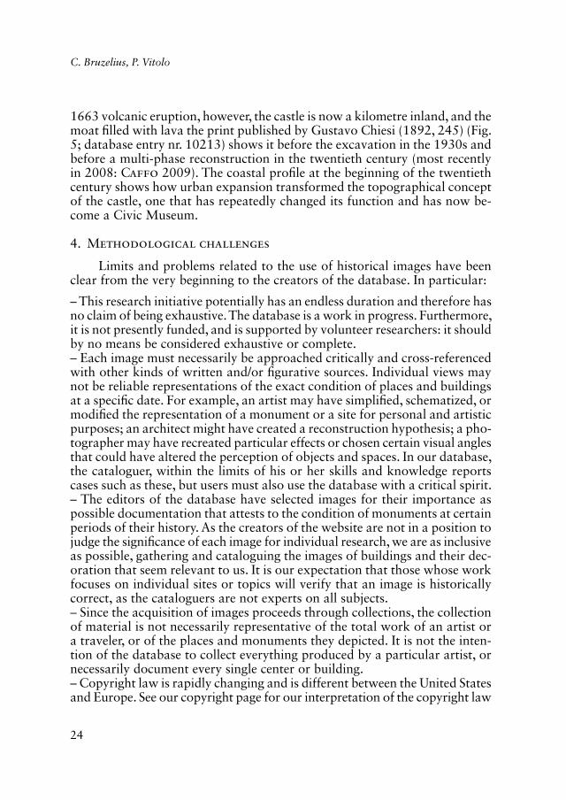
1663 volcanic eruption, however, the castle is now a kilometre inland, and the moat filled with lava the print published by Gustavo Chiesi (1892, 245) (Fig. 5; database entry nr. 10213) shows it before the excavation in the 1930s and before a multi-phase reconstruction in the twentieth century (most recently in 2008: Caffo 2009). The coastal profile at the beginning of the twentieth century shows how urban expansion transformed the topographical concept of the castle, one that has repeatedly changed its function and has now be-come a Civic Museum.
4. Methodological challenges
Limits and problems related to the use of historical images have been clear from the very beginning to the creators of the database. In particular:
– This research initiative potentially has an endless duration and therefore has no claim of being exhaustive. The database is a work in progress. Furthermore, it is not presently funded, and is supported by volunteer researchers: it should by no means be considered exhaustive or complete.– Each image must necessarily be approached critically and cross-referenced with other kinds of written and/or figurative sources. Individual views may not be reliable representations of the exact condition of places and buildings at a specific date. For example, an artist may have simplified, schematized, or modified the representation of a monument or a site for personal and artistic purposes; an architect might have created a reconstruction hypothesis; a pho-tographer may have recreated particular effects or chosen certain visual angles that could have altered the perception of objects and spaces. In our database, the cataloguer, within the limits of his or her skills and knowledge reports cases such as these, but users must also use the database with a critical spirit.– The editors of the database have selected images for their importance as possible documentation that attests to the condition of monuments at certain periods of their history. As the creators of the website are not in a position to judge the significance of each image for individual research, we are as inclusive as possible, gathering and cataloguing the images of buildings and their dec-oration that seem relevant to us. It is our expectation that those whose work focuses on individual sites or topics will verify that an image is historically correct, as the cataloguers are not experts on all subjects.– Since the acquisition of images proceeds through collections, the collection of material is not necessarily representative of the total work of an artist or a traveler, or of the places and monuments they depicted. It is not the inten-tion of the database to collect everything produced by a particular artist, or necessarily document every single center or building.– Copyright law is rapidly changing and is different between the United States and Europe. See our copyright page for our interpretation of the copyright law

25
The Medieval Kingdom of Sicily Image Database
as it presently stands in the United States, where the dataset is based (http://kos.aahvs.duke.edu/copyrightreuse.php).
5. Future development of the project
The editors of the database, in looking towards the future, have in mind the following steps:
1) Enlarge and expand the image collections of the database, gathering new material in European and American collections. To this end we will incorpo-rate a crowdsourcing component that can help us include private collections, such as the photographs and drawings of World War II veterans.2) Enlarge the geographical representation and typology of materials, focusing on geographical areas not yet well represented in the collection (Basilicata, Molise, Calabria).3) Amplify the typology of sources to include for example images in illumi-nated books.
At present, the research team and technical assistants are developing an interactive mapping function that will show the locations of sites in relation to the roads, ports, and other modes of travel and the geophysical and political features of the region. The new mapping component will be searchable by types of institutions (monasteries, churches, castles, palaces, gates, bridges, towers, etc.) as well as artistic styles or the names of artists or patrons. It will be possible to visualize the itineraries of Grand Tour travelers. These new capacities will enable scholars to craft a personal approach to their research questions, identifying for example the spread of certain types of strategic foundations (such as castles of religious groups), or to consider issues such as “center” and “periphery,” analyzing the relations of monuments and territory in relation to symbolic or strategic objectives within different local conditions. Finally, the map will permit the integration of this type of inquiry with the study of the itineraries of artists, architects, scholars and travelers of modern periods so that we may be able to reflect upon the accumulated knowledge derived from travel and movement through space.
6. Conclusion
It is our hope that this initiative will become a fundamental resource for the documentation and study of the rich historic patrimony (cities, works of art, buildings) produced in medieval South Italy. We also hope the project will assist in the research, restoration, and appreciation of the historic legacy of South Italy – not only in the major urban centers, but also in the smaller (but no less important) cities (such as Galatina, Nola, Nardò, for example) as well as the countryside. The research team is deeply committed to the

26
C. Bruzelius, P. Vitolo
history of monuments as part of the transmission of memory and identity, as well as the importance of historical preservation informed by the full range of documentary resources.
Caroline BruzeliusDepartment of Art, Art History & Visual Studies
Duke University, North Carolina [email protected]
Paola VitoloDipartimento di Architettura
Università degli Studi “Federico II” di [email protected]
REFERENCES
Bella T. 2017, Bâtir face à la mer: la Cathédrale normande de Catane en Sicile. État de la question, in L’art roman et la mer, «Les Cahiers de Saint-Michel de Cuxa», 48, 23-37.
Braun G., Hogenberg F. 1598, Civitates orbis terrarum, 5, Köln.Bruzelius C. 2014, The Norman Cathedral of Sant’Agata in Catania, in G. Bordi, I. Carlet-
tini, M.L. Fobelli et al. (eds.), L’officina dello sguardo. I luoghi dell’arte. Immagine, memoria, materia. Scritti in onore di Maria Andaloro, II, Roma, Gangemi, 121-126.
Bruzelius C. 2016, Visualizing the Medieval Past: The Kingdom of Sicily Image Database Project, in J.-M. Martin, R. Alaggio (eds.), Quei maledetti Normanni. Studi offerti a Errico Cuozzo per i suoi settant’anni da colleghi, allievi, amici, Ariano Irpino, Centro Europeo di Studi Normanni, 109-116.
Bruzelius C., Vitolo P. 2016, The Kingdom of Sicily Image Database, «Archeologia e Cal-colatori», 27, 107-130.
Cadei A. 1998, I castelli federiciani: concezione architettonica e realizzazione tecnica, in P. Toubert, A. Paravicini Bagliani (eds.), Federico II e la Sicilia, Palermo, Sellerio Editore, 183-201.
Caffo F. 2009, Castello Ursino di Catania. Gli anni dei restauri 1988-2008, Catania, Soprin-tendenza per i beni culturali e ambientali.
Chiesi G. 1892, La Sicilia illustrata nella storia, nell’arte, nei paesi, Milano, Sonzogno.Cianciolo Cosentino G. 2007, Francesco Saverio Cavallari (1810-1896). Architetto senza
frontiere tra Sicilia, Germania e Messico, Palermo, Caracol.Cometa M. 1999, Il romanzo dell’architettura: la Sicilia e il Grand Tour nell’età di Goethe,
Roma, Laterza.De Seta C. (ed.) 2001, Grand Tour: viaggi narrati e dipinti, Napoli, Electa.De Seta C. (ed.) 2006, Iconografia delle città in Campania: Napoli e i centri della provincia,
Napoli, Electa.De Seta C. (ed.) 2007, Iconografia delle città in Campania: le province di Avellino, Benevento,
Caserta, Salerno, Napoli, Electa.Di Blasi A. 2000, Il Castello Ursino di Catania e il suo ruolo territoriale, in G. Arena, A.
Riggio, P. Visocchi (eds.), Monastero e castello nella costruzione del paesaggio. I seminario di geografia storica (Cassino 1994), Perugia, Rux, 361-365.
Gandolfo F. 2007, Le Cattedrali siciliane, in A.C. Quintavalle (ed.), Medioevo: l’Europa delle Cattedrali. Atti del Convegno (Parma 2006), Milano, Electa, 191-207.
Giuffrè M., Barbera P., Cianciolo Cosentino G. (eds.) 2006, The Time of Schinkel and the Age of the Neoclassicism between Palermo and Berlin, Cannitello, Biblioteca del Cenide.

27
The Medieval Kingdom of Sicily Image Database
Gringeri Pantano F. 2009, L’isola del viaggio. Palazzolo Acreide, il Museo dei viaggiatori in Sicilia, Catania, Sanfilippo.
Maglio A. 2009, L’Arcadia è una terra straniera. Gli architetti tedeschi e il mito dell’Italia nell’Ottocento, Napoli, CLEAN.
Mangone F. 2002, Viaggi a sud: gli architetti nordici e l’Italia, 1850-1925, Napoli, Electa.Maurici F. 1997, Federico II e la Sicilia. I castelli dell’imperatore, Catania, Maimone.Nobile M.R. 2017, Medioevo meridionale reinterpretato in un sito della Duke University,
«Il disegno di Architettura», 41, maggio, 16-20.Pellé C. 1840, Les Iles et les bords de la Méditerranée, London, Fisher.Scamardi T. 1998, Viaggiatori tedeschi in Calabria: dal Grand Tour al turismo di massa,
Soveria Mannelli, Rubbettino.Smecca P.D. 2006, Viaggiatori britannici e francesi in Sicilia (1500-1915): bibliografia com-
mentata, Lugano, Agorà.Tuzet H. 1988, Viaggiatori stranieri in Sicilia nel XVIII secolo, Palermo, Sellerio.Vitolo P. 2016, The Kingdom of Sicily database project, in Virtual Museum of Archaeological
Computing, Itineraries-Projects (http://archaeologicalcomputing.isma.cnr.it/itineraries/projects/the-kingdom-of-sicily-database-project-and-the-collections-of-historical-imag-es-for-archaeological-studies/).
Vitolo P. 2017a, Il Medioevo, il paesaggio, le città: evocazione, interpretazione, documen-tazione. Il progetto The Medieval Kingdom of Sicily Image Database, in G. Belli, F. Capano, M.I. Pascariello (eds.), La città, il viaggio, il turismo. Percezione, produzione, trasformazione, Conference Proceedings (Naples 2017), Napoli, Cirice, 731-736 (avai-lable on: http://www.iconografiacittaeuropea.unina.it/, section Il Sud d’Italia tra schizzi e appunti di viaggio. L’interpretazione dell’immagine, la ricerca di una identità, eds. B. Mussari, G. Scamardì).
Vitolo P. 2017b, Un contributo allo studio del patrimonio artistico e architettonico dell’Italia meridionale: il progetto The Medieval Kingdom of Sicily Image Database, in P. Barbe-ra, M.R. Vitale (eds.), Sicily Through Foreign Eyes: Travelling Architects. La Sicilia nello sguardo degli altri: architetti in viaggio. Conference Proceedings (Siracusa 2017), Siracusa, LetteraVentidue, 489-505.
Vitolo P., forthcoming, The Tomb of Mary of Aragon in the Catania Cathedral as a represen-tation of the political context in the Aragonese Kingdom of Sicily.
SITOGRAPHY
British School at Rome. Digital Collections: http://www.bsrdigitalcollections.it/.Centro Interdipartimentale di Ricerca sull’iconografia della città europea (CIRICE): http://
www.iconografiacittaeuropea.unina.it/.Duke University, Wired! Lab: http://www.dukewired.org/.Getty Art&Architecture Thesaurus: http://www.getty.edu/research/tools/vocabularies/aat/.Istituto Centrale per il Catalogo e la Documentazione (ICCD): http://www.iccd.beniculturali.it/.Marburg Photo Archive: http://www.fotomarburg.de/.The Medieval Kingdom of Sicily Image Database: http://kos.aahvs.duke.edu/.The Society of Architectural Historians, SAHARA project: http://www.sah.org/publica-
tions-and-research/sahara/.

28
C. Bruzelius, P. Vitolo
ABSTRACT
The Medieval Kingdom of Sicily Image Database uses new media technologies to reframe our understanding of medieval Europe by focusing on the role of the built environment for the for-mation of State identity in the medieval Kingdom of Sicily during the Norman, Swabian, Angevin and Aragonese dynasties (c. 950-1420). The material in the database is important for two reasons: the significance of South Italy as a prototype of multicultural State formation and the highly frag-mentary condition (war bombardment, earthquakes, urban transformation) of the sites that played a central role in the power structures of the Kingdom. A comprehensive database of historical im-ages of monuments and cities (prints, drawings, maps, photographs) made by scholars, artists and travellers from the fifteenth century to the twentieth century, can enable scholars and the public to recover the appearance of the landscape, cities, and individual monuments prior to radical renovation or destructions. An interdisciplinary research team is conducting a systematic survey and critical cataloguing of images dispersed in the archives, museums and libraries of Italy, Europe and US.