Embed Size (px)
Citation preview

Archeological Reconnaissance ofBear Paw Battlefield,
Blaine County, Montana
National Park Service - Midwest Archeological Center

Archeological Reconnaissanceof Bear Paw Battlefield,Blaine County, Montana
By
Douglas D. Scott
Midwest Archeological CenterTechnical Report No. 73
United States Department of the InteriorNational Park Service
Midwest Archeological CenterLincoln, Nebraska
2001

This report has been reviewed against the criteria contained in 43CFR Part 7, Subpart A,Section 7.18 (a) (1) and, upon recommendation of the Midwest Regional Office
and the Midwest Archeological Center, has been classified as
Available
Making the report available meets the criteria of 43CFR Part 7, Subpart A, Section 7.18 (a) (1).

i
Abstract
An archeological reconnaissance was conducted of 1,400 acres within the Bear Paw Battlefieldboundary as defined in a recent general management plan. Although a heavy vegetation matte obscuredmost of the inventory area ground surface, the inventory team was able, by means of Global PositioningSystem units and a total station transit, to locate and map 36 stone circles, 29 rock cairns, 10 rockalignments, 55 battle-related riflepits, the soldiers’ mass grave, an early-twentieth-century trash deposit, ahomestead site, 1 battle-related artifact, 66 wooden staked locations related to the 1992 Anderson–Englishstudy, and 45 of C. R. Noyes’ staked locations. The project correlated the newly mapped data with olderdigitized maps of known features, sites, and staked locations. The newly mapped locations represent nomore than 30 to 40 percent of the known features on the property.

ii
Acknowledgments
The archeological investigations at Bear Paw Battlefield were facilitated by a number of people.Bear Paw Battlefield Site Manager Arthur Currence did everything in his power to make the crewcomfortable and ensure that we had all the support necessary. Dan Foster of Nez Perce National Histori-cal Park not only got the project off the ground, but was a real inspiration for the whole project. We owe aspecial debt of gratitude for their assistance and the warm reception given the crew.
The hard work of the archeological crew, Archeological Technician Harold Roecker and volunteersDick Harmon, Kelsey Attenhoffer, Connie Constan, Jim Magara, and David Thorn, is especiallyappreciated. Jon James, Big Hole National Battlefield, and volunteer Tom James assisted in the inventoryfor two days. Nez Perce National Historical Park Superintendent Doug Youri and Bear Paw BattlefieldSite Manager Arthur Currence joined the crew for one day, along with Otis Halfmoon, KathleenHalfmoon, and Carol High Eagle. This “extra” help is truly appreciated.
Jon’s insights into the history of the area were truly informative, and the community of Chinook onceagain opened its arms to us. We thank them for the great buffalo feed and especially wish to recognizeJude Southword of the Blaine County Museum and Andy Anderson for their generous help and constantencouragement.
Mark Lynott and Tom Thiessen, both at the Midwest Archeological Center, provided overall projectguidance and support, for which I am grateful. Carrol Moxham and John Andresen did their usualwonders with the manuscript, turning it into a final edited report.

iii
Contents
Abstract.......................................................................................................................................................... i
Acknowledgments ........................................................................................................................................ ii
List of Tables............................................................................................................................................... iv
List of Figures.............................................................................................................................................. iv
Introduction .................................................................................................................................................. 1Field Methods.......................................................................................................................................... 2Recording ................................................................................................................................................ 2
Prehistoric and Historic Archeology Background........................................................................................ 3Prehistoric–Protohistoric Cultural Sequences in Northern Montana ...................................................... 3
Early Prehistoric Period ..................................................................................................................... 3Middle Prehistoric Period .................................................................................................................. 4Late Prehistoric Period....................................................................................................................... 5The Protohistoric–Historic Transition................................................................................................ 5
Prehistoric and Protohistoric Site Types Found During Inventory............................................................... 7Lithic Scatters.......................................................................................................................................... 7Stone Circles............................................................................................................................................ 7Stone Cairns ............................................................................................................................................ 7Rock Alignments..................................................................................................................................... 8
The Battle Context — A Brief History......................................................................................................... 9
Relic Collecting and Metal Detecting at Bear Paw .................................................................................... 11
Battle-Related Features Recorded During the Inventory............................................................................ 13
Late Historic Period Artifacts and Features................................................................................................ 15General Observations ............................................................................................................................ 15
Conclusions and Recommendations........................................................................................................... 17
References Cited......................................................................................................................................... 19

iv
Tables
1. Summary of artifact types collected at Bear Paw Battlefield............................................................... 12
Figures
1. Bear Paw Battlefield and the surrounding area .................................................................................... 23
2. Bear Paw Battlefield during the inventory work, view to the west ...................................................... 24
3. Plot of sites and features found during the 2000 inventory.................................................................. 25
4. Plot of the Anderson–English stone circles, cairns, rock alignments, and riflepits ............................. 26
5. Andy Anderson standing at a stone circle site he found in 1992 ......................................................... 27
6. A stone cairn site used by soldiers during the battle. Anderson and English found armycartridge cases at this locale................................................................................................................. 27
7. Plot of the numbered stakes set by C. R. Noyes .................................................................................. 28
8. A portion of Thain White’s Bear Paw battle relic collection on display at the BlaineCounty Museum, Chinook, Montana................................................................................................... 29
9. The Gordon Pouliot Bear Paw battle relic collection, photographed at his home................................ 29
10. The Norman Johnson Bear Paw battle relic collection of artillery shell fragments ondisplay at the Blaine County Museum, Chinook, Montana ................................................................. 30
11. A Nez Perce riflepit located on the east bluff ...................................................................................... 30
12. An annotated 1930s photograph of Nez Perce shelter pits located in the ravine at the siegearea....................................................................................................................................................... 31
13. An annotated 1930s photograph belonging to C. R. Noyes of some of the Nez Perceriflepits ................................................................................................................................................. 31
14. A large Nez Perce shelter pit located in the camp area ........................................................................ 32
15. A 1930s photograph showing one of the Nez Perce riflepits on the east bluff. ................................... 32
16. An army riflepit with boulders piled on the military side and overlooking a ravine ........................... 33
17. Andy Anderson sitting in an army riflepit located east of the park boundary ..................................... 33
18. A 1930s photograph of the army soldiers’ mass grave......................................................................... 34
19. The mass grave in its current condition................................................................................................ 34
20. A plot map of both the 1992 Anderson–English inventory and the 2000 inventory ............................ 35

1
Introduction
Bear Paw Battlefield is situated within the open, moderately rolling prairie country of north-centralMontana along and adjacent to a portion of Snake Creek. The battlefield site is situated in the foothills ofthe north slope of the Bearpaw Mountains and occupies portions of two distinct topographic features. Thearea where the Nez Perce were camped when attacked by the Fifth Infantry, and the Second and SeventhCavalries, is on a level, primary terrace of Snake Creek. The prairie edge and surface to the east and westof Snake Creek ranges from 20 to 40 ft above this primary terrace, and on the east it is dissected byseveral ephemeral drainage systems trending toward the Nez Perce camp locale from the east andsoutheast. The majority of the battlefield site, and the primary locations where the army took up positionsagainst the Nez Perce, are on this prairie surface above the creek bottom.
Bear Paw Battlefield has been designated a national historical landmark and is protected by theNational Park Service (NPS) in cooperation with local and state authorities. Its closest federaladministrative ties are with Big Hole National Battlefield, Wisdom, Montana, which is the largest andgeographically closest part of the Montana Unit of Nez Perce National Historical Park (Figure 1). TheNPS maintains a site manager’s office in Chinook, Montana, consistent with the provisions of currentlegislation and cooperative agreements.
Nez Perce National Historical Park, with its headquarters in Spalding, Idaho, preserves and interpretsplaces that have significance to the culture and history of the Nez Perce Indians, whose Historic periodterritory ranged over what is now the northwestern United States and adjacent portions of Canada.Administratively one of the most complex parks in the National Park System, Nez Perce NationalHistorical Park oversees operations in 38 units in four states. Five units are owned by the NPS; the othersare cooperative efforts involving a variety of land ownership and jurisdiction situations, and Bear PawBattlefield is one of these cooperative efforts.
As part of its cooperative obligations, the NPS contracted a prehistoric archeological overview andassessment on behalf of Bear Paw Battlefield (Rennie and Brumley 1994) and included the battlefield in ageneral management plan (National Park Service 1997). The management plan defined a boundaryencompassing 1,400 acres, which includes most of the land on which battle-related activities occurred(Figure 2).
Bear Paw Battlefield is open to the public but has access restrictions and minimal visitor accom-modations. Much of the battlefield itself is fenced and closed to visitor traffic. A parking area and over-look provide a full view of the battlefield and surrounding scenery, and there is a trail through a portion ofthe battlefield for a walking tour. Near the parking area are two stone historic marker monuments erectedprior to the battlefield’s national historical landmark status that present a summary of the historic eventstransforming the late 1800s Nez Perce encampment into a battlefield.
The fenced central portion of the greater battleground area is managed by the NPS. Around this corearea, particularly on the east and south sides, are privately owned lands encompassed by the boundariesdefined in the NPS general management plan.
No formal archeological inventories have been conducted of Bear Paw Battlefield or the immediatearea. However, the battlefield has been the focus of research and collecting efforts by numerousindividuals for many years. Only a few of these collecting efforts are documented. The most extensivecollecting efforts were undertaken by the late Thain White of Dayton, Montana; Gordon Pouliot of WestGlacier, Montana; and Norman Johnson of Havre, Montana. Their efforts are well documented andconstitute a primary data set of the types and quantities of camp and battle debris left on the field after thebattle (Scott 1997). Local researchers Leroy “Andy” Anderson of Chinook, Montana, and Paul English ofHavre, have also identified rock cairns and rock alignments both within and adjacent to the parkboundary, some of which yielded metallic debris when they conducted preliminary metal detecting in thearea after the 1991 range fire.

2
Field Methods
With the help of volunteers, the Midwest Archeological Center (MWAC) conducted a surfacereconnaissance inventory between June 5 and 8, 2000, within the boundary defined in the generalmanagement plan. The work was limited to visual surface inventory.
Dan Foster of Nez Perce National Historical Park ably guided the crew and maintained intervalspacing. The crew was composed of MWAC Archeological Technician Harold Roeker and volunteersDick Harmon, Kelsey Attenhoffer, Connie Constan, Jim Magara, and David Thorn for the entire period offieldwork. Jon James of Big Hole National Battlefield and volunteer Tom James assisted in the inventoryfor two days. Nez Perce National Historical Park Superintendent Doug Youri and Bear Paw BattlefieldSite Manager Arthur Currence joined the crew for one day, along with Otis Halfmoon, KathleenHalfmoon, and Carol High Eagle.
The fieldwork consisted of the crew walking the grounds in a series of parallel transects until theentire park area and adjacent lands within the general management plan (GNP) boundary were covered.Transect spacing depended on vegetation density. Spacing was approximately 3 m in areas with goodground visibility and extended to 10 m between crew members when grass cover was so dense as toobscure the ground surface. Approximately 1,400 acres were covered at a reconnaissance level duringthis fieldwork. Nearly every area within the management plan boundary was covered with a dense vege-tative matte. Small portions of the northwestern or Miles (Napoleon) cannon pit area and some areas eastof the park boundary had ground visibility that approached 50 percent, but ground visibility was generallyless than 20 percent in most areas. The fieldwork is best characterized as reconnaissance level; that is,only the most obvious features were seen and recorded.
Recording
Standard MWAC archeological data-recording methods were used in each component of theoperation as specified below. Individual artifacts were recorded and noted in the electronic data log, andfield notes were also used to record the data. Exposed in situ artifact specimens and topography werephotographed and recorded digitally.
After covering several transects, recording was begun. Each artifact and feature was marked by a pinflag and piece-plotted as follows. A Sokkia total station transit was used to record the features within thepark boundary. A Precision Lightweight GPS Receiver (PLGR) was used to record coordinates offeatures observed outside the park boundary. The transit was set up at a selected grid coordinate markerdetermined by the PLGR. Distance and azimuth readings for each artifact and feature were recorded inreference to the known grid coordinates.
Each day’s electronic data was downloaded each evening into a laptop computer using the SokkiaMAP software and AutoCAD LT 98 to develop a field map. That data was edited, and AutoCAD LT 98was used for final map production for this report.

3
Prehistoric and Historic Archeology Background
Prehistoric–Protohistoric Cultural Sequences in Northern Montana
The following information on the prehistory of the area is borrowed from the Bear Paw Battlefieldprehistoric archeological overview prepared by Rennie and Brumley (1994). Their overview andassessment of the region’s prehistoric archeology is the best available summary of our current knowledgeof the area and poses some excellent research questions. Archeologists working on the NorthwesternPlains, which encompasses the project area, have found evidence of human occupation extending backover at least the last 11,000 years. The reader is referred to Frison (1991), Reeves (1969, 1973, 1983),Ruebelmann (1983), Brumley and Dau (1988), Vickers (1986), and Brumley and Rennie (1993) for athorough discussion of various models developed for interpreting the region’s prehistory.
Each chronological phase or cultural complex within the region is defined largely on the basis of oneor more distinctive projectile point styles or types. Ceramics appear intermittently within the prehistoriccultural record of the Northwestern Plains including northern Montana during the last 2,000 years; and,where present, they provide a second major criterion for definition of cultural complexes and chrono-logical phases. Relative and absolute dates for these phases and complexes are based on excavation ofsites where diagnostic forms have been found in stratified deposits. Organic materials such as bone andcharcoal that are associated with various assemblages can be radiocarbon dated, providing approximationsof the actual ages of the materials and the relative ages of materials from non-stratified sites. The threemajor cultural periods and their general defining characteristics are summarized immediately below.
Early Prehistoric Period
Dating from ca. 11,000 to 7,700 years BP, this period contains a number of archeological unitscharacterized by projectile point styles presumably designed for use on a heavy throwing or stabbingspear. Early Prehistoric period complexes recognized in northern Montana include Clovis, Goshen, AgateBasin, Hell Gap, Alberta, Cody, and the Plains/Mountain and/or Foothill Mountain complexes, and thepoint types of that period are generally variations on lanceolate or stemmed forms. Early Prehistoric orPaleoindian peoples appear to have been primarily big game hunters, with the earliest well-defined groups— Clovis and Goshen — known elsewhere to have hunted a variety of now-extinct animal speciesincluding mammoth. Later groups generally relied on early forms of bison as their primary food source.Evidence of stone boiling in the form of water-fractured, fire-cracked rock (FCR) is presently lacking forthe Early Prehistoric period. Evidence of Early Prehistoric period people in northern Montana is limitedand restricted to widely scattered surface finds that are interpretable only by reference to excavatedmaterials from other regions.
Materials similar to those identified elsewhere in the Northwestern Plains as Clovis and Goshen arerepresented in northern Montana by an isolated point from northern Blaine County (Deaver 1980) and bypoints recovered from the surface of four campsites situated within and adjacent to the BearpawMountains in Choteau, Blaine, and Hill Counties (Brumley 1988a). In addition to Clovis, an essentiallycomplete sequence of projectile points characteristic of the other Early Prehistoric period complexes havebeen recovered at several surface sites throughout the Bearpaw Mountains. Brekke (1970) describessurface finds from an extensive campsite located around a major spring in central Blaine County, justsouth of the Milk River valley. Materials recovered there include Hell Gap points and point typescharacteristic of Middle and Late Prehistoric period cultural complexes. Within the Milk River valley tothe east of Fort Belknap, Rossillon (1985) notes finding an isolated Paleoindian point she identified asAgate Basin. Ruebelmann (1983) reports an Agate Basin point, and Deaver (1980) reports an Albertapoint found on the surface at separate sites in Phillips County to the east of the Little Rockies. Noevidence of Early Prehistoric occupation has yet been reported within or near the project area.

4
Middle Prehistoric Period
Dating from about 8,000 to about 1,300 years BP, this period is characterized by projectile pointtypes presumably designed for use with a spear thrower or atlatl. Major complexes or phases includeMummy Cave, Oxbow, McKean, Pelican Lake, Yonkee, Sandy Creek, and Besant. Cultural groups duringthis period were predominately bison hunters. However, certain contemporary groups occupying the areaof central and southern Montana and Wyoming appear to have developed a more diversified subsistenceeconomy based on hunting a broader spectrum of animal species, as well as gathering and processing wildplant foods. Evidence of stone boiling in the form of water-fractured FCR is abundant throughout boththe Middle and Late Prehistoric periods. This evidence appears to reflect a major adaptive change in foodprocessing and storage technologies. Pottery first appears in some Besant phase sites during the latterpart of the Middle Prehistoric period.
Early side-notched atlatl points, characteristic of what is identified as the Mummy Cave complex,are well represented in surface finds at a number of site locales within and adjacent to the BearpawMountains (Brumley 1988a, 1988b).
The McKean complex is primarily characterized by the presence of McKean Lanceolate, Duncan,and Hanna atlatl point forms (Wheeler 1952). Another projectile point form referred to as Mallory hasbeen found, on occasion, in McKean complex assemblages from southern Montana to northern Coloradoand western Nebraska (Forbis n.d.; Lobdell 1973; Morris et al. 1984; Munson 1990; Reher 1979), butMallory points are not presently known from northern Montana. From central and southern Montanasouth, a number of McKean complex sites have produced grinding slabs and rock-lined hearths. Theseartifacts and features are commonly interpreted as reflecting an increased reliance on plant foods duringMcKean complex times (Frison 1991; Keyser 1986). Further north on the Canadian Plains, similarevidence is lacking, with McKean peoples predominately hunting bison for subsistence (Brumley 1975,1978). In northern Montana, McKean Lanceolate, Duncan, and Hanna projectile points are common insurface collections. However, no excavated or dated cultural assemblages have as yet been reported.
The Pelican Lake complex is recognized by most researchers as characterized by atlatl-size, corner-notched projectile points. However, a small number of Pelican Lake assemblages contain a few smallcorner-notched, arrow-point-size projectiles, suggesting the limited presence, or even full coexistence, ofbow-and-arrow technology. The few presently available radiocarbon dates for the Pelican Lake assem-blages containing these small points are all from sites situated on the Canadian Plains. These dates arequite early in terms of the overall time span for the Pelican Lake complex, suggesting the atlatl was notjust being replaced by the bow, but may have coexisted with it for a long period of time as a minor orsecondary weaponry system.
Brumley and Rennie (1993) note a trait dichotomy distinguishing the northern from the southernexpressions of McKean, Pelican Lake, and Avonlea complexes and phases. The southern assemblages ofthese complexes and phases, roughly located southward from central Montana, are characterized byoccasional to frequent rock-lined hearths and/or grinding slabs. These traits are absent from the corres-ponding northern assemblages.
Within the general study area, Davis and Stallcop (1965) report on excavations conducted at theKeaster site (24PH401), a multi-occupation bison kill site located in the south of Phillips County, a shortdistance west of the Little Rockies. Another poorly known cultural complex referred to as Sandy Creekhas been defined by Dyck (1983). Present evidence suggests the Sandy Creek complex to be temporallyintermediate and related to both the earlier Oxbow and the later Besant. Sandy Creek is characterized byrather non-descript, side-notched atlatl points which, out of dated contexts, could fit into the range ofvariation of points found associated with Mummy Cave, Oxbow, and Besant complex assemblages. Suchnon-descript points are abundant in surface collections from the Bearpaw Mountains (Brumley 1988a,1988b), and may reflect the presence of this phase within northern Montana.
Particularly abundant in northern Montana during the latter part of the Middle Prehistoric period arematerials referable to the Besant complex. The primary diagnostic artifact of the Besant complex is the
5
atlatl-size, shallow side-notched projectile point. The range of variation in Besant point form is broad andappears to overlap in part with the range of variation for projectile points of the earlier Mummy Cavecomplex and Sandy Creek phase, to which Besant peoples may have been related (Brumley and Dau1988; Brumley and Rennie 1993).
Herdegen’s Birdtail Butte site (24BL1152) is a small but extensively utilized campsite and bisonjump located near the southeast margins of the Bearpaw Mountains. Diagnostic projectile pointsrecovered from the surface in the campsite portion of the site include materials referable to the McKean,Pelican Lake, Besant, Avonlea, and Prairie/Plains complexes of the Middle and Late Prehistoric periods.Test excavations within the bison jump portion of the site revealed a series of 16 stratigraphic units withinfour meters of sediments.
Small, arrow-point-size versions of Besant projectile points have been found in some late Besantassemblages and are referred to as Samantha points. The presence of these points is believed to reflectlate Besant assemblages, when the transition from use of the atlatl to the bow and arrow was taking place.Ceramics have also been found in some Besant assemblages. It appears that ceramics become morefrequent in Besant assemblages as one proceeds east toward the Dakotas. In northern Montana, the onlyBesant ceramic association known is from a surface blowout site along Tiber Reservoir (Brumley n.d.).
Late Prehistoric Period
Dating from ca. 100 AD to historic times, this period is characterized by projectile points clearlyintended for use with the bow and arrow. Point forms include a variety of un-notched, stemmed, andnotched forms. Bison hunting remained the primary subsistence activity. Evidence of communal bisonkills, which involved coordinated efforts by groups of hunters driving animals over cliffs, into corrals, orinto natural traps, are present throughout the entire archeological record. They appear, however, to reacha peak in both number and magnitude during the Late Prehistoric period.
The Avonlea complex marks the introduction of the bow and arrow as the dominant weaponrysystem on the Northwestern Plains. The complex is defined largely on the basis of a form of delicate,very well made, side-notched arrow point. Small, well-made corner-notched arrow points referred to byReeves (1983) as Head-Smashed-In Corner-notched have been found in several Avonlea assemblages,usually occurring in very low frequency or as single specimens. Avonlea materials are abundant in theproject area, with sites consisting of both bison kills and campsites. Well-documented Avonlea sites innorthern Montana include Timber Ridge (Davis 1966), Three Buttes (Brekke 1969), Lost Terrace (Davisand Fisher 1988), Wahkpa Chu’gn (Davis and Stallcop 1965), Herdegen’s Birdtail Butte (Brumley 1990),Henry Smith (Ruebelmann 1988), Fantasy, Beaver Bend, and TRJ (Tratebas and Johnson 1988).Ceramics are reported only from the Fantasy site. Avonlea, because of its frequent occurrence and highlydistinctive character, has received considerable attention from researchers both within and outsidenorthern Montana (Davis 1988). It is clearly the best documented cultural complex in northern Montana.
The second Late Prehistoric projectile point complex recognized here is the Prairie/Plains Side-notched complex. Assemblages of this complex are dominated by Prairie/Plains Side-notched pointforms (Brumley and Dau 1988), but it should be emphasized that the Prairie/Plains complex encompassesa broad range of cultural variation.
The Protohistoric–Historic Transition
One of the first groups of explorers to examine portions of northern Montana was Lewis and Clark,who viewed the region along the Missouri River valley in May of 1805 and again in July of 1806 (Coues1965). Then and throughout the Historic period, north-central Montana was occupied principally by theAtsina and Gros Ventres, and secondarily by the Assiniboine and Blackfoot. Archeological sites knownto date to the Protohistoric and Early Historic periods, however, are quite rare in northern Montana.Brumley (1966) and Milne-Brumley (1974) documented historic human burials in the Milk River valleynear and north of Havre, and Ann Johnson (1975) described a petroglyph boulder near the Missouri Rivervalley depicting horse hoofprints.

6
Although archeological investigations within northern Montana began to increase beginning in the1960s and have contributed to the development and continued refinement of local and regional culturehistory models, no records of previous professional cultural resources inventories or other studiesspecifically within the defined Bear Paw Battlefield study area have been identified (Kurtz 1994).However, Passmann (1990) reports on the results of a negative inventory of a proposed stockwaterreservoir immediately outside the defined study.
Although as yet not fully documented, in 1992 and in several subsequent years Leroy Anderson,former director of the Blaine County Museum, and amateur archeologist Paul English personally con-ducted an informal but thorough surface inventory within much of the Bear Paw Battlefield study area.The materials they have identified in that study as being of definite or probable prehistoric age consistsolely of surface stone features. Anderson and English have plotted many of the identified surface stonefeatures on field maps. They have recorded the locations of approximately 90 tipi-ring-size stone circles,25 individual stone cairns, and 9 stone alignments or drive lines. It should be pointed out that none of thematerials identified by Anderson and English have yet been formally recorded as defined sites. Further,complete counts of surface stone features within the project area were apparently not taken, and certainfeatures that were of a problematic nature were excluded. The information gathered through the efforts ofAnderson and English, however, provide the only available data specific to the study area from which it ispossible to make general statements regarding the kinds and quantities of cultural resources that are ormay be present.

7
Prehistoric and Protohistoric Site Types Found During Inventory
Lithic Scatters
Lithic scatters usually consist of limited to extensive quantities of cultural materials largely or totallyexposed atop the ground surface. Observed materials most commonly consist of chipped-stone debitageand/or fire-cracked rock (FCR) along with more limited quantities of well-made stone tools and toolfragments. Most lithic scatters within the project region are on stable ground surfaces or exposed inslightly eroded areas; but in the former case at least, they lack stratification, datable organic materials, anddiagnostic artifacts.
One piece of FCR was found in association with six pieces of debitage in the northwest corner of thepark, UTM coordinates 5360274.2N/632473.3E. The area was covered in moderate to heavy vegetation,and the ground surface could not be fully examined. The few flakes appear to have derived from locallyavailable quartzite and argillite cobbles. Age and function could not be determined.
Stone Circles
Stone circles consisting of locally available unmodified stone are the most common surface featuresfound at archeological sites in northern Montana. Typically, stone circles within northern Montana consistof ovate to roughly circular concentrations of stones ranging from large cobbles to small boulders.
A total of 36 stone circles were found during the field investigations (Figure 3). Fourteen werelocated in two separate groups in the vicinity of the 12-pound Napoleon cannon pit in the northwesternarea of the GMP boundary, approximately 1,000 m northwest of the historic marker monuments. Threewere noted immediately west of the cannon pit and are located on gently rolling ground. They are about2.5 m in diameter, with the circle made up of small to moderate-sized cobbles. The remainder werelocated on a low rise located between two ravines that drain into an intermittent north–south trendingdrainage or creek east of the cannon pit feature. These stone circles varied in diameter from 2.5 to 4.5 m.These were also made up of small to moderate-sized cobbles.
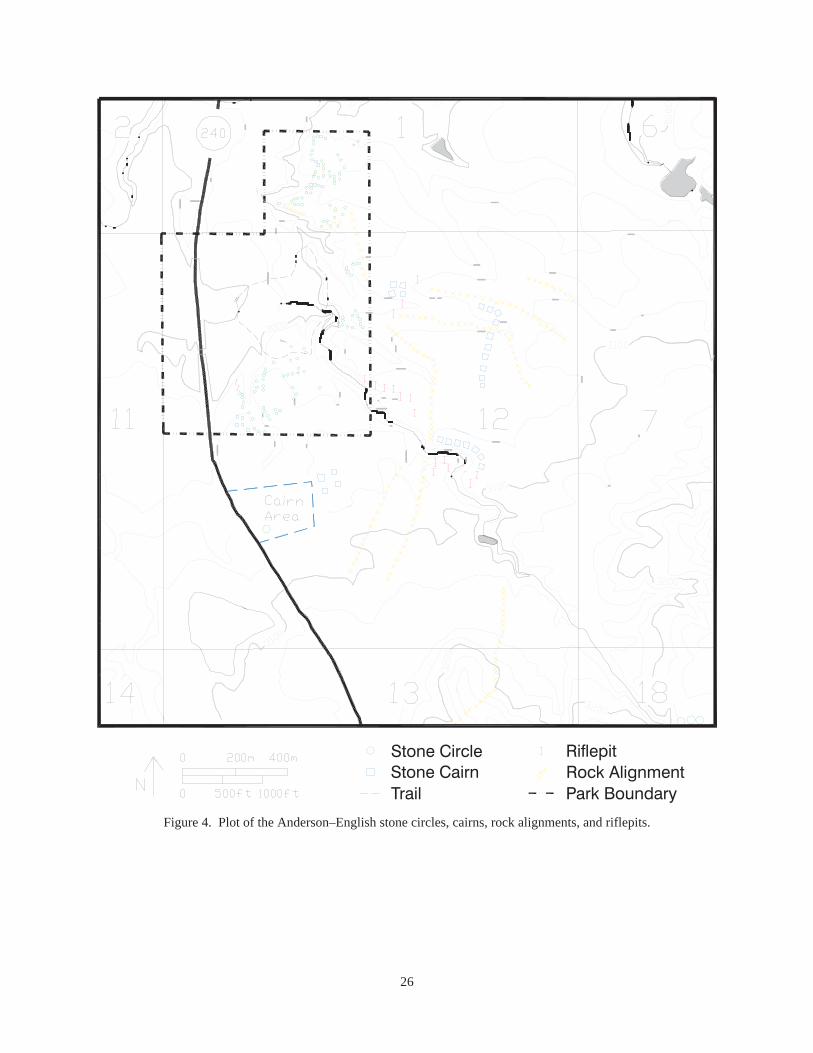
Within and east of the park boundary an additional 22 stone circles were noted and recorded. Fourare located within the park boundary, north of the foot trail and east of the north bluff. These four stonecircles were composed of small to moderate-sized cobbles arranged in a roughly circular formation. Eachcircle is about 4.5 to 6 m across. During the 2000 inventory, 30 wooden stakes were found and recordedthat probably relate to the 1992 Anderson–English inventory conducted after a range fire. Anderson andEnglish, according to their maps, noted at least 52 stone circles and 16 cairns in this same area (Figures4 and 5). Dense vegetation prevented the crew from determining if the identified wooden stakes repre-sented stone circles, cairns, or other features.
South and east of the Hotchkiss cannon site and extending outside the fenced park boundary, the2000 inventory effort found and recorded 18 stone circles and 36 wooden stakes. Diameters of the stonecircles averaged about 5 m. Most were 4.5 to 6 m in diameter. A few were much larger. One is nearly8 m in diameter. Anderson and English, according to their mapped locations, recorded 51 stone circlesand 16 cairns in the same area.
Stone Cairns
Stone cairns are another type of surface feature common within the project region (Figure 3). Rennieand Brumley (1994) define them as small to large piles of cobbles and boulders. They state that cairnscan vary significantly in size — from small ones made of 2 to 3 stones, to massive structures containingseveral tons of stone. Cairns can be found as separate structures and as elements of larger features such asrock alignments. In addition to having been constructed by historic and prehistoric native peoples, cairnswere also constructed by historic Euroamericans, particularly while clearing cultivated lands of stone. In

8
determining whether specific cairns are associated with the activities of past Native Americans or historicEuroamerican activities, Rennie and Brumley (1994) define four primary characteristics of a cairn:
(1) the location of the structure in relation to evidence of other prehistoric or historic materials oractivities;
(2) the extent of sodding around the stones comprising a cairn;
(3) the extent of lichen cover on the exposed surfaces of the stones comprising a cairn; and
(4) the nature of any associated cultural materials.
The 2000 field investigations noted and recorded 31 rock piles that meet the criteria of cairns. Tworock piles, one at the head of a ravine near the cannon pits and one on the northeast side of the park fenceline, are most likely rock rubble piles resulting from recent field-clearing work.
The remaining 29 are small piles of rocks and cobbles scattered over the park’s fenced area and tothe east of the park fence. Their ages and functions could not be reliably determined from the availableevidence. Anderson and English plotted at least 32 cairns in 1991 in the same general areas (Figures 4and 6).
Rock Alignments
A rock alignment, consisting of a series of cairns and/or a solid line of rocks, is another class ofsurface stone feature common in northern Montana, according to Rennie and Brumley (1994). Suchfeatures are generally interpreted as reflecting past communal ungulate hunting activities by NativeAmericans.
The current project recorded 10 rock alignments (Figure 3). Three were plotted in the northernfenced area between Death Point of Rocks and the north bluff overlooking the Nez Perce camp to thesouth. One alignment is on the eastern fence line, crossing the fence at a slight diagonal. It is located onboth sides of the eastern fence line. Six rock alignments were recorded east of the fenced area andanother on a ridge crest over 1,600 m south-southeast of the historic marker monuments located in theparking area.
Anderson and English identified 12 rock alignments during their inventory within the project area(Figure 4). Ten roughly correlate with the 10 found during the current project work.
9
The Battle Context — A Brief History
The final battle of the Nez Perce War of 1877 took place in the valley and on the surroundingterraces of Snake Creek. Detailed accounts of the battle are available elsewhere (McWhorter 1986, 1991;Beal 1963; Ege 1982; Brady 1916; Hare 1916; and Greene 1995; among others). For the purposes of thisarcheological report, only the essentials are presented.
After fighting a number of pitched battles and several skirmishes, the Nez Perce moved north towardCanada. In late September, they halted on Snake Creek north of the Bear Paw Mountains to restthemselves and their weary horses. The Nez Perce had outrun General O. O. Howard’s command andbelieved they were in a position to rest without fear of attack.
The Nez Perce were unaware that Colonel Nelson A. Miles was searching for them with anexpedition composed of two companies of the Second Cavalry, three of the Seventh, four of the Fifth In-fantry mounted on captured Sioux horses, two unmounted Fifth Infantry companies, a 1.65-inch (37-mm)Hotchkiss cannon, a 12-pound Napoleon cannon, and an attendant supporting wagon train.
During the morning hours of September 30, Miles began an attack on the Nez Perce village, whichlay in a shallow crescent-shaped valley. High bluffs and terraces dominated the valley. Miles deployedCompanies F and H, Second Cavalry, to capture the horse herd. These companies moved north and west.Their movements were further west than intended, but they succeed in capturing most of the herd.Company G of the Second pursued some Nez Perce who escaped the camp, and engaged them about fivemiles north of Bear Paw Battlefield.
Companies A, D, and K, Seventh Cavalry, attacked the village from the south side but were repulsedwith significant losses. Several charges were made by the army during the day. Mounted elements of theFifth Infantry moved along the village’s eastern bluffs and engaged the Nez Perce. Nez Perce losses wereonly about 22 killed, but the casualties were costly to the small Nez Perce force. They used the terraineffectively and dug riflepits to provide cover for the warriors; and they effectively held their ground, onlygiving way slightly to the ever-tightening circle of soldiers.
By evening Miles had effectively encircled the village, although White Bird and about 50 other NezPerce escaped and finally reached haven in Canada. Since Miles could not destroy or capture the villagewithout additional significant losses, he brought up the artillery and bombarded the camp. Skirmishingfrom riflepits continued for the next three days, with neither side making any headway.
Howard arrived with his command on October 3 and the stalemate was broken. Chief Josephsurrendered his band on October 5. The Nez Perce suffered 25 killed and at least 46 wounded. The armyhad 23 killed and 45 wounded. At least one, and possibly two, wounded later died. Of the soldier dead,all but four were Seventh Cavalrymen. The soldier dead were buried on the field, on the terrace south ofthe village site. The remains were later exhumed and moved to Custer National Cemetery. The NezPerce dead were also buried on the field and probably remain there today.

10

11
Relic Collecting and Metal Detecting at Bear Paw
Relic collecting at Bear Paw Battlefield has been a local recreational activity for at least 40 yearsaccording to several local informants, including Andy Anderson, Paul English, Gordon Pouliot, andseasonal Park Ranger Jim Magara. Perhaps one of the first persons to undertake examination and docu-mentation of the battle’s physical evidence was L. V. McWhorter. McWhorter’s interest in the Nez PerceCampaign is legendary. Accompanying battle participants, primarily Nez Perce, McWhorter ventured tothe various battlefields of 1877 and recorded the memories of the participants. McWhorter, using woodenstakes, marked many of the sites and features pointed out to him by the then-elderly participants. Copiesof McWhorter’s maps and notes are on file at Big Hole National Battlefield and the Midwest Archeo-logical Center. In 1935 and 1936, C. R. Noyes mapped the staked locations with chain and transit(Figure 7). Noyes produced the first truly accurate map of the field with the primary landscape denoted aswell as the locations staked by McWhorter and the Nez Perce battle participants. Copies of C. R. Noyes’map are on file at Big Hole National Battlefield and the Midwest Archeological Center.
It is well known that Bear Paw Battlefield was a ripe area for finding relics related to the battle.Incidental and serious collectors ranged over the site for many years. Unfortunately, most of these effortshave gone undocumented. Fortunately, there are several notable exceptions (Table 1).
Thain White visited and extensively researched and collected the site from the late 1950s through atleast 1975 (Figure 8). White relied heavily on the Noyes map for his collection efforts. He transcribedNoyes’ survey notes, thus saving them for current research efforts, and he transcribed many ofMcWhorter’s notes related to battle incidents. Copies are on file at Big Hole National Battlefield and theMidwest Archeological Center. Gordon Pouliot (personal communication July 23, 1994) indicated he hadmetal-detected the area with White. Both produced reasonably extensive documentation of their finds,and copies are on file at Big Hole National Battlefield and the Midwest Archeological Center, but theirdocumentation focuses on artifact descriptions rather than original locations. While this information isnot as precise as we might wish it by today’s standards, it nevertheless remains very good documentationof their collection efforts and finds. This is particularly true of White’s collection. White loaned hiscollection to a now-defunct museum in Spokane, Washington. When the collection was transferred to theCheney–Cowles Museum, and subsequently returned to White, many artifacts were missing.
O. W. Judge, another avid collector, found many items on the battlefield in 1962. White took thetrouble to document the Judge collection of Bear Paw artifacts, and copies of White’s documentation areon file at Big Hole National Battlefield and the Midwest Archeological Center. White recorded thesefinds with the same consistency as he had recorded his own collecting efforts. Thus, White’s documen-tation remains a primary resource in determining the types and quantities of artifacts associated with thebattlefield commonly found during the era he collected. The remaining artifacts from Bear Paw Battle-field are now on loan and displayed at the Blaine County Museum, thanks to the diligent efforts of AndyAnderson.
Gordon Pouliot also has an extensive collection of Bear Paw Battlefield material, which is still in hispossession (Figure 9). At least a portion of his collection is displayed in an outbuilding on his property.The Pouliot material duplicated the White collection, although included among the artifacts are a largegroup of crushed .45-70 cartridge cases, all smashed in the same manner. It is suspected these are armycases probably crushed by soldiers obeying orders to keep the Nez Perce from capturing them for reload-ing ammunition.
Another collector of the 1960s and early 1970s was Norman Johnson. Johnson also documented hisfind locales, and a copy of his documentation is on file at the Midwest Archeological Center. Most of hiscollection is on display in the Blaine County Museum in Chinook (Figure 10).
Leroy “Andy” Anderson is another avid Bear Paw researcher and park supporter. He, Paul English,and a few others began a metal detector and visual inventory of the battlefield and surrounding area after arange fire in 1991. They, too, have documented their find locations, and copies of their notes and map are

12
on file at Bear Paw Battlefield and the Midwest Archeological Center. The map is included as part of theRennie and Brumley (1994) prehistoric overview. Among their finds are .45-70 cartridge cases and tincans. The cans and cartridge cases were found outside the boundary fence when they were staking thevarious features found after the fire. Most cartridge cases are .45-70 Benet primed. Both short- and long-crimp internally primed cases are present. There are two externally primed with slightly convex heads inAnderson’s collection that may postdate the battle. The can tops and one body may be from the battleperiod. They are all hole-in-top with heavy solder. Two are rectangular meat can types, but all are small.The round type may be a size 2 or 2½.
Table 1. Summary of artifact types collected at Bear Paw Battlefield.
ArtifactType
WhiteCollection
PouliotCollection
JohnsonCollection
Anderson–English Collection Total
.44 Henry Cartridges —
.44 Henry Cartridge Cases 15
.44-40 Cartridges 1
.44-40 Cartridge Cases 13
.44 Bullets 8
.45-70 Cartridges 16
.45-70 Cartridge Cases 410
.45-70 Benet Primers 14
.45-70 Bullets 278
.45 Colt Cartridges 9
.45 Colt Cases 13
.45 Colt Bullets 5
.50-70 Cartridges 4
.50-70 Cartridge Cases 7
.50-70 Bullets 8
Miscellaneous Bullets and Balls —
Miscellaneous Cartridge Cases 5
Lead Fragments 20
12-Pound Cannon Shell Fragments 2
Bormann Fuses 2
Canister Balls 106
1.65" Hotchkiss Shell Fragments 13
1.65" Hotchkiss Fuse Fragments 2
1.65" Hotchkiss Brass Band Fragments 11
Miscellaneous Artifacts 28
1
26
—
—
5
9
200+
—
75+
6
9
4
—
11
2
14
2
—
4
—
22
7
2
2
43
—
3
—
—
—
8
108
—
67
1
—
—
—
2
1
1
4
1
2
—
9
9
1
4
20+
—
1
—
—
—
—
18
—
2
—
—
—
—
—
—
—
2
—
—
—
—
—
—
—
9
1
45
1
13
13
33
736+
14
422+
16
22
9
4
20
11
15
11
21
8
2
137
29
5
17
100+
Total 1706+
13
Battle-Related Features Recorded During the Inventory
The battlefield has a number of currently visible features associated with the battle, and some aremarked and interpreted. Riflepits are present and easily seen on all portions of the battlefield.
The current project recorded 55 depressions that appear to fit the criteria for riflepits or shelter pits,perhaps more properly called hasty entrenchments. Thirty-two of the depressions or hasty entrenchmentswere found and recorded in the village area and on the ridges above the village site (Figures 11–14).Thirteen were recorded in six locales south and east of the army positions, with most outside the currentpark boundary fence (Figures 15–17), and 10 were recorded about 1,000 m west of the village area.
These latter 10 are the cannon emplacement and associated riflepits used by the artillery crew and itsprotective force during the bombardment of the Nez Perce village during the battle (Figure 3). The 12-pound Napoleon cannon emplacement is a large pit with eight riflepits located north and south of the largepit. The arrangement is linear. A single isolated pit is located 160 m northeast of the main cannonemplacement (Figure 3). This pit may be a picket post or possibly the second emplacement of the1.65-inch Hotchkiss cannon.
The 13 hasty entrenchments found south and east of the village area are uniquely situated. One is atthe head of a ravine south of the fenced boundary (Figure 16), three are along the margins of the southeastcoulee near the southeast fence corner, two are on a bench and ridge above the southeast coulee, two areon the margins of the next coulee north, three others are on the margins of a large coulee that overlooksthe village, and finally, two entrenchments are found north of the large coulee that looks down on thevillage area. These riflepits are situated so they overlook the logical routes of movement to and from thevillage. It is likely these depressions are hasty entrenchments placed in strategic locations to thwart anyNez Perce trying to leave or enter the village via cover provided by the coulees.
When entrenchments are mentioned in the Indian Wars literature, they are often referred to as hastilydug entrenchments, quickly dug, a mound of earth thrown up for protection, or a shallow riflepit. Suchstatements leave the impression of haphazard construction to meet an immediate and life-threateningneed. They also convey a feeling of unpreparedness on the part of those constructing the earthwork — alack of familiarity, training, or knowledge of the purpose or use of a earthwork, beyond that of turning afew bullets in the immediate engagement. None of this could be further from the truth.
The common perception of military engagements in the west is one of a running fight betweenantagonists or hit-and-run tactics of Indians versus the Euroamerican encroacher. A review of the historicliterature relating to the Indian Wars era demonstrates that various types of earthworks were used incombat situations between Native Americans and Euroamericans. An interesting sidelight is that NativeAmericans did construct and utilize several types of entrenchments in much the same manner as theEuroamerican combatants. Limited archeological investigation (Bray 1958; Scott 1994) of earthworks inthe trans-Mississippi West demonstrates that the earthworks constructed by Euroamericans, specificallysoldiers, were not hasty or haphazard as is the common perception. They were constructed according toprocedure outlined in various military guides of the period.
The American classic, and one that guided the construction of earthworks in the Mexican War andthe Civil War, is D. H. Mahan’s 1836 A Complete Treatise on Field Fortification, with the GeneralOutlines of the Principles Regulating the Arrangement, the Attack, and the Defense of Permanent Works.Hasty fortifications were defined as those constructed so that troops could take better advantage of theopportunities of natural cover (Mahan 1847). Nevertheless, hasty entrenchments were not to be the rule.American and, for that matter, European military thought was dominated by the concept of massed frontalassault. The use of entrenchments was to play a defensive role.
Dennis Mahan’s treatise on field fortifications was uniquely American in that it recognized that mostAmerican wars would be fought by militia and only the few regulars would be the most disciplined. If

14
defense was necessary, then the militia could build and occupy field fortifications strong enough to resistthe enemy’s frontal assault until a well-organized counterassault could displace them (Hagerman 1965).
Not until the latter part of the nineteenth century did military theorists begin to formalize the conceptof small-unit tactics. Small-unit movement, essentially at the squad level, was introduced in EmoryUpton’s 1872 Infantry Tactics, but these were only mechanical movements, not fighting tactics.
Unfortunately, the army published few formal field manuals for small units before the beginning ofthe twentieth century. However, a number of practical guides for officers were privately publishedthroughout the century to bridge the gap left by the lack of official guidance available outside the WestPoint classroom. One of the most-used guides was Captain Edward Farrow’s Mountain Scouting. Farrowwas an instructor at West Point when he wrote his practical guide in 1881. He had seen active fieldservice during the Nez Perce campaign of 1877 and was with Howard when he arrived at the Big Hole.Farrow (1881:243) noted, “The history of all battles of late years has shown the expediency of making useof natural shelter or constructing field entrenchment’s.”
Military manuals of the early twentieth century are more structured than Farrow’s instructions, butthey describe essentially the same procedure for digging riflepits and trenches in the face of the enemy.Moss (1918:385–387) is a good example of such a work, and provides some clear definitions of thepurpose of such works.
Moss (1918:385) states that the object of field fortifications are twofold: first, to increase the fightingpower of the troops by enabling the soldier to use his weapons with the greatest possible effect; andsecond, to protect the soldier against the enemy’s fire. While the military objective might be stated in thatorder, the doughboy might have reversed the priority order.
Although written nearly forty years after Farrow’s 1881 publication, the Moss description ofentrenchment methods and types is very similar. It can be argued that riflepits or hasty entrenchments,those meant to be constructed in the face of the enemy, did not change in type or need. Even the WorldWar II “foxhole” as described in the manuals of that period does not differ significantly in purpose orconstruction from that advocated by Farrow in 1881.
The strong similarity in size and construction method of the archeological examples of riflepitsat Fort Dilts (Haury 1989), Big Hole National Battlefield (Scott 1994), the Reno-Benteen defense site(Bray 1958), and Bear Paw Battlefield to the methods of entrenchment described in the period manualsemphasizes that the term hasty entrenchment does not mean haphazard. Hasty entrenchments were a realtype of earthwork that were constructed in a prescribed manner. Organized forces requiring hastyentrenchments to be dug in the presence of the enemy were trained and disciplined, and thus dug theirhasty entrenchments in the manner in which they had been trained.
The Nez Perce riflepits are more irregular in outline than the known army riflepits. Such differencesprobably reflect the different cultural practices of the two combatant groups, and could be the subject offurther archeological investigation and interpretation.
Another prominent feature on the field is the site of the army’s mass grave (Figures 18–19). Theburials were removed many years ago, but the pit or trench is still very visible. Fragments of human bone,army uniform buttons, boots, and items of equipment are reported to have been found in the excavatedtrench and in the backdirt pile over the years according to Andy Anderson and seasonal Park Ranger JimMagara. This location was mapped during the current project.
Only one battle-era artifact was seen and recorded during the field investigations This is a .45-caliber 405-grain lead bullet. The bullet had been fired from a .45-caliber Springfield army rifle orcarbine. The bullet was found, and left in place, on the south-facing slope of a ravine about 680 m northof the historic marker monuments.

15
Late Historic Period Artifacts and Features
Two late-nineteenth- or early-twentieth-century trash dumps, two dugouts, and a single isolatedceramic fragment were recorded during the fieldwork. The ceramic fragment was found near the park’ssoutheast corner, but outside the boundary. It is a fragment of white ironstone.
A trash dump or trash scatter containing miscellaneous metal and portions of a ceramic figurine werelocated south of the park boundary fence near the highway, approximately 650 m south-southwest of thehistoric marker monuments.
A second trash scatter associated with two dugouts cut into a ravine sideslope was recorded 530 mnorthwest of the historic marker monuments. The trash scatter contained a variety of metal and glass, andthe glass was from bottle and jars. The diagnostic material, scattered over a 50-m area on the flat abovethe ravine, dated to the early twentieth century, certainly the first quarter of the century.
One dugout was immediately west of the trash scatter. It was an irregularly shaped, but roughlyrectangular depression about 8 m long east to west and 4 m wide north to south. This may have been thesite of a shed or root cellar. The second depression was cut into a south-facing bank of the ravine as itcurved from north to northwest. The depression is about 20 m long east to west and 8 m wide north tosouth. This may have been the site of a domestic structure, possibly a house.
General Observations
The Anderson–English work in 1992 recorded 147 possible features, exclusive of riflepits (Figure 4).These possible features included 103 stone circles, 32 cairns, and 12 rock alignments. The 2000archeological inventory recorded 36 stone circles, 29 cairns, 10 rock alignments or portions thereof, and66 wooden stake location (Figure 3). The stake locations had such dense vegetation covering the area thatthe feature the stake marked could not be discerned. Exclusive of the stake locations and riflepits, the2000 project recorded 75 features, and it recorded 51 percent of the features found by Anderson andEnglish after the 1991 range fire. If the stake locations are factored in, then the 2000 project found 141locations, exclusive of riflepits, or 96 percent of the 1992 Anderson–English find locations. Since thevegetation was too dense to identify the stake locations in 2000, it more appropriate to say that only 51percent of the 1991 features were relocated (Figure 20).
Anderson and English recorded 18 possible riflepit locations in 1991, but they did not record anyriflepits in the Nez Perce village area. Instead, their riflepit locations are in the southeast area of the parkand outside the boundary. The 2000 project recorded 46 riflepits, most of which are in the village area.Excluding the village riflepits, the 2000 project recorded 12 riflepits around the park and east and south ofthe boundary. While there is some correlation between the two projects’ riflepit locations, it is general atbest (Figure 20). For instance, the current project did not record as many riflepits near the southeastcorner as Anderson and English did, 3 versus 12, respectively. The differences may be due to severalfactors. One is the change in the density of the vegetation between 1991 and 2000. A second differenceis the unwillingness of this author to call every subtle depression a riflepit, if it does not meet any othercriteria for hasty entrenchments, such as a definitive earth berm or rocks placed more on the firing sidethan the other.
C. R. Noyes mapped the L. V. McWhorter stake locations in 1935 and 1936. According to the map,Noyes placed 153 stakes around the field indicating the locations of riflepits, Nez Perce tepee sites, andvarious other features and locales associated with the battle. The staked locations were replaced bynumbered, metal-capped rebar several years ago. Those metal stakes were cut down and set flush with theground in 1998. The 2000 visual inventory found only 45 of the Noyes–McWhorter staked sites, or alittle over 29 percent, since the thick grass prevented the team from seeing most of the staked locations. Ifmetal detectors had been employed to find the locations, there is little doubt that many more would havebeen found.

16

17
Conclusions and Recommendations
Bear Paw Battlefield is well known; physical evidence of the battle has been collected by the variousmetal detectorists, and some of these collecting efforts have been documented. Copies of various notesand collections descriptions are on file at Big Hole National Battlefield, Bear Paw Battlefield, and theMidwest Archeological Center. The McWhorter stake locations as depicted on the Noyes map weredigitized using AutoCAD in 1994 (Scott 1995). The 2000 inventory used a total station transit and a GPSunit to map the locations of all field finds. Using Noyes survey stations, several of which were recordedduring the 2000 inventory, as registration points in the AutoCAD map, the 2000 data was imported to acopy of the 1994 digitized version. The correlation between the points is not perfect: there is a relativelyconsistent error between the digitized Noyes stake locations and those Noyes stakes mapped in 2000.That error is about 13 meters between the digitized version and the 2000 version. There is a greater errorobserved between the Anderson–English digitized locations and the 2000 mapped locations of the samefeatures. We believe the error between the digitized Noyes locations and the 2000 mapped Noyes stakesis due to the standard error commonly found in digitizing data from photocopied maps rather than theoriginal map and to the use of the only available USGS 7.5-minute quadrangle maps which are over 20years old, as well as to minor errors on the original map and minor registration errors in the digitizing.These can be rectified with further detailed mapping of the site at some point in the future.
The differences between the Anderson–English locations and those same features mapped in 2000are relatively straightforward. Anderson and English used the available orthophoto map of the area onwhich they plotted their finds’ sites by eyeball. Without clear and easily defined reference points, someerror in plotting occurred. The differences between the 1991 data and the 2000 mapped data are notice-able but not extreme. The 2000 mapped data are the more precise.
Regardless of the accuracy in the 2000 mapping, one is struck by the significantly lower numbers offeatures found and recorded by the current effort than those of previous efforts. Compared to theAnderson–English 1991 work, the 2000 team only found 51 percent of those features. Even allowing forinter-observer error, this is a significant difference. While the 2000 team did find 96 percent of theAnderson–English staked locales, the dense grass growth since 1991 obscured our ability to determinewhat was at most of those staked locations.
The effect of the dense grass growth is doubly noted when comparing the known Noyes stakelocations versus those recorded in 2000. Only 29 percent could be found by visual inventory. The densevegetation matte confounded our ability to effectively find the previously known sites and features. Weestimate that the 2000 inventory found and recorded, at best, only 30 to 40 percent of the known sites andfeatures within the Bear Paw GMP boundary. For this reason the 2000 inventory effort can only beconsidered a reconnaissance level at best. It is also for this reason that no site forms were generated forthis project. Since only 30 or 40 percent of the known features were relocated, it was determined that anysite forms generated would be full of error and imprecision that would bias future recording efforts. Thedata generated for this project should be considered an initial recording effort and be used as baseline datafor future inventory and recording efforts.
One recommendation resulting from this inventory is that detailed mapping of Bear Paw Battlefield’ssites and features should continue as opportunities permit. The 2000 inventory and mapping is incom-plete due to the thick vegetation matte. As prescribed burns are done or the vegetation matte is reducedby other means, mapping and feature recording should be done as soon as possible.
At least one conclusion can be drawn from the previous and current work concerning the distributionof hasty entrenchments or riflepits. It is patently obvious that some riflepits were placed at strategicpositions overlooking several deep coulees that could be used for escape or other movements. The shapeof the riflepits found in these locations is relatively regular and the orientation is generally toward the NezPerce positions. It is reasonable to assume that these are army riflepits placed by design to prevent theNez Perce from escaping the cordon that was thrown up around them during the battle. As such, their

18
placement is the physical reality of, and provides some additional insight into, the strategy and tacticsemployed by Nelson Miles and his officers.
Nez Perce and army riflepits appear different in construction and design. In interpreting culturaldifferences in warfare the riflepits offer a unique opportunity to explain what constituted appropriatecover for combatants reared in different cultures. Several riflepit features are readily visible and conven-iently located adjacent to the current interpretive trail. These features could be archeologically excavatedto ascertain their construction techniques. They could be compared to one another to determine culturaldifferences in construction and further compared to riflepits from other battles to expand our under-standing of how different cultures built and used riflepits.
Bear Paw Battlefield has yielded many artifacts to collectors and earlier researchers. Those extantdocumented collections form a core of physical evidence on the battle. They also demonstrate theresearch potential of the in situ artifacts. The battlefield has yielded and undoubtedly still containspatterned data that can be extracted, analyzed, and interpreted using available archeological techniquesand theory. The battlefield should be systematically metal-detected to recover that patterned informationat some point in the future when all parties can agree to the procedure. The in situ data coupled withadditional analysis of the extant collection has a very high potential to reveal details of the battle notrecorded in the historic record, and to yield new insights about the battle and its participants.
19
References Cited
Beal, Merrill1963 “I Will Fight No More Forever.” Ballentine Books, New York.
Brady, Cyrus Townsend1916 The Epic of the Nez Perce. In Northwest Fights and Fighters, edited by Cyrus Townsend
Brady, pp. 3–43. Doubleday, New York.
Bray, Robert T.1958 A Report of Archeological Investigations at the Reno-Benteen Site, Custer Battlefield National
Monument, June 2 – July 1, 1958. Manuscript on file, National Park Service, Midwest Archeo-logical Center, Lincoln.
Brekke, A.1969 Antiquity in North Central Montana. Archaeology in Montana 10(3):1–11.
1970 Three Buttes Bison Kill (24BL104). Archaeology in Montana 11(4):39–54.
Brumley, J.H.1966 The Lost River Burial. Archaeology in Montana 7(4):1–14.
1975 Radiocarbon Dates from the Wahkpa Chu’gn Site. Archaeology in Montana 16(2):105–116.
1978 McKean Complex Subsistence and Hunting Strategies in the Southern Alberta Plains. PlainsAnthropologist, Memoir 23(82, Part 2):175–193.
1988aAn Examination of Archaeological Materials from the Bear Paw Mountains Area of NorthernMontana. 2 Volumes. Ethos Consultants Inc., Havre, Montana. Report prepared for and on file atthe Montana State Historic Preservation Office, Helena, Montana.
1988bMedicine Wheels on the Northern Plains: A Summary and Appraisal. Manuscript Series No. 12.Archaeological Survey of Alberta, Alberta Culture and Multiculturalism, Edmonton.
1990 Investigations at Herdegen’s Birdtail Butte Site (24BL1152). Ethos Consultants, Inc., Havre,Montana.
n.d. Description and Evaluation of Various Ceramic Materials from Various Areas of Montana.Manuscript in possession of the author.
Brumley, J.H., and Barry J. Dau1988 Historical Resource Investigations Within the Forty Mile Coulee Reservoir. Manuscript Series
No. 13. Archaeological Survey of Alberta, Alberta Culture and Multiculturalism, Edmonton.
Brumley J., and P. Rennie1993 The Results of Investigations at the King Site Along the East Margins of the Little Rocky
Mountains. Ethos Consultants, Inc., Havre, Montana. Prepared for and on file at Fort BelknapCollege, Harlem, Montana.
Coues, E. (editor)1965 The History of the Lewis and Clark Expedition. 3 volumes. Reprinted 1965, Dover Publica-
tions, Inc., New York. Originally published 1893 in 4 volumes by Francis P. Harper, New York.
Davis, L.B.1966 Avonlea Point Occurrence in Northern Montana and Canada. Plains Anthropologist 11(32):
100–116.
1988 Avonlea Yesterday and Today: Archaeology and Prehistory. Saskatchewan ArchaeologicalSociety, Regina.

20
Davis, L.B., and J.W. Fisher Jr.1988 Avonlea Predation on Wintering Plains Pronghorns. In Avonlea Yesterday and Today: Archae-
ology and Prehistory, edited by L.B. Davis, pp. 101–118. Saskatchewan Archaeological Society,Regina.
Davis, L.B., and E. Stallcop1965 The Keaster Site (24PH401): A Stratified Bison Kill Occupation in the Missouri Breaks Area of
North Central Montana. Memoir No. 2. Montana Archaeological Society, Missoula, Montana.
Deaver, Ken1980 Archaeological Site Distribution in North Blaine County, Montana. Prepared by Pro-Lysts, Inc.,
for the Bureau of Land Management, Lewistown District Office, Eugene, Oregon.
Dyck, I.G.1983 The Prehistory of Southern Saskatchewan. In Tracking Ancient Hunters: Prehistoric Archae-
ology in Saskatchewan, edited by H.T. Epp and I. Dyck. Saskatchewan Archaeological Society,Regina.
Ege, Robert J.1982 After the Little Bighorn, Battle of Snake Creek, Montana Territory, September 30 to October 5,
1877. Fred Werner, Greeley, Colorado.
Farrow, Edward1881 Mountain Scouting. Privately published by the author, New York.
Forbis, R.G.n.d. Signal Butte and MacHaffie: Two Stratified Sites on the Northern Great Plains. Manuscript on
file, Department of Archaeology, University of Calgary.
Frison, George C.1991 Prehistoric Hunters of the High Plains. Academic Press, New York.
Greene, Jerome A.1995 The U.S. Army and the Nee-Me-Poo Crisis of 1877: Historic Sites Associated with the Nez
Perce Conflict. Draft on file, Pacific Northwest Regional Office, National Park Service, Seattle,Washington.
Hagerman, Edward1965 The Evolution of Trench Warfare in the American Civil War. Ph.D. dissertation, Department of
History, Duke University, Durham, North Caroliina.
Hare, W.H.1916 Chief Joseph’s Own Story. In Northwest Fights and Fighters, edited by Cyrus Townsend
Brady, pp. 44–75. Doubleday, New York.
Haury, Cherie E.1989 The North Dakota Archeological Association State Centennial Project: Fort Dilts (32BO6).
Contribution No. 252. Department of Anthropology, University of North Dakota, Grand Forks.
Johnson, Ann1975 Hoofprint Boulder (24RV1026). Archaeology in Montana 16(1):43–48.
Keyser, J.D.1986 The Evidence for McKean Complex Plant Utilization. Plains Anthropologist 31(113):225–235.
Kurtz, L.1994 Results of site file search request to Patrick Rennie, Ethos Consultants, Inc., Havre, Montana,
from Leanne Kurtz, Montana State Historic Preservation Office, Helena, Montana. Dated April 29,1994.

21
Lobdell, J.1973 The Scoggin Site: An Early Middle Period Bison Kill. The Wyoming Archaeologist 16(1).
Mahan, Dennis1847 An Elementary Treatise on Advanced-Guard, Out-Post, and Detachment Service of Troops.
Wiley and Putnam, New York.
McWhorter, L. V.1986 Hear Me My Chiefs! Nez Perce History and Legend. Edited by Ruth Bordin. Caxton Printers,
Caldwell, Idaho.
1991 Yellow Wolf: His Own Story. Caxton Printers, Caldwell, Idaho.
Milne-Brumley, Laurie.1974 The Fox Burial Site (24HL413). Archaeology in Montana 15(2):1–26.
Morris, E., R. Blakeslee, and K. Thompson1984 Preliminary Description of McKean Sites in Northeastern Colorado. In McKean/Middle Plains
Archaic: Current Research, edited by M. Kornfeld and L. Todd, pp. 45–50. Occasional Papers onWyoming Archaeology No. 4. Wyoming Recreation Commission, Cheyenne.
Moss, James1918 Manual of Military Training. George Banta Publishing, Menasha, Wisconsin.
Munson, G.1990 Archaeological Investigations at 24RB1164. GCM Services, Inc., Butte, Montana. Report pre-
pared for Peabody Coal Company’s Big Sky Mine, Area B, Rosebud County, Montana.
National Park Service1997 General Management Plan for Nez Perce National Historical Site and Big Hole National
Battlefield. Published online at <http://nps.gov/biho/gmp1.htm> Document created September1997; posted October 12, 1999; acessed March 5, 2001. U. S. Department of the Interior, NationalPark Service, Washington, D.C.
Passmann, D.1990 A Surface Inventory of Approximately 1 Acre of Land. Conducted in response to a proposed
stockwater reservoir immediately outside defined study area.
Reeves, B.O.K.1969 The Southern Alberta Paleo-Cultural Paleo-Environmental Sequence. In Post-Pleistocene Man
and His Environment on the Northern Plains, edited by L.B. Davis, R.G. Forbis, O.A. Christensenand G. Fedirchuk, pp. 6–46. The University of Calgary Archaeological Association and theStudents’ Press, Calgary.
1973 The Concept of an Altithermal Cultural Hiatus in Northern Plains Prehistory. AmericanAnthropologist 75(5):1221–1253.
1983 Culture Change in the Northern Plains: 1000 B.C. – A.D. 1000. p. 390. Occasional PaperNo. 20. Archaeological Survey of Alberta, Alberta Culture, Edmonton.
Reher, C.1979 The Western Powder River Basin Survey. Unpublished report prepared by and on file at the
Office of the State Archaeologist, University of Wyoming, Laramie, for the Bureau of Land Manage-ment, Wyoming State Office.

22
Rennie, Patrick, and John Brumley1994 Archeological Overview and Assessment of Bear’s Paw Battlefield State Park, Blaine County,
Montana. Ethos Consultants, Havre, Montana. Prepared for the National Park Service, MidwestArcheological Center, Lincoln, and the Rocky Mountain Region, Denver. Report on file, NationalPark Service, Midwest Archeological Center, Lincoln, Nebraska.
Rossillon, M.1985 Preliminary Report of Archaeological and Historic Investigation in the Fort Belknap–East High-
way Project Area (F1-7(4)430). Manuscript on file, Montana Department of Highways, Helena.
Ruebelmann, G.A.1983 An Overview of the Archaeology and Prehistory of the Lewistown BLM District, Montana.
Archaeology in Montana 24(3)1–165.
1988 The Henry Smith Site: An Avonlea Bison Procurement and Ceremonial Complex in NorthernMontana. In Avonlea Yesterday and Today: Archaeology and Prehistory, edited by L.B. Davis, pp.191–202. Saskatchewan Archaeological Society, Regina.
Scott, Douglas D.1994 A Sharp Little Affair: The Archeology of the Big Hole Battlefield. Reprints in Anthropology
Volume 45. J and L Reprints, Lincoln, Nebraska.
1995 Historic Archaeological Overview and Assessment of the Bear Paw Battlefield, Blaine County,Montana. Manuscript on file, National Park Service, Midwest Archeological Center, National ParkService, Lincoln, Nebraska.
1997 An Assessment of the White, Pouliot, Johnson, and Anderson–English Relic Collection from theBear Paw Battlefield, Blaine County, Montana. Manuscript on file, National Park Service, MidwestArcheological Center, Lincoln, Nebraska.
Tratebas, A., and A.M. Johnson1988 Three Avonlea Bison Kill Sites in the Milk River Drainage of Northeastern Montana. In Avon-
lea Yesterday and Today: Archaeology and Prehistory, edited by L. B. Davis, pp. 89–100.Saskatchewan Archaeological Society, Regina.
Tutherly, Herbert E.1898 Elementary Treatise on Miltary Science and the Art of War. Free Press Association, Burlington,
Vermont.
Vickers, R.1986 Alberta Plains Prehistory: A Review. Occasional Paper No. 27. Archaeological Survey of
Alberta, Alberta Culture, Edmonton.
Wheeler, R.P.1952 A Note on the “McKean Lanceolate Point.” Plains Archaeological Conference Newsletter
4(4):45–50.

23
Figure 1. Bear Paw Battlefield and the surrounding area.

24
Figure 2. Bear Paw Battlefield during the inventory work, view to the west.

25
Figure 3. Plot of sites and features found during the 2000 inventory.
26
Figure 4. Plot of the Anderson–English stone circles, cairns, rock alignments, and riflepits.

27
Figure 5. Andy Anderson standing at a stone circle site he found in 1992.
Figure 6. A stone cairn site used by soldiers during the battle. Anderson and English found army cartridgecases at this locale.

28
Figure 7. Plot of the numbered stakes set by C. R. Noyes.

29
Figure 8. A portion of Thain Whites’s Bear Paw battle relic collection on display at the BlaineCounty Museum, Chinook, Montana.
Figure 9. The Gordon Pouliot Bear Paw battle relic collection, photographed at his home.

30
Figure 10. The Norman Johnson Bear Paw battle relic collection of artillery shell fragments on display at the BlaineCounty Museum, Chinook, Montana.
Figure 11. A Nez Perce riflepit located on the east bluff.

31
Figure 12. An annotated 1930s photograph of Nez Perce shelter pits located in the ravine at the siege area.
Figure 13. An annotated 1930s photograph belonging to C. R. Noyes of some of the Nez Perce riflepits.

32
Figure 14. A large Nez Perce shelter pit located in the camp area.
Figure 15. A 1930s photograph showing one of the Nez Perce riflepits on the east bluff.

33
Figure 16. An army riflepit with boulders piled on the military side and overlooking a ravine.
Figure 17. Andy Anderson sitting in an army riflepit located east of the park boundary.

34
Figure 18. A 1930’s photograph of the army soldiers’ mass grave.
Figure 19. The mass grave in its current condition.

35
Figure 20. A plot map of both the 1992 Anderson–English inventory and the 2000 inventory.

36