Embed Size (px)
Citation preview
archi DOCT The e-journal for the dissemination of doctoral research in architecture.
Supported by the ENHSA Network | Fueled by the ENHSA Observatory
enhsaeuropean network
of heads of schools of architectureenhsa
european network
of heads of schools of architecture
European Observatory of Doctoral Research in Architecture
SCARCITY
January2014www.enhsa.net/archidoct
ISSN 2309-0103 2
ISSN 2309-0103www.enhsa.net/archidoctVol. 1 (2) / January 2014
66//
Nan
cy C
oulin
g
Scar
city a
nd O
cean
Spa
ce- C
ase-
stud
y Bar
ents
Sea
, Nor
way
Scarcity and ocean space - Case-study Barents Sea, NorwayNancy Couling // UEPFL- Swiss Federal Institute of Technology Lausanne // Switzerland
AbstractUrban systems operate at a multitude of scales, densities and levels of specialization over vast areas of the planet, as has been pointed out by Lefebvre in The Production of Space and The Urban Revolution and more recently by Neil Brenner and Christian Schmid in their essay Planetary Urbanization. Pressure on ocean space for energy production, extraction of resources, infrastructural and logistical development is steadily increasing, making the ocean a site of spatial and environmental convergence, a type of urban “hinterland”. While ephemeral in relative dimensions over time , critical nodes are beginning to emerge where the vast scale of the ocean is confined by physical limits. The first part of this paper examines ocean space in terms of scarcity within this context.
Scarcity has been discussed as a relational term, relative to need or demand (Samuel and Robert, 2010) and in fact as a condition produced by ever-changing and newly created “needs”(Luks, 2010). In spite of market dynamics, some commodities have a stable and absolute quantity. “[…] the total quantity of the stuff named H
2O remains unchanged through the hydrological
cycle, neither created nor destroyed”(Samuel and Robert, 2010, p.110).
The limitedness of ocean space completes the conception of a finite world. It also highlights the inherent problematic of measurable quantities and boundaries in relation to scarcity, both of which pose challenges to current design vocabulary and planning methods. Marine resources are considered a common heritage of mankind. The UN supports the “Marine Spatial Planning” (MSP) initiative, currently being carried out by a handful of countries and ideally aimed at a bal-ance of both use and protection of marine resources. Examples of MSP demonstrate, however, the strong link between economic priorities and ocean planning. This point will be illustrated by spatial plans for the German EEZs in the North Sea, since MSP is well advanced in Germany. Limits to conventional planning, and the need for a new form of design when dealing with a complex, three-dimensional ecosystem such as the ocean, become apparent. Part one concludes with selected theoretical positions, which can serve to inform spatial conceptualizations better adapted to ocean conditions.
This discussion draws on a case-study carried out by the EPFL laboratoire Bâle (laba) on the Barents Sea- a resource-rich territory four times the size of Norway. Here, for the first time, the receding ice-front has made both the vast oil and gas reserves more readily accessible and the Northern Sea Route commercially viable, posing a critical environmental dilemma. The design re-search resulted in both long-term development plans, called ‘Territorial Constitutions’ - consisting of a plan and written articles of constitution- followed by architectural projects anchored within this framework. Selected projects, which illustrate innovative ways of designing with the specific characteristics of the ocean, will be discussed in the second part of this paper.
KeywordsOcean space; resources; compexity; scale; flux.
67//
ISSN 2309-0103www.enhsa.net/archidoctVol. 1 (2) / January 2014
Scarcity and ocean space - Case-study Barents Sea, Norway
I: Scarcity and Ocean Space
A finite spatial world
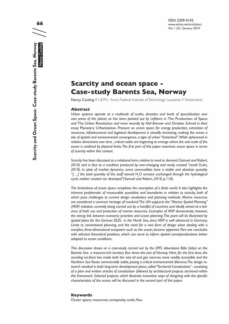
According to oceanographer Robert Ballard, one of the most important events of the Apollo 8 mission to the moon on December 1968 was when they turned the cameras back on Earth and saw it from this perspective for the first time [Fig. 1]. “our world seemed more fragile & finite than ever before” (Ballard, 2000, p.4).
Scar
city a
nd O
cean
Spa
ce
While Ballard believed that the oceans should receive more attention, heightened in-terest in the oceans is resource-driven and predominantly superficial (of the surface) in character. This has resulted in a quantum shift in scale and intensity of ocean use. Maritime trade has utilized the ocean as a global connector throughout history, including its energy sources such as the trade and monsoon winds, leading to periods of unprece-dented expansion of trade and territory (de Landa, 1997).
The current period of exponential increase in shipping traffic began in the 1960s with the twin revolutions of containerized shipping and mechanized bulk transport, encouraged initially by low fuel prices and the move away from state control to market economy approaches (Stopford, 2009). According to the United Nation Conference on Trade and Development’s 2008 “Review of Maritime Transport”, over 80% of world merchandise trade by volume is carried by sea, making maritime transport the backbone supporting international trade and globalization (Asariotis, Benamara, Hoffmann and Wilmsmeier, 2008).
Researchers predict that the globalisation trend is set to level off due to world recession, since fuel costs are limiting the speed and relative cost-effectiveness of supplying goods from even Chinese markets (Rubin, 2008). Such pressure makes the new Northern Sea
Figure 1. view of the earth from Apollo 8, 1968. ( NASA )
ISSN 2309-0103www.enhsa.net/archidoctVol. 1 (2) / January 2014
68//
Route between Europe and Asia interesting for international trade, since it boasts better security, cost and time-saving advantages over the Suez Canal, and is suitable for the next generation of giant container ships of 15-20,000 TEU (twenty-foot equivalent container units). Currently the “Suez max” and also the maximum size for the enlarged Panama Ca-nal is 12,500 TEU (396m long). Changing ice conditions along Russia’s Northern coastline have only recently made this route commercially viable – the first transit ship sailed in September 2010 and traffic is expected to increase exponentially.
Access to offshore resources, including oil, gas, mineral deposits and renewable energy sources represent a further area of increased activity and spatial occupation. Oilrigs are being installed in ever greater depths as deposits in shallower waters become fully ex-ploited. In the Barents Sea, the Norwegian Ministry for the Environment has established a pre-defined area for the allocation of licensing blocks for petroleum exploration activ-ities. This corresponds with their commitment to “pave the way for petroleum produc-tion in the areas that have been opened” (Royal Norwegian Ministry of the Environment, 2011, p.135).
Urbanized territories are connected across the ocean through dense infrastructur-al networks supplying energy, communication and goods. Extensive clearing, laying, and maintenance processes are initiated, new nodal zones established, and priority corridors secured. This web is thickening into a new type of occupation, which, due to overlapping spatial demands, requires planning and management. Research shows that almost no part of the ocean remains unaffected by human impact (Halpern et al., 2008). The oceans, therefore, represent the final conceptual link to completing a finite spatial world.
The advancing scarcity of ocean space
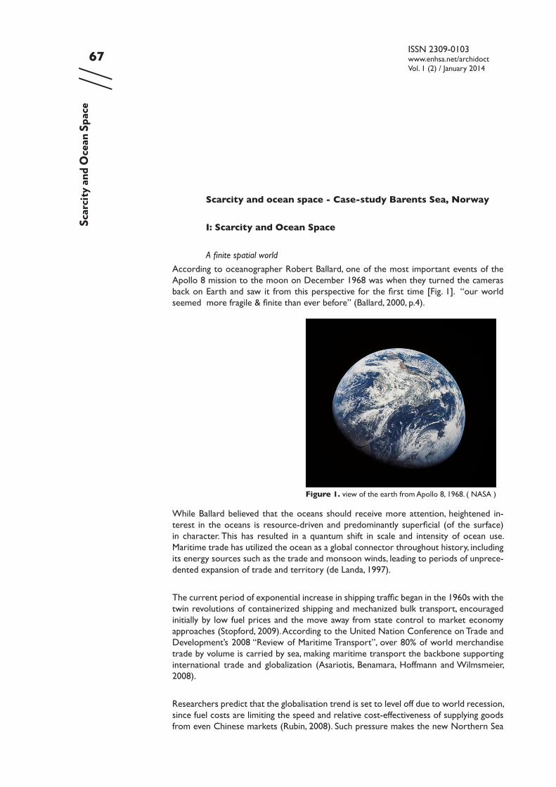
The doctrine of the freedom of the seas, a principle put forward in the 17th century, which limited a state’s jurisdiction over ocean territory to a narrow coastal strip of three nautical miles had generally been accepted until the mid-twentieth century. However, increasing conflicts at sea, threats of pollution, the need to regulate the expanding ship-ping trade, and multiple claims to territories further offshore, led the United Nations to initiate a comprehensive legal framework for ocean space. This process began in 1949, resulting in the first United Nations Convention on the Law of the Sea (UNCLOS) at the Conference in Geneva in 1958. The third Convention of 1982, subsequently defined a na-tion’s exclusive economic zone to a distance of 200 nautical miles offshore, and included regulations for the use of this zone. [Fig. 2]
In certain areas of the globe, for example the industrialized North Sea, the Mediterra-nean, large areas of both the China Sea and the Pacific Ocean, and the Barents Sea itself, the maximum 200 nautical-mile limit cannot be met and the spatial division is negotiated between the exclusive economic zones of neighbouring countries.
The definition of an offshore exclusive economic zone through UNCLOS enabled coast-al nations to clarify and coordinate diverse spatial demands. Marine Spatial Planning is an example of such a process.
Scar
city a
nd O
cean
Spa
ce
69//
ISSN 2309-0103www.enhsa.net/archidoctVol. 1 (2) / January 2014
As activity in ocean space intensifies and becomes spatially organized through planning processes and international legal mechanisms, economic priorities clearly emerge.
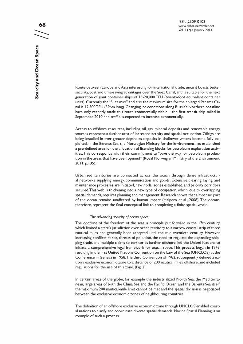
Ensuring the efficiency and security of shipping transportation and demarcating areas for energy production and nature reserves have been the drivers of the Marine Spatial Plan for the German EEZ in the North Sea [Fig. 3]. In particular, this example is marked by pressure to build offshore wind-farms which will make a significant contribution to Ge-
Scar
city a
nd O
cean
Spa
ce
Figure 2. Ocean space division- ca. 64% “high seas” (international waters), & 36% within a national EEZ. ( http://en.wikipedia.org/wiki/File: International_waters.svg. Author:B1mbo. Modified by laba (Gugger, Couling and Blanchard, 2012) )
Figure 3. Marine Spatial Plan, German EEZ in the North Sea 2009. (BSH (Bundesamt für Seeschifffahrt und Hydrographie/German Maritime and Hydrographic Agency))
ISSN 2309-0103www.enhsa.net/archidoctVol. 1 (2) / January 2014
70//
many’s renewable energy target of 30% by 2020. The plan shows designated traffic routes, which determine space available for potential wind-farm development - currently a total of 880km2 in the North Sea. These, in turn, require transformer and converter platforms, seafloor cables and a network of high-voltage power lines on land. Also marked in the plan are areas designated under the EU “Natura 2000” programme for the protection of important natural flora/fauna and bird habitats.
Although offshore wind-farms are producers of “green” energy, spatial conflicts occur with natural populations, for example migrating birds. Planning legislation has as yet not resolved such cyclic use patterns in ocean space, otherwise perceived as a void with no physical obstructions.
This concept of the ocean as merely an empty surface has been researched by political geographer Philip Steinberg. In “The Social Construction of the Ocean”, Steinberg dis-cusses how ocean space was perceived and “constructed” in different historical periods and cultural contexts. Frequently, ocean trade-routes were seen as crossing a non-de-velopable and therefore irrelevant space. The early industrial period is such an example;
This rationalist idealization of the ocean as empty and featureless was com plimented by romantics who praised the ocean for its wild nature that resisted taming by the forces of modernity. (Steinberg, 2001, p.118)
Can scarcity be the argument for intensified offshore energy production and fossil-fuel extraction?
The Barents Sea is predicted to contain 25% of the world’s oil and 33% of the world gas reserves, putting the territory under extreme development pressure. Helge Lund, Chief executive officer of Norway’s Statoil, argues that “energy is the catalyst for human & social development”, a catalyst that, according to Lund, 1,7 billion people still have no access to in the form of electricity. Statoil’s gas markets, however, are almost exclusively European, linked to six landing points in France, Germany, Belgium and the UK.
Peter Droege, specialist in sustainable urban strategies, maintains that none of this oil and gas is required. He advocates instead decentralized wind, solar biomass and hydropower facilities, locally linked to provide the alternative to a conventional power supply sys-tem (Droege, 2008). “Demand” for these resources then follows the model of relativity described in the introduction to this paper and raises the question of the real cost of resources according to either mainstream economics or ecological economics (Luks, 2010).
How can a discussion on ocean space avoid the political and economic paradigms of scarcity and which design instruments can assist in describing an alternative approach? A closer examination of three characteristics of ocean space; scale, complexity and flux, exposes the limits of terrestrial spatial models and opens up new conceptual possibilities.
Scar
city a
nd O
cean
Spa
ce
71//
ISSN 2309-0103www.enhsa.net/archidoctVol. 1 (2) / January 2014
Scale
The above outline of shipping, offshore energy sectors, and MSP has described a ‘limited’ space according to conventional concepts of scale and the allocation of boundaries.
Yet, in the case of the oceans, systems are interrelated, physical boundaries non-existent and the minute directly connected to the vast.
One of the AA-led “Beyond Entropy” investigations examining form in relation to ener-gy, articulates this point:
The notion of energy subverts the concept of a homogeneous space-time continuum- with each proposal interacting with its temporal and spatial con- text. [...] The continual subdivision of scale from big to small is subverted by the continuous emergence of the very big within the very small (Pansera, 2011, p.109)
Neither natural habitats nor consumer end-products are restricted by boundaries at sea- birds, fish and ocean mammals travel vast distances on a regular basis. Similarly, the ocean receives plastic waste from the world’s waterways, which is then distributed by ocean currents and harboured in locations far from the origin. Plastic is however also redistributed on a minute scale- ground down to tiny particles, indistinguishable from other food sources and subsequently eaten by fish and birds.
Planning ocean space, therefore, challenges the application of scale as an analytical de-vice. In her essay “The Problem of Scale”, Iná Elias de Castro discusses how the content of phenomena changes with the change of scale. In cartographic representation, the in-crease in homogeneity appears at an inverse ratio to scale – whereas in reality, the large scale is more heterogeneous. Allocating large areas of “untouched” ocean surface at the scales represented in Marine Spatial Planning inevitably simplifies and reduces the real content of such areas. “When size changes, so does the content… What are the new contents at these new dimensions?” (Iná Elias de Castro, 2002).
Dealing with scale in ocean planning requires specific tools and representations; tools of analysis which reveal important cyclic systems and critical moments in time and ocean space irrespective of their “size” or frequency, and modes of representation with-in which these findings can be described and recorded.
Complexity
The ocean’s seeming lack of visible structure, direction and enclosure, suggests rhizomic space - open, smooth, undefined space. Deleuze and Guattari discuss the rhizome attri-butes of what they have defined as ‘smooth space’- non-hierarchical and non-directional quality and behaviour. The sea is “the smooth space par excellence” (Deleuze and Guat-tari, 2005, p. 479). The smoothness of this space refers to its power of de-territorialisa-tion and to the directional property of the space, which, like a vector, is always changing.
Scar
city a
nd O
cean
Spa
ce
ISSN 2309-0103www.enhsa.net/archidoctVol. 1 (2) / January 2014
72//
Smooth space resists closing off and allocation. In smooth space one “distributes oneself in open space, according to frequencies and in the course of one’s crossings” (ibid, p.481).
Space in the ocean can be divided into layered zones; airspace, sea surface, sea body, seabed, and under-seabed (Nolte, 2010). While the ocean surface may be described as “smooth space”, the sea body is a rich and complex environment. Each stratum requires particular treatment in terms of potential use and protection. The open sea is perceived from the surface as a vast, neutral, scale-less, boundless, directionless expanse- which determines its value as a potentially integrative, confluent, non-ascribed territory- but further strata are occupied by large populations and many forms of life. This combina-tion of abstraction, or “blankness” (Kipnis, 2009, p.101) and complexity concealed from non-specialist perception, is characteristic of ocean space.
The way in which contemporary urban space, in particular the unoccupied voids, can be understood as a potential is discussed by Albert Pope in his essay “Mass absence”. Pope argues that the modernist attempt to design space for a political collective was ended by the subsequent dominance of totalitarian regimes in Europe. An important change brought about by modernism, however, was the dominance of space over form: “Space, not form became the dominant phenomenal effect of the built environment” (Pope, 2009, p.63)Pope sees this modern, unbounded, yet neglected space as being a truly “free space”, full of possibilities; “we are presented not so much with neutral fields, as with latent potentials that might give rise to more complex conditions” (ibid p.28), and in fact, the space which best represents our contemporary condition; ” … space is a more ap-propriate response to the fluid constituencies and unstable identities in which we exist today” (ibid, p. 60)
Ocean space, due to its stratified composition, can therefore be seen as both a pure, ab-stract, “smooth” surface space, representing the potential of our contemporary, “open” spatial condition and a complex dynamic natural habitat. It follows that an effective ocean planning must encompass the full depth of this spatial realm, including its diverse condi-tions and requirements.
Flux
The ocean is an ecosystem, within which, effects of interactions may be far-reaching and, in fact, unpredictable. Conditions are dynamic and characterized by flux. The territori-alisation of the ocean has been structured around systems of flow and exchange - new and historic trade routes as well as the permanent materialization of trade into trans-ocean energy arteries. As a liquid medium, the ocean would seem to provide an ideal environment of minimal friction, ease of transfer, and reduced boundary situations for such systems. Undersea pipelines, for example, are chosen precisely for these reasons;
“Offshore lines minimize issues of land ownership and concerns of political instability.” (Timmermans, 2002)
Conceptualising urban dynamics in terms of flows leads to non-linear systems. De Landa describes a non-linear model of market dynamics which he argues was critical in the
Scar
city a
nd O
cean
Spa
ce
73//
ISSN 2309-0103www.enhsa.net/archidoctVol. 1 (2) / January 2014
development of the European urban landscape, emphasising the importance of “mesh-works” which were developed out of multiple, volatile interactions between smaller en-tities (de Landa, 1997, p.44). One such meshwork was a network of long-distance trading centres in the Middle Ages, or “gateway cities” which diffused heterogeneous material- goods as well as ideas (ibid, p.40). Gateway cities in direct contact with the sea, which were also capitals, as in the case of London and Amsterdam in the 16th & 17th centuries, were in the strongest position not only to dominate ocean trade and colonisation, but also to maintain stability at home.
In their collection of essays on Heterogeneous Space in Architecture, Hensel, Menges & Hight define one of the characteristics of heterogeneous space as its state of flux, created by “the immanent field of relations between differentials” (Hensel, Menges and Hight, 2009, p. 13). The authors then argue that such a manifold set of relations between intertwined systems leads directly to ecology: “Heterogeneous spaces therefore suggest approaching the relationship between agents and environment with an ecological ethic” (ibid, p.16).
Planning is traditionally based on fixed parameters. Ocean planning, however, faces the challenge of balancing fixed elements and elements in a constant state of flux which de-mands the integration of time into planning strategies.
Conclusion Part I
These ideas enrich the spatial understanding of the ocean site. Characterised by flux, non-linear dynamics, an interrelated system of extreme scale and diversity, the ocean is itself a living agent in constant interaction with organic and inorganic elements. In terms of scarcity, ocean systems resist linear demarcation and standard forms of quantifica-tion. “If we let go of limits, we also let go of the vague “apeiron” of infinity and embrace finitude: not as scarcity, or as limit, but as coexistence in the disquieting flux of time” (Morton, 2012).
Morton argues against both the Greek concept of infinity (apeiron, - a “vague limitless blur.. out of which everything manifests”) and the idea that we live in an age of limits. Instead he proposes that abundance be embraced through the relationships between the earth’s plenitude of life-forms.
II. The Barents Sea
Master students at laba studied the Barents Sea as a developing territory in the 2011/12 academic year. In terms of space and resources, the Barents is a territory of abundance, where Europe’s last large, clean, intact marine ecosystem hangs in the balance of ex-panding fossil fuel extraction and increased shipping activities. Investigations into suitable areas for wind and wave-power are also in their early stages.
Scar
city a
nd O
cean
Spa
ce
ISSN 2309-0103www.enhsa.net/archidoctVol. 1 (2) / January 2014
74//
The strategic development of infrastructure, the provision of access and the complex grid of international networks active in the region are indicators of a particular type of urbanism operating at the territorial scale. But the investigation also gave us the opportu-nity to research the dynamics of other forces, driven, for example, by important fish, bird and plankton life. A differentiated underwater topography is one of the physical char-acteristics of the site as well as the seasonal transformation from a liquid to solid state, which allows the polar bear population, for example, to move from one archipelago to another. Throughout the average depth of 230m, the site is constantly changing according to currents, temperature, salinity and migration. The complexity, vulnerability and critical importance of this territory on a global scale soon became apparent.
These rich and diverse local conditions formed the basis for five proposals for territorial development. The work demonstrates innovative urban design methods and principles as applied to ocean territory and offers a possible interpretation of the ideas of scale, complexity and flows as described above.
Complexity: Sustainable Harvesting
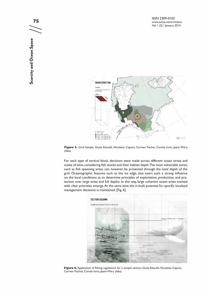
This project proposed a resource management strategy for the Barents Sea using a four-dimensional system designed to address the complexity of the water column’s layers over time. Therefore exemplary sections through the Barents Sea became the predomi-nant tool rather than surface representations.
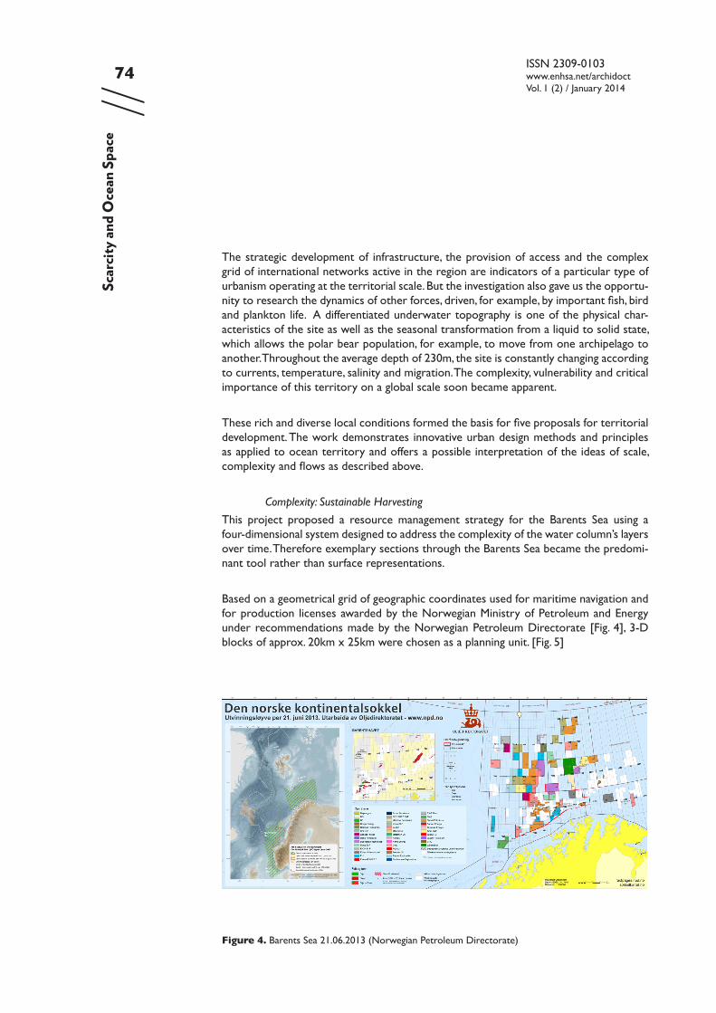
Based on a geometrical grid of geographic coordinates used for maritime navigation and for production licenses awarded by the Norwegian Ministry of Petroleum and Energy under recommendations made by the Norwegian Petroleum Directorate [Fig. 4], 3-D blocks of approx. 20km x 25km were chosen as a planning unit. [Fig. 5]
Figure 4. Barents Sea 21.06.2013 (Norwegian Petroleum Directorate)
Scar
city a
nd O
cean
Spa
ce
75//
ISSN 2309-0103www.enhsa.net/archidoctVol. 1 (2) / January 2014
Figure 5. Grid Sample. Giulia Altarelli, Nicoletta Caputo, Carmen Fischer, Carolie Iorio, Jeane Wéry (laba)
Figure 6. Application of fishing regulations for a sample section. Giulia Altarelli, Nicoletta Caputo, Carmen Fischer, Carolie Iorio, Jeane Wéry (laba)
Scar
city a
nd O
cean
Spa
ce
For each type of vertical block, decisions were made across different ocean strata and scales of time, considering fish stocks and their habitat depth. The most vulnerable zones, such as fish spawning areas, can, however, be protected through the total depth of the grid. Oceanographic features such as the ice edge, also exert such a strong influence on the local conditions as to determine principles of exploitation, production, and pro-tection over large areas and full depths. In this way, large coherent ocean areas marked with clear priorities emerge. At the same time the in-built potential for specific localised management decisions is maintained. [Fig. 6]
ISSN 2309-0103www.enhsa.net/archidoctVol. 1 (2) / January 2014
76//
This project assists in the conceptualisation of fluid, layered ocean space, the use of this space over time, and addresses a range of ocean scales. It proposes a management tool specifically designed for the complexity of ocean space – a tool capable of maintaining an abstract, open surface yet acknowledging the differentiation of sub-surface ocean space and its habitats. In fact, seen in this way, the ocean surface is the least “active” of the ocean zones and can retain its potential as a “free space” as described by Pope in part one of this paper.
Scale: A Pool of Resources
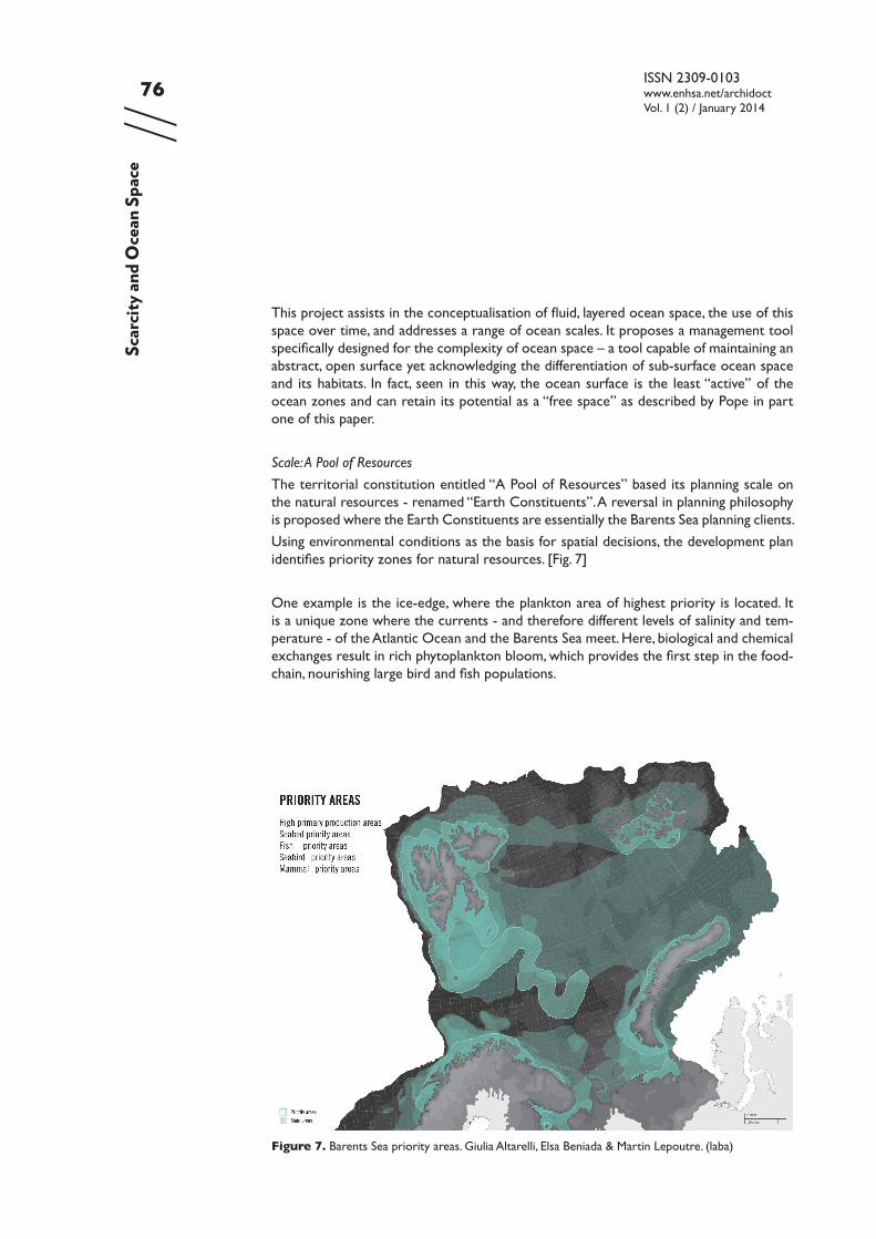
The territorial constitution entitled “A Pool of Resources” based its planning scale on the natural resources - renamed “Earth Constituents”. A reversal in planning philosophy is proposed where the Earth Constituents are essentially the Barents Sea planning clients.
Using environmental conditions as the basis for spatial decisions, the development plan identifies priority zones for natural resources. [Fig. 7]
One example is the ice-edge, where the plankton area of highest priority is located. It is a unique zone where the currents - and therefore different levels of salinity and tem-perature - of the Atlantic Ocean and the Barents Sea meet. Here, biological and chemical exchanges result in rich phytoplankton bloom, which provides the first step in the food-chain, nourishing large bird and fish populations.
Figure 7. Barents Sea priority areas. Giulia Altarelli, Elsa Beniada & Martin Lepoutre. (laba)
Scar
city a
nd O
cean
Spa
ce
77//
ISSN 2309-0103www.enhsa.net/archidoctVol. 1 (2) / January 2014
Activities harmful to the natural resources are banned within these priority zones, and shipping routes must be deviated and tightly controlled. Through the process of analy-sis and documentation, the scale and importance of these resources becomes clearly evident. Rather than an empty, scale-less space, the Barents Sea is highly differentiated. Natural events and habitats can be precisely located. The new Northern Sea Route is, seen in this light, insignificant in comparison and therefore infrastructure gives way to the Earth Constituents.
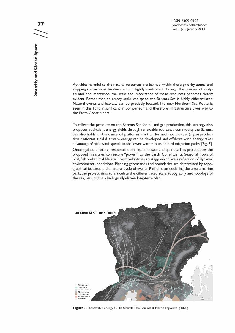
To relieve the pressure on the Barents Sea for oil and gas production, this strategy also proposes equivalent energy yields through renewable sources, a commodity the Barents Sea also holds in abundance; oil platforms are transformed into bio-fuel (algae) produc-tion platforms, tidal & stream energy can be developed and offshore wind energy takes advantage of high wind-speeds in shallower waters outside bird migration paths. [Fig. 8]
Once again, the natural resources dominate in power and quantity. This project uses the proposed measures to restore “power” to the Earth Constituents. Seasonal flows of bird, fish and animal life are integrated into its strategy, which are a reflection of dynamic environmental conditions. Planning geometries and boundaries are determined by topo-graphical features and a natural cycle of events. Rather than declaring the area a marine park, the project aims to articulate the differentiated scale, topography and topology of the sea, resulting in a biologically-driven long-term plan.
Figure 8. Renewable energy. Giulia Altarelli, Elsa Beniada & Martin Lepoutre. ( laba )
Scar
city a
nd O
cean
Spa
ce
ISSN 2309-0103www.enhsa.net/archidoctVol. 1 (2) / January 2014
78//
In terms of the problems of scale identified in the first part of this paper, this project has used a “biological” scale as a basis for planning. This means that cyclic events such as bird migrations are analysed and located in the plan. As a result, despite the large scale, the heterogeneity of the Barents Sea can be more accurately represented. Recognition of inter-related scales and environments, for example movement between breeding, win-tering, and feeding grounds, results in a relevant, temporal subdivision of ocean space.
Flux: Humans and Seasons
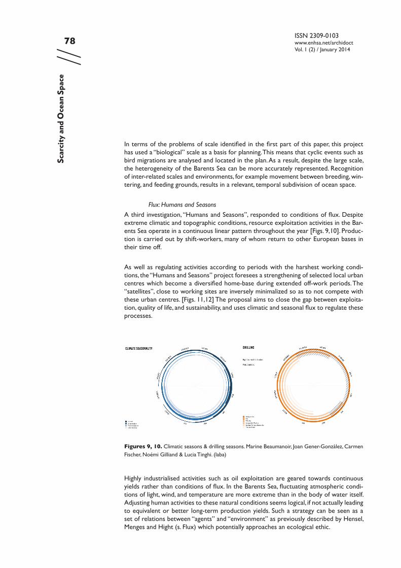
A third investigation, “Humans and Seasons”, responded to conditions of flux. Despite extreme climatic and topographic conditions, resource exploitation activities in the Bar-ents Sea operate in a continuous linear pattern throughout the year [Figs. 9,10]. Produc-tion is carried out by shift-workers, many of whom return to other European bases in their time off.
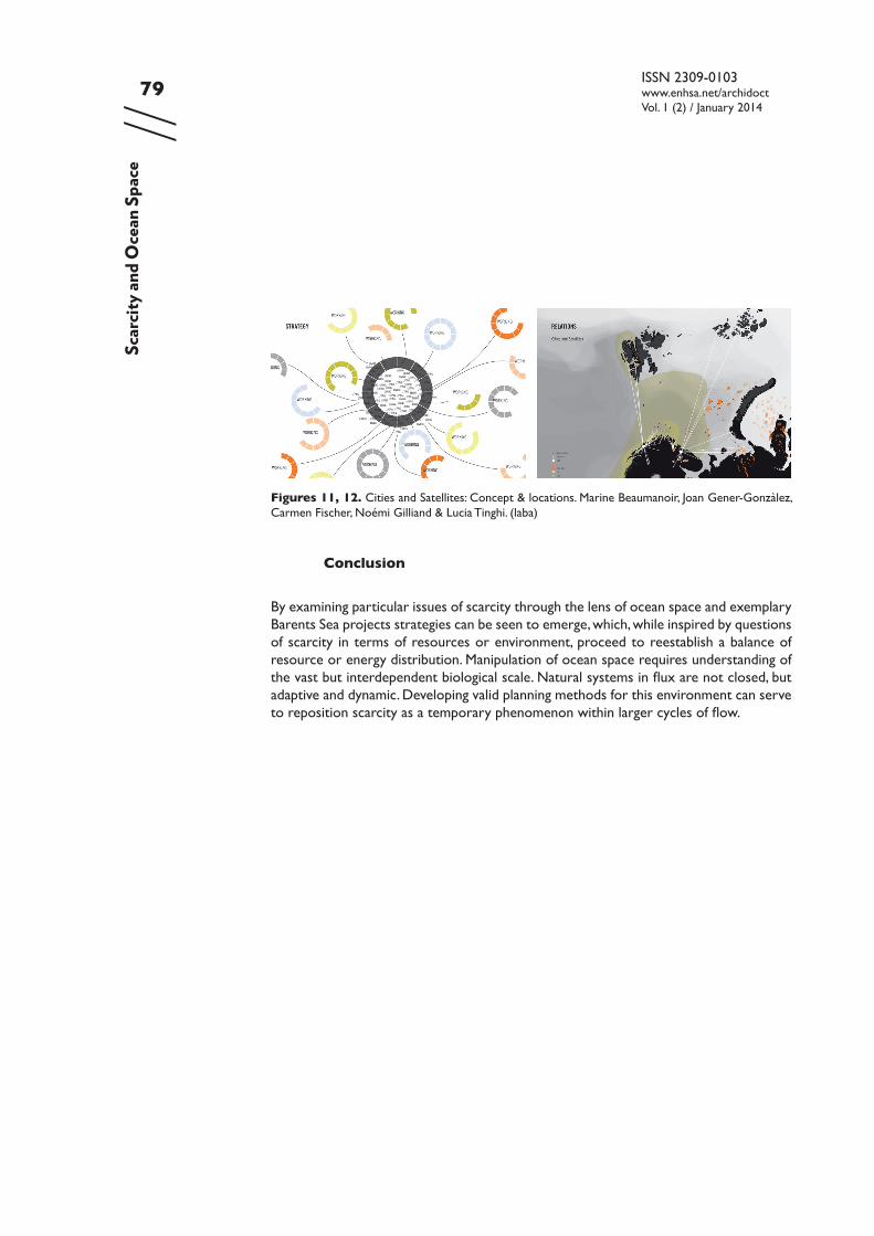
As well as regulating activities according to periods with the harshest working condi-tions, the “Humans and Seasons” project foresees a strengthening of selected local urban centres which become a diversified home-base during extended off-work periods. The “satellites”, close to working sites are inversely minimalized so as to not compete with these urban centres. [Figs. 11,12] The proposal aims to close the gap between exploita-tion, quality of life, and sustainability, and uses climatic and seasonal flux to regulate these processes.
Figures 9, 10. Climatic seasons & drilling seasons. Marine Beaumanoir, Joan Gener-Gonzàlez, Carmen Fischer, Noémi Gilliand & Lucia Tinghi. (laba)
Scar
city a
nd O
cean
Spa
ce
Highly industrialised activities such as oil exploitation are geared towards continuous yields rather than conditions of flux. In the Barents Sea, fluctuating atmospheric condi-tions of light, wind, and temperature are more extreme than in the body of water itself. Adjusting human activities to these natural conditions seems logical, if not actually leading to equivalent or better long-term production yields. Such a strategy can be seen as a set of relations between “agents” and “environment” as previously described by Hensel, Menges and Hight (s. Flux) which potentially approaches an ecological ethic.
79//
ISSN 2309-0103www.enhsa.net/archidoctVol. 1 (2) / January 2014
Conclusion
By examining particular issues of scarcity through the lens of ocean space and exemplary Barents Sea projects strategies can be seen to emerge, which, while inspired by questions of scarcity in terms of resources or environment, proceed to reestablish a balance of resource or energy distribution. Manipulation of ocean space requires understanding of the vast but interdependent biological scale. Natural systems in flux are not closed, but adaptive and dynamic. Developing valid planning methods for this environment can serve to reposition scarcity as a temporary phenomenon within larger cycles of flow.
Figures 11, 12. Cities and Satellites: Concept & locations. Marine Beaumanoir, Joan Gener-Gonzàlez, Carmen Fischer, Noémi Gilliand & Lucia Tinghi. (laba)
Scar
city a
nd O
cean
Spa
ce
ISSN 2309-0103www.enhsa.net/archidoctVol. 1 (2) / January 2014
80//
References
Asariotis, R., Benamara, H., Hoffmann, J. and Wilmsmeier, G., 2008. Review of Maritime Transport 2008: Report by UNCTAD secretariat. [online] New York and Geneva: UN. Avail-able at: <http://unctad.org/en/docs/rmt2008_en.pdf> [Accessed 5 Jul. 2013].
Ballard, R., 2000. The eternal darkness: a personal history of deep-sea exploration. Princeton, New Jersey: Princeton University Press.
Brenner, N. and Schmid, C., 2011. Planetary Urbanization. In: M. Gandy, ed., Urban Con-stellations. Berlin: Jovis.
Deleuze, G. and Guattari, F., 2005. A thousand plateaus: capitalism and schizophrenia. 11th print. ed. Minneapolis: University of Minnesota Press.
Droege, P., 2008. Urban Energy Transition: An Introduction. In: Peter Droege, ed., Urban Energy Transition. [online] Amsterdam: Elsevier, pp.1–14. Available at: <http://www.sci-encedirect.com/science/article/pii/B9780080453415000293> [Accessed 30 Jan. 2013].
Elias de Castro, I., 2002. The Problem of Scale. Quaderns d’arquitectura i urbanisme, 233(Used Land).Publicació del Collegi Oficial d’Arquitectes de Catalunya.
Gugger, H., Couling, N. and Blanchard, A. eds., 2012. Barents Lessons. Teaching and Re-search in Architecture. Zürich: Park Books.
Halpern, B.S., Walbridge, S., Selkoe, K.A., Kappel, C.V., Micheli, F., D’Agrosa, C., Bruno, J.F., Casey, K.S., Ebert, C., Fox, H.E., Fujita, R., Heinemann, D., Lenihan, H.S., Madin, E.M.P., Perry, M.T., Selig, E.R., Spalding, M., Steneck, R. and Watson, R., 2008. A Global Map of Human Impact on Marine Ecosystems. Science, 319(5865), pp.948–952.
Hensel, M., Menges, A. and Hight, C. eds., 2009. Space Reader Heterogeneous Space in Architecure, AD Reader. Chichester, UK: John Wiley & Sons Ltd.
Kipnis, J., 2009. Towards a New Architecture. In: M. Hensel, C. Hight and A. Menges, eds., Space Reader Heterogeneous Space in Architecure, AD Reader. Chichester, UK: John Wiley & Sons Ltd.
De Landa, M., 1997. A thousand years of nonlinear history. New York: Zone Books.
Lefebvre, H., 1991. The Production of Space. Translated by D. Nicholson-Smith. Oxford, UK etc: Blackwell.
Lefebvre, H., 2003. The Urban Revolution. Minneapolis: University of Minnesota Press.
Luks, F., 2010. Deconstructing Economic Interpretations of Sustainable development: Limits, Scarcity and Abundance. In: L. Mehta, ed., The Limits to Scarcity- contesting the politics of allocation. London: Earthscan.
Morton, T., 2012. Everything We Need: Scarcity, Scale, Hyperobjects. Architectural Design, 04/2012.
Nolte, N., 2010. Nutzungsansprüche und Raumordnung auf dem Meer. Hansa Interna-tional Maritime Journal, 147(9), pp.79–83.
Pansera, S., 2011. Beyond entropy: when energy becomes form. London: AA Publications.
Pope, A., 2009. Mass Absence. In: M. Hensel, C. Hight and A. Menges, eds., Space Reader
Scar
city a
nd O
cean
Spa
ce
81//
ISSN 2309-0103www.enhsa.net/archidoctVol. 1 (2) / January 2014
Heterogeneous Space in Architecure, AD Reader. Chichester, UK: John Wiley & Sons Ltd.
Royal Norwegian Ministry of the Environment, 2011. Meld. St. 10. Report to the Stort-ing (white paper). First update of the Integrated Management Plan for the Marine Environ-ment of the Barents Sea - Lofoten Area. Available at: <http://www.regjeringen.no/en/dep/md/documents-and-publications/government-propositions-and-reports-/reports-to-the-storting-white-papers-2/2010-2011/meld-st-10-20102011.html?id=682050> [Accessed 29 Aug. 2013].
Rubin, J., 2008. The New Inflation. StrategEcon, CIBC World Markets. [online] Available at: <http://research.cibcwm.com/economic_public/download/smay08.pdf> [Accessed 24 Jan. 2013].
Samuel, S. and Robert, J., 2010. Water Can and Ought to Run Freely; Reflections on the Notion of ‘Scarcity’ in Economics. In: L. Mehta, ed., The Limits to Scarcity - contesting the politics of allocation. London: Earthscan.
Steinberg, P.E., 2001. The Social Construction of the Ocean. Cambridge studies in international relations. Cambridge [etc.]: Cambridge University Press.
Stopford, M., 2009. Maritime economics. 3rd ed. London: Routledge.
Timmermans, W., J., 2002. The Future of Offshore Pipelining. Offshore Magazine, 62(6).
Scar
city a
nd O
cean
Spa
ce