Embed Size (px)
Citation preview
ARCHITECTURAL DEBRIS AND CONSTRUCTION SEQUENCING AT AN 18TH-
CENTURY RURAL NATIVE AMERICAN HOUSEHOLD IN CONNECTICUT
A Thesis Presented
by
TIMOTHY D. HOLLIS
Submitted to the Office of Graduate Studies,University of Massachusetts Boston,
in Partial fulfillment of the requirements for the degree of
MASTER OF ARTS
June 2013
Historical Archaeology Program

© 2013 by Timothy D. HollisAll rights reserved
ARCHITECTURAL DEBRIS AND CONSTRUCTION SEQUENCING AT AN
18TH-CENTURY RURAL NATIVE AMERICAN HOUSEHOLD IN
CONNECTICUT
A Thesis Presented
by
TIMOTHY D. HOLLIS
Approved as to style and content by:
________________________________________________Stephen W. Silliman, ProfessorChairperson of Committee
________________________________________________Judith F. Zeitlin, ProfessorMember
________________________________________________Kevin McBride, Associate Professor University of ConnecticutMember
_________________________________________Stephen W. Silliman, Program DirectorHistorical Archaeology Program
_________________________________________Judith F. Zeitlin, ChairpersonDepartment of Anthropology
ABSTRACT
ARCHITECTURAL DEBRIS AND CONSTRUCTION SEQUENCING AT AN 18TH-
CENTURY RURAL NATIVE AMERICAN HOUSEHOLD IN CONNECTICUT
June 2013
Timothy D. Hollis, B.A., University of Massachusetts Boston
M.A. University of Massachusetts Boston
Directed by Professor Stephen W. Silliman
This thesis details the archaeological investigation of a rural Native American
household site on the Eastern Pequot reservation in southeastern Connecticut. Spatial and
architectural artifact analyses are used to determine the sequence of construction and
nature of structures built a late 18th-century occupation in order to place the site in a
context of Native Americans living through colonialism via the construction of a built
environment and place-making. The data set used to conduct the analysis includes both
architectural material, particularly nails and window glass, and non-architectural material
such as ceramics and vessel glass. Unique to sites so far investigated on the reservation,
Site 102-123 shows multiple structures and construction phases. The structures are
iv
relatively small houses with dry-laid fieldstone chimneys. Each structure is associated
with a different type of storage, a root cellar for one and a subfloor cellar for the other.
The architectural materials suggest not just collapse but likely directed demolition. In
addition, the filling in of subfloor storage areas and the large number of broken nails in
the assemblage imply that recycling of architectural materials was part of the deliberate
demolition of the site. The most likely interpretation of the site is the sequential
construction of two structures which remained in use concurrently, and these provide a
unique view of conceptual and physical “residence” on the reservation as residents
shifted their uses of space, buildings, and storage in the latter decade or two of the 18th
century.
v
TABLE OF CONTENTS
LIST OF FIGURES....................................................................................... vii
LIST OF TABLES......................................................................................... viii
CHAPTER..................................................................................................... Page
1. INTRODUCTION....................................................................... 1The Built and Social Constructed Environment.................... 6Time Scales............................................................................ 10Conclusion............................................................................. 12
2. BACKGROUND......................................................................... 14Social and Cultural History of the Pequot............................. 15The Colonial Environment..................................................... 21Eighteenth-Century Domestic Architecture, Farmsteads, and Agriculture....................................................................... 27Summary................................................................................ 31
3. PROJECT SITE AND RESEARCH METHODOLOGY............ 32Nails....................................................................................... 41Window Glass........................................................................ 50Other Artifact Classes............................................................ 53Architectural Debris Deposits................................................ 53Organizing Data on Nails, Window Glass, and Non-Architectural Artifacts............................................. 57
4. RESULTS..................................................................................... 62Nail Data................................................................................ 63Window Glass and Other Artifact Classes............................. 75Spatial Data Summary........................................................... 88
5. INTERPRETATIONS.................................................................. 90
6. CONCLUSION............................................................................ 105
APPENDIX
A. TABLES OF CERAMIC TYPES USED IN MEAN CERMAIC DATING........................................... 113
REFERENCES.............................................................................................. 118
vi
LIST OF FIGURES
Figure Page
1. Site Topography and Unit Locations..................................... 36
2. South Chimney Collapse at Site 102-123, Facing West........ 37
3. South Chimney Collapse from Above................................... 38
4. Unit Locations and Surface Features..................................... 40
5. Distribution of Nails at Site 102-123..................................... 65
6. Nails by Group and Size........................................................ 69
7. Number of Whole Nails by Group and Size.......................... 70
8. Comparison of Nail Assemblage at Sites 102-123 and 102-125 72
9. Comparison of Whole Nail Assemblage at Sites 102-123 and 102-125........................................................................... 73
10. Distribution of Window Glass at Site 102-123...................... 78
11. Window Glass by Group........................................................ 79
12. Vessel Glass Distribution at Site 102-123.............................. 82
13. Distribution of Ceramic Artifacts at Site 102-123................. 83
14. Vessel Glass Distribution at Site 102-123.............................. 84
15. Ceramic Artifact Distribution at Site 102-123....................... 85
16. Large Artifacts by Group and Fraction of Assemblage......... 87
17. Large Granite Stone Refit at Site 102-123............................. 102
vii
LIST OF TABLES
Table Page
1. General Application of Square Cut Nails by Pennyweight (Inashima, 1994).................................................................... 45
2. Comparison of Artifact Size and Rank Value........................ 52
3. Organization of Units at Site 102-123................................... 57
4. Quantity of Nails (including fragments)................................ 63
5. Nails by Modification, including fragments.......................... 66
6. Whole Nails by Modification................................................. 67
7. Nails by Size.......................................................................... 68
8. Nails by Manufacture............................................................. 75
9. Window Glass by Group........................................................ 77
10. Vessel Glass by Group........................................................... 80
11. Ceramic Artifacts by Group................................................... 81
12. Large Artifacts by Group....................................................... 86
13. Mean Ceramic Dates.............................................................. 89
14. Group 1 Ceramic Types Used for Mean Ceramic Dating...... 113
15. Group 2 Ceramic Types Used for Mean Ceramic Dating...... 114
16. Group 3 Ceramic Types Used for Mean Ceramic Dating...... 114
17. Group 4 Ceramic Types Used for Mean Ceramic Dating...... 115
18. Group 5 Ceramic Types Used for Mean Ceramic Dating...... 115
19. Group 6 Ceramic Types Used for Mean Ceramic Dating...... 115
20. Group 7 Ceramic Types Used for Mean Ceramic Dating...... 116
viii
Table Page
21. Group 8 Ceramic Types Used for Mean Ceramic Dating...... 116
22. Group 9 Ceramic Types Used for Mean Ceramic Dating...... 117
23. Group 10 Ceramic Types Used for Mean Ceramic Dating.... 117
ix
CHAPTER 1
INTRODUCTION
Archaeologists have long studied houses – both extant and long gone – as a way
of understanding the lived experiences of their inhabitants. Houses, and other built
structures, are products of the people who build and inhabit them, and therefore a
reflection of both the decision making processes and the resources available to them. In
the case of Native Americans in 18th-century New England, those structures reflect both
the physical environment as well as the social, political, and economic environment of
the time.
Architectural materials, and their relation to other artifact classes, are utilized here
as indicators of the sequence of the construction and demolition of structures which are
no longer standing. These structures are reflections of the physical and social
environment and are part of a larger process of living through colonialism, making them
part of the physical and practical acts of “residence” (Silliman 2001; Silliman 2012) as
further defined below. This thesis intends to present two ideas: a method for using fine-
grained spatial data across a single site and multiple artifact classes to determine the
1
nature of structures constructed there, and an interpretation of those structures as artifacts
of a specific social, political, and economic environment through the lens of residence.
From a methodological perspective, this study intends to apply spatial analysis of
artifacts aggregated at the level of the excavation unit to reconstruct the presence of
structures at the site in both time and space. From a more theoretical standpoint, this
study links the process of construction to the lived experience of the builders through a
process of place-making.
This thesis examines an archaeological site, site 102-123 in State of Connecticut
nomenclature, on the Eastern Pequot reservation in North Stonington, Connecticut, where
excavation indicated a sequence of houses constructed in the 18th century, and argues that
the site is an example of the builders and inhabitants engagement with the social and
physical environment. In a colonial context, houses built by indigenous people are an
example of “residence” – literally and conceptually – in colonialism (Silliman 2009:3).
The primary methods for understanding the structures described here involve
construction materials, their relationship to other artifact categories and their spatial
organization. Essential to the understanding of this site is the determination of the
sequence of construction, modification, and eventual abandonment of the site. This site
occupies an interpretive position that is different from both the Late Woodland villages
that were common throughout southern New England prior to contact with Europeans
and the New England villages of European settlers, which were the antecedents of today's
New England towns and cities.
2
Site 102-123 is within the current boundaries of the Eastern Pequot reservation, a
225-acre wooded area that would have been variably cleared in the 18th and 19th
centuries for cultivation.1 Unique for sites on the reservation is the presence of two
chimney falls at this site, implying multiple structures, and the possibility for different
construction episodes at this site. No other sites yet examined on the reservation offer the
opportunity to study the modification of a habitation site with multiple distinct phases.
The materials of particular importance for the study of architecture are nails and window
glass because their form and distribution offer evidence of the ways in which the two
structures were utilized and demolished. Compared to the distributions of ceramic and
vessel glass artifacts, these data help to build a spatial model that distinguish between
architectural and non-architectural artifacts. Site 102-123 was excavated in 2005 and
2006 by students from the University of Massachusetts Boston and members of the
Eastern Pequot Tribal Nation. The site's above ground features include two large chimney
collapses and two other stone piles, one of which was revealed to be a midden largely
consisting of rock and shell (Hunter 2012). The site is near a large enclosure that contains
artifacts that are roughly contemporaneous, and near site 102-104, an earlier 18th century
site that may be the location of a wigwam-style dwelling (Hayden 2012:48). Hayden's
work describes several structures across the reservation that were also utilized in the 18th
and 19th centuries. That work concentrates more on the identification of different features
across multiple sites over a period, where this work is focused on a single sites transition
1In consideration of the Eastern Pequot Tribal Nation's policies for archaeological resource protection, no
specific site location is given, but that placement is not critical to the interpretation provided herein. 3
over a period of time. She further suggests that the construction of residential structures
was “neither formalized nor a strictly governed process.” (Hayden 2012:113)
Theoretical concerns about residence, time scale, and the colonial environment
have been present throughout the course of the archeological investigations on the
reservation. Several sites have been studied ranging from the early 18th century to the
20th. Artifacts recovered from site 102-123, as detailed in chapters three and four,
indicate a habitation date in the late 18th or early 19th century. Other sites on the
reservation indicate earlier habitation, and several others indicate habitation during the
19th century. Relatively few artifacts have been recovered that are pre-colonial in nature.
There are no known sites that date to the Woodland period known on the reservation at
the time of this writing.
The interplay of the built environment and the lived experience of the people
within it is an important theoretical element of this research. The reservation can be
conceptualized simultaneously as both a colonial landscape and a Native landscape. This
reservation and neighboring ones were at the center of many legal and extra-legal
struggles between Native people and settlers (Den Ouden 2005). Johnson notes that
landscapes associated with indigenous people are “full of meaning, with complex
narratives linking the natural world to the world of humans, or to put it another way,
writing human concerns into the landscape itself.” (Johnson 2005:189) The same
processes of linking and “writing” persist throughout the changing power relations of
colonialism. The landscape, whether considered as colonial, Native, agricultural, or in
4
some other interpretive category, only has historical import in that it was lived,
experienced, and conceptualized by people in the past and in the present.
Foremost in the intersection of colonialism and the built environment is the idea
of “residing” within a colonial environment. The theoretical ideas of residence and the
built environment are applied here to understand the relevance of household space to
Native people in the 18th century. Residence is an engagement with colonialism through
lived experience (Silliman 2001:195) in ways of “living through” that disrupts the
“domination/resistance dichotomy” (Silliman 2012:6). The construction of English-style
buildings and adoption of English-style landscape modifications could be seen as a form
of residence (Silliman 2009). The adoption of houses on the Mashantucket reservation,
for example, “reflected the availability of certain kinds of technologies, but did not
necessarily reflect changes in social and domestic patterns or site structure” (McBride
1990:116). This form of persistence is a type of interaction with colonial power structures
that is less visible than what is traditionally considered resistance, but residence is a form
of preserving cultural traditions, including community and a particular, but not static,
relationship to a particular landscape – in this case, the reservation itself.
Residence is particularly well suited for analysis of sites such as 102-123, which
is a locus of habitation. Residence is a manner of living through, not constant resistance
to, colonialism, but also is a theoretical construct that rejects acculturation as an
interpretive model for cultural continuity and change. Categorizing the structures at site
102-123 as artifacts of resistance or as simple acquiescence to colonialism is inadequate
for recognizing the daily presence of colonialism in the lives of the inhabitants of the site.
5
The residence approach to colonialism here is one that acknowledges people's
engagement with colonial power structures, but neither romanticizes the struggle with
colonialism nor relegates indigenous people to a spiral of acculturation and
disappearance. Residence, instead, is about how people live in the colonial environment,
and how colonialism pervades the lives of the colonized.
Colonialism is a process that transforms both parties involved (Gosden 2004b:1),
and is dependent on relational networks between people and objects, which can be
positive or malign (Gosden 2004a:169). The more subtle ways of engaging with the
colonized population are relevant for the purposes of this study. However, when one
considers the relationship of people to the built environment, residence raises the most
salient points as to how the people living on the reservation (and Pequot people not living
on the reservation, to a lesser extent) challenged and engaged with colonialism.
The Built and Socially Constructed Environment
How a society is organized is reflected in how it organizes space (Scarry and
McEwan 1995:483). The placement and use of buildings and other structures, and the
shape and form of landscape modification are not haphazard, or dictated only by the
surrounding physical environment. Rather, societal and individual forces influence the
decision-making process of agents engaged in the process of building or dismantling a
structure or making a landscape. The experiences which influence decision making are
varied, including experiences of other landscapes, community knowledge, and skills or
resources available. Specific to the experience of Native people, reservations are and
6
were communal spaces within which communal values are enacted (Silverman
2005:184).
The act of building can be considered to be a form of cultural construction, as
people enact cultural practices through the act of physical construction, including
landscape modification (Pauketat and Alt 2005:214). Considering buildings, as well as
the materials used to construct them, as artifacts allows for a consideration of the built
environment as the product of human activity. The relationship between artifacts and
human behavior is a process that defines artifacts as “entities [that] do not have their own
properties, but take on varying characteristics depending on how they are linked with
other entities” (Gosden 2004:169). I wish to emphasize the fluid nature of people's
responses to colonialism through the creation of hybrid forms that synthesize both Native
and European forms of material culture (Gosden 2004b:22,24), specifically applied to
architecture and the organization of those structures. The enactment of cultural practices
is the mechanism by which these relationships are reproduced in the physical world.
Pauketat and Alt describe the act of construction in the context of Cahokian mound
building as
people forming and experiencing identities, making and inscribing memories, and
re-interpreting practices and traditions materially, spatially, temporally, and
corporeally. In other words, people make or contest cultures continuously, and
they do this through their bodies, in space, and through matter in ways that draw
on the past, define the present, and constrain the future. Cultures may seem to
7
reside in the head, but they are made in the physical world. (Pauketat and Alt
2005:214)
Pauketat and Alt discuss the construction of monumental architecture and the
effects of that construction of the public sphere, but the principle remains largely
unaltered in smaller-scale phenomena. How buildings are constructed is an important
material element that demonstrates a multi-layered, culturally-informed decision-making
process. The action of building or creating reinforces and reproduces the elements of the
network connecting people and material culture, while simultaneously adding new
elements to the network. The act of demolishing a structure is not subtractive from the
network of human interaction, but rather reformative – a dismantled house exists in the
memories of people, and creates a place where a house used to be. Similarly, the
dismantling of a house does not destroy the links between people, but rather changes the
region of formation for those links. While the construction of monumental structures such
as the Cahokian mound reflect the expenditures of vast amounts of labor and an
enormously complex network of people and things, the construction of one or two small
structures by a relatively small group of people is also encoded with meaning, and the
influence of those structures of the lived experience of people is still present, despite their
humble nature of these structures.
Buildings have an important effect on the experience of their occupants (Blier
2006:246). The form of any building is dictated by its owner (Candee 1969b:60), or, at
least, the owner at the time of construction, and in the case of small scale construction the
owner and builder are likely the same individuals. Construction of buildings also
8
incorporates an element of tradition, especially in the realm of folk or vernacular
architecture, where builders draw from multi-generational templates (Adams and
McMurry 1997:xix-xx). Houses permeate the lives of people who live there (and, in some
cases, the lives of people who do not live there). A house is a physical marker of one's
residence in a particular place, and the relationship between one and that place.
The landscape, in this case, the built landscape, is an experienced and subjective
space which sets up resistances and constraints (Bender 2006:303), and the buildings a
form of living with the local environment (Graham et al. 2007:453). The built
environment exists at an intersection where the “physical environment, societal structures
[…] and individual experience exist in a recursive web.” (Pauls 2006:66) This
experiential aspect can be considered through the lens of socialization through the
material world (Gosden 2004a:170). The constraints of the landscape are defined by
physical characteristics, limiting where structures can be built, where fields can be
plowed, and where people can move or extend their gaze. The environment and the
physical geography of any area influence the architectural forms and options for the
community's development (Blier 2006:238).
Social agents both create and respond to the landscape (Johnson 2006:143-144).
This includes both the creation of physical alterations to the landscape – the building of
structures, but also plowing and clearing – and the construction of the experience of the
landscape. Both of these processes create a landscape that is fundamentally mutable; that
is, it can be changed by people, and durable. In addition to being both seen and
experienced, landscapes are also capable of communicating ideas (Rotman and Nassaney
9
1997:42). Landscape “embodies history, structure, and contexts of human behavior”
(Hood 1996:121). Ideas are embedded in the physical construction of the landscape, all of
which are laden with practical and ideological concerns. This engagement with the
landscape is an active one (Johnson 2006:143) that depended heavily on the labor and
creativity of the people who undertook the modifications (or lack thereof) to the
landscape. The construction and maintenance of a human-dictated environment,
structures in this case, required meaningful activities that affected both the landscape and
the people through the act of construction.
Buildings embody the use of labor both in the act of building and produce a form
of material culture (Blier 2006:233). This use of labor represents a number of important
decisions – what sort of structures should be constructed to serve what particular
purposes. Architecture is a product of materials, technologies, and knowledge (Glassie in
Blier 2006:237). All of these elements are important in considering what sort of structures
can be constructed. While the availability of materials, technologies, or knowledge
imposes limits, the selection of which elements to utilize also provides an arena for
agency. In the case of homes constructed by their ultimate residents, the structure is an
expression of what they have available and the decisions they made to construct that
structure, decisions made about how they want to structure the landscape around them.
Time Scales
The assessment of the changes of Eastern Pequot lifeways and uses of the
landscape can be considered from multiple points (Silliman 2009:12). Many people have
engaged with the landscape, over many lifetimes. In the case of farmsteads, the lifetime
10
of a household is different, and may be substantially longer than the lifetime of any one
member of that household. This presents an opportunity to consider the landscape from
multiple time scales – personal (of which there are many), familial, and generational, all
of which contribute to the construction of social meaning (Silliman 2009:12). As such,
there are multiple points to consider when attempting to reconstruct the meaning of
people's engagement with a landscape. This is not an argument to invalidate longer period
connections (Silliman 2009:30), but rather to note that people's relationship with the past
is one that is multifaceted. A landscape can have different meanings for different people,
but those meanings are mutable throughout time as well, as the landscape and the agent
change. The process is recursive, as the landscape (and other physical objects) influences
the experiences and position of the agent.
Familial time scales are particularly important for small farms, as the farm family
is an important unit of labor and social unit when considering the impact of humans on
the landscape. This is true even on reservations when “farms” may have differed in
concepts of ownership and use compared to neighboring Euro-American settlers. The
family is not necessarily the only people engaging with a landscape, but is likely to be the
people most often engaging with a particular plot. Individual relationships with the
landscape will vary, although older members will likely transmit information about the
landscape to younger members. At the same time, all members of the family will actively
create the history of the landscape through their daily activities. The construction of a
history of a landscape is also part of the process of remembering, where the past of the
landscape is constructed within a person and transmitted to other persons. All of these
11
activities contribute to the familial scale of landscape history by creating a collective
history that encompasses and synthesizes personal histories, but does not totally replace
or consume them.
These communal, familial, and personal histories all represent smaller time scales
than are usually considered when addressing questions archaeologically. The portions of
personal histories of a place that are constructed from personal memories cover a period
of a single human lifetime, and are combined with other personal memories. This human
lifespan timescale is a much smaller time frame than the period stretching from the end of
the Woodland period to the 19th century. Within that period, many generations of Pequot
people lived, perhaps not on that particular plot, and constructed histories of landscape
engagement. While four centuries appears to be a brief period in archaeological time
scales, it is many human lifetimes. All of these levels of memory should be considered
not as distinct types of history but rather as different aspects of shared history. The
different scales of history do not borrow from each other, but rather constitute each other.
Conclusion
The following chapters attempt to describe the architectural variability of the site
in a colonial context. The following chapter includes a brief history of the Eastern Pequot
and a discussion of the role of agriculture and farmhouses in 18th- and 19th-century New
England. Chapter 3 covers the specific methodology used to address architectural
artifacts, especially nails and glass, and to relate those to identification of structures that
existed in the past. Chapter 4 describes the assemblage of architectural debris, the spatial
distribution of that debris, and the relationship between the artifacts and other artifact
12

classes, while chapter 5 provides an interpretive description of the site based on that data.
Chapter 6 will offer some conclusions regarding house forms, the sequence of
construction at the site, colonialism, and the archaeology of the built environment.
13

CHAPTER 2
BACKGROUND
This research pertains to Native people living in a colonial environment and their
interaction with their built environment. As such, it must draw together information about
the historical context of the Eastern Pequot Tribal Nation, the history of colonialism in
southern New England, theoretical ideas about the relationship of people with the built
environment, and actual physical structures present in rural New England in the 18th
century. These engagements can then be applied to archaeological data pertaining to both
architecture and the use of space, but need to be placed first in the context of the colonial
and capitalist environment which existed in the late 18th century, in addition to the
changes in Pequot lifeways that preceded that period. This chapter presents a summary of
Pequot history from the pre-colonial period, a brief discussion of the theoretical issues
involved in the study of colonialism as applies to architecture and living on a reservation,
and a discussion of the nature of rural agriculture in southern new England in the 18th
century.
14
Social and Cultural History of the Pequot
The Eastern Pequot Reservation is located in southeastern Connecticut in the
town of North Stonington, across Long Pond from the Mashantucket Pequot Reservation.
It is now a wooded landscape used by the tribe for community purposes and as a
residential area for some tribal members. The history of the Eastern Pequot is long and
complex, and has been thoroughly entangled with first European and then Euro-American
colonialism since the arrival of Europeans in northeastern North America. Before being
split into the Eastern and Mashantucket Pequot tribes, the Pequot lived along the coast of
Connecticut, but following violent conflict with European settlers, were removed to the
interior, eventually to where the reservations are now (McBride 1991:65-66). The
reservations were both established in the late 17th century, and since then have been used
extensively, especially for residential life and farming in the 18th and 19th centuries
(McBride 2005:42; Silliman and Witt, 2009).The persistence of Native peoples in a
region increasingly inhabited by Euro-Americans meant greater and greater integration
with an economic, political, and ecological Atlantic World (Baron et al. 1996:562;
Cronon 1983:161).
As a physical space, the reservation is a complex landscape. The poor quality of
the reservation's soil for agriculture was mentioned in petitions to the General Court, and
the Eastern Pequots attempted to make maximum use of the land available to them for
agricultural purposes (Den Ouden 2005:25-26). Long Pond and its earlier undammed
riverine corridor of smaller lakes bordering the reservation on the western edge provided
a source of freshwater and fish in addition to the terrestrial resources available on the
15
reservation. Immediately across Long Pond is the Mashantucket Pequot reservation,
established in 1666, and has been extensively studied historically and archaeologically
(Campisi 1990; McBride 1991, 2005). The physical proximity of the two reservations
implies that communication and movement between the two reservations would have
been relatively easy and such interaction would have been beneficial to the preservation
of cultural traditions. Multiple habitation areas have been identified that date roughly
between the mid-18th century to the mid-19th century, a period when the reservation had
been inhabited for between 70 to 200 years. The decisions made in these particular
historical circumstances reflect the colonial environment. Habitation and agricultural
practice on the reservation with techniques and structures similar to the Pequot's Euro-
American neighbors has a decades-long history during a time of economic growth and
integration (Hayden 2012; Silliman 2009; Silliman and Witt 2010:46,63-65).
Turning to the social world of the people who have lived on the reservation, the
practices of pre-colonial Native Americans are relevant when addressing Native lifeways
in later periods. While the Woodland period should not be considered the only cultural
baseline for Native American behavior, it is a useful starting point to trace the changes in
land use following the arrival of Europeans and during the construction of the Euro-
American colonial edifice (Silliman 2009). The people who would have built, used, and
eventually abandoned the structures on the reservation were separated from their
ancestors’ Woodland traditions by centuries of change and living within the colonial
environment. This separation is not an impassable divide over the gulf of history or
abandonment and renunciation of tradition, but the result of historical processes where
16
the world of southern New England has changed along with the people (see Mitchell and
Scheiber 2010). They had collectively experienced radical changes in their political
power, their subsistence strategies, and their access to land and other resources. This does
not undermine their claims to connection with Woodland traditions, but rather is meant to
take into account the period during which Native lifeways were being actively disrupted
and changing to a rapidly altering environment (Silliman 2012). The extremely long view
is a strength of archaeology, but should not be the sole time frame to consider the
engagement of people with the material culture (Silliman 2012).
Pequot subsistence patterns of the Late Woodland period (1000-1500 CE)
revolved around marine and estuarine environments, forming a mixed maritime and
horticultural base for subsistence (McBride 1991:65). This landscape management
involved horticulture and hunting and gathering, along with a great deal of reliance on
marine resources. Villages dating to the Late Woodland period that have been studied
archaeologically indicate a less intensive land use pattern than European models of
farming (Cronon 1983:38).
Europeans – first Dutch, then English – began to arrive in southern New England
in the beginning of the 17th century, leading to the establishment of Connecticut Colony
in 1636. Prior to the establishment of the Connecticut colony, during the initial stages of
interaction between Native people and Europeans in New England, the Pequot began to
supply wampum to European traders (Cronon 1983:97). They also established fortified
villages, most notably the large palisaded village at Mystic. McBride suggests these
changes are tied to European contact and involvement with the fur trade and the Atlantic
17
economy (McBride 1994:12). The combination of economic and demographic changes
made for a fluid social environment.
A detailed history of the Pequot War (1636-1637) is not necessary for this thesis,
but any history of the Peqout and their relationship with Europeans should at least cover
the conflict briefly. The war provides important context for understanding the relationship
between the Pequot and the colonial government. It illustrates the changing relationship
to the world economy of Native peoples in the 17th and 18th centuries and a turning point
in Pequot history. The war was brief and devastating, leading to the enslavement and
attempted dissolution of the Pequot in New England, and eventually to the establishment
of the reservations in the later part of the seventeenth century. The eventual establishment
of the Eastern Pequot and Mashantucket reservations happened in locations distant from
the sites of the large coastal Pequot settlements which existed prior to the Pequot War,
although the presence of marine shellfish at site 102-123, and elsewhere, indicates that
Pequot people in the 18th century maintained links to coastal areas (Hunter 2012:38-39).
The reservations were established well inland of the areas used by the Pequot for their
maritime subsistence activities. A third reservation at Noank, on the Atlantic coast, was
later disestablished by the Connecticut government in 1721 (McBride 1991:67).
The reservation’s location well inland makes it a location distinct from the coastal
environment associated with large Pequot settlements but not alien to Pequot people in
the Woodland period or prior to the Pequot War. For example, it is not so distant that
coastal resources would have been inaccessible (Hunter 2012). The unfamiliarity of the
environment should not be overstated, as by the time of the establishment of the
18
reservation, the Pequots would have developed a community memory over decades. An
entire generation of Pequots would have grown up in the period between the war and
establishment of the two reservations. To a certain extent, while both the Eastern (and
Mashantucket) reservations were inhabited and the Noank reservation was in use, there is
a potential to create “links between places they have known and new places”, building
upon their knowledge of known landscapes to develop and make a home out of new
landscapes (Bender 2006:309). The nearby Mashantucket reservation was only used
intermittently until the disestablishment of the Noank reservation in 1721 (McBride
1991:67). There is no evidence, at this time in the trajectory of archaeological research on
the reservation, of year-round habitation at the Eastern Pequot reservation during the first
half of the 18th century, so it may have been used intermittently or had long-term
habitations that are not easily identified by surface features, similar to land use practices
observed at the Mashantucket reservation in the early reservation period (McBride
1991:66). Seasonal or permanent habitation in structures not easily detectable are still
forms of residing on the reservation. Given the size of the reservation and the low
archaeological visibility of ephemeral structures, the lack of detection should not be
considered as proof of absence in this period.
By the 18th century, Native people were able to consider, analyze, and participate
in Euro-American landscape management practices as hired laborers or as farmers.
McBride believes that subsistence patterns in the early reservation period (ca. 1666-1720)
were “generally similar to those documented prior to the Pequot War. Maize horticulture
and seasonal hunting and gathering still made up a substantial portion of subsistence”
19
(McBride 1990:66). This implies that the traditions of the Late Woodland or early
colonial period, having been modified for a more inland environment, would be similar to
the practices early in the occupation of the reservation. With a lack of sites on the Eastern
Pequot reservation that date to the 17th or early 18th centuries, the understanding of
subsistence on the reservation early in its occupation is largely conjectural. McBride
notes elsewhere that, among other changes “construction of Euro-American style framed
houses and meeting houses, increased use of European domestic animals” and other
improvements at the Mashantucket reservation “began within a decade or two of the
Great Awakening of 1742-1743, when hundreds of Native people throughout southern
New England converted to Christianity” (McBride 2005:42). This transitional period is
important as it shows the Pequot actively modifying cultural practices on the reservation
and in relation to the world outside of the reservation. There is a distinct possibility that
similar processes were in play at the two reservations, considering the close proximity
and similar cultural background of the Eastern and Mashantucket Pequots.
The first generation of Euro-American style buildings on the Eastern Pequot
reservation may be those from the 18th century. McBride (1991:75) argues that the
neighboring Euro-American farmsteads are not the best analog for the contemporary
Pequot farmsteads at Mashantucket, but rather “the earlier 17th-century and prehistoric
sites on the reservation. The similarity of prehistoric and 17th-century sites to 18th- and
19th-century sites, which are permanent or semi-permanent, suggests that many of the
older prehistoric and early historic sites formerly defined as temporary may actually be
long-term occupations.” This seems to be at odds with the absences of prehistoric and
20
17th century occupations near the 18th century farmsteads detected on the Eastern Pequot
reservation, although the number of archaeological field seasons numbers less than one-
third of those on the Mashantucket reservation. Several Eastern Pequot residential are
described in Hayden, demonstrating common features as sub-floor storage (at two sites)
and interior hearths (at three) from several sites which range from the early 18th century
to the mid-19th century (Hayden 2012:107-109). These sites do not appear to have been
extensively remodeled over the period of their occupation, which I later take up as a point
of contrast.
The reservation was occupied well after the 18th century. Several 19th century
residential sites have been detected and examined, some very thoroughly (e.g., Cipolla et
al. 2007; Hayden 2012). These structures appear to use fieldstone partial foundations and
chimneys, with very little or no use of brick. The 19th century houses largely appear to be
grouped closer together, although whether this an indicator of multiple households or
multiple occupations is not clear at the moment.
The Colonial Environment
The Eastern Pequot lived in a colonial environment of unequal power relations
during the 18th and 19th centuries. This colonial environment is part of a larger Atlantic
system that includes the encroaching capitalism that altered Native lifeways, especially
through the socially shaping influence of material culture (Gosden 2004a:170;
2004b:153). The use of material culture identified as Euro-American is an expression of
the pervasiveness of colonialism. The societies and relational networks that influence the
construction and use of buildings are not static or monolithic entities. Notions of
21
hybridity are often invoked to study how people deal with conflicting values and ways of
engaging with the world, including in the realm of the relationship between people and
vernacular architecture (Blier 2006:244). The process of adopting European practices and
material culture was a strategy that allowed Native communities to persist in various
forms (Den Ouden 2005). The use of hybrid forms allows for fluidity of meaning through
the adoption, modification, and creation of cultural practices in an arena where “the
meaning of objects could not and did not remain unchanged.” (van Dommelen 2006:119)
Theoretical constructions such as “entanglement” (Martindale 2009: 61) build on the
intersection of hybridity and colonial studies construct ways of understanding the past
that undermine dichotomous conceptualizations such as conquered/conqueror or
Native/European. Connecting the interplay of material culture, identity, and social
relationships with approaches that emphasize hybridity makes colonial power relations
part of the constructed identities that include the adoption of goods or practices that
originate, in terms of manufacture or conception, in Europe or European America.
Hybrid forms can be considered in architectural forms as well. Edwards, when
arguing for colonial architecture as a product of creolization, notes that colonial
architecture was “not European architecture transplanted” (Edwards 2001:86). Rather, it
was the result of the process of cultural exchange in an environment of unequal power
relations, where environments were in flux and available resources were shifting, and
distinct from the development of Creole populations . In his discussion of creole
architecture, Edwards limits himself to discussing the architecture of the tropical regions
(Edwards 2001:90), emphasizing the European empires in Africa, the Caribbean, and
22
South America. However, his arguments that creole architecture is “nativized [and] non-
indigenous” (Edwards 2001:90) can be applied in New England as well. There are
obvious issues with claiming that any structure on the reservation is non-indigenous. The
terminology is flawed, but the flaw does not extend to a conceptualization that reflects
the process of hybridization as one that integrates European concepts of architecture and
space ('non-indigenous') with Native concepts (leading to 'nativized'). This integration is
essential in the cultural transformative process. Architectural creolization is not meant to
say that Native culture is somehow destroyed and replaced by a hybridized form, but
rather that the process of cultural change is complicated by the introduction of new
elements in the form of new architectural styles, which form the basis of a new class of
architectural forms. The differences in the availability of certain resources or
environmental variability can also alter architectural forms or the implementation of
those forms. While the construction of domestic structures on the reservation represents
Native architecture in the sense that they are constructed by Native people, they are also
closely related in origins and styles to the buildings constructed by Euro-Americans at the
same time. These structures were markedly different from those of the Late Woodland
period. These buildings and the agricultural practices associated with them were part of a
set of skills, ideas, and material culture that was part of being Pequot in the 18th century.
Some of these architectural and agricultural practices were adopted or appropriated in a
colonial environment, and they are in turn products of colonialism. While imperial
architecture is more widely associated with large government buildings meant in part to
glorify or monumentalize the state (Blier 2006:244), the spread of these small, everyday
23
houses is a reminder of the widespread transformation of a landscape within projects of
colonialism.
The apparent use of material culture that could be identified as European or Euro-
American should not be seen as an argument for the “disappearance” of Native peoples
by their adoption of new forms of material culture. The narrative surrounding the
“disappearance” of Native peoples in New England is an element of the creation of Euro-
American hegemony (O'Brien 2006:415). Disappearance, in the eyes of Euro-Americans,
could be in the form of the adoption of Euro-American material culture, which had been
constructed as supplanting Native material markers of identity, and therefore Native
identity (i.e. “Indian-ness”) (Baron et al. 1996:415).
The entanglement of Native Americans and the reservation with the colonial
government and power structure is a long-term one (Silliman 2005:56). The landscape of
the reservation “is a product of the activities that constitute domination and resistance”
(Hood 1996:124). All of the activities that took place on the reservation after its
establishment are embedded in colonial power relations. These power relations can vary
in from highly local to broader power issues that relate to colonialism. Silverman, in his
discussion of Native people on Nantucket, notes that “it was essential for people who
wanted to persist in a colonial-dominated region to learn how to run an English-style
farm and speak English” (Silverman 2005:221).
Reservation spaces existed as “the locus of community life for Native peoples, as
well as sites of ancestral and ongoing struggles. In a very real sense, they were
homelands” (Den Ouden 2005:15). An important corollary to the idea of a reservation as
24
a homeland is an awareness of the pervasiveness of the colonial power relations for
people living on the reservation, meaning that reservations were not “sanctuaries,
insulating Native communities from an 'outside' colonial world” (Den Ouden 2005:16),
but that they occupy a position that both separates and connects the community living on
the reservation to the colonial world.. The decision to live on the reservation was a
political one, an enactment of residence within the Native world and one the placed the
people on the reservation in a position to construct the reservation as a Native space
through their residence.
Residing on the reservation was an active decision to locate in an area where the
community of Native people will be present, even if there are relatively few Native
people actually living on the reservation itself, as the population of the reservation varied
substantially over time. Locating oneself (and one's family) on the reservation is an
endorsement of communal values (Henretta 1978:4) by choosing to reside in an identified
Pequot space, even if the house form may have been indistinguishable from those on land
owned by Euro-American neighbors. The similarity between a house on the reservation
and houses owned by Anglo-Americans could be considered as a suggestion of “social or
cultural affiliation with their Anglo-American neighbors or at least an effort at outward
conformity” (Baron et al. 1997:581).
Throughout the entire reservation period, Native people were constantly engaging
with the colonial economy (Baron et al. 1996:573; Silliman and Witt 2010). The
integration of Native people into the Atlantic system took many forms. Elements of
capitalism were starting to take shape at this time – “a flexible currency, banking,
25
corporations, transportation systems, industrialization, and pervasive consumerism”
(Gilje 1996:162). The 19th century was a period of increasing integration of the
transportation systems linking local, regional, national, and international markets
(Kulikoff 1989:136). Labor integration differs from the appearance of material culture
from other parts of the world in that the labor of the Pequots here was used to perpetuate
and actively construct the Atlantic system, an important part of the colonial world. The
labor of Native peoples was not merely either a component of capitalist production or
mean survival. Agricultural labor was a practice that “sustained a sense of historical
continuity – a direct, tangible connection with the past and with one's ancestors” (Den
Ouden 2005:25-26).
This increased integration, however, did not undermine the subsistence nature of
farming in the 18th and 19th centuries. Although surpluses of farmstead production in the
Northeast and elsewhere in the United States may have been sold in markets, these goods
were farm products that were 'surplus' to the subsistence needs of farmers until the
second half of the 19th century (Henretta 1978:12). Subsistence dominated agriculture in
New England partially due to the environmental characteristics of the thin, rocky soil of
New England (Schwartz 1995:455). Subsistence farmers were never truly divorced from
the market economy – the myth of the self-sufficient farmer is just that (Kulikoff
1989:127). The significance of agriculture is visible when situated in the broader
economic system. The late 18th century was a period where capitalism was “in its
adolescence” (Gilje 1996:162) and as a transition between forms of capitalism “from a
rudimentary form of capitalist exploitation, with many petty capitalists, to a more mature
26
system” (Kulikoff 1989:133). These elements would influence the decision making of
people across the Atlantic world, including on the Eastern Pequot reservation.
Eighteenth-Century Domestic Architecture, Farmsteads, and Agriculture
Farmsteads are rural, agricultural, and domestic spaces in the eyes of
archaeologists (Baugher and Klien 2001-2002:10). They are relatively isolated and low
density forms of settlements, whether occupied by settlers on private plots of land or
indigenous people on reservations. The organization of space on a farmstead is a layout
for “the use, convenience, and efficiency of the farmer” (Mascia 1996:155). Farmstead
buildings combine domestic space and work space into a single area, creating, in
archaeological contexts, “an idiosyncratic glimpse into the totality of the human
conditions” (Scharfenberger and Viet 2001-2002:68). Layout is an enactment of
relationship that defines what the farmer should be doing and how, not simply a reflection
of the most efficient way to produce particular goods. The labor of farmers and the labor
products of farm work cover a broad spectrum of activities and products. Agricultural
labor is one that is a routine, daily practice, towards generating both the means of
survival and, possibly, a surplus (or cash crop) for the wider economy.
Farmstead houses, despite their ubiquity, have never been considered to be
particularly important in archaeological and historical research. Houses that are preserved
and studied tended to be the larger homes of prosperous families, so the sample of still
standing buildings from the 18th century neglects many of the smaller buildings that
would have been demolished. This bias towards large, significant architecture is nothing
new – in the early part of the 19th century, contempt was reserved for earlier architectural
27
forms (Maynard 2000:338). The two-story, center chimney houses that have been
preserved into the 21st century are among the largest houses constructed in New England
during the 18th century (Stachiw et al. 1997:IV-14). Rather than a New England
landscape filled with these large homes, the 18th century rural landscape would have
been dominated, at least in terms of architectural features, by small, somewhat
impermanent dwellings (Steinitz 1989:17). These buildings, whether the larger,
“significant” buildings or the more common smaller buildings, reflect the attitudes of
their builders through the act of construction, and are thus artifacts that stamp a particular
attitude into the landscape, but also are reinterpreted over time (Adams 1990:95).
Understanding that attitude can be complicated, as a house may mean to deliver a number
of messages depending on who is seeing and experiencing that house.
The residential structure form that dominated in the Woodland period in southern
New England was the wigwam, a rounded structure, framed by bent poles driven into the
ground and covered with woven mats. Wigwams of this or similar forms have been
studied archaeologically on the Eastern Pequot reservation (Hayden 2012:64-66),
elsewhere in Connecticut (Handsman and Richmond 1995:100), and elsewhere in New
England (e.g. Largy and Rainey 2006:64). Wigwams are detected by the arrangement of
post-holes and should be clearly distinguishable from framed houses, although they are
relatively difficult to detect. This house form was constructed prior to the colonial period
with no metal tools or nails, but out of local material. They were relatively easy to
maintain given access to sufficient quantities of wood and matting material. The
wigwams present at Niantic were oval in plan, between 4.2 and 5.3 meters in length, with
28
a central hearth and one or two doors (Sturtevant 1975:441). Metal artifacts, including
nails, may be associated with wigwams constructed after the arrival of iron metallurgy
with Europeans in the 17th century. Wigwams were in wide use during the 17th century
at the Mashantucket reservation, and have been described by Europeans in the 17th and
18th centuries (Willoughby 1906:118). Even in the 18th century, wigwams were a viable
alternative to framed houses (Dwight 1822: 82), although the shift to framed houses
appears to be underway in the 18th century. The changing availability of resources as the
reservation became smaller and the land was cleared meant that the materials for the
construction of wigwams became more scarce (Stachiw et al 1997:8). Only one wigwam
has been detected archaeologically on the Eastern Pequot reservation (Hayden 2012:97-
98), but textual sources indicate that their presence on both the Mashantucket (McBride
1990:107) and Eastern Pequot reservations (Dwight 1822: 82; Silliman 2008:19) through
to the 19th century.
Some wigwams in the 17th and 18th centuries would have been excellent
examples of architectural hybridity. Little notes that the relative treelessness of Nantucket
may have encouraged Native people to construct hybrid board and wigwam huts with
sapling poles and purchased sawed boards (Little 1981: 28). Research conducted for the
construction of a replica framed house at the Mashantucket Pequot Museum and
Research Center cites 18th-century reports by Ezra Styles of houses that included flooring,
hinged doors, and a window sash (Stachiw et al. 1997:II-4; Hayden 2012:39).
Furthermore, archaeological excavations at the Mashantucket Pequot reservation have
detected structures that may be a hybrid form of European and Native construction styles
29
(McBride 1990:113). These structures appear “to be built into south-facing hillsides with
a fieldstone retaining wall constructed against the hillside. A low stone wall two or three
feet wide was then built in a U or D shape” (McBride 1990:14). It is unclear whether they
supported mat coverings or boards, frames, and shingles. The evidence for these
structures is limited, but they do seem to be clear examples of a hybrid form. Hayden has
examined the household remains of several sites on the Eastern Pequot reservation, and
notes that at least one site dating to the early to mid-18th century is consistent with a
wigwam-type structure (Hayden 2012: 64), while those roughly contemporaneous with
site 102-123 and post-dating the site are framed houses which do no appear to have
distinct phases of construction as at this site.
The framed plank house form was one of the most common house forms in New
England in the 18th century, a structure with exterior planks arranged outside of the
building over an internal frame. The small cottages which were the likely antecedents to
the framed farmhouses of the 18th century in turn were descended from English cottages
of the countryside (Candee 1969a:110). Lean-to additions were popular in the early
settlement of Massachusetts Bay, but had largely been abandoned by the late 18th century
(Candee 1969a:105; Small 1997:40). Most New England houses would have been small
with two or three rooms (Stachiw et al 1997:11). A study of the Direct Tax in New
England indicated that the most common houses would have been about 600 square feet,
with one or two rooms and a single story (Stienitz 1989:15,20-21). A small house, such as
an 11’ by 17’ by 6’ house common on Nantucket, would have required about 500 board
feet of lumber (Little 1981:4), which could have been purchased or acquired from
30
clearing or recycled from other structures. Additionally, small houses or pioneer houses
may have been constructed first as a semi-permanent structure while the permanent house
was being constructed (Scharfenberger and Viet 2001-2002:58-60). Structures such as
these are likely to be similar to the small houses present at farmsteads on the Eastern
Pequot reservation, as opposed to the large structures, representing a substantial
investment of wealth which are preserved to the present day. Mashantucket Pequots were
living in European style framed houses by the 19th century (McBride 1990:113).
However, the reason for the shift to this house style is unclear (McBride 1991:73).
Summary
The landscape of the 18th century was one where many practices intersected. The
building of structures on that landscape was an active decision made by Native people
living in a colonial environment that restricted the options that were available to them,
but did not determine their actions. By examining how they chose to organize the space
around them, we examine how they chose to live with colonialism, sometimes resisting it
outright and other times maneuvering within it. The construction of buildings on the
reservation is also in important intersection between the work of individuals and families,
the resources available to households, and the political and economic system that governs
the availability of those resources. As the colonial landscape changed the physical
landscape, it also altered the ways in which people could interact with and modify the
landscape. The next chapter considers these issues more deeply in the context of an 18th-
century site on the Eastern Pequot reservation.
31
CHAPTER 3
PROJECT SITE AND RESEARCH METHODOLOGY
Examining architectural remains offers a chance to consider issues of the use of
the built environment. Connecting larger issues of colonialism and residence to
archaeological data is a process which can be applied to certain sites more readily than
others. Identifying the nature of the structure present at the site, and the sequence of its
construction, use, and eventual abandonment provide an opportunity to examine a
household in a colonial environment which experienced a distinct series of modifications
and new construction over a substantial period of time. Site 102-123 is an important site
on the Eastern Pequot reservation for understanding the architecture for several reasons.
Foremost is the presence of two chimney collapses at the site. These particular features,
along with other structural features present at the site, indicate a more complex series of
modifications to the site than the construction and abandonment of a structure seen
elsewhere on the reservation (see Hayden 2012). This site, therefore, offers a unique
opportunity to examine the relationship between people living on the reservation and the
built environment in the 18th century. No written documents describe the process of
32
construction and demolition at the site, so the forms of the structures and the sequence of
their construction must be reconstructed entirely from archaeological data.
Other sites at the reservation show the sequence of structures that are constructed,
used, rarely modified, and then abandoned or dismantled (Hayden 2012:55, 66, 69-70).
Several of these sites utilize subfloor storage and internal hearths and pose differing
models in disposal of materials, either by diffusing scattering debris across a relatively
wide area, or by the use of disposal pits. In all cases, these habitation areas are separated
from one another by one hundred meters or more. The presence of a sequence of multiple
constructions in close proximity at this site offers a different view of Native people's use
of buildings and space, one of reuse and modification. The two chimney collapses pose a
variety of possible interpretations. They could represent two sequentially occupied
houses. Conversely, they could also represent two contemporaneous houses, either
constructed simultaneously or sequentially. A single large house with two chimneys is
also possible, but unlikely given the presence of both a root cellar south of both chimneys
and a cellar associated with the south chimney and given the fact that no one has ever
seen a Native American reservation house of that size.
Understanding how and when these modifications were made, and what the form
of those structures were at various points during the occupation of the site can help to
explicate the relationship between the people living at the site and the material culture in
the form of the built environment.
The methodology employed here, a spatial analysis where data at both the
excavation unit level and aggregated to larger levels, combines multiple artifact classes to
33
utilize relations between these different artifact classes. The use of multiple artifact
classes both makes the data set more robust and helps to illustrate the interconnected
nature of the artifacts, structures, and people at the site. Identifying the distribution and
types of nails and other artifacts present at and around each chimney provides insight into
the construction and demolition of those structures or structure. While nails and window
glass are often considered to be artifacts of limited interpretive value, here they are
anchored to specific features and compared to the distribution of other artifact types
across the site to define areas of differing disposal. Additionally, both nails and ceramics
provide some temporal information which can be combined with the distribution of those
artifacts to establish a relative chronology. The data at site 102-123, however, do not lend
themselves to absolute dates beyond a degree of certainty associated with the excavation
of European ceramics, but the use of mean ceramic dates and knowledge of the
introduction of cut nails allows for the construction of a relative chronology between
various features at the site.
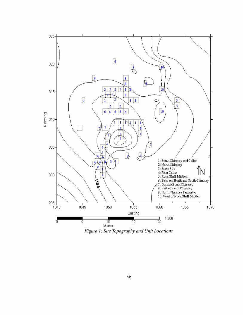
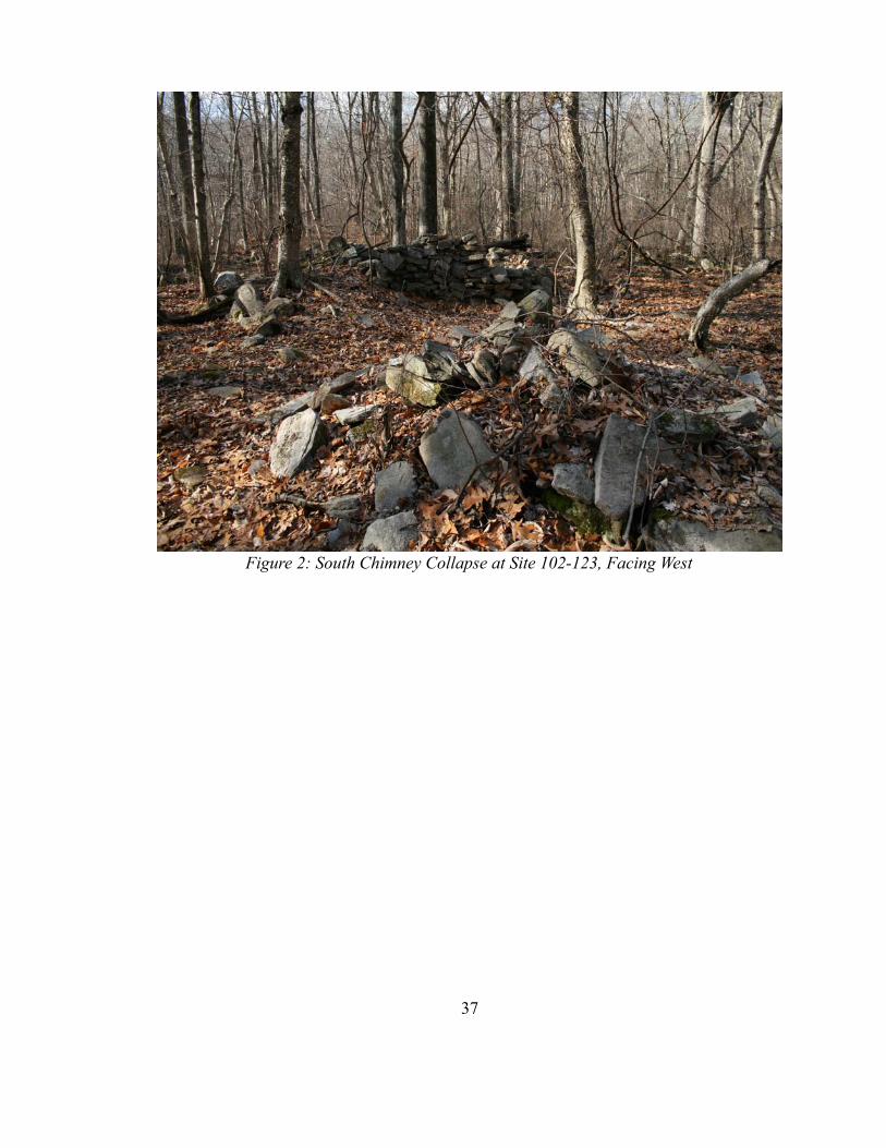
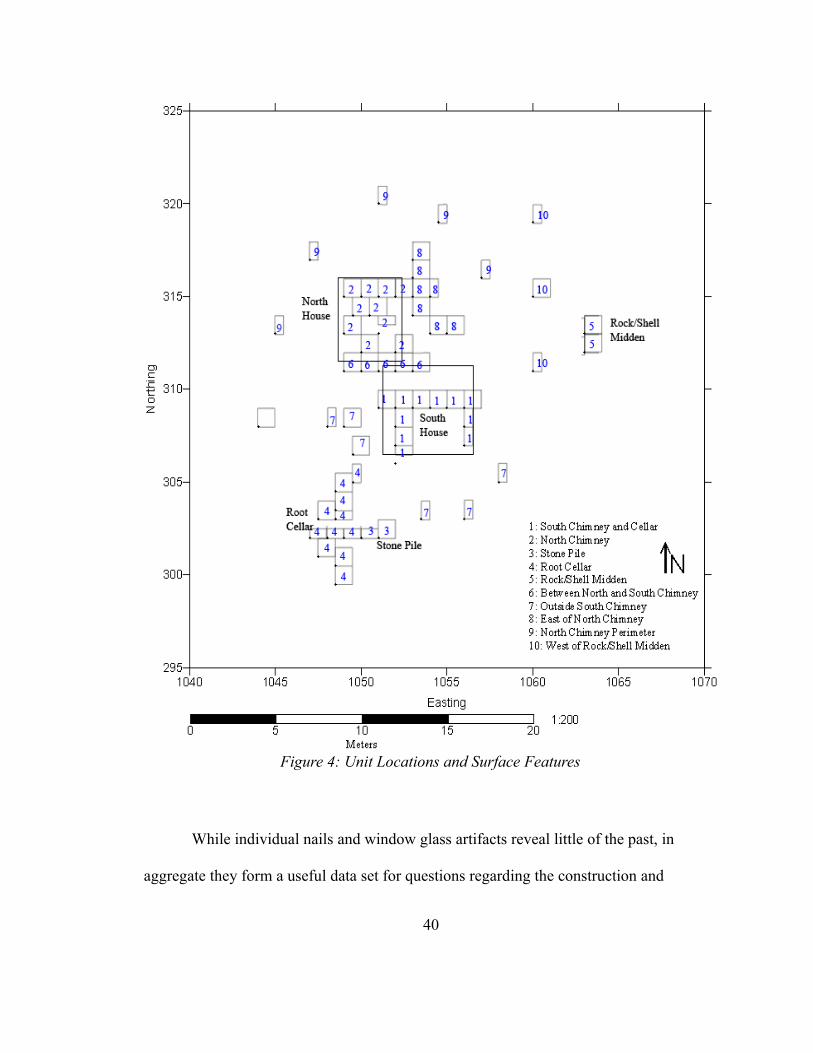
The site examined here (Site 102-123) was detected by pedestrian survey in 2003
and excavated during the 2005 and 2006 field seasons (Figure 1). Several large stone
piles are present at the site, two of which were determined to be chimney collapses
(Figure 2 and Figure 3), but there are no standing buildings. The southern chimney fall is
associated with a deep cellar feature, filled with rock, on the north (interior) side. The
northern chimney collapse does not associate with an adjacent cellar. Several fieldstone
fences are present, most notably one that runs north-south directly west of the chimney
collapses, as well as a small stone pile, which is not a chimney fall, to the south of the
34
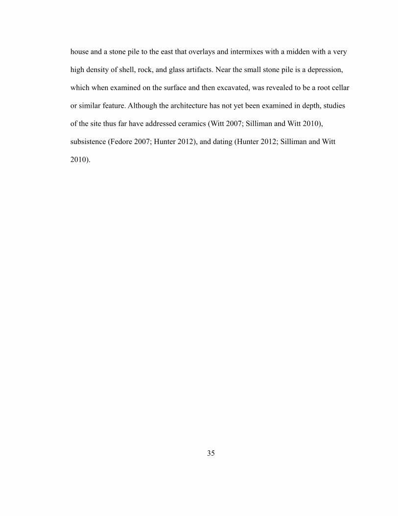
house and a stone pile to the east that overlays and intermixes with a midden with a very
high density of shell, rock, and glass artifacts. Near the small stone pile is a depression,
which when examined on the surface and then excavated, was revealed to be a root cellar
or similar feature. Although the architecture has not yet been examined in depth, studies
of the site thus far have addressed ceramics (Witt 2007; Silliman and Witt 2010),
subsistence (Fedore 2007; Hunter 2012), and dating (Hunter 2012; Silliman and Witt
2010).
35
36
Figure 1: Site Topography and Unit Locations
37
Figure 2: South Chimney Collapse at Site 102-123, Facing West
The site was excavated during the 2005 and 2006 field seasons, followed by a
brief return in Fall 2009 for select sampling, by undergraduate and graduate students
from the University of Massachusetts Boston and several interns from the Eastern Pequot
Tribal Nation. The site was mapped using an electronic total station to record the
position of surface features and the location of individual test units. The units were hand
excavated, first through a reconnaissance subsurface survey of shovel test pits to identify
artifact concentrations and features, and then by the hand-troweled excavation of 41 1-m-
38
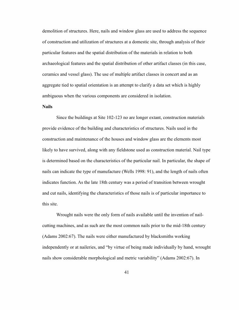
Figure 3: South Chimney Collapse from Above
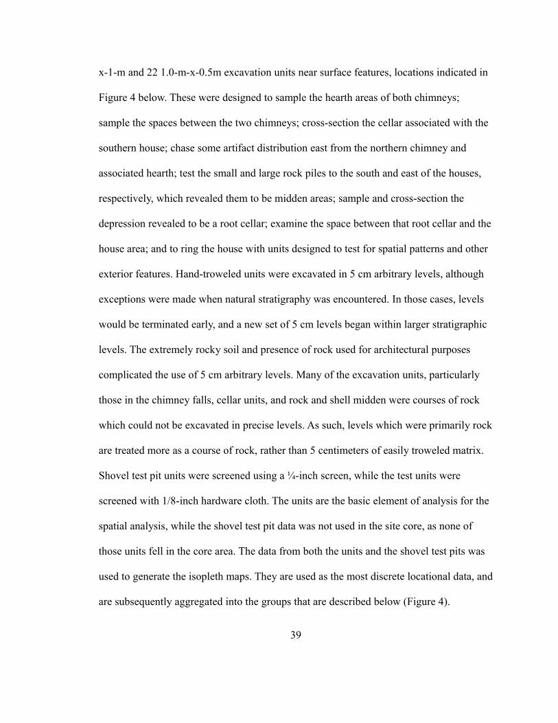
x-1-m and 22 1.0-m-x-0.5m excavation units near surface features, locations indicated in
Figure 4 below. These were designed to sample the hearth areas of both chimneys;
sample the spaces between the two chimneys; cross-section the cellar associated with the
southern house; chase some artifact distribution east from the northern chimney and
associated hearth; test the small and large rock piles to the south and east of the houses,
respectively, which revealed them to be midden areas; sample and cross-section the
depression revealed to be a root cellar; examine the space between that root cellar and the
house area; and to ring the house with units designed to test for spatial patterns and other
exterior features. Hand-troweled units were excavated in 5 cm arbitrary levels, although
exceptions were made when natural stratigraphy was encountered. In those cases, levels
would be terminated early, and a new set of 5 cm levels began within larger stratigraphic
levels. The extremely rocky soil and presence of rock used for architectural purposes
complicated the use of 5 cm arbitrary levels. Many of the excavation units, particularly
those in the chimney falls, cellar units, and rock and shell midden were courses of rock
which could not be excavated in precise levels. As such, levels which were primarily rock
are treated more as a course of rock, rather than 5 centimeters of easily troweled matrix.
Shovel test pit units were screened using a ¼-inch screen, while the test units were
screened with 1/8-inch hardware cloth. The units are the basic element of analysis for the
spatial analysis, while the shovel test pit data was not used in the site core, as none of
those units fell in the core area. The data from both the units and the shovel test pits was
used to generate the isopleth maps. They are used as the most discrete locational data, and
are subsequently aggregated into the groups that are described below (Figure 4).
39
While individual nails and window glass artifacts reveal little of the past, in
aggregate they form a useful data set for questions regarding the construction and
40
Figure 4: Unit Locations and Surface Features
demolition of structures. Here, nails and window glass are used to address the sequence
of construction and utilization of structures at a domestic site, through analysis of their
particular features and the spatial distribution of the materials in relation to both
archaeological features and the spatial distribution of other artifact classes (in this case,
ceramics and vessel glass). The use of multiple artifact classes in concert and as an
aggregate tied to spatial orientation is an attempt to clarify a data set which is highly
ambiguous when the various components are considered in isolation.
Nails
Since the buildings at Site 102-123 no are longer extant, construction materials
provide evidence of the building and characteristics of structures. Nails used in the
construction and maintenance of the houses and window glass are the elements most
likely to have survived, along with any fieldstone used as construction material. Nail type
is determined based on the characteristics of the particular nail. In particular, the shape of
nails can indicate the type of manufacture (Wells 1998: 91), and the length of nails often
indicates function. As the late 18th century was a period of transition between wrought
and cut nails, identifying the characteristics of those nails is of particular importance to
this site.
Wrought nails were the only form of nails available until the invention of nail-
cutting machines, and as such are the most common nails prior to the mid-18th century
(Adams 2002:67). The nails were either manufactured by blacksmiths working
independently or at naileries, and “by virtue of being made individually by hand, wrought
nails show considerable morphological and metric variability” (Adams 2002:67). In
41
addition to nails made by blacksmiths, wrought nails were simple enough in manufacture
that they could be made at home with the proper equipment (Benson 1983:136). Nails
were also commonly imported from Europe until the second decade of the 19th century
(Adams 2002:71), indicating that the manufacture of nails in the United States was
unable to provide enough nails for the demands of builders. Adams (2002:71) attributes
the decline of imported nails to growing production in the early 19th century as well as
international events that may have affected the cost or availability of imported nails.
The manufacture of cut nails was a process still in development in the late 18th
century. While wrought nails are largely considered to be nonstandardized due to the
idiosyncratic nature of their manufacture, cut nails were also nonstandardized well into
the 19th century (Benson 1983:137). The manufacture of cut nails developed rapidly in
the 18th and 19th centuries, with multiple changes occurring to the process during the
period before and after the American War of Independence (Phillips 1996:47). Hand-
operated nails machines were operated south of Boston in the 1780s (Phillips 1993:5).
Analysis of nail samples indicates that cut nails were in wide use by 1795 (Phillips
1993:13), and standardization of nails increased through 1810, as nails became more
regular and less eccentric. By 1809, machine cut nails also had heads made by machine
(Adams 2002:80). The belief that cut nails are weaker and break along the grain of the
metal more readily than wrought nails is mistaken (Phillips 1993:13), although this belief
may have slowed the adoption of cut nails. While cut nails were eventually considered to
be “a superior nail for building purposes, depending on the wood being used” (Adams
2002:69), when compared to wire nails, early cut nails were ranked unfavorably to
42
wrought nails, and perceived as a “cheap, inferior, substitute for handwrought nails”
(Leach 2000:39). Larger cut nails were slower to be adopted because the machines used
to manufacture large cut nails needed to be more powerful than the earliest nail-cutting
machine, although beliefs about the weakness of cut nails compared to wrought nails may
have also been a factor in the reluctance of some people to adopt their use (Phillips
1993:13). In summary, the nails in use in the 18th and early 19th centuries would have
been limited to cut or handwrought nails. Wire nails came to dominate the nail market
largely because of their cheapness and not because of any superior quality (Adams
2002:69). However, wire nails were not produced until 1883, and did not come to
dominate the market until 1897 (Adams 2002:71), long after the period under study here.
Nails have been made for millennia, and for most of that time, they were
constructed out of wrought iron. Wrought iron is relatively easy to work and can be
fashioned into nails or nail plates more readily than cast iron. Cast iron nails are known
but relatively rare (Lenik 1977:45). Cast iron has superior corrosion resistance to wrought
iron, but never overtook the manufacture of wrought iron nails. Nails could also be made
from other materials, including copper (Inashima 1994:47), although the expense of
copper would have limited its use in nails for large scale projects, such as construction. In
some cases, zinc or lead was used as a coating on nails to improve corrosion resistance
(Leach 2000:43). Steel nails are not likely to be found in an archaeological assemblage
until after 1882 (Adams 2002:69), and did not become commonplace until the 1890s
(Wells 1998:87).
43
The materials and manufacturing technique for particular nails can be useful in
determining the date when a building may have been constructed or modified, but
provide relatively few clues as to the function of the nails. Wells, when discussing
usefulness of nails as a material for dating, notes that “the actual use of any particular nail
cannot be known out of its original context. Functional types may be of limited use in
describing some nails, in the same manner and with the same skepticism as 'arrow head'
or 'adz' are used to describe prehistoric stone artifacts” (Wells 1998:87). Schuyler and
Mills divided the nails from the Content Brook Supply Mill in Massachusetts into six
types, recognizing that “difference in specific use are not clear” based solely on the shape
and size of the nails (Schuyler and Mills 1976:75). The nails at Arryl House in Clermont,
New York, were divided into groups based on their presumed pennyweight sizes, with
two broad groups. The smaller group, between 2.25 and 3 inches in length, corresponded
to 7d, 8d, 9d, and 10d nails, “commonly used in construction for flooring, boarding, and
interior fittings” (Wentworth 1979:34). The larger group, between 3.25 and 4 inches in
length, corresponding to 12d, 16d, 18d, and 20d nails, “were often used for wood
studding and heavy framing” (Wentworth 1979:34). From both of these studies, the most
common method of determining nail use is to estimate the original size of the nail. With
few exceptions for the head type, this should give an indication as to the possible original
function, keeping in mind that nails were not standardized, nor were carpenters
compelled to use particular nails for particular purposes. Moreover, even though large
nails can be used for small projects in some cases, small nails cannot be used for larger
44
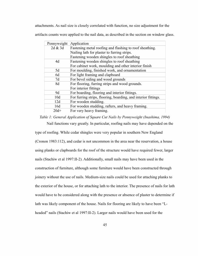
attachments. As nail size is closely correlated with function, no size adjustment for the
artifacts counts were applied to the nail data, as described in the section on window glass.
Pennyweight Application2d & 3d Fastening metal roofing and flashing to roof sheathing.
Nailing lath for plaster to furring strips.Fastening wooden shingles to roof sheathing
4d Fastening wooden shingles to roof sheathingFor cabinet work, moulding and other interior finish
5d For moulding, finished work, and ornamentation6d For light framing and clapboard7d For bevel siding and wood grounds8d For flooring, furring strips and wood grounds.
For interior fittings9d For boarding, flooring and interior fittings.10d For furring strips, flooring, boarding, and interior fittings.12d For wooden studding.16d For wooden studding, rafters, and heavy framing.
20d+ For very heavy framing.
Table 1: General Application of Square Cut Nails by Pennyweight (Inashima, 1994)
Nail functions vary greatly. In particular, roofing nails may have depended on the
type of roofing. While cedar shingles were very popular in southern New England
(Cronon 1983:112), and cedar is not uncommon in the area near the reservation, a house
using planks or clapboards for the roof of the structure would have required fewer, larger
nails (Stachiw et al 1997:II-2). Additionally, small nails may have been used in the
construction of furniture, although some furniture would have been constructed through
joinery without the use of nails. Medium-size nails could be used for attaching planks to
the exterior of the house, or for attaching lath to the interior. The presence of nails for lath
would have to be considered along with the presence or absence of plaster to determine if
lath was likely component of the house. Nails for flooring are likely to have been “L-
headed” nails (Stachiw et al 1997:II-2). Larger nails would have been used for the
45
framing and sheathing of the house. The largest nails would have been used for joining
planks to frames, especially 20d or larger nails. The absence of large, 20d nails would
imply that wood studding was not the primary method of supporting weight in the
structure (Inashima 1994:47).
Corrosion eventually attacks iron nails, leaving many nails covered in a deep,
reddish-brown oxidation layer. Corrosion obscures some features that might shed light on
the original form and, therefore, probable function of a nail, but corrosion can also
sometime assist in identifying some features that may not be visible on an uncorroded
nail, such as grain direction (Leach 2000:35). The difference between wrought and cast
iron can also be easily detected, given cast iron's greater resistance to corrosion.
Corrosion can also strongly affect the composition of an archaeological assemblage due
to differential rates of corrosion (and thus differential rates of artifact retrieval) especially
on smaller nails (Inashima 1994:46).
The use of nails in houses is usually considered to be associated first and foremost
with the construction, but nails are reusable to a certain extent. Recycling and salvage can
have a major effect on the nails in archaeological assemblages (Inashima 1994:46).
Inhabitants of a building would have been more likely to salvage nails depending of the
relative value of the nails and value of the labor expended to salvage them – a difficult
and demanding job. In particular, the effort expended would have also depended on the
type of nail, as smaller nails may not have been worth that effort. For example, while
researching framed houses on the Mashantucket Pequot reservation, Stachiw, Dempsey,
and Paske determined that “the majority of nails and other architectural hardware were
46
salvaged from the sites. Many of the nails were broken or twisted – probably discarded
because they broke during removal” (Stachiw et al. 1997:II-1). If nail recycling was
widespread, then most relatively large nails would have been recovered, while those that
were not of any use would have been discarded. If true, then frugality would tend to tilt
the assemblage of nails recovered archaeologically towards a high proportion of bent or
twisted nails, from an original assemblage including both larger nails that would have
been salvaged, and smaller nails that would have succumbed to corrosion.
Adams (2002:66) lists five possible areas in which nails can be of analytical use:
the use of nails in a structure, as determined from the size and style of a nail; the history
of structural renovations; the technology of manufacture; technological and marketing
lag; and the chronology of a structure. Size and style have already been touched upon, in
that the form of a nail is largely determined by its function. Renovation of structures is an
area of consideration since structures are artifacts that are physically modified throughout
their use. Renovation can also complicate the use of nails to determine a building's
construction date, as renovations will likely use newer nails than those employed in the
original construction of the structure (Adams 2002:73). A renovated building will possess
a mix of nails, including some that date from the original construction and some from
renovations and repairs. The possible use of recycled nails in renovations further
complicates the dating of buildings.
Available technologies and the acquisition of these technologies provide an
avenue for insight into the penetration of industrial techniques and products into rural
areas. The use of cut nails as opposed to handwrought would be demonstration of the
47
increasing availability of mass produced over artisanal goods, though handwrought nails
could also be produced in extremely large quantities. The shipment of nails adds to the
time between the production of the nail and its use in a structure, thus requiring
archaeologists to consider the addition of more time to the minimum dates from nails.
Adams believes that nails would take longer to go from manufacture to use than the 4.5
years estimated for glass bottles in the Pacific Northwest (Adams 2002:72). Although the
Eastern Pequot reservation is unlikely to be as isolated as a fort in the northwestern
United States, nails can loiter on store shelves, and, when combined with recycling
behavior, do not have to be consumed often. The eventual dismantling or collapse of a
building would lead to a collection of nails that would include nails from the construction
of that building as well as nails from any renovation episodes, implying that a date based
solely on the types of nails included in a collection must take into account modifications
of that building.
Despite the lag in acquisition of nails, and the fact that recycled nails may be used
in multiple structures if husbanded carefully, a simple chronology can be determined
from the types of nails used in a structure. Handwrought nails are of such great antiquity
as to be useless for determining a terminus post quem. Inashima suggest that machine cut
nails should suggest a date of approximately 1800 or later, particularly for headless or L-
headed nails. Stamped nails should date to 1825, becoming more regular around 1840. By
1840, nails should be highly regular (Inashima 1994:46). Phillips’ chronology is more
detailed, but largely agrees. She places handwrought nails in the 17th century through
early 19th century, although handwrought nails date back to antiquity. Early machine cut
48
nails range from 1790 to circa 1820, including hand headed, rose headed, and T-headed,
as well as early machine headed nails. “Transitional Machine Cut-Nails” date from circa
1810 to circa 1840 and are very similar to early machine cut nails, but with slight
differences in the positioning of burrs and bevels. Modern machine cut nails date from
circa 1835 to 1890 in her typology, despite the fact that machine cut nails are available
for purchase in the 21st century; however, by 1890 steel had largely replaced iron. They
possess a squared end, different grain direction, and slight differences in the head shape
(Phillips 1993:9).
With these issues in mind, I turn to the nail assemblage from the site. Before any
analysis took place, the artifacts were cleaned and conserved – not simply brushed, but
having corrosion products removed from nails and having those nails treated with
soaking in distilled water and multiple tannic acid treatments. Preliminary analysis of the
nails consisted of two complementary steps. Nails were analyzed both quantitatively,
particularly through the measurement of length, the primary indicator of original
function, and qualitatively, cataloging head shape and nail cross section. Nails were
categorized by modification as either unmodified, bent, or clinched, where bent nails
were bent at angles less than 90 degrees, while clinched nails were bent at greater angles.
Analysis of the nails for manufacture looked for diagnostic features associated with the
use of either handforging techniques or mechanical manufacture, primarily in the
differences in the shape of the nail shank and head. An assessment of the role of nails and
window glass in the construction of a structure was not limited to the whole nails. As
many nails are likely to have broken in either the processes of house collapse or removal
49
during salvaging, the assessment also considered nail fragments, even though they only
provide a lower bound for the length of nail and many diagnostic features are likely to be
absent or damaged. However, nail fragments provide useful data by indicating the
presence or absence of nail in a particular excavation unit or shovel test pit. Finally,
temporal data were extracted by identifying the manufacturing characteristics of nails and
comparing these to their association with particular features.
Window Glass
In addition to nails, window glass provides insight into buildings represented in
the archaeological record. Glass was heavily taxed and recognized as both a “luxury and
necessity” (Scharfenberger 2004:60, 62), although glass manufactured in North America
did not become commonplace until after the War of Independence (Scharfenberger
2004:60). Window glass in the late 18th and early 19th centuries was an important
architectural element, but also an important component of the “developing social and
economic structure” (Scharfenburger 2004:69). Window glass can provide insight into
the social class of the builders and occupants of a building, as different grades of window
glass were used by different social classes. The dark green or opaque glass tended to be
less expensive in the 18th century, while clearer and thinner glass was preferred by
wealthier persons. While opaque glasses were less expensive to produce, the color of the
glass is not a reliable indicator of the method of manufacture for any particular glass
fragment (Schafenberger 2004:63, 64).
Three broad categories of glass, based on their method of manufacture, are used
by archaeologists. Crown glass is manufactured by spinning a bubble of hot glass into a
50
disc, and then cutting away the needed panes. Cylinder glass is manufactured from a hot
cylinder of glass which is cut and allowed to lay flat, creating glass with small waves in
the material from stretching of the glass. Plate glass is manufactured by pouring molten
glass into a table and allowing it to cool flat, avoiding the distortions caused by the
manufacture of cylinder or crown glass. Both the crown and cylinder methods were in
use at the same time in the 18th century (Lorrian 1968:37), so both may be expected at
the same site, particularly if the long-standing building may have had replacement
windows installed. Crown glass was the preferred form of window glass in the 18th
century, owing to its superior clarity (Scharfenburger 2004:62, 63).
Window glass was treated in the analysis in a similar manner to nails, although
the qualitative data from window glass are likely to be very limited. When considering
window glass, all pieces were measured to estimate the surface area. Individual pieces of
window glass are less important than the total surface area of glass indicated by the
assemblage. Rather than measure each individual artifact to calculate the surface area, the
artifacts were assigned to size categories. In this case, pre-existing size categories have
been in use since the beginning of archaeological investigations on the Eastern Pequot
reservation. These size categories were then given numerical values (see Table 2), the
counts were multiplied by the size category value, and totaled. This total represents the
size of the artifacts, in terms of surface area within a given context, but avoids the labor
expenditure of calculating the total surface area of each artifact. Thus, a small (e.g.
smaller than 1 square centimeter) window glass artifact receives a value of 1, while a
large artifact (e.g. greater than 5 square centimeters) would receive a value of 5, and the
51
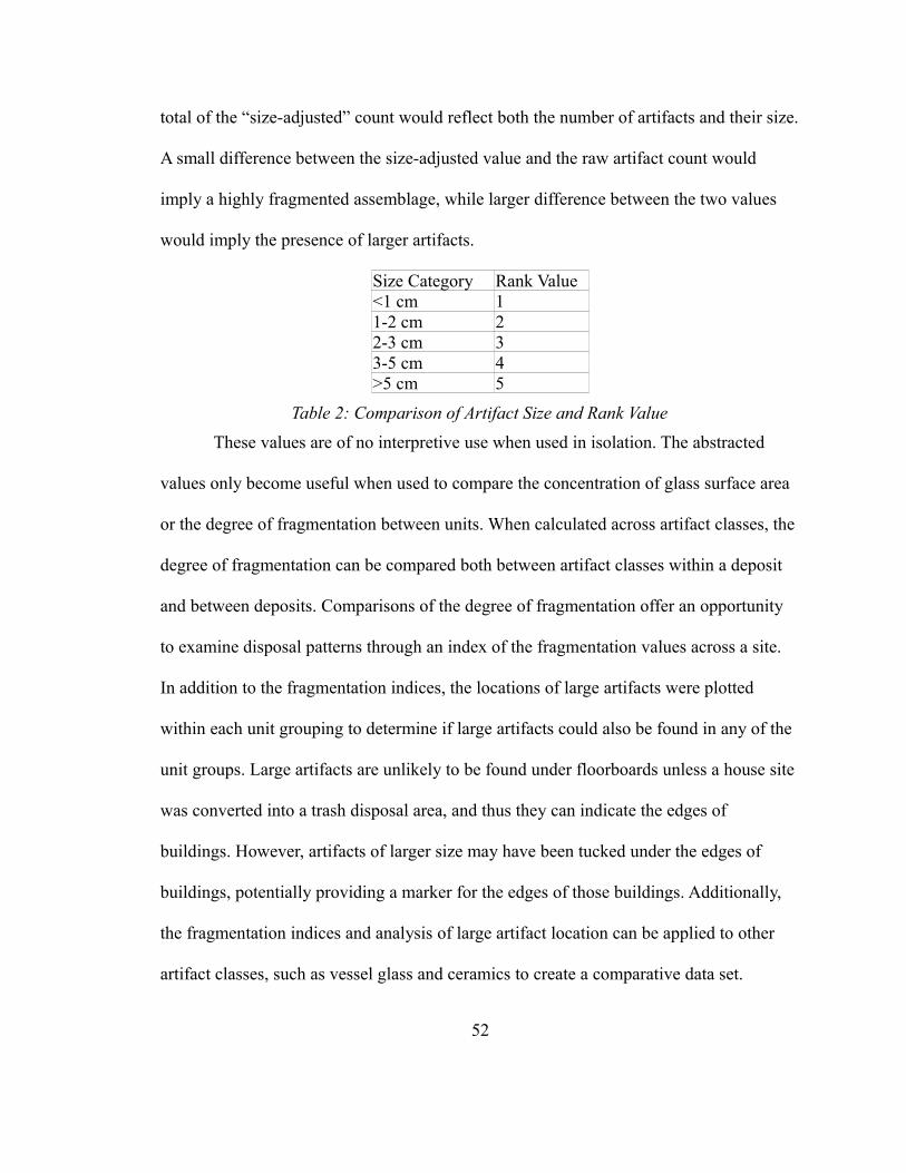
total of the “size-adjusted” count would reflect both the number of artifacts and their size.
A small difference between the size-adjusted value and the raw artifact count would
imply a highly fragmented assemblage, while larger difference between the two values
would imply the presence of larger artifacts.
Size Category Rank Value<1 cm 11-2 cm 22-3 cm 33-5 cm 4>5 cm 5
Table 2: Comparison of Artifact Size and Rank Value
These values are of no interpretive use when used in isolation. The abstracted
values only become useful when used to compare the concentration of glass surface area
or the degree of fragmentation between units. When calculated across artifact classes, the
degree of fragmentation can be compared both between artifact classes within a deposit
and between deposits. Comparisons of the degree of fragmentation offer an opportunity
to examine disposal patterns through an index of the fragmentation values across a site.
In addition to the fragmentation indices, the locations of large artifacts were plotted
within each unit grouping to determine if large artifacts could also be found in any of the
unit groups. Large artifacts are unlikely to be found under floorboards unless a house site
was converted into a trash disposal area, and thus they can indicate the edges of
buildings. However, artifacts of larger size may have been tucked under the edges of
buildings, potentially providing a marker for the edges of those buildings. Additionally,
the fragmentation indices and analysis of large artifact location can be applied to other
artifact classes, such as vessel glass and ceramics to create a comparative data set.
52
Other Artifact Classes
Other artifact classes, such as ceramics, provide further insight into the built
environment. A highly fragmented assemblage of ceramics, in an area where other data
indicate that a structure may have stood, may represent material that has fallen between
floorboards. The presence of larger pieces – that is, a less fragmented assemblage – may
indicate materials that were disposed of outside of a structure, especially those that might
get tucked under building edges or in a designated disposal area. A simple way to
quantify the degree of fragmentation in an assemblage (on the scale of excavation units
for these purposes) is to generate a measure of the average size of the artifact in a
particular subassemblage. Dividing the aggregated size value by the total number of
artifacts within a given context generates a value that can represent the degree of
fragmentation within an assemblage, with lower values indicating more highly
fragmented assemblages. This mean value was correlated to the size categories used to
generate the aggregated size values, in effect providing a mean size for artifacts within a
group. Additionally, mean ceramic dates can be used to estimate the period of occupation
for different structures.
Architectural Debris Deposits
Beyond specific artifact classes, the thesis also considers the above artifacts in
their spatial contexts and their co-occurrences. The types of deposits generated from
architectural debris can fall into a variety of categories. In particular, “extremely dense
concentrations of nails can indicate the presence of a structure,” although a cluster of
nails does not necessarily indicate the location of a building (Young 1994a:2). The
53
characteristics of nails must be used carefully to categorize the formation processes that
lead to the deposit in the archaeological record. Care must be taken to distinguish
between the sites of actual structures and the sites that are the result of the disposal of
discarded material from the demolition of a structure, which can also be characterized by
extremely high concentrations of nails (Young 1994a:2). During research at the
Mashantucket Pequot reservation, McBride has used the presence of concentrations of
window glass and nails to identify the presence of framed houses (McBride 1991:73).
These physical components would have been present in framed houses, but were not
unknown in wigwam-type structures that included elements such as window glass or door
hardware. The inclusion of material culture types, such as window glass and door
hardware, indicates that nails may have been used in the construction of wigwams with
European-derived material culture, or, at the very least, furniture that may have contained
some small nails.
Nails can enter the archaeological record at several stages of house construction.
Young (1994b:56) identified four stages at which nails may enter the archaeological
record: construction, structural decay, razing, and decay of lumber in a disposal area. To
these four activities, renovation should also be considered, either as a subset of
construction or as a separate activity. Nails lost during construction are most likely to be
completely unaltered (Young 1994b:56). Having never been driven, they are unlikely to
be modified either by the process of removing the nail from wood, or from the process of
clinching the nail to form a hook or staple. Nails from decay or razing are likely to be at
least somewhat altered, however.
54
The collapse of a house presents a different type of deposit. While all structures
are likely to have at least some debris associated with their construction, the manner of
the building's end will result in slightly different deposits. Doroszenko notes that wooden
buildings collapse in three ways – “a 90 degree angle collapse, lean-over collapse, and
collapse in an inward/outward configuration” (Doroszenko 2000-2001:42). While each of
these would seem to leave a distinct pattern, any post-collapse clean up would alter the
distribution of materials left from the collapse of the house. As such, the nature of
building collapse could not necessarily be determined simply from the distribution of
materials let on the ground.
As part of the cleanup of a collapsed or dismantled house, a lumber pile would
likely accumulate, with boards that were unlikely to be salvaged. The nails that
accumulate in an area such as this are likely to be those that would be discarded and not
salvaged (Young 1994b:56). Given the relatively high cost of nails in the 18th century
compared to the cost of nails in the 19th and 20th centuries, more nails are likely to have
been salvaged from the discarded lumber. The process of razing a building would have
produced a discarded lumber pile, while a structure abandoned in place to decay would
not have an associated woodpile from razing, with the nails concentrated in the location
where the house had collapsed. A deliberate razing may have fewer nails, as a more
concerted effort to salvage nails is undertaken as part of the razing procedure, and the
nails exposed to the elements for less time. The disposal site is likely to have a high
proportion of clinched nails and a low proportion of unaltered nails, with the unaltered
nails having been salvaged during the razing process, while the clinched nails are
55
abandoned, as if not worth the effort of straightening back into their original shape. The
process of retrieving nails from boards will likely bend many of the softer wrought iron
nails (Faulkner 2004:58). Young (1994a) found that disposal sites would have a high
proportion of clinched nails and a low proportion of unaltered nails. In observing
carpenters in modern Tennessee dismantling a small house, Young observed that “a
building, intentionally torn down by hand, exhibits frequencies of three unaltered nails
and three pulled nails to every one clinched nail (a 3:3:1 ratio). Refuse disposal sites
show a 1:3:1 ratio (one unaltered, three pulled, one clinched)” (Young 1994a:58).
An additional type of deposit related to the use of a structure includes deposits
related to the moving of a particular structure. Given the possibility of two structures
occupying nearby spaces in a relatively close period of time, the possibility should be
considered. Two important characteristics stand out here. The foundation of a building
that was moved with the assistance of a lizard (a large wooden sled) might have
disturbances in the structure from the insertion of gluts, which were large wooden wedges
used to raise the building and move it onto the lizard (Faulkner 2004:57). A team of
horses or oxen would then pull the building to a new location, although sufficient
amounts of human laborers could probably move a small house as well. Faulkner argues
that large gaps in the foundation should be considered as possible locations where gluts
and a lizard were inserted into the foundation and then used to move the structure. If a
building were moved, the disposal patterns of nails around the structure are likely to be
different, and more biased towards nails lost in construction, rather than in razing or
56
decay of a structure. As such, moved building should have a high ratio of unmodified
nails to clinched or bent nails (Faulkner 2004:58).
Organizing Data on Nails, Window Glass, and Non-Architectural Artifacts
Analysis of these materials in a small area such as site 102-123 was aided by
dividing the site into several regions with unique features. These regions are groups of
units believed to represent distinct areas during the habitation of the site. For site 102-
123, several of these regions can be inferred from the surface remains and initial analysis
of the data (see Figure 4 above). Two large stone piles sit in close proximity and represent
the chimney collapses. Each large stone pile was identified as a group, and are the most
likely places for structures to have been standing during the habitation period. A group
between these two chimneys largely clear of surface rock was split from the two chimney
groups to improve resolution between the two chimney groups. Additionally, spatial
groups surrounding the chimneys were evaluated to examine differences between the
structures and the areas immediately outside of those structures. The root cellar feature
was examined separately, as was the stone pile adjacent to the root cellar, and the
rock/shell midden and units between the midden and chimneys were analyzed separately.
The units near the north chimney collapse are divided into two groups, group 8 being
adjacent to group 2 and group 7, while group 9 is separated from group 2 by two to three
meters. The table below summarizes the locations of the groups, and the units included in
each group. No group contains units that are also contained in another group, and all units
in the core of site 102-123 are included in these units.
Group Description No. of Square Meters Units
57
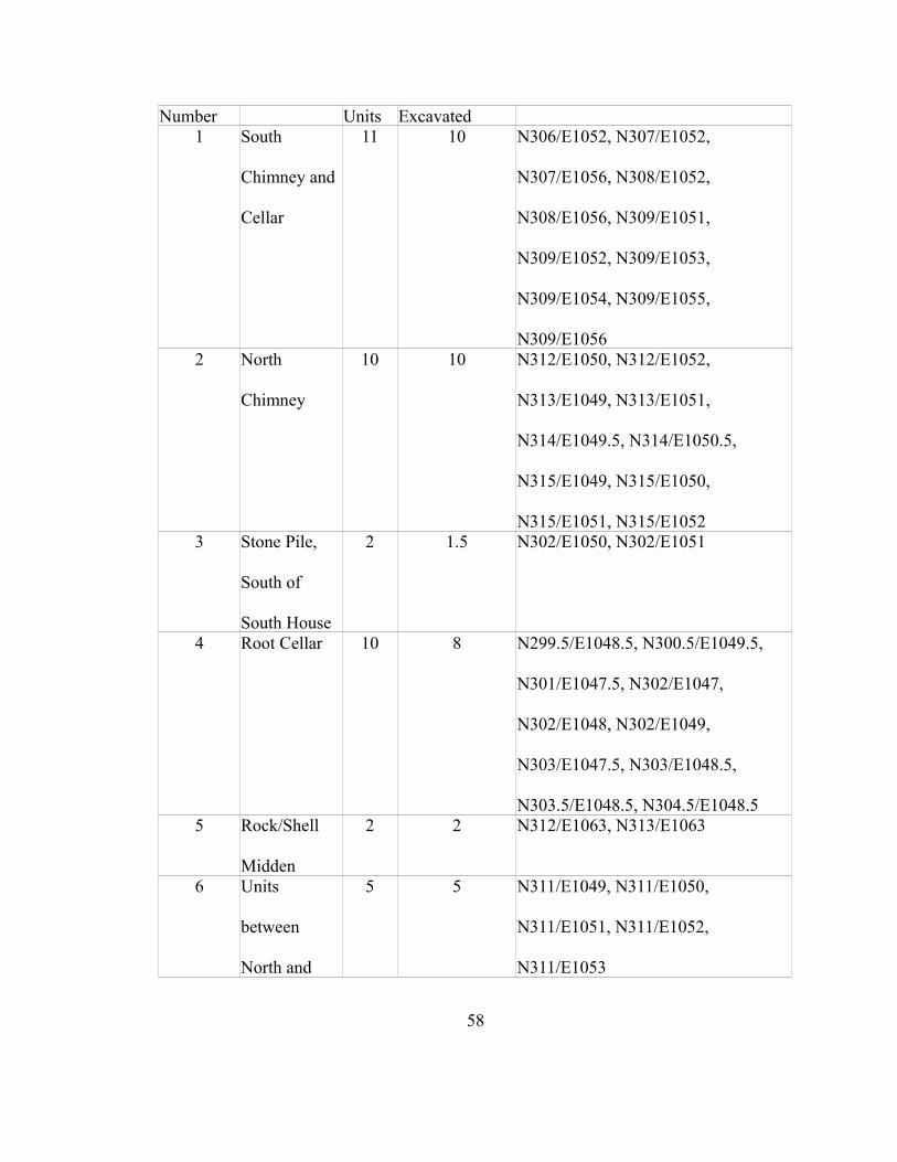
Number Units Excavated1 South
Chimney and
Cellar
11 10 N306/E1052, N307/E1052,
N307/E1056, N308/E1052,
N308/E1056, N309/E1051,
N309/E1052, N309/E1053,
N309/E1054, N309/E1055,
N309/E10562 North
Chimney
10 10 N312/E1050, N312/E1052,
N313/E1049, N313/E1051,
N314/E1049.5, N314/E1050.5,
N315/E1049, N315/E1050,
N315/E1051, N315/E10523 Stone Pile,
South of
South House
2 1.5 N302/E1050, N302/E1051
4 Root Cellar 10 8 N299.5/E1048.5, N300.5/E1049.5,
N301/E1047.5, N302/E1047,
N302/E1048, N302/E1049,
N303/E1047.5, N303/E1048.5,
N303.5/E1048.5, N304.5/E1048.55 Rock/Shell
Midden
2 2 N312/E1063, N313/E1063
6 Units
between
North and
5 5 N311/E1049, N311/E1050,
N311/E1051, N311/E1052,
N311/E1053
58
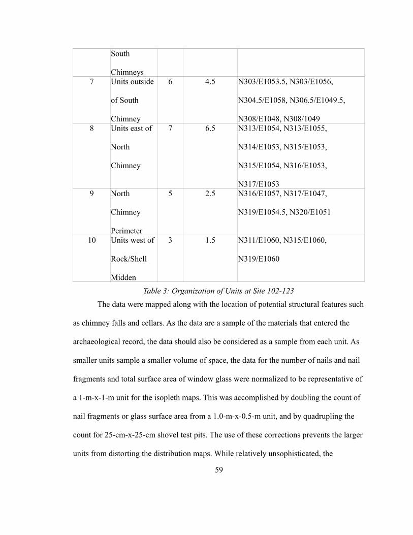
South
Chimneys7 Units outside
of South
Chimney
6 4.5 N303/E1053.5, N303/E1056,
N304.5/E1058, N306.5/E1049.5,
N308/E1048, N308/10498 Units east of
North
Chimney
7 6.5 N313/E1054, N313/E1055,
N314/E1053, N315/E1053,
N315/E1054, N316/E1053,
N317/E10539 North
Chimney
Perimeter
5 2.5 N316/E1057, N317/E1047,
N319/E1054.5, N320/E1051
10 Units west of
Rock/Shell
Midden
3 1.5 N311/E1060, N315/E1060,
N319/E1060
Table 3: Organization of Units at Site 102-123
The data were mapped along with the location of potential structural features such
as chimney falls and cellars. As the data are a sample of the materials that entered the
archaeological record, the data should also be considered as a sample from each unit. As
smaller units sample a smaller volume of space, the data for the number of nails and nail
fragments and total surface area of window glass were normalized to be representative of
a 1-m-x-1-m unit for the isopleth maps. This was accomplished by doubling the count of
nail fragments or glass surface area from a 1.0-m-x-0.5-m unit, and by quadrupling the
count for 25-cm-x-25-cm shovel test pits. The use of these corrections prevents the larger
units from distorting the distribution maps. While relatively unsophisticated, the
59
corrections could be applied uniformly. Applying the corrections is separate from the
correction for artifact size, which was meant to capture both rough total surface area of
window glass and to prevent highly fragmented sub-assemblages from appearing more
prominent than assemblages that contained a large number of larger artifacts.
Integrating the data from the distribution of nails and window glass and the
degree of fragmentation of window glass and other artifact classes offers an opportunity
to determine how and when any structures at a site were constructed. The distribution of
artifacts in relation to other structural remains, in this case chimney falls, but also features
such as cellars or foundations, can identify the locations where materials were disposed.
Without a discrete site chronology, identifying the sequence of construction or habitation
can be complicated. There is no obvious disposal feature within the presumed bounds of a
building, and without such a feature, disposal patterns will not be enough to determine
the sequence of habitation or construction. However, a clear indicator of sequential,
rather than simultaneous, occupation is highly fragmented debris that may be deposited
within the bounds of a building if that building has been dismantled or abandoned.
Locating such a deposit would indicate changing patterns of behavior regarding
habitation and work spaces. Using the unit groupings to identify the characteristics of the
units associated with particular surface features aids in identifying the particular
characteristics of the buildings that would have been standing in those areas in the past.
Some data were further disaggregated to level of excavation unit, to identify the filling or
excavation of certain features. The object of a fine grained spatial analysis across
multiple artifact classes is to provide multiple points of comparison in an attempt to
60

understand both the sequence of construction at the site and the broader use of space with
regards to the structures present there.
61
CHAPTER 4
RESULTS
This section reports the results of the analysis of the various artifacts using the
procedures described in the previous chapter. Comparisons between these various
groupings show substantial variation in the assemblages associated with the features, with
construction debris concentrated around the chimney collapses, and highly fragmented
ceramic and vessel glass distributed across the site. The various data classes are
organized by type below, and synthesized in the following chapter. The data support an
interpretation of two houses constructed sequentially, but likely without full replacement,
in the 18th century, one associated with a root cellar and one with a cellar under the floor,
both filled at different times, with several episodes of construction. The following chapter
will apply the data included here to possible interpretations for the sequence and nature of
construction and demolition at site 102-123.
The data set consists of multiple material classes, divided into architectural and
non-architectural artifacts. Nails and window glass comprise the architectural materials,
with 387 nails or nail fragments, and 486 individual window glass artifacts. When the
62
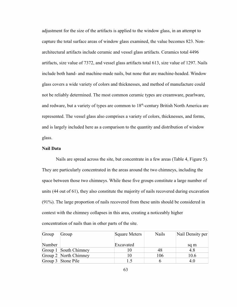
adjustment for the size of the artifacts is applied to the window glass, in an attempt to
capture the total surface areas of window glass examined, the value becomes 823. Non-
architectural artifacts include ceramic and vessel glass artifacts. Ceramics total 4496
artifacts, size value of 7372, and vessel glass artifacts total 613, size value of 1297. Nails
include both hand- and machine-made nails, but none that are machine-headed. Window
glass covers a wide variety of colors and thicknesses, and method of manufacture could
not be reliably determined. The most common ceramic types are creamware, pearlware,
and redware, but a variety of types are common to 18th-century British North America are
represented. The vessel glass also comprises a variety of colors, thicknesses, and forms,
and is largely included here as a comparison to the quantity and distribution of window
glass.
Nail Data
Nails are spread across the site, but concentrate in a few areas (Table 4, Figure 5).
They are particularly concentrated in the areas around the two chimneys, including the
space between those two chimneys. While these five groups constitute a large number of
units (44 out of 61), they also constitute the majority of nails recovered during excavation
(91%). The large proportion of nails recovered from these units should be considered in
context with the chimney collapses in this area, creating a noticeably higher
concentration of nails than in other parts of the site.
Group
Number
Group Square Meters
Excavated
Nails Nail Density per
sq mGroup 1 South Chimney 10 48 4.8Group 2 North Chimney 10 106 10.6Group 3 Stone Pile 1.5 6 4.0
63
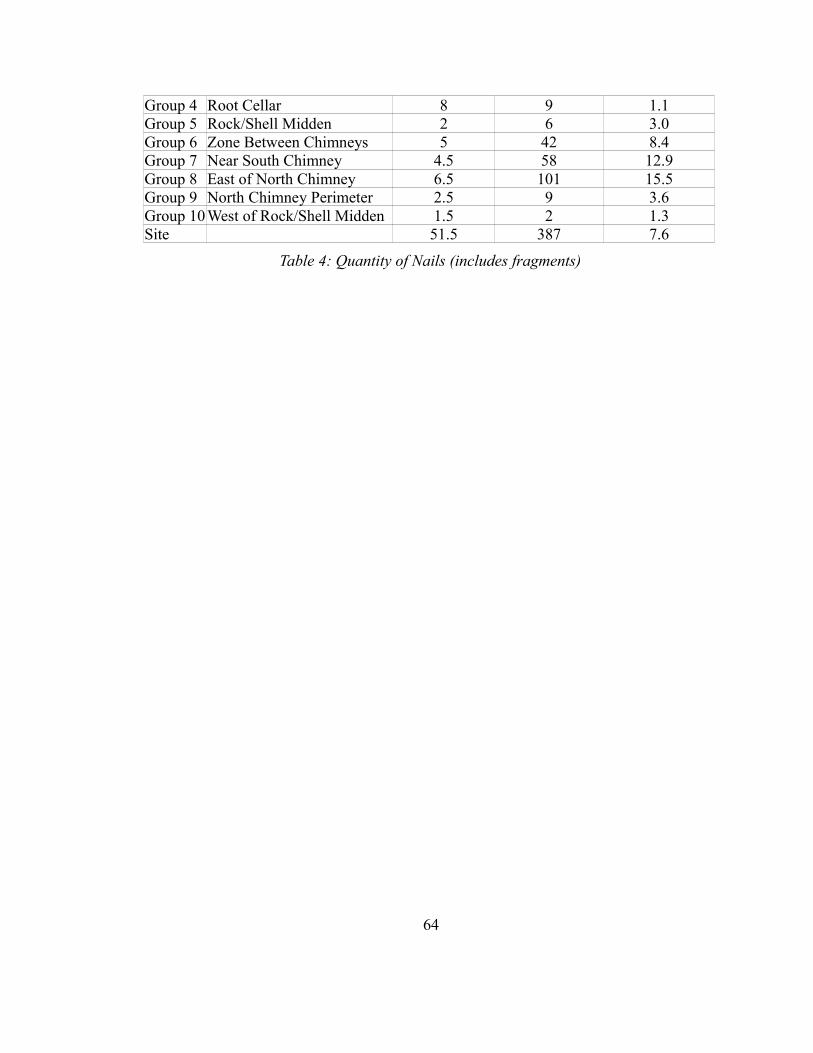
Group 4 Root Cellar 8 9 1.1Group 5 Rock/Shell Midden 2 6 3.0Group 6 Zone Between Chimneys 5 42 8.4Group 7 Near South Chimney 4.5 58 12.9Group 8 East of North Chimney 6.5 101 15.5Group 9 North Chimney Perimeter 2.5 9 3.6Group 10 West of Rock/Shell Midden 1.5 2 1.3Site 51.5 387 7.6
Table 4: Quantity of Nails (includes fragments)
64
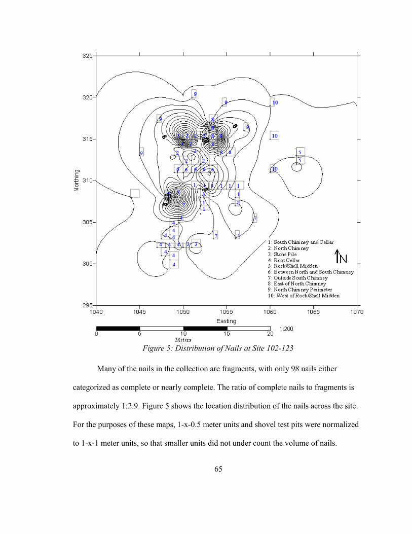
Many of the nails in the collection are fragments, with only 98 nails either
categorized as complete or nearly complete. The ratio of complete nails to fragments is
approximately 1:2.9. Figure 5 shows the location distribution of the nails across the site.
For the purposes of these maps, 1-x-0.5 meter units and shovel test pits were normalized
to 1-x-1 meter units, so that smaller units did not under count the volume of nails.
65
Figure 5: Distribution of Nails at Site 102-123
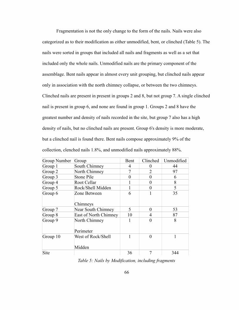
Fragmentation is not the only change to the form of the nails. Nails were also
categorized as to their modification as either unmodified, bent, or clinched (Table 5). The
nails were sorted in groups that included all nails and fragments as well as a set that
included only the whole nails. Unmodified nails are the primary component of the
assemblage. Bent nails appear in almost every unit grouping, but clinched nails appear
only in association with the north chimney collapse, or between the two chimneys.
Clinched nails are present in present in groups 2 and 8, but not group 7. A single clinched
nail is present in group 6, and none are found in group 1. Groups 2 and 8 have the
greatest number and density of nails recorded in the site, but group 7 also has a high
density of nails, but no clinched nails are present. Group 6's density is more moderate,
but a clinched nail is found there. Bent nails compose approximately 9% of the
collection, clenched nails 1.8%, and unmodified nails approximately 88%.
Group Number Group Bent Clinched UnmodifiedGroup 1 South Chimney 4 0 44Group 2 North Chimney 7 2 97Group 3 Stone Pile 0 0 6Group 4 Root Cellar 1 0 8Group 5 Rock/Shell Midden 1 0 5Group 6 Zone Between
Chimneys
6 1 35
Group 7 Near South Chimney 5 0 53Group 8 East of North Chimney 10 4 87Group 9 North Chimney
Perimeter
1 0 8
Group 10 West of Rock/Shell
Midden
1 0 1
Site 36 7 344
Table 5: Nails by Modification, including fragments
66
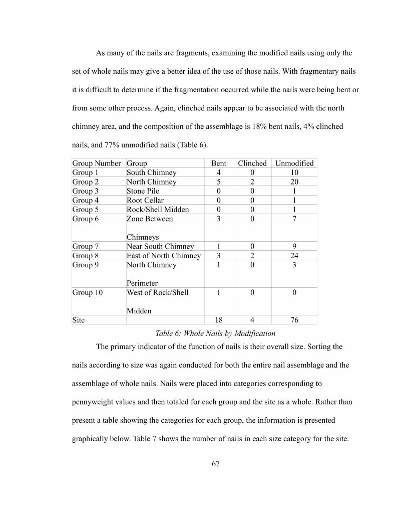
As many of the nails are fragments, examining the modified nails using only the
set of whole nails may give a better idea of the use of those nails. With fragmentary nails
it is difficult to determine if the fragmentation occurred while the nails were being bent or
from some other process. Again, clinched nails appear to be associated with the north
chimney area, and the composition of the assemblage is 18% bent nails, 4% clinched
nails, and 77% unmodified nails (Table 6).
Group Number Group Bent Clinched UnmodifiedGroup 1 South Chimney 4 0 10Group 2 North Chimney 5 2 20Group 3 Stone Pile 0 0 1Group 4 Root Cellar 0 0 1Group 5 Rock/Shell Midden 0 0 1Group 6 Zone Between
Chimneys
3 0 7
Group 7 Near South Chimney 1 0 9Group 8 East of North Chimney 3 2 24Group 9 North Chimney
Perimeter
1 0 3
Group 10 West of Rock/Shell
Midden
1 0 0
Site 18 4 76
Table 6: Whole Nails by Modification
The primary indicator of the function of nails is their overall size. Sorting the
nails according to size was again conducted for both the entire nail assemblage and the
assemblage of whole nails. Nails were placed into categories corresponding to
pennyweight values and then totaled for each group and the site as a whole. Rather than
present a table showing the categories for each group, the information is presented
graphically below. Table 7 shows the number of nails in each size category for the site.
67
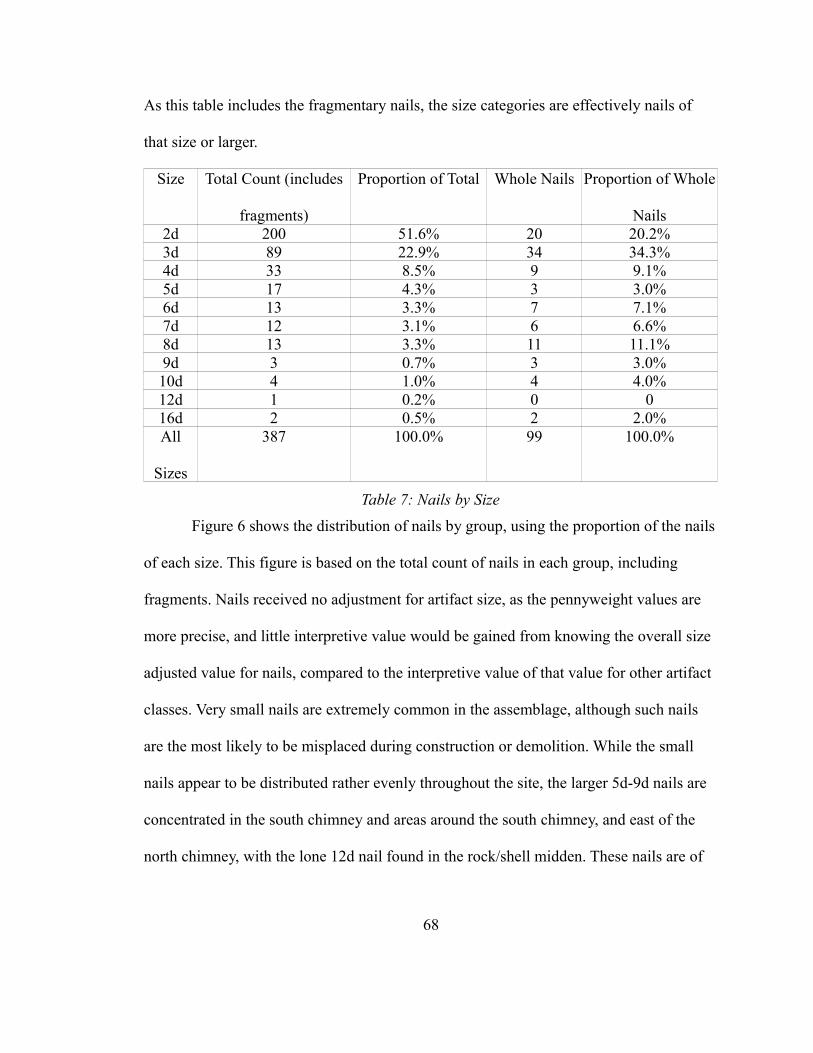
As this table includes the fragmentary nails, the size categories are effectively nails of
that size or larger.
Size Total Count (includes
fragments)
Proportion of Total Whole Nails Proportion of Whole
Nails2d 200 51.6% 20 20.2%3d 89 22.9% 34 34.3%4d 33 8.5% 9 9.1%5d 17 4.3% 3 3.0%6d 13 3.3% 7 7.1%7d 12 3.1% 6 6.6%8d 13 3.3% 11 11.1%9d 3 0.7% 3 3.0%10d 4 1.0% 4 4.0%12d 1 0.2% 0 016d 2 0.5% 2 2.0%All
Sizes
387 100.0% 99 100.0%
Table 7: Nails by Size
Figure 6 shows the distribution of nails by group, using the proportion of the nails
of each size. This figure is based on the total count of nails in each group, including
fragments. Nails received no adjustment for artifact size, as the pennyweight values are
more precise, and little interpretive value would be gained from knowing the overall size
adjusted value for nails, compared to the interpretive value of that value for other artifact
classes. Very small nails are extremely common in the assemblage, although such nails
are the most likely to be misplaced during construction or demolition. While the small
nails appear to be distributed rather evenly throughout the site, the larger 5d-9d nails are
concentrated in the south chimney and areas around the south chimney, and east of the
north chimney, with the lone 12d nail found in the rock/shell midden. These nails are of
68
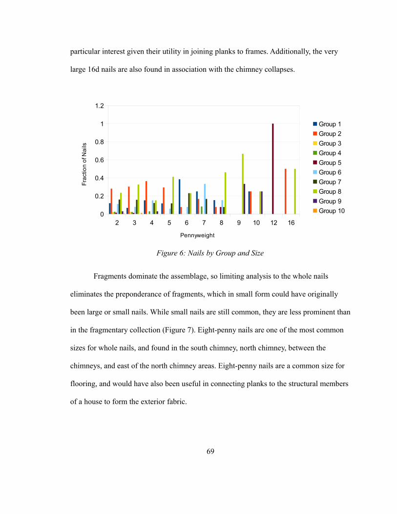
particular interest given their utility in joining planks to frames. Additionally, the very
large 16d nails are also found in association with the chimney collapses.
Fragments dominate the assemblage, so limiting analysis to the whole nails
eliminates the preponderance of fragments, which in small form could have originally
been large or small nails. While small nails are still common, they are less prominent than
in the fragmentary collection (Figure 7). Eight-penny nails are one of the most common
sizes for whole nails, and found in the south chimney, north chimney, between the
chimneys, and east of the north chimney areas. Eight-penny nails are a common size for
flooring, and would have also been useful in connecting planks to the structural members
of a house to form the exterior fabric.
69
2 3 4 5 6 7 8 9 10 12 160
0.2
0.4
0.6
0.8
1
1.2
Group 1
Group 2
Group 3
Group 4
Group 5
Group 6
Group 7
Group 8
Group 9
Group 10
Pennyweight
Fra
ctio
n o
f Na
ils
Figure 6: Nails by Group and Size
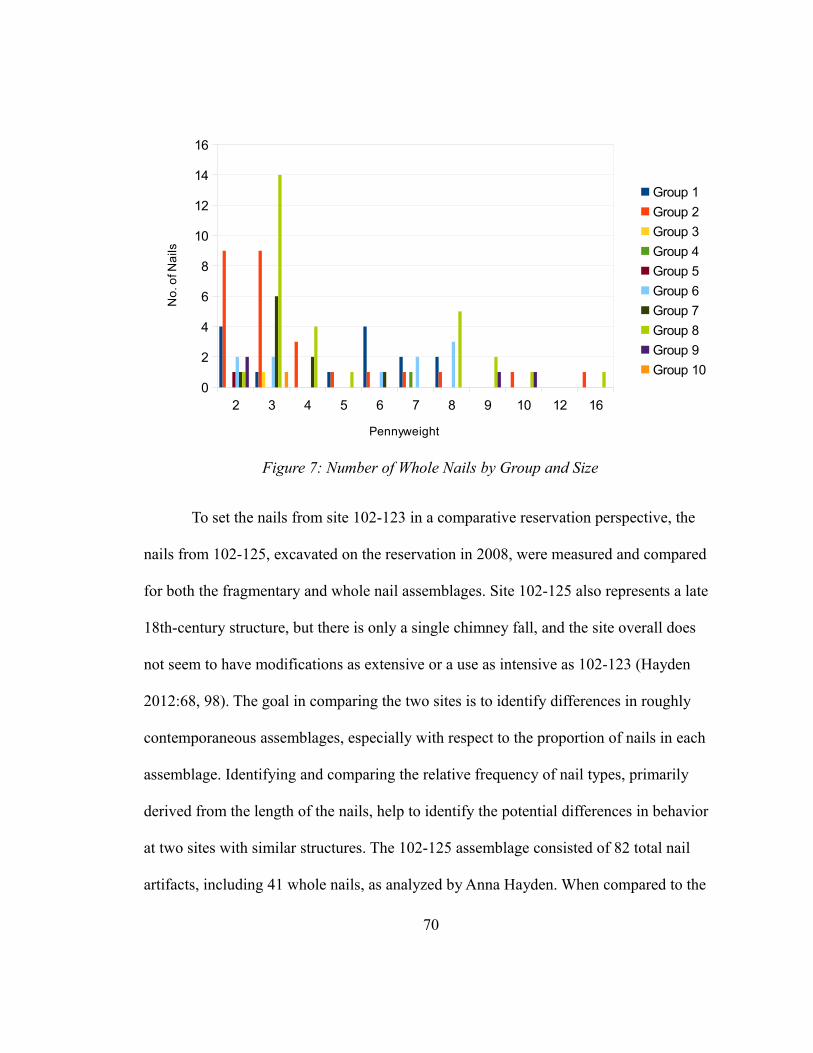
To set the nails from site 102-123 in a comparative reservation perspective, the
nails from 102-125, excavated on the reservation in 2008, were measured and compared
for both the fragmentary and whole nail assemblages. Site 102-125 also represents a late
18th-century structure, but there is only a single chimney fall, and the site overall does
not seem to have modifications as extensive or a use as intensive as 102-123 (Hayden
2012:68, 98). The goal in comparing the two sites is to identify differences in roughly
contemporaneous assemblages, especially with respect to the proportion of nails in each
assemblage. Identifying and comparing the relative frequency of nail types, primarily
derived from the length of the nails, help to identify the potential differences in behavior
at two sites with similar structures. The 102-125 assemblage consisted of 82 total nail
artifacts, including 41 whole nails, as analyzed by Anna Hayden. When compared to the
70
2 3 4 5 6 7 8 9 10 12 160
2
4
6
8
10
12
14
16
Group 1
Group 2
Group 3
Group 4
Group 5
Group 6
Group 7
Group 8
Group 9
Group 10
Pennyweight
No
. of N
ails
Figure 7: Number of Whole Nails by Group and Size
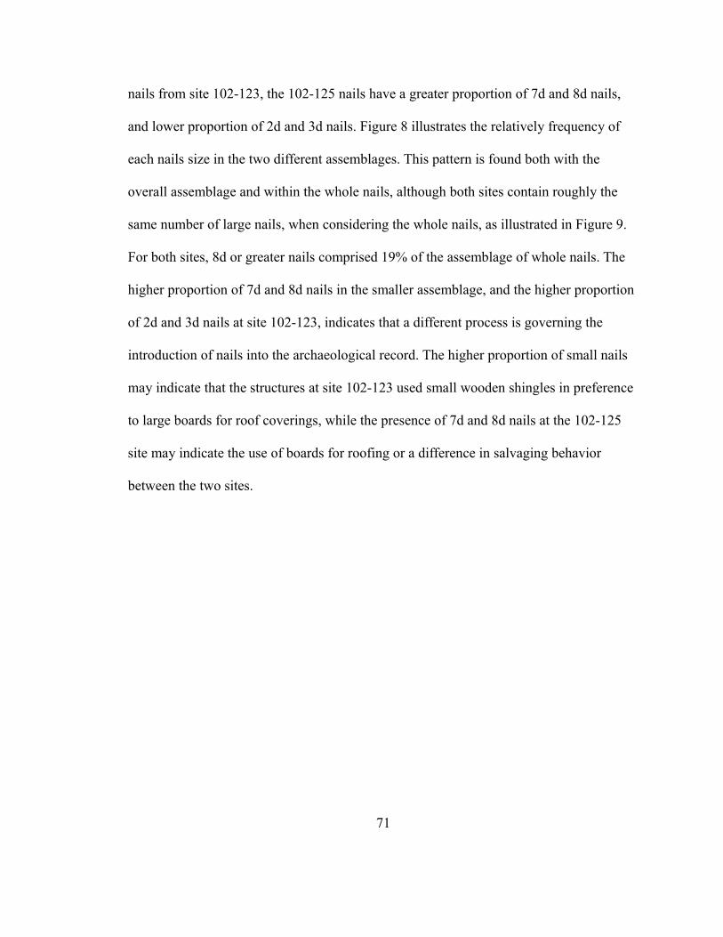
nails from site 102-123, the 102-125 nails have a greater proportion of 7d and 8d nails,
and lower proportion of 2d and 3d nails. Figure 8 illustrates the relatively frequency of
each nails size in the two different assemblages. This pattern is found both with the
overall assemblage and within the whole nails, although both sites contain roughly the
same number of large nails, when considering the whole nails, as illustrated in Figure 9.
For both sites, 8d or greater nails comprised 19% of the assemblage of whole nails. The
higher proportion of 7d and 8d nails in the smaller assemblage, and the higher proportion
of 2d and 3d nails at site 102-123, indicates that a different process is governing the
introduction of nails into the archaeological record. The higher proportion of small nails
may indicate that the structures at site 102-123 used small wooden shingles in preference
to large boards for roof coverings, while the presence of 7d and 8d nails at the 102-125
site may indicate the use of boards for roofing or a difference in salvaging behavior
between the two sites.
71
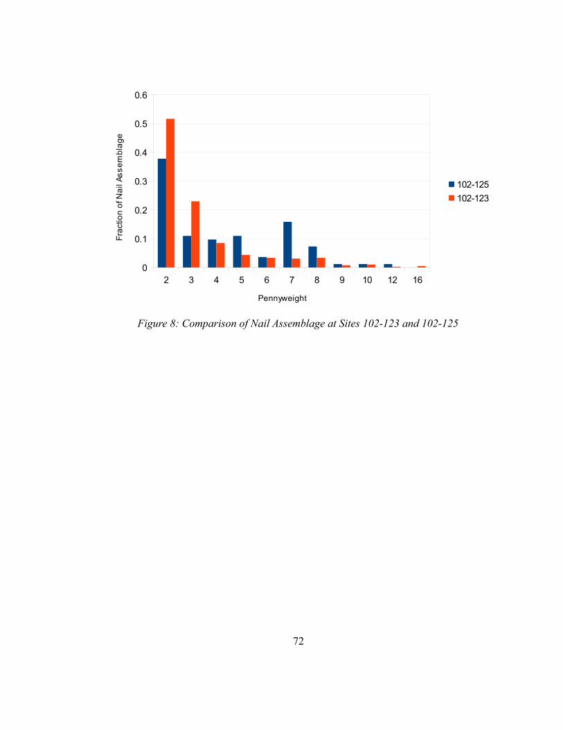
72
2 3 4 5 6 7 8 9 10 12 160
0.1
0.2
0.3
0.4
0.5
0.6
102-125
102-123
Pennyweight
Fra
ctio
n o
f Na
il A
ss
em
bla
ge
Figure 8: Comparison of Nail Assemblage at Sites 102-123 and 102-125
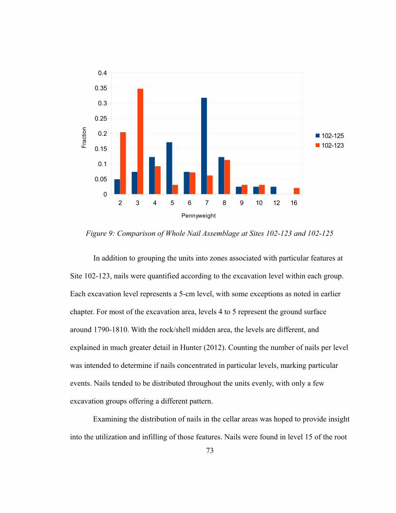
In addition to grouping the units into zones associated with particular features at
Site 102-123, nails were quantified according to the excavation level within each group.
Each excavation level represents a 5-cm level, with some exceptions as noted in earlier
chapter. For most of the excavation area, levels 4 to 5 represent the ground surface
around 1790-1810. With the rock/shell midden area, the levels are different, and
explained in much greater detail in Hunter (2012). Counting the number of nails per level
was intended to determine if nails concentrated in particular levels, marking particular
events. Nails tended to be distributed throughout the units evenly, with only a few
excavation groups offering a different pattern.
Examining the distribution of nails in the cellar areas was hoped to provide insight
into the utilization and infilling of those features. Nails were found in level 15 of the root
73
2 3 4 5 6 7 8 9 10 12 160
0.05
0.1
0.15
0.2
0.25
0.3
0.35
0.4
102-125
102-123
Pennyweight
Fra
ctio
n
Figure 9: Comparison of Whole Nail Assemblage at Sites 102-123 and 102-125
cellar and level 15 of the south chimney area’s full cellar. In both cases, nails do not
concentrate in any particular level to the exclusion of others, unlike nails found in the
areas of the chimney collapses. In the areas surrounding the chimney falls, nails peak in
level 5, with a high concentration in level 4, and a noticeable decline in the following
levels. In general, nails usually appear throughout all levels of a group of units, with the
majority falling between levels 2 and 5, although the nails in the rock/shell midden only
appear in levels 8 and 9. This overlaps with the greatest concentration of shell in the
midden (levels 6-9), although shell is found in both shallower and deeper levels.
Additionally, faunal remains and ceramics are concentrated in levels 4-9 and 5-8,
respectively (Hunter 2012:44-45). In the cellar three units of the south chimney group,
nails are present throughout the cellar, and of 26 nails, only 5 appear concentrated in a
particular level. They are found from the first level down through the fifteenth, implying
there is not an accumulation of material at the lowest levels of the cellar. As there is also
rock distributed throughout the cellar fill, this may be indicative of a single filling event,
where discarded construction material was used to fill the cellar. The root cellar, by
contrast, also has nails distributed throughout, but of the 9 nails, 5 are found in the lowest
levels (12-15). These represent a different depositional pattern, especially in light of the
relative paucity of rock in the root cellar. These nails may represent items stored in the
root cellar and then lost, rather than construction debris disposed in an event like the
filling of the cellar. Alternatively, they could have been evidence of intentional disposal,
but in a different fashion than the cellar.
74
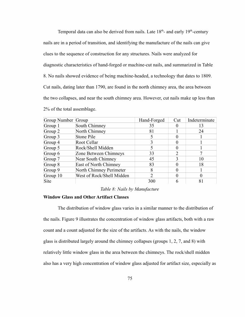
Temporal data can also be derived from nails. Late 18th- and early 19th-century
nails are in a period of transition, and identifying the manufacture of the nails can give
clues to the sequence of construction for any structures. Nails were analyzed for
diagnostic characteristics of hand-forged or machine-cut nails, and summarized in Table
8. No nails showed evidence of being machine-headed, a technology that dates to 1809.
Cut nails, dating later than 1790, are found in the north chimney area, the area between
the two collapses, and near the south chimney area. However, cut nails make up less than
2% of the total assemblage.
Group Number Group Hand-Forged Cut IndeterminateGroup 1 South Chimney 35 0 13Group 2 North Chimney 81 1 24Group 3 Stone Pile 5 0 1Group 4 Root Cellar 3 0 1Group 5 Rock/Shell Midden 5 0 1Group 6 Zone Between Chimneys 33 2 7Group 7 Near South Chimney 45 3 10Group 8 East of North Chimney 83 0 18Group 9 North Chimney Perimeter 8 0 1Group 10 West of Rock/Shell Midden 2 0 0Site 300 6 81
Table 8: Nails by Manufacture
Window Glass and Other Artifact Classes
The distribution of window glass varies in a similar manner to the distribution of
the nails. Figure 9 illustrates the concentration of window glass artifacts, both with a raw
count and a count adjusted for the size of the artifacts. As with the nails, the window
glass is distributed largely around the chimney collapses (groups 1, 2, 7, and 8) with
relatively little window glass in the area between the chimneys. The rock/shell midden
also has a very high concentration of window glass adjusted for artifact size, especially as
75
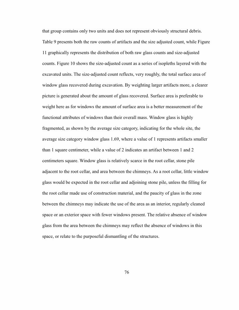
that group contains only two units and does not represent obviously structural debris.
Table 9 presents both the raw counts of artifacts and the size adjusted count, while Figure
11 graphically represents the distribution of both raw glass counts and size-adjusted
counts. Figure 10 shows the size-adjusted count as a series of isopleths layered with the
excavated units. The size-adjusted count reflects, very roughly, the total surface area of
window glass recovered during excavation. By weighting larger artifacts more, a clearer
picture is generated about the amount of glass recovered. Surface area is preferable to
weight here as for windows the amount of surface area is a better measurement of the
functional attributes of windows than their overall mass. Window glass is highly
fragmented, as shown by the average size category, indicating for the whole site, the
average size category window glass 1.69, where a value of 1 represents artifacts smaller
than 1 square centimeter, while a value of 2 indicates an artifact between 1 and 2
centimeters square. Window glass is relatively scarce in the root cellar, stone pile
adjacent to the root cellar, and area between the chimneys. As a root cellar, little window
glass would be expected in the root cellar and adjoining stone pile, unless the filling for
the root cellar made use of construction material, and the paucity of glass in the zone
between the chimneys may indicate the use of the area as an interior, regularly cleaned
space or an exterior space with fewer windows present. The relative absence of window
glass from the area between the chimneys may reflect the absence of windows in this
space, or relate to the purposeful dismantling of the structures.
76
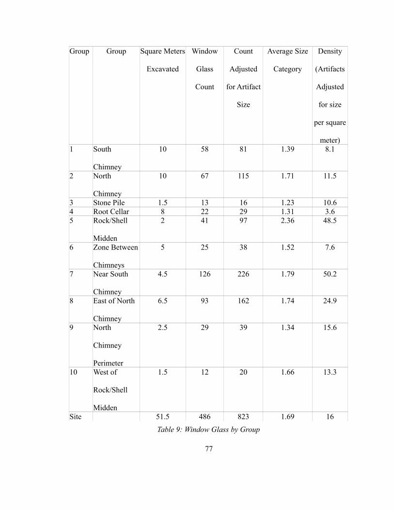
Group Group Square Meters
Excavated
Window
Glass
Count
Count
Adjusted
for Artifact
Size
Average Size
Category
Density
(Artifacts
Adjusted
for size
per square
meter)1 South
Chimney
10 58 81 1.39 8.1
2 North
Chimney
10 67 115 1.71 11.5
3 Stone Pile 1.5 13 16 1.23 10.64 Root Cellar 8 22 29 1.31 3.65 Rock/Shell
Midden
2 41 97 2.36 48.5
6 Zone Between
Chimneys
5 25 38 1.52 7.6
7 Near South
Chimney
4.5 126 226 1.79 50.2
8 East of North
Chimney
6.5 93 162 1.74 24.9
9 North
Chimney
Perimeter
2.5 29 39 1.34 15.6
10 West of
Rock/Shell
Midden
1.5 12 20 1.66 13.3
Site 51.5 486 823 1.69 16
Table 9: Window Glass by Group
77
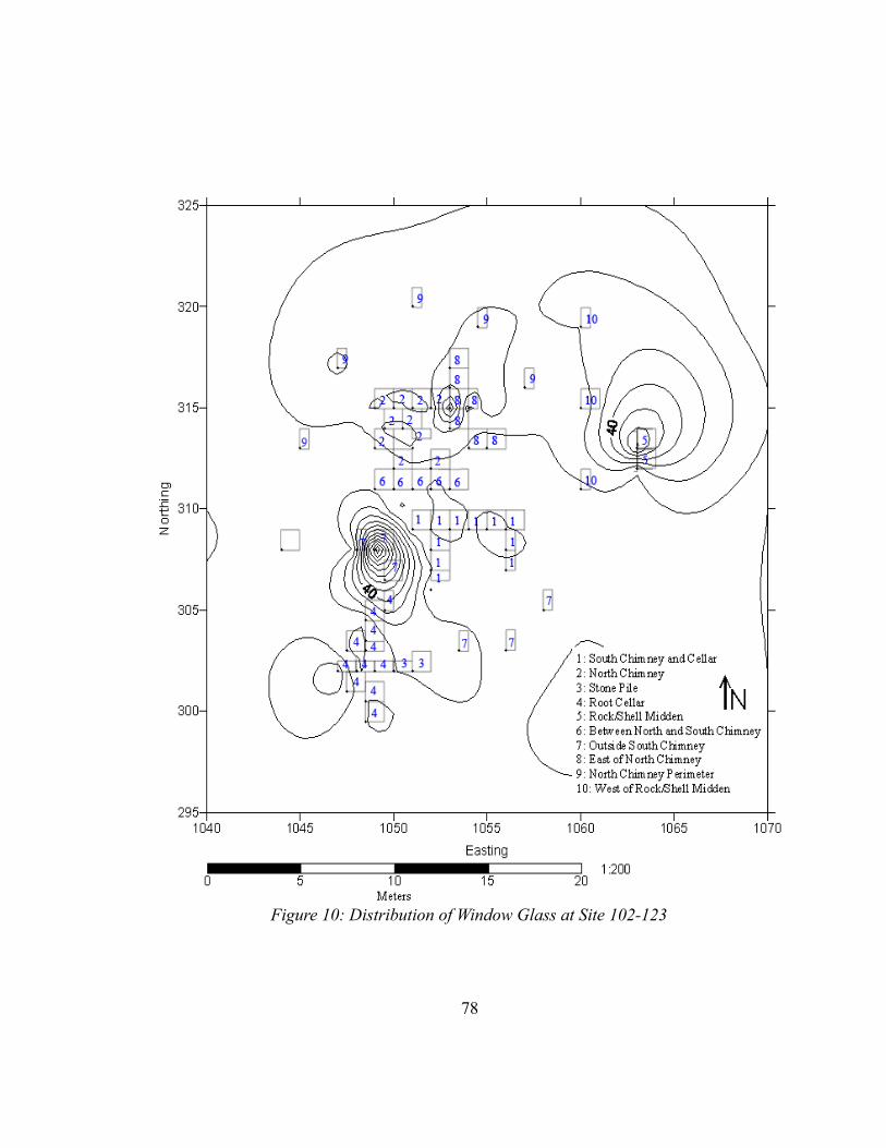
78
Figure 10: Distribution of Window Glass at Site 102-123
Comparison to other artifact classes shows that the window glass is relatively
concentrated around the chimneys, while vessel glass (in Table 10 and Figure 14) is
highly concentrated in the rock/shell midden and ceramics are concentrated at both of the
chimney areas and the rock/shell midden. Notably, the rock/shell midden also has very
high average artifact size, along with the units near the north chimney, although the latter
represents a much smaller assemblage. The higher artifact size in the rock/shell midden
indicates a different disposal behavior – removal of debris from the core trafficked area
of the house – than the more highly fragmented materials found in the other groups.
Ceramics are also concentrated in the rock/shell midden, with 793 individual artifacts in
only two units, as opposed to the south chimney, which has the most artifacts (1165), but
79
Group 1Group 2
Group 3Group 4
Group 5Group 6
Group 7Group 8
Group 9Group 10
0
50
100
150
200
250
Window Glass Count
Count Adjusted for Artifact SizeC
ou
nt
Figure 11: Window Glass by Group
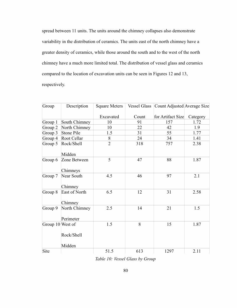
spread between 11 units. The units around the chimney collapses also demonstrate
variability in the distribution of ceramics. The units east of the north chimney have a
greater density of ceramics, while those around the south and to the west of the north
chimney have a much more limited total. The distribution of vessel glass and ceramics
compared to the location of excavation units can be seen in Figures 12 and 13,
respectively.
Group Description Square Meters
Excavated
Vessel Glass
Count
Count Adjusted
for Artifact Size
Average Size
CategoryGroup 1 South Chimney 10 91 157 1.72Group 2 North Chimney 10 22 42 1.9Group 3 Stone Pile 1.5 31 55 1.77Group 4 Root Cellar 8 24 34 1.41Group 5 Rock/Shell
Midden
2 318 757 2.38
Group 6 Zone Between
Chimneys
5 47 88 1.87
Group 7 Near South
Chimney
4.5 46 97 2.1
Group 8 East of North
Chimney
6.5 12 31 2.58
Group 9 North Chimney
Perimeter
2.5 14 21 1.5
Group 10 West of
Rock/Shell
Midden
1.5 8 15 1.87
Site 51.5 613 1297 2.11
Table 10: Vessel Glass by Group
80
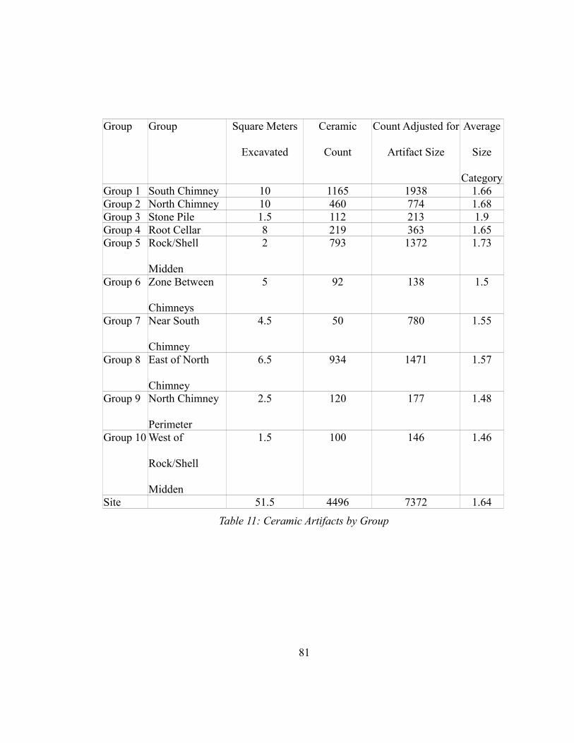
Group Group Square Meters
Excavated
Ceramic
Count
Count Adjusted for
Artifact Size
Average
Size
CategoryGroup 1 South Chimney 10 1165 1938 1.66Group 2 North Chimney 10 460 774 1.68Group 3 Stone Pile 1.5 112 213 1.9Group 4 Root Cellar 8 219 363 1.65Group 5 Rock/Shell
Midden
2 793 1372 1.73
Group 6 Zone Between
Chimneys
5 92 138 1.5
Group 7 Near South
Chimney
4.5 50 780 1.55
Group 8 East of North
Chimney
6.5 934 1471 1.57
Group 9 North Chimney
Perimeter
2.5 120 177 1.48
Group 10 West of
Rock/Shell
Midden
1.5 100 146 1.46
Site 51.5 4496 7372 1.64
Table 11: Ceramic Artifacts by Group
81
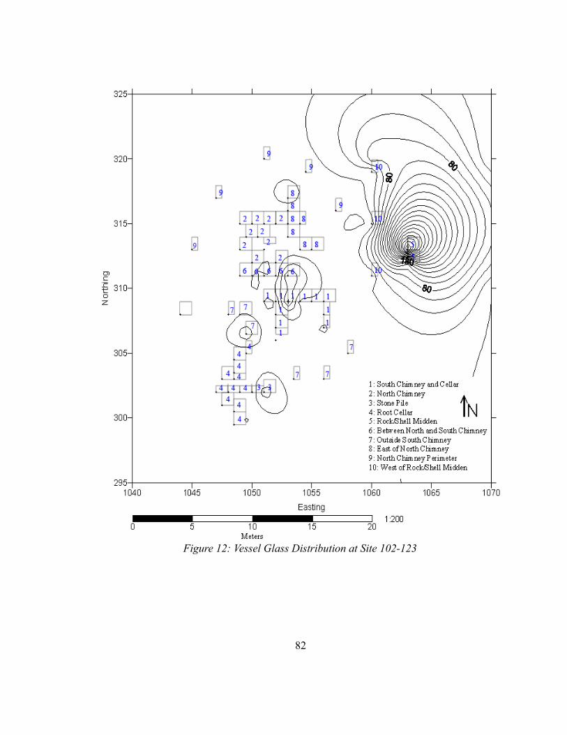
82
Figure 12: Vessel Glass Distribution at Site 102-123
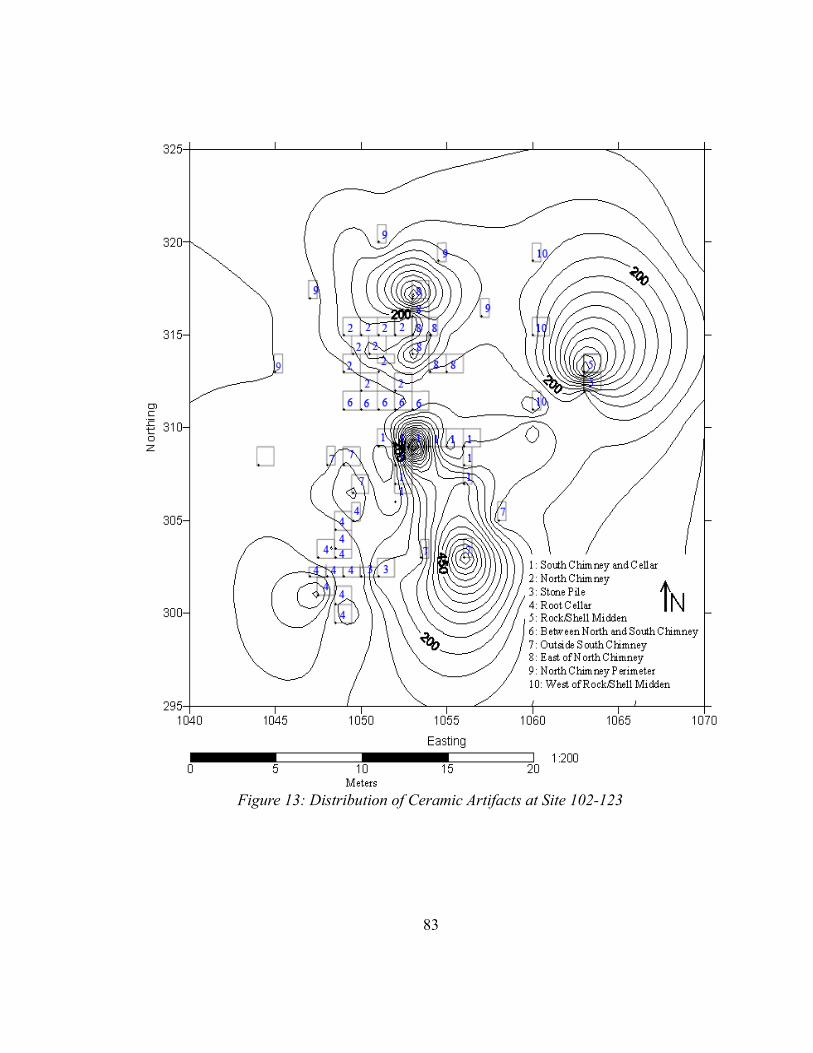
83
Figure 13: Distribution of Ceramic Artifacts at Site 102-123
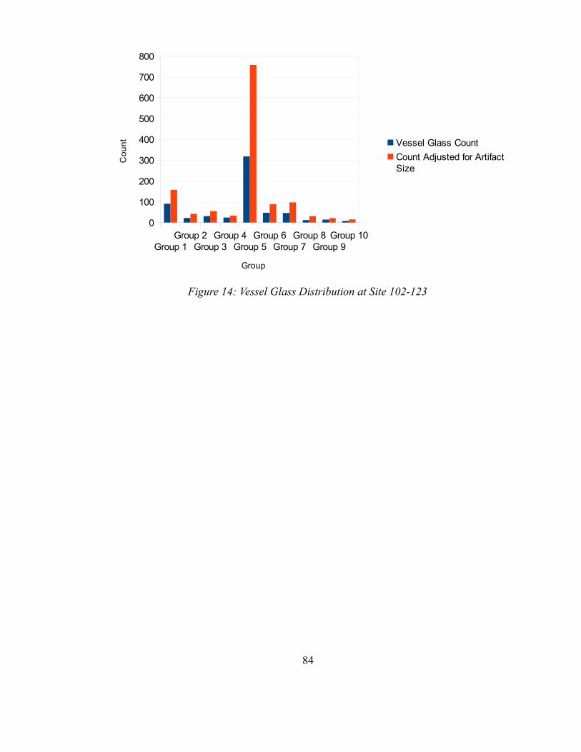
84
Group 1Group 2
Group 3Group 4
Group 5Group 6
Group 7Group 8
Group 9Group 10
0
100
200
300
400
500
600
700
800
Vessel Glass Count
Count Adjusted for Artifact Size
Group
Co
un
t
Figure 14: Vessel Glass Distribution at Site 102-123
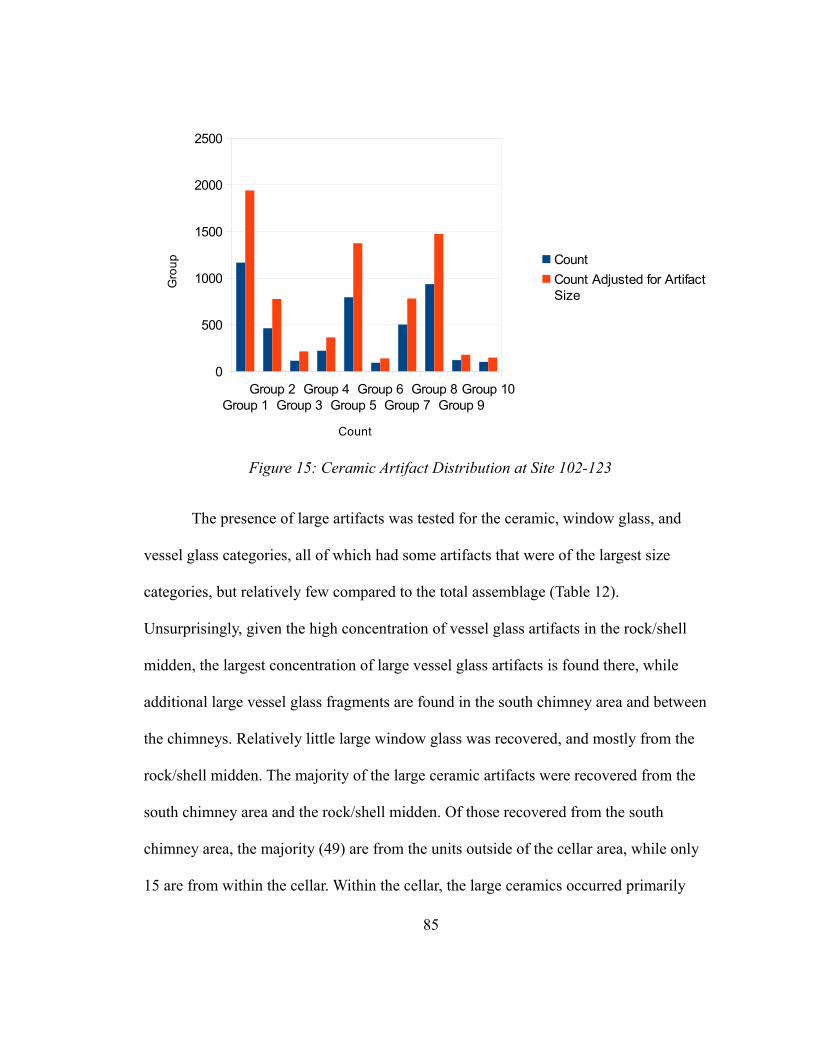
The presence of large artifacts was tested for the ceramic, window glass, and
vessel glass categories, all of which had some artifacts that were of the largest size
categories, but relatively few compared to the total assemblage (Table 12).
Unsurprisingly, given the high concentration of vessel glass artifacts in the rock/shell
midden, the largest concentration of large vessel glass artifacts is found there, while
additional large vessel glass fragments are found in the south chimney area and between
the chimneys. Relatively little large window glass was recovered, and mostly from the
rock/shell midden. The majority of the large ceramic artifacts were recovered from the
south chimney area and the rock/shell midden. Of those recovered from the south
chimney area, the majority (49) are from the units outside of the cellar area, while only
15 are from within the cellar. Within the cellar, the large ceramics occurred primarily
85
Group 1Group 2
Group 3Group 4
Group 5Group 6
Group 7Group 8
Group 9Group 10
0
500
1000
1500
2000
2500
Count
Count Adjusted for Artifact Size
Count
Gro
up
Figure 15: Ceramic Artifact Distribution at Site 102-123
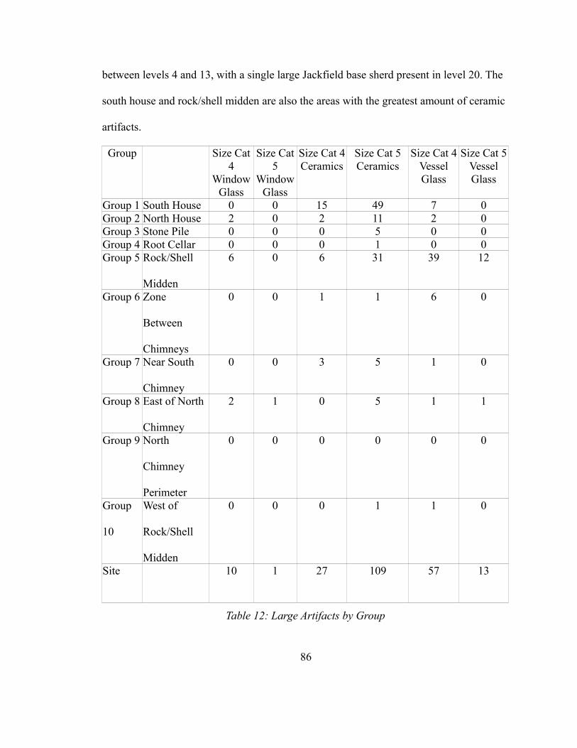
between levels 4 and 13, with a single large Jackfield base sherd present in level 20. The
south house and rock/shell midden are also the areas with the greatest amount of ceramic
artifacts.
Group Size Cat 4
Window Glass
Size Cat 5
Window Glass
Size Cat 4 Ceramics
Size Cat 5 Ceramics
Size Cat 4 Vessel Glass
Size Cat 5 Vessel Glass
Group 1 South House 0 0 15 49 7 0Group 2 North House 2 0 2 11 2 0Group 3 Stone Pile 0 0 0 5 0 0Group 4 Root Cellar 0 0 0 1 0 0Group 5 Rock/Shell
Midden
6 0 6 31 39 12
Group 6 Zone
Between
Chimneys
0 0 1 1 6 0
Group 7 Near South
Chimney
0 0 3 5 1 0
Group 8 East of North
Chimney
2 1 0 5 1 1
Group 9 North
Chimney
Perimeter
0 0 0 0 0 0
Group
10
West of
Rock/Shell
Midden
0 0 0 1 1 0
Site 10 1 27 109 57 13
Table 12: Large Artifacts by Group
86
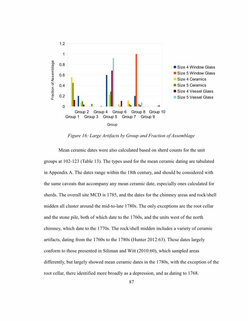
Group 1Group 2
Group 3Group 4
Group 5Group 6
Group 7Group 8
Group 9Group 10
0
0.2
0.4
0.6
0.8
1
1.2
Size 4 Window Glass
Size 5 Window Glass
Size 4 Ceramics
Size 5 Ceramics
Size 4 Vessel Glass
Size 5 Vessel Glass
Group
Fra
ctio
n o
f As
se
mb
lag
e
Figure 16: Large Artifacts by Group and Fraction of Assemblage
Mean ceramic dates were also calculated based on sherd counts for the unit
groups at 102-123 (Table 13). The types used for the mean ceramic dating are tabulated
in Appendix A. The dates range within the 18th century, and should be considered with
the same caveats that accompany any mean ceramic date, especially ones calculated for
sherds. The overall site MCD is 1785, and the dates for the chimney areas and rock/shell
midden all cluster around the mid-to-late 1780s. The only exceptions are the root cellar
and the stone pile, both of which date to the 1760s, and the units west of the north
chimney, which date to the 1770s. The rock/shell midden includes a variety of ceramic
artifacts, dating from the 1760s to the 1780s (Hunter 2012:63). These dates largely
conform to those presented in Siliman and Witt (2010:60), which sampled areas
differently, but largely showed mean ceramic dates in the 1780s, with the exception of the
root cellar, there identified more broadly as a depression, and as dating to 1768.
87
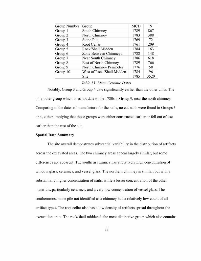
Group Number Group MCD NGroup 1 South Chimney 1789 867Group 2 North Chimney 1783 388Group 3 Stone Pile 1769 72Group 4 Root Cellar 1761 209Group 5 Rock/Shell Midden 1784 163Group 6 Zone Between Chimneys 1788 148Group 7 Near South Chimney 1786 618Group 8 East of North Chimney 1789 766Group 9 North Chimney Perimeter 1776 58Group 10 West of Rock/Shell Midden 1784 96
Site 1785 3520
Table 13: Mean Ceramic Dates
Notably, Group 3 and Group 4 date significantly earlier than the other units. The
only other group which does not date to the 1780s is Group 9, near the north chimney.
Comparing to the dates of manufacture for the nails, no cut nails were found in Groups 3
or 4, either, implying that those groups were either constructed earlier or fell out of use
earlier than the rest of the site.
Spatial Data Summary
The site overall demonstrates substantial variability in the distribution of artifacts
across the excavated areas. The two chimney areas appear largely similar, but some
differences are apparent. The southern chimney has a relatively high concentration of
window glass, ceramics, and vessel glass. The northern chimney is similar, but with a
substantially higher concentration of nails, while a lesser concentration of the other
materials, particularly ceramics, and a very low concentration of vessel glass. The
southernmost stone pile not identified as a chimney had a relatively low count of all
artifact types. The root cellar also has a low density of artifacts spread throughout the
excavation units. The rock/shell midden is the most distinctive group which also contains
88
a high quantity of ceramics and more than half of the assemblage of vessel glass.
Importantly, the average size of the artifacts in the rock/shell midden was above the value
for the site, indicating that the deposition process occurring in those two units was likely
substantially different than the process elsewhere on the site. The five units between the
two chimneys contain almost as many nails as the 11 units in the southern chimney area,
but relatively little window glass or ceramics. Vessel glass is found between the chimney
collapses, and relatively large pieces, as well. Near the south and north chimney is a very
high concentration of nails, as well as ceramics, as well as the highest concentration of
window glass. Like the region between the chimneys, vessel glass artifacts tend to be
relatively large in this area, although very few artifacts were recovered from east of the
north chimney. The areas west of the north chimney and west of the rock/shell midden
have the lowest density of artifacts, and those that are present are highly fragmented.
Those groups are furthest from the chimney collapses and middens, indicating that the
concentration of artifacts, especially small, highly fragmented artifacts declines from
habitation areas within the landscape of the site.
89
CHAPTER 5
INTERPRETATIONS
The data presented in the previous chapter summarize the results of an analysis of
multiple artifact types tied to a spatial framework to identify structural remains and
behavioral patterns across site 102-123. The intersection of a fine-grained spatial analysis
and a site that contains complexities amenable to such an analysis is unique on the
Eastern Pequot reservation at this time, and provides insights into the use of domestic
space on the reservation in the late 18th century. The central question for this analysis
remains the organization of space at site 102-123, specifically the nature and sequence of
construction of the various structures now only marked by their collapsed chimneys. This
chapter applies the results of the previous chapter to resolve issues regarding the
construction of these buildings and their ultimate fate. Unlike other sites on the
reservation before, during, and after the occupation of these structures (e.g., Hayden
2012), extensive modifications are present at site 102-123, indicating a greater degree of
investment of labor into the structures at site 102-123 and temporal transition over a
potentially longer occupation span. Identifying the sequence of construction at this site
90
can illuminate the decision making process regarding residential structures on this
particular site, and how the built environment was constructed and eventually
demolished. It will also offer direct implications for acts of residence, the physical and
the metaphorical, outlined at the outset of the thesis.
As noted in chapter 3, several basic variations for the arrangement of structures at
site 102-123 were proposed. First, two separate structures could have been occupied
sequentially. This implies that one structure was constructed, occupied, and then
demolished purposefully or accidentally, and a second structure was constructed and
eventually demolished or collapsed. Second, two separate structures could have been
occupied concurrently. This scenario envisions both structures being occupied at the same
time, although not necessarily constructed or demolished at the same time. Third, the two
chimneys may have represented a single large structure with a chimney at each end. A
fourth option, a single moved structure, can be discounted by the presence of two
separate chimneys and deserves no further attention. Finally, the possibility of an
additional structure that left no easily detectable surface remains, such as a wigwam-type
building should be considered, even though it would have been succeeded by obviously
more permanent framed structures. Each of these scenarios offers sub-variations, but the
basic questions is one or two structures, and if two, in what order were they built?
The scenario of sequentially occupied houses implies that one house would have
been demolished, and its materials possibly recycled into the construction of the new
house. As the majority of nails are fragments or intentional discards, it is possible that
either chimney collapse indicates a demolished house salvaged for construction material.
91
However, if nails and wood were salvaged for a new construction project, the fieldstone
used to construct the chimney was left on the ground, both creating a space which would
have been surrendered to any productive activity and discarding construction material
already close to the construction site for the new house. With few machine-cut nails
present in the north chimney area and the proximal south chimney area, neither can be
established to have been an earlier construction based on those materials alone.
Additionally, the mean ceramic dates for both the south and north chimney areas are
relatively close (1789 and 1783, respectively), as are the dates for the proximate chimney
areas (1786 and 1789, respectively). These are not statistically significant in any
meaningful way, especially with the technique based on sherd counts. The relatively early
mean ceramic date associated with the group to the north and west of the north house
(1776) may also speak to the north house being earlier, especially if the areas closer to the
south house are used more intensively for the disposal of small artifacts after that house’s
construction. The relatively early mean ceramic dates support the interpretation that the
area west of the north chimney would be less intensively utilized, as newer ceramics
would not enter that area after the southern house was complete.
If the two houses are sequential, then the most likely association is between the
root cellar on the southern edge of the site and the northern house. The southern house
was constructed over a cellar, which would have been excavated before ever building a
house over it, but the northern house had no underfloor cellar for cool food storage. The
root cellar is also filled with mixed A/B horizon soil, likely from the excavation of the
full cellar nearby given that excavations between the two revealed an older A soil horizon
92
buried beneath some mottled fill containing C-horizon sediments, sprayed toward the root
cellar from the house cellar. In addition, the full cellar is filled with rock, likely from one
of the chimney collapses. However, the rock in the south chimney cellar appears to be
placed there intentionally, in an attempt to fill the cellar, given that the cellar is almost
filled with rock to its rim. This would be an unusually filled hole if it only received debris
from a toppling chimney.
The presence of the full cellar, combined with the filling of the root cellar, speaks
strongly to the construction of the southern chimney and attendant structure second
behind the northern house, and the presence of the chimney implies that this particular
structure was used for residential activities, rather than a storage or utility area. The
relatively close ceramic dating and presence of machine-cut nails at both chimney areas
imply that both were in use at roughly the same time, although the slightly earlier ceramic
date at the northern chimney might be explained by an earlier construction and initial
habitation date. The absence of construction debris, particularly rock, but also very few
nails and window glass, in the nearby root cellar, an optimal location for the disposal of
such debris since it was being partially filled by cellar excavation, also implies that there
was no demolition or collapse prior to the filling of the root cellar. Sediments from the
excavation of the house cellar appear to have been used to fill the root cellar, while rock
from the same excavation could have been applied to the construction of the southern
chimney. That said, though, the northern chimney pile does not appear to be substantially
reduced compared to the potentially later southern chimney, which one might expect if
the stones had been salvaged for another construction episode. This also militates against
93
thinking that the southern house was constructed when the northern one had an
unexpected structural failure with a chimney collapse. The southern chimney collapse
does contain more material, as the cellar is full of rock which appears to be associated
with the surface chimney collapse, although the full cellar may have originally contained
a substantial amount of rock to support a more substantial chimney. The slightly smaller
northern pile may be a result of utilizing the collapsed northern chimney for other
constructions, but the fact that the northern chimney collapse was not fully re-utilized
argues against the use of the material for the construction of the southern chimney.
Possibly the northern house was demolished or collapsed before the southern house, and
thus was a source of salvaged stone for a longer period than the southern chimney
collapse. Filling the root cellar would eliminate a substantial storage area, which would
be mitigated by the construction of the full cellar under the (forthcoming) southern house.
Had the root cellar been filled with construction debris, a large proportion of nails,
window glass, and rock would be anticipated in the root cellar, but only a few nails are
present (9, opposed to 106 at the north chimney area), and only in the lower-most levels,
which most likely represent the floor of the cellar during its period of use. Similarly, a
lower count of nails would be anticipated at the north chimney area, unless all of the nails
are associated with the south chimney. The presence of cut nails at both north and south
chimneys, as well as the relatively low difference in mean ceramic dates between those
areas, when contrasted with the mean ceramic date of the root cellar, implies that similar
activities were being conducted in both areas throughout the occupation of the site. The
very low overall quantity of machine-cut nails at the site may be an indicator of the use of
94
such nails for repairs, while the construction of the structures took place when only hand-
made nails were present in any quantity. The storage space lost with filling the root cellar
may have been replaced by converting the northern house from a residential structure to a
storage area, if no longer actually occupied.
A two-house variation implies that small artifacts would be found between the
two houses due to trampling, in addition to large artifacts that may have been disposed of
out of sight and out of trafficked areas. If the houses are of the approximately 15-ft-x-17-
ft or 16-ft-x-22-ft size commonly attributed to the time and region (Stienitz 1989:15, 20-
21; also Stachiw et al 1997) and seen elsewhere on the Eastern Pequot (Hayden 2012;
Silliman personal communication, 2012) and Mashantucket (McBride 1991:74)
reservations, the space between the two houses would have to have been less than two
meters. This could permit discard and some traffic. The artifacts in the between-house set
are small, and several large pieces of vessel glass are present, but no large pieces of
window glass are recorded in that area. However, if the two houses were occupied at the
same time, there may have been no windows between the two houses. A window set into
the wall of a house separated from another wall by only a small space, possibly less than
a meter, would have provided little additional light or ventilation, and little to look at
(especially if a collapsed northern house, in one scenario, offered the only real view),
while providing another space for heat to escape during the winter. Windows or doors
built into the southern exposure of the north house – a prediction based on the value of
southern exposures during New England winters – may have been boarded, or left in
place if the northern house was still standing and used for storage. Overall, the area
95
between the two chimneys lacks large artifacts of all categories, especially ceramics,
while the large ceramics found in the units associated with the two chimney collapses are
largely absent from the pattern of units between the two chimney collapses. The presence
of large vessel glass in what would have been a narrow area between the two houses, if
that is what the space represents, indicates that this space may have been an expedient
disposal area. The large vessel glass artifacts are unlikely to have been the types of
material that would slip between the floorboards of a house, and there is no cellar feature
between the two chimneys that would have made for an expedient interior disposal area.
If the volume of artifacts reflects the length of occupation, which is tentative at
best, the southern house would seem to have been occupied longer, or been subject to
more intensive activity. Both chimneys show a distinct peak in the amount of artifacts
compared to the area between the chimneys, although units outside the chimney areas are
also relatively rich in artifacts. The similar mean ceramic date for both chimney areas
speaks to the likelihood that both structures were in use at the same general time,
although the lower mean ceramic date to the west of the north structure may indicate a
reduced use of that area after the construction of the southern house, and the slightly
older date associated with the north chimney may be related to an earlier construction
date. The noticeably lower mean ceramic dates in the root cellar and southern stone pile
indicate that those areas were used significantly less intensively for disposal and certainly
not as storage areas following the construction of the southern structure.
The third option, a single large house, would mean that the two chimneys would
appear very similar in the spread and content of artifacts, and the area between the two
96
houses would further bear substantial similarity to the area around the chimneys.
Similarity and variation both exist, as discussed above, so this offers little discrimination
about his scenario. Little to no window glass would be anticipated in the area between the
two houses since windows would not be in an interior wall of the house. While window
glass is found in a low frequency, it is present. The paucity of artifacts in the region
between the two chimneys may represent an area covered by floorboards. The presence
of large artifacts in the area, particularly large vessel glass shards, argues against the
presence of a floor which would have prevented these artifacts from slipping into the dirt
below, especially when considering that the units between the two chimneys are unlikely
to represent an even one-meter space between the two houses, but more likely an area
where the edges of the two houses were close, and thus partially covered by the
floorboards of the two structures. In a two house interpretation, the trench does not
represent a one-meter wide alleyway between the two proposed structures, but rather an
area that would include some interior space from each structure, and a narrow strip of
exterior space between the two structures. A single house would also imply that there
would be minimal difference between the mean ceramic dates between the two houses,
and admittedly, a difference of only approximately 6 mean ceramic years is observed.
Had the northern house been abandoned after the southern house was constructed, and
work areas had shifted towards the area of the southern house, a mean ceramic date more
like the root cellar or west of the northern house would be expected. A more substantial
shift in mean ceramic date is noted west of the north structure, relative to the chimney
collapses. If the areas west of the north chimney represents an area of disposal while the
97

north house was the primary locus of activity, the mean ceramic date for the north house
and south house being relatively close could be explained by the continued use of the
north house area, but discontinuation of use of the northwest area as activities shifted
towards the south house.
The construction of a single large house requires a consideration of why such a
structure would be built, especially with two chimneys. A structure that would encompass
both chimneys would be at least 7 meters in length, and if the proportions of such a
structure were the same as a smaller house, would imply a width of almost 7 meters with
fireplaces at opposite ends facing each other. The slightly raised terrace on which the
houses sat, however, limits the plausibility of a structure much larger than this footprint.
Heating a house with two end chimneys would be less efficient in terms of firewood
consumption than a single, center chimney house, a structure common in New England.
In addition, a large two-chimney house would be an unprecedented house size and
structure on the Eastern Pequot reservation, given all archaeological studies to date, or
even on the nearby Mashantucket Pequot reservation (McBride, personal communication,
2006).
Given the evidence discussed thus far, the preponderance of evidence seems to
point toward a northern structure with attendant root cellar constructed first. The root
cellar was then filled during the excavation of the cellar for the southern structure, which
was then constructed over the cellar. The northern structure likely remained in use at the
same time as the newly constructed southern structure until the site was abandoned and
both houses fell into disuse or were demolished. Family expansion may have led to
98
pressures to construct a second dwelling. The convenience of an in-house cellar may have
encouraged the inhabitants to build the southern structure and possibly convert the
northern structure to a storage structure or continue to use it a residential structure,
although none of the artifact or spatial data conclusively indicates a change in function
after the construction of the south house. Besides, it would be significantly harder to
excavate a cellar beneath a standing house. Beyond purely functional considerations,
psychological factors may have played a role in the decision-making process as well,
particularly the connections felt to a place, specifically a home, that the inhabitants saw
as more than a collection of resources.
Analysis of the material at the two houses also speaks to the nature of their
construction, occupation, and eventual dismantling. Of particular importance is the
possibility for the recycling of construction materials. The high number of small nails in
the assemblage and the high ratio of fragmentary to whole nails indicate that the salvage
of materials may have been an important element in the demolition process. The number
of bent and clinched nails may not represent accurately the process of removing nails
from boards during the process of recycling. Of the whole nails, more than half (54 of 98)
are 2d and 3d nails, very small artifacts that would have been easily lost at any stage of
construction. The large number of fragments may result from nails that were broken
during the extraction process and disposed of on site. Additionally, the proportion of
fragmentary nails to whole nails would only be increased by the removal of whole nails
from the site during the demolition process as the recycling process continued. The
comparison of the relative frequency of whole nails between site 102-123 and 102-125
99
illustrates that despite the presence of two chimneys and a much larger assemblage of
nails at 102-123, the nails most useful for flooring and attaching planks to frames are a
much lower proportion of the assemblage at 102-123. Large nails, such as the 16d and
12d framing nails, of which only a few examples are present at the site, could have been
salvaged when demolishing the structures. The lack of large nails may also be explained
by the use of joinery and treenails in preference to large nails, but the presence of a few
large nails does speak to the likelihood that they were used for joining structural
members. Removing a relatively few large nails would have taken far less time than
possibly hundreds of small nails, although many of the medium-sized nails also were
likely salvaged, at a substantial investment of time and effort.
Window glass artifacts are also highly fragmented. If panes had fallen into a
building during an unintentional collapse, larger fragments would have been expected.
The relatively high degree of fragmentation in the window glass assemblage may also be
an indicator of a thorough salvage effort at the site. Architectural glass is present in
relatively large quantities at both the north and south chimneys, implying that the
structures associated with those chimneys possessed a roughly similar quantity of framed
glass. Window glass in the rock/shell midden area does tend to be larger than elsewhere
on the site, but this deposit has more than merely architectural debris.
Compared to the nails and window glass, for which salvage seems plausible, the
fieldstone used for the chimneys was largely left in place or used to fill in the cellar of the
southern house. While filling the cellar can be seen as a form of recycling construction
material, that same material does not seem to be reused at other construction sites
100
elsewhere on the reservation (or possibly off the reservation). Instead, it seems that
someone – either departing residents or later arrivals – found it worthwhile to fill the
gaping hole that would have been the cellar, an act that could have only been done
effectively if the superstructure had already been removed or heavily disintegrated. The
presence of two chimneys also seems to argue for the presence of two contemporaneous
structures, once the principle of recycling is applied to fieldstone as well as smaller
architectural material. If the north structure had been dismantled prior to the construction
of the south structure, why leave a large amount of fieldstone lying on the surface? The
stone pile renders the area useless for productive work and represents a source of stone
already selected for inclusion in a chimney immediately next to the construction site. The
overall amount of stone in the north chimney fall is less than in the south chimney
collapse, when considering the vast amount of rock in the cellar as well. Also, the rock
pile south of the southern house may represent a disposal area for rock, albeit in smaller
quantities, and having two such areas in close proximity to the house consumes a
substantial amount of useful space. Rock may have been preferentially scavenged from
the north chimney collapse to construct the stone walls near the site, or the cellar fill may
include stone from both chimney collapses.
101
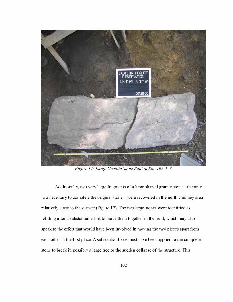
Additionally, two very large fragments of a large shaped granite stone – the only
two necessary to complete the original stone – were recovered in the north chimney area
relatively close to the surface (Figure 17). The two large stones were identified as
refitting after a substantial effort to move them together in the field, which may also
speak to the effort that would have been involved in moving the two pieces apart from
each other in the first place. A substantial force must have been applied to the complete
stone to break it, possibly a large tree or the sudden collapse of the structure. This
102
Figure 17: Large Granite Stone Refit at Site 102-123
original stone may have been used as fire back or hearth stone at some point, and would
have been architecturally useful in a complete form. However, its two fragments were
found more than 2 meters apart, which is not a distance possible with a general chimney
collapse. Even broken, the stone segments could have been put to use in the foundational
levels of a new chimney, although they do not seem to have been. Recycling this material
would not only reduce the amount of labor necessary for bringing fieldstone to the new
chimney, but also would clear an area adjacent to the structure. Instead it was left on the
surface. While this speaks to the likelihood that the northern house was standing while
the southern house was constructed, the large stone may also be further evidence of
recycling. A large, distinctive stone such as this may have been of greater value or
importance than other stones in the northern chimney, and as a result it may have been
broken in an attempt to salvage and use it elsewhere. The enormous effort of moving the
stone probably doomed any attempt to salvage it, but that may not have been apparent at
the outset of recycling activities. However, as noted above, it is difficult to believe that
the broken pieces would not have been incorporated into further construction activities at
the sites. If it was a recycling effort gone wrong, then it most likely happened after both
houses were no longer inhabited.
The general pattern of disposal at the site implies a great deal of expedient
disposal around the two structures. Artifacts near the chimneys are highly fragmented,
with the exception of the large vessel glass artifacts found between the two structures.
The exception to this pattern is the rock/shell midden, which shows a much lower degree
of fragmentation, as well as a very high concentration of artifacts on all types except for
103
nails. This feature is described in great detail in Hunter (2012). This seems to indicate a
difference in disposal patterns – the rock/shell midden is an area specifically allocated to
disposal, while the areas around the houses are not necessarily identified as only disposal
areas.
The data set used to conduct this analysis does not offer unambiguous answers,
but the weight of evidential lines does point toward reasonable conclusions. The most
likely interpretation of the structures that were in use at 102-123 remains a two-structure,
sequential construction with intentional salvage and at least one major episode of
modification over the lifetime of the site. The construction and use of multiple buildings
implies a substantial investment in both labor and commitment to a specific place on the
reservation, and it also indicates a changing focus on the role and location of domestic
storage with the decommissioning of a root cellar and the construction of a house cellar.
Unfortunately, the dating of the site does not offer a clear indication of the duration of the
occupation, only that it appears to be during the latter half of the 18th century. Site 102-
123 may represent a multi-generational modified landscape, but is clearly a complex
intersection of many behaviors and practices.
104
CHAPTER 6
CONCLUSION
Site 102-123 provides more than just information on the sequence of construction
and types of structures found on an 18th -century reservation. It also provides an
opportunity to examine the decisions that were made by Native people living in a colonial
environment in a reservation space. The construction, use, and demolition of these houses
were important modifications to a landscape set within larger colonial power relations.
These structures were Native not because they possessed diagnostic features that
distinguish them from “Euro-American” structures, but because they were built and used
by Native peoples. They are Native in that they are linked to the people who built and
lived there, and they are colonial in the origins of the materials and architectural designs
at the broadest level and in the social relations surrounding construction, demolition, and
the economic choices pertaining to them. By how they built and demolished the
structures at the reservation, residents of the Eastern Pequot reservation were actively
making the landscape, within the strictures and with the materials that existed in that
colonial context.
105
The construction of plank houses with boards, nails, and paned window glass is a
form of residence as discussed earlier. The materials used are similar to those found at
European or Euro-American farmsteads throughout New England, but here appear on a
Native American reservation. A simplistic approach would consider this an example of
acculturation, but the deployment of these materials can also be viewed as the utilization
of resources that are connected to the colonial environment to facilitate community
persistence (Silliman 2009). The decisions to utilize certain types of building material and
house forms reflects both the availability of those materials and the knowledge of those
house forms and the agency of the builders who chose to construct, modify, and
eventually demolish these structures. While artifacts as commonplace as nails and
window glass are not often thought to encode political meaning, the difference between a
structure constructed with such materials and a wigwam, such as those historically known
to be on the reservation, would be a striking contrast to people living on the reservation,
or connected to different house forms through the memories of others.
Modifications to the site would have been meaningful. The act of building these
houses would be the product of the labor of these residents and possibly others, and the
buildings would have been artifacts that shaped their everyday lives, serving as an
important point of focus for their lived experiences. Individual or familial investment in
the construction of these structures may explain the preservation of the north house when
the south house was constructed. While the filled root cellar was unlikely to have as
much meaning as a home, the north house may have been used a residence for part of a
family or as a storage area. A familial attachment to that structure and the memories
106
associated with it may have encouraged the residents of site 102-123 to preserve the north
house even when the south house fulfilled the same needs. The north house may not have
even been the first structure constructed at site 102-123, but is much more likely to be a
locus of meaningful memory than a more utilitarian structure, like the root cellar, and a
reminder of residence at the site, possibly across generations. The potential for
attachment to particular structures or memories attached to the area of site 102-123 seems
greater, given that no other sites on the reservation show a similar pattern of multiple
construction episodes.
Similarly, the purposeful infilling of the cellar indicates meaningful decisions on
the part of the residents or persons who utilized the site for other purposes after its
abandonment. The collapse and distribution of the few artifacts in the cellar indicate an
intentional filling, as opposed to an unintentional collapse. The artifacts that are present
in the cellar are distributed throughout the levels with rock, and no temporal variation is
detectable within the various levels. There does not seem to be a clear accumulation of
artifacts at the cellar floor. Filling the cellar in anticipation of reusing the site may have
been possible, but there would still have been a large amount of rock left on the surface.
Filling the cellar may have had more to do with a process of demolition that would be
meaningful in the context of their lived experience at the site. Hasho (2012: 80) notes that
the stone walls at site 102-123 were likely constructed after 1800. Even with the
possibility for time-lag in the acquisition of ceramics and other materials, the
construction of these walls may represent a third utilization of the site, of a very different
107
character, although the filling of the large cellar may have been in anticipation of reusing
the site for a different purpose.
The probable interpretation that the north house was left intact offers interesting
implications for the understanding the experience of the people living at site 102-123.
The north house would have been a noticeable element of the built environment. It would
also have been a substantial investment of labor. Without precise chronology, it is
difficult to determine the time scale of occupation at the site, but at least two possibilities
present themselves. The construction of the south house may have been intra-
generational, by the same people who constructed the north house. In this case, the north
house represents a meaningful investment of personal labor. Alternatively, the south
house may be an inter-generational construction project, where the north house represents
the labor of the preceding generation, and more of an indirect link to that generation's
lived experience. By investment of labor, I do not mean merely time spent in
construction, but a change to the landscape effected by human agents, specifically, the
household residing at the site. These structures were part of the process of making culture
by constructing artifacts, including a landscape of human activity.
The construction of these houses would also be an expansion of the network of
people, ideas, and material culture that makes up the relational network within the lives
of the residents of site 102-123. All of the nails and window glass that went into the
construction of the house, as well as the wooden planks and other perishable materials are
part of this network, but only provide an indirect picture of the most important material
culture element of that network, the structure itself. The disposal patterns described in
108
chapter 4 are also an indirect way to access the relational network by considering how
space in and around the structures was utilized. The construction of the north house was
an important modification to the landscape, and the accompanying root cellar also created
a space for storage that was distinct from the habitation area of the house and work areas
of the surrounding area. Compared to the three residential site examined by Hayden
(2012: 114) and the south house, the north house is unique in that the underground
storage is not a subfloor storage space. The construction of the southern house and
subsequent filling of the root cellar was a substantial alteration to the area, changing the
root cellar from a storage area to a place where a storage area once was, and possibly
changing the role of the northern house in the relational network as well. The change in
the role of the northern house may have been utilitarian (to a storage area, for example),
but also likely contained a component of the house as a place that was a former residence,
or a residence utilized earlier in the households lifespan. The demolition of the houses
and filling of the cellar likewise changed those structures into places where structures
once were and allowed the people salvaging those buildings to take part of the structure
with them and incorporate it into new structures. The filling of the root cellar and
construction of the southern house and cellar also were a distinct reconfiguration of the
built environment at the site, which may have been in response to any number of
environmental, social, or political factors, but allowed the people living at the site to
remain there and maintain the relationships they had constructed with that particular
environment.
109
The construction of these houses in the form that they took – framed plank houses
– also speaks to the increasing integration of the colonial world into the lives of people on
the reservation. The use of nails and window glass in the structures should not be
considered remarkable, as such materials are found in sites which were likely to be the
location of wigwam-style structures of earlier date (Hayden 2012:64-65), but the
construction style and widespread adoption of these materials reflects decisions made in a
changing physical and economic environment. The use of local materials in the form of
fieldstone, and the decisions to construct additional buildings at site 102-123 are
consistent with Hayden's conclusions that the construction of residential structures was
highly variable (Hayden 2012:114). The decision to reside on the reservation is an
important one, as is the decision to construct houses in a manner which would be
indistinguishable from the houses of many non-Native residents of New England. Houses
are powerful symbols of and metaphors for political authority (Johnson 2005:157), and
their presence is a political statement. Constructing a home on the reservation utilizes a
Native space, and reaffirms the nature of that space as one utilized by Native people, but
the form of the structures also indicates the adoption of techniques, forms, and materials
associated with the broader colonial world in which they lived. The structures are part of
a world that includes the entire English-speaking Atlantic, but also part of the microcosm
of the Eastern Pequot Reservation.
Given the likely time-lag in the acquisition of these objects, it is likely that the site
was occupied into the early nineteenth century, but not likely more than a few years into
it. The mean ceramic dates cluster around the mid-to-late eighteenth century, a period of
110
considerable political and economic turmoil. McBride observed that the shift from
wigwam-style architecture to framed houses occurred around the period of the First Great
Awakening of the 1730s-1740s (McBride 2005:38), and this seems to post-date that by
several decades. The Brothertown Indian movement, an organization of Christian Natives
who left New England in the early 19th century and eventually settled in Wisconsin, was
also active at this time, and the political, social and religious upheaval may have had an
influence on the importance of remaining in a particular place, in contrast to the goals of
the Brothertown movement, and other influences. Rather than find a new home in the
western part of the county, the residents at site 102-123 constructed and renovated a place
for themselves on land politically tied to the Eastern Pequot nation in a time of political
and social turmoil. Choosing to remain on the reservation shows a way of living through
colonialism through residence, by placing one's home in a location which has a particular
cultural association, despite also being situated in pervasive colonial structure of
governance and economic integration. The decision to site one's home on the reservation
makes the construction and renovation of the structures an example of place-making, and
particularly the process of associating one's self with the politically important parcel of
land, and imparting personal meaning to that parcel. The fact that these modifications
took place at a site where it would have been possible, as later reservations inhabitants
did, to move on to a different place, either on or off that reservation, during a time of
significant political and social turmoil speaks to the attachment the inhabitants held of
this particular place. Silliman and Witt (2010:64) suggest that differences in the ceramic
assemblage throughout the lifecycle of site 102-123 may reflect a substantial degree of
111
mobility for the residents and greater access to European ceramics later in the site’s
occupation. Even with a relatively high degree of mobility, the use and modification of
site 102-123 indicates this space held a particular importance to at least a small group of
people. Similarly, increasing usage of European ceramics parallels the increasing
economic integration of the eighteenth century, and their adoption into Pequot lifeways is
an illustration of the growing presence of colonial material culture.
These changes to the relational network all occur within the context of the
colonial power structure permeating the lives of people on the Eastern Pequot
reservation. While plank houses like those at site 102-123 were constructed from
materials commonly available in the 18th century, and thus part of the 18th century
political economy. The availability of nails and glass, as well as European ceramics and
vessel glass, were part of this broader economic system. There is no direct link between
the political, economic, and social changes of the late 18th century and the forms of
houses on the reservation, but those systemic changes created an environment in which
the people who built the houses at site 102-123 made decisions about where and how to
build, when to stay, and when to leave. The realities of colonialism, especially the limited
resources on the reservation, combined with the types of material culture that were
available at the time of the construction of the structures. The use of these materials,
however, should be thought of as Pequot people applying the resources, both physical,
such as nails and window glass, and more abstract, such as the construction skills and
house forms that developed in the Atlantic world.
112
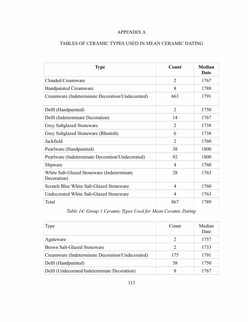
APPENDIX A
TABLES OF CERAMIC TYPES USED IN MEAN CERAMIC DATING
Type Count Median Date
Clouded Creamware 2 1767
Handpainted Creamware 8 1788
Creamware (Indeterminate Decoration/Undecorated) 663 1791
Delft (Handpainted) 2 1750
Delft (Indeterminate Decoration) 14 1767
Grey Saltglazed Stoneware 2 1738
Grey Saltglazed Stoneware (Rhenish) 6 1738
Jackfield 2 1760
Pearlware (Handpainted) 38 1800
Pearlware (Indeterminate Decoration/Undecorated) 92 1800
Slipware 4 1760
White Salt-Glazed Stoneware (Indeterminate Decoration)
28 1763
Scratch Blue White Salt-Glazed Stoneware 4 1760
Undecorated White Salt-Glazed Stoneware 4 1763
Total 867 1789
Table 14: Group 1 Ceramic Types Used for Mean Ceramic Dating
Type Count Median Date
Agateware 2 1757
Brown Salt-Glazed Stoneware 2 1733
Creamware (Indeterminate Decoration/Undecorated) 175 1791
Delft (Handpainted) 38 1750
Delft (Undecorated/Indeterminate Decoration) 8 1767
113
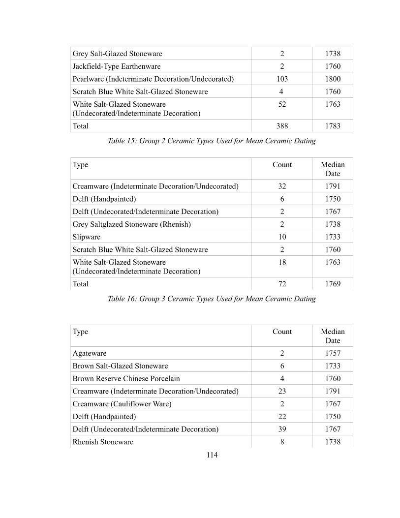
Grey Salt-Glazed Stoneware 2 1738
Jackfield-Type Earthenware 2 1760
Pearlware (Indeterminate Decoration/Undecorated) 103 1800
Scratch Blue White Salt-Glazed Stoneware 4 1760
White Salt-Glazed Stoneware (Undecorated/Indeterminate Decoration)
52 1763
Total 388 1783
Table 15: Group 2 Ceramic Types Used for Mean Ceramic Dating
Type Count Median Date
Creamware (Indeterminate Decoration/Undecorated) 32 1791
Delft (Handpainted) 6 1750
Delft (Undecorated/Indeterminate Decoration) 2 1767
Grey Saltglazed Stoneware (Rhenish) 2 1738
Slipware 10 1733
Scratch Blue White Salt-Glazed Stoneware 2 1760
White Salt-Glazed Stoneware (Undecorated/Indeterminate Decoration)
18 1763
Total 72 1769
Table 16: Group 3 Ceramic Types Used for Mean Ceramic Dating
Type Count Median Date
Agateware 2 1757
Brown Salt-Glazed Stoneware 6 1733
Brown Reserve Chinese Porcelain 4 1760
Creamware (Indeterminate Decoration/Undecorated) 23 1791
Creamware (Cauliflower Ware) 2 1767
Delft (Handpainted) 22 1750
Delft (Undecorated/Indeterminate Decoration) 39 1767
Rhenish Stoneware 8 1738
114
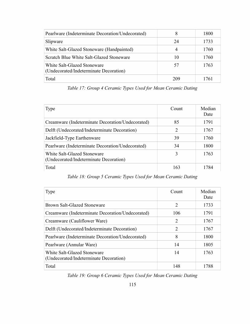
Pearlware (Indeterminate Decoration/Undecorated) 8 1800
Slipware 24 1733
White Salt-Glazed Stoneware (Handpainted) 4 1760
Scratch Blue White Salt-Glazed Stoneware 10 1760
White Salt-Glazed Stoneware (Undecorated/Indeterminate Decoration)
57 1763
Total 209 1761
Table 17: Group 4 Ceramic Types Used for Mean Ceramic Dating
Type Count Median Date
Creamware (Indeterminate Decoration/Undecorated) 85 1791
Delft (Undecorated/Indeterminate Decoration) 2 1767
Jackfield-Type Earthenware 39 1760
Pearlware (Indeterminate Decoration/Undecorated) 34 1800
White Salt-Glazed Stoneware (Undecorated/Indeterminate Decoration)
3 1763
Total 163 1784
Table 18: Group 5 Ceramic Types Used for Mean Ceramic Dating
Type Count Median Date
Brown Salt-Glazed Stoneware 2 1733
Creamware (Indeterminate Decoration/Undecorated) 106 1791
Creamware (Cauliflower Ware) 2 1767
Delft (Undecorated/Indeterminate Decoration) 2 1767
Pearlware (Indeterminate Decoration/Undecorated) 8 1800
Pearlware (Annular Ware) 14 1805
White Salt-Glazed Stoneware (Undecorated/Indeterminate Decoration)
14 1763
Total 148 1788
Table 19: Group 6 Ceramic Types Used for Mean Ceramic Dating
115
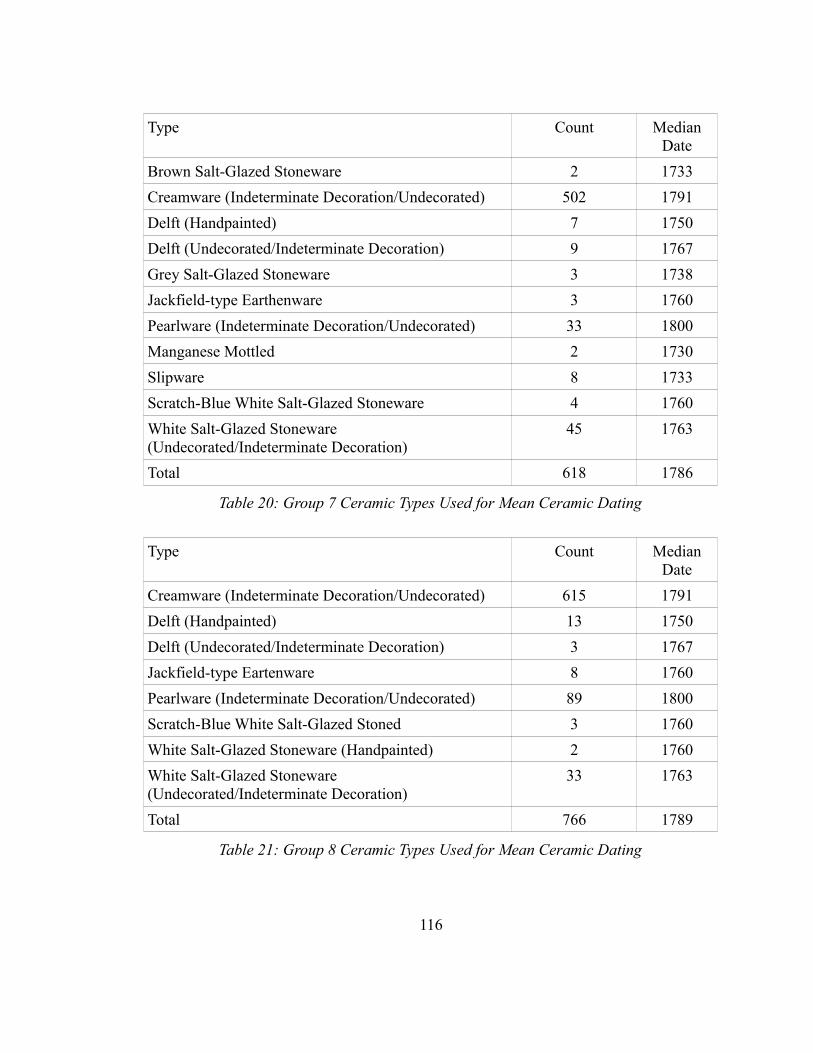
Type Count Median Date
Brown Salt-Glazed Stoneware 2 1733
Creamware (Indeterminate Decoration/Undecorated) 502 1791
Delft (Handpainted) 7 1750
Delft (Undecorated/Indeterminate Decoration) 9 1767
Grey Salt-Glazed Stoneware 3 1738
Jackfield-type Earthenware 3 1760
Pearlware (Indeterminate Decoration/Undecorated) 33 1800
Manganese Mottled 2 1730
Slipware 8 1733
Scratch-Blue White Salt-Glazed Stoneware 4 1760
White Salt-Glazed Stoneware (Undecorated/Indeterminate Decoration)
45 1763
Total 618 1786
Table 20: Group 7 Ceramic Types Used for Mean Ceramic Dating
Type Count Median Date
Creamware (Indeterminate Decoration/Undecorated) 615 1791
Delft (Handpainted) 13 1750
Delft (Undecorated/Indeterminate Decoration) 3 1767
Jackfield-type Eartenware 8 1760
Pearlware (Indeterminate Decoration/Undecorated) 89 1800
Scratch-Blue White Salt-Glazed Stoned 3 1760
White Salt-Glazed Stoneware (Handpainted) 2 1760
White Salt-Glazed Stoneware (Undecorated/Indeterminate Decoration)
33 1763
Total 766 1789
Table 21: Group 8 Ceramic Types Used for Mean Ceramic Dating
116
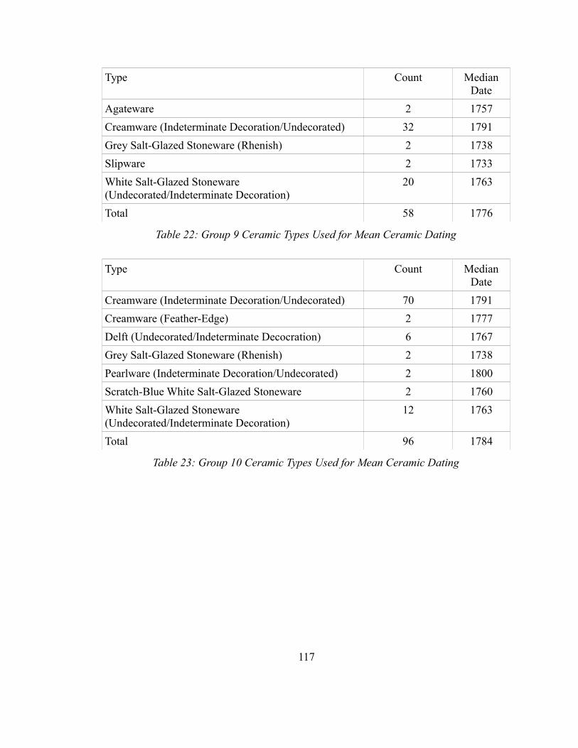
Type Count Median Date
Agateware 2 1757
Creamware (Indeterminate Decoration/Undecorated) 32 1791
Grey Salt-Glazed Stoneware (Rhenish) 2 1738
Slipware 2 1733
White Salt-Glazed Stoneware (Undecorated/Indeterminate Decoration)
20 1763
Total 58 1776
Table 22: Group 9 Ceramic Types Used for Mean Ceramic Dating
Type Count Median Date
Creamware (Indeterminate Decoration/Undecorated) 70 1791
Creamware (Feather-Edge) 2 1777
Delft (Undecorated/Indeterminate Decocration) 6 1767
Grey Salt-Glazed Stoneware (Rhenish) 2 1738
Pearlware (Indeterminate Decoration/Undecorated) 2 1800
Scratch-Blue White Salt-Glazed Stoneware 2 1760
White Salt-Glazed Stoneware (Undecorated/Indeterminate Decoration)
12 1763
Total 96 1784
Table 23: Group 10 Ceramic Types Used for Mean Ceramic Dating
117
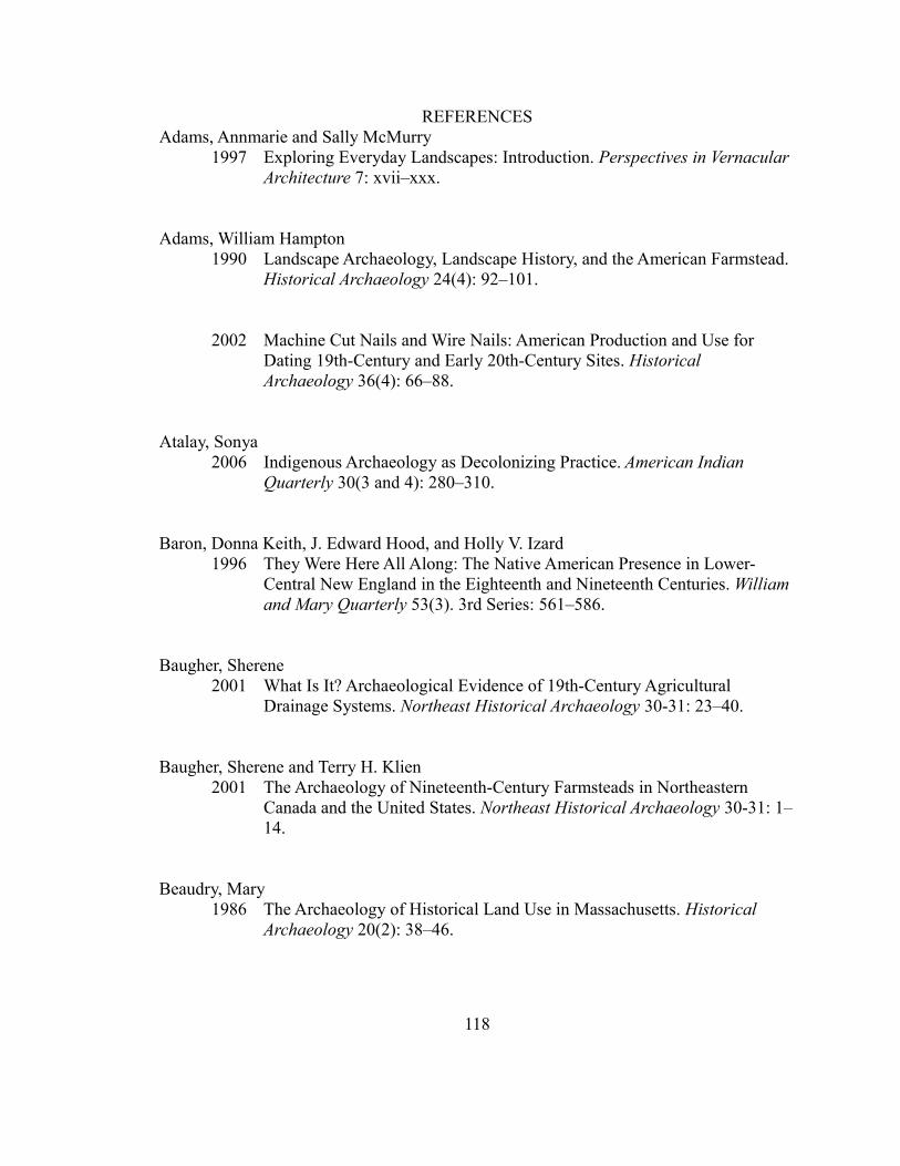
REFERENCESAdams, Annmarie and Sally McMurry
1997 Exploring Everyday Landscapes: Introduction. Perspectives in Vernacular Architecture 7: xvii–xxx.
Adams, William Hampton 1990 Landscape Archaeology, Landscape History, and the American Farmstead.
Historical Archaeology 24(4): 92–101.
2002 Machine Cut Nails and Wire Nails: American Production and Use for Dating 19th-Century and Early 20th-Century Sites. Historical Archaeology 36(4): 66–88.
Atalay, Sonya2006 Indigenous Archaeology as Decolonizing Practice. American Indian
Quarterly 30(3 and 4): 280–310.
Baron, Donna Keith, J. Edward Hood, and Holly V. Izard 1996 They Were Here All Along: The Native American Presence in Lower-
Central New England in the Eighteenth and Nineteenth Centuries. William and Mary Quarterly 53(3). 3rd Series: 561–586.
Baugher, Sherene 2001 What Is It? Archaeological Evidence of 19th-Century Agricultural
Drainage Systems. Northeast Historical Archaeology 30-31: 23–40.
Baugher, Sherene and Terry H. Klien 2001 The Archaeology of Nineteenth-Century Farmsteads in Northeastern
Canada and the United States. Northeast Historical Archaeology 30-31: 1–14.
Beaudry, Mary 1986 The Archaeology of Historical Land Use in Massachusetts. Historical
Archaeology 20(2): 38–46.
118
Bender, Barbara 2006 Place and Landscape. In Handbook of Material Culture Pp. 303–314.
London: Sage Publications Inc.
Benson, Donna 1983 A Taxonomy for Square Cut Nails. Conference on Historic Site
Archaeology 15: 123–152.
Blier, Suzanne Preston 2006 Vernacular Architecture. In Handbook of Material Culture Pp. 230–253.
London: Sage Publications Inc.
Bragdon, Kathleen J. 1999 Native People of Southern New England, 1500-1650. New Ed. University
of Oklahoma Press.
Campisi, Jack 1990 The Emergence of the Mashantucket Pequot Tribe, 1637-1975. In The
Pequots in Southern New England: The Fall and Rise of an American Indian Nation Pp. 117–140. The Civilization of the American Indian. Norman: University of Oklahoma Press.
Candee, Richard M. 1969a A Documentary History of Plymouth Colony Architecture, 1620-1700,
Part II. Old-Time New England 59(4): 105–111.
1969b A Documentary History of Plymouth Colony Architecture, 1620-1700. Old-Time New England 59(3): 59–71.
Cipolla, Craig 2005 Negotiating Boundaries of Colonialism: Nineteenth-Century Lifeways on
the Eastern Pequot Reservation, North Stonington, Connecticut. Master’s Thesis, University of Massachusetts, Boston.
119
Cipolla, Craig, Stephen W. Silliman, and David Landon2007 Making Do: Nineteenth-Century Subsistence Patterns on the Eastern
Pequot Reservation. Northeast Anthropology 74:41-64.
Clark, Bonnie J. and Kathleen Corbett 2006 Finding Common Ground in Common Places. In Between Dirt and
Discussion: Methods, Methodologies, and Interpretation in Historical Archaeology Pp. 152–168. Springer.
Coutts, Peter 1977 Old Buildings Tell Tales. World Archaeology 9(2): 200–219.
Cronon, William 1983 Changes in the Land: Indians, Colonists, and the Ecology of New England.
New York: Hill and Wang.
De Cunzo, Lu Ann 2001 The Archaeology of Agriculture and Rural Life in Northern Delaware,
1800-1940. Northeast Historical Archaeology 30-31: 85–112.
Den Ouden, Amy E. 2005 Beyond Conquest: Native Peoples and the Struggle for History in New
England. University of Nebraska Press.
van Dommelen, Peter 2006 Colonial Matters. In Handbook of Material Culture Pp. 104–124. London:
Sage Publications Inc.
Donahue, Brian 2004 Environmental Stewardship and Decline in Old New England. Journal of
the Early Republic 24(2): 234–241.
Doroszenko, Dena 2001 Burning Down the House: The Archaeological Manifestation of Fire on
Historic Domestic Sites. Northeast Historical Archaeology 30-31: 41–52.
120
Dwight, Timothy1969 Travels in New England and New York, Volume I. Originally published
1822. Cambridge: Belknap Press of Harvard University Press.
Edwards, Jay D. 2001 Architectural Creolization: The Importance of Colonial Architecture. In
Architectural Anthropology Pp. 83–120. Westport, CT: Bergin & Garvey.
Faulkner, Charles H. 2004 Moved Buildings: A Hidden Factor in the Archaeology of the Built
Environment. Historical Archaeology 38(2): 55–67.
Friedlander, Amy 1991 House and Barn: The Wealth of Farmers, 1795-1815. Historical
Archaeology 25(2): 15–29.
Garman, James C., Paul A. Russo, Stephen A. Mrozowski, and Michael A. Volmar 1997 “This Great Wild Tract”: Henry David Thoreau, Native American, and the
Archaeology of the Estabrook Woods. Historical Archaeology 31(4): 59–80.
Gilje, Paul A. 1996 The Rise of Capitalism in the Early Republic. Journal of the Early
Republic 16(2): 159–181.
Gordon, Jean and Jan McArthur 1984 Living Patterns in Antebellum Rural American as Depicted by Nineteenth-
Century Women Writers. Winterthur Portfolio 19(2/3): 177–192.
Gosden, Chris 2004a The Past and Foreign Countries: Colonial and Post-Colonial Archaeology
and Anthropology. In A Companion to Social Archaeology Pp. 161–178. Malden, MA: Blackwell Publishing.
2004b Archaeology and Colonialism: Cultural Contact from 5000 BC to the Present. Topics in Contemporary Archaeology. Cambridge: Cambridge University Press.
121
Graham, Willie, Carter L. Hudgins, Carl R. Lounsbury, Fraser D. Neiman, and James P. Whittenburg 2007 Adaptation and Innovation: Archaeological and Architectural Perspectives
on the Seventeenth-Century Chesapeake. William and Mary Quarterly 64(3): 451–522.
Groover, Mark D. 2004 Household Succession as a Catalyst of Landscape Change. Historical
Archaeology 38(4): 25–43.
Groth, Paul 1999 Making New Connections in Vernacular Architecture. The Journal of the
Society of Architectural Historians 58(3): 444–451.
Handsman, Russel G. and Trudie Lamb Richmond1995 Confronting Colonialism: The Mahican and Schaghticoke Peoples and Us.
In Making Alternative Histories: The Practice of Archaeology and History in Non-Western Settings Pp 87-117. Santa Fe: School of American Research Press.
Hasho, Sara L.2012 Bound in Stone: A Landscape and Architectural Analysis of The Eastern
Pequot Tribal Nation Reservation, Connecticut. Master's thesis, Department of Anthropology, University of Massachusetts, Boston.
Hayden, Anna2012 Household Spaces: Eighteenth and Nineteenth Century Spatial Practices
on the Eastern Pequot Reservation. Master's thesis, Department of Anthropology, University of Massachusetts, Boston.
Henretta, James A. 1978 Families and Farms: Mentalité in Pre-Industrial America. William and
Mary Quarterly 35(1). Third Series: 3–32.
Hewett, Cecil 1977 Understanding Standing Buildings. World Archaeology 9(2): 174–184.
122
Hood, J. Edward 1996 Social Relations and the Cultural Landscape. In Landscape Archaeology:
Reading and Interpreting the American Historical Landscape Pp. 121–146. Knoxville: University of Tennessee Press.
Hunter, Ryan2012 Coastal Connections and Residential Contexts: Eastern Pequot Shellfish
Use in the Eighteenth and Nineteenth Centuries. Master's Thesis, University of Massachusetts, Boston.
Inashima, Paul Y. 1994 Technical Notes on Nails. Quarterly Bulletin of the Archaeological Society
of Virginia 49(1): 46–48.
Johnson, Matthew 2006 Ideas of Landscape. Malden, MA: Blackwell Publishing.
Kulikoff, Alan 1989 The Transition to Capitalism in Rural America. William and Mary
Quarterly 46(1). New Series: 120–144.
Largy, Tonya and Mary Lynne Rainey 2006 Poverty or Natural Wisdom: Native Home Solutions in Eighteenth-
Century Nantucket. Archaeology of Eastern North America 34: 61–69.
Leach, Almon E. 2000 Nail Identification at Old Fort Niagara. Bulletin of the Journal of the New
York State Archaeological Association(116): 35–50.
Lenik, Edward J. 1977 A Study of Cast Iron Nails. Historical Archaeology 11: 45–47.
Little, Elizabeth A. 1981 Historic Indian Houses of Nantucket. Nantucket Algonquin Studies, 4.
Nantucket: Nantucket Historical Association.
123
Lorrian, Dessamae 1968 An Archaeologists Guide to Nineteenth Century American Glass.
Historical Archaeology 2: 35–44.
Martindale, Andrew2009 Entanglement and Tinkering: Structural history in the Archaeology of
Northern Tsimshian. Journal of Social Archaeology 9(1): 59-91.
Masica, Sara F. 1996 “One of the Best Farms in Essex County”: The Changing Domestic
Landscape of a Tenant who Became an Owner. In Landscape Archaeology: Reading and Interpreting the American Historical Landscape Pp. 147–174. Knoxville: University of Tennessee Press.
Maynard, W. Barksdale 2000 “Best, Lowliest Style!” The Early-Nineteenth-Century Rediscovery of
American Colonial Architecture. The Journal of the Society of Architectural Historians 59(3): 338–357.
McBride, Kevin A. 1990 The Historical Archaeology of the Mashentucket Pequots, 1637-1900. In
The Pequots in Southern New England: The Fall and Rise of an American Indian Nation Pp. 96–116. The Civilization of the American Indian. Norman: University of Oklahoma Press.
1991 “Ancient and Crazie”: Pequot Lifeways During the Historic Period. In Algonkians of New England: Past and Present Pp. 63–75. Boston: Boston University.
1994 Native American Cultures in Transition: The Eastern Long Island Sound Culture Area in the Prehistoric and Contact Periods. Connecticut History 35(1): 5–21.
124
2005 Transformation by Degree: Eighteenth Century Native American Land Use. In Eighteenth Century Native Communities of Southern New England in the Colonial Context Pp. 35–56. Windsor, CT: Mashantucket Pequot Museum & Research Center.
McCann, Karen D. and Robert L. Ewing 2001 Recovering Information Worth Knowing: Developing More
Discriminating Approaches for Selecting 19th-Century Farmsteads and Rural Domestic Sites. Northeast Historical Archaeology 30-31: 15–22.
McNeil, Julie Ann 2005 Potsherds and People: Considering the Connections Between Ceramics
and Identity at the Eastern Pequot Tribal Nation Reservation, North Stonington, Connecticut. Masters Thesis, University of Massachusetts, Boston.
O’Brien, Jean M. 2006 “Vanishing” Indians in Nineteenth-Century New England. In New
Perpsectives on Native North America Pp. 414–432. Lincoln, Nebraska: University of Nebraska Press.
O’Donovan, Maria and LouAnn Wurst 2001 Living on the Edge: Consumption and Class at the Keith Site. Northeast
Historical Archaeology 30-31: 73–84.
Pauketat, Timothy R. and Susan M. Alt 2005 Agency in a Postmould? Physicality and the Archaeology of Culture-
Making. Journal of Archaeological Method and Theory 12(3): 213–236.
Pauls, Elizabeth P. 2006 The Place of Space: Architecture, Landscape, and Social Life. In Historical
Archaeology Pp. 65–83. Malden, MA: Blackwell Publishing.
125
Philips, Maureen K. 1993 Mechanic Geniuses and Duckies: A Revision of New England’s Cut Nail
Chronology Before 1820. APT Bulletin 25(3/4): 4–16.
1996 Mechanic Geniuses and Duckies Redux: Nail Makers and Their Machines. APT Bulletin 27(1/2): 47–56.
Rotman, Deborah L. and Michael S. Nassaney 1997 Class, Gender, and the Built Environment: Deriving Social Relations from
Cultural Landscapes in Southwest Michigan. Historical Archaeology 31(2): 42–62.
Scarry, John F. and Bonnie G. McEwan 1995 Domestic Architecture in Apalachee Province: Apalachee and Spanish
Residential Styles In the Late Prehistoric and Early Historic Period Southeast. American Antiquity 60(3): 482–495.
Scharfenberger, Gerard P. 2004 Recent Evidence for Broad Window Glass in Seventeenth- and Eighteenth-
Century America. Historical Archaeology 38(4): 59–72.
Scharfenberger, Gerard P. and Richard F. Veit 2001 Rethinking the Mengkom-Mixing Bowl: Salvage Archaeology at the
Johannes Luyster House, A Dutch-American Farm. Northeast Historical Archaeology 30-31: 53–72.
Schuyler, Robert L. and Christopher Mills 1976 The Supply Mill on Content Brook in Massachusetts: An Example of the
Investigation of Recent Historic Sites. Journal of Field Archaeology 3(1): 61–95.
Schwartz, Amy D. 1995 Colonial New England: Old Visions, New Directions. Agricultural History
69(3): 454–481.
126

Silliman, Stephen W. 2001 Agency, Practical Politics, and the Archaeology of Culture Contact.
Journal of Social Archaeology 1(2): 184–204.
2004 Lost Laborers in Colonial California : Native Americans and the Archaeology of Rancho Petaluma. Tucson: University of Arizona Press.
2005 Culture Contact or Colonialism? Challenges in the Archaeology of Native North America. American Antiquity 70(1): 55–74.
2009 Change and Continuity, Practice and Memory: Native American Persistence in Colonial New England. American Antiquity 74(2): 211-230.
2012 Archaeologies of Indigenous Survivance and Residence: Navigating Colonial and Scholarly Dualities. In The Archaeology of the Colonized and Its Contribution to Global Archaeological Theory, edited by Neal Ferris and Rodney Harrison. Oxford University Press.
Silliman, Stephen W. and Katherine H. Sebastian Dring 2008 Working on Pasts for Futures: Eastern Pequot Field School Archaeology in
Connecticut. In Collaboration at the Trowel's Edge: Teaching and Learning in Indigenous Archaeology, edited by Stephen W. Silliman, pp. 67-87. American Studies in Archaeology #2. Tuscon: University of Arizona Press.
Silliman, Stephen W. and Thomas Witt2010 The Complexities of Consumption: Eastern Pequot Cultural Economics in
18th-Century New England. Historical Archaeology 44(4):46-68.
Silverman, David J. 2001 The Impact of Indentured Servitude on the Society and Culture of
Southern New England Indians, 1680-1810. The New England Quarterly 74(4): 622–666.
2003 “We Chuse to Be Bounded”: Native American Animal Husbandry in Colonial New England. William and Mary Quarterly 60(1). 3rd: 511–548.
127
2005a Indians, Missionaries, Religious Translation: Creating Wampanoag Christianity in Seventeenth Century Martha’s Vineyard. William and Mary Quarterly 62(2): 141–174.
2005b Faith and Boundaries: Colonists, Christianity, and Community Among The Wampanoag Indians of Martha's Vineyard, 1600-1871. Cambridge University Press.
Small, Nora Pat 1997 New England Farmhouses in the Early Republic: Rhetoric and Reality.
Perspectives in Vernacular Architecture 6: 33–45.
St. George, Robert 1982 The Stanley-Lake Barn in Topsfield, Massachusetts: Some Comments on
Agricultural Buildings in Early New England. Perspectives in Vernacular Architecture 1: 7–23.
2006 Home Furnishing and Domestic Interiors. In Handbook of Material Culture Pp. 221–229. London: Sage Publications Inc.
Stachiw, Myron O., Claire W. Dempsey, and Thomas Paske 1997 A Mashantucket Pequot 1780 Era Farmstead Dwelling House: A Research
and Design Project. Uncasville: Mashantucket Pequot Museum and Research Center.
Stahl, Ann, Rob Mann, and Diana DiPaolo Loren 2004 Writing for Many: Interdisciplinary Communication, Constructionism, and
the Practices of Writing. Historical Archaeology 38(2): 83–102.
Steinitz, Michael 1989 Rethinking Geographical Approaches to the Common House: The
Evidence from Eighteenth-Century Massachusetts. Perspectives in Vernacular Architecture 3: 16–26.
128
Stewart-Abernathy, Leslie C. 1986 Urban Farmsteads: Household Responsibilities in the City. Historical
Archaeology 20(2): 5–15.
Sturtevant, William C. 1975 Two 1761 Wigwams at Niantic, Connecticut. American Antiquity 40(4):
437–444.
Thorson, Robert 2004 Stone by Stone: The Magnificent History in New England’s Stone Walls.
Walker & Company.
Trigger, Bruce G. 1991 Early Native American Responses to European Contact: Romantic Versus
Rationalistic Interpretations. The Journal of American History 77(4): 1195–1215.
Tuan, Yi-Fu 1976 Reflections on Humanistic Geography. Journal of Architectural Education
30(1): 3–5.
Watkins, Joe 2001 Place-Meant. American Indian Quarterly 25(1): 41–45.
Wells, Tom 1998 Nail Chronology: The Use of Technologically Derived Features.
Historical Archaeology 32(2): 78–99.
Wentworth, Dennis L. 1979 Archaeological Test Excavations at Arryl House, Clermont, New York.
Journal of Field Archaeology 6(1): 29–39.
Willoughby, Charles C. 1906 House and Gardens of New England Indians. American Anthropologist
8(1). New Series: 115–132.
129
Wilson, John S. 1990 We’ve Got Thousands of These! What Makes a Historic Farmstead
Significant. Historical Archaeology 24(2): 23–33.
Wood, Joseph S. 1986 The New England Village as an American Vernacular Form. Perspectives
in Vernacular Architecture 2: 54–63.
Wurst, LouAnn 1999 Internalizing Class in Historical Archaeology. Historical Archaeology
33(1): 7–21.
Yamin, Rebecca, and Sarah T. Bridges 1996 Farms and Gentlemen Farmers: The Nineteenth-Century Suburban
Landscape. In Landscape Archaeology: Reading and Interpreting the American Historical Landscape Pp. 175–192. Knoxville: University of Tennessee Press.
Yamin, Rebecca and Karen Bescherer Metheny 1996 Preface: Reading the Historical Landscape. In Landscape Archaeology:
Reading and Interpreting the American Historical Landscape P. xiii–xx. Knoxville: University of Tennessee Press.
Young, Amy L. 1994 Spatial Patterning on a Nineteenth-century Appalachian Houselot:
Evidence From Nail Analysis. Southeastern Archaeology 13(1): 56–63.
1994 Nailing Down the Pattern. Tennessee Anthropologist 19(1): 1–21.
130