Embed Size (px)
Citation preview
Marked by pivotal transformations in NewWorld prehistory (Ford 1969; Reichel- Dolmatoff 1959; Willey and Phillips
1958), understanding the cultural patterns associ-ated with the Formative period has been a far- reaching, varied, and significant domain ofarchaeological inquiry throughout the Americas. Ofthe many regions where Formative transformationshave been investigated, southwestern Ecuador has
provided an extremely early and complex archae-ological record (Bischoff and Gamboa 1972, 2006;Bruhns 2003; Idrovo Urigüen 1999; Lathrap 1971;Lathrap et al. 1975; Lathrap et al. 1977; Lum breras2006; Marcos 1978, 1998, 2003; Marcos andMichczynski 1996; Marcos et al. 1999; Meggers1966; Meggers et al. 1965; Raymond 1998, 2003;Raymond et al. 1980; Zeidler 2008). Over the lastfive decades, archaeological research has focused
ARCHITECTURE, SETTLEMENT, AND FORMATIVE DEVELOPMENTSIN THE EQUATORIAL ANDES: NEW DISCOVERIES IN THE
DEPARTMENT OF TUMBES, PERU
Jerry D. Moore
The cultural transformations associated with the Formative period are pivotal for understanding the prehistory of the Amer-icas. Over the last five decades, investigations in southwestern Ecuador have provided an early and robust set of archaeo-logical data relating to Archaic- to- Formative transformations as exemplified by the Las Vegas, Valdivia, Machalilla, andChorrera archaeological traditions. However, recent archaeological research in adjacent zones of the equatorial Andesindicates that the transformations in southwestern Ecuador were paralleled by coeval but distinct developments. Recent(2006–2007) excavations in the Department of Tumbes, Peru, have documented previously unknown Formative transfor-mations, including the development of substantial domestic architecture during the Archaic (ca. 4700–4330 B.C.E.) andearly Formative (ca. 3500–3100 B.C.E.), the shift from elliptical pole- and- thatch dwellings to rectangular wattle- and- daubstructures at ca. 900–500 B.C.E., and the construction of public architecture and the establishment of a two- tiered settle-ment system by ca. 1000–800 B.C.E. These recently discovered archaeological patterns from Tumbes and additional datafrom southern Ecuador provide the basis for revised comparative perspectives in which southwestern Ecuador is a significant— but no longer the only— vantage point for understanding the evolution of Formative societies in the equatorial Andes.
Las transformaciones culturales asociadas con el Formativo son claves para nuestro entendimiento de la prehistoria ameri-cana. En los andes ecuatoriales, la península Santa Elena y las zonas cercanas del suroeste de Ecuador, nos han presentadoun temprano y robusto conjunto de datos arqueológicos sobre las transformaciones del Arcaico al Formativo como las cul-turas arqueológicas de Las Vegas, Valdivia, Machalilla, y Chorrera. Sin embargo, investigaciones recientes en zonas aledañasde los Andes ecuatoriales muestran que las transformaciones que ocurrieron en el suroeste de Ecuador fueron acompañadaspor desarrollos coetáneos pero distintos en el sur de Ecuador y el norte del Perú. Investigaciones recientes (2006–2007) en elDepartamento de Tumbes, Perú, descubrieron datos nuevos sobre el proceso Formativo y sus antecedentes en tres sitios: ElPorvenir, Santa Rosa, y Uña de Gato. Entre otros hallazgos, se incluyen los restos de una estructura del la época Arcaica deA.C. 4700–4330, una casa elíptica con tamaño 12.8 × 11 m con una fecha de A.C. 3500–3100, y una secuencia de estructurasque marca el cambio ca. A.C. 950/800 a 500 de estructuras elípticas hechas de palma y poste a estructuras rectangulareshechas de bahareque. Además, las excavaciones establecieron el desarrollo de arquitectura pública que comenzó posiblementepara A.C. 1400 pero claramente fue establecida para A.C. 1000–800, una época marcada también por un cambio fundamen-tal en los patrones de asentamiento en cual Uña de Gato fue el centro regional y El Porvenir una aldea pequeña. En fin, losdescubrimientos nuevos de Tumbes y otros datos comparativos nos presentan una visión amplia en cual la península de SantaElena representa una importante, pero no la única, punto de vista para entender la evolución de las sociedades del Formativoenlos Andes ecuatoriales.
Jerry D. Moore � Department of Anthropology, California State University Dominguez Hills, 1000 E. Victoria St.,Carson, CA 90747 ([email protected])
Latin American Antiquity 21(2), 2010, pp. 172–197Copyright ©2010 by the Society for American Archaeology
172
LAQ21(2)Moore_Layout 1 6/4/10 5:12 PM Page 172
173 LATIN AmerIcAN ANTIquITy [Vol. 21, No. 2, 2010
on the developments associated with the Valdivia,Machalilla, and Chorrera traditions (Evans andMeggars 1957; Hill 1975; Holm 1985; Meggersand Evans 1962; Meggers et al. 1965; Staller 2001a,2001b; Zeidler 2003, 2008; Zeidler and Pearsall1994; Zevallos and Holm 1960). Combined withexcavations at earlier Archaic Las Vegas culturesites (Malpass and Stothert 1992; Stothert 1988,2003), investigations at Valdivia sites such as RealAlto and Loma Alta (Damp 1979, 1984, 1988;Lathrap 1971; Lathrap et al. 1975; Lathrap et al.1977; Marcos 1978, 1998, 2003; Marcos andMichczynski 1996; Marcos et al. 1999; Ubelaker2003; Zeidler 1984, 2000, 2008) and archaeologi-cal surveys (Marcos 2003; Schwarz and Raymond1996) have resulted in a particularly rich body fromsouthwestern Ecuador. J. Scott Raymond has writ-ten:
Just as the Viru valley for many years was thepeephole through which Peruvian prehistorywas viewed, so the Santa Elena region has beenthe vantage point from which the EcuadorianFormative has been interpreted. Although therehas been a concerted effort to counter the nar-row regional bias of the peninsula throughresearch in the Guayas basin [Raymond et al.1980], in the valleys of the El Oro province ...and in the wet lowlands of Esmeraldas ..., thesequence from Santa Elena and the neighbor-ing Valdivia and Chanduy valleys still serve asthe principal framework for organizing, under-standing, and explaining the Formative soci-eties, particularly during the earliest phases[2003:35].
As Burger (2003) has cogently observed, dis-cussions of the “Ecuadorian” Formative are, in asense, misnamed, projecting early- nineteenth- century political divisions deep into the prehispanicpast (Staller 2000). Rather than a process uniqueto southwestern Ecuador, an emerging body of dataindicates that parallel and coeval but distinctiveFormative developments occurred elsewhere in theequatorial Andes of southern Ecuador and north-ern Peru. Archaeological data from the southernEcuadorian highlands (Bruhns 2003; Guffroy 2004;Idrovo Urigüen 1999; Temme 1999), the southernOriente region (Valdez 2008; Valdez et al. 2005),and the south coast of Ecuador (Staller 1994, 2000,2001a, 2001b) suggest the need for a broader, com-
parative perspective on Formative developments inthe equatorial Andes (Zeidler 2008).Contributing to this reassessment, recent
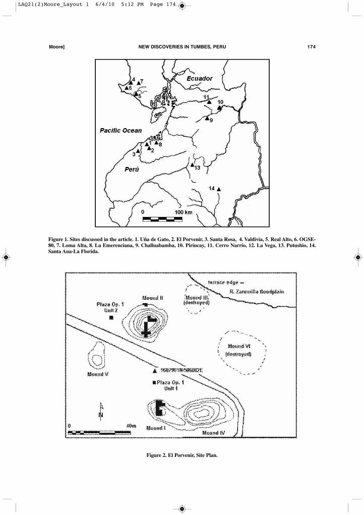
(2006–2007) excavations in the Department ofTumbes, Peru, have uncovered a surprisingly richarchitectural record for the Archaic and Formativeperiods spanning ca. 4700–300 B.C.E. The fol-lowing discussion summarizes prehistoric archi-tectural data from three sites in the Tumbes regionwith significant Formative deposits: El Porvenir,Uña de Gato, and Santa Rosa (Figures 1–5).Located on the edges of the floodplains of the Zaru-milla and Tumbes rivers, the material records ofthese sites indicate diachronic changes in domes-tic architecture, public architecture, and settlementpatterns. Although other classes of archaeologicaldata were recovered during the excavations andhave been reported elsewhere (Moore 2008; Mooreet al. 2008; Pajuelo 2006, 2007, 2008; Vilchez etal. 2007), the present article focuses on significantdiachronic and regional variations in Formativearchitecture and built environments in the equato-rial Andes.There are solid theoretical reasons for focusing
on Formative architecture. The built environmentis reflective and constitutive of human behavior(Moore 1996, 2005:3–5), concretely expressingkey aspects of Formative transformations, such asthe development of sedentism, the evolution ofsocial complexity, and the creation of new socialorders (Beck et al. 2008; Flannery 1972, 2002;Joyce 2004; Lesure 1999; Lesure and Blake 2002).For example, Raymond has suggested that evenduring the Archaic period in southwestern Ecuador“shelters, flimsy as they may have been, were ladenwith social value and played a symbolic role” andfurther proposes that “symbolically, then, the con-cept of ‘house’ may have distinguished the localcommunity within a region and identified and struc-tured relations among socio- residential units withina community” (2003:39, 52). Further, the con-struction of earthen mounds and other forms of“monumental” architecture may reflect reorgani-zations of social inequality and, in turn, become thephysical referents for new social relations. Simi-larly, Heckenberger writes of the monu- mentalitéof prehispanic settlements in Amazonia, noting thatconstructed earthworks “are particularly critical”for understanding those societies (2005:123).Finally, an energetics approach to public architec-
LAQ21(2)Moore_Layout 1 6/4/10 5:12 PM Page 173
moore] NeW DIScOVerIeS IN TumBeS, Peru 174
Figure 1. Sites discussed in the article. 1. Uña de Gato, 2. El Porvenir, 3. Santa Rosa, 4. Valdivia, 5. Real Alto, 6. OGSE-80, 7. Loma Alta, 8. La Emerenciana, 9. Challuabamba, 10. Pirincay, 11. Cerro Narrío, 12. La Vega, 13. Putushio, 14.Santa Ana-La Florida.
Figure 2. El Porvenir, Site Plan.
LAQ21(2)Moore_Layout 1 6/4/10 5:12 PM Page 174
ture (Abrams 1989; Childe 1974; Moore 1996; Vega- Centeno 2007) may provide insight into theconcentration of political power and the degree ofsociopolitical complexity among different soci-eties. This is well- traveled theoretical ground andsuggests that a focus on architecture and settlementplans is analytically appropriate for a comparativestudy of the Formative period in the equatorialAndes.After a brief summary of archaeological inves-
tigations in the Department of Tumbes, I present
evidence regarding domestic architecture, publicarchitecture, and settlement patterns for FormativeTumbes. I compare the Tumbes data against evi-dence from Formative sites within a 200-km radius,including the Santa Elena Peninsula, the highlandsof El Oro, and the Oriente of Zamora- Chinchipe.This delineation excludes important cases fartherto the north (e.g., Currie 1995; Lunniss 2008; Vil-laba 1988; Zeidler and Pearsall 1994) and south(Guffroy 1994; Guffroy et al. 1989; Kaulicke 1998),but some limits to the scope of this article are nec-
175 LATIN AmerIcAN ANTIquITy [Vol. 21, No. 2, 2010
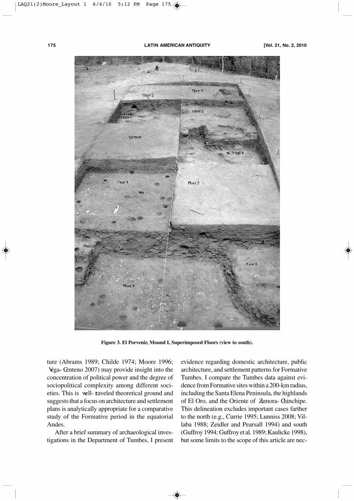
Figure 3. El Porvenir, Mound I, Superimposed Floors (view to south).
LAQ21(2)Moore_Layout 1 6/4/10 5:12 PM Page 175
essary. In brief, the comparative data indicate thatthe Formative period of the equatorial Andes wasmarked by distinctive, but interacting, regional traditions— thus broadening our vantage point forunderstanding Formative developments.
Previous Research and Archaeological Background
In general prehistoric Tumbes has been ignored,archaeologically considered a “cultural backwater”(Staller 2000). The Proyecto Arqueológico Tumbesis a multiphase research program designed to reformthat perspective. In 2006 and 2007 excavations wereconducted at four archaeological sites, three ofwhich contain Formative occupations: El Porvenir,Uña de Gato, and Santa Rosa, sites recorded dur-ing a 1996 archaeological reconnaissance in theTumbes region (Moore 2008; Moore et al. 1997).Before 1996, only 27 sites were recorded for the
entire Department of Tumbes (Ishida 1960; Izumiand Terada 1961, 1966; Kauffman Doig 1987;Ravines 1973; Ravines and Matos 1983), and until2003 the only major systematic excavations werethe University of Tokyo’s 1958 and 1960 investi-gations at the sites of Garbanzal and Pechiche,which involved only 13 days of excavation (Izumiand Terada 1966:1; Mejía Xesspe 1960:207). Sevenradiocarbon dates obtained during the University ofTokyo’s excavations were the only absolute datesavailable for the Department of Tumbes (Izumi andTerada 1966) and suggested a simple tripartite divi-sion of prehistory (modeled after Meggars’sEcuadorian framework): Formative (1800–500B.C.E.), Regional Development (500 B.C.E.–500C.E.), and Integration period (500–1500 C.E.; foradditional discussion, see Currie 1985, 1989; Hoc-quenghem 1991, 1998; Hocquenghem et al. 1993;Izumi and Terada 1966; Richardson et al. 1990; cf.Moore 2008; Moore et al. 2008).
moore] NeW DIScOVerIeS IN TumBeS, Peru 176
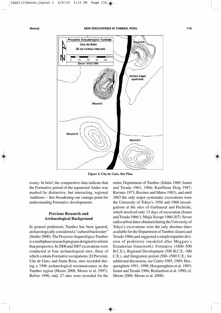
Figure 4. Uña de Gato, Site Plan.
LAQ21(2)Moore_Layout 1 6/4/10 5:12 PM Page 176
Consequently, a principal research goal has beenrevising this imprecise temporal framework (Table1). While a detailed discussion of the proposedchronological revisions lies outside the focus of thisarticle (see Moore 2008, for a discussion), severalobservations are relevant. First, the Archaic occu-pation of Tumbes dates to before 4700–4330 B.C.E.(Table 2). Second, the Formative period is signifi-cantly earlier than previously thought, dating to ca.3500–3100 B.C.E. Third, the previously definedceramic typologies for Tumbes and their chrono-logical associations (Estrada et al. 1964; Izumi andTerada 1966) have proven to be incorrectly dated,loosely associated, and complicated by presumedconnections with sequences from other regions (fordiscussion, see Moore 2008; Moore et al. 2008;Pajuelo 2006; Pajuelo and Moore 2005).As noted above, Formative deposits were uncov-
ered at three archaeological sites in the Tumbesregion. The site of El Porvenir is located on a ter-race on the western floodplain of the Río Zarumilla(Figure 2). The site consists of a group of sixmounds surrounding an open area or possible plazaand comprising an area of 300 × 100 m (Vilchezet al. 2007). By the time of the 2006 excavations,three of the mounds had been partially or exten-sively destroyed by modern constructions, butMounds I, II, and III were largely intact, with basalareas of 750–800 m2 and maximum heights of1.0–1.6 m. Excavations focused on Mounds I andII and proceeded in block excavations by naturaland cultural layers, exposing a stratigraphicsequence in an archaeological palimpsest of super-
imposed floors (Figure 3). These block excavationswere supplemented by two test pits in the inter-vening plaza area and two pits in a thick middendeposit on the north side of Mound II.The site of Uña de Gato is located 1.2 km north-
west of El Porvenir, also on the western terrace ofthe Rio Zarumilla (Figure 4). The core of the sitecovers an area of approximately 225 × 175 m,marked by the remains of four large artificialmounds built around an irregular open space. Thesemounds have been partially destroyed by modernconstruction and road building. Mound I measures32 × 23 m at its base and has a maximum heightof 5.4 m, approximately 70–80 percent of its orig-inal size. Mound II is a stepped platform mound,which in 1996 had measured 42 × 26 m (Moore etal. 1997) but by 2007 had been reduced to 33.7 ×24.3 m. Mound II is 1.6 m tall, itself a reductionfrom its original height. Mound III was 16 × 16 min area and had a height of 1.25 m when recordedin 1996 (Moore et al. 1997), but subsequent destruc-tion has left an intact area of less than 40 m2. MoundIV measured 13 × 9 m in area and stood 1.0 m tallin 1996. Modern houses now cover Mound IV, andthe 2007 excavations were conducted only atMounds I, II, and III. In addition to the central coreof Uña de Gato, a more extensive area of middencovers an area of 500–600 × 300 m along the ter-race escarpment, the remains of a once- larger sitereduced by erosion and human destruction.The site of Santa Rosa is located on the west-
ern bank of the Rio Tumbes (Moore et al. 2008).The central portion of the site consists of three areas
177 LATIN AmerIcAN ANTIquITy [Vol. 21, No. 2, 2010
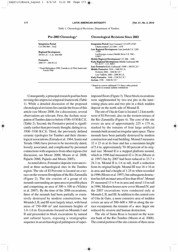
Table 1. Chronological Revisions, Department of Tumbes.
LAQ21(2)Moore_Layout 1 6/4/10 5:12 PM Page 177
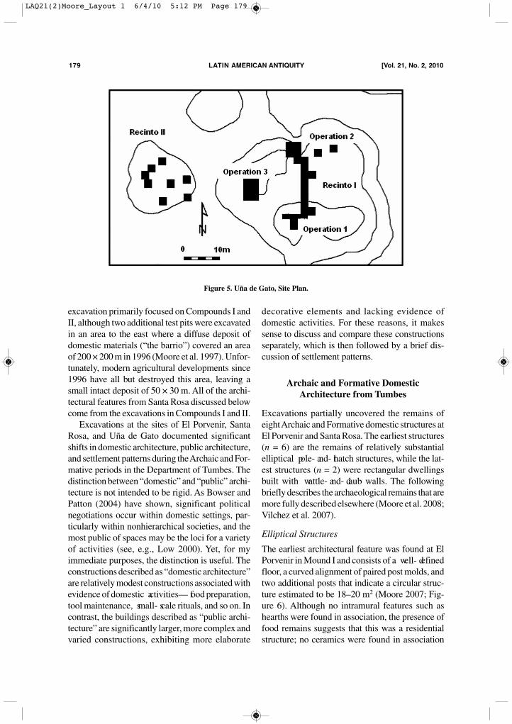
originally referred to as “compounds,” althoughexcavations subsequently showed that this term ismisleading (Figure 5). Compound I covers an areaof 38 × 44 m and at is southern end has a maxi-
mum elevation of 4.2 m above the surrounding nat-ural surface. Compound II covers an area of 17 ×18 m and has a maximum elevation of 2.5 m. Com-pound III is a low mound covering 11 × 9.8 m. The
moore] NeW DIScOVerIeS IN TumBeS, Peru 178
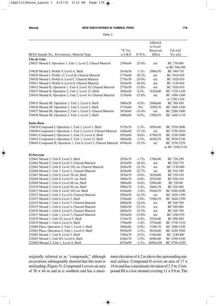
Table 2.
Adjustedto Local
14C Yrs Reservoir Cal A.D. BETA Sample No., Provenience, Material Type ± � B.P. �13C‰ Effect Yrs ±2�
Uña de Gato239627 Mound I, Operation 1, Unit 1, Level 2, Chared Material 2390±40 -25.9‰ n/a BC 730-690
or BC 540-390239628 Mound I, Profile 9, Level A, Shell 2610±50 -1.1‰ 2980±70 BC 940-710239629 Mound I, Profile 12, Level B, Charred Material 2770±40 -20.2‰ n/a BC 1010-820239630 Mound I, Profile 8, Level C, Charred Material 2770±50 -26.0‰ n/a BC 1020-810239631 Mound I, Profile 8, Level D, Charred Material 2810±50 -26.6‰ n/a BC 1120-840239632 Mound II, Operation 1, Unit 4, Level 10, Charred Material 2770±50 -23.8‰ n/a BC 1020-810239633 Mound II, Operation 2, Unit 2, Level 12, Shell 3840±40 0.3‰ 3620±60 BC 1720-1430239634 Mound II, Operation 2, Unit 2, Level 16, Charred Material 3130±40 -23.9‰ n/a BC 1490-1360
or 1350-1310239635 Mound III, Operation 1, Unit 1, Level 9, Shell 3060±50 -0.5‰ 2840±60 BC 780-450239636 Mound III, Operation 2, Unit 2, Level 3, Shell 3770±60 0‰ 3550±70 BC 1660-1360239637 Mound III, Operation 2, Unit 1, Level 3, Charred Material 3670±60 -24.4‰ n/a BC 2200-1890239638 Mound III, Operation 2, Unit 1, Level 3, Shell 3600±60 -0.5‰ 3380±70 BC 1440-1110
Santa Rosa239639 Compound I, Operation 1, Unit 1, Level 1, Shell 5179±70 -2.3‰ 4950±80 BC 3520-3090239640 Compound I, Operation 1, Unit 2, Level 4, Charred Material 4440±60 -27.1‰ n/a BC 3350-2910239641 Compound I, Operation 1, Unit 13, Level 8, Shell 5010±60 -0.6‰ 4790±70 BC 3330-2900239642 Compound I, Operation 2, Unit 1, Level 13, Shell 4850±60 -2.5‰ 4630±70 BC 3070-2740239643 Compound II, Operation 1, Unit 8, Level 2, Charred Material 4560±40 -23.5‰ n/a BC 3370-3270
or BC 3240-3110
El Porvenir222663 Mound 2, Unit 8, Level 3, Shell 2920±70 -1.7‰ 2700±80 BC 720-290222664 Mound 2, Unit 8, Level 3, Charred Material 2610±50 -26.4‰ n/a BC 830-770222665 Mound 2, Unit 8, Level 102 cm, Charred Material 2840±50 -22.2‰ n/a BC 1130-880222666 Mound 2, Unit 7, Level 3, Charred Material 2650±60 -22.7‰ n/a BC 910-780222667 Mound 2, Unit 8, Level 38 cm, Shell 2830±70 -0.9‰ 2610±80 BC 530-150222668 Mound 2, Unit 8, Level 51 cm, Shell 3090±70 -0.8‰ 2870±80 BC 830-410222669 Mound 2, Unit 8, Level 68 cm, Shell 2800±80 -0.6‰ 2580±80 BC 520-80222670 Mound 2, Unit 8, Level 96 cm, Shell 3080±70 -1.8‰ 2860±70 BC 820-400222671 Mound 2, Unit 8, Level 102 cm, Shell 6160±60 -3.4‰ 5940±70 BC 4540-4290222672 Mound 2, Unit 5, Level 6, Charred Material 3050±50 -24.3‰ n/a BC 1420-1190222673 Mound 2, Unit 6, Level 2, Shell 5320±60 -2.8‰ 5100±70 BC 3640-3350222674 Mound 1, Unit 3, Level 7, Charred Material 2680±50 -24.4‰ n/a BC 920-790222675 Mound 1, Unit 6, Level 4, Charred Material 2680±50 -23.1‰ n/a BC 940-800222676 Mound 1, Unit 6, Level 5, Charred Material 2660±50 -23.5‰ n/a BC 920-790222677 Mound 1, Unit 1, Level 7, Charred Material 2920±50 -25.0‰ n/a BC 1280-970222678 Mound 1, Unit 10, Level 5, Shell 3130±70 -0.4‰ 2910±80 BC 890-500222679 Mound 1, Unit 6, Level 6, Shell 3790±90 -1.6‰ 3570±80 BC 1730-1310222680 Plaza, Operation 2, Unit 1, Level 3, Shell 3960±60 -0.8‰ 3740±70 BC 1900-1530222681 Plaza, Operation 2, Unit 1, Level 4, Shell 5830±50 -2.3‰ 5610±60 BC 4220-3940222682 Mound 1, Unit 8, Level 5, Shell 3380±70 -0.2‰ 3160±80 BC 1240-800222683 Mound 1, Unit 8/5, Level 6, Shell 6260±70 -2.5‰ 6040±80 BC 4700-4340222684 Mound 2, Unit 1, Level 4, Shell 6270±90 -3.1‰ 6050±100 BC 4750-4320
LAQ21(2)Moore_Layout 1 6/4/10 5:12 PM Page 178
excavation primarily focused on Compounds I andII, although two additional test pits were excavatedin an area to the east where a diffuse deposit ofdomestic materials (“the barrio”) covered an areaof 200 × 200 m in 1996 (Moore et al. 1997). Unfor-tunately, modern agricultural developments since1996 have all but destroyed this area, leaving asmall intact deposit of 50 × 30 m. All of the archi-tectural features from Santa Rosa discussed belowcome from the excavations in Compounds I and II.Excavations at the sites of El Porvenir, Santa
Rosa, and Uña de Gato documented significantshifts in domestic architecture, public architecture,and settlement patterns during the Archaic and For-mative periods in the Department of Tumbes. Thedistinction between “domestic” and “public” archi-tecture is not intended to be rigid. As Bowser andPatton (2004) have shown, significant politicalnegotiations occur within domestic settings, par-ticularly within nonhierarchical societies, and themost public of spaces may be the loci for a varietyof activities (see, e.g., Low 2000). Yet, for myimmediate purposes, the distinction is useful. Theconstructions described as “domestic architecture”are relatively modest constructions associated withevidence of domestic activities— food preparation,tool maintenance, small- scale rituals, and so on. Incontrast, the buildings described as “public archi-tecture” are significantly larger, more complex andvaried constructions, exhibiting more elaborate
decorative elements and lacking evidence ofdomestic activities. For these reasons, it makessense to discuss and compare these constructionsseparately, which is then followed by a brief dis-cussion of settlement patterns.
Archaic and Formative Domestic Architecture from Tumbes
Excavations partially uncovered the remains ofeight Archaic and Formative domestic structures atEl Porvenir and Santa Rosa. The earliest structures(n = 6) are the remains of relatively substantialelliptical pole- and- thatch structures, while the lat-est structures (n = 2) were rectangular dwellingsbuilt with wattle- and- daub walls. The followingbriefly describes the archaeological remains that aremore fully described elsewhere (Moore et al. 2008;Vilchez et al. 2007).
Elliptical Structures
The earliest architectural feature was found at ElPorvenir in Mound I and consists of a well- definedfloor, a curved alignment of paired post molds, andtwo additional posts that indicate a circular struc-ture estimated to be 18–20 m2 (Moore 2007; Fig-ure 6). Although no intramural features such ashearths were found in association, the presence offood remains suggests that this was a residentialstructure; no ceramics were found in association
179 LATIN AmerIcAN ANTIquITy [Vol. 21, No. 2, 2010
Figure 5. Uña de Gato, Site Plan.
LAQ21(2)Moore_Layout 1 6/4/10 5:12 PM Page 179
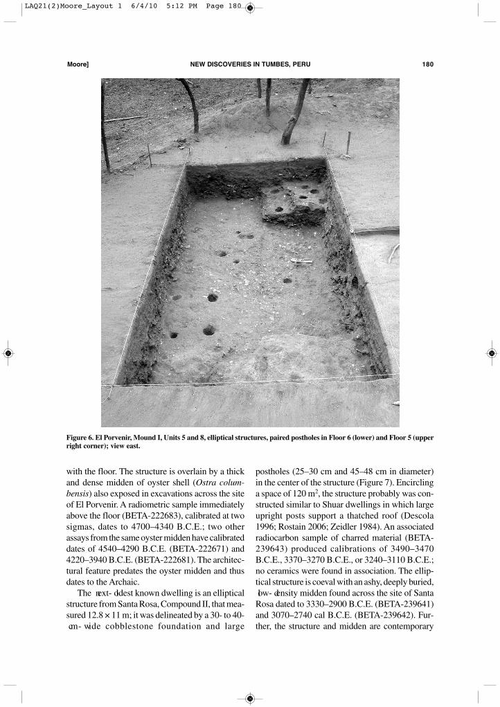
with the floor. The structure is overlain by a thickand dense midden of oyster shell (Ostra colum-bensis) also exposed in excavations across the siteof El Porvenir. A radiometric sample immediatelyabove the floor (BETA-222683), calibrated at twosigmas, dates to 4700–4340 B.C.E.; two otherassays from the same oyster midden have calibrateddates of 4540–4290 B.C.E. (BETA-222671) and4220–3940 B.C.E. (BETA-222681). The architec-tural feature predates the oyster midden and thusdates to the Archaic.The next- oldest known dwelling is an elliptical
structure from Santa Rosa, Compound II, that mea-sured 12.8 × 11 m; it was delineated by a 30- to 40- cm- wide cobblestone foundation and large
postholes (25–30 cm and 45–48 cm in diameter)in the center of the structure (Figure 7). Encirclinga space of 120 m2, the structure probably was con-structed similar to Shuar dwellings in which largeupright posts support a thatched roof (Descola1996; Rostain 2006; Zeidler 1984). An associatedradiocarbon sample of charred material (BETA-239643) produced calibrations of 3490–3470B.C.E., 3370–3270 B.C.E., or 3240–3110 B.C.E.;no ceramics were found in association. The ellip-tical structure is coeval with an ashy, deeply buried, low- density midden found across the site of SantaRosa dated to 3330–2900 B.C.E. (BETA-239641)and 3070–2740 cal B.C.E. (BETA-239642). Fur-ther, the structure and midden are contemporary
moore] NeW DIScOVerIeS IN TumBeS, Peru 180
Figure 6. El Porvenir, Mound I, Units 5 and 8, elliptical structures, paired postholes in Floor 6 (lower) and Floor 5 (upperright corner); view east.
LAQ21(2)Moore_Layout 1 6/4/10 5:12 PM Page 180
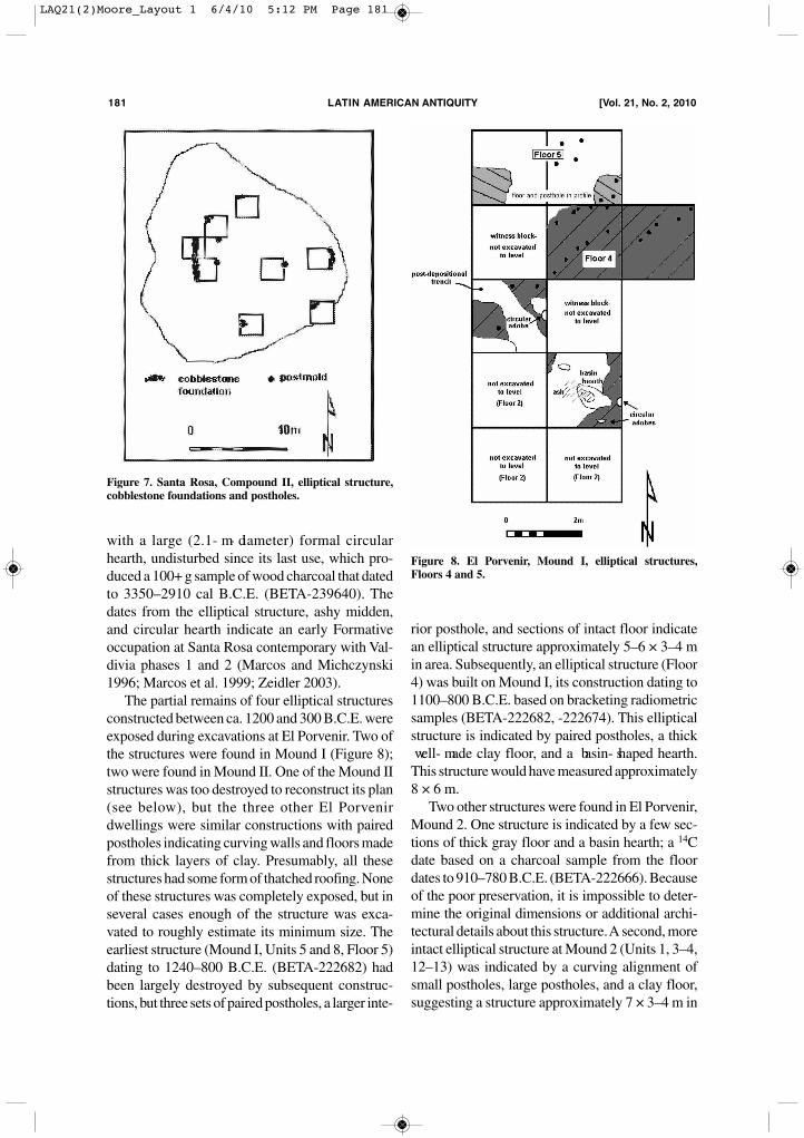
with a large (2.1- m- diameter) formal circularhearth, undisturbed since its last use, which pro-duced a 100+ g sample of wood charcoal that datedto 3350–2910 cal B.C.E. (BETA-239640). Thedates from the elliptical structure, ashy midden,and circular hearth indicate an early Formativeoccupation at Santa Rosa contemporary with Val-divia phases 1 and 2 (Marcos and Michczynski1996; Marcos et al. 1999; Zeidler 2003).The partial remains of four elliptical structures
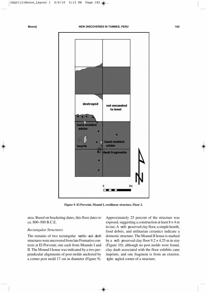
constructed between ca. 1200 and 300 B.C.E. wereexposed during excavations at El Porvenir. Two ofthe structures were found in Mound I (Figure 8);two were found in Mound II. One of the Mound IIstructures was too destroyed to reconstruct its plan(see below), but the three other El Porvenirdwellings were similar constructions with pairedpostholes indicating curving walls and floors madefrom thick layers of clay. Presumably, all thesestructures had some form of thatched roofing. Noneof these structures was completely exposed, but inseveral cases enough of the structure was exca-vated to roughly estimate its minimum size. Theearliest structure (Mound I, Units 5 and 8, Floor 5)dating to 1240–800 B.C.E. (BETA-222682) hadbeen largely destroyed by subsequent construc-tions, but three sets of paired postholes, a larger inte-
rior posthole, and sections of intact floor indicatean elliptical structure approximately 5–6 × 3–4 min area. Subsequently, an elliptical structure (Floor4) was built on Mound I, its construction dating to1100–800 B.C.E. based on bracketing radiometricsamples (BETA-222682, -222674). This ellipticalstructure is indicated by paired postholes, a thick well- made clay floor, and a basin- shaped hearth.This structure would have measured approximately8 × 6 m.Two other structures were found in El Porvenir,
Mound 2. One structure is indicated by a few sec-tions of thick gray floor and a basin hearth; a 14Cdate based on a charcoal sample from the floordates to 910–780 B.C.E. (BETA-222666). Becauseof the poor preservation, it is impossible to deter-mine the original dimensions or additional archi-tectural details about this structure. A second, moreintact elliptical structure at Mound 2 (Units 1, 3–4,12–13) was indicated by a curving alignment ofsmall postholes, large postholes, and a clay floor,suggesting a structure approximately 7 × 3–4 m in
181 LATIN AmerIcAN ANTIquITy [Vol. 21, No. 2, 2010
Figure 7. Santa Rosa, Compound II, elliptical structure,cobblestone foundations and postholes.
Figure 8. El Porvenir, Mound I, elliptical structures,Floors 4 and 5.
LAQ21(2)Moore_Layout 1 6/4/10 5:12 PM Page 181
area. Based on bracketing dates, this floor dates toca. 800–500 B.C.E.
Rectangular Structures
The remains of two rectangular wattle- and- daubstructures were uncovered from late Formative con-texts at El Porvenir, one each from Mounds I andII. The Mound I house was indicated by a two per-pendicular alignments of post molds anchored bya corner post mold 17 cm in diameter (Figure 9).
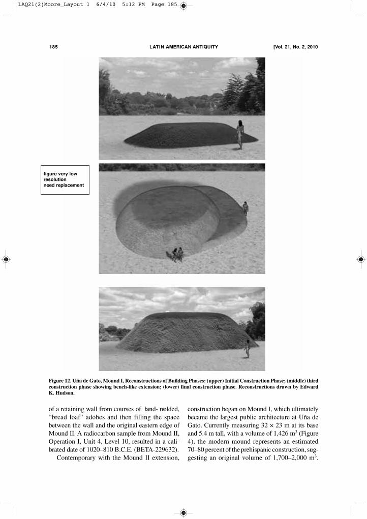
Approximately 25 percent of the structure wasexposed, suggesting a construction at least 8 × 4 min size. A well- preserved clay floor, a simple hearth,food debris, and utilitarian ceramics indicate adomestic structure. The Mound II house is markedby a well- preserved clay floor 9.2 × 4.25 m in size(Figure 10); although no post molds were found,clay daub associated with the floor exhibits caneimprints, and one fragment is from an exterior, right- angled corner of a structure.
moore] NeW DIScOVerIeS IN TumBeS, Peru 182
Figure 9. El Porvenir, Mound I, rectilinear structure, Floor 2.
LAQ21(2)Moore_Layout 1 6/4/10 5:12 PM Page 182
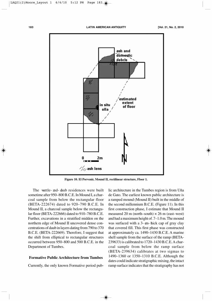
The wattle- and- daub residences were builtsometime after 950–800 B.C.E. In Mound I, a char-coal sample from below the rectangular floor(BETA-222674) dated to 920–790 B.C.E. InMound II, a charcoal sample below the rectangu-lar floor (BETA-222666) dated to 910–780 B.C.E.Further, excavations in a stratified midden on thenorthern edge of Mound II uncovered dense con-centrations of daub in layers dating from 790 to 370B.C.E. (BETA-222669). Therefore, I suggest thatthe shift from elliptical to rectangular structuresoccurred between 950–800 and 500 B.C.E. in theDepartment of Tumbes.
Formative Public Architecture from Tumbes
Currently, the only known Formative period pub-
lic architecture in the Tumbes region is from Uñade Gato. The earliest known public architecture isa ramped mound (Mound II) built in the middle ofthe second millennium B.C.E. (Figure 11). In thisfirst construction phase, I estimate that Mound IImeasured 20 m (north–south) × 26 m (east–west)and had a maximum height of .7–1.0 m. The moundwas surfaced with a 3- cm- thick cap of gray claythat covered fill. This first phase was constructedat approximately ca. 1490–1430 B.C.E. A marineshell sample from the surface of the ramp (BETA-239633) is calibrated to 1720–1430 B.C.E. A char-coal sample from below the ramp surface(BETA-239634) calibrates at two sigmas to1490–1360 or 1350–1310 B.C.E. Although thedates could indicate stratigraphic mixing, the intactramp surface indicates that the stratigraphy has not
183 LATIN AmerIcAN ANTIquITy [Vol. 21, No. 2, 2010
Figure 10. El Porvenir, Mound II, rectilinear structure, Floor 1.
LAQ21(2)Moore_Layout 1 6/4/10 5:12 PM Page 183

been disturbed, tentatively suggesting that theramped mound was built sometime after1490–1430 B.C.E.Subsequently, Mound II was expanded to the
east and raised to create a larger, taller, stepped
platform mound (Figure 11). The base of the moundcovered an area of 42 m (east–west) × 26 m(north–south), with a maximum height of 1.5–2 m.The eastern extension was built using a variationof a box and fill technique, involving construction
moore] NeW DIScOVerIeS IN TumBeS, Peru 184
Figure 11. Uña de Gato, Mound II, Reconstructions of Building Phases: (upper) Initial Construction Phase; (lower) sec-ond construction phase showing eastern addition. Reconstructions drawn by Edward K. Hudson.
figure very low
resolution
need replacement
LAQ21(2)Moore_Layout 1 6/4/10 5:12 PM Page 184
of a retaining wall from courses of hand- molded,“bread loaf” adobes and then filling the spacebetween the wall and the original eastern edge ofMound II. A radiocarbon sample from Mound II,Operation I, Unit 4, Level 10, resulted in a cali-brated date of 1020–810 B.C.E. (BETA-229632).Contemporary with the Mound II extension,
construction began on Mound I, which ultimatelybecame the largest public architecture at Uña deGato. Currently measuring 32 × 23 m at its baseand 5.4 m tall, with a volume of 1,426 m3 (Figure4), the modern mound represents an estimated70–80 percent of the prehispanic construction, sug-gesting an original volume of 1,700–2,000 m3.
185 LATIN AmerIcAN ANTIquITy [Vol. 21, No. 2, 2010
Figure 12. Uña de Gato, Mound I, Reconstructions of Building Phases: (upper) Initial Construction Phase; (middle) thirdconstruction phase showing bench-like extension; (lower) final construction phase. Reconstructions drawn by EdwardK. Hudson.
figure very low
resolution
need replacement
LAQ21(2)Moore_Layout 1 6/4/10 5:12 PM Page 185
Based on stratigraphic exposures on the easternside of Mound I, the mound was built in at leastfour stages over a relatively brief time during thetenth century B.C.E. (Figure 12; Table 3). Initially,Mound I was a relatively small platform moundabout 1.65 m tall built from yellow- brown, hand- modeled “ loaf- shaped” adobes set in a gray claymatrix. The initial mound was topped with a grayclay floor, and its sides were covered with redstucco. Subsequently, the mound was covered witha layer of fill and coated with a layer of gray clay.The third construction phase involved extendingMound I northward by building a bench- like exten-sion and thus forming a stepped platform mound.In the fourth and final construction phase, thisbench surface was filled in and the mound wasraised and surfaced with a grayish brown clay.If the construction phases in the northeastern
profile characterize the entire mound, then appar-ently most of Mound I was constructed during thefinal phase 4. A very approximate estimate of con-struction effort can be derived using these propor-tions and labor estimates obtained by Erasmus(1965), who determined that a workman using tra-ditional hand tools could excavate approximately2.6 m3 per day. Using the estimated volume of1,700–2,000 m3, then approximately 650–770 person- days were required to excavate the mater-ial incorporated into the mound. Doubling that esti-mate to include transport and construction indicatesthat approximately 1,300–1,500 person- days wererequired to build Mound I— a project for 20 peo-ple working two to three months.Just east of Mound I, a distinct series of con-
structions were built in the extensively damagedMound III. Sometime after 2200–1100 B.C.E. andbefore 780–450 B.C.E. a small mound was builtfrom hand- modeled, semispherical adobes madefrom dark red clay. Subsequently, a rectangularbuilding was constructed, cutting into the red adobemound. Only a small portion of this construction
was preserved, insufficient to estimate its originalsize, though it was 3.5 m on one axis. Based on aradiometric sample of marine shell (BETA-239635), the structure dates to 780–450 B.C.E.This structure was built with a lower half- wall of“bread loaf” adobes, topped by a wattle- and- daubwall and enclosing a well- plastered floor. The inte-rior walls of this structure had been painted and dec-orated with a simple form of bas- relief. Daubfragments with cane impressions and traces of red-dish brown stucco were found on top of the floor.One fragment displayed a rolled coil of clay pressedonto the still- wet daub; the coil formed a right angle.Notably, all the decorated daub fragments werefound with the painted surfaces down and imme-diately on the floor; the decorated fragments hadfallen from inside the structure. This is the onlyexample of interior decoration currently knownfrom a Formative construction in the Departmentof Tumbes.
Summary of Archaic and Formative Architectural and Settlement Patterns
in Tumbes
First, the earliest structures at El Porvenir and SantaRosa indicate that substantial, relatively large struc-tures were constructed in the Tumbes region by thefifth and fourth millennia B.C.E. As discussedbelow, the Tumbes structures are significantlylarger and more substantial than contemporarydwellings known from early Valdivia settlements(Damp 1984, 1988; Raymond 2003; Zeidler 1984).Currently, no dwellings of this antiquity have beenreported from El Oro or adjacent areas of northernPeru (Guffroy 2004; Staller 1994).Second, a basic shift from elliptical pole- and-
thatch dwellings to rectangular wattle- and- daubhouses occurred ca. 950/800–500 B.C.E. in theDepartment of Tumbes. Similar variations fromcircular to rectangular structures have beenobserved in diverse archaeological traditions, inter-preted as reflecting multiple factors including theevolution of agrarian economies, an increasedemphasis on interior storage, and the developmentof extended- family residential groups, among otherfactors (Flannery 1972, 2002). Based on currentarchaeological knowledge from Tumbes, none ofthese factors obviously applies. Agriculture wasestablished at Real Alto by Valdivia phase 3 B.C.E.
moore] NeW DIScOVerIeS IN TumBeS, Peru 186
Table 3. Uña de Gato, Mound I: Construction Phases,Volumes, and Dates
% of cal BCEvolume (est.) (2 sigmas) sample
Phase 1 17 n/aPhase 2 4 940 – 710 BETA-23929Phase 3 23 1010 -820 BETA-23930Phase 4 56 1120 – 840 BETA-23931
LAQ21(2)Moore_Layout 1 6/4/10 5:12 PM Page 186
in southern Ecuador (Pearsall 1978, 2002; Pearsalland Piperno 1990; Zarrillo et al. 2007; cf. Stallerand Thompson 2002), and maize phytoliths arereported from the even earlier Las Vegas site(Stothert et al. 2003); there is every reason to thinkthat maize- based agrarian societies long precededthe 950/800–500 B.C.E. shift from elliptical to rec-tangular dwellings (Tykot and Staller 2002). Nei-ther is there any evidence for an increase inintramural storage; there are no known storage pitsor bins associated with either elliptical or rectan-gular structures. And finally, there is no evidencefor the development of extended- family residentialgroups associated with the shift from elliptical torectangular dwellings. House sizes are broadly sim-ilar—15–48 m2; rectangular dwellings are notlarger than elliptical ones, nor are they multiroomedconstructions. At this early stage of archaeologicalresearch in the Tumbes region, there is no clearexplanation for this reorganization in domesticarchitecture, except to note that it seems associatedwith a change in building materials, specifically theshift from pole and thatch to hand- modeled adobesand wattle and daub. While hand- modeled adobeswere incorporated into floors and hearths in ellip-tical pole- and- thatch structures, loaf- shaped adobesfirst appear in either linear walls or in mound con-struction. Although apsidal wattle- and- daub struc-tures are known from other regions of the world,all wattle- and- daub structures known from theTumbes region have rectangular plans, includingthe late prehispanic structure at Loma Saavedra(Moore et al. 2005) and modern constructions(Jerry D. Moore, field notes, June 2005). Thus,while it is known that dwellings changed from ellip-tical/apsidal to rectangular plan at ca. 950/800–500B.C.E., it is unclear what this change implies.Third, the creation of platform mounds began
perhaps as early as ca. 1400 B.C.E. and was wellestablished by 1000–800 B.C.E. Initially, moundconstruction involved the placement of unconsol-idated fill that was then covered by clay floors, butas mound height increased, structural features wererequired to retain and support the fill. This took sev-eral forms. Hand- modeled adobe bricks were setin a mud matrix to create more stable volumes.Walls of “bread loaf” adobe bricks were used toretain mound fill. Associated with these changes isa significant increase in construction labor, withmound construction requiring the sustained effort
of labor from multiple households. In contrast,building a pole- and- thatch dwelling required theresidence group’s labor, supplemented by short- term assistance from other men, similar to thearrangement described for the Shuar (Jívaro) inwhich the house owner is assisted by “one or twoclose male relatives” and a half- dozen men to carrythe main house posts (Harner 1972:45).Fourth, with the development of platform
mounds between 1400 and 1000 B.C.E., settlementplans diverged. El Porvenir consists of a simplecluster around a central open space or plaza, whileUña de Gato has a central core marked by platformmounds and plazas surrounded by residential areas.The central core constructions at Uña de Gato weredistinctive, incorporating diverse architecturalforms, construction techniques (box and fill, fill andcob, adobe and wattle), and decorative elements(painted stucco, modeled reliefs). Unlike El Por-venir, which was marked by symmetries in settle-ment plan and architectural practices, Uña de Gatowas characterized by distinctions— between a sitecore surrounded by a large residential zone andamong the different forms of public architecture:tall mounds, stepped platform mounds, and wattle- and- daub constructions with decorated interiorwalls.The creation of platform mounds suggests that
a two- tiered settlement hierarchy had developed inthe Tumbes region during the latter half of the sec-ond millennium B.C.E., in which Uña de Gato wasthe local center and El Porvenir was an affiliatedhamlet, probably only one of several such com-munities (Moore et al. 1997). The hypothesis of theexistence of a two- tiered settlement system is bol-stered by Uña de Gato’s and El Porvenir’s differ-ential involvement in long- distance obsidianexchange. Residents at both settlements had accessto obsidian from two sources, principally from Mul-lumica, located 435 km to the northeast and dueeast of Quito, and to a lesser extent the Carboncillosource in the Saraguro region, approximately 115km northeast of Tumbes (Ogburn 2007; Shackleyand Ogburn 2008; cf. Burger et al. 1994). Althoughobsidian was relatively scarce at both sites, it wasmore commonly encountered at Uña de Gato,which possibly served as a redistributive center(Moore et al. 2008:269–271).To summarize, archaeological data from Santa
Rosa, El Porvenir, and Uña de Gato point to sig-
187 LATIN AmerIcAN ANTIquITy [Vol. 21, No. 2, 2010
LAQ21(2)Moore_Layout 1 6/4/10 5:12 PM Page 187
nificant diachronic variations in domestic archi-tecture, public architecture, and settlement planduring the Archaic and the Formative periods. Bythe fifth and fourth millennia B.C.E., elliptical pole- and- thatch residences were built, an architecturalpattern sustained until 950/800–500 B.C.E., whenresidences shifted to rectangular wattle- and- daubconstructions. Platform mounds were first con-structed perhaps by 1400 B.C.E. but were largerand incorporated more sophisticated constructiontechniques by ca. 1000–800 B.C.E. These devel-opments also suggest the existence of a two- tieredsettlement system in the Tumbes region in whichUña de Gato was a regional center. In short, thearchaeological data from Tumbes contribute to abroader vision of Formative developments, espe-cially when compared to data from adjacentregions.
Formative Trajectories in the EquatorialAndes: Comparative Perspectives
The archaeological data from Tumbes can be com-pared to archaeological patterns from other For-mative period sites in Guayas (Damp 1979, 1984;Lathrap et al. 1975; Lathrap et al. 1977; Marcos1978, 2003; Marcos and Michczynski 1996; Mar-cos et al. 1999; Raymond 2003; Stothert 1988; Zei-dler 1984, 2000, 2003, 2008), El Oro (Staller 1994,2001a, 2001b), Azuay (Grieder et al. 2002; Griederet al. 2009; Temme 1999), Loja (Bruhns 2003;Gomis 1999; Guffroy 2004), and Zamora- Chichipe(Valdez 2008; Valdez et al. 2005). A broader com-parative perspective points to marked regional vari-ations in cultural trajectories during the Formative,variations expressed in domestic architecture, pub-lic architecture, and settlement plans.
Domestic Architecture
The earliest domestic architecture comes from theArchaic site of OGSE-80 on the Santa Elena Penin-sula, where Stothert (1988:50–54) uncovered theremains of a relatively ephemeral structure lessthan 1.5 m in diameter, perhaps a temporary shel-ter (Raymond 2003:39), dating to 8018–7453B.C.E. The sequence of Valdivia dwellings is morecomplete. Damp (1979, 1984, 1988) excavated aset of early Valdivia dwellings, indicated by ellip-tical patterns of small post molds and domestic
debris. At Real Alto, the best- preserved Valdvia Idwelling, Structure 2-77, measured 4.5 × 3.2 m(14.4 m2) as delineated by 30 postholes, 5–10 cmin diameter, that formed an elliptical wall and artic-ulated with a center post. Sun- dried clay chunksinterpreted as daub fragments were found on thefloor. Damp (1979:211, 1984:578) suggests thatStructure 2-77 dates to ca. 3250 B.C.E. At LomaAlta, the best- preserved dwelling was Structure 4,which dates to Valdivia I/II with an associated radio-metric date of 2680 ± 160 B.C.E. (GX-7699). Struc-ture 4 was an elliptical dwelling measuring 3.2 ×2.3 m and was built by excavating a wall trench andthen placing the posts in the trench; this was indi-cated by a “ ribbon- like feature” of organic mater-ial and some postholes (Damp 1984:579–580).Middle Valdivia dwellings were significantly
larger and more substantial than early Valdiviastructures. For example, Valdivia phase 3, Struc-ture 1, was
a wall- trench house whose floor was a shal-low saucer- shaped pit excavated about 21 cen-timeters into the sterile soil. The house waslarge and elliptical, measuring twelve by eightmeters. Its walls, typical of Valdivia houses,were made of massive, closely packed, verti-cal logs placed in a continuous elliptical trenchand covered with a thick coating of mud. Twopairs of interior posts supported a high gabledroof [Lathrap et al. 1977:8].
Zeidler (1984) documents architectural plans for41 middle Valdivia structures, of which 15 weresufficiently complete to measure floor area andassociate with specific phases in the Valdiviasequence. These data demonstrate a dramaticincrease in house size between Valdivia I/II andValdivia III and thereafter, with mean house sizesof 49.10 m2 (Valdvia III), 51.60 m2 (ValdiviaIV/V), and 53.77 m2 (Valdivia VI). In addition, datafrom eight “ proto- Machalilla” structures— one ofwhich was “rhomboidal,” the only Real Altodwelling not elliptical or circular— indicate a meanarea of 70.37 m2.To date, no house plans have been published
from Machalilla contexts, although partial excava-tions have encountered “two partial house floors insection during site testing in the Rio Verde drainage,indicating floor deposits between 20–30 cm thickas well as the presence of sub- floor hearths and a
moore] NeW DIScOVerIeS IN TumBeS, Peru 188
LAQ21(2)Moore_Layout 1 6/4/10 5:12 PM Page 188
sub- floor pit” (Zeidler 2008:467. No Chorrerahouse plans have been published.Guffroy (2004) has published architectural data
from the site of La Vega, located in the provinceof Loja. Structure 1 (Guffroy 2004:47–50) has anassociated date of 2787 ± 94 B.P. (or 1212–797cal B.C.E. at two sigmas) and dates to CatamayoB. The semicircular structure is 8 m long and 5 mat its greatest width and thus has a floor area ofapproximately 31 m2. As reconstructed, Structure1 had a curved foundation and sloping walls sup-ported by a large central post, leaving the westernside open. Extramural features indicated domes-tic activities. Some 25 m north of Structure 1another set of architectural features (Structure 2)actually consist of two constructions: a circularfoundation made of large cobbles set in mud mor-tar, followed by a rectangular construction markedby a double course of foundations. Neither build-ing was complete, and the rectangular construc-tion probably incorporated stones from the earlierconstruction. The circular structure is recon-structed as approximately 10 × 8 m (Guffroy2004:50). Only a corner of the rectangular struc-ture was preserved, but it was at least 7 × 3 m inarea. A hearth inside the circular structure con-tained carbon dated to 2900 ± 60 B.P. (Guffroy2004:57) or 1269–919 cal B.C.E. The circularstructure at La Vega employed a building tech-nique similar to the large elliptical structure atSanta Rosa. Another parallel is the use of wholeSpondylus shells placed into the mud matrix of thefloor (Guffroy 2004:55–57), a ritual practice asso-ciated with constructions at Santa Rosa and at ElPorvenir (Moore et al. 2008:271–275).Another late Formative structure from the south-
ern Ecuadorian highlands is reported by Temme(1999) from Putushio in the province of Azuay.Temme (1999:134) describes a multicomponentsite with three rectangular structures associatedwith late Formative dates. One structure (ComplejoF 240/15800) is described as “a wattle and daubconstruction with small rectangular subdivisions”(Temme 1999:134; my translation) and dated to2560 ± 85 B.P. (842–409 cal B.C.E.). The secondconstruction (F-15), dating to 2360 ± 130 B.P.(798–164 cal B.C.E.), was “a simple foundation ofa single course of stones” (Temme 1999:134; mytranslation). A third construction (F 1167) isdescribed as an alignment of stones placed next to
a paved plaza and associated with a date of 2450 ±65 B.P. (765–678 or 674–405 cal B.C.E.); excava-tions in this feature recovered a fragment of daubwith cane impressions on its dorsal surface andincised lines and red paint on its finished surface(Temme 1999:134–135). Unfortunately, no com-plete plans or dimensions for the structures areavailable from Putushio.Similarly, Bruhns and colleagues have uncov-
ered a number of well- made floors during theirexcavations at Pirincay. Although no dwelling hasbeen completely exposed, a pattern of post moldsforming a right- angled corner suggests a rectan-gular building dating to ca. 1200 B.C.E. (Bruhns2003:149). Locally available calcium carbonatewas used as floor plaster, and fragments of daubindicate that the dwelling was a wattle- and- daubconstruction.Finally, Grieder and colleagues (Grieder et al.
2002; Grieder et al. 2009:18–23) have reported ontheir excavations at Challuabamba, located nearCuenca, which uncovered a series of wattle- and- daub domestic structures dating from ca. 2000B.C.E. The excavations did not identify a completestructure, but early observations at the site by Uhle(1922) mentioned both apsidal and rectangularbuildings, although the structures uncovered byGrieder appear rectilinear (Grieder et al.2009:18–20). Large fragments of daub with wat-tle impressions indicate that walls were some 10cm thick. At ca. 1450 B.C.E., some domestic struc-tures incorporated cobblestone revetments thatserved as retaining walls along the Rio Tombe-bamba.
Public Architecture
As with the other classes of archaeological data,some of the best records of the development ofpublic architecture come from Valdivia sites, par-ticularly Real Alto and La Emerenciana. At RealAlto, the transformations in domestic architecturethat occurred after Valdivia 2a/3 were paralleled bythe creation of public architecture. Marcos pro-vides a succinct summary:
During the second period, that lasted some 600years, between 3000 BCE and 2400 BCE, therewere important changes in intrasite settlementpatterns, and community development. DuringValdivia Phases 2b and 3, a major change took
189 LATIN AmerIcAN ANTIquITy [Vol. 21, No. 2, 2010
LAQ21(2)Moore_Layout 1 6/4/10 5:12 PM Page 189
place in Real Alto. The circular village gaveway to a rectangular pre- urban settlement witha central plaza. It covered approximately 16hectares. In the Plaza, four mounds topped bypublic buildings, looked down on the openspace. The two largest mounds, Mound “A” or“ Fiesta- House Mound,” and Mound “B” or“Charnel House Mound,” faced each other inthe northern third of the open plaza. These twomounds and the space between them formed“the Ceremonial Precinct.” The two smallermounds, Mound “C” on the northeast sector ofthe plaza, and Mound “D” on the southwest-ern side, appear to have been designated formeetings and ceremonies by the “initiated few”in each one of the village halves [1998:314].
Marcos’s excavations in the Fiesta Mound indi-cated a minimum of eight rebuilding and resurfac-ing “epochs” between Valdivia 2 and 7 (Marcos1978:23, 526, 1988; Staller 1994:47; Zeidler1984:13–15). Approximately 50 × 37 m at its baseand 1.4 m tall, the Fiesta Mound contained featuresindicating recurrent feasting and rituals. Based onpublished plans, the opposite Charnel HouseMound measured 125 × 40 m at its base, stood 1.8m tall, and was topped by an elliptical 12.5-×-7-mstructure (Lathrap et al. 1977:8–9; Zeidler2008:463). This mound held the tomb of an adultfemale, an associated but disarticulated male skele-ton, and seven secondary burials in a commongrave. The major mounds at Real Alto were asso-ciated with distinctive rituals.A well- reported example of Valdivia 7–8 pub-
lic architecture is at La Emerenciana, province ofEl Oro, and dates to ca. 1850–1680 B.C.E. (Staller1994:230, 2000, 2001a, 2001b; Staller and Thomp-son 2002; Tykot and Staller 2002). The La Emeren-ciana mound was built on a modified dune, cappedby a hard- packed clay surface, and then had twooval daub platforms on its top; the constructedmound was 75 × 47 m and 1.5 m tall (Staller1994:325). The edge of the mound was fronted byfour steps or low terraces built with retaining walls.The La Emerenciana mound apparently began asa residential construction but then became a funer-ary/ritual locus at ca. 2310 cal B.C.E., as four buri-als were placed upright in shallow graves, coveredin red pigment, and shrouded with fishing nets ortextiles. Later deposits of burnt fauna and plantfoods and smashed ceramics may represent post-
funerary offerings or feasts (Staller 2001b). Moundconstruction at La Emerenciana exemplifies thedevelopment of “large Phase 8 civic- ceremonialcenters with monumental public architecture of amagnitude not seen in earlier Valdivia phases” (Zei-dler 2008:464). As Marcos observes, “During thisperiod, the great changes that led to the consolida-tion of the Formative process were crystallized”(2003:18).Such crystallizations are not evident in Loja dur-
ing the coeval Catamayo A phase (Guffroy2008:892). While one site (Quebrada de los Cuyes)was interpreted as a hamlet, Guffroy observes, “Themajority of sites studied are of limited extents anddo not appear to represent important settlements,but rather extended family residential sites or spe-cial activity sites” (2004:85–86; my translation).Similarly no public architecture was uncovered atChalluabamba, although there is evidence for a high- status burial placed in the floor of a pole- and- thatch structure (Grieder et al. 2002:171).Given this modest pattern of public architecture
in the southern Ecuadorian highlands, the early cer-emonial architecture at Santa Ana–La Florida,described by Valdez and colleagues (Valdez 2008;Valdez et al. 2005), is surprisingly complex.Located in the southern Oriente province of Zamora- Chinchipe, Santa Ana–La Florida providesa robust set of Archaic and early Formative datesbetween 4323 and 2373 cal B.C.E. (Valdez2008:879–880). In addition to elaborate polishedstone vessels and figurines and a stirrup- spout ves-sel showing a shaman emerging from a Spondylusshell (Valdez 2008:882), the site also contains acomplex of ceremonial architecture. Valdez pro-vides a useful description:
The architectural remains that have beenuncovered display the general layout of whatseems to be a local ceremonial center. At thepresent date, the stone foundations of severalround structures that are clustered in a large double- row circle characterize the site. Thecircle measures 40 m in diameter and obvi-ously divides the precinct in two distinct com-ponents: an exterior section marked by several ring- shaped structures, and an interior spacewhere three sets of rectangular structures aresymmetrically opposed in tiers. There are veryfew signs of domestic refuse middens through-out the explored parts of the site.
moore] NeW DIScOVerIeS IN TumBeS, Peru 190
LAQ21(2)Moore_Layout 1 6/4/10 5:12 PM Page 190
To complete the general picture, the south-eastern end of the naturally descending river-bank terrace has been artificially transformed.A complicated construction process has ele-vated and leveled a horizontal plane of 80 m2.A series of concentric stone contention wallsheld and reinforced the riverbank fall line. Inthe interior of the terrace, the walls convenedand formed a spiral point of origin. At the verycenter of this stone coil, a ceremonial hearthwas found, with an offering cache placed undersmall stones. In the interior spaces betweensome of the concentric walls, burial offerings— composed of turquoise beads andpolished stone bowls— were deposited. Weassume that these were accompanying proba-ble elite burials, but the bone conservation isso poor that only small fragments of a humanskull were recovered [2008:872].
Settlement Plans
As with the other comparative domains, the mostcomplete information about shifts in settlementplans comes from Real Alto. Zeidler provides asuccinct summary of these changes:
The Early Valdivia village was laid out in ahorseshoe shape with small flimsy bent- poledwellings forming a ring around a small openplaza. Each dwelling probably housed anuclear family. At the opening of the U- shapedplaza is evidence of ritual activity, presumablyof a communal nature. By Phase 3, the RealAlto village grew into an elliptical plan mea-suring 400m X 300m. Dwellings again forma dense ring around a long plaza, but the housestructures become much larger and more per-manent in their construction, indicatingextended family dwellings having consider-able longevity. At the center of the new con-figuration are two small opposing mounds eachsupporting a ceremonial structure. . . . By LateValdivia times [phases 6–7] habitation areabecomes reduced within the village, as smalldaughter settlements appear adjacent to flood-plain agricultural plots and the ceremonialprecinct begins to serve a wider local area[2008:463–464].
Marcos (2003) significantly amends this sce-nario, venturing some population estimates for dif-
ferent phases at Real Alto. In phases 1 and 2a(4400–3300 cal B.C.E.) the village of Real Alto vil-lage had 50–60 inhabitants living in 12–15 smalldwellings, whereas in phases 2b and 3 (3000–2400cal B.C.E.) there was a significant population of600–1,110 residents living in 90–100 dwellings(Marcos 2003:17, cf. 14–15). This lasted untilphases 4–7 (2400–1800 cal B.C.E.) “when part ofthe on- site population moved from a central loca-tion at Real Alto to 5 satellite hamlets, or ‘daugh-ter’ communities, along the Río Verde and Río Real.Each of these communities consisted of five to tenhouses with 40–100 inhabitants” (Marcos2003:17–18; original emphasis). The population atReal Alto declined to an estimated 500–1,000inhabitants living in 60–80 dwellings (Marcos2003:18). This model views Real Alto as becom-ing a regional center by ca. 2400–1800 B.C.E., themajor ceremonial and political locus among a smallnumber of nearby hamlets. To summarize, thegrowth in Real Alto’s size from phase 1/2a to phase2b/3 was paralleled by greater formalization of thesettlement plan and concomitant increase in pop-ulation and size. Real Alto developed into a regionalcenter whose resident population decreased some-what but apparently maintained a central sociopo-litical position in an emergent, two- tiered networkof settlements.As noted above, no similar evidence for changes
in settlement plans is known currently from thehighlands of Loja, where settlements are either dis-persed homesteads or small hamlets (Guffroy2004). As Bruhns has observed for the Ecuadorianhighlands, “There are apparently no large sites orreadily identifiable special purpose architecture.The historic situation of a population scattered infarmsteads or hamlets without urban centers andno architecturally differentiated ceremonial cen-ters appears to have had a considerable time depthin the southern highlands” (2003:148). Bruhns’sgeneralization would appear to characterize theFormative settlement at Challuabamba (Grieder etal. 2002; Grieder et al. 2009). And while it is true,as Bruhns notes, that “the apparent paucity of spe-cialized architecture in the south does not mean alack of specialization” at the community level(2003:152), it does suggest that Formative periodregional settlement patterns differed between thecoast and highland zones.
191 LATIN AmerIcAN ANTIquITy [Vol. 21, No. 2, 2010
LAQ21(2)Moore_Layout 1 6/4/10 5:12 PM Page 191
Comparisons and Hypotheses
Given the current unevenness in archaeologicalunderstanding of the Formative in the equatorialAndes, any comparative study provides the basisfor hypotheses rather than firm conclusions. Whatis broadly apparent, however, is that the Formativedevelopments in Guayas, El Oro, Loja, Zamora- Chichipe, and Tumbes are characterized by markedregional variations rather than a single develop-mental trajectory.First, current data indicate that there are sig-
nificant interregional variations in Archaic andearly Formative domestic architecture in terms ofantiquity, size, and building techniques. As notedabove, the earliest structure encountered in El Por-venir, Mound I, Floor 6, is an elliptical structure ofdoubled posts, enclosing an area of 18–20 m2 anddating to 4700–4300 cal B.C.E. This structure ismore substantial than the Las Vegas structurereported by Stothert or the early Valdivia dwellingsfrom Loma Alta or Real Alto. Similarly, the struc-ture at Santa Rosa (3500–3100 B.C.E.), CompoundII, is coeval with Valdivia phases 1 and 2a but at12.8 × 10 m (120 m2) is similar in size to later struc-tures at Real Alto built during Valdivia 2b–3. Onlylater are similar- sized structures known from theLoja region, during Catamayo B and C (ca.1200–900 and 900–500 B.C.E.). If the increase indwelling size at Real Alto reflected a reorganiza-tion of residence groups from individual familiesto multifamily units (Marcos 2003:17; Zeidler1984:69–70), then this reorganization may haveoccurred in the Tumbes region one or more cen-turies before it occurred in Guayas or Loja.Second, Formative public architecture varied in
scale and social function in the region. Althoughpublic architecture is not known from the Forma-tive in Loja, the examples from Guayas, El Oro,and Tumbes point to different ritual practices andcultural associations. At Real Alto, constructionsare associated with either feastings or funerals(Lathrap et al. 1977; Marcos 2003; Raymond 2003;Zeidler 2008); similar activities are indicated at thelate Valdivia mounds at La Emerenciana (Staller1994, 2000). This transformation of public archi-tecture into funerary architecture may be reflectedby the Santa Ana–La Florida site in Zamora- Chinchipe (Valdez 2008), although this awaits moreextensive excavation
In contrast, there is no evidence for funeraryassociations for the public architecture at Uña deGato. The only features interpreted as offeringsappear to be linked to single- event construction rit-uals rather than recurrent rites of commemoration(Moore et al. 2008:271–274). Again, the data setsare limited, but it seems as though public architec-ture is associated with distinctive sets of ritual prac-tices in the Valdivia and Tumbes regions.Third, two- tiered settlement hierarchies devel-
oped by 2400–1800 B.C.E. on the Santa ElenaPeninsula, at approximately 1400–1000 B.C.E. inthe Tumbes region, whereas similar settlement hier-archies do not exist during the Formative period inthe Ecuadorian highlands. The evidence for theemergence of a Valdivia 4–7 two- tiered settlementhierarchy in Guayas significantly precedes similardevelopments in Tumbes. Yet in both regions set-tlement hierarchies developed during the Forma-tive period, characterized by a relatively largeregional center with public architecture (e.g., RealAlto or Uña de Gato) and smaller affiliated sitesnearby (the five Valdivia hamlets on the Rio Verdeand Rio Real drainages or the hamlet of El Porveniron the Rio Zarumilla). While the regional networkassociated with Valdivia 4–7 appears more exten-sive than that in Tumbes, this could simply reflectthe lack of archaeological investigations at othersites along the Zarumilla drainage. In contrast, sim-ilar settlement hierarchies apparently did notdevelop in the southern Ecuadorian highlands dur-ing the Formative period (Bruhns 2003; Grieder etal. 2009; Guffroy 2004).Fourth, the Valdivia 7–8 abandonment of Real
Alto and the emergence of late Valdivia sites inManabi and El Oro contrast with the in situ conti-nuities in the Tumbes region. The lengthy sequenceof occupation at Real Alto ends with Valdivia 7,when the regional center is abandoned and late Val-divia settlements develop to the north in Manabiand south in El Oro. In contrast, the sites of Uñade Gato and El Porvenir continue to be occupiedinto the late Formative period until the fifth–fourthcenturies B.C.E. Further, the construction of pub-lic architecture at Uña de Gato continued and, ifanything, accelerated ca. 1000–800 cal B.C.E. dur-ing the late Formative period. Thus, the creation ofpublic architecture and the reorganization of set-tlement plans appear to have been an autochtho-nous development in Tumbes, one that drew on
moore] NeW DIScOVerIeS IN TumBeS, Peru 192
LAQ21(2)Moore_Layout 1 6/4/10 5:12 PM Page 192
earlier local patterns, rather than one stimulated bythe spread of Valdivia traditions.
Conclusion
Significant and precocious developments duringthe Archaic and Formative periods in the equator-ial Andes were not limited to the Santa Elena Penin-sula. Despite the unevenness in availablearchaeological data from other regions, it is clearthat contemporary and independent developmentsoccurred elsewhere in southern Ecuador and north-ern Peru. While apparently there were interactionsbetween the populations in these regions, theymaintained distinctive cultural practices— an infer-ence drawn by other scholars working with differ-ent data sets. For example, Guffroy writes of theceramic styles in Loja, “The Catamayo A phase[ceramic] material does not present any of the traitsmost characteristic of Valdivia culture. It is possi-ble, however, to identify general similarities, whosesignificance . . . is difficult to establish” (2004:87;my translation). Similarly, Staller has observed thatthe ceramic data indicate “a significant diversitybetween regions” during late Valdivia (ca.2100–1450 B.C.E. [2001b:241]). Such diversitywas similarly present in earlier periods. A com-parative analysis of domestic and public architec-ture and of settlement plans supports Guffroy’scharacterization of the Formative as marked by“notable differences that suggest the existence ofsubtly distinctive sociohistorical developments”(2004:99; my translation).The Formative period in the equatorial Andes
appears as a mosaic of adaptations and cultural tra-ditions. In an analytical sense, the Formative periodshould be considered a period of “regional devel-opment,” and not only the centuries between 500B.C.E. and 500 C.E. as Meggers (1966) originallyproposed. Rather than conceptualizing these pat-terns as post- Formative diversification, recent dataregarding domestic architecture, public architec-ture, and settlement plans from El Porvenir, SantaRosa, and Uña de Gato highlight the temporal depthof prehispanic cultural variations in the equatorialAndes.Recent archaeological data from Formative sites
in Tumbes and adjacent regions of southernEcuador suggest a complex diversity of coeval cul-tural traditions, perhaps correlated with distinctive
environmental zones and/or different ethnic groups,whose populations interacted but maintained dis-tinctive sets of cultural practices. Why this patternof Formative diversity should exist is uncertain, butthe first step toward explaining variation is therecognition that it exists. While the developmentalpattern associated with the Valdivia is of undis-puted significance for understanding the evolutionof Formative societies, it was not the only pattern,nor does it appear to be directly analogous to other,diverse and coeval patterns. Rather, recent investi-gations elsewhere in southern Ecuador and farnorthern Peru provide alternative perspectives onthe evolution of Formative societies of which Val-divia is a significant, but no longer the only, van-tage point.
Acknowledgments. The 2006 and 2007 archaeological exca-vations in Tumbes were funded by the National ScienceFoundation (RUI: “Architecture and Power on the Far NorthCoast of Peru,”0549454) and were authorized by theInstituto Nacional de Cultura (Resolución DirectoralNacional No 783/INC May, 29, 2006 and ResoluciónDirectoral Nacional No 527/INC April 20, 2007.) I amindebted to the project co-directors—Lic. Maria CarolinaVilchez (2006) and Lic. Daniel Ivan Dávila (2007)—and tothe other staff members of the Proyecto ArqueológicoTumbes—Bernardino Olaya Olaya, Eva Pajuelo, andMilagros Orbegoso—for their tremendous contributions tothe project. I also wish to thank Lic. Rafael Díaz Montalvo,director of the Instituto Nacional de Cultura—Tumbes forhis consistent support and goodwill. I deeply appreciate thecomments made by the anonymous reviewers for LatinAmerican Antiquity and by colleagues who read earlier ver-sions of this article, Brenda Bowser, Janine Gasco, JohnStaller, and Andrew Stewart; of course, I am responsible forany errors and misinterpretations. Finally, I wish to thank thecommunities of El Porvenir, Santa Rosa, and Uña de Gatofor their interest and support.
References Cited
Abrams, Elliot1989 Architecture and Energy: An Evolutionary Approach.In Archaeological Method and Theory, edited by M. Schif-fer, Vol. 1:47–87. University of Arizona Press, Tucson.
Beck, Robin A., Jr., Douglas J. Bolender, James A. Brown, andTimothy K. Earle
2008 Eventful Archaeology: The Place of Space in Struc-tural Transformation. Current Anthropology49(2):833–860.
Bischof, Henning, and Julio Viteri Gamboa1972 Pre- Valdivia Occupations on the Southwest Coast ofEcuador. American Antiquity 37:548–551.
2006 Entre Vegas y Valdivia: La fase San Pedro en elsuroeste del Ecuador. Bulletin de l’Institut Français d’É-tudes Andines 35(3):361–376.
Bowser, Brenda, and John Q. Patton
193 LATIN AmerIcAN ANTIquITy [Vol. 21, No. 2, 2010
LAQ21(2)Moore_Layout 1 6/4/10 5:12 PM Page 193
2004 Domestic Spaces as Public Places: An Ethnoarchae-ological Case Study of Houses, Gender, and Politics in theEcuadorian Amazon. Journal of Archaeological Methodand Theory 11:157–181.
Bruhns, Karen2003 Social and Cultural Development in the EcuadorianHighlands and Eastern Lowlands During the Formative.In The Archaeology of Formative Ecuador, edited by J.Scott Raymond and Richard Burger, pp. 125–174. Dum-barton Oaks, Washington, D.C.
Burger, Richard2003 Conclusions: Cultures of the Ecuadorian Formativein Their Andean Context. In The Archaeology of Forma-tive Ecuador, edited by J. Scott Raymond and RichardBurger, pp. 465–487. Dumbarton Oaks, Washington, D.C.
Burger, Richard, Frank Asaro, Helen Michel, Fred Stross, andErnesto Salazar
1994 An Initial Consideration of Obsidian Procurementand Exchange in Prehispanic Ecuador. Latin AmericanAntiquity 5(3):228–255.
Childe, V. Gordon1974 [1936] The Urban Revolution. In The Rise and Fallof Civilizations: Modern Archaeological Approaches toAncient Cultures, edited by C. Lamberg- Karlovsky and J.Sabloff, pp. 6–14. Cummings Publishing Co., Menlo Park.
Currie, Elisabeth1985 La cultural Jambelí con referencia particular alconchero Guarumal. In Memoria del Primer SimposioEuropeo Sobre Antropología del Ecuador, edited bySegundo Moreno Yanez, pp. 31–46. Ediciones Abya Yala,Quito.
1989 Cultural Relationships in Southern Ecuador 300BC–AD 300: Excavations in the Guarumal and PuntaBrava Sites. Unpublished Ph.D. diss., Institute of Archae-ology, University College, London.
1995 Prehistory of the Southern Manabí Coast, Ecuador:López Viejo. BAR International Series 618. Oxford.
Damp, Jonathan1979 Better Homes and Gardens: The Life and Death ofthe Early Valdivia Community. Unpublished Ph.D. diss.,University of Calgary.
1984 Architecture of the Early Valdivia Village. AmericanAntiquity 49:573–585.
1988 La Primera Ocupación Valdivia de Real Alto: PatronesEconómicos, Arquitectónicos e Ideológicos. EscuelaPolitécnica de Literal, Centro de Estudios Arqueológicosy Antropológicos, Guayaquil.
Descola, Phillipe1996 The Spears of Twilight: Life and Death in the Ama-zon Jungle. New Press, New York.
Erasmus, Charles1965 Monument Building: Some Field Experiments. South-western Journal of Anthropology 21(4):277–301.
Estrada, Emilio, Betty Meggers, and Clifford Evans1964 The Jambelí Culture of South Coastal Ecuador. Pro-ceedings of the United States National Museum115:483–558. Smithsonian Institution, Washington, D.C.
Evans, Clifford, and Betty Meggers1957 Formative Period Cultures of the Guayas Basin,Coastal Ecuador. American Antiquity 22:235–247.
Flannery, Kent1972 The Origins of the Village as a Settlement Type inMesoamerica and the Near East: A Comparative Study. InMan, Settlement, and Urbanism, edited by P. J. Ucko, R.Tringham, and G. W. Dimbleby, pp. 23–53. Duckworth,London.
2002 The Origins of the Village Revisited: From Nuclear
to Extended Households. American Antiquity67(3):417–433.
Ford, James A.1969 A Comparison of Formative Cultures in the Ameri-cas. Smithsonian Contributions to Anthropology, 11,Smithsonian Institution. U.S. Government Printing Office,Washington, D.C.
Fresco, Antonio1983 La Red Vial Incaica en la Sierra Sur del Ecuador,Algunos Datos para su Estudio. Cultura 5(15):109–148.
Gomis, Dominique1999 La Cerámica Formativa Tardia de la Sierra Austral delEcuador (Cañar, Azuay y Loja): Unidad territorial y par-ticularidades regionales. In Formativo Sudamericano: UnaRevaluación, edited by Paulina Ledergerber- Crespo, pp.139–159. Ediciones Abya- Yala, Quito.
Grieder, Terence, James D. Farmer, Antonio Carillo, and Brad-ford M. Jones
2002 Art and Prestige Among the Noble Houses of theEquatorial Andes. In Andean Archaeology II: Art, Land-scape, and Society, edited by Helaine Silverman andWilliam Isbell, pp. 157–177. Kluwer Academic/PlenumPublishers, New York.
Grieder, Terence, James D. Farmer, David V. Hill, Peter W.Stahl, and Douglas H. Ubelaker
2009 Art and Archaeology of Challuabamba, Ecuador. Uni-versity of Texas Press, Austin.
Guffroy, Jean2004 Catamayo Precolombino: Investigaciones Arque-ológicas en la provincia de Loja (Ecuador). Institut deRecherche pour le Développement, Orleáns.
2008 Cultural Boundaries and Crossings: Ecuador and Peru.In Handbook of South American Archaeology, edited byH. Silverman and W. Isbell, pp. 889–902. Springer, NewYork.
Guffroy, Jean (editor)1994 Cerro Ñañañique: Un établissement Monumental dela Période Formative, en limite de désert (Haut Piura,Peru). Edicciones Ostrom, Paris.
Guffroy, Jean, Peter Kaulicke, and Krysztof Makowski1989 La Prehistoria del Departamento de Piura: Estado delos Conocimientos y Problemática. Bulletin de l’InstitutFrançais d’Études Andines 22(3):701–719. Lima.
Harner, Michael1972 The Jívaro: People of the Sacred Waterfall. Double-day/Natural History Press, Garden City, New York.
Heckenberger, Michael J.2005 The Ecology of Power: Culture, Place and Person-hood in the Southern Amazon, AD 1000–2000. Routledge,New York.
Hill, Betsy D.1975 A New Chronology of the Valdivia Ceramic Complexfrom the Coastal Zone of Guayas Province, Ecuador.Ñawpa Pacha 10–12:1–32.
Hocquenghem, Ann Marie1991 Frontera entre “Areas Culturales” Nor Andinas y Cen-troandinas en los Valles y en la Costa del Extremo NortePeruano. Bulletin de l’Institut Français d’Études Andines20(2):309–348.
1998 Para Vencer la Muerte: Piura y Tumbes— Raices enel Bosque Seco y en la Selva Alta— Horizontes en el Pací-fico y en la Amazonia. Travaux de l’Institut Français d’É-tudes Andines 109.
Hocquenghem, Ann Marie, Jaime Idrovo, Peter Kaulicke, andD. Gomis
1993 Bases de Intercambio entre Sociedades Norperuanasy Surecuatorianas: Una Zona de Transición entre 1500
moore] NeW DIScOVerIeS IN TumBeS, Peru 194
LAQ21(2)Moore_Layout 1 6/4/10 5:12 PM Page 194
A.C. y 600 D.C. Bulletin de l’Institut Français d’ÉtudesAndines 22(2):443–466. Lima.
Holm, Olaf1985 Arquitectura Precolombina en el Litoral. Museo delBanco Central del Ecuador, Guayaquil.
Idrovo Urigüen, Jaime1999 El Formativo en la sierra Ecuatoriana. In FormativoSudamericano: Una Revaluación, edited by P. Ledergerber- Crespo, pp. 114–123. Ediciones Abya- Yala,Quito.
Ishida, Eichiro1960 Andes: The Report of the University of Tokyo Scien-tific Expeditions to the Andes in 1958. Directed by E.Ishida. Tokyo.
Izumi, Seichi, and Kasuo Terada1961 Excavations in the Valley of Tumbes, Perú. Journalof the Anthropological Society of Nipon (Zinruigaku Zossi)68:196–204.
1966 Andes 3: Excavations at Pechiche and Garbanzal,Tumbes Valley, Perú 109.
Joyce, Rosemary A.2004 Unintended Consequences? Monumentality as aNovel Experience in Formative Mesoamerica. Journal ofArchaeological Method and Theory 11(1):5–29.
Kauffman Doig, Federico1987 Notas Arqueológicas sobre la Costa Extremo Norte.Boletín de Lima 9(49):53–57.
Kaulicke, Peter1998 El Periodo Formativo de Piura. Boletín de Arque-ología PUCP 2:19–36.
Lathrap, Donald1971 The Tropical Forest and the Cultural Context ofChavín. In Dumbarton Oaks Conference on Chavín, editedby Elizabeth Benson, pp. 73–100. Dumbarton OaksResearch Libraries and Collections, Washington, D.C.
Lathrap, Donald, Donald Collier, and Helen Chandra1975 Ancient Ecuador: Culture, Clay and Creativity,3000–300 BC. Field Museum of Natural History, Chicago.
Lathrap, Donald, Jorge Marcos, and James Zeidler1977 Real Alto: An Ancient Ceremonial Center. Archaeol-ogy 30:2–13.
Lesure, Richard1999 Platform Architecture and Activity Patterns in an EarlyMesoamerican Village in Chiapas, Mexico. Journal ofField Archaeology 26:391–406.
Lesure, Richard, and Michael Blake2002 Interpretive Challenges in the Study of Early Com-plexity: Economy, Ritual, and Architecture at Paso de laAmada, Mexico. Journal of Anthropological Archaeology21:1–24.
Low, Setha2000 On the Plaza: The Politics of Public Space and Cul-ture. University of Texas Press, Austin.
Lumbreras, Luis2006 Un Formativo sin cerámica y cerámica preformativa.Estudios Atacameños. Arqueología y Antropología Suran-dinas 32:11–34.
Lunniss, Richard2008 Where the Land and the Ocean Meet: The EngoroyPhase Ceremonial Site at Salando, Ecuador, 600–100 BC.In Pre- Columbian Landscapes of Creation and Origin,edited by John Staller, pp. 203–248. Springer, New York.
Malpass, Michael, and Karen Stothert1992 Evidence for Preceramic Houses and HouseholdOrganization in Western South America. Andean Past3:137–164.
Marcos, Jorge
1978 The Ceremonial Precinct at Real Alto: Organizationof Time and Space in Valdivia Society. Unpublished Ph.D.diss., University of Illinois, Urbana- Champaign.
1988 Real Alto: La Historia de un Centro Ceremonial Val-divia. Biblioteca Ecuatoriana de Arqueología, 4 (Primeraand Segunda Partes), Escuela Politécnica del Litoral— Centro de Estudios Arqueológicos y Antropológicos,Guayaquil. Corporación Editorial Nacional, Quito.
1998 A Reassessment of the Chronology of the EcuadorianFormative. In El Área Septrentrional Andina: Arqueologíay Etnohistoria, edited by Mercedes Guinea, pp. 295–346.Biblioteca Abya- Yala, Quito.
2003 A Reassessment of the Ecuadorian Formative. In TheArchaeology of Formative Ecuador, edited by J. Scott Ray-mond and Richard Burger, pp. 7–32. Dumbarton Oaks,Washington, D.C.
Marcos, Jorge, and Adam Michczynski1996 Good Dates and Bad Dates in Ecuador: RadiocarbonSamples and Archaeological Excavation: A Commentaryon the “Valdivia Absolute Chronology.” In Proceedings ofthe Third Latin American Congress of the University ofVarsovia, Varsovia and Biskupin- Wenecja. Andean Archae-ological Mission of the Institute of Archaeology, WarsawUniversity, Warsaw.
Marcos, Jorge, Aurelio Álvarez Pérez, and Giorgio Spinolo1999 La Producción Durante el Formativo Temprano: ElDesarrollo Agrícola, Artesanal y el Intercambio de Exóti-cos en Real Alto. In Formativo Sudamericano: Una Reva -luación, edited by P. Ledergerber- Crespo, pp. 97–113.Ediciones Abya- Yala, Quito.
Meggers, Betty J.1966 Ecuador. Praeger, New York.
Meggers, Betty J., and Clifford Evans1962 The Machalilla Culture: An Early Formative Complexon the Ecuadorian Coast. American Antiquity28(2):186–192.
Meggers, Betty J., Clifford Evans, and Emilio Estrada1965 Early Formative Period of Coastal Ecuador: The Val-divia and Machalilla Phases. Smithsonian Contributionsto Anthropology 1, Smithsonian Institution. U.S. Govern-ment Printing Office, Washington, D.C.
Mejía Xesspe, Toribio1960 Algunos Nuevos elementos de la Civilización Recuay— Pasto en el extremo norte del litoral peruano. InAntiguo Perú, Espacio y Tiempo, edited by Juan MejíaBaca, pp. 205–217. Semana de la Arqueología Peruana,Lima.
Moore, Jerry1996 Architecture and Power in the Prehispanic Andes:The Archaeology of Public Buildings. Cambridge Univer-sity Press, Cambridge.
2005 Cultural Landscapes in the Prehispanic Andes:Archaeologies of Place. University Press of Florida,Gainesville.
2007 Early 5th Millennium B.C. Prehispanic Architecturein Far Northern Peru. Antiquity Project Gallery. Electronicdocument,https://antiquity.ac.uk/ProjGall/moore1/index.html.
2008 El Periodo Intermedio Tardío en el Departamento deTumbes. Revista del Museo de Antropología, Arqueologíae Historia, Universidad Nacional de Trujillo, Perú10:155–175.
Moore, Jerry, Daniel Dávila Manrique, and Eva Pajuelo (edi-tors)
2008 Proyecto Arqueológico Tumbes: Excavaciones enSanta Rosa y Uña de Gato, Departamento de Tumbes,Temporada 2007. Technical report submitted to the Insti-
195 LATIN AmerIcAN ANTIquITy [Vol. 21, No. 2, 2010
LAQ21(2)Moore_Layout 1 6/4/10 5:12 PM Page 195
tuto Nacional de Cultura, Lima.Moore, Jerry, Bernardino Olaya Olaya, and Wilson Puell Men-
doza1997 Investigaciones del Imperio Chimú en el valle deTumbes, Perú. Revista del Museo de Arqueología,Antropología e Historia 7:173–184.
Moore, Jerry, Carolina Maria Vilchez, Bernardino Olaya Olaya,Eva Pajuelo, and Andrew Bryan
2005 Informe Técnico: 2003 Excavaciones en el sitio LomaSaavedra. Report on file, Instituto Nacional de Cultura,Lima.
Ogburn, Dennis2007 Source Provenance of Obsidian Artifacts from North-ern Peru. Berkeley Archaeological Laboratory, Universityof California, Berkeley.
Pajuelo, Eva2006 Reassessing the Frontier: Implications of NewResearch in Tumbes, Peru. MS on file at the University ofIllinois, Urbana- Champaign.
2007 Cerámica. In Proyecto Arqueológico Tumbes: Excava-ciones en El Povenir y Loma Saavedra, Departamento deTumbes, Temporada 2006, edited by Carolina Vílchez,Jerry Moore, and Eva Pajuelo, pp. 181–186. InstitutoNacional de Cultura, Tumbes, Peru.
2008 Cerámica. In Proyecto Arqueológico Tumbes: Excava-ciones en Santa Rosa y Uña de Gato, Departamento deTumbes, Temporada 2007, edited by Jerry Moore, DanielDávila Manrique, and Eva Pajuelo, pp. 245–252. InstitutoNacional de Cultura, Tumbes, Peru.
Pajuelo, Eva, and Jerry Moore2005 Reclaiming the Frontier: Material Expressions andthe Appropriation of the Past in Late Prehispanic Tumbes,Peru. Paper presented at the Annual Meeting of the Insti-tute for Andean Studies, Berkeley, January 7–8.
Pearsall, Deborah1978 Phytolith Analysis of Archaeological Soils: Evidencefor Maize Cultivation in Formative Ecuador. Science199:177–178.
2002 Maize Is Still Ancient in Prehistoric Ecuador: TheView from Real Alto, with Comments on Staller andThompson. Journal of Archaeological Science 29:51–55.
Pearsall, Deborah, and Dolores Piperno1990 Antiquity of Maize Cultivation in Ecuador: Summaryand Reevaluation of the Evidence. American Antiquity5:324–337.
Ravines, Rogger1973 Conchales del Río Zarumilla, Perú. Revista del MuseoNacional 39.
Ravines, Rogger, and Ramiro Matos1983 Inventario de Monumentos Arqueológicos del Perú.Zona Norte. Primera Aproximación. Instituto Nacional deCultura, Lima.
Raymond, J. Scott1998 Beginnings of Sedentism in the Lowlands of North-western South America. In Advances in the Archaeologyof the Northern Andes, edited by A. Oyuela- Caycedo andJ. S. Raymond, pp. 10–19. Institute of Archaeology Mono-graph Vol. 39. University of California, Los Angeles.
2003 Social Formations in the Western Lowlands ofEcuador During the Early Formative. In The Archaeologyof Formative Ecuador, edited by J. Scott Raymond andRichard Burger, pp. 33–67. Dumbarton Oaks, Washing-ton, D.C.
Raymond, J. Scott, Jorge G. Marcos, and Donald. W. Lathrap1980 Evidence of Early Formative Settlement in the GuayasBasin, Ecuador. Current Anthropology 21(5):700–701.
Raymond, J. S., A. Oyuela- Caycedo, and P. Carmichael
1998 The Earliest Ceramic Technologies of the NorthernAndes: Comparative Analysis. In Andean Ceramics: Tech-nology, Organization, and Approaches, edited by I. Shi-mada, pp. 153–172. MASCA Research Papers in Scienceand Archaeology, Supplement to Vol. 15. University ofPennsylvania Museum of Anthropology and Archaeology,Philadelphia.
Reichel- Dolmatoff, Gerardo1959 The Formative Stage: An Appraisal from the Colom-bian Perspective. Actas del XXIII Congreso Internacionalde Americanistas 1:152–164. San Jose, Costa Rica.
Richardson, James, II, Mark McConaughy, Allison Heaps dePeña, and Elena Décima Zamecnik
1990 The Northern Frontier of the Kingdom of Chimor: ThePiura, Chira and Tumbez Valleys. In The Northern Dynas-ties: Kingship and Statecraft in Chimor, edited by M.Moseley and A. Cordy- Collins, pp. 419–445. DumbartonOaks Research Library and Collection, Washington, D.C.
Rostain, Stéphan2006 Etnoarqueología de las casas Huapula y Jíbaro. Bul-letin de l’Institut Français d’Études Andines 35:337–346.
Schwarz, Frederick, and J. Scott Raymond1996 Formative Settlement Patterns in the Valdivia Valley,Southwest Coastal Ecuador. Journal of Field Archaeology23(2):205–224.
Shackley, M. Steven, and Dennis Ogburn2008 Source Provenance of Obsidian Artifacts from North-ern Peru. Berkeley Archaeological Laboratory, Universityof California, Berkeley.
Staller, John E.1994 Late Valdivia Occupation in Southern Coastal El OroProvince, Ecuador: Excavations at the Early FormativePeriod (3500–1500 B.C.) Site of La Emerencia. Unpub-lished Ph.D. diss., Department of Anthropology, SouthernMethodist University.
2000 Political and Prehistoric Frontiers: How History Influ-ences Our Understanding of the Past. In The EntangledPast: Integrating History and Archaeology, Proceedingsof the 30th Annual Chacmool Archaeological Conference,edited by M. Boyd, J. Erwin, and M. Hendrickson, pp.242–257. Calgary.
2001a The Jelí Phase Complex at La Emerenciana, a LateValdivia Site in Southern El Oro Province, Ecuador.Andean Past 6:117–174.
2001b Reassessing the Developmental and ChronologicalRelationships of the Formative of Coastal Ecuador. Jour-nal of World Prehistory 15(2):193–256.
Staller, John, and Robert G. Thompson2002 A Multidisciplinary Approach to Understanding theInitial Introduction of Maize into Coastal Ecuador. Jour-nal of Archaeological Science 29:33–50.
Stothert, Karen1988 La Prehistoria Temprana de la península de SantaElena: Cultura Las Vegas. Miscelánea AntropológicaEcua toriana 10. Museo del Banco Central del Ecuador,Guayaquil.
2003 Expressions of Ideology in the Formative Period ofEcuador. In The Archaeology of Formative Ecuador, editedby J. Scott Raymond and Richard Burger, pp. 337–421.Dumbarton Oaks, Washington, D.C.
Stothert, Karen, Dolores Piperno, and T. C. Andres2003 Terminal Pleistocene/Early Holocene Human Adap-tation in Coastal Ecuador: The Las Vegas Evidence. Qua-ternary International 109–110:23–43.
Temme, Matilde1999 El Formativo de Putushío, sierra sur del Ecuador. InFormativo Sudamericano: Una Revaluación, edited by P.
moore] NeW DIScOVerIeS IN TumBeS, Peru 196
LAQ21(2)Moore_Layout 1 6/4/10 5:12 PM Page 196
Ledergerber- Crespo, pp. 124–138. Ediciones Abya- Yala,Quito.
Tykot, Robert, and John E. Staller2002 The Importance of Early Maize Agriculture in CoastalEcuador: New Data from La Emerenciana. Current Anthro-pology 43(4):666–677.
Ubelaker, Douglas2003 Health Issues in the Early Formative of Ecuador:Skeletal Biology of Real Alto. In The Archaeology of For-mative Ecuador, edited by J. Scott Raymond and RichardBurger, pp. 259–287. Dumbarton Oaks, Washington, D.C.
Uhle, Max1922 Influencias mayas en el Alto Ecuador. Tipografía yEncuadernación Salesianas, Quito.
Valdez, Francisco2008 Inter- Zonal Relationships in Ecuador. In Handbookof South American Archaeology, edited by H. Silvermanand W. Isbell, pp. 865–888. Springer, New York.
Valdez, Francisco, Jean Guffroy, Geoffrey de Saulieu, JulioHurtado, and Alexandra Yepes
2005 Découverte d’un site cérémoniel formatif sur le ver-sant oriental des Andes. Comptes- Rendus: Paléontologiehumaine et préhistoire 4(1):369–374.
Vega- Centeno Sara- Lafosse, Rafael2007 Construction, Labor Organization, and Feasting Dur-ing the Late Archaic Period in the Central Andes. Journalof Anthropological Archaeology 26:150–171.
Vilchez Carrasco, Carolina, Jerry D. Moore, and Eva Pajuelo(editors)
2007 Informe Final: Proyecto Arqueológico Tumbes:Excavaciones en El Porvenir y Loma Saavedra, Departa-mento de Tumbes, Temporada 2006. Technical report, Insti-tuto Nacional de Cultura, Lima.
Villaba, Marcelo1988 Cotocollao: Una Aldea Formativa del Valle de Quito.Serie Monográfica 2, Miscelánea Antropológica Ecuato-riana. Museo del Banco Central del Ecuador, Quito.
Willey, Gordon, and Phillip Phillips1958 Method and Theory in American Archaeology. Uni-versity of Chicago Press, Chicago.
Zarrillo, Sonia, Deborah M. Pearsall, J. Scott Raymond, MaryAnn Tisdale, and Dugane J. Quon
2007 Directly Dated Starch Residues Document Early For-mative Maize (Zea mays L.) in Tropical Ecuador. Pro-ceedings of the National Academy of Sciences of the UnitedStates of America 105(3):5006–5011.
Zeidler, James1984 Social Space in Valdivia Society: Community Pat-terning and Domestic Structure at Real Alto, 3000–2000BC. Unpublished Ph.D. diss., University of Illinois, Urbana- Champaign.
2000 Gender, Status and Community in Early FormativeValdivia Society. In The Archaeology of Communities: ANew World Perspective, edited by Marcello Canuto andJason Yaeger, pp. 161–181. Routledge, London.
2003 Formative Period Chronology for the Coast and West-ern Lowlands of Ecuador. In The Archaeology of Forma-tive Ecuador, edited by J. Scott Raymond and RichardBurger, pp. 487–527. Dumbarton Oaks, Washington, D.C.
2008 The Ecuadorian Formative. In Handbook of SouthAmerican Archaeology, edited by H. Silverman and W.Isbell, pp. 459–488. Springer, New York.
Zeidler, James, and Deborah Pearsall (editors)1994 Regional Archaeology in Northern Manabí, Ecuador,Vol. 1: Environment, Cultural Chronology, and Prehis-toric Subsistence in the Jama River Valley. University ofPittsburgh Memoirs in Latin American Archaeology, No.8. Pittsburgh.
Zevallos Mendoza, Carlos, and Olaf Holm1960 Excavaciones arqueológicas en San Pablo. Ciencia yNaturaleza 3(2–3):62–95.
Submitted December 5, 2008; Accepted January 31, 2009;Revised October 31, 2009.
197 LATIN AmerIcAN ANTIquITy [Vol. 21, No. 2, 2010
LAQ21(2)Moore_Layout 1 6/4/10 5:12 PM Page 197