Embed Size (px)
Citation preview
BrieflyNotedCelebrating GISAround the WorldGIS Day is Wednesday November 15 Plan an event register it and get promotional resources at gisdaycomor head there to find anevent near you
ArcGIS Online NowMore Flexible AffordableAn ArcGIS Online subscription no longer requires a minimum number of named users making it more flexible and affordable for smaller organizations to use Now users can subscribe to it for however many named users they need There must be at least one Level 2 nameduser however to managethe subscription
ArcGIS 105 Excels in OGC ComplianceThe ArcGIS 105 platform has received more than 30 compliance certificates from the Open Geospatial Consortium Inc (OGC) These certificates of compliance which cover avariety of OGC implementation standards allow users to workmore collaboratively both insideand outside their organizationswhile minimizing the risks of sharing data Learn more about Esrirsquos commitment to open technology at goesricomOpenSoftware2017
DigitalGlobersquos Imagery+Analytics inArcGIS EnterpriseDigitalGlobe chose ArcGIS Enterprise 105 to deliver its new subscription service for high-resolution imagery and analytics The service called Imagery+Analytics leveragesArcGIS Image Server to let userssearch access and analyze vastamounts of high-resolution DigitalGlobe imagery within their own Esri environments
ArcNews Esri | Fall 2017 | Vol 39 No 4
continued on page 6
Taylor Shellfish Farms of Shelton Washington takes The Science of Where to Puget Sound to sus-tainably produce Manila clams Pacific and Shigoku oysters mussels and geoduck In Canada Shock Trauma Air Rescue Service (STARS) uses The Science of Where to transport critically ill and injured patients via helicopter The Chesapeake Conservancy in Annapolis Maryland puts The Science of Where to work to pri-oritize conservation efforts in the Chesapeake Bay And The Science of Where gives Oakland County Michigan the ability to share information about topics as diverse as economic development delin-quent taxes and opioid addiction To accomplish all this The Science of Where must be versatile agile and powerful But what is this sci-ence And from where does it derive its capabilities The answers to these questions came at the 2017 Esri User Conference (Esri UC) the largest annual gathering of GIS users in the world This yearrsquos event held in July in San Diego California drew almost 18000 people from the United States Canada the United Arab Emirates Japan Germany Ecuador and dozens of other countries
ldquoFor this conference we have a theme called The Science of Whererdquo said Esri president Jack Dangermond as he welcomed the crowd at a packed Plenary Session in the San Diego Convention Center But the phrase is more than a mantra Behind the words is a system of under-standing driven by science technology and people ldquoItrsquos the science of geography and the technol-ogy of GISrdquo Dangermond said ldquoThe Science of
The Science of Where in ActionUsers Showcased Incredible GIS Work at the 2017 Esri User Conference
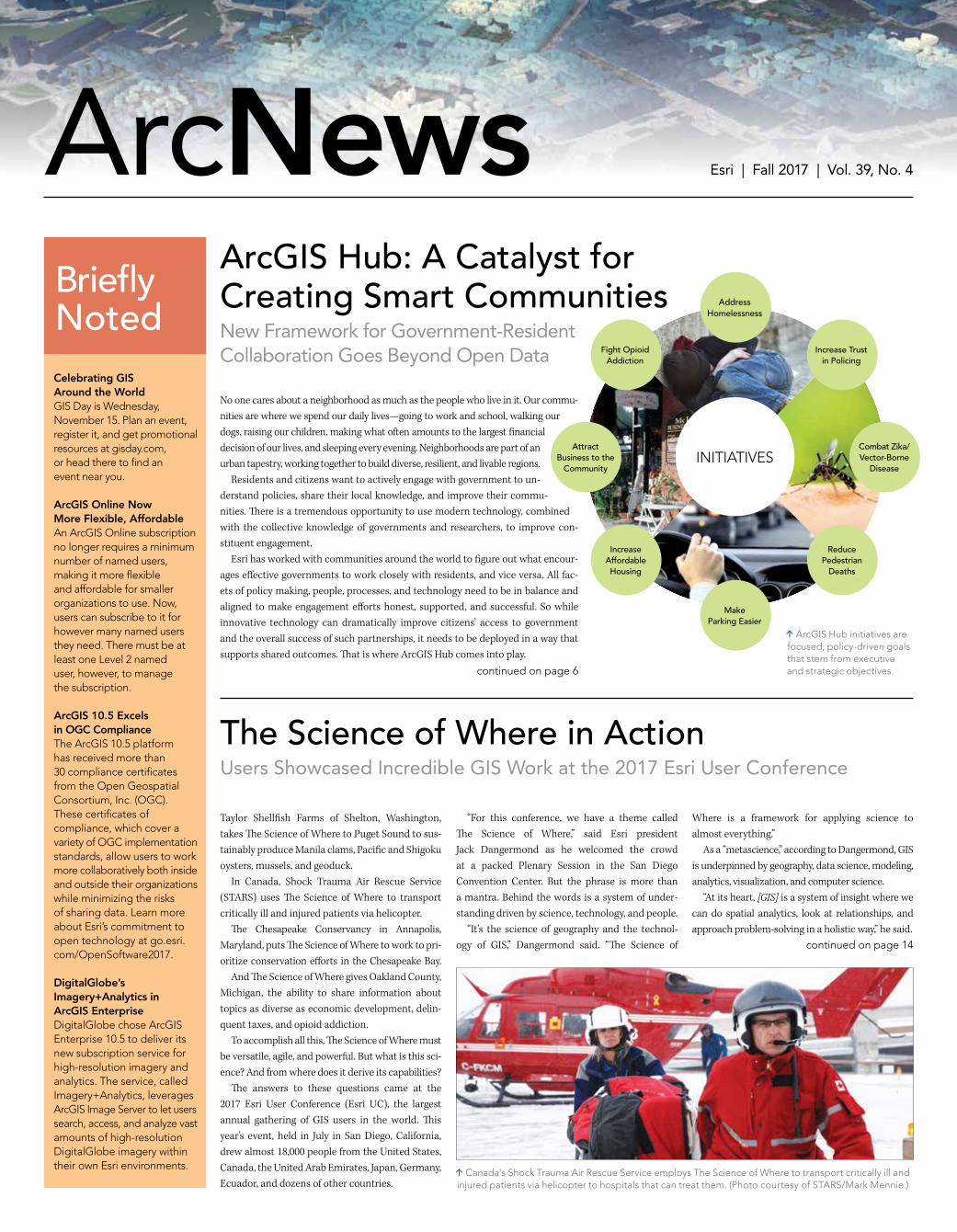
No one cares about a neighborhood as much as the people who live in it Our commu-nities are where we spend our daily livesmdashgoing to work and school walking our dogs raising our children making what often amounts to the largest financial decision of our lives and sleeping every evening Neighborhoods are part of an urban tapestry working together to build diverse resilient and livable regions Residents and citizens want to actively engage with government to un-derstand policies share their local knowledge and improve their commu-nities There is a tremendous opportunity to use modern technology combined with the collective knowledge of governments and researchers to improve con-stituent engagement Esri has worked with communities around the world to figure out what encour-ages effective governments to work closely with residents and vice versa All fac-ets of policy making people processes and technology need to be in balance and aligned to make engagement efforts honest supported and successful So while innovative technology can dramatically improve citizensrsquo access to government and the overall success of such partnerships it needs to be deployed in a way that supports shared outcomes That is where ArcGIS Hub comes into play
ArcGIS Hub A Catalyst for Creating Smart CommunitiesNew Framework for Government-ResidentCollaboration Goes Beyond Open Data
continued on page 14
Canadas Shock Trauma Air Rescue Service employs The Science of Where to transport critically ill and injured patients via helicopter to hospitals that can treat them (Photo courtesy of STARSMark Mennie)
ArcGIS Hub initiatives are focused policy-driven goals that stem from executive and strategic objectives
Where is a framework for applying science to almost everythingrdquo As a ldquometasciencerdquo according to Dangermond GIS is underpinned by geography data science modeling analytics visualization and computer science ldquoAt its heart [GIS] is a system of insight where we can do spatial analytics look at relationships and approach problem-solving in a holistic wayrdquo he said
AddressHomelessness
AttractBusiness to the
Community
IncreaseAffordable Housing
MakeParking Easier
ReducePedestrian
Deaths
Combat ZikaVector-Borne
Disease
Fight OpioidAddiction
Increase Trustin Policing
INITIATIVES
2 ArcNews Fall 2017 esricomarcnews
Share Your Story in ArcNews
esricomansubmission
Tell readers around the world how your organization saved money and time or acquired new capabilities through using GIS
Copyright copy 2015 Esri All rights reserved
Executive EditorMonica Pratt
EditorCitabria Stevens
Graphic DesignerTakeshi Kanemura
4
26
ArcNewsCUSTOM REPRINTSAn effective way to promote your
products and services bull Enhance your companyrsquos visibilitybull Reinforce product imagebull Develop direct mail campaignsbull Compile reference materials
------------------------------------------------------------
Tel 909-793-2853 ext 1-3467Fax 909-307-3101
Email reprintsesricom
ArcNewsEsri | Fall 2017 | Vol 39 No 4
Using 3D GIS the Wellington City Councilrsquos Emergency Operations Centre was able to react rapidly to the 78-magnitude Kaikoura earthquake that struck parts of New Zealand on November 14 2016
10
17
Manage Your ArcNews Subscription To subscribe unsubscribe or make changes to your Esri publications please go to esricomupdates
Outside the United States please contact your international distributor to subscribe unsubscribe or change your address For a directory of distributors visit esricomdistributors
Article Submission Guidelines Before writing an article read and follow the publication guidelines at esricomansubmission
ArcNews Esri 380 New York Street Redlands CA 92373-8100 USA arcnews_editoresricom Tel 909-793-2853 ext 1-2730 Website esricomarcnews
ArcNews (ISSN 1064-6108) is published quarterly by Esri at 380 New York Street Redlands CA 92373-8100 USA ArcNews is written for the Esri user community as well as others interested in mapping and geographic information system (GIS) technology It contains material of interest to planners foresters scientists cartogra-phers geographers engineers business professionals and others who use spatial information
Table of Contents
NEWS1 The Science of Where in Action
1 Briefly Noted
16 Esri Young Scholars Find the Drive to Do More
37 Coursebooks Go Digital at Esri Training
ESRI TECHNOLOGY1 ArcGIS Hub A Catalyst for Creating Smart Communities
3 Unique Innovations Make ArcGIS Pro 20 the Most Advanced Desktop GIS Available
24 ArcGIS Online Keeps Blazing Trails
YOUR WORK4 3D GIS Simplifies Management of Oil and Gas Leases in West Texas
5 Pinpointing Revenue Loss with Simple Data Visualization
9 Enterprise GIS Helps the Federal Government Compile Share Housing Data
10 3D Geospatial Data Puts Earthquake Damage into Context
20 Following Ice Storm City Fixes Tree Hazards in Real Time
22 GIS Field Apps Keep Public Works Department Running Smoothly
29 Web-Based Apps Help Agricultural Producers ConsumersDigest Information
30 Restoring a Watershed One Bag of Litter at a Time
32 Mobile Technology Keeps Election Day on Track in LA County
33 Automating Inspection Reports with Mobile GIS
GIS PEOPLE8 Using GIS to Revolutionize Development from Egypt to the Rest of Africa
12 Preparing for Next Generation 911 Now
17 Helping Youth Form Scientific Habits of Mind
18 New GIS Coding Initiative Engages Girls Women
34 Can Cartographers Do Maps
35 Esri T-shirt Heroes Take On the World
COLLABORATIONS7 Open Data Powers Economic Growth in South Bend Indiana
26 Esri Partners Share Data for Better Results
28 With Street-Level Imagery Property Reappraisals Go Virtual
35 Esri Press
36 New Training and Certification Offerings
38 Career Opportunities
5
With its professional 2D and 3D mapping capabilities and intuitive user interface ArcGIS Pro 20mdashthe latest version of Esrirsquos next generation 64-bit desktop GIS softwaremdashis technologically ahead of everything else on the market It delivers new innovations not available in any other desktop GIS and advances visualization analytics image processing and data management ArcGIS Pro 20 is more tightly integrated with the rest of the ArcGIS platform as well Now is a great time to upgrade
Highly Requested WorkflowsEsri asked ArcGIS Pro users to report their favorite workflows to its engineers so in ArcGIS 20 those workflows are easier and more powerful Now users can perform more complete workflows such as map creation and data management solely in ArcGIS Pro instead of having to use ArcMap or ArcCatalog Other workflow improvements include the ability to create more effective and meaningful maps with grids which make it simpler to find locations on a map and annotation which lets users label features not represented in a feature class (such as a sea in a larger body of water or mountainranges in imagery) Favorites an added feature helps users get started with new ArcGIS Pro proj-ects more quickly by maintaining a collection of their frequently used folder database and server connections Users can also modify topology properties directly in ArcGIS Pro and use the en-hanced Traverse tool to improve COGO (coordinate geometry) workflows Additionally the Catalog pane now includes widely requested context menu options for importing and exporting data With this users can import a feature class simply by right-clicking a geodatabase or feature dataset in the Catalog pane and selecting Import Conversely users can export a geodatabase feature dataset feature class table or shapefile by right-clicking in the Catalog pane and selecting Export
Unique InnovationsUnlike in other desktop GIS programs users of ArcGIS Pro 20 can now easily explore 3D land-scapes with new 3D navigation controls and then sync the views of 3D and 2D maps For example if a city planner is creating a 2D map of road closures for a construction project and wants to factor in information thatrsquos stored in a 3D dataset (like building and tree heights or underground fea-tures) he or she can combine the 3D dataset with the 2D map to present a more comprehensive outlook on how the construction will affect roads and businesses 3D drawing has also been improved It now includes feature drawing by camera distance which allows users to customize the symbology of 3D features based on how far they are from the cam-era For instance features 50 yards away from it can be green while features 100 yards away can be yellow and those 200 yards away can be red Users can also modify individual features this way making the nearside of a feature one color and the far side another 3D visualizations are now even more spectacular as well Esri has enhanced the lighting of 3D objects in ArcGIS Pro by adjusting the position of the point light sources used to simulate the sun when using the Noon at camera position setting Additional enhancements include geoprocessing tools only available in ArcGIS Pro like the Fill Missing Values tool which replaces null values with estimated ones to minimize the impact of those missing values on subsequent analysis And embeddable dynamic charts bring a whole new level of understanding to maps by allowing users to interact with charts and see the results instan-taneously on the map Also a new tool called Create Space Time Cube From Defined Locations lets users generate space-time cubes where attributes change over time but the geography does not like with environmental monitoring stations
ArcGIS Platform IntegrationArcGIS Pro 20 works better with the rest of the ArcGIS platform including ArcGIS Online ArcGIS Enterprise and Esrirsquos vast library of ready-to-use apps To boost efficiency ArcGIS Pro 20 allows us-ers to continue working in ArcGIS Pro while packaging operations are completed in the background Cross-platform workflows are now easier and more powerful as well This version includes en-hancements for editing and interacting with the geodatabase in the updated ArcGIS Pro SDK Users are also able to consume native Open Geospatial Consortium Inc (OGC) Web Feature Services (WFS) directly in ArcGIS Pro and sync with feature layers that reference data registered in Portal for ArcGIS 1051 Additionally vertical coordinate systems are included when sharing web scenes and web scene layers
Download ArcGIS Pro 20Head to My Esri at myesricom to download ArcGIS Pro 20 and upgrade to the most advanced desktop GIS on the market
Unique Innovations Make
ArcGIS Pro 20the Most Advanced Desktop GIS Available
Annotation lets users label features not represented in a feature class as well as adjust those labels to fit with the maprsquos design
With embeddable dynamic charts in ArcGIS Pro users can interact with their charts and see the results instantaneously on the map
ArcGIS Pro 20 now supports grids which make it easier to find locations on a map
3esricomarcnews ArcNews Fall 2017
4 ArcNews Fall 2017 esricomarcnews
3D GIS Simplifies Management of Oil and GasLeases in West TexasWith ArcGIS Pro Analysts Can Easily View Extent of Leased Land Plus Depth of Mineral Deposits
University Lands manages the surface and mineral interests of 21 million acres of land across 19 counties in west Texas Its revenue goes to the Permanent University Fund (PUF) one of the largest university endowments in the United States that benefits operational and capital improvements for both the University of Texas and Texas AampM University systems Since 1923 oil and gas production have been key sources of income for the PUF University Lands leases its land to companies for oil and gas development and retains royalty interest in production To ensure that companiesrsquo drilling operations were staying inside the boundaries of their leases and that University Lands was receiving accurate royalty payments analysts from the land and regulatory departments needed to be able to quickly identify oil and gas
wells traversing through leases and view per-forations (oil and gas extraction points) alongthat trajectory This required having a 3D view of the leased land including the depths of mineral deposits and the horizontal wells (laterals) being used to extract oil and gas Since analysts at University Lands were already familiar with using ArcGIS for portions of their work the organizationrsquos GIS team decided that ArcGIS Pro would be the best solution for integrating their workflows entirely
Viewing 3D Data on 2D MapsPrior to implementing ArcGIS Pro land and regulatory analysts at University Lands had to juggle information housed in various re-positories For each well land analysts would use ArcReader to determine where the well
wasmdashand if it was located where it was sup-posed to be Then they would scour horizontal directional drilling reports to get the maximum depth of the well and figure out if its owner was drilling in the correct range for its lease Regulatory analysts would use the measuring tool in ArcReader to determine the locations of perforations so they could validate which lease a company was obtaining its production from With ArcGIS Pro however analysts in both de-partments could view 3D data on their 2D maps without having to open another application The programrsquos ribbon interface is contextual giving users the tools they need when they need them And ArcGIS Pro has seamless panning zooming and labeling which enables the University Lands analysts to visually inspect the leases and laterals faster than they could have before To implement ArcGIS Pro University Lands GIS analysts Ray Jimenez and Ben Kennady converted the lateral data from CSV files into layers that can be viewed in 3D scenes They used Python script-ing along with ArcPy a Python site package to display the leases and laterals in 3D in ArcGIS Pro The scripts allowed the land and regulation ana-lysts who were only moderately familiar with GIS to incorporate a focused view of data into their current workflows Finally the subsurface data was displayed in an ArcGIS Pro scene so that analysts could examine the leases and well laterals in a 3D environment using just one program
The Benefits of Retaining IT InfrastructureNow analysts from University Landsrsquo land depart-ment can better assess whether companies are operating within their leased land agreements and the organizationrsquos regulatory and accounting departments can ensure that companies are re-porting their production figures accurately ldquoArcGIS Pro easily integrated into our exist-ing enterprise GIS system and gave us the 3D view we needed while saving us the cost of pur-chasing a new software solutionrdquo said Jimenez Implementing ArcGIS Pro allowed University Lands to maintain the IT infrastructure it was already using while enhancing some of its most important workflows The GIS team only had to train users on how to look at and nar-row the focus of the data in ArcGIS Pro since the interface was different from what they had used before rather than teaching them a whole new suite of technology And sticking with the ArcGIS platform is making subsequent develop-ment of the tools pretty simple ldquoWe have future plans to include more 3D data like oil and gas formations so users can view wells in the target formationrdquo said Jimenez ldquoThat would expand our [ArcGIS] Pro use to our geology departmentrdquo The GIS team is also looking to include a tool in ArcGIS Pro that breaks up laterals where they intersect with lease lines so University Lands can measure the length of the lateral in each lease ldquoThis will make regulatory analyst jobs even easier so they donrsquot have to measure out the lat-eral themselvesrdquo added Jimenez For more information on how University Lands implemented ArcGIS Pro email Jimenez at gisutsystemedu
Analysts use ArcGIS Pro mostly to view wells laterals and leases This map shows them in 2D
This map shows the wells laterals and leases in 3D making it easier to see the depths of
the mineral deposits and the horizontal wells (laterals) being used to extract oil and gas
5esricomarcnews ArcNews Fall 2017
Pinpointing Revenue Losswith Simple Data VisualizationUtility in Alabama Zeroes In on Clusters of Dead Meters Using Insights for ArcGIS
Opelika Utilities in Opelika Alabama serves nearly 20000 customers Its mission is to de-termine the current and future water needs of Opelikarsquos citizens and industries while ensuring that its water sources facilities and staff con-tinually provide pure and plentiful water With a view to improve its operational efficien-cy Opelika Utilities began taking a closer look at where it was losing revenue and how it could in-crease earnings more effectively While many util-ities are concerned about water loss due to leaky infrastructure this is not a major issue for Opelika Utilities since its infrastructure-based water loss is well below industry standards Instead Opelika Utilitiesrsquo primary concern was dead metersmdashmeters that are either broken or not reporting ac-curate usage The utility had no way of knowing how vast its dead meter problem was though un-til it assembled all its data in Insights for ArcGIS and visualized some unexpected patterns
Transitioning from Manual to Automated to EasyFor years Opelika Utilities had employed a manual process to identify potential dead me-ters and extremely high and low monthly meter readings which often indicate leaks or meters that arenrsquot tracking water being used Once a month an office-based team member would spend a day reviewing the meter reports pains-takingly combing through 14000 daily readings in Microsoft Excel line by line Unsurprisingly a significant amount of information likely got overlooked Opelika Utilities needed an easiermdashand automatedmdashway to review its meter read-ings analyze them and generate work orders so that nonoperating meters could be attended to In 2016 Opelika Utilities teamed up with Esri partner GISinc to connect its billing system to the Cityworks solution (which it was already us-ing) and GIS To collect filter and aggregate data the team used Python scripts along with ArcPy a Python site package to develop a mostly auto-mated way to comb through meter reports and find discrepancies in readings With this script-ing process Opelika Utilities was able to simplify its meter inspection and work order processes leading to an increased annual revenue of about $100000 But the scripting process was demand-ing on the hosted servers and maintaining andmodifying the scripts took a lot of time and effort By April 2017 Opelika Utilities was ready to make dead meters easier to identify Armed with hundreds of thousands of records on ser-vice connections meter usage work order his-tory and more Opelika Utilities and GISinc put all this data into Insights for ArcGIS
Discerning Patterns in Dead MetersThis web-based data analytics workbench made it simple to visualize the results which were
eye-openingmdashso much so that Opelika Utilitiesrsquo general manager Dan Hilyer almost fell on the floor Out of 14000 meters more than 3000 (be-tween 20 and 25 percent) were dead This trans-lated into an estimated $25000-per-month loss in revenue or $300000 per year ldquoItrsquos information that no manager wants to hear but information that we need to knowrdquo said Hilyer This was a much higher loss than Opelika Utilities had expected The companyrsquos capital projects manager Alan Lee knew there had to be a larger problem Thankfully with Insights for ArcGIS Opelika Utilities could do further analy-sis to discern patterns in dead meters and iden-tify specific manufacturers model numbers and when meters were installed It turned out that most of the issues were occurring in meters from a single manufacturer that were being installed in new developments The good news was all the problematic meters were still under warranty So replacing the majority of the dead meters would cost Opelika Utilities nothing in equipment ldquoInsights for ArcGIS gives [the] end user the pow-er to filter data and see results without the require-ment of being a computer programmer or Python scripterrdquo said Lee ldquoOnce the data is connected itrsquos all plug and playmdasha very powerful softwarerdquo As Opelika Utilities continues to replace the dead meters some of its next steps include working with GISinc to enhance the results by integrating them with Operations Dashboard for ArcGIS to show progress Collector for ArcGIS to assist with field collection and Cityworks to automate the work order process even more Additionally Opelika Utilities is identifying the next big question it wants to ask and analyze data for using Insights for ArcGIS ldquo[This illustrates] what can happen when you combine powerful technology from Esri with the desire to improve operational efficiency and a vision of location-enabled businessrdquo said Kevin Stewart director of state and local sales at GISinc
Identifying and Curbing Revenue LossAt some point every meter will stop working due to manufacturer defect age or damage and require maintenance or replacement The power of being able to connect meter usage with billing and service requests can help utili-ties identify the extent of their equipment prob-lems And with Insights for ArcGIS the process can be replicated repeatedly meaning that utili-ties can use the technology to identify and curb all issues causing revenue loss For more information email Lee from Opelika Utilities at aleeowwbcom or Stewart of GISinc at kevinstewartgisinccom To see how to put Insights for ArcGIS to work in any organization watch a collection of dem-onstrations at goesricomInsights-Fall17
With Insights for ArcGIS Opelika Utilities was able to identify extremely high and low monthly meter readings which could indicate dead meters
Insights for ArcGIS helped the utility see that most of the problems were occurring in meters from a single manufacturer
ArcGIS Hub A Catalyst for Creating Smart Communitiescontinued from cover
For Vision Zero a global initiative to prevent traffic-related deaths cities can build surveys to find out about unsafe road conditions or build an app that lets users view the most dangerous intersections in a city
It Starts with a GoalOpen data is a global movement to share au-thoritative information that is public and reus-able to drive economic development improve government efficiency and increase stakeholder engagement ArcGIS Open Data enables any or-ganization to quickly and freely share its datamdashboth geospatial and tabularmdashin common open formats with a simple user experience on offi-cially branded websites More than 8000 govern-ment nonprofit and commercial organizations use ArcGIS Open Data to provide open informa-tion to their constituents and customers In working with many government staff members research groups and communities on ArcGIS Open Data Esri learned both the benefits and shortcomings of open data poli-cies Governments often ask which pieces of data they should release first and how they can know that their open data is actually being used to improve livelihoods or businesses And while citizens researchers and businesses want up-to-date authoritative information to improve their awareness and decision-making they often donrsquot know which data will be the most useful until they know what data their govern-ments can make available By itself open data is a great set of principles but the concept often lacks focused goals or expected outcomes Open data is much more effective when it is driven by strategic priori-ties and empowered to measure outcomes for
improving engagement on specific constituent-centered benefits In July Esri introduced ArcGIS Hub a new two-way engagement platform that truly con-nects government and citizens ArcGIS Hub includes tools for managing open data and introduces a new framework designed to pri-oritize initiatives organize data and teams measure the progress of key performance indi-cators and empower the community to under-stand complex relationships with explorative analytics and infographic reports ArcGIS Hub goes beyond open data It is a catalyst for creat-ing smart communities
Initiatives Provide Structured EngagementArcGIS Hub initiatives are a new concept and capability of ArcGIS They are focused policy-driven goals that come straight out of execu-tive and strategic objectives Vision Zero for example is a global initiative to prevent traffic-related deaths and life-altering injuries The goalmdashto have zero traffic-related deathsmdashis clearly identifiable as an important and mea-surable metric Everyone has a vested interest in accomplishing this target and as a result groups are motivated and focused on how they can work together to achieve this outcome The platform recommends specific tools and apps to use to help citizens engage with particular initiatives Esri Story Maps apps for example inform the public about the current state of affairs related to an initiative and what the government is doing to achieve associated
goals Surveys gather initiative-related informa-tion and feedback from the public and internal stakeholders And dashboards with analytics measure progress toward accomplishing the initiativersquos objectives These tools are brought together for the public to view and use in dy-namic and mobile-responsive ArcGIS Hub ini-tiative web pages which allow users to learn about an initiativersquos goal interact with data and maps and provide input They also recommend ways to engage with the government Initiatives in ArcGIS Hub help governments prioritize the data they need to power tools apps and analyses that optimize policies and actions and generate better outcomes The Vision Zero ArcGIS Hub initiative for example uses common collision report data indicators and street infra-structure data that most cities have With ArcGIS Hub cities can provide this data in a simple user experience that makes it easy to configure maps apps surveys and dashboards with compelling cartography and eye-catching charts Cities can build surveys for garnering public input on unsafe road conditions or build an app that allows us-ers to view the most dangerous intersections in a city This ability to unlock the informative power of data enables everyonemdashfrom staff members in the transportation and planning departments to educators law enforcement officers and business executivesmdashto work from the same data and gain new perspectives In addition to aiming data and apps at a specific goal ArcGIS Hub initiatives can help governments better coordinate their own work and invite other organizations such as civic advocacy groups to cohost events gather new data perform analysis
and collaborate with tech developers to devise cre-ative solutions to issues Discussion and feedback from the community are captured through ArcGIS Hub conversations which are forums to track pub-lic feedback government responses and ArcGIS Hub initiative team actions to ensure that every-one is working together toward the initiativersquos goal ArcGIS Hub includes a growing gallery of initiative templates for prominent issues such as Vision Zero addressing the opioid crisis and preventing vector-borne disease outbreaks Organizations can also create their own cus-tom ArcGIS Hub initiatives that identify and standardize new processes and goals These ini-tiatives can be repeatedly launched within an organization (at each school in a school district for example) or shared with other ArcGIS Hub municipalities so that hubs around the world can adopt and adapt them for their own needs
Become a Smart CommunityIf a government is going to be ldquoof the people by the people for the peoplerdquo as US president Abraham Lincoln famously expressed during the Gettysburg Address then open governmentmdashwith open datamdashis one way to precipitate that ArcGIS Hub extends enterprise GIS beyond government circles providing organizations businesses and citizens with equitable access to data analysis and opportunities for cooperation The road to successful community collabora-tion begins with sharing data and implementing open data best practices Then find the execu-tive leadership that will prioritize community-centered initiatives and seek out the advocacy groups that are ready and willing to collaborate Finally connect with Esri at esricomhub to learn how to create a smarter more engaged community with ArcGIS Hub
6 ArcNews Fall 2017 esricomarcnews
Open Data Powers Economic Growth in South Bend IndianaArcGIS Hub Early Adopter City Aims for Vitality Transparency and Engagement
With a population of just over 100000 residents South Bend Indiana is best known for the University of Notre Dame its young mayor Pete Buttigieg and as the one-time headquarters of the Studebaker Corporation a now defunct American automaker Although the city has faced challenges famil-iar to other areas in what is known as the Rust Belt where manufacturing used to dominate South Bend is now thriving because of recently successful economic development and revital-ization projects The South Bend city government focuses on providing residents with high-quality ser-vices at the greatest value to taxpayers And residents have widespread confidence that the city successfully manages the fundamen-tals Staff members work to gather input from citizens while providing clear and transpar-ent indications of how the government uses public resources For this transparency effort South Bend uses ArcGIS Open Data to share plans decisions and projects with communitymembers And soon the city will transition to ArcGIS Hub One of South Bendrsquos major projects the Vacant and Abandoned Properties initiative set aside 1000 days in which to either rehabilitate or demolish 1000 abandoned houses through-out the city In partnership with the City of South Bend the Urban Enterprise Association of South Bend Inc offered the Vacant to Value (V2V) Repair Grant Program which provided matching grant funds of up to $10000 to re-pair vacant and abandoned properties located within the City of South Bend South Bend took action on 1122 vacant or abandoned properties by its deadline with a repair rate ofnearly 40 percent ArcGIS Open Data was so valuable in com-municating initiative results that the City of South Bend is currently transitioning to ArcGIS Hub as an early adopter With ArcGIS Hub South Bend will be able to further its commu-nity engagement efforts by providing a central location where citizens can rally around initia-tives and access relevant open data Following the Vacant and Abandoned Properties initiative South Bend is working to engage the public on what should be done with vacant parcels Reneacute Casiano director of applications for the City of South Bendrsquos
department of innovation and technology per-formed suitability analysis to determine how vacant lots could be better used to drive growth and stability in neighborhoods His analysis in-cluded county parcels code enforcement viola-tions permitting lidar topology and propertyvalue information Land parcels could become pocket parks or gardens Neighbors could be allowed to pur-chase the land Or they could support the local environment by becoming a rain retention par-cel to help maintain creek levels a tree nursery to anchor soil or a small monitoring station for environmental studies or smart city tech hubs Through ArcGIS Hub South Bend residents will be able to visualize proposed ideas and provide live feedback ldquoWe used the analysis at neighborhood meetings to work with residents and see which best-use land options they would like to see in their neighborhoodrdquo Casiano explainedldquoThe community part of this is key While we might think that physical characteristics lend the land to one use the neighborhood mem-bers might need a completely different use Since they live there it is very important to get their inputrdquo
Casiano sees ArcGIS Hub as a way for citizens to become greater stakeholders intheir future ldquoArcGIS Hub and ArcGIS Open Data strengthen the cityrsquos transparency ef-forts by enabling everybody to participate in data-driven discussions about public policyrdquo Casiano said ldquoThe community section of ArcGIS Hub offers a digital platform for resi-dents and the city staff members to discuss our public policy either through open data or otherinitiative informationrdquo
South Bend residents will be able to use ArcGIS Hub to visualize proposed ideas and provide live feedback
ArcGIS Open Data was so valuable in communicating the results of its Vacant
and Abandoned Properties initiative that the City of South Bend is transitioning to
ArcGIS Hub as an early adopter
By helping users put open data into the con-text of top priorities ArcGIS Hub enables gov-ernments and communities to work together on policy initiatives that tackle pressing issues Current ArcGIS Open Data users will still have access to the same open data functionality and capabilities they had before but will now man-age those capabilities through ArcGIS Hub To learn more about ArcGIS Hub and find out how to get started with itvisit esricomhub
7esricomarcnews ArcNews Fall 2017
8 ArcNews Fall 2017 esricomarcnews
Using GIS to Revolutionize Development from Egypt to the Rest of AfricaGIS Hero
For Menghestab Haile GIS is about transforming development ldquoGIS will accelerate developmentmdashif we can manage to make it understandable for decision-makersrdquo he said To him leaders are the key to precipitating progress ldquoIf you really want to make a difference in a country or on a continent you really need to have the decision-makers on boardrdquo he added But across Africa where Haile has focused his career many governments donrsquot have the information they need to makeinformed decisions ldquoSo you [have to] link the right information with the rightdecision-makers at the right levels and with the right amount of detailrdquo he said ldquoFor me that is what GIS doesrdquo As the country director and representative for the World Food Programmersquos (WFP) Egypt Country Office he is in a prime posi-tion to link leaders to GIS And that is exactly what he is doing Working in partnership with Egyptrsquos Central Agency for Public Mobilization and Statistics (CAPMAS)mdashwhich collects process-es analyzes and disseminates all statistical data in Egyptmdashand Esri Northeast Africa (Esri NeA) Haile is leading the develop-ment of a Geospatial Platform for Food and Nutrition Security But this is just where his vision begins ldquoItrsquos not only a projectrdquo said Hailersquos colleague Alaa Zohery a senior information manager associate of GIS at WFP and one of the engineers who helped build the platform ldquoIt is an innova-tion It is something really newrdquo Much of WFPrsquos work in Egypt revolves around promoting good nutrition and a lot of its projects focus on capacity build-ing Egyptrsquos government has strong technical capabilities but Haile noticed that ministries and other organizations were ap-prehensive about sharing their datamdashincluding CAPMAS which has the largest amount of and most authoritative data in Egypt ldquoTheir biggest challenge was fear of losing control of their datardquo said Haile So he enlisted Esri NeA to show CAPMAS how it could share its data while still protecting it ldquoThrough that partnership we basically built the confidence of the government that we were not exposing their data and [that] they were in control of itrdquo he said Now CAPMAS is central to Hailersquos goal of getting information into the hands of decision-makers starting with data on food se-curity The statistical organization currently houses its public-facing data on the geospatial platform which officially launched inNovember 2016 And by the end of this year Egypt will have re-leased its first-ever paperless census on the portal This means that anyonemdashscientists statisticians researchers and government staff membersmdashcan access data from CAPMAS and the census and use it ldquoCensus data usually takes two years to analyze before it is sharedrdquo said Haile ldquoNow it takes two monthsrdquo ldquoThe ultimate objective is to em-power whole segments of soci-ety by disseminating the statistics and informa-tion and by improv-ing this sort of
dissemination using very attractive and very informative tools such as GIS toolsrdquo explained one of Hailersquos key partners in this ventureDr Mohamed Ramadan the research and development adviser to the president of CAPMAS Now that the data and technology are in place for the geospa-tial platform allowing anyone to analyze the drivers of food and nutritional insecurity the next phase of the project is to get more government ministries involved in data sharing ldquoWe have proved that we have the technologyrdquo said Haile ldquoNow we will create other portals for other ministriesrdquo Each portal will address the needs of the individual ministry But by following a similar setup as the Geospatial Platform for Food and Nutrition Security the team will ensure that the vari-ous portals are compatible This will make it easier for the differ-ent ministries to work toward common goals such as achieving the Sustainable Development Goals (the United Nationsrsquo current agenda for eradicating poverty and safeguarding the planet) And that gets to the heart of the project to foster government-to-government linkages across Egypt and eventually share this model with other countries around Africa ldquoI am demonstrating what can be done at a country level which can be upscaled to other countriesrdquo said Haile ldquoFrom the first time [we talked] it was [Hailersquos] point of view that we should share our experience with other countries espe-cially other African countriesrdquo said Ramadan ldquoAnd we expressed our 100 percent readiness for thatrdquo Haile and his colleagues at WFP and CAPMAS have already host-ed a delegation from Ethiopia that wanted to see how the paperless census was going to work He has also targeted other countriesmdashincluding Nigeria Cameroon Mali Malawi and Botswanamdashas the next batch of African countries that could revolutionize develop-ment by connecting their data to location and getting it in frontof decision-makers ldquoMy view is if we work together then we can work with the decision-makers at the biggest levelmdashat the African Union levelrdquo said Haile
With his technical expertise in GIS and experience living and working in other African countries it seems that Haile has been building up to this all of his professional life Originally from Ethiopia he studied physics as an undergrad-uate and received his PhD in climate science from the University of Reading in the United Kingdom While there he was trying as he put it to figure out how to be useful in Africa ldquoIn most places [in Africa] you donrsquot have observation on the groundrdquo Haile said because of geography poverty lack of infra-structure conflict and the like So he decided to integrate satel-lite data with model-generated meteorological data and weather forecasts to make climate studies in Africa more feasible ldquoI found that to integrate the satellite data with the model data you needed GIS capabilitiesrdquo he recalled Following graduation he worked at the university as a research fellow before returning to Ethiopia to use GIS to help the govern-ment modernize its early warning system which monitors the cli-mate weather and a countryrsquos food situation to predict drought and ward off famine From there he went to Kenya to help the Intergovernmental Authority on Developmentrsquos (IGAD) member states strengthen their remote-sensing applications for food secu-rity early warning and environmental monitoring systems Haile then made his move over to WFP where he became the head of its Vulnerability Analysis and Mapping (VAM) unit in Sudan helping the government build its technical capacity to moni-tor food security Then he went to WFPrsquos headquarters in Rome where he led the GIS and remote sensing section of the VAM unit From there Haile went back to Ethiopia as the deputy director of WFPrsquos Africa Office in Addis Ababa where he focused on policy analysis resource management and again on capacity building ldquoIt is here that I really saw the weaknesses that governments haverdquo he recalled ldquoBasically you have decision-makers thathellipdonrsquot have the information that is required to make informed decisionsrdquo When Haile got to WFPrsquos Egypt office where he spent two years as the deputy country director before becoming the coun-try director he was finally in a position to connect data directly to the leaders who need it ldquoNow I am a decision-maker and have the resources to say what we will focus on while at the same time I have the techni-cal understanding to actually demonstrate how policy decision-making and technical capabilities can work together to help leaders deliver on their objectivesrdquo he said Haile is trying to get governments to see that GIS is not a luxury ldquoI want to make sure that GIS and data and remote sensing are all part of [government] budgetsrdquo he said because he believes it is criti-cal for governments to understand geography so they can fully com-prehend what is affecting people in their countries and regions ldquoBut a lot of leaders donrsquot know thatrdquo he lamented before adding ldquoHere in Egypt I am proving how important it is All the ministers I talk to now want me to work with themrdquo And Egypt wants to contribute its knowledge and know-how from the Geospatial Platform for Food and Nutrition Security project to the rest of the African continent Which is certainly a win for Haile ldquoThis is much bigger than me or than Egyptrdquo he said ldquoIn the end we are talking about devel-opment transformationrdquo
Menghestab Haile
The Geospatial Platform for Food and Nutrition Security
Enterprise GIS Helpsthe Federal Government Compile Share Housing Data
9esricomarcnews ArcNews Fall 2017
The US Department of Housing and Urban Development (HUD) has a mission to build durable inclusive communities and provide quali-ty homes for low-income families and individuals In pursuit of these objectives HUD collaborates with communities across the United States to establish job-generating economic development projects To meet high demand for information about these projects and make its data easily accessible HUD works with Esri part-ner VSolvit to develop and maintain an enterprise GIS (eGIS) Building on the data it houses in ArcGIS Server HUD can easily manage this data generate intelligent maps and create interac-tive web apps and dashboards Members of Congress often request reports from HUD to see how the departmentrsquos money flows through their districts and to check up on local HUD projects Recently HUD launched the Community Assessment Reporting Tool (CART) to answer the frequently asked question How is HUD investing in my commu-nity Using any device representativesrsquo staff members can simply go to CART type the name of a location into the GIS web app and see the housing funds allotted to that community the dollars spent on rental assistance information on mortgage insurance programs and other insurance-related data community develop-ment blocks poverty levels and more
From Hours Days or Weeks to NowBefore HUD launched CART the departmentrsquos staff spent many tedious hours manually creating reports If a member of Congress asked to see entitlements in his or her district a HUD field analyst would begin the process by asking local communitiesrsquo planning and development offices for data on area HUD investments Then the analyst would pull up two additional data layersmdashone that showed the area of the entitlement jurisdiction and another that showed the congressional districtmdashon a map to see where the two
intersected The analyst would populate that area with the entitle-ment data and finally send the map to the requester This process usually took hours or daysmdashand sometimes even weeks Now CART does all the work Built with ArcGIS API for JavaScript it automatically compiles the agencyrsquos program invest-ments at five geographic levels city county state metropolitan statistical area (MSA) and congressional district Drawing on the most recent data the CART web app displays the information in a dashboard with a map a chart and a table Users can jump from tab to tab to view the different ways HUD invests in a community And CART isnrsquot only a tool for congressional staff It is pub-lic facing as well accessible via HUDrsquos eGIS Storefront athttpsegishudgov a portal that makes the agencyrsquos authorita-tive datasets available and easy to find and that also houses all the departmentrsquos external and internal apps Citizens can use CART to see how much funding is available for projects in their neighborhoods find out the occupancy of a specific public housing project discover which HUD funds are available to their communities and look up HUD investments based on congressional district With access to this information citizens can better engage with their representatives on matters that concern them and their neighborhoods Whatrsquos more CART is available to each of HUDrsquos 18 program offices and 64 field and regional offices This enables staff at any location to access HUDrsquos eGIS information and answer questions for stakeholders on behalf of the agency
Consistent Data Future DevelopmentCART takes data from different sources people and agencies such as the US Census Bureau the American Community Survey nongovernmental organizations federal employees and contrac-tors It also draws data from HUDrsquos internal systems such as the
The Community Assessment Reporting Tool (CART) from the US Department of Housing and Urban Development (HUD) answers the question How is HUD investing in my community
Inventory Management System the Tenant Rental Assistance Certification System and the Homelessness Data Exchange Data providers update their contributed data quarterly annually or simply as needed The eGIS program team conditions this varying administrative data by geocoding it with time and space features To ensure that map outputs and reports are consistent all data must comply with HUDrsquos standards These requirements ensure that the data in CART is accessible and compatible with other data so that us-ers can generate accurate analyses To make CART even more useful the team is exploring new avenues for the app such as how to summarize and visualize HUD program data for other geographic levels Adding American Indian and Alaska Native jurisdictions for example would help people understand how HUD is investing in tribal communities Additionally in giving demonstrations of CART to congressio-nal staff HUD employees have had the opportunity to think more broadly about how other enterprise-wide GIS apps could benefit the agency and its constituents One possibility is disaster sup-port After a natural disaster such as a flood various agencies and people want to know what HUD investments are in the af-fected area and which assets were damaged Disaster recovery managers for example could use the analysis capabilities of eGIS to answer these basic questions inform decision-makers about the situation and help victims get back on their feet
Satisfying Stakeholders and Meeting Citizensrsquo NeedsWith CART HUD can deliver better intelligence to all stakehold-ers and manage its funding more efficiently HUD is now meeting Congressrsquos need for information in an easy-to-understand format that is useful for allocating housing allowances evaluating com-munity needs and communicating with citizens
TRANSFORMING THE WAY THE WORLD WORKS
With Trimble and Esrireg delivering innovative ways to collect and output the highest quality data to and from your GIS your organization is empowered to make the best decisions leading to better business outcomes
See how Trimble solutions provide you with enhanceddeliverables in ArcGISreg Visit geospatialtrimblecomesri
copy 20
17 Trimble Inc A
ll rights reserved GEO
-135A (0
717)
Powerful data Empowered decisionsTRIMBLE AND ESRI
10 ArcNews Fall 2017 esricomarcnews
Just after midnight on November 14 2016 resi-dents on both the south and north islands of New Zealand were awakened by a 78 magni-tude earthquake The Kaikoura earthquake was one of the most complex earthquakes ever re-corded with 21 fault lines rupturing over about 110 miles (180 kilometers) New Zealandrsquos capital of Wellington experi-enced considerable damage Windows shattered in high-rise buildings and plaster and masonry fell onto the streets In the immediate aftermath of the earthquake the Wellington City Council was under pressure to cordon off the city To evaluate the damage and react to a rapidly changing environment the council had to mo-bilize fast Building assessments had to be done under extreme conditionsmdashin high winds and torrential rainsmdashand quick decisions had to be made to get transportation infrastructure and the cityrsquos port operating normally again The mayor councillors and senior government officials needed to be briefed with comprehen-sive real-time information so they could make sound decisions and communicate effectively with the public to avoid loss of lives Geospatial data became an important uni-fier and the ArcGIS platform allowed emergency crews on the ground to swiftly gather informa-tion and easily share it with officials who were briefing city leaders and the media This helped the Wellington City Council figure out what was happening throughout the city and make key
decisions on whether or not to evacuate citizens close streets and demolish buildings
Understanding the Earthquakersquos EffectsFollowing the earthquake the Wellington City Councilrsquos Emergency Operations Centre (EOC) was responsible for sharing current information
with special council teams government agencies and other organizations To evaluate what was happening around the city and analyze commu-nicate and act on these updates the EOC used 3D building and terrain data in conjunction with geospatial tools supplied by Eagle Technology Esrirsquos official distributor in New Zealand
ldquoGeospatial [technology] was our means of understanding our city what was happening to it and the effects that the earthquake and our responses were havingrdquo said Sean Audain the innovation officer for Wellington City Council To rapidly collect the first wave of informa-tion from the field the Wellington City Councilrsquos
3D Geospatial Data Puts Earthquake Damage into ContextNew Zealandrsquos Wellington City Council Relied on the ArcGIS Platform to Quickly Collect Data Make Decisions
Using web scenes in ArcGIS Online the Emergency Operations Centre (EOC) put safety zones into context so decision-makers could see which other areas needed to be blocked off and which parts of the city could remain open
11esricomarcnews ArcNews Fall 2017
local hosts (city workers who help tourists and homeless people and assist with events) used Survey123 for ArcGIS to record damage throughout the city and requests for assistance from citizens Additionally building inspectors used Collector for ArcGIS to record their build-ing assessments documenting the damage and indicating whether buildings had internalandor external safety concerns Working with the people collecting this field data as well as local utilities and other asset owners the coun-cilrsquos GIS analysts produced 3D visualizations of the data to showcase a realistic view of the destructionrsquos extent throughout Wellington and the potential problems that lay ahead for resi-dents infrastructure and the economy At the EOCrsquos headquarters GIS analysts used web maps and web scenes in ArcGIS Online to create a common operating picture that could both be tailored to individual teams and feed into the entire emergency operation They also creat-ed Esri Story Maps apps to communicate with a range of agenciesmdashincluding New Zealandrsquos cen-tral government the regional emergency man-agement office the fire department and urban search and rescuemdashthat were also working to mitigate the earthquakersquos damage With all this data displayed in real time 3D scenes became vital for calculating safety zonesmdashcordoned-off areas around unstable and collapsing buildings It also allowed the EOC to put these zones into context so decision-makers could view the surrounding streets to see what else needed to be blocked off and which areas could remain open for public use When possible the EOC used configurable story maps to share its information with the public to keep everyone abreast of tsunami evacuation zones road clo-sures affected transportation services the loca-tions of emergency water supplies and more
Progressing from Response to RecoveryWith real-time access to more accurate infor-mation the Wellington City Council could be proactive rather than responsive in managing the aftermath of the Kaikoura earthquake ldquoBy having a stable durable way of storing analyzing and communicating data wehellipman-aged to transition smoothly from response to recoveryrdquo said Audain As aftershocks rolled through Audain and his team overlayed the incoming earthquake damage data onto bedrock and soils maps to visualize how vulnerable certain areas and populations were to additional destruction since soft soils shake more than hard rock With that information they and the cityrsquos emergen-cy controllers were able to brief government ministers the mayor and councillors on how to deal with the earthquakersquos immediate after-math as well as make well-informed plans for
recovery Thus even though the environment in Wellington was changing rapidly senior city council officials had the confidence to make tough decisions quickly Ultimately the Wellington City Council de-cided that cordoning off and closing the cityrsquos entire central business district was not neces-sary This prevented a potentially enormous disruption to daily life in Wellington Had such a critical part of the city been cordoned off Wellington would have suffered overwhelming logistical issues and damaging economic defi-cits and the community likely would have lost an important feeling of ownership in dealing with the aftermath of the earthquake Instead thanks to geospatial information and the ArcGIS platform the city took a more focused approach to managing this emergency city building inspectors evaluated over 1600 multi-level commercial and residential structures
infrastructure teams cordoned off individual streets welfare teams only evacuated residents in affected areas and contractors swiftly demol-ished severely damaged buildings ldquoWhen bad things happen to good people quick and accurate information is gold for those people for decision-makers and for the mediardquo said Mike Mendonca chief resilience officer for the Wellington City Council ldquoIn the longer term geospatial [data] can also help tell the story that supports determining the future of our cityrdquo For more information on the Wellington City Councilrsquos immediate and extended response to the Kaikoura earthquake contact Audainat seanaudainwccgovtnz
The Wellington City Council was under pressure to cordon off the cityrsquos entire business district but using the ArcGIS platform allowed councillors to take a more focused approach to managing the earthquakersquos aftermath
The EOC used Esri Story Maps apps to share
information with the public and keep everyone informed about
tsunami evacuation zones road closures and more
11esricomarcnews ArcNews Fall 2017
About the Authors
Jeff Ledbetter GISP PMP is a senior project manager for Esri partner Michael Baker International where he leads public safety and NG911 GIS projects Ledbetter has been working in GIS since 1998 and began applying the technology to public safety in 2009He is a member of the URISA NG911 Task Force which supports GIS professionals in developing NG911 systems For more information emailhim at jeffledbettermbakerintlcom
Kathrine Cargo GISP is the GISmapping coordinator for the Orleans Parish Communication District in New Orleans Louisiana She is the chair of the URISA NG911 Task Force and is a member of the National Emergency Number Associationrsquos (NENA) GIS Data Stewardship Work Group For more information contact Cargoat kcargo911nolaorg
Harness the processing power of the cloud to quickly get from data to decisions ENVIreg products work seamlessly with the ArcGISreg Platform When everyone from your organization can access and share geospatial analytics and products they make quicker more informed decisions regardless of geographic location
TRANSITION YOUR IMAGE ANALYTICS TO THE CLOUD
copy2017 Exelis Visual Information Solutions Inc a subsidiary of Harris Corporation All rights reserved All other marks are the property of their respective owners
harrisgeospatialcomcloudanalytics
12 ArcNews Fall 2017 esricomarcnews
Sometimes when change comes it is difficult and confusing In 2011 an extension was added to US Highway 90 Alternate on the east side of Houston Texas A few days after it opened an 83-year-old grandmother accidentally entered the extension going eastbound on the west-bound side of the highway with cars coming straight at her at 65 miles per hour A Good Samaritan on the eastbound side of the highway saw what was happening and called 911 from his cell phone He assumed that emergency responders would be able to see his location instantly But the 911 dispatcher couldnrsquot find him because the map she was us-ing didnrsquot have the new highway extension on it The incident ended in a fiery head-on collision that caused the grandmother to lose her life First responders eventually located the site of the crash by overriding the system The reason the 911 dispatcher was unable to pinpoint the caller was because the new high-way extension hadnrsquot been added to the GIS data being used nor had its existence been communicated with the Houston Emergency Center or the Greater Harris County 911 Emergency Network As a result the computer-aided dispatch (CAD) software for the 911 cen-ter had no indication that a highway extension was even there Next Generation 911 (NG911) aims to up-grade emergency response systems so they can keep up with ever-evolving mobile commu-nication and technology For NG911 to work features such as street centerlines and address points must be maintained at a higher level of precision than ever before This should both ex-cite and terrify GIS professionals who work in local and regional government On one hand it cements how mission critical a GIS database really is On the other hand amplifying existing data to this level and maintaining its accuracy is a huge undertaking Currently NG911 standards are still being fi-nalized While that is taking place it is impera-tive that GIS professionals in local and regional
government explore what their role will be in this transition to NG911 and embark on creat-ing a street centerline and addressing database that can service every internal and external partner in an enterprise GIS
Finally Embracing GIS in 911The technology used to accurately locate 911 callers has not kept pace with advances in the digital technology that delivers calls for ser-vice such as smartphones tablets home se-curity systems and health-related wearables Although the current Enhanced 911 (E911) system has evolved since it was established more than 40 years ago it was designed at a time when the only 911 calls received were from phones in static locations transmitting via twisted-pair copper wire E911 was the in-dustryrsquos answer to locating analog calls from wireless phones using GPS and cell tower trian-gulation It could figure out where a caller was because the phones or the cell towerrsquos connec-tion to the wired phone network never moved With the advent of smartphones and their accompanying apps people now expect that the 911 system will instantaneously know their location and be accessible in ways that go be-yond voice communication (via text message for example) But this is not the case Today if someone calls 911 from anything but a landline it can take a dispatcher 45ndash90 sec-onds to locate the caller within approximately 150 feet In a worst-case scenario the dispatcher can find the location of the wireless tower that is transmitting the callmdashthough this is not always the tower closest to the caller Whatrsquos more the Federal Communications Commission (FCC) only requires that 40 percent of all wireless911 calls be accompanied by a dispatchable loca-tion (a verified street address that includes unit information when necessary) with about 150-footaccuracy The FCC seeks to increase this to80 percent of wireless calls by 2021 With NG911 however 911 communication will transmit across Internet Protocol (IP)-based networks This will enable all IP-based
devicesmdashthose smartphones security systems and wearable medical devicesmdashto initiate a call to 911 Call centers will also be able to receive additional information from callers such as photos and videos to augment emergency re-sponse And devices will be able to send their own coordinates to NG911 during an emergen-cy call This is where the world of spatial pos-sibilities really opens up NG911 fully embraces GIS technology bring-ing it into the center of the 911 system In any 911 call there are two GIS-based core services at play the emergency call routing function which dictates where to send the call for ser-vice and the location validation function which determines whether an address is valid for routing and dispatch For these NG911 core services to function properly an authoritative GIS-based collection of featuresmdashsuch as street centerlines address points call center jurisdic-tion boundaries and the operating areas for emergency service providers (eg police fire and paramedics)mdashmust exist And these fea-tures have to be meticulously maintained so they remain accurate and up-to-date A collection of features this detailed and timely will be the gold standard of location data Not only will it benefit NG911 and other public safety systems but it will also strengthen ev-ery enterprise system that deals with location And what local or regional government enter-prise doesnrsquot deal with location Almost everydepartmentmdashfrom the planning and public health divisions to the revenue and county asses-sorrsquos officesmdashtracks location data on paper forms or in spreadsheets flat databases and GIS data-bases Now GIS professionals have the opportu-nity to build a street centerline and addressing database that can serve all their colleagues in lo-cal and regional government and beyond
Get Started with Data SharingMaking this transition begins with bringing the data out of hiding Many government enter-prises operate independently of one another quashing interdepartmental communication and data sharing But for NG911 to work GIS professionals need to build crosswalks that connect data silos to one another The GIS au-thority addressing authority and 911 author-ity all need to have access to each otherrsquos data Unsurprisingly this will have many intangible benefits for the entire enterprise such as in-creased cooperation and efficiency To start the data sharing process GIS pro-fessionals should first visit their governmentrsquos public safety 911 communications andor
addressing departments People in these of-fices will be familiar with NG911 concepts but they may not fully appreciate what it means to have an authoritative GIS-based collection of geographic data Itrsquos even more likely that they wonrsquot understand how much effort it will take to develop and maintain these precise records Given that each emergency call center is li-able for coordinating the creation and mainte-nance of its authoritative data it is up to the GIS professional to provide GIS subject matter expertise while letting the public safety 911 and addressing authorities know exactly what is needed to acquire and preserve such accurate GIS data
Obtaining Better Access to Lifesaving ServicesNG911 may not have been able to prevent a trag-edy like the one in Houston but it is a system de-signed to get the public better access to lifesaving services through as many channels as possible And for GIS professionals it is an opportunity to increase the meaningful contributions they make to their communities through GIS Head to ng911noworg to read about the NG911 NOW Coalitionrsquos goal to have sustain-able and standardized IP-based 911 capabili-ties in every 911 system and call center in the United States by 2020 Learn more about NG911 standards and first steps toward upgradingat nenaorgpage=GIS_NG911_PSAP
Preparing for Next Generation 911 NowBy Jeff Ledbetter Michael Baker International and Kathrine Cargo Orleans Parish Communication District
Managing GISA column from members of the Urban andRegional Information Systems Association
Fostering Excellence in GISwwwURISAorg
Next Generation 911 upgrades emergency response systems so they can keep up with technology
Harness the processing power of the cloud to quickly get from data to decisions ENVIreg products work seamlessly with the ArcGISreg Platform When everyone from your organization can access and share geospatial analytics and products they make quicker more informed decisions regardless of geographic location
TRANSITION YOUR IMAGE ANALYTICS TO THE CLOUD
copy2017 Exelis Visual Information Solutions Inc a subsidiary of Harris Corporation All rights reserved All other marks are the property of their respective owners
harrisgeospatialcomcloudanalytics
(Photo courtesy of Taylor Shellfish Farms)
The Science of Where in Actioncontinued from cover
Dangermond underscored the importance of people to The Science of Where all working together to use GIS to confront problems such as pollution loss of nature climate change food shortages social conflict and natural disasters Keynote speaker Dr Geoffrey West a renowned theoretical physicist encouraged the audience to think about how we sustainably organize so-ciety given that clusters of peoplemdashcitiesmdashput intense pressure on the worldrsquos resources while they also facilitate innovation ldquoWe are going to have to do everything we possibly can to better understand andhellipcol-laborate to address [these issues]rdquo Dangermond saidmdashjust like the city of Dubai is with its Smart Dubai program As HE Dr Aisha Bint Butti Bin Bishr director general of the Smart Dubai Office and her colleagues demonstrated GISmdashand the cooperation that it cultivatesmdashis a key element of making the emirate safer more seamless and ultimately the happiest city on earth The challenges may be great but Dangermond is an optimist ldquoCan we make a difference with our work and turn [things] aroundrdquo he asked ldquoMy view is Yes we canrdquo
The Science of Where to Sustainably Farm ShellfishLocation has always been critical to Taylor Shellfish Farms which grows shellfish sustainably on 12000 acres of leased or owned tide land and owns and operates three oyster bars in Seattle Yet this fifth-generation family-owned business has only been employing Esri technology for one year The Taylor family and employees now use GIS to map their 30 farming sites analyze farming condi-tions identify the best growing areas for different shellfish species and conduct surveys to meetenvironmental requirements ldquoWhen I started at Taylor we were using hand-drawn maps and I knew there had to be a better wayrdquo said Erin Ewald assistant director of regulatory and environmental compliance for the business ldquoSo [we] are modernizing our company through GISrdquo Taylor Shellfish Farms didnrsquot start small Since September 2016 the company has adopt-ed ArcGIS Online ArcGIS Pro Esri Story Maps Drone2Map for ArcGIS and multiple mobile apps including Explorer for ArcGIS Survey123 for ArcGIS Collector for ArcGIS and Workforce for ArcGIS ldquoOur company is growing in both size and geo-graphic reach and these mobile apps are leading the way in our digital transformationrdquo said Ewald ldquoWersquore now able to take our real-time business operations and environmental data onto the farms with usrdquo
ldquoIn Samish Bay the tide can recede over a mile to expose large sandy tidal flats rich with nutrients We grow oysters clams and geo-duck hererdquo said Nyle Taylor the farmrsquos project coordinator who stressed that the word geo-duck is actually pronounced ldquogooey duckrdquo In this bay and others farm managers can view a map of farming areas on their smartphones and add information to itmdashusing a sketching tool for example to suggest areas where the farmmight expand ldquoThis ability to take a wealth of GIS data into the fieldhelliphelps us understand the environment wersquore working inrdquo Ewald said ldquoAs we combine this new understanding with generations of experience in a suitability analysis we use this data to identify optimal growing areas for our different shellfish speciesrdquo With Survey123 Ewald can quickly config-ure digital surveys that workers use to collect environmental and other data for regulatory agencies And Taylor Shellfish Farms now also maps out where to plant shellfish using drone-captured imagery processed with Drone2Map ldquoLaying out farm beds prior to using Drone2Map was a boots-on-the ground ap-proachrdquo Taylor said ldquoDrone imagery revolu-tionizes how we do it Using a digital terrain model itrsquos easy to see the natural drainages in the beach We can build our beds around these to avoid our seed being washed awayrdquo
The Science of Wheremdashand Howmdash to Save LivesAt Shock Trauma Air Rescue Service planning for dynamic situations is how the Canadian nonprofit provides emergency medical care and transport to seriously ill and injured people With The Science of Where STARS can better manage its response to these emergencies Operating mainly in remote areas of Alberta British Columbia Saskatchewan and Manitoba STARS helicopters are dispatched to medical emergencies such as heart attacks strokes and traffic recreational or industrial accidents Much of the critical work goes on at the organizationrsquos Emergency Link Center (ELC) a 24-hour medi-cal communications and dispatch center Thatrsquos where Kevin Hatch and Paul Wiles work building technology that speeds up response times For example STARS is using GIS to automate the standard operating procedures (SOPs) it fol-lows to determine whether a helicopter needs to be sent to an incident ldquoWe use a dynamic set of SOPs to tell our dispatchers precisely what they need to know so they can make that deci-sionrdquo Hatch a telecommunication specialist for STARS told the audience The ELC uses ArcGIS GeoEvent Server to provide dynamic SOPs as each incident unfolds from what procedures to follow before deciding to send a helicopter to what to do as the mission evolves A model created with ArcGIS GeoEvent
Although Taylor Shellfish Farms has only been using Esri technology for a year it has implemented a suite of software and apps to lead its digital transformation
Kevin Hatch of Canadas Shock Trauma Air Rescue Service (STARS) helped build GIS technology that speeds up response times
(Photo courtesy of Taylor Shellfish Farms)
14 ArcNews Fall 2017 esricomarcnews
ArcGIS GeoEvent Server alerts STARS dispatchers if they miss an action such as securing a landing zone
15esricomarcnews ArcNews Fall 2017
Manager generates the dynamic SOPs ldquoIt tells us what we need to know and when we need to know itrdquo said Wiles a GIS and telephony tech-nologist for STARS ldquoThis improves efficiency reduces human error and helps us ensure the best life-saving decisions are maderdquo To illustrate how dynamic SOPs can help once a mission is under way Hatch showed the audience a one-car rollover in Banff National Park STARS decided to send a helicopter to the scene where two people were trapped in a ve-hicle and a third person had been ejected ldquoNow [that] wersquove assigned a resource GeoEvent has created a new feature which uses the AVL [automatic vehicle location] of the heli-copterrdquo Hatch said ldquoUsing factors such as the status of the aircraft and the base [ from which] it was dispatched the SOPs are instructing the dispatcher to perform actions such as giving updates to our pilots and air medical crewsrdquo GeoEvent Server will even alert a dispatcher if an action such as securing a landing zone is missed ldquoWhen we talk about dynamic SOPs map-ping spatial analysis innovation and en-gagement what we are really talking about is improving the tools our team uses to help us make more success storiesrdquo Hatch said ldquoAt the end of the day itrsquos about the patientrdquo
The Science of Where Pollution Gets Cleaned UpAt the Chesapeake Conservancy itrsquos all about the baymdashthe Chesapeake Bay The largest es-tuary in the United States and the third larg-est in the world the Chesapeake Bay stretches200 miles along the mid-Atlantic coast The watershed that feeds it occupies more than64000 square miles in six states and is home to more than 18 million people For a century the health of the Chesapeake Bay was beset by pollution population growth and changes in land use Over the last four de-cades focused efforts have brought the bay back from the brink of destruction
ldquoBut we still have a long way to gordquo said Jeff Allenby director of conservation technology for the Chesapeake Conservancy Given that so many cities counties and states have a stake in restoring the Chesapeake Bay the conservancy has embraced technology to priori-tize restoration projects While datasets like the National Land Cover Database have informed regional cleanup efforts smaller entities were us-ing different sets of data This made it difficult to implement targeted conservation projects For 18 months the conservancy worked for the Chesapeake Bay Program and with part-ners such as the University of Vermont Spatial Analysis Laboratory and WorldView Solutions Inc to create an ultra-high-resolution land-cover dataset for the entire watershed It was released in December 2016 Almost immediately the conservancyrsquos partners began asking when it was going to
update the data But this was costly and time-consuming So using ArcGIS Pro the ChesapeakeConservancy employed imagery from the National Agriculture Imagery Program (NAIP) to create a new false-color image of the region and segment it streamlining the entire land classifi-cation workflow into one processing model ldquoArcGIS Pro is reducing the amount of time that it takes us to go from raw imagery to land coverrdquo Allenby told the audience To classify more than two terabytes of the most recent NAIP imagery it would take the conservancy just over 150 hours instead of more than 2500 hours Additionally the conservancy can classify land cover in just one area or using ArcGIS Image Server in Microsoft Azure create land-cover classifications for all 206 counties in the watershed This enables the conservancy and its partners to better understand how develop-ment in one place might affect the entire bay ldquoOnce we know our priorities we can create customized action maps for our local partnersrdquo said Cassandra Pallai the conservancyrsquos geospa-tial program manager ldquoTogether Image Server
and the processing capacity of the cloud are enabling us to spend less time making the data that we need to meet our goals and more time on conservationrdquo (Read the full ArcNews article about this project at httppctxlyr508g)
Extending The Science of WhereOakland County Michigan is working with its own municipalities by expanding GIS use be-yond the knowledgeable few The county can build a map or app once pay for it once and allow everyone to benefit ldquoThrough Web GIS wersquove grown our distrib-uted GIS model by combining the value of our many collaborative systems of record [into] a powerful system of systems which allows ushellipto branch out to all our municipalities businesses and citizensrdquo said Phil Bertolini Oakland Countyrsquos deputy county executive and chief information officer He showed the audience the Access Oakland Open Data Portal which uses maps to promote economic programs and attract new business-es The Medical Main Street map for example underscores Oakland Countyrsquos thriving health care industry and Global Oakland markets southeastern Michigan as an advantageous destination for businesses from around the world to open new locations ldquoTo date we have more than 400 new busi-nesses located in Oakland County with an eco-nomic investment of $39 billionrdquo said Bertolini The success of these open data initiatives spurred Bertolini to challenge his team to build up a new generation of GIS users in Oakland County ldquoWhat was our approachrdquo asked Tammi Shepherd Oakland Countyrsquos chief of applica-tion services ldquoGrow our tree by finding and inspiring just one user who would then add hundreds morerdquo ldquoWe found that some branches grow through our cultivation whereas others sprout almost entirely on their ownrdquo said Oakland County IT business analyst Mike Dagle who along with
Shepherd took the audience on a tour of how Oakland County transformed its GIS The team helped social media managers in-corporate colorful maps into their Facebook Twitter and blog posts It created a suite of apps to simplify how the tax administration depart-ment stakes notices on the properties of citizens who have not paid their taxes Shepherd and Dagle and their colleagues helped the equaliza-tion division create an internal app that displays all the details about county properties including parcel acreage wetlands and historical imag-ery The team then added this app to its suite of standard product offerings making it available for any municipality in the county to use and customize GIS is now central to how Oakland Countyrsquos water resources commissionerrsquos office manages its assets with the ArcGIS GeoAnalytics Server helping it prioritize and allocate scarce in-frastructure resources And finally GIS maps and apps assist the countyrsquos public health office in ad-ministering and offering resources for residents affected by the opioid crisis ldquoTwo years after challenging my teamrdquo said Bertolini ldquowe have hundreds more users in a distributed GIS model across our county departments and municipalitiesrdquo (Read the ArcNews article about open data at Oakland County at httppctxlyr508h and see the ArcNews article about how one of its munici-palities used GIS to manage a community event at httppctxlyr508i)
Holistic Thinking Made EasierHundreds of thousands of other organizations around the world employ GIS and The Science of Wheremdashincluding the United Parcel Service to optimize delivery routes and the emirate of Abu Dhabi to enhance government operations The kind of holistic thinking they do is the only way to confront this planetrsquos great challenges and turn things around And that is precisely the kind of thinking that GIS and The Science of Where make easier
Jeff Allenby and Cassandra Pallai demonstrated the Chesapeake Conservancys high-resolution land-cover dataset for the Chesapeake Bay watershed
HE Dr Aisha Bint Butti Bin Bishr director general of the Smart Dubai Office
showed the audience how GIS is making Dubai the happiest city on earth
The Global Oakland web app markets Michigan as a great place for businesses from around the world to open new locations
16 ArcNews Fall 2017 esricomarcnews
Esri has a vested interest in developing the next leaders in GIS That is why every year it hosts a group of students from around the world at the Esri User Conference who have produced exemplary work in GIS This yearrsquos group of Esri Young Scholars hailed from 21 countries Some are well-versed in using GIS and others only re-cently encountered the technology Some are still undergraduates while others have graduated with their masterrsquos degrees and still others are pursuing PhDs All those who were able to make it were ex-cited to attend the 2017 Esri User Conference in San Diego California and thrilled to pres-ent their work at the Map Gallery ldquoThe moment my project was displayed at the Map Gallery that was the greatest momentrdquo said Serin Son a GIS masterrsquos student at Ewha Womans University in Seoul South Korea who used GIS to ana-lyze the characteristics of traffic accidents involving females around Seoul to see how to improve driver safety The young scholars relished meeting their peers and networking with so many GIS professionals who have done tremen-dous work in their fields ldquoI felt grateful to meet and make friends with my fellow Young Scholars from across the world all connected by the same pas-sionrdquo said Simon Haumann a recent grad-uate of the University of Viennarsquos masterrsquos degree program in cartography and geo-information whose project on optimizing the operational range of electronic bikes in routing systems won him this yearrsquos prize from Esri Switzerland
Many of the students were also inspired by the advanced technology they witnessed in demonstrationsmdashsome of which they were even able to try out on the expo floor ldquoI didnrsquot know what ArcGIS Pro was but I learned hererdquo said Balca Agacsapan an environmental engineer pursuing her PhD at Anadolu University in Turkey The project she submitted to the competition used un-manned aerial vehicles (UAVs) and GIS to evaluate building rooftops at her university for their potential to conduct solar energy via photovoltaic panels ldquoIn my next project I want to use Drone2Map for ArcGISrdquo an app she saw demonstrated at the conference Alan Pearse an earth science and statistics major at Australiarsquos Queensland University of Technology is excited about ldquothe [ArcGIS] API for Pythonhellipthat works with ArcGIS Online and ArcGIS Enterpriserdquo he said ldquoJust the fact that you can use Jupyter Notebooks and process your Python code on the fly and generate maps and do all your analysis in situmdashI thought that was pretty awesomerdquo The project he submitted to the competition involved developing an ArcGIS toolbox that calculates spatially explicit watershed attri-butes to better analyze the effects that land use has on stream health To get to San Diego the students submit-ted their projects to the Esri Young Scholars competition through the Esri distributors in their countries ldquoEsri advertised at my university for stu-dents to present a project for the contestrdquo said Mauricio Grande from Joseacute Simeoacuten Cantildeas Central American University in El Salvador His project used Drone2Map for ArcGIS to quantify the impact that recent for-est fires had on mountainous areas around San Salvador ldquoYou have to work with one teacher from your university and you have to present a work that is developed with Esri software So you present your project a poster and a technical paper [to GEOSIS Esrirsquos official distributor in El Salvador] and then you are in the contestrdquo For Amelie Zehndbauer who recently graduated with her bachelorrsquos degree in geoinformatics and satellite positioning from the Munich University of Applied Sciences in Germany the process was a little different ldquoI applied with my bachelorrsquos thesisrdquo which assessed the quality and user-friendlinessof photogrammetric software including Drone2Map for ArcGIS she said ldquoAn em-ployee of Esri Germany helped me with my bachelorrsquos thesis and gave me the hint to ap-ply for the Esri Young Scholars competitionrdquo Emily Acheson who is currently get-ting her PhD from the University of British Columbia in Canada applied with her mas-terrsquos thesis which she put together at the University of Ottawa Studying the mosqui-toes that carry malarial parasites in Tanzania she mapped where the mosquitoes were lo-cated as well as where mosquito nets were being used and compared them to see if mosquito net distribution was matching the distribution of mosquitoes It was not
ldquoWe looked at indoor residual spraying toordquo she said ldquoWe wanted to compare spray-ing to the nets and we found that spraying does a good job at targeting mosquitoesrdquo For someone who said she initially had no background in GIS she has certainly centered her research on the technology ldquoI took one course during undergrad that used ArcGIS and I fell in love with the tech-nologyrdquo she said ldquoI wanted to find a way to use it in my PhD I thought it would be a great tool to study disease distributionrdquo And she is doing just that Studying a killer fungus in British Columbia called Cryptococcus gattii she is now using GIS to figure out why it is in Canada at all since it is usually found in tropical places Being a GIS novice yet becoming cap-tivated by the technology is not unusual among this group ldquoI had no clue what GIS was beforerdquo said Nael Al Hassanieh who used GIS for the first time in his final project for his masterrsquos degree which he recently received in aero-nautical engineering from the University of Balamand in Lebanon For it he and his colleague Michelle Nassar used 3D GIS for Beirut Rafic Hariri International Airport to create Obstacle Limitation Surfaces (OLS) which indicate the volume of airspace around an airport that needs to be free from obstacles such as buildings trees and hills ldquoThe location of Beirut Airport is kind of sensitive because there are hills [and build-ings] around ithellipand the sea from the west siderdquo said Al Hassanieh ldquoIt was kind of a special project because itrsquos the first time this analysis has been done in Lebanon using GIS with high-accuracy mapsrdquo which is ul-timately why he decided to submit it to the Esri Young Scholars competition There are plenty of young scholars who got bitten by the GIS bug early though Sander Varbla from Estoniarsquos Tallinn University of Technology started using GIS in high school ldquoI was in eleventh grade the first time I re-alized that something like GIS existsrdquo said Varbla who is more than halfway through his studies for a joint bachelorrsquos and mas-terrsquos degree in civil engineering with a spe-cialization in geodesy ldquoWe had to do this
research project with GIS and my interest in it grew and grewrdquo The project he submitted for the Esri Young Scholars competition revolved around improving the accuracy of global navigation satellite system (GNSS)-based bathymetric measurements in the Baltic Sea And Patricia Polo an environmental engi-neering undergraduate student at the Latin University of Panama encountered GIS ear-ly in her university studies ldquoIn the university we do GIS remote sensing spatial analysismdashall those sub-jectsrdquo said Polo whose project analyzed noise pollution in different areas of Panama City She was so inspired by the people she met at the Esri User Conference that she plans to continue using GIS and is even considering getting a masterrsquos degree in it Above all the Esri Young Scholars were proud to present their work and energizedby who they encountered and what they saw ldquoThis was just an amazing opportunity for me to showcase my research and see how itrsquos actually solving problemsrdquo said Keneilwe Hlahane a GIS and remote sensing masterrsquos student in the oceanography department at the University of Cape Town in South Africa For her project she used GIS to monitor eutrophication (when rich nutrients such as nitrogen and phosphorus exist in excess in a body of water and alter the ecosystem) which is causing water quality in dams and rivers throughout South Africa to deteriorate ldquoThis goes back to the theme of this yearrsquos conference Applying The Science of Where which is what Irsquom doing Irsquom applying the sci-ence of GIS within water quality resourcesrdquo Hlahane like so many Esri Young Scholars left the conference with the drive to do even more ldquoIrsquove definitely learned a lot of thingsrdquo she said ldquoIrsquom going to try to apply some of the methods that Irsquove seen here to my research to improve itrdquo For more information about the Esri Young Scholars program email Michael Gould Esrirsquos global education managerat mgouldesricom
Editorrsquos note Some quotations in this article have been lightly edited for clarity
YoungScholarsFind the Driveto Do More
All the Esri Young Scholars who made the trip to San Diego got a chance to meet Esri president Jack Dangermond
Esri
About the Author
Dixon Butler an atmospheric physicist is the president of YLACES and an independent consultant focusing on science environmental energy and space policy STEM education and congressional appropriations Previously he was the director of the Modeling Data and Information Systems division for NASArsquos Mission to Planet Earth and the director of the GLOBE Program (globegov) He also spent time as a clerk for the US House of Representatives Committee on Appropriations where he concentrated on energy and water
For more information about YLACES (ylacesorg) and how to get involved with youth science education email Butler at dixonylacesorg
YLACES presented the Youth Environmental Science (YES) Medal to Esri in 2016 for its sustained contributions to student environmental research and learning The award includes a $10000 grant to an organization engaging youth as active citizen environmental scientists and Esri chose the Jane Goodall Institutersquos Roots amp Shoots program
About the Author
Dixon Butler an atmospheric physicist is the president of YLACES and an independent consultant focusing on science environmental energy and space policy STEM education and congressional appropriations Previously he was the director of the Modeling Data and Information Systems division for the National Aeronautics and Space Administrationrsquos (NASA) Mission to Planet Earth and the director of the GLOBE Program (globegov) He also spent time as a clerk for the US House of Representatives Committee on Appropriations where he concentrated on energy and water
For more information about YLACES (ylacesorg) and how to get involved with youth science education email Butlerat dixonylacesorg
Helping Youth Form Scientific Habits of MindBy Engaging with The Science of Where Future Decision-Makers Strengthen Their Scientific AbilitiesBy Dixon Butler Youth Learning as Citizen Environmental Scientists
Citizens make better decisions when they can think scientifically Scientific habits of mind start with critical reasoning and include healthy skep-ticism the ability to distinguish answerable ques-tions from unanswerable ones being comfortable examining both quantitative and qualitative in-formation and the capacity to place things into larger contexts and perceive connections Just as the social sciences and humanities are for everyone so is science We can all think scientifically communicate and relate to one anothermdasheven if we arenrsquot Nobel Prize winners renowned authors or community leaders But we need to build these scientific thinking abili-ties when we are young Today that requires demystifying science and its processes Learning scientific concepts and reenacting experiments in a lab are important but theyrsquore not enough to awaken kidsrsquo scientific propen-sities Gathering environmental data and lo-cating it in space and timemdashusing GISmdashis the most accessible way for students to do science and therefore form scientific habits of mind From the age of eight children have the in-tellectual capacity to grasp research questions And a science lab can be anywheremdashright out-side even Having students do environmental citizen science which requires relatively little
( free or low-cost) equipment for close examina-tion and experimentation offers a way to make student research not only broadly doable but also useful to the wider scientific community since the data that can be easily collected and examined outdoors is greatly needed for under-standing the environment and addressing envi-ronmental concerns at different scales Youth Learning as Citizen Environmental Scientists (YLACES) is dedicated to helping kids learn scientific habits of mind by doing environmental research in both formal and in-formal settings Because such research projects necessitate data analysis using GIS enables them to conduct far broader and more sophisti-cated investigations There is increasing infrastructure to sup-port these kinds of student activities as wellmdashthrough the Global Learning and Observations to Benefit the Environment (GLOBE) Program for example which helps make it possible for students and citizens all over the world to engage in data collection and the scientific process And of course there is Esrirsquos Schools and Clubs Program which provides teachers and students with software donations and as-sistance so they can explore and analyze data using maps
YLACES has supported schools teachers and environmental organizations with instrumenta-tion and training And since it views scientific ability as universal rather than specialized the organization is also aiming to change the focus of most science fairs from identifying promising young scientists for special educational activities to providing meaningful feedback on studentsrsquo research so they can improve their scientific abilities and their projects can contribute to im-portant scientific examinations Strengthening the scientific abilities of our future decision-makers will require support from everyone including the GIS user com-munity Teachers and youth group leaders need help learning how to use GIS and young learn-ers need coaching in doing research Those who are savvy with GIS can advise people in using the technology by getting involved with organi-zations like SciStarter which works to connect citizens with citizen science projects They can also offer to help evaluate student research re-ports via GLOBE which operates both virtual and in-person student research symposia to showcase and assess studentsrsquo environmental research GIS practitioners can guide teachers in using GIS by becoming GeoMentors or advo-cate for efforts to build spatial understanding
17esricomarcnews ArcNews Fall 2017
more concretely into science education They can always make contributions to science edu-cation nonprofits as well including YLACES The GIS community with its deep apprecia-tion of the spatial nature of earth science re-search has much to offer this investment in our collective future
Collecting environmental data and locating it in space and time is the easiest way for kids to form scientific habits of mind
18 ArcNews Fall 2017 esricomarcnews
Crossing BordersA column by Doug RichardsonExecutive Director American Association of Geographers
New GIS Coding Initiative Engages Girls WomenWomen have come a long way in GIS since Mei-Po Kwan a professor of geography and GIS at the University of Illinois at Urbana-Champaign wrote her groundbreaking 2002 ar-ticle ldquoIs GIS for Womenrdquo In it she cites female GIS practitionersrsquo personal experiences in the vocation quoting one who said that a GIS lab felt like ldquothe domain of the white middle- to upper-class graduate geography studentsrdquo In a more recent study about the profession from 2016 GIS analyst Livia Betancourt Mazur and Hunter College professor Jochen Albrecht sought to find out with new data if wom-en are underrepresented in GIS In surveying almost 500 women in GISmdashasking questions such as Have you ever been the only woman in the room (at meetings events etc)mdashtheresearchers found that while women are not grossly underrepresented in GIS they are likely underrepresented in certain sectors and positions especially ones that require managerial or highly technical skills This suggests that Kwanrsquos question still resonates today It is within this context that the American Association of Geographers (AAG) is launch-ing a new initiative called Coding for Girls in GIS and Geography AAG has developed GIS coding curriculum and is planning a series of workshops on coding for girls and women beginning at the AAG Annual Meeting in New Orleans Louisiana in April and continu-ing throughout 2018 across the United States AAG is also working with its many interna-tional programs to set up similar initiatives around the world with workshops and webinars already scheduled for Ukraine and throughout Africa including in Cameroon Ethiopia Nigeria and South Africa Many AAG members and staff have strong experience and expertise in computer pro-gramming They have taught introductory and advanced GIS courses at universities or par-ticipated in college and high school mentoring programs to support and empower young women who are interested in STEM (science technology engineering and math) fields In fact AAGrsquos new Coding for Girls in GIS and Geography initiative is being coordinated by AAG senior researcher Dr Coline Dony who has worked for and recently spent the summer
with Girls Who Code a nonprofit that teaches computer science and GIS concepts to high school students Donyrsquos personal experience has motivated her to take on this initiative ldquoI was often the only woman in GIS courses that involved any programming and I want to change thatrdquo she said ldquoEnrolling for these courses should feel like the right choice for women in geography This initiative is about boosting womenrsquos interest in programming by teaching them how to create web-based geovisualizations and how to automate analyses of new sources of spatial data such as those from social mediardquo AAG looks forward to engaging with the broader geography and GIS communitiesmdashincluding other GIS organizations and the extensive GeoMentor network operated by AAG and Esrimdashto broaden the reach of Coding for Girls in GIS and Geography and create similar programs for high school students across the United States and around the world At AAG we are convinced that a more diverse geography and GIScience community will enhance our discipline and amplify our ability to understand and improve our world To make this happen we need to change the culture of our schools and workplaces to tap the talents of girls and women at an early age and prepare them with the computing and spatial thinking skills required to conduct cutting-edge research and land good jobs Gaining early access to these skills can help girls and women overcome stereotypes and lead to exciting opportunities around the world It will also infuse GIS and GIScience with new ideas perspectives and talent which can only propel these fields forward For more information on Coding for Girls in GIS and Geography or to participate in these events email AAG research associate Jolene Keen at jkeenaagorg
Contact Doug Richardson at drichardsonaagorg
Dr Coline Dony (far left) led a Girls Who Code Summer Immersion Program in Washington DC which National Public Radios lead developer Joanne Garlow (right) joined as a guest (Photo courtesy of Coline Dony)
Learn skills in demography online an understanding of principles of demography and measurement of population dynamics
the ability to use geospatial data and methods in diverse applied settings
the application of demographic tools in marketing planning public policy and research
the integration of theory data and method in the project development in applied demographics
Consider a 12-credit Graduate Certificate or 30-credit Master of Professional Studies in Applied Demography Now accepting applications for 2018
worldcampuspsueduadesri18-WC-0292bjhsss
2018
GIScience amp Technology at the AAG Annual Meeting
April 10-14 2018 | New Orleans
The American Association of Geographers Annual Meeting is an interdisciplinary forum where thought leaders and experts in GIS and geography intersect to build new partnerships and collaborations
Meet local and international colleagues Network and exchange ideas Discover topical publications Interact with state-of-the-art technologies
Donrsquot miss the French Quarter Festival happening during the annual meeting mdash non-stop music on the streets of New Orleans
raquo JOIN US IN NEW ORLEANSannualmeetingaagorg
PHOTOS COURTESY NEW ORLEANS CONVENTION AND VISITORS BUREAU PHOTO OF BRIDGE BY RICHARD NOWITZ
Following Ice Storm City Fixes Tree Hazards in Real TimeWith Custom-Made Web App Eugene Oregon Briskly Coordinates Field ResourcesBy Brian Richardson City of Eugene
On the night of December 14 2016 as an ice storm tore through Eugene Oregon the cacophony of fracturing and crashing trees was the call to action for Eric Cariaga the parks and open space technical specialist for the public works department at the City of Eugene ldquoIt was apparent early on that this was a dynamic stormrdquo recalled Cariaga who has worked at the city for 20 years ldquoI could tell by the sheer number of failing trees that this was going to be a major tree eventrdquo Ultimately more than 3500 trees were damaged mak-ing it the most catastrophic ice storm Eugene had expe-rienced in almost 55 years Calls from the public about downed trees and other storm-related problems began flooding the public works departmentrsquos phone lines It was going to require a team of more than 100 staff members from the public works parks and maintenance depart-ments to work together to clean up the mess Wanting to maximize efficiency for the 50 field response crews contractors and contract managers who were dealingdirectly with storm cleanup Cariaga used Web AppBuilderfor ArcGIS to create a web-based appmdashcalled the 2016 Ice Storm Hazard Tree Response appmdashthat could help emer-gency management staff in the office map and track the tree hazards This was then used in conjunction with Collector for ArcGIS to gather data in the field and Operations Dashboard for ArcGIS to keep track of real-time updates With chaos unfolding on the streets of Eugenemdashand 1700 storm-related work orders needing attentionmdashthe calls from the public were recorded in the Maintenance Management System (MMS) a custom-built app that re-sides in the cityrsquos relational database management system and then published as map services in ArcGIS Online The information then had to be scrutinized to ensure that it was accurate and not previously reported
ldquoIt was not too difficult taking the real-time information our dispatchers recorded from the public and creating both the desktop application and the Collector maprdquo said Cariaga He built several layers showing the work orders field crewsrsquo jurisdictional boundaries and tree speciesmdashwhich were particularly helpful to know since deciduous hard-woods are more prone to damage from ice storms than evergreen softwoods Cariaga implemented the layers into both the tree response app and Collector Out in the field contract managers and specialized tree care professionals called tree scouts used Collector to gath-er data on fallen trees and branches That information was seamlessly incorporated into ArcGIS Online and distrib-uted immediately to the tree response app and Operations Dashboard With this wide-reaching GIS field staff could see updates in real time and managers could keep close tabs on the storm response Additionally once field staff cleared a scene they could use Collector to find the nearesthazardmdashin real timemdashthat needed to be mitigated ldquoThis was incredibly valuable for our crewsrdquo said Cariaga ldquoThey could not only see the location of downed trees and limbs [but] they [also] had a good idea of the damage be-fore they arrived on-scene In most instances they knew if they were qualified to respond to a particular call and had the correct toolsrdquo In the office the real-time updates from the field were displayed in Operations Dashboard With constantly changing data coming in the self-updating charts gauges and histograms helped contract managers contractors and emergency command staff gain a holistic view of the tree hazards all over the city When field crews updated their work orders in Collector critical information about each hazard was automatically loaded into Operations Dashboard so everyone could see when a work order had
been completed and which resources needed to go where next Having this information available digitally on one map was far better than the old paper-based system in which field staff picked up work orders at the beginning of each weekmdashmaking it difficult to update the schedule with new information In the hours and days following the ice storm Eugenersquos public works staff investigated more than 1200 calls from the community regarding tree hazards Branches hung dangerously over streets and in parks and recording and mitigating the damage was an enormous task The highly skilled tree scouts continued to work me-thodically throughout the city First they canvassed prior-ity routesmdashhigh-traffic roadways and areas where there was more of a chance that falling trees could damage property or injure the public They then branched out to other areas of the city eventually evaluating every street park and trail in Eugene At each spot they recorded tree-related hazards in Collector Details included the severity of the hazardous conditions coordinates and photos With all this data available in ArcGIS Online Collector and Operations Dashboard technical staff in the City of Eugenersquos parks and open space department were able to document understand and analyze the hazardsmdashdetermining hot spots of storm-related destruction figur-ing out which tree species were most susceptible to ice storm damage calculating the average number of haz-ards each response team mitigated per day and more It also saved Eugene time when working with the Federal Emergency Management Agency (FEMA) to apply for re-imbursement for storm cleanup and other related costs ldquoThis storm response was by far the best Irsquove ever seen in my time at the City of Eugenerdquo said Cariaga ldquoWe were able to respond to calls quicker and with increased accuracy and efficiencyrdquo While the City of Eugene continues to implement GIS technology in more areas of servicemdashfrom tracking maintenance activities to maintaining and updating park assetsmdashCariaga doesnrsquot want to lose sight of the most important portion of the response the men and women who work out in the field They spent weeks identifying and clearing tree hazardsmdashremoving downed trees and branches from the entire right-of-way street system which includes all publicly owned streets ldquoThey truly [were] the stars of this recovery processrdquo said Cariaga ldquoWithout our field staff willing to go out in the rain snow or freezing temperatures none of this wouldbe possiblerdquo For more information about this project contact Brian Richardson the City of Eugenersquos public works publicaffairs manager at BrianJRichardsoncieugeneorusor 541-682-5523
20 ArcNews Fall 2017 esricomarcnews
On December 14 2016 a severe ice storm hit Eugene Oregon downing trees all over the city
21esricomarcnews ArcNews Fall 2017
Using the self-updating charts gauges and histograms in Operations Dashboard for ArcGIS both field and office staff could easily see which resources needed to go where
Eric Cariaga the cityrsquos parks and open space technical specialist built a web-based app that could map and track the tree hazards residents called in to the public works department
Using the app in Collector for ArcGIS field crews could see the location of downed trees and limbs and could get a good idea of the damage before they arrived on-scene
GIS Field Apps Keep Public Works Department Running Smoothly
For years Nacogdochesrsquo public works department used a combination of different software packages Microsoft Excel files and handwritten notes to keep track of the dumpster compactor and open-top trash can pick-ups it was responsible for Unsurprisingly this muddled system led to in-consistencies between the pickup schedule and billing To keep better track of the dumpsters and their collection timetables public works manager Cary Walker asked the engineering departmentGIS division to develop a system that would let the commercial front-load trash truck driv-ers know when and where dumpsters needed to be picked up each day Walker also wanted to be able to see the driversrsquo locations in real time so the depart-ment could dispatch them to extra dumpster pickups if they were in the area To meet both needs the GIS division chose to use Workforce for ArcGIS First the GIS division needed to locate all the dumpsters compactors and open tops in Nacogdoches Jose Olvera the sanitation supervisor used paper route sheets (which are just spreadsheets) of the driversrsquo routes to find every single commercial dumpster and record its GPS coordinates the collection pointrsquos address the building name the dumpsterrsquos size the ownerrsquos account number the pickup days and the order in which it was collected Although this was the best way to gather all this information it presented an additional challenge each route sheet showed the dumpsters
The City of Nacogdoches considered the oldest town in Texas has significantly expanded its GIS program over the last seven years Smart devices coupled with mobile solutions from Esrimdashsuch as Workforce for ArcGIS Collector for ArcGIS and Survey123 for ArcGISmdashhave enabled the cityrsquos engineering departmentGIS division to get its data out in the field and into the hands of the people who can make the most of it
The public works department has become one of the cityrsquos heaviest users of GIS Tasked with a range of undertakings from managing commercial dumpsters to issuing work orders for street sanitation and pothole maintenance the department wanted to move away from sluggish paper-based processes to app-centered workflows Building on its already robust use of the ArcGIS platform the GIS division made this digital transition easily and economically
that were picked up on a specific day so if a dumpster was picked up six days a week the GPS coordinates were recorded six times With help from the public works departmentrsquos office assistants however the GIS division was able to comb through the database to cross-reference the dumpster locations against billing statements and eliminate duplicate data Once the dumpster database was complete the GIS division automated the process of selecting the dumpsters compactors and open tops that had to be picked up on a given day sequencing the order in which they needed to be collected and uploading this information to Workforce It did this by first creating Python scripts to extract each dayrsquos routes from the database and put them into a CSV file and then uploaded the assignments to Workforce Now the scripts run each night and remove all the completed assignments before uploading the next dayrsquos routes When the commercial front-load drivers report for work the following morning they turn on their iPads and access Workforce to find out their pickups for the day In turn the public works departmentrsquos office assistants use the app to monitor the drivers as they go about their collection routes Immediately after Workforce was implemented the public works de-partment noticed that drivers were completing their routes faster and that the call volume from citizens with dumpster pickup issues had decreased
Automating Dumpster Pickup Assignments
With Workforce the public works department can keep better track of commercial dumpsters and their collection schedules and monitor driversrsquo locations in real time
Workforce for ArcGIS automatically selects the dumpsters that need to be picked up on a given day and sequences the order in which they should be collected
22 ArcNews Fall 2017 esricomarcnews
The GIS division at the City of Nacogdoches gets data into the hands of the people who can make the most of it
When commercial front-load drivers report for work each morning they turn on their iPads and access Workforce to get their pickup assignments for the day
23esricomarcnews ArcNews Fall 2017
To complete most of its work the City of Nacogdochesrsquo public works department relies heavily on 10 trucks 3 for collecting residential and commercial trash containers 3 commercial dumpster sanitation trucks 2 for picking up garbage from open-top dumpsters 1 yard waste truck and 1 for collecting brush To ensure that the department keeps these trucks in good working order Walker asked the engineering departmentGIS division if it could develop a new work order system to track vehicle maintenance requests While Walkerrsquos request wasnrsquot specifically grounded in geography the GIS division determined that Survey123 for ArcGIS would work well for this The team sat down with members of the public works department and vehicle maintenance group to figure out exactly what they wanted to track Using Survey123 the GIS division developed a simple survey that contained only fields that city personnel needed to seemdashsuch as the vehicle number the problem and the personrsquos contactinformationmdashto submit a work order to vehicle maintenance Then using ArcGIS Online the team added fields to the survey that only the ve-hicle maintenance department would be able to see such as the manufacturermod-el the status of the repair which parts were used and how long the repair took The sys-tem also keeps track of who creates a work order as well as each update to that work order so it is easy to see when a work order is submitted and when the repair is made Now personnel within the public works departmentmdashand throughout the City of Nacogdochesmdashcan submit vehicle main-tenance work orders using Survey123 The vehicle maintenance department can easily view and edit these work orders by logging in to ArcGIS Online and looking at the ve-hicle maintenance feature layer Data tab Finally city staff members no longer have to leave notes on their windshields requesting repairs or wonder why their vehicle is taking so long to fix
For 25 years the public works department in Nacogdoches had used paper forms to issue work orders The process was time-consuming A paper work order had to be created and delivered to the person who was going to complete it Then he or she had to bring it back to the office assistants when the work order was finished In addition to streamlining this process Walker wanted to be able to monitor when and where work orders were completed Specifically he wanted a customized app that could track requests to fix potholes trim city-managed bushes and clean up leaves repair and replace street signs collect garbage and fix or change out residential trash containers Walker wanted each type of work order to have its own symbol so it would be easy to look at a map and instantly know what the work or-ders were for He also wanted to maintain an archive of completed work orders for future reference The Nacogdoches engineering departmentGIS division knew that Collector for ArcGIS would satisfy these requirements Since maintenance was being done on the cityrsquos main enterprise geoda-tabase the GIS division began by creating a new enterprise geodatabase that contained dumpster accounts warnings for dumpster drivers such as low overhead power lines and trees and current and archived work orders The team also shared a map of addresses streets city utilities rights of way and work orders as a feature service Using ArcGIS Online the division then developed an app called the Public Works Work Order System that the office assistants could use to assign work orders to field crews The app also allows other departments within the city to submit work orders Using Collector on their iPads crew members out in the field can see when they get assigned a new work order and if possible head straight to the issue to fix it Once a crew member marks a work order as complete Collector archives it so it is accessible via the Public Works Work Order System app Since the public works department integrated Collector with the Public Works Work Order System app a year and a half ago the City of Nacogdoches has reaped quite a few benefits Work orders are easier to track and field crews are more efficient by knowing where their work orders are located and who they will be doing a job with Additionally by tracking pothole locations for a full year the city was able to easily verify which streets needed to be repaired It is currently tracking storm drain repairs as well to determine which ones will need to be replaced soon
Receiving Work Orders in the Field Keeping Track of Vehicle Maintenance Requests
The public works office assistants use ArcGIS Online to assign work orders to field crews
The team was also able to add fields to the back end of the survey that only the vehicle maintenance department could see and use
With Collector for ArcGIS crew members out in the field can see when they get assigned a new work order
After tracking pothole locations for a full year the City of Nacogdoches easily verified the streets that needed to be repaired
With Survey123 for ArcGIS the GIS division built a survey that contained only the fields needed to submit a work order for vehicle maintenance
Saving Time and Money
Giving employees in the public works department such wide-ranging access to enterprise GISmdashespecially via apps they can use in the fieldmdashhas been a boon for the City of Nacogdoches ldquoThese applications have saved the city from purchasing outside software packages and have saved time and money on a daily operational basisrdquo said Steve Bartlett a city engineer For more information on how the City of Nacogdoches uses GISmdashin the public works de-partment and beyondmdashcontact Tred Riggs the cityrsquos engineering technician supervisor atriggstcinacogdochestxus or 936-559-2519
ArcGIS Online Keeps Blazing TrailsA Deeper Look at Recent Improvements to ArcGIS Online
Three new features in Scene Viewer bring 3D scenes to the next level First a new elevation mode called Relative to scene automatically selects the highest posi-tion of all layers to ensure that users can clearly see points that overlap with objects For exam-ple in a web-based tourist scene that has both a 3D building layer and point layers that mark popular tourist locations using the Relative to scene elevation mode will place the points on top of the buildings so they show up cleanly The second feature is the Callout option which lifts icons above the buildings they mark and draws a vertical callout line below to help users identify exactly which location an icon re-fers to This can be especially helpful for points that are located on the ground between build-ings since they would otherwise be occluded
Third is the new Declutter setting For scenes that have many overlapping points it automati-cally cleans things up by hiding point layers that overlap For example a scene of art galleries in New York City would be littered with overlap-ping points since there are so many of them and a lot of them are located close together Using the Declutter setting however provides a clean viewing experience as fewer points are show-cased on the full scene When a user zooms in to a specific area though all points become visible Smart mapping has new 3D capabilities with-in Scene Viewer as well Users can now stylize buildings with colored and gray-scale textures use the Counts amp Amounts style to drive color ramps (showing energy use from high to low for example with dark blue indicating high use and light blue signifying low use) and employ the types style to assign a different icon or symbol to each attribute value (a green circle to indi-cate parks and a purple square to signify com-mercial buildings for instance) Users can also now create hosted feature layer views to generate multiple views of their datamdashwith different styling sharing and edit-ing permissionsmdashwithout having to duplicate their data It is also possible for users to define what data is visible by creating a view definition based on features or fields Map Viewer now makes it easier to run the same (or similar) analysis over and over It au-tomatically saves analysis input parameters in the results layer so users can just click the new Rerun Analysis button to update the analysis with the most recent data The button also works to keep live data feeds current Just
update the input layer before clicking it and everything stays up-to-date Additionally us-ers can employ the Rerun Analysis function to share the steps of an analysis along with the re-sult When others receive the dataset they can use the Rerun Analysis button to open the tool pane view the parameters used to create the result and rerun the analysis themselves
With each new release ArcGIS Online gains advanced capabilities and fresh content Thanks to input from users about what they need most from the technology Esrirsquos team of developers is able to continually infuse ArcGIS Online with improvements that make it easier to use and simpler to navigate
Dive a bit deeper into some of the more recent improvements to ArcGIS Online and see what this integral part of the ArcGIS platform is capable of
New Capabilities
The Esri World Geocoding Service which has exceptional coverage accuracy and flex-ibility now supports address-level geocoding in 135 countries In addition the reference data for most countries has been updated and new authoritative address data sources were added for Australia ( from PSMA Australiarsquos Geocoded National Address File or G-NAF) and Austria ( from BEV the Federal Office of Metrologyand Surveying) Now even poorly formatted addresses can yield the correct match For example the Esri World Geocoding Service can decipher most misspellings as well as extra non-location-based information (such as a homeownerrsquos name) and identify the appropriate coordinates
The new Callout option in Scene Viewer lifts icons above the buildings they mark and draws a vertical callout line below
With Counts amp Amounts users can
drive color ramps that show energy use from high (dark blue) to low
(light blue)
The new Rerun Analysis button makes it easier to run the same analysis more than once
24 ArcNews Fall 2017 esricomarcnews
25esricomarcnews ArcNews Fall 2017
Even with the profusion of feature layers apps and basemaps already available in ArcGIS Online Esri keeps adding more The Living Atlas of the World contains two new basemaps World Imagery (Firefly) and World Imagery (Clarity) Currently in beta these are both alternative views of the World Imagery basemap The Firefly basemap is dark and desaturated to ensure that the data presented on top of it pops It is best paired with a single glowing thematic layer to easily capture a viewerrsquos interest on a focused topic such as weather phenomena which benefits from the drama and spatial context of imagery but is sometimes better represented by reduced-color imagery The Clarity basemap is intended to be used when it is more important to get a clear view of a place than to present the most recent imagery of that location (the latter being the default for World Imagery) For instance if the most up-to-date imagery of New York City has a cloud over Times Square but a user really needs to show the streets that make up Times Square he or she could employ the Clarity basemap to get a slightly older version of the imagery that doesnrsquot contain the clouds The World Imagery basemap has a wealth of new content as well Thanks to Esrirsquos ongoing partnership with DigitalGlobe developers have been able to update the World Imagery basemap with new high-resolution imagery for Afghanistan Alaska Austria Canada Colombia Germany the Netherlands New Zealand Spain Suriname Turkey and other places Several dozen metro areas have also been updated with submeter-resolution imagery Esri has improved its demographic maps for the United States and a number of other countries as well For the United States Esrirsquos demographic maps now feature the latest 2017 current-year estimates and 2022 five-year forecasts based on census and American Community Survey (ACS) data Esri partner Michael Bauer Research has also released updates for more than30 countries including China India Japan Kazakhstan Israel and the United Arab Emirates Additionally the 2010 US Census demographic data is available for free in the Living Atlas of the World
To help users who have multiple accounts for ArcGIS Online and Esri websites Esri introduced Switch Accounts which links them Now it is easier to toggle among ArcGIS Online accounts and Esri web-sites including My Esri Technical Support and GeoNet ArcGIS Online accounts that use the same login (a social or enterprise login for example) are automatically linked with Switch Accounts where-as ArcGIS Online accounts with different logins allow users to link their accounts from the Switch Accounts panel With this users can stay signed in choose to sign out of the current account or opt to sign out of every linked accountmdashall in one place The contents and privileges associated with each account remain independent and separate completely unaffected by the linking Users can also launch web apps directly from ArcGIS Online by clicking the Apps button on the right-hand side of the header on the home page Once an app is selected it will open in a new browser tab Additionally when users sign out of ArcGIS Online in one tab they automatically get signed out of ArcGIS instances open in other tabs
Working together just got a whole lot easier As part of an early adopter program users can now share content between their ArcGIS Online organizations and ArcGIS Enterprise 1051 portals These new distributed collaboration capabilities in ArcGIS Online allow organizations working in both online and on-premises systems to establish a trusted environment with defined rules for sharing maps layers and files The data stays in sync using item and data replication
Improved Navigation
More Content
Distributed Collaboration
For more information about whatrsquos new in ArcGIS Online visit the ArcGIS Online blog at goesricomblogs Esri also invites all users to share their product enhancement ideas at goesricomideas
Early adopters can now share content between their ArcGIS Online organizations and ArcGIS Enterprise 1051
The dark and desaturated Firefly basemap ensures that the data
presented on top of it pops
Web GIS for Staff and the PublicWith a population of 81000 thatrsquos growing at a steady rate the City of Medford Oregon needed a new way to provide city staff and residents with access to public land information So the cityrsquos GIS team collaborated with VESTRA Resources Inc (vestracom) to replace its existing app with one that leverages Web GIS via the ArcGIS platform The Medford Land Information (MLI) app is a modern mostly out-of-the-box solution that empowersdecision-making and fosters collaboration within the city as well as with the public It contains information about building permits occupational licenses planning and zoning code enforcement infrastructure aerial photos of the entire city and more The app aggregates data from multiple servers and puts it in one location To bridge the gap from the old unsupported system to the new technology VESTRA migrated the cityrsquos highly customized Microsoft Silverlight app to JavaScript using ArcGIS API for JavaScript and implemented the new MLI app in ArcGIS Online VESTRA also used Web AppBuilder for ArcGIS to create custom widgets that mirror some of the functionality of the older app such as advanced querying reporting capabilities and the ability to access the cityrsquos land information from the IBM iSeries (AS400) server where it is stored Requiring minimal to no training MLI allows citizens and businesses to easily wield the same public-record information as city staff Users can find a wealth of information about each parcel in the city including land value the year any structures were built and the zoning and fire districts They can also use MLI to answer spatial questions such as Which ward do I live in and What elementary school serves this area Having all this information available to the public has substantially reduced the number of calls the City of Medford receives from citizens which has helped staff save time reduce costs and be more effective overall Additionally in allowing Medfordrsquos citizens to easily visualize this information on maps the city is keeping them informed and engaged with their community
Move to Mobile Hits the MarkHydro One which has served Ontario Canada since the early twentieth century faces a constant challenge finding innovative ways to increase the performance of its vast electricity system while reducing costs and keeping safety the number-one priority As the owner of 97 percent of the transmission network in Ontario Hydro One needed to move away from antiquated paper-based processes that limited access to information led to questionable data integrity and required months to make simple updates Linemen for example could only carry maps of their operational areas in their trucks meaning that if there was an incident in another jurisdiction those maps would be useless ldquoWe needed a new way to connect our offices to the field forces and vice versardquo said Brad Bowness vice president of distribution at Hydro One The solution was to implement Move to Mobile (M2M) which tightly integrates Hydro Onersquos SAP Enterprise Asset Management system and SAP Work Manager (a scheduling software) with Lemur from Critigen(critigencom) Running in the ArcGIS platform Lemur automates the process of sending updated map data to field crewsrsquo tablets ldquoCritigen helped us put ArcGIS in the fieldrdquo said Janice Coulson Hydro Onersquos project team lead on the M2M project ldquoField crews receive up-to-date cached map data for their region If an incident occurs in another region they can access that regionrsquos data to respondrdquo Getting field data back into the office is easy too ldquoAs line maintainers complete their work in [SAP Work Manager] our business processes are maintaining that asset information both on the SAP side and in the enterprise GISrdquo explained Coulson With truck locations now visible to schedulers dispatch can quickly notify the nearest crew member to respond to an outage or emergency At the same time crews can submit new issues they encounter while in the field or make the decision to address these problems on the spot ldquoTheyrsquove never had that visibility before and they are taking ownership of the processrdquo said Coulson By integrating these best-in-class technologies Hydro One replaced more than 40 paper forms modernized its scheduling methods and gave linemen real-time access to up-to-date SAP data and GIS maps Moreover using Lemur to automate the extent and frequency of map cache updates lowered the demand load on Hydro Onersquos server architecture reduced data entry time from an upper end of 180 days to 4 or 5 days and greatly improved the integrity of field submissions ldquoWe have successfully integrated both SAP Work Manager and GIS into one systemrdquo said Bowness ldquoWe are already realizing productivity savings as a result of the M2M and I am confident this will be a powerful tool for Hydro One business operationsrdquo
26 ArcNews Fall 2017 esricomarcnews
ESRI PARTNERS
Share Data for Better ResultsEquipped with innovative ideas industry expertise and the ArcGIS platform Esri partners are implementing enterprise GIS that keeps workers safe increases efficiency and saves on costs
Find out how the following four Esri partners are making organizations and communities smarter by giving more people access to a wide range of geospatial information
With Critigenrsquos Lemur schedulers can see crew locations in the SAP Work Manager map view and share them with dispatch so dispatch can notify the nearest crew member of an outage or emergency
Citizens businesses and city staff can use the Medford Land Information (MLI) system to search for information about county parcel taxes sales and details as well as to view parcel maps
Lemur allows users to configure the GIS to cache specific map layers for offline use in the field as well as update the frequency and extent of coverage
Collaborating to Curb HomelessnessIn 2014 the City of Tacoma Washington began working with community partners to address issues related to mental health substance abuse and homelessness After soliciting community feedback the city partnered with Comprehensive Life Resources (CLR) a nonprofit organization that offers mental health homeless hous-ing and other human services to residents in and around Tacoma One of CLRrsquos programs called Positive Interactions assists local businesses in addressing concerns related to homelessness and blight Tailored to fit the needs of both businesses and individuals experiencing homelessness Positive Interactions operates a response line that business owners and community members can call to express their concerns about homeless activity in their areas CLR field crews then engage directly with the homeless indi-viduals in a way that is sensitive to the traumas they have faced to learn their needs and connect them with services To get Positive Interactions started CLR employees collected field data about businesses and Tacomarsquos homeless population on paper and then completed fillable forms in Microsoft Word once they got back to the office It was common to have lapses in time between interacting with homeless individuals and submit-ting the forms which often resulted in lost or inaccurate data CLR also needed to record spatial information analyze data track time and resources and create reportsmdashbut it couldnrsquot do any of this easily So CLR approached Frontier Precision ( frontierprecisioncom) which suggested that the organization employ Survey123 for ArcGIS on employeesrsquo phones and tablets to gather data in the field Since nobody at the nonprofit had experience with GIS CLR had Frontier Precision assist in configuring deploying and managing the survey and the data CLR deployed the digital survey in September 2016 and since then employees have submitted almost5000 surveys With so much data CLR can analyze it to find trends and patterns in where homeless activity takes place how homelessness changes during different seasons and how demographics factor in Now man-agement can better deploy field crews to areas with high levels of homeless individuals And crew members can view prior surveys to figure out if the homeless individual they are about to visit has been contacted before and follow up with him or her on services that were previously offered After Frontier Precision demonstrated how helpful GIS is and how easy it is to use CLR fully embraced the tech-nology by deploying it across the organization in several different programs Starting this year CLR will have a pub-lic resources locator that will help members of the community and case workers find housing financial and legal services for those in need Additionally CLR will employ Survey123 for data collection related to its gang reduction project its mobile community intervention response team and for foster care case management
Speeding Up Work and Response TimesDenton Municipal Electric (DME) has been serving the Greater Denton Texas area for more than 100 years To continue to provide effective and efficient utility services the company needed to replace older technology with new systems that would help improve response times increase reliability and ensure crew safety ldquoBecause DMErsquos systems operations group manages all outages and crews as they respond to incidents in-tegrating our data systems [into] a common platform is becoming very important as we growrdquo said Trey Price engineering systems applications supervisor for DME ldquoTwo years ago we determined our old archaic system was crashing too often unable to deliver accurate GIS information to crews and was a cybersecurity riskrdquo To improve productivity and data integrity amalgamate dispatching and work assignments in one sys-tem obtain real-time visibility into field activity and help crews quickly and safely get to their assignments DME partnered with Clevest Solutions Inc (clevestcom) and implemented the Clevest Mobile Workforce Management system which is fully integrated with the ArcGIS platform DMErsquos project required a configurable utility-wide system for managing work the ability to create and adminis-ter work orders for various citywide calls for service about water and wastewater locating electric and fiber-optic service lines and to repair or replace meters and city assets such as poles or streetlights and new ways to integrate multiple systems used to manage everything from customer information assets maintenance and outages to GIS and 811 (the call-before-you-dig line) The utility also needed a way to handle ticketing for non-customer calls such as those to report leaks from services DME doesnrsquot handle both at the office and in the field The Clevest Mobile Workforce Management solution lets DME provide mobile service outage and lo-cate orders And all this is integrated with ArcGIS Enterprise and ArcGIS Online as well as ArcGIS Network Analyst Office employees use Clevest WorkSpace on their desktop computers while staff in the field access a mobile app called WorkBook on their smartphones or tablets ldquoThe real-time map view allows us to instantly filter such items as electric orders outages locates and street-lightsrdquo said Price ldquoIf I am in the office I can see where the crews are whatrsquos been assigned and what they are work-ing on If I am a crew member I can see what is assigned to me and prioritize my work In addition to accurate GIS information regarding the work location I can now pull up account information related to that locationrdquo So far the feedback about M2M has been positive with office staff and field crews finding the Clevest solu-tion easy to use and informative Price said that DMErsquos response times are speeding up as well ldquoWe expect the improved response times and faster power restoration to boost customer satisfactionrdquo said Price ldquoBy unifying our workflow around a paperless system we are reducing operational costsrdquo
Esris global partners provide customer-focused geoenabled solutions that span dozens of industries Products and services range from configured apps and custom-built solutions to complete ArcGIS system implementations and content Search and discover partners solutions and services at esricompartners
27esricomarcnews ArcNews Fall 2017
The real-time map view in the Clevest Mobile Workforce Management solution allows employees at Denton Municipal Electric (DME) to instantly filter items such as electric orders outages and locates
With Clevest Mobile Workforce Management field staff at DME can access the WorkBook mobile app on their devices
Using Survey123 for ArcGIS CLR easily arranged to have trash left behind by homeless individuals cleaned up so that local businesses could operate as usual
With almost 5000 surveys submitted Comprehensive Life Resources (CLR) can now analyze its homelessness data to find trends and patterns
28 ArcNews Fall 2017 esricomarcnews
With Street-Level Imagery Property Reappraisals Go VirtualEsri Startup Partner Mapillary Helps County in Ohio Simulate Site Visits
New businesses that join the Esri Startup Program receive on-line services software content training and support so they can incorporate mapping and location analytics into their products Mapillary a Swedish startup that wants to map the world us-ing street-level images has been in the program for three years In that time Esri has relayed deep technical knowledge of the ArcGIS platform and helped connect this GIS newcomer with all the right industry touchpoints Recently Mapillary teamed up with Esri partner Bruce Harris amp Associates Inc (BHA) to help Erie County Ohio improve how it con-ducts recurring property reappraisals on a small island in Lake Erie
A Digital Geospatially Integrated WorkflowLike most counties in the United States Erie County is required to conduct property reappraisals every six years On Kelleys Island located about four miles off the mainland in the western basin of Lake Erie staff members from the county auditorrsquos office were doing property inspections using paper maps and printed property records Because the appraisals required checking the grade and condition of all county buildings on the island audi-tors had to visit every single site Even though the island is just over four square miles in size this workflow took up a lot of time was too prone to human er-ror and was difficult to replicate every six years So Erie County sought to improve how it conducted fair and equitable property assessments The GIS team at the auditorrsquos office opted to set up a digital geospatially integrated workflow First the county worked with consulting firm BHA to imple-ment its Paperless Reappraisal System (PRS) a set of apps that uses ArcGIS for Local Government solutions and ArcGIS Online to make the entire reappraisal processmdashfrom data collection and review to quality control and workflow managementmdashdigital
PRS works directly with Erie Countyrsquos GIS by linking appraisers to county land records and up-to-date georeferenced information Still the county wanted to be able to simulate the site visits required to check the building grades and conditions To make that happen BHA partnered with Mapillary to use its street-level imagery and computer vision capabilities in conjunction with BHArsquos own PRS Photo Reviewer app Combining geography auto-mation and advanced analysis techniques Mapillaryrsquos imagery platform automatically turns 2D photos into 3D street views by stitching images together at points that match up recognizing objects in the images and generating map data such as street signs road characteristics and building types Thus whereas BHArsquos app provided useful oblique imagery of Kelleys Island Mapillaryrsquos addition of a street-level angle gave the county the vantage point it needed to fully simulate site visits This integra-tion was cost-effective and sped up the appraisal workflow
Giving Field and Office Staff the Same ViewpointTo carry out the reappraisals Mapillary personnel and BHA staff along with Erie County auditor Richard Jeffrey and his staff equipped a county vehicle with four action cameras (which are small lightweight and splash-proof) to capture street-level im-agery of the entire island Photos were taken over a span of eight hours They were then uploaded to Mapillary which scrubbed the images to remove faces and license plates point matched them and stitched them together to create the street-level viewpoint Back at the office BHA staff verified parcel characteristics such as assessed building grades property condition and con-struction materials Staff from the county auditorrsquos office viewed all the work via the PRS Photo Reviewer app with Mapillaryrsquos in-tegrated photo viewer capabilities Using the app with Mapillary allowed Erie County office em-ployees to see the appraisal process through the eyes of field staff And having a street-level vantage point to verify appraisal data en-sured that property assessments were accurate and up-to-date
ldquoHaving this imagery integrated in our apps to use at any time [is] invaluablerdquo said Mark Wroblewski the GIS coordinator for the Erie County Auditorrsquos Office ldquoThe ability to seamlessly collect imagery at any time without contracts or expenses [is] another return on the investment for Erie Countyrdquo
Collaboration Leads to Smooth CompletionLeveraging Mapillaryrsquos technology along with software from Esri and BHA provided Erie County with street-level imagery that met its assessment needs The resolution and quality of photosmdashall tak-en by staff while driving the streets of Kelleys Islandmdashexceeded the countyrsquos expectations The photos effectively supplement the coun-tyrsquos workflow for checking the grade and condition of any building And because the imagery is integrated with PRS using Mapillaryrsquos API county staff can navigate from parcel to parcel smoothly With this street-level imagery and its metadata appraisal managers and county constituents can now see information that Erie County previously had to attain by making site visits to each individual property Additionally data entry teams can use the always-available imagery to ensure the quality and consistency of building characteristics Overall the integration saved the county time and money Thanks to this collaboration between a young startup and a vet-eran Esri partner Erie County is on track to meet its sexennial reappraisal mandate
Having a street-level vantage point from which to verify appraisal data ensures that Erie Countyrsquos property assessments are accurate and up-to-date It took eight hours for this crew to capture photos of the entire
island that could be used in Mapillary
Web-Based Apps Help Agricultural Producers Consumers Digest InformationCanadian Governmentrsquos Agriculture Department Develops Self-Serve Map- and App-Building Platform Using ArcGIS Online
The agricultural industry is facing unique agronomic economic and environmental challenges and opportunitiesmdashfrom extreme weather events and new invasive species to growing global compe-tition Consumer expectations are evolving as well Canadians are demanding more variety and convenience from their food as well as environmental friendliness and assurances of quality and safety Producers are looking for novel products and processes to help them meet the demands of these new markets while also ensuring that their operations are competitive and sustainable Agriculture and Agri-Food Canada (AAFC) a government orga-nization that aims to drive innovation and ingenuity in Canadarsquos agriculture and food industries determined that one of the best ways to help the sector develop sustainably is to give as many organizations and people as possible the ability to visualize and effectively leverage the wealth of informationmdashfrom crop den-sity and soil moisture to farm locations and agri-environmental indicatorsmdashthat is available to support decision-making in the industry today Using ArcGIS Online AAFC is making that possible Two years ago the organization opened up its ArcGIS Online organizational account to almost 180 departmental users Called UMAP this AAFC-branded cloud-based portal enables these users to employ a wide range of agricultural data to create interactive web maps and apps for their colleagues food producers and the public
A Self-Serve Geospatial DestinationWhen this project started AAFC had limited resources So it wanted a solution that would require little in-house development and that would get the department up and running with making its own maps and apps quickly The solution also needed to meet security requirements and integrate data according to govern-ment standards As a heavy user of the ArcGIS platform already AAFC saw that ArcGIS Online met these requirements Using it would give the team a secure software-as-a-service (SaaS) cloud-based plat-form that is hosted and supported by Esri ldquoWe found the SaaS model very attractive because it meant that we could operate with a small server footprintrdquo said James Ashton AAFCrsquos geomatics applications manager In other words the organization could focus on using the software rather than building it and maintaining the infrastructure
Now UMAP is a self-serve geospatial destination that AAFC staff can use to mash up key organizational information layersmdashsuch as annual crop inventories and historic yield and production statisticsmdashwith interoperable data from other organizations and third parties like Esri They can then use this data to create intel-ligent web maps that can be shared with specific interest groups or departments Employees can also build on work previously com-pleted by colleagues and share new results across the enterprise Whatrsquos more employees designated as publishers can host their own nonsensitive data in the cloud and create their own map services by converting CSV files into shapefiles to web en-able them for ArcGIS Online UMAP administrators monitor credit usage across the organization as well and choose which data to make public or keep private ldquoThe platform transforms our datasets into ready-to-use web re-sources that serve as powerful tools to communicate complex infor-mation in a very simple wayrdquo said Ashton ldquoIt significantly reduces confusion about where to access organizational maps and the need for departments to contact each other for information This also re-duces the number of requests received by our help deskrdquo The UMAP home page has a customized banner featured con-tent and links to training videosmdashall of which align with brand-ing and objectives
Disseminating Geospatial Data EfficientlyTo make it easier to get data and apps to outside organizations and producers AAFC also populated a public-facing app gallery with popular web apps ldquoThe demand for information is always increasing and wersquore seeing a much broader range of potential usersrdquo said Ashton ldquoBy leveraging a more efficient and cost-effective approach to dis-seminating geospatial data we continue to transform ourselves into a knowledge-based department where we [employ] geospa-tial information in our decisionsrdquo Two of the public-facing web apps that AAFC staff recently devel-oped and shared are the Annual Crop Inventory app and the Land Use app The Annual Crop Inventory app allows users to quickly ana-lyze and visualize field-level cropping patterns (ie an overview ofwhat has been planted on farmland before) across Canada The Land Use app enables users to analyze changes in land use throughout thecountry between 1990 2000 and 2010 If a producer is interested in
renting farmland for example he or she could use these maps to see which crops have been planted in previous years That way the pro-ducer can make the most effective and environmentally conscious decision about which land to farm and what to cultivate on it ldquoA picture is worth a thousand wordsrdquo said Ashton ldquoMaps help us visualize the information we collect and that [the Science and Technology Branch at AAFC] creates This in turn helps us ask better questions and make better decisions Imagine how a farm-er or policy maker could benefit from simple web-based access to open datasets on changes in land use such as crop rotations or the environmental impacts of droughtsrdquo AAFC uses Esri templates such as Compare Maps and spe-cialized Canadian federal government ones to build the apps quickly and in compliance with accessibility and common gov-ernment branding requirements By using ArcGIS Online in con-junction with templates some appsmdashlike the Spatial Density of Major Crops in Canada appmdashhave taken only an hour to deploy In addition AAFC registers its data web services and apps to the Federal Geospatial Platform (an internal government portal) and the public-facing Canadian Governmentrsquos Open Data Portal By doing this it ensures that these portals point back to AAFCrsquos services giving more peoplemdashboth internally and externallymdashaccess to the organizationrsquos data
Enabling Better Decision-MakingBy using the ArcGIS platform to better inform internal staff ag-ricultural producers and the public AAFC is ensuring that more people can visualize and leverage the myriad information the department receives meeting both consumer expectations and producer needs AAFCrsquos maps and apps are informing policy makers on a global scale from grain brokers looking for new cereal sources to real estate scouts seeking new investment opportunities Now they can all see where specific cropping trends like monocrop-ping are occurring and where forest or urban expansion are tak-ing place Using web maps the department can share its data broadly and cost-effectively allowing policy makers to easily col-laborate in finding solutions to ongoing challenges For more information contact Gordon Plunkett the spa-tial data infrastructure (SDI) director for Esri Canada atgplunkettesrica or 613-683-6213
Having rapid visualization of field-level cropping patterns across the Canadian landscapemdashall in one browsermdashgives powerful web analytics and visualization to the agriculture industry
Using one of AAFCrsquos web apps such as the Spatial Density of Major Crops app researchers and the public can analyze the density of crops across Canada
29esricomarcnews ArcNews Fall 2017
MapLogicMap book solution for ArcGISreg
Download a fully unlocked evaluation version and try it out for 30 days
wwwmaplogiccom407-657-1250 bull salesmaplogiccom
bull A complete map book in a single MXDbull Multiple layouts in ArcMapbull Automated street indexing
Take your map book creation to the next level
wwwjunipersyscom
The unbeatable rugged tablet amp sub-meter GNSS
receiver mapping solution for Esrireg ArcGISreg apps
SIMPLE RUGGED RELIABLE
30 ArcNews Fall 2017 esricomarcnews
Restoring a Watershed One Bag of Litter at a TimePrince Georgersquos County Uses Survey123 for ArcGIS to Meet Waste Reduction Targets
Throughout the mid-Atlantic region of the United States ldquoSave the Bayrdquo bumper stick-ers and signs adorn cars and store windows They refer to the Chesapeake Baymdashthe larg-est estuary in the countrymdashwhich stretches 200 miles and receives runoff from a vast wa-tershed that contains about 18 million people Unsurprisingly the Chesapeake Bay faces con-siderable pollution issues Prince Georgersquos County located just outside Washington DC sits in the bayrsquos smaller Anacostia River watershedmdashone of the most densely populated watersheds in the Chesapeake Bay drainage basin With900000 people occupying almost 500 square miles of cities suburbs and farms the countyis especially concerned about storm water run-off polluting its waterways Littermdashwhich often gets washed up in storm drains and transported to local lakes and streamsmdashis one of the most persistent pollut-ants in the county Not only an unsightly blemish on the landscape this garbage carries additional toxins into the bay that affect biota the chemical makeup of the water and drainage outlets ldquoWe were constantly asked the question Where is this litter coming fromrdquo said Tiaa Rutherford Prince Georgersquos Countyrsquos litter re-duction program manager ldquoAs a county we could not answer that questionrdquo To keep the local bay tributaries and com-munities clean and beautifulmdashand to help protect the 43 fish species and 200 bird species that live in the Anacostia River watershedmdashthe Prince Georgersquos County Department of the Environment (DoE) launched a mobile app to track litter Built with Survey123 for ArcGIS the app called PGCLitterTRAK allows county residents community organizations and busi-nesses participating in cleanup activities to use their smartphones to quickly record informa-tion about the trash and debris they collect
ldquoUsing Survey123 we developed a simple tool that empowers people doing cleanup work to report back to us on the quantity and location of litterrdquo said Rutherford
Measuring Litter Pickup ProperlyIn 2010 several state and federal environmental agencies as well as local and county govern-ment departments drafted an interjurisdic-tional trash cleanup blueprint for the Anacostia River To satisfy federal water quality standards it mandated that Prince Georgersquos County re-duce the amount of garbage in the watershed by 170628 pounds per year Prince Georgersquos County was already using ArcGIS to show how it was meeting its trash reduction targets But data collection and documentation were off Only certain types of refuse picked up in specific watersheds receive trash removal credits from the Environmental Protection Agency Yet the county could not val-idate the litter picked up by local organizations and the public nor could it categorize the array of trash collected by its own garbage trucks To more effectively demonstrate how hard the county was working to reduce the amount of litter going into the river Catherine R Escarpeta a senior GIS analyst with DoE de-cided to use a resource the county already had an ArcGIS Online subscription Employing Survey123 Escarpeta built PGCLitterTRAK which lets trash collectors record the number of bags of litter gathered the types of items picked up and the locations of the garbagemdashall on-site At no extra cost Survey123 was ideal for this project Its formcentric design ability to collect location information in the background and ca-pacity to upload photos made it easy to use In addition Survey123 allowed the county to pub-lish its litter tracking app to Android iOS and Windows devices seamlessly so large numbers of volunteers and employees could use it
PGCLitterTRAK connects directly to LitterTRAK Map an internal web-based map that employees at Prince Georgersquos County can use to visualize the incoming data and make decisions about where to best allocate resources
SOFOR GISDecember 11 -12
2017
11th Southern Forestry and Natural Resource
Management GIS Conference
Athens GA
soforgisnet2017
Monitor Your GIS Platform
Reduce the Impact of Service Failures
Receive instant alerts pinpointingissues when your maps or services fail helping you to get back online before users callbull Monitor ArcGISreg for Server amp Morebull Real-Time Performance Monitoringbull Instant Text andor Email Alertsbull Rapidly Pinpoint Issuesbull Charts Graphs amp Historical Databasebull Customized User Interfacebull bull User Deened Monitoring Pointsbull Easy Installation amp Setup
Also Available for ArcGIS Online in ArcGIS MarketplaceSM
530-223-2585 wwwvestracom
We help you putGIS to work
gistrainingkingcountygovwwwkingcountygovgistraining
Professional GIS training in our Seattle facility or at your site
GIS TRAININGEXPRESS trade
Expert ArcGISreg Training Custom Classes and Workshops GIS Academytrade ldquoBeyond the Basicsrdquo GIS Certification Institute Qualified URISArsquos Pacific NW Education Center Veteransrsquo GI Bill Benefits
Selected programs of study at the King County GIS Center are approved for
those eligible to receive benets under Title 38 and Title 10 USCTeaching GIS across the
globe since 2001
Our instructors come to your team
Call us Let us get you going with ArcGISR Pro
7132787883 infoTeachMeGIScom
31esricomarcnews ArcNews Fall 2017
Recording Accurate DataAbove all Escarpeta wanted to make the app easy to use She included setup hintsmdashsnippets of text like a sample email address or phone numbermdashthat help users answer questions cor-rectly She also ensured that the county could validate the data by requiring some questionsmdashsuch as What is your organizationmdashand giv-ing others drop-down menus so users only have certain uniform answers to choose from Additionally Escarpeta customized the survey so that some fields especially those required to accurately report litter cleanup to the county get completed automatically upon submission
Escarpeta also wanted to ensure that Prince Georgersquos County received the correct data She focused the apprsquos questions on the quantity and location of litter collected For example when filling in the type of garbage being picked up if a user selects Bags of Litter the next question will be How many bags If the user selects Tires instead the app will ask How many tires Users can upload photographs to further document their cleanup efforts And hidden fields within the appmdashsuch as fiscal year council and main-tenance districts and watershed datamdashensure that the information can be automatically ex-ported to the proper departments within Prince Georgersquos County without bogging down users with extraneous details ldquoPGCLitterTRAK and Survey123 enhance the userrsquos experience by only asking about what that person is doing at that specific locationrdquo said Escarpeta The app also functions offline which is cru-cial to tracking and reporting litter since parts of the county have limited wireless connectivity Additionally various functions built into usersrsquo devices such as the voice-to-text capability work within the app
Guiding Legislation and Allocating ResourcesOnce users collect data out in the field PGCLitterTRAK connects directly to LitterTRAK Map an internal web-based map that Escarpeta built using Web AppBuilder for ArcGIS With LitterTRAK Map county employ-ees such as program managers and crew super-visors can review and analyze the litter data coming in from throughout Prince Georgersquos County Escarpeta can add layers to the map as wellmdashsuch as hot spot analyses council and maintenance districts and other background informationmdashto enable county employees to better visualize the data
With all this agencies such as the Department of Public Works and Transportation and the Department of Permitting Inspections and Enforcement can run reports on the types of cleanup activities they conduct like road-side litter removal and the disposal of illegally dumped items These departments can then figure out how to guide legislation and better allocate their resources determining where to focus outreach efforts to reduce litter where to place more trash receptacles and where to po-sition cameras to impede illegal dumping
Reducing Litter Across the CountyAlthough Prince Georgersquos County developed PGCLitterTRAK to target the Anacostia watershed the app is helping to reducelitter countywide ldquoPGCLitterTRAK is making it easier for Prince Georgersquos County government to reduce litter in our waterways streets and neighbor-hoodsrdquo said Adam Ortiz the director of DoE ldquoThis user-friendly app gives us the ability to ob-tain real-time information and see a catalog of trash picked up by our countyrsquos lsquotrash warriorsrsquo
who are on the front lines of the battle against litter in Prince Georgersquosrdquo Additionally program managers through-out the county are examining how to employ Survey123 for tracking other assets and issues like storm drains in need of ldquono dumpingrdquo im-prints street signs in need of replacing and residents in need of little nudges to pick up theirpet waste PGCLitterTRAK is now an indispensable tool for keeping Prince Georgersquos County clean green and beautiful according to Ortiz ldquoWhether you are cleaning roads streams parks or your neighborhood PGCLitterTRAK tracks litter reduction achievements and en-courages citizens to support the county by volunteering and being good stewards of the environmentrdquo he said To find out more about Prince Georgersquos Countyrsquos litter reduction program email Rutherford at trutherfordcopgmdus For more information about PGCLitterTRAK email Escarpeta (soon to be Catherine Adams)at crescarpetacopgmdus
With PGCLitterTRAK county workers can track everything they pick up and even upload photosmdashright from where the refuse is located
PGCLitterTRAK only asks users about what they are doing at a specific location to ensure that the county receives the correct data
Mobile Technology Keeps Election Day on Track in LA CountyWith Workforce for ArcGIS Troubleshooters Get to Polling Places More Quickly
During every election Californiarsquos Los Angeles County Registrar-RecorderCounty Clerk deploys troubleshooters to ensure that polling places are open and running smooth-ly These troubleshooters encounter situations ranging from locked polling place doors and poll workers not showing up on time to people distributing political propaganda too close to a polling place and having to restock ballots and equipment at polling places that are running low ldquoWe send 50 troubleshooters into the field to take care of our 4500 polling places during a major electionmdashthatrsquos 90 polling places per personrdquo said Elio Salazar GIS man-ager for the Los Angeles County Registrar-RecorderCounty Clerk ldquoWhenever there is a problem we want to be able to send the closest troubleshooter to the polling place as quickly as possiblerdquo To streamline this extensive Election Day work Los Angeles County started using Workforce for ArcGIS First rolled out as a pilot in November 2016 Salazar and his team were able to rely on Workforce completely during a special election for Californiarsquos 34th congressional district held in June
They decided to use Workforce because it not only al-lowed the department to track the real-time location of trou-bleshooters using an interactive web-based map but it also enabled the county to load its own data into the map ldquoEach polling place and troubleshooter [is] geotagged giving the dispatcher the ability to quickly get the near-est troubleshooter to the polling placerdquo said Kenneth Bennett the information technology manager at the Registrar-RecorderCounty Clerk ldquoThis is a great tool for our department to address any Election Day issuesrdquo
One Interface for Communicating NavigatingNow dispatchers use Workforce to communicate assign-ments to troubleshooters and troubleshooters use it to navigate to the polling places and report back to dis-patchers on the status of their assignments And all this is done within the same interface Salazar described the process ldquoWhen a call comes in dis-patchers use the map within Workforce to identify the near-est troubleshooter and create an assignment Workforce sends a work assignment notification to the troubleshooterrsquos smartphone The troubleshooter uses Workforce to mes-sage back to the dispatcher to confirm that they got the as-signment and [that] theyrsquore on their way Within Workforce the troubleshooter can navigate to the right location Once they finish the assignment they can mark it as complete and let the dispatcher know that itrsquos donerdquo On Election Day in June the team created 52 work as-signments including setting up and opening the polls per-forming maintenance on audio ballot booths and sending multilingual assistance to certain polling places Salazar said that everyone who used Workforce found it easy to operate ldquoBefore Workforce the troubleshooters were using pa-per mapsrdquo Salazar said ldquoWe are now saving a lot of driv-ing and getting the troubleshooters where they need to be much fasterrdquo In postelection debriefings the dispatchers and trouble-shooters said they were happy with the app and thought it worked great Los Angeles County is preparing to use it again for all elections in 2018 For more information on how the Los Angeles County Registrar-RecorderCounty Clerk deployed Workforce email Salazar at esalazarrrcclacountygov
Condensing the Troubleshooting ProcessPreviously when a problem occurred at a polling place one of the election workers would call the dispatchers at the countyrsquos election operations center to notify them The dispatchers would then get in touch with one of the trou-bleshooters all of whom were driving around Los Angeles County in vans stocked with the supplies they needed to resolve problems But the troubleshootersrsquo areas of responsibility are always quite large since the team covers more than4000 square miles every Election Day And traffic in and around Los Angeles can be ferocious So sometimes it might be better to send a different troubleshooter to a problem than the one whorsquos in charge of that polling place Los Angeles County wanted to condense this process and get troubleshooters to polling places more quickly Salazar and his GIS team looked at several solutions ldquoMany solutions allowed us to track the troubleshoot-ers but we also needed to be able to see the polling place and who the closest troubleshooter isrdquo said Salazar
When a call comes in dispatchers use Workforce to find the nearest troubleshooter and create an assignment The app then sends a work assignment notification to the troubleshooterrsquos smartphone
On Election Day in June the team created 52 work assignments in Workforce for ArcGIS Each troubleshooter is responsible for about 90 polling places over a large area Taking traffic and the troubleshooterrsquos location into consideration sometimes itrsquos better to send a troubleshooter from a neighboring jurisdiction to deal with a problem
32 ArcNews Fall 2017 esricomarcnews
Automating Inspection Reports with Mobile GISDelaware Cuts Time It Takes to Assess Agricultural Easements by 75 Percent
The Delaware Department of Agriculture (DDA) has a strong history of preserving farmland For 20 years Delaware has pur-chased development rights from landowners in annual rounds investing $219 million into Delawarersquos agriculture industry The success of the agriculture land preservation program is attrib-uted to a competitive bidding process in which easements are purchased at an average 56 percent discount off the appraised value This allows farmers to make some extra money off their land while continuing to farm it DDA now holds permanent agricultural easements on 866 farms covering 122000 acres of Delaware land Additionally DDA holds 425 temporary 10-year easements on another 55000 acres Because these easements remain privately owned DDA moni-tors them to ensure that landowners continue to comply with development restrictions The inspections themselves are not complicated but manually managing the related data and pho-tos was becoming challenging and costly So DDA enhanced its use of the ArcGIS platformmdashand implemented Collector for ArcGISmdashto streamline inspections and automate reports
Managing Data and Photos ManuallyPrior to 2016 DDA inspectors employed a manual workflow to con-duct and report on site visits They used paper maps to decipher property boundaries recorded inspection notes on laptops and used digital cameras to take photos of the properties being sure to write down each property ID number on a piece of paper and pho-tograph that before every inspection to keep the photos organized After inspectors finished a set of hundreds of assessments they would manually organize the photos by property ID renam-ing each photo so it contained the ID and placing all the photos from each property into a folder Inspectors then put the inspec-tion results photos and captions into a report template which contained a property map that had to be centered and edited to show the photo locations This process took hundreds of hours each year Managing the data and photos manually as well as creating individual reports for each property was tedious Inspectors werenrsquot able to com-plete their reports until months after the inspections took place generating a severe time lag The workflow was clearly in need of an upgrade and the staff was asking for improvements
Designing a Dual-Purpose GeodatabaseLooking for a low-cost upgrade DDArsquos GIS coordinator Jimmy Kroon determined that he could use Collector for ArcGIS to en-able mobile data collection and the Data Driven Pages in ArcGIS Desktop to automate the reports The enterprise GIS team at Delawarersquos Department of Technology and Information (DTI) had experience using Collector so it assisted with designing the database and offered to host it in ArcGIS Server
To get started Kroon and DTIrsquos GIS team designed a geodata-base that would support data-driven map documents for individ-ual inspection reports Then the team adapted the geodatabase to be the backbone of the operation in Collector Because the geodatabase structures for Collector and the data-driven map documents were slightly different the team used ModelBuilder to create a model that transcribes records between them To test everything Kroon first published the solution in ArcGIS Online This allowed him to make quick modifications to the da-tabase schema and map symbology to ensure that the inspec-tion workflow in Collector performed as expected Once testing was complete DTIrsquos GIS team published the solution in FirstMap Delawarersquos enterprise GIS and created a secure editing environment
Inspecting Easements with CollectorIt took less than an hour for Kroon to train the inspectors on how to use the new solution Within a week DDA inspectors began using Collector to conduct a set of 306 farm inspections They reported that the app was easy to use Having easement boundaries on a mobile map with real-time location details helped them get oriented quickly in the field They liked being able to capture all inspection data and photos using a single de-vice And Collectorrsquos offline capabilities made rural inspections much easier since the inspectors didnrsquot have to search for mobile service to upload their data Once the inspections were complete Kroon checked the data for errors converted it into the reporting schema and aligned the report template map to the inspection database ArcGIS Desktop exported every record as an individual PDF file each named according to the property ID Every report contains the inspection data that is stored in the attribute table photos which are stored as geodatabase at-tachments and photo locations that are stored as related point feature classes Now exporting reports takes an hour or two of processing time (depending on the number of reports being gen-erated) rather than weeks of manual effort In the first year alone DDA used Collector to inspect and gener-ate reports for 730 easements throughout the state of Delaware
Evaluating Return on InvestmentOne year after implementation DDA looked back at the process and calculated its return on investment (ROI) for the solution Indeed it took much less time to generate reports The staff was thrilled about not having to complete these assessments manually And DDArsquos funding partners were happy to be getting inspection reports more quickly Even better reports were now more thorough because they contained extra data pulled from the programrsquos GIS database and county GIS servers During the ROI appraisal DDA uncovered an unexpected ben-efit as well Inspectors revealed that they were completing their
33ArcNews Fall 2017
site visits about twice as fast using Collector as they did with the old workflow This was attributed to having data real-time loca-tion mapping and photo capture all in one device ldquoJust the [ federally funded] properties would normally take about 20 days to finish at 75 hours daily so 150 hours to com-pleterdquo said Milton Melendez a planner in the agriculture land preservation program ldquoNow it takes just about 75 hours to finish in about 10 daysrdquo Kroon also gathered information on how long it took on aver-age to complete reports using both the old and new workflows and DTIrsquos enterprise GIS team helped estimate how long it took to create the solution Additional costs including purchasing new smartphones and a new cellular service plan with data were also included in the detailed ROI report In the end DDA reaped very clear benefits from the new work-flow Setting up the solution required a one-time investment of 41 hours and now DDA saves nearly 500 hours annuallymdash75 percent of the time it used to takemdashon completing inspections Generalizing employee costs for everyone involved in the inspec-tionsmdashincluding their average salary health care and fringe ben-efits and overhead expensesmdashDDA saved $22710 in the first year and is slated to save more than $25000 in each ensuing year After reviewing the ROI report Delawarersquos deputy secretary of agriculture Austin Short concluded ldquoWith all the focus on bud-get reductions exercises such as this one are great examples of how DDA is saving moneyrdquo For more information about this project email Kroon MGIS at jimmykroonstatedeus
esricomarcnews
The map screen in Collector for ArcGIS displays easement boundaries and the inspectorrsquos location
Photo courtesy of the Delaware Department of Agriculture
The Relevance of CartographyA Cartographerrsquos Perspective
A column by Menno-Jan KraakPresident of the International Cartographic Association
Can Cartographers Do MapsUsually I write about relatively abstract and theoretical topics such as the challenges of mapping big data (httppctxlyr53dg) or how maps can be instrumental in achieving the Sustainable Development Goals (httppctxlyr53dh) All are no doubt important matters that deserve attention But sometimes I hear this ldquoProfessor you can talk about maps but can you do mapsrdquo Do maps What does that mean It turns out my students want to know if I can use maps My answer ldquoOf courserdquo But they are not talking about comparing two choropleth maps or interpreting a geo-logical map or being able to explain a distinct spatial pattern They donrsquot want to know if Irsquove mastered map drawing or using exploratory mapping software No In fact they often reference an anecdote that says if you put four cartographers in a car it will never arrive at its destination because they each think they know how to best read the map What my students are asking is if I can do with maps what they were intended formdashif I can use them out in the wild My answer remains the same ldquoOf courserdquo I am very ca-pable of using maps to navigate around a city or find my way through the countryside Every other year I like to put my map-use skills to the test by participating in an orien-teering race During the biennial International Cartographic Conference (ICC) there is always such an event This year with the conference in Washington DC the orienteering race was conducted at Fountainhead Regional Park about 25 miles southwest of the US capital Here myself and about 45 other cartographers navigated our way from the start of a preset course to its finish using only a map and a compass to pick the best route from one control point to another The winner is the person who makes it to all the con-trol points in order and completes the course in the quickest time possible Successful orienteering requires running fast while analyzing the terrain en route and making speedy navigational decisions It comprises both a physical and mental challenge
Orienteering maps are like topographic maps but different The coloring of the landmdashwhich on an orienteering map indicates the navigability of the terrainmdashcan be espe-cially tricky On a topographic map different colors might indicate different land-use categories with green often designating forestland On an orienteering map however a forestrsquos color can vary from white (meaning easy running) to saturated green (meaning impassable) Also easy running only refers to the land use not the heights of the terrain On both maps however blue does indicate water if that is of any comfort Using what my GPS watch recorded I plotted my race in blue on the map below Our course was 31 kilometers or just under 2 miles This length was determined by the straight lines that connect to the big circles which indicate the 10 control points we had to pass through The table in the upper left corner of the map gives additional detail on how the con-trol points are hiddenmdashby erosion gullies (symbol 5) and hills (symbol 6) for example Racers wore electronic devices on their fingers that they had to put into a companion device at every control point where it marked racers as having been there and registered their times My path was just over 4 kilometers (25 miles) so a little longer than the 31 kilometers of the designated course Did I get lost That is a matter of scale Looking at the blue line that indicates my path there are quite a few squiggly lines around most of the control points This shows that I was searching for the orange and white flag that held the companion device Note control point 2 in particular I was near it for a while but couldnrsquot quite get there That cost me time At point 8 I took off in the wrong direction and realized it only once I crossed a stream that I knew wasnrsquot part of the course So I went farther than I needed to which also cost me time (I should have used the compass earlier) And how fast was this race On the road a 4-kilometer race would usually take me about 20 minutes This one took me just over 50 minutes That all has to do with the terrain the weather conditions and the map reading There were torrential downpours during this orienteering race making the slopes very muddy and slippery Sometimes it was bettermdashand quickermdashto follow an actual path and run some extra distance to avoid waterlogged areas like I did between points 6 and 7 On the way to points 2 and 7 there was only one bridge to use to cross a stream so again it was easier to take a longer detour And just before point 9 a stream that would have been easy to jump during dry weather turned into a small river that was up to my thighs so I had to wade through it costing me more time Despite arriving at the finish line dirty and completely soaked this yearrsquos ICC orienteer-ing race was great fun As for the combined physical and mental challenge My body did indeed suffer but the race freed my mind So herersquos proof that not only can I talk about maps but I can also do maps And since designing and creating maps isnrsquot the same thing as using them I recommend that all cartographers do maps as wellmdashperhaps by trying orienteeringmdashto get a better idea of what users need
About the Author
Menno-Jan Kraak is professor of geovisual analytics and cartography at the University of Twente in the Netherlands where he has been teaching since 1996 He has a degree in cartography from the Faculty of Geographical Sciences at Utrecht University and received his PhD in cartography from Delft University of Technology Kraak has written extensively on cartography and GIS His book Cartography Visualization of Spatial Data written with Ferjan Ormeling has been translated into five languages He also wrote Mapping Time Illustrated by Minardrsquos Map of Napoleonrsquos Russian Campaign of 1812 published by Esri Press in 2014 Kraak is a member of the editorial boards of several cartography journals including the International Journal of Cartography He currently serves as president of the International Cartographic Association
Using what his GPS watch recorded during the race Menno-Jan Kraak plotted his path in blue on the orienteering map
34 ArcNews Fall 2017 esricomarcnews
䄀 刀 刀 伀 圀 䰀 䤀 吀 䔀
匀甀戀洀攀琀攀爀 䜀倀匀
䄀 刀 刀 伀 圀
匀甀戀洀攀琀攀爀 匀甀戀昀漀漀琀 䜀一匀匀
䄀 刀 刀 伀 圀
挀洀 刀吀䬀
䄀 刀 刀 伀 圀 䜀 伀 䰀 䐀
挀洀 刀吀䬀 眀椀琀栀 匀愀昀攀刀吀䬀 吀䴀
䌀 漀洀瀀愀琀椀戀氀攀 眀椀琀栀 椀伀 匀䄀渀搀爀漀椀搀 圀椀渀搀漀眀猀 㐀 ⴀ㘀 挀洀 眀椀琀栀 圀䄀䄀匀 愀渀搀 愀氀 氀 匀䈀䄀匀 挀洀 眀椀琀栀 愀渀礀 刀 吀䬀 一攀琀眀漀爀欀 唀猀攀猀 䜀倀匀䜀䰀伀一䄀匀匀䜀愀氀 椀 氀攀漀 䈀攀椀䐀 漀甀 愀氀 氀 愀琀 漀渀挀 攀
吀攀氀㨀 㐀㔀 ⤀ 㠀㐀ⴀ㔀攀ⴀ洀愀椀氀 㨀 椀渀昀漀䀀攀漀猀ⴀ最渀猀猀挀漀洀
䴀愀搀攀 椀渀 䌀愀渀愀搀愀
䄀刀刀伀圀 匀䔀刀䤀䔀匀䔀 匀
倀漀猀椀琀椀漀渀椀渀最 匀礀猀琀攀洀猀
35esricomarcnews ArcNews Fall 2017
Esri T-shirtHeroes Take On the World
Four-year-old Pepper channels her inner Map Girl to navigate the soccer field outside San Francisco California Perhaps her senior GIS analyst mom is inspiring another mapper in the family
Esri PressGIS Tutorial 1 for ArcGIS Pro A Platform WorkbookBy Wilpen L Gorr and Kristen S KurlandLooking for an introductory text for learning ArcGIS Pro the next generation professional desktop GIS GIS Tutorial 1 for ArcGIS Pro A Platform Workbook is just that resource With in-depth exercises that incor-porate ArcGIS Pro ArcGIS Online and other ArcGIS apps readers learn the latest GIS technology to make maps create and analyze spatial data and manage systems Wilpen L Gorr and Kristen S Kurlandmdashauthors of the top-selling books GIS Tutorial 1 Basic Workbook GIS Tutorial for Health and GIS Tutorial for Crime Analysismdashblend proven teaching methods with de-tailed exercises Your Turn sections and expanded homework assignments making this workbook best suited to learning GIS in a classroom Resources for instructors are available upon request Fall 2017 480 pp E-bookISBN 9781589484931 and paperback ISBN 9781589484665
For more information about all Esri Press publications visit esricomesripress
Imagery and GIS Best Practices for Extracting Information from ImageryBy Kass Green Russell G Congalton and Mark TukmanIn Imagery and GIS Best Practices for Extracting Information from Imagery readers learn how to successfully integrate imagery into maps and GIS proj-ects Demonstrating how to efficiently manage and serve imagery datasets the book also shows how GIS can be used to derive value from imagery The authors draw on a combined total of 85 years of experience in the field to share practical advice and lessons learned from applying these techniques in the real world With more than 150 full-color illustrations this reference guide helps practitioners obtain the most value from their imagery Fall 2017 448 pp E-book ISBN 9781589484894 and paperback ISBN 9781589484542
Gisleine Ribas (left) and her colleague Kim Ollivier (right)show off their spatial superpowers at the 2017 Esri RegionalUser Group Conference in Whangarei New Zealand
Geospatial Education Online PortfolioOperate at the forefront of the geospatial industry With an online degree from Penn State you can explore the latest trends in
GIS
Geospatial Intelligence
Homeland Security
Remote Sensing
Learn from the online leader in geospatial education
worldcampuspsueduarcnews
18-WC-0389lrfsmb
36 ArcNews Fall 2017 esricomarcnews
New Training and Certification Offerings
Go to esricomtraining for more information Find courses at esricomtrainingcatalogsearch
Keep up with Esri training news by subscribing to the newsletter (goesricompreferences)
visiting the Esri Training Matters blog (esricomtrainingblog) connecting with the Esri Training
Community on GeoNet (goesricomtraining-community) and following EsriTraining on Twitter
TrainingNew Instructor-Led CoursesEsris instructor-led courses are developed in-house by subject matter experts who have a deep understanding of ArcGIS best practices and recommended workflows All instructors have Esri Technical Certifications and CompTIA CTT++ certification For fresh approaches to analysis workflows field data collection and telling stories with maps check out the following new courses
bull ArcGIS Analysis Workflows for Public Safety Learn how to turn public safety data into actionable intelligence Using ArcGIS Pro partici-pants explore realistic scenarios and apply a standard analysis workflow to gain deeper insight into how location impacts public safety incidents trends and operations
bull Field Data Collection and Management Using ArcGIS To support efficient operations and real-time decision-making this course explores workflows that aid in collecting accurate field data Ideal for GIS and other professionals who manage or support field operations participants discover best practices for configuring and deploying ArcGIS field apps including Collector for ArcGIS Workforce for ArcGIS Operations Dashboard for ArcGIS and Survey123 for ArcGIS
bull Creating Story Maps with ArcGIS For anyone who wants to inform engage or inspire an audience this one-day course teaches attendees how to build Esri Story Maps apps Taking advantage of this powerful medium learn-ers integrate web maps with text photos videos and other media to create a rich interactive experience and one truly powerful communication medium
View all instructor-led courses at esricomtraininginstructor-led-curriculum
E-Learning Spotlight GeoPlanner for ArcGIS SeriesThe GeoPlanner for ArcGIS web app supports all steps of the planning processmdashfrom project cre-ation and data management to design evaluation and real-time feedback integration This series of four web courses introduces GeoPlanner for ArcGIS and takes participants through a geodesign-based approach to creating evaluating and sharing design plans with stakeholders Esri customers with a current maintenance subscription have unlimited organization-wide access to more than 400 e-Learning resources Explore the entire e-Learning collectionat esricomtrainingcatalog
CertificationObtaining a technical certification is a powerful way for students to differentiate themselves whether they are continuing in their academic careers or entering the workforce That is why the Esri Technical Certification Program is partnering with users in higher education so they can align their geospatial curriculum with the ArcGIS Desktop Entry certification This way educational in-stitutions can provide a clearer path for students to become certified GIS practitioners For educa-tional programs that have geospatial curriculum based on the ArcGIS platform more information can be found at goesricomtech-certification Candidates who are ready to schedule an exam appointment may visit the Pearson VUE website (pearsonvuecomesri) to select their preferred date and location Pearson VUE operates more than 5000 test centers worldwide To explore the latest Esri Technical Certification exams visit esricomtrainingcertification or join the Esri Technical Certification group on LinkedIn to connect with other professionals and discuss all things certification
Coursebooks Go Digital at Esri TrainingPrinted Books Shelved in Favor of Digital Versions with Color Maps and Other Features
Esri Training continues its digital transformation with a new initiative students at Esri training centers will now receive only digital workbooks in their classes Digital books replace the printed coursebooks that Esri has supplied over the last 30 years to students who attend traditional instructor-led classes They offer several benefits over print ver-sions including the followingbull Color For years one of the enhancements most frequently
requested by students has been to replace black-and-white coursebooks with color books When working with maps users want to see them in color of course But producing thousands of printed color coursebooks every year is expensive With digital books Esri Training can finally provide the materials in color
bull Productivity tools Printed books are wonderful to hold and flip through but digital books have great features too For ex-ample bookmarks allow users to jump directly to lesson pages and learners can quickly search the content for specific words and phrases Users can also highlight text and add digital notes That makes it easy to find important information after the class is over when participants are trying to remember how to com-plete an ArcGIS task or workflow back at the office
bull Up-to-date materials In the past Esri software releases oc-curred every couple of years Today releases happen quarterly This cycle is great for providing new and improved functional-ity to Esris customers but it makes it very challenging to keep training materials up-to-date With digital books Esri will be able to update content much faster
bull Reduced environmental footprint As a company committed to sustainability and smart planning Esri feels a responsibility to conserve resources wherever possible Digital books offer yet another way for Esri and its users to preserve the environment
bull Cost savings Recognizing that many organizations have limited training budgets Esri strives to offer affordable com-petitively priced products Adopting digital coursebooks will produce savings that will help keep the cost of instructor-led training as low as possible
A Digital EvolutionDigital coursebooks are the latest in a long line of digital moves for Esri Training In 1997 Esri launched Esri Virtual Campus one of the first commercial websites devoted to teaching GIS topics and technology online Web courses were a relatively new phe-nomenon in the late 1990s but quickly gained a following espe-cially in the higher education community Virtual Campus web courses were so popular that Esri decided to virtualize the in-person seminar experience by launching live train-ing seminars in 2001 These are hour-long free online seminars on technical topics Those also proved to bemdashand remainmdashpopular The instructor-led online classroom was introduced in 2004 Shortly afterward the Great Recession hit and many GIS professionals found themselves grounded unable to travel to attend a training class For several years the online classroom was the only viable option for many Esri customers to attend instructor-led training Today the on-line classroom is just as well attended as Esris traditional classrooms In 2016 Esri Training redesigned its website doubling the size of the e-Learning collection to include new formats and durations
So digital is already a huge part of what Esri does Plus online classroom students have always received digital coursebooks Feedback from those attendees has helped Esri understand which digital features are most valuable both during class and afterward back at the office
In Class and BeyondTo ensure that students continue to have an excellent class-room experience Esri is adding a second monitor to each classroom workspace as well Students will be able to view the digital coursebook on one monitor while following the course presentation and interacting with Esri software on theother monitor At the beginning of class students will download their digital coursebook from the Training website and annotate it as desired throughout the class At the end of class students will upload their annotated coursebooks to the Training website Back at the office the coursebook can be downloaded to a local drive and easily referenced at any time
Students taking instructor-led Esri Training courses will now receive only digital workbooks in their classes
Classrooms will featuredual-monitor workstationsfor each student
With digital books Esri Training can finally provide maps in color
37esricomarcnews ArcNews Fall 2017
ldquoAs a student at Redlands I had experience as a GIS manager working for government agencies climate
change analysis and GIS data collection All of those are part of what Irsquom doing in my work todayrdquo
Jakob Larson rsquo17 BA Environmental Business
GIS manager The Wildlands Conservancy
ldquoAs a student at Redlands I had experience as a GIS manager working for government agencies climate
change analysis and GIS data collection All of those are part of what Irsquom doing in my work todayrdquo
Learn more
urspatialredlandseduurspatialredlandsedu
Located at the epicenter of geographic information systems (GIS)mdashRedlands California home to the worldrsquos leading GIS company Esri
We offerbull Specialized programs that align with geospatial workforce
needsmdashtwo residential masterrsquos in GIS programs a spatial studies undergraduate minor and an MBA with a GIS emphasis
bull Access to Esri technology training people and events
bull Spatial-thinking opportunities infused throughout the Universityrsquos courseworkmdashin business natural sciences environmental sciences social sciences humanities design and other disciplinesmdashwith cutting-edge spatial tools to build skills employers need
bull Community service learning projects in which students use GIS and other geospatial technologies to enhance the lives of others
University of Redlands
A Leader in Spatial Studies
SPA-17-001_Esri GIS ArcNews Scholarship Fall Ad r2indd 1 82217 856 AM
38 ArcNews Fall 2017 esricomarcnews
esricomcareers Follow EsriCareers on Twitter
Career OpportunitiesEsri is hiring smart people with all levels of experience for positions at our headquarters re-gional offices and RampD Centers Your work will affect the way people live and how organiza-tions solve problems We offer exceptional benefits competitive salaries profit sharing and a collaborative and stimulating environment Join us and be part of Esrirsquos mission to make a difference in our world
Software Development and ArcGIS Product Engineering3D Software EngineermdashArcGIS Pro Mapping Work on sophisticated 3D functionality that enhances Esrirsquos existing products contributes to new technologies and delivers valuable re-sults to Esri usersSoftware DevelopermdashImagery Build industry-leading software that allows ArcGIS server and desktop apps to work with rich geospatial imagery and dataSearch and Geocoding Product Engineer Help design the next generation of geocoding for the ArcGIS platform and ensure that it meets the Esri communityrsquos geocoding and geosearch needsStreetMap Premium Product Engineer Contribute to advancing the street data that pow-ers high-quality cartographic maps accurate geocoding and optimized routingApps Product Engineer Look beyond the traditional uses of GIS and create compellingnative geospatial apps that work across a variety of platformsCartographer Help build the Living Atlas of the World Create stunning new designs and publish cutting-edge online maps and layers that support a broad array of uses
Product ManagementProduct ManagermdashUtility Network Introduce and evangelize Utility Networkmdasha newfeature in ArcGIS Pro for managing utility and telecommunications network datamdashto Esri users partners and internal staff
Professional Services and ConsultingTechnical ConsultantmdashLaw Enforcement Employ your GIS skills and expertise in public safety to help law enforcement agencies around the world implement Esris enterprise platform
Educational Services and Technical SupportInstructorsmdashGIS Teach Esri software courses in traditional or online instructor-led class-rooms to help users stay on the front line of GIS technologyCourse Developer Leverage your GIS experience and work with the latest Esri software and subject matter experts to design develop and maintain instructor-led and web-basedtraining materialsGeodatabase Analyst Provide high-quality technical support to users and employ Esri tools and other related technologies to resolve technical issues with enterprise GIS servers
Business DevelopmentTeam LeadmdashLocal Government Lead an account team in promoting the use of ArcGIS in the local government sphere Strategically participate in all stages of the sales life cycle while providing effective coaching and support to team membersAccount ManagermdashElectric and Gas Help organizations in the electric and gas industries leverage geospatial information and technology by articulating the strengths and value propo-sitions of the ArcGIS platformAccount ManagermdashVeterans Affairs Use your wide-ranging knowledge about veteransrsquo af-fairs to envision develop and implement location strategies for related organizations
Presales and Solution EngineeringSolution EngineersmdashMultiple Domains Help customers in one of several different fields adopt the ArcGIS platform by proactively crafting and proposing solutions that clarify how GIS addresses and solves critical business challenges
MarketingGlobal Marketing Manager Be Esrirsquos global brand advocate and drive international growth by extending marketing programs through the Esri Global Distributor networkIndustry ManagersmdashMultiple Domains Develop and oversee the implementation of global go-to-market strategies to drive growth in new and existing markets
Esri is an equal opportunity employer (EOE) All qualified applicants will receive consider-ation for employment without regard to race color religion sex national origin disability status protected veteran status or any other characteristic protected by law
Esri Corporate Headquarters
esricom
Esri Technical Supportesricomsupport
Esri Desktop Order Center and Software InformationTel 1-800-447-9778 (USA only)
Esri Productsesricomproducts
Esri Storeesricomstore
Esri Developer Networkdevelopersarcgiscom
Customer Care Portalmyesricom
Esri Distributors WorldwideEsri Australia Pty Ltd mdashAustraliawwwesriaustraliacomau
Esri BeLux NVmdashBelgiumwwwesribeluxcom
Esri Bulgaria LtdmdashBulgariawwwesribulgariacom
Esri Canada LimitedmdashCanadawwwesrica
Esri Chile SAmdashChilewwwesricl
Esri China (Beijing) Holding Co LtdmdashChinawwwesrichinacomcn
Esri Colombia SASmdashColombiawwwesrico
Esri Northeast Africa mdashEgyptwwwesrineacom
Esri Finland OymdashFinlandwwwesrifi
Esri France SAmdashFrancewwwesrifrancefr
Esri Deutschland GmbHmdashGermanywwwesride
Esri China (Hong Kong) LimitedmdashHong Kongwwwesrichinahk
NIIT GIS Limited (Esri India)mdashIndiawwwesriindiacom
Esri Italia SpAmdashItalywwwesriitaliait
Esri Japan CorporationmdashJapanwwwesrijcom
Esri Eastern Africa LimitedmdashKenyawwwesrieacoke
Esri Lebanon salmdashLebanonwwwesrilebanoncom
Esri Southern AfricamdashMauritiuswwwesri-southernafricacom
Esri Nederland BVmdashThe Netherlandswwwesrinl
Esri Muscat Co LLCmdashOmanwwwesrimuscatcom
Esri Panama SAmdashPanamawwwesripa
Esri Polska sp z oomdashPolandwwwesripl
Esri PortugalmdashSistemas e Informaccedilatildeo Geograacutefica SAmdashPortugalwwwesri-portugalpt
Esri Romania SRLmdashRomaniawwwesriro
Limited Liability Company ESRI CISmdashRussiawwwesri-cisru
Esri Saudi Arabia LtdmdashSaudi Arabiawwwesrisaudiarabiacom
Esri South Africa (Pty) LtdmdashSouth Africawwwesri-southafricacom
Esri Korea IncmdashSouth Koreawwwesrikrcom
Esri South Asia Pte LtdmdashSingaporewwwesrisacom
Esri Espantildea Soluciones Geospaciales SLmdashSpainwwwesries
Esri Sverige ABmdashSwedenwwwesrise
Esri (Thailand) Co LtdmdashThailandwwwesrithcom
Esri Bilgi Sistemleri Muhendislik ve Egitim LtdmdashTurkeywwwesriturkeycomtr
Esri (UK) LtdmdashUnited Kingdomwwwesriukcom
Esri Ukraine LtdmdashUkrainewwwesriua
Grupo Esri de Venezuela CAmdashVenezuelawwwesrivencom
Esri has more than 80 distributors in other countries around the world For more information contact Esri (tel 909-793-2853ext 1-1235 fax 909-307-3070) or visit esricomdistributors
Esri US Regional OfficesBoston mdashMiddleton MATel 978-777-4543
CharlottemdashCharlotte NCTel 704-541-9810
DenvermdashBroomfield COTel 303-449-7779
MinneapolismdashSt Paul MNTel 651-454-0600
OlympiamdashOlympia WATel 360-754-4727
PhiladelphiamdashChesterbrook PA Tel 610-644-3374
RedlandsmdashRedlands CATel 909-793-2853 ext 1-1906
San AntoniomdashSan Antonio TXTel 210-499-1044
St LouismdashSt Charles MOTel 636-949-6620
Federal Office
Washington DCmdashVienna VATel 703-506-9515
For additional information about Esri US regional offices visit esricomabout-esriusa
ldquoAs a student at Redlands I had experience as a GIS manager working for government agencies climate
change analysis and GIS data collection All of those are part of what Irsquom doing in my work todayrdquo
Jakob Larson rsquo17 BA Environmental Business
GIS manager The Wildlands Conservancy
ldquoAs a student at Redlands I had experience as a GIS manager working for government agencies climate
change analysis and GIS data collection All of those are part of what Irsquom doing in my work todayrdquo
Learn more
urspatialredlandseduurspatialredlandsedu
Located at the epicenter of geographic information systems (GIS)mdashRedlands California home to the worldrsquos leading GIS company Esri
We offerbull Specialized programs that align with geospatial workforce
needsmdashtwo residential masterrsquos in GIS programs a spatial studies undergraduate minor and an MBA with a GIS emphasis
bull Access to Esri technology training people and events
bull Spatial-thinking opportunities infused throughout the Universityrsquos courseworkmdashin business natural sciences environmental sciences social sciences humanities design and other disciplinesmdashwith cutting-edge spatial tools to build skills employers need
bull Community service learning projects in which students use GIS and other geospatial technologies to enhance the lives of others
University of Redlands
A Leader in Spatial Studies
SPA-17-001_Esri GIS ArcNews Scholarship Fall Ad r2indd 1 82217 856 AM
Presorted Standard
US Postage Paid Esri
158514
Copyright copy 2017 Esri All rights reserved Printed in the United States of America
The information contained in this work is the exclusive property of Esri or its licensors This work is protected under United States copyright law and other international copyright treaties and conventions No part of this work may be reproduced or transmitted in any form or by any means electronic or mechanical including photocopying and recording or by any information storage or retrieval system except as expressly permitted in writing by Esri All requests should be sent to Attention Contracts and Legal Services Manager Esri 380 New York Street Redlands California 92373-8100 USA
The information contained in this work is subject to change without notice
esricom 3D Analyst ACORN Address Coder ADF AML ArcAtlas ArcCAD ArcCatalog ArcCOGO ArcData ArcDoc ArcEdit ArcEditor ArcEurope ArcExplorer ArcExpress ArcGIS arcgiscom ArcGlobe ArcGrid ArcIMS ARCINFO ArcInfo ArcInfo Librarian ArcLessons ArcLocation ArcLogistics ArcMap ArcNetwork ArcNews ArcObjects ArcOpen ArcPad ArcPlot ArcPress ArcPy ArcQuest ArcReader ArcScan ArcScene ArcSchool ArcScripts ArcSDE ArcSdl ArcSketch ArcStorm ArcSurvey ArcTIN ArcToolbox ArcTools ArcUSA ArcUser ArcView ArcVoyager ArcWatch ArcWeb ArcWorld ArcXML Atlas GIS AtlasWare Avenue BAO Business Analyst Business Analyst Online BusinessMAP CityEngine Community Community Analyst CommunityInfo Community Maps Database Integrator DBI Kit Drone2Map EDN Esri esricom EsrimdashTeam GIS EsrimdashThe GIS Company EsrimdashThe GIS People EsrimdashThe GIS Software Leader FormEdit GeoCollector GeoEnrichment GeoEvent Geographic Design System Geography Matters Geography Network geographynetworkcom Geoloqi GeoPlanner Geoportal Geotrigger GIS by Esri giscom GISData Server GIS Day gisdaycom GIS for Everyone Insights JTX MapIT Maplex MapObjects MapStudio ModelBuilder MOLE MPSmdashAtlas PLTS Rent-a-Tech SDE SML SourcebookmiddotAmerica SpatiaLABS Spatial Database Engine Story Map Cascade Story Map Crowdsource Story Map Journal Story Map Shortlist Story Map Spyglass Story Map Swipe Story Map Series Story Map Tour StreetMap Tapestry the ARCINFO logo the ArcGIS Explorer logo the ArcGIS logo the ArcPad logo the Esri globe logo the Esri Press logo The Geographic Advantage The Geographic Approach the GIS Day logo the MapIT logo The Science of Where The Worldrsquos Leading Desktop GIS Water Writes and Your Personal Geographic Information System are trademarks service marks or registered marks of Esri in the United States the European Community or certain other jurisdictions CityEngine is a registered trademark of Esri RampD Center Zurich AG and is distributed under license by Esri
Other companies and products or services mentioned herein may be trademarks service marks or registered marks of their respective mark owners
Add a Subscription Change Your Address or UnsubscribeSubscribe unsubscribe or update information at esricomupdatesOutside the United States contact your local distributorTo request other publication services see page 2
Esri AD
Copyright copy 2017 Esri All rights reserved
UNLEASH THE POWER OF LOCATION INTELLIGENCEWHEN YOU NEED ALL YOUR DATA TO DELIVER ALL ITS INSIGHT WHICH TODAY IS ALWAYSSeventy-five percent of Fortune 500 companies are applying Esrirsquos The Science of Where
to business and operations to realize their own digital transformation
esricomdigital-transformation
G78613_ArcNews_DigitalTranformation_Ad_dl_FNLindd 1 9817 1139 AM
380 New York Street Redlands CA 92373-8100
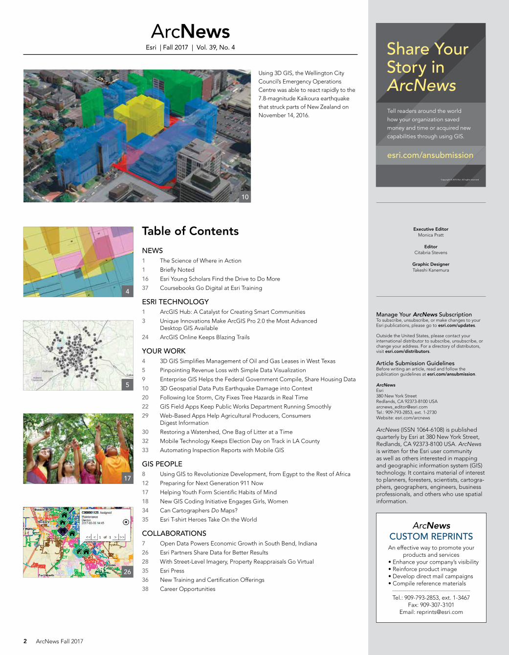
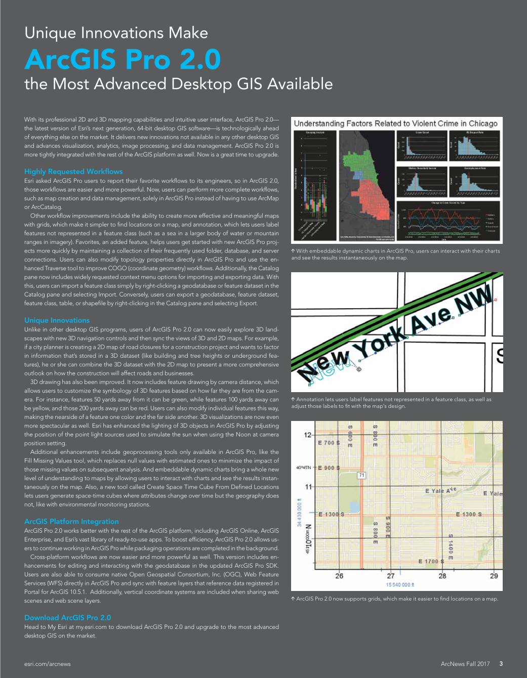
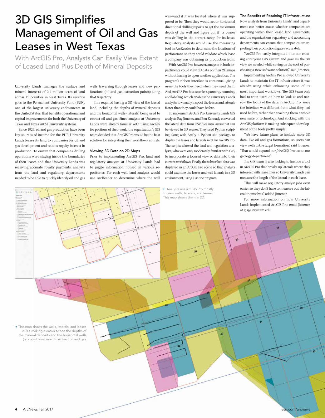
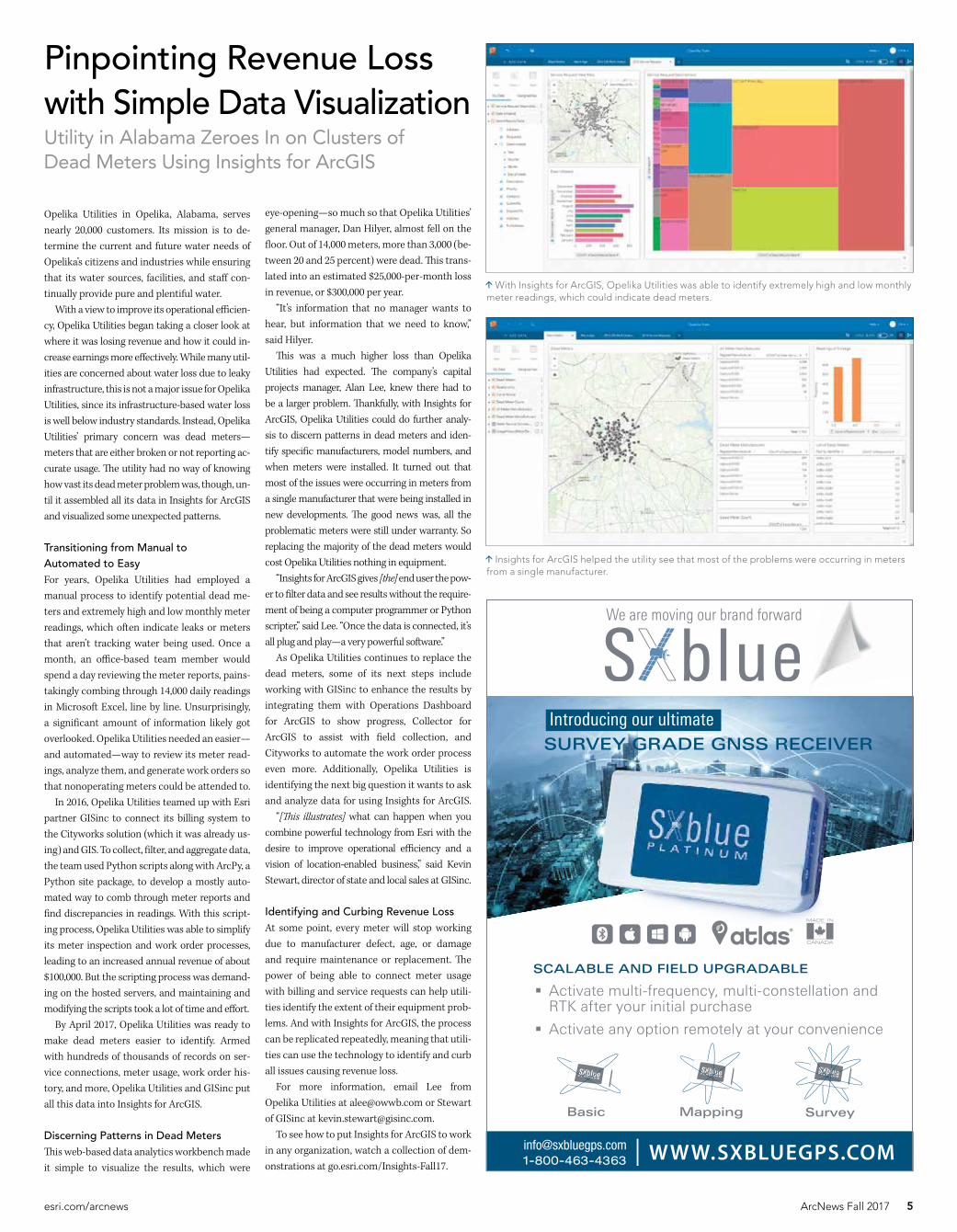
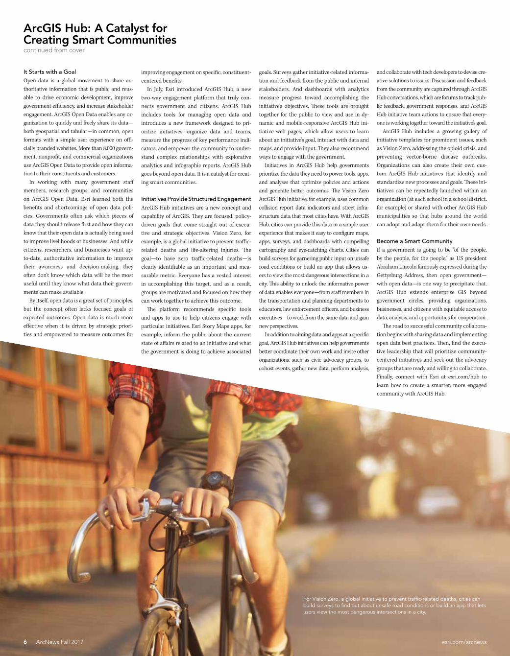
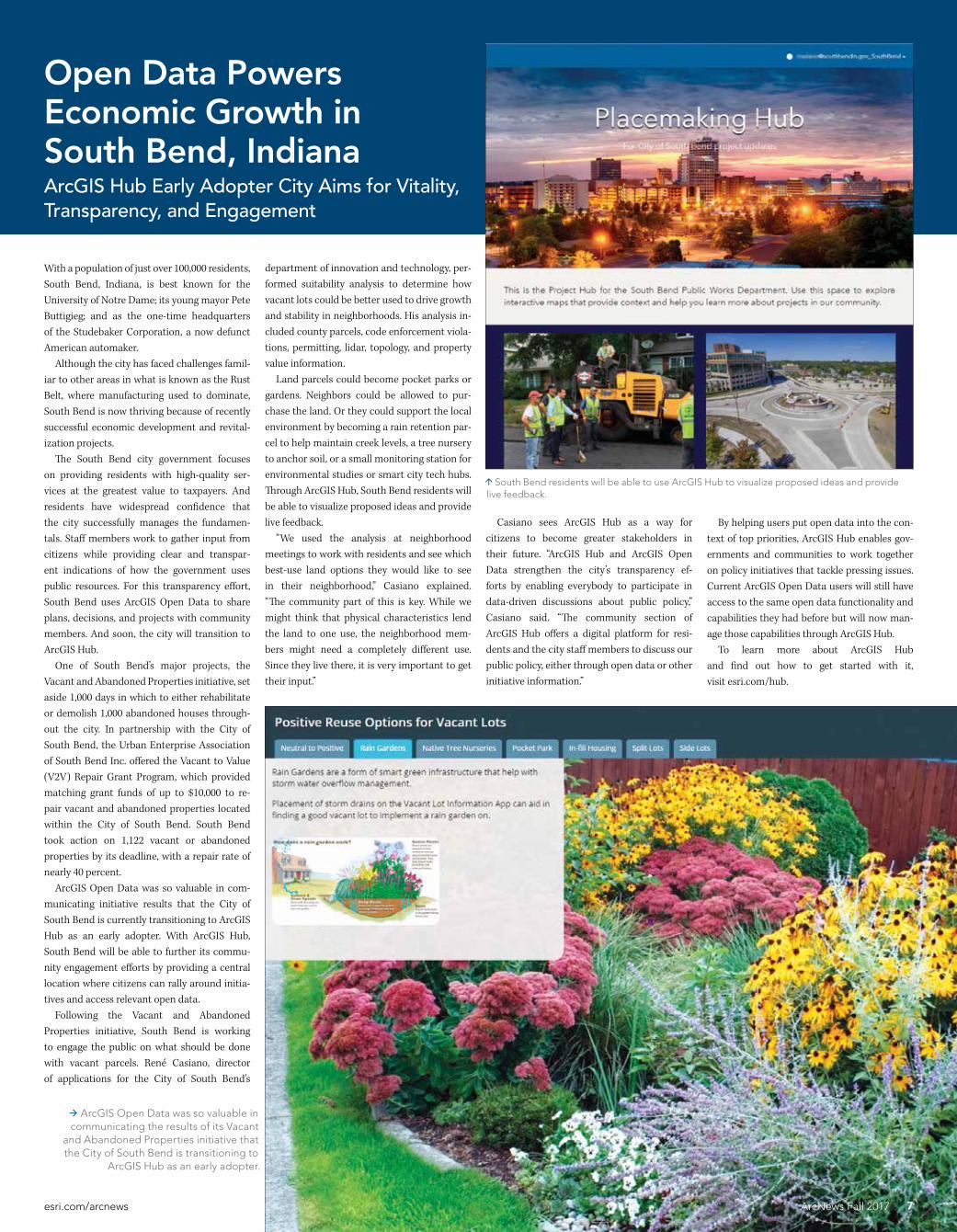
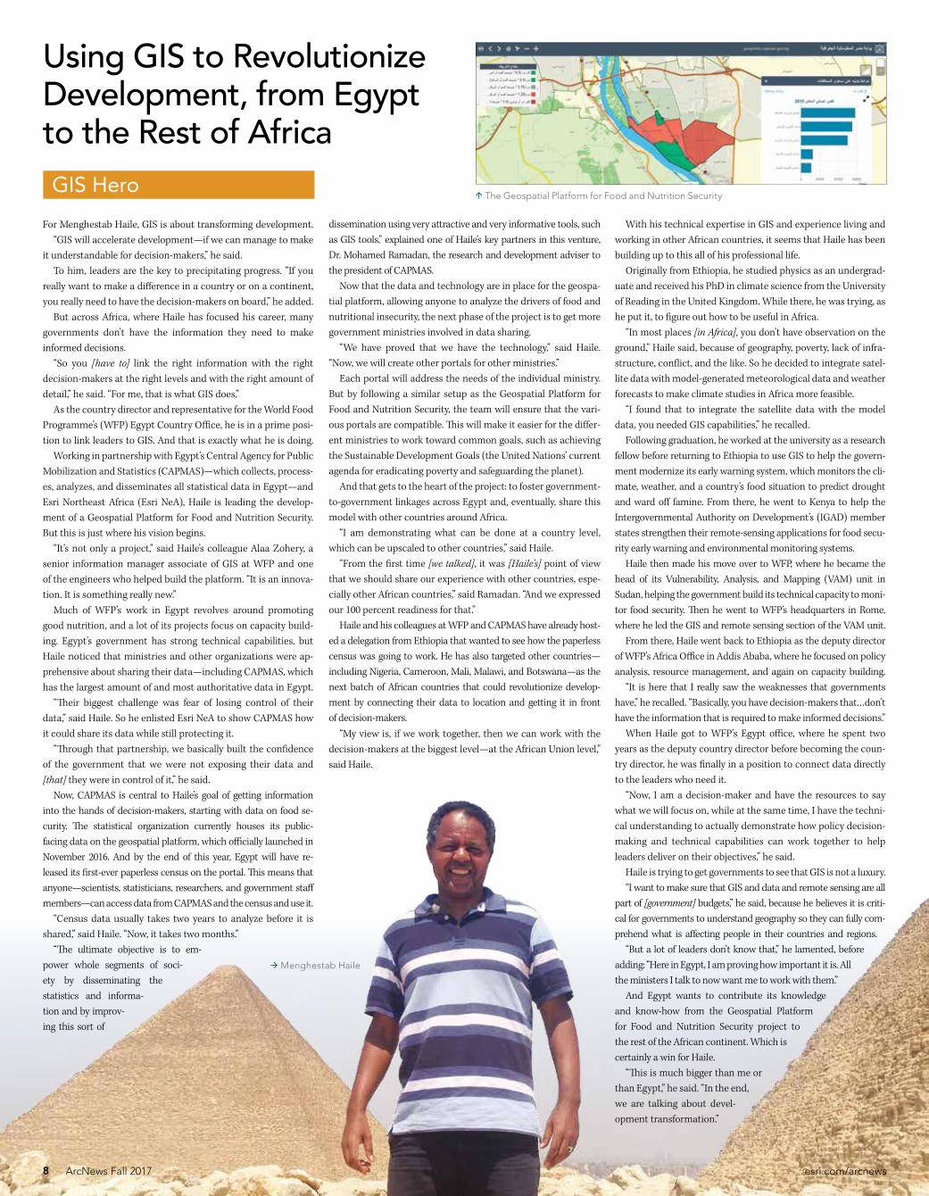
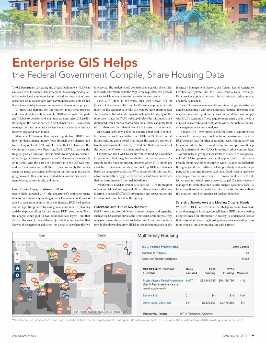
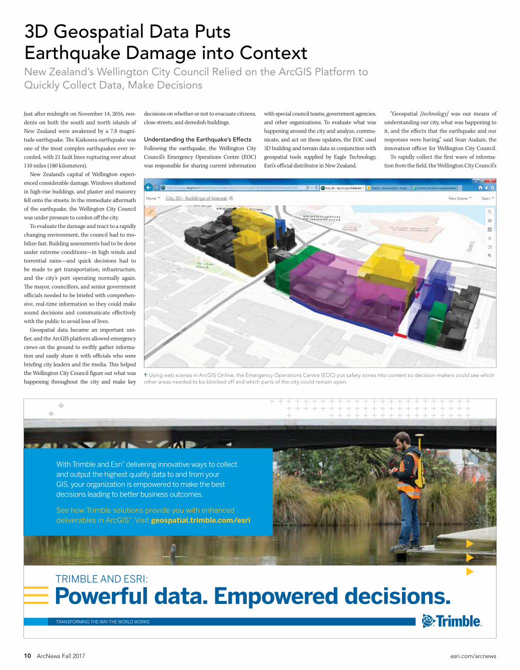
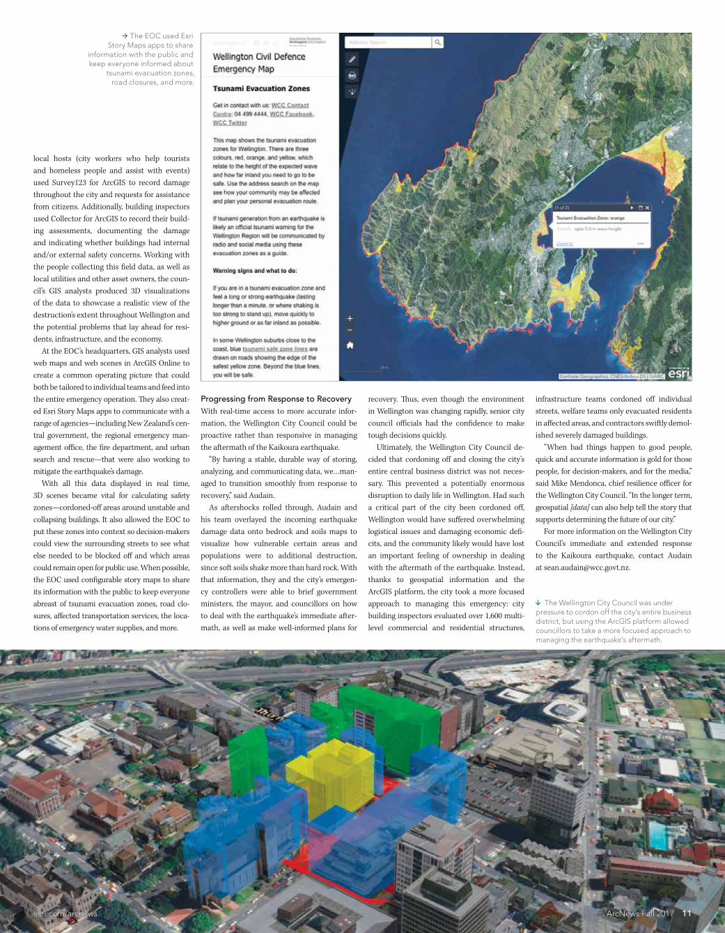
11esricomarcnews ArcNews Fall 2017
local hosts (city workers who help tourists and homeless people and assist with events) used Survey123 for ArcGIS to record damage throughout the city and requests for assistance from citizens Additionally building inspectors used Collector for ArcGIS to record their build-ing assessments documenting the damage and indicating whether buildings had internalandor external safety concerns Working with the people collecting this field data as well as local utilities and other asset owners the coun-cilrsquos GIS analysts produced 3D visualizations of the data to showcase a realistic view of the destructionrsquos extent throughout Wellington and the potential problems that lay ahead for resi-dents infrastructure and the economy At the EOCrsquos headquarters GIS analysts used web maps and web scenes in ArcGIS Online to create a common operating picture that could both be tailored to individual teams and feed into the entire emergency operation They also creat-ed Esri Story Maps apps to communicate with a range of agenciesmdashincluding New Zealandrsquos cen-tral government the regional emergency man-agement office the fire department and urban search and rescuemdashthat were also working to mitigate the earthquakersquos damage With all this data displayed in real time 3D scenes became vital for calculating safety zonesmdashcordoned-off areas around unstable and collapsing buildings It also allowed the EOC to put these zones into context so decision-makers could view the surrounding streets to see what else needed to be blocked off and which areas could remain open for public use When possible the EOC used configurable story maps to share its information with the public to keep everyone abreast of tsunami evacuation zones road clo-sures affected transportation services the loca-tions of emergency water supplies and more
Progressing from Response to RecoveryWith real-time access to more accurate infor-mation the Wellington City Council could be proactive rather than responsive in managing the aftermath of the Kaikoura earthquake ldquoBy having a stable durable way of storing analyzing and communicating data wehellipman-aged to transition smoothly from response to recoveryrdquo said Audain As aftershocks rolled through Audain and his team overlayed the incoming earthquake damage data onto bedrock and soils maps to visualize how vulnerable certain areas and populations were to additional destruction since soft soils shake more than hard rock With that information they and the cityrsquos emergen-cy controllers were able to brief government ministers the mayor and councillors on how to deal with the earthquakersquos immediate after-math as well as make well-informed plans for
recovery Thus even though the environment in Wellington was changing rapidly senior city council officials had the confidence to make tough decisions quickly Ultimately the Wellington City Council de-cided that cordoning off and closing the cityrsquos entire central business district was not neces-sary This prevented a potentially enormous disruption to daily life in Wellington Had such a critical part of the city been cordoned off Wellington would have suffered overwhelming logistical issues and damaging economic defi-cits and the community likely would have lost an important feeling of ownership in dealing with the aftermath of the earthquake Instead thanks to geospatial information and the ArcGIS platform the city took a more focused approach to managing this emergency city building inspectors evaluated over 1600 multi-level commercial and residential structures
infrastructure teams cordoned off individual streets welfare teams only evacuated residents in affected areas and contractors swiftly demol-ished severely damaged buildings ldquoWhen bad things happen to good people quick and accurate information is gold for those people for decision-makers and for the mediardquo said Mike Mendonca chief resilience officer for the Wellington City Council ldquoIn the longer term geospatial [data] can also help tell the story that supports determining the future of our cityrdquo For more information on the Wellington City Councilrsquos immediate and extended response to the Kaikoura earthquake contact Audainat seanaudainwccgovtnz
The Wellington City Council was under pressure to cordon off the cityrsquos entire business district but using the ArcGIS platform allowed councillors to take a more focused approach to managing the earthquakersquos aftermath
The EOC used Esri Story Maps apps to share
information with the public and keep everyone informed about
tsunami evacuation zones road closures and more
11esricomarcnews ArcNews Fall 2017
About the Authors
Jeff Ledbetter GISP PMP is a senior project manager for Esri partner Michael Baker International where he leads public safety and NG911 GIS projects Ledbetter has been working in GIS since 1998 and began applying the technology to public safety in 2009He is a member of the URISA NG911 Task Force which supports GIS professionals in developing NG911 systems For more information emailhim at jeffledbettermbakerintlcom
Kathrine Cargo GISP is the GISmapping coordinator for the Orleans Parish Communication District in New Orleans Louisiana She is the chair of the URISA NG911 Task Force and is a member of the National Emergency Number Associationrsquos (NENA) GIS Data Stewardship Work Group For more information contact Cargoat kcargo911nolaorg
Harness the processing power of the cloud to quickly get from data to decisions ENVIreg products work seamlessly with the ArcGISreg Platform When everyone from your organization can access and share geospatial analytics and products they make quicker more informed decisions regardless of geographic location
TRANSITION YOUR IMAGE ANALYTICS TO THE CLOUD
copy2017 Exelis Visual Information Solutions Inc a subsidiary of Harris Corporation All rights reserved All other marks are the property of their respective owners
harrisgeospatialcomcloudanalytics
12 ArcNews Fall 2017 esricomarcnews
Sometimes when change comes it is difficult and confusing In 2011 an extension was added to US Highway 90 Alternate on the east side of Houston Texas A few days after it opened an 83-year-old grandmother accidentally entered the extension going eastbound on the west-bound side of the highway with cars coming straight at her at 65 miles per hour A Good Samaritan on the eastbound side of the highway saw what was happening and called 911 from his cell phone He assumed that emergency responders would be able to see his location instantly But the 911 dispatcher couldnrsquot find him because the map she was us-ing didnrsquot have the new highway extension on it The incident ended in a fiery head-on collision that caused the grandmother to lose her life First responders eventually located the site of the crash by overriding the system The reason the 911 dispatcher was unable to pinpoint the caller was because the new high-way extension hadnrsquot been added to the GIS data being used nor had its existence been communicated with the Houston Emergency Center or the Greater Harris County 911 Emergency Network As a result the computer-aided dispatch (CAD) software for the 911 cen-ter had no indication that a highway extension was even there Next Generation 911 (NG911) aims to up-grade emergency response systems so they can keep up with ever-evolving mobile commu-nication and technology For NG911 to work features such as street centerlines and address points must be maintained at a higher level of precision than ever before This should both ex-cite and terrify GIS professionals who work in local and regional government On one hand it cements how mission critical a GIS database really is On the other hand amplifying existing data to this level and maintaining its accuracy is a huge undertaking Currently NG911 standards are still being fi-nalized While that is taking place it is impera-tive that GIS professionals in local and regional
government explore what their role will be in this transition to NG911 and embark on creat-ing a street centerline and addressing database that can service every internal and external partner in an enterprise GIS
Finally Embracing GIS in 911The technology used to accurately locate 911 callers has not kept pace with advances in the digital technology that delivers calls for ser-vice such as smartphones tablets home se-curity systems and health-related wearables Although the current Enhanced 911 (E911) system has evolved since it was established more than 40 years ago it was designed at a time when the only 911 calls received were from phones in static locations transmitting via twisted-pair copper wire E911 was the in-dustryrsquos answer to locating analog calls from wireless phones using GPS and cell tower trian-gulation It could figure out where a caller was because the phones or the cell towerrsquos connec-tion to the wired phone network never moved With the advent of smartphones and their accompanying apps people now expect that the 911 system will instantaneously know their location and be accessible in ways that go be-yond voice communication (via text message for example) But this is not the case Today if someone calls 911 from anything but a landline it can take a dispatcher 45ndash90 sec-onds to locate the caller within approximately 150 feet In a worst-case scenario the dispatcher can find the location of the wireless tower that is transmitting the callmdashthough this is not always the tower closest to the caller Whatrsquos more the Federal Communications Commission (FCC) only requires that 40 percent of all wireless911 calls be accompanied by a dispatchable loca-tion (a verified street address that includes unit information when necessary) with about 150-footaccuracy The FCC seeks to increase this to80 percent of wireless calls by 2021 With NG911 however 911 communication will transmit across Internet Protocol (IP)-based networks This will enable all IP-based
devicesmdashthose smartphones security systems and wearable medical devicesmdashto initiate a call to 911 Call centers will also be able to receive additional information from callers such as photos and videos to augment emergency re-sponse And devices will be able to send their own coordinates to NG911 during an emergen-cy call This is where the world of spatial pos-sibilities really opens up NG911 fully embraces GIS technology bring-ing it into the center of the 911 system In any 911 call there are two GIS-based core services at play the emergency call routing function which dictates where to send the call for ser-vice and the location validation function which determines whether an address is valid for routing and dispatch For these NG911 core services to function properly an authoritative GIS-based collection of featuresmdashsuch as street centerlines address points call center jurisdic-tion boundaries and the operating areas for emergency service providers (eg police fire and paramedics)mdashmust exist And these fea-tures have to be meticulously maintained so they remain accurate and up-to-date A collection of features this detailed and timely will be the gold standard of location data Not only will it benefit NG911 and other public safety systems but it will also strengthen ev-ery enterprise system that deals with location And what local or regional government enter-prise doesnrsquot deal with location Almost everydepartmentmdashfrom the planning and public health divisions to the revenue and county asses-sorrsquos officesmdashtracks location data on paper forms or in spreadsheets flat databases and GIS data-bases Now GIS professionals have the opportu-nity to build a street centerline and addressing database that can serve all their colleagues in lo-cal and regional government and beyond
Get Started with Data SharingMaking this transition begins with bringing the data out of hiding Many government enter-prises operate independently of one another quashing interdepartmental communication and data sharing But for NG911 to work GIS professionals need to build crosswalks that connect data silos to one another The GIS au-thority addressing authority and 911 author-ity all need to have access to each otherrsquos data Unsurprisingly this will have many intangible benefits for the entire enterprise such as in-creased cooperation and efficiency To start the data sharing process GIS pro-fessionals should first visit their governmentrsquos public safety 911 communications andor
addressing departments People in these of-fices will be familiar with NG911 concepts but they may not fully appreciate what it means to have an authoritative GIS-based collection of geographic data Itrsquos even more likely that they wonrsquot understand how much effort it will take to develop and maintain these precise records Given that each emergency call center is li-able for coordinating the creation and mainte-nance of its authoritative data it is up to the GIS professional to provide GIS subject matter expertise while letting the public safety 911 and addressing authorities know exactly what is needed to acquire and preserve such accurate GIS data
Obtaining Better Access to Lifesaving ServicesNG911 may not have been able to prevent a trag-edy like the one in Houston but it is a system de-signed to get the public better access to lifesaving services through as many channels as possible And for GIS professionals it is an opportunity to increase the meaningful contributions they make to their communities through GIS Head to ng911noworg to read about the NG911 NOW Coalitionrsquos goal to have sustain-able and standardized IP-based 911 capabili-ties in every 911 system and call center in the United States by 2020 Learn more about NG911 standards and first steps toward upgradingat nenaorgpage=GIS_NG911_PSAP
Preparing for Next Generation 911 NowBy Jeff Ledbetter Michael Baker International and Kathrine Cargo Orleans Parish Communication District
Managing GISA column from members of the Urban andRegional Information Systems Association
Fostering Excellence in GISwwwURISAorg
Next Generation 911 upgrades emergency response systems so they can keep up with technology
Harness the processing power of the cloud to quickly get from data to decisions ENVIreg products work seamlessly with the ArcGISreg Platform When everyone from your organization can access and share geospatial analytics and products they make quicker more informed decisions regardless of geographic location
TRANSITION YOUR IMAGE ANALYTICS TO THE CLOUD
copy2017 Exelis Visual Information Solutions Inc a subsidiary of Harris Corporation All rights reserved All other marks are the property of their respective owners
harrisgeospatialcomcloudanalytics
(Photo courtesy of Taylor Shellfish Farms)
The Science of Where in Actioncontinued from cover
Dangermond underscored the importance of people to The Science of Where all working together to use GIS to confront problems such as pollution loss of nature climate change food shortages social conflict and natural disasters Keynote speaker Dr Geoffrey West a renowned theoretical physicist encouraged the audience to think about how we sustainably organize so-ciety given that clusters of peoplemdashcitiesmdashput intense pressure on the worldrsquos resources while they also facilitate innovation ldquoWe are going to have to do everything we possibly can to better understand andhellipcol-laborate to address [these issues]rdquo Dangermond saidmdashjust like the city of Dubai is with its Smart Dubai program As HE Dr Aisha Bint Butti Bin Bishr director general of the Smart Dubai Office and her colleagues demonstrated GISmdashand the cooperation that it cultivatesmdashis a key element of making the emirate safer more seamless and ultimately the happiest city on earth The challenges may be great but Dangermond is an optimist ldquoCan we make a difference with our work and turn [things] aroundrdquo he asked ldquoMy view is Yes we canrdquo
The Science of Where to Sustainably Farm ShellfishLocation has always been critical to Taylor Shellfish Farms which grows shellfish sustainably on 12000 acres of leased or owned tide land and owns and operates three oyster bars in Seattle Yet this fifth-generation family-owned business has only been employing Esri technology for one year The Taylor family and employees now use GIS to map their 30 farming sites analyze farming condi-tions identify the best growing areas for different shellfish species and conduct surveys to meetenvironmental requirements ldquoWhen I started at Taylor we were using hand-drawn maps and I knew there had to be a better wayrdquo said Erin Ewald assistant director of regulatory and environmental compliance for the business ldquoSo [we] are modernizing our company through GISrdquo Taylor Shellfish Farms didnrsquot start small Since September 2016 the company has adopt-ed ArcGIS Online ArcGIS Pro Esri Story Maps Drone2Map for ArcGIS and multiple mobile apps including Explorer for ArcGIS Survey123 for ArcGIS Collector for ArcGIS and Workforce for ArcGIS ldquoOur company is growing in both size and geo-graphic reach and these mobile apps are leading the way in our digital transformationrdquo said Ewald ldquoWersquore now able to take our real-time business operations and environmental data onto the farms with usrdquo
ldquoIn Samish Bay the tide can recede over a mile to expose large sandy tidal flats rich with nutrients We grow oysters clams and geo-duck hererdquo said Nyle Taylor the farmrsquos project coordinator who stressed that the word geo-duck is actually pronounced ldquogooey duckrdquo In this bay and others farm managers can view a map of farming areas on their smartphones and add information to itmdashusing a sketching tool for example to suggest areas where the farmmight expand ldquoThis ability to take a wealth of GIS data into the fieldhelliphelps us understand the environment wersquore working inrdquo Ewald said ldquoAs we combine this new understanding with generations of experience in a suitability analysis we use this data to identify optimal growing areas for our different shellfish speciesrdquo With Survey123 Ewald can quickly config-ure digital surveys that workers use to collect environmental and other data for regulatory agencies And Taylor Shellfish Farms now also maps out where to plant shellfish using drone-captured imagery processed with Drone2Map ldquoLaying out farm beds prior to using Drone2Map was a boots-on-the ground ap-proachrdquo Taylor said ldquoDrone imagery revolu-tionizes how we do it Using a digital terrain model itrsquos easy to see the natural drainages in the beach We can build our beds around these to avoid our seed being washed awayrdquo
The Science of Wheremdashand Howmdash to Save LivesAt Shock Trauma Air Rescue Service planning for dynamic situations is how the Canadian nonprofit provides emergency medical care and transport to seriously ill and injured people With The Science of Where STARS can better manage its response to these emergencies Operating mainly in remote areas of Alberta British Columbia Saskatchewan and Manitoba STARS helicopters are dispatched to medical emergencies such as heart attacks strokes and traffic recreational or industrial accidents Much of the critical work goes on at the organizationrsquos Emergency Link Center (ELC) a 24-hour medi-cal communications and dispatch center Thatrsquos where Kevin Hatch and Paul Wiles work building technology that speeds up response times For example STARS is using GIS to automate the standard operating procedures (SOPs) it fol-lows to determine whether a helicopter needs to be sent to an incident ldquoWe use a dynamic set of SOPs to tell our dispatchers precisely what they need to know so they can make that deci-sionrdquo Hatch a telecommunication specialist for STARS told the audience The ELC uses ArcGIS GeoEvent Server to provide dynamic SOPs as each incident unfolds from what procedures to follow before deciding to send a helicopter to what to do as the mission evolves A model created with ArcGIS GeoEvent
Although Taylor Shellfish Farms has only been using Esri technology for a year it has implemented a suite of software and apps to lead its digital transformation
Kevin Hatch of Canadas Shock Trauma Air Rescue Service (STARS) helped build GIS technology that speeds up response times
(Photo courtesy of Taylor Shellfish Farms)
14 ArcNews Fall 2017 esricomarcnews
ArcGIS GeoEvent Server alerts STARS dispatchers if they miss an action such as securing a landing zone
15esricomarcnews ArcNews Fall 2017
Manager generates the dynamic SOPs ldquoIt tells us what we need to know and when we need to know itrdquo said Wiles a GIS and telephony tech-nologist for STARS ldquoThis improves efficiency reduces human error and helps us ensure the best life-saving decisions are maderdquo To illustrate how dynamic SOPs can help once a mission is under way Hatch showed the audience a one-car rollover in Banff National Park STARS decided to send a helicopter to the scene where two people were trapped in a ve-hicle and a third person had been ejected ldquoNow [that] wersquove assigned a resource GeoEvent has created a new feature which uses the AVL [automatic vehicle location] of the heli-copterrdquo Hatch said ldquoUsing factors such as the status of the aircraft and the base [ from which] it was dispatched the SOPs are instructing the dispatcher to perform actions such as giving updates to our pilots and air medical crewsrdquo GeoEvent Server will even alert a dispatcher if an action such as securing a landing zone is missed ldquoWhen we talk about dynamic SOPs map-ping spatial analysis innovation and en-gagement what we are really talking about is improving the tools our team uses to help us make more success storiesrdquo Hatch said ldquoAt the end of the day itrsquos about the patientrdquo
The Science of Where Pollution Gets Cleaned UpAt the Chesapeake Conservancy itrsquos all about the baymdashthe Chesapeake Bay The largest es-tuary in the United States and the third larg-est in the world the Chesapeake Bay stretches200 miles along the mid-Atlantic coast The watershed that feeds it occupies more than64000 square miles in six states and is home to more than 18 million people For a century the health of the Chesapeake Bay was beset by pollution population growth and changes in land use Over the last four de-cades focused efforts have brought the bay back from the brink of destruction
ldquoBut we still have a long way to gordquo said Jeff Allenby director of conservation technology for the Chesapeake Conservancy Given that so many cities counties and states have a stake in restoring the Chesapeake Bay the conservancy has embraced technology to priori-tize restoration projects While datasets like the National Land Cover Database have informed regional cleanup efforts smaller entities were us-ing different sets of data This made it difficult to implement targeted conservation projects For 18 months the conservancy worked for the Chesapeake Bay Program and with part-ners such as the University of Vermont Spatial Analysis Laboratory and WorldView Solutions Inc to create an ultra-high-resolution land-cover dataset for the entire watershed It was released in December 2016 Almost immediately the conservancyrsquos partners began asking when it was going to
update the data But this was costly and time-consuming So using ArcGIS Pro the ChesapeakeConservancy employed imagery from the National Agriculture Imagery Program (NAIP) to create a new false-color image of the region and segment it streamlining the entire land classifi-cation workflow into one processing model ldquoArcGIS Pro is reducing the amount of time that it takes us to go from raw imagery to land coverrdquo Allenby told the audience To classify more than two terabytes of the most recent NAIP imagery it would take the conservancy just over 150 hours instead of more than 2500 hours Additionally the conservancy can classify land cover in just one area or using ArcGIS Image Server in Microsoft Azure create land-cover classifications for all 206 counties in the watershed This enables the conservancy and its partners to better understand how develop-ment in one place might affect the entire bay ldquoOnce we know our priorities we can create customized action maps for our local partnersrdquo said Cassandra Pallai the conservancyrsquos geospa-tial program manager ldquoTogether Image Server
and the processing capacity of the cloud are enabling us to spend less time making the data that we need to meet our goals and more time on conservationrdquo (Read the full ArcNews article about this project at httppctxlyr508g)
Extending The Science of WhereOakland County Michigan is working with its own municipalities by expanding GIS use be-yond the knowledgeable few The county can build a map or app once pay for it once and allow everyone to benefit ldquoThrough Web GIS wersquove grown our distrib-uted GIS model by combining the value of our many collaborative systems of record [into] a powerful system of systems which allows ushellipto branch out to all our municipalities businesses and citizensrdquo said Phil Bertolini Oakland Countyrsquos deputy county executive and chief information officer He showed the audience the Access Oakland Open Data Portal which uses maps to promote economic programs and attract new business-es The Medical Main Street map for example underscores Oakland Countyrsquos thriving health care industry and Global Oakland markets southeastern Michigan as an advantageous destination for businesses from around the world to open new locations ldquoTo date we have more than 400 new busi-nesses located in Oakland County with an eco-nomic investment of $39 billionrdquo said Bertolini The success of these open data initiatives spurred Bertolini to challenge his team to build up a new generation of GIS users in Oakland County ldquoWhat was our approachrdquo asked Tammi Shepherd Oakland Countyrsquos chief of applica-tion services ldquoGrow our tree by finding and inspiring just one user who would then add hundreds morerdquo ldquoWe found that some branches grow through our cultivation whereas others sprout almost entirely on their ownrdquo said Oakland County IT business analyst Mike Dagle who along with
Shepherd took the audience on a tour of how Oakland County transformed its GIS The team helped social media managers in-corporate colorful maps into their Facebook Twitter and blog posts It created a suite of apps to simplify how the tax administration depart-ment stakes notices on the properties of citizens who have not paid their taxes Shepherd and Dagle and their colleagues helped the equaliza-tion division create an internal app that displays all the details about county properties including parcel acreage wetlands and historical imag-ery The team then added this app to its suite of standard product offerings making it available for any municipality in the county to use and customize GIS is now central to how Oakland Countyrsquos water resources commissionerrsquos office manages its assets with the ArcGIS GeoAnalytics Server helping it prioritize and allocate scarce in-frastructure resources And finally GIS maps and apps assist the countyrsquos public health office in ad-ministering and offering resources for residents affected by the opioid crisis ldquoTwo years after challenging my teamrdquo said Bertolini ldquowe have hundreds more users in a distributed GIS model across our county departments and municipalitiesrdquo (Read the ArcNews article about open data at Oakland County at httppctxlyr508h and see the ArcNews article about how one of its munici-palities used GIS to manage a community event at httppctxlyr508i)
Holistic Thinking Made EasierHundreds of thousands of other organizations around the world employ GIS and The Science of Wheremdashincluding the United Parcel Service to optimize delivery routes and the emirate of Abu Dhabi to enhance government operations The kind of holistic thinking they do is the only way to confront this planetrsquos great challenges and turn things around And that is precisely the kind of thinking that GIS and The Science of Where make easier
Jeff Allenby and Cassandra Pallai demonstrated the Chesapeake Conservancys high-resolution land-cover dataset for the Chesapeake Bay watershed
HE Dr Aisha Bint Butti Bin Bishr director general of the Smart Dubai Office
showed the audience how GIS is making Dubai the happiest city on earth
The Global Oakland web app markets Michigan as a great place for businesses from around the world to open new locations
16 ArcNews Fall 2017 esricomarcnews
Esri has a vested interest in developing the next leaders in GIS That is why every year it hosts a group of students from around the world at the Esri User Conference who have produced exemplary work in GIS This yearrsquos group of Esri Young Scholars hailed from 21 countries Some are well-versed in using GIS and others only re-cently encountered the technology Some are still undergraduates while others have graduated with their masterrsquos degrees and still others are pursuing PhDs All those who were able to make it were ex-cited to attend the 2017 Esri User Conference in San Diego California and thrilled to pres-ent their work at the Map Gallery ldquoThe moment my project was displayed at the Map Gallery that was the greatest momentrdquo said Serin Son a GIS masterrsquos student at Ewha Womans University in Seoul South Korea who used GIS to ana-lyze the characteristics of traffic accidents involving females around Seoul to see how to improve driver safety The young scholars relished meeting their peers and networking with so many GIS professionals who have done tremen-dous work in their fields ldquoI felt grateful to meet and make friends with my fellow Young Scholars from across the world all connected by the same pas-sionrdquo said Simon Haumann a recent grad-uate of the University of Viennarsquos masterrsquos degree program in cartography and geo-information whose project on optimizing the operational range of electronic bikes in routing systems won him this yearrsquos prize from Esri Switzerland
Many of the students were also inspired by the advanced technology they witnessed in demonstrationsmdashsome of which they were even able to try out on the expo floor ldquoI didnrsquot know what ArcGIS Pro was but I learned hererdquo said Balca Agacsapan an environmental engineer pursuing her PhD at Anadolu University in Turkey The project she submitted to the competition used un-manned aerial vehicles (UAVs) and GIS to evaluate building rooftops at her university for their potential to conduct solar energy via photovoltaic panels ldquoIn my next project I want to use Drone2Map for ArcGISrdquo an app she saw demonstrated at the conference Alan Pearse an earth science and statistics major at Australiarsquos Queensland University of Technology is excited about ldquothe [ArcGIS] API for Pythonhellipthat works with ArcGIS Online and ArcGIS Enterpriserdquo he said ldquoJust the fact that you can use Jupyter Notebooks and process your Python code on the fly and generate maps and do all your analysis in situmdashI thought that was pretty awesomerdquo The project he submitted to the competition involved developing an ArcGIS toolbox that calculates spatially explicit watershed attri-butes to better analyze the effects that land use has on stream health To get to San Diego the students submit-ted their projects to the Esri Young Scholars competition through the Esri distributors in their countries ldquoEsri advertised at my university for stu-dents to present a project for the contestrdquo said Mauricio Grande from Joseacute Simeoacuten Cantildeas Central American University in El Salvador His project used Drone2Map for ArcGIS to quantify the impact that recent for-est fires had on mountainous areas around San Salvador ldquoYou have to work with one teacher from your university and you have to present a work that is developed with Esri software So you present your project a poster and a technical paper [to GEOSIS Esrirsquos official distributor in El Salvador] and then you are in the contestrdquo For Amelie Zehndbauer who recently graduated with her bachelorrsquos degree in geoinformatics and satellite positioning from the Munich University of Applied Sciences in Germany the process was a little different ldquoI applied with my bachelorrsquos thesisrdquo which assessed the quality and user-friendlinessof photogrammetric software including Drone2Map for ArcGIS she said ldquoAn em-ployee of Esri Germany helped me with my bachelorrsquos thesis and gave me the hint to ap-ply for the Esri Young Scholars competitionrdquo Emily Acheson who is currently get-ting her PhD from the University of British Columbia in Canada applied with her mas-terrsquos thesis which she put together at the University of Ottawa Studying the mosqui-toes that carry malarial parasites in Tanzania she mapped where the mosquitoes were lo-cated as well as where mosquito nets were being used and compared them to see if mosquito net distribution was matching the distribution of mosquitoes It was not
ldquoWe looked at indoor residual spraying toordquo she said ldquoWe wanted to compare spray-ing to the nets and we found that spraying does a good job at targeting mosquitoesrdquo For someone who said she initially had no background in GIS she has certainly centered her research on the technology ldquoI took one course during undergrad that used ArcGIS and I fell in love with the tech-nologyrdquo she said ldquoI wanted to find a way to use it in my PhD I thought it would be a great tool to study disease distributionrdquo And she is doing just that Studying a killer fungus in British Columbia called Cryptococcus gattii she is now using GIS to figure out why it is in Canada at all since it is usually found in tropical places Being a GIS novice yet becoming cap-tivated by the technology is not unusual among this group ldquoI had no clue what GIS was beforerdquo said Nael Al Hassanieh who used GIS for the first time in his final project for his masterrsquos degree which he recently received in aero-nautical engineering from the University of Balamand in Lebanon For it he and his colleague Michelle Nassar used 3D GIS for Beirut Rafic Hariri International Airport to create Obstacle Limitation Surfaces (OLS) which indicate the volume of airspace around an airport that needs to be free from obstacles such as buildings trees and hills ldquoThe location of Beirut Airport is kind of sensitive because there are hills [and build-ings] around ithellipand the sea from the west siderdquo said Al Hassanieh ldquoIt was kind of a special project because itrsquos the first time this analysis has been done in Lebanon using GIS with high-accuracy mapsrdquo which is ul-timately why he decided to submit it to the Esri Young Scholars competition There are plenty of young scholars who got bitten by the GIS bug early though Sander Varbla from Estoniarsquos Tallinn University of Technology started using GIS in high school ldquoI was in eleventh grade the first time I re-alized that something like GIS existsrdquo said Varbla who is more than halfway through his studies for a joint bachelorrsquos and mas-terrsquos degree in civil engineering with a spe-cialization in geodesy ldquoWe had to do this
research project with GIS and my interest in it grew and grewrdquo The project he submitted for the Esri Young Scholars competition revolved around improving the accuracy of global navigation satellite system (GNSS)-based bathymetric measurements in the Baltic Sea And Patricia Polo an environmental engi-neering undergraduate student at the Latin University of Panama encountered GIS ear-ly in her university studies ldquoIn the university we do GIS remote sensing spatial analysismdashall those sub-jectsrdquo said Polo whose project analyzed noise pollution in different areas of Panama City She was so inspired by the people she met at the Esri User Conference that she plans to continue using GIS and is even considering getting a masterrsquos degree in it Above all the Esri Young Scholars were proud to present their work and energizedby who they encountered and what they saw ldquoThis was just an amazing opportunity for me to showcase my research and see how itrsquos actually solving problemsrdquo said Keneilwe Hlahane a GIS and remote sensing masterrsquos student in the oceanography department at the University of Cape Town in South Africa For her project she used GIS to monitor eutrophication (when rich nutrients such as nitrogen and phosphorus exist in excess in a body of water and alter the ecosystem) which is causing water quality in dams and rivers throughout South Africa to deteriorate ldquoThis goes back to the theme of this yearrsquos conference Applying The Science of Where which is what Irsquom doing Irsquom applying the sci-ence of GIS within water quality resourcesrdquo Hlahane like so many Esri Young Scholars left the conference with the drive to do even more ldquoIrsquove definitely learned a lot of thingsrdquo she said ldquoIrsquom going to try to apply some of the methods that Irsquove seen here to my research to improve itrdquo For more information about the Esri Young Scholars program email Michael Gould Esrirsquos global education managerat mgouldesricom
Editorrsquos note Some quotations in this article have been lightly edited for clarity
YoungScholarsFind the Driveto Do More
All the Esri Young Scholars who made the trip to San Diego got a chance to meet Esri president Jack Dangermond
Esri
About the Author
Dixon Butler an atmospheric physicist is the president of YLACES and an independent consultant focusing on science environmental energy and space policy STEM education and congressional appropriations Previously he was the director of the Modeling Data and Information Systems division for NASArsquos Mission to Planet Earth and the director of the GLOBE Program (globegov) He also spent time as a clerk for the US House of Representatives Committee on Appropriations where he concentrated on energy and water
For more information about YLACES (ylacesorg) and how to get involved with youth science education email Butler at dixonylacesorg
YLACES presented the Youth Environmental Science (YES) Medal to Esri in 2016 for its sustained contributions to student environmental research and learning The award includes a $10000 grant to an organization engaging youth as active citizen environmental scientists and Esri chose the Jane Goodall Institutersquos Roots amp Shoots program
About the Author
Dixon Butler an atmospheric physicist is the president of YLACES and an independent consultant focusing on science environmental energy and space policy STEM education and congressional appropriations Previously he was the director of the Modeling Data and Information Systems division for the National Aeronautics and Space Administrationrsquos (NASA) Mission to Planet Earth and the director of the GLOBE Program (globegov) He also spent time as a clerk for the US House of Representatives Committee on Appropriations where he concentrated on energy and water
For more information about YLACES (ylacesorg) and how to get involved with youth science education email Butlerat dixonylacesorg
Helping Youth Form Scientific Habits of MindBy Engaging with The Science of Where Future Decision-Makers Strengthen Their Scientific AbilitiesBy Dixon Butler Youth Learning as Citizen Environmental Scientists
Citizens make better decisions when they can think scientifically Scientific habits of mind start with critical reasoning and include healthy skep-ticism the ability to distinguish answerable ques-tions from unanswerable ones being comfortable examining both quantitative and qualitative in-formation and the capacity to place things into larger contexts and perceive connections Just as the social sciences and humanities are for everyone so is science We can all think scientifically communicate and relate to one anothermdasheven if we arenrsquot Nobel Prize winners renowned authors or community leaders But we need to build these scientific thinking abili-ties when we are young Today that requires demystifying science and its processes Learning scientific concepts and reenacting experiments in a lab are important but theyrsquore not enough to awaken kidsrsquo scientific propen-sities Gathering environmental data and lo-cating it in space and timemdashusing GISmdashis the most accessible way for students to do science and therefore form scientific habits of mind From the age of eight children have the in-tellectual capacity to grasp research questions And a science lab can be anywheremdashright out-side even Having students do environmental citizen science which requires relatively little
( free or low-cost) equipment for close examina-tion and experimentation offers a way to make student research not only broadly doable but also useful to the wider scientific community since the data that can be easily collected and examined outdoors is greatly needed for under-standing the environment and addressing envi-ronmental concerns at different scales Youth Learning as Citizen Environmental Scientists (YLACES) is dedicated to helping kids learn scientific habits of mind by doing environmental research in both formal and in-formal settings Because such research projects necessitate data analysis using GIS enables them to conduct far broader and more sophisti-cated investigations There is increasing infrastructure to sup-port these kinds of student activities as wellmdashthrough the Global Learning and Observations to Benefit the Environment (GLOBE) Program for example which helps make it possible for students and citizens all over the world to engage in data collection and the scientific process And of course there is Esrirsquos Schools and Clubs Program which provides teachers and students with software donations and as-sistance so they can explore and analyze data using maps
YLACES has supported schools teachers and environmental organizations with instrumenta-tion and training And since it views scientific ability as universal rather than specialized the organization is also aiming to change the focus of most science fairs from identifying promising young scientists for special educational activities to providing meaningful feedback on studentsrsquo research so they can improve their scientific abilities and their projects can contribute to im-portant scientific examinations Strengthening the scientific abilities of our future decision-makers will require support from everyone including the GIS user com-munity Teachers and youth group leaders need help learning how to use GIS and young learn-ers need coaching in doing research Those who are savvy with GIS can advise people in using the technology by getting involved with organi-zations like SciStarter which works to connect citizens with citizen science projects They can also offer to help evaluate student research re-ports via GLOBE which operates both virtual and in-person student research symposia to showcase and assess studentsrsquo environmental research GIS practitioners can guide teachers in using GIS by becoming GeoMentors or advo-cate for efforts to build spatial understanding
17esricomarcnews ArcNews Fall 2017
more concretely into science education They can always make contributions to science edu-cation nonprofits as well including YLACES The GIS community with its deep apprecia-tion of the spatial nature of earth science re-search has much to offer this investment in our collective future
Collecting environmental data and locating it in space and time is the easiest way for kids to form scientific habits of mind
18 ArcNews Fall 2017 esricomarcnews
Crossing BordersA column by Doug RichardsonExecutive Director American Association of Geographers
New GIS Coding Initiative Engages Girls WomenWomen have come a long way in GIS since Mei-Po Kwan a professor of geography and GIS at the University of Illinois at Urbana-Champaign wrote her groundbreaking 2002 ar-ticle ldquoIs GIS for Womenrdquo In it she cites female GIS practitionersrsquo personal experiences in the vocation quoting one who said that a GIS lab felt like ldquothe domain of the white middle- to upper-class graduate geography studentsrdquo In a more recent study about the profession from 2016 GIS analyst Livia Betancourt Mazur and Hunter College professor Jochen Albrecht sought to find out with new data if wom-en are underrepresented in GIS In surveying almost 500 women in GISmdashasking questions such as Have you ever been the only woman in the room (at meetings events etc)mdashtheresearchers found that while women are not grossly underrepresented in GIS they are likely underrepresented in certain sectors and positions especially ones that require managerial or highly technical skills This suggests that Kwanrsquos question still resonates today It is within this context that the American Association of Geographers (AAG) is launch-ing a new initiative called Coding for Girls in GIS and Geography AAG has developed GIS coding curriculum and is planning a series of workshops on coding for girls and women beginning at the AAG Annual Meeting in New Orleans Louisiana in April and continu-ing throughout 2018 across the United States AAG is also working with its many interna-tional programs to set up similar initiatives around the world with workshops and webinars already scheduled for Ukraine and throughout Africa including in Cameroon Ethiopia Nigeria and South Africa Many AAG members and staff have strong experience and expertise in computer pro-gramming They have taught introductory and advanced GIS courses at universities or par-ticipated in college and high school mentoring programs to support and empower young women who are interested in STEM (science technology engineering and math) fields In fact AAGrsquos new Coding for Girls in GIS and Geography initiative is being coordinated by AAG senior researcher Dr Coline Dony who has worked for and recently spent the summer
with Girls Who Code a nonprofit that teaches computer science and GIS concepts to high school students Donyrsquos personal experience has motivated her to take on this initiative ldquoI was often the only woman in GIS courses that involved any programming and I want to change thatrdquo she said ldquoEnrolling for these courses should feel like the right choice for women in geography This initiative is about boosting womenrsquos interest in programming by teaching them how to create web-based geovisualizations and how to automate analyses of new sources of spatial data such as those from social mediardquo AAG looks forward to engaging with the broader geography and GIS communitiesmdashincluding other GIS organizations and the extensive GeoMentor network operated by AAG and Esrimdashto broaden the reach of Coding for Girls in GIS and Geography and create similar programs for high school students across the United States and around the world At AAG we are convinced that a more diverse geography and GIScience community will enhance our discipline and amplify our ability to understand and improve our world To make this happen we need to change the culture of our schools and workplaces to tap the talents of girls and women at an early age and prepare them with the computing and spatial thinking skills required to conduct cutting-edge research and land good jobs Gaining early access to these skills can help girls and women overcome stereotypes and lead to exciting opportunities around the world It will also infuse GIS and GIScience with new ideas perspectives and talent which can only propel these fields forward For more information on Coding for Girls in GIS and Geography or to participate in these events email AAG research associate Jolene Keen at jkeenaagorg
Contact Doug Richardson at drichardsonaagorg
Dr Coline Dony (far left) led a Girls Who Code Summer Immersion Program in Washington DC which National Public Radios lead developer Joanne Garlow (right) joined as a guest (Photo courtesy of Coline Dony)
Learn skills in demography online an understanding of principles of demography and measurement of population dynamics
the ability to use geospatial data and methods in diverse applied settings
the application of demographic tools in marketing planning public policy and research
the integration of theory data and method in the project development in applied demographics
Consider a 12-credit Graduate Certificate or 30-credit Master of Professional Studies in Applied Demography Now accepting applications for 2018
worldcampuspsueduadesri18-WC-0292bjhsss
2018
GIScience amp Technology at the AAG Annual Meeting
April 10-14 2018 | New Orleans
The American Association of Geographers Annual Meeting is an interdisciplinary forum where thought leaders and experts in GIS and geography intersect to build new partnerships and collaborations
Meet local and international colleagues Network and exchange ideas Discover topical publications Interact with state-of-the-art technologies
Donrsquot miss the French Quarter Festival happening during the annual meeting mdash non-stop music on the streets of New Orleans
raquo JOIN US IN NEW ORLEANSannualmeetingaagorg
PHOTOS COURTESY NEW ORLEANS CONVENTION AND VISITORS BUREAU PHOTO OF BRIDGE BY RICHARD NOWITZ
Following Ice Storm City Fixes Tree Hazards in Real TimeWith Custom-Made Web App Eugene Oregon Briskly Coordinates Field ResourcesBy Brian Richardson City of Eugene
On the night of December 14 2016 as an ice storm tore through Eugene Oregon the cacophony of fracturing and crashing trees was the call to action for Eric Cariaga the parks and open space technical specialist for the public works department at the City of Eugene ldquoIt was apparent early on that this was a dynamic stormrdquo recalled Cariaga who has worked at the city for 20 years ldquoI could tell by the sheer number of failing trees that this was going to be a major tree eventrdquo Ultimately more than 3500 trees were damaged mak-ing it the most catastrophic ice storm Eugene had expe-rienced in almost 55 years Calls from the public about downed trees and other storm-related problems began flooding the public works departmentrsquos phone lines It was going to require a team of more than 100 staff members from the public works parks and maintenance depart-ments to work together to clean up the mess Wanting to maximize efficiency for the 50 field response crews contractors and contract managers who were dealingdirectly with storm cleanup Cariaga used Web AppBuilderfor ArcGIS to create a web-based appmdashcalled the 2016 Ice Storm Hazard Tree Response appmdashthat could help emer-gency management staff in the office map and track the tree hazards This was then used in conjunction with Collector for ArcGIS to gather data in the field and Operations Dashboard for ArcGIS to keep track of real-time updates With chaos unfolding on the streets of Eugenemdashand 1700 storm-related work orders needing attentionmdashthe calls from the public were recorded in the Maintenance Management System (MMS) a custom-built app that re-sides in the cityrsquos relational database management system and then published as map services in ArcGIS Online The information then had to be scrutinized to ensure that it was accurate and not previously reported
ldquoIt was not too difficult taking the real-time information our dispatchers recorded from the public and creating both the desktop application and the Collector maprdquo said Cariaga He built several layers showing the work orders field crewsrsquo jurisdictional boundaries and tree speciesmdashwhich were particularly helpful to know since deciduous hard-woods are more prone to damage from ice storms than evergreen softwoods Cariaga implemented the layers into both the tree response app and Collector Out in the field contract managers and specialized tree care professionals called tree scouts used Collector to gath-er data on fallen trees and branches That information was seamlessly incorporated into ArcGIS Online and distrib-uted immediately to the tree response app and Operations Dashboard With this wide-reaching GIS field staff could see updates in real time and managers could keep close tabs on the storm response Additionally once field staff cleared a scene they could use Collector to find the nearesthazardmdashin real timemdashthat needed to be mitigated ldquoThis was incredibly valuable for our crewsrdquo said Cariaga ldquoThey could not only see the location of downed trees and limbs [but] they [also] had a good idea of the damage be-fore they arrived on-scene In most instances they knew if they were qualified to respond to a particular call and had the correct toolsrdquo In the office the real-time updates from the field were displayed in Operations Dashboard With constantly changing data coming in the self-updating charts gauges and histograms helped contract managers contractors and emergency command staff gain a holistic view of the tree hazards all over the city When field crews updated their work orders in Collector critical information about each hazard was automatically loaded into Operations Dashboard so everyone could see when a work order had
been completed and which resources needed to go where next Having this information available digitally on one map was far better than the old paper-based system in which field staff picked up work orders at the beginning of each weekmdashmaking it difficult to update the schedule with new information In the hours and days following the ice storm Eugenersquos public works staff investigated more than 1200 calls from the community regarding tree hazards Branches hung dangerously over streets and in parks and recording and mitigating the damage was an enormous task The highly skilled tree scouts continued to work me-thodically throughout the city First they canvassed prior-ity routesmdashhigh-traffic roadways and areas where there was more of a chance that falling trees could damage property or injure the public They then branched out to other areas of the city eventually evaluating every street park and trail in Eugene At each spot they recorded tree-related hazards in Collector Details included the severity of the hazardous conditions coordinates and photos With all this data available in ArcGIS Online Collector and Operations Dashboard technical staff in the City of Eugenersquos parks and open space department were able to document understand and analyze the hazardsmdashdetermining hot spots of storm-related destruction figur-ing out which tree species were most susceptible to ice storm damage calculating the average number of haz-ards each response team mitigated per day and more It also saved Eugene time when working with the Federal Emergency Management Agency (FEMA) to apply for re-imbursement for storm cleanup and other related costs ldquoThis storm response was by far the best Irsquove ever seen in my time at the City of Eugenerdquo said Cariaga ldquoWe were able to respond to calls quicker and with increased accuracy and efficiencyrdquo While the City of Eugene continues to implement GIS technology in more areas of servicemdashfrom tracking maintenance activities to maintaining and updating park assetsmdashCariaga doesnrsquot want to lose sight of the most important portion of the response the men and women who work out in the field They spent weeks identifying and clearing tree hazardsmdashremoving downed trees and branches from the entire right-of-way street system which includes all publicly owned streets ldquoThey truly [were] the stars of this recovery processrdquo said Cariaga ldquoWithout our field staff willing to go out in the rain snow or freezing temperatures none of this wouldbe possiblerdquo For more information about this project contact Brian Richardson the City of Eugenersquos public works publicaffairs manager at BrianJRichardsoncieugeneorusor 541-682-5523
20 ArcNews Fall 2017 esricomarcnews
On December 14 2016 a severe ice storm hit Eugene Oregon downing trees all over the city
21esricomarcnews ArcNews Fall 2017
Using the self-updating charts gauges and histograms in Operations Dashboard for ArcGIS both field and office staff could easily see which resources needed to go where
Eric Cariaga the cityrsquos parks and open space technical specialist built a web-based app that could map and track the tree hazards residents called in to the public works department
Using the app in Collector for ArcGIS field crews could see the location of downed trees and limbs and could get a good idea of the damage before they arrived on-scene
GIS Field Apps Keep Public Works Department Running Smoothly
For years Nacogdochesrsquo public works department used a combination of different software packages Microsoft Excel files and handwritten notes to keep track of the dumpster compactor and open-top trash can pick-ups it was responsible for Unsurprisingly this muddled system led to in-consistencies between the pickup schedule and billing To keep better track of the dumpsters and their collection timetables public works manager Cary Walker asked the engineering departmentGIS division to develop a system that would let the commercial front-load trash truck driv-ers know when and where dumpsters needed to be picked up each day Walker also wanted to be able to see the driversrsquo locations in real time so the depart-ment could dispatch them to extra dumpster pickups if they were in the area To meet both needs the GIS division chose to use Workforce for ArcGIS First the GIS division needed to locate all the dumpsters compactors and open tops in Nacogdoches Jose Olvera the sanitation supervisor used paper route sheets (which are just spreadsheets) of the driversrsquo routes to find every single commercial dumpster and record its GPS coordinates the collection pointrsquos address the building name the dumpsterrsquos size the ownerrsquos account number the pickup days and the order in which it was collected Although this was the best way to gather all this information it presented an additional challenge each route sheet showed the dumpsters
The City of Nacogdoches considered the oldest town in Texas has significantly expanded its GIS program over the last seven years Smart devices coupled with mobile solutions from Esrimdashsuch as Workforce for ArcGIS Collector for ArcGIS and Survey123 for ArcGISmdashhave enabled the cityrsquos engineering departmentGIS division to get its data out in the field and into the hands of the people who can make the most of it
The public works department has become one of the cityrsquos heaviest users of GIS Tasked with a range of undertakings from managing commercial dumpsters to issuing work orders for street sanitation and pothole maintenance the department wanted to move away from sluggish paper-based processes to app-centered workflows Building on its already robust use of the ArcGIS platform the GIS division made this digital transition easily and economically
that were picked up on a specific day so if a dumpster was picked up six days a week the GPS coordinates were recorded six times With help from the public works departmentrsquos office assistants however the GIS division was able to comb through the database to cross-reference the dumpster locations against billing statements and eliminate duplicate data Once the dumpster database was complete the GIS division automated the process of selecting the dumpsters compactors and open tops that had to be picked up on a given day sequencing the order in which they needed to be collected and uploading this information to Workforce It did this by first creating Python scripts to extract each dayrsquos routes from the database and put them into a CSV file and then uploaded the assignments to Workforce Now the scripts run each night and remove all the completed assignments before uploading the next dayrsquos routes When the commercial front-load drivers report for work the following morning they turn on their iPads and access Workforce to find out their pickups for the day In turn the public works departmentrsquos office assistants use the app to monitor the drivers as they go about their collection routes Immediately after Workforce was implemented the public works de-partment noticed that drivers were completing their routes faster and that the call volume from citizens with dumpster pickup issues had decreased
Automating Dumpster Pickup Assignments
With Workforce the public works department can keep better track of commercial dumpsters and their collection schedules and monitor driversrsquo locations in real time
Workforce for ArcGIS automatically selects the dumpsters that need to be picked up on a given day and sequences the order in which they should be collected
22 ArcNews Fall 2017 esricomarcnews
The GIS division at the City of Nacogdoches gets data into the hands of the people who can make the most of it
When commercial front-load drivers report for work each morning they turn on their iPads and access Workforce to get their pickup assignments for the day
23esricomarcnews ArcNews Fall 2017
To complete most of its work the City of Nacogdochesrsquo public works department relies heavily on 10 trucks 3 for collecting residential and commercial trash containers 3 commercial dumpster sanitation trucks 2 for picking up garbage from open-top dumpsters 1 yard waste truck and 1 for collecting brush To ensure that the department keeps these trucks in good working order Walker asked the engineering departmentGIS division if it could develop a new work order system to track vehicle maintenance requests While Walkerrsquos request wasnrsquot specifically grounded in geography the GIS division determined that Survey123 for ArcGIS would work well for this The team sat down with members of the public works department and vehicle maintenance group to figure out exactly what they wanted to track Using Survey123 the GIS division developed a simple survey that contained only fields that city personnel needed to seemdashsuch as the vehicle number the problem and the personrsquos contactinformationmdashto submit a work order to vehicle maintenance Then using ArcGIS Online the team added fields to the survey that only the ve-hicle maintenance department would be able to see such as the manufacturermod-el the status of the repair which parts were used and how long the repair took The sys-tem also keeps track of who creates a work order as well as each update to that work order so it is easy to see when a work order is submitted and when the repair is made Now personnel within the public works departmentmdashand throughout the City of Nacogdochesmdashcan submit vehicle main-tenance work orders using Survey123 The vehicle maintenance department can easily view and edit these work orders by logging in to ArcGIS Online and looking at the ve-hicle maintenance feature layer Data tab Finally city staff members no longer have to leave notes on their windshields requesting repairs or wonder why their vehicle is taking so long to fix
For 25 years the public works department in Nacogdoches had used paper forms to issue work orders The process was time-consuming A paper work order had to be created and delivered to the person who was going to complete it Then he or she had to bring it back to the office assistants when the work order was finished In addition to streamlining this process Walker wanted to be able to monitor when and where work orders were completed Specifically he wanted a customized app that could track requests to fix potholes trim city-managed bushes and clean up leaves repair and replace street signs collect garbage and fix or change out residential trash containers Walker wanted each type of work order to have its own symbol so it would be easy to look at a map and instantly know what the work or-ders were for He also wanted to maintain an archive of completed work orders for future reference The Nacogdoches engineering departmentGIS division knew that Collector for ArcGIS would satisfy these requirements Since maintenance was being done on the cityrsquos main enterprise geoda-tabase the GIS division began by creating a new enterprise geodatabase that contained dumpster accounts warnings for dumpster drivers such as low overhead power lines and trees and current and archived work orders The team also shared a map of addresses streets city utilities rights of way and work orders as a feature service Using ArcGIS Online the division then developed an app called the Public Works Work Order System that the office assistants could use to assign work orders to field crews The app also allows other departments within the city to submit work orders Using Collector on their iPads crew members out in the field can see when they get assigned a new work order and if possible head straight to the issue to fix it Once a crew member marks a work order as complete Collector archives it so it is accessible via the Public Works Work Order System app Since the public works department integrated Collector with the Public Works Work Order System app a year and a half ago the City of Nacogdoches has reaped quite a few benefits Work orders are easier to track and field crews are more efficient by knowing where their work orders are located and who they will be doing a job with Additionally by tracking pothole locations for a full year the city was able to easily verify which streets needed to be repaired It is currently tracking storm drain repairs as well to determine which ones will need to be replaced soon
Receiving Work Orders in the Field Keeping Track of Vehicle Maintenance Requests
The public works office assistants use ArcGIS Online to assign work orders to field crews
The team was also able to add fields to the back end of the survey that only the vehicle maintenance department could see and use
With Collector for ArcGIS crew members out in the field can see when they get assigned a new work order
After tracking pothole locations for a full year the City of Nacogdoches easily verified the streets that needed to be repaired
With Survey123 for ArcGIS the GIS division built a survey that contained only the fields needed to submit a work order for vehicle maintenance
Saving Time and Money
Giving employees in the public works department such wide-ranging access to enterprise GISmdashespecially via apps they can use in the fieldmdashhas been a boon for the City of Nacogdoches ldquoThese applications have saved the city from purchasing outside software packages and have saved time and money on a daily operational basisrdquo said Steve Bartlett a city engineer For more information on how the City of Nacogdoches uses GISmdashin the public works de-partment and beyondmdashcontact Tred Riggs the cityrsquos engineering technician supervisor atriggstcinacogdochestxus or 936-559-2519
ArcGIS Online Keeps Blazing TrailsA Deeper Look at Recent Improvements to ArcGIS Online
Three new features in Scene Viewer bring 3D scenes to the next level First a new elevation mode called Relative to scene automatically selects the highest posi-tion of all layers to ensure that users can clearly see points that overlap with objects For exam-ple in a web-based tourist scene that has both a 3D building layer and point layers that mark popular tourist locations using the Relative to scene elevation mode will place the points on top of the buildings so they show up cleanly The second feature is the Callout option which lifts icons above the buildings they mark and draws a vertical callout line below to help users identify exactly which location an icon re-fers to This can be especially helpful for points that are located on the ground between build-ings since they would otherwise be occluded
Third is the new Declutter setting For scenes that have many overlapping points it automati-cally cleans things up by hiding point layers that overlap For example a scene of art galleries in New York City would be littered with overlap-ping points since there are so many of them and a lot of them are located close together Using the Declutter setting however provides a clean viewing experience as fewer points are show-cased on the full scene When a user zooms in to a specific area though all points become visible Smart mapping has new 3D capabilities with-in Scene Viewer as well Users can now stylize buildings with colored and gray-scale textures use the Counts amp Amounts style to drive color ramps (showing energy use from high to low for example with dark blue indicating high use and light blue signifying low use) and employ the types style to assign a different icon or symbol to each attribute value (a green circle to indi-cate parks and a purple square to signify com-mercial buildings for instance) Users can also now create hosted feature layer views to generate multiple views of their datamdashwith different styling sharing and edit-ing permissionsmdashwithout having to duplicate their data It is also possible for users to define what data is visible by creating a view definition based on features or fields Map Viewer now makes it easier to run the same (or similar) analysis over and over It au-tomatically saves analysis input parameters in the results layer so users can just click the new Rerun Analysis button to update the analysis with the most recent data The button also works to keep live data feeds current Just
update the input layer before clicking it and everything stays up-to-date Additionally us-ers can employ the Rerun Analysis function to share the steps of an analysis along with the re-sult When others receive the dataset they can use the Rerun Analysis button to open the tool pane view the parameters used to create the result and rerun the analysis themselves
With each new release ArcGIS Online gains advanced capabilities and fresh content Thanks to input from users about what they need most from the technology Esrirsquos team of developers is able to continually infuse ArcGIS Online with improvements that make it easier to use and simpler to navigate
Dive a bit deeper into some of the more recent improvements to ArcGIS Online and see what this integral part of the ArcGIS platform is capable of
New Capabilities
The Esri World Geocoding Service which has exceptional coverage accuracy and flex-ibility now supports address-level geocoding in 135 countries In addition the reference data for most countries has been updated and new authoritative address data sources were added for Australia ( from PSMA Australiarsquos Geocoded National Address File or G-NAF) and Austria ( from BEV the Federal Office of Metrologyand Surveying) Now even poorly formatted addresses can yield the correct match For example the Esri World Geocoding Service can decipher most misspellings as well as extra non-location-based information (such as a homeownerrsquos name) and identify the appropriate coordinates
The new Callout option in Scene Viewer lifts icons above the buildings they mark and draws a vertical callout line below
With Counts amp Amounts users can
drive color ramps that show energy use from high (dark blue) to low
(light blue)
The new Rerun Analysis button makes it easier to run the same analysis more than once
24 ArcNews Fall 2017 esricomarcnews
25esricomarcnews ArcNews Fall 2017
Even with the profusion of feature layers apps and basemaps already available in ArcGIS Online Esri keeps adding more The Living Atlas of the World contains two new basemaps World Imagery (Firefly) and World Imagery (Clarity) Currently in beta these are both alternative views of the World Imagery basemap The Firefly basemap is dark and desaturated to ensure that the data presented on top of it pops It is best paired with a single glowing thematic layer to easily capture a viewerrsquos interest on a focused topic such as weather phenomena which benefits from the drama and spatial context of imagery but is sometimes better represented by reduced-color imagery The Clarity basemap is intended to be used when it is more important to get a clear view of a place than to present the most recent imagery of that location (the latter being the default for World Imagery) For instance if the most up-to-date imagery of New York City has a cloud over Times Square but a user really needs to show the streets that make up Times Square he or she could employ the Clarity basemap to get a slightly older version of the imagery that doesnrsquot contain the clouds The World Imagery basemap has a wealth of new content as well Thanks to Esrirsquos ongoing partnership with DigitalGlobe developers have been able to update the World Imagery basemap with new high-resolution imagery for Afghanistan Alaska Austria Canada Colombia Germany the Netherlands New Zealand Spain Suriname Turkey and other places Several dozen metro areas have also been updated with submeter-resolution imagery Esri has improved its demographic maps for the United States and a number of other countries as well For the United States Esrirsquos demographic maps now feature the latest 2017 current-year estimates and 2022 five-year forecasts based on census and American Community Survey (ACS) data Esri partner Michael Bauer Research has also released updates for more than30 countries including China India Japan Kazakhstan Israel and the United Arab Emirates Additionally the 2010 US Census demographic data is available for free in the Living Atlas of the World
To help users who have multiple accounts for ArcGIS Online and Esri websites Esri introduced Switch Accounts which links them Now it is easier to toggle among ArcGIS Online accounts and Esri web-sites including My Esri Technical Support and GeoNet ArcGIS Online accounts that use the same login (a social or enterprise login for example) are automatically linked with Switch Accounts where-as ArcGIS Online accounts with different logins allow users to link their accounts from the Switch Accounts panel With this users can stay signed in choose to sign out of the current account or opt to sign out of every linked accountmdashall in one place The contents and privileges associated with each account remain independent and separate completely unaffected by the linking Users can also launch web apps directly from ArcGIS Online by clicking the Apps button on the right-hand side of the header on the home page Once an app is selected it will open in a new browser tab Additionally when users sign out of ArcGIS Online in one tab they automatically get signed out of ArcGIS instances open in other tabs
Working together just got a whole lot easier As part of an early adopter program users can now share content between their ArcGIS Online organizations and ArcGIS Enterprise 1051 portals These new distributed collaboration capabilities in ArcGIS Online allow organizations working in both online and on-premises systems to establish a trusted environment with defined rules for sharing maps layers and files The data stays in sync using item and data replication
Improved Navigation
More Content
Distributed Collaboration
For more information about whatrsquos new in ArcGIS Online visit the ArcGIS Online blog at goesricomblogs Esri also invites all users to share their product enhancement ideas at goesricomideas
Early adopters can now share content between their ArcGIS Online organizations and ArcGIS Enterprise 1051
The dark and desaturated Firefly basemap ensures that the data
presented on top of it pops
Web GIS for Staff and the PublicWith a population of 81000 thatrsquos growing at a steady rate the City of Medford Oregon needed a new way to provide city staff and residents with access to public land information So the cityrsquos GIS team collaborated with VESTRA Resources Inc (vestracom) to replace its existing app with one that leverages Web GIS via the ArcGIS platform The Medford Land Information (MLI) app is a modern mostly out-of-the-box solution that empowersdecision-making and fosters collaboration within the city as well as with the public It contains information about building permits occupational licenses planning and zoning code enforcement infrastructure aerial photos of the entire city and more The app aggregates data from multiple servers and puts it in one location To bridge the gap from the old unsupported system to the new technology VESTRA migrated the cityrsquos highly customized Microsoft Silverlight app to JavaScript using ArcGIS API for JavaScript and implemented the new MLI app in ArcGIS Online VESTRA also used Web AppBuilder for ArcGIS to create custom widgets that mirror some of the functionality of the older app such as advanced querying reporting capabilities and the ability to access the cityrsquos land information from the IBM iSeries (AS400) server where it is stored Requiring minimal to no training MLI allows citizens and businesses to easily wield the same public-record information as city staff Users can find a wealth of information about each parcel in the city including land value the year any structures were built and the zoning and fire districts They can also use MLI to answer spatial questions such as Which ward do I live in and What elementary school serves this area Having all this information available to the public has substantially reduced the number of calls the City of Medford receives from citizens which has helped staff save time reduce costs and be more effective overall Additionally in allowing Medfordrsquos citizens to easily visualize this information on maps the city is keeping them informed and engaged with their community
Move to Mobile Hits the MarkHydro One which has served Ontario Canada since the early twentieth century faces a constant challenge finding innovative ways to increase the performance of its vast electricity system while reducing costs and keeping safety the number-one priority As the owner of 97 percent of the transmission network in Ontario Hydro One needed to move away from antiquated paper-based processes that limited access to information led to questionable data integrity and required months to make simple updates Linemen for example could only carry maps of their operational areas in their trucks meaning that if there was an incident in another jurisdiction those maps would be useless ldquoWe needed a new way to connect our offices to the field forces and vice versardquo said Brad Bowness vice president of distribution at Hydro One The solution was to implement Move to Mobile (M2M) which tightly integrates Hydro Onersquos SAP Enterprise Asset Management system and SAP Work Manager (a scheduling software) with Lemur from Critigen(critigencom) Running in the ArcGIS platform Lemur automates the process of sending updated map data to field crewsrsquo tablets ldquoCritigen helped us put ArcGIS in the fieldrdquo said Janice Coulson Hydro Onersquos project team lead on the M2M project ldquoField crews receive up-to-date cached map data for their region If an incident occurs in another region they can access that regionrsquos data to respondrdquo Getting field data back into the office is easy too ldquoAs line maintainers complete their work in [SAP Work Manager] our business processes are maintaining that asset information both on the SAP side and in the enterprise GISrdquo explained Coulson With truck locations now visible to schedulers dispatch can quickly notify the nearest crew member to respond to an outage or emergency At the same time crews can submit new issues they encounter while in the field or make the decision to address these problems on the spot ldquoTheyrsquove never had that visibility before and they are taking ownership of the processrdquo said Coulson By integrating these best-in-class technologies Hydro One replaced more than 40 paper forms modernized its scheduling methods and gave linemen real-time access to up-to-date SAP data and GIS maps Moreover using Lemur to automate the extent and frequency of map cache updates lowered the demand load on Hydro Onersquos server architecture reduced data entry time from an upper end of 180 days to 4 or 5 days and greatly improved the integrity of field submissions ldquoWe have successfully integrated both SAP Work Manager and GIS into one systemrdquo said Bowness ldquoWe are already realizing productivity savings as a result of the M2M and I am confident this will be a powerful tool for Hydro One business operationsrdquo
26 ArcNews Fall 2017 esricomarcnews
ESRI PARTNERS
Share Data for Better ResultsEquipped with innovative ideas industry expertise and the ArcGIS platform Esri partners are implementing enterprise GIS that keeps workers safe increases efficiency and saves on costs
Find out how the following four Esri partners are making organizations and communities smarter by giving more people access to a wide range of geospatial information
With Critigenrsquos Lemur schedulers can see crew locations in the SAP Work Manager map view and share them with dispatch so dispatch can notify the nearest crew member of an outage or emergency
Citizens businesses and city staff can use the Medford Land Information (MLI) system to search for information about county parcel taxes sales and details as well as to view parcel maps
Lemur allows users to configure the GIS to cache specific map layers for offline use in the field as well as update the frequency and extent of coverage
Collaborating to Curb HomelessnessIn 2014 the City of Tacoma Washington began working with community partners to address issues related to mental health substance abuse and homelessness After soliciting community feedback the city partnered with Comprehensive Life Resources (CLR) a nonprofit organization that offers mental health homeless hous-ing and other human services to residents in and around Tacoma One of CLRrsquos programs called Positive Interactions assists local businesses in addressing concerns related to homelessness and blight Tailored to fit the needs of both businesses and individuals experiencing homelessness Positive Interactions operates a response line that business owners and community members can call to express their concerns about homeless activity in their areas CLR field crews then engage directly with the homeless indi-viduals in a way that is sensitive to the traumas they have faced to learn their needs and connect them with services To get Positive Interactions started CLR employees collected field data about businesses and Tacomarsquos homeless population on paper and then completed fillable forms in Microsoft Word once they got back to the office It was common to have lapses in time between interacting with homeless individuals and submit-ting the forms which often resulted in lost or inaccurate data CLR also needed to record spatial information analyze data track time and resources and create reportsmdashbut it couldnrsquot do any of this easily So CLR approached Frontier Precision ( frontierprecisioncom) which suggested that the organization employ Survey123 for ArcGIS on employeesrsquo phones and tablets to gather data in the field Since nobody at the nonprofit had experience with GIS CLR had Frontier Precision assist in configuring deploying and managing the survey and the data CLR deployed the digital survey in September 2016 and since then employees have submitted almost5000 surveys With so much data CLR can analyze it to find trends and patterns in where homeless activity takes place how homelessness changes during different seasons and how demographics factor in Now man-agement can better deploy field crews to areas with high levels of homeless individuals And crew members can view prior surveys to figure out if the homeless individual they are about to visit has been contacted before and follow up with him or her on services that were previously offered After Frontier Precision demonstrated how helpful GIS is and how easy it is to use CLR fully embraced the tech-nology by deploying it across the organization in several different programs Starting this year CLR will have a pub-lic resources locator that will help members of the community and case workers find housing financial and legal services for those in need Additionally CLR will employ Survey123 for data collection related to its gang reduction project its mobile community intervention response team and for foster care case management
Speeding Up Work and Response TimesDenton Municipal Electric (DME) has been serving the Greater Denton Texas area for more than 100 years To continue to provide effective and efficient utility services the company needed to replace older technology with new systems that would help improve response times increase reliability and ensure crew safety ldquoBecause DMErsquos systems operations group manages all outages and crews as they respond to incidents in-tegrating our data systems [into] a common platform is becoming very important as we growrdquo said Trey Price engineering systems applications supervisor for DME ldquoTwo years ago we determined our old archaic system was crashing too often unable to deliver accurate GIS information to crews and was a cybersecurity riskrdquo To improve productivity and data integrity amalgamate dispatching and work assignments in one sys-tem obtain real-time visibility into field activity and help crews quickly and safely get to their assignments DME partnered with Clevest Solutions Inc (clevestcom) and implemented the Clevest Mobile Workforce Management system which is fully integrated with the ArcGIS platform DMErsquos project required a configurable utility-wide system for managing work the ability to create and adminis-ter work orders for various citywide calls for service about water and wastewater locating electric and fiber-optic service lines and to repair or replace meters and city assets such as poles or streetlights and new ways to integrate multiple systems used to manage everything from customer information assets maintenance and outages to GIS and 811 (the call-before-you-dig line) The utility also needed a way to handle ticketing for non-customer calls such as those to report leaks from services DME doesnrsquot handle both at the office and in the field The Clevest Mobile Workforce Management solution lets DME provide mobile service outage and lo-cate orders And all this is integrated with ArcGIS Enterprise and ArcGIS Online as well as ArcGIS Network Analyst Office employees use Clevest WorkSpace on their desktop computers while staff in the field access a mobile app called WorkBook on their smartphones or tablets ldquoThe real-time map view allows us to instantly filter such items as electric orders outages locates and street-lightsrdquo said Price ldquoIf I am in the office I can see where the crews are whatrsquos been assigned and what they are work-ing on If I am a crew member I can see what is assigned to me and prioritize my work In addition to accurate GIS information regarding the work location I can now pull up account information related to that locationrdquo So far the feedback about M2M has been positive with office staff and field crews finding the Clevest solu-tion easy to use and informative Price said that DMErsquos response times are speeding up as well ldquoWe expect the improved response times and faster power restoration to boost customer satisfactionrdquo said Price ldquoBy unifying our workflow around a paperless system we are reducing operational costsrdquo
Esris global partners provide customer-focused geoenabled solutions that span dozens of industries Products and services range from configured apps and custom-built solutions to complete ArcGIS system implementations and content Search and discover partners solutions and services at esricompartners
27esricomarcnews ArcNews Fall 2017
The real-time map view in the Clevest Mobile Workforce Management solution allows employees at Denton Municipal Electric (DME) to instantly filter items such as electric orders outages and locates
With Clevest Mobile Workforce Management field staff at DME can access the WorkBook mobile app on their devices
Using Survey123 for ArcGIS CLR easily arranged to have trash left behind by homeless individuals cleaned up so that local businesses could operate as usual
With almost 5000 surveys submitted Comprehensive Life Resources (CLR) can now analyze its homelessness data to find trends and patterns
28 ArcNews Fall 2017 esricomarcnews
With Street-Level Imagery Property Reappraisals Go VirtualEsri Startup Partner Mapillary Helps County in Ohio Simulate Site Visits
New businesses that join the Esri Startup Program receive on-line services software content training and support so they can incorporate mapping and location analytics into their products Mapillary a Swedish startup that wants to map the world us-ing street-level images has been in the program for three years In that time Esri has relayed deep technical knowledge of the ArcGIS platform and helped connect this GIS newcomer with all the right industry touchpoints Recently Mapillary teamed up with Esri partner Bruce Harris amp Associates Inc (BHA) to help Erie County Ohio improve how it con-ducts recurring property reappraisals on a small island in Lake Erie
A Digital Geospatially Integrated WorkflowLike most counties in the United States Erie County is required to conduct property reappraisals every six years On Kelleys Island located about four miles off the mainland in the western basin of Lake Erie staff members from the county auditorrsquos office were doing property inspections using paper maps and printed property records Because the appraisals required checking the grade and condition of all county buildings on the island audi-tors had to visit every single site Even though the island is just over four square miles in size this workflow took up a lot of time was too prone to human er-ror and was difficult to replicate every six years So Erie County sought to improve how it conducted fair and equitable property assessments The GIS team at the auditorrsquos office opted to set up a digital geospatially integrated workflow First the county worked with consulting firm BHA to imple-ment its Paperless Reappraisal System (PRS) a set of apps that uses ArcGIS for Local Government solutions and ArcGIS Online to make the entire reappraisal processmdashfrom data collection and review to quality control and workflow managementmdashdigital
PRS works directly with Erie Countyrsquos GIS by linking appraisers to county land records and up-to-date georeferenced information Still the county wanted to be able to simulate the site visits required to check the building grades and conditions To make that happen BHA partnered with Mapillary to use its street-level imagery and computer vision capabilities in conjunction with BHArsquos own PRS Photo Reviewer app Combining geography auto-mation and advanced analysis techniques Mapillaryrsquos imagery platform automatically turns 2D photos into 3D street views by stitching images together at points that match up recognizing objects in the images and generating map data such as street signs road characteristics and building types Thus whereas BHArsquos app provided useful oblique imagery of Kelleys Island Mapillaryrsquos addition of a street-level angle gave the county the vantage point it needed to fully simulate site visits This integra-tion was cost-effective and sped up the appraisal workflow
Giving Field and Office Staff the Same ViewpointTo carry out the reappraisals Mapillary personnel and BHA staff along with Erie County auditor Richard Jeffrey and his staff equipped a county vehicle with four action cameras (which are small lightweight and splash-proof) to capture street-level im-agery of the entire island Photos were taken over a span of eight hours They were then uploaded to Mapillary which scrubbed the images to remove faces and license plates point matched them and stitched them together to create the street-level viewpoint Back at the office BHA staff verified parcel characteristics such as assessed building grades property condition and con-struction materials Staff from the county auditorrsquos office viewed all the work via the PRS Photo Reviewer app with Mapillaryrsquos in-tegrated photo viewer capabilities Using the app with Mapillary allowed Erie County office em-ployees to see the appraisal process through the eyes of field staff And having a street-level vantage point to verify appraisal data en-sured that property assessments were accurate and up-to-date
ldquoHaving this imagery integrated in our apps to use at any time [is] invaluablerdquo said Mark Wroblewski the GIS coordinator for the Erie County Auditorrsquos Office ldquoThe ability to seamlessly collect imagery at any time without contracts or expenses [is] another return on the investment for Erie Countyrdquo
Collaboration Leads to Smooth CompletionLeveraging Mapillaryrsquos technology along with software from Esri and BHA provided Erie County with street-level imagery that met its assessment needs The resolution and quality of photosmdashall tak-en by staff while driving the streets of Kelleys Islandmdashexceeded the countyrsquos expectations The photos effectively supplement the coun-tyrsquos workflow for checking the grade and condition of any building And because the imagery is integrated with PRS using Mapillaryrsquos API county staff can navigate from parcel to parcel smoothly With this street-level imagery and its metadata appraisal managers and county constituents can now see information that Erie County previously had to attain by making site visits to each individual property Additionally data entry teams can use the always-available imagery to ensure the quality and consistency of building characteristics Overall the integration saved the county time and money Thanks to this collaboration between a young startup and a vet-eran Esri partner Erie County is on track to meet its sexennial reappraisal mandate
Having a street-level vantage point from which to verify appraisal data ensures that Erie Countyrsquos property assessments are accurate and up-to-date It took eight hours for this crew to capture photos of the entire
island that could be used in Mapillary
Web-Based Apps Help Agricultural Producers Consumers Digest InformationCanadian Governmentrsquos Agriculture Department Develops Self-Serve Map- and App-Building Platform Using ArcGIS Online
The agricultural industry is facing unique agronomic economic and environmental challenges and opportunitiesmdashfrom extreme weather events and new invasive species to growing global compe-tition Consumer expectations are evolving as well Canadians are demanding more variety and convenience from their food as well as environmental friendliness and assurances of quality and safety Producers are looking for novel products and processes to help them meet the demands of these new markets while also ensuring that their operations are competitive and sustainable Agriculture and Agri-Food Canada (AAFC) a government orga-nization that aims to drive innovation and ingenuity in Canadarsquos agriculture and food industries determined that one of the best ways to help the sector develop sustainably is to give as many organizations and people as possible the ability to visualize and effectively leverage the wealth of informationmdashfrom crop den-sity and soil moisture to farm locations and agri-environmental indicatorsmdashthat is available to support decision-making in the industry today Using ArcGIS Online AAFC is making that possible Two years ago the organization opened up its ArcGIS Online organizational account to almost 180 departmental users Called UMAP this AAFC-branded cloud-based portal enables these users to employ a wide range of agricultural data to create interactive web maps and apps for their colleagues food producers and the public
A Self-Serve Geospatial DestinationWhen this project started AAFC had limited resources So it wanted a solution that would require little in-house development and that would get the department up and running with making its own maps and apps quickly The solution also needed to meet security requirements and integrate data according to govern-ment standards As a heavy user of the ArcGIS platform already AAFC saw that ArcGIS Online met these requirements Using it would give the team a secure software-as-a-service (SaaS) cloud-based plat-form that is hosted and supported by Esri ldquoWe found the SaaS model very attractive because it meant that we could operate with a small server footprintrdquo said James Ashton AAFCrsquos geomatics applications manager In other words the organization could focus on using the software rather than building it and maintaining the infrastructure
Now UMAP is a self-serve geospatial destination that AAFC staff can use to mash up key organizational information layersmdashsuch as annual crop inventories and historic yield and production statisticsmdashwith interoperable data from other organizations and third parties like Esri They can then use this data to create intel-ligent web maps that can be shared with specific interest groups or departments Employees can also build on work previously com-pleted by colleagues and share new results across the enterprise Whatrsquos more employees designated as publishers can host their own nonsensitive data in the cloud and create their own map services by converting CSV files into shapefiles to web en-able them for ArcGIS Online UMAP administrators monitor credit usage across the organization as well and choose which data to make public or keep private ldquoThe platform transforms our datasets into ready-to-use web re-sources that serve as powerful tools to communicate complex infor-mation in a very simple wayrdquo said Ashton ldquoIt significantly reduces confusion about where to access organizational maps and the need for departments to contact each other for information This also re-duces the number of requests received by our help deskrdquo The UMAP home page has a customized banner featured con-tent and links to training videosmdashall of which align with brand-ing and objectives
Disseminating Geospatial Data EfficientlyTo make it easier to get data and apps to outside organizations and producers AAFC also populated a public-facing app gallery with popular web apps ldquoThe demand for information is always increasing and wersquore seeing a much broader range of potential usersrdquo said Ashton ldquoBy leveraging a more efficient and cost-effective approach to dis-seminating geospatial data we continue to transform ourselves into a knowledge-based department where we [employ] geospa-tial information in our decisionsrdquo Two of the public-facing web apps that AAFC staff recently devel-oped and shared are the Annual Crop Inventory app and the Land Use app The Annual Crop Inventory app allows users to quickly ana-lyze and visualize field-level cropping patterns (ie an overview ofwhat has been planted on farmland before) across Canada The Land Use app enables users to analyze changes in land use throughout thecountry between 1990 2000 and 2010 If a producer is interested in
renting farmland for example he or she could use these maps to see which crops have been planted in previous years That way the pro-ducer can make the most effective and environmentally conscious decision about which land to farm and what to cultivate on it ldquoA picture is worth a thousand wordsrdquo said Ashton ldquoMaps help us visualize the information we collect and that [the Science and Technology Branch at AAFC] creates This in turn helps us ask better questions and make better decisions Imagine how a farm-er or policy maker could benefit from simple web-based access to open datasets on changes in land use such as crop rotations or the environmental impacts of droughtsrdquo AAFC uses Esri templates such as Compare Maps and spe-cialized Canadian federal government ones to build the apps quickly and in compliance with accessibility and common gov-ernment branding requirements By using ArcGIS Online in con-junction with templates some appsmdashlike the Spatial Density of Major Crops in Canada appmdashhave taken only an hour to deploy In addition AAFC registers its data web services and apps to the Federal Geospatial Platform (an internal government portal) and the public-facing Canadian Governmentrsquos Open Data Portal By doing this it ensures that these portals point back to AAFCrsquos services giving more peoplemdashboth internally and externallymdashaccess to the organizationrsquos data
Enabling Better Decision-MakingBy using the ArcGIS platform to better inform internal staff ag-ricultural producers and the public AAFC is ensuring that more people can visualize and leverage the myriad information the department receives meeting both consumer expectations and producer needs AAFCrsquos maps and apps are informing policy makers on a global scale from grain brokers looking for new cereal sources to real estate scouts seeking new investment opportunities Now they can all see where specific cropping trends like monocrop-ping are occurring and where forest or urban expansion are tak-ing place Using web maps the department can share its data broadly and cost-effectively allowing policy makers to easily col-laborate in finding solutions to ongoing challenges For more information contact Gordon Plunkett the spa-tial data infrastructure (SDI) director for Esri Canada atgplunkettesrica or 613-683-6213
Having rapid visualization of field-level cropping patterns across the Canadian landscapemdashall in one browsermdashgives powerful web analytics and visualization to the agriculture industry
Using one of AAFCrsquos web apps such as the Spatial Density of Major Crops app researchers and the public can analyze the density of crops across Canada
29esricomarcnews ArcNews Fall 2017
MapLogicMap book solution for ArcGISreg
Download a fully unlocked evaluation version and try it out for 30 days
wwwmaplogiccom407-657-1250 bull salesmaplogiccom
bull A complete map book in a single MXDbull Multiple layouts in ArcMapbull Automated street indexing
Take your map book creation to the next level
wwwjunipersyscom
The unbeatable rugged tablet amp sub-meter GNSS
receiver mapping solution for Esrireg ArcGISreg apps
SIMPLE RUGGED RELIABLE
30 ArcNews Fall 2017 esricomarcnews
Restoring a Watershed One Bag of Litter at a TimePrince Georgersquos County Uses Survey123 for ArcGIS to Meet Waste Reduction Targets
Throughout the mid-Atlantic region of the United States ldquoSave the Bayrdquo bumper stick-ers and signs adorn cars and store windows They refer to the Chesapeake Baymdashthe larg-est estuary in the countrymdashwhich stretches 200 miles and receives runoff from a vast wa-tershed that contains about 18 million people Unsurprisingly the Chesapeake Bay faces con-siderable pollution issues Prince Georgersquos County located just outside Washington DC sits in the bayrsquos smaller Anacostia River watershedmdashone of the most densely populated watersheds in the Chesapeake Bay drainage basin With900000 people occupying almost 500 square miles of cities suburbs and farms the countyis especially concerned about storm water run-off polluting its waterways Littermdashwhich often gets washed up in storm drains and transported to local lakes and streamsmdashis one of the most persistent pollut-ants in the county Not only an unsightly blemish on the landscape this garbage carries additional toxins into the bay that affect biota the chemical makeup of the water and drainage outlets ldquoWe were constantly asked the question Where is this litter coming fromrdquo said Tiaa Rutherford Prince Georgersquos Countyrsquos litter re-duction program manager ldquoAs a county we could not answer that questionrdquo To keep the local bay tributaries and com-munities clean and beautifulmdashand to help protect the 43 fish species and 200 bird species that live in the Anacostia River watershedmdashthe Prince Georgersquos County Department of the Environment (DoE) launched a mobile app to track litter Built with Survey123 for ArcGIS the app called PGCLitterTRAK allows county residents community organizations and busi-nesses participating in cleanup activities to use their smartphones to quickly record informa-tion about the trash and debris they collect
ldquoUsing Survey123 we developed a simple tool that empowers people doing cleanup work to report back to us on the quantity and location of litterrdquo said Rutherford
Measuring Litter Pickup ProperlyIn 2010 several state and federal environmental agencies as well as local and county govern-ment departments drafted an interjurisdic-tional trash cleanup blueprint for the Anacostia River To satisfy federal water quality standards it mandated that Prince Georgersquos County re-duce the amount of garbage in the watershed by 170628 pounds per year Prince Georgersquos County was already using ArcGIS to show how it was meeting its trash reduction targets But data collection and documentation were off Only certain types of refuse picked up in specific watersheds receive trash removal credits from the Environmental Protection Agency Yet the county could not val-idate the litter picked up by local organizations and the public nor could it categorize the array of trash collected by its own garbage trucks To more effectively demonstrate how hard the county was working to reduce the amount of litter going into the river Catherine R Escarpeta a senior GIS analyst with DoE de-cided to use a resource the county already had an ArcGIS Online subscription Employing Survey123 Escarpeta built PGCLitterTRAK which lets trash collectors record the number of bags of litter gathered the types of items picked up and the locations of the garbagemdashall on-site At no extra cost Survey123 was ideal for this project Its formcentric design ability to collect location information in the background and ca-pacity to upload photos made it easy to use In addition Survey123 allowed the county to pub-lish its litter tracking app to Android iOS and Windows devices seamlessly so large numbers of volunteers and employees could use it
PGCLitterTRAK connects directly to LitterTRAK Map an internal web-based map that employees at Prince Georgersquos County can use to visualize the incoming data and make decisions about where to best allocate resources
SOFOR GISDecember 11 -12
2017
11th Southern Forestry and Natural Resource
Management GIS Conference
Athens GA
soforgisnet2017
Monitor Your GIS Platform
Reduce the Impact of Service Failures
Receive instant alerts pinpointingissues when your maps or services fail helping you to get back online before users callbull Monitor ArcGISreg for Server amp Morebull Real-Time Performance Monitoringbull Instant Text andor Email Alertsbull Rapidly Pinpoint Issuesbull Charts Graphs amp Historical Databasebull Customized User Interfacebull bull User Deened Monitoring Pointsbull Easy Installation amp Setup
Also Available for ArcGIS Online in ArcGIS MarketplaceSM
530-223-2585 wwwvestracom
We help you putGIS to work
gistrainingkingcountygovwwwkingcountygovgistraining
Professional GIS training in our Seattle facility or at your site
GIS TRAININGEXPRESS trade
Expert ArcGISreg Training Custom Classes and Workshops GIS Academytrade ldquoBeyond the Basicsrdquo GIS Certification Institute Qualified URISArsquos Pacific NW Education Center Veteransrsquo GI Bill Benefits
Selected programs of study at the King County GIS Center are approved for
those eligible to receive benets under Title 38 and Title 10 USCTeaching GIS across the
globe since 2001
Our instructors come to your team
Call us Let us get you going with ArcGISR Pro
7132787883 infoTeachMeGIScom
31esricomarcnews ArcNews Fall 2017
Recording Accurate DataAbove all Escarpeta wanted to make the app easy to use She included setup hintsmdashsnippets of text like a sample email address or phone numbermdashthat help users answer questions cor-rectly She also ensured that the county could validate the data by requiring some questionsmdashsuch as What is your organizationmdashand giv-ing others drop-down menus so users only have certain uniform answers to choose from Additionally Escarpeta customized the survey so that some fields especially those required to accurately report litter cleanup to the county get completed automatically upon submission
Escarpeta also wanted to ensure that Prince Georgersquos County received the correct data She focused the apprsquos questions on the quantity and location of litter collected For example when filling in the type of garbage being picked up if a user selects Bags of Litter the next question will be How many bags If the user selects Tires instead the app will ask How many tires Users can upload photographs to further document their cleanup efforts And hidden fields within the appmdashsuch as fiscal year council and main-tenance districts and watershed datamdashensure that the information can be automatically ex-ported to the proper departments within Prince Georgersquos County without bogging down users with extraneous details ldquoPGCLitterTRAK and Survey123 enhance the userrsquos experience by only asking about what that person is doing at that specific locationrdquo said Escarpeta The app also functions offline which is cru-cial to tracking and reporting litter since parts of the county have limited wireless connectivity Additionally various functions built into usersrsquo devices such as the voice-to-text capability work within the app
Guiding Legislation and Allocating ResourcesOnce users collect data out in the field PGCLitterTRAK connects directly to LitterTRAK Map an internal web-based map that Escarpeta built using Web AppBuilder for ArcGIS With LitterTRAK Map county employ-ees such as program managers and crew super-visors can review and analyze the litter data coming in from throughout Prince Georgersquos County Escarpeta can add layers to the map as wellmdashsuch as hot spot analyses council and maintenance districts and other background informationmdashto enable county employees to better visualize the data
With all this agencies such as the Department of Public Works and Transportation and the Department of Permitting Inspections and Enforcement can run reports on the types of cleanup activities they conduct like road-side litter removal and the disposal of illegally dumped items These departments can then figure out how to guide legislation and better allocate their resources determining where to focus outreach efforts to reduce litter where to place more trash receptacles and where to po-sition cameras to impede illegal dumping
Reducing Litter Across the CountyAlthough Prince Georgersquos County developed PGCLitterTRAK to target the Anacostia watershed the app is helping to reducelitter countywide ldquoPGCLitterTRAK is making it easier for Prince Georgersquos County government to reduce litter in our waterways streets and neighbor-hoodsrdquo said Adam Ortiz the director of DoE ldquoThis user-friendly app gives us the ability to ob-tain real-time information and see a catalog of trash picked up by our countyrsquos lsquotrash warriorsrsquo
who are on the front lines of the battle against litter in Prince Georgersquosrdquo Additionally program managers through-out the county are examining how to employ Survey123 for tracking other assets and issues like storm drains in need of ldquono dumpingrdquo im-prints street signs in need of replacing and residents in need of little nudges to pick up theirpet waste PGCLitterTRAK is now an indispensable tool for keeping Prince Georgersquos County clean green and beautiful according to Ortiz ldquoWhether you are cleaning roads streams parks or your neighborhood PGCLitterTRAK tracks litter reduction achievements and en-courages citizens to support the county by volunteering and being good stewards of the environmentrdquo he said To find out more about Prince Georgersquos Countyrsquos litter reduction program email Rutherford at trutherfordcopgmdus For more information about PGCLitterTRAK email Escarpeta (soon to be Catherine Adams)at crescarpetacopgmdus
With PGCLitterTRAK county workers can track everything they pick up and even upload photosmdashright from where the refuse is located
PGCLitterTRAK only asks users about what they are doing at a specific location to ensure that the county receives the correct data
Mobile Technology Keeps Election Day on Track in LA CountyWith Workforce for ArcGIS Troubleshooters Get to Polling Places More Quickly
During every election Californiarsquos Los Angeles County Registrar-RecorderCounty Clerk deploys troubleshooters to ensure that polling places are open and running smooth-ly These troubleshooters encounter situations ranging from locked polling place doors and poll workers not showing up on time to people distributing political propaganda too close to a polling place and having to restock ballots and equipment at polling places that are running low ldquoWe send 50 troubleshooters into the field to take care of our 4500 polling places during a major electionmdashthatrsquos 90 polling places per personrdquo said Elio Salazar GIS man-ager for the Los Angeles County Registrar-RecorderCounty Clerk ldquoWhenever there is a problem we want to be able to send the closest troubleshooter to the polling place as quickly as possiblerdquo To streamline this extensive Election Day work Los Angeles County started using Workforce for ArcGIS First rolled out as a pilot in November 2016 Salazar and his team were able to rely on Workforce completely during a special election for Californiarsquos 34th congressional district held in June
They decided to use Workforce because it not only al-lowed the department to track the real-time location of trou-bleshooters using an interactive web-based map but it also enabled the county to load its own data into the map ldquoEach polling place and troubleshooter [is] geotagged giving the dispatcher the ability to quickly get the near-est troubleshooter to the polling placerdquo said Kenneth Bennett the information technology manager at the Registrar-RecorderCounty Clerk ldquoThis is a great tool for our department to address any Election Day issuesrdquo
One Interface for Communicating NavigatingNow dispatchers use Workforce to communicate assign-ments to troubleshooters and troubleshooters use it to navigate to the polling places and report back to dis-patchers on the status of their assignments And all this is done within the same interface Salazar described the process ldquoWhen a call comes in dis-patchers use the map within Workforce to identify the near-est troubleshooter and create an assignment Workforce sends a work assignment notification to the troubleshooterrsquos smartphone The troubleshooter uses Workforce to mes-sage back to the dispatcher to confirm that they got the as-signment and [that] theyrsquore on their way Within Workforce the troubleshooter can navigate to the right location Once they finish the assignment they can mark it as complete and let the dispatcher know that itrsquos donerdquo On Election Day in June the team created 52 work as-signments including setting up and opening the polls per-forming maintenance on audio ballot booths and sending multilingual assistance to certain polling places Salazar said that everyone who used Workforce found it easy to operate ldquoBefore Workforce the troubleshooters were using pa-per mapsrdquo Salazar said ldquoWe are now saving a lot of driv-ing and getting the troubleshooters where they need to be much fasterrdquo In postelection debriefings the dispatchers and trouble-shooters said they were happy with the app and thought it worked great Los Angeles County is preparing to use it again for all elections in 2018 For more information on how the Los Angeles County Registrar-RecorderCounty Clerk deployed Workforce email Salazar at esalazarrrcclacountygov
Condensing the Troubleshooting ProcessPreviously when a problem occurred at a polling place one of the election workers would call the dispatchers at the countyrsquos election operations center to notify them The dispatchers would then get in touch with one of the trou-bleshooters all of whom were driving around Los Angeles County in vans stocked with the supplies they needed to resolve problems But the troubleshootersrsquo areas of responsibility are always quite large since the team covers more than4000 square miles every Election Day And traffic in and around Los Angeles can be ferocious So sometimes it might be better to send a different troubleshooter to a problem than the one whorsquos in charge of that polling place Los Angeles County wanted to condense this process and get troubleshooters to polling places more quickly Salazar and his GIS team looked at several solutions ldquoMany solutions allowed us to track the troubleshoot-ers but we also needed to be able to see the polling place and who the closest troubleshooter isrdquo said Salazar
When a call comes in dispatchers use Workforce to find the nearest troubleshooter and create an assignment The app then sends a work assignment notification to the troubleshooterrsquos smartphone
On Election Day in June the team created 52 work assignments in Workforce for ArcGIS Each troubleshooter is responsible for about 90 polling places over a large area Taking traffic and the troubleshooterrsquos location into consideration sometimes itrsquos better to send a troubleshooter from a neighboring jurisdiction to deal with a problem
32 ArcNews Fall 2017 esricomarcnews
Automating Inspection Reports with Mobile GISDelaware Cuts Time It Takes to Assess Agricultural Easements by 75 Percent
The Delaware Department of Agriculture (DDA) has a strong history of preserving farmland For 20 years Delaware has pur-chased development rights from landowners in annual rounds investing $219 million into Delawarersquos agriculture industry The success of the agriculture land preservation program is attrib-uted to a competitive bidding process in which easements are purchased at an average 56 percent discount off the appraised value This allows farmers to make some extra money off their land while continuing to farm it DDA now holds permanent agricultural easements on 866 farms covering 122000 acres of Delaware land Additionally DDA holds 425 temporary 10-year easements on another 55000 acres Because these easements remain privately owned DDA moni-tors them to ensure that landowners continue to comply with development restrictions The inspections themselves are not complicated but manually managing the related data and pho-tos was becoming challenging and costly So DDA enhanced its use of the ArcGIS platformmdashand implemented Collector for ArcGISmdashto streamline inspections and automate reports
Managing Data and Photos ManuallyPrior to 2016 DDA inspectors employed a manual workflow to con-duct and report on site visits They used paper maps to decipher property boundaries recorded inspection notes on laptops and used digital cameras to take photos of the properties being sure to write down each property ID number on a piece of paper and pho-tograph that before every inspection to keep the photos organized After inspectors finished a set of hundreds of assessments they would manually organize the photos by property ID renam-ing each photo so it contained the ID and placing all the photos from each property into a folder Inspectors then put the inspec-tion results photos and captions into a report template which contained a property map that had to be centered and edited to show the photo locations This process took hundreds of hours each year Managing the data and photos manually as well as creating individual reports for each property was tedious Inspectors werenrsquot able to com-plete their reports until months after the inspections took place generating a severe time lag The workflow was clearly in need of an upgrade and the staff was asking for improvements
Designing a Dual-Purpose GeodatabaseLooking for a low-cost upgrade DDArsquos GIS coordinator Jimmy Kroon determined that he could use Collector for ArcGIS to en-able mobile data collection and the Data Driven Pages in ArcGIS Desktop to automate the reports The enterprise GIS team at Delawarersquos Department of Technology and Information (DTI) had experience using Collector so it assisted with designing the database and offered to host it in ArcGIS Server
To get started Kroon and DTIrsquos GIS team designed a geodata-base that would support data-driven map documents for individ-ual inspection reports Then the team adapted the geodatabase to be the backbone of the operation in Collector Because the geodatabase structures for Collector and the data-driven map documents were slightly different the team used ModelBuilder to create a model that transcribes records between them To test everything Kroon first published the solution in ArcGIS Online This allowed him to make quick modifications to the da-tabase schema and map symbology to ensure that the inspec-tion workflow in Collector performed as expected Once testing was complete DTIrsquos GIS team published the solution in FirstMap Delawarersquos enterprise GIS and created a secure editing environment
Inspecting Easements with CollectorIt took less than an hour for Kroon to train the inspectors on how to use the new solution Within a week DDA inspectors began using Collector to conduct a set of 306 farm inspections They reported that the app was easy to use Having easement boundaries on a mobile map with real-time location details helped them get oriented quickly in the field They liked being able to capture all inspection data and photos using a single de-vice And Collectorrsquos offline capabilities made rural inspections much easier since the inspectors didnrsquot have to search for mobile service to upload their data Once the inspections were complete Kroon checked the data for errors converted it into the reporting schema and aligned the report template map to the inspection database ArcGIS Desktop exported every record as an individual PDF file each named according to the property ID Every report contains the inspection data that is stored in the attribute table photos which are stored as geodatabase at-tachments and photo locations that are stored as related point feature classes Now exporting reports takes an hour or two of processing time (depending on the number of reports being gen-erated) rather than weeks of manual effort In the first year alone DDA used Collector to inspect and gener-ate reports for 730 easements throughout the state of Delaware
Evaluating Return on InvestmentOne year after implementation DDA looked back at the process and calculated its return on investment (ROI) for the solution Indeed it took much less time to generate reports The staff was thrilled about not having to complete these assessments manually And DDArsquos funding partners were happy to be getting inspection reports more quickly Even better reports were now more thorough because they contained extra data pulled from the programrsquos GIS database and county GIS servers During the ROI appraisal DDA uncovered an unexpected ben-efit as well Inspectors revealed that they were completing their
33ArcNews Fall 2017
site visits about twice as fast using Collector as they did with the old workflow This was attributed to having data real-time loca-tion mapping and photo capture all in one device ldquoJust the [ federally funded] properties would normally take about 20 days to finish at 75 hours daily so 150 hours to com-pleterdquo said Milton Melendez a planner in the agriculture land preservation program ldquoNow it takes just about 75 hours to finish in about 10 daysrdquo Kroon also gathered information on how long it took on aver-age to complete reports using both the old and new workflows and DTIrsquos enterprise GIS team helped estimate how long it took to create the solution Additional costs including purchasing new smartphones and a new cellular service plan with data were also included in the detailed ROI report In the end DDA reaped very clear benefits from the new work-flow Setting up the solution required a one-time investment of 41 hours and now DDA saves nearly 500 hours annuallymdash75 percent of the time it used to takemdashon completing inspections Generalizing employee costs for everyone involved in the inspec-tionsmdashincluding their average salary health care and fringe ben-efits and overhead expensesmdashDDA saved $22710 in the first year and is slated to save more than $25000 in each ensuing year After reviewing the ROI report Delawarersquos deputy secretary of agriculture Austin Short concluded ldquoWith all the focus on bud-get reductions exercises such as this one are great examples of how DDA is saving moneyrdquo For more information about this project email Kroon MGIS at jimmykroonstatedeus
esricomarcnews
The map screen in Collector for ArcGIS displays easement boundaries and the inspectorrsquos location
Photo courtesy of the Delaware Department of Agriculture
The Relevance of CartographyA Cartographerrsquos Perspective
A column by Menno-Jan KraakPresident of the International Cartographic Association
Can Cartographers Do MapsUsually I write about relatively abstract and theoretical topics such as the challenges of mapping big data (httppctxlyr53dg) or how maps can be instrumental in achieving the Sustainable Development Goals (httppctxlyr53dh) All are no doubt important matters that deserve attention But sometimes I hear this ldquoProfessor you can talk about maps but can you do mapsrdquo Do maps What does that mean It turns out my students want to know if I can use maps My answer ldquoOf courserdquo But they are not talking about comparing two choropleth maps or interpreting a geo-logical map or being able to explain a distinct spatial pattern They donrsquot want to know if Irsquove mastered map drawing or using exploratory mapping software No In fact they often reference an anecdote that says if you put four cartographers in a car it will never arrive at its destination because they each think they know how to best read the map What my students are asking is if I can do with maps what they were intended formdashif I can use them out in the wild My answer remains the same ldquoOf courserdquo I am very ca-pable of using maps to navigate around a city or find my way through the countryside Every other year I like to put my map-use skills to the test by participating in an orien-teering race During the biennial International Cartographic Conference (ICC) there is always such an event This year with the conference in Washington DC the orienteering race was conducted at Fountainhead Regional Park about 25 miles southwest of the US capital Here myself and about 45 other cartographers navigated our way from the start of a preset course to its finish using only a map and a compass to pick the best route from one control point to another The winner is the person who makes it to all the con-trol points in order and completes the course in the quickest time possible Successful orienteering requires running fast while analyzing the terrain en route and making speedy navigational decisions It comprises both a physical and mental challenge
Orienteering maps are like topographic maps but different The coloring of the landmdashwhich on an orienteering map indicates the navigability of the terrainmdashcan be espe-cially tricky On a topographic map different colors might indicate different land-use categories with green often designating forestland On an orienteering map however a forestrsquos color can vary from white (meaning easy running) to saturated green (meaning impassable) Also easy running only refers to the land use not the heights of the terrain On both maps however blue does indicate water if that is of any comfort Using what my GPS watch recorded I plotted my race in blue on the map below Our course was 31 kilometers or just under 2 miles This length was determined by the straight lines that connect to the big circles which indicate the 10 control points we had to pass through The table in the upper left corner of the map gives additional detail on how the con-trol points are hiddenmdashby erosion gullies (symbol 5) and hills (symbol 6) for example Racers wore electronic devices on their fingers that they had to put into a companion device at every control point where it marked racers as having been there and registered their times My path was just over 4 kilometers (25 miles) so a little longer than the 31 kilometers of the designated course Did I get lost That is a matter of scale Looking at the blue line that indicates my path there are quite a few squiggly lines around most of the control points This shows that I was searching for the orange and white flag that held the companion device Note control point 2 in particular I was near it for a while but couldnrsquot quite get there That cost me time At point 8 I took off in the wrong direction and realized it only once I crossed a stream that I knew wasnrsquot part of the course So I went farther than I needed to which also cost me time (I should have used the compass earlier) And how fast was this race On the road a 4-kilometer race would usually take me about 20 minutes This one took me just over 50 minutes That all has to do with the terrain the weather conditions and the map reading There were torrential downpours during this orienteering race making the slopes very muddy and slippery Sometimes it was bettermdashand quickermdashto follow an actual path and run some extra distance to avoid waterlogged areas like I did between points 6 and 7 On the way to points 2 and 7 there was only one bridge to use to cross a stream so again it was easier to take a longer detour And just before point 9 a stream that would have been easy to jump during dry weather turned into a small river that was up to my thighs so I had to wade through it costing me more time Despite arriving at the finish line dirty and completely soaked this yearrsquos ICC orienteer-ing race was great fun As for the combined physical and mental challenge My body did indeed suffer but the race freed my mind So herersquos proof that not only can I talk about maps but I can also do maps And since designing and creating maps isnrsquot the same thing as using them I recommend that all cartographers do maps as wellmdashperhaps by trying orienteeringmdashto get a better idea of what users need
About the Author
Menno-Jan Kraak is professor of geovisual analytics and cartography at the University of Twente in the Netherlands where he has been teaching since 1996 He has a degree in cartography from the Faculty of Geographical Sciences at Utrecht University and received his PhD in cartography from Delft University of Technology Kraak has written extensively on cartography and GIS His book Cartography Visualization of Spatial Data written with Ferjan Ormeling has been translated into five languages He also wrote Mapping Time Illustrated by Minardrsquos Map of Napoleonrsquos Russian Campaign of 1812 published by Esri Press in 2014 Kraak is a member of the editorial boards of several cartography journals including the International Journal of Cartography He currently serves as president of the International Cartographic Association
Using what his GPS watch recorded during the race Menno-Jan Kraak plotted his path in blue on the orienteering map
34 ArcNews Fall 2017 esricomarcnews
䄀 刀 刀 伀 圀 䰀 䤀 吀 䔀
匀甀戀洀攀琀攀爀 䜀倀匀
䄀 刀 刀 伀 圀
匀甀戀洀攀琀攀爀 匀甀戀昀漀漀琀 䜀一匀匀
䄀 刀 刀 伀 圀
挀洀 刀吀䬀
䄀 刀 刀 伀 圀 䜀 伀 䰀 䐀
挀洀 刀吀䬀 眀椀琀栀 匀愀昀攀刀吀䬀 吀䴀
䌀 漀洀瀀愀琀椀戀氀攀 眀椀琀栀 椀伀 匀䄀渀搀爀漀椀搀 圀椀渀搀漀眀猀 㐀 ⴀ㘀 挀洀 眀椀琀栀 圀䄀䄀匀 愀渀搀 愀氀 氀 匀䈀䄀匀 挀洀 眀椀琀栀 愀渀礀 刀 吀䬀 一攀琀眀漀爀欀 唀猀攀猀 䜀倀匀䜀䰀伀一䄀匀匀䜀愀氀 椀 氀攀漀 䈀攀椀䐀 漀甀 愀氀 氀 愀琀 漀渀挀 攀
吀攀氀㨀 㐀㔀 ⤀ 㠀㐀ⴀ㔀攀ⴀ洀愀椀氀 㨀 椀渀昀漀䀀攀漀猀ⴀ最渀猀猀挀漀洀
䴀愀搀攀 椀渀 䌀愀渀愀搀愀
䄀刀刀伀圀 匀䔀刀䤀䔀匀䔀 匀
倀漀猀椀琀椀漀渀椀渀最 匀礀猀琀攀洀猀
35esricomarcnews ArcNews Fall 2017
Esri T-shirtHeroes Take On the World
Four-year-old Pepper channels her inner Map Girl to navigate the soccer field outside San Francisco California Perhaps her senior GIS analyst mom is inspiring another mapper in the family
Esri PressGIS Tutorial 1 for ArcGIS Pro A Platform WorkbookBy Wilpen L Gorr and Kristen S KurlandLooking for an introductory text for learning ArcGIS Pro the next generation professional desktop GIS GIS Tutorial 1 for ArcGIS Pro A Platform Workbook is just that resource With in-depth exercises that incor-porate ArcGIS Pro ArcGIS Online and other ArcGIS apps readers learn the latest GIS technology to make maps create and analyze spatial data and manage systems Wilpen L Gorr and Kristen S Kurlandmdashauthors of the top-selling books GIS Tutorial 1 Basic Workbook GIS Tutorial for Health and GIS Tutorial for Crime Analysismdashblend proven teaching methods with de-tailed exercises Your Turn sections and expanded homework assignments making this workbook best suited to learning GIS in a classroom Resources for instructors are available upon request Fall 2017 480 pp E-bookISBN 9781589484931 and paperback ISBN 9781589484665
For more information about all Esri Press publications visit esricomesripress
Imagery and GIS Best Practices for Extracting Information from ImageryBy Kass Green Russell G Congalton and Mark TukmanIn Imagery and GIS Best Practices for Extracting Information from Imagery readers learn how to successfully integrate imagery into maps and GIS proj-ects Demonstrating how to efficiently manage and serve imagery datasets the book also shows how GIS can be used to derive value from imagery The authors draw on a combined total of 85 years of experience in the field to share practical advice and lessons learned from applying these techniques in the real world With more than 150 full-color illustrations this reference guide helps practitioners obtain the most value from their imagery Fall 2017 448 pp E-book ISBN 9781589484894 and paperback ISBN 9781589484542
Gisleine Ribas (left) and her colleague Kim Ollivier (right)show off their spatial superpowers at the 2017 Esri RegionalUser Group Conference in Whangarei New Zealand
Geospatial Education Online PortfolioOperate at the forefront of the geospatial industry With an online degree from Penn State you can explore the latest trends in
GIS
Geospatial Intelligence
Homeland Security
Remote Sensing
Learn from the online leader in geospatial education
worldcampuspsueduarcnews
18-WC-0389lrfsmb
36 ArcNews Fall 2017 esricomarcnews
New Training and Certification Offerings
Go to esricomtraining for more information Find courses at esricomtrainingcatalogsearch
Keep up with Esri training news by subscribing to the newsletter (goesricompreferences)
visiting the Esri Training Matters blog (esricomtrainingblog) connecting with the Esri Training
Community on GeoNet (goesricomtraining-community) and following EsriTraining on Twitter
TrainingNew Instructor-Led CoursesEsris instructor-led courses are developed in-house by subject matter experts who have a deep understanding of ArcGIS best practices and recommended workflows All instructors have Esri Technical Certifications and CompTIA CTT++ certification For fresh approaches to analysis workflows field data collection and telling stories with maps check out the following new courses
bull ArcGIS Analysis Workflows for Public Safety Learn how to turn public safety data into actionable intelligence Using ArcGIS Pro partici-pants explore realistic scenarios and apply a standard analysis workflow to gain deeper insight into how location impacts public safety incidents trends and operations
bull Field Data Collection and Management Using ArcGIS To support efficient operations and real-time decision-making this course explores workflows that aid in collecting accurate field data Ideal for GIS and other professionals who manage or support field operations participants discover best practices for configuring and deploying ArcGIS field apps including Collector for ArcGIS Workforce for ArcGIS Operations Dashboard for ArcGIS and Survey123 for ArcGIS
bull Creating Story Maps with ArcGIS For anyone who wants to inform engage or inspire an audience this one-day course teaches attendees how to build Esri Story Maps apps Taking advantage of this powerful medium learn-ers integrate web maps with text photos videos and other media to create a rich interactive experience and one truly powerful communication medium
View all instructor-led courses at esricomtraininginstructor-led-curriculum
E-Learning Spotlight GeoPlanner for ArcGIS SeriesThe GeoPlanner for ArcGIS web app supports all steps of the planning processmdashfrom project cre-ation and data management to design evaluation and real-time feedback integration This series of four web courses introduces GeoPlanner for ArcGIS and takes participants through a geodesign-based approach to creating evaluating and sharing design plans with stakeholders Esri customers with a current maintenance subscription have unlimited organization-wide access to more than 400 e-Learning resources Explore the entire e-Learning collectionat esricomtrainingcatalog
CertificationObtaining a technical certification is a powerful way for students to differentiate themselves whether they are continuing in their academic careers or entering the workforce That is why the Esri Technical Certification Program is partnering with users in higher education so they can align their geospatial curriculum with the ArcGIS Desktop Entry certification This way educational in-stitutions can provide a clearer path for students to become certified GIS practitioners For educa-tional programs that have geospatial curriculum based on the ArcGIS platform more information can be found at goesricomtech-certification Candidates who are ready to schedule an exam appointment may visit the Pearson VUE website (pearsonvuecomesri) to select their preferred date and location Pearson VUE operates more than 5000 test centers worldwide To explore the latest Esri Technical Certification exams visit esricomtrainingcertification or join the Esri Technical Certification group on LinkedIn to connect with other professionals and discuss all things certification
Coursebooks Go Digital at Esri TrainingPrinted Books Shelved in Favor of Digital Versions with Color Maps and Other Features
Esri Training continues its digital transformation with a new initiative students at Esri training centers will now receive only digital workbooks in their classes Digital books replace the printed coursebooks that Esri has supplied over the last 30 years to students who attend traditional instructor-led classes They offer several benefits over print ver-sions including the followingbull Color For years one of the enhancements most frequently
requested by students has been to replace black-and-white coursebooks with color books When working with maps users want to see them in color of course But producing thousands of printed color coursebooks every year is expensive With digital books Esri Training can finally provide the materials in color
bull Productivity tools Printed books are wonderful to hold and flip through but digital books have great features too For ex-ample bookmarks allow users to jump directly to lesson pages and learners can quickly search the content for specific words and phrases Users can also highlight text and add digital notes That makes it easy to find important information after the class is over when participants are trying to remember how to com-plete an ArcGIS task or workflow back at the office
bull Up-to-date materials In the past Esri software releases oc-curred every couple of years Today releases happen quarterly This cycle is great for providing new and improved functional-ity to Esris customers but it makes it very challenging to keep training materials up-to-date With digital books Esri will be able to update content much faster
bull Reduced environmental footprint As a company committed to sustainability and smart planning Esri feels a responsibility to conserve resources wherever possible Digital books offer yet another way for Esri and its users to preserve the environment
bull Cost savings Recognizing that many organizations have limited training budgets Esri strives to offer affordable com-petitively priced products Adopting digital coursebooks will produce savings that will help keep the cost of instructor-led training as low as possible
A Digital EvolutionDigital coursebooks are the latest in a long line of digital moves for Esri Training In 1997 Esri launched Esri Virtual Campus one of the first commercial websites devoted to teaching GIS topics and technology online Web courses were a relatively new phe-nomenon in the late 1990s but quickly gained a following espe-cially in the higher education community Virtual Campus web courses were so popular that Esri decided to virtualize the in-person seminar experience by launching live train-ing seminars in 2001 These are hour-long free online seminars on technical topics Those also proved to bemdashand remainmdashpopular The instructor-led online classroom was introduced in 2004 Shortly afterward the Great Recession hit and many GIS professionals found themselves grounded unable to travel to attend a training class For several years the online classroom was the only viable option for many Esri customers to attend instructor-led training Today the on-line classroom is just as well attended as Esris traditional classrooms In 2016 Esri Training redesigned its website doubling the size of the e-Learning collection to include new formats and durations
So digital is already a huge part of what Esri does Plus online classroom students have always received digital coursebooks Feedback from those attendees has helped Esri understand which digital features are most valuable both during class and afterward back at the office
In Class and BeyondTo ensure that students continue to have an excellent class-room experience Esri is adding a second monitor to each classroom workspace as well Students will be able to view the digital coursebook on one monitor while following the course presentation and interacting with Esri software on theother monitor At the beginning of class students will download their digital coursebook from the Training website and annotate it as desired throughout the class At the end of class students will upload their annotated coursebooks to the Training website Back at the office the coursebook can be downloaded to a local drive and easily referenced at any time
Students taking instructor-led Esri Training courses will now receive only digital workbooks in their classes
Classrooms will featuredual-monitor workstationsfor each student
With digital books Esri Training can finally provide maps in color
37esricomarcnews ArcNews Fall 2017
ldquoAs a student at Redlands I had experience as a GIS manager working for government agencies climate
change analysis and GIS data collection All of those are part of what Irsquom doing in my work todayrdquo
Jakob Larson rsquo17 BA Environmental Business
GIS manager The Wildlands Conservancy
ldquoAs a student at Redlands I had experience as a GIS manager working for government agencies climate
change analysis and GIS data collection All of those are part of what Irsquom doing in my work todayrdquo
Learn more
urspatialredlandseduurspatialredlandsedu
Located at the epicenter of geographic information systems (GIS)mdashRedlands California home to the worldrsquos leading GIS company Esri
We offerbull Specialized programs that align with geospatial workforce
needsmdashtwo residential masterrsquos in GIS programs a spatial studies undergraduate minor and an MBA with a GIS emphasis
bull Access to Esri technology training people and events
bull Spatial-thinking opportunities infused throughout the Universityrsquos courseworkmdashin business natural sciences environmental sciences social sciences humanities design and other disciplinesmdashwith cutting-edge spatial tools to build skills employers need
bull Community service learning projects in which students use GIS and other geospatial technologies to enhance the lives of others
University of Redlands
A Leader in Spatial Studies
SPA-17-001_Esri GIS ArcNews Scholarship Fall Ad r2indd 1 82217 856 AM
38 ArcNews Fall 2017 esricomarcnews
esricomcareers Follow EsriCareers on Twitter
Career OpportunitiesEsri is hiring smart people with all levels of experience for positions at our headquarters re-gional offices and RampD Centers Your work will affect the way people live and how organiza-tions solve problems We offer exceptional benefits competitive salaries profit sharing and a collaborative and stimulating environment Join us and be part of Esrirsquos mission to make a difference in our world
Software Development and ArcGIS Product Engineering3D Software EngineermdashArcGIS Pro Mapping Work on sophisticated 3D functionality that enhances Esrirsquos existing products contributes to new technologies and delivers valuable re-sults to Esri usersSoftware DevelopermdashImagery Build industry-leading software that allows ArcGIS server and desktop apps to work with rich geospatial imagery and dataSearch and Geocoding Product Engineer Help design the next generation of geocoding for the ArcGIS platform and ensure that it meets the Esri communityrsquos geocoding and geosearch needsStreetMap Premium Product Engineer Contribute to advancing the street data that pow-ers high-quality cartographic maps accurate geocoding and optimized routingApps Product Engineer Look beyond the traditional uses of GIS and create compellingnative geospatial apps that work across a variety of platformsCartographer Help build the Living Atlas of the World Create stunning new designs and publish cutting-edge online maps and layers that support a broad array of uses
Product ManagementProduct ManagermdashUtility Network Introduce and evangelize Utility Networkmdasha newfeature in ArcGIS Pro for managing utility and telecommunications network datamdashto Esri users partners and internal staff
Professional Services and ConsultingTechnical ConsultantmdashLaw Enforcement Employ your GIS skills and expertise in public safety to help law enforcement agencies around the world implement Esris enterprise platform
Educational Services and Technical SupportInstructorsmdashGIS Teach Esri software courses in traditional or online instructor-led class-rooms to help users stay on the front line of GIS technologyCourse Developer Leverage your GIS experience and work with the latest Esri software and subject matter experts to design develop and maintain instructor-led and web-basedtraining materialsGeodatabase Analyst Provide high-quality technical support to users and employ Esri tools and other related technologies to resolve technical issues with enterprise GIS servers
Business DevelopmentTeam LeadmdashLocal Government Lead an account team in promoting the use of ArcGIS in the local government sphere Strategically participate in all stages of the sales life cycle while providing effective coaching and support to team membersAccount ManagermdashElectric and Gas Help organizations in the electric and gas industries leverage geospatial information and technology by articulating the strengths and value propo-sitions of the ArcGIS platformAccount ManagermdashVeterans Affairs Use your wide-ranging knowledge about veteransrsquo af-fairs to envision develop and implement location strategies for related organizations
Presales and Solution EngineeringSolution EngineersmdashMultiple Domains Help customers in one of several different fields adopt the ArcGIS platform by proactively crafting and proposing solutions that clarify how GIS addresses and solves critical business challenges
MarketingGlobal Marketing Manager Be Esrirsquos global brand advocate and drive international growth by extending marketing programs through the Esri Global Distributor networkIndustry ManagersmdashMultiple Domains Develop and oversee the implementation of global go-to-market strategies to drive growth in new and existing markets
Esri is an equal opportunity employer (EOE) All qualified applicants will receive consider-ation for employment without regard to race color religion sex national origin disability status protected veteran status or any other characteristic protected by law
Esri Corporate Headquarters
esricom
Esri Technical Supportesricomsupport
Esri Desktop Order Center and Software InformationTel 1-800-447-9778 (USA only)
Esri Productsesricomproducts
Esri Storeesricomstore
Esri Developer Networkdevelopersarcgiscom
Customer Care Portalmyesricom
Esri Distributors WorldwideEsri Australia Pty Ltd mdashAustraliawwwesriaustraliacomau
Esri BeLux NVmdashBelgiumwwwesribeluxcom
Esri Bulgaria LtdmdashBulgariawwwesribulgariacom
Esri Canada LimitedmdashCanadawwwesrica
Esri Chile SAmdashChilewwwesricl
Esri China (Beijing) Holding Co LtdmdashChinawwwesrichinacomcn
Esri Colombia SASmdashColombiawwwesrico
Esri Northeast Africa mdashEgyptwwwesrineacom
Esri Finland OymdashFinlandwwwesrifi
Esri France SAmdashFrancewwwesrifrancefr
Esri Deutschland GmbHmdashGermanywwwesride
Esri China (Hong Kong) LimitedmdashHong Kongwwwesrichinahk
NIIT GIS Limited (Esri India)mdashIndiawwwesriindiacom
Esri Italia SpAmdashItalywwwesriitaliait
Esri Japan CorporationmdashJapanwwwesrijcom
Esri Eastern Africa LimitedmdashKenyawwwesrieacoke
Esri Lebanon salmdashLebanonwwwesrilebanoncom
Esri Southern AfricamdashMauritiuswwwesri-southernafricacom
Esri Nederland BVmdashThe Netherlandswwwesrinl
Esri Muscat Co LLCmdashOmanwwwesrimuscatcom
Esri Panama SAmdashPanamawwwesripa
Esri Polska sp z oomdashPolandwwwesripl
Esri PortugalmdashSistemas e Informaccedilatildeo Geograacutefica SAmdashPortugalwwwesri-portugalpt
Esri Romania SRLmdashRomaniawwwesriro
Limited Liability Company ESRI CISmdashRussiawwwesri-cisru
Esri Saudi Arabia LtdmdashSaudi Arabiawwwesrisaudiarabiacom
Esri South Africa (Pty) LtdmdashSouth Africawwwesri-southafricacom
Esri Korea IncmdashSouth Koreawwwesrikrcom
Esri South Asia Pte LtdmdashSingaporewwwesrisacom
Esri Espantildea Soluciones Geospaciales SLmdashSpainwwwesries
Esri Sverige ABmdashSwedenwwwesrise
Esri (Thailand) Co LtdmdashThailandwwwesrithcom
Esri Bilgi Sistemleri Muhendislik ve Egitim LtdmdashTurkeywwwesriturkeycomtr
Esri (UK) LtdmdashUnited Kingdomwwwesriukcom
Esri Ukraine LtdmdashUkrainewwwesriua
Grupo Esri de Venezuela CAmdashVenezuelawwwesrivencom
Esri has more than 80 distributors in other countries around the world For more information contact Esri (tel 909-793-2853ext 1-1235 fax 909-307-3070) or visit esricomdistributors
Esri US Regional OfficesBoston mdashMiddleton MATel 978-777-4543
CharlottemdashCharlotte NCTel 704-541-9810
DenvermdashBroomfield COTel 303-449-7779
MinneapolismdashSt Paul MNTel 651-454-0600
OlympiamdashOlympia WATel 360-754-4727
PhiladelphiamdashChesterbrook PA Tel 610-644-3374
RedlandsmdashRedlands CATel 909-793-2853 ext 1-1906
San AntoniomdashSan Antonio TXTel 210-499-1044
St LouismdashSt Charles MOTel 636-949-6620
Federal Office
Washington DCmdashVienna VATel 703-506-9515
For additional information about Esri US regional offices visit esricomabout-esriusa
ldquoAs a student at Redlands I had experience as a GIS manager working for government agencies climate
change analysis and GIS data collection All of those are part of what Irsquom doing in my work todayrdquo
Jakob Larson rsquo17 BA Environmental Business
GIS manager The Wildlands Conservancy
ldquoAs a student at Redlands I had experience as a GIS manager working for government agencies climate
change analysis and GIS data collection All of those are part of what Irsquom doing in my work todayrdquo
Learn more
urspatialredlandseduurspatialredlandsedu
Located at the epicenter of geographic information systems (GIS)mdashRedlands California home to the worldrsquos leading GIS company Esri
We offerbull Specialized programs that align with geospatial workforce
needsmdashtwo residential masterrsquos in GIS programs a spatial studies undergraduate minor and an MBA with a GIS emphasis
bull Access to Esri technology training people and events
bull Spatial-thinking opportunities infused throughout the Universityrsquos courseworkmdashin business natural sciences environmental sciences social sciences humanities design and other disciplinesmdashwith cutting-edge spatial tools to build skills employers need
bull Community service learning projects in which students use GIS and other geospatial technologies to enhance the lives of others
University of Redlands
A Leader in Spatial Studies
SPA-17-001_Esri GIS ArcNews Scholarship Fall Ad r2indd 1 82217 856 AM
Presorted Standard
US Postage Paid Esri
158514
Copyright copy 2017 Esri All rights reserved Printed in the United States of America
The information contained in this work is the exclusive property of Esri or its licensors This work is protected under United States copyright law and other international copyright treaties and conventions No part of this work may be reproduced or transmitted in any form or by any means electronic or mechanical including photocopying and recording or by any information storage or retrieval system except as expressly permitted in writing by Esri All requests should be sent to Attention Contracts and Legal Services Manager Esri 380 New York Street Redlands California 92373-8100 USA
The information contained in this work is subject to change without notice
esricom 3D Analyst ACORN Address Coder ADF AML ArcAtlas ArcCAD ArcCatalog ArcCOGO ArcData ArcDoc ArcEdit ArcEditor ArcEurope ArcExplorer ArcExpress ArcGIS arcgiscom ArcGlobe ArcGrid ArcIMS ARCINFO ArcInfo ArcInfo Librarian ArcLessons ArcLocation ArcLogistics ArcMap ArcNetwork ArcNews ArcObjects ArcOpen ArcPad ArcPlot ArcPress ArcPy ArcQuest ArcReader ArcScan ArcScene ArcSchool ArcScripts ArcSDE ArcSdl ArcSketch ArcStorm ArcSurvey ArcTIN ArcToolbox ArcTools ArcUSA ArcUser ArcView ArcVoyager ArcWatch ArcWeb ArcWorld ArcXML Atlas GIS AtlasWare Avenue BAO Business Analyst Business Analyst Online BusinessMAP CityEngine Community Community Analyst CommunityInfo Community Maps Database Integrator DBI Kit Drone2Map EDN Esri esricom EsrimdashTeam GIS EsrimdashThe GIS Company EsrimdashThe GIS People EsrimdashThe GIS Software Leader FormEdit GeoCollector GeoEnrichment GeoEvent Geographic Design System Geography Matters Geography Network geographynetworkcom Geoloqi GeoPlanner Geoportal Geotrigger GIS by Esri giscom GISData Server GIS Day gisdaycom GIS for Everyone Insights JTX MapIT Maplex MapObjects MapStudio ModelBuilder MOLE MPSmdashAtlas PLTS Rent-a-Tech SDE SML SourcebookmiddotAmerica SpatiaLABS Spatial Database Engine Story Map Cascade Story Map Crowdsource Story Map Journal Story Map Shortlist Story Map Spyglass Story Map Swipe Story Map Series Story Map Tour StreetMap Tapestry the ARCINFO logo the ArcGIS Explorer logo the ArcGIS logo the ArcPad logo the Esri globe logo the Esri Press logo The Geographic Advantage The Geographic Approach the GIS Day logo the MapIT logo The Science of Where The Worldrsquos Leading Desktop GIS Water Writes and Your Personal Geographic Information System are trademarks service marks or registered marks of Esri in the United States the European Community or certain other jurisdictions CityEngine is a registered trademark of Esri RampD Center Zurich AG and is distributed under license by Esri
Other companies and products or services mentioned herein may be trademarks service marks or registered marks of their respective mark owners
Add a Subscription Change Your Address or UnsubscribeSubscribe unsubscribe or update information at esricomupdatesOutside the United States contact your local distributorTo request other publication services see page 2
Esri AD
Copyright copy 2017 Esri All rights reserved
UNLEASH THE POWER OF LOCATION INTELLIGENCEWHEN YOU NEED ALL YOUR DATA TO DELIVER ALL ITS INSIGHT WHICH TODAY IS ALWAYSSeventy-five percent of Fortune 500 companies are applying Esrirsquos The Science of Where
to business and operations to realize their own digital transformation
esricomdigital-transformation
G78613_ArcNews_DigitalTranformation_Ad_dl_FNLindd 1 9817 1139 AM
380 New York Street Redlands CA 92373-8100
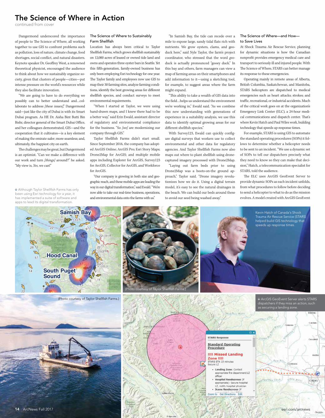
(Photo courtesy of Taylor Shellfish Farms)
The Science of Where in Actioncontinued from cover
Dangermond underscored the importance of people to The Science of Where all working together to use GIS to confront problems such as pollution loss of nature climate change food shortages social conflict and natural disasters Keynote speaker Dr Geoffrey West a renowned theoretical physicist encouraged the audience to think about how we sustainably organize so-ciety given that clusters of peoplemdashcitiesmdashput intense pressure on the worldrsquos resources while they also facilitate innovation ldquoWe are going to have to do everything we possibly can to better understand andhellipcol-laborate to address [these issues]rdquo Dangermond saidmdashjust like the city of Dubai is with its Smart Dubai program As HE Dr Aisha Bint Butti Bin Bishr director general of the Smart Dubai Office and her colleagues demonstrated GISmdashand the cooperation that it cultivatesmdashis a key element of making the emirate safer more seamless and ultimately the happiest city on earth The challenges may be great but Dangermond is an optimist ldquoCan we make a difference with our work and turn [things] aroundrdquo he asked ldquoMy view is Yes we canrdquo
The Science of Where to Sustainably Farm ShellfishLocation has always been critical to Taylor Shellfish Farms which grows shellfish sustainably on 12000 acres of leased or owned tide land and owns and operates three oyster bars in Seattle Yet this fifth-generation family-owned business has only been employing Esri technology for one year The Taylor family and employees now use GIS to map their 30 farming sites analyze farming condi-tions identify the best growing areas for different shellfish species and conduct surveys to meetenvironmental requirements ldquoWhen I started at Taylor we were using hand-drawn maps and I knew there had to be a better wayrdquo said Erin Ewald assistant director of regulatory and environmental compliance for the business ldquoSo [we] are modernizing our company through GISrdquo Taylor Shellfish Farms didnrsquot start small Since September 2016 the company has adopt-ed ArcGIS Online ArcGIS Pro Esri Story Maps Drone2Map for ArcGIS and multiple mobile apps including Explorer for ArcGIS Survey123 for ArcGIS Collector for ArcGIS and Workforce for ArcGIS ldquoOur company is growing in both size and geo-graphic reach and these mobile apps are leading the way in our digital transformationrdquo said Ewald ldquoWersquore now able to take our real-time business operations and environmental data onto the farms with usrdquo
ldquoIn Samish Bay the tide can recede over a mile to expose large sandy tidal flats rich with nutrients We grow oysters clams and geo-duck hererdquo said Nyle Taylor the farmrsquos project coordinator who stressed that the word geo-duck is actually pronounced ldquogooey duckrdquo In this bay and others farm managers can view a map of farming areas on their smartphones and add information to itmdashusing a sketching tool for example to suggest areas where the farmmight expand ldquoThis ability to take a wealth of GIS data into the fieldhelliphelps us understand the environment wersquore working inrdquo Ewald said ldquoAs we combine this new understanding with generations of experience in a suitability analysis we use this data to identify optimal growing areas for our different shellfish speciesrdquo With Survey123 Ewald can quickly config-ure digital surveys that workers use to collect environmental and other data for regulatory agencies And Taylor Shellfish Farms now also maps out where to plant shellfish using drone-captured imagery processed with Drone2Map ldquoLaying out farm beds prior to using Drone2Map was a boots-on-the ground ap-proachrdquo Taylor said ldquoDrone imagery revolu-tionizes how we do it Using a digital terrain model itrsquos easy to see the natural drainages in the beach We can build our beds around these to avoid our seed being washed awayrdquo
The Science of Wheremdashand Howmdash to Save LivesAt Shock Trauma Air Rescue Service planning for dynamic situations is how the Canadian nonprofit provides emergency medical care and transport to seriously ill and injured people With The Science of Where STARS can better manage its response to these emergencies Operating mainly in remote areas of Alberta British Columbia Saskatchewan and Manitoba STARS helicopters are dispatched to medical emergencies such as heart attacks strokes and traffic recreational or industrial accidents Much of the critical work goes on at the organizationrsquos Emergency Link Center (ELC) a 24-hour medi-cal communications and dispatch center Thatrsquos where Kevin Hatch and Paul Wiles work building technology that speeds up response times For example STARS is using GIS to automate the standard operating procedures (SOPs) it fol-lows to determine whether a helicopter needs to be sent to an incident ldquoWe use a dynamic set of SOPs to tell our dispatchers precisely what they need to know so they can make that deci-sionrdquo Hatch a telecommunication specialist for STARS told the audience The ELC uses ArcGIS GeoEvent Server to provide dynamic SOPs as each incident unfolds from what procedures to follow before deciding to send a helicopter to what to do as the mission evolves A model created with ArcGIS GeoEvent
Although Taylor Shellfish Farms has only been using Esri technology for a year it has implemented a suite of software and apps to lead its digital transformation
Kevin Hatch of Canadas Shock Trauma Air Rescue Service (STARS) helped build GIS technology that speeds up response times
(Photo courtesy of Taylor Shellfish Farms)
14 ArcNews Fall 2017 esricomarcnews
ArcGIS GeoEvent Server alerts STARS dispatchers if they miss an action such as securing a landing zone
15esricomarcnews ArcNews Fall 2017
Manager generates the dynamic SOPs ldquoIt tells us what we need to know and when we need to know itrdquo said Wiles a GIS and telephony tech-nologist for STARS ldquoThis improves efficiency reduces human error and helps us ensure the best life-saving decisions are maderdquo To illustrate how dynamic SOPs can help once a mission is under way Hatch showed the audience a one-car rollover in Banff National Park STARS decided to send a helicopter to the scene where two people were trapped in a ve-hicle and a third person had been ejected ldquoNow [that] wersquove assigned a resource GeoEvent has created a new feature which uses the AVL [automatic vehicle location] of the heli-copterrdquo Hatch said ldquoUsing factors such as the status of the aircraft and the base [ from which] it was dispatched the SOPs are instructing the dispatcher to perform actions such as giving updates to our pilots and air medical crewsrdquo GeoEvent Server will even alert a dispatcher if an action such as securing a landing zone is missed ldquoWhen we talk about dynamic SOPs map-ping spatial analysis innovation and en-gagement what we are really talking about is improving the tools our team uses to help us make more success storiesrdquo Hatch said ldquoAt the end of the day itrsquos about the patientrdquo
The Science of Where Pollution Gets Cleaned UpAt the Chesapeake Conservancy itrsquos all about the baymdashthe Chesapeake Bay The largest es-tuary in the United States and the third larg-est in the world the Chesapeake Bay stretches200 miles along the mid-Atlantic coast The watershed that feeds it occupies more than64000 square miles in six states and is home to more than 18 million people For a century the health of the Chesapeake Bay was beset by pollution population growth and changes in land use Over the last four de-cades focused efforts have brought the bay back from the brink of destruction
ldquoBut we still have a long way to gordquo said Jeff Allenby director of conservation technology for the Chesapeake Conservancy Given that so many cities counties and states have a stake in restoring the Chesapeake Bay the conservancy has embraced technology to priori-tize restoration projects While datasets like the National Land Cover Database have informed regional cleanup efforts smaller entities were us-ing different sets of data This made it difficult to implement targeted conservation projects For 18 months the conservancy worked for the Chesapeake Bay Program and with part-ners such as the University of Vermont Spatial Analysis Laboratory and WorldView Solutions Inc to create an ultra-high-resolution land-cover dataset for the entire watershed It was released in December 2016 Almost immediately the conservancyrsquos partners began asking when it was going to
update the data But this was costly and time-consuming So using ArcGIS Pro the ChesapeakeConservancy employed imagery from the National Agriculture Imagery Program (NAIP) to create a new false-color image of the region and segment it streamlining the entire land classifi-cation workflow into one processing model ldquoArcGIS Pro is reducing the amount of time that it takes us to go from raw imagery to land coverrdquo Allenby told the audience To classify more than two terabytes of the most recent NAIP imagery it would take the conservancy just over 150 hours instead of more than 2500 hours Additionally the conservancy can classify land cover in just one area or using ArcGIS Image Server in Microsoft Azure create land-cover classifications for all 206 counties in the watershed This enables the conservancy and its partners to better understand how develop-ment in one place might affect the entire bay ldquoOnce we know our priorities we can create customized action maps for our local partnersrdquo said Cassandra Pallai the conservancyrsquos geospa-tial program manager ldquoTogether Image Server
and the processing capacity of the cloud are enabling us to spend less time making the data that we need to meet our goals and more time on conservationrdquo (Read the full ArcNews article about this project at httppctxlyr508g)
Extending The Science of WhereOakland County Michigan is working with its own municipalities by expanding GIS use be-yond the knowledgeable few The county can build a map or app once pay for it once and allow everyone to benefit ldquoThrough Web GIS wersquove grown our distrib-uted GIS model by combining the value of our many collaborative systems of record [into] a powerful system of systems which allows ushellipto branch out to all our municipalities businesses and citizensrdquo said Phil Bertolini Oakland Countyrsquos deputy county executive and chief information officer He showed the audience the Access Oakland Open Data Portal which uses maps to promote economic programs and attract new business-es The Medical Main Street map for example underscores Oakland Countyrsquos thriving health care industry and Global Oakland markets southeastern Michigan as an advantageous destination for businesses from around the world to open new locations ldquoTo date we have more than 400 new busi-nesses located in Oakland County with an eco-nomic investment of $39 billionrdquo said Bertolini The success of these open data initiatives spurred Bertolini to challenge his team to build up a new generation of GIS users in Oakland County ldquoWhat was our approachrdquo asked Tammi Shepherd Oakland Countyrsquos chief of applica-tion services ldquoGrow our tree by finding and inspiring just one user who would then add hundreds morerdquo ldquoWe found that some branches grow through our cultivation whereas others sprout almost entirely on their ownrdquo said Oakland County IT business analyst Mike Dagle who along with
Shepherd took the audience on a tour of how Oakland County transformed its GIS The team helped social media managers in-corporate colorful maps into their Facebook Twitter and blog posts It created a suite of apps to simplify how the tax administration depart-ment stakes notices on the properties of citizens who have not paid their taxes Shepherd and Dagle and their colleagues helped the equaliza-tion division create an internal app that displays all the details about county properties including parcel acreage wetlands and historical imag-ery The team then added this app to its suite of standard product offerings making it available for any municipality in the county to use and customize GIS is now central to how Oakland Countyrsquos water resources commissionerrsquos office manages its assets with the ArcGIS GeoAnalytics Server helping it prioritize and allocate scarce in-frastructure resources And finally GIS maps and apps assist the countyrsquos public health office in ad-ministering and offering resources for residents affected by the opioid crisis ldquoTwo years after challenging my teamrdquo said Bertolini ldquowe have hundreds more users in a distributed GIS model across our county departments and municipalitiesrdquo (Read the ArcNews article about open data at Oakland County at httppctxlyr508h and see the ArcNews article about how one of its munici-palities used GIS to manage a community event at httppctxlyr508i)
Holistic Thinking Made EasierHundreds of thousands of other organizations around the world employ GIS and The Science of Wheremdashincluding the United Parcel Service to optimize delivery routes and the emirate of Abu Dhabi to enhance government operations The kind of holistic thinking they do is the only way to confront this planetrsquos great challenges and turn things around And that is precisely the kind of thinking that GIS and The Science of Where make easier
Jeff Allenby and Cassandra Pallai demonstrated the Chesapeake Conservancys high-resolution land-cover dataset for the Chesapeake Bay watershed
HE Dr Aisha Bint Butti Bin Bishr director general of the Smart Dubai Office
showed the audience how GIS is making Dubai the happiest city on earth
The Global Oakland web app markets Michigan as a great place for businesses from around the world to open new locations
16 ArcNews Fall 2017 esricomarcnews
Esri has a vested interest in developing the next leaders in GIS That is why every year it hosts a group of students from around the world at the Esri User Conference who have produced exemplary work in GIS This yearrsquos group of Esri Young Scholars hailed from 21 countries Some are well-versed in using GIS and others only re-cently encountered the technology Some are still undergraduates while others have graduated with their masterrsquos degrees and still others are pursuing PhDs All those who were able to make it were ex-cited to attend the 2017 Esri User Conference in San Diego California and thrilled to pres-ent their work at the Map Gallery ldquoThe moment my project was displayed at the Map Gallery that was the greatest momentrdquo said Serin Son a GIS masterrsquos student at Ewha Womans University in Seoul South Korea who used GIS to ana-lyze the characteristics of traffic accidents involving females around Seoul to see how to improve driver safety The young scholars relished meeting their peers and networking with so many GIS professionals who have done tremen-dous work in their fields ldquoI felt grateful to meet and make friends with my fellow Young Scholars from across the world all connected by the same pas-sionrdquo said Simon Haumann a recent grad-uate of the University of Viennarsquos masterrsquos degree program in cartography and geo-information whose project on optimizing the operational range of electronic bikes in routing systems won him this yearrsquos prize from Esri Switzerland
Many of the students were also inspired by the advanced technology they witnessed in demonstrationsmdashsome of which they were even able to try out on the expo floor ldquoI didnrsquot know what ArcGIS Pro was but I learned hererdquo said Balca Agacsapan an environmental engineer pursuing her PhD at Anadolu University in Turkey The project she submitted to the competition used un-manned aerial vehicles (UAVs) and GIS to evaluate building rooftops at her university for their potential to conduct solar energy via photovoltaic panels ldquoIn my next project I want to use Drone2Map for ArcGISrdquo an app she saw demonstrated at the conference Alan Pearse an earth science and statistics major at Australiarsquos Queensland University of Technology is excited about ldquothe [ArcGIS] API for Pythonhellipthat works with ArcGIS Online and ArcGIS Enterpriserdquo he said ldquoJust the fact that you can use Jupyter Notebooks and process your Python code on the fly and generate maps and do all your analysis in situmdashI thought that was pretty awesomerdquo The project he submitted to the competition involved developing an ArcGIS toolbox that calculates spatially explicit watershed attri-butes to better analyze the effects that land use has on stream health To get to San Diego the students submit-ted their projects to the Esri Young Scholars competition through the Esri distributors in their countries ldquoEsri advertised at my university for stu-dents to present a project for the contestrdquo said Mauricio Grande from Joseacute Simeoacuten Cantildeas Central American University in El Salvador His project used Drone2Map for ArcGIS to quantify the impact that recent for-est fires had on mountainous areas around San Salvador ldquoYou have to work with one teacher from your university and you have to present a work that is developed with Esri software So you present your project a poster and a technical paper [to GEOSIS Esrirsquos official distributor in El Salvador] and then you are in the contestrdquo For Amelie Zehndbauer who recently graduated with her bachelorrsquos degree in geoinformatics and satellite positioning from the Munich University of Applied Sciences in Germany the process was a little different ldquoI applied with my bachelorrsquos thesisrdquo which assessed the quality and user-friendlinessof photogrammetric software including Drone2Map for ArcGIS she said ldquoAn em-ployee of Esri Germany helped me with my bachelorrsquos thesis and gave me the hint to ap-ply for the Esri Young Scholars competitionrdquo Emily Acheson who is currently get-ting her PhD from the University of British Columbia in Canada applied with her mas-terrsquos thesis which she put together at the University of Ottawa Studying the mosqui-toes that carry malarial parasites in Tanzania she mapped where the mosquitoes were lo-cated as well as where mosquito nets were being used and compared them to see if mosquito net distribution was matching the distribution of mosquitoes It was not
ldquoWe looked at indoor residual spraying toordquo she said ldquoWe wanted to compare spray-ing to the nets and we found that spraying does a good job at targeting mosquitoesrdquo For someone who said she initially had no background in GIS she has certainly centered her research on the technology ldquoI took one course during undergrad that used ArcGIS and I fell in love with the tech-nologyrdquo she said ldquoI wanted to find a way to use it in my PhD I thought it would be a great tool to study disease distributionrdquo And she is doing just that Studying a killer fungus in British Columbia called Cryptococcus gattii she is now using GIS to figure out why it is in Canada at all since it is usually found in tropical places Being a GIS novice yet becoming cap-tivated by the technology is not unusual among this group ldquoI had no clue what GIS was beforerdquo said Nael Al Hassanieh who used GIS for the first time in his final project for his masterrsquos degree which he recently received in aero-nautical engineering from the University of Balamand in Lebanon For it he and his colleague Michelle Nassar used 3D GIS for Beirut Rafic Hariri International Airport to create Obstacle Limitation Surfaces (OLS) which indicate the volume of airspace around an airport that needs to be free from obstacles such as buildings trees and hills ldquoThe location of Beirut Airport is kind of sensitive because there are hills [and build-ings] around ithellipand the sea from the west siderdquo said Al Hassanieh ldquoIt was kind of a special project because itrsquos the first time this analysis has been done in Lebanon using GIS with high-accuracy mapsrdquo which is ul-timately why he decided to submit it to the Esri Young Scholars competition There are plenty of young scholars who got bitten by the GIS bug early though Sander Varbla from Estoniarsquos Tallinn University of Technology started using GIS in high school ldquoI was in eleventh grade the first time I re-alized that something like GIS existsrdquo said Varbla who is more than halfway through his studies for a joint bachelorrsquos and mas-terrsquos degree in civil engineering with a spe-cialization in geodesy ldquoWe had to do this
research project with GIS and my interest in it grew and grewrdquo The project he submitted for the Esri Young Scholars competition revolved around improving the accuracy of global navigation satellite system (GNSS)-based bathymetric measurements in the Baltic Sea And Patricia Polo an environmental engi-neering undergraduate student at the Latin University of Panama encountered GIS ear-ly in her university studies ldquoIn the university we do GIS remote sensing spatial analysismdashall those sub-jectsrdquo said Polo whose project analyzed noise pollution in different areas of Panama City She was so inspired by the people she met at the Esri User Conference that she plans to continue using GIS and is even considering getting a masterrsquos degree in it Above all the Esri Young Scholars were proud to present their work and energizedby who they encountered and what they saw ldquoThis was just an amazing opportunity for me to showcase my research and see how itrsquos actually solving problemsrdquo said Keneilwe Hlahane a GIS and remote sensing masterrsquos student in the oceanography department at the University of Cape Town in South Africa For her project she used GIS to monitor eutrophication (when rich nutrients such as nitrogen and phosphorus exist in excess in a body of water and alter the ecosystem) which is causing water quality in dams and rivers throughout South Africa to deteriorate ldquoThis goes back to the theme of this yearrsquos conference Applying The Science of Where which is what Irsquom doing Irsquom applying the sci-ence of GIS within water quality resourcesrdquo Hlahane like so many Esri Young Scholars left the conference with the drive to do even more ldquoIrsquove definitely learned a lot of thingsrdquo she said ldquoIrsquom going to try to apply some of the methods that Irsquove seen here to my research to improve itrdquo For more information about the Esri Young Scholars program email Michael Gould Esrirsquos global education managerat mgouldesricom
Editorrsquos note Some quotations in this article have been lightly edited for clarity
YoungScholarsFind the Driveto Do More
All the Esri Young Scholars who made the trip to San Diego got a chance to meet Esri president Jack Dangermond
Esri
About the Author
Dixon Butler an atmospheric physicist is the president of YLACES and an independent consultant focusing on science environmental energy and space policy STEM education and congressional appropriations Previously he was the director of the Modeling Data and Information Systems division for NASArsquos Mission to Planet Earth and the director of the GLOBE Program (globegov) He also spent time as a clerk for the US House of Representatives Committee on Appropriations where he concentrated on energy and water
For more information about YLACES (ylacesorg) and how to get involved with youth science education email Butler at dixonylacesorg
YLACES presented the Youth Environmental Science (YES) Medal to Esri in 2016 for its sustained contributions to student environmental research and learning The award includes a $10000 grant to an organization engaging youth as active citizen environmental scientists and Esri chose the Jane Goodall Institutersquos Roots amp Shoots program
About the Author
Dixon Butler an atmospheric physicist is the president of YLACES and an independent consultant focusing on science environmental energy and space policy STEM education and congressional appropriations Previously he was the director of the Modeling Data and Information Systems division for the National Aeronautics and Space Administrationrsquos (NASA) Mission to Planet Earth and the director of the GLOBE Program (globegov) He also spent time as a clerk for the US House of Representatives Committee on Appropriations where he concentrated on energy and water
For more information about YLACES (ylacesorg) and how to get involved with youth science education email Butlerat dixonylacesorg
Helping Youth Form Scientific Habits of MindBy Engaging with The Science of Where Future Decision-Makers Strengthen Their Scientific AbilitiesBy Dixon Butler Youth Learning as Citizen Environmental Scientists
Citizens make better decisions when they can think scientifically Scientific habits of mind start with critical reasoning and include healthy skep-ticism the ability to distinguish answerable ques-tions from unanswerable ones being comfortable examining both quantitative and qualitative in-formation and the capacity to place things into larger contexts and perceive connections Just as the social sciences and humanities are for everyone so is science We can all think scientifically communicate and relate to one anothermdasheven if we arenrsquot Nobel Prize winners renowned authors or community leaders But we need to build these scientific thinking abili-ties when we are young Today that requires demystifying science and its processes Learning scientific concepts and reenacting experiments in a lab are important but theyrsquore not enough to awaken kidsrsquo scientific propen-sities Gathering environmental data and lo-cating it in space and timemdashusing GISmdashis the most accessible way for students to do science and therefore form scientific habits of mind From the age of eight children have the in-tellectual capacity to grasp research questions And a science lab can be anywheremdashright out-side even Having students do environmental citizen science which requires relatively little
( free or low-cost) equipment for close examina-tion and experimentation offers a way to make student research not only broadly doable but also useful to the wider scientific community since the data that can be easily collected and examined outdoors is greatly needed for under-standing the environment and addressing envi-ronmental concerns at different scales Youth Learning as Citizen Environmental Scientists (YLACES) is dedicated to helping kids learn scientific habits of mind by doing environmental research in both formal and in-formal settings Because such research projects necessitate data analysis using GIS enables them to conduct far broader and more sophisti-cated investigations There is increasing infrastructure to sup-port these kinds of student activities as wellmdashthrough the Global Learning and Observations to Benefit the Environment (GLOBE) Program for example which helps make it possible for students and citizens all over the world to engage in data collection and the scientific process And of course there is Esrirsquos Schools and Clubs Program which provides teachers and students with software donations and as-sistance so they can explore and analyze data using maps
YLACES has supported schools teachers and environmental organizations with instrumenta-tion and training And since it views scientific ability as universal rather than specialized the organization is also aiming to change the focus of most science fairs from identifying promising young scientists for special educational activities to providing meaningful feedback on studentsrsquo research so they can improve their scientific abilities and their projects can contribute to im-portant scientific examinations Strengthening the scientific abilities of our future decision-makers will require support from everyone including the GIS user com-munity Teachers and youth group leaders need help learning how to use GIS and young learn-ers need coaching in doing research Those who are savvy with GIS can advise people in using the technology by getting involved with organi-zations like SciStarter which works to connect citizens with citizen science projects They can also offer to help evaluate student research re-ports via GLOBE which operates both virtual and in-person student research symposia to showcase and assess studentsrsquo environmental research GIS practitioners can guide teachers in using GIS by becoming GeoMentors or advo-cate for efforts to build spatial understanding
17esricomarcnews ArcNews Fall 2017
more concretely into science education They can always make contributions to science edu-cation nonprofits as well including YLACES The GIS community with its deep apprecia-tion of the spatial nature of earth science re-search has much to offer this investment in our collective future
Collecting environmental data and locating it in space and time is the easiest way for kids to form scientific habits of mind
18 ArcNews Fall 2017 esricomarcnews
Crossing BordersA column by Doug RichardsonExecutive Director American Association of Geographers
New GIS Coding Initiative Engages Girls WomenWomen have come a long way in GIS since Mei-Po Kwan a professor of geography and GIS at the University of Illinois at Urbana-Champaign wrote her groundbreaking 2002 ar-ticle ldquoIs GIS for Womenrdquo In it she cites female GIS practitionersrsquo personal experiences in the vocation quoting one who said that a GIS lab felt like ldquothe domain of the white middle- to upper-class graduate geography studentsrdquo In a more recent study about the profession from 2016 GIS analyst Livia Betancourt Mazur and Hunter College professor Jochen Albrecht sought to find out with new data if wom-en are underrepresented in GIS In surveying almost 500 women in GISmdashasking questions such as Have you ever been the only woman in the room (at meetings events etc)mdashtheresearchers found that while women are not grossly underrepresented in GIS they are likely underrepresented in certain sectors and positions especially ones that require managerial or highly technical skills This suggests that Kwanrsquos question still resonates today It is within this context that the American Association of Geographers (AAG) is launch-ing a new initiative called Coding for Girls in GIS and Geography AAG has developed GIS coding curriculum and is planning a series of workshops on coding for girls and women beginning at the AAG Annual Meeting in New Orleans Louisiana in April and continu-ing throughout 2018 across the United States AAG is also working with its many interna-tional programs to set up similar initiatives around the world with workshops and webinars already scheduled for Ukraine and throughout Africa including in Cameroon Ethiopia Nigeria and South Africa Many AAG members and staff have strong experience and expertise in computer pro-gramming They have taught introductory and advanced GIS courses at universities or par-ticipated in college and high school mentoring programs to support and empower young women who are interested in STEM (science technology engineering and math) fields In fact AAGrsquos new Coding for Girls in GIS and Geography initiative is being coordinated by AAG senior researcher Dr Coline Dony who has worked for and recently spent the summer
with Girls Who Code a nonprofit that teaches computer science and GIS concepts to high school students Donyrsquos personal experience has motivated her to take on this initiative ldquoI was often the only woman in GIS courses that involved any programming and I want to change thatrdquo she said ldquoEnrolling for these courses should feel like the right choice for women in geography This initiative is about boosting womenrsquos interest in programming by teaching them how to create web-based geovisualizations and how to automate analyses of new sources of spatial data such as those from social mediardquo AAG looks forward to engaging with the broader geography and GIS communitiesmdashincluding other GIS organizations and the extensive GeoMentor network operated by AAG and Esrimdashto broaden the reach of Coding for Girls in GIS and Geography and create similar programs for high school students across the United States and around the world At AAG we are convinced that a more diverse geography and GIScience community will enhance our discipline and amplify our ability to understand and improve our world To make this happen we need to change the culture of our schools and workplaces to tap the talents of girls and women at an early age and prepare them with the computing and spatial thinking skills required to conduct cutting-edge research and land good jobs Gaining early access to these skills can help girls and women overcome stereotypes and lead to exciting opportunities around the world It will also infuse GIS and GIScience with new ideas perspectives and talent which can only propel these fields forward For more information on Coding for Girls in GIS and Geography or to participate in these events email AAG research associate Jolene Keen at jkeenaagorg
Contact Doug Richardson at drichardsonaagorg
Dr Coline Dony (far left) led a Girls Who Code Summer Immersion Program in Washington DC which National Public Radios lead developer Joanne Garlow (right) joined as a guest (Photo courtesy of Coline Dony)
Learn skills in demography online an understanding of principles of demography and measurement of population dynamics
the ability to use geospatial data and methods in diverse applied settings
the application of demographic tools in marketing planning public policy and research
the integration of theory data and method in the project development in applied demographics
Consider a 12-credit Graduate Certificate or 30-credit Master of Professional Studies in Applied Demography Now accepting applications for 2018
worldcampuspsueduadesri18-WC-0292bjhsss
2018
GIScience amp Technology at the AAG Annual Meeting
April 10-14 2018 | New Orleans
The American Association of Geographers Annual Meeting is an interdisciplinary forum where thought leaders and experts in GIS and geography intersect to build new partnerships and collaborations
Meet local and international colleagues Network and exchange ideas Discover topical publications Interact with state-of-the-art technologies
Donrsquot miss the French Quarter Festival happening during the annual meeting mdash non-stop music on the streets of New Orleans
raquo JOIN US IN NEW ORLEANSannualmeetingaagorg
PHOTOS COURTESY NEW ORLEANS CONVENTION AND VISITORS BUREAU PHOTO OF BRIDGE BY RICHARD NOWITZ
Following Ice Storm City Fixes Tree Hazards in Real TimeWith Custom-Made Web App Eugene Oregon Briskly Coordinates Field ResourcesBy Brian Richardson City of Eugene
On the night of December 14 2016 as an ice storm tore through Eugene Oregon the cacophony of fracturing and crashing trees was the call to action for Eric Cariaga the parks and open space technical specialist for the public works department at the City of Eugene ldquoIt was apparent early on that this was a dynamic stormrdquo recalled Cariaga who has worked at the city for 20 years ldquoI could tell by the sheer number of failing trees that this was going to be a major tree eventrdquo Ultimately more than 3500 trees were damaged mak-ing it the most catastrophic ice storm Eugene had expe-rienced in almost 55 years Calls from the public about downed trees and other storm-related problems began flooding the public works departmentrsquos phone lines It was going to require a team of more than 100 staff members from the public works parks and maintenance depart-ments to work together to clean up the mess Wanting to maximize efficiency for the 50 field response crews contractors and contract managers who were dealingdirectly with storm cleanup Cariaga used Web AppBuilderfor ArcGIS to create a web-based appmdashcalled the 2016 Ice Storm Hazard Tree Response appmdashthat could help emer-gency management staff in the office map and track the tree hazards This was then used in conjunction with Collector for ArcGIS to gather data in the field and Operations Dashboard for ArcGIS to keep track of real-time updates With chaos unfolding on the streets of Eugenemdashand 1700 storm-related work orders needing attentionmdashthe calls from the public were recorded in the Maintenance Management System (MMS) a custom-built app that re-sides in the cityrsquos relational database management system and then published as map services in ArcGIS Online The information then had to be scrutinized to ensure that it was accurate and not previously reported
ldquoIt was not too difficult taking the real-time information our dispatchers recorded from the public and creating both the desktop application and the Collector maprdquo said Cariaga He built several layers showing the work orders field crewsrsquo jurisdictional boundaries and tree speciesmdashwhich were particularly helpful to know since deciduous hard-woods are more prone to damage from ice storms than evergreen softwoods Cariaga implemented the layers into both the tree response app and Collector Out in the field contract managers and specialized tree care professionals called tree scouts used Collector to gath-er data on fallen trees and branches That information was seamlessly incorporated into ArcGIS Online and distrib-uted immediately to the tree response app and Operations Dashboard With this wide-reaching GIS field staff could see updates in real time and managers could keep close tabs on the storm response Additionally once field staff cleared a scene they could use Collector to find the nearesthazardmdashin real timemdashthat needed to be mitigated ldquoThis was incredibly valuable for our crewsrdquo said Cariaga ldquoThey could not only see the location of downed trees and limbs [but] they [also] had a good idea of the damage be-fore they arrived on-scene In most instances they knew if they were qualified to respond to a particular call and had the correct toolsrdquo In the office the real-time updates from the field were displayed in Operations Dashboard With constantly changing data coming in the self-updating charts gauges and histograms helped contract managers contractors and emergency command staff gain a holistic view of the tree hazards all over the city When field crews updated their work orders in Collector critical information about each hazard was automatically loaded into Operations Dashboard so everyone could see when a work order had
been completed and which resources needed to go where next Having this information available digitally on one map was far better than the old paper-based system in which field staff picked up work orders at the beginning of each weekmdashmaking it difficult to update the schedule with new information In the hours and days following the ice storm Eugenersquos public works staff investigated more than 1200 calls from the community regarding tree hazards Branches hung dangerously over streets and in parks and recording and mitigating the damage was an enormous task The highly skilled tree scouts continued to work me-thodically throughout the city First they canvassed prior-ity routesmdashhigh-traffic roadways and areas where there was more of a chance that falling trees could damage property or injure the public They then branched out to other areas of the city eventually evaluating every street park and trail in Eugene At each spot they recorded tree-related hazards in Collector Details included the severity of the hazardous conditions coordinates and photos With all this data available in ArcGIS Online Collector and Operations Dashboard technical staff in the City of Eugenersquos parks and open space department were able to document understand and analyze the hazardsmdashdetermining hot spots of storm-related destruction figur-ing out which tree species were most susceptible to ice storm damage calculating the average number of haz-ards each response team mitigated per day and more It also saved Eugene time when working with the Federal Emergency Management Agency (FEMA) to apply for re-imbursement for storm cleanup and other related costs ldquoThis storm response was by far the best Irsquove ever seen in my time at the City of Eugenerdquo said Cariaga ldquoWe were able to respond to calls quicker and with increased accuracy and efficiencyrdquo While the City of Eugene continues to implement GIS technology in more areas of servicemdashfrom tracking maintenance activities to maintaining and updating park assetsmdashCariaga doesnrsquot want to lose sight of the most important portion of the response the men and women who work out in the field They spent weeks identifying and clearing tree hazardsmdashremoving downed trees and branches from the entire right-of-way street system which includes all publicly owned streets ldquoThey truly [were] the stars of this recovery processrdquo said Cariaga ldquoWithout our field staff willing to go out in the rain snow or freezing temperatures none of this wouldbe possiblerdquo For more information about this project contact Brian Richardson the City of Eugenersquos public works publicaffairs manager at BrianJRichardsoncieugeneorusor 541-682-5523
20 ArcNews Fall 2017 esricomarcnews
On December 14 2016 a severe ice storm hit Eugene Oregon downing trees all over the city
21esricomarcnews ArcNews Fall 2017
Using the self-updating charts gauges and histograms in Operations Dashboard for ArcGIS both field and office staff could easily see which resources needed to go where
Eric Cariaga the cityrsquos parks and open space technical specialist built a web-based app that could map and track the tree hazards residents called in to the public works department
Using the app in Collector for ArcGIS field crews could see the location of downed trees and limbs and could get a good idea of the damage before they arrived on-scene
GIS Field Apps Keep Public Works Department Running Smoothly
For years Nacogdochesrsquo public works department used a combination of different software packages Microsoft Excel files and handwritten notes to keep track of the dumpster compactor and open-top trash can pick-ups it was responsible for Unsurprisingly this muddled system led to in-consistencies between the pickup schedule and billing To keep better track of the dumpsters and their collection timetables public works manager Cary Walker asked the engineering departmentGIS division to develop a system that would let the commercial front-load trash truck driv-ers know when and where dumpsters needed to be picked up each day Walker also wanted to be able to see the driversrsquo locations in real time so the depart-ment could dispatch them to extra dumpster pickups if they were in the area To meet both needs the GIS division chose to use Workforce for ArcGIS First the GIS division needed to locate all the dumpsters compactors and open tops in Nacogdoches Jose Olvera the sanitation supervisor used paper route sheets (which are just spreadsheets) of the driversrsquo routes to find every single commercial dumpster and record its GPS coordinates the collection pointrsquos address the building name the dumpsterrsquos size the ownerrsquos account number the pickup days and the order in which it was collected Although this was the best way to gather all this information it presented an additional challenge each route sheet showed the dumpsters
The City of Nacogdoches considered the oldest town in Texas has significantly expanded its GIS program over the last seven years Smart devices coupled with mobile solutions from Esrimdashsuch as Workforce for ArcGIS Collector for ArcGIS and Survey123 for ArcGISmdashhave enabled the cityrsquos engineering departmentGIS division to get its data out in the field and into the hands of the people who can make the most of it
The public works department has become one of the cityrsquos heaviest users of GIS Tasked with a range of undertakings from managing commercial dumpsters to issuing work orders for street sanitation and pothole maintenance the department wanted to move away from sluggish paper-based processes to app-centered workflows Building on its already robust use of the ArcGIS platform the GIS division made this digital transition easily and economically
that were picked up on a specific day so if a dumpster was picked up six days a week the GPS coordinates were recorded six times With help from the public works departmentrsquos office assistants however the GIS division was able to comb through the database to cross-reference the dumpster locations against billing statements and eliminate duplicate data Once the dumpster database was complete the GIS division automated the process of selecting the dumpsters compactors and open tops that had to be picked up on a given day sequencing the order in which they needed to be collected and uploading this information to Workforce It did this by first creating Python scripts to extract each dayrsquos routes from the database and put them into a CSV file and then uploaded the assignments to Workforce Now the scripts run each night and remove all the completed assignments before uploading the next dayrsquos routes When the commercial front-load drivers report for work the following morning they turn on their iPads and access Workforce to find out their pickups for the day In turn the public works departmentrsquos office assistants use the app to monitor the drivers as they go about their collection routes Immediately after Workforce was implemented the public works de-partment noticed that drivers were completing their routes faster and that the call volume from citizens with dumpster pickup issues had decreased
Automating Dumpster Pickup Assignments
With Workforce the public works department can keep better track of commercial dumpsters and their collection schedules and monitor driversrsquo locations in real time
Workforce for ArcGIS automatically selects the dumpsters that need to be picked up on a given day and sequences the order in which they should be collected
22 ArcNews Fall 2017 esricomarcnews
The GIS division at the City of Nacogdoches gets data into the hands of the people who can make the most of it
When commercial front-load drivers report for work each morning they turn on their iPads and access Workforce to get their pickup assignments for the day
23esricomarcnews ArcNews Fall 2017
To complete most of its work the City of Nacogdochesrsquo public works department relies heavily on 10 trucks 3 for collecting residential and commercial trash containers 3 commercial dumpster sanitation trucks 2 for picking up garbage from open-top dumpsters 1 yard waste truck and 1 for collecting brush To ensure that the department keeps these trucks in good working order Walker asked the engineering departmentGIS division if it could develop a new work order system to track vehicle maintenance requests While Walkerrsquos request wasnrsquot specifically grounded in geography the GIS division determined that Survey123 for ArcGIS would work well for this The team sat down with members of the public works department and vehicle maintenance group to figure out exactly what they wanted to track Using Survey123 the GIS division developed a simple survey that contained only fields that city personnel needed to seemdashsuch as the vehicle number the problem and the personrsquos contactinformationmdashto submit a work order to vehicle maintenance Then using ArcGIS Online the team added fields to the survey that only the ve-hicle maintenance department would be able to see such as the manufacturermod-el the status of the repair which parts were used and how long the repair took The sys-tem also keeps track of who creates a work order as well as each update to that work order so it is easy to see when a work order is submitted and when the repair is made Now personnel within the public works departmentmdashand throughout the City of Nacogdochesmdashcan submit vehicle main-tenance work orders using Survey123 The vehicle maintenance department can easily view and edit these work orders by logging in to ArcGIS Online and looking at the ve-hicle maintenance feature layer Data tab Finally city staff members no longer have to leave notes on their windshields requesting repairs or wonder why their vehicle is taking so long to fix
For 25 years the public works department in Nacogdoches had used paper forms to issue work orders The process was time-consuming A paper work order had to be created and delivered to the person who was going to complete it Then he or she had to bring it back to the office assistants when the work order was finished In addition to streamlining this process Walker wanted to be able to monitor when and where work orders were completed Specifically he wanted a customized app that could track requests to fix potholes trim city-managed bushes and clean up leaves repair and replace street signs collect garbage and fix or change out residential trash containers Walker wanted each type of work order to have its own symbol so it would be easy to look at a map and instantly know what the work or-ders were for He also wanted to maintain an archive of completed work orders for future reference The Nacogdoches engineering departmentGIS division knew that Collector for ArcGIS would satisfy these requirements Since maintenance was being done on the cityrsquos main enterprise geoda-tabase the GIS division began by creating a new enterprise geodatabase that contained dumpster accounts warnings for dumpster drivers such as low overhead power lines and trees and current and archived work orders The team also shared a map of addresses streets city utilities rights of way and work orders as a feature service Using ArcGIS Online the division then developed an app called the Public Works Work Order System that the office assistants could use to assign work orders to field crews The app also allows other departments within the city to submit work orders Using Collector on their iPads crew members out in the field can see when they get assigned a new work order and if possible head straight to the issue to fix it Once a crew member marks a work order as complete Collector archives it so it is accessible via the Public Works Work Order System app Since the public works department integrated Collector with the Public Works Work Order System app a year and a half ago the City of Nacogdoches has reaped quite a few benefits Work orders are easier to track and field crews are more efficient by knowing where their work orders are located and who they will be doing a job with Additionally by tracking pothole locations for a full year the city was able to easily verify which streets needed to be repaired It is currently tracking storm drain repairs as well to determine which ones will need to be replaced soon
Receiving Work Orders in the Field Keeping Track of Vehicle Maintenance Requests
The public works office assistants use ArcGIS Online to assign work orders to field crews
The team was also able to add fields to the back end of the survey that only the vehicle maintenance department could see and use
With Collector for ArcGIS crew members out in the field can see when they get assigned a new work order
After tracking pothole locations for a full year the City of Nacogdoches easily verified the streets that needed to be repaired
With Survey123 for ArcGIS the GIS division built a survey that contained only the fields needed to submit a work order for vehicle maintenance
Saving Time and Money
Giving employees in the public works department such wide-ranging access to enterprise GISmdashespecially via apps they can use in the fieldmdashhas been a boon for the City of Nacogdoches ldquoThese applications have saved the city from purchasing outside software packages and have saved time and money on a daily operational basisrdquo said Steve Bartlett a city engineer For more information on how the City of Nacogdoches uses GISmdashin the public works de-partment and beyondmdashcontact Tred Riggs the cityrsquos engineering technician supervisor atriggstcinacogdochestxus or 936-559-2519
ArcGIS Online Keeps Blazing TrailsA Deeper Look at Recent Improvements to ArcGIS Online
Three new features in Scene Viewer bring 3D scenes to the next level First a new elevation mode called Relative to scene automatically selects the highest posi-tion of all layers to ensure that users can clearly see points that overlap with objects For exam-ple in a web-based tourist scene that has both a 3D building layer and point layers that mark popular tourist locations using the Relative to scene elevation mode will place the points on top of the buildings so they show up cleanly The second feature is the Callout option which lifts icons above the buildings they mark and draws a vertical callout line below to help users identify exactly which location an icon re-fers to This can be especially helpful for points that are located on the ground between build-ings since they would otherwise be occluded
Third is the new Declutter setting For scenes that have many overlapping points it automati-cally cleans things up by hiding point layers that overlap For example a scene of art galleries in New York City would be littered with overlap-ping points since there are so many of them and a lot of them are located close together Using the Declutter setting however provides a clean viewing experience as fewer points are show-cased on the full scene When a user zooms in to a specific area though all points become visible Smart mapping has new 3D capabilities with-in Scene Viewer as well Users can now stylize buildings with colored and gray-scale textures use the Counts amp Amounts style to drive color ramps (showing energy use from high to low for example with dark blue indicating high use and light blue signifying low use) and employ the types style to assign a different icon or symbol to each attribute value (a green circle to indi-cate parks and a purple square to signify com-mercial buildings for instance) Users can also now create hosted feature layer views to generate multiple views of their datamdashwith different styling sharing and edit-ing permissionsmdashwithout having to duplicate their data It is also possible for users to define what data is visible by creating a view definition based on features or fields Map Viewer now makes it easier to run the same (or similar) analysis over and over It au-tomatically saves analysis input parameters in the results layer so users can just click the new Rerun Analysis button to update the analysis with the most recent data The button also works to keep live data feeds current Just
update the input layer before clicking it and everything stays up-to-date Additionally us-ers can employ the Rerun Analysis function to share the steps of an analysis along with the re-sult When others receive the dataset they can use the Rerun Analysis button to open the tool pane view the parameters used to create the result and rerun the analysis themselves
With each new release ArcGIS Online gains advanced capabilities and fresh content Thanks to input from users about what they need most from the technology Esrirsquos team of developers is able to continually infuse ArcGIS Online with improvements that make it easier to use and simpler to navigate
Dive a bit deeper into some of the more recent improvements to ArcGIS Online and see what this integral part of the ArcGIS platform is capable of
New Capabilities
The Esri World Geocoding Service which has exceptional coverage accuracy and flex-ibility now supports address-level geocoding in 135 countries In addition the reference data for most countries has been updated and new authoritative address data sources were added for Australia ( from PSMA Australiarsquos Geocoded National Address File or G-NAF) and Austria ( from BEV the Federal Office of Metrologyand Surveying) Now even poorly formatted addresses can yield the correct match For example the Esri World Geocoding Service can decipher most misspellings as well as extra non-location-based information (such as a homeownerrsquos name) and identify the appropriate coordinates
The new Callout option in Scene Viewer lifts icons above the buildings they mark and draws a vertical callout line below
With Counts amp Amounts users can
drive color ramps that show energy use from high (dark blue) to low
(light blue)
The new Rerun Analysis button makes it easier to run the same analysis more than once
24 ArcNews Fall 2017 esricomarcnews
25esricomarcnews ArcNews Fall 2017
Even with the profusion of feature layers apps and basemaps already available in ArcGIS Online Esri keeps adding more The Living Atlas of the World contains two new basemaps World Imagery (Firefly) and World Imagery (Clarity) Currently in beta these are both alternative views of the World Imagery basemap The Firefly basemap is dark and desaturated to ensure that the data presented on top of it pops It is best paired with a single glowing thematic layer to easily capture a viewerrsquos interest on a focused topic such as weather phenomena which benefits from the drama and spatial context of imagery but is sometimes better represented by reduced-color imagery The Clarity basemap is intended to be used when it is more important to get a clear view of a place than to present the most recent imagery of that location (the latter being the default for World Imagery) For instance if the most up-to-date imagery of New York City has a cloud over Times Square but a user really needs to show the streets that make up Times Square he or she could employ the Clarity basemap to get a slightly older version of the imagery that doesnrsquot contain the clouds The World Imagery basemap has a wealth of new content as well Thanks to Esrirsquos ongoing partnership with DigitalGlobe developers have been able to update the World Imagery basemap with new high-resolution imagery for Afghanistan Alaska Austria Canada Colombia Germany the Netherlands New Zealand Spain Suriname Turkey and other places Several dozen metro areas have also been updated with submeter-resolution imagery Esri has improved its demographic maps for the United States and a number of other countries as well For the United States Esrirsquos demographic maps now feature the latest 2017 current-year estimates and 2022 five-year forecasts based on census and American Community Survey (ACS) data Esri partner Michael Bauer Research has also released updates for more than30 countries including China India Japan Kazakhstan Israel and the United Arab Emirates Additionally the 2010 US Census demographic data is available for free in the Living Atlas of the World
To help users who have multiple accounts for ArcGIS Online and Esri websites Esri introduced Switch Accounts which links them Now it is easier to toggle among ArcGIS Online accounts and Esri web-sites including My Esri Technical Support and GeoNet ArcGIS Online accounts that use the same login (a social or enterprise login for example) are automatically linked with Switch Accounts where-as ArcGIS Online accounts with different logins allow users to link their accounts from the Switch Accounts panel With this users can stay signed in choose to sign out of the current account or opt to sign out of every linked accountmdashall in one place The contents and privileges associated with each account remain independent and separate completely unaffected by the linking Users can also launch web apps directly from ArcGIS Online by clicking the Apps button on the right-hand side of the header on the home page Once an app is selected it will open in a new browser tab Additionally when users sign out of ArcGIS Online in one tab they automatically get signed out of ArcGIS instances open in other tabs
Working together just got a whole lot easier As part of an early adopter program users can now share content between their ArcGIS Online organizations and ArcGIS Enterprise 1051 portals These new distributed collaboration capabilities in ArcGIS Online allow organizations working in both online and on-premises systems to establish a trusted environment with defined rules for sharing maps layers and files The data stays in sync using item and data replication
Improved Navigation
More Content
Distributed Collaboration
For more information about whatrsquos new in ArcGIS Online visit the ArcGIS Online blog at goesricomblogs Esri also invites all users to share their product enhancement ideas at goesricomideas
Early adopters can now share content between their ArcGIS Online organizations and ArcGIS Enterprise 1051
The dark and desaturated Firefly basemap ensures that the data
presented on top of it pops
Web GIS for Staff and the PublicWith a population of 81000 thatrsquos growing at a steady rate the City of Medford Oregon needed a new way to provide city staff and residents with access to public land information So the cityrsquos GIS team collaborated with VESTRA Resources Inc (vestracom) to replace its existing app with one that leverages Web GIS via the ArcGIS platform The Medford Land Information (MLI) app is a modern mostly out-of-the-box solution that empowersdecision-making and fosters collaboration within the city as well as with the public It contains information about building permits occupational licenses planning and zoning code enforcement infrastructure aerial photos of the entire city and more The app aggregates data from multiple servers and puts it in one location To bridge the gap from the old unsupported system to the new technology VESTRA migrated the cityrsquos highly customized Microsoft Silverlight app to JavaScript using ArcGIS API for JavaScript and implemented the new MLI app in ArcGIS Online VESTRA also used Web AppBuilder for ArcGIS to create custom widgets that mirror some of the functionality of the older app such as advanced querying reporting capabilities and the ability to access the cityrsquos land information from the IBM iSeries (AS400) server where it is stored Requiring minimal to no training MLI allows citizens and businesses to easily wield the same public-record information as city staff Users can find a wealth of information about each parcel in the city including land value the year any structures were built and the zoning and fire districts They can also use MLI to answer spatial questions such as Which ward do I live in and What elementary school serves this area Having all this information available to the public has substantially reduced the number of calls the City of Medford receives from citizens which has helped staff save time reduce costs and be more effective overall Additionally in allowing Medfordrsquos citizens to easily visualize this information on maps the city is keeping them informed and engaged with their community
Move to Mobile Hits the MarkHydro One which has served Ontario Canada since the early twentieth century faces a constant challenge finding innovative ways to increase the performance of its vast electricity system while reducing costs and keeping safety the number-one priority As the owner of 97 percent of the transmission network in Ontario Hydro One needed to move away from antiquated paper-based processes that limited access to information led to questionable data integrity and required months to make simple updates Linemen for example could only carry maps of their operational areas in their trucks meaning that if there was an incident in another jurisdiction those maps would be useless ldquoWe needed a new way to connect our offices to the field forces and vice versardquo said Brad Bowness vice president of distribution at Hydro One The solution was to implement Move to Mobile (M2M) which tightly integrates Hydro Onersquos SAP Enterprise Asset Management system and SAP Work Manager (a scheduling software) with Lemur from Critigen(critigencom) Running in the ArcGIS platform Lemur automates the process of sending updated map data to field crewsrsquo tablets ldquoCritigen helped us put ArcGIS in the fieldrdquo said Janice Coulson Hydro Onersquos project team lead on the M2M project ldquoField crews receive up-to-date cached map data for their region If an incident occurs in another region they can access that regionrsquos data to respondrdquo Getting field data back into the office is easy too ldquoAs line maintainers complete their work in [SAP Work Manager] our business processes are maintaining that asset information both on the SAP side and in the enterprise GISrdquo explained Coulson With truck locations now visible to schedulers dispatch can quickly notify the nearest crew member to respond to an outage or emergency At the same time crews can submit new issues they encounter while in the field or make the decision to address these problems on the spot ldquoTheyrsquove never had that visibility before and they are taking ownership of the processrdquo said Coulson By integrating these best-in-class technologies Hydro One replaced more than 40 paper forms modernized its scheduling methods and gave linemen real-time access to up-to-date SAP data and GIS maps Moreover using Lemur to automate the extent and frequency of map cache updates lowered the demand load on Hydro Onersquos server architecture reduced data entry time from an upper end of 180 days to 4 or 5 days and greatly improved the integrity of field submissions ldquoWe have successfully integrated both SAP Work Manager and GIS into one systemrdquo said Bowness ldquoWe are already realizing productivity savings as a result of the M2M and I am confident this will be a powerful tool for Hydro One business operationsrdquo
26 ArcNews Fall 2017 esricomarcnews
ESRI PARTNERS
Share Data for Better ResultsEquipped with innovative ideas industry expertise and the ArcGIS platform Esri partners are implementing enterprise GIS that keeps workers safe increases efficiency and saves on costs
Find out how the following four Esri partners are making organizations and communities smarter by giving more people access to a wide range of geospatial information
With Critigenrsquos Lemur schedulers can see crew locations in the SAP Work Manager map view and share them with dispatch so dispatch can notify the nearest crew member of an outage or emergency
Citizens businesses and city staff can use the Medford Land Information (MLI) system to search for information about county parcel taxes sales and details as well as to view parcel maps
Lemur allows users to configure the GIS to cache specific map layers for offline use in the field as well as update the frequency and extent of coverage
Collaborating to Curb HomelessnessIn 2014 the City of Tacoma Washington began working with community partners to address issues related to mental health substance abuse and homelessness After soliciting community feedback the city partnered with Comprehensive Life Resources (CLR) a nonprofit organization that offers mental health homeless hous-ing and other human services to residents in and around Tacoma One of CLRrsquos programs called Positive Interactions assists local businesses in addressing concerns related to homelessness and blight Tailored to fit the needs of both businesses and individuals experiencing homelessness Positive Interactions operates a response line that business owners and community members can call to express their concerns about homeless activity in their areas CLR field crews then engage directly with the homeless indi-viduals in a way that is sensitive to the traumas they have faced to learn their needs and connect them with services To get Positive Interactions started CLR employees collected field data about businesses and Tacomarsquos homeless population on paper and then completed fillable forms in Microsoft Word once they got back to the office It was common to have lapses in time between interacting with homeless individuals and submit-ting the forms which often resulted in lost or inaccurate data CLR also needed to record spatial information analyze data track time and resources and create reportsmdashbut it couldnrsquot do any of this easily So CLR approached Frontier Precision ( frontierprecisioncom) which suggested that the organization employ Survey123 for ArcGIS on employeesrsquo phones and tablets to gather data in the field Since nobody at the nonprofit had experience with GIS CLR had Frontier Precision assist in configuring deploying and managing the survey and the data CLR deployed the digital survey in September 2016 and since then employees have submitted almost5000 surveys With so much data CLR can analyze it to find trends and patterns in where homeless activity takes place how homelessness changes during different seasons and how demographics factor in Now man-agement can better deploy field crews to areas with high levels of homeless individuals And crew members can view prior surveys to figure out if the homeless individual they are about to visit has been contacted before and follow up with him or her on services that were previously offered After Frontier Precision demonstrated how helpful GIS is and how easy it is to use CLR fully embraced the tech-nology by deploying it across the organization in several different programs Starting this year CLR will have a pub-lic resources locator that will help members of the community and case workers find housing financial and legal services for those in need Additionally CLR will employ Survey123 for data collection related to its gang reduction project its mobile community intervention response team and for foster care case management
Speeding Up Work and Response TimesDenton Municipal Electric (DME) has been serving the Greater Denton Texas area for more than 100 years To continue to provide effective and efficient utility services the company needed to replace older technology with new systems that would help improve response times increase reliability and ensure crew safety ldquoBecause DMErsquos systems operations group manages all outages and crews as they respond to incidents in-tegrating our data systems [into] a common platform is becoming very important as we growrdquo said Trey Price engineering systems applications supervisor for DME ldquoTwo years ago we determined our old archaic system was crashing too often unable to deliver accurate GIS information to crews and was a cybersecurity riskrdquo To improve productivity and data integrity amalgamate dispatching and work assignments in one sys-tem obtain real-time visibility into field activity and help crews quickly and safely get to their assignments DME partnered with Clevest Solutions Inc (clevestcom) and implemented the Clevest Mobile Workforce Management system which is fully integrated with the ArcGIS platform DMErsquos project required a configurable utility-wide system for managing work the ability to create and adminis-ter work orders for various citywide calls for service about water and wastewater locating electric and fiber-optic service lines and to repair or replace meters and city assets such as poles or streetlights and new ways to integrate multiple systems used to manage everything from customer information assets maintenance and outages to GIS and 811 (the call-before-you-dig line) The utility also needed a way to handle ticketing for non-customer calls such as those to report leaks from services DME doesnrsquot handle both at the office and in the field The Clevest Mobile Workforce Management solution lets DME provide mobile service outage and lo-cate orders And all this is integrated with ArcGIS Enterprise and ArcGIS Online as well as ArcGIS Network Analyst Office employees use Clevest WorkSpace on their desktop computers while staff in the field access a mobile app called WorkBook on their smartphones or tablets ldquoThe real-time map view allows us to instantly filter such items as electric orders outages locates and street-lightsrdquo said Price ldquoIf I am in the office I can see where the crews are whatrsquos been assigned and what they are work-ing on If I am a crew member I can see what is assigned to me and prioritize my work In addition to accurate GIS information regarding the work location I can now pull up account information related to that locationrdquo So far the feedback about M2M has been positive with office staff and field crews finding the Clevest solu-tion easy to use and informative Price said that DMErsquos response times are speeding up as well ldquoWe expect the improved response times and faster power restoration to boost customer satisfactionrdquo said Price ldquoBy unifying our workflow around a paperless system we are reducing operational costsrdquo
Esris global partners provide customer-focused geoenabled solutions that span dozens of industries Products and services range from configured apps and custom-built solutions to complete ArcGIS system implementations and content Search and discover partners solutions and services at esricompartners
27esricomarcnews ArcNews Fall 2017
The real-time map view in the Clevest Mobile Workforce Management solution allows employees at Denton Municipal Electric (DME) to instantly filter items such as electric orders outages and locates
With Clevest Mobile Workforce Management field staff at DME can access the WorkBook mobile app on their devices
Using Survey123 for ArcGIS CLR easily arranged to have trash left behind by homeless individuals cleaned up so that local businesses could operate as usual
With almost 5000 surveys submitted Comprehensive Life Resources (CLR) can now analyze its homelessness data to find trends and patterns
28 ArcNews Fall 2017 esricomarcnews
With Street-Level Imagery Property Reappraisals Go VirtualEsri Startup Partner Mapillary Helps County in Ohio Simulate Site Visits
New businesses that join the Esri Startup Program receive on-line services software content training and support so they can incorporate mapping and location analytics into their products Mapillary a Swedish startup that wants to map the world us-ing street-level images has been in the program for three years In that time Esri has relayed deep technical knowledge of the ArcGIS platform and helped connect this GIS newcomer with all the right industry touchpoints Recently Mapillary teamed up with Esri partner Bruce Harris amp Associates Inc (BHA) to help Erie County Ohio improve how it con-ducts recurring property reappraisals on a small island in Lake Erie
A Digital Geospatially Integrated WorkflowLike most counties in the United States Erie County is required to conduct property reappraisals every six years On Kelleys Island located about four miles off the mainland in the western basin of Lake Erie staff members from the county auditorrsquos office were doing property inspections using paper maps and printed property records Because the appraisals required checking the grade and condition of all county buildings on the island audi-tors had to visit every single site Even though the island is just over four square miles in size this workflow took up a lot of time was too prone to human er-ror and was difficult to replicate every six years So Erie County sought to improve how it conducted fair and equitable property assessments The GIS team at the auditorrsquos office opted to set up a digital geospatially integrated workflow First the county worked with consulting firm BHA to imple-ment its Paperless Reappraisal System (PRS) a set of apps that uses ArcGIS for Local Government solutions and ArcGIS Online to make the entire reappraisal processmdashfrom data collection and review to quality control and workflow managementmdashdigital
PRS works directly with Erie Countyrsquos GIS by linking appraisers to county land records and up-to-date georeferenced information Still the county wanted to be able to simulate the site visits required to check the building grades and conditions To make that happen BHA partnered with Mapillary to use its street-level imagery and computer vision capabilities in conjunction with BHArsquos own PRS Photo Reviewer app Combining geography auto-mation and advanced analysis techniques Mapillaryrsquos imagery platform automatically turns 2D photos into 3D street views by stitching images together at points that match up recognizing objects in the images and generating map data such as street signs road characteristics and building types Thus whereas BHArsquos app provided useful oblique imagery of Kelleys Island Mapillaryrsquos addition of a street-level angle gave the county the vantage point it needed to fully simulate site visits This integra-tion was cost-effective and sped up the appraisal workflow
Giving Field and Office Staff the Same ViewpointTo carry out the reappraisals Mapillary personnel and BHA staff along with Erie County auditor Richard Jeffrey and his staff equipped a county vehicle with four action cameras (which are small lightweight and splash-proof) to capture street-level im-agery of the entire island Photos were taken over a span of eight hours They were then uploaded to Mapillary which scrubbed the images to remove faces and license plates point matched them and stitched them together to create the street-level viewpoint Back at the office BHA staff verified parcel characteristics such as assessed building grades property condition and con-struction materials Staff from the county auditorrsquos office viewed all the work via the PRS Photo Reviewer app with Mapillaryrsquos in-tegrated photo viewer capabilities Using the app with Mapillary allowed Erie County office em-ployees to see the appraisal process through the eyes of field staff And having a street-level vantage point to verify appraisal data en-sured that property assessments were accurate and up-to-date
ldquoHaving this imagery integrated in our apps to use at any time [is] invaluablerdquo said Mark Wroblewski the GIS coordinator for the Erie County Auditorrsquos Office ldquoThe ability to seamlessly collect imagery at any time without contracts or expenses [is] another return on the investment for Erie Countyrdquo
Collaboration Leads to Smooth CompletionLeveraging Mapillaryrsquos technology along with software from Esri and BHA provided Erie County with street-level imagery that met its assessment needs The resolution and quality of photosmdashall tak-en by staff while driving the streets of Kelleys Islandmdashexceeded the countyrsquos expectations The photos effectively supplement the coun-tyrsquos workflow for checking the grade and condition of any building And because the imagery is integrated with PRS using Mapillaryrsquos API county staff can navigate from parcel to parcel smoothly With this street-level imagery and its metadata appraisal managers and county constituents can now see information that Erie County previously had to attain by making site visits to each individual property Additionally data entry teams can use the always-available imagery to ensure the quality and consistency of building characteristics Overall the integration saved the county time and money Thanks to this collaboration between a young startup and a vet-eran Esri partner Erie County is on track to meet its sexennial reappraisal mandate
Having a street-level vantage point from which to verify appraisal data ensures that Erie Countyrsquos property assessments are accurate and up-to-date It took eight hours for this crew to capture photos of the entire
island that could be used in Mapillary
Web-Based Apps Help Agricultural Producers Consumers Digest InformationCanadian Governmentrsquos Agriculture Department Develops Self-Serve Map- and App-Building Platform Using ArcGIS Online
The agricultural industry is facing unique agronomic economic and environmental challenges and opportunitiesmdashfrom extreme weather events and new invasive species to growing global compe-tition Consumer expectations are evolving as well Canadians are demanding more variety and convenience from their food as well as environmental friendliness and assurances of quality and safety Producers are looking for novel products and processes to help them meet the demands of these new markets while also ensuring that their operations are competitive and sustainable Agriculture and Agri-Food Canada (AAFC) a government orga-nization that aims to drive innovation and ingenuity in Canadarsquos agriculture and food industries determined that one of the best ways to help the sector develop sustainably is to give as many organizations and people as possible the ability to visualize and effectively leverage the wealth of informationmdashfrom crop den-sity and soil moisture to farm locations and agri-environmental indicatorsmdashthat is available to support decision-making in the industry today Using ArcGIS Online AAFC is making that possible Two years ago the organization opened up its ArcGIS Online organizational account to almost 180 departmental users Called UMAP this AAFC-branded cloud-based portal enables these users to employ a wide range of agricultural data to create interactive web maps and apps for their colleagues food producers and the public
A Self-Serve Geospatial DestinationWhen this project started AAFC had limited resources So it wanted a solution that would require little in-house development and that would get the department up and running with making its own maps and apps quickly The solution also needed to meet security requirements and integrate data according to govern-ment standards As a heavy user of the ArcGIS platform already AAFC saw that ArcGIS Online met these requirements Using it would give the team a secure software-as-a-service (SaaS) cloud-based plat-form that is hosted and supported by Esri ldquoWe found the SaaS model very attractive because it meant that we could operate with a small server footprintrdquo said James Ashton AAFCrsquos geomatics applications manager In other words the organization could focus on using the software rather than building it and maintaining the infrastructure
Now UMAP is a self-serve geospatial destination that AAFC staff can use to mash up key organizational information layersmdashsuch as annual crop inventories and historic yield and production statisticsmdashwith interoperable data from other organizations and third parties like Esri They can then use this data to create intel-ligent web maps that can be shared with specific interest groups or departments Employees can also build on work previously com-pleted by colleagues and share new results across the enterprise Whatrsquos more employees designated as publishers can host their own nonsensitive data in the cloud and create their own map services by converting CSV files into shapefiles to web en-able them for ArcGIS Online UMAP administrators monitor credit usage across the organization as well and choose which data to make public or keep private ldquoThe platform transforms our datasets into ready-to-use web re-sources that serve as powerful tools to communicate complex infor-mation in a very simple wayrdquo said Ashton ldquoIt significantly reduces confusion about where to access organizational maps and the need for departments to contact each other for information This also re-duces the number of requests received by our help deskrdquo The UMAP home page has a customized banner featured con-tent and links to training videosmdashall of which align with brand-ing and objectives
Disseminating Geospatial Data EfficientlyTo make it easier to get data and apps to outside organizations and producers AAFC also populated a public-facing app gallery with popular web apps ldquoThe demand for information is always increasing and wersquore seeing a much broader range of potential usersrdquo said Ashton ldquoBy leveraging a more efficient and cost-effective approach to dis-seminating geospatial data we continue to transform ourselves into a knowledge-based department where we [employ] geospa-tial information in our decisionsrdquo Two of the public-facing web apps that AAFC staff recently devel-oped and shared are the Annual Crop Inventory app and the Land Use app The Annual Crop Inventory app allows users to quickly ana-lyze and visualize field-level cropping patterns (ie an overview ofwhat has been planted on farmland before) across Canada The Land Use app enables users to analyze changes in land use throughout thecountry between 1990 2000 and 2010 If a producer is interested in
renting farmland for example he or she could use these maps to see which crops have been planted in previous years That way the pro-ducer can make the most effective and environmentally conscious decision about which land to farm and what to cultivate on it ldquoA picture is worth a thousand wordsrdquo said Ashton ldquoMaps help us visualize the information we collect and that [the Science and Technology Branch at AAFC] creates This in turn helps us ask better questions and make better decisions Imagine how a farm-er or policy maker could benefit from simple web-based access to open datasets on changes in land use such as crop rotations or the environmental impacts of droughtsrdquo AAFC uses Esri templates such as Compare Maps and spe-cialized Canadian federal government ones to build the apps quickly and in compliance with accessibility and common gov-ernment branding requirements By using ArcGIS Online in con-junction with templates some appsmdashlike the Spatial Density of Major Crops in Canada appmdashhave taken only an hour to deploy In addition AAFC registers its data web services and apps to the Federal Geospatial Platform (an internal government portal) and the public-facing Canadian Governmentrsquos Open Data Portal By doing this it ensures that these portals point back to AAFCrsquos services giving more peoplemdashboth internally and externallymdashaccess to the organizationrsquos data
Enabling Better Decision-MakingBy using the ArcGIS platform to better inform internal staff ag-ricultural producers and the public AAFC is ensuring that more people can visualize and leverage the myriad information the department receives meeting both consumer expectations and producer needs AAFCrsquos maps and apps are informing policy makers on a global scale from grain brokers looking for new cereal sources to real estate scouts seeking new investment opportunities Now they can all see where specific cropping trends like monocrop-ping are occurring and where forest or urban expansion are tak-ing place Using web maps the department can share its data broadly and cost-effectively allowing policy makers to easily col-laborate in finding solutions to ongoing challenges For more information contact Gordon Plunkett the spa-tial data infrastructure (SDI) director for Esri Canada atgplunkettesrica or 613-683-6213
Having rapid visualization of field-level cropping patterns across the Canadian landscapemdashall in one browsermdashgives powerful web analytics and visualization to the agriculture industry
Using one of AAFCrsquos web apps such as the Spatial Density of Major Crops app researchers and the public can analyze the density of crops across Canada
29esricomarcnews ArcNews Fall 2017
MapLogicMap book solution for ArcGISreg
Download a fully unlocked evaluation version and try it out for 30 days
wwwmaplogiccom407-657-1250 bull salesmaplogiccom
bull A complete map book in a single MXDbull Multiple layouts in ArcMapbull Automated street indexing
Take your map book creation to the next level
wwwjunipersyscom
The unbeatable rugged tablet amp sub-meter GNSS
receiver mapping solution for Esrireg ArcGISreg apps
SIMPLE RUGGED RELIABLE
30 ArcNews Fall 2017 esricomarcnews
Restoring a Watershed One Bag of Litter at a TimePrince Georgersquos County Uses Survey123 for ArcGIS to Meet Waste Reduction Targets
Throughout the mid-Atlantic region of the United States ldquoSave the Bayrdquo bumper stick-ers and signs adorn cars and store windows They refer to the Chesapeake Baymdashthe larg-est estuary in the countrymdashwhich stretches 200 miles and receives runoff from a vast wa-tershed that contains about 18 million people Unsurprisingly the Chesapeake Bay faces con-siderable pollution issues Prince Georgersquos County located just outside Washington DC sits in the bayrsquos smaller Anacostia River watershedmdashone of the most densely populated watersheds in the Chesapeake Bay drainage basin With900000 people occupying almost 500 square miles of cities suburbs and farms the countyis especially concerned about storm water run-off polluting its waterways Littermdashwhich often gets washed up in storm drains and transported to local lakes and streamsmdashis one of the most persistent pollut-ants in the county Not only an unsightly blemish on the landscape this garbage carries additional toxins into the bay that affect biota the chemical makeup of the water and drainage outlets ldquoWe were constantly asked the question Where is this litter coming fromrdquo said Tiaa Rutherford Prince Georgersquos Countyrsquos litter re-duction program manager ldquoAs a county we could not answer that questionrdquo To keep the local bay tributaries and com-munities clean and beautifulmdashand to help protect the 43 fish species and 200 bird species that live in the Anacostia River watershedmdashthe Prince Georgersquos County Department of the Environment (DoE) launched a mobile app to track litter Built with Survey123 for ArcGIS the app called PGCLitterTRAK allows county residents community organizations and busi-nesses participating in cleanup activities to use their smartphones to quickly record informa-tion about the trash and debris they collect
ldquoUsing Survey123 we developed a simple tool that empowers people doing cleanup work to report back to us on the quantity and location of litterrdquo said Rutherford
Measuring Litter Pickup ProperlyIn 2010 several state and federal environmental agencies as well as local and county govern-ment departments drafted an interjurisdic-tional trash cleanup blueprint for the Anacostia River To satisfy federal water quality standards it mandated that Prince Georgersquos County re-duce the amount of garbage in the watershed by 170628 pounds per year Prince Georgersquos County was already using ArcGIS to show how it was meeting its trash reduction targets But data collection and documentation were off Only certain types of refuse picked up in specific watersheds receive trash removal credits from the Environmental Protection Agency Yet the county could not val-idate the litter picked up by local organizations and the public nor could it categorize the array of trash collected by its own garbage trucks To more effectively demonstrate how hard the county was working to reduce the amount of litter going into the river Catherine R Escarpeta a senior GIS analyst with DoE de-cided to use a resource the county already had an ArcGIS Online subscription Employing Survey123 Escarpeta built PGCLitterTRAK which lets trash collectors record the number of bags of litter gathered the types of items picked up and the locations of the garbagemdashall on-site At no extra cost Survey123 was ideal for this project Its formcentric design ability to collect location information in the background and ca-pacity to upload photos made it easy to use In addition Survey123 allowed the county to pub-lish its litter tracking app to Android iOS and Windows devices seamlessly so large numbers of volunteers and employees could use it
PGCLitterTRAK connects directly to LitterTRAK Map an internal web-based map that employees at Prince Georgersquos County can use to visualize the incoming data and make decisions about where to best allocate resources
SOFOR GISDecember 11 -12
2017
11th Southern Forestry and Natural Resource
Management GIS Conference
Athens GA
soforgisnet2017
Monitor Your GIS Platform
Reduce the Impact of Service Failures
Receive instant alerts pinpointingissues when your maps or services fail helping you to get back online before users callbull Monitor ArcGISreg for Server amp Morebull Real-Time Performance Monitoringbull Instant Text andor Email Alertsbull Rapidly Pinpoint Issuesbull Charts Graphs amp Historical Databasebull Customized User Interfacebull bull User Deened Monitoring Pointsbull Easy Installation amp Setup
Also Available for ArcGIS Online in ArcGIS MarketplaceSM
530-223-2585 wwwvestracom
We help you putGIS to work
gistrainingkingcountygovwwwkingcountygovgistraining
Professional GIS training in our Seattle facility or at your site
GIS TRAININGEXPRESS trade
Expert ArcGISreg Training Custom Classes and Workshops GIS Academytrade ldquoBeyond the Basicsrdquo GIS Certification Institute Qualified URISArsquos Pacific NW Education Center Veteransrsquo GI Bill Benefits
Selected programs of study at the King County GIS Center are approved for
those eligible to receive benets under Title 38 and Title 10 USCTeaching GIS across the
globe since 2001
Our instructors come to your team
Call us Let us get you going with ArcGISR Pro
7132787883 infoTeachMeGIScom
31esricomarcnews ArcNews Fall 2017
Recording Accurate DataAbove all Escarpeta wanted to make the app easy to use She included setup hintsmdashsnippets of text like a sample email address or phone numbermdashthat help users answer questions cor-rectly She also ensured that the county could validate the data by requiring some questionsmdashsuch as What is your organizationmdashand giv-ing others drop-down menus so users only have certain uniform answers to choose from Additionally Escarpeta customized the survey so that some fields especially those required to accurately report litter cleanup to the county get completed automatically upon submission
Escarpeta also wanted to ensure that Prince Georgersquos County received the correct data She focused the apprsquos questions on the quantity and location of litter collected For example when filling in the type of garbage being picked up if a user selects Bags of Litter the next question will be How many bags If the user selects Tires instead the app will ask How many tires Users can upload photographs to further document their cleanup efforts And hidden fields within the appmdashsuch as fiscal year council and main-tenance districts and watershed datamdashensure that the information can be automatically ex-ported to the proper departments within Prince Georgersquos County without bogging down users with extraneous details ldquoPGCLitterTRAK and Survey123 enhance the userrsquos experience by only asking about what that person is doing at that specific locationrdquo said Escarpeta The app also functions offline which is cru-cial to tracking and reporting litter since parts of the county have limited wireless connectivity Additionally various functions built into usersrsquo devices such as the voice-to-text capability work within the app
Guiding Legislation and Allocating ResourcesOnce users collect data out in the field PGCLitterTRAK connects directly to LitterTRAK Map an internal web-based map that Escarpeta built using Web AppBuilder for ArcGIS With LitterTRAK Map county employ-ees such as program managers and crew super-visors can review and analyze the litter data coming in from throughout Prince Georgersquos County Escarpeta can add layers to the map as wellmdashsuch as hot spot analyses council and maintenance districts and other background informationmdashto enable county employees to better visualize the data
With all this agencies such as the Department of Public Works and Transportation and the Department of Permitting Inspections and Enforcement can run reports on the types of cleanup activities they conduct like road-side litter removal and the disposal of illegally dumped items These departments can then figure out how to guide legislation and better allocate their resources determining where to focus outreach efforts to reduce litter where to place more trash receptacles and where to po-sition cameras to impede illegal dumping
Reducing Litter Across the CountyAlthough Prince Georgersquos County developed PGCLitterTRAK to target the Anacostia watershed the app is helping to reducelitter countywide ldquoPGCLitterTRAK is making it easier for Prince Georgersquos County government to reduce litter in our waterways streets and neighbor-hoodsrdquo said Adam Ortiz the director of DoE ldquoThis user-friendly app gives us the ability to ob-tain real-time information and see a catalog of trash picked up by our countyrsquos lsquotrash warriorsrsquo
who are on the front lines of the battle against litter in Prince Georgersquosrdquo Additionally program managers through-out the county are examining how to employ Survey123 for tracking other assets and issues like storm drains in need of ldquono dumpingrdquo im-prints street signs in need of replacing and residents in need of little nudges to pick up theirpet waste PGCLitterTRAK is now an indispensable tool for keeping Prince Georgersquos County clean green and beautiful according to Ortiz ldquoWhether you are cleaning roads streams parks or your neighborhood PGCLitterTRAK tracks litter reduction achievements and en-courages citizens to support the county by volunteering and being good stewards of the environmentrdquo he said To find out more about Prince Georgersquos Countyrsquos litter reduction program email Rutherford at trutherfordcopgmdus For more information about PGCLitterTRAK email Escarpeta (soon to be Catherine Adams)at crescarpetacopgmdus
With PGCLitterTRAK county workers can track everything they pick up and even upload photosmdashright from where the refuse is located
PGCLitterTRAK only asks users about what they are doing at a specific location to ensure that the county receives the correct data
Mobile Technology Keeps Election Day on Track in LA CountyWith Workforce for ArcGIS Troubleshooters Get to Polling Places More Quickly
During every election Californiarsquos Los Angeles County Registrar-RecorderCounty Clerk deploys troubleshooters to ensure that polling places are open and running smooth-ly These troubleshooters encounter situations ranging from locked polling place doors and poll workers not showing up on time to people distributing political propaganda too close to a polling place and having to restock ballots and equipment at polling places that are running low ldquoWe send 50 troubleshooters into the field to take care of our 4500 polling places during a major electionmdashthatrsquos 90 polling places per personrdquo said Elio Salazar GIS man-ager for the Los Angeles County Registrar-RecorderCounty Clerk ldquoWhenever there is a problem we want to be able to send the closest troubleshooter to the polling place as quickly as possiblerdquo To streamline this extensive Election Day work Los Angeles County started using Workforce for ArcGIS First rolled out as a pilot in November 2016 Salazar and his team were able to rely on Workforce completely during a special election for Californiarsquos 34th congressional district held in June
They decided to use Workforce because it not only al-lowed the department to track the real-time location of trou-bleshooters using an interactive web-based map but it also enabled the county to load its own data into the map ldquoEach polling place and troubleshooter [is] geotagged giving the dispatcher the ability to quickly get the near-est troubleshooter to the polling placerdquo said Kenneth Bennett the information technology manager at the Registrar-RecorderCounty Clerk ldquoThis is a great tool for our department to address any Election Day issuesrdquo
One Interface for Communicating NavigatingNow dispatchers use Workforce to communicate assign-ments to troubleshooters and troubleshooters use it to navigate to the polling places and report back to dis-patchers on the status of their assignments And all this is done within the same interface Salazar described the process ldquoWhen a call comes in dis-patchers use the map within Workforce to identify the near-est troubleshooter and create an assignment Workforce sends a work assignment notification to the troubleshooterrsquos smartphone The troubleshooter uses Workforce to mes-sage back to the dispatcher to confirm that they got the as-signment and [that] theyrsquore on their way Within Workforce the troubleshooter can navigate to the right location Once they finish the assignment they can mark it as complete and let the dispatcher know that itrsquos donerdquo On Election Day in June the team created 52 work as-signments including setting up and opening the polls per-forming maintenance on audio ballot booths and sending multilingual assistance to certain polling places Salazar said that everyone who used Workforce found it easy to operate ldquoBefore Workforce the troubleshooters were using pa-per mapsrdquo Salazar said ldquoWe are now saving a lot of driv-ing and getting the troubleshooters where they need to be much fasterrdquo In postelection debriefings the dispatchers and trouble-shooters said they were happy with the app and thought it worked great Los Angeles County is preparing to use it again for all elections in 2018 For more information on how the Los Angeles County Registrar-RecorderCounty Clerk deployed Workforce email Salazar at esalazarrrcclacountygov
Condensing the Troubleshooting ProcessPreviously when a problem occurred at a polling place one of the election workers would call the dispatchers at the countyrsquos election operations center to notify them The dispatchers would then get in touch with one of the trou-bleshooters all of whom were driving around Los Angeles County in vans stocked with the supplies they needed to resolve problems But the troubleshootersrsquo areas of responsibility are always quite large since the team covers more than4000 square miles every Election Day And traffic in and around Los Angeles can be ferocious So sometimes it might be better to send a different troubleshooter to a problem than the one whorsquos in charge of that polling place Los Angeles County wanted to condense this process and get troubleshooters to polling places more quickly Salazar and his GIS team looked at several solutions ldquoMany solutions allowed us to track the troubleshoot-ers but we also needed to be able to see the polling place and who the closest troubleshooter isrdquo said Salazar
When a call comes in dispatchers use Workforce to find the nearest troubleshooter and create an assignment The app then sends a work assignment notification to the troubleshooterrsquos smartphone
On Election Day in June the team created 52 work assignments in Workforce for ArcGIS Each troubleshooter is responsible for about 90 polling places over a large area Taking traffic and the troubleshooterrsquos location into consideration sometimes itrsquos better to send a troubleshooter from a neighboring jurisdiction to deal with a problem
32 ArcNews Fall 2017 esricomarcnews
Automating Inspection Reports with Mobile GISDelaware Cuts Time It Takes to Assess Agricultural Easements by 75 Percent
The Delaware Department of Agriculture (DDA) has a strong history of preserving farmland For 20 years Delaware has pur-chased development rights from landowners in annual rounds investing $219 million into Delawarersquos agriculture industry The success of the agriculture land preservation program is attrib-uted to a competitive bidding process in which easements are purchased at an average 56 percent discount off the appraised value This allows farmers to make some extra money off their land while continuing to farm it DDA now holds permanent agricultural easements on 866 farms covering 122000 acres of Delaware land Additionally DDA holds 425 temporary 10-year easements on another 55000 acres Because these easements remain privately owned DDA moni-tors them to ensure that landowners continue to comply with development restrictions The inspections themselves are not complicated but manually managing the related data and pho-tos was becoming challenging and costly So DDA enhanced its use of the ArcGIS platformmdashand implemented Collector for ArcGISmdashto streamline inspections and automate reports
Managing Data and Photos ManuallyPrior to 2016 DDA inspectors employed a manual workflow to con-duct and report on site visits They used paper maps to decipher property boundaries recorded inspection notes on laptops and used digital cameras to take photos of the properties being sure to write down each property ID number on a piece of paper and pho-tograph that before every inspection to keep the photos organized After inspectors finished a set of hundreds of assessments they would manually organize the photos by property ID renam-ing each photo so it contained the ID and placing all the photos from each property into a folder Inspectors then put the inspec-tion results photos and captions into a report template which contained a property map that had to be centered and edited to show the photo locations This process took hundreds of hours each year Managing the data and photos manually as well as creating individual reports for each property was tedious Inspectors werenrsquot able to com-plete their reports until months after the inspections took place generating a severe time lag The workflow was clearly in need of an upgrade and the staff was asking for improvements
Designing a Dual-Purpose GeodatabaseLooking for a low-cost upgrade DDArsquos GIS coordinator Jimmy Kroon determined that he could use Collector for ArcGIS to en-able mobile data collection and the Data Driven Pages in ArcGIS Desktop to automate the reports The enterprise GIS team at Delawarersquos Department of Technology and Information (DTI) had experience using Collector so it assisted with designing the database and offered to host it in ArcGIS Server
To get started Kroon and DTIrsquos GIS team designed a geodata-base that would support data-driven map documents for individ-ual inspection reports Then the team adapted the geodatabase to be the backbone of the operation in Collector Because the geodatabase structures for Collector and the data-driven map documents were slightly different the team used ModelBuilder to create a model that transcribes records between them To test everything Kroon first published the solution in ArcGIS Online This allowed him to make quick modifications to the da-tabase schema and map symbology to ensure that the inspec-tion workflow in Collector performed as expected Once testing was complete DTIrsquos GIS team published the solution in FirstMap Delawarersquos enterprise GIS and created a secure editing environment
Inspecting Easements with CollectorIt took less than an hour for Kroon to train the inspectors on how to use the new solution Within a week DDA inspectors began using Collector to conduct a set of 306 farm inspections They reported that the app was easy to use Having easement boundaries on a mobile map with real-time location details helped them get oriented quickly in the field They liked being able to capture all inspection data and photos using a single de-vice And Collectorrsquos offline capabilities made rural inspections much easier since the inspectors didnrsquot have to search for mobile service to upload their data Once the inspections were complete Kroon checked the data for errors converted it into the reporting schema and aligned the report template map to the inspection database ArcGIS Desktop exported every record as an individual PDF file each named according to the property ID Every report contains the inspection data that is stored in the attribute table photos which are stored as geodatabase at-tachments and photo locations that are stored as related point feature classes Now exporting reports takes an hour or two of processing time (depending on the number of reports being gen-erated) rather than weeks of manual effort In the first year alone DDA used Collector to inspect and gener-ate reports for 730 easements throughout the state of Delaware
Evaluating Return on InvestmentOne year after implementation DDA looked back at the process and calculated its return on investment (ROI) for the solution Indeed it took much less time to generate reports The staff was thrilled about not having to complete these assessments manually And DDArsquos funding partners were happy to be getting inspection reports more quickly Even better reports were now more thorough because they contained extra data pulled from the programrsquos GIS database and county GIS servers During the ROI appraisal DDA uncovered an unexpected ben-efit as well Inspectors revealed that they were completing their
33ArcNews Fall 2017
site visits about twice as fast using Collector as they did with the old workflow This was attributed to having data real-time loca-tion mapping and photo capture all in one device ldquoJust the [ federally funded] properties would normally take about 20 days to finish at 75 hours daily so 150 hours to com-pleterdquo said Milton Melendez a planner in the agriculture land preservation program ldquoNow it takes just about 75 hours to finish in about 10 daysrdquo Kroon also gathered information on how long it took on aver-age to complete reports using both the old and new workflows and DTIrsquos enterprise GIS team helped estimate how long it took to create the solution Additional costs including purchasing new smartphones and a new cellular service plan with data were also included in the detailed ROI report In the end DDA reaped very clear benefits from the new work-flow Setting up the solution required a one-time investment of 41 hours and now DDA saves nearly 500 hours annuallymdash75 percent of the time it used to takemdashon completing inspections Generalizing employee costs for everyone involved in the inspec-tionsmdashincluding their average salary health care and fringe ben-efits and overhead expensesmdashDDA saved $22710 in the first year and is slated to save more than $25000 in each ensuing year After reviewing the ROI report Delawarersquos deputy secretary of agriculture Austin Short concluded ldquoWith all the focus on bud-get reductions exercises such as this one are great examples of how DDA is saving moneyrdquo For more information about this project email Kroon MGIS at jimmykroonstatedeus
esricomarcnews
The map screen in Collector for ArcGIS displays easement boundaries and the inspectorrsquos location
Photo courtesy of the Delaware Department of Agriculture
The Relevance of CartographyA Cartographerrsquos Perspective
A column by Menno-Jan KraakPresident of the International Cartographic Association
Can Cartographers Do MapsUsually I write about relatively abstract and theoretical topics such as the challenges of mapping big data (httppctxlyr53dg) or how maps can be instrumental in achieving the Sustainable Development Goals (httppctxlyr53dh) All are no doubt important matters that deserve attention But sometimes I hear this ldquoProfessor you can talk about maps but can you do mapsrdquo Do maps What does that mean It turns out my students want to know if I can use maps My answer ldquoOf courserdquo But they are not talking about comparing two choropleth maps or interpreting a geo-logical map or being able to explain a distinct spatial pattern They donrsquot want to know if Irsquove mastered map drawing or using exploratory mapping software No In fact they often reference an anecdote that says if you put four cartographers in a car it will never arrive at its destination because they each think they know how to best read the map What my students are asking is if I can do with maps what they were intended formdashif I can use them out in the wild My answer remains the same ldquoOf courserdquo I am very ca-pable of using maps to navigate around a city or find my way through the countryside Every other year I like to put my map-use skills to the test by participating in an orien-teering race During the biennial International Cartographic Conference (ICC) there is always such an event This year with the conference in Washington DC the orienteering race was conducted at Fountainhead Regional Park about 25 miles southwest of the US capital Here myself and about 45 other cartographers navigated our way from the start of a preset course to its finish using only a map and a compass to pick the best route from one control point to another The winner is the person who makes it to all the con-trol points in order and completes the course in the quickest time possible Successful orienteering requires running fast while analyzing the terrain en route and making speedy navigational decisions It comprises both a physical and mental challenge
Orienteering maps are like topographic maps but different The coloring of the landmdashwhich on an orienteering map indicates the navigability of the terrainmdashcan be espe-cially tricky On a topographic map different colors might indicate different land-use categories with green often designating forestland On an orienteering map however a forestrsquos color can vary from white (meaning easy running) to saturated green (meaning impassable) Also easy running only refers to the land use not the heights of the terrain On both maps however blue does indicate water if that is of any comfort Using what my GPS watch recorded I plotted my race in blue on the map below Our course was 31 kilometers or just under 2 miles This length was determined by the straight lines that connect to the big circles which indicate the 10 control points we had to pass through The table in the upper left corner of the map gives additional detail on how the con-trol points are hiddenmdashby erosion gullies (symbol 5) and hills (symbol 6) for example Racers wore electronic devices on their fingers that they had to put into a companion device at every control point where it marked racers as having been there and registered their times My path was just over 4 kilometers (25 miles) so a little longer than the 31 kilometers of the designated course Did I get lost That is a matter of scale Looking at the blue line that indicates my path there are quite a few squiggly lines around most of the control points This shows that I was searching for the orange and white flag that held the companion device Note control point 2 in particular I was near it for a while but couldnrsquot quite get there That cost me time At point 8 I took off in the wrong direction and realized it only once I crossed a stream that I knew wasnrsquot part of the course So I went farther than I needed to which also cost me time (I should have used the compass earlier) And how fast was this race On the road a 4-kilometer race would usually take me about 20 minutes This one took me just over 50 minutes That all has to do with the terrain the weather conditions and the map reading There were torrential downpours during this orienteering race making the slopes very muddy and slippery Sometimes it was bettermdashand quickermdashto follow an actual path and run some extra distance to avoid waterlogged areas like I did between points 6 and 7 On the way to points 2 and 7 there was only one bridge to use to cross a stream so again it was easier to take a longer detour And just before point 9 a stream that would have been easy to jump during dry weather turned into a small river that was up to my thighs so I had to wade through it costing me more time Despite arriving at the finish line dirty and completely soaked this yearrsquos ICC orienteer-ing race was great fun As for the combined physical and mental challenge My body did indeed suffer but the race freed my mind So herersquos proof that not only can I talk about maps but I can also do maps And since designing and creating maps isnrsquot the same thing as using them I recommend that all cartographers do maps as wellmdashperhaps by trying orienteeringmdashto get a better idea of what users need
About the Author
Menno-Jan Kraak is professor of geovisual analytics and cartography at the University of Twente in the Netherlands where he has been teaching since 1996 He has a degree in cartography from the Faculty of Geographical Sciences at Utrecht University and received his PhD in cartography from Delft University of Technology Kraak has written extensively on cartography and GIS His book Cartography Visualization of Spatial Data written with Ferjan Ormeling has been translated into five languages He also wrote Mapping Time Illustrated by Minardrsquos Map of Napoleonrsquos Russian Campaign of 1812 published by Esri Press in 2014 Kraak is a member of the editorial boards of several cartography journals including the International Journal of Cartography He currently serves as president of the International Cartographic Association
Using what his GPS watch recorded during the race Menno-Jan Kraak plotted his path in blue on the orienteering map
34 ArcNews Fall 2017 esricomarcnews
䄀 刀 刀 伀 圀 䰀 䤀 吀 䔀
匀甀戀洀攀琀攀爀 䜀倀匀
䄀 刀 刀 伀 圀
匀甀戀洀攀琀攀爀 匀甀戀昀漀漀琀 䜀一匀匀
䄀 刀 刀 伀 圀
挀洀 刀吀䬀
䄀 刀 刀 伀 圀 䜀 伀 䰀 䐀
挀洀 刀吀䬀 眀椀琀栀 匀愀昀攀刀吀䬀 吀䴀
䌀 漀洀瀀愀琀椀戀氀攀 眀椀琀栀 椀伀 匀䄀渀搀爀漀椀搀 圀椀渀搀漀眀猀 㐀 ⴀ㘀 挀洀 眀椀琀栀 圀䄀䄀匀 愀渀搀 愀氀 氀 匀䈀䄀匀 挀洀 眀椀琀栀 愀渀礀 刀 吀䬀 一攀琀眀漀爀欀 唀猀攀猀 䜀倀匀䜀䰀伀一䄀匀匀䜀愀氀 椀 氀攀漀 䈀攀椀䐀 漀甀 愀氀 氀 愀琀 漀渀挀 攀
吀攀氀㨀 㐀㔀 ⤀ 㠀㐀ⴀ㔀攀ⴀ洀愀椀氀 㨀 椀渀昀漀䀀攀漀猀ⴀ最渀猀猀挀漀洀
䴀愀搀攀 椀渀 䌀愀渀愀搀愀
䄀刀刀伀圀 匀䔀刀䤀䔀匀䔀 匀
倀漀猀椀琀椀漀渀椀渀最 匀礀猀琀攀洀猀
35esricomarcnews ArcNews Fall 2017
Esri T-shirtHeroes Take On the World
Four-year-old Pepper channels her inner Map Girl to navigate the soccer field outside San Francisco California Perhaps her senior GIS analyst mom is inspiring another mapper in the family
Esri PressGIS Tutorial 1 for ArcGIS Pro A Platform WorkbookBy Wilpen L Gorr and Kristen S KurlandLooking for an introductory text for learning ArcGIS Pro the next generation professional desktop GIS GIS Tutorial 1 for ArcGIS Pro A Platform Workbook is just that resource With in-depth exercises that incor-porate ArcGIS Pro ArcGIS Online and other ArcGIS apps readers learn the latest GIS technology to make maps create and analyze spatial data and manage systems Wilpen L Gorr and Kristen S Kurlandmdashauthors of the top-selling books GIS Tutorial 1 Basic Workbook GIS Tutorial for Health and GIS Tutorial for Crime Analysismdashblend proven teaching methods with de-tailed exercises Your Turn sections and expanded homework assignments making this workbook best suited to learning GIS in a classroom Resources for instructors are available upon request Fall 2017 480 pp E-bookISBN 9781589484931 and paperback ISBN 9781589484665
For more information about all Esri Press publications visit esricomesripress
Imagery and GIS Best Practices for Extracting Information from ImageryBy Kass Green Russell G Congalton and Mark TukmanIn Imagery and GIS Best Practices for Extracting Information from Imagery readers learn how to successfully integrate imagery into maps and GIS proj-ects Demonstrating how to efficiently manage and serve imagery datasets the book also shows how GIS can be used to derive value from imagery The authors draw on a combined total of 85 years of experience in the field to share practical advice and lessons learned from applying these techniques in the real world With more than 150 full-color illustrations this reference guide helps practitioners obtain the most value from their imagery Fall 2017 448 pp E-book ISBN 9781589484894 and paperback ISBN 9781589484542
Gisleine Ribas (left) and her colleague Kim Ollivier (right)show off their spatial superpowers at the 2017 Esri RegionalUser Group Conference in Whangarei New Zealand
Geospatial Education Online PortfolioOperate at the forefront of the geospatial industry With an online degree from Penn State you can explore the latest trends in
GIS
Geospatial Intelligence
Homeland Security
Remote Sensing
Learn from the online leader in geospatial education
worldcampuspsueduarcnews
18-WC-0389lrfsmb
36 ArcNews Fall 2017 esricomarcnews
New Training and Certification Offerings
Go to esricomtraining for more information Find courses at esricomtrainingcatalogsearch
Keep up with Esri training news by subscribing to the newsletter (goesricompreferences)
visiting the Esri Training Matters blog (esricomtrainingblog) connecting with the Esri Training
Community on GeoNet (goesricomtraining-community) and following EsriTraining on Twitter
TrainingNew Instructor-Led CoursesEsris instructor-led courses are developed in-house by subject matter experts who have a deep understanding of ArcGIS best practices and recommended workflows All instructors have Esri Technical Certifications and CompTIA CTT++ certification For fresh approaches to analysis workflows field data collection and telling stories with maps check out the following new courses
bull ArcGIS Analysis Workflows for Public Safety Learn how to turn public safety data into actionable intelligence Using ArcGIS Pro partici-pants explore realistic scenarios and apply a standard analysis workflow to gain deeper insight into how location impacts public safety incidents trends and operations
bull Field Data Collection and Management Using ArcGIS To support efficient operations and real-time decision-making this course explores workflows that aid in collecting accurate field data Ideal for GIS and other professionals who manage or support field operations participants discover best practices for configuring and deploying ArcGIS field apps including Collector for ArcGIS Workforce for ArcGIS Operations Dashboard for ArcGIS and Survey123 for ArcGIS
bull Creating Story Maps with ArcGIS For anyone who wants to inform engage or inspire an audience this one-day course teaches attendees how to build Esri Story Maps apps Taking advantage of this powerful medium learn-ers integrate web maps with text photos videos and other media to create a rich interactive experience and one truly powerful communication medium
View all instructor-led courses at esricomtraininginstructor-led-curriculum
E-Learning Spotlight GeoPlanner for ArcGIS SeriesThe GeoPlanner for ArcGIS web app supports all steps of the planning processmdashfrom project cre-ation and data management to design evaluation and real-time feedback integration This series of four web courses introduces GeoPlanner for ArcGIS and takes participants through a geodesign-based approach to creating evaluating and sharing design plans with stakeholders Esri customers with a current maintenance subscription have unlimited organization-wide access to more than 400 e-Learning resources Explore the entire e-Learning collectionat esricomtrainingcatalog
CertificationObtaining a technical certification is a powerful way for students to differentiate themselves whether they are continuing in their academic careers or entering the workforce That is why the Esri Technical Certification Program is partnering with users in higher education so they can align their geospatial curriculum with the ArcGIS Desktop Entry certification This way educational in-stitutions can provide a clearer path for students to become certified GIS practitioners For educa-tional programs that have geospatial curriculum based on the ArcGIS platform more information can be found at goesricomtech-certification Candidates who are ready to schedule an exam appointment may visit the Pearson VUE website (pearsonvuecomesri) to select their preferred date and location Pearson VUE operates more than 5000 test centers worldwide To explore the latest Esri Technical Certification exams visit esricomtrainingcertification or join the Esri Technical Certification group on LinkedIn to connect with other professionals and discuss all things certification
Coursebooks Go Digital at Esri TrainingPrinted Books Shelved in Favor of Digital Versions with Color Maps and Other Features
Esri Training continues its digital transformation with a new initiative students at Esri training centers will now receive only digital workbooks in their classes Digital books replace the printed coursebooks that Esri has supplied over the last 30 years to students who attend traditional instructor-led classes They offer several benefits over print ver-sions including the followingbull Color For years one of the enhancements most frequently
requested by students has been to replace black-and-white coursebooks with color books When working with maps users want to see them in color of course But producing thousands of printed color coursebooks every year is expensive With digital books Esri Training can finally provide the materials in color
bull Productivity tools Printed books are wonderful to hold and flip through but digital books have great features too For ex-ample bookmarks allow users to jump directly to lesson pages and learners can quickly search the content for specific words and phrases Users can also highlight text and add digital notes That makes it easy to find important information after the class is over when participants are trying to remember how to com-plete an ArcGIS task or workflow back at the office
bull Up-to-date materials In the past Esri software releases oc-curred every couple of years Today releases happen quarterly This cycle is great for providing new and improved functional-ity to Esris customers but it makes it very challenging to keep training materials up-to-date With digital books Esri will be able to update content much faster
bull Reduced environmental footprint As a company committed to sustainability and smart planning Esri feels a responsibility to conserve resources wherever possible Digital books offer yet another way for Esri and its users to preserve the environment
bull Cost savings Recognizing that many organizations have limited training budgets Esri strives to offer affordable com-petitively priced products Adopting digital coursebooks will produce savings that will help keep the cost of instructor-led training as low as possible
A Digital EvolutionDigital coursebooks are the latest in a long line of digital moves for Esri Training In 1997 Esri launched Esri Virtual Campus one of the first commercial websites devoted to teaching GIS topics and technology online Web courses were a relatively new phe-nomenon in the late 1990s but quickly gained a following espe-cially in the higher education community Virtual Campus web courses were so popular that Esri decided to virtualize the in-person seminar experience by launching live train-ing seminars in 2001 These are hour-long free online seminars on technical topics Those also proved to bemdashand remainmdashpopular The instructor-led online classroom was introduced in 2004 Shortly afterward the Great Recession hit and many GIS professionals found themselves grounded unable to travel to attend a training class For several years the online classroom was the only viable option for many Esri customers to attend instructor-led training Today the on-line classroom is just as well attended as Esris traditional classrooms In 2016 Esri Training redesigned its website doubling the size of the e-Learning collection to include new formats and durations
So digital is already a huge part of what Esri does Plus online classroom students have always received digital coursebooks Feedback from those attendees has helped Esri understand which digital features are most valuable both during class and afterward back at the office
In Class and BeyondTo ensure that students continue to have an excellent class-room experience Esri is adding a second monitor to each classroom workspace as well Students will be able to view the digital coursebook on one monitor while following the course presentation and interacting with Esri software on theother monitor At the beginning of class students will download their digital coursebook from the Training website and annotate it as desired throughout the class At the end of class students will upload their annotated coursebooks to the Training website Back at the office the coursebook can be downloaded to a local drive and easily referenced at any time
Students taking instructor-led Esri Training courses will now receive only digital workbooks in their classes
Classrooms will featuredual-monitor workstationsfor each student
With digital books Esri Training can finally provide maps in color
37esricomarcnews ArcNews Fall 2017
ldquoAs a student at Redlands I had experience as a GIS manager working for government agencies climate
change analysis and GIS data collection All of those are part of what Irsquom doing in my work todayrdquo
Jakob Larson rsquo17 BA Environmental Business
GIS manager The Wildlands Conservancy
ldquoAs a student at Redlands I had experience as a GIS manager working for government agencies climate
change analysis and GIS data collection All of those are part of what Irsquom doing in my work todayrdquo
Learn more
urspatialredlandseduurspatialredlandsedu
Located at the epicenter of geographic information systems (GIS)mdashRedlands California home to the worldrsquos leading GIS company Esri
We offerbull Specialized programs that align with geospatial workforce
needsmdashtwo residential masterrsquos in GIS programs a spatial studies undergraduate minor and an MBA with a GIS emphasis
bull Access to Esri technology training people and events
bull Spatial-thinking opportunities infused throughout the Universityrsquos courseworkmdashin business natural sciences environmental sciences social sciences humanities design and other disciplinesmdashwith cutting-edge spatial tools to build skills employers need
bull Community service learning projects in which students use GIS and other geospatial technologies to enhance the lives of others
University of Redlands
A Leader in Spatial Studies
SPA-17-001_Esri GIS ArcNews Scholarship Fall Ad r2indd 1 82217 856 AM
38 ArcNews Fall 2017 esricomarcnews
esricomcareers Follow EsriCareers on Twitter
Career OpportunitiesEsri is hiring smart people with all levels of experience for positions at our headquarters re-gional offices and RampD Centers Your work will affect the way people live and how organiza-tions solve problems We offer exceptional benefits competitive salaries profit sharing and a collaborative and stimulating environment Join us and be part of Esrirsquos mission to make a difference in our world
Software Development and ArcGIS Product Engineering3D Software EngineermdashArcGIS Pro Mapping Work on sophisticated 3D functionality that enhances Esrirsquos existing products contributes to new technologies and delivers valuable re-sults to Esri usersSoftware DevelopermdashImagery Build industry-leading software that allows ArcGIS server and desktop apps to work with rich geospatial imagery and dataSearch and Geocoding Product Engineer Help design the next generation of geocoding for the ArcGIS platform and ensure that it meets the Esri communityrsquos geocoding and geosearch needsStreetMap Premium Product Engineer Contribute to advancing the street data that pow-ers high-quality cartographic maps accurate geocoding and optimized routingApps Product Engineer Look beyond the traditional uses of GIS and create compellingnative geospatial apps that work across a variety of platformsCartographer Help build the Living Atlas of the World Create stunning new designs and publish cutting-edge online maps and layers that support a broad array of uses
Product ManagementProduct ManagermdashUtility Network Introduce and evangelize Utility Networkmdasha newfeature in ArcGIS Pro for managing utility and telecommunications network datamdashto Esri users partners and internal staff
Professional Services and ConsultingTechnical ConsultantmdashLaw Enforcement Employ your GIS skills and expertise in public safety to help law enforcement agencies around the world implement Esris enterprise platform
Educational Services and Technical SupportInstructorsmdashGIS Teach Esri software courses in traditional or online instructor-led class-rooms to help users stay on the front line of GIS technologyCourse Developer Leverage your GIS experience and work with the latest Esri software and subject matter experts to design develop and maintain instructor-led and web-basedtraining materialsGeodatabase Analyst Provide high-quality technical support to users and employ Esri tools and other related technologies to resolve technical issues with enterprise GIS servers
Business DevelopmentTeam LeadmdashLocal Government Lead an account team in promoting the use of ArcGIS in the local government sphere Strategically participate in all stages of the sales life cycle while providing effective coaching and support to team membersAccount ManagermdashElectric and Gas Help organizations in the electric and gas industries leverage geospatial information and technology by articulating the strengths and value propo-sitions of the ArcGIS platformAccount ManagermdashVeterans Affairs Use your wide-ranging knowledge about veteransrsquo af-fairs to envision develop and implement location strategies for related organizations
Presales and Solution EngineeringSolution EngineersmdashMultiple Domains Help customers in one of several different fields adopt the ArcGIS platform by proactively crafting and proposing solutions that clarify how GIS addresses and solves critical business challenges
MarketingGlobal Marketing Manager Be Esrirsquos global brand advocate and drive international growth by extending marketing programs through the Esri Global Distributor networkIndustry ManagersmdashMultiple Domains Develop and oversee the implementation of global go-to-market strategies to drive growth in new and existing markets
Esri is an equal opportunity employer (EOE) All qualified applicants will receive consider-ation for employment without regard to race color religion sex national origin disability status protected veteran status or any other characteristic protected by law
Esri Corporate Headquarters
esricom
Esri Technical Supportesricomsupport
Esri Desktop Order Center and Software InformationTel 1-800-447-9778 (USA only)
Esri Productsesricomproducts
Esri Storeesricomstore
Esri Developer Networkdevelopersarcgiscom
Customer Care Portalmyesricom
Esri Distributors WorldwideEsri Australia Pty Ltd mdashAustraliawwwesriaustraliacomau
Esri BeLux NVmdashBelgiumwwwesribeluxcom
Esri Bulgaria LtdmdashBulgariawwwesribulgariacom
Esri Canada LimitedmdashCanadawwwesrica
Esri Chile SAmdashChilewwwesricl
Esri China (Beijing) Holding Co LtdmdashChinawwwesrichinacomcn
Esri Colombia SASmdashColombiawwwesrico
Esri Northeast Africa mdashEgyptwwwesrineacom
Esri Finland OymdashFinlandwwwesrifi
Esri France SAmdashFrancewwwesrifrancefr
Esri Deutschland GmbHmdashGermanywwwesride
Esri China (Hong Kong) LimitedmdashHong Kongwwwesrichinahk
NIIT GIS Limited (Esri India)mdashIndiawwwesriindiacom
Esri Italia SpAmdashItalywwwesriitaliait
Esri Japan CorporationmdashJapanwwwesrijcom
Esri Eastern Africa LimitedmdashKenyawwwesrieacoke
Esri Lebanon salmdashLebanonwwwesrilebanoncom
Esri Southern AfricamdashMauritiuswwwesri-southernafricacom
Esri Nederland BVmdashThe Netherlandswwwesrinl
Esri Muscat Co LLCmdashOmanwwwesrimuscatcom
Esri Panama SAmdashPanamawwwesripa
Esri Polska sp z oomdashPolandwwwesripl
Esri PortugalmdashSistemas e Informaccedilatildeo Geograacutefica SAmdashPortugalwwwesri-portugalpt
Esri Romania SRLmdashRomaniawwwesriro
Limited Liability Company ESRI CISmdashRussiawwwesri-cisru
Esri Saudi Arabia LtdmdashSaudi Arabiawwwesrisaudiarabiacom
Esri South Africa (Pty) LtdmdashSouth Africawwwesri-southafricacom
Esri Korea IncmdashSouth Koreawwwesrikrcom
Esri South Asia Pte LtdmdashSingaporewwwesrisacom
Esri Espantildea Soluciones Geospaciales SLmdashSpainwwwesries
Esri Sverige ABmdashSwedenwwwesrise
Esri (Thailand) Co LtdmdashThailandwwwesrithcom
Esri Bilgi Sistemleri Muhendislik ve Egitim LtdmdashTurkeywwwesriturkeycomtr
Esri (UK) LtdmdashUnited Kingdomwwwesriukcom
Esri Ukraine LtdmdashUkrainewwwesriua
Grupo Esri de Venezuela CAmdashVenezuelawwwesrivencom
Esri has more than 80 distributors in other countries around the world For more information contact Esri (tel 909-793-2853ext 1-1235 fax 909-307-3070) or visit esricomdistributors
Esri US Regional OfficesBoston mdashMiddleton MATel 978-777-4543
CharlottemdashCharlotte NCTel 704-541-9810
DenvermdashBroomfield COTel 303-449-7779
MinneapolismdashSt Paul MNTel 651-454-0600
OlympiamdashOlympia WATel 360-754-4727
PhiladelphiamdashChesterbrook PA Tel 610-644-3374
RedlandsmdashRedlands CATel 909-793-2853 ext 1-1906
San AntoniomdashSan Antonio TXTel 210-499-1044
St LouismdashSt Charles MOTel 636-949-6620
Federal Office
Washington DCmdashVienna VATel 703-506-9515
For additional information about Esri US regional offices visit esricomabout-esriusa
ldquoAs a student at Redlands I had experience as a GIS manager working for government agencies climate
change analysis and GIS data collection All of those are part of what Irsquom doing in my work todayrdquo
Jakob Larson rsquo17 BA Environmental Business
GIS manager The Wildlands Conservancy
ldquoAs a student at Redlands I had experience as a GIS manager working for government agencies climate
change analysis and GIS data collection All of those are part of what Irsquom doing in my work todayrdquo
Learn more
urspatialredlandseduurspatialredlandsedu
Located at the epicenter of geographic information systems (GIS)mdashRedlands California home to the worldrsquos leading GIS company Esri
We offerbull Specialized programs that align with geospatial workforce
needsmdashtwo residential masterrsquos in GIS programs a spatial studies undergraduate minor and an MBA with a GIS emphasis
bull Access to Esri technology training people and events
bull Spatial-thinking opportunities infused throughout the Universityrsquos courseworkmdashin business natural sciences environmental sciences social sciences humanities design and other disciplinesmdashwith cutting-edge spatial tools to build skills employers need
bull Community service learning projects in which students use GIS and other geospatial technologies to enhance the lives of others
University of Redlands
A Leader in Spatial Studies
SPA-17-001_Esri GIS ArcNews Scholarship Fall Ad r2indd 1 82217 856 AM
Presorted Standard
US Postage Paid Esri
158514
Copyright copy 2017 Esri All rights reserved Printed in the United States of America
The information contained in this work is the exclusive property of Esri or its licensors This work is protected under United States copyright law and other international copyright treaties and conventions No part of this work may be reproduced or transmitted in any form or by any means electronic or mechanical including photocopying and recording or by any information storage or retrieval system except as expressly permitted in writing by Esri All requests should be sent to Attention Contracts and Legal Services Manager Esri 380 New York Street Redlands California 92373-8100 USA
The information contained in this work is subject to change without notice
esricom 3D Analyst ACORN Address Coder ADF AML ArcAtlas ArcCAD ArcCatalog ArcCOGO ArcData ArcDoc ArcEdit ArcEditor ArcEurope ArcExplorer ArcExpress ArcGIS arcgiscom ArcGlobe ArcGrid ArcIMS ARCINFO ArcInfo ArcInfo Librarian ArcLessons ArcLocation ArcLogistics ArcMap ArcNetwork ArcNews ArcObjects ArcOpen ArcPad ArcPlot ArcPress ArcPy ArcQuest ArcReader ArcScan ArcScene ArcSchool ArcScripts ArcSDE ArcSdl ArcSketch ArcStorm ArcSurvey ArcTIN ArcToolbox ArcTools ArcUSA ArcUser ArcView ArcVoyager ArcWatch ArcWeb ArcWorld ArcXML Atlas GIS AtlasWare Avenue BAO Business Analyst Business Analyst Online BusinessMAP CityEngine Community Community Analyst CommunityInfo Community Maps Database Integrator DBI Kit Drone2Map EDN Esri esricom EsrimdashTeam GIS EsrimdashThe GIS Company EsrimdashThe GIS People EsrimdashThe GIS Software Leader FormEdit GeoCollector GeoEnrichment GeoEvent Geographic Design System Geography Matters Geography Network geographynetworkcom Geoloqi GeoPlanner Geoportal Geotrigger GIS by Esri giscom GISData Server GIS Day gisdaycom GIS for Everyone Insights JTX MapIT Maplex MapObjects MapStudio ModelBuilder MOLE MPSmdashAtlas PLTS Rent-a-Tech SDE SML SourcebookmiddotAmerica SpatiaLABS Spatial Database Engine Story Map Cascade Story Map Crowdsource Story Map Journal Story Map Shortlist Story Map Spyglass Story Map Swipe Story Map Series Story Map Tour StreetMap Tapestry the ARCINFO logo the ArcGIS Explorer logo the ArcGIS logo the ArcPad logo the Esri globe logo the Esri Press logo The Geographic Advantage The Geographic Approach the GIS Day logo the MapIT logo The Science of Where The Worldrsquos Leading Desktop GIS Water Writes and Your Personal Geographic Information System are trademarks service marks or registered marks of Esri in the United States the European Community or certain other jurisdictions CityEngine is a registered trademark of Esri RampD Center Zurich AG and is distributed under license by Esri
Other companies and products or services mentioned herein may be trademarks service marks or registered marks of their respective mark owners
Add a Subscription Change Your Address or UnsubscribeSubscribe unsubscribe or update information at esricomupdatesOutside the United States contact your local distributorTo request other publication services see page 2
Esri AD
Copyright copy 2017 Esri All rights reserved
UNLEASH THE POWER OF LOCATION INTELLIGENCEWHEN YOU NEED ALL YOUR DATA TO DELIVER ALL ITS INSIGHT WHICH TODAY IS ALWAYSSeventy-five percent of Fortune 500 companies are applying Esrirsquos The Science of Where
to business and operations to realize their own digital transformation
esricomdigital-transformation
G78613_ArcNews_DigitalTranformation_Ad_dl_FNLindd 1 9817 1139 AM
380 New York Street Redlands CA 92373-8100
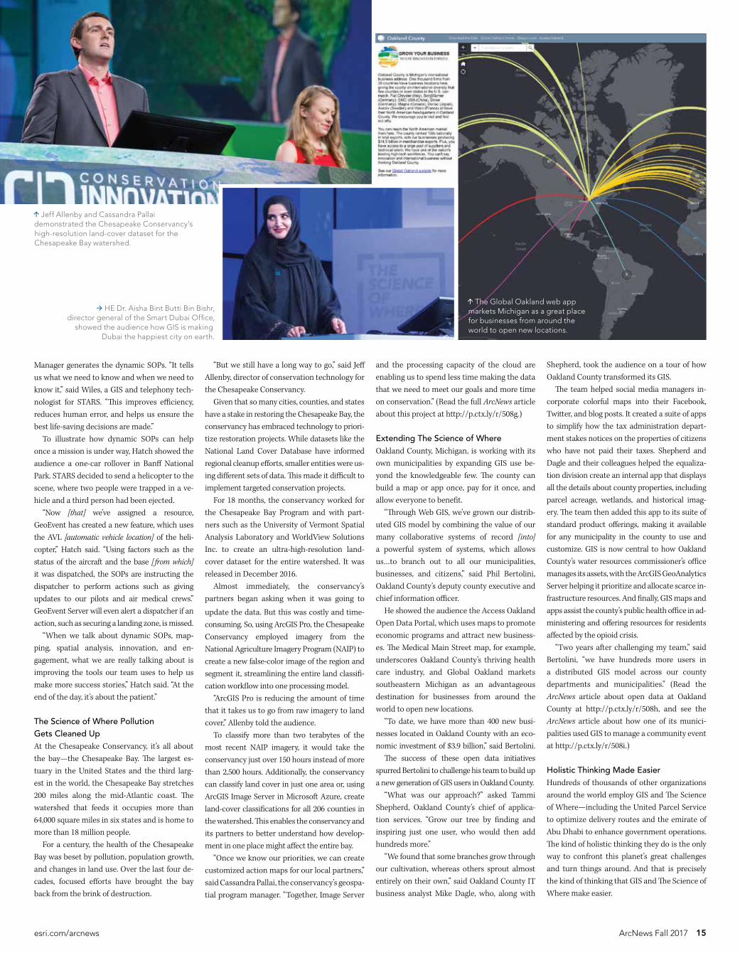
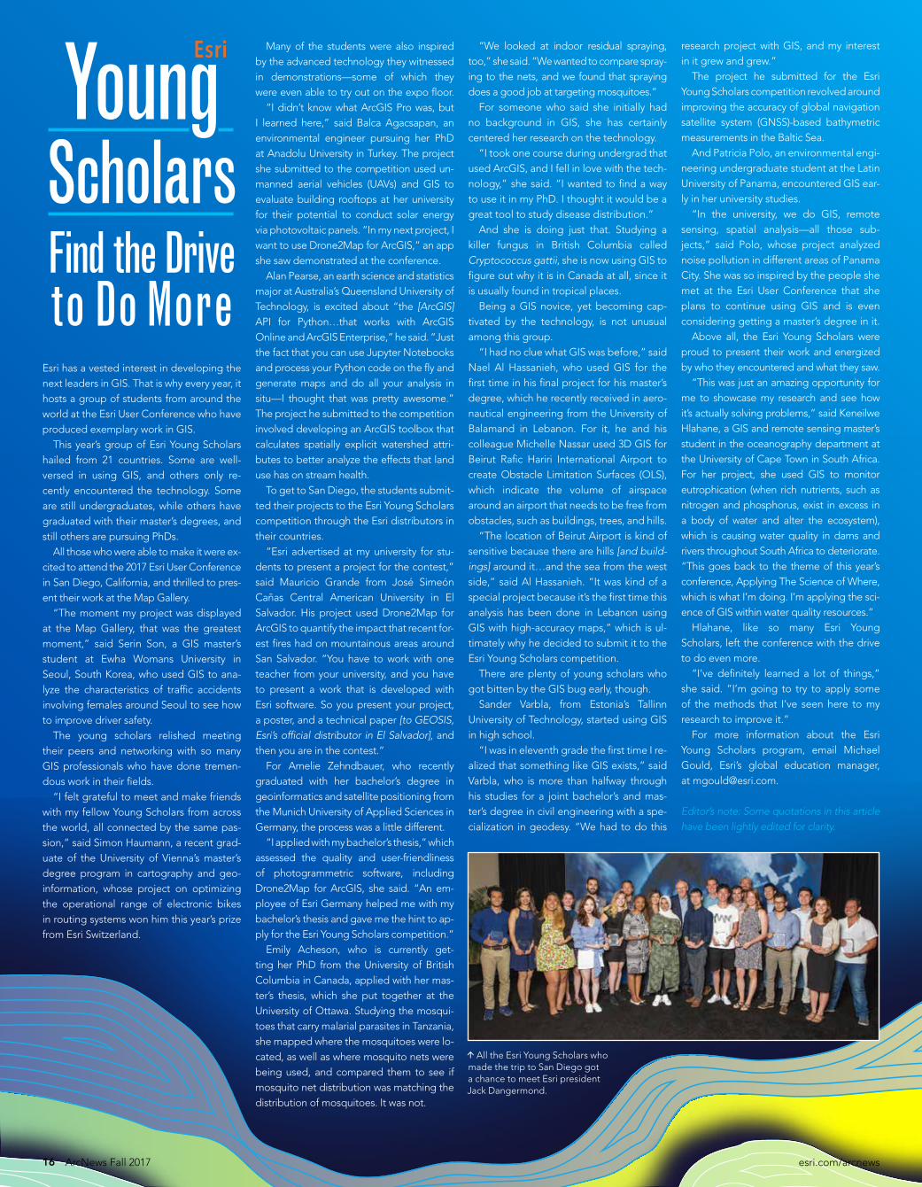
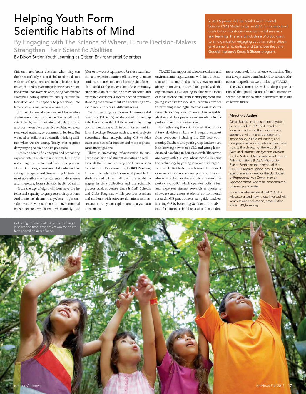
About the Author
Dixon Butler an atmospheric physicist is the president of YLACES and an independent consultant focusing on science environmental energy and space policy STEM education and congressional appropriations Previously he was the director of the Modeling Data and Information Systems division for NASArsquos Mission to Planet Earth and the director of the GLOBE Program (globegov) He also spent time as a clerk for the US House of Representatives Committee on Appropriations where he concentrated on energy and water
For more information about YLACES (ylacesorg) and how to get involved with youth science education email Butler at dixonylacesorg
YLACES presented the Youth Environmental Science (YES) Medal to Esri in 2016 for its sustained contributions to student environmental research and learning The award includes a $10000 grant to an organization engaging youth as active citizen environmental scientists and Esri chose the Jane Goodall Institutersquos Roots amp Shoots program
About the Author
Dixon Butler an atmospheric physicist is the president of YLACES and an independent consultant focusing on science environmental energy and space policy STEM education and congressional appropriations Previously he was the director of the Modeling Data and Information Systems division for the National Aeronautics and Space Administrationrsquos (NASA) Mission to Planet Earth and the director of the GLOBE Program (globegov) He also spent time as a clerk for the US House of Representatives Committee on Appropriations where he concentrated on energy and water
For more information about YLACES (ylacesorg) and how to get involved with youth science education email Butlerat dixonylacesorg
Helping Youth Form Scientific Habits of MindBy Engaging with The Science of Where Future Decision-Makers Strengthen Their Scientific AbilitiesBy Dixon Butler Youth Learning as Citizen Environmental Scientists
Citizens make better decisions when they can think scientifically Scientific habits of mind start with critical reasoning and include healthy skep-ticism the ability to distinguish answerable ques-tions from unanswerable ones being comfortable examining both quantitative and qualitative in-formation and the capacity to place things into larger contexts and perceive connections Just as the social sciences and humanities are for everyone so is science We can all think scientifically communicate and relate to one anothermdasheven if we arenrsquot Nobel Prize winners renowned authors or community leaders But we need to build these scientific thinking abili-ties when we are young Today that requires demystifying science and its processes Learning scientific concepts and reenacting experiments in a lab are important but theyrsquore not enough to awaken kidsrsquo scientific propen-sities Gathering environmental data and lo-cating it in space and timemdashusing GISmdashis the most accessible way for students to do science and therefore form scientific habits of mind From the age of eight children have the in-tellectual capacity to grasp research questions And a science lab can be anywheremdashright out-side even Having students do environmental citizen science which requires relatively little
( free or low-cost) equipment for close examina-tion and experimentation offers a way to make student research not only broadly doable but also useful to the wider scientific community since the data that can be easily collected and examined outdoors is greatly needed for under-standing the environment and addressing envi-ronmental concerns at different scales Youth Learning as Citizen Environmental Scientists (YLACES) is dedicated to helping kids learn scientific habits of mind by doing environmental research in both formal and in-formal settings Because such research projects necessitate data analysis using GIS enables them to conduct far broader and more sophisti-cated investigations There is increasing infrastructure to sup-port these kinds of student activities as wellmdashthrough the Global Learning and Observations to Benefit the Environment (GLOBE) Program for example which helps make it possible for students and citizens all over the world to engage in data collection and the scientific process And of course there is Esrirsquos Schools and Clubs Program which provides teachers and students with software donations and as-sistance so they can explore and analyze data using maps
YLACES has supported schools teachers and environmental organizations with instrumenta-tion and training And since it views scientific ability as universal rather than specialized the organization is also aiming to change the focus of most science fairs from identifying promising young scientists for special educational activities to providing meaningful feedback on studentsrsquo research so they can improve their scientific abilities and their projects can contribute to im-portant scientific examinations Strengthening the scientific abilities of our future decision-makers will require support from everyone including the GIS user com-munity Teachers and youth group leaders need help learning how to use GIS and young learn-ers need coaching in doing research Those who are savvy with GIS can advise people in using the technology by getting involved with organi-zations like SciStarter which works to connect citizens with citizen science projects They can also offer to help evaluate student research re-ports via GLOBE which operates both virtual and in-person student research symposia to showcase and assess studentsrsquo environmental research GIS practitioners can guide teachers in using GIS by becoming GeoMentors or advo-cate for efforts to build spatial understanding
17esricomarcnews ArcNews Fall 2017
more concretely into science education They can always make contributions to science edu-cation nonprofits as well including YLACES The GIS community with its deep apprecia-tion of the spatial nature of earth science re-search has much to offer this investment in our collective future
Collecting environmental data and locating it in space and time is the easiest way for kids to form scientific habits of mind
18 ArcNews Fall 2017 esricomarcnews
Crossing BordersA column by Doug RichardsonExecutive Director American Association of Geographers
New GIS Coding Initiative Engages Girls WomenWomen have come a long way in GIS since Mei-Po Kwan a professor of geography and GIS at the University of Illinois at Urbana-Champaign wrote her groundbreaking 2002 ar-ticle ldquoIs GIS for Womenrdquo In it she cites female GIS practitionersrsquo personal experiences in the vocation quoting one who said that a GIS lab felt like ldquothe domain of the white middle- to upper-class graduate geography studentsrdquo In a more recent study about the profession from 2016 GIS analyst Livia Betancourt Mazur and Hunter College professor Jochen Albrecht sought to find out with new data if wom-en are underrepresented in GIS In surveying almost 500 women in GISmdashasking questions such as Have you ever been the only woman in the room (at meetings events etc)mdashtheresearchers found that while women are not grossly underrepresented in GIS they are likely underrepresented in certain sectors and positions especially ones that require managerial or highly technical skills This suggests that Kwanrsquos question still resonates today It is within this context that the American Association of Geographers (AAG) is launch-ing a new initiative called Coding for Girls in GIS and Geography AAG has developed GIS coding curriculum and is planning a series of workshops on coding for girls and women beginning at the AAG Annual Meeting in New Orleans Louisiana in April and continu-ing throughout 2018 across the United States AAG is also working with its many interna-tional programs to set up similar initiatives around the world with workshops and webinars already scheduled for Ukraine and throughout Africa including in Cameroon Ethiopia Nigeria and South Africa Many AAG members and staff have strong experience and expertise in computer pro-gramming They have taught introductory and advanced GIS courses at universities or par-ticipated in college and high school mentoring programs to support and empower young women who are interested in STEM (science technology engineering and math) fields In fact AAGrsquos new Coding for Girls in GIS and Geography initiative is being coordinated by AAG senior researcher Dr Coline Dony who has worked for and recently spent the summer
with Girls Who Code a nonprofit that teaches computer science and GIS concepts to high school students Donyrsquos personal experience has motivated her to take on this initiative ldquoI was often the only woman in GIS courses that involved any programming and I want to change thatrdquo she said ldquoEnrolling for these courses should feel like the right choice for women in geography This initiative is about boosting womenrsquos interest in programming by teaching them how to create web-based geovisualizations and how to automate analyses of new sources of spatial data such as those from social mediardquo AAG looks forward to engaging with the broader geography and GIS communitiesmdashincluding other GIS organizations and the extensive GeoMentor network operated by AAG and Esrimdashto broaden the reach of Coding for Girls in GIS and Geography and create similar programs for high school students across the United States and around the world At AAG we are convinced that a more diverse geography and GIScience community will enhance our discipline and amplify our ability to understand and improve our world To make this happen we need to change the culture of our schools and workplaces to tap the talents of girls and women at an early age and prepare them with the computing and spatial thinking skills required to conduct cutting-edge research and land good jobs Gaining early access to these skills can help girls and women overcome stereotypes and lead to exciting opportunities around the world It will also infuse GIS and GIScience with new ideas perspectives and talent which can only propel these fields forward For more information on Coding for Girls in GIS and Geography or to participate in these events email AAG research associate Jolene Keen at jkeenaagorg
Contact Doug Richardson at drichardsonaagorg
Dr Coline Dony (far left) led a Girls Who Code Summer Immersion Program in Washington DC which National Public Radios lead developer Joanne Garlow (right) joined as a guest (Photo courtesy of Coline Dony)
Learn skills in demography online an understanding of principles of demography and measurement of population dynamics
the ability to use geospatial data and methods in diverse applied settings
the application of demographic tools in marketing planning public policy and research
the integration of theory data and method in the project development in applied demographics
Consider a 12-credit Graduate Certificate or 30-credit Master of Professional Studies in Applied Demography Now accepting applications for 2018
worldcampuspsueduadesri18-WC-0292bjhsss
2018
GIScience amp Technology at the AAG Annual Meeting
April 10-14 2018 | New Orleans
The American Association of Geographers Annual Meeting is an interdisciplinary forum where thought leaders and experts in GIS and geography intersect to build new partnerships and collaborations
Meet local and international colleagues Network and exchange ideas Discover topical publications Interact with state-of-the-art technologies
Donrsquot miss the French Quarter Festival happening during the annual meeting mdash non-stop music on the streets of New Orleans
raquo JOIN US IN NEW ORLEANSannualmeetingaagorg
PHOTOS COURTESY NEW ORLEANS CONVENTION AND VISITORS BUREAU PHOTO OF BRIDGE BY RICHARD NOWITZ
Following Ice Storm City Fixes Tree Hazards in Real TimeWith Custom-Made Web App Eugene Oregon Briskly Coordinates Field ResourcesBy Brian Richardson City of Eugene
On the night of December 14 2016 as an ice storm tore through Eugene Oregon the cacophony of fracturing and crashing trees was the call to action for Eric Cariaga the parks and open space technical specialist for the public works department at the City of Eugene ldquoIt was apparent early on that this was a dynamic stormrdquo recalled Cariaga who has worked at the city for 20 years ldquoI could tell by the sheer number of failing trees that this was going to be a major tree eventrdquo Ultimately more than 3500 trees were damaged mak-ing it the most catastrophic ice storm Eugene had expe-rienced in almost 55 years Calls from the public about downed trees and other storm-related problems began flooding the public works departmentrsquos phone lines It was going to require a team of more than 100 staff members from the public works parks and maintenance depart-ments to work together to clean up the mess Wanting to maximize efficiency for the 50 field response crews contractors and contract managers who were dealingdirectly with storm cleanup Cariaga used Web AppBuilderfor ArcGIS to create a web-based appmdashcalled the 2016 Ice Storm Hazard Tree Response appmdashthat could help emer-gency management staff in the office map and track the tree hazards This was then used in conjunction with Collector for ArcGIS to gather data in the field and Operations Dashboard for ArcGIS to keep track of real-time updates With chaos unfolding on the streets of Eugenemdashand 1700 storm-related work orders needing attentionmdashthe calls from the public were recorded in the Maintenance Management System (MMS) a custom-built app that re-sides in the cityrsquos relational database management system and then published as map services in ArcGIS Online The information then had to be scrutinized to ensure that it was accurate and not previously reported
ldquoIt was not too difficult taking the real-time information our dispatchers recorded from the public and creating both the desktop application and the Collector maprdquo said Cariaga He built several layers showing the work orders field crewsrsquo jurisdictional boundaries and tree speciesmdashwhich were particularly helpful to know since deciduous hard-woods are more prone to damage from ice storms than evergreen softwoods Cariaga implemented the layers into both the tree response app and Collector Out in the field contract managers and specialized tree care professionals called tree scouts used Collector to gath-er data on fallen trees and branches That information was seamlessly incorporated into ArcGIS Online and distrib-uted immediately to the tree response app and Operations Dashboard With this wide-reaching GIS field staff could see updates in real time and managers could keep close tabs on the storm response Additionally once field staff cleared a scene they could use Collector to find the nearesthazardmdashin real timemdashthat needed to be mitigated ldquoThis was incredibly valuable for our crewsrdquo said Cariaga ldquoThey could not only see the location of downed trees and limbs [but] they [also] had a good idea of the damage be-fore they arrived on-scene In most instances they knew if they were qualified to respond to a particular call and had the correct toolsrdquo In the office the real-time updates from the field were displayed in Operations Dashboard With constantly changing data coming in the self-updating charts gauges and histograms helped contract managers contractors and emergency command staff gain a holistic view of the tree hazards all over the city When field crews updated their work orders in Collector critical information about each hazard was automatically loaded into Operations Dashboard so everyone could see when a work order had
been completed and which resources needed to go where next Having this information available digitally on one map was far better than the old paper-based system in which field staff picked up work orders at the beginning of each weekmdashmaking it difficult to update the schedule with new information In the hours and days following the ice storm Eugenersquos public works staff investigated more than 1200 calls from the community regarding tree hazards Branches hung dangerously over streets and in parks and recording and mitigating the damage was an enormous task The highly skilled tree scouts continued to work me-thodically throughout the city First they canvassed prior-ity routesmdashhigh-traffic roadways and areas where there was more of a chance that falling trees could damage property or injure the public They then branched out to other areas of the city eventually evaluating every street park and trail in Eugene At each spot they recorded tree-related hazards in Collector Details included the severity of the hazardous conditions coordinates and photos With all this data available in ArcGIS Online Collector and Operations Dashboard technical staff in the City of Eugenersquos parks and open space department were able to document understand and analyze the hazardsmdashdetermining hot spots of storm-related destruction figur-ing out which tree species were most susceptible to ice storm damage calculating the average number of haz-ards each response team mitigated per day and more It also saved Eugene time when working with the Federal Emergency Management Agency (FEMA) to apply for re-imbursement for storm cleanup and other related costs ldquoThis storm response was by far the best Irsquove ever seen in my time at the City of Eugenerdquo said Cariaga ldquoWe were able to respond to calls quicker and with increased accuracy and efficiencyrdquo While the City of Eugene continues to implement GIS technology in more areas of servicemdashfrom tracking maintenance activities to maintaining and updating park assetsmdashCariaga doesnrsquot want to lose sight of the most important portion of the response the men and women who work out in the field They spent weeks identifying and clearing tree hazardsmdashremoving downed trees and branches from the entire right-of-way street system which includes all publicly owned streets ldquoThey truly [were] the stars of this recovery processrdquo said Cariaga ldquoWithout our field staff willing to go out in the rain snow or freezing temperatures none of this wouldbe possiblerdquo For more information about this project contact Brian Richardson the City of Eugenersquos public works publicaffairs manager at BrianJRichardsoncieugeneorusor 541-682-5523
20 ArcNews Fall 2017 esricomarcnews
On December 14 2016 a severe ice storm hit Eugene Oregon downing trees all over the city
21esricomarcnews ArcNews Fall 2017
Using the self-updating charts gauges and histograms in Operations Dashboard for ArcGIS both field and office staff could easily see which resources needed to go where
Eric Cariaga the cityrsquos parks and open space technical specialist built a web-based app that could map and track the tree hazards residents called in to the public works department
Using the app in Collector for ArcGIS field crews could see the location of downed trees and limbs and could get a good idea of the damage before they arrived on-scene
GIS Field Apps Keep Public Works Department Running Smoothly
For years Nacogdochesrsquo public works department used a combination of different software packages Microsoft Excel files and handwritten notes to keep track of the dumpster compactor and open-top trash can pick-ups it was responsible for Unsurprisingly this muddled system led to in-consistencies between the pickup schedule and billing To keep better track of the dumpsters and their collection timetables public works manager Cary Walker asked the engineering departmentGIS division to develop a system that would let the commercial front-load trash truck driv-ers know when and where dumpsters needed to be picked up each day Walker also wanted to be able to see the driversrsquo locations in real time so the depart-ment could dispatch them to extra dumpster pickups if they were in the area To meet both needs the GIS division chose to use Workforce for ArcGIS First the GIS division needed to locate all the dumpsters compactors and open tops in Nacogdoches Jose Olvera the sanitation supervisor used paper route sheets (which are just spreadsheets) of the driversrsquo routes to find every single commercial dumpster and record its GPS coordinates the collection pointrsquos address the building name the dumpsterrsquos size the ownerrsquos account number the pickup days and the order in which it was collected Although this was the best way to gather all this information it presented an additional challenge each route sheet showed the dumpsters
The City of Nacogdoches considered the oldest town in Texas has significantly expanded its GIS program over the last seven years Smart devices coupled with mobile solutions from Esrimdashsuch as Workforce for ArcGIS Collector for ArcGIS and Survey123 for ArcGISmdashhave enabled the cityrsquos engineering departmentGIS division to get its data out in the field and into the hands of the people who can make the most of it
The public works department has become one of the cityrsquos heaviest users of GIS Tasked with a range of undertakings from managing commercial dumpsters to issuing work orders for street sanitation and pothole maintenance the department wanted to move away from sluggish paper-based processes to app-centered workflows Building on its already robust use of the ArcGIS platform the GIS division made this digital transition easily and economically
that were picked up on a specific day so if a dumpster was picked up six days a week the GPS coordinates were recorded six times With help from the public works departmentrsquos office assistants however the GIS division was able to comb through the database to cross-reference the dumpster locations against billing statements and eliminate duplicate data Once the dumpster database was complete the GIS division automated the process of selecting the dumpsters compactors and open tops that had to be picked up on a given day sequencing the order in which they needed to be collected and uploading this information to Workforce It did this by first creating Python scripts to extract each dayrsquos routes from the database and put them into a CSV file and then uploaded the assignments to Workforce Now the scripts run each night and remove all the completed assignments before uploading the next dayrsquos routes When the commercial front-load drivers report for work the following morning they turn on their iPads and access Workforce to find out their pickups for the day In turn the public works departmentrsquos office assistants use the app to monitor the drivers as they go about their collection routes Immediately after Workforce was implemented the public works de-partment noticed that drivers were completing their routes faster and that the call volume from citizens with dumpster pickup issues had decreased
Automating Dumpster Pickup Assignments
With Workforce the public works department can keep better track of commercial dumpsters and their collection schedules and monitor driversrsquo locations in real time
Workforce for ArcGIS automatically selects the dumpsters that need to be picked up on a given day and sequences the order in which they should be collected
22 ArcNews Fall 2017 esricomarcnews
The GIS division at the City of Nacogdoches gets data into the hands of the people who can make the most of it
When commercial front-load drivers report for work each morning they turn on their iPads and access Workforce to get their pickup assignments for the day
23esricomarcnews ArcNews Fall 2017
To complete most of its work the City of Nacogdochesrsquo public works department relies heavily on 10 trucks 3 for collecting residential and commercial trash containers 3 commercial dumpster sanitation trucks 2 for picking up garbage from open-top dumpsters 1 yard waste truck and 1 for collecting brush To ensure that the department keeps these trucks in good working order Walker asked the engineering departmentGIS division if it could develop a new work order system to track vehicle maintenance requests While Walkerrsquos request wasnrsquot specifically grounded in geography the GIS division determined that Survey123 for ArcGIS would work well for this The team sat down with members of the public works department and vehicle maintenance group to figure out exactly what they wanted to track Using Survey123 the GIS division developed a simple survey that contained only fields that city personnel needed to seemdashsuch as the vehicle number the problem and the personrsquos contactinformationmdashto submit a work order to vehicle maintenance Then using ArcGIS Online the team added fields to the survey that only the ve-hicle maintenance department would be able to see such as the manufacturermod-el the status of the repair which parts were used and how long the repair took The sys-tem also keeps track of who creates a work order as well as each update to that work order so it is easy to see when a work order is submitted and when the repair is made Now personnel within the public works departmentmdashand throughout the City of Nacogdochesmdashcan submit vehicle main-tenance work orders using Survey123 The vehicle maintenance department can easily view and edit these work orders by logging in to ArcGIS Online and looking at the ve-hicle maintenance feature layer Data tab Finally city staff members no longer have to leave notes on their windshields requesting repairs or wonder why their vehicle is taking so long to fix
For 25 years the public works department in Nacogdoches had used paper forms to issue work orders The process was time-consuming A paper work order had to be created and delivered to the person who was going to complete it Then he or she had to bring it back to the office assistants when the work order was finished In addition to streamlining this process Walker wanted to be able to monitor when and where work orders were completed Specifically he wanted a customized app that could track requests to fix potholes trim city-managed bushes and clean up leaves repair and replace street signs collect garbage and fix or change out residential trash containers Walker wanted each type of work order to have its own symbol so it would be easy to look at a map and instantly know what the work or-ders were for He also wanted to maintain an archive of completed work orders for future reference The Nacogdoches engineering departmentGIS division knew that Collector for ArcGIS would satisfy these requirements Since maintenance was being done on the cityrsquos main enterprise geoda-tabase the GIS division began by creating a new enterprise geodatabase that contained dumpster accounts warnings for dumpster drivers such as low overhead power lines and trees and current and archived work orders The team also shared a map of addresses streets city utilities rights of way and work orders as a feature service Using ArcGIS Online the division then developed an app called the Public Works Work Order System that the office assistants could use to assign work orders to field crews The app also allows other departments within the city to submit work orders Using Collector on their iPads crew members out in the field can see when they get assigned a new work order and if possible head straight to the issue to fix it Once a crew member marks a work order as complete Collector archives it so it is accessible via the Public Works Work Order System app Since the public works department integrated Collector with the Public Works Work Order System app a year and a half ago the City of Nacogdoches has reaped quite a few benefits Work orders are easier to track and field crews are more efficient by knowing where their work orders are located and who they will be doing a job with Additionally by tracking pothole locations for a full year the city was able to easily verify which streets needed to be repaired It is currently tracking storm drain repairs as well to determine which ones will need to be replaced soon
Receiving Work Orders in the Field Keeping Track of Vehicle Maintenance Requests
The public works office assistants use ArcGIS Online to assign work orders to field crews
The team was also able to add fields to the back end of the survey that only the vehicle maintenance department could see and use
With Collector for ArcGIS crew members out in the field can see when they get assigned a new work order
After tracking pothole locations for a full year the City of Nacogdoches easily verified the streets that needed to be repaired
With Survey123 for ArcGIS the GIS division built a survey that contained only the fields needed to submit a work order for vehicle maintenance
Saving Time and Money
Giving employees in the public works department such wide-ranging access to enterprise GISmdashespecially via apps they can use in the fieldmdashhas been a boon for the City of Nacogdoches ldquoThese applications have saved the city from purchasing outside software packages and have saved time and money on a daily operational basisrdquo said Steve Bartlett a city engineer For more information on how the City of Nacogdoches uses GISmdashin the public works de-partment and beyondmdashcontact Tred Riggs the cityrsquos engineering technician supervisor atriggstcinacogdochestxus or 936-559-2519
ArcGIS Online Keeps Blazing TrailsA Deeper Look at Recent Improvements to ArcGIS Online
Three new features in Scene Viewer bring 3D scenes to the next level First a new elevation mode called Relative to scene automatically selects the highest posi-tion of all layers to ensure that users can clearly see points that overlap with objects For exam-ple in a web-based tourist scene that has both a 3D building layer and point layers that mark popular tourist locations using the Relative to scene elevation mode will place the points on top of the buildings so they show up cleanly The second feature is the Callout option which lifts icons above the buildings they mark and draws a vertical callout line below to help users identify exactly which location an icon re-fers to This can be especially helpful for points that are located on the ground between build-ings since they would otherwise be occluded
Third is the new Declutter setting For scenes that have many overlapping points it automati-cally cleans things up by hiding point layers that overlap For example a scene of art galleries in New York City would be littered with overlap-ping points since there are so many of them and a lot of them are located close together Using the Declutter setting however provides a clean viewing experience as fewer points are show-cased on the full scene When a user zooms in to a specific area though all points become visible Smart mapping has new 3D capabilities with-in Scene Viewer as well Users can now stylize buildings with colored and gray-scale textures use the Counts amp Amounts style to drive color ramps (showing energy use from high to low for example with dark blue indicating high use and light blue signifying low use) and employ the types style to assign a different icon or symbol to each attribute value (a green circle to indi-cate parks and a purple square to signify com-mercial buildings for instance) Users can also now create hosted feature layer views to generate multiple views of their datamdashwith different styling sharing and edit-ing permissionsmdashwithout having to duplicate their data It is also possible for users to define what data is visible by creating a view definition based on features or fields Map Viewer now makes it easier to run the same (or similar) analysis over and over It au-tomatically saves analysis input parameters in the results layer so users can just click the new Rerun Analysis button to update the analysis with the most recent data The button also works to keep live data feeds current Just
update the input layer before clicking it and everything stays up-to-date Additionally us-ers can employ the Rerun Analysis function to share the steps of an analysis along with the re-sult When others receive the dataset they can use the Rerun Analysis button to open the tool pane view the parameters used to create the result and rerun the analysis themselves
With each new release ArcGIS Online gains advanced capabilities and fresh content Thanks to input from users about what they need most from the technology Esrirsquos team of developers is able to continually infuse ArcGIS Online with improvements that make it easier to use and simpler to navigate
Dive a bit deeper into some of the more recent improvements to ArcGIS Online and see what this integral part of the ArcGIS platform is capable of
New Capabilities
The Esri World Geocoding Service which has exceptional coverage accuracy and flex-ibility now supports address-level geocoding in 135 countries In addition the reference data for most countries has been updated and new authoritative address data sources were added for Australia ( from PSMA Australiarsquos Geocoded National Address File or G-NAF) and Austria ( from BEV the Federal Office of Metrologyand Surveying) Now even poorly formatted addresses can yield the correct match For example the Esri World Geocoding Service can decipher most misspellings as well as extra non-location-based information (such as a homeownerrsquos name) and identify the appropriate coordinates
The new Callout option in Scene Viewer lifts icons above the buildings they mark and draws a vertical callout line below
With Counts amp Amounts users can
drive color ramps that show energy use from high (dark blue) to low
(light blue)
The new Rerun Analysis button makes it easier to run the same analysis more than once
24 ArcNews Fall 2017 esricomarcnews
25esricomarcnews ArcNews Fall 2017
Even with the profusion of feature layers apps and basemaps already available in ArcGIS Online Esri keeps adding more The Living Atlas of the World contains two new basemaps World Imagery (Firefly) and World Imagery (Clarity) Currently in beta these are both alternative views of the World Imagery basemap The Firefly basemap is dark and desaturated to ensure that the data presented on top of it pops It is best paired with a single glowing thematic layer to easily capture a viewerrsquos interest on a focused topic such as weather phenomena which benefits from the drama and spatial context of imagery but is sometimes better represented by reduced-color imagery The Clarity basemap is intended to be used when it is more important to get a clear view of a place than to present the most recent imagery of that location (the latter being the default for World Imagery) For instance if the most up-to-date imagery of New York City has a cloud over Times Square but a user really needs to show the streets that make up Times Square he or she could employ the Clarity basemap to get a slightly older version of the imagery that doesnrsquot contain the clouds The World Imagery basemap has a wealth of new content as well Thanks to Esrirsquos ongoing partnership with DigitalGlobe developers have been able to update the World Imagery basemap with new high-resolution imagery for Afghanistan Alaska Austria Canada Colombia Germany the Netherlands New Zealand Spain Suriname Turkey and other places Several dozen metro areas have also been updated with submeter-resolution imagery Esri has improved its demographic maps for the United States and a number of other countries as well For the United States Esrirsquos demographic maps now feature the latest 2017 current-year estimates and 2022 five-year forecasts based on census and American Community Survey (ACS) data Esri partner Michael Bauer Research has also released updates for more than30 countries including China India Japan Kazakhstan Israel and the United Arab Emirates Additionally the 2010 US Census demographic data is available for free in the Living Atlas of the World
To help users who have multiple accounts for ArcGIS Online and Esri websites Esri introduced Switch Accounts which links them Now it is easier to toggle among ArcGIS Online accounts and Esri web-sites including My Esri Technical Support and GeoNet ArcGIS Online accounts that use the same login (a social or enterprise login for example) are automatically linked with Switch Accounts where-as ArcGIS Online accounts with different logins allow users to link their accounts from the Switch Accounts panel With this users can stay signed in choose to sign out of the current account or opt to sign out of every linked accountmdashall in one place The contents and privileges associated with each account remain independent and separate completely unaffected by the linking Users can also launch web apps directly from ArcGIS Online by clicking the Apps button on the right-hand side of the header on the home page Once an app is selected it will open in a new browser tab Additionally when users sign out of ArcGIS Online in one tab they automatically get signed out of ArcGIS instances open in other tabs
Working together just got a whole lot easier As part of an early adopter program users can now share content between their ArcGIS Online organizations and ArcGIS Enterprise 1051 portals These new distributed collaboration capabilities in ArcGIS Online allow organizations working in both online and on-premises systems to establish a trusted environment with defined rules for sharing maps layers and files The data stays in sync using item and data replication
Improved Navigation
More Content
Distributed Collaboration
For more information about whatrsquos new in ArcGIS Online visit the ArcGIS Online blog at goesricomblogs Esri also invites all users to share their product enhancement ideas at goesricomideas
Early adopters can now share content between their ArcGIS Online organizations and ArcGIS Enterprise 1051
The dark and desaturated Firefly basemap ensures that the data
presented on top of it pops
Web GIS for Staff and the PublicWith a population of 81000 thatrsquos growing at a steady rate the City of Medford Oregon needed a new way to provide city staff and residents with access to public land information So the cityrsquos GIS team collaborated with VESTRA Resources Inc (vestracom) to replace its existing app with one that leverages Web GIS via the ArcGIS platform The Medford Land Information (MLI) app is a modern mostly out-of-the-box solution that empowersdecision-making and fosters collaboration within the city as well as with the public It contains information about building permits occupational licenses planning and zoning code enforcement infrastructure aerial photos of the entire city and more The app aggregates data from multiple servers and puts it in one location To bridge the gap from the old unsupported system to the new technology VESTRA migrated the cityrsquos highly customized Microsoft Silverlight app to JavaScript using ArcGIS API for JavaScript and implemented the new MLI app in ArcGIS Online VESTRA also used Web AppBuilder for ArcGIS to create custom widgets that mirror some of the functionality of the older app such as advanced querying reporting capabilities and the ability to access the cityrsquos land information from the IBM iSeries (AS400) server where it is stored Requiring minimal to no training MLI allows citizens and businesses to easily wield the same public-record information as city staff Users can find a wealth of information about each parcel in the city including land value the year any structures were built and the zoning and fire districts They can also use MLI to answer spatial questions such as Which ward do I live in and What elementary school serves this area Having all this information available to the public has substantially reduced the number of calls the City of Medford receives from citizens which has helped staff save time reduce costs and be more effective overall Additionally in allowing Medfordrsquos citizens to easily visualize this information on maps the city is keeping them informed and engaged with their community
Move to Mobile Hits the MarkHydro One which has served Ontario Canada since the early twentieth century faces a constant challenge finding innovative ways to increase the performance of its vast electricity system while reducing costs and keeping safety the number-one priority As the owner of 97 percent of the transmission network in Ontario Hydro One needed to move away from antiquated paper-based processes that limited access to information led to questionable data integrity and required months to make simple updates Linemen for example could only carry maps of their operational areas in their trucks meaning that if there was an incident in another jurisdiction those maps would be useless ldquoWe needed a new way to connect our offices to the field forces and vice versardquo said Brad Bowness vice president of distribution at Hydro One The solution was to implement Move to Mobile (M2M) which tightly integrates Hydro Onersquos SAP Enterprise Asset Management system and SAP Work Manager (a scheduling software) with Lemur from Critigen(critigencom) Running in the ArcGIS platform Lemur automates the process of sending updated map data to field crewsrsquo tablets ldquoCritigen helped us put ArcGIS in the fieldrdquo said Janice Coulson Hydro Onersquos project team lead on the M2M project ldquoField crews receive up-to-date cached map data for their region If an incident occurs in another region they can access that regionrsquos data to respondrdquo Getting field data back into the office is easy too ldquoAs line maintainers complete their work in [SAP Work Manager] our business processes are maintaining that asset information both on the SAP side and in the enterprise GISrdquo explained Coulson With truck locations now visible to schedulers dispatch can quickly notify the nearest crew member to respond to an outage or emergency At the same time crews can submit new issues they encounter while in the field or make the decision to address these problems on the spot ldquoTheyrsquove never had that visibility before and they are taking ownership of the processrdquo said Coulson By integrating these best-in-class technologies Hydro One replaced more than 40 paper forms modernized its scheduling methods and gave linemen real-time access to up-to-date SAP data and GIS maps Moreover using Lemur to automate the extent and frequency of map cache updates lowered the demand load on Hydro Onersquos server architecture reduced data entry time from an upper end of 180 days to 4 or 5 days and greatly improved the integrity of field submissions ldquoWe have successfully integrated both SAP Work Manager and GIS into one systemrdquo said Bowness ldquoWe are already realizing productivity savings as a result of the M2M and I am confident this will be a powerful tool for Hydro One business operationsrdquo
26 ArcNews Fall 2017 esricomarcnews
ESRI PARTNERS
Share Data for Better ResultsEquipped with innovative ideas industry expertise and the ArcGIS platform Esri partners are implementing enterprise GIS that keeps workers safe increases efficiency and saves on costs
Find out how the following four Esri partners are making organizations and communities smarter by giving more people access to a wide range of geospatial information
With Critigenrsquos Lemur schedulers can see crew locations in the SAP Work Manager map view and share them with dispatch so dispatch can notify the nearest crew member of an outage or emergency
Citizens businesses and city staff can use the Medford Land Information (MLI) system to search for information about county parcel taxes sales and details as well as to view parcel maps
Lemur allows users to configure the GIS to cache specific map layers for offline use in the field as well as update the frequency and extent of coverage
Collaborating to Curb HomelessnessIn 2014 the City of Tacoma Washington began working with community partners to address issues related to mental health substance abuse and homelessness After soliciting community feedback the city partnered with Comprehensive Life Resources (CLR) a nonprofit organization that offers mental health homeless hous-ing and other human services to residents in and around Tacoma One of CLRrsquos programs called Positive Interactions assists local businesses in addressing concerns related to homelessness and blight Tailored to fit the needs of both businesses and individuals experiencing homelessness Positive Interactions operates a response line that business owners and community members can call to express their concerns about homeless activity in their areas CLR field crews then engage directly with the homeless indi-viduals in a way that is sensitive to the traumas they have faced to learn their needs and connect them with services To get Positive Interactions started CLR employees collected field data about businesses and Tacomarsquos homeless population on paper and then completed fillable forms in Microsoft Word once they got back to the office It was common to have lapses in time between interacting with homeless individuals and submit-ting the forms which often resulted in lost or inaccurate data CLR also needed to record spatial information analyze data track time and resources and create reportsmdashbut it couldnrsquot do any of this easily So CLR approached Frontier Precision ( frontierprecisioncom) which suggested that the organization employ Survey123 for ArcGIS on employeesrsquo phones and tablets to gather data in the field Since nobody at the nonprofit had experience with GIS CLR had Frontier Precision assist in configuring deploying and managing the survey and the data CLR deployed the digital survey in September 2016 and since then employees have submitted almost5000 surveys With so much data CLR can analyze it to find trends and patterns in where homeless activity takes place how homelessness changes during different seasons and how demographics factor in Now man-agement can better deploy field crews to areas with high levels of homeless individuals And crew members can view prior surveys to figure out if the homeless individual they are about to visit has been contacted before and follow up with him or her on services that were previously offered After Frontier Precision demonstrated how helpful GIS is and how easy it is to use CLR fully embraced the tech-nology by deploying it across the organization in several different programs Starting this year CLR will have a pub-lic resources locator that will help members of the community and case workers find housing financial and legal services for those in need Additionally CLR will employ Survey123 for data collection related to its gang reduction project its mobile community intervention response team and for foster care case management
Speeding Up Work and Response TimesDenton Municipal Electric (DME) has been serving the Greater Denton Texas area for more than 100 years To continue to provide effective and efficient utility services the company needed to replace older technology with new systems that would help improve response times increase reliability and ensure crew safety ldquoBecause DMErsquos systems operations group manages all outages and crews as they respond to incidents in-tegrating our data systems [into] a common platform is becoming very important as we growrdquo said Trey Price engineering systems applications supervisor for DME ldquoTwo years ago we determined our old archaic system was crashing too often unable to deliver accurate GIS information to crews and was a cybersecurity riskrdquo To improve productivity and data integrity amalgamate dispatching and work assignments in one sys-tem obtain real-time visibility into field activity and help crews quickly and safely get to their assignments DME partnered with Clevest Solutions Inc (clevestcom) and implemented the Clevest Mobile Workforce Management system which is fully integrated with the ArcGIS platform DMErsquos project required a configurable utility-wide system for managing work the ability to create and adminis-ter work orders for various citywide calls for service about water and wastewater locating electric and fiber-optic service lines and to repair or replace meters and city assets such as poles or streetlights and new ways to integrate multiple systems used to manage everything from customer information assets maintenance and outages to GIS and 811 (the call-before-you-dig line) The utility also needed a way to handle ticketing for non-customer calls such as those to report leaks from services DME doesnrsquot handle both at the office and in the field The Clevest Mobile Workforce Management solution lets DME provide mobile service outage and lo-cate orders And all this is integrated with ArcGIS Enterprise and ArcGIS Online as well as ArcGIS Network Analyst Office employees use Clevest WorkSpace on their desktop computers while staff in the field access a mobile app called WorkBook on their smartphones or tablets ldquoThe real-time map view allows us to instantly filter such items as electric orders outages locates and street-lightsrdquo said Price ldquoIf I am in the office I can see where the crews are whatrsquos been assigned and what they are work-ing on If I am a crew member I can see what is assigned to me and prioritize my work In addition to accurate GIS information regarding the work location I can now pull up account information related to that locationrdquo So far the feedback about M2M has been positive with office staff and field crews finding the Clevest solu-tion easy to use and informative Price said that DMErsquos response times are speeding up as well ldquoWe expect the improved response times and faster power restoration to boost customer satisfactionrdquo said Price ldquoBy unifying our workflow around a paperless system we are reducing operational costsrdquo
Esris global partners provide customer-focused geoenabled solutions that span dozens of industries Products and services range from configured apps and custom-built solutions to complete ArcGIS system implementations and content Search and discover partners solutions and services at esricompartners
27esricomarcnews ArcNews Fall 2017
The real-time map view in the Clevest Mobile Workforce Management solution allows employees at Denton Municipal Electric (DME) to instantly filter items such as electric orders outages and locates
With Clevest Mobile Workforce Management field staff at DME can access the WorkBook mobile app on their devices
Using Survey123 for ArcGIS CLR easily arranged to have trash left behind by homeless individuals cleaned up so that local businesses could operate as usual
With almost 5000 surveys submitted Comprehensive Life Resources (CLR) can now analyze its homelessness data to find trends and patterns
28 ArcNews Fall 2017 esricomarcnews
With Street-Level Imagery Property Reappraisals Go VirtualEsri Startup Partner Mapillary Helps County in Ohio Simulate Site Visits
New businesses that join the Esri Startup Program receive on-line services software content training and support so they can incorporate mapping and location analytics into their products Mapillary a Swedish startup that wants to map the world us-ing street-level images has been in the program for three years In that time Esri has relayed deep technical knowledge of the ArcGIS platform and helped connect this GIS newcomer with all the right industry touchpoints Recently Mapillary teamed up with Esri partner Bruce Harris amp Associates Inc (BHA) to help Erie County Ohio improve how it con-ducts recurring property reappraisals on a small island in Lake Erie
A Digital Geospatially Integrated WorkflowLike most counties in the United States Erie County is required to conduct property reappraisals every six years On Kelleys Island located about four miles off the mainland in the western basin of Lake Erie staff members from the county auditorrsquos office were doing property inspections using paper maps and printed property records Because the appraisals required checking the grade and condition of all county buildings on the island audi-tors had to visit every single site Even though the island is just over four square miles in size this workflow took up a lot of time was too prone to human er-ror and was difficult to replicate every six years So Erie County sought to improve how it conducted fair and equitable property assessments The GIS team at the auditorrsquos office opted to set up a digital geospatially integrated workflow First the county worked with consulting firm BHA to imple-ment its Paperless Reappraisal System (PRS) a set of apps that uses ArcGIS for Local Government solutions and ArcGIS Online to make the entire reappraisal processmdashfrom data collection and review to quality control and workflow managementmdashdigital
PRS works directly with Erie Countyrsquos GIS by linking appraisers to county land records and up-to-date georeferenced information Still the county wanted to be able to simulate the site visits required to check the building grades and conditions To make that happen BHA partnered with Mapillary to use its street-level imagery and computer vision capabilities in conjunction with BHArsquos own PRS Photo Reviewer app Combining geography auto-mation and advanced analysis techniques Mapillaryrsquos imagery platform automatically turns 2D photos into 3D street views by stitching images together at points that match up recognizing objects in the images and generating map data such as street signs road characteristics and building types Thus whereas BHArsquos app provided useful oblique imagery of Kelleys Island Mapillaryrsquos addition of a street-level angle gave the county the vantage point it needed to fully simulate site visits This integra-tion was cost-effective and sped up the appraisal workflow
Giving Field and Office Staff the Same ViewpointTo carry out the reappraisals Mapillary personnel and BHA staff along with Erie County auditor Richard Jeffrey and his staff equipped a county vehicle with four action cameras (which are small lightweight and splash-proof) to capture street-level im-agery of the entire island Photos were taken over a span of eight hours They were then uploaded to Mapillary which scrubbed the images to remove faces and license plates point matched them and stitched them together to create the street-level viewpoint Back at the office BHA staff verified parcel characteristics such as assessed building grades property condition and con-struction materials Staff from the county auditorrsquos office viewed all the work via the PRS Photo Reviewer app with Mapillaryrsquos in-tegrated photo viewer capabilities Using the app with Mapillary allowed Erie County office em-ployees to see the appraisal process through the eyes of field staff And having a street-level vantage point to verify appraisal data en-sured that property assessments were accurate and up-to-date
ldquoHaving this imagery integrated in our apps to use at any time [is] invaluablerdquo said Mark Wroblewski the GIS coordinator for the Erie County Auditorrsquos Office ldquoThe ability to seamlessly collect imagery at any time without contracts or expenses [is] another return on the investment for Erie Countyrdquo
Collaboration Leads to Smooth CompletionLeveraging Mapillaryrsquos technology along with software from Esri and BHA provided Erie County with street-level imagery that met its assessment needs The resolution and quality of photosmdashall tak-en by staff while driving the streets of Kelleys Islandmdashexceeded the countyrsquos expectations The photos effectively supplement the coun-tyrsquos workflow for checking the grade and condition of any building And because the imagery is integrated with PRS using Mapillaryrsquos API county staff can navigate from parcel to parcel smoothly With this street-level imagery and its metadata appraisal managers and county constituents can now see information that Erie County previously had to attain by making site visits to each individual property Additionally data entry teams can use the always-available imagery to ensure the quality and consistency of building characteristics Overall the integration saved the county time and money Thanks to this collaboration between a young startup and a vet-eran Esri partner Erie County is on track to meet its sexennial reappraisal mandate
Having a street-level vantage point from which to verify appraisal data ensures that Erie Countyrsquos property assessments are accurate and up-to-date It took eight hours for this crew to capture photos of the entire
island that could be used in Mapillary
Web-Based Apps Help Agricultural Producers Consumers Digest InformationCanadian Governmentrsquos Agriculture Department Develops Self-Serve Map- and App-Building Platform Using ArcGIS Online
The agricultural industry is facing unique agronomic economic and environmental challenges and opportunitiesmdashfrom extreme weather events and new invasive species to growing global compe-tition Consumer expectations are evolving as well Canadians are demanding more variety and convenience from their food as well as environmental friendliness and assurances of quality and safety Producers are looking for novel products and processes to help them meet the demands of these new markets while also ensuring that their operations are competitive and sustainable Agriculture and Agri-Food Canada (AAFC) a government orga-nization that aims to drive innovation and ingenuity in Canadarsquos agriculture and food industries determined that one of the best ways to help the sector develop sustainably is to give as many organizations and people as possible the ability to visualize and effectively leverage the wealth of informationmdashfrom crop den-sity and soil moisture to farm locations and agri-environmental indicatorsmdashthat is available to support decision-making in the industry today Using ArcGIS Online AAFC is making that possible Two years ago the organization opened up its ArcGIS Online organizational account to almost 180 departmental users Called UMAP this AAFC-branded cloud-based portal enables these users to employ a wide range of agricultural data to create interactive web maps and apps for their colleagues food producers and the public
A Self-Serve Geospatial DestinationWhen this project started AAFC had limited resources So it wanted a solution that would require little in-house development and that would get the department up and running with making its own maps and apps quickly The solution also needed to meet security requirements and integrate data according to govern-ment standards As a heavy user of the ArcGIS platform already AAFC saw that ArcGIS Online met these requirements Using it would give the team a secure software-as-a-service (SaaS) cloud-based plat-form that is hosted and supported by Esri ldquoWe found the SaaS model very attractive because it meant that we could operate with a small server footprintrdquo said James Ashton AAFCrsquos geomatics applications manager In other words the organization could focus on using the software rather than building it and maintaining the infrastructure
Now UMAP is a self-serve geospatial destination that AAFC staff can use to mash up key organizational information layersmdashsuch as annual crop inventories and historic yield and production statisticsmdashwith interoperable data from other organizations and third parties like Esri They can then use this data to create intel-ligent web maps that can be shared with specific interest groups or departments Employees can also build on work previously com-pleted by colleagues and share new results across the enterprise Whatrsquos more employees designated as publishers can host their own nonsensitive data in the cloud and create their own map services by converting CSV files into shapefiles to web en-able them for ArcGIS Online UMAP administrators monitor credit usage across the organization as well and choose which data to make public or keep private ldquoThe platform transforms our datasets into ready-to-use web re-sources that serve as powerful tools to communicate complex infor-mation in a very simple wayrdquo said Ashton ldquoIt significantly reduces confusion about where to access organizational maps and the need for departments to contact each other for information This also re-duces the number of requests received by our help deskrdquo The UMAP home page has a customized banner featured con-tent and links to training videosmdashall of which align with brand-ing and objectives
Disseminating Geospatial Data EfficientlyTo make it easier to get data and apps to outside organizations and producers AAFC also populated a public-facing app gallery with popular web apps ldquoThe demand for information is always increasing and wersquore seeing a much broader range of potential usersrdquo said Ashton ldquoBy leveraging a more efficient and cost-effective approach to dis-seminating geospatial data we continue to transform ourselves into a knowledge-based department where we [employ] geospa-tial information in our decisionsrdquo Two of the public-facing web apps that AAFC staff recently devel-oped and shared are the Annual Crop Inventory app and the Land Use app The Annual Crop Inventory app allows users to quickly ana-lyze and visualize field-level cropping patterns (ie an overview ofwhat has been planted on farmland before) across Canada The Land Use app enables users to analyze changes in land use throughout thecountry between 1990 2000 and 2010 If a producer is interested in
renting farmland for example he or she could use these maps to see which crops have been planted in previous years That way the pro-ducer can make the most effective and environmentally conscious decision about which land to farm and what to cultivate on it ldquoA picture is worth a thousand wordsrdquo said Ashton ldquoMaps help us visualize the information we collect and that [the Science and Technology Branch at AAFC] creates This in turn helps us ask better questions and make better decisions Imagine how a farm-er or policy maker could benefit from simple web-based access to open datasets on changes in land use such as crop rotations or the environmental impacts of droughtsrdquo AAFC uses Esri templates such as Compare Maps and spe-cialized Canadian federal government ones to build the apps quickly and in compliance with accessibility and common gov-ernment branding requirements By using ArcGIS Online in con-junction with templates some appsmdashlike the Spatial Density of Major Crops in Canada appmdashhave taken only an hour to deploy In addition AAFC registers its data web services and apps to the Federal Geospatial Platform (an internal government portal) and the public-facing Canadian Governmentrsquos Open Data Portal By doing this it ensures that these portals point back to AAFCrsquos services giving more peoplemdashboth internally and externallymdashaccess to the organizationrsquos data
Enabling Better Decision-MakingBy using the ArcGIS platform to better inform internal staff ag-ricultural producers and the public AAFC is ensuring that more people can visualize and leverage the myriad information the department receives meeting both consumer expectations and producer needs AAFCrsquos maps and apps are informing policy makers on a global scale from grain brokers looking for new cereal sources to real estate scouts seeking new investment opportunities Now they can all see where specific cropping trends like monocrop-ping are occurring and where forest or urban expansion are tak-ing place Using web maps the department can share its data broadly and cost-effectively allowing policy makers to easily col-laborate in finding solutions to ongoing challenges For more information contact Gordon Plunkett the spa-tial data infrastructure (SDI) director for Esri Canada atgplunkettesrica or 613-683-6213
Having rapid visualization of field-level cropping patterns across the Canadian landscapemdashall in one browsermdashgives powerful web analytics and visualization to the agriculture industry
Using one of AAFCrsquos web apps such as the Spatial Density of Major Crops app researchers and the public can analyze the density of crops across Canada
29esricomarcnews ArcNews Fall 2017
MapLogicMap book solution for ArcGISreg
Download a fully unlocked evaluation version and try it out for 30 days
wwwmaplogiccom407-657-1250 bull salesmaplogiccom
bull A complete map book in a single MXDbull Multiple layouts in ArcMapbull Automated street indexing
Take your map book creation to the next level
wwwjunipersyscom
The unbeatable rugged tablet amp sub-meter GNSS
receiver mapping solution for Esrireg ArcGISreg apps
SIMPLE RUGGED RELIABLE
30 ArcNews Fall 2017 esricomarcnews
Restoring a Watershed One Bag of Litter at a TimePrince Georgersquos County Uses Survey123 for ArcGIS to Meet Waste Reduction Targets
Throughout the mid-Atlantic region of the United States ldquoSave the Bayrdquo bumper stick-ers and signs adorn cars and store windows They refer to the Chesapeake Baymdashthe larg-est estuary in the countrymdashwhich stretches 200 miles and receives runoff from a vast wa-tershed that contains about 18 million people Unsurprisingly the Chesapeake Bay faces con-siderable pollution issues Prince Georgersquos County located just outside Washington DC sits in the bayrsquos smaller Anacostia River watershedmdashone of the most densely populated watersheds in the Chesapeake Bay drainage basin With900000 people occupying almost 500 square miles of cities suburbs and farms the countyis especially concerned about storm water run-off polluting its waterways Littermdashwhich often gets washed up in storm drains and transported to local lakes and streamsmdashis one of the most persistent pollut-ants in the county Not only an unsightly blemish on the landscape this garbage carries additional toxins into the bay that affect biota the chemical makeup of the water and drainage outlets ldquoWe were constantly asked the question Where is this litter coming fromrdquo said Tiaa Rutherford Prince Georgersquos Countyrsquos litter re-duction program manager ldquoAs a county we could not answer that questionrdquo To keep the local bay tributaries and com-munities clean and beautifulmdashand to help protect the 43 fish species and 200 bird species that live in the Anacostia River watershedmdashthe Prince Georgersquos County Department of the Environment (DoE) launched a mobile app to track litter Built with Survey123 for ArcGIS the app called PGCLitterTRAK allows county residents community organizations and busi-nesses participating in cleanup activities to use their smartphones to quickly record informa-tion about the trash and debris they collect
ldquoUsing Survey123 we developed a simple tool that empowers people doing cleanup work to report back to us on the quantity and location of litterrdquo said Rutherford
Measuring Litter Pickup ProperlyIn 2010 several state and federal environmental agencies as well as local and county govern-ment departments drafted an interjurisdic-tional trash cleanup blueprint for the Anacostia River To satisfy federal water quality standards it mandated that Prince Georgersquos County re-duce the amount of garbage in the watershed by 170628 pounds per year Prince Georgersquos County was already using ArcGIS to show how it was meeting its trash reduction targets But data collection and documentation were off Only certain types of refuse picked up in specific watersheds receive trash removal credits from the Environmental Protection Agency Yet the county could not val-idate the litter picked up by local organizations and the public nor could it categorize the array of trash collected by its own garbage trucks To more effectively demonstrate how hard the county was working to reduce the amount of litter going into the river Catherine R Escarpeta a senior GIS analyst with DoE de-cided to use a resource the county already had an ArcGIS Online subscription Employing Survey123 Escarpeta built PGCLitterTRAK which lets trash collectors record the number of bags of litter gathered the types of items picked up and the locations of the garbagemdashall on-site At no extra cost Survey123 was ideal for this project Its formcentric design ability to collect location information in the background and ca-pacity to upload photos made it easy to use In addition Survey123 allowed the county to pub-lish its litter tracking app to Android iOS and Windows devices seamlessly so large numbers of volunteers and employees could use it
PGCLitterTRAK connects directly to LitterTRAK Map an internal web-based map that employees at Prince Georgersquos County can use to visualize the incoming data and make decisions about where to best allocate resources
SOFOR GISDecember 11 -12
2017
11th Southern Forestry and Natural Resource
Management GIS Conference
Athens GA
soforgisnet2017
Monitor Your GIS Platform
Reduce the Impact of Service Failures
Receive instant alerts pinpointingissues when your maps or services fail helping you to get back online before users callbull Monitor ArcGISreg for Server amp Morebull Real-Time Performance Monitoringbull Instant Text andor Email Alertsbull Rapidly Pinpoint Issuesbull Charts Graphs amp Historical Databasebull Customized User Interfacebull bull User Deened Monitoring Pointsbull Easy Installation amp Setup
Also Available for ArcGIS Online in ArcGIS MarketplaceSM
530-223-2585 wwwvestracom
We help you putGIS to work
gistrainingkingcountygovwwwkingcountygovgistraining
Professional GIS training in our Seattle facility or at your site
GIS TRAININGEXPRESS trade
Expert ArcGISreg Training Custom Classes and Workshops GIS Academytrade ldquoBeyond the Basicsrdquo GIS Certification Institute Qualified URISArsquos Pacific NW Education Center Veteransrsquo GI Bill Benefits
Selected programs of study at the King County GIS Center are approved for
those eligible to receive benets under Title 38 and Title 10 USCTeaching GIS across the
globe since 2001
Our instructors come to your team
Call us Let us get you going with ArcGISR Pro
7132787883 infoTeachMeGIScom
31esricomarcnews ArcNews Fall 2017
Recording Accurate DataAbove all Escarpeta wanted to make the app easy to use She included setup hintsmdashsnippets of text like a sample email address or phone numbermdashthat help users answer questions cor-rectly She also ensured that the county could validate the data by requiring some questionsmdashsuch as What is your organizationmdashand giv-ing others drop-down menus so users only have certain uniform answers to choose from Additionally Escarpeta customized the survey so that some fields especially those required to accurately report litter cleanup to the county get completed automatically upon submission
Escarpeta also wanted to ensure that Prince Georgersquos County received the correct data She focused the apprsquos questions on the quantity and location of litter collected For example when filling in the type of garbage being picked up if a user selects Bags of Litter the next question will be How many bags If the user selects Tires instead the app will ask How many tires Users can upload photographs to further document their cleanup efforts And hidden fields within the appmdashsuch as fiscal year council and main-tenance districts and watershed datamdashensure that the information can be automatically ex-ported to the proper departments within Prince Georgersquos County without bogging down users with extraneous details ldquoPGCLitterTRAK and Survey123 enhance the userrsquos experience by only asking about what that person is doing at that specific locationrdquo said Escarpeta The app also functions offline which is cru-cial to tracking and reporting litter since parts of the county have limited wireless connectivity Additionally various functions built into usersrsquo devices such as the voice-to-text capability work within the app
Guiding Legislation and Allocating ResourcesOnce users collect data out in the field PGCLitterTRAK connects directly to LitterTRAK Map an internal web-based map that Escarpeta built using Web AppBuilder for ArcGIS With LitterTRAK Map county employ-ees such as program managers and crew super-visors can review and analyze the litter data coming in from throughout Prince Georgersquos County Escarpeta can add layers to the map as wellmdashsuch as hot spot analyses council and maintenance districts and other background informationmdashto enable county employees to better visualize the data
With all this agencies such as the Department of Public Works and Transportation and the Department of Permitting Inspections and Enforcement can run reports on the types of cleanup activities they conduct like road-side litter removal and the disposal of illegally dumped items These departments can then figure out how to guide legislation and better allocate their resources determining where to focus outreach efforts to reduce litter where to place more trash receptacles and where to po-sition cameras to impede illegal dumping
Reducing Litter Across the CountyAlthough Prince Georgersquos County developed PGCLitterTRAK to target the Anacostia watershed the app is helping to reducelitter countywide ldquoPGCLitterTRAK is making it easier for Prince Georgersquos County government to reduce litter in our waterways streets and neighbor-hoodsrdquo said Adam Ortiz the director of DoE ldquoThis user-friendly app gives us the ability to ob-tain real-time information and see a catalog of trash picked up by our countyrsquos lsquotrash warriorsrsquo
who are on the front lines of the battle against litter in Prince Georgersquosrdquo Additionally program managers through-out the county are examining how to employ Survey123 for tracking other assets and issues like storm drains in need of ldquono dumpingrdquo im-prints street signs in need of replacing and residents in need of little nudges to pick up theirpet waste PGCLitterTRAK is now an indispensable tool for keeping Prince Georgersquos County clean green and beautiful according to Ortiz ldquoWhether you are cleaning roads streams parks or your neighborhood PGCLitterTRAK tracks litter reduction achievements and en-courages citizens to support the county by volunteering and being good stewards of the environmentrdquo he said To find out more about Prince Georgersquos Countyrsquos litter reduction program email Rutherford at trutherfordcopgmdus For more information about PGCLitterTRAK email Escarpeta (soon to be Catherine Adams)at crescarpetacopgmdus
With PGCLitterTRAK county workers can track everything they pick up and even upload photosmdashright from where the refuse is located
PGCLitterTRAK only asks users about what they are doing at a specific location to ensure that the county receives the correct data
Mobile Technology Keeps Election Day on Track in LA CountyWith Workforce for ArcGIS Troubleshooters Get to Polling Places More Quickly
During every election Californiarsquos Los Angeles County Registrar-RecorderCounty Clerk deploys troubleshooters to ensure that polling places are open and running smooth-ly These troubleshooters encounter situations ranging from locked polling place doors and poll workers not showing up on time to people distributing political propaganda too close to a polling place and having to restock ballots and equipment at polling places that are running low ldquoWe send 50 troubleshooters into the field to take care of our 4500 polling places during a major electionmdashthatrsquos 90 polling places per personrdquo said Elio Salazar GIS man-ager for the Los Angeles County Registrar-RecorderCounty Clerk ldquoWhenever there is a problem we want to be able to send the closest troubleshooter to the polling place as quickly as possiblerdquo To streamline this extensive Election Day work Los Angeles County started using Workforce for ArcGIS First rolled out as a pilot in November 2016 Salazar and his team were able to rely on Workforce completely during a special election for Californiarsquos 34th congressional district held in June
They decided to use Workforce because it not only al-lowed the department to track the real-time location of trou-bleshooters using an interactive web-based map but it also enabled the county to load its own data into the map ldquoEach polling place and troubleshooter [is] geotagged giving the dispatcher the ability to quickly get the near-est troubleshooter to the polling placerdquo said Kenneth Bennett the information technology manager at the Registrar-RecorderCounty Clerk ldquoThis is a great tool for our department to address any Election Day issuesrdquo
One Interface for Communicating NavigatingNow dispatchers use Workforce to communicate assign-ments to troubleshooters and troubleshooters use it to navigate to the polling places and report back to dis-patchers on the status of their assignments And all this is done within the same interface Salazar described the process ldquoWhen a call comes in dis-patchers use the map within Workforce to identify the near-est troubleshooter and create an assignment Workforce sends a work assignment notification to the troubleshooterrsquos smartphone The troubleshooter uses Workforce to mes-sage back to the dispatcher to confirm that they got the as-signment and [that] theyrsquore on their way Within Workforce the troubleshooter can navigate to the right location Once they finish the assignment they can mark it as complete and let the dispatcher know that itrsquos donerdquo On Election Day in June the team created 52 work as-signments including setting up and opening the polls per-forming maintenance on audio ballot booths and sending multilingual assistance to certain polling places Salazar said that everyone who used Workforce found it easy to operate ldquoBefore Workforce the troubleshooters were using pa-per mapsrdquo Salazar said ldquoWe are now saving a lot of driv-ing and getting the troubleshooters where they need to be much fasterrdquo In postelection debriefings the dispatchers and trouble-shooters said they were happy with the app and thought it worked great Los Angeles County is preparing to use it again for all elections in 2018 For more information on how the Los Angeles County Registrar-RecorderCounty Clerk deployed Workforce email Salazar at esalazarrrcclacountygov
Condensing the Troubleshooting ProcessPreviously when a problem occurred at a polling place one of the election workers would call the dispatchers at the countyrsquos election operations center to notify them The dispatchers would then get in touch with one of the trou-bleshooters all of whom were driving around Los Angeles County in vans stocked with the supplies they needed to resolve problems But the troubleshootersrsquo areas of responsibility are always quite large since the team covers more than4000 square miles every Election Day And traffic in and around Los Angeles can be ferocious So sometimes it might be better to send a different troubleshooter to a problem than the one whorsquos in charge of that polling place Los Angeles County wanted to condense this process and get troubleshooters to polling places more quickly Salazar and his GIS team looked at several solutions ldquoMany solutions allowed us to track the troubleshoot-ers but we also needed to be able to see the polling place and who the closest troubleshooter isrdquo said Salazar
When a call comes in dispatchers use Workforce to find the nearest troubleshooter and create an assignment The app then sends a work assignment notification to the troubleshooterrsquos smartphone
On Election Day in June the team created 52 work assignments in Workforce for ArcGIS Each troubleshooter is responsible for about 90 polling places over a large area Taking traffic and the troubleshooterrsquos location into consideration sometimes itrsquos better to send a troubleshooter from a neighboring jurisdiction to deal with a problem
32 ArcNews Fall 2017 esricomarcnews
Automating Inspection Reports with Mobile GISDelaware Cuts Time It Takes to Assess Agricultural Easements by 75 Percent
The Delaware Department of Agriculture (DDA) has a strong history of preserving farmland For 20 years Delaware has pur-chased development rights from landowners in annual rounds investing $219 million into Delawarersquos agriculture industry The success of the agriculture land preservation program is attrib-uted to a competitive bidding process in which easements are purchased at an average 56 percent discount off the appraised value This allows farmers to make some extra money off their land while continuing to farm it DDA now holds permanent agricultural easements on 866 farms covering 122000 acres of Delaware land Additionally DDA holds 425 temporary 10-year easements on another 55000 acres Because these easements remain privately owned DDA moni-tors them to ensure that landowners continue to comply with development restrictions The inspections themselves are not complicated but manually managing the related data and pho-tos was becoming challenging and costly So DDA enhanced its use of the ArcGIS platformmdashand implemented Collector for ArcGISmdashto streamline inspections and automate reports
Managing Data and Photos ManuallyPrior to 2016 DDA inspectors employed a manual workflow to con-duct and report on site visits They used paper maps to decipher property boundaries recorded inspection notes on laptops and used digital cameras to take photos of the properties being sure to write down each property ID number on a piece of paper and pho-tograph that before every inspection to keep the photos organized After inspectors finished a set of hundreds of assessments they would manually organize the photos by property ID renam-ing each photo so it contained the ID and placing all the photos from each property into a folder Inspectors then put the inspec-tion results photos and captions into a report template which contained a property map that had to be centered and edited to show the photo locations This process took hundreds of hours each year Managing the data and photos manually as well as creating individual reports for each property was tedious Inspectors werenrsquot able to com-plete their reports until months after the inspections took place generating a severe time lag The workflow was clearly in need of an upgrade and the staff was asking for improvements
Designing a Dual-Purpose GeodatabaseLooking for a low-cost upgrade DDArsquos GIS coordinator Jimmy Kroon determined that he could use Collector for ArcGIS to en-able mobile data collection and the Data Driven Pages in ArcGIS Desktop to automate the reports The enterprise GIS team at Delawarersquos Department of Technology and Information (DTI) had experience using Collector so it assisted with designing the database and offered to host it in ArcGIS Server
To get started Kroon and DTIrsquos GIS team designed a geodata-base that would support data-driven map documents for individ-ual inspection reports Then the team adapted the geodatabase to be the backbone of the operation in Collector Because the geodatabase structures for Collector and the data-driven map documents were slightly different the team used ModelBuilder to create a model that transcribes records between them To test everything Kroon first published the solution in ArcGIS Online This allowed him to make quick modifications to the da-tabase schema and map symbology to ensure that the inspec-tion workflow in Collector performed as expected Once testing was complete DTIrsquos GIS team published the solution in FirstMap Delawarersquos enterprise GIS and created a secure editing environment
Inspecting Easements with CollectorIt took less than an hour for Kroon to train the inspectors on how to use the new solution Within a week DDA inspectors began using Collector to conduct a set of 306 farm inspections They reported that the app was easy to use Having easement boundaries on a mobile map with real-time location details helped them get oriented quickly in the field They liked being able to capture all inspection data and photos using a single de-vice And Collectorrsquos offline capabilities made rural inspections much easier since the inspectors didnrsquot have to search for mobile service to upload their data Once the inspections were complete Kroon checked the data for errors converted it into the reporting schema and aligned the report template map to the inspection database ArcGIS Desktop exported every record as an individual PDF file each named according to the property ID Every report contains the inspection data that is stored in the attribute table photos which are stored as geodatabase at-tachments and photo locations that are stored as related point feature classes Now exporting reports takes an hour or two of processing time (depending on the number of reports being gen-erated) rather than weeks of manual effort In the first year alone DDA used Collector to inspect and gener-ate reports for 730 easements throughout the state of Delaware
Evaluating Return on InvestmentOne year after implementation DDA looked back at the process and calculated its return on investment (ROI) for the solution Indeed it took much less time to generate reports The staff was thrilled about not having to complete these assessments manually And DDArsquos funding partners were happy to be getting inspection reports more quickly Even better reports were now more thorough because they contained extra data pulled from the programrsquos GIS database and county GIS servers During the ROI appraisal DDA uncovered an unexpected ben-efit as well Inspectors revealed that they were completing their
33ArcNews Fall 2017
site visits about twice as fast using Collector as they did with the old workflow This was attributed to having data real-time loca-tion mapping and photo capture all in one device ldquoJust the [ federally funded] properties would normally take about 20 days to finish at 75 hours daily so 150 hours to com-pleterdquo said Milton Melendez a planner in the agriculture land preservation program ldquoNow it takes just about 75 hours to finish in about 10 daysrdquo Kroon also gathered information on how long it took on aver-age to complete reports using both the old and new workflows and DTIrsquos enterprise GIS team helped estimate how long it took to create the solution Additional costs including purchasing new smartphones and a new cellular service plan with data were also included in the detailed ROI report In the end DDA reaped very clear benefits from the new work-flow Setting up the solution required a one-time investment of 41 hours and now DDA saves nearly 500 hours annuallymdash75 percent of the time it used to takemdashon completing inspections Generalizing employee costs for everyone involved in the inspec-tionsmdashincluding their average salary health care and fringe ben-efits and overhead expensesmdashDDA saved $22710 in the first year and is slated to save more than $25000 in each ensuing year After reviewing the ROI report Delawarersquos deputy secretary of agriculture Austin Short concluded ldquoWith all the focus on bud-get reductions exercises such as this one are great examples of how DDA is saving moneyrdquo For more information about this project email Kroon MGIS at jimmykroonstatedeus
esricomarcnews
The map screen in Collector for ArcGIS displays easement boundaries and the inspectorrsquos location
Photo courtesy of the Delaware Department of Agriculture
The Relevance of CartographyA Cartographerrsquos Perspective
A column by Menno-Jan KraakPresident of the International Cartographic Association
Can Cartographers Do MapsUsually I write about relatively abstract and theoretical topics such as the challenges of mapping big data (httppctxlyr53dg) or how maps can be instrumental in achieving the Sustainable Development Goals (httppctxlyr53dh) All are no doubt important matters that deserve attention But sometimes I hear this ldquoProfessor you can talk about maps but can you do mapsrdquo Do maps What does that mean It turns out my students want to know if I can use maps My answer ldquoOf courserdquo But they are not talking about comparing two choropleth maps or interpreting a geo-logical map or being able to explain a distinct spatial pattern They donrsquot want to know if Irsquove mastered map drawing or using exploratory mapping software No In fact they often reference an anecdote that says if you put four cartographers in a car it will never arrive at its destination because they each think they know how to best read the map What my students are asking is if I can do with maps what they were intended formdashif I can use them out in the wild My answer remains the same ldquoOf courserdquo I am very ca-pable of using maps to navigate around a city or find my way through the countryside Every other year I like to put my map-use skills to the test by participating in an orien-teering race During the biennial International Cartographic Conference (ICC) there is always such an event This year with the conference in Washington DC the orienteering race was conducted at Fountainhead Regional Park about 25 miles southwest of the US capital Here myself and about 45 other cartographers navigated our way from the start of a preset course to its finish using only a map and a compass to pick the best route from one control point to another The winner is the person who makes it to all the con-trol points in order and completes the course in the quickest time possible Successful orienteering requires running fast while analyzing the terrain en route and making speedy navigational decisions It comprises both a physical and mental challenge
Orienteering maps are like topographic maps but different The coloring of the landmdashwhich on an orienteering map indicates the navigability of the terrainmdashcan be espe-cially tricky On a topographic map different colors might indicate different land-use categories with green often designating forestland On an orienteering map however a forestrsquos color can vary from white (meaning easy running) to saturated green (meaning impassable) Also easy running only refers to the land use not the heights of the terrain On both maps however blue does indicate water if that is of any comfort Using what my GPS watch recorded I plotted my race in blue on the map below Our course was 31 kilometers or just under 2 miles This length was determined by the straight lines that connect to the big circles which indicate the 10 control points we had to pass through The table in the upper left corner of the map gives additional detail on how the con-trol points are hiddenmdashby erosion gullies (symbol 5) and hills (symbol 6) for example Racers wore electronic devices on their fingers that they had to put into a companion device at every control point where it marked racers as having been there and registered their times My path was just over 4 kilometers (25 miles) so a little longer than the 31 kilometers of the designated course Did I get lost That is a matter of scale Looking at the blue line that indicates my path there are quite a few squiggly lines around most of the control points This shows that I was searching for the orange and white flag that held the companion device Note control point 2 in particular I was near it for a while but couldnrsquot quite get there That cost me time At point 8 I took off in the wrong direction and realized it only once I crossed a stream that I knew wasnrsquot part of the course So I went farther than I needed to which also cost me time (I should have used the compass earlier) And how fast was this race On the road a 4-kilometer race would usually take me about 20 minutes This one took me just over 50 minutes That all has to do with the terrain the weather conditions and the map reading There were torrential downpours during this orienteering race making the slopes very muddy and slippery Sometimes it was bettermdashand quickermdashto follow an actual path and run some extra distance to avoid waterlogged areas like I did between points 6 and 7 On the way to points 2 and 7 there was only one bridge to use to cross a stream so again it was easier to take a longer detour And just before point 9 a stream that would have been easy to jump during dry weather turned into a small river that was up to my thighs so I had to wade through it costing me more time Despite arriving at the finish line dirty and completely soaked this yearrsquos ICC orienteer-ing race was great fun As for the combined physical and mental challenge My body did indeed suffer but the race freed my mind So herersquos proof that not only can I talk about maps but I can also do maps And since designing and creating maps isnrsquot the same thing as using them I recommend that all cartographers do maps as wellmdashperhaps by trying orienteeringmdashto get a better idea of what users need
About the Author
Menno-Jan Kraak is professor of geovisual analytics and cartography at the University of Twente in the Netherlands where he has been teaching since 1996 He has a degree in cartography from the Faculty of Geographical Sciences at Utrecht University and received his PhD in cartography from Delft University of Technology Kraak has written extensively on cartography and GIS His book Cartography Visualization of Spatial Data written with Ferjan Ormeling has been translated into five languages He also wrote Mapping Time Illustrated by Minardrsquos Map of Napoleonrsquos Russian Campaign of 1812 published by Esri Press in 2014 Kraak is a member of the editorial boards of several cartography journals including the International Journal of Cartography He currently serves as president of the International Cartographic Association
Using what his GPS watch recorded during the race Menno-Jan Kraak plotted his path in blue on the orienteering map
34 ArcNews Fall 2017 esricomarcnews
䄀 刀 刀 伀 圀 䰀 䤀 吀 䔀
匀甀戀洀攀琀攀爀 䜀倀匀
䄀 刀 刀 伀 圀
匀甀戀洀攀琀攀爀 匀甀戀昀漀漀琀 䜀一匀匀
䄀 刀 刀 伀 圀
挀洀 刀吀䬀
䄀 刀 刀 伀 圀 䜀 伀 䰀 䐀
挀洀 刀吀䬀 眀椀琀栀 匀愀昀攀刀吀䬀 吀䴀
䌀 漀洀瀀愀琀椀戀氀攀 眀椀琀栀 椀伀 匀䄀渀搀爀漀椀搀 圀椀渀搀漀眀猀 㐀 ⴀ㘀 挀洀 眀椀琀栀 圀䄀䄀匀 愀渀搀 愀氀 氀 匀䈀䄀匀 挀洀 眀椀琀栀 愀渀礀 刀 吀䬀 一攀琀眀漀爀欀 唀猀攀猀 䜀倀匀䜀䰀伀一䄀匀匀䜀愀氀 椀 氀攀漀 䈀攀椀䐀 漀甀 愀氀 氀 愀琀 漀渀挀 攀
吀攀氀㨀 㐀㔀 ⤀ 㠀㐀ⴀ㔀攀ⴀ洀愀椀氀 㨀 椀渀昀漀䀀攀漀猀ⴀ最渀猀猀挀漀洀
䴀愀搀攀 椀渀 䌀愀渀愀搀愀
䄀刀刀伀圀 匀䔀刀䤀䔀匀䔀 匀
倀漀猀椀琀椀漀渀椀渀最 匀礀猀琀攀洀猀
35esricomarcnews ArcNews Fall 2017
Esri T-shirtHeroes Take On the World
Four-year-old Pepper channels her inner Map Girl to navigate the soccer field outside San Francisco California Perhaps her senior GIS analyst mom is inspiring another mapper in the family
Esri PressGIS Tutorial 1 for ArcGIS Pro A Platform WorkbookBy Wilpen L Gorr and Kristen S KurlandLooking for an introductory text for learning ArcGIS Pro the next generation professional desktop GIS GIS Tutorial 1 for ArcGIS Pro A Platform Workbook is just that resource With in-depth exercises that incor-porate ArcGIS Pro ArcGIS Online and other ArcGIS apps readers learn the latest GIS technology to make maps create and analyze spatial data and manage systems Wilpen L Gorr and Kristen S Kurlandmdashauthors of the top-selling books GIS Tutorial 1 Basic Workbook GIS Tutorial for Health and GIS Tutorial for Crime Analysismdashblend proven teaching methods with de-tailed exercises Your Turn sections and expanded homework assignments making this workbook best suited to learning GIS in a classroom Resources for instructors are available upon request Fall 2017 480 pp E-bookISBN 9781589484931 and paperback ISBN 9781589484665
For more information about all Esri Press publications visit esricomesripress
Imagery and GIS Best Practices for Extracting Information from ImageryBy Kass Green Russell G Congalton and Mark TukmanIn Imagery and GIS Best Practices for Extracting Information from Imagery readers learn how to successfully integrate imagery into maps and GIS proj-ects Demonstrating how to efficiently manage and serve imagery datasets the book also shows how GIS can be used to derive value from imagery The authors draw on a combined total of 85 years of experience in the field to share practical advice and lessons learned from applying these techniques in the real world With more than 150 full-color illustrations this reference guide helps practitioners obtain the most value from their imagery Fall 2017 448 pp E-book ISBN 9781589484894 and paperback ISBN 9781589484542
Gisleine Ribas (left) and her colleague Kim Ollivier (right)show off their spatial superpowers at the 2017 Esri RegionalUser Group Conference in Whangarei New Zealand
Geospatial Education Online PortfolioOperate at the forefront of the geospatial industry With an online degree from Penn State you can explore the latest trends in
GIS
Geospatial Intelligence
Homeland Security
Remote Sensing
Learn from the online leader in geospatial education
worldcampuspsueduarcnews
18-WC-0389lrfsmb
36 ArcNews Fall 2017 esricomarcnews
New Training and Certification Offerings
Go to esricomtraining for more information Find courses at esricomtrainingcatalogsearch
Keep up with Esri training news by subscribing to the newsletter (goesricompreferences)
visiting the Esri Training Matters blog (esricomtrainingblog) connecting with the Esri Training
Community on GeoNet (goesricomtraining-community) and following EsriTraining on Twitter
TrainingNew Instructor-Led CoursesEsris instructor-led courses are developed in-house by subject matter experts who have a deep understanding of ArcGIS best practices and recommended workflows All instructors have Esri Technical Certifications and CompTIA CTT++ certification For fresh approaches to analysis workflows field data collection and telling stories with maps check out the following new courses
bull ArcGIS Analysis Workflows for Public Safety Learn how to turn public safety data into actionable intelligence Using ArcGIS Pro partici-pants explore realistic scenarios and apply a standard analysis workflow to gain deeper insight into how location impacts public safety incidents trends and operations
bull Field Data Collection and Management Using ArcGIS To support efficient operations and real-time decision-making this course explores workflows that aid in collecting accurate field data Ideal for GIS and other professionals who manage or support field operations participants discover best practices for configuring and deploying ArcGIS field apps including Collector for ArcGIS Workforce for ArcGIS Operations Dashboard for ArcGIS and Survey123 for ArcGIS
bull Creating Story Maps with ArcGIS For anyone who wants to inform engage or inspire an audience this one-day course teaches attendees how to build Esri Story Maps apps Taking advantage of this powerful medium learn-ers integrate web maps with text photos videos and other media to create a rich interactive experience and one truly powerful communication medium
View all instructor-led courses at esricomtraininginstructor-led-curriculum
E-Learning Spotlight GeoPlanner for ArcGIS SeriesThe GeoPlanner for ArcGIS web app supports all steps of the planning processmdashfrom project cre-ation and data management to design evaluation and real-time feedback integration This series of four web courses introduces GeoPlanner for ArcGIS and takes participants through a geodesign-based approach to creating evaluating and sharing design plans with stakeholders Esri customers with a current maintenance subscription have unlimited organization-wide access to more than 400 e-Learning resources Explore the entire e-Learning collectionat esricomtrainingcatalog
CertificationObtaining a technical certification is a powerful way for students to differentiate themselves whether they are continuing in their academic careers or entering the workforce That is why the Esri Technical Certification Program is partnering with users in higher education so they can align their geospatial curriculum with the ArcGIS Desktop Entry certification This way educational in-stitutions can provide a clearer path for students to become certified GIS practitioners For educa-tional programs that have geospatial curriculum based on the ArcGIS platform more information can be found at goesricomtech-certification Candidates who are ready to schedule an exam appointment may visit the Pearson VUE website (pearsonvuecomesri) to select their preferred date and location Pearson VUE operates more than 5000 test centers worldwide To explore the latest Esri Technical Certification exams visit esricomtrainingcertification or join the Esri Technical Certification group on LinkedIn to connect with other professionals and discuss all things certification
Coursebooks Go Digital at Esri TrainingPrinted Books Shelved in Favor of Digital Versions with Color Maps and Other Features
Esri Training continues its digital transformation with a new initiative students at Esri training centers will now receive only digital workbooks in their classes Digital books replace the printed coursebooks that Esri has supplied over the last 30 years to students who attend traditional instructor-led classes They offer several benefits over print ver-sions including the followingbull Color For years one of the enhancements most frequently
requested by students has been to replace black-and-white coursebooks with color books When working with maps users want to see them in color of course But producing thousands of printed color coursebooks every year is expensive With digital books Esri Training can finally provide the materials in color
bull Productivity tools Printed books are wonderful to hold and flip through but digital books have great features too For ex-ample bookmarks allow users to jump directly to lesson pages and learners can quickly search the content for specific words and phrases Users can also highlight text and add digital notes That makes it easy to find important information after the class is over when participants are trying to remember how to com-plete an ArcGIS task or workflow back at the office
bull Up-to-date materials In the past Esri software releases oc-curred every couple of years Today releases happen quarterly This cycle is great for providing new and improved functional-ity to Esris customers but it makes it very challenging to keep training materials up-to-date With digital books Esri will be able to update content much faster
bull Reduced environmental footprint As a company committed to sustainability and smart planning Esri feels a responsibility to conserve resources wherever possible Digital books offer yet another way for Esri and its users to preserve the environment
bull Cost savings Recognizing that many organizations have limited training budgets Esri strives to offer affordable com-petitively priced products Adopting digital coursebooks will produce savings that will help keep the cost of instructor-led training as low as possible
A Digital EvolutionDigital coursebooks are the latest in a long line of digital moves for Esri Training In 1997 Esri launched Esri Virtual Campus one of the first commercial websites devoted to teaching GIS topics and technology online Web courses were a relatively new phe-nomenon in the late 1990s but quickly gained a following espe-cially in the higher education community Virtual Campus web courses were so popular that Esri decided to virtualize the in-person seminar experience by launching live train-ing seminars in 2001 These are hour-long free online seminars on technical topics Those also proved to bemdashand remainmdashpopular The instructor-led online classroom was introduced in 2004 Shortly afterward the Great Recession hit and many GIS professionals found themselves grounded unable to travel to attend a training class For several years the online classroom was the only viable option for many Esri customers to attend instructor-led training Today the on-line classroom is just as well attended as Esris traditional classrooms In 2016 Esri Training redesigned its website doubling the size of the e-Learning collection to include new formats and durations
So digital is already a huge part of what Esri does Plus online classroom students have always received digital coursebooks Feedback from those attendees has helped Esri understand which digital features are most valuable both during class and afterward back at the office
In Class and BeyondTo ensure that students continue to have an excellent class-room experience Esri is adding a second monitor to each classroom workspace as well Students will be able to view the digital coursebook on one monitor while following the course presentation and interacting with Esri software on theother monitor At the beginning of class students will download their digital coursebook from the Training website and annotate it as desired throughout the class At the end of class students will upload their annotated coursebooks to the Training website Back at the office the coursebook can be downloaded to a local drive and easily referenced at any time
Students taking instructor-led Esri Training courses will now receive only digital workbooks in their classes
Classrooms will featuredual-monitor workstationsfor each student
With digital books Esri Training can finally provide maps in color
37esricomarcnews ArcNews Fall 2017
ldquoAs a student at Redlands I had experience as a GIS manager working for government agencies climate
change analysis and GIS data collection All of those are part of what Irsquom doing in my work todayrdquo
Jakob Larson rsquo17 BA Environmental Business
GIS manager The Wildlands Conservancy
ldquoAs a student at Redlands I had experience as a GIS manager working for government agencies climate
change analysis and GIS data collection All of those are part of what Irsquom doing in my work todayrdquo
Learn more
urspatialredlandseduurspatialredlandsedu
Located at the epicenter of geographic information systems (GIS)mdashRedlands California home to the worldrsquos leading GIS company Esri
We offerbull Specialized programs that align with geospatial workforce
needsmdashtwo residential masterrsquos in GIS programs a spatial studies undergraduate minor and an MBA with a GIS emphasis
bull Access to Esri technology training people and events
bull Spatial-thinking opportunities infused throughout the Universityrsquos courseworkmdashin business natural sciences environmental sciences social sciences humanities design and other disciplinesmdashwith cutting-edge spatial tools to build skills employers need
bull Community service learning projects in which students use GIS and other geospatial technologies to enhance the lives of others
University of Redlands
A Leader in Spatial Studies
SPA-17-001_Esri GIS ArcNews Scholarship Fall Ad r2indd 1 82217 856 AM
38 ArcNews Fall 2017 esricomarcnews
esricomcareers Follow EsriCareers on Twitter
Career OpportunitiesEsri is hiring smart people with all levels of experience for positions at our headquarters re-gional offices and RampD Centers Your work will affect the way people live and how organiza-tions solve problems We offer exceptional benefits competitive salaries profit sharing and a collaborative and stimulating environment Join us and be part of Esrirsquos mission to make a difference in our world
Software Development and ArcGIS Product Engineering3D Software EngineermdashArcGIS Pro Mapping Work on sophisticated 3D functionality that enhances Esrirsquos existing products contributes to new technologies and delivers valuable re-sults to Esri usersSoftware DevelopermdashImagery Build industry-leading software that allows ArcGIS server and desktop apps to work with rich geospatial imagery and dataSearch and Geocoding Product Engineer Help design the next generation of geocoding for the ArcGIS platform and ensure that it meets the Esri communityrsquos geocoding and geosearch needsStreetMap Premium Product Engineer Contribute to advancing the street data that pow-ers high-quality cartographic maps accurate geocoding and optimized routingApps Product Engineer Look beyond the traditional uses of GIS and create compellingnative geospatial apps that work across a variety of platformsCartographer Help build the Living Atlas of the World Create stunning new designs and publish cutting-edge online maps and layers that support a broad array of uses
Product ManagementProduct ManagermdashUtility Network Introduce and evangelize Utility Networkmdasha newfeature in ArcGIS Pro for managing utility and telecommunications network datamdashto Esri users partners and internal staff
Professional Services and ConsultingTechnical ConsultantmdashLaw Enforcement Employ your GIS skills and expertise in public safety to help law enforcement agencies around the world implement Esris enterprise platform
Educational Services and Technical SupportInstructorsmdashGIS Teach Esri software courses in traditional or online instructor-led class-rooms to help users stay on the front line of GIS technologyCourse Developer Leverage your GIS experience and work with the latest Esri software and subject matter experts to design develop and maintain instructor-led and web-basedtraining materialsGeodatabase Analyst Provide high-quality technical support to users and employ Esri tools and other related technologies to resolve technical issues with enterprise GIS servers
Business DevelopmentTeam LeadmdashLocal Government Lead an account team in promoting the use of ArcGIS in the local government sphere Strategically participate in all stages of the sales life cycle while providing effective coaching and support to team membersAccount ManagermdashElectric and Gas Help organizations in the electric and gas industries leverage geospatial information and technology by articulating the strengths and value propo-sitions of the ArcGIS platformAccount ManagermdashVeterans Affairs Use your wide-ranging knowledge about veteransrsquo af-fairs to envision develop and implement location strategies for related organizations
Presales and Solution EngineeringSolution EngineersmdashMultiple Domains Help customers in one of several different fields adopt the ArcGIS platform by proactively crafting and proposing solutions that clarify how GIS addresses and solves critical business challenges
MarketingGlobal Marketing Manager Be Esrirsquos global brand advocate and drive international growth by extending marketing programs through the Esri Global Distributor networkIndustry ManagersmdashMultiple Domains Develop and oversee the implementation of global go-to-market strategies to drive growth in new and existing markets
Esri is an equal opportunity employer (EOE) All qualified applicants will receive consider-ation for employment without regard to race color religion sex national origin disability status protected veteran status or any other characteristic protected by law
Esri Corporate Headquarters
esricom
Esri Technical Supportesricomsupport
Esri Desktop Order Center and Software InformationTel 1-800-447-9778 (USA only)
Esri Productsesricomproducts
Esri Storeesricomstore
Esri Developer Networkdevelopersarcgiscom
Customer Care Portalmyesricom
Esri Distributors WorldwideEsri Australia Pty Ltd mdashAustraliawwwesriaustraliacomau
Esri BeLux NVmdashBelgiumwwwesribeluxcom
Esri Bulgaria LtdmdashBulgariawwwesribulgariacom
Esri Canada LimitedmdashCanadawwwesrica
Esri Chile SAmdashChilewwwesricl
Esri China (Beijing) Holding Co LtdmdashChinawwwesrichinacomcn
Esri Colombia SASmdashColombiawwwesrico
Esri Northeast Africa mdashEgyptwwwesrineacom
Esri Finland OymdashFinlandwwwesrifi
Esri France SAmdashFrancewwwesrifrancefr
Esri Deutschland GmbHmdashGermanywwwesride
Esri China (Hong Kong) LimitedmdashHong Kongwwwesrichinahk
NIIT GIS Limited (Esri India)mdashIndiawwwesriindiacom
Esri Italia SpAmdashItalywwwesriitaliait
Esri Japan CorporationmdashJapanwwwesrijcom
Esri Eastern Africa LimitedmdashKenyawwwesrieacoke
Esri Lebanon salmdashLebanonwwwesrilebanoncom
Esri Southern AfricamdashMauritiuswwwesri-southernafricacom
Esri Nederland BVmdashThe Netherlandswwwesrinl
Esri Muscat Co LLCmdashOmanwwwesrimuscatcom
Esri Panama SAmdashPanamawwwesripa
Esri Polska sp z oomdashPolandwwwesripl
Esri PortugalmdashSistemas e Informaccedilatildeo Geograacutefica SAmdashPortugalwwwesri-portugalpt
Esri Romania SRLmdashRomaniawwwesriro
Limited Liability Company ESRI CISmdashRussiawwwesri-cisru
Esri Saudi Arabia LtdmdashSaudi Arabiawwwesrisaudiarabiacom
Esri South Africa (Pty) LtdmdashSouth Africawwwesri-southafricacom
Esri Korea IncmdashSouth Koreawwwesrikrcom
Esri South Asia Pte LtdmdashSingaporewwwesrisacom
Esri Espantildea Soluciones Geospaciales SLmdashSpainwwwesries
Esri Sverige ABmdashSwedenwwwesrise
Esri (Thailand) Co LtdmdashThailandwwwesrithcom
Esri Bilgi Sistemleri Muhendislik ve Egitim LtdmdashTurkeywwwesriturkeycomtr
Esri (UK) LtdmdashUnited Kingdomwwwesriukcom
Esri Ukraine LtdmdashUkrainewwwesriua
Grupo Esri de Venezuela CAmdashVenezuelawwwesrivencom
Esri has more than 80 distributors in other countries around the world For more information contact Esri (tel 909-793-2853ext 1-1235 fax 909-307-3070) or visit esricomdistributors
Esri US Regional OfficesBoston mdashMiddleton MATel 978-777-4543
CharlottemdashCharlotte NCTel 704-541-9810
DenvermdashBroomfield COTel 303-449-7779
MinneapolismdashSt Paul MNTel 651-454-0600
OlympiamdashOlympia WATel 360-754-4727
PhiladelphiamdashChesterbrook PA Tel 610-644-3374
RedlandsmdashRedlands CATel 909-793-2853 ext 1-1906
San AntoniomdashSan Antonio TXTel 210-499-1044
St LouismdashSt Charles MOTel 636-949-6620
Federal Office
Washington DCmdashVienna VATel 703-506-9515
For additional information about Esri US regional offices visit esricomabout-esriusa
ldquoAs a student at Redlands I had experience as a GIS manager working for government agencies climate
change analysis and GIS data collection All of those are part of what Irsquom doing in my work todayrdquo
Jakob Larson rsquo17 BA Environmental Business
GIS manager The Wildlands Conservancy
ldquoAs a student at Redlands I had experience as a GIS manager working for government agencies climate
change analysis and GIS data collection All of those are part of what Irsquom doing in my work todayrdquo
Learn more
urspatialredlandseduurspatialredlandsedu
Located at the epicenter of geographic information systems (GIS)mdashRedlands California home to the worldrsquos leading GIS company Esri
We offerbull Specialized programs that align with geospatial workforce
needsmdashtwo residential masterrsquos in GIS programs a spatial studies undergraduate minor and an MBA with a GIS emphasis
bull Access to Esri technology training people and events
bull Spatial-thinking opportunities infused throughout the Universityrsquos courseworkmdashin business natural sciences environmental sciences social sciences humanities design and other disciplinesmdashwith cutting-edge spatial tools to build skills employers need
bull Community service learning projects in which students use GIS and other geospatial technologies to enhance the lives of others
University of Redlands
A Leader in Spatial Studies
SPA-17-001_Esri GIS ArcNews Scholarship Fall Ad r2indd 1 82217 856 AM
Presorted Standard
US Postage Paid Esri
158514
Copyright copy 2017 Esri All rights reserved Printed in the United States of America
The information contained in this work is the exclusive property of Esri or its licensors This work is protected under United States copyright law and other international copyright treaties and conventions No part of this work may be reproduced or transmitted in any form or by any means electronic or mechanical including photocopying and recording or by any information storage or retrieval system except as expressly permitted in writing by Esri All requests should be sent to Attention Contracts and Legal Services Manager Esri 380 New York Street Redlands California 92373-8100 USA
The information contained in this work is subject to change without notice
esricom 3D Analyst ACORN Address Coder ADF AML ArcAtlas ArcCAD ArcCatalog ArcCOGO ArcData ArcDoc ArcEdit ArcEditor ArcEurope ArcExplorer ArcExpress ArcGIS arcgiscom ArcGlobe ArcGrid ArcIMS ARCINFO ArcInfo ArcInfo Librarian ArcLessons ArcLocation ArcLogistics ArcMap ArcNetwork ArcNews ArcObjects ArcOpen ArcPad ArcPlot ArcPress ArcPy ArcQuest ArcReader ArcScan ArcScene ArcSchool ArcScripts ArcSDE ArcSdl ArcSketch ArcStorm ArcSurvey ArcTIN ArcToolbox ArcTools ArcUSA ArcUser ArcView ArcVoyager ArcWatch ArcWeb ArcWorld ArcXML Atlas GIS AtlasWare Avenue BAO Business Analyst Business Analyst Online BusinessMAP CityEngine Community Community Analyst CommunityInfo Community Maps Database Integrator DBI Kit Drone2Map EDN Esri esricom EsrimdashTeam GIS EsrimdashThe GIS Company EsrimdashThe GIS People EsrimdashThe GIS Software Leader FormEdit GeoCollector GeoEnrichment GeoEvent Geographic Design System Geography Matters Geography Network geographynetworkcom Geoloqi GeoPlanner Geoportal Geotrigger GIS by Esri giscom GISData Server GIS Day gisdaycom GIS for Everyone Insights JTX MapIT Maplex MapObjects MapStudio ModelBuilder MOLE MPSmdashAtlas PLTS Rent-a-Tech SDE SML SourcebookmiddotAmerica SpatiaLABS Spatial Database Engine Story Map Cascade Story Map Crowdsource Story Map Journal Story Map Shortlist Story Map Spyglass Story Map Swipe Story Map Series Story Map Tour StreetMap Tapestry the ARCINFO logo the ArcGIS Explorer logo the ArcGIS logo the ArcPad logo the Esri globe logo the Esri Press logo The Geographic Advantage The Geographic Approach the GIS Day logo the MapIT logo The Science of Where The Worldrsquos Leading Desktop GIS Water Writes and Your Personal Geographic Information System are trademarks service marks or registered marks of Esri in the United States the European Community or certain other jurisdictions CityEngine is a registered trademark of Esri RampD Center Zurich AG and is distributed under license by Esri
Other companies and products or services mentioned herein may be trademarks service marks or registered marks of their respective mark owners
Add a Subscription Change Your Address or UnsubscribeSubscribe unsubscribe or update information at esricomupdatesOutside the United States contact your local distributorTo request other publication services see page 2
Esri AD
Copyright copy 2017 Esri All rights reserved
UNLEASH THE POWER OF LOCATION INTELLIGENCEWHEN YOU NEED ALL YOUR DATA TO DELIVER ALL ITS INSIGHT WHICH TODAY IS ALWAYSSeventy-five percent of Fortune 500 companies are applying Esrirsquos The Science of Where
to business and operations to realize their own digital transformation
esricomdigital-transformation
G78613_ArcNews_DigitalTranformation_Ad_dl_FNLindd 1 9817 1139 AM
380 New York Street Redlands CA 92373-8100
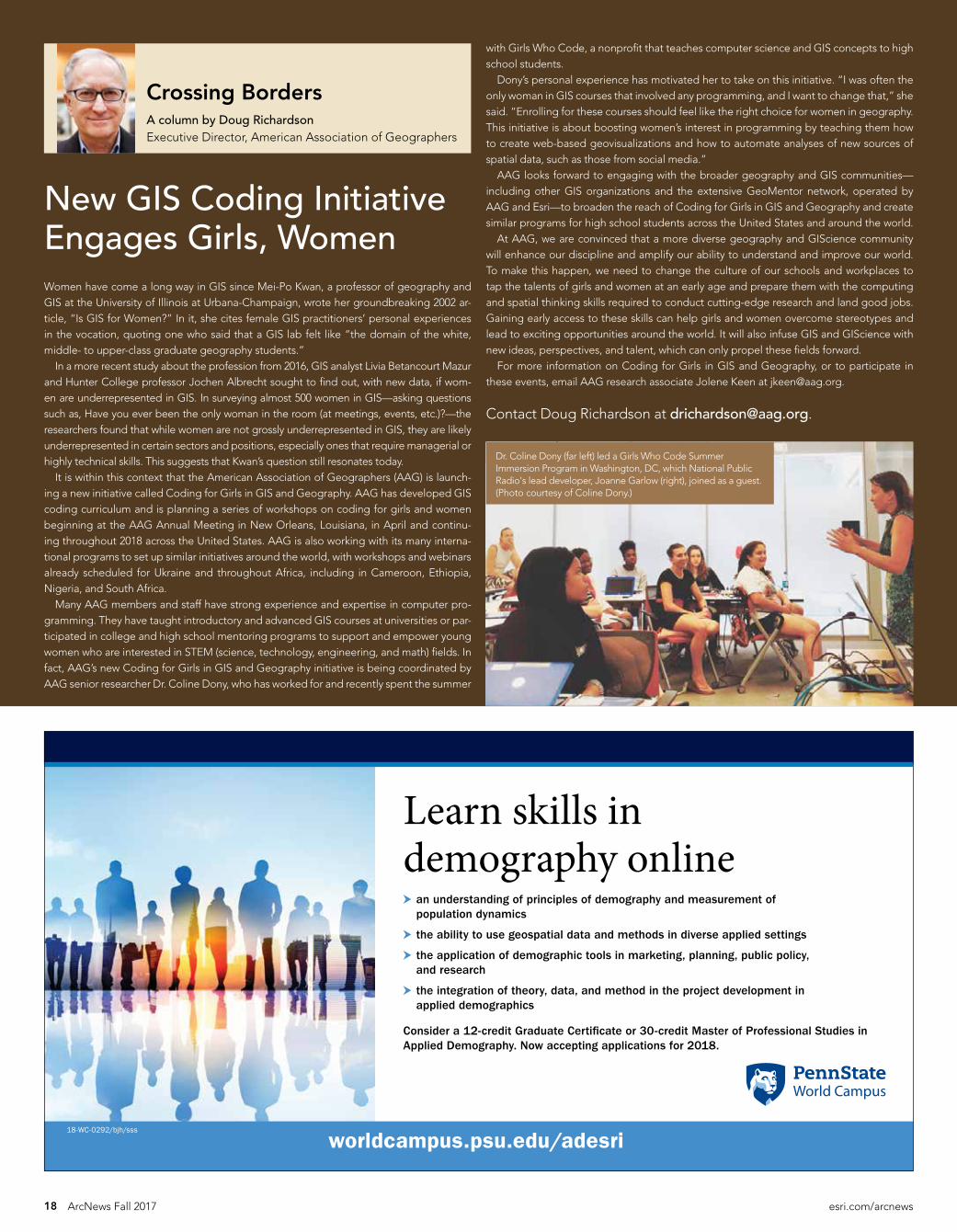
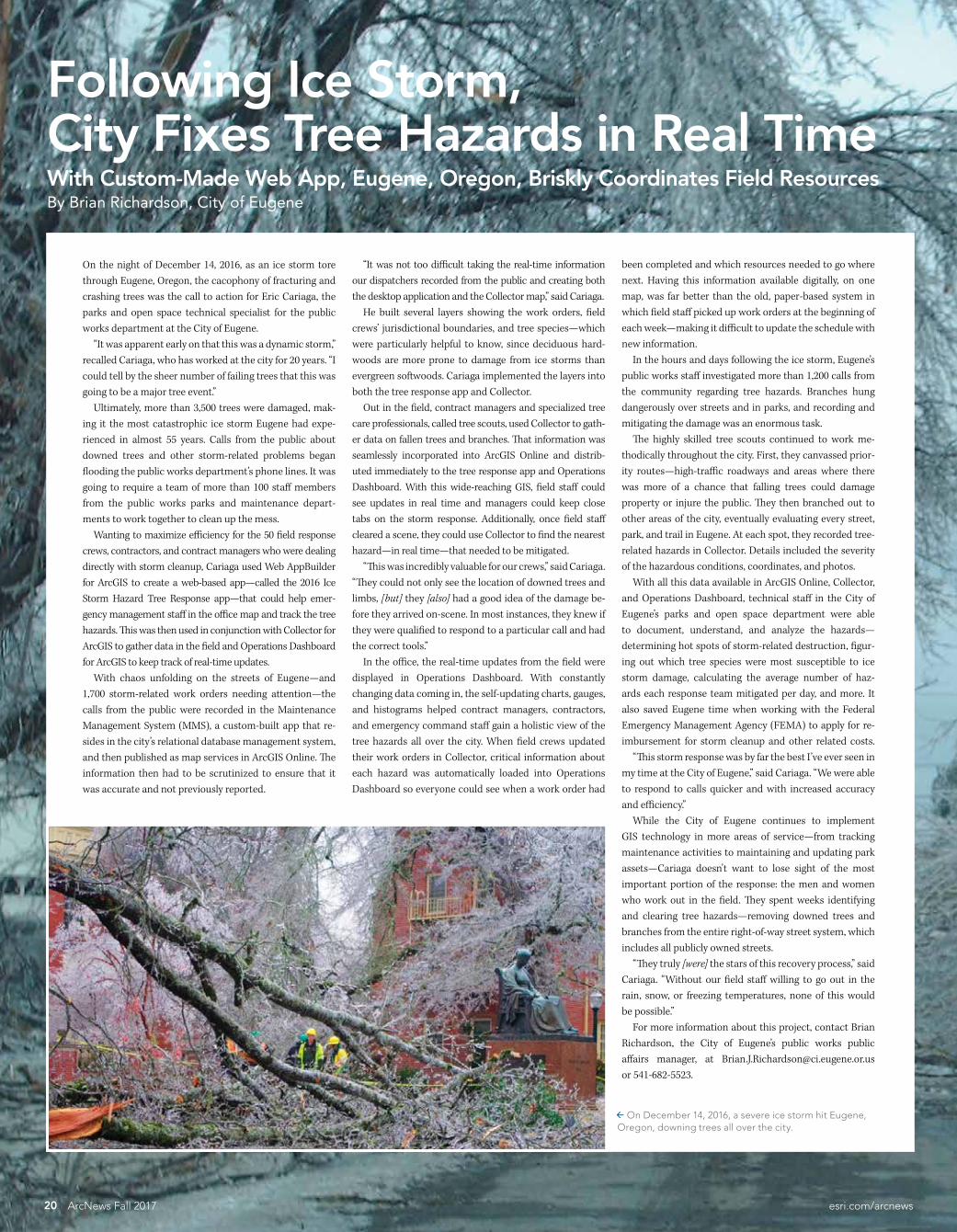
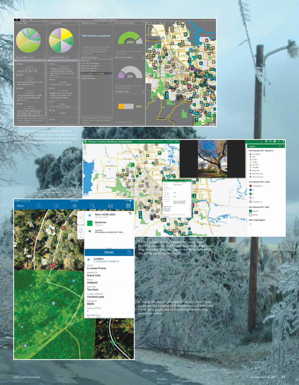
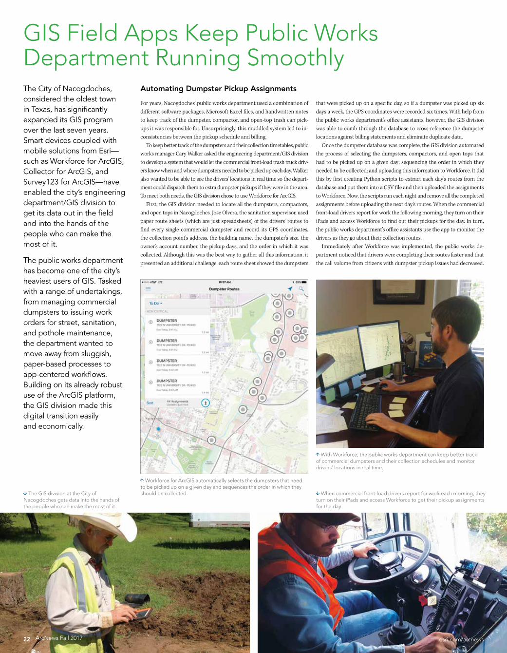
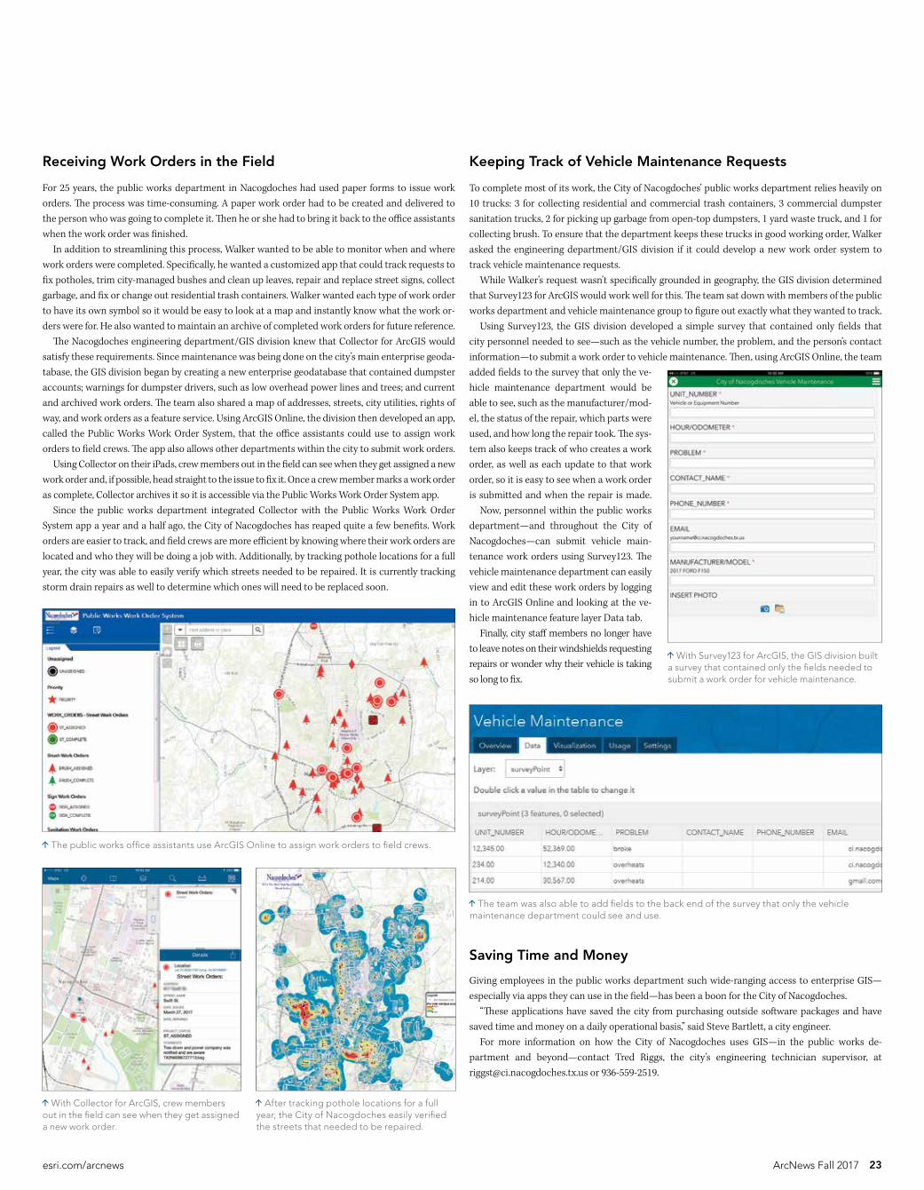
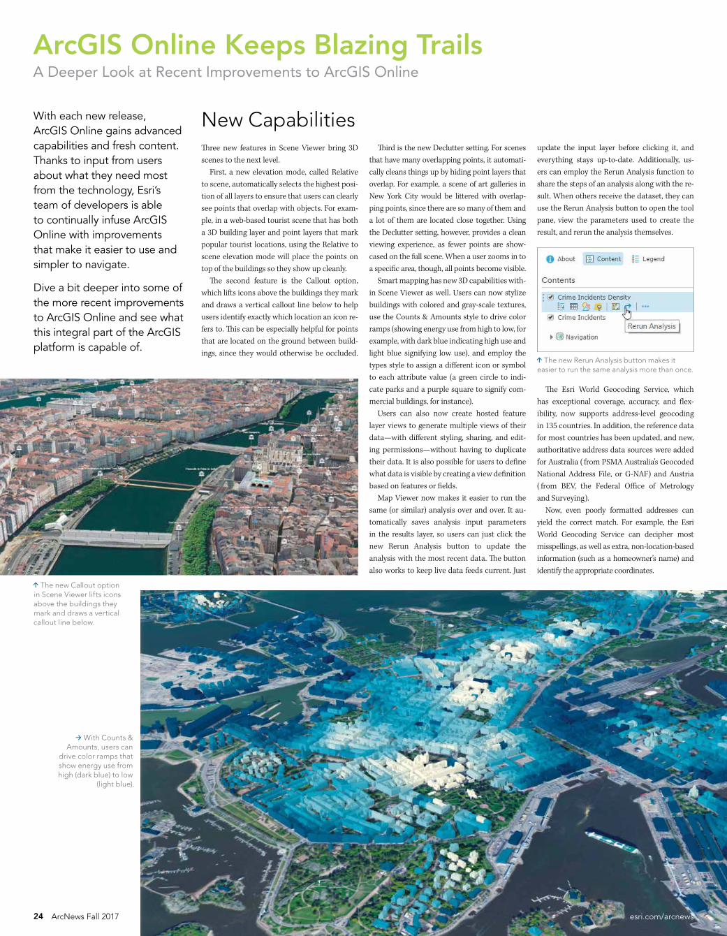
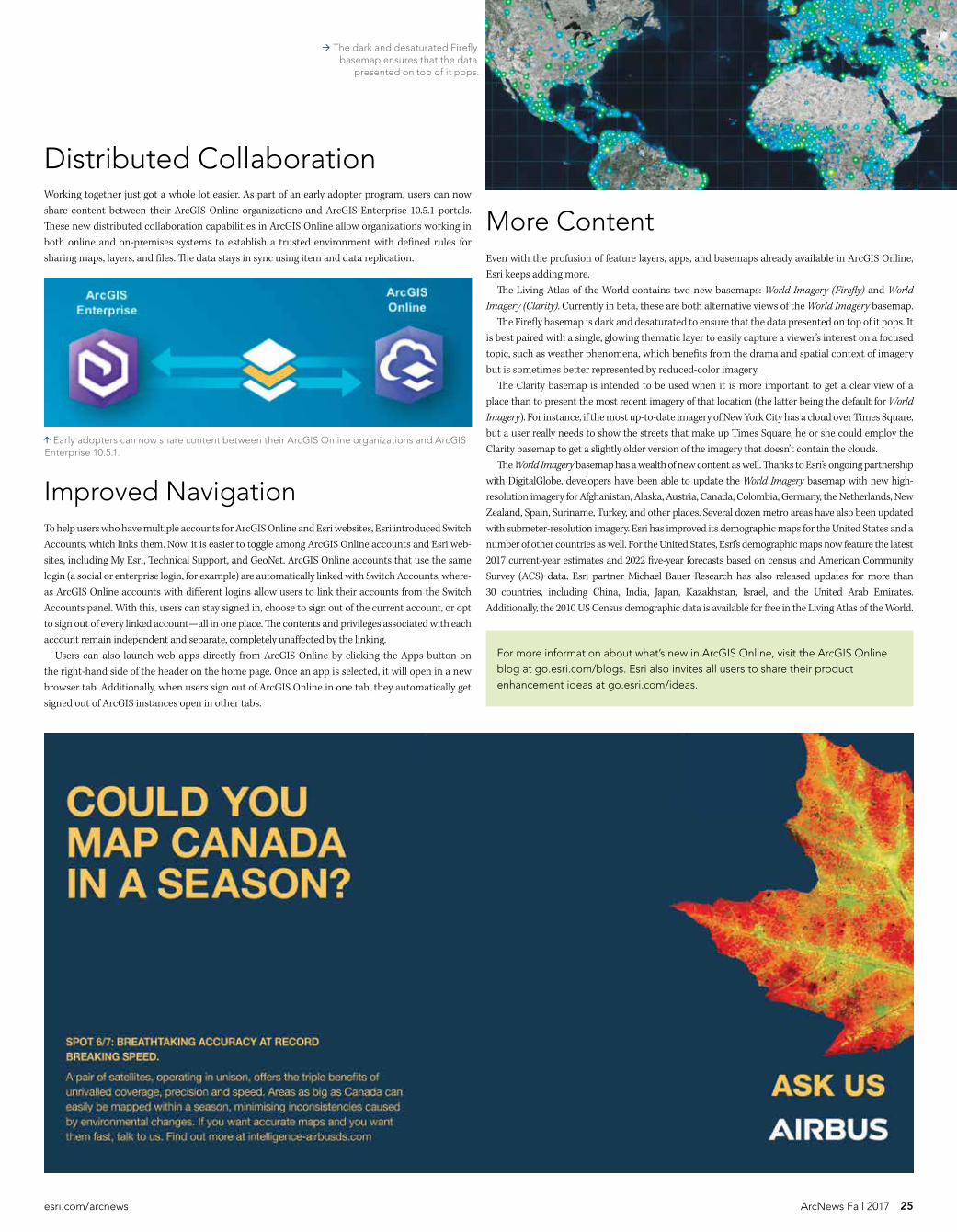
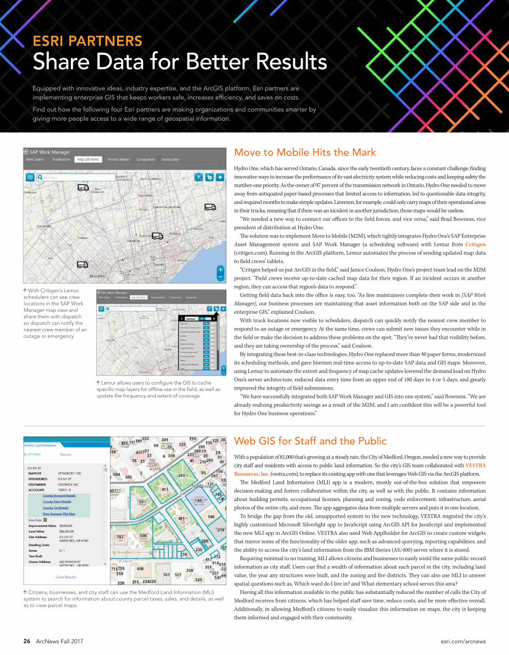
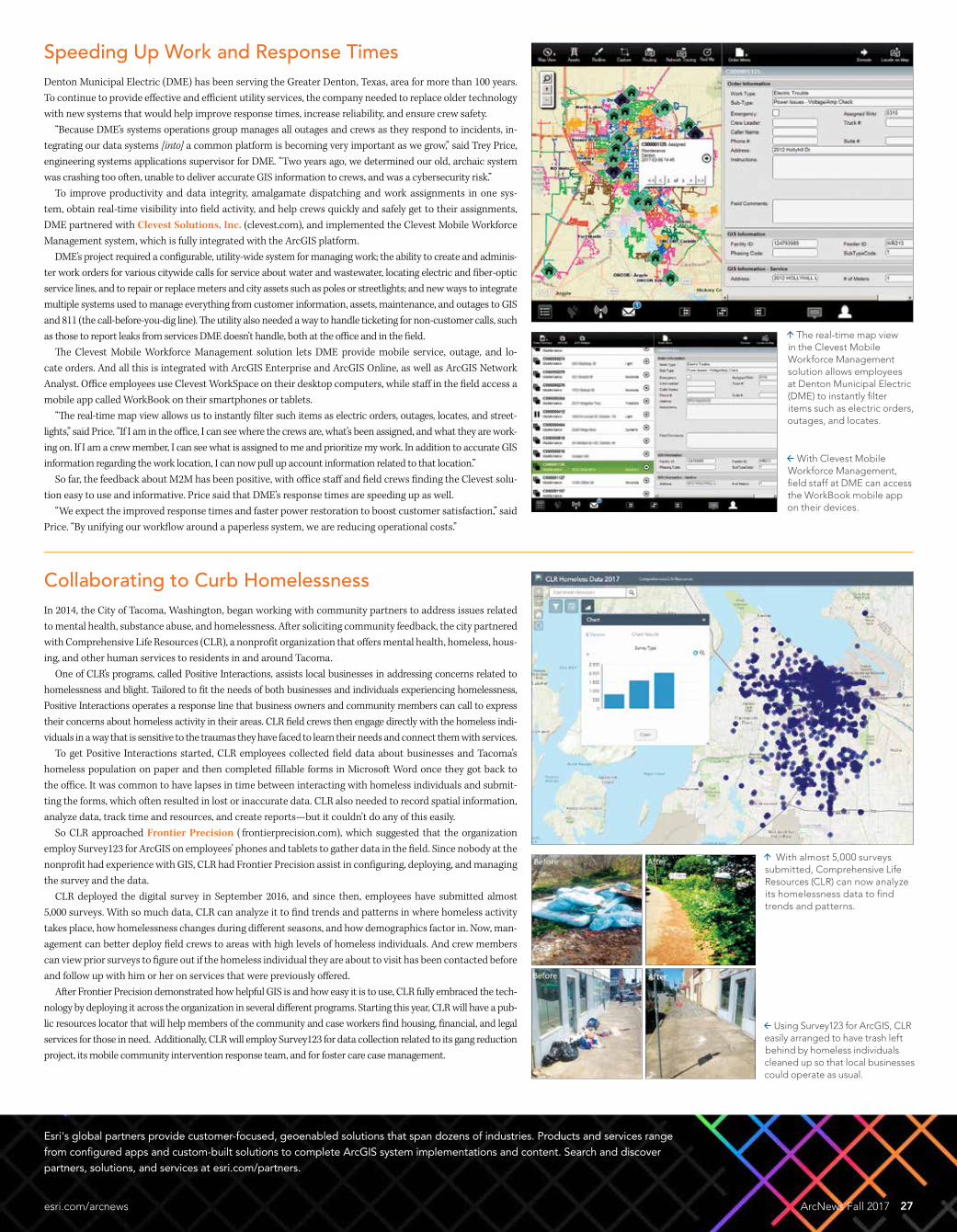
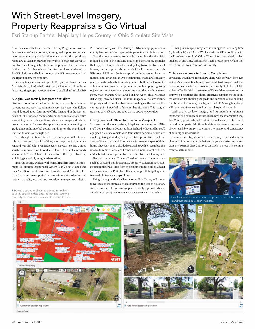
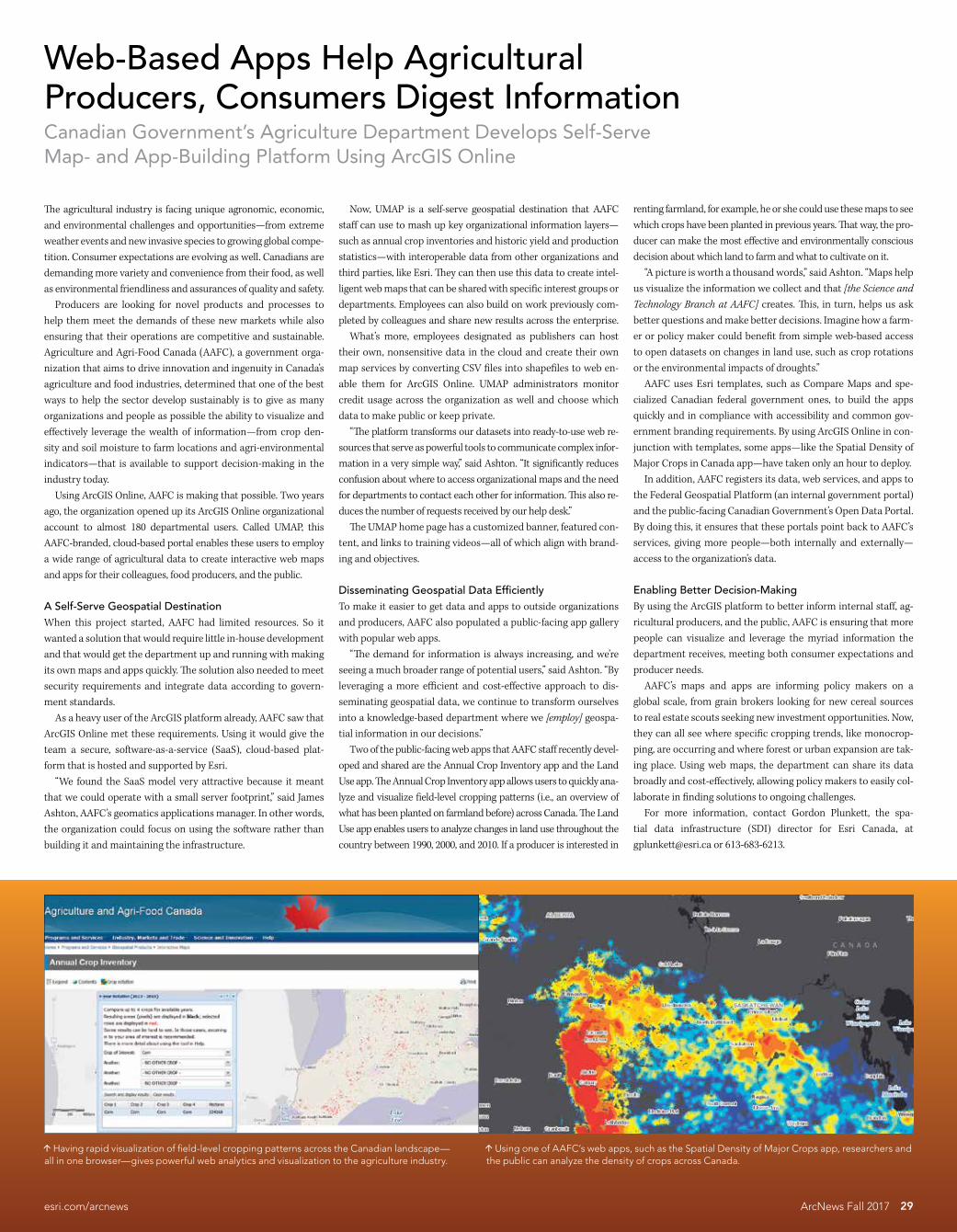
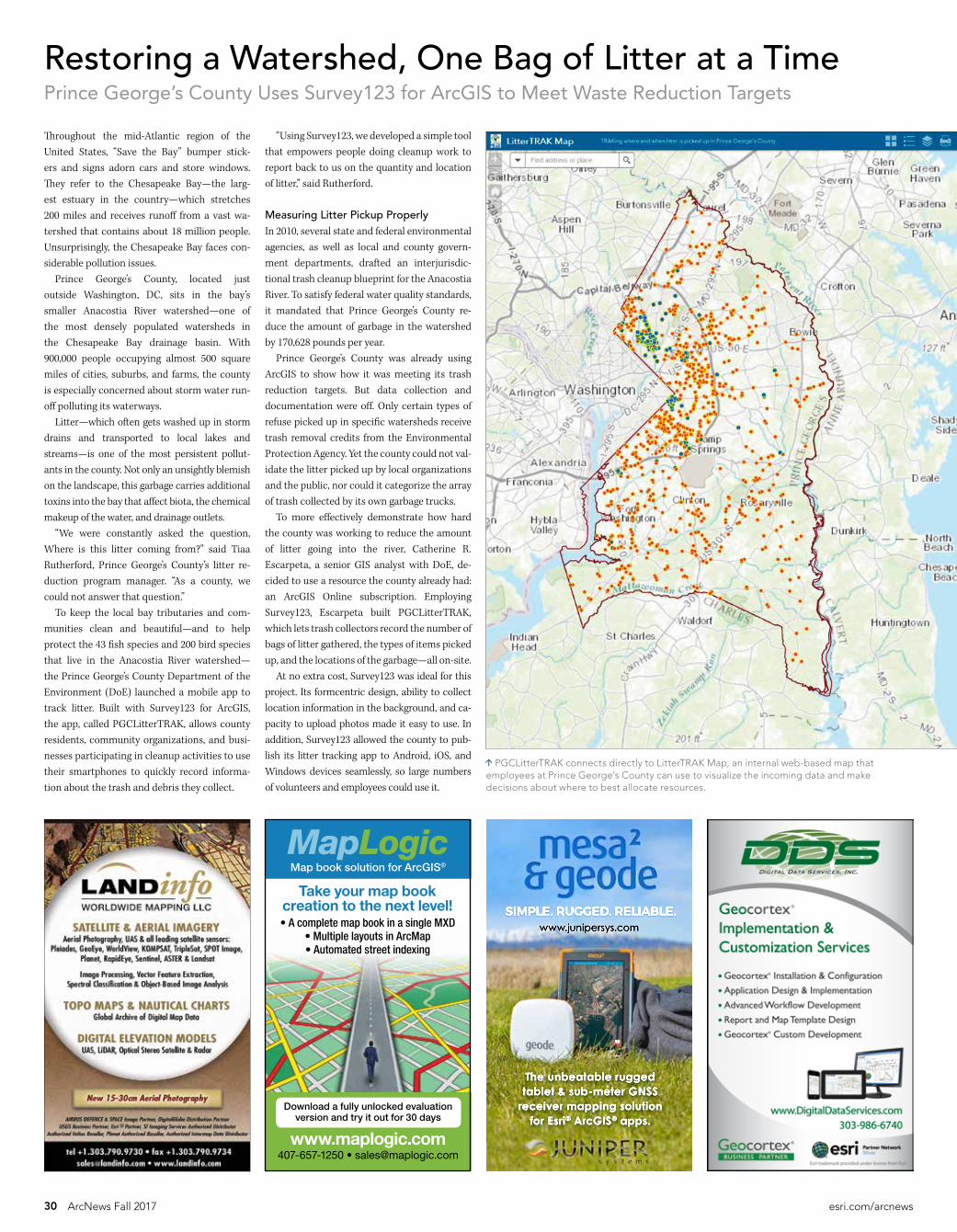
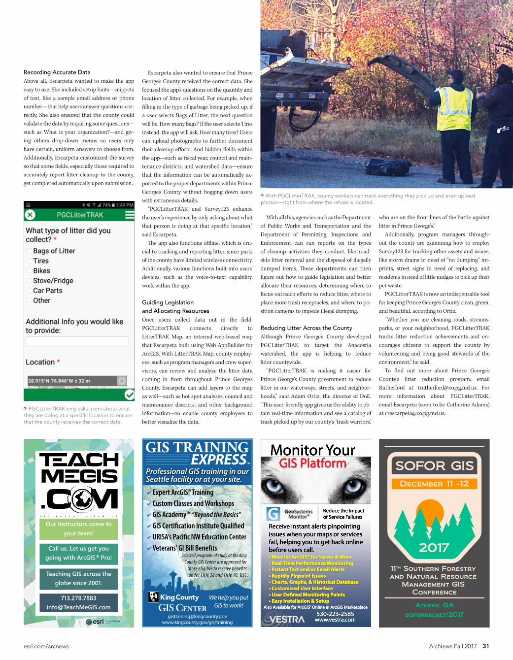
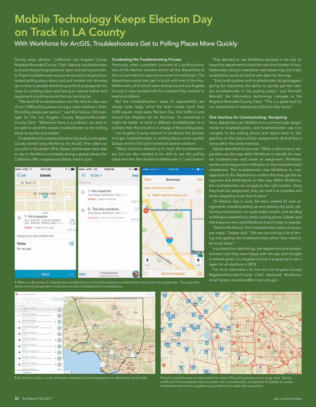
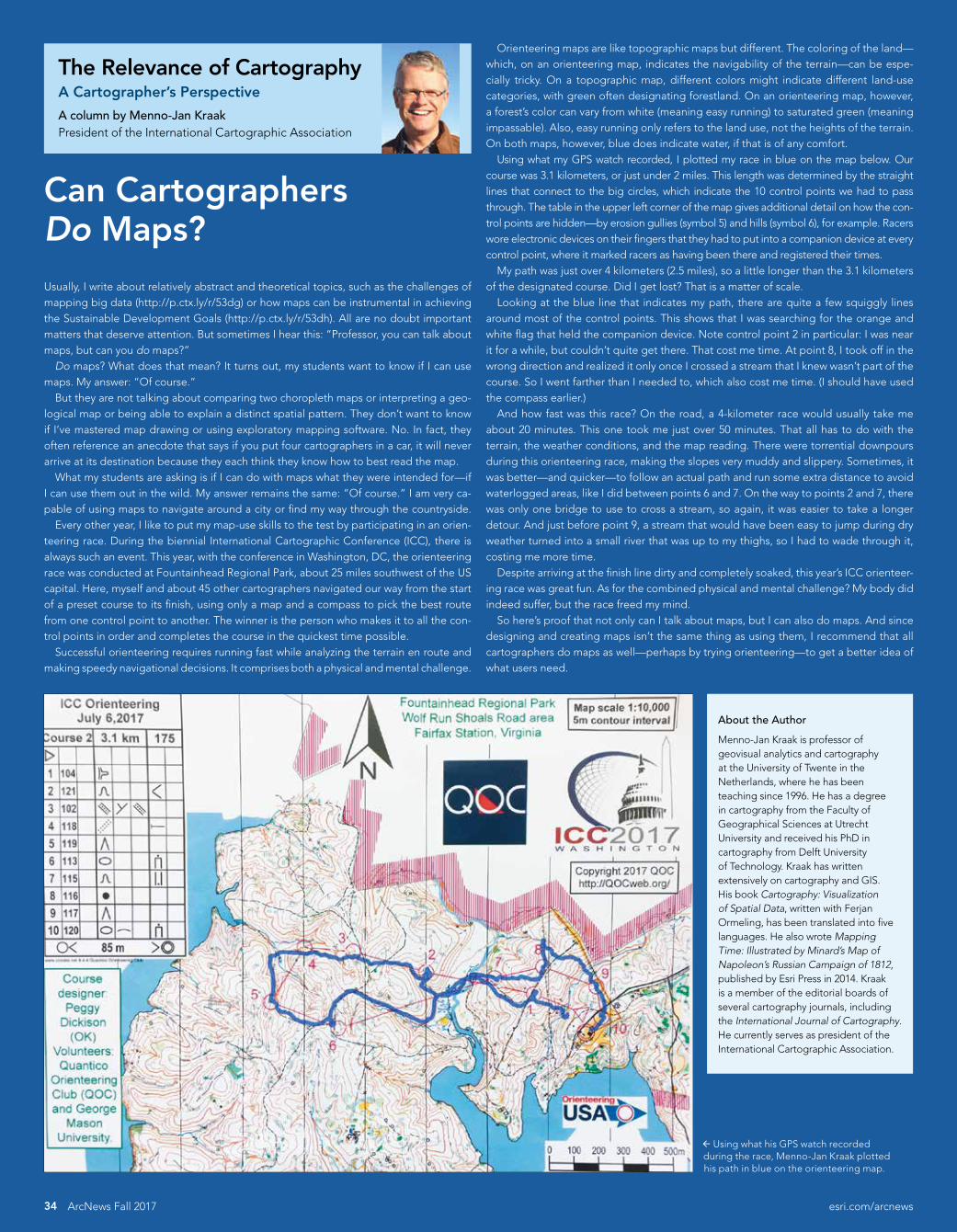
ldquoAs a student at Redlands I had experience as a GIS manager working for government agencies climate
change analysis and GIS data collection All of those are part of what Irsquom doing in my work todayrdquo
Jakob Larson rsquo17 BA Environmental Business
GIS manager The Wildlands Conservancy
ldquoAs a student at Redlands I had experience as a GIS manager working for government agencies climate
change analysis and GIS data collection All of those are part of what Irsquom doing in my work todayrdquo
Learn more
urspatialredlandseduurspatialredlandsedu
Located at the epicenter of geographic information systems (GIS)mdashRedlands California home to the worldrsquos leading GIS company Esri
We offerbull Specialized programs that align with geospatial workforce
needsmdashtwo residential masterrsquos in GIS programs a spatial studies undergraduate minor and an MBA with a GIS emphasis
bull Access to Esri technology training people and events
bull Spatial-thinking opportunities infused throughout the Universityrsquos courseworkmdashin business natural sciences environmental sciences social sciences humanities design and other disciplinesmdashwith cutting-edge spatial tools to build skills employers need
bull Community service learning projects in which students use GIS and other geospatial technologies to enhance the lives of others
University of Redlands
A Leader in Spatial Studies
SPA-17-001_Esri GIS ArcNews Scholarship Fall Ad r2indd 1 82217 856 AM
38 ArcNews Fall 2017 esricomarcnews
esricomcareers Follow EsriCareers on Twitter
Career OpportunitiesEsri is hiring smart people with all levels of experience for positions at our headquarters re-gional offices and RampD Centers Your work will affect the way people live and how organiza-tions solve problems We offer exceptional benefits competitive salaries profit sharing and a collaborative and stimulating environment Join us and be part of Esrirsquos mission to make a difference in our world
Software Development and ArcGIS Product Engineering3D Software EngineermdashArcGIS Pro Mapping Work on sophisticated 3D functionality that enhances Esrirsquos existing products contributes to new technologies and delivers valuable re-sults to Esri usersSoftware DevelopermdashImagery Build industry-leading software that allows ArcGIS server and desktop apps to work with rich geospatial imagery and dataSearch and Geocoding Product Engineer Help design the next generation of geocoding for the ArcGIS platform and ensure that it meets the Esri communityrsquos geocoding and geosearch needsStreetMap Premium Product Engineer Contribute to advancing the street data that pow-ers high-quality cartographic maps accurate geocoding and optimized routingApps Product Engineer Look beyond the traditional uses of GIS and create compellingnative geospatial apps that work across a variety of platformsCartographer Help build the Living Atlas of the World Create stunning new designs and publish cutting-edge online maps and layers that support a broad array of uses
Product ManagementProduct ManagermdashUtility Network Introduce and evangelize Utility Networkmdasha newfeature in ArcGIS Pro for managing utility and telecommunications network datamdashto Esri users partners and internal staff
Professional Services and ConsultingTechnical ConsultantmdashLaw Enforcement Employ your GIS skills and expertise in public safety to help law enforcement agencies around the world implement Esris enterprise platform
Educational Services and Technical SupportInstructorsmdashGIS Teach Esri software courses in traditional or online instructor-led class-rooms to help users stay on the front line of GIS technologyCourse Developer Leverage your GIS experience and work with the latest Esri software and subject matter experts to design develop and maintain instructor-led and web-basedtraining materialsGeodatabase Analyst Provide high-quality technical support to users and employ Esri tools and other related technologies to resolve technical issues with enterprise GIS servers
Business DevelopmentTeam LeadmdashLocal Government Lead an account team in promoting the use of ArcGIS in the local government sphere Strategically participate in all stages of the sales life cycle while providing effective coaching and support to team membersAccount ManagermdashElectric and Gas Help organizations in the electric and gas industries leverage geospatial information and technology by articulating the strengths and value propo-sitions of the ArcGIS platformAccount ManagermdashVeterans Affairs Use your wide-ranging knowledge about veteransrsquo af-fairs to envision develop and implement location strategies for related organizations
Presales and Solution EngineeringSolution EngineersmdashMultiple Domains Help customers in one of several different fields adopt the ArcGIS platform by proactively crafting and proposing solutions that clarify how GIS addresses and solves critical business challenges
MarketingGlobal Marketing Manager Be Esrirsquos global brand advocate and drive international growth by extending marketing programs through the Esri Global Distributor networkIndustry ManagersmdashMultiple Domains Develop and oversee the implementation of global go-to-market strategies to drive growth in new and existing markets
Esri is an equal opportunity employer (EOE) All qualified applicants will receive consider-ation for employment without regard to race color religion sex national origin disability status protected veteran status or any other characteristic protected by law
Esri Corporate Headquarters
esricom
Esri Technical Supportesricomsupport
Esri Desktop Order Center and Software InformationTel 1-800-447-9778 (USA only)
Esri Productsesricomproducts
Esri Storeesricomstore
Esri Developer Networkdevelopersarcgiscom
Customer Care Portalmyesricom
Esri Distributors WorldwideEsri Australia Pty Ltd mdashAustraliawwwesriaustraliacomau
Esri BeLux NVmdashBelgiumwwwesribeluxcom
Esri Bulgaria LtdmdashBulgariawwwesribulgariacom
Esri Canada LimitedmdashCanadawwwesrica
Esri Chile SAmdashChilewwwesricl
Esri China (Beijing) Holding Co LtdmdashChinawwwesrichinacomcn
Esri Colombia SASmdashColombiawwwesrico
Esri Northeast Africa mdashEgyptwwwesrineacom
Esri Finland OymdashFinlandwwwesrifi
Esri France SAmdashFrancewwwesrifrancefr
Esri Deutschland GmbHmdashGermanywwwesride
Esri China (Hong Kong) LimitedmdashHong Kongwwwesrichinahk
NIIT GIS Limited (Esri India)mdashIndiawwwesriindiacom
Esri Italia SpAmdashItalywwwesriitaliait
Esri Japan CorporationmdashJapanwwwesrijcom
Esri Eastern Africa LimitedmdashKenyawwwesrieacoke
Esri Lebanon salmdashLebanonwwwesrilebanoncom
Esri Southern AfricamdashMauritiuswwwesri-southernafricacom
Esri Nederland BVmdashThe Netherlandswwwesrinl
Esri Muscat Co LLCmdashOmanwwwesrimuscatcom
Esri Panama SAmdashPanamawwwesripa
Esri Polska sp z oomdashPolandwwwesripl
Esri PortugalmdashSistemas e Informaccedilatildeo Geograacutefica SAmdashPortugalwwwesri-portugalpt
Esri Romania SRLmdashRomaniawwwesriro
Limited Liability Company ESRI CISmdashRussiawwwesri-cisru
Esri Saudi Arabia LtdmdashSaudi Arabiawwwesrisaudiarabiacom
Esri South Africa (Pty) LtdmdashSouth Africawwwesri-southafricacom
Esri Korea IncmdashSouth Koreawwwesrikrcom
Esri South Asia Pte LtdmdashSingaporewwwesrisacom
Esri Espantildea Soluciones Geospaciales SLmdashSpainwwwesries
Esri Sverige ABmdashSwedenwwwesrise
Esri (Thailand) Co LtdmdashThailandwwwesrithcom
Esri Bilgi Sistemleri Muhendislik ve Egitim LtdmdashTurkeywwwesriturkeycomtr
Esri (UK) LtdmdashUnited Kingdomwwwesriukcom
Esri Ukraine LtdmdashUkrainewwwesriua
Grupo Esri de Venezuela CAmdashVenezuelawwwesrivencom
Esri has more than 80 distributors in other countries around the world For more information contact Esri (tel 909-793-2853ext 1-1235 fax 909-307-3070) or visit esricomdistributors
Esri US Regional OfficesBoston mdashMiddleton MATel 978-777-4543
CharlottemdashCharlotte NCTel 704-541-9810
DenvermdashBroomfield COTel 303-449-7779
MinneapolismdashSt Paul MNTel 651-454-0600
OlympiamdashOlympia WATel 360-754-4727
PhiladelphiamdashChesterbrook PA Tel 610-644-3374
RedlandsmdashRedlands CATel 909-793-2853 ext 1-1906
San AntoniomdashSan Antonio TXTel 210-499-1044
St LouismdashSt Charles MOTel 636-949-6620
Federal Office
Washington DCmdashVienna VATel 703-506-9515
For additional information about Esri US regional offices visit esricomabout-esriusa
ldquoAs a student at Redlands I had experience as a GIS manager working for government agencies climate
change analysis and GIS data collection All of those are part of what Irsquom doing in my work todayrdquo
Jakob Larson rsquo17 BA Environmental Business
GIS manager The Wildlands Conservancy
ldquoAs a student at Redlands I had experience as a GIS manager working for government agencies climate
change analysis and GIS data collection All of those are part of what Irsquom doing in my work todayrdquo
Learn more
urspatialredlandseduurspatialredlandsedu
Located at the epicenter of geographic information systems (GIS)mdashRedlands California home to the worldrsquos leading GIS company Esri
We offerbull Specialized programs that align with geospatial workforce
needsmdashtwo residential masterrsquos in GIS programs a spatial studies undergraduate minor and an MBA with a GIS emphasis
bull Access to Esri technology training people and events
bull Spatial-thinking opportunities infused throughout the Universityrsquos courseworkmdashin business natural sciences environmental sciences social sciences humanities design and other disciplinesmdashwith cutting-edge spatial tools to build skills employers need
bull Community service learning projects in which students use GIS and other geospatial technologies to enhance the lives of others
University of Redlands
A Leader in Spatial Studies
SPA-17-001_Esri GIS ArcNews Scholarship Fall Ad r2indd 1 82217 856 AM
Presorted Standard
US Postage Paid Esri
158514
Copyright copy 2017 Esri All rights reserved Printed in the United States of America
The information contained in this work is the exclusive property of Esri or its licensors This work is protected under United States copyright law and other international copyright treaties and conventions No part of this work may be reproduced or transmitted in any form or by any means electronic or mechanical including photocopying and recording or by any information storage or retrieval system except as expressly permitted in writing by Esri All requests should be sent to Attention Contracts and Legal Services Manager Esri 380 New York Street Redlands California 92373-8100 USA
The information contained in this work is subject to change without notice
esricom 3D Analyst ACORN Address Coder ADF AML ArcAtlas ArcCAD ArcCatalog ArcCOGO ArcData ArcDoc ArcEdit ArcEditor ArcEurope ArcExplorer ArcExpress ArcGIS arcgiscom ArcGlobe ArcGrid ArcIMS ARCINFO ArcInfo ArcInfo Librarian ArcLessons ArcLocation ArcLogistics ArcMap ArcNetwork ArcNews ArcObjects ArcOpen ArcPad ArcPlot ArcPress ArcPy ArcQuest ArcReader ArcScan ArcScene ArcSchool ArcScripts ArcSDE ArcSdl ArcSketch ArcStorm ArcSurvey ArcTIN ArcToolbox ArcTools ArcUSA ArcUser ArcView ArcVoyager ArcWatch ArcWeb ArcWorld ArcXML Atlas GIS AtlasWare Avenue BAO Business Analyst Business Analyst Online BusinessMAP CityEngine Community Community Analyst CommunityInfo Community Maps Database Integrator DBI Kit Drone2Map EDN Esri esricom EsrimdashTeam GIS EsrimdashThe GIS Company EsrimdashThe GIS People EsrimdashThe GIS Software Leader FormEdit GeoCollector GeoEnrichment GeoEvent Geographic Design System Geography Matters Geography Network geographynetworkcom Geoloqi GeoPlanner Geoportal Geotrigger GIS by Esri giscom GISData Server GIS Day gisdaycom GIS for Everyone Insights JTX MapIT Maplex MapObjects MapStudio ModelBuilder MOLE MPSmdashAtlas PLTS Rent-a-Tech SDE SML SourcebookmiddotAmerica SpatiaLABS Spatial Database Engine Story Map Cascade Story Map Crowdsource Story Map Journal Story Map Shortlist Story Map Spyglass Story Map Swipe Story Map Series Story Map Tour StreetMap Tapestry the ARCINFO logo the ArcGIS Explorer logo the ArcGIS logo the ArcPad logo the Esri globe logo the Esri Press logo The Geographic Advantage The Geographic Approach the GIS Day logo the MapIT logo The Science of Where The Worldrsquos Leading Desktop GIS Water Writes and Your Personal Geographic Information System are trademarks service marks or registered marks of Esri in the United States the European Community or certain other jurisdictions CityEngine is a registered trademark of Esri RampD Center Zurich AG and is distributed under license by Esri
Other companies and products or services mentioned herein may be trademarks service marks or registered marks of their respective mark owners
Add a Subscription Change Your Address or UnsubscribeSubscribe unsubscribe or update information at esricomupdatesOutside the United States contact your local distributorTo request other publication services see page 2
Esri AD
Copyright copy 2017 Esri All rights reserved
UNLEASH THE POWER OF LOCATION INTELLIGENCEWHEN YOU NEED ALL YOUR DATA TO DELIVER ALL ITS INSIGHT WHICH TODAY IS ALWAYSSeventy-five percent of Fortune 500 companies are applying Esrirsquos The Science of Where
to business and operations to realize their own digital transformation
esricomdigital-transformation
G78613_ArcNews_DigitalTranformation_Ad_dl_FNLindd 1 9817 1139 AM
380 New York Street Redlands CA 92373-8100
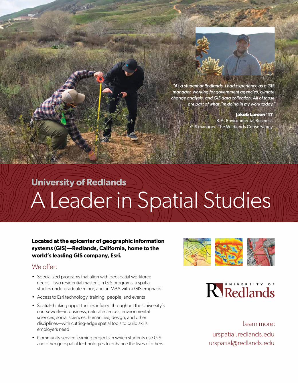
ldquoAs a student at Redlands I had experience as a GIS manager working for government agencies climate
change analysis and GIS data collection All of those are part of what Irsquom doing in my work todayrdquo
Jakob Larson rsquo17 BA Environmental Business
GIS manager The Wildlands Conservancy
ldquoAs a student at Redlands I had experience as a GIS manager working for government agencies climate
change analysis and GIS data collection All of those are part of what Irsquom doing in my work todayrdquo
Learn more
urspatialredlandseduurspatialredlandsedu
Located at the epicenter of geographic information systems (GIS)mdashRedlands California home to the worldrsquos leading GIS company Esri
We offerbull Specialized programs that align with geospatial workforce
needsmdashtwo residential masterrsquos in GIS programs a spatial studies undergraduate minor and an MBA with a GIS emphasis
bull Access to Esri technology training people and events
bull Spatial-thinking opportunities infused throughout the Universityrsquos courseworkmdashin business natural sciences environmental sciences social sciences humanities design and other disciplinesmdashwith cutting-edge spatial tools to build skills employers need
bull Community service learning projects in which students use GIS and other geospatial technologies to enhance the lives of others
University of Redlands
A Leader in Spatial Studies
SPA-17-001_Esri GIS ArcNews Scholarship Fall Ad r2indd 1 82217 856 AM
Presorted Standard
US Postage Paid Esri
158514
Copyright copy 2017 Esri All rights reserved Printed in the United States of America
The information contained in this work is the exclusive property of Esri or its licensors This work is protected under United States copyright law and other international copyright treaties and conventions No part of this work may be reproduced or transmitted in any form or by any means electronic or mechanical including photocopying and recording or by any information storage or retrieval system except as expressly permitted in writing by Esri All requests should be sent to Attention Contracts and Legal Services Manager Esri 380 New York Street Redlands California 92373-8100 USA
The information contained in this work is subject to change without notice
esricom 3D Analyst ACORN Address Coder ADF AML ArcAtlas ArcCAD ArcCatalog ArcCOGO ArcData ArcDoc ArcEdit ArcEditor ArcEurope ArcExplorer ArcExpress ArcGIS arcgiscom ArcGlobe ArcGrid ArcIMS ARCINFO ArcInfo ArcInfo Librarian ArcLessons ArcLocation ArcLogistics ArcMap ArcNetwork ArcNews ArcObjects ArcOpen ArcPad ArcPlot ArcPress ArcPy ArcQuest ArcReader ArcScan ArcScene ArcSchool ArcScripts ArcSDE ArcSdl ArcSketch ArcStorm ArcSurvey ArcTIN ArcToolbox ArcTools ArcUSA ArcUser ArcView ArcVoyager ArcWatch ArcWeb ArcWorld ArcXML Atlas GIS AtlasWare Avenue BAO Business Analyst Business Analyst Online BusinessMAP CityEngine Community Community Analyst CommunityInfo Community Maps Database Integrator DBI Kit Drone2Map EDN Esri esricom EsrimdashTeam GIS EsrimdashThe GIS Company EsrimdashThe GIS People EsrimdashThe GIS Software Leader FormEdit GeoCollector GeoEnrichment GeoEvent Geographic Design System Geography Matters Geography Network geographynetworkcom Geoloqi GeoPlanner Geoportal Geotrigger GIS by Esri giscom GISData Server GIS Day gisdaycom GIS for Everyone Insights JTX MapIT Maplex MapObjects MapStudio ModelBuilder MOLE MPSmdashAtlas PLTS Rent-a-Tech SDE SML SourcebookmiddotAmerica SpatiaLABS Spatial Database Engine Story Map Cascade Story Map Crowdsource Story Map Journal Story Map Shortlist Story Map Spyglass Story Map Swipe Story Map Series Story Map Tour StreetMap Tapestry the ARCINFO logo the ArcGIS Explorer logo the ArcGIS logo the ArcPad logo the Esri globe logo the Esri Press logo The Geographic Advantage The Geographic Approach the GIS Day logo the MapIT logo The Science of Where The Worldrsquos Leading Desktop GIS Water Writes and Your Personal Geographic Information System are trademarks service marks or registered marks of Esri in the United States the European Community or certain other jurisdictions CityEngine is a registered trademark of Esri RampD Center Zurich AG and is distributed under license by Esri
Other companies and products or services mentioned herein may be trademarks service marks or registered marks of their respective mark owners
Add a Subscription Change Your Address or UnsubscribeSubscribe unsubscribe or update information at esricomupdatesOutside the United States contact your local distributorTo request other publication services see page 2
Esri AD
Copyright copy 2017 Esri All rights reserved
UNLEASH THE POWER OF LOCATION INTELLIGENCEWHEN YOU NEED ALL YOUR DATA TO DELIVER ALL ITS INSIGHT WHICH TODAY IS ALWAYSSeventy-five percent of Fortune 500 companies are applying Esrirsquos The Science of Where
to business and operations to realize their own digital transformation
esricomdigital-transformation
G78613_ArcNews_DigitalTranformation_Ad_dl_FNLindd 1 9817 1139 AM
380 New York Street Redlands CA 92373-8100