Embed Size (px)
Citation preview
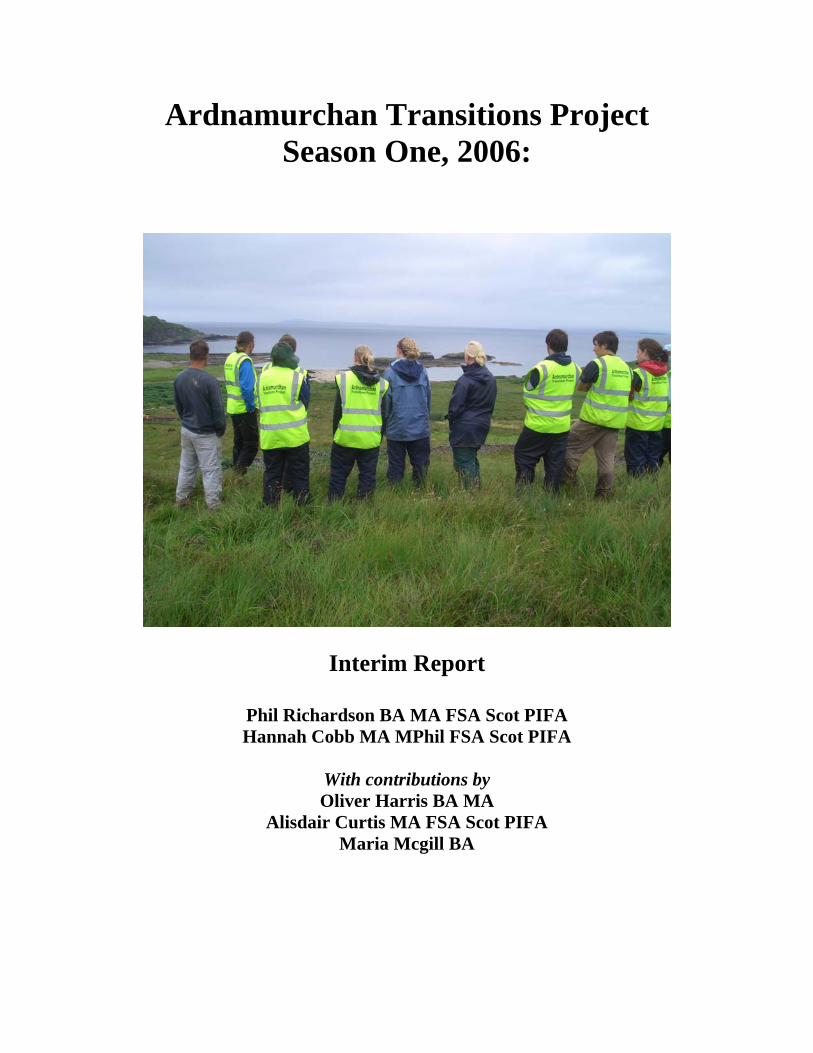
Ardnamurchan Transitions Project Season One, 2006:
Interim Report
Phil Richardson BA MA FSA Scot PIFA Hannah Cobb MA MPhil FSA Scot PIFA
With contributions by Oliver Harris BA MA
Alisdair Curtis MA FSA Scot PIFA Maria Mcgill BA
2
CONTENTS
Background to the project 4
Overall research programme 4
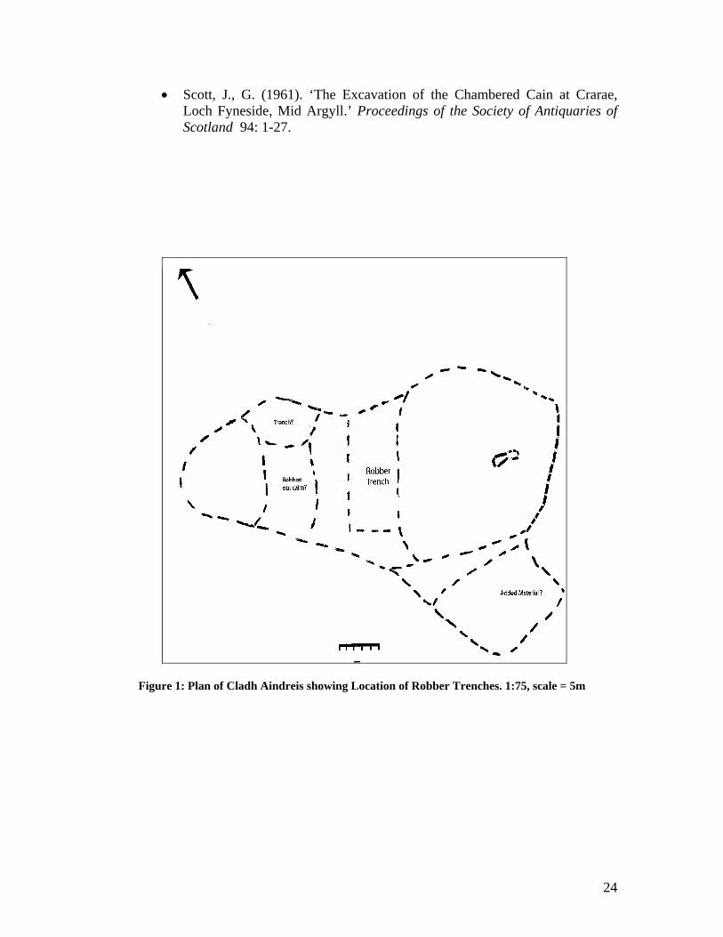
Site location 7
Description of the monument 7
History of Research 8
Aims and objectives for 2006 season 12
Excavation methodology 14
Excavation results 15
Discussion and preliminary interpretations 15
Publication plans and future work 23
Notes and acknowledgements 25
References 25
3
Illustrations
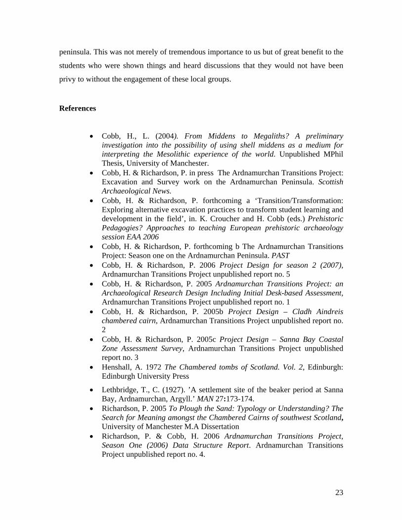
• Figure 1: Plan of Cladh Aindreis (at 1:75) showing location of robber trenches.
Scale in image = 5m.
• Figure 2: Locations of sites - Cladh Aindreis is larger star, Sanna Bay is smaller
star
• Figure 3: Lower Swordle Bay, showing trench locations
• Figure 4: The extent to which the views from each site are restricted, on the
Ardnamuchan Peninsula
• Figure 5: Panorama, views from Sanna Bay
• Figure 6: Panorama, views from Cladh Aindreis
• Figure 7: Post-ex plan trench 1. scale 1:80
• Figure 8: Trench 1 following removal of turf, showing cairn 004
• Figure 9: Section of pit feature [020]/[015]
• Figure 10: Section of pit feature [014]
• Figure 11: Trench 3 before extension
• QTVR film of Cladh Aindreis
Background to the project
Research into the Mesolithic, Neolithic and Bronze Age periods in Western Scotland has
been intensive over the last few decades, and concerted programme of excavation and
survey have seen our knowledge of these periods increase significantly. However the
Ardnamurchan Peninsula remains a relatively understudied area within Western Scotland
for all of these key periods. As such, the Ardnamurchan Transitions Project (ATP) aims
to investigate the transitions between the Mesolithic, Neolithic and Bronze Age in the
area through a combination of site specific excavation and wider survey work (Cobb and
Richardson 2005a). This work will not only increase knowledge about the peninsula
itself, but also aims to set it in its wider regional context. Of the sites from this period on
the peninsula, the chambered tomb of Cladh Aindreis (figure 1) has been identified as
4
potentially significant. Until now this site has only been subject to basic survey work,
which noted the irregular cairn shape, and suggested that this had been subject to some
modification over time. It is in taking up these initial issues that this research project
places one of its main aims; to establish the form and chronological sequence of the cairn
and chamber. To achieve this, the project hopes to conduct several seasons of work on
the site (Cobb and Richardson 2005b), which will include a geophysical survey of the
cairn, test pitting, excavation and a rigorous dating programme. As no specific
radiocarbon dates have been established for the Ardnamurchan peninsula (figure 2) from
the Mesolithic or Neolithic, this is also a crucial element of our study. A further
geophysical and palaeoenvironmental survey of the wider Swordle Bay (figure 3) will
also seek to establish the extent and impacts of prehistoric activity in the bay and, and
clarify the palaeoenvironmental setting of the site.
Overall research programme
The project represents a joint venture between Hannah Cobb and Phil Richardson, two
current Archaeology PhD students at the Universities of Manchester and Newcastle.
Whilst the significance of the peninsula has been identified through our doctoral research,
this study stands alone as a separate, long term project of research which we intend will
both inform but also extend well beyond the scope of our doctoral research. As well as
simply examining the peninsula within its regional context our research is also driven by
a series of wider themes. By focussing on the question of transition, this project hopes to
challenge and explore the nature of the transition from hunting and gathering to farming,
and the rigidity of our own modern preconceptions that surround interpretations of this
transition. By moving beyond site based syntheses, it is our intention to challenge the
orthodox picture of prehistory as a series of separate ‘periods’ where objects and remains
are divided into functionally determined types. This is not to wholly reject such schemes,
but rather it is the intention of this project to significantly challenge the basic nature of
these conceptions and to demonstrate that used uncritically such concepts are rooted in
older, modernist philosophies (Richardson 2005). Although in some ways our aims
reflect traditional research agendas in archaeological investigation, we are also
particularly concerned with exploring the potential of such research excavations to
5
provide and develop innovative vocational training for undergraduate students. Most
research excavations work on a limited remit that often use unpaid undergraduate labour
for largely menial tasks, and critically such projects rarely situate any field practice
within its theoretical context. Consequently students frequently find it hard to reconcile
the outcomes of their compulsory fieldwork activities with the general theoretical aspects
that they are taught in the classroom. We believe that this is not only detrimental to
archaeology as a discipline, but to the personal development of undergraduate students.
Indeed positive excavation experiences can provide vital life skills to undergraduates
whether or not they intend to continue in archaeology after having graduated from
university. Consequently we hope to involve as many undergraduate students as possible
on this excavation with the specific aim of providing clear and varied vocational training.
Through such training we hope to empower all undergraduates, by giving them positive
training in a number of transferable skills, whilst at the same time integrating critical
theoretical issues, which they might not otherwise address on more traditional
excavations (Cobb and Richardson forthcoming a & b).
The Ardnamurchan Transitions Project has the following key overall aims:
To investigate evidence for the Mesolithic, Neolithic and Bronze Age periods on the
Ardnamurchan peninsula, and the processes of transition between each.
To significantly contribute towards increasing the knowledge of the prehistory of the
peninsula in general and to situate this within a wider regional context.
To clarify questions raised by Henshall (1972) regarding Neolithic tomb typology on
the peninsula in relation to its wider regional context
To encourage local community interest in the prehistory of the area and to develop
local interest in archaeology in general.
6
To develop practical methodologies which integrate and situate core theoretical
questions within archaeological practice.
The aims for the project will be met through the following overall objectives;
To excavate a possible multi-period site (Cladh Aindreis, Swordle Bay, nr. Ockle) to
explore tomb typology and chronology.
To provide the first radiocarbon dates for the peninsula to support knowledge of tomb
type and peninsula.
To survey the Swordle Valley by topographical Electronic survey and random test
pitting/ small scale excavation to situate the site of Cladh Aindreis within its localised
context and provide further palaeo-environmental data about the site setting.
To survey the other two chambered tombs on the peninsula for comparison with
Cladh Aindreis.
To identify further sites from the periods under study through rapid walkover survey
and some small scale excavation (Cobb and Richardson 2005c).
To disseminate information about the project and its findings to local community
groups.
To provide opportunities for local community members of all ages to engage in the
excavation process.
To explore sites from the periods under consideration using a series of alternative
methodologies, including Quick Time Virtual Reality (henceforth QTVR) and further
experiential forms of recording.
7
Site location
The first area investigated was the site of the chambered cairn, Cladh Aindreis (NGR:
NM 5470 7076 centred - see Figure 2), and Swordle Bay (figure 3), in which it is
situated. Following a rapid walkover survey of Swordle Bay and Desk Based Assessment
an evaluation of potentially significant features out with the scheduled area of the
chambered cairn was undertaken. The second area of fieldwork involved a rapid coastal
reconnaissance of the coastal area at Sanna Bay, Ardnamurchan (NGR: NM 4455 6900
centred, - see Figure 2).
Description of the monument
The chambered tomb of Cladh Aindreis (figure 1) has not been excavated, although it has
been severely robbed. However, it was surveyed in 1962 by Henshall as part of her work
The Chambered Tombs of Scotland and features in the second volume of this, published
in 1972, classified as a Clyde type chambered cairn. The site was also visited by the
Ordnance Survey in 1970, although the entry noting this visit on the RCHAMS record for
the site, simply corroborates Henshall's observations, and on visiting the site today it is
clear that these observations still largely apply nearly 30 years on. A description is given
below.
Cladh Aindreis (see QTVR film) is situated in a central and commanding position at the
mouth of a river valley, on a terrace immediately above the flood plain and aligned north-
west – south-east (chamber aligned east - west). The adjacent river runs north-south
approximately 30m to the southwest of the tomb and the valley goes on to slope down
into what is a gentle and sheltered bay, with the current high watermark approximately
200m to the north-north-west of the cairn. Eigg and Rhum are clearly visible, straight
ahead to the north and north-north-west, and so is the closer Island of Muck to the north-
west. Looking south, inland, from the cairn, the watershed of the valley can be seen, and
beyond these a number of the major peaks in the area.
8
The cairn is 47m in length, from south-east to north-west, and is an unusual shape (an
oblong with a roughly circular bulge to the south-east), which Henshall suggests may be
the result of robbing in some areas and additions to the cairn in others (figure 1; Henshall
1972, 315). Situated within the south-east end is the chamber, which is rectangular in
plan and its general dimensions are 3m x 0.8m. The chamber is delineated by upright
slabs (most of which exist, although several look to have leant and been displaced to
some extent), and is divided into two compartments (Ibid). Interestingly, Henshall notes
that “shells have been found in rabbit-scrapes in the cairn” (Ibid).
History of Research
The sum of recent work on the peninsula is the basic survey of the three chambered
cairns identified as part of Henshall’s seminal study of the chambered tombs of Scotland,
the small scale excavation of a lithic scatter in the early 1980s and the excavations in the
1990s of the Mesolithic site of Risga in Loch Sunart by a team from the University of
Glasgow. Consequently our knowledge of the early prehistory of the area and the key
transitions from hunting and gathering to farming and metalworking is limited.
However this small amount of work, and the continuous finds that have resulted from the
informal survey work of a number of local amateur enthusiasts, suggests that the current
paucity of knowledge does not reflect the true record. Indeed in the light of recent
research which has stressed the mobility of the prehistoric populations of the area, and
the geographical position and central location of the peninsula between the northern and
southern Inner Hebrides, it seems likely that this area could have played an important role
during critical periods of early prehistoric change in Western Scotland. The project is
intended to run for five years in the first instance and will use a combination of site
specific excavation and wider survey work to find new material from the periods and to
provide a detailed investigation of some already known sites.
9
One of the authors (HC) examined part of the peninsula as part of an MPhil Dissertation
concerning wider western Scotland (Cobb 2005). Only four sites were visited on the
Ardnamurchan Peninsula as part of this. Indeed, none of the Ardnamurchan sites visited
in the study have been excavated (although the island of Risga, which could not be
visited due to its situation in Loch Sunnart, between Ardnamurchan and the Morvern
Peninsula, was extensively excavated in the early 1900s, and was re-excavated in the late
1980s). Compounding this is the fact that the three Mesolithic sites visited are simply
observations of surface scatters of lithics and shell midden material by early antiquarians
and passers by, rather than the remains of sites documented through detailed field survey.
Accordingly, no radiocarbon dates are available for any of the sites, and the observations
that can be made about them are relatively limited, rendering this section briefer than any
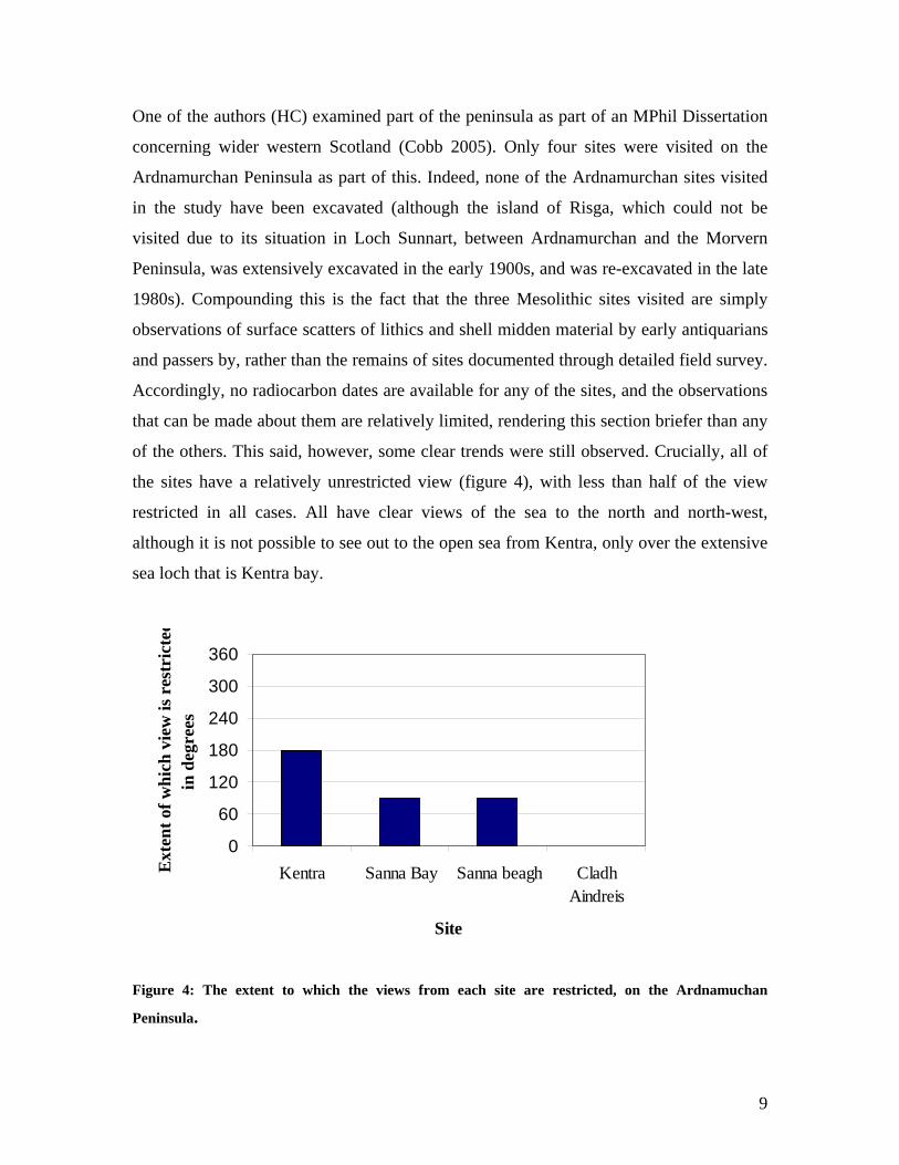
of the others. This said, however, some clear trends were still observed. Crucially, all of
the sites have a relatively unrestricted view (figure 4), with less than half of the view
restricted in all cases. All have clear views of the sea to the north and north-west,
although it is not possible to see out to the open sea from Kentra, only over the extensive
sea loch that is Kentra bay.
0
60
120
180
240
300
360
Kentra Sanna Bay Sanna beagh CladhAindreis
Site
Ext
ent o
f whi
ch v
iew
is r
estr
icte
din
deg
rees
Figure 4: The extent to which the views from each site are restricted, on the Ardnamuchan
Peninsula.
10
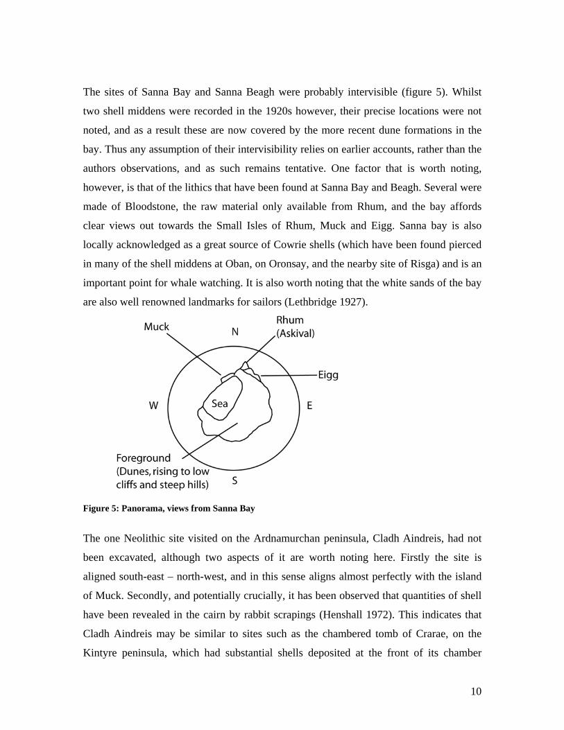
The sites of Sanna Bay and Sanna Beagh were probably intervisible (figure 5). Whilst
two shell middens were recorded in the 1920s however, their precise locations were not
noted, and as a result these are now covered by the more recent dune formations in the
bay. Thus any assumption of their intervisibility relies on earlier accounts, rather than the
authors observations, and as such remains tentative. One factor that is worth noting,
however, is that of the lithics that have been found at Sanna Bay and Beagh. Several were
made of Bloodstone, the raw material only available from Rhum, and the bay affords
clear views out towards the Small Isles of Rhum, Muck and Eigg. Sanna bay is also
locally acknowledged as a great source of Cowrie shells (which have been found pierced
in many of the shell middens at Oban, on Oronsay, and the nearby site of Risga) and is an
important point for whale watching. It is also worth noting that the white sands of the bay
are also well renowned landmarks for sailors (Lethbridge 1927).
Figure 5: Panorama, views from Sanna Bay
The one Neolithic site visited on the Ardnamurchan peninsula, Cladh Aindreis, had not
been excavated, although two aspects of it are worth noting here. Firstly the site is
aligned south-east – north-west, and in this sense aligns almost perfectly with the island
of Muck. Secondly, and potentially crucially, it has been observed that quantities of shell
have been revealed in the cairn by rabbit scrapings (Henshall 1972). This indicates that
Cladh Aindreis may be similar to sites such as the chambered tomb of Crarae, on the
Kintyre peninsula, which had substantial shells deposited at the front of its chamber
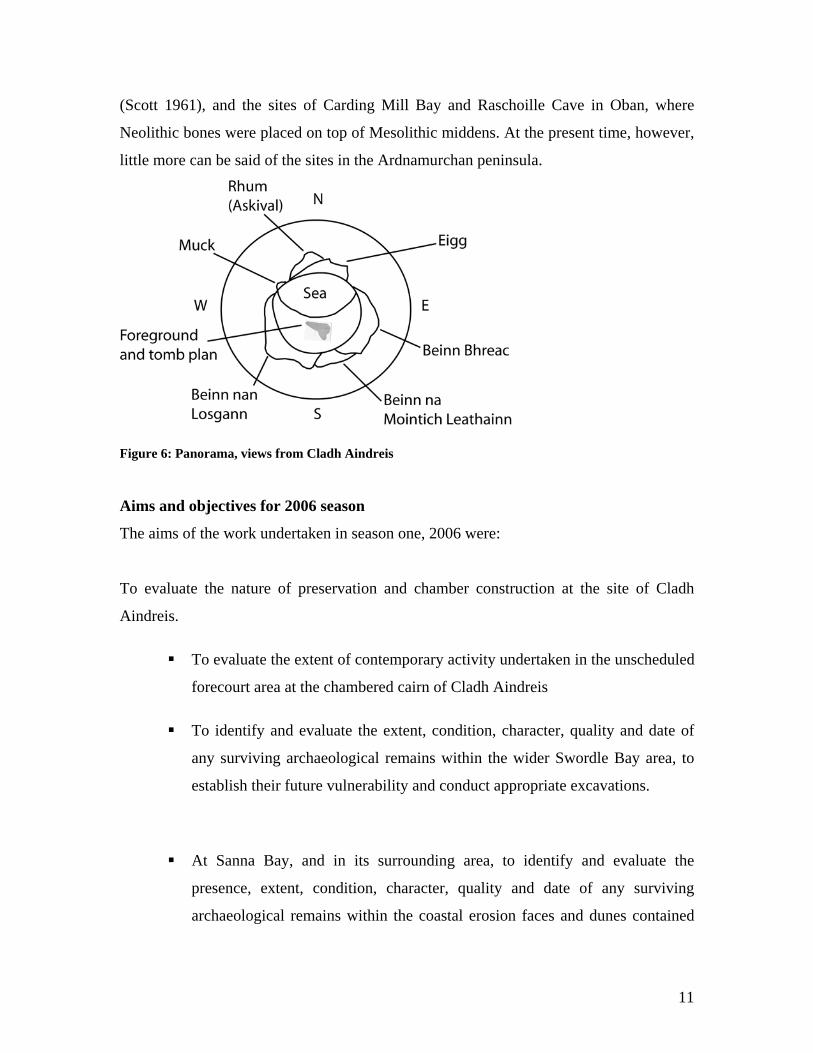
11
(Scott 1961), and the sites of Carding Mill Bay and Raschoille Cave in Oban, where
Neolithic bones were placed on top of Mesolithic middens. At the present time, however,
little more can be said of the sites in the Ardnamurchan peninsula.
Figure 6: Panorama, views from Cladh Aindreis
Aims and objectives for 2006 season
The aims of the work undertaken in season one, 2006 were:
To evaluate the nature of preservation and chamber construction at the site of Cladh
Aindreis.
To evaluate the extent of contemporary activity undertaken in the unscheduled
forecourt area at the chambered cairn of Cladh Aindreis
To identify and evaluate the extent, condition, character, quality and date of
any surviving archaeological remains within the wider Swordle Bay area, to
establish their future vulnerability and conduct appropriate excavations.
At Sanna Bay, and in its surrounding area, to identify and evaluate the
presence, extent, condition, character, quality and date of any surviving
archaeological remains within the coastal erosion faces and dunes contained
12
within the bay area, and to establish their future vulnerability and assess the
need for appropriate excavations.
To examine the typological and experiential relationships between Cladh
Aindreis and the other Neolithic chambered tombs on the peninsula.
To use the outcomes of the above evaluative aims in order to develop a
comprehensive proposal for future intrusive and non-intrusive investigation at
Cladh Aindreis, and for further survey and excavation work within Swordle
Bay and the wider peninsula.
To establish links with the local community and to begin to develop local
interest in the prehistory of the area and in archaeology in general.
To develop practical methodologies which integrate and situate core
theoretical questions within archaeological practice.
These aims were to be met through the following objectives:
To identify through survey, and record the presence, extent, condition,
character, quality and date of any surviving archaeological remains within
Swordle Bay.
To establish the future vulnerability of any surviving archaeological remains
within Swordle Bay.
To conduct appropriate excavations to assist in meeting the above two
objectives.
To excavate, record and asses the nature of any surviving archaeological
remains out with the scheduled area of the chambered cairn within the area to
the south of the chamber, which may have represented a forecourt area.
13
To assess the nature and condition of the scheduled chambered cairn without
undertaking invasive archaeological works in order to make proposals fro
future work.
To undertake a rapid walkover survey of Sanna Bay and the surrounding area
to identify, record and interpret the presence, extent, condition, character,
quality and date of any surviving archaeological remains within the coastal
erosion faces and dunes contained within the bay area, and to establish their
future vulnerability and assess the need for appropriate excavations.
To disseminate information about the project and its findings to local
community groups.
Excavation methodology
Following consultation with Historic Scotland all Bracken was removed from the
Chambered Cairn area using a strimmer and by hand in order that the current shape of the
cairn may be ascertained. All artefacts were retained for analysis and bulk soil samples
were recovered on a judgmental basis.
A walkover survey was carried out of the entire Swordle Bay area and Sanna Bay, within
the limitations of access and health and safety, this included a landward strip of 100m and
where practicable, an examination of the intertidal zone. A key element of the
reconnaissance survey was a detailed walk over survey of the immediate areas around the
chambered cairn of Cladh Aindreis. This was undertaken in order to identify related sites
and areas of archaeological importance. Through these walkover surveys selected sites
within Swordle Bay were identified for further investigation, through test pitting and
excavation. A further two sites were encountered at Sanna Bay.
Excavation results
Numbers in bold in the following sections correspond to contexts listed in Appendix 1 of
the Data Structure Report (DSR) (Richardson and Cobb 2006). The remains of a
14
Chambered Cairn lie within the v-shaped inlet valley Swordle Bay approximately 250m
from Swordle Bay House. This cairn is now a Scheduled Ancient Monument (SAM) and
as such all works were conducted out with the SAM area.
Within Swordle Bay three areas containing archaeological deposits were recorded (figure
3). Trench one contained a small stone cairn which sat upon the first layer of subsoil
beneath the present turf line. A further two features were cut into the natural black gravel
subsoil. Area two was a small sub-circular cairn both sat upon and abutted by natural
alluvial beach gravels. Finally a feature cut into the natural beach gravels was
encountered eroding of a dune face along the shore line.
Trench One was placed with special care due to this SAM area. The co-ordinates of the
scheduled area were identified using a GPS. In order to allow for potential errors
produced by the GPS equipment a 5m ‘buffer’ zone was allowed between these points
and trench one, in order that there would definitely not be any works conducted within
the SAM area. As such, at the site of Cladh Aindreis itself, the extent of the cairn and
surrounding area was removed of all foliage and the cairn was planned and relevant parts
of the structure were photographed (figure 1). No diagnostic finds were noted within
Trench 1 although a broken flint blade was found in the upper subsoils, with retouch on
both sides of its proximal end. Large quantities of quartzite, both in chipped form and as
river rolled pebbles, were found within all contexts. Some tiny flint waste flakes possibly
representing debitage were also found.
Trench 1 (figure 7) - Phil Richardson, Hannah Cobb and Oliver Harris
Small Cairn
In the north of the trench a small stone cairn was discovered immediately below topsoil
(figure 8). This stone measured 3.7m long x 2m wide x 1.16m deep. It consisted of
medium to small sub-angular rocks [004], some of which showed signs of being water
15
rolled. These stones were tipped, showed no signs of being structural and were
surrounded by a loose silty soil [005]. Only the western portion of this stone mound was
removed. These excavations revealed a light reddish brown sandy silt old ground surface
(OGS) 011. This OGS is stratigraphically above the natural subsoil [008] into which the
two pit features were cut. Thus 011 appears to represent an extent of the original turf line
and subsoil upon which these stones were placed. Given this it is presumed that this
‘cairn’ represents much more recent ‘robbing’ activity at the site of Cladh Andries, and
may even represent the spoil removed from around the chamber.
Pit Features
Beneath these upper deposits a stained gravel surface was found into which two pits were
cut. One was amorphous in shape, and possibly represented two pits, but disappeared into
the trench edge towards the scheduled area, and so their extent was not established.
Another was sub-oval and had been repeatedly re-cut and subject to burning activity. The
sub-oval pit represents two phases of activity (figure 7 & 9). A larger pit 1.6m long x
1.1m wide x 0.2m deep [015] represents the first phase of activity. This feature contained
a compact, stained and humic layer at the base 019. This may suggest that it had been
lined with turf or other organic matter. The pit was also lined by a series of small stones
around the upper edge [021]. The principal fill consisted of a dark blackish brown sandy
silt which contained much charcoal and ash. The upper portion of the feature [028] silted
up after going out of use. Some time after the larger feature silted up another smaller pit
was dug into it [020]. In this case the pit was lined by large stones in a smaller sub-oval
setting [022]. This pit contained a compact lower fill [016] which also contained lots of
charcoal. Above this a loose grey black fill which contained large quantities of charcoal
and carbonised wood. Again the upper fill consists of a silting action [009]. The similar
nature of these two features suggests that they represent similar reuse of the same feature
albeit time enough to allow the larger pit to silt up occurred between activities. No
artifacts were recovered from the feature although a sample for radiocarbon dating was
recovered from context 012.
16
A more amorphous pit [014] (figure 7 & 10) was present in the north-west of the trench
this consisted of two fills; the lower, a silting action [013] was overlain by a silty gravel
upper fill [010]. This feature would also appear to have been re-cut by [026] which whilst
consisting of similar fills did represent a change in the nature of the cut. The exact
proportions of this feature were not able to be defined as only a portion of the feature was
present within the trench. No artefacts were recovered from the feature.
Trench 2- Phil Richardson, Hannah Cobb and Maria Magill
A small 1m x 2m test pit was opened on top of a small knoll to the east of the cairns
chamber. The cairn itself faces SE-NW, and approximately 20m from the front of the
cairn material there is a small knoll where the ground rises. This effectively acts to
enclose the forecourt area at the front of the cairn. This was excavated in order to define
the nature of this knoll. Topsoil was removed to a depth of 0.24m down onto a mid-
orange brown sandy gravel. No archaeological remains were encountered.
Swordle Bay - Phil Richardson, Hannah Cobb and Al Curtis
On the fore shore a feature was noted eroding out of an exposed dune face. This feature
was sealed beneath a layer of white brown sand [203], sealing this was an old turf line
[204]. These layers represent were in turn sealed by a wind blown sand layer [205] and
the current turf line [206]. The feature was 2.3m long x 0.82 deep and survived to a
length of 1.1m. It consisted of a single fill of a blackish grey silty gravel [202]. The edges
of the cut were difficult to ascertain as the gravel edges were extremely similar to the fill
and thus they were mixed. The fill [202] contained large amounts of charcoal and pieces
of burnt wood. Furthermore, finds included modern pottery and a small piece of wood
with paint still on it. The feature is therefore interpreted as a modern fire pit. This dual
build up of sand followed by turf lines must represent rapid dune build up processes
since, as stated above, feature 201 does appear to be of modern origin. Two worked flints
were discovered on the coastal edge of fill 202, however, these appear to be residual,
either re-deposited when the feature was back filled or washed into the feature by tidal
action. A second possible feature turned out to be nothing more than discolouration of the
natural sand deposit on the extreme of the dune face.
17
Small Cairn and Lazy Beds - Phil Richardson, Hannah Cobb and Al Curtis
A small trench was opened to the WNW of the cairn, on a lower terrace of the Swordle
River. Here a small area of lazy bed cultivation was observed to be respecting a discrete
circular stone area, which appeared to be artificially raised above the natural lay of the
land on its western (river facing) side. An L-shaped trench measuring 6.9m long x 1m
wide was opened to investigate the nature of this structure and to examine its relationship
with the surrounding cultivation. Excavation suggested that this was a small circular cairn
set into the beach gravels (figure 11). There was no stratigraphical relationship between
the lazy beds and cairn material which appears to respect the position of the cairn. The
cairn was made up of small to medium water rolled cobbles [302], the excavation trench
revealed a setting of three up right stones [303] which were set on edge and may
represent structural evidence. However only ¼ of the structure was revealed in
excavation in an area that may possibly have been subject to more recent robbing
activity. Only one possibly diagnostic find was made, and this was an iron rove. This has
been sent away for further analysis. Consequently little can be said about the age and
purpose of this structure at present, however it will be fully investigated in season 2.
Sanna Bay Survey
As well as the main excavation work around Swordle Bay a rapid walkover survey
assisted by members of the Moidart Heritage group, was undertaken at Sanna Bay, at the
west of the Peninsula, and within the hills to the south of Sanna Bay, in the area between
Portuairk and Grigadale. Sanna Bay has a large shifting dune system in which finds from
the Mesolithic to the Viking period have periodically been noted, including a series of
possible multi-period middens in the 1920s (Lethbridge 1927). Most recently a series of
prehistoric flint and pottery finds have been made by local expert Jim Kirby and other
members of the Moidart Heritage Group. Additionally a possible shell midden has been
noted around the Grigadale area, perhaps relating to caves in the peak of Sgurr nam
Meann (pers com. J. Kirby).
A rapid walkover survey of these areas found little material, however 2 buried land
surfaces revealed by dune blowouts that has previously been identified by Jim Kirby
18
were revisited. At one of these a spread of shells and a piece of flint were noted (NM
44523 69297). At another (NM 44621 69276) a series of eroding land surfaces could
clearly be seen within the dune blow out and two different types of pottery were found in
these; a burnished piece that is probably medieval and a more rough piece which is likely
to be later prehistoric. This area will be given a further detailed examination future
seasons.
Discussion and preliminary interpretations
Within the Swordle Valley our objectives in 2006 were to undertake a small scale
evaluative survey of the lower valley and undertake as much evaluative work at the site
of Cladh Aindreis without breaking the ground in the scheduled area. This work was
conceived for two reasons; to assist in developing a detailed excavation strategy for
future seasons and to provide a preliminary contribution towards the wider project aims
of establishing the date, form and chronological sequence of the cairn and chamber.
Additionally a clear objective was to begin to define the boundaries of the monument, it’s
relation to other sites within a 2km radius, and to record the palaeoenvironmental setting
of the site. As such, at the site of Cladh Aindreis itself, the extent of the cairn and
surrounding area was removed of all foliage and the cairn was planned (figure 1) and
relevant parts of the structure were photographed.
In the forecourt of the tomb, outside of the scheduled area, a trench was opened (Trench
1) in which robbed material from the cairn was identified in the upper subsoils. Beneath
these upper deposits a stained gravel surface was found into which two pits were cut. One
was amorphous in shape, and possibly represented two pits, but disappeared into the
trench edge towards the scheduled area, and so their extent was not established. Another
was sub-oval and had been repeatedly re-cut and subject to burning activity. A compact,
stained and humic layer at the base of this pit suggested that it may have been lined with
turf or other organic matter. A sample of carbonised wood was recovered from this pit
and has been sent away for radiocarbon dating. 100% of the excavated material from both
of the pits was taken for sampling and wet sieving. It has been hypothesised that the
surface into which these pits were cut is the surface upon which the cairn may also have
19
been built, although we were unable to establish this without SMC. No diagnostic finds
were noted within Trench 1, although a broken flint blade was found in the upper
subsoils, with retouch on both sides of its proximal end. Large quantities of quartzite,
both in chipped form and as river rolled pebbles, were found within all contexts. Some
tiny flint waste flakes possibly representing debitage were also found.
By clearing all foliage from the cairn structure it became clear that it may not simply
represent the 40m long roughly trapezoidal shape that Henshall identified in 1972.
Instead, from the shape of the cairn material surrounding the chamber, the cairn has the
appearance of a round cairn which was later modified by the addition of a tail to make a
trapezoidal long cairn (See Figure 1). However the trench has been severely robbed and
robbed cairn material has been redeposited largely around the chamber area, which may
enhance the appearance of this area as a circular cairn. Additionally a robber trench,
approximately 10m x 20m appears to have been placed about halfway between the
chamber and the end of the cairn material. This trench may further enhance the
appearance of an original circular cairn around the chamber. However due to its location
within the cairn material this robber trench may actually provide a valuable tool for
addressing the question of the construction phases of the cairn.
Out with the immediate cairn area 3 further trenches were opened. The cairn itself faces
SE-NW, and approximately 20m from the front of the cairn material there is a small knoll
where the ground rises. This effectively acts to enclose the forecourt area at the front of
the cairn. As such a 1m x 2m trench (Trench 2) was placed on top of the knoll, in line
with the chamber, to investigate whether the knoll was natural and if it represented any
form anthropogenic activity. Excavation showed that this knoll was natural and no
cultural material was found in the subsoils.
Another trench (Trench 3) was opened to the WNW of the cairn, on a lower terrace of the
Swordle River. Here a small area of rig and furrow field system was observed to be
respecting a discrete circular stone area, which appeared to be artificially raised above the
natural lay of the land on its western (river facing) side. A trench was opened to
investigate what this structure was and examine its relationship with the surrounding rig
20
and furrow. Excavation suggested that this was a small circular structure set into the
beach gravels, and respected by the rig and furrow. However only ¼ of the structure was
revealed in excavation in an area that may possibly have been subject to more recent
robbing activity. Only one possibly diagnostic find was made, and this was an iron rove.
This has been sent away for further analysis. Consequently little can be said about the age
and purpose of this structure at present, however it will be fully investigated in season 2
(Cobb and Richardson 2006).
On the western side of the Swordle River a rapid walkover survey of the beach area was
undertaken. This also included further investigation of a series of burnt pits that could be
seen in the eroding beach section. Excavation of these found one to be empty and one to
contain a flint scraper and broken flint blade. However the context in which these were
found was clearly mixed as modern pottery and flakes of paint were found below them. It
is likely that these pits represent very recent activity. A more detailed walk over survey of
the bay is intended, however, and further investigation will be undertaken of a cave in the
far west of the bay.
As well as the main excavation work around Swordle Bay and the lower Swordle Valley,
a rapid walkover survey assisted by members of the Moidart Heritage group, was
undertaken at Sanna Bay, at the west of the Peninsula, and within the hills to the south of
Sanna Bay, in the area between Portuairk and Grigadale. Sanna Bay has a large shifting
dune system in which finds from the Mesolithic to the Viking period have periodically
been noted, including a series of possible multi-period middens in the 1920s (Lethbridge
1927). A rapid walkover survey of these areas found little material, however 2 buried
land surfaces revealed by dune blowouts that has previously been identified by Jim Kirby
were revisited. At one of these a spread of shells and a piece of flint were noted. At
another a series of eroding land surfaces could clearly be seen within the dune blow out
and two different types of pottery were found in these; a burnished piece that is probably
medieval and a more rough piece which is likely to be later prehistoric. This area will be
given a further detailed examination future seasons.
21
Publication plans and future work
Season 1 proved highly successful for the Ardnamurchan Transitions Project and all
objectives for the season were successfully met. As such we now have a detailed
excavation strategy for the site of Cladh Aindreis, and clear plans for future survey work
both in Swordle Bay and Valley and on the rest of the peninsula (See ATP 2007 Project
Design, Cobb and Richardson 2006). Additionally we were highly successful in forging
connections with local groups and individuals, largely due to the success of the site open
day, and the enthusiasm and kindness of local groups and individuals. The open day was
held on the 6th August 2006 and 22 groups attended (ranging in size from 2 to 9 people).
As well as many people expressing an interest in coming to volunteer in future seasons,
we have also become involved with a local schools and community project entitled “A year in the life of Ardnamurchan” which will structure some activities around our work in
Season 2. We have also been invited to speak about the project to the Moidart Heritage Group in February 2007, and to the wider community in the Kilchoan Community Centre
during our second season of work in summer 2007. We have also been invited to make use of a local study centre, which will provide an opportunity to engage local groups in
further archaeological work. Furthermore through the contacts we have made we have
been informed about a number of sites and area that are not recorded by the SMR which
we hope to investigate in further seasons of work.
Season two will take place between 17th June and 9th July 2007 and will aim to clarify
and expand upon the information provided here. Detailed recommendations for a further
course of action, both at the cairn and around the peninsula are clearly laid out within the
ATP Project Design 2007 (Cobb and Richardson 2006).
Post-excavation
Sample processing, artefact and ecofact analyses, a programme of C14 dating and
publication of the results from this fieldwork will be undertaken to provide a more
conclusive picture of this site.
22
Archiving and Finds Disposal
The project archive, comprising all ATP record sheets, plans and reports, will be
deposited with the National Monuments Record of Scotland on completion of fieldwork
and any relevant post-excavation analyses. Finds will be subject to the Scots Law of
Treasure Trove and Bona Vacantia, and will be reported to the Queen and Lord
Treasurer’s Remembrancer for disposal. Appropriate conservation of finds will be
conducted before disposal.
Dissemination of Information
A brief summary of the archaeological results will be submitted for inclusion in
Discovery and Excavation in Scotland, 2006. Two short articles on our findings will be
published in Scottish Archaeological News and PAST, the newsletter of the Prehistoric
Society (Cobb and Richardson in press; Cobb and Richardson forthcoming). A paper was
presented at the 2006 EAA conference regarding teaching methods used. A paper will be
given in February 2007 to the Moidart Local History Group regarding our work. A
website has been set up and information will be continually updated at this site. The
address for this is http://ardnamurchantransitionsproject.googlepages.com/
Notes and acknowledgements
The Ardnamurchan Transitions Project would like to thank the Ardnamurchan Estates for
permission to conduct archaeological works. We would also like to thank Oliver Harris
and Al Curtis for their generous help as staff and also all students and volunteers whose
contributions to the project were invaluable. The field work was generously funded by
The Prehistoric Society, The Council for British Archaeology Challenge Fund, The
Students as Partners Fund (through the University of Manchester), The School of
Historical Studies, University of Newcastle and The University of Manchester. We would
also like to thank all the local individuals and groups, such as Jim Kirby and The Moidart
Heritage Group, who gave up their time in order to talk to us and show us some of the
23
peninsula. This was not merely of tremendous importance to us but of great benefit to the
students who were shown things and heard discussions that they would not have been
privy to without the engagement of these local groups.
References
• Cobb, H., L. (2004). From Middens to Megaliths? A preliminary investigation into the possibility of using shell middens as a medium for interpreting the Mesolithic experience of the world. Unpublished MPhil Thesis, University of Manchester.
• Cobb, H. & Richardson, P. in press The Ardnamurchan Transitions Project: Excavation and Survey work on the Ardnamurchan Peninsula. Scottish Archaeological News.
• Cobb, H. & Richardson, P. forthcoming a ‘Transition/Transformation: Exploring alternative excavation practices to transform student learning and development in the field’, in. K. Croucher and H. Cobb (eds.) Prehistoric Pedagogies? Approaches to teaching European prehistoric archaeology session EAA 2006
• Cobb, H. & Richardson, P. forthcoming b The Ardnamurchan Transitions Project: Season one on the Ardnamurchan Peninsula. PAST
• Cobb, H. & Richardson, P. 2006 Project Design for season 2 (2007), Ardnamurchan Transitions Project unpublished report no. 5
• Cobb, H. & Richardson, P. 2005 Ardnamurchan Transitions Project: an Archaeological Research Design Including Initial Desk-based Assessment, Ardnamurchan Transitions Project unpublished report no. 1
• Cobb, H. & Richardson, P. 2005b Project Design – Cladh Aindreis chambered cairn, Ardnamurchan Transitions Project unpublished report no. 2
• Cobb, H. & Richardson, P. 2005c Project Design – Sanna Bay Coastal Zone Assessment Survey, Ardnamurchan Transitions Project unpublished report no. 3
• Henshall, A. 1972 The Chambered tombs of Scotland. Vol. 2, Edinburgh: Edinburgh University Press
• Lethbridge, T., C. (1927). ’A settlement site of the beaker period at Sanna Bay, Ardnamurchan, Argyll.’ MAN 27:173-174.
• Richardson, P. 2005 To Plough the Sand: Typology or Understanding? The Search for Meaning amongst the Chambered Cairns of southwest Scotland, University of Manchester M.A Dissertation
• Richardson, P. & Cobb, H. 2006 Ardnamurchan Transitions Project, Season One (2006) Data Structure Report. Ardnamurchan Transitions Project unpublished report no. 4.
24
• Scott, J., G. (1961). ‘The Excavation of the Chambered Cain at Crarae, Loch Fyneside, Mid Argyll.’ Proceedings of the Society of Antiquaries of Scotland 94: 1-27.
Figure 1: Plan of Cladh Aindreis showing Location of Robber Trenches. 1:75, scale = 5m
25
Figure 2: Locations of sites - Cladh Aindreis is larger star, Sanna Bay is smaller star