Embed Size (px)
Citation preview
The world’s leading sustainability consultancy
Area 451 Restricted Dredge Deposit Zone 2 Site Characterisation Report Report
December 2013
Environmental Resources Management Limited
Incorporated in the United Kingdom with registration number 1014622
Registered Office: 2nd Floor, Exchequer Court, 33 St Mary Axe, London, EC3A 8AA
Boskalis Westminster Limited
Area 451 Restricted Dredge Deposit Zone 2 Site Characterisation Report Report
December 2013
For and on behalf of Environmental Resources Management Approved by: Kevin Murphy _____________ Signed: ________________________________ Position: Partner ________________________ Date: 10 December 2013 __________________
This report has been prepared by Environmental Resources Management the trading name of Environmental Resources Management Limited, with all reasonable skill, care and diligence within the terms of the Contract with the client, incorporating our General Terms and Conditions of Business and taking account of the resources devoted to it by agreement with the client. We disclaim any responsibility to the client and others in respect of any matters outside the scope of the above. This report is confidential to the client and we accept no responsibility of whatsoever nature to third parties to whom this report, or any part thereof, is made known. Any such party relies on the report at their own risk.
CONTENTS
1 NEED FOR THE NEW SITE 1
1.1 INTRODUCTION 1
1.2 SHORT AND LONG TERM DISPOSAL NEEDS 3
1.3 SUITABILITY AND CAPACITY OF EXISTING DISPOSAL SITES 4
1.4 POTENTIAL ALTERNATIVE DISPOSAL SITES 4
1.5 DETERMINATION OF THE ACCEPTABILITY OF THE MATERIAL FOR SEA DISPOSAL 5
1.6 STRUCTURE OF THIS REPORT 5
2 DEPOSIT SITE CONSIDERATIONS 6
2.1 SITE DESCRIPTION 6
2.2 DEPOSIT SITE CHARACTERISTICS 9
2.3 BENTHIC CONSIDERATIONS 21
2.4 FISHERY CONSIDERATIONS 23
2.5 MARINE MAMMALS 25
2.6 PROTECTED AREAS AND SPECIES 26
2.7 INFRASTRUCTURE AND OTHER OPERATIONS 32
2.8 ARCHAEOLOGY AND CULTURAL HERITAGE 32
3 MATERIAL CHARACTERISTICS 35
3.1 MATERIAL TYPES 35
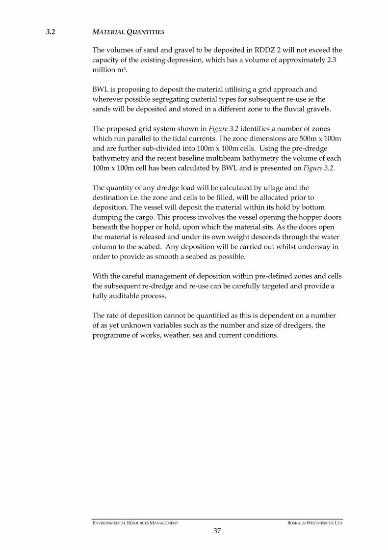
3.2 MATERIAL QUANTITIES 37
3.3 CHARACTERISTICS OF MATERIAL DURING DEPOSITION 39
3.4 CHARACTERISTICS OF MATERIAL IN-SITU 42
4 ASSESSMENT OF POTENTIAL EFFECTS 43
4.1 EFFECTS OF DEPOSITION ON WATER COLUMN 43
4.2 EFFECTS OF DEPOSITION ON SEABED CONDITIONS 43
4.3 EFFECTS ON IDENTIFIED RECEPTORS 44
5 REASON FOR SITE SELECTION 47
6 MONITORING PROPOSALS 48
REFERENCES 49
ANNEX A FIGURE A.1 RDDZ 2 RESOURCE GEOLOGY AND THICKNESS
(SUPPLIED BY BWL)
ENVIRONMENTAL RESOURCES MANAGEMENT BOSKALIS WESTMINSTER LTD
1
1 NEED FOR THE NEW SITE
1.1 INTRODUCTION
Background 1.1.1
Boskalis Westminster Limited (BWL) has identified a solution to a long
standing problem associated with large dredge projects that produce
aggregates of sufficient quality and quantity for re-use in projects such as
beach replenishment.
In many cases those considering dredge operations that will give rise to
quantities of sands and gravels that could be used beneficially have sought
such schemes but technical and operational issues have precluded them being
viable options. In most cases the beneficial schemes require volumes of
aggregate delivered in small amounts over periods of time that do not tie in
with the relatively fast turn around and high rate of generation that
characterises capital and maintenance dredge schemes. Furthermore the
ability to stock pile the required material ashore is difficult as there is usually
a lack of space within a distance of the beneficial use site to make the required
transportation of the material to site viable.
BWL has identified a viable opportunity to provide a site offshore that can
hold sands and gravels arising from capital and maintenance dredge schemes
so that it can be re-used in beneficial schemes at a later date in a manner that
fits with the beneficial schemes timings and requirements. This approach
supports the various aims of waste legislation in avoiding disposal where
possible.
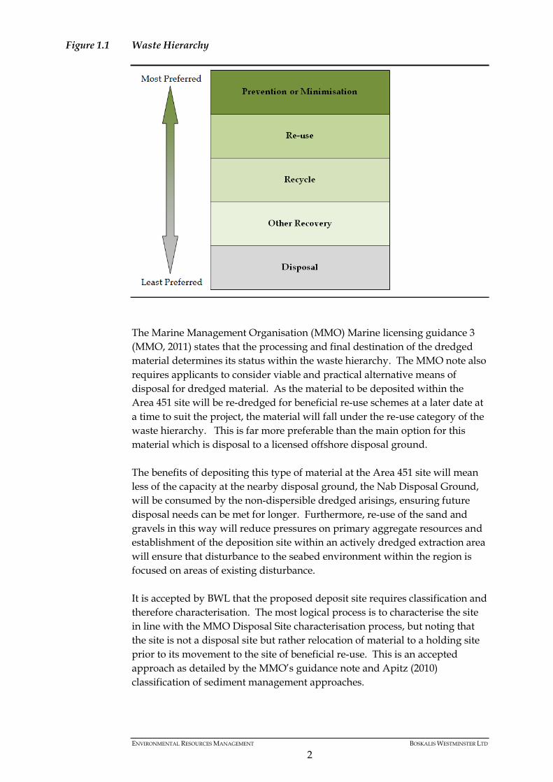
The Waste Framework Directive (EC, 2008) details the waste hierarchy which
is shown in Figure 1.1.
ENVIRONMENTAL RESOURCES MANAGEMENT BOSKALIS WESTMINSTER LTD
2
Figure 1.1 Waste Hierarchy
The Marine Management Organisation (MMO) Marine licensing guidance 3
(MMO, 2011) states that the processing and final destination of the dredged
material determines its status within the waste hierarchy. The MMO note also
requires applicants to consider viable and practical alternative means of
disposal for dredged material. As the material to be deposited within the
Area 451 site will be re-dredged for beneficial re-use schemes at a later date at
a time to suit the project, the material will fall under the re-use category of the
waste hierarchy. This is far more preferable than the main option for this
material which is disposal to a licensed offshore disposal ground.
The benefits of depositing this type of material at the Area 451 site will mean
less of the capacity at the nearby disposal ground, the Nab Disposal Ground,
will be consumed by the non-dispersible dredged arisings, ensuring future
disposal needs can be met for longer. Furthermore, re-use of the sand and
gravels in this way will reduce pressures on primary aggregate resources and
establishment of the deposition site within an actively dredged extraction area
will ensure that disturbance to the seabed environment within the region is
focused on areas of existing disturbance.
It is accepted by BWL that the proposed deposit site requires classification and
therefore characterisation. The most logical process is to characterise the site
in line with the MMO Disposal Site characterisation process, but noting that
the site is not a disposal site but rather relocation of material to a holding site
prior to its movement to the site of beneficial re-use. This is an accepted
approach as detailed by the MMO’s guidance note and Apitz (2010)
classification of sediment management approaches.
ENVIRONMENTAL RESOURCES MANAGEMENT BOSKALIS WESTMINSTER LTD
3
Deposit or Disposal 1.1.2
Due to time constraints BWL requires the site to be licensed as soon as
possible. Realising the unique nature of the request BWL is happy for the site
to be characterised in line with current MMO requirements but wishes to
ensure that the matter of classification can be re-visited at a later date.
The proposed deposit site sits within Area 451, a recently re licenced
aggregate extraction area. The material dredged from a licensed aggregate
extraction area is not classed as a waste and can be taken ashore and moved
without having to comply with The London Convention 1972 or the OSPAR
Convention 1992. These pieces of legislation cover the control of waste and
dumping activity. Under the OSPAR Convention dumping is classified as:
(f) "Dumping" means (i) any deliberate disposal in the maritime area of wastes or other matter
(1) from vessels or aircraft; (2) from offshore installations;
(ii) any deliberate disposal in the maritime area of (1) vessels or aircraft; (2) offshore installations and offshore pipelines.
(g) “Dumping” does not include
(i) ….. (ii) placement of matter for a purpose other than the mere disposal thereof, provided that, if the placement is for a purpose other than that for which the matter was originally designed or constructed, it is in accordance with the relevant provisions of the Convention; and …
For this reason the following document talks about deposition rather than
disposal.
1.2 SHORT AND LONG TERM DISPOSAL NEEDS
BWL is regularly involved in capital and maintenance dredge projects that
will produce sands and gravels of sufficient quality and quantity to warrant
re-use rather than loss to a disposal ground.
BWL has very recently been awarded the contract to carry out the
Southampton Approaches and Channel Dredge (SACD) for ABP
Southampton. This dredge programme will give rise to 4.5-5.0 million m3 of
material of which it is estimated >500,000 m3 will be good quality sands and
gravels. It is these sands and gravels that will be deposited at the Area 451
deposit site if permitted.
In the longer term there may be further capital and maintenance projects in
the region that give rise to sands and gravels in sufficient quantity and quality
to warrant set aside for beneficial reuse at a later date rather than loss to a
ENVIRONMENTAL RESOURCES MANAGEMENT BOSKALIS WESTMINSTER LTD
4
disposal ground. In these situations and where permitted the material will be
deposited within the Area 451 site, within the capacity of the site.
BWL are therefore seeking to characterise the Area 451 deposit site for
deposition and temporary storage of material from both the SACD and future
projects as appropriate.
1.3 SUITABILITY AND CAPACITY OF EXISTING DISPOSAL SITES
There are several marine disposal sites in the South Coast Region and the Nab
Tower site (W1060) is the main site for the region. The Nab Tower is 11.94
km2 in extent and is a dispersal site. The site has been used for the disposal of
capital and maintenance dredge material, silt washings from land-processed
marine aggregates, re-deposited contaminated aggregates, sewage sludge and
liquid industrial wastes. The disposal of liquid industrial wastes ceased at
Nab Tower in 1985 and the disposal of sewage sludge ceased in 1998.
Between 1984 and 1998, an average of approximately 264,000 wet tonnes of
sewage sludge was disposed of annually. The majority of material disposed at
Nab Tower is now maintenance and capital dredge material from the nearby
ports. Between 1998 and 2008 4.65 million tonnes of capital and maintenance
dredge material, silt washings, and re-deposited contaminated aggregates
were deposited at the Nab Tower site (annual average of 423,617 tonnes)
(EMU, 2012).
Whilst the Nab Tower disposal site could accommodate the volume of
materials being considered here it is a dispersive site and the heavier material
fractions are unlikely to disperse from the site resulting in reduction in the
capacity of the site. By depositing the heavier material fractions at an
alternative site, capacity of the Nab Tower site will be maintained whilst also
resulting in additional benefits.
1.4 POTENTIAL ALTERNATIVE DISPOSAL SITES
As outlined in the Environmental Statement (ES) for the SACD (ABPmer,
2012) alternative uses for the dredged material could not be readily found.
Where a potential need had been identified, operational constraints meant it
could not be satisfied. The only viable option identified was disposal to the
Nab Disposal Ground, which will continue to take the finer fractions from the
SACD.
There are no other viable alternatives to the options already considered for the
SACD.
ENVIRONMENTAL RESOURCES MANAGEMENT BOSKALIS WESTMINSTER LTD
5
1.5 DETERMINATION OF THE ACCEPTABILITY OF THE MATERIAL FOR SEA DISPOSAL
The material to be deposited within the Area 451 deposit site will be sands
and gravels of marine origin. These resources by their nature have minimal
fines associated with them and therefore there is a reduced possibility of
contamination levels that would preclude deposit at sea. The material
characteristics are discussed further in Section 3.
1.6 STRUCTURE OF THIS REPORT
The information within this report is provided to address the information
requirements outlined in the MMO Marine licensing guidance 3 (MMO, 2011)
and the more detailed Cefas guidance (Birchenough and Vivian) to enable
designation of a new deposition site and its characterisation. The remainder of
this characterisation report contains the following sections:
Section 2 – Deposit Site Considerations
Section 3 – Material Characteristics
Section 4 – Assessment of Potential Effects
Section 5 – Reason for Site Selection
Section 6 – Proposed Monitoring
ENVIRONMENTAL RESOURCES MANAGEMENT BOSKALIS WESTMINSTER LTD
6
2 DEPOSIT SITE CONSIDERATIONS
2.1 SITE DESCRIPTION
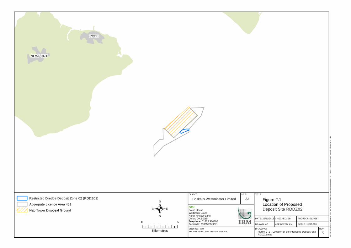
Area 451 is located 12 km off the east coast of the Isle of Wight, east and
adjacent to the Nab Disposal Site. Westminster Gravels Ltd (WGL), a sister
company of BWL, currently holds a 15 year aggregate dredging licence, due to
expire March 31st 2028, for Area 451. The proposed deposit area is known
as the Restricted Dredge Deposit Zone 2 (RDDZ 2) section of aggregate Area
451 and occupies an area of 0.6 km2 at the centre of Area 451 in water depths
of 25 m to 40 m below Chart Datum. Co-ordinates for RDDZ 2 are presented
in Table 2.1 and the location of the deposit site is presented in Figure 2.1.
Table 2.1 Proposed Deposit Site, RDDZ 2 Coordinates (WGS84)
Node Longitude (DDM) Latitude (DDM)
A 0° 57.6840 W 50° 34.6463 N
B 0° 57.4384 W 50° 34.7881 N
C 0° 57.4765 W 50° 34.5364 N
D 0° 56.8666 W 50° 34.6804 N
E 0° 56.6961 W 50° 34.7044 N
F 0° 56.6427 W 50° 34.7628 N
G 0° 56.4394 W 50° 34.7592 N
H 0° 56.3388 W 50° 34.7898 N
I 0° 56.3388 W 50° 34.9154 N
J 0° 56.7713 W 50° 34.9237 N
K 0° 57.2148 W 50° 34.8593 N
The current licence at Area 451 was determined on 7th February 2013 and
permits the removal of 18.75 million tonnes of sediment over a 15 year period,
with a maximum annual tonnage of 2.5 million tonnes and no rollover. The
average extraction tonnage is expected to be approximately 1.25 million
tonnes.
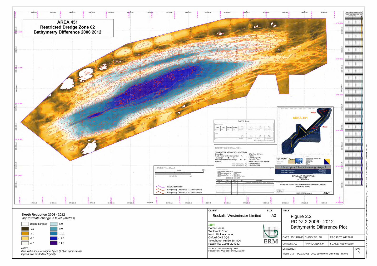
Area 451 has been dredged for the past 10 years for sand and gravel resource
being worked in zones in line with industry best practice, RDDZ 2 being one
such zone. To date and since December 2006, approximately 2,313,000 m3 of
aggregate has been removed from the RDDZ 2 mainly for beach
replenishment schemes but also smaller volumes for use in the aggregate
industry. This extraction has lowered the seabed in RDDZ 2. This lowering is
clearly visible in Figure 2.2 which presents the difference between the 2006
pre-dredge bathymetry and the 2012 bathymetry. All aggregate extraction
dredging has been undertaken using a trailer suction hopper dredgers, and
monthly Electronic Monitoring System (EMS) data were recorded.
RYDE
NEWPORT
CLIENT: SIZE: TITLE:
DATE: 25/11/2013
DRAWN: AZ
CHECKED: EB
APPROVED: KM
PROJECT: 0128267
SCALE:DRAWING: REV:
Boskalis Westminster Limited A4 Figure 2.1Location of Proposed Deposit Site RDDZ02
0SOURCE: ESRIPROJECTION: WGS 1984 UTM Zone 30N
U:\P
rojec
ts\01
2826
7Area
451_
GIS_
AK_M
I\Map
s\Cha
racter
isatio
nRep
ort\Fi
gure
2_1 -
Loca
tion o
f the P
ropos
ed D
epos
it Site
RDD
Z 2.m
xd
ERMEaton HouseWallbrook CourtNorth Hinksey LaneOxford OX2 0QSTelephone: 01865 384800Facsimile: 01865 2049820 6
Kilometres
Restricted Dredge Deposit Zone 02 (RDDZ02)Aggegrate Licence Area 451Nab Tower Disposal Ground
Figure 2_1 - Location of the Proposed Deposit SiteRDDZ 2.mxd
1:200,000
CLIENT: SIZE: TITLE:
DATE: 25/11/2013
DRAWN: AZ
CHECKED: EB
APPROVED: KM
PROJECT: 0128267
SCALE: Not to ScaleDRAWING: REV:
Boskalis Westminster Limited A3 Figure 2.2RDDZ 2 2006 - 2012 Bathymetric Difference Plot
0SOURCE: Data provided by ClientPROJECTION: WGS 1984 UTM Zone 30N
U:\Pr
ojects
\0128
267A
rea45
1_GI
S_AK
_MI\M
aps\C
harac
terisa
tionR
eport
\Figu
re 2_
2 - R
DDZ 2
2006
- 201
2 Bath
ymetr
ic Dif
feren
ce Pl
ot.mx
d
ERMEaton HouseWallbrook CourtNorth Hinksey LaneOxford OX2 0QSTelephone: 01865 384800Facsimile: 01865 204982
Figure 2_2 - RDDZ 2 2006 - 2012 Bathymetric Difference Plot.mxd
Depth Reduction 2006 - 2012Approximate change in level (metres)
-0.1-1.0-2.0-4.0
-6.0-8.0-10.0-12.0-14.5
Depth Increase
NOTE: Due to the scale of original figure (A1) an approximate legend was drafted for legibility
ENVIRONMENTAL RESOURCES MANAGEMENT BOSKALIS WESTMINSTER LTD
9
Under the current aggregate extraction Marine Licence, WGL is required to
undertake both baseline and future monitoring surveys. The baseline surveys
were carried out for Area 451 in 2012, providing geophysical, multibeam
bathymetry and drop down video (DDV) data at selected sites.
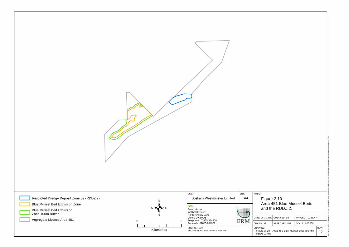
The subsequent Conservation Review (FugroEmu, 2013) which examined the
side scan sonar and targeted DDV footage, highlighted the presence of blue
mussel beds within an area of Area 451. WGL has placed an exclusion zone
around the beds, as agreed by the MMO, and no extraction activity is
permitted within these zones. The relevance of the deposit activity to these
blue mussel beds is discussed further in Section 4.
2.2 DEPOSIT SITE CHARACTERISTICS
Existing Sediment Characteristics 2.2.1
The sediment characteristics of the proposed deposit site within Area 451 are
well understood having been assessed for aggregate extraction purposes
through a number of recent surveys. These survey data have been used to
generate the figures presented in this section. In addition recent and historic
data have been assessed for the:
South Coast Region Marine Aggregates Regional Environmental
Assessment (MAREA) (EMU, 2012) and supporting studies;
Area 451 Environmental Statement (2012);
South Coast Regional Environmental Characterisation (REC) (James et
al 2010); and
Coastal Impact Study (CIS) for Area 451 (HR Wallingford 2011).
Using the best available data (side scan sonar, bathymetry and vibrocore data)
BWL has produced a detailed site characterisation plan for RDDZ 2. This
figure details the geology and sediment characteristics of the area as well as
showing cross sections of the site to assist understanding of the current
bathymetry of the site. Due to the size of this figure, Figure A.1 is provided at
Annex A.
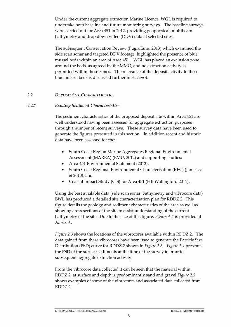
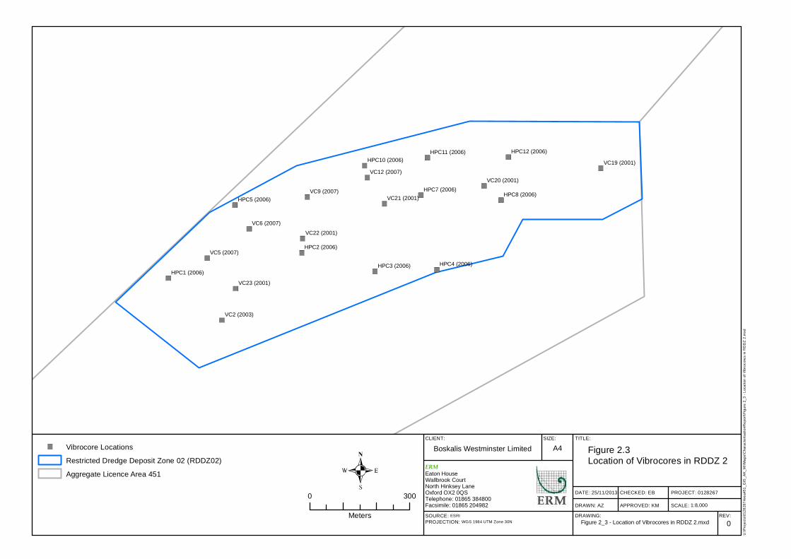
Figure 2.3 shows the locations of the vibrocores available within RDDZ 2. The
data gained from these vibrocores have been used to generate the Particle Size
Distribution (PSD) curve for RDDZ 2 shown in Figure 2.3. Figure 2.4 presents
the PSD of the surface sediments at the time of the survey ie prior to
subsequent aggregate extraction activity.
From the vibrocore data collected it can be seen that the material within
RDDZ 2, at surface and depth is predominantly sand and gravel Figure 2.5
shows examples of some of the vibrocores and associated data collected from
RDDZ 2.
VC9 (2007)
VC6 (2007)
VC5 (2007)
VC2 (2003)
VC12 (2007)
HPC8 (2006)HPC7 (2006)HPC5 (2006)
HPC4 (2006)HPC3 (2006)
HPC2 (2006)
HPC1 (2006)VC23 (2001)
VC22 (2001)
VC21 (2001)
VC20 (2001)
VC19 (2001)HPC12 (2006)HPC11 (2006)
HPC10 (2006)
CLIENT: SIZE: TITLE:
DATE: 25/11/2013
DRAWN: AZ
CHECKED: EB
APPROVED: KM
PROJECT: 0128267
SCALE:DRAWING: REV:
Boskalis Westminster Limited A4 Figure 2.3Location of Vibrocores in RDDZ 2
0SOURCE: ESRIPROJECTION: WGS 1984 UTM Zone 30N
U:\P
rojec
ts\01
2826
7Area
451_
GIS_
AK_M
I\Map
s\Cha
racter
isatio
nRep
ort\Fi
gure
2_3 -
Loca
tion o
f Vibr
ocore
s in R
DDZ 2
.mxd
ERMEaton HouseWallbrook CourtNorth Hinksey LaneOxford OX2 0QSTelephone: 01865 384800Facsimile: 01865 204982
0 300
Meters
Vibrocore LocationsRestricted Dredge Deposit Zone 02 (RDDZ02)Aggregate Licence Area 451
Figure 2_3 - Location of Vibrocores in RDDZ 2.mxd
1:8,000
Figure 2.4 Pre Aggregate Extraction PSD Curve for RDDZ 2
0
10
20
30
40
50
60
70
80
90
100
0.01 0.10 1.00 10.00 100.00
Perc
en
tag
e
pa
ssin
g
Particle size in mm
Vc 19
Vc 20
Vc 21
Vc 22
Vc 23
Vc 02
HPC 01
HPC 02
HPC 03
HPC 04
HPC 05
HPC 07
HPC 08
HPC 10
HPC 11
HPC 12
Vc 5/07
Vc 6/07
Vc 9/07
Vc 12/07
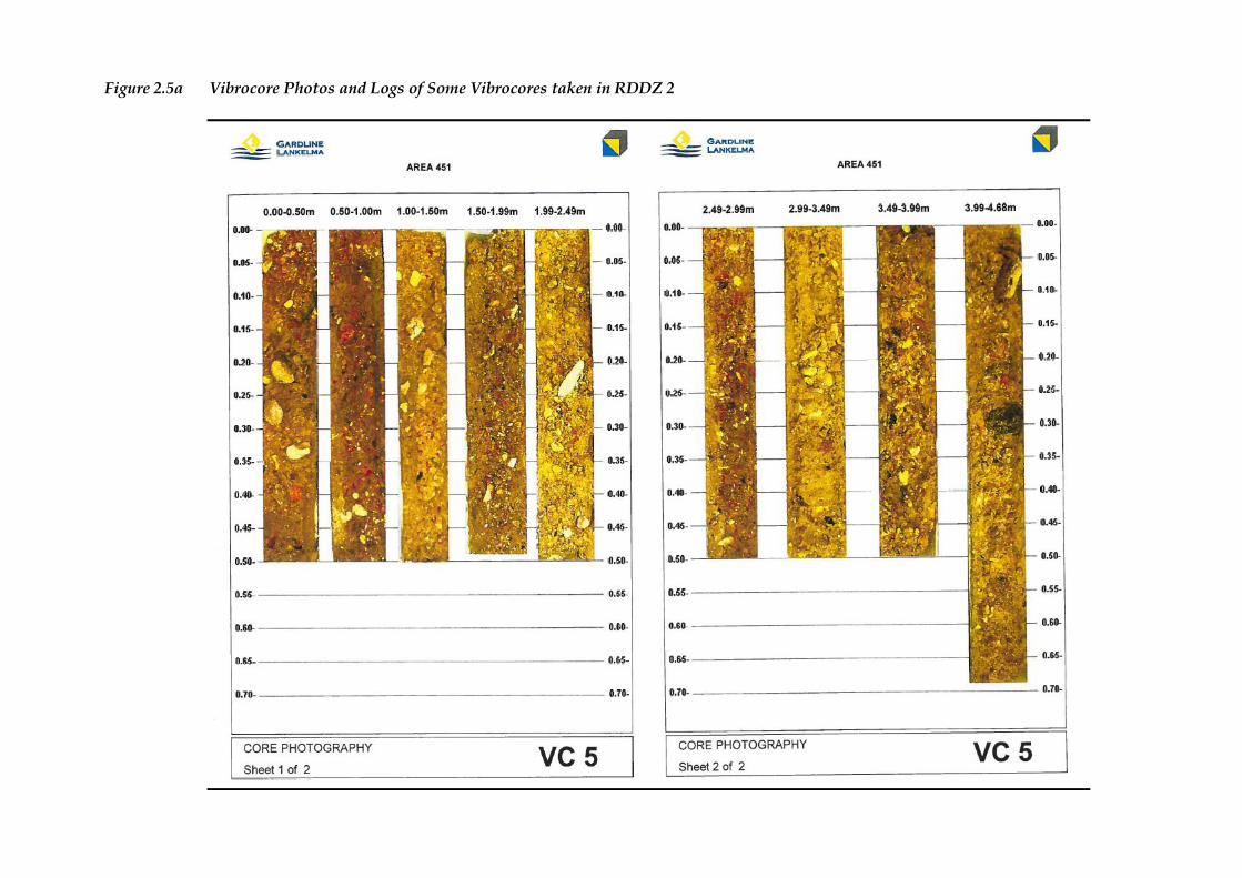
Figure 2.5a Vibrocore Photos and Logs of Some Vibrocores taken in RDDZ 2
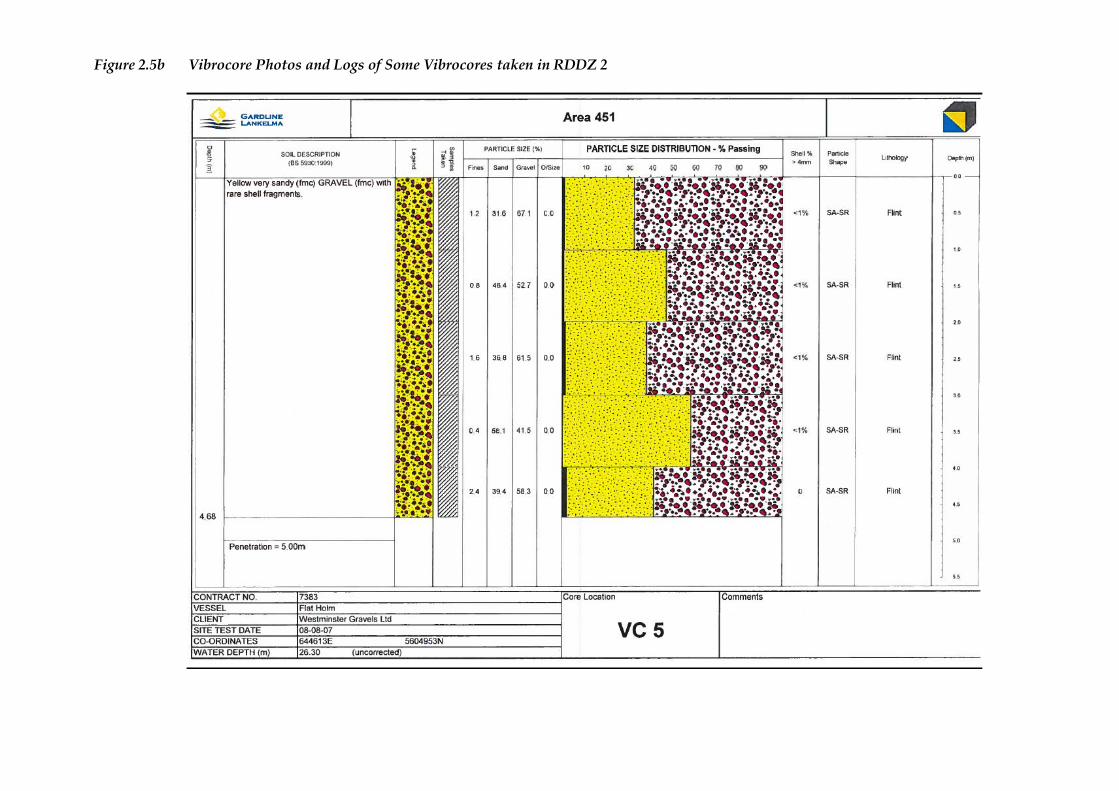
Figure 2.5b Vibrocore Photos and Logs of Some Vibrocores taken in RDDZ 2
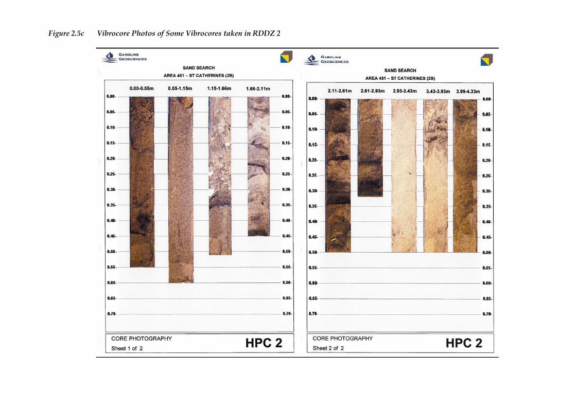
Figure 2.5c Vibrocore Photos of Some Vibrocores taken in RDDZ 2
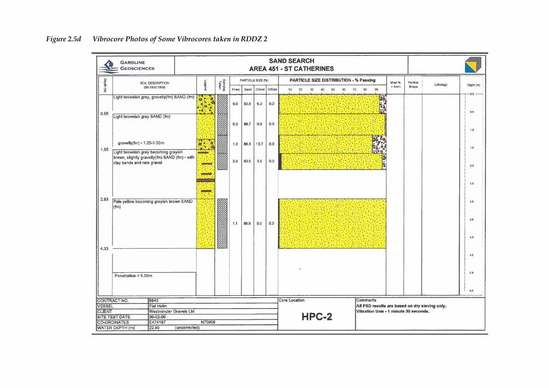
Figure 2.5d Vibrocore Photos of Some Vibrocores taken in RDDZ 2
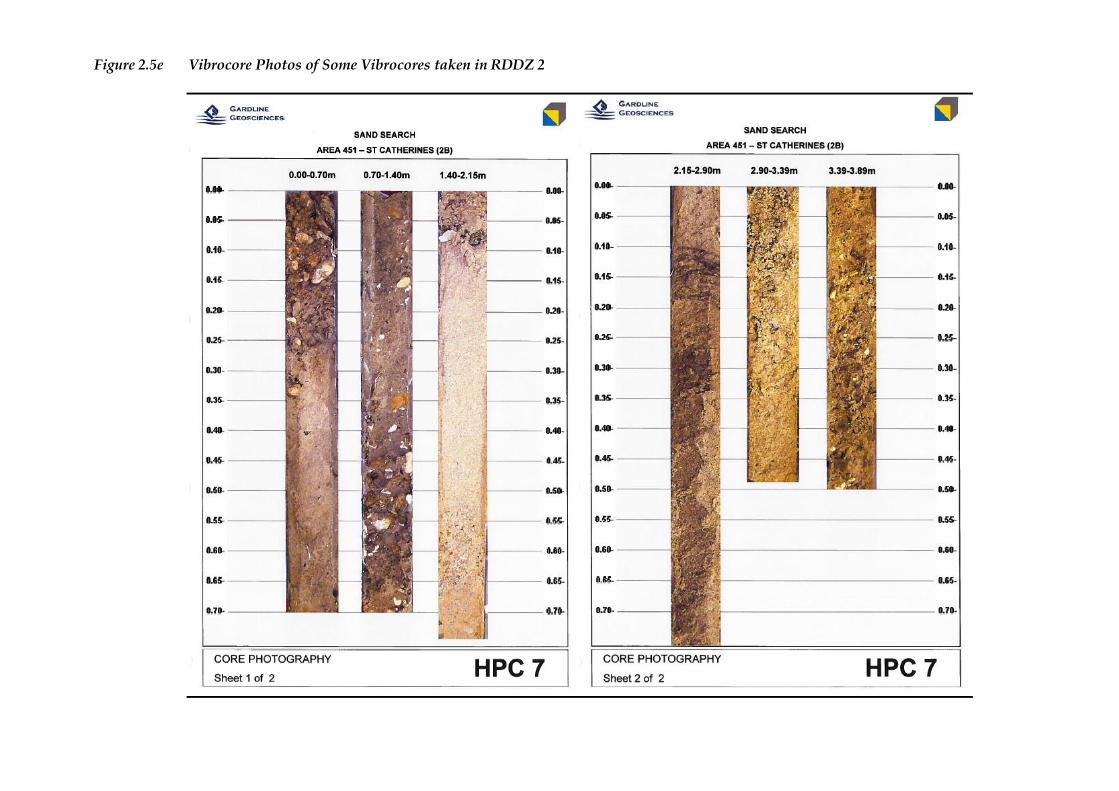
Figure 2.5e Vibrocore Photos of Some Vibrocores taken in RDDZ 2
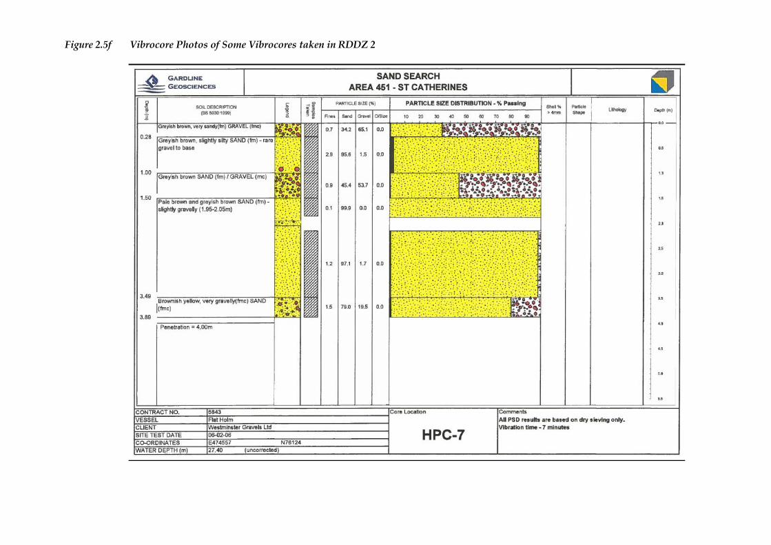
Figure 2.5f Vibrocore Photos of Some Vibrocores taken in RDDZ 2
ENVIRONMENTAL RESOURCES MANAGEMENT BOSKALIS WESTMINSTER LTD
18
The proposed deposit site has been an active dredged zone for 10 years and as
a result of a number of significant beach replenishment schemes a shallow but
well defined depression in the seafloor where resource has been removed.
There is a very slow rate of sediment infilling in this area, suggesting low
levels of mobile sediments in the area (ERM, 2012, p74).
As reported in the Area 451 ES (ERM, 2012) the coarse sediments found in
exposed offshore locations such as Area 451 are not generally associated with
contaminants, which if pollutants are present, are more likely to be associated
with areas of high proportions of silts and clays. The sands and gravels
within the proposed deposit site are considered by the South Coast MAREA to
have low sediment contaminant concentrations.
Water Quality 2.2.2
General Considerations
The South Coast MAREA describes water quality in the region as generally
good, which reflects the open water, dispersive and well flushed current
regime in the area and its distance from sources of contaminants, such as
major urban areas. CEFAS holds limited monitoring data for winter
suspended concentrations to the north of the proposed deposit site and
described the area as having a mean suspended sediment concentration (SSC)
of 25 mg l-1 (range 4 to 45 mg l-1) (Cefas, 2001).
Plumes
Sediment plumes in the vicinity of RDDZ 2 are currently generated by
aggregate extraction at Area 451 and disposal activity at the Nab Disposal
Ground. As reported in the SACD ES (ABPmer 2012), the Nab Deposit
Ground, adjacent to the RDDZ 2 area, is a highly dispersive site that has been
used for many years as a licensed disposal site. The Nab Disposal Ground
receives an average of about 447,000 m3 of sediment per year from
maintenance dredging in Southampton Water and the Test, Itchen and
Hamble Estuaries. A similar order of magnitude of sediment is deposited in
the Nab Disposal Ground from other areas such as Portsmouth, Chichester
and Langstone Harbours, the Nab Channel and the Medina. To date, no
environmental impacts of significance have been identified (ABPmer, 2012,
Cpt 10).
Bathymetry 2.2.3
Seabed levels across the proposed deposit site range from 25 m below CD to
the north and east of the site, to 40 m below CD at the southwest tip of the site.
The centre of the site lies approximately 35 m below CD and forms a
significant depression in a northeast – southwest orientation within the site, as
shown in Figure 2.2.
As shown in Figure A.1 (Annex A) the proposed deposit site lies on younger
gravel terrace facies, bordered to the south, north and west by basal facies and
ENVIRONMENTAL RESOURCES MANAGEMENT BOSKALIS WESTMINSTER LTD
19
clay/sand/gravel facies to the east. The clay/sand/gravel facies are
relatively featureless, with small areas of irregular hummocky seabed
southwest of the site, whilst there are a number of minor sand ribbons and
sand waves within the basal facies to the west and north of the site.
Bathymetric surveys have been regularly carried out and are required to be
undertaken every two years within Area 451. Figure 2.6 shows the current
bathymetry of RDDZ 2 and the depression within the deposit site has an
estimated volume capacity of 2.2 to 2.3 million m3 to return it to its pre dredge
level.
The mega ripples within the depression in the proposed deposit area shown
in Figure 2.6 and Figure A.1 are formed through the action of wave and current
driven sediment transport, which is explained in greater detail in the Area 451
CIS (HR Wallingford, 2011). The mega ripples are formed in alignment with
the depression, in a northeast – southwest orientation and run the length of
the depression. The sand ribbons and sand waves in proximity to the site are
also aligned in the same orientation. A detailed description of the bathymetry
within RDDZ 2 is available in the CIS, Plume Dispersion and Model
Validation Reports (HR Wallingford, 2011) which is Annex B of the Area 451
ES (ERM, 2012).
Physical Oceanography 2.2.4
As detailed in the South Coast MAREA (Emu 2012) the predominant angle of
wave approach in the central part of the English Channel is from the west and
southwest. Whilst the area to the east of the Isle of Wight is fairly sheltered
from these waves, wave refraction around the island results in swell waves
from these directions propagating across the proposed deposit site and on into
the eastern Solent. Winds from the south, southeast and east also produce
occasionally severe storm wave conditions at the proposed deposit site,
although the shorter fetch lengths across the Channel to the French coast limit
the wave heights and periods from these sectors.
Tidal currents at the proposed deposit site are often strong, especially during
spring tides and in areas where the seabed contours cause constriction of
flows. The nearest Admiralty tidal diamond is located approximately
0.5 nautical miles to the east of the proposed deposit site, where the tidal flows
are reported to be predominantly northeasterly or southwesterly with peak
flows of about 1.1 ms-1 on spring tides and about 0.56 ms-1 on neap tides.
These current speeds will regularly mobilise sand on the seabed but are much
less likely to mobilise gravel or coarser sediment particles. The flow and wave
conditions of the region are discussed in greater detail within the South Coast
MAREA (Emu 2012) and supporting technical reports presented in Appendix
A to the MAREA (HR Wallingford 2010) and Appendix 6A (HR Wallingford
2012).

CLIENT: SIZE: TITLE:
DATE: 25/11/2013
DRAWN: AZ
CHECKED: EB
APPROVED: KM
PROJECT: 0128267
SCALE: Not to ScaleDRAWING: REV:
Boskalis Westminster Limited A3 Figure 2.6Current (2012) Bathymetry of RDDZ 2
0SOURCE: Data provided by ClientPROJECTION: WGS 1984 UTM Zone 30N
U:\Pr
ojects
\0128
267A
rea45
1_GI
S_AK
_MI\M
aps\C
harac
terisa
tionR
eport
\Figu
re 2_
6 - C
urren
t 201
2 Bath
ymetr
y of R
DDZ 2
.mxd
ERMEaton HouseWallbrook CourtNorth Hinksey LaneOxford OX2 0QSTelephone: 01865 384800Facsimile: 01865 204982
Figure 2_6 - Current 2012 Bathymetry of RDDZ 2.mxd
ENVIRONMENTAL RESOURCES MANAGEMENT BOSKALIS WESTMINSTER LTD
21
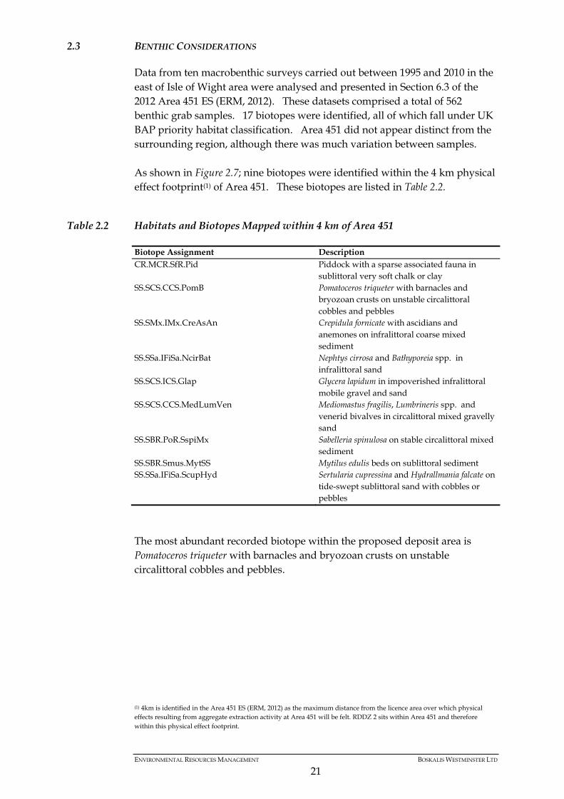
2.3 BENTHIC CONSIDERATIONS
Data from ten macrobenthic surveys carried out between 1995 and 2010 in the
east of Isle of Wight area were analysed and presented in Section 6.3 of the
2012 Area 451 ES (ERM, 2012). These datasets comprised a total of 562
benthic grab samples. 17 biotopes were identified, all of which fall under UK
BAP priority habitat classification. Area 451 did not appear distinct from the
surrounding region, although there was much variation between samples.
As shown in Figure 2.7; nine biotopes were identified within the 4 km physical
effect footprint(1) of Area 451. These biotopes are listed in Table 2.2.
Table 2.2 Habitats and Biotopes Mapped within 4 km of Area 451
Biotope Assignment Description
CR.MCR.SfR.Pid Piddock with a sparse associated fauna in
sublittoral very soft chalk or clay
SS.SCS.CCS.PomB Pomatoceros triqueter with barnacles and
bryozoan crusts on unstable circalittoral
cobbles and pebbles
SS.SMx.IMx.CreAsAn Crepidula fornicate with ascidians and
anemones on infralittoral coarse mixed
sediment
SS.SSa.IFiSa.NcirBat Nephtys cirrosa and Bathyporeia spp. in
infralittoral sand
SS.SCS.ICS.Glap Glycera lapidum in impoverished infralittoral
mobile gravel and sand
SS.SCS.CCS.MedLumVen Mediomastus fragilis, Lumbrineris spp. and
venerid bivalves in circalittoral mixed gravelly
sand
SS.SBR.PoR.SspiMx Sabelleria spinulosa on stable circalittoral mixed
sediment
SS.SBR.Smus.MytSS Mytilus edulis beds on sublittoral sediment
SS.SSa.IFiSa.ScupHyd Sertularia cupressina and Hydrallmania falcate on
tide-swept sublittoral sand with cobbles or
pebbles
The most abundant recorded biotope within the proposed deposit area is
Pomatoceros triqueter with barnacles and bryozoan crusts on unstable
circalittoral cobbles and pebbles.
(1) 4km is identified in the Area 451 ES (ERM, 2012) as the maximum distance from the licence area over which physical
effects resulting from aggregate extraction activity at Area 451 will be felt. RDDZ 2 sits within Area 451 and therefore
within this physical effect footprint.
CLIENT: SIZE: TITLE:
DATE: 25/11/2013
DRAWN: AZ
CHECKED: EB
APPROVED: KM
PROJECT: 0128267
SCALE:DRAWING: REV:
Boskalis Westminster Limited A4 Figure 2.7Biotopes in relation to the RDDZ 2
0SOURCE: Data supplied by ClientPROJECTION: WGS 1984 UTM Zone 30N
U:\P
rojec
ts\01
2826
7Area
451_
GIS_
AK_M
I\Map
s\Cha
racter
isatio
nRep
ort\Fi
gure
2_7 -
Biot
opes
in re
lation
to th
e RDD
Z 2.m
xd
ERMEaton HouseWallbrook CourtNorth Hinksey LaneOxford OX2 0QSTelephone: 01865 384800Facsimile: 01865 204982
0 4
Kilometres
Restricted Dredge Deposit Zone 02 (RDDZ02)Restricted Dredge Zone 024km BufferAggregate Licence Area 451
Figure 2_7 - Biotopes in relation to the RDDZ 2.mxd
1:80,000
BiotopesCR.MCRSS.SBR.PoR.SspiMxSS.SBR.SMus.MytSSSS.SCS.CCS.MedLumVenSS.SCS.CCS.PomBSS.SCS.ICS.GlapSS.SCS.ICS.SSh
SS.SMx.IMx.CreAsAnSS.SSa.CMuSa.AalbNucSS.SSa.IFiSa.IMoSaSS.SSa.IFiSa.NcirBatSS.SSa.IFiSa.ScupHydSS.Sa.IFiSa.TbAmPo
ENVIRONMENTAL RESOURCES MANAGEMENT BOSKALIS WESTMINSTER LTD
23
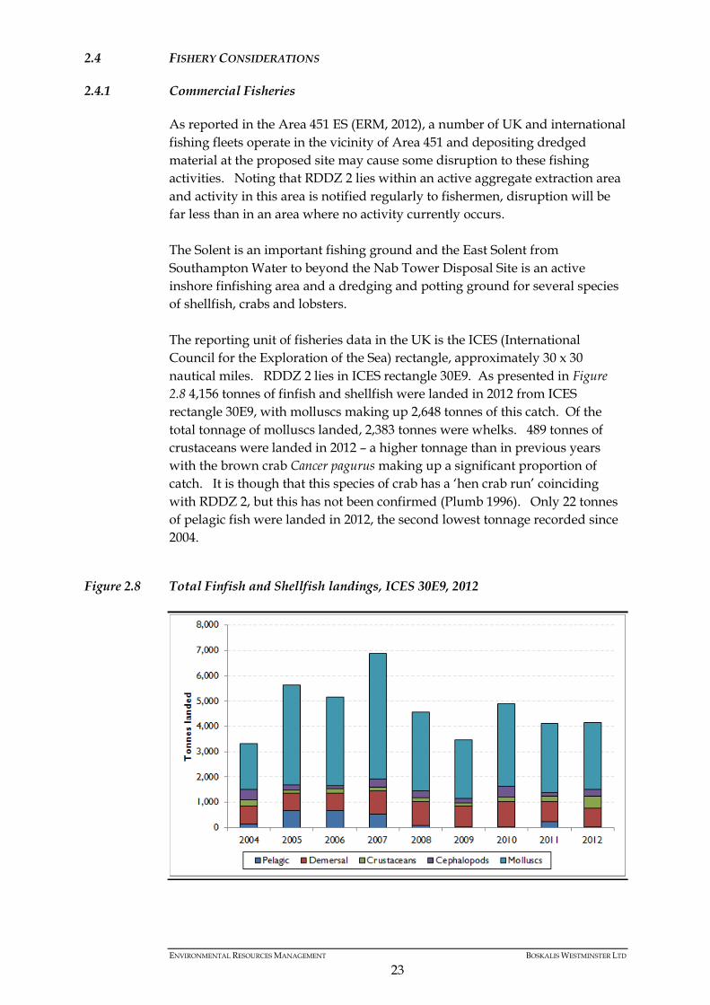
2.4 FISHERY CONSIDERATIONS
Commercial Fisheries 2.4.1
As reported in the Area 451 ES (ERM, 2012), a number of UK and international
fishing fleets operate in the vicinity of Area 451 and depositing dredged
material at the proposed site may cause some disruption to these fishing
activities. Noting that RDDZ 2 lies within an active aggregate extraction area
and activity in this area is notified regularly to fishermen, disruption will be
far less than in an area where no activity currently occurs.
The Solent is an important fishing ground and the East Solent from
Southampton Water to beyond the Nab Tower Disposal Site is an active
inshore finfishing area and a dredging and potting ground for several species
of shellfish, crabs and lobsters.
The reporting unit of fisheries data in the UK is the ICES (International
Council for the Exploration of the Sea) rectangle, approximately 30 x 30
nautical miles. RDDZ 2 lies in ICES rectangle 30E9. As presented in Figure
2.8 4,156 tonnes of finfish and shellfish were landed in 2012 from ICES
rectangle 30E9, with molluscs making up 2,648 tonnes of this catch. Of the
total tonnage of molluscs landed, 2,383 tonnes were whelks. 489 tonnes of
crustaceans were landed in 2012 – a higher tonnage than in previous years
with the brown crab Cancer pagurus making up a significant proportion of
catch. It is though that this species of crab has a ‘hen crab run’ coinciding
with RDDZ 2, but this has not been confirmed (Plumb 1996). Only 22 tonnes
of pelagic fish were landed in 2012, the second lowest tonnage recorded since
2004.
Figure 2.8 Total Finfish and Shellfish landings, ICES 30E9, 2012
ENVIRONMENTAL RESOURCES MANAGEMENT BOSKALIS WESTMINSTER LTD
24
As described in the SACD ES (ABPmer 2012) the Solent fishing industry
makes an important contribution to the area’s economy, landing catches
estimated at around £7.9 million in 2006. More recently there has been an
increase in charter and casual angling vessels, which is now a year round
industry and of considerable importance to the local economy (Walmsley &
Pawson, 2007).
The Area 451 ES (ERM 2012) stated that there are little or no trawler, shellfish
dredger, seiner and netter fishing activities within the Area 451 application
area, and therefore the RDDZ 2 area. Detailed data on the ICES landing
statistics for 30E9 can be found in the Area 451 ES (ERM 2012).
Recreational Fisheries 2.4.2
The south coast region has a well-established and popular recreational fishery
due to its good accessibility and numerous sheltered areas. It attracts
recreational shore and boat anglers all year round, the majority of which are
line anglers.
The main fish species of recreational interest are bass (Dicentrarchus labrax),
rays (Raja clavata and Raja undulata), mackerel (Scomber scombrus), tope
(Galeorhinus galeus), smoothound (Mustelus canis), spurdog (Squalus acanthias),
conger eel (Conger conger), and black seabream (Spondyliosoma cantharus).
Large cod (Gadus morhua) can also be caught in autumn and winter whilst
plaice can be caught in spring. Fish landings are not monitored for
recreational fishing and therefore do not appear in official statistics, however,
there is a high intensity of charter vessels and hobby angling in the region
indicating the importance of recreational fishing in this area.
There are no wrecks within the RDDZ 2 area, and anglers tend to fish more
over wreck sites and towards the Overfalls, southeast of RDDZ 2, where fish
are in higher abundance. As a result, levels of recreational fishing in RDDZ 2
are relatively low, with preferred sites nearby.
Spawning and Nursery Grounds 2.4.3
The key spawning areas which overlap with or have been identified in close
proximity to the RDDZ 2 area are those of cod, plaice, sandeel and sole, see
Section 6.4 of the Area 451 ES (ERM, 2012). The species with a nursery area
that interacts with the RDDZ 2 area are plaice, sole, thornback ray, tope,
undulate ray and edible crab. The key fish and shellfish spawning and
nursery areas in the area are presented in Figures 6.10 and 6.11 of the Area 451
ES (ERM 2012). Furthermore, the maps produced in the South Coast MAREA
(Emu 2012) are sourced from Ellis et al (2010), to distinguish between areas of
low intensity spawning and high intensity spawning, from Coull et al (1998)
and from consultation with local fishermen.
Brown crab spawn in November/December and incubate their eggs until the
following April to June. During the incubation period the hen brown crab
ENVIRONMENTAL RESOURCES MANAGEMENT BOSKALIS WESTMINSTER LTD
25
carrying the egg mass on their underside remain largely sedentary and buried
in the sediment. During this period of relative immobility the hen crabs and
eggs would be more susceptible to loss and damage from direct smothering.
Juveniles are also vulnerable to loss from sediment deposit activities within
nursery grounds. RDDZ 2 overlaps with potential brown crab spawning and
nursery areas on the South Coast (Figure 6.12, pg 6-32, ERM 2012) noting that
the extent of these areas is not well defined. Impacts from the dredging
activities assessed in the Area 451 ES on crabs and from suspended sediments
are considered to be of a small magnitude given the area dredged at any one
time and the duration and extent of sediment plumes.
2.5 MARINE MAMMALS
The waters of southern England around the Isle of Wight support a low
abundance and diversity of marine mammals (cetaceans (1) and pinnipeds (2))
compared to other coastal areas of the UK. The marine environment around
the Isle of Wight supports relatively few cetaceans. Species diversity and
abundances are listed as low, with only four out of 26 UK cetacean species
recorded in these waters (Seawatch Foundation 2011). The predominantly
shallow coastal habitat favours inshore water species such as bottlenose
dolphin (Tursiops truncates) and harbour porpoise (Phocoena phocoena). In
deeper offshore waters more than 10 km from shore, long finned pilot whales
(Globicephala melas) are seasonal visitors between November and January.
Short-beaked common dolphin (Delphinus delphis) is another deeper water
species occasionally recorded in the region between August and December
(James et al 2010; Jones et al 2004; Emu 2012).
There are no significant haul out or breeding sites for either common seal or
grey seal around the Isle of Wight, although there is a known harbour seal
haul out site at Poole Harbour. Both species are also occasionally recorded in
the area, with regular sightings at Chichester Harbour (James et al 2010; Jones
et al 2004). The species regularly or occasionally recorded around the Isle of
Wight are listed in Table 2.3.
No marine mammal species have been recorded with any regularity within
the RDDZ 2 area and densities within the region are low, however it is
possible that small numbers of both cetaceans and seals pass through or
forage within the RDDZ 2.
(1) Whales, dolphins and porpoises belong to the taxonomic order of Cetacea and are referred to as cetaceans. (2) Seals belong to the taxonomic family Pinnipedia and are referred to as pinnipeds.
ENVIRONMENTAL RESOURCES MANAGEMENT BOSKALIS WESTMINSTER LTD
26
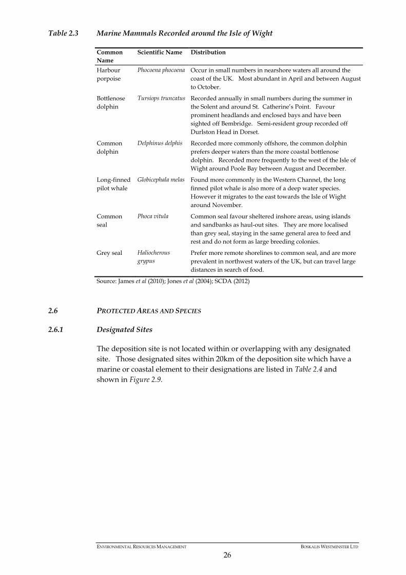
Table 2.3 Marine Mammals Recorded around the Isle of Wight
Common
Name
Scientific Name Distribution
Harbour
porpoise
Phocoena phocoena Occur in small numbers in nearshore waters all around the
coast of the UK. Most abundant in April and between August
to October.
Bottlenose
dolphin
Tursiops truncatus Recorded annually in small numbers during the summer in
the Solent and around St. Catherine’s Point. Favour
prominent headlands and enclosed bays and have been
sighted off Bembridge. Semi-resident group recorded off
Durlston Head in Dorset.
Common
dolphin
Delphinus delphis Recorded more commonly offshore, the common dolphin
prefers deeper waters than the more coastal bottlenose
dolphin. Recorded more frequently to the west of the Isle of
Wight around Poole Bay between August and December.
Long-finned
pilot whale
Globicephala melas Found more commonly in the Western Channel, the long
finned pilot whale is also more of a deep water species.
However it migrates to the east towards the Isle of Wight
around November.
Common
seal
Phoca vitula Common seal favour sheltered inshore areas, using islands
and sandbanks as haul-out sites. They are more localised
than grey seal, staying in the same general area to feed and
rest and do not form as large breeding colonies.
Grey seal Haliocherous
grypus
Prefer more remote shorelines to common seal, and are more
prevalent in northwest waters of the UK, but can travel large
distances in search of food.
Source: James et al (2010); Jones et al (2004); SCDA (2012)
2.6 PROTECTED AREAS AND SPECIES
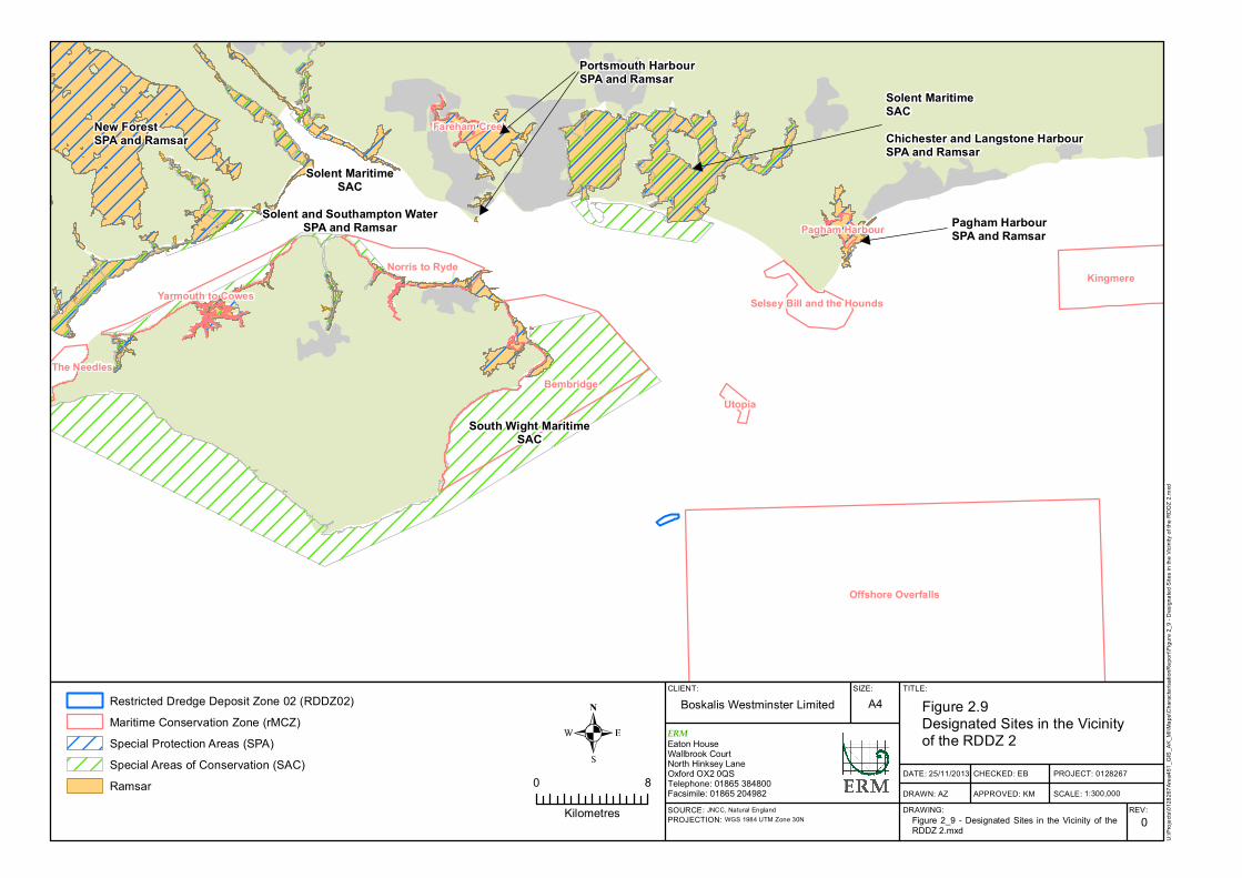
Designated Sites 2.6.1
The deposition site is not located within or overlapping with any designated
site. Those designated sites within 20km of the deposition site which have a
marine or coastal element to their designations are listed in Table 2.4 and
shown in Figure 2.9.
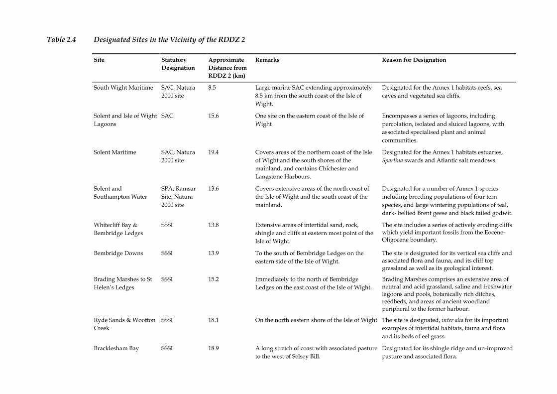
Table 2.4 Designated Sites in the Vicinity of the RDDZ 2
Site Statutory
Designation
Approximate
Distance from
RDDZ 2 (km)
Remarks Reason for Designation
South Wight Maritime SAC, Natura
2000 site
8.5
Large marine SAC extending approximately
8.5 km from the south coast of the Isle of
Wight.
Designated for the Annex 1 habitats reefs, sea
caves and vegetated sea cliffs.
Solent and Isle of Wight
Lagoons
SAC 15.6 One site on the eastern coast of the Isle of
Wight
Encompasses a series of lagoons, including
percolation, isolated and sluiced lagoons, with
associated specialised plant and animal
communities.
Solent Maritime SAC, Natura
2000 site
19.4 Covers areas of the northern coast of the Isle
of Wight and the south shores of the
mainland, and contains Chichester and
Langstone Harbours.
Designated for the Annex 1 habitats estuaries,
Spartina swards and Atlantic salt meadows.
Solent and
Southampton Water
SPA, Ramsar
Site, Natura
2000 site
13.6 Covers extensive areas of the north coast of
the Isle of Wight and the south coast of the
mainland.
Designated for a number of Annex 1 species
including breeding populations of four tern
species, and large wintering populations of teal,
dark- bellied Brent geese and black tailed godwit.
Whitecliff Bay &
Bembridge Ledges
SSSI 13.8 Extensive areas of intertidal sand, rock,
shingle and cliffs at eastern most point of the
Isle of Wight.
The site includes a series of actively eroding cliffs which yield important fossils from the Eocene-Oligocene boundary.
Bembridge Downs SSSI 13.9 To the south of Bembridge Ledges on the
eastern side of the Isle of Wight.
The site is designated for its vertical sea cliffs and associated flora and fauna, and its cliff top grassland as well as its geological interest.
Brading Marshes to St
Helen’s Ledges
SSSI 15.2 Immediately to the north of Bembridge
Ledges on the east coast of the Isle of Wight.
Brading Marshes comprises an extensive area of neutral and acid grassland, saline and freshwater lagoons and pools, botanically rich ditches, reedbeds, and areas of ancient woodland peripheral to the former harbour.
Ryde Sands & Wootton
Creek
SSSI 18.1 On the north eastern shore of the Isle of Wight The site is designated, inter alia for its important
examples of intertidal habitats, fauna and flora
and its beds of eel grass
Bracklesham Bay SSSI 18.9 A long stretch of coast with associated pasture
to the west of Selsey Bill.
Designated for its shingle ridge and un-improved
pasture and associated flora.
Site Statutory
Designation
Approximate
Distance from
RDDZ 2 (km)
Remarks Reason for Designation
Bembridge rMCZ (22) 9.1 Coastal area around the eastern edge of the
Isle of Wight
Identified as a rMCZ for its rocky reef habitats,
sea grass beds and fish fauna
Offshore Overfalls rMCZ (17) 0.5 Area of sand and gravel banks to the south
east of the Isle of Wight
Identified as a rMCZ for its unique relict glacial
sand and gravel deposits which support a rich
fish fauna.
Utopia
(including North
Utopia Ref. Area 13)
rMCZ (28) 7.9 Small site to the south west of Selsey Bill Identified as a rMCZ for its benthic fauna
including sponges and anemones
Selsey Bill and the
Hounds
rMCZ (25.2) 16.7 Coastal area around Selsey Bill Identified as a rMCZ for peat and clay exposures,
rocky habitats and rich fauna.
Source: SCDA (2012), JNCC website (2011), Natural England website (2011).
Offshore Overfalls
Bembridge
KingmereNorris to Ryde
Yarmouth to Cowes Selsey Bill and the Hounds
The Needles
Utopia
Fareham Creek
Pagham Harbour
CLIENT: SIZE: TITLE:
DATE: 25/11/2013
DRAWN: AZ
CHECKED: EB
APPROVED: KM
PROJECT: 0128267
SCALE:DRAWING: REV:
Boskalis Westminster Limited A4 Figure 2.9Designated Sites in the Vicinity of the RDDZ 2
0SOURCE: JNCC, Natural EnglandPROJECTION: WGS 1984 UTM Zone 30N
U:\P
rojec
ts\01
2826
7Area
451_
GIS_
AK_M
I\Map
s\Cha
racter
isatio
nRep
ort\Fi
gure
2_9 -
Des
ignate
d Site
s in t
he Vi
cinity
of th
e RDD
Z 2.m
xd
ERMEaton HouseWallbrook CourtNorth Hinksey LaneOxford OX2 0QSTelephone: 01865 384800Facsimile: 01865 204982
0 8
Kilometres
Restricted Dredge Deposit Zone 02 (RDDZ02)Maritime Conservation Zone (rMCZ)Special Protection Areas (SPA)Special Areas of Conservation (SAC)Ramsar
Figure 2_9 - Designated Sites in the Vicinity of theRDDZ 2.mxd
1:300,000
New Forest SPA and Ramsar
Solent MaritimeSAC
Solent and Southampton WaterSPA and Ramsar
Portsmouth HarbourSPA and Ramsar
Solent MaritimeSACChichester and Langstone HarbourSPA and Ramsar
Pagham HarbourSPA and Ramsar
South Wight MaritimeSAC
ENVIRONMENTAL RESOURCES MANAGEMENT BOSKALIS WESTMINSTER LTD
30
Protected Species 2.6.2
Blue Mussels (Mytilus Sp.)
Blue mussel beds can be supporting or sub features of habitats listed in Annex
I of the Habitats Directives. In addition, blue mussels on sediment (intertidal
and subtidal) are a priority habitat within the UK Biodiversity Action Plan
(now the UK Post 2010 Biodiversity Framework) (Fugro Emu, 2013).
The Area 451 Conservation Review (Fugro Emu, 2013) highlighted the
presence of dense aggregations of mussels within and adjacent to Area 451,
the nature of which match Annex I (EC Habitats Directive 92/43/EEC) criteria
for reef. Following the Conservation Review and in consultation with the
MMO and its advisors WGL placed an Exclusion Zone (EZ) around the beds
in which no aggregate extraction will occur. The extent of the EZ included a
buffer of 100 metres to ensure the stability of the beds is not undermined as a
result of substrate slipping into dredged areas. The EZ in place is shown on
Figure 2.10.
The good quality sidescan sonar data reviewed for the Conservation Review
showed that the boundaries between the mussel features and the ambient
seabed are distinct allowing for accurate mapping. As shown in Figure 2.10,
RDDZ 2 does not overlap with the blue mussel beds and at its closet point
RDDZ 2 is over 1km away from the beds.
The Conservation Review (Fugro Emu 2013) found that the mussels were
found in association with ’mounds’ of relatively consolidated mud. Whilst
the exact origin (geogenic or biogenic) of the silty sediment could not be
ascertained with certainty, as the area around the mounds are
characteristically sand and gravel, it is suggested that due to their association
with patches of mussels, the mounds seem indicative of mussel mud, i.e.
biogenic. Due to the cohesive nature of the mussel mud, the deposits may
last for several years after mussels have disappeared (Holt et al (1998). This
substrate was found to differ from the surrounding seabed, and is considered
to consolidate the sediment. These mud formations, in association with blue
mussels were also found to be slightly raised above the seabed. The sidescan
sonar data has shown that the boundaries between the mussel features and
the ambient seabed are distinct allowing for accurate mapping.
The Review goes on to note that the Nab Tower Disposal Ground is in close
proximity to Area 451 and may provide some of the fine sediments that
contribute to these features.
CLIENT: SIZE: TITLE:
DATE: 25/11/2013
DRAWN: AZ
CHECKED: EB
APPROVED: KM
PROJECT: 0128267
SCALE:DRAWING: REV:
Boskalis Westminster Limited A4 Figure 2.10Area 451 Blue Mussel Bedsand the RDDZ 2.
0SOURCE: ESRIPROJECTION: WGS 1984 UTM Zone 30N
U:\P
rojec
ts\01
2826
7Area
451_
GIS_
AK_M
I\Map
s\Cha
racter
isatio
nRep
ort\Fi
gure
2_10
- Area
451 B
lue M
usse
l Bed
s and
the R
DDZ 2
..mxd
ERMEaton HouseWallbrook CourtNorth Hinksey LaneOxford OX2 0QSTelephone: 01865 384800Facsimile: 01865 2049820 3
Kilometres
Restricted Dredge Deposit Zone 02 (RDDZ 2)Blue Mussel Bed Exclusion ZoneBlue Mussel Bed Exclusion Zone 100m BufferAggregate Licence Area 451
Figure 2_10 - Area 451 Blue Mussel Beds and theRDDZ 2..mxd
1:80,000
ENVIRONMENTAL RESOURCES MANAGEMENT BOSKALIS WESTMINSTER LTD
32
Other Protected Species
The Conservation Review for Area 451 (Fugro Emu, 2013) identified
brittlestars Ophiothrix fragilis associated with the blue mussels, but not in
sufficient enough numbers to constitute a brittlestar bed. As there is no
brittlestar bed present and an EZ is in place around the blue mussel bed with
which the brittlestar are associated, brittlestar are not considered to be a
constraint to or be adversely impacted by deposition at RDDZ 2 and are
therefore not considered further.
No other protected species are present within RDDZ 2.
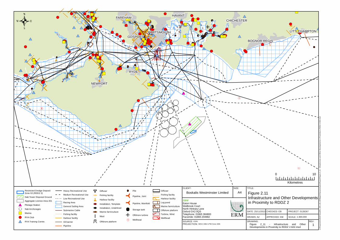
2.7 INFRASTRUCTURE AND OTHER OPERATIONS
The South Coast region supports a variety of marine infrastructure including
commercial ports, military ports, navigation and shipping routes, oil and gas
exploration and development, aggregate extraction, cables and pipelines and
disposal sites.
Figure 2.11 shows the infrastructure and other operations within the region
around Area 451 RDDZ 2. As shown on Figure 2.11 there is no significant
infrastructure or development overlapping or near to the deposit site. The
exception is the Area 451 Aggregate Extraction area and the Nab Disposal
Ground which lies immediately to the west of the deposit site.
The deposit site sits within an active aggregate extraction area, Area 451, managed by BWL the same company proposing to undertake the deposit of sand and gravel within RDDZ 2. Details and history of Area 451 are outlined in Section 2.1. The details and history of the Nab Disposal Ground are outlined in Section 1.3.
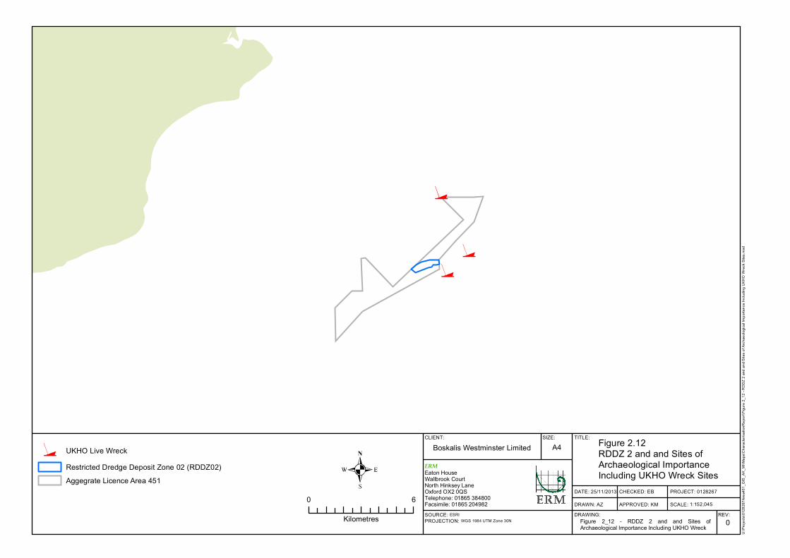
2.8 ARCHAEOLOGY AND CULTURAL HERITAGE
A number of recent reports prepared for Area 451 (Emu 2011 and Wessex
Archaeology 2013) have been reviewed to establish the archaeological status
of any archaeological sites likely to be impacted by deposition activities at the
deposit site.
Figure 2.12 shows that there are no sites of archaeological or cultural heritage
importance within RDDZ 2 and therefore likely to be impacted by the
deposition site activity.
PORTSMOUTHGOSPORT
FAREHAM
BOGNOR REGIS
RYDE
HAVANTCHICHESTER
NEWPORT
LITTLEHAMPTON
CLIENT: SIZE: TITLE:
DATE: 25/11/2013
DRAWN: AZ
CHECKED: EB
APPROVED: KM
PROJECT: 0128267
SCALE:DRAWING: REV:
Boskalis Westminster Limited A4 Figure 2.11Infrastructure and Other Developments in Proximity to RDDZ 2
1SOURCE: ESRIPROJECTION: WGS 1984 UTM Zone 30N
U:\P
rojec
ts\01
2826
7Area
451_
GIS_
AK_M
I\Map
s\Cha
racter
isatio
nRep
ort\Fi
gure
2_11
- Infr
astru
cture
and O
ther D
evelo
pmen
ts in
Prox
imity
to R
DDZ 2
A02.m
xd
ERMEaton HouseWallbrook CourtNorth Hinksey LaneOxford OX2 0QSTelephone: 01865 384800Facsimile: 01865 204982
0 10
Kilometres
Figure 2_11 - Infrastructure and OtherDevelopments in Proximity to RDDZ 2 A02.mxd
1:300,000
Restricted Dredge Deposit Zone 02 (RDDZ 2)Nab Tower Disposal GroundAggregate Licence Area 451Pilotage Station
MarinaRYA ClubRYA Training Centre
Heavy Recreational UseMedium Recreational UseLow Recreational UseRacing AreaGeneral Sailing AreaSubmarine CableFishing facilityHarbour facilityOil barrierPipeline
DiffuserFishing facilityHarbour facilityInstallation, TemplateInstallation, UndefinedMarine farm/cultureMast
Offshore platform
Pile
Pipeline, Joint
Pipeline, Manifold
Storage tank
Offshore turbineWellhead
DiffuserFishing facilityHarbour facilityLog pondMarine farm/cultureOffshore platformTurbine, WindWellhead
Nab Anchorages
CLIENT: SIZE: TITLE:
DATE: 25/11/2013
DRAWN: AZ
CHECKED: EB
APPROVED: KM
PROJECT: 0128267
SCALE:DRAWING: REV:
Boskalis Westminster Limited A4 Figure 2.12RDDZ 2 and and Sites of Archaeological ImportanceIncluding UKHO Wreck Sites
0SOURCE: ESRIPROJECTION: WGS 1984 UTM Zone 30N
U:\P
rojec
ts\01
2826
7Area
451_
GIS_
AK_M
I\Map
s\Cha
racter
isatio
nRep
ort\Fi
gure
2_12
- RDD
Z 2 an
d and
Site
s of A
rchae
ologic
al Im
porta
nce I
nclud
ing U
KHO
Wrec
k Site
s.mxd
ERMEaton HouseWallbrook CourtNorth Hinksey LaneOxford OX2 0QSTelephone: 01865 384800Facsimile: 01865 2049820 6
Kilometres
UKHO Live WreckRestricted Dredge Deposit Zone 02 (RDDZ02)Aggegrate Licence Area 451
Figure 2_12 - RDDZ 2 and and Sites ofArchaeological Importance Including UKHO Wreck
1:152,045
ENVIRONMENTAL RESOURCES MANAGEMENT BOSKALIS WESTMINSTER LTD
35
3 MATERIAL CHARACTERISTICS
3.1 MATERIAL TYPES
The material to be deposited with the RDDZ 2 site will consist predominantly
of sands and gravels of marine origin, arising from consented dredging
programmes, and will be deemed acceptable for disposal to sea ie there will be
no contamination that exceeds the Cefas action levels.
As presented in Figure 2.4 the current sediment composition at the site is sand
and gravels. Figure 3.1 shows the pre-aggregate extraction surface PSD curve
for the RDDZ 2 overlain with the marine sand and fluvial sand and gravel
PSD envelopes for the SACD. The detailed SACD PSD data are presented
within Appendix B of the SACD ES (Figures B.8 and B.9, APBmer, 2012). As
can be seen from these data, sediment characteristics of the sand and gravel
material to be dredged and deposited are very similar to the pre dredge
sediment characteristics at the deposit site.
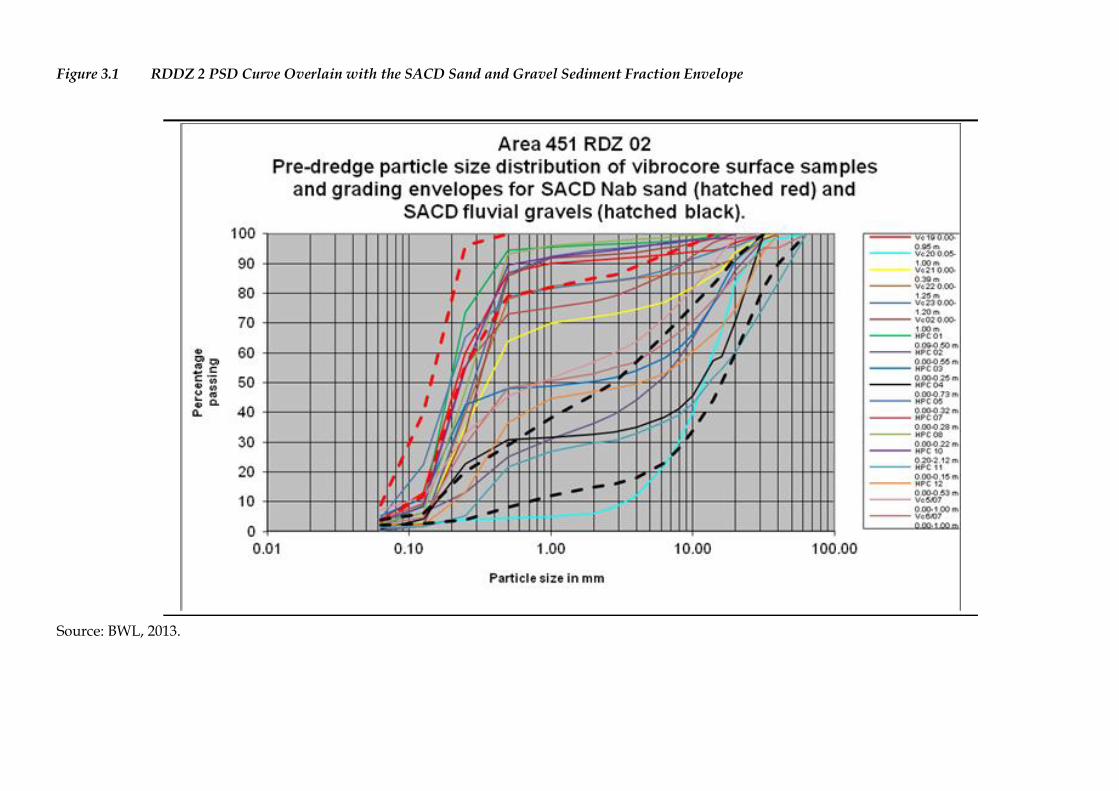
Figure 3.1 RDDZ 2 PSD Curve Overlain with the SACD Sand and Gravel Sediment Fraction Envelope
Source: BWL, 2013.
ENVIRONMENTAL RESOURCES MANAGEMENT BOSKALIS WESTMINSTER LTD
37
3.2 MATERIAL QUANTITIES
The volumes of sand and gravel to be deposited in RDDZ 2 will not exceed the
capacity of the existing depression, which has a volume of approximately 2.3
million m3.
BWL is proposing to deposit the material utilising a grid approach and
wherever possible segregating material types for subsequent re-use ie the
sands will be deposited and stored in a different zone to the fluvial gravels.
The proposed grid system shown in Figure 3.2 identifies a number of zones
which run parallel to the tidal currents. The zone dimensions are 500m x 100m
and are further sub-divided into 100m x 100m cells. Using the pre-dredge
bathymetry and the recent baseline multibeam bathymetry the volume of each
100m x 100m cell has been calculated by BWL and is presented on Figure 3.2.
The quantity of any dredge load will be calculated by ullage and the
destination i.e. the zone and cells to be filled, will be allocated prior to
deposition. The vessel will deposit the material within its hold by bottom
dumping the cargo. This process involves the vessel opening the hopper doors
beneath the hopper or hold, upon which the material sits. As the doors open
the material is released and under its own weight descends through the water
column to the seabed. Any deposition will be carried out whilst underway in
order to provide as smooth a seabed as possible.
With the careful management of deposition within pre-defined zones and cells
the subsequent re-dredge and re-use can be carefully targeted and provide a
fully auditable process.
The rate of deposition cannot be quantified as this is dependent on a number
of as yet unknown variables such as the number and size of dredgers, the
programme of works, weather, sea and current conditions.
CLIENT: SIZE: TITLE:
DATE: 25/11/2013
DRAWN: AZ
CHECKED: EB
APPROVED: KM
PROJECT: 0128267
SCALE: Not to Scale
DRAWING: REV:
Boskalis Westminster Limited A3 Figure 3.2BWL RDDZ 2 Zoning Grid and Zone Volumes
0
SOURCE: Data provided by ClientPROJECTION: WGS 1984 UTM Zone 30N
U:\P
roje
cts
\0128
267A
rea451_
GIS
_A
K_M
I\M
aps\C
hara
cte
risationR
eport
\Fig
ure
3_
2 -
BW
L R
DD
Z 2
Zonin
g G
rid
and Z
one V
olu
mes.m
xd
ERM
Eaton HouseWallbrook CourtNorth Hinksey LaneOxford OX2 0QSTelephone: 01865 384800Facsimile: 01865 204982
Figure 3_2 - BWL RDDZ 2 Zoning Grid and Zone Volumes.mxd
ENVIRONMENTAL RESOURCES MANAGEMENT BOSKALIS WESTMINSTER LTD
39
3.3 CHARACTERISTICS OF MATERIAL DURING DEPOSITION
The behaviour of material when it is deposited is dependent upon a number
of factors, including vessel type and deposition method, material type and
local tidal currents. Sediment plumes will occur during the deposition of
material onto the seabed in RDDZ 2, however, the sediment proposed for
deposition within RDDZ 2 comprises mainly sands and gravels rather than
fines, and as such any plumes created should be relatively localised and short-
term. Sands and gravels once released into the water column will descend to
the seabed quicker than finer material, reducing the time the majority of the
material will be influenced by tidal currents and therefore transported from
the site of deposition.
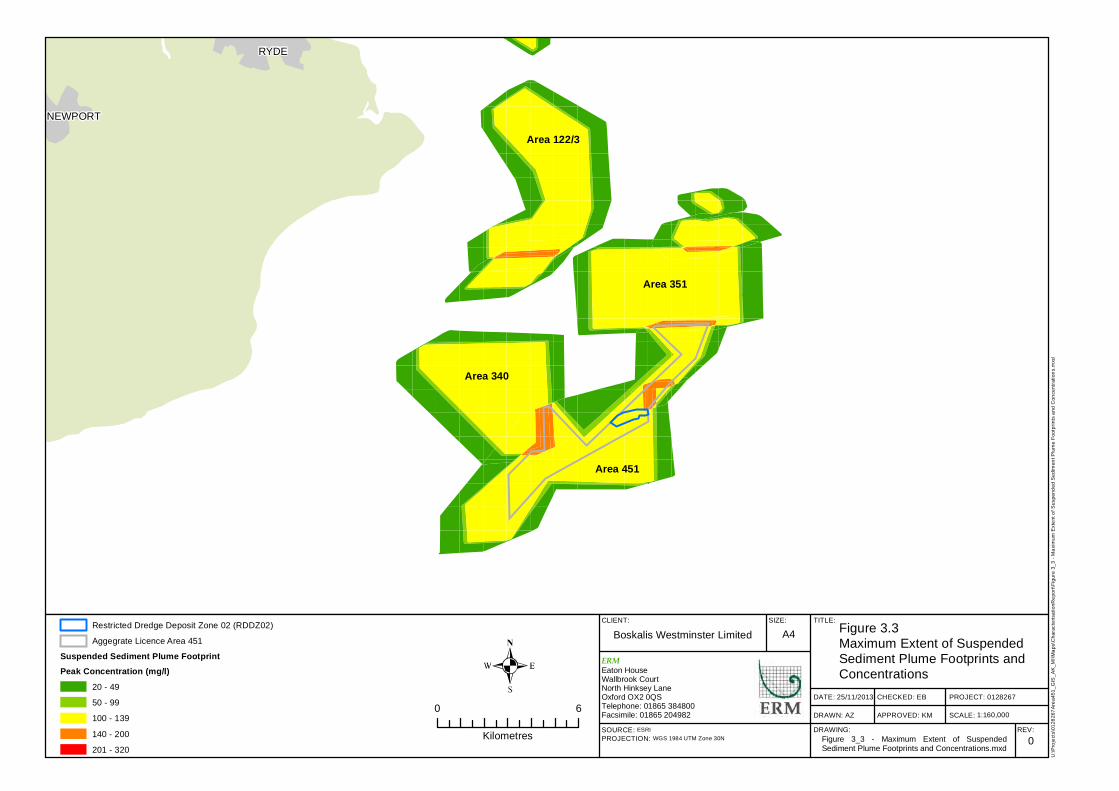
Figure 3.3 shows the maximum predicted extent of the plume generated from
aggregate extraction in the region (Figure 5.11 from the Area 451 ES (ERM
2012)) based on plume data from the SC MAREA (Emu 2012)). Plumes up to
50 mgl-1 occur relatively consistently up to approximately 1000 m from the
east/northeast and west/southwest of licence boundaries. Plumes are
generally reduced to the north and south of the licences. Given the
consistency in distance for plume dispersion in Figure 3.3 it can be assumed
that disposal of a material, similar to that found in aggregate extraction
plumes, in RDDZ 2 area would produce a similar size plume, or indeed a
smaller plume if the material is a heavier fraction.
The SACD ES provided detailed modelling outputs that showed the extent of
plumes generated as a result of deposition of sand at the Nab Disposal
Ground, located adjacent to the RDDZ 2 area (Figure 3.4). Plumes of up to
50 mgl-1 from this sand deposition are predicted to occur up to 400 m from the
deposition site on the peak flood tide (1).
Based on the above assumption that plume generation is relatively consistent
across the region it can also be assumed that deposition of sand in RDDZ 2
will produce a similar plume to that shown in Figure 3.4. However, given that
the material to be deposited at RDDZ 2 will consist of more gravel it is likely
that the plume shown in Figure 3.4 will represent a worst case plume as it
contains a higher proportion of fines than will be deposited at RDDZ 2.
(1) The MAREA considers plumes on the peak flood and ebb tides, hence the comparison given here.
RYDE
NEWPORT
CLIENT: SIZE: TITLE:
DATE: 25/11/2013
DRAWN: AZ
CHECKED: EB
APPROVED: KM
PROJECT: 0128267
SCALE:DRAWING: REV:
Boskalis Westminster Limited A4 Figure 3.3Maximum Extent of Suspended Sediment Plume Footprints and Concentrations
0SOURCE: ESRIPROJECTION: WGS 1984 UTM Zone 30N
U:\P
rojec
ts\01
2826
7Area
451_
GIS_
AK_M
I\Map
s\Cha
racter
isatio
nRep
ort\Fi
gure
3_3 -
Max
imum
Exten
t of S
uspe
nded
Sed
imen
t Plum
e Foo
tprint
s and
Con
centr
ation
s.mxd
ERMEaton HouseWallbrook CourtNorth Hinksey LaneOxford OX2 0QSTelephone: 01865 384800Facsimile: 01865 2049820 6
Kilometres
Restricted Dredge Deposit Zone 02 (RDDZ02)Aggegrate Licence Area 451
Suspended Sediment Plume FootprintPeak Concentration (mg/l)
20 - 4950 - 99100 - 139140 - 200201 - 320
Figure 3_3 - Maximum Extent of SuspendedSediment Plume Footprints and Concentrations.mxd
1:160,000
Area 122/3
Area 340
Area 351
Area 451
ENVIRONMENTAL RESOURCES MANAGEMENT BOSKALIS WESTMINSTER LTD
41
Figure 3.4 ABPmer Figure Showing the Initial Plume Following Disposal of Sand
Source: ABPmer, 2012. Appendix C.
ENVIRONMENTAL RESOURCES MANAGEMENT BOSKALIS WESTMINSTER LTD
42
ABPmer have prepared an addenda to the SACD ES (ABPmer 2013), to update
the ES with the revised disposal operations ie the use of RDDZ 2 to take
certain sand and gravel fractions of the SACD dredge arisings. In this
document ABPmer confirm that the plumes modelled for the SACD disposal
operations at the Nab Disposal Ground (Appendix C, ABPmer 2012) are
applicable to the RDDZ 2 site, stating that:
‘…the worst case scenario (for changes in SSC) for the proposed deposit at RDDZ 2
is represented by the modelled distribution shown in Figure C90 (Appendix C
ABPmer 2012) although the ‘centroid’ of movement will be displaced approximately
0.6km to the east. This model scenario assumes that all of the sediment deposited is
available for redistribution by re-erosion from the seabed given sufficient
hydrodynamic conditions. In actual fact, gravels are unable to be re-suspended, and
these will ‘armour’ the bed and lock a proportion of the finer sediments comprising the
deposits, preventing their onward movement. The levels of SSC are, therefore, likely to
be slightly overstated in the modelling whilst the overall extent of the change (i.e. the
shape of the plume) is well represented.’ (ABPmer 2013).
3.4 CHARACTERISTICS OF MATERIAL IN-SITU
Once in situ the sand and gravel material will behave similarly to the sand
and gravel material that existed at the site before aggregate extraction
commenced. There is a very slow rate of sediment infilling in this area,
suggesting low levels of mobile sediments in the area (p74 ERM, 2012).
Movement of the material once in situ will therefore be minimal. The
depression in which the material is to be deposited (depicted in the cross
section shown on Figure A.1) will further assist containment of the material.
The gridded deposition approach to be adopted by BWL will ensure that
shoaling of material is minimised. It is worth noting that creation of
pronounced mounds of material during deposition will make re-dredge of the
material at a later time for beneficial re-use schemes difficult and is therefore
something BWL will manage to avoid as far as possible. It is proposed that
static dumping is avoided and dumping occurs whilst the vessel is underway.
ENVIRONMENTAL RESOURCES MANAGEMENT BOSKALIS WESTMINSTER LTD
43
4 ASSESSMENT OF POTENTIAL EFFECTS
4.1 EFFECTS OF DEPOSITION ON WATER COLUMN
As discussed in Section 2.2.2, water quality in RDDZ 2 is generally good and
reflects the open water, dispersive and well flushed current regime in the area
and its distance from sources of contaminants such as major urban areas.
The sediment discharged will contain sand and gravel and will have a greater
density and velocity on entering the water surface than finer sediments. The
greater momentum and negative buoyancy of the discharged material mean
that the deposited sands and gravels will descend rapidly to the bed. Pebbles
and gravel will fall almost immediately to the bed and will not, in normal
conditions, be transported out of the deposit area.
Discharging the sediment to the water column will generate suspended
sediments which could result in a local increase in turbidity and reduced
water clarity and have potential secondary impacts on biological receptors.
As discussed in Section 3.3 plume will dissipate relatively quickly after
deposition ceases but will continue to occur intermittently during deposition
activities for the medium term (ie the lifetime of the deposition operations).
The potential impacts on water quality as a result of dredge plumes and
elevated suspended sediment are considered to be of small magnitude and
unlikely to breach any water quality standards or classifications.
4.2 EFFECTS OF DEPOSITION ON SEABED CONDITIONS
Bathymetry 4.2.1
The primary impacts of the proposed operations upon the bathymetry of
RDDZ 2 will be the reduction in depth as a result of the deposition of up to 2.3
million m3 of sands and gravels. Beyond RDDZ 2 there will be no changes in
bathymetry as a result of deposition activity in RDDZ 2.
Due to the change in bathymetry there is the potential for changes to currents
and tidal flows. However, the impacts on geology, geomorphology and
sediments are predicted to be small as they will occur over a limited spatial
area, mainly within RDDZ 2, and will predominantly reflect the conditions
that existed prior to dredging in Area 451.
Physical Oceanography 4.2.2
The deposition of sand and gravel proposed in RDDZ 2 has the potential to
change the topography of the seabed, which in turn could lead to changes in
the wave state. The Coastal Impact Study conducted in 2012 for the Area 451
ES reported that changes to the wave state and depth are constrained, and in
ENVIRONMENTAL RESOURCES MANAGEMENT BOSKALIS WESTMINSTER LTD
44
waters greater than 15 m depth changes to the seabed as a result of the
proposed deposition activities would not be expected to affect the wave state.
As a result, impacts on waves are predicted to be spatially limited and small
scale as the RDDZ 2 area lies in water depth of 25 m to 40 m below CD.
Depositing of sediment will take place using a grid technique (as presented in
Figure 3.2) to ensure managed deposition across the site. This will also aid in
monitoring the decrease in water depth across RDDZ 2, and depositing
operations will be capped at the pre-dredged level.
4.3 EFFECTS ON IDENTIFIED RECEPTORS
Benthic Environment 4.3.1
The recent Area 451 ES (ERM, 2012) considered the impacts to the benthic
environment in detail. Due to RDDZ 2 lying within Area 451 the following
assessment draws upon the Area 451 ES findings.
Benthic characteristics for the RDDZ 2 area are presented in Section 2.3. Area
451, within which the RDDZ 2 site lies, is an active dredging area, and has
been for 10 years. The invertebrate communities present in RDDZ 2 are
therefore relatively tolerant to changes in suspended sediments. Given the
low sensitivity and low exposure to a change in suspended sediment
concentrations likely during sediment deposition, and despite their indirect
importance to nature conservation features, the impact to invertebrate
communities is considered to be not significant.
Furthermore, as outlined in Section 3.1 all material deposited within RDDZ 2
will be a similar sediment type to that which exists at the site, so sediment
characteristics post deposition will remain relatively unchanged and as such,
benthic community structures will not be impacted.
Commercial Fisheries 4.3.2
The impacts to fisheries of deposition at RDDZ 2 have been described in
Section 2.4. Further detail can also be found in the Area 451 ES (ERM, 2012)
and the SACD ES (ABPmer, 2012). The South Coast MAREA (Emu, 2012)
highlighted that the only fish or shellfish species that has the potential to be
impacted by sediment depositing activities within the east of Isle of Wight
sub-region is the brown crab. All other potential effects of sediment
deposition on fish and shellfish species were assessed as not significant.
The effects of smothering and contamination of feeding grounds from sediment deposition was deemed insignificant by the SACD ES, whilst the loss of shellfish prey was considered insignificant to minor adverse, depending on the nature conservation importance of the fish species. Therefore it is concluded that there will be no adverse impacts upon commercial fisheries as a result of deposition activity at RDDZ 2.
ENVIRONMENTAL RESOURCES MANAGEMENT BOSKALIS WESTMINSTER LTD
45
Recreational Fisheries 4.3.3
Although recreational fisheries in the south coast region have increased in
popularity, there is a low recorded level within RDDZ 2, primarily due to the
lack of wrecks and more suitable grounds nearby. In addition, as RDDZ 2 lies
within the active dredge zone of Area 451 there will be no additional loss of
potential fishing grounds. Therefore it is concluded that there will be no
adverse impacts upon recreational fisheries as a result of deposition activity at
RDDZ 2.
Spawning and Nursery Grounds 4.3.4
Although there are insufficient data to define its extent, a brown crab
spawning area and ‘hen crab run’ is thought to coincide with the proposed
deposit site (Plumb 1996). The potential for smothering of suitable habitats
for critical phases of life history for the brown crab is considered by the South
Coast MAREA to be of minor significance. Noting that the scale of the
activities considered within the South Coast MAREA are much greater than
those proposed for RDDZ 2 and that the Area 451 ES considered the
magnitude of activity in Area 451 to be small given the area dredged at any
one time and the duration and extent of sediment plumes, it is therefore
concluded that the deposition activity within RDDZ 2, being of smaller
magnitude that the activity in Area 451, will not have an adverse impact upon
brown crab spawning and nursery grounds.
As previously discussed, the sediment to be deposited will be similar to those
that currently exist in RDDZ 2 so there will be no significant change in
sediment type at RDDZ 2. This will maintain the current conditions for the
spawning and nursery grounds within and around the deposition area. It is
therefore concluded that there will be no adverse impacts upon spawning and
nursery grounds as a result of deposition activity at RDDZ 2.
Marine Mammals 4.3.5
As discussed in Section 2.5, marine mammal distribution was reported to be
low within and around Area 451 and found that it was unlikely for there to be
any significant impacts on marine mammals as a result of dredging activities
to the east of the Isle of Wight, or within the whole of the South Coast MAREA
study area. The Area 451 ES (ERM, 2012) concluded that the impacts to
marine mammals as a result of aggregate extraction at Area 451 are Not
Significant. As the deposition activity within RDDZ 2 lies within Area 451 and
will result in impacts similar to or less than those assessed for the Area 451 ES,
marine mammals are not considered likely to be adversely impacted by
deposition at RDDZ 2.
Protected Areas and Species – Blue Mussel Beds 4.3.6
RDDZ 2 does not overlap with the identified blue mussel beds in Area 451, as
shown on Figure 2.10.
ENVIRONMENTAL RESOURCES MANAGEMENT BOSKALIS WESTMINSTER LTD
46
It is noted in the conservation review (Emu, 2013) that the mussel beds lie
within the plume extent of the Nab Disposal Ground, suggesting that the blue
mussel beds are tolerant of the levels of SSC resulting from disposal activity at
the Nab Disposal Ground. As there is no overlap of RDDZ 2 with the blue
mussel beds and that the plume resulting from the deposition activity of sand
and gravel will not be greater than that already experienced by the beds from
the Nab Disposal Ground, which takes significant amounts of fine material for
disposal (therefore producing greater plumes), it is concluded that any
impacts from the deposition activity at RDDZ 2 will be within that already
occurring and will therefore not result in any adverse impacts to the blue
mussel beds.
Infrastructure and Other Operations 4.3.7
Aggregate Extraction Area 451
The deposit site sits within an active aggregate extraction area, Area 451,
managed by the same company proposing to undertake the deposit of sand
and gravel within RDDZ 2. BWL is therefore able to manage its operations,
both aggregate extraction and deposition, within Area 451 to avoid
operational overlaps and to ensure that the conditions placed on vessel
operation with Area 451 by the Marine Licence L/2012/00277/1 are complied
with.
Additionally the benefits of siting the deposition site within an existing area of
activity, as discussed in Section 1, will be that disturbance associated with the
activity occurs within an area already impacted. For these reasons it is
concluded there are no adverse effects resulting from the deposition activity
with RDDZ 2 upon aggregate extraction at Area 451.
Nab Disposal Ground
Area 451 has existed alongside the Nab Disposal Ground for the past ten years
without incident or issue. The deposit activity at RDDZ 2 will not overlap
with activity at the Nab Disposal Ground.
Additionally the deposit site is being proposed to help maintain capacity at
the Nab Disposal Ground as outlined in Section 1. Through maintaining
capacity at the Nab Disposal Ground there will be secondary benefits to other
operations in the region which dispose of capital and maintenance dredgings
to the site. If the sites capacity were to be reached then another disposal site
would need to be found. For these aforementioned reasons it is concluded
there are no adverse effects resulting from the deposition activity with RDDZ
2 upon the Nab Disposal Ground and there is a positive benefit in terms of
preserving >500,000 m3 of capacity at the site.
ENVIRONMENTAL RESOURCES MANAGEMENT BOSKALIS WESTMINSTER LTD
47
5 REASON FOR SITE SELECTION
As outlined in the previous sections there are significant benefits to
establishing a site that has the capacity to accommodate large volumes of sand
and gravel generated from capital and maintenance dredge schemes,
particularly when dredge regimes and possible beneficial re-use cannot be
aligned to make use of the material as it arises. BWL has identified RDDZ 2 as
a site with sufficient capacity and characteristics to provide such a holding
facility.
The classification of a deposition site at RDDZ 2 will result in significant
benefits, ensuring that sand and gravel that could be utilised for re-use is not
‘lost’ through disposal to the Nab Disposal Ground, as well as assisting to
maintain capacity at the Nab Disposal Ground, a dispersive site, by depositing
the much less dispersive sand and non-dispersive gravel elements at RDDZ 2
instead. Importantly the proposed RDDZ 2 site will assist BWL, those
requiring capital and maintenance dredge schemes and the Regulator to
consider re-use of materials that would otherwise be disposed of, enabling all
to support the Waste Framework Directive (EC, 2008) waste hierarchy and
aims of other waste legislation in avoiding disposal where possible.
As outlined in Section 4 there are no adverse impacts likely to occur as a result
of deposition activity in RDDZ 2. RDDZ 2 sits within an active aggregate
extraction area and there will be no discernible difference between the impacts
that may occur as a result of the deposition activity and those already
occurring from the extraction activity at Area 451.
For these reasons RDDZ 2 is put forward by BWL as a viable site to hold
material once dredged, to enable it to be considered for viable beneficial re-use
that will arise in the future.
ENVIRONMENTAL RESOURCES MANAGEMENT BOSKALIS WESTMINSTER LTD
48
6 MONITORING PROPOSALS
It is recognised by BWL that some monitoring will be required to demonstrate
that the deposit operations and associated environmental effects occur as
anticipated. BWL therefore propose that the following monitoring will be
undertaken if the RDDZ 2 is characterised as a deposit site for sand and gravel
material.
Pre-deposition bathymetric survey. A recent high quality baseline
multibeam bathymetric survey and side scan sonar survey has been
carried out as part of the Area 451 baseline survey Marine Licence
requirements.
Post-deposition bathymetry survey. A post deposition multibeam
bathymetry survey of the zones and cells (Figure 3.2) used for deposition
plus a 500m buffer will be undertaken once deposition for a campaign has
ceased. This will provide confirmation that deposition has not exceeded
the available capacity of RDDZ 2 and will provide the basis for any dredge
re-use strategy.
Deposition within Area 451 RDDZ 2 will be managed as defined in Section
3.2. Cargo ullage reports will be kept during deposition activity.
A report of the post deposition multibeam survey and cargo ullage reports
will be made available to the regulator and its advisors.
As RDDZ 2 sits within Area 451 where possible the monitoring requirements
will be accommodated within the monitoring regime of Area 451.
ENVIRONMENTAL RESOURCES MANAGEMENT BOSKALIS WESTMINSTER LTD
49
REFERENCES
ABPmer, 2013. Variation to Southampton Approach Channel Dredge Marine
Licence: Supplementary Information. Report R.2198
ABPmer, 2012. Environmental Statement for Port of Southampton:
Southampton Approach Channel Dredge - Updated by Further Information.
ABP Marine Environmental Research, Research Report R.2015.
Apitz, S. E., 2010. "Waste or resource? Classifying and scoring dredged
material management strategies in terms of the waste hierarchy." Journal
of Soils and Sediments 10: 1657 - 1668.
Birchenough, A. C., and Vivian, C. M. G., no date given. Case Studies to
Demonstrate the Selection of Dredged Material Disposal Sites at Sea. Cefas
Ref ME1401 CDEV Thematic R&D Project.
CEFAS, 2001. The Impact of Disposal of Marine Dredged Material on the
South Wight Maritime and Solent Maritime Candidate Special Areas of
Conservation (cSACs). A review of existing consents for the sea disposal of
dredged material, as required under the Conservation (Natural Habitats &c)
Regulations, 1994. Pp 16.
Coull K.A., Johnstone R., and Rogers S.I., 1998. Fisheries Sensitivity Maps in British Waters. Published and distributed by UKOOA Ltd. Ellis, J.R., Milligan, S.P., Readdy, L., Taylor, N. and Brown, M.J. 2012. Spawning and nursery grounds of selected fish species in UK waters. Sci. Ser. tech. Rep., Cefas, Lowestoft, 147: 56 pp.
EMU Limited, 2012. South Coast Marine Aggregate Regional Environmental
Assessment, Volumes 1 and 2. Report for the South Coast Dredging
Association. Report Ref: J/1/06/1870.
ERM, 2012. Area 451 – East Isle of Wight Marine Licence Application: Final
Environmental Statement. Ref 0128267.
Fugro Emu Ltd, 2013. Area 451 Conservation Review. Report Number:
13/J/03/2195/1450.
Holt, T.J., Rees, E.I., Hawkins, S.J., and Seed, R. 1998. Biogenic Reefs (volume IX). An overview of dynamic and sensitivity characteristics for conservation management of marine SACs. Scottish Association for Marine Science (UK Marine SACs Project). 170 Pages
HR Wallingford, 2012. South Coast Dredging Association MAREA: Flow and
wave model validation. Report EX 6664.
HR Wallingford, 2011. Area 451, St Catherine’s Coastal Impact Study. Report
EX 6458.
ENVIRONMENTAL RESOURCES MANAGEMENT BOSKALIS WESTMINSTER LTD
50
HR Wallingford, 2010. South Coast Dredging Association MAREA: Summary
report. Report EX 6212
James, J W C, Pearce, B, Coggan, R A, Arnott, S H L, Clark, R, Plim, J F, Pinnion, J, Barrio Frójan, C, Gardiner, J P, Morando, A, Baggaley, P A, Scott, G, Bigourdan, N. 2010. The South Coast Regional Environmental Characterisation. British Geological Survey Open Report OR/09/51. 249 pp.
Jones, L.A., Irving, R., Cosgrove, A.R.P., Coyle, M.D., Gilliland, P.M., Murray, A.R. (2004). Eastern Channel Marine natural Area Profile: A contribution to regional planning and management of the seas around England. Peterborough: English Nature.
MMO Marine licensing guidance 3 Dredging, disposal and aggregate
dredging (MMO, 2011)
Plumb, T.W. (1996). Fisheries intensity study revised area 395- South East of
nab tower, Solent
Walmsley, S.A., and Pawson, M.G., 2007. The coastal fisheries of England and
Wales, Part V: a review of their status 2005-6. Science Series Technical Report,
Cefas Lowestoft, 140: 83pp.
Waste Framework Directive (EC, 2008) Council Directive 2008/98/EC
Wessex Archaeology, 2013. Area 451 Marine Aggregates Extraction
Archaeological Assessment of 2012 Geophysical Data, Archaeological Baseline
Report. Ref: 87920.02.
Annex A
Figure A.1. RDDZ 2 Resource
Geology And Thickness (Supplied
By BWL)
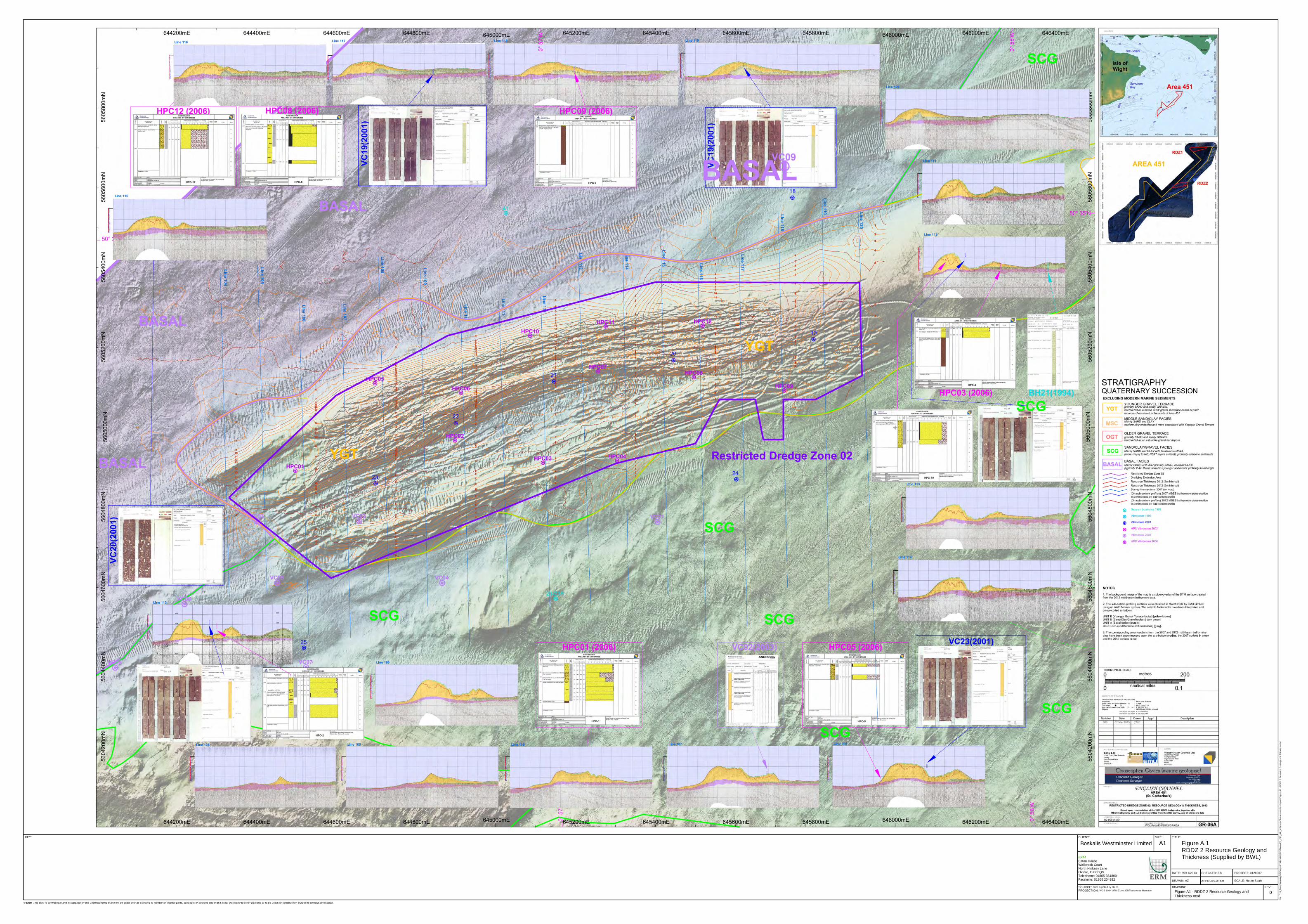
© ERM This print is confidential and is supplied on the understanding that it will be used only as a record to identify or inspect parts, concepts or designs and that it is not disclosed to other persons or to be used for construction purposes without permission.
CLIENT: SIZE: TITLE:
DATE: 25/11/2013
DRAWN: AZ
CHECKED: EB
APPROVED: KM
PROJECT: 0128267
SCALE: Not to ScaleDRAWING: REV:
KEY:
Boskalis Westminster Limited A1 Figure A.1RDDZ 2 Resource Geology and Thickness (Supplied by BWL)
0SOURCE: Data supplied by clientPROJECTION: WGS 1984 UTM Zone 30NTransverse Mercator
File:
C:\3_
Temp
\Work
ingGI
SProj
ectFo
lders\
0128
267A
rea45
1_GI
S_AK
_MI\M
aps\C
harac
terisa
tionR
eport
\Figu
re A1
- RDD
Z 2 R
esou
rce G
eolog
y and
Thick
ness
.mxd
ERMEaton HouseWallbrook CourtNorth Hinksey LaneOxford, OX2 0QSTelephone: 01865 384800Facsimile: 01865 204982
Figure A1 - RDDZ 2 Resource Geology andThickness.mxd
The world’s leading sustainability consultancy
ERM has 145 offices
across the following
countries worldwide
Argentina The Netherlands
Australia New Zealand
Belgium Panama
Brazil Peru
Canada Poland
Chile Portugal
China Puerto Rico
Colombia Romania
France Russia
Germany Singapore
Hong Kong South Africa
Hungary Spain
India Sweden
Indonesia Taiwan
Ireland Thailand
Italy United Arab Emirates
Japan UK
Kazakhstan US
Korea Venezuela
Malaysia Vietnam
Mexico