Embed Size (px)
Citation preview

TheMonth’s
The Kansas City Area Grotto
Volume 17Issue 5-6June 2003
ArkansasCaving
a view into Devil’s Den, Buffalo National River (photo by Gary Johnson)
this month’s focus
The Month’s Guano2
June 16-22, 2003Karst Field Studies at Mammoth Cave:Speleology with Roger Brucker.Cave Surveying and Cartography with PatriciaKambesis and Dr. Nicholas Crawford.For more information, contact the Center for Caveand Karst Studies at [email protected], visit theCenter's website at caveandkarst.wku.edu or call theCenter at 270-745-3252.
June 17-22, 2003 Karst Field Studies at Mammoth Cave: KarstHydrology with Dr. William White and Dr. NicholasCrawford. For more information, contact the Centerfor Cave and Karst Studies at [email protected],visit the Center's website at caveandkarst.wku.edu orcall the Center at 270-745-3252.
June 20-22, 2003 MCKC 10th Anniversary Celebration in MeramecState Park. For more information, visithome.swbell.net/bob4mvg/mckc/celebration.htm.
June 20-23, 2003 50th Annual Cave Capers on Delaney Creek Parknear Salem, Indiana, hosted by Central IndianaGrotto. For more information, e-mail Kathy Wellingat [email protected] or visit the Capers website atwww.cavecapers.com.
June 21, 2003 CRF Ozarks trip to Powder Mill Creek Cave forsurveying (wetsuit required). Note: rain will cancelthis trip. For more information, contact Doug Bakerat [email protected].
June 21-22, 2003Restoration project weekend at Carroll Cave. AllCCC members are invited to participate. The groupwill be building/marking trails and doing RestorationInventory for the purpose of adding projects to thetask list. The ladder is installed so access is not aproblem. The cave is limited to 24 visitors per day,so signup is on a first-come-first-served basis.Everyone who signs up will have the opportunity toenter the cave and participate in the project. Formore information or to sign up, contact MikeHartley at [email protected] (yes, he has email!)or visit the CCC website at www.carrollcave.org.
June 21-28, 2003National Cave Rescue Commission 2003 CaveRescue Operations and Management Seminar atCamp Washington Ranch in Calsbad, New Mexico.NCRC will be offering Level 1 (team member), Level2 (team leader) and Level 3 (specialist) training.Register before May 12th to avoid paying a late fee.For more information, contact the registrar [email protected] or visit the seminar websiteat seminar2003.ncrc.info.
July 4, 2003Annual July 4th party at Bryon Carmoney's house.The celebrations start at 4pm; bring your fireworksand your climbing gear. Theme has not been decided
yet — suggestions are welcome. Questions? ContactBryon Carmoney directly.
July 18-20, 2003Karstorama Event at Mount Vernon, Kentucky,sponsored by the Greater Cincinnati Grotto. Guidedand self-led trips in Rockcastle County andsurrounding counties will be available. For moreinformation, contact Wayne Barton [email protected] or 513-961-5183.
July 19, 2003CRF Ozarks trip to Powder Mill Creek Cave forsurveying (wetsuit required). Note: rain will cancelthis trip. For more information, contact Doug Bakerat [email protected].
August 4-8, 2003NSS Convention in Porterville, California. Regular(NSS member) admission is $110 with a $25 late feeafter June 15. The workshops and field trips areextra, between $15 and $100 each. For more infor-mation, contact Peri Frantz at [email protected] or 408-356-8506 or contact Lynn Fieldingat [email protected] or 310-533-8627. Moreinformation can also be found on the NSSConvention website at www.nss2003.com.
The NSS has prepared a promotional video to show-case the convention site and some local attractions.The video can be downloaded using the followinglink (file size: 96 MB):http://www.kcgrotto.org/nss_2003/nss_2003.zip
If you don't have a high-speed connection, please e-mail [email protected] to get a copy on CD.
August 16, 2003CRF Ozarks trip to Powder Mill Creek Cave forsurveying (wetsuit required). Note: rain will cancelthis trip. For more information, contact Doug Bakerat [email protected].
August 29 - September 1, 2003Rocky Mountain Regional in the Lime Creek Areanear Eagle, Colorado, hosted by the ColoradoGrotto. For more information, contact Barbara R.Smith at [email protected] or 303-948-2240 orcontact Christa Schneider [email protected] or 303-432-1430. Moreinformation is also available on the Colorado Grottowebsite atwww.caves.org/grotto/colorado/RMR_2003.htm.
September 6, 2003CRF Ozarks trip to Powder Mill Creek Cave forsurveying (wetsuit required). Note: rain will cancelthis trip. For more information, contact Doug Bakerat [email protected].
October 13-17, 2003National Cave and Karst Management Symposium atthe Sheraton Hotel in Gainesville, Florida. For moreinformation, see the symposium's website atwww.nckms.com.
Events Table of ContentsA Trip to Fitton Cave,Buffalo National Rivertrip report by Gary Johnson, photos byNathan Braswell and Gary Johnson
page 4
A Trip to Skull Pit andDevil’s Dentrip report by Jeff Page, photos byMike McKinney
page 9
A Trip to Chilly Bowl Cavetrip report by Bill Gee, photos byTom Lounsbury and Bill Gee
page 11
A Trip to Gunner Cave andNeedles Cavetrip report by Gary Johnson, photo byRegan Youngman
page 14
Geologic Wonders ofBuffalo National Rivertrip report by Gary Johnson, photos byMike McKinney and Gary Johnson
page 19
Modu'LED 8 Kit for Petzl Duoan equipment review by Michael Fraley
page 24

The Month’s Guano 3
The Month’s GuanoJune 2003, Vol. 17, Issue 5-6
The Month's Guano is published on thelast Wednesday of the month. Twelveissues annually.
Submit articles to editor by the lastWednesdayof the month.
Guano subscription rate for nonmem-bers: $ 6.00 annually. Electronic: FREE.
President: Jeff PageVice President/Treasurer:Richard CindricSecretary: Jeff AndrewsEditor: Bryon Carmoney, 3512 N 63rdTerrace, Kansas City, KS 66104Web Master: Sam Clippinger
E-Mail Addresses: Bryon [email protected]; Jeff [email protected]; Sam [email protected]; andJeff [email protected]
Kansas City Area Grotto is affiliatedwith the National SpeleologicalSociety, The Missouri SpeleologicalSurvey, and a Founding Member ofMissouri Caves & KarstConservancy.
Meetings are held every secondWednesday at 7 p.m. (alternate site inMay), Magg Hall, behind SpencerLaboratories, Volker Blvd. & Cherry,Kansas City, Missouri.
Annual Dues: $15 for Full Members (3caving trips with KCAG, nominationand vote of membership required.)
NCRC Callout number – Emergencyuse only: Central Region 502-564-7815.This number may be used for caverescue emergencies in the states ofIllinois, Indiana, Iowa, Kentucky,Michigian, Missouri, Ohio andWisconsin.
Greetings fellow KCAGers: In the evolution of our new The Month's Guano format, we'vemade a decision to try to keep each issue on one theme. This issue, with 25 pages
devoted to Arkansas caving, must be a Grotto record. There are a great deal of photos, butalso a great deal of text. It reflects our Grotto's fondness of caving in Arkansas. The next issuewill be devoted to the adventures of the KCAG group in New Mexico. I'm looking forward tothat one, too. Meanwhile there is much to enjoy and absorb from this issue.
In previewing it, what struck me most were Gary's self revelations about dealing with his fears inthe article on Gunner Cave. Gary is a novice who is gaining experience at a rapid pace.Everyone who starts caving will soon confront situ-ations they would never have to deal with in theirday-to-day lives. Gary's article goes beyond adescription of the cave. It discusses what is goingon in the interior of his mind. It's rare when acaver is this forthcoming about sharing his fears. Itreminded me of many things that went throughmy mind when I was learning from more experi-enced cavers.
A lot of it has to do with being a novice andsimply gaining experience from one cave to thenext. But there is a universal theme as well. I'vealways believed that to be successful in caving,people must confront their darkest fears underground. Some can never do it and they move onto other interests. It's one thing that sets caving apart from many other recreational pursuits. It'salso a good lesson to trip leaders. I don't think any of us were aware of Gary's plight on theGunner trip. It's always a good idea to ask the newer cavers how they are doing and give assur-ances. It could make the difference between gaining or losing a valuable fellow caver.
Cave softly and safely,
Jeff PageKCAG President
MessagePresident
AFrom
the
Jeff Page descendsinto Skull Pit (photo by Mike
McKinney).
The Month’s Guano4
Ifirst learned about Fitton Cave when I visited BlanchardSprings Caverns in December 2002 for a wild cave tour.I asked the guide about other caves and he told me
about Fitton Cave. He had visited it several times himselfand strongly recommended the cave. Unfortunately for me,however, several KCAG members had visited Fitton just afew months previously, so I didn't hold much hope offinding someone ready to return to Fitton so soon. So Istarted looking for Arkansas cavers who might be headed forFitton. I found Wade Baker of the Boston Mountain Grotto.He had been in Fitton Cave several times and was planninganother trip, which he allowed me to join.
Every time I go to Arkansas, I try to make the most ofthe time by hiking some of the magnificent trails in theBuffalo National River area. This time I decided to combinethe Fitton Cave trip with a hiking trip of Hemmed InHollow. I wanted to test my hiking ability on one of themost demanding trails in the Midwest. In May I would beventuring to New Mexico and some of the trails there
feature drastic elevation changes, so I wanted to text myability on a local trail so I'd be able to plan appropriately forNew Mexico. Hemmed In Hollow would prove to be theperfect trail for approximating a Guadalupe Mountainsclimb. Hemmed In Hollow drops over 1800 feet from theCompton trailhead to the Buffalo River, over little more thantwo miles. An unmerciful drop, particularly when you'repacking over 40 pounds of camping gear. Hemmed InHollow itself features the tallest waterfall between theAppalachians and the Rockies — reportedly 204 feet.
When I arrived, the region was still in the midst of adrought, so the waterfall was running at a reduced level, buta good stream was still emerging from over the top of thesheer cliff overhead. High winds whipped the water far offto the side so that little seemed to ever actually reach theground. A third of the way up the bluff I could seeremnants of cave formations that had long ago been
Trip toFitton CaveTrip toFitton Cave
trip report by Gary Johnsontrip report by Gary Johnsonphotos by Nathan Braswellphotos by Nathan Braswell
AA
Buffalo National River
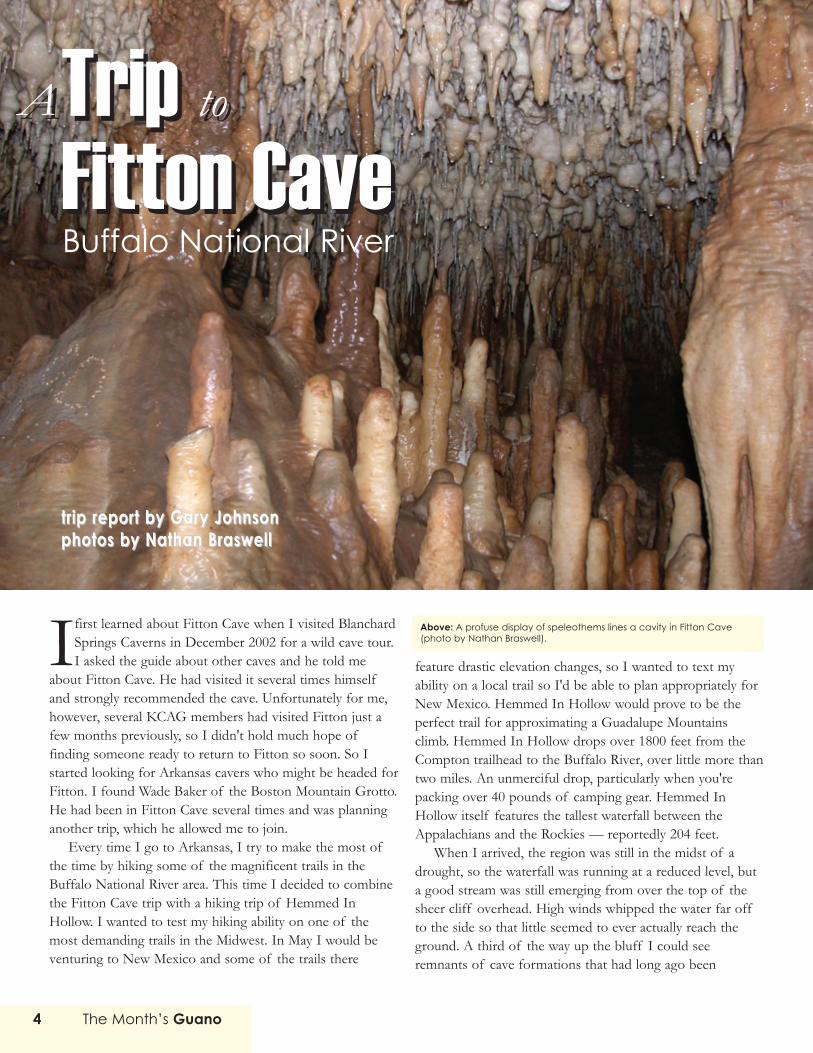
Above: A profuse display of speleothems lines a cavity in Fitton Cave(photo by Nathan Braswell).

exposed to the elements — a tantalizing suggestion that thearea may still be harboring sections of a Hemmed In HollowCave.
If the trip down to the waterfall wasn't bad enough, thetrip back up would of course be far more demanding.Instead of hiking directly back up to the trailhead, I decidedto hike up Sneeds Creek instead and return by a route thatpromised to be somewhat less steep. Maybe it was, maybe itwasn't. I don't know for certain. All I know is Sneeds CreekTrail kicked my butt. It contains an horrendous section thatclimbs about 700 feet in half a mile. I had to stop for abreather after every 100 feet of trail. I set up camp abouthalf way up. On the following morning, I hiked the rest ofthe way up the hill and then moved onto a trail near FittonCave, where I spent a relatively slow-paced day examiningthe vicinity of the cave and recuperating from my HemmedIn Hollow experience.
That evening, the skies unleashed a torrential storm —50 mph winds and two inches of rain. But the followingmorning, the sky was blue and the sun was shining. Mosttraces of the previous night's storm were already evapo-rating. This made the trek up the small hollow to Fitton's dryentrance relatively easy. (Fitton also has a wet entrance onthe other side of the ridge. This entrance is known as BatCave.)
Wade and the rest of the caving group met me at mycampsite on Sunday morning, April 20th, and then we hikedto the cave. We reached the cave entrance at 8am. To theright of the entrance, you can see the remnants of theconcrete foundation poured by the cave's past owner —Arkansas caving legend Jim Schermerhorn. When he ownedthe cave, he had sealed the entrance with a heavy, square irondoor. The door can still be found in the bottom of thishollow about a hundred yards to the southwest. Apparentlysome people have mistaken Schermerhorn's old door for thegate to Fitton. When I encountered the old door, a log waswedged under it, as if someone had tried to pry it open. Butthe door leads to nothing now. Schermerhorn's door wasremoved after the NPS took possession of the cave becausethe door wasn't bat friendly. In its place, an iron grate wasinstalled with gaps between the bars that are large enoughfor bats to fly through.
In contrast to the Hemmed In Hollow trail, the cavingtrip to Fitton was much less demanding. Wade had decidedthis would be a photo trip. Accordingly, the pace of the tripwas leisurely — which is fine with me: it gives ample oppor-tunities to look for cave life. I've been on several caving tripswhere the goal was to move through a cave as quickly as
Right: The bluffs at Hemmed-In Hollow drop over 200 feet (photo by Gary Johnson.

The Month’s Guano6
possible. And in those situations I've seen many interestingcave features fly past as a blur.
Wade struggled with the gate's combination lock for afew minutes before it finally popped open. Then we climbeddown into the cave. To the right, cavers anxious to try theirvertical gear can rappel to a lower passage. We went to theleft and scrambled down a large mound of breakdown to thefloor of a large room, at least a 100 feet across, with a good20 feet of ceiling. A couple small pools to the left containeda handful of salamander larvae (about a half inch long each).About 20 Pipistrelle bats dotted the ceiling. Straight ahead arow of impressive columns served as a divider and broke theroom in two.
Wade called the largest column "the centerpiece." Weexplored this room for several minutes as everyone tookphotographs. The formations here are quite large and forman impressive entrance area. We would return to this area acouple hours later and climb down the breakdown on theright side to a passage that extends for several miles to theeast. For now, though, we pushed straight ahead and downanother breakdown pile to the floor of another large room.
The scale of this cave is impressive. A thirty-foot highbluff-like wall curves around the left side of the room.Several wide, shallow pools sit at the base of the wall. Ifound a couple more salamander larvae in these pools. Offto the right, a scree-like pile of breakdown led up to a higherlevel. We would try that level in a few minutes. First, we triedthe passage that bypasses this breakdown pile to the left. Wefollowed the passage for two or three hundred yards whilelooking for a salamander nursery that Wade had encounteredon a previous trip. He eventually decided this was the wrongroute and we retreated back to the big room and climbed thescree.
The route over the scree led to a passage that is one ofthe cave's highlights: a profuse display of soda straws andother small formations. In this area we also discovered a highconcentration of salamanders in a small pool about 12 feetacross and about 6 inches deep. I counted at least 30 sala-mander larvae. Most were relatively small (about a half inchlong each) and black in color but we saw at least two thatwere about two inches long. We could not identify the sala-mander type. The larger salamander larvae seemed to be greywith brownish-orange stripes down their backs.
Eventually, the floor and ceiling converge in this passageto the point that it becomes difficult to move without endan-gering the soda straws. So we retreated down the scree pileand headed for the east passageways. And here is where mymemory gets foggy and the rest of the cave sort of blurstogether. So I might be getting things out of order fromhere on.
Top: The dry entrance to Fitton Cave is gated (photo by Gary Johnson).
Bottom: “The Centerpiece” commands the entry room at Fitton Cave(photo Nathan Braswell)..

After a relatively brief bit of crawling, we reached anunusual column that seemed to almost pierce the floor ofthe passage and continue on into the ceiling. The columnwas nearly cylindrical. Its base emerges from a small pit,about six feet deep. The column itself is about a foot wide.This strange column has earned such appellations as "thereamer" (for rather obvious reasons, which I'm not going togo into here).
A passage dubbed "the monorail" continues further. Thispassage is largely hands-and-knees crawling height. In fact,so many hands and knees have passed down this soft claypassage that a double-trough path has been worn. Unlessyou want to do some belly crawling, you'll want to place yourhands and knees in the troughs. This makes negotiating thepassage much easier.
Eventually, we reached a small room with standing heightwhere the passage splits in three directions. To the left itcontinues as a crawl over breakdown. To the right itcontinues as a canyon like passage. And straight up, a pathleads over some breakdown into a higher level of the cave.We chose the latter route.
This vertical path requires a minor bit of chimneying.The route leads into an upper level passage that largelyconsists of breakdown. That would be the norm for most ofthe passageways we would explore for here on. At first, wewere in a series of large rooms. Each room had at least 30feet of ceiling height. The first room was a breakdown pitwith a single, small snow-white formation — one of the fewformations we would see for the next quarter mile ofpassageway — serving as a signpost for the hole through thefloor of the room (and indicating the route back toward theentrance).
The floor of the next upper-level room was covered withbat guano, although there were no bats in sight. In fact, theguano was so old that it had turned into a brittle crust. Thisroom eventually linked into a third room with a wide pit tothe left. Wade said a waterfall frequently feeds this pit,although there was no sign of a waterfall during our visit.This large room was approximately 200 feet across. On itsfar side the passage continued deeper into the cave.
We followed this route to a vertical perforation of thepassage that Wade called "the manhole." It's possible tochimney to the bottom of this twelve-foot deep hole, butgetting back up might be a problem. The sides of themanhole are covered with slippery flowstone. Instead ofattempting the manhole, three members of the partyattempted a belly crawl to the right, hoping it would link upwith the bottom of the manhole. They described a narrowsqueeze down into a maze of passageways, but they couldn't
Right: Large formations command the entry rooms at Fitton Cave, asthese two photos attest (photos by Nathan Braswell).

find the bottom of the manhole. They felt they were close,but rather than risk getting lost in the maze, they chose toreturn.
From here, we continued to the east, through passagesthat required hands-and-knees crawling and occasional bellycrawling, in the direction of the West Crystal Passage. Everynow and then the passage opened up enough that you couldsit upright. This passage was virtually devoid of formations.It was all breakdown and bare rock. We crawled throughseveral hundred yards of such passage before we began tocontemplate whether it was time to call it quits and return tothe entrance. I wanted to see as much cave as possible, but Ialso knew I had a long drive back to KC waiting for me onceI exited the cave. So I had to unfortunately argue it was timeto turn around.
While the rest of the group sat and took a breather, Idecided to take a quick look down the passage. Maybe theWest Crystal Passage was just around the corner. NathanBraswell (whose photos accompany this report) followed. Wequickly plowed through about 300 yards of passage, all ofwhich looked virtually identical — breakdown and bare rock— before we encountered a minor stretch of quartz crystalslining the edge of some large dolomite breakdown blocks.We felt confident this 20-foot stretch of crystals was notsignificant enough to warrant naming this passage the WestCrystal Passage, but with no more promising leads, wedecided to turn around. We quickly scrambled back to thegroup and began the trek back to the cave entrance.
Overall, this was one of the easiest trips that I've beenon. Compared to the Richard Cindric-led trip to GunnerCave (2/1/2003), this was an absolute cakewalk. But Fittoncan no doubt be a much more demanding cave. It's all amatter of how far you explore and which passages youexplore. The wet entrance from Bat Cave is a notorioussection of Fitton, with thigh-high water that must be wadedfor extended distances. And then there is the 21 Jumpspassage, where you must leap from one ledge to the other —21 times — with a canyon passage below dropping 90 feet towater. No, this cave can be much more demanding. But thistrip was a good introduction to Fitton. And now that I'vebeen here once, I'm sure I'll be back to explore otherpassages.
Thanks go to Wade Baker for letting me join his trip and to NathanBraswell, who graciously allowed us to publish his photographs. Nathanwill spend Summer 2003 in the Northwest fighting fires. Good luck,Nathan!
Top: A Pipistrelle Bat hides among soda straws in Fitton Cave.
Middle: Speleothems line a small passageway.
Bottom: Gary Johnson stands beside “The Reamer” in Fitton Cave.
(photos by Nathan Braswell)
The Month’s Guano 9
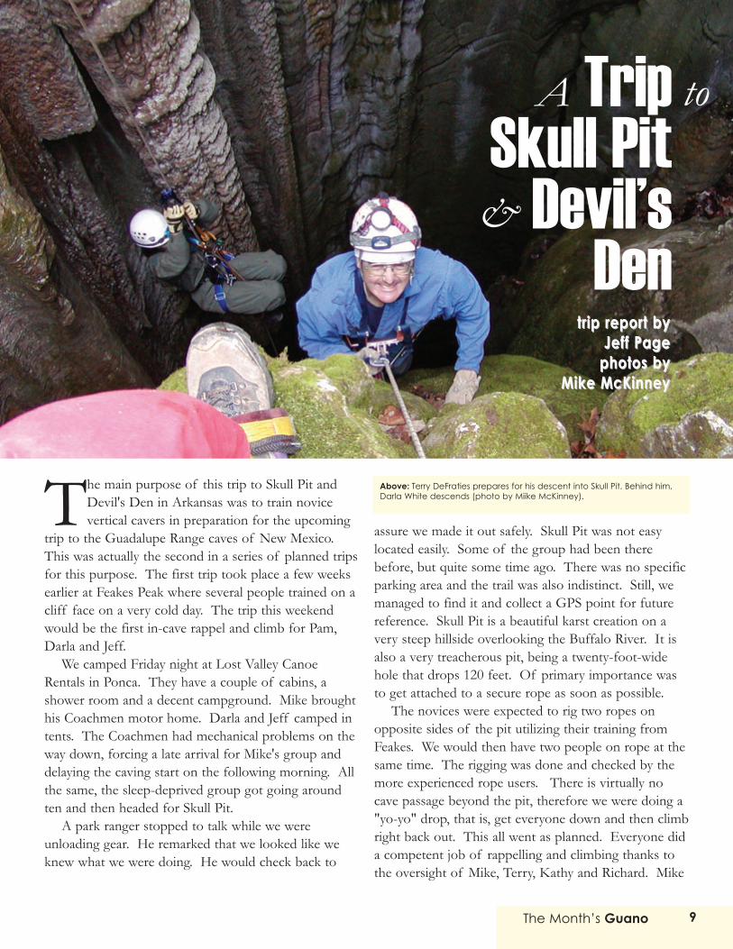
The main purpose of this trip to Skull Pit andDevil's Den in Arkansas was to train novicevertical cavers in preparation for the upcoming
trip to the Guadalupe Range caves of New Mexico.This was actually the second in a series of planned tripsfor this purpose. The first trip took place a few weeksearlier at Feakes Peak where several people trained on acliff face on a very cold day. The trip this weekendwould be the first in-cave rappel and climb for Pam,Darla and Jeff.
We camped Friday night at Lost Valley CanoeRentals in Ponca. They have a couple of cabins, ashower room and a decent campground. Mike broughthis Coachmen motor home. Darla and Jeff camped intents. The Coachmen had mechanical problems on theway down, forcing a late arrival for Mike's group anddelaying the caving start on the following morning. Allthe same, the sleep-deprived group got going aroundten and then headed for Skull Pit.
A park ranger stopped to talk while we wereunloading gear. He remarked that we looked like weknew what we were doing. He would check back to
assure we made it out safely. Skull Pit was not easylocated easily. Some of the group had been therebefore, but quite some time ago. There was no specificparking area and the trail was also indistinct. Still, wemanaged to find it and collect a GPS point for futurereference. Skull Pit is a beautiful karst creation on avery steep hillside overlooking the Buffalo River. It isalso a very treacherous pit, being a twenty-foot-widehole that drops 120 feet. Of primary importance wasto get attached to a secure rope as soon as possible.
The novices were expected to rig two ropes onopposite sides of the pit utilizing their training fromFeakes. We would then have two people on rope at thesame time. The rigging was done and checked by themore experienced rope users. There is virtually nocave passage beyond the pit, therefore we were doing a"yo-yo" drop, that is, get everyone down and then climbright back out. This all went as planned. Everyone dida competent job of rappelling and climbing thanks tothe oversight of Mike, Terry, Kathy and Richard. Mike
TripSkull Pit
Devil’sDen
A
&
to
trip report bytrip report byJeff PageJeff Page
photos byphotos byMike McKinneyMike McKinney
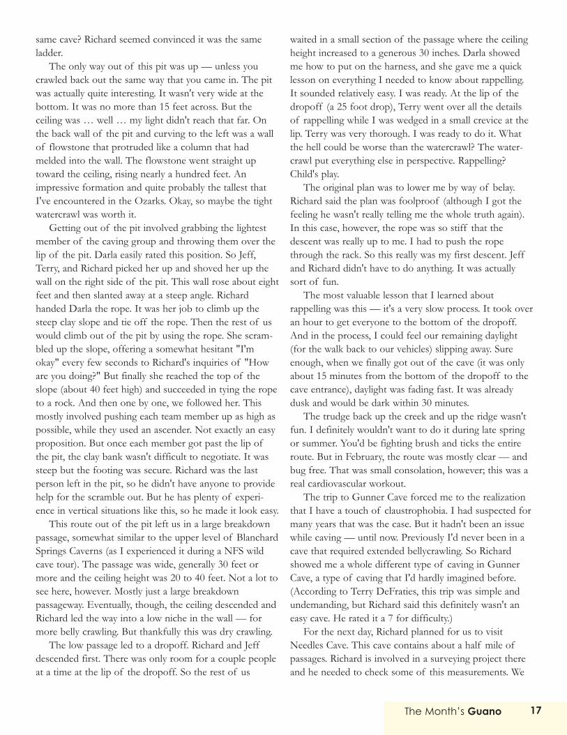
Above: Terry DeFraties prepares for his descent into Skull Pit. Behind him,Darla White descends (photo by Miike McKinney).

The Month’s Guano10
and Richard snapped some digital photos. The ascentfrom the pit provided the best opportunity to appre-ciate the beauty of the sunlight illuminating the wallsand flora above. It was a very memorable climb.
We de-rigged and were off to Devil's Den. This pitcave is on the well-traveled trail to Fitton. There wereother hikers along the trail that day, but no other caverswere observed. Devil's Den entrance is not a free drop,as was Skull, but the drops are of similar total length.The first half is a funnel-shaped slide where the climberwalks backwards on rappel. The second half goes overa lip and free drops to the bottom. The rope had to berigged to a tree across the trail and downhill from thelow side (six o'clock position) of the pit entrance.Another rope was rigged at the nine o'clock position togive one of the more experienced cavers a tether thatthey to use at the lip. They could then give instructionsto climbers who might be having trouble with thedescent.
Everyone got down with no trouble. Devil's Denhas quite a bit of horizontal passage to explore oncethe pit is negotiated. About half the group removedtheir climbing gear and took off to explore. It wasgetting late in the day, however, and the group wasgetting tired and hungry. The exploration was cut shortand we began the climb out. Terry, Mike, Darla andJeff were still at the bottom when they heard "ROCK,ROCK, ROCK!" from above. A Pelican case fell tothe bottom and shattered on the breakdown. Richardhad dropped his camera case. Mike and Terry foundthe camera submerged in a pool of water. Richard'strip photos were lost.
Everyone got up the rope without incident andbegan derigging. Unfortunately, a bag tied to the endof the rope got hung up around the lower lip and Terryhad to climb back down to free it. We got on the trailback to the cars around sundown.
This was a very successful trip for all the noviceclimbers. I came back with an appreciation for howmuch knowledge, experience and training is requiredfor a trip like this. I also came to understand howmuch time is expended getting a half dozen or sopeople down and back up a rope. Thanks go to Mike,Terry, Kathy and Richard for their time and infinitepatience. Cave softly and safely.Top: A view from the bottom of Skull Pit.
Bottom: Kathy Sumner prepares to descend Skull Pit.
photos by Miike McKinney

The Month’s Guano 11
On one of the coldest days of the year, I drove down toArkansas for a trip in Chilly Bowl Cave. Tom Lounsburyput the trip together. Chilly Bowl is about 20 miles south
and a little east of Harrison, Arkansas.I arrived at the "campground" (not much more than a clear spot
among the trees) about 7pm. The road in was five miles of typicalOzarks dirt road, narrow and twisted and covered with snow. I haveno idea how I made it with my 2x4 truck, street tires and trailer.There were more than a few occasions when I felt the back of thetruck going sideways on a hill. Doing it at night made things evenmore ... interesting!
The temperature was around 10º F when I arrived. Yup, that iscold. I got the camper set up and the furnace running and thendiscovered that all inlets and outlets to my fresh water tank werefrozen. There was no way to fill the water heater or drain the tank. Iwound up sleeping on the floor so I could leave the tank uncoveredand — hopefully — help the water thaw. I planned on three nightsof camping, so I had some water in jerry cans to use for drinkingand cooking. As it turned out, I was the only camper. Everyone elsewimped out and camped in Harrison at a motel. The campground isgood for tenters but very cramped for those of us with RVs. It isheavily wooded. The nearest real house is about a half mile on theother side of a draw.
The next morning people started to arrive about 8:30am. Joe
Ray was the first, then Bob Lerch. The three of us waited andtalked and waited some more. Caver time was obviously the orderof business here. About 9:30 we decided to rig the drop and getourselves in the cave to wait for the rest of the gang. Joe had beenthere many times and knew exactly how to rig the drop.
The entrance to Chilly Bowl Cave is down the hill from thecamping area, next to a creek. It is just a hole in the ground withsome trees around it. The drop is in two pitches, the first about 60feet and the second about 40 feet. In the middle is a pretty decentledge to rebelay on. The bottom of the hole is a room perhaps tenfeet in diameter with one small drain leading out.
Joe led the way with me second and Bob third. Once at thebottom, we stored our climbing gear and crawled into the drain. Itgoes down about ten more feet into a hole small enough to make aneasy climb. At the bottom, the passage goes in two directions. Thepassage is about 700 feet long and 4 feet wide — and 10 to 14inches high! Wowser, that was a long crawl.
A hundred feet or so in you go across the top of the Piddle Pit,a pit about 8 feet across and 10 or 12 feet deep. Just a piddling little
trip report byBill Geetrip report byBill Geephotos by Tom Lounsburyphotos by Tom Lounsbury
Trip Chilly Bowl CaveA toA toTrip Chilly Bowl Cave
Above: Chilly Bowl Cave requires a substantial amount of crawling.
Inset: An impressive display of flowstone in Chilly Bowl Cave.
photos by Tom Lounsbury
The Month’s Guano12
thing ... When Tom set up the trip he told everyone to make a pig.I had my doubts but did it anyway. After that crawl I'm really gladI did. It would have taken me twice as long with a regular pack,and I would have tied it to my ankle anyway. The only problemwas that I did not have enough room for a camera. The onlypictures I got are on the surface.
Joe proceeded to take Bob and me on a tour of the cave, at amodest pace. About two hours in we came across the rest of thecrew at a crossroads. They were on the high road and we were onthe low. We soon met up with them and became a party of 9. Idon't remember everyone who was there. Lawrence Ireland, BenMiller and Roger Brown are the only three I remember.
After getting out of the long crawl, the cave becomesextremely three-dimensional. We spent a lot of time crawling at
the top of a canyon or wiggling through passage only a few feetwide. There are not a lot of decorations. The passages criss-cross each other on several levels. At one point we crawled into acrack in the rock that is only 10 inches or so high. Go about 6feet and you pop out the side of a dome. It's pretty impressivelooking down 30 feet and up 50 feet. Backing out of that crackwas difficult.
Eventually we came to a very large dome at the back of thecave. The dome is something like 200 feet high and 50 or 60 feetacross, and has a waterfall and small stream in it. Up to then, thecave had been almost completely dry. Tom says the dome hasbeen bolted and climbed, but there is not much up at the top.
We went into a side passage that has some of the biggestdogtooth spar in the world. The crystals are easily a foot on aside and cover a whole wall. The top of this passage comes outon the side of the big dome.
Everyone stopped here for a meal. After eating we went onby another route. Tom and Joe brought us to the place wherethey camped while surveying the cave. They have a real bunker inthere made from a niche in the passage and a bunch of sandbags.It's big enough for 5 or 6 really good friends to sleep. There wasa hammock hung between two rocks with several bats roosting onit.
We divided into two groups for the trip out. The secondgroup waited 45 minutes before leaving. The trip out of thecamping room was through some of the tightest passage I havebeen in. It was helmets off at several places. After some morecanyon climbing and two etriers we wound up back at theentrance crawl. I quickly found out how the cave got its name.On a cold winter day, it was breathing in. The temperature in thatlong crawl was not more than 35 or 40 degrees and the wind waswhistling through. Even with the very hard work of crawling, Iwas freezing.
Back at the entrance pit, Tom Lounsbury was the first oneout. I went second. Being rather a novice at vertical work, Istruggled getting over the two lips. It was about 8:30pm, so wehad a good ten-hour trip in the cave. I went up the hill to thecampground and started some of the vehicles so they'd warm up.Then I got out of my caving clothes and into my warm camper.Tom went over to the parking lot and started more cars.Everyone was out of the cave by 9:30pm.
Tom's original plan had been to spend Sunday doing somemore area caves, but because of the cold weather, he decided toskip them. Once again I was the only camper. Everyone elsewimped out and went into Harrison. Sunday morning I got up,packed up and was on the road by 9am. The roads were a littlemore clear than when I came in, but I still had a few anxiousmoments. At least on the way out, I could see where I was going!About the time I hit Branson, the drain on my fresh water tankthawed enough that I could empty it.
Despite the cold, the icy roads and frozen water tank, it was agood trip. Physically it was the hardest caving trip I've been on.That exit crawl about did me in. I'd like to do it again sometimewhen the weather is not quite so nasty..
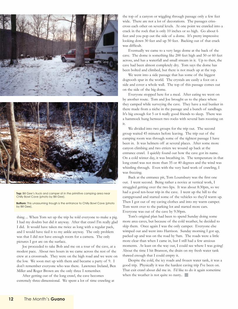
Top: Bill Gee’s truck and camper sit in the primitive camping area nearChilly Bowl Cave (photo by Bill Gee).
Bottom: This unassuming trough is the entrance to Chilly Bowl Cave (photoby Bill Gee).

The Month’s Guano 13
trip report byGary Johnsontrip report byGary Johnsonphoto by Regan Youngmanphoto by Regan Youngman
Trip Gunner CaveA toA toTrip Gunner CaveNeedles CaveNeedles Cave
&&
While at Blanchard Springs for a wild cave tourin December 2002, I asked the rangers aboutwild caves in the Sylamore Ranger District
area, and they gave me a list of caves, with brief descrip-tions of each cave. I browsed through the list and foundGunner Cave. It sounded intriguing, so I mentioned it atthe next grotto meeting. Gunner Cave is almost threemiles long and according to the description on the OzarkNational Forest document, requires a wet suit and a handline (but no vertical gear). Richard Cindric had been toGunner Cave before and he grinned when I mentioned it.He described a pit where an old wooden post served as amakeshift ladder and the only way up. He could hardlybelieve that someone had gone to the bother of dragginglumber into the pit and creating the ladder. But you couldsee his eyes light up. There was something special aboutthis cave.
I didn't hold much hope of seeing Gunner Cave
anytime in the near future. But no more than a coupleweeks later I got an e-mail message from Richard. He wasgoing to Arkansas and he was interested in visitingGunner Cave again. Would I like to go? I quickly acceptedhis invitation. But I didn't really know what I was gettinginto.
First, Richard said the cave didn't require a wetsuit, notfor the area we were headed anyway. And he thoughtmaking a hand line a requirement was sheer folly — itdidn't require a hand line. It required a full-fledged rappel.I didn't have any vertical experience, but Richard assuredme that wasn't a problem: they'd set up a belay and lowerme down. Piece o' cake. He seemed confident. I didn'tthink twice about it. So, great. I'm headed for Gunner.
This would prove to be the cave that would completelyredefine for me what it meant to go caving. Gunner Cave
Above: Richard Cindric checks his surveying figures while standing at theentrance to Needles Cave (photo by Regan Youngman).

The Month’s Guano14
would be the most demanding cave that I had ever beenin. Until Gunner Cave, all the trips I had been on were,well, easy and fun. Heck, I'd even gone through the endwatercrawl at Whippoorwill Cave during the September2002 grotto trip to Bear Lake. And I'd even enjoyed thatexperience. But Gunner Cave was in a completelydifferent category altogether.
I arrived at the Blanchard Springs campground a daybefore everyone else, and this allowed me to hike fromBlanchard Springs up to Gunner Pool and back. This trail— North Sylamore Trail — is especially scenic. You hikealong steep bluffs and beside a beautiful stretch of river.Mixed in along the way are historic farm sites, wonderfulgroves of tall pine trees, and moss-covered valley floors.This is a great trail for backpacking. It includes twosuperb camping areas alongside Sylamore Creek, where
pine needles have formed a marvelously soft mattress.These campsites are free of weeds and underbrush andare accompanied by fire rings.
I'd read about some old cave formations that werenow exposed high on the trail just north of Gunner Pool.So I hiked toward them. I found the remnant formationsabout a half-mile beyond the Gunner Pool Bridge. Theywere located high above the creek — about two hundredfeet up the bluff. So these formations must date backhundreds of thousands of years, when the creek was justbeginning to cut through the limestone and dolomite. Atthis point, the trail wound between some large blocks ofdolomite before following a bluff line, about 50 feetbelow the top of the ridge. Immediately alongside the leftside of the trail, the bluff dropped off sharply. To theright, along a small depression in the bluff, I found several
Blanchard Springs CavernsWild Cave Tour
While few caving trips werearranged in the fourth
quarter of 2002 by the grotto, Idecided to fill the lull by headingfor Blanchard Springs and takingone of their wild cave tours.These tours are not cheap. WhileDevil's Icebox at Rock BridgeMemorial State Park in Missouricosts $25, the Forest Service asks$65 for their wild cave tour ofBlanchard Springs Caverns. Apricey proposition. But, hey, it'sBlanchard Springs Caverns one ofthe most impressively decoratedcaves in all of the Ozarks. Theyalso provide most of the equip-ment that you'll need. In otherwords, they provide the kneepads, the helmets, the head-lamps, and the batteries. Andafter the trip is done, you get a t-shirt. It's not exactly a $65 t-shirt,but it's a nice shirt with a pictureof one of the cave's most impres-sive formations.
The first hour of the trip ispreoccupied with gettingeveryone equipped andinstructed on how to use the
equipment. Then a school busdrops by the visitor center andprovides a quick five-minute rideto the same entrance that theregular commercial tours use — aconcrete-and-glass air lockblasted through bedrock. Wefollowed the Discovery Trail forabout a quarter mile, whichincludes the cave's most impres-sive formation — the GiantFlowstone — a huge example offlowstone, 80 feet high and 200feet long. A cave stream flowspast the base of the formation.Soon afterwards, we left thepaved trails behind and trekkeddown a clay-floored passage.
We spent a great deal of timein breakdown passages, butthere are also some nice forma-tions along the way. One of thehighlights is a pair of huge stalag-mites, “The Titans,” each about70 feet tall. The tour required littlein the way of crawling. Thepassageway was almost all widewalking passage. However, itrequired negotiating some steepslopes and some semi-precariousledges.
The tour also passes thenatural entrance, which is a
vertical drop of 70 feet. Becauseof the difficulty involved in nego-tiating the natural entrance, thecave remained relatively free ofvandalism, unlike many otherOzarks caves. Entry is alsopossible through the springentrance — provided you'rewilling to don a wet suit anddiving gear. This route requiresnegotiating lengthy submergedpassages. (Entrance through thespring is strictly forbidden.)
This is a well-run tour. Theguides aren't geology experts orspeleology experts, but they'regenuinely interested in cavingand they enthusiastically sharetheir knowledge.
But is the tour worth $65?That's a tough call. And it's nodoubt a personal call,depending on how much sparecash you have lying around.Whatever the case, this is a veryimpressive cave. It has some ofthe largest passages that I'veseen in the Ozarks.

The Month’s Guano 15
much deteriorated formations. Nothing earth shattering.But a fascinating little display of the area's geologichistory.
I highly recommend the Sylamore Trail. It's one of myfavorite areas in Arkansas. And the Blanchard Springscampground is excellent also; it has nice shower facilitiesand heated restrooms that are open year round, so this isa great place for winter trips. Thankfully the weathercooperated during the Gunner Cave trip weekend, withnighttime temperatures in the 40s and daytime highs inthe 60s. Great weather for late January and early February.
That evening the rest of the caving group arrived:Richard, Terry DeFraties, Jeff Page, and Darla White. Onthe following morning, we dropped by the BlanchardSprings visitor center, picked up the caving permit, andgot some quick directions on how to reach the cave.During previous trips, Richard had parked near a farm-house, but the owner had apparently contacted theNational Forest Service office and requested that caversstay away from her property. So we were forced to take analternative route, which the Blanchard Springs rangerdescribed to us.
The route wasn't bad. It was all downhill for aboutthree quarters of a mile. But it led over slick dolomiteboulders, which made it real easy to turn your ankle alongthe way. In addition, we all realized that while the route tothe cave wasn't difficult, it would be a real bitch on theway out. We'd have to be sure to get out of the cavebefore nightfall. Scrambling up the rocky creek bed couldbe dangerous in the dark.
The entrance to Gunner Cave is a pit. However, it canbe negotiated without vertical gear. Tree roots and rocksprovide plenty of handholds along the north side of thepit, making the climb relatively easy, although it would beeasy to imagine someone slipping on the wet dolomiteand plummeting 50 feet to the bottom. (According toRichard, this has indeed happened — with fatal results.)Just past the drip line, the cave floor was coated withseveral inches of ice. But the ice didn't last for long. Soonthe entrance passage split in two. We looked down the leftroute. The passage became immediately watery. So wetook the right passage. It became watery also, but thedepth was shallow.
Gunner isn't exactly a beautiful cave. You won't findmany formations or flowstone. But extensive wateractivity has carved out some large passages. The ceilingheight probably averaged twelve feet and the width variedbetween 10 and 30 feet.
After following the passage over some two-to-threefoot deep pools of clear water, which could be negotiatedby way of several handholds in the rock, we arrived at ajunction where the passage split in several directions. Welooked at the cave map. One passage headed for a sectionof the cave called "the Nasties." We decided we'd skipthat area. Instead Richard pointed at a canyon passagethat led back to the left. He led the way as we zippedthrough the passage.
Eventually, we reached a section where Richardstripped off his pack and wrapped the strap around hisankle. He ducked under a twisted, well-weathered ledge ofdolomite and disappeared. "Pack off," cried Terry. Hellwith that, I thought, this doesn't look so bad. I crawledafter Richard.
If I ever have any caving nightmares (not that I've hadany, but if I do …), I'm sure they'll be somewhat like thepassage I found myself in. The passage immediatelydropped to crawling height, and then bellycrawl height.The floor was completely composed of chert rubble. Ipulled off my pack and pushed it in front of me. (Not asmart move, but I'm learning.) At one point, I had todislodge Richard's pack, which while being pulled by hisfoot had become wedged between rocks. Eventually thepassage dropped to only about 10 inches high. It pinchedmy chest and sharp fragments of chert left scratchesdown my chest and stomach. The passage was fairly wide,probably 10 to 12 feet. But it was a tight squeeze verti-cally. And it kept getting tighter. After I turned my headto the left, I discovered there wasn't room to turn myhead anymore. I had to continue forward with my headcocked to the left. Chert rubble ripped the front of mycave suit. I was wearing an aviation suit, which is fine formost caves when extended crawling isn't required. Buthere, the chert broke the zipper pulls on the front of thesuit (the pulls were made of thin, brittle metal) and sandfilled the zippers (which I later learned made them impos-sible to open, so after we were done I had to stand in theshower, fully dressed, in order to unzip the suit).
As I struggled to get through the passage, even diggingout some of the chert so that my chest could pass, strayneurons in my brain started firing off. PANIC! I startedmaking pacts with myself that if I ever got out of thispassage, I would never do anything like this again.PANIC! Get me out of this damn cave! And then Icaught up with Richard. He was splashing around in ashallow pool, straining to see to his left and then to hisright: "I don't remember this much water in here," he

The Month’s Guano16
said. Was he just screwing with me? I don't know. Heseemed genuinely concerned. Maybe he was just puttingon a performance to see me squirm. But he didn't seemto be acting. He seemed worried. "Are we turningaround?" I asked. "Are we in the right passage?" Don't tellme this is all a mistake. Don't tell me we entered thewrong passage. Richard, you know where we're headed,right? Then he pressed on. And I followed him. Soon the10 inches of crawlspace included a couple inches offreezing water. I could literally feel the water sucking theenergy out of my chest. We crawled further into thewater. PANIC! And I started to wonder how much energyI'd have left. Maybe I'd just die right here, wedged in atiny passage, cold water draining away all the heat frommy body. Hypothermia! What a way to go. PANIC! Mybrain kept telling me to get the hell out of the there!Move! … Mooooooooove! I had to fight away theimpulse to panic. I tried to look at the situation in purelylogical terms: panicking won't help a damn bit. In fact, itwill do nothing but make things worse. I had to remain incontrol and continue forward. "Are we about out of thispassage?" I shouted at Richard. (Give me some reassur-ance! Give me something, anything!) "I don't know," hesaid. That's not what I wanted to hear. Tell me the
passage is about to open up. PANIC! Tell me we're aboutout of here. "What do you mean you don't know?" Iasked. What the hell does that mean? We're crawling intocold water, it's sucking the life out of me, and you don'tknow? How can that be? PANIC! I don't know if I cando this much more. I don't know if I can physically dothis. PANIC! I don't know if … I was looking atRichard's feet. He was standing up. He was standing up?He was standing up! I scrambled out of the passage andto my feet. But the cold water had taken its toll. I felt as ifhalf of my energy had been sucked away.
The entire crawl probably wasn't more than 150 feet. Iknow there are much longer belly crawls out there. (ReadBill Gee's description of a Chilly Bowl bellycrawl in thisissue of The Month's Guano for an example of a muchlonger bellycrawl.) But this cave passage in Gunner Caveis the one that I now use to measure all my subsequentcaving trips. This is the passage that redefined caving forme.
Looking around, I discovered we were now in the pitthat Richard had described at the grotto meeting. Therewas the old ladder. Two 2x4s were nailed together. Largespikes serving as ladder rungs. Could it be the same ladderthat Richard had encountered nearly 20 years ago in this
Additional SylamoreRanger District Caves
The National Forest Service's listof caves in the Sylamore
District includes over two dozencaves. Many of these cavesdon't amount to much, butthey're still fun to visit. ShelterCave #1, for example, is about750 feet long. It's located littlemore than 50 yards from one ofthe most frequently traveled trailsin the park. If you know where tolook, you'll find a faint pathwinding through the woods andup a hill. You'll even find whatlook like stones laid out as astairway. So maybe this was acommercial cave at one time. Ormaybe at one time the ForestService encouraged visitation tothe cave. The nice-sizedentrance looked promising, but
the passageway quickly droppedto crawling height. Some oldformations (long since vandalizedand deteriorating) partly obstructthe passage. Shelter Cave #2 isnot far away. However, it's muchmore difficult to reach. You mustcontinue up the bluff to the leftfrom Shelter Cave #1 and acrossa steep slope. It would be easyto imagine someone slipping andtumbling several hundred feet tothe bottom of the hill. While thiscave is much more difficult toreach than Shelter Cave #1, itshows stronger signs of humanpresence: the cave floor is onemass of footprints. While thesecaves have long since been lefthigh and dry as the water tabledropped, they must still getmuddy on occasion. Sometime inthe not so distant past, the floorof Shelter Cave #2 had become
muddy, and during that time, itwas visited by dozens, if nothundreds, of cavers — all ofwhom left their deep footprintson the cave floor. The cavepassageway here is much largerthan Shelter Cave #1, althoughthe cave is slightly shorter, about600 feet long. You can walk inthe cave entrance and all theway to the end of the mainpassage without any crawling oreven any ducking. The passage isat least 30 feet across, and nearthe end of the cave, thepassage increases to nearly 100feet wide before narrowing downagain for the final 70 to 80 feet. Ahuge rimstone dam (now dry) —about four feet high — chokes offthe passage.
The Month’s Guano 17
same cave? Richard seemed convinced it was the sameladder.
The only way out of this pit was up — unless youcrawled back out the same way that you came in. The pitwas actually quite interesting. It wasn't very wide at thebottom. It was no more than 15 feet across. But theceiling was … well … my light didn't reach that far. Onthe back wall of the pit and curving to the left was a wallof flowstone that protruded like a column that hadmelded into the wall. The flowstone went straight uptoward the ceiling, rising nearly a hundred feet. Animpressive formation and quite probably the tallest thatI've encountered in the Ozarks. Okay, so maybe the tightwatercrawl was worth it.
Getting out of the pit involved grabbing the lightestmember of the caving group and throwing them over thelip of the pit. Darla easily rated this position. So Jeff,Terry, and Richard picked her up and shoved her up thewall on the right side of the pit. This wall rose about eightfeet and then slanted away at a steep angle. Richardhanded Darla the rope. It was her job to climb up thesteep clay slope and tie off the rope. Then the rest of uswould climb out of the pit by using the rope. She scram-bled up the slope, offering a somewhat hesitant "I'mokay" every few seconds to Richard's inquiries of "Howare you doing?" But finally she reached the top of theslope (about 40 feet high) and succeeded in tying the ropeto a rock. And then one by one, we followed her. Thismostly involved pushing each team member up as high aspossible, while they used an ascender. Not exactly an easyproposition. But once each member got past the lip ofthe pit, the clay bank wasn't difficult to negotiate. It wassteep but the footing was secure. Richard was the lastperson left in the pit, so he didn't have anyone to providehelp for the scramble out. But he has plenty of experi-ence in vertical situations like this, so he made it look easy.
This route out of the pit left us in a large breakdownpassage, somewhat similar to the upper level of BlanchardSprings Caverns (as I experienced it during a NFS wildcave tour). The passage was wide, generally 30 feet ormore and the ceiling height was 20 to 40 feet. Not a lot tosee here, however. Mostly just a large breakdownpassageway. Eventually, though, the ceiling descended andRichard led the way into a low niche in the wall — formore belly crawling. But thankfully this was dry crawling.
The low passage led to a dropoff. Richard and Jeffdescended first. There was only room for a couple peopleat a time at the lip of the dropoff. So the rest of us
waited in a small section of the passage where the ceilingheight increased to a generous 30 inches. Darla showedme how to put on the harness, and she gave me a quicklesson on everything I needed to know about rappelling.It sounded relatively easy. I was ready. At the lip of thedropoff (a 25 foot drop), Terry went over all the detailsof rappelling while I was wedged in a small crevice at thelip. Terry was very thorough. I was ready to do it. Whatthe hell could be worse than the watercrawl? The water-crawl put everything else in perspective. Rappelling?Child's play.
The original plan was to lower me by way of belay.Richard said the plan was foolproof (although I got thefeeling he wasn't really telling me the whole truth again).In this case, however, the rope was so stiff that thedescent was really up to me. I had to push the ropethrough the rack. So this really was my first descent. Jeffand Richard didn't have to do anything. It was actuallysort of fun.
The most valuable lesson that I learned aboutrappelling was this — it's a very slow process. It took overan hour to get everyone to the bottom of the dropoff.And in the process, I could feel our remaining daylight(for the walk back to our vehicles) slipping away. Sureenough, when we finally got out of the cave (it was onlyabout 15 minutes from the bottom of the dropoff to thecave entrance), daylight was fading fast. It was alreadydusk and would be dark within 30 minutes.
The trudge back up the creek and up the ridge wasn'tfun. I definitely wouldn't want to do it during late springor summer. You'd be fighting brush and ticks the entireroute. But in February, the route was mostly clear — andbug free. That was small consolation, however; this was areal cardiovascular workout.
The trip to Gunner Cave forced me to the realizationthat I have a touch of claustrophobia. I had suspected formany years that was the case. But it hadn't been an issuewhile caving — until now. Previously I'd never been in acave that required extended bellycrawling. So Richardshowed me a whole different type of caving in GunnerCave, a type of caving that I'd hardly imagined before.(According to Terry DeFraties, this trip was simple andundemanding, but Richard said this definitely wasn't aneasy cave. He rated it a 7 for difficulty.)
For the next day, Richard planned for us to visitNeedles Cave. This cave contains about a half mile ofpassages. Richard is involved in a surveying project thereand he needed to check some of this measurements. We

The Month’s Guano18
wouldn't be in the cave long. Just a quick stop on the wayhome. Maybe a couple hours. Three hours tops. "DoesNeedles require any bellycrawling?" I asked Richard. "Notthat I recall," he said. So I felt good. It'd be a nice little tripinto easy walking passages. And that is indeed what wefound at Needles — for the first half of the cave trip. Butafter that … well, all I can say is don't trust anythingRichard says. Nothing.
Needles Cave is located north of Calico Rock, nearBergren Cave. Both caves are located in the same littlehollow, which is honeycombed with caves. Needles Cavewas busy on the day that we visited. Three cars wereparked nearby, and inside the cave, we found members oftwo different surveying teams. The cave has a prettyentrance, approximately 25 feet high and about 30 feetwide, and the rocks outside are covered with moss. Themain passageway was fairly large for the first couplehundred yards into the cave and then it dropped to about 5feet high, with a flat floor and a passage shaped sort of likea bell curve. Not a lot of formations, but water activity hadcarved some nice passages. We stopped for several minutesas Richard, Jeff, and Terry took measurements of a passagethat had proved troublesome during Richard's previoussurveying trip. Then we headed for the cave's waterfall.And here's where we encountered a bellycrawl passage. Ihad gained my fill of belly crawling at Gunner Cave andwasn't too excited about doing anymore so soon. As Imuttered under my breath and glared at the low passage,the rest of the group tied their packs around their anklesand crawled forward. Shouting curses at the cave, I pulledoff my pack, looped the strap around my ankle, andcrawled forward, into the sandy passage that curved to theleft. Luckily, the crawl didn't last long before dropping intoa shallow depression. Any headroom at this point wasappreciated. The depression led under a ledge of rock.After climbing past the ledge, we were now standing in thewaterfall room. A modest stream, about one foot wide, slidover a narrow ledge about 15 feet above the floor of theroom and dropped to a rubble floor. We sat down andwatched the waterfall for several minutes.
Earlier in the day, a surveying crew had gone past thewaterfall. We had encountered a couple members of thiscrew on our way into the cave and they were soaked butclean. They said the crawlway passage led to a sinkhole butthey couldn't access the sinkhole because it was chokedwith trash and debris — an all-to-frequent sight in Ozarksinkholes.
On the way back to the cave's entrance, Richard led us
through a sandy crawlspace. Soon we were all caked withsand. This crawl wasn't difficult. It was likely a longer crawlthan the chert watercrawl at Gunner, but the passagewasn't particularly tight and it was relatively dry. So thepassage was easy to negotiate.
On the way back to our trucks, we encountered anothersurveying crew, and they found our condition to be quitehumorous. Everyone else who had exited the cave hadbeen washed clean, but we were coated with a thick layerof mud, clay, and sand. Richard tried to convince them thatwe had crawled through a passage that hadn't beenmapped. "No, there's no passage there," they said. But lookat us! The sand and muck on our suits is your evidence.What do you think we were doing? Rolling around on thefloor of the main passage? They smirked. Oh, well.
So while Needles Cave contained much more crawlingthan Richard had led me to believe (once again, don'tbelieve anything he says), it was still a relatively easy trip.And while getting to a cave can frequently be the mostdemanding part of a caving trip, here the hike was along agravel road (with the final hundred yards to the caveentrance being a beautiful little stream).
This was a great trip, and I'm grateful to Richard forasking me to come along. I was clearly the least experi-enced caver in the group. I had no vertical experience. Ihadn't done any extended belly crawling before. I had nosurveying experience. About the only thing I was good forwas reading a topo map. (The map reading skills weresomewhat helpful during our trek to Gunner Cave.)Otherwise, though, I felt like I had little to offer the group.But I'll work on getting further vertical experience. And I'llstudy surveying further (I've already got a copy of OnStation). I learned a lot during this trip — mostly aboutmy own limitations.
Thank you Richard Cindric for inviting me on the trip. Thank youTerry DeFraties and Darla White for teaching me how to rappel.And thank you Jeff Page for serving as the camp cook.

Geologic Wondersof Buffalo National
River
The Month’s Guano 19
Geologic Wondersof Buffalo National
River
The following article discusses a handful of thegeologic wonders present in Buffalo National River.This park is rich in towering bluffs, natural bridges,
waterfalls, springs, sinkholes, stream-carved bedrock, aban-doned mines, old quarries, steep hollows, and of course,caves. This article just scratches the surface and provides arandom sampling of the park's wonders. Entire books havebeen written about Buffalo National River and its scenicqualities; however, the emphasis here is upon geologicfeatures.
Lost ValleyLost Valley is one of the most popular areas in BuffaloNational River. It's easy to access. And the trail is relativelylevel and short. So while you might find yourself all aloneon many of the trails at Buffalo National River, at LostValley you're almost guaranteed to have company. The woodchip and tree bark path heads up a hollow and passes large
dolomite boulders and a forest of tall trees in route to astunning collection of natural wonders. Cob Cave is atowering bluff overhang. There isn't any cave to explorehere. But the massive bluff has been undercut by wateraction. Archaeological evidence indicates that Indians usedthis shelter cave. Corn cobs found in the cave are the genesisfor the cave's name. Further up the hollow, you'll find anatural tunnel that bores through a limestone outcropping. Astream passes through this tunnel and keeps the limestonewet, so if you decide to walk through the tunnel, be sure towear shoes with good traction, or you'll likely do a BusterKeaton and be seeing stars. Not far past the upper entranceof the tunnel, you'll find a nice waterfall taking a twenty footdrop to the stream below. Soon after, the trail starts amodest climb and weaves beside a limestone bluff. If youfollow the trail to its end, you'll have found Eden Falls Cave.This is not a large cave, but you'll definitely need a headlamp
trip report byGary Johnsontrip report byGary Johnson
Above: Pam Rader stands in picturesque Broadwater Hollow (photo byMike McKinney)..

The Month’s Guano20
or flashlight if you decide to journey far inside. The cave'sentrance is an easy-to-negotiate 200-foot-long passage thataverages about three to four feet in height. Stooping andduckwalking will get you through the passage, as well as aminor bit of hands and knees crawling. (Be careful if you'renot wearing a helmet. It'd be easy to smack your head on thecave ceiling.) The entrance passage is fairly wide, about thirtyfeet. Eventually the passage enters a large room with about50 feet of headroom. Immediately upon stepping into thisroom, you're greeted by a waterfall. A small stream flowsover a limestone lip and plunges 35 feet to a shallow pooldirectly at your feet. There isn't much more to the cave, butthis is nonetheless a marvelous little cave.
Mud Cave A well-trod path from Cecil Creek Trail leads directly to theentrance of Mud Cave. In fact, if you didn't know better,you might mistake the spur to the cave entrance as CecilCreek Trail and not take the turn that leads up the rathersteep hill and continues the main trail as it climbs to CecilBench. So I'm sure many people stumble across this cave byaccident.
The entrance is at the base of a bluff. Cool air escapingfrom the cave keeps the rocks at the entrance covered withmoss. The entrance is a horizontal slit with breakdownblocks (each two to three feet wide) lining the steep descentto the floor of the entrance room — about an 80-foot climbdown. Back in the 1800s and the early 1900s, church serviceswere reportedly held in the cave's entrance room on hotsummer mornings. This is a large room and the main cavepassage heads back and to the right. (The large passageeventually pinches into mud.) The passage is so large that it'sa bit intimidating. A huge volume of black space occupiesthe back of the cave. With bright light streaming throughthe entrance, my eyes never adjusted to the room's darkness,and therefore my headlamp never seemed to make much ofa dent in the room.
The cave's one true claim to fame is the large formationon the right side of the entrance room: a huge gour about20 feet tall. Along its slick sides, you'll find dozens of smallrimstone dams and pools. This is definitely an active forma-tion, but because the cave doesn't require a permit and theentrance is not gated, the cave receives many visitors whowalk all over the gour, not realizing (or not caring) howfragile the formation is. If you visit this cave, please becareful.
Broadwater HollowLocated at the northern extreme of the Cecil Creek Trail,Broadwater Hollow is home to one of the most scenicwaterfalls in Arkansas — Broadwater Falls. An unofficialtrailhead just north of the town of Compton provides theeasiest access to the hollow. This trail starts at the very edgeof National Park Service property. So be careful where youpark. Private property beside the trail is clearly posted. Thistrail winds through the hollow beside a small stream, passinglarge limestone boulders and small waterfalls. At BroadwaterFalls, the stream takes a picturesque tumble over a limestoneledge and drops 20 feet to a greenish-blue pool. Not muchfurther down the hollow, the stream heads underground,disappearing completely. Throughout its entire length, thestream plays a coy now-it’s-here, now-it’s-gone game as itflows to Cecil Creek, and then Cecil Creek plays the samegame. Cecil Creek Trail crosses Cecil Creek many times.
Top: Moss covers the rocks at the entrance to Mud Cave (photo by GaryJohnson).
Bottom: An impressive gour sits in the entrance room of Mud Cave (photoby Gary Johnson).
The Month’s Guano 21
Some of the crossings are wet and some are dry — a clearindication of subterranean water and a tantalizing suggestionthat this area harbors a cave system. Just before BroadwaterHollow Trail meets Cecil Creek Trail, you'll find severalwonderful campsites sheltered by tall trees and nestledbeside a stream. A great place to camp while exploring thisarea.
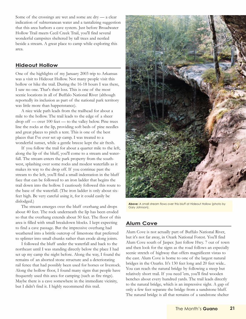
Hideout Hollow One of the highlights of my January 2003 trip to Arkansaswas a visit to Hideout Hollow. Not many people visit thishollow or hike the trail. During the 16-18 hours I was there,I saw no one. That's their loss. This is one of the mostscenic locations in all of Buffalo National River (althoughreportedly its inclusion as part of the national park territorywas little more than happenstance).
A nice wide path leads from the trailhead for about amile to the hollow. The trail leads to the edge of a sheerdrop off — over 100 feet — to the valley below. Pine treesline the rocks at the lip, providing soft beds of pine needlesand great places to pitch a tent. This is one of the bestplaces that I've ever set up camp. I was treated to awonderful sunset, while a gentle breeze kept the air fresh.
If you follow the trail for about a quarter mile to the left,along the lip of the bluff, you'll come to a stream and water-fall. The stream enters the park property from the south-west, splashing over some rocks and modest waterfalls as itmakes its way to the drop off. If you continue past thestream to the left, you'll find a small indentation in the bluffface that can be followed to an iron ladder that begins thetrail down into the hollow. I cautiously followed this route tothe base of the waterfall. (The iron ladder is only about six-feet high. Be very careful using it, for it could easily bedislodged.)
The stream emerges over the bluff overhang and dropsabout 40 feet. The rock underneath the lip has been erodedso that the overhang extends about 50 feet. The floor of thisarea is filled with small breakdown blocks. I kept expectingto find a cave passage. But the impressive overhang hadweathered into a brittle outcrop of limestone that preferredto splinter into small chunks rather than erode along joints.
I followed the bluff under the waterfall and back to thenortheast until I was standing directly below the place I hadset up my camp the night before. Along the way, I found theremains of an aborted stone structure and a deterioratingrail fence that had possibly been used for horses or livestock.Along the hollow floor, I found many signs that people havefrequently used this area for camping (such as fire rings).Maybe there is a cave somewhere in the immediate vicinity,but I didn't find it. I highly recommend this trail.
Alum CoveAlum Cove is not actually part of Buffalo National River,but it's not far away, in Ozark National Forest. You'll findAlum Cove south of Jasper. Just follow Hwy. 7 out of townand then look for the signs as the road follows an especiallyscenic stretch of highway that offers magnificent vistas tothe east. Alum Cove is home to one of the largest naturalbridges in the Ozarks. It's 130 feet long and 20 feet wide..You can reach the natural bridge by following a steep butrelatively short trail. If you need 'em, you'll find woodenbenches about every hundred yards. The trail leads directlyto the natural bridge, which is an impressive sight. A gap ofonly a few feet separate the bridge from a sandstone bluff.The natural bridge is all that remains of a sandstone shelter
Above: A small stream flows over this bluff at Hideout Hollow (photo byGary Johnson).
The Month’s Guano22
cave that long ago collapsed. The trail follows the bluffproviding good views down into the channel that runsbeneath the bridge. For the best views, you'll want to plungedown to the base of the natural bridge. This area is wet andcovered with moss. The trail continues down into thehollow, where in wet seasons a stream tumbles over somemodest waterfalls. On the far side of the hollow, the trailruns beside several small but picturesque shelter caves. Thefront walls of the caves are thin and they curve in gracefularches. Meanwhile a forest of trees encroaches to withinonly a few feet of the entrances, creating a wonderfulalmost-magical atmosphere. If an elf or pixie were to makean appearance, you might not be surprised.
Indian Rockhouse Cave Located near Buffalo Point, Indian Rockhouse hiking trail isone of the highlights of Buffalo National River. The trailpasses a wonderful variety of natural features, including asinkhole, a 30-foot waterfall, a spring, stream-carvedbedrock, and a forest of stunted cedars along a bluff. Inaddition, hikers will find the remnants of an old mine, aswell as an old quarry. It seems as if every few feet the trailhas a new surprise. The trail's name comes from the cave atits farthest reaches. Indian Rockhouse Cave is largelycomprised of a single huge room, about 200 feet long and60 feet wide. Long ago, the south wall of the cave collapsedexposing the cave interior to the elements. Accordingly, theremaining cave formations, which are quite numerous, havereached an advanced stage of deterioration. This is one ofthose caves where you wish you could have seen it backwhen it was still wet and growing. It would no doubt havebeen quite impressive.
A stream cuts through the left side of the cave. And thisis where visitors will find most of the interesting cavepassages. A large passage bores into the back wall above thestream. This passage can be reached relatively easily by step-ping on breakdown in the stream. But the passage doesn'tgo far. It doglegs to the left and dead ends after only about100 feet. Meanwhile, the stream enters from further to theright, between several large breakdown blocks. Somewhatmore interesting are a pair of passages near the front left ofthe main room. Both passages curve around and make for afew fun minutes of climbing before they terminate. Onepassage is immediately above the stream. The other passageclimbs up a few feet along a twisting route.
According to one of the park rangers, visitors to thesepassages should be careful. Rainfall can cause the stream torise quickly and visitors have drowned after being trapped inthese lower passages.
Hikers will no doubt find several more caves while hikingIndian Rockhouse trail. For example, one cave consists of anice-sized room, about 30 feet deep and 60 feet long. Alarge skylight perforates the cave's ceiling on the right side.In addition, when I hiked this trail in December 2002, Ifound a dry spring with an enterable (but narrow) entrancepassage that wound down at a steep angle.
During the summer, the National Park Service offerstours of another nearby cave — Bat Cave. This cave can befound by following a steep trail to the east of IndianRockhouse Cave. During the off-season, Bat Cave is closed,as its name suggests, to protect hibernating bats.
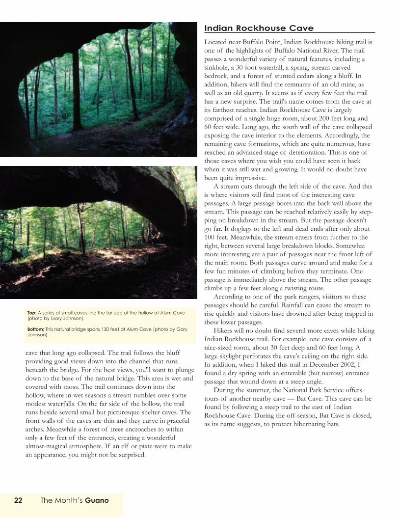
Top: A series of small caves line the far side of the hollow at Alum Cove(photo by Gary Johnson).
Bottom: This natural bridge spans 130 feet at Alum Cove (photo by GaryJohnson).

Rush MinesThe old mining town of Rush is the last canoe takeout pointon the Buffalo River. Matter of fact, if you don't takeout atRush, you're likely headed for the White River. Rush is nowa ghost town. But back during WWI it was humming withactivity. The hills that the town was built upon are rich inzinc and this metal was in high demand during the war. Zincis used for several purposes. For example, it is commonlyused as a protective coating for iron and steel. In addition, itis used for plates in dry electric cells and as a filler in rubbertires.
For evidence of the mining activity at Rush, you needonly take a drive along the road that passes the fewremaining houses at Rush. You'll find huge piles of tailings— the refuse from zinc mining. If you're a bit more ambi-tious, you might head for the hiking trail that leads up RushMountain. This trail climbs a steep grade for a quarter mileand then levels off. Along this level stretch of trail, you'llfind an amazing number of mine entrances. Most of theseentrances are now fenced off to discourage would-beexplorers.
Several years ago the National Park Service brought inengineers to examine the mines and determine their state,and the engineers found the mines had become instable anddangerous. Sections had recently collapsed and other tunnelswere on the verge of collapse. So no one is now allowed toenter the mines. But nonetheless, just standing at theentrances of these huge tunnels can be quite compelling.Most are yawning maws — 20 feet across or more.
While following the main trail around Rush Mountain, Ifound many trail spurs. I wondered what these spurs mightbe leading to, so I followed one and soon found myselfstanding in a channel that had been blasted through a shelfof limestone: a row of three large mine entrances towered infront of me. Cold air poured from the tunnels. Surroundedby forest, and with the passing of time giving the artificialentrances a rugged, weathered appearance, the mines nowlook like caves. A very impressive sight that will no doubtmake any caver salivate. But remember, these mines are in anadvanced state of decay and entry isn't wise. I resisted thetemptation to look further and returned to the main trail.
On the far side of the mountain is Monte Carlo Mine,which was active until the '60s. (Most of the other minesclosed soon after WWI ended.) Near the entrance of MonteCarlo Mine, you'll find some mining machinery left asevidence of the past activity here. This was probably thelargest of the mines at Rush — and its tunnels are rumoredto intersect a lengthy cave system. Accordingly, the mine'sseveral entrances are heavily gated.
More Articles About Arkansas Caves
In previous issues of This Month’s Guano, we’vepublished several additional trip reports aboutArkansas caves. Here is a list of those trip reports.All these issues of This Month’s Guano are avail-able for download from www.kcgrotto.org in PDFformat (Acrobat Reader required).
• Four Mile Cave (August 2002)• Fitton Cave (August 2002)• Chilly Bowl Cave (map only) (May 2002)• Big Hole (photo only) (May 2002)• Whippoorwill Cave (March 2002)• Skull Pit (March 2002)• Amos Neal Cave (March 2002)• Little Bear Cave (February 2002)• Kiddy Mix Cave (February 2002)• Alexander Cave (March 2001)• Blanchard Springs Wild Cave Tour
(April 2001)• Ennis Cave (map only) (January 2001)
Right: A small waterfall at Hideout Hollow (photo by Gary Johnson).

The Month’s Guano24
The never-ending quest for the perfect lightcontinues. Cavers constantly have to make trade-offs between light quality, battery life, weight,
durability, and of course cost. However, the designteam at Petzl has worked to give cavers a good compro-mise on most of these items. True to its name, theModu'LED 8 houses a halogen bulb for a powerfulbeam for distance lighting and an eight-LEDmodule for extended battery life. The eightLEDs have three power settings allowingthe user to determine a balancebetween battery life and brightness.Each setting is regulated to main-tain a constant brightness level.While the Duo LED 8 sells foraround $99 from InnerMountain Outfitters and KarstSports, both vendors sell a DuoModu'LED 8 kit for around $50.Both vendors also sell a versionof the Duo Belt with theModu'LED 8 for around $99, whichconsiderably extends the battery life.
This model has several features that areattractive to cavers. First, if you already own aDuo, you need not buy an entire headlamp in order totake advantage of the benefits of the module.Installation is easy. You simply need to unscrew thebezel, remove the reflectors, replace the standard bulbwith the module, seat the new reflector (included), andreplace the plastic lens and the bezel. During the instal-lation process, it is important that you pay attention tothe module's polarity. If you place the module in incor-rectly, it will not function. If the module does notwork, simply remove it, rotate it 180°, and place it backinto the duo. Petzl provides a color pamphlet to guideyou through the simple process.
The next feature that will attract cavers' attention isthe variable power settings. The lamp has three settings:maximal, optimal, and economic (maximal being thebrightest setting, and economic being the dimmest).The power regulation on the module means that eachsetting maintains a constant brightness for as long as
battery voltage will allow, then begins to dim and thenmaintains a very low level of brightness until thebatteries finally die. Operating on four AA alkalinebatteries, the maximal setting maintains its brightnessfor about five hours before declining rather quickly,leveling out, and then dying after about 50 hours. The
optimal
settingmaintains its
brightness for about15 hours and dies after 55 hours.
The economic setting maintains its brightness for 65hours, declines very slowly, and finally dies after 90hours. The Duo Belt LED 8, which operates on four Cbatteries, has a much greater burn time. The maximalbegins to dim after 14 hours and dies after 160. Theoptimal setting maintains its brightness for 10 hoursand dies at around 180 hours. The economic settinglasts for an impressive 180 hours and finally stops after240 hours. Selecting a power setting is simple. Flippingthe switch down will start the module on the optimalsetting. A quick flick off and back on will set themodule on maximal. Another flip off and on will acti-vate the economic setting. Cycling through the settingsis as easy as turning the lamp on and off. The switch is,unfortunately, on the left side of the lamp, so right-handed cavers will have to learn to adjust the lamp withtheir left hand.
The module's quality of light is excellent. One
Modu'LED 8 Kit for Petzl DuoA N E Q U I P M E N T R E V I E W B Y M I C H A E L F R A L E Y

The Month’s Guano 25
problem that cavers generally have with LED lights isthe tint of the light. Most LEDs advertise themselvesas having a "white" and "more natural" light. However,though many LED modules do have a soft white light,others appear more blue than white. Since most caverstoday have been used to the yellow glow of an incan-descent bulb or carbide lamp, the switch to somethingthat leans on the blue endof the spectrum is some-times an uncomfortableadjustment. However, theLEDs used in this modulehave a good quality ofwhite light with only theslightest bluish tint.
The question stillremains "Which settingwill I use when caving?"This question reallydepends on how muchlight you are used to. Thelight of a carbide lampwith a 1.5-inch flame and afour-inch reflectorproduces a level of lightsomewhere in between the maximal and optimalsetting. I expect that most cavers will choose to use themaximal setting, though some cavers have reportedusing the optimal on several of their trips. Certainly theoptimal setting allows for safe travel through a cavewhile providing a soft diffuse light to illuminate acaver's peripheral vision. One caver reported preferringthe maximal setting, but realized halfway through histrip, he had been caving on the optimal setting. If youdecide to use the optimal setting, you can expect tochange your batteries after about 16.5 hours of contin-uous use. Nonetheless, the desire for more light will bemore of a concern to others, and maximal will be thesetting of choice. If you use the maximal setting,expect a battery change at about six to 6.5 hours. Note
that the characteristics of the cave will also make adifference in your setting preferences. In small cavesthe optimal setting will provide more than enough light,where large cave passages may require the maximalsetting or the halogen bulb. The economic setting is notsuitable for a primary light source, but makes an excel-lent light for food and water breaks.
The Duo itself has anumber of features thathave made it a popularchoice. The pivoting headmount and durableconstruction are bothplusses. However, somehave raised questionsabout how water resistantthe light may or may notbe. It is telling that Petzlhas included instructionsas to what to do if watergets in the circuits.
Overall, this is a suit-able caving light. It makesuse of several functionsthat LED cavers prefer: it
has adjustable power settings, reasonable battery life,and good quality of light. Two of its settings are accept-able as primary light sources. The price of the DuoLED 8 is also quite reasonable compared to other LEDheadlamps. If you already own a Duo, the price of theModu'LED 8 is that much more reasonable. The three-year warranty for the module is an added bonus.
My special thanks to Stephen Brewer, Mike Spencer, SteveKennerly, Art Goller, David Lasser for sharing their experiencesand comments on the lamp; Jon Rockefeller and Alex Sprowl forrevision suggestions; and the members of the Kansas SpeleologicalSociety for help in field testing.
Pros
• Adjustable powerlevels
• Reasonablebattery life
• RuggedConstruction
• Three yearwarranty
• Pivoting head• May easily retrofit
existing equip-ment
Cons
• Questionablewaterproofing
• Duo LED 8 is a bitpricey for somecavers