Embed Size (px)
Citation preview
SCOTTISH BORDERSTOURIST BOARD
around Jedburgh
ScottishBordersC O U N C I L
£1.00

Introduction
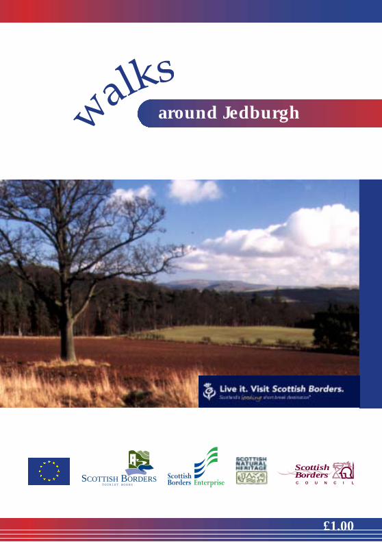
This booklet describes a number of circular walksin the Jedburgh area, all of them starting from thecentre of the town. It is an ideal area for walking,with rolling hills rising either side of the Jed Waterand extensive areas of woodland. The walksinclude much of historical and natural interest;some notes are supplied in the text, and furtherinformation is available from the TouristInformation Centre in Jedburgh or from localbookshops and other outlets.
Walkers of all abilities can enjoy the routesdescribed, which range from short walks aroundthe town area to slightly more strenuous walkstaking in the surrounding countryside. The pathsare generally reasonably easy to follow, and if youglance at the summaries you will see distancesand the more important terrain variations clearlymarked.
For those who would like something moreadventurous, the Cheviot Hills are not far away,and provided you follow the Country Code anddon’t walk on grouse moors between August andOctober you should find few restrictions on accessto the high tops. Remember several of the summitsare over 600 metres and you should be properlyequipped even in summer; apart from sensibleclothing you should carry map and compass and
know how to use them. The area is covered by OSLandranger sheets 74 & 80.
Two longer walks in the area are St Cuthbert’s Wayand the Borders Abbeys Way. St Cuthbert’s Wayruns from Melrose to Lindisfarne, a distance of100km/62 miles, and passes just to the east ofJedburgh along Dere Street, the Roman Road. It isincluded as part of two of the walks in this booklet.The Borders Abbeys Way is still being completed.As this booklet was published, it was open fromKelso to Jedburgh, and on from Jedburgh throughDenholm to Hawick. Both of these walks are fullysignposted, and further information on them canbe obtained from the Tourist Information Centrein Jedburgh or other local outlets.
Also not far away is the Harestanes CountrysideVisitor Centre, open daily from April to October.The centre itself has exhibitions, displays, tearoom,toilets and other facilities, and a series of walks islaid out from the centre around the MonteviotEstate, including a walk to the notable landmarkof the Waterloo Monument on Peniel Heugh.
In Jedburgh itself, a Town Trail leaflet availablefrom the Tourist Information Centre suppliesfurther detail, and during the summer there areregular town walks with a knowledgeable guide.
We hope you enjoy your walks but please rememberthat the freedom of access to the countryside thatwe enjoy in Scotland is dependent on sensiblebehaviour. It’s somebody else’s land you arewalking on - respect it as if it were your own,control your dogs, and please don’t leave any litter.If you experience any difficulty while out walking,please do let us know through one of our TouristInformation Centres.
Walks Around Jedburgh
2
Pen
iel H
eugh
- th
e W
ater
loo
Mon
umen
t
Walks Around Jedburgh
3
Before setting off on longer walks, alwayscheck the weather forecast and prepareyourself accordingly, but remember thatweather conditions can change rapidly.Remember that hot weather, causingsunburn and/ or dehydration, can be justas debilitating as rain or snow. Always carryadequate cover for your body in allconditions.
General Advice to Walkers
On longer hill walks you should always wearor carry good waterproofs, proper walkingboots, windproof clothing, and take food anddrink with you. These provisions may notbe necessary on the shorter, low level walks,but a light waterproof and refreshments arestill worth taking, just in case. When out onthe hills a map and compass should becarried to aid navigation.
Take great care when walking on countryroads. Pavements or footpaths should beused if provided. If there is no pavement orfootpath, walk on the right-hand side of theroad so that you can see oncoming traffic.You should take extra care and be preparedto walk in single file, especially on narrowroads or in poor light, keep close to the sideof the road. It may be safer to cross the roadwell before a sharp right-hand bend (so thatoncoming traffic has a better chance of seeingyou). Cross back after the bend. Help otherroad users to see you. Wear or carrysomething light coloured, bright orfluorescent in poor daylight conditions addfollowing to end:
LivestockThe walks in this booklet pass throughlivestock farming areas. Please rememberthat the farmer’s livelihood may depend onthe rearing and sale of livestock, and alwayswalk responsibly. Dogs can be a particularconcern for farmers during lambing time(March - May) and when cows are calving(Spring & Autumn). Dogs therefore should
Please leave gates as you find them andensure that if you have to open a gate, youclose it securely behind you. Leaving a gateopen can easily lead to stock escaping orbecoming mixed, and this can cause farmersa great deal of unnecessary work. Thank youfor your co-opeation, which will help toensure that these walks are available forthose who follow in your footsteps in futureyears.
Access in ScotlandThe Land Reform (Scotland) Act 2003 andthe Scottish Outdoor Access Code came intoeffect in February 2005. The Land Reform(Scotland) Act establishes a statutory rightof responsible access to land and inlandwaters for outdoor recreation, crossing land,and some educational and commercialpurposes. The Scottish Outdoor AccessCode gives detailed guidance on yourresponsibilities when exercising access rightsand if you are managing land and water. TheAct sets out where and when access rightsapply. The Code defines how access rightsshould be exercised responsibly.
not be taken into fields where there areyoung livestock. Livestock includes allyoung livestock such as lambs, calves andfowls. In more open countryside wherelambs are present, keep your dog on a shortlead. Disturbance at this time can separateyoung livestock from their mothers leavingthem cold, hungry and exposed to predators.Dogs should also not be taken into fields ofcattle when they have calves, as the cows seea dog as a threat and may attack it and you.Go into a neighbouring field or onto adjacentland. During the bird breeding season (April- June) keep your dog under close control oron a short lead in ground nesting areas.Without a dog, if you walk quietly throughlivestock areas, keeping a safe distance fromstock and watching them carefully, youshould experience little or no difficulty.
Walks Around Jedburgh
Know the Code before you go...Enjoy Scotland’s outdoors - responsibly!
Enjoy Scotland’s outdoors! Everyone hasthe right to be on most land and inlandwater for recreation, education and forgoing from place to place providing theyact responsibly. These access rights andresponsibilities are explained in theScottish Outdoor Access Code. The keythings are:
When you’re in the outdoors:
● take personal responsiblity for your ownactions and act safely;
● respect people’s privacy and peace ofmind;
● help land mnagers and others to worksafely and effectively;
● care for your environment and take yourlitter home;
● keep your dog under proper control;
● take extra care if you’re organising andevent or running a business.
When you’re managing the outdoors:
● respect access rights;
● act reasonably when asking people toavoid land management operations;
● work with your local authority and otherbodies to help integrate access and landmanagement;
● respect rights of way and customaryaccess;
Find out more by visiting:www.outdooraccess-scotland.comor phoning Scottish Natural Heritage on0131-446 2400.
Waymarking and Maps
Generally speaking, the routes in thisbooklet are not fully way marked on theground, though this may change in thefuture. On some of the walks you may comeacross ‘public footpath’ signs.
The Ordnance Survey 1:50,000 Landrangeror 1:25,000 Explorer maps should be usedin conjunction with this booklet so thatwalkers can identify the hills and otherpoints of interest, as these are too numerousto include in the format of a booklet.
We hope that you will enjoy these walks andnot encounter any difficulties on route.However if you do come across a problemwhilst walking these routes, please report itto Scottish Borders Council Access Officeron 01835 824000 or Scottish Border Paths on01835 826432.
Scottish BordersWalking Festival
The Scottish Borders Walking Festival, aweek long celebration of walking and thecountryside, was the first of its kind inScotland and has been held annually since1995. It usually takes place in September andthe host town rotates to give a differentchoice of walks each year. Further detailsare available from Visit Scotland.
�Q�
����QQQQ������QQ���Q�
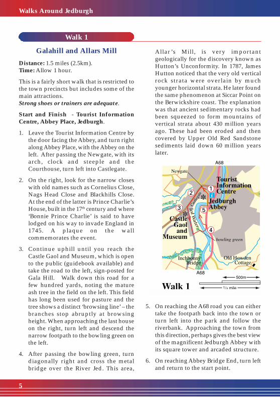
Allar ’s Mill, is very importantgeologically for the discovery known asHutton’s Unconformity. In 1787, JamesHutton noticed that the very old verticalrock strata were overlain by muchyounger horizontal strata. He later foundthe same phenomenon at Siccar Point onthe Berwickshire coast. The explanationwas that ancient sedimentary rocks hadbeen squeezed to form mountains ofvertical strata about 430 million yearsago. These had been eroded and thencovered by Upper Old Red Sandstonesediments laid down 60 million yearslater.
Walk 1
Galahill and Allars Mill
Distance: 1.5 miles (2.5km).Time: Allow 1 hour.
This is a fairly short walk that is restricted tothe town precincts but includes some of themain attractions.Strong shoes or trainers are adequate.
Start and Finish - Tourist InformationCentre, Abbey Place, Jedburgh.
1. Leave the Tourist Information Centre bythe door facing the Abbey, and turn rightalong Abbey Place, with the Abbey on theleft. After passing the Newgate, with itsarch, clock and steeple and theCourthouse, turn left into Castlegate.
2. On the right, look for the narrow closeswith old names such as Cornelius Close,Nags Head Close and Blackhills Close.At the end of the latter is Prince Charlie’sHouse, built in the 17th century and where‘Bonnie Prince Charlie’ is said to havelodged on his way to invade England in1745. A plaque on the wallcommemorates the event.
3. Continue uphill until you reach theCastle Gaol and Museum, which is opento the public (guidebook available) andtake the road to the left, sign-posted forGala Hill. Walk down this road for afew hundred yards, noting the matureash tree in the field on the left. This fieldhas long been used for pasture and thetree shows a distinct ‘browsing line’ – thebranches stop abruptly at browsingheight. When approaching the last houseon the right, turn left and descend thenarrow footpath to the bowling green onthe left.
4. After passing the bowling green, turndiagonally right and cross the metalbridge over the River Jed. This area,
5. On reaching the A68 road you can eithertake the footpath back into the town orturn left into the park and follow theriverbank. Approaching the town fromthis direction, perhaps gives the best viewof the magnificent Jedburgh Abbey withits square tower and arcaded structure.
6. On reaching Abbey Bridge End, turn leftand return to the start point.
Walks Around Jedburgh
5
����QQQQ�����Q�
�Q��Q�����QQQQ������QQ��
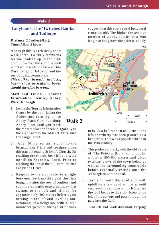
suggest that this route could be severalcenturies old. The higher the averagenumber of woody species in a 30mlength of hedgerow, the older it is likely
to be. Just before the track turns to theleft, snowberry has been planted as ahedgerow. This was a popular shrub inthe 19th century.
4. This pathway/track, with the old nameof ‘The Twitches Baulk’, continues fora further 500-600 metres and givesexcellent views of the town below aswell as the surrounding countrysidebefore eventually exiting onto theJedburgh to Lanton road.
5. Turn right onto this road and walkuphill for a few hundred metres untilyou reach the cottage on the left wherethe road bends to the right. Keep to theleft of the cottage and pass through thegate into the field.
6. Turn left and walk downhill, keeping
Walk 2
Ladylands, The ‘Twitches Baulks’and Tudhope
Distance: 2.5 miles (4km).Time: Allow 2 hours.
Although this is a relatively shortwalk, there is a fairly strenuoussection leading up to the highpoint, however the climb is wellworthwhile with fine views of theRoyal Burgh of Jedburgh and thesurrounding countryside.This walk can be muddy in places;heavy shoes or walking bootsshould therefore be worn.
Start and Finish - TouristInformation Centre, AbbeyPlace, Jedburgh.
1. Leave the Tourist InformationCentre by the door facing theAbbey and turn right intoAbbey Place. Continue alongAbbey Place until you reachthe Market Place and walk diagonally tothe right across the Market Place intoExchange Street.
2. After 50 metres, turn right into theFriarsgate or Friars and continue alongthis narrow road to St John’s Church. Onreaching the church, bear left and walkuphill on Sharplaw Road. Prior toreaching the top of the hill, turn left intoLadylands Drive.
3. Keeping to the right side, turn rightbetween the bankside and the firstbungalow after the row of conifers, andcontinue upwards onto a pathway thatswings to the left and climbs forapproximately 300 metres before againturning to the left and levelling out.Remnants of a hedgerow with a largenumber of species on the right of the track
Walks Around Jedburgh
6

����QQQQ�����Q��Q��Q���QQ����QQ���Q��Q��Q�
�Q��Q�
��QQ����QQ��
3. Follow the path downstream. Dipperscan often be seen here. These dark brownbirds with white bibs stand on stones,
bobbing up and down before launchingthemselves into the water to search forsubmerged insects, crustaces, molluscs orsmall fish.
Pass under the 16th century CanongateBridge, now used only by pedestrians. Indays gone by, this was the main accessbridge into the town. Ducks often
Walk 3
Riverside Walk and Hartrigge
Distance: 3 miles (5km).Time: Allow 1.5 hours.
This is a fairly leisurely walk along thebanks of the Jed Water as it passesthrough the town. It then followsa country road before joiningthe old driveways that oncegave access to HartriggeEstate. Hartrigge House,which once stood inthe grounds, wasbuilt in 1854 butwas demolished anumber of yearsago. Most of theexisting groundnow belongs to thelocal authority.Stout shoes ortrainers arerecommended.
Start and Finish -Tourist InformationCentre, Abbey Place, Jedburgh.
1. Leave the Tourist Information Centre andturn left into Abbey Place, then walkdownhill to Abbey Bridge End.
2. After 30 metres or so, turn left throughthe underpass and on reaching the otherside of the A68, turn left onto theriverside path.
Walks Around Jedburgh
7
to the field edge, with a hawthorn hedgeand ditch on your left, until you come toa kissing gate. After passing through thisgate, turn left and descend onto the trackthat leads down to a junction of tracks.
7. Keeping the buildings on the right,continue straight on along the left side
of the courtyard, thereafter passingthrough a gate onto the road. Continuealong the road until the Jedburgh toLanton road is reached.
8. Turn right onto this road and walk downinto the town via Exchange Street andMarket Place, and back to the start point.

congregate here. Look out for mallards,dabbling ducks which feed on thesurface or by upending, and goosanders,diving ducks with narrow saw-edgedbills with backward sloping serrations.
4. Where the path meets the A68 road,cross the road and turn right until youreach the end of the adjacent oldTownfoot Bridge. Follow the road downthe right side of the river, past the GoosePool, where, many years ago, thevillagers used to keep their geese.Continue along this road until it joins theriverside path again.
5. The path eventually meets the roadagain at the Station Bridge. Cross to theother side, turn right and then almostimmediately left onto the minor roadleading to Woodend.
6. Continue along this road for a shortdistance and turn right, climbing the hilltowards Wester and Easter Ulston. Alarge oak tree more than 200 years oldstands at the road junction, and a beechtree of similar age is just up the road.Trees of this age are important, not justfor their contribution to the landscape,but because they often play host todifferent species than their neighbours.At the top of the steep incline and afterpassing the first house on the right, takethe old driveway that forks to the right,passing farm buildings and kennels.
7. Follow this driveway as it dips and thentravels uphill. The thicket of trees andshrubs as the driveway crosses theTower Burn is a good place to look forwoodland songbirds. The trackeventually swings to the right past theconverted Hartrigge Stables until agateway is reached. Pass through thegate on the left and continue along thedriveway.
8. After passing through a small wood,which contains species such asrhododendron, the driveway begins todescend, past houses on the right. Treesseen here include horse chestnut. Firstintroduced from the Balkan countries inthe 17th century, their name is thoughtto derive from the Turkish habit offeeding the nuts to ailing horses, eventhough no animal will normally eatthem. At the foot of the hill, where thedriveway branches, follow the left forkthat exits onto the road.
9. Turn right on this road and walkdownhill, crossing the junction intoRichmond Row. Cross over theCanongate Bridge, as described earlier,turn left onto the riverside path andretrace your steps back to the start point.
Walks Around Jedburgh
8
The Jed Water

2. After leaving the House and Gardens,turn right into Queen Street and onreaching the High Street cross overdiagonally to the left towards the Fire
Station. On reaching the Fire Station, turnleft and continue along what is knownas the Pleasance to St John’s ScottishEpiscopal Church. At the church, turnright uphill into Sharplaw Road andcontinue on this road until you leave thetown behind.
Walk 4
Lanton Moor andTimpendean Tower
Distance: 5.5 miles (8.5km).Time: Allow 3 hours.
This issomething ofa historicalwalk, takingin firstlyMary Queenof ScotsHouse andGardens andthencontinuingover Lanton Moor tothe ruin of TimpendeanTower.This walk is predominantly on tracksand minor roads and therefore strong shoesor trainers can be worn.Note: Dogs are not permitted beyond thestile leading onto Timpendean Farm.
Start and Finish - Tourist InformationCentre, Abbey Place, Jedburgh.
1. Leave the Tourist Information Centre bythe door facing the Abbey, turn right intoAbbey Place and almost immediatelyright again into the lane beside theCarter ’s Rest. Walk down into theCanongate and cross over to the otherside. Turn right and after a short distanceturn left into Queen Street. Continue toMary Queen of Scots House and Gardenson the right.Mary Queen of Scots House is one of thefew remaining examples of a 16thcentury Border fortified house. It is saidthat, when the Queen visited Jedburghin 1566, she stayed in this (then new)house before and after her dramatic rideto Hermitage Castle to visit Boswell.
Walks Around Jedburgh
9
����������������
QQQQQQQQQQQQQQQQ
����������������
��QQ��
��QQ���Q�
����QQQQ�����Q�
��QQ����QQ��

3. After passing Sharplaw Farm on theright, walk on for a short distance andturn left onto a farm track. Continue onthis track as it rises gradually and swingsfirst left and then right before entering awooded area.
4. On reaching a sign board ‘LothianEstates, Pedestrians, Horses, Please Keepto the Recognised Paths’, continuestraight on for approximately 800 metres,following the track as it heads north-westacross Lanton Moor.
5. Eventually a gateway is reached on thebrow of the hill overlooking Teviotdale,with Timpendean Tower visible belowand to the right. Cross the stile beside thegate and walk down the track along thefield edge until you reach a ladder stileon the right.
6. Cross over the stile and follow thecontours of ancient earthworks until theTower itself is reached. TimpendeanTower is 16th century and stands besidean earthwork of earlier but otherwiseindeterminate date. Timpendean orTympenden, was once part of the estateof Bonjedward, owned by the Douglasfamily.
Walks Around Jedburgh
10
Note: The Tower itself is in a poor stateof repair and walkers are asked not toapproach too closely.
7. To return to Jedburgh, retrace your stepsback across Lanton Moor and down thefarm track to the minor road nearSharplaw Farm. Instead of turning righton the minor road, continue straightahead onto the track opposite.
8. This track eventually reaches the A68road. Cross with great care to thepavement opposite and turn right.Continue on the pavement for about 100metres and at the entrance to JedforestRugby Football Club, bear left onto thepath which runs parallel to the road. Thispath was once the route of the Kelso/Jedburgh railway line.
9. Continue along the path until it againjoins the pavement, and immediatelyafter crossing Station Bridge over the JedWater, cross to the opposite side of theroad and pass through the gate onto theriverside walkway.
10. Follow the walkway until it reachesTownfoot Bridge. Turn right over thebridge and make your way back to thestart point along the High Street.
Timpendean Tower
Walk 5
Larkhall Burn and Todlaw
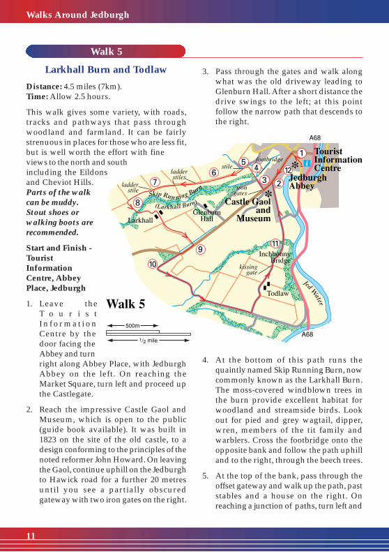
Distance: 4.5 miles (7km).Time: Allow 2.5 hours.
This walk gives some variety, with roads,tracks and pathways that pass throughwoodland and farmland. It can be fairlystrenuous in places for those who are less fit,but is well worth the effort with fineviews to the north and southincluding the Eildonsand Cheviot Hills.Parts of the walkcan be muddy.Stout shoes orwalking boots arerecommended.
Start and Finish -TouristInformationCentre, AbbeyPlace, Jedburgh
1. Leave theT o u r i s tI n f o r m a t i o nCentre by thedoor facing theAbbey and turnright along Abbey Place, with JedburghAbbey on the left. On reaching theMarket Square, turn left and proceed upthe Castlegate.
2. Reach the impressive Castle Gaol andMuseum, which is open to the public(guide book available). It was built in1823 on the site of the old castle, to adesign conforming to the principles of thenoted reformer John Howard. On leavingthe Gaol, continue uphill on the Jedburghto Hawick road for a further 20 metresuntil you see a partially obscuredgateway with two iron gates on the right.
3. Pass through the gates and walk alongwhat was the old driveway leading toGlenburn Hall. After a short distance thedrive swings to the left; at this pointfollow the narrow path that descends tothe right.
4. At the bottom of this path runs thequaintly named Skip Running Burn, nowcommonly known as the Larkhall Burn.The moss-covered windblown trees inthe burn provide excellent habitat forwoodland and streamside birds. Lookout for pied and grey wagtail, dipper,wren, members of the tit family andwarblers. Cross the footbridge onto theopposite bank and follow the path uphilland to the right, through the beech trees.
5. At the top of the bank, pass through theoffset gateway and walk up the path, paststables and a house on the right. Onreaching a junction of paths, turn left and
Walks Around Jedburgh
11
��QQ���Q��Q�����QQQQ������QQ������QQQQ������QQ���Q�
walk a short distance uphill beforecrossing a stile onto open ground.
6. Keeping close to the right side, you areeffectively following what was the routeof the old road to Hawick. On thegradual ascent you pass somemagnificent, ancient beech trees andbelow and to the left can be seenGlenburn Hall, built in the early 19thcentury to a design by William Elliot.
7. Continue upwards, keeping close to thewall on the right, until a ladder stile isreached. After crossing the stile, turn leftand continue with the wall on your leftuntil a second ladder stile is reached.Cross the stile and follow the grassytrack along the field edge, between awall and the remains of an old hedge,until it exits onto a farm track. Thedrystone walls have been built entirelywith clearance stones from the adjoiningfields.
8. After crossing yet another stile, followthe track as it continues for a shortdistance before swinging to the left. Itthen passes through a strip of woodlandwhere it rises and continues throughLarkhall Farm steading. After about 250metres the track reaches the B6358Jedburgh to Hawick road
9. At this point you have the option ofturning left and walking back down intothe town. If you prefer to continue thefull walk, turn right and walk uphill fora short distance to where the roadswings to the right. Taking great care,cross to the other side of the road andjoin a track that travels straight on.
10. Follow this track until you reach a gate.Do not pass through this gate, but turnleft downhill. A row of beech trees hasbeen planted as a windbreak on the rightof the track. Some of these trees arebeginning to bend to the leeward side,
Walks Around Jedburgh
12
showing how the weather can change theshape of a tree.
11. After about a kilometre you reach ajunction of tracks. Turn left. The groundunderneath the beech hedge on the lefthas been burrowed by rabbits and thenumber of fox scats (droppings) hereindicates how often a fox must visit thewarren for food. Continue on pastTodlaw Farm on the right.
12. The track then narrows and continuesdownhill through a wood, eventuallycrossing a small burn. The sycamores onthe right have been coppiced (cut backand allowed to grow again) producing adenser hedgeline than a row of maturetrees would. The track joins a narrowroad and continues past a number oflarge houses on the left side until iteventually reaches the Castlegate at theCastle Gaol and Museum.
13. Walk down the Castlegate and return tothe start point.
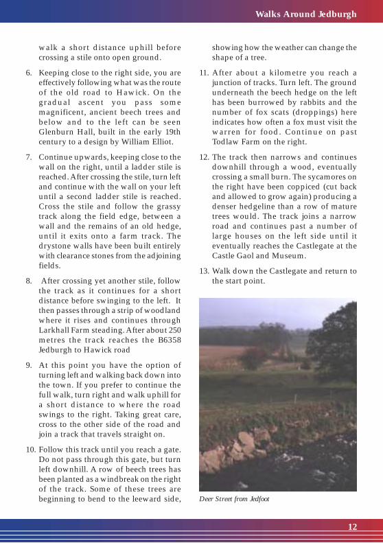
Deer Street from Jedfoot

������
QQQQQQ
������
��QQ����QQ��
�Q�
A Scots pine plantation near the top ofthe hill is bounded by a wall. Along theedge of the plantation are mature birchtrees, twisted with age, with bracketfungi and deforming galls on theirtrunks.
4. Continue past the houses at Tudhope onthe right, until you reach Roma Cottage,also on the right. Pass to the right of thecottage onto a forestry track and continuealong this track until it bends sharply tothe left. At this point turn right onto asmaller track. Rhododendrons havecolonised successfully here. They veryeasily take over from native shrubs andcome to dominate the ground flora. Theyproduce dense shade, and their leavesdecay very slowly, producing acids.
Walk 6
Williescrook and Sharplaw
Distance: 4 miles (6.5 km).Time: Allow 2 hours.
This walk starts with a steep climb on theJedburgh to Lanton Village road and thentakes you through pleasant woodlandowned by Lothian Estates. It passes thesmall white painted cottage known asWilliescrook before reaching avantage point that gives excellentviews to the north and east.Stout shoes or boots arerecommended.
Start and Finish - TouristInformation Centre,Abbey Place, Jedburgh.
1. Leave the TouristInformation Centreand turn right intoAbbey Place. In 100yards you enter theoften busy MarketPlace with its colourfulbuildings. Afterpassing the Jubilee Fountain, erected tocommemorate Queen Victoria’sDiamond Jubilee in 1897, walk diagonallyacross the square to the right and walkup Exchange Street.
2. From Exchange Street you continue ontothe steep Lanton Road or what is knownlocally as the ‘Pares Hoose Brae’. Thismeans the Poor House Hill, from the dayswhen the poor residents of the town livedin this area.
3. The road continues to climb and twistuntil you leave the town precincts andeventually reach the top of the hill. Thereare excellent views of the countryside tothe east and south and to the CheviotHills that mark the border with England.
Walks Around Jedburgh
13

5. After 100 metres you reach a junction oftracks with open fields beyond. Followthe path to the left. A mature Scots pineon the right has been riddled with holesby greater spotted woodpeckers as theysearch for insects for food. This woodlandis managed in a way which greatlybenefits wildlife, and many woodlandbirds have been reported here. Continueuntil you pass the white cottage on theright called Williescrook, with its smallpottery shed.
After passing the cottage, follow theclearly defined track through the wood.There is clear evidence of red squirrelfeeding here. If you look up you will seered squirrel nests or ‘dreys’, neat roundstructures made of an interwoven massof twigs with an inner lining of grass,leaves or even feathers.
6. Ignore the track on the left and walk onfor a short distance until you come to ajunction of tracks. Turn right here. Thiswoodland was felled some time ago and,although trees were retained around theedge, much of the woodland hasnaturally regenerated with a variety ofspecies, all about the same age.
Burdock can be seen in the newly plantedarea on the left. This plant has bracts withspines which point downwards, formingtiny hooks or burs. Burdock inspired theinvention of the fastening material,Velcro.The wall alongside the track hasan interesting assemblage of floweringplants. Cleavers or goosegrass (so calledbecause it used to be fed to geese andchickens) is covered with hooked bristlesand climbs over the wall by the end ofthe summer. Follow the farm track thatcontinues for approximately 800 metresbefore reaching a minor road.
7. Turn right onto this minor road. Afterpassing Sharplaw Farm on the left, theroad descends and enters the town viaSharplaw Road. The ivy seen here is animportant habitat. The flowers are avaluable nectar source for invertebrates.The berries, leaves and bark are also eatenby other species, and the leaves providenesting and over-wintering sites formany birds and small mammals. Onreaching the bottom of the hill, turn rightinto the Friars or Friarsgate thateventually exits onto Exchange Street.
8. Turn left into Market Square and retraceyour steps back to the start point.
Walks Around Jedburgh
14
The distant Eildon Hills
right. After passing Woodend Cottageon the left there follows a walk of about akilometre along a country lane to MountUlston House, passing the TV transmitteraerial en route. Towards the top of theroad, a collapsed wall supports commonpolypody fern plants and honeysucklegrowing in the shade. Common polypodyhas a fleshy, swollen stem, and at one timethis was avidly searched for as a remedyfor lung diseases and whooping cough.
5. Keeping to the left of Mount Ulston houseand grounds, you reach a path aheadwhich takes you through a wooded area.Visible on the left is the outstandinglandmark known as Peniel Heugh (theWaterloo Monument).
6. After a further 800 metres the path joinsDere Street, the old Roman Road whichoriginally ran all the way from York toEdinburgh. Turn right and continueuphill on the Roman Road forapproximately 800 metres. As you lookback, the Eildon Hills form a conspicuouslandmark. These triple hills were calledTrimontium by the Romans.
There are many flowering plantsalongside the track, including rosebaywillowherb. It is hard to imagine that thisplant, very common today, was quite rareonly 100 years ago. Each plant producesabout 80,000 seeds, so it spreads veryeasily. Continue until you reach a minorroad.
7. Turn right along the road. You may seehares in the fields. Although mostlysolitary, during the spring several may beseen together, leaping and chasing eachother in ‘mad March hare’ behaviour.After passing Easter Ulston Farm, turnleft along the farm track known as theSandy Road. After almost 800 metres,
Walk 7
Mount Ulston and Dere Street
Distance: 5.5 miles (8.5 km).Time: Allow 2-3 hours.
This walk mixes country roads, tracks andfootpaths. At Mount Ulston there areexcellent views northwards across the TeviotValley to the Eildon Hills and of theimpressive Peniel Heugh or WaterlooMonument. The walk also covers a sectionof the Roman road known as Dere Street.Some parts of this walk can be very muddyafter wet weather and boots arerecommended.
Start and Finish - Tourist InformationCentre, Abbey Place, Jedburgh.
1. Leave the Tourist Information Centre,turn right and almost immediately rightagain into the lane beside the Carter’sRest. On reaching the Canongate, crossto the other side, turn right and continuedownhill. After using the underpass atthe A68 road, turn right and then first leftonto the riverside path which passesunder the old Canongate Bridge.
2. Follow the path until it meets the A68again. Cross with care, turn right over thebridge and continue to the adjacentTownfoot Bridge. Follow the road downthe right side of the river, past the GoosePool, where many years ago, the villagersused to keep their geese. Continue alongthis road until it joins the riverside pathagain.
3. Follow the path downstream until itreaches the A68 at Station Bridge. Crossthe road, turn right and then almostimmediately turn left to join the minorroad leading to Woodend.
4. Continue along this minor road for 800metres, taking the second road on the
Walks Around Jedburgh
15

leave the track and turn right through asmall gate and follow the path throughmature woodland and plantations untilthe Jedburgh to Crailinghall road.
8. Turn right onto this road and walkdownhill to the junction of the roadleading to Oxnam. Follow the roaddownhill for a mile until it reaches theA68 at the swimming pool. After usingthe underpass onto Abbey Bridge End,turn right and return to the start point.
Walks Around Jedburgh
16
�Q�����QQQQ�����Q�
��QQ��
��QQ��
����QQQQ�����Q�����QQQQ������QQ���Q���QQ��
�Q��Q���QQ������QQQQ������QQ���Q��Q��Q��Q�
�Q��Q�
�Q�
��QQ������QQQQ�����Q��Q��Q�
�Q�
Walk 8
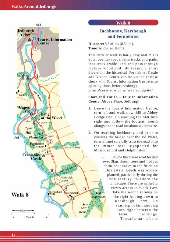
Inchbonny, Kersheughand Ferniehirst
Distance: 5.5 miles (8.5 km).Time: Allow 2-3 hours.
This circular walk is fairly easy and mixesquiet country roads, farm tracks and pathsthat cross arable land and pass throughmature woodland. By taking a shortdiversion, the historical Ferniehirst Castleand Visitor Centre can be visited (pleasecheck with Tourist Information Centre as toopening times before visiting).Stout shoes or strong trainers are suggested.
Start and Finish - Tourist InformationCentre, Abbey Place, Jedburgh
1. Leave the Tourist Information Centre,turn left and walk downhill to AbbeyBridge End. On reaching the A68, turnright and follow the footpath southalongside the road for about a kilometre.
2. On reaching Inchbonny, and prior tocrossing the bridge over the Jed Water,turn left and carefully cross the road ontothe minor road signposted forMossburnford and Dolphinston.
3. Follow the minor road for justover 2km. Beech trees and hedgesform boundaries to the fields onthis estate. Beech was widelyplanted, particularly during the19th century, to adorn thelandscape. There are splendidviews across to Black Law.Take the second turning onthe right leading down toKersheugh Farm. Onreaching the farm steadingturn right between thefarm buildings.Thereafter turn left and
Walks Around Jedburgh
17
�Q���QQ���Q��Q�
�Q���QQ��
��QQ��������
QQQQQQ
��������QQ��
�Q�����QQQQ����
��QQ��
�Q�
Walks Around Jedburgh
18
then right to join the farm track thattravels along the right side of the fieldwith the fence and hawthorn hedge onthe right.
4. At the end of this track and after crossingthe stile, continue downhill into the dipand walk diagonally left to a gate at thetop of the rise. Pass through the gate.Without walking down the slope to theplantation on your left, notice the squirreldreys in the trees. Continue along the sideof the field with the fence on your rightuntil you reach a second, smaller gate.
5. The path then enters a wood anddescends into what is called MuckleDean, a most delightful old woodland.There are many woodland floweringplants including wood sorrel, celandine,golden saxifrage, primrose, wood avensand dog mercury. Many scuffed placeswhere badgers have been foraging forgrubs, worms and underground bulbscan be seen alongside the path. Theirtracks pass through the vegetation on thesteep banksides. Cross the burn by thefootbridge and continue up the other sideof the Dean on steps until you exit ontoopen ground.
6. Keeping to the right of the fence andhawthorn hedge, continue along the pathuntil it eventually reaches a minor road.Yellowhammers nest in the hedge duringthe summer. Their song, which appearsto say ‘a little bit of bread and no cheese’,is often heard between February andNovember. Below and to the left can beseen the picturesque Ferniehirst Castle,home of Lord and Lady Lothian. If open,you can perhaps have a pleasant breakfrom your walk with a visit to the Castleand Visitor Centre. The castle datesmainly from the late 16th century; from1935 to 1985 there was a youth hostelhere.
7. If you wish to continue the walk, crossthe minor road and follow the path alongthe field edge. Ignore the small gate onthe left and continue until you reach thegate ahead. Pass through the gate and,keeping the wood on the left, follow thepath as it turns left and downhill.
At the foot of the hill, pass over the stileinto the wood and turn right along thepath. This is a very attractive oldwoodland with mature oaks, anoccasional ash tree and an understoreyof hazel.
8. In 100 metres you reach a track with amagnificent ancient oak tree on the left,aptly named ‘King of the Wood’. Thistree, like the Capon Tree beside the A68,is part of the ancient Jed Forest. Itssituation and circumference suggest thatit could be 400 years old. Oak bark andfoliage can support more species of insectand lichen than any other tree. It is worthpaying homage to the valuablecontribution this tree makes by spendingsome time observing the wildlifeassociated with it. At this point follow thetrack downhill before crossing a stile intoa field.
9. After crossing the field, pass over asecond stile onto the A68 road close tothe Capon Tree, another very ancient oak.Turn right onto the roadside footpath andwalk back into the town to the start point,crossing the road with great care whenthe footpath switches sides.
Note: For a shorter alternative walk, at point3, follow the road for 1km, turning rightat the first junction leading downhill toFerniehirst Castle. Prior to reaching thefirst cottage on the right, turn right andfollow the path along the field edge. Thencontinue as from point 7.
Walk 9
Howden,Hunthill and the Sandy Road
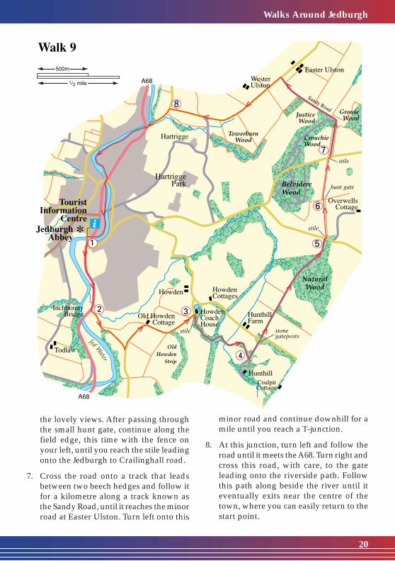
Distance: 6.5 miles (10.5 km).Time: Allow 3-4 hours.
This is the longest walk in the booklet andalso probably the most scenic. More than halfthe walk takes you along what the locals callthe Sandy Road. This is an old road that onceran between Hunthill and Easter Ulston. Theview from the highest point near BelvidereWood gives a panoramic vista of thesurrounding countryside with manyprominent landmarks.Sections of the walk can become very muddyafter wet weather: stout shoes or walkingboots are recommended.
Start and Finish - Tourist InformationCentre, Abbey Place, Jedburgh.
1. Leave the Tourist Information Centre andturn left down to Abbey Bridge End. Onreaching the junction, turn right andfollow the footpath south alongside theA68 for a kilometre.
2. At Inchbonny, and prior to crossing thebridge over the Jed Water, turn left andcarefully cross the road onto the minorroad signposted for Mossburnford andDolphinston. Continue up this road andtake the first junction on the left.
3. Follow this minor road as it passes OldHowden cottage on the left. After afurther 800 metres, and just prior toreaching the cottage known as HowdenCoach House on the right, cross the stilenext to the galvanised gates onto a farmtrack leading into the wood. Continue upthis track and before reaching a gatewayinto a field, turn left onto a pathway.Follow the path as it winds uphill throughthe wood.The path crosses the Howden Burn,
where willows thrive in the wet ground.Marsh thistles, with their spiny stems,also favour these conditions. Through thewood there is an old estate driveway withmany trees and shrubs planted over 100years ago. Limes were often used toborder driveways and here they areaccompanied by shrubs typically plantedas a game covert to provide warmth andconcealment for pheasant rearing. Box,at the bottom of the driveway, is anevergreen whose leaves have anunpleasant smell. Its wood isexceptionally hard and was used to makeprinting blocks, rulers and chess pieces.The path eventually exits onto thedriveway leading to Hunthill.
4. Turn left onto this driveway and afterpassing between the two stone gatepoststopped with lions, cross over the minorroad onto a track to the right of thecottage. Continue to follow this track,initially over open ground and thenthrough a wood. A clue that this was oncea wood managed to provide possiblybrushwood for fuel, coppice wood fortool handles, timber for building, winterfodder, animal bedding or grazing is theditch and bank around the boundary ofthe present plantation.
5. On leaving the wood the track reachesthe Jedburgh to Oxnam road. Turn rightand then almost immediately turn leftand cross a stile beside the gateway intoa field.
6. With the fence on your right, follow thefield edge uphill. Gorse grows along thefenceline on ground which isundermined by rabbits. Blooms may befound at any time of the year, and theysmell of coconut and vanilla. Continueuntil you reach the highest pointmentioned earlier. Pause here to admire
Walks Around Jedburgh
19
�Q�����QQQQ����
���
QQQ
�����QQ���Q�
��QQ����QQ����QQ��
�Q��Q��Q�����QQQQ�����Q���QQ������QQQQ����
����QQQQ�����
��
QQQ
���
��QQ��
����QQQQ������QQ��
�Q���QQ����QQ���Q�����QQQQ������QQ���Q���QQ��
the lovely views. After passing throughthe small hunt gate, continue along thefield edge, this time with the fence onyour left, until you reach the stile leadingonto the Jedburgh to Crailinghall road.
7. Cross the road onto a track that leadsbetween two beech hedges and follow itfor a kilometre along a track known asthe Sandy Road, until it reaches the minorroad at Easter Ulston. Turn left onto this
minor road and continue downhill for amile until you reach a T-junction.
8. At this junction, turn left and follow theroad until it meets the A68. Turn right andcross this road, with care, to the gateleading onto the riverside path. Followthis path along beside the river until iteventually exits near the centre of thetown, where you can easily return to thestart point.
Walks Around Jedburgh
20

AcknowledgementsThe walks in this booklet have been agreedwith the owners and farmers whose landthey cross. Their co-operation is gratefullyacknowledged. The booklet has beenproduced with financial assistance fromScottish Border Paths. SBP is a partnershipof public agencies aimed at developingcountryside access in the Scottish Borders.Much of their funds come from Europe, andtheir assistance is also greatly acknowedged.
DisclaimerWhilst every effort has been made to ensurethat the information and advice containedin this booklet is correct at the date ofpublication. It is always for you, the walker,to assess whether completing a walk iswithin your capability, using your commonsense and your knowledge of your own stateof health and fitness, competence andexperience. No liability is accepted by theauthors and publishers for any loss, injuryor damage, arising out of, or in any wayconnected with any person or personsundertaking or attempting to undertake anyof the walks described in this booklet,howsoever caused.
Copyright InformationAll text, photographs & maps in thispublication are copyright.
VisitScotland BordersShepherd’s Mill, Whinfield Road,Selkirk TD7 5DTInformation ServiceTel: 0870 608 0404Accommodation Bookings:Tel: 0845 2255 121Email: [email protected]
Visitor Information Centresat Jedburgh, Kelso, Peebles, Hawickand Selkirk.
Scottish Borders CouncilTel: 01835 824000Web: www.scotborders.gov.uk
Countryside Ranger ServiceHarestanes, Ancrum, Jedburgh,TD8 6UQ.Tel: 01835 830281Email: [email protected]
Access OfficerCouncil Headquarters, NewtownSt Boswells, Melrose, TD6 0SA.Tel: 01835 824000Email: [email protected]
Scottish Natural Heritage (Informationon Scottish Outdoor Access Code)Tel: 0131 446 2400www.outdooraccess-scotland.com
Scottish Border PathsTel: 01835 824632Email: [email protected]
Traveline(for public transport information)Tel: 0870 608 2608Web: www.traveline.org.uk
Other websitesFor further information on walkingin Scotland, visit: www.walkingwild.com
Contact Information
�Q��Q��Q���QQ���Q��Q�
������������
QQQQQQQQQQQQ
�������������Q��Q��Q��Q��Q���QQ����QQ���Q��Q��Q���QQ���Q��Q���QQ����QQ���Q���QQ����QQ���Q�
����QQQQ�����Q��Q��Q��Q��Q��Q��Q�
�Q��Q��Q��Q��Q���QQ����QQ���Q�����QQQQ������QQ������QQQQ��������QQQQ������QQ��
��QQ��
��QQ����QQ������QQQQ������QQ����QQ���Q���QQ���Q���QQ���Q�
��QQ���Q��Q��Q��Q��Q���QQ����QQ������QQQQ������QQ���Q�
����QQQQ�����Q��Q�����QQQQ������QQ���Q�
����QQQQ����
����QQQQ������QQ���Q���QQ���Q��Q��Q��Q��Q���QQ��
��QQ����QQ���Q�����QQQQ����
�Q���QQ��
��QQ������QQQQ������QQ���Q��Q���QQ���Q��Q��Q�
�Q���QQ���Q��Q��
�QQ���Q��Q�
��QQ���Q��Q��Q��Q��Q��Q�
��QQ���Q�
Designed by Scottish Borders Council Graphic Design SectionPrinted in the Scottish Borders by Buccleuch Printers, Hawick, March 1999
Walks Around Jedburgh
SCOTTISH BORDERSTOURIST BOARD
ScottishBordersC O U N C I L