Embed Size (px)
Citation preview
North Augusta Development Code 3-1
ARTICLE 3 – ZONING DISTRICTS TABLE OF CONTENTS Page 3.1 Zoning Districts .............................................................................................. 3-3 3.1.1 Compliance with Regulations ................................................................ 3-3 3.2 Zoning District Boundaries and the Official Map(s) ..................................... 3-3 3.2.1 Official Zoning Map ............................................................................... 3-3 3.2.2 Federal Emergency Management Agency (FEMA) Flood Insurance Rate Maps (FIRM) North Augusta, South Carolina ................................ 3-4
3.2.3 Interpretations of Boundaries on Map(s) ............................................... 3-4 3.2.4 Amendments to Official Zoning Map ...................................................... 3-5 3.2.5 Annexation Zoning ................................................................................ 3-5
3.3 Base Zoning Districts ..................................................................................... 3-5 3.3.1 Purpose Statements and Supplemental Standards for Base Zoning Districts ..................................................................................... 3-5 3.3.2 Residential Districts ............................................................................... 3-5 3.3.3 Commercial Districts ............................................................................. 3-6 3.3.4 IND, Industrial District............................................................................ 3-7 3.4 Permitted Uses in Zoning Districts ................................................................ 3-9 3.4.1 Generally............................................................................................... 3-9 3.4.2 Interpretation ......................................................................................... 3-9 3.4.3 Accessory and Temporary Uses ........................................................... 3-9 3.4.4 TND, P, PD, R-MH Districts................................................................... 3-9 3.4.5 Uses Not Listed ..................................................................................... 3-9 3.5 Dimensional Standards in Base Zoning Districts ....................................... 3-24 3.5.1 General ............................................................................................... 3-24 3.5.2 Residential Density ............................................................................. 3-25 3.5.3 Intensity in Nonresidential Districts ...................................................... 3-25 3.5.4 Dimensional Standards for Lots .......................................................... 3-25 3.5.5 Dimensional Standards for Structures ................................................. 3-25 3.5.6 Setbacks, Generally ............................................................................ 3-25 3.5.7 Front Setbacks .................................................................................... 3-26 3.5.8 Corner Side Yards ............................................................................... 3-28 3.5.9 Setback Encroachments ..................................................................... 3-28 3.5.10 Height of Buildings and/or Structures .................................................. 3-29 3.5.11 Visual Clearance at Intersections ........................................................ 3-30 3.5.12 Building Requirements in Established Flood Hazard Areas ................. 3-30 3.5.13 Flag Lots ............................................................................................. 3-30 3.5.14 Zero Lot Line Units .............................................................................. 3-31 3.6 Special Districts ............................................................................................ 3-32 3.6.1 PD, Planned Development District ...................................................... 3-32 3.6.2 CR, Critical Areas District .................................................................... 3-36 3.6.3 TND, Traditional Neighborhood Development District ......................... 3-36 3.6.4 P, Public Use District ........................................................................... 3-36 3.6.5 R-MH, Manufactured Housing and Mobile Home District ..................... 3-39 3.7 Reserved ....................................................................................................... 3-40 3.8 Corridor Overlay Districts ............................................................................ 3-40 3.8.1 Applicability ......................................................................................... 3-40 3.8.2 Establishment of Corridor Overlay Districts ......................................... 3-41 3.8.3 District Purposes and Standards ......................................................... 3-42
ARTICLE 3 – ZONING DISTRICTS
North Augusta Development Code (Amend. 12-7-20) 3-2
3.8.4 G, Georgia Avenue Overlay District..................................................... 3-42 3.8.5 HC, Highway Corridor Overlay District ................................................ 3-51 3.8.6 NP, Neighborhood Preservation Corridor Overlay District ................... 3-60 3.8.7 LMK, Landmark Overlay District (Reserved) ....................................... 3-63
TABLES Page 3-1 Zoning Districts .......................................................................................................3-3 3-2 Use Matrix ............................................................................................................ 3-11 3-3 Dimensional Standards ......................................................................................... 3-27 3-4 Exceptions to Height Limitations ........................................................................... 3-30 3-5 Maximum Number of Flag Lots ............................................................................. 3-31 3-6 Design Elements for a Planned Development ....................................................... 3-35 3-7 Uses Permitted in the P, Public Use District.......................................................... 3-38 3-8 Corridor Districts Established ................................................................................ 3-41 3-9 Dimensional Standards for the Highway Corridor Overlay Districts ....................... 3-53 3-10 Minimum and Maximum Access Widths ................................................................ 3-53 3-11 Dimensional Standards for the Neighborhood Preservation Corridor Overlay District ............................................................................................... 3-61 FIGURES Page 3-1 Corridor and Intersecting Streets .......................................................................... 3-41 3-2 Georgia Avenue .................................................................................................... 3-43 3-3 Facades ................................................................................................................ 3-46 3-4 Building Modulation .............................................................................................. 3-47 3-7 Vehicular and Pedestrian Connectivity .................................................................. 3-54 3-8 Crosswalk ............................................................................................................. 3-54 3-9 Mast Arm .............................................................................................................. 3-56 3-10 Span Wire ............................................................................................................. 3-56 3-11 Pedestrian Scaled Lighting ................................................................................... 3-56 3-12 Benches and Trash Receptacles .......................................................................... 3-56 3-13 Textured Block Retaining Wall .............................................................................. 3-57 3-14 Large Building Broken into Separate Facade Modules ......................................... 3-59 3-15 Example of Residential Structure Converted to Commercial Use In the Neighborhood Preservation Corridor ........................................................... 3-61
ARTICLE 3 – ZONING DISTRICTS
North Augusta Development Code (Amend. 12-7-20) 3-3
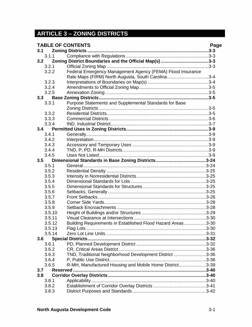
3.1 ZONING DISTRICTS In order to implement the Comprehensive Plan, the City of North Augusta is hereby divided into the following zoning and development districts. TABLE 3-1 ZONING DISTRICTS
Zoning District Categories Zoning Districts
Base Districts
Residential R-14 R-10 R-7 R-5
Large Lot, Single-Family Residential Medium Lot, Single-Family Residential Small Lot, Single-Family Residential Mixed Residential
Commercial
OC NC GC TC D
Office Commercial Neighborhood Commercial General Commercial Thoroughfare Commercial Downtown Mixed Use
Industrial IND Industrial
Special Districts
PD CR
TND P
R-MH
Planned Development Critical Areas Traditional Neighborhood Development Public Use Manufactured Home Residential
Overlay Districts G
HC NP
LMK
Georgia Avenue Overlay District Highway Corridor Overlay District Neighborhood Preservation Overlay District Landmark Overlay District
Comment: No regulations have been prepared for the Landmark Overlay District. This section is reserved and regulations may be inserted after §3.8.7 if the city decides to adopt historic preservation standards. 3.1.1 Compliance with Regulations No use of any building, structure, parking lot or land shall hereafter be established, and no building, structure, parking lot or part thereof shall be erected, reconstructed, converted, enlarged, moved or structurally altered unless in compliance with applicable district regulations set forth in this Chapter. 3.2 ZONING DISTRICT BOUNDARIES AND THE OFFICIAL MAP(S) 3.2.1 Official Zoning Map The boundaries of the zoning districts are shown on a map entitled "Official Zoning Map, North Augusta, South Carolina," (Official Zoning Map) which together with all explanatory matter is hereby adopted by reference and declared to be a part of this Chapter. The Official Zoning Map shall be identified by the signature of the Mayor, attested by the City Clerk, together with the date of the adoption of this Chapter. Regardless of the existence of purported copies of the Official Zoning Map which may from time to time be made or published, or the Flood Insurance Rate Maps Boundary
ARTICLE 3 – ZONING DISTRICTS
North Augusta Development Code (Amend. 12-7-20) 3-4
Maps, the Official Zoning Map which shall be located in the Department, shall be the final authority as to the current zoning status of land and water areas, buildings, and other structures in the City of North Augusta, South Carolina. 3.2.2 Federal Emergency Management Agency (FEMA) Flood Insurance Rate Maps (FIRM) North Augusta, South Carolina
3.2.2.1 Adoption of Flood Insurance Rate Maps – This article shall apply to all areas of special flood hazard within the City of North Augusta or later annexed into the city limits as identified by the Federal Emergency Management Agency in its Flood Insurance Study, for Aiken County dated August 16, 2018 and for Edgefield County dated September 14, 2018, including accompanying maps, approved Floodway Data Tables and their depictions of the Savannah River Floodway on approved Letters of Map Revisions (LOMRs), other supporting data and any revisions thereto, are hereby adopted by reference and declared to be a part of the Official Zoning Map. The adoption of the Flood Insurance Study (FIS), dated August 16, 2018 and September 14, 2018, is in accordance with Section 60.3(d), Title 44 of the Code of Federal Regulations. (Rev. 2-1-10; Ord. 2010-01) (Rev. 6-4-12; Ord. 2012-07) (Rev. 8-13-18, Ord. 2018-08)
3.2.2.2 Adoption of Letters of Map Revision (LOMR) – All LOMRs that are issued in the areas identified in §3.2.2.1 are hereby adopted. (Adopt. 2-1-10; Ord. 2010-01) 3.2.3 Interpretations of Boundaries on Map(s) The following rules shall apply to the interpretation of the boundaries of districts as shown on the Official Zoning Map or the FIRM maps: 3.2.3.1 Boundaries indicated as approximately following the center lines of streets, highways, or roads shall be construed to follow such center lines. 3.2.3.2 Boundaries indicated as approximately following platted lot lines shall be construed as following platted lot lines. 3.2.3.3 Boundaries indicated as approximately following political boundaries shall be construed as following such boundaries. 3.2.3.4 Boundaries indicated as approximately following the centerline of waterways, creeks and ditches shall be construed as following such lines. 3.2.3.5 Boundaries indicated approximately as parallel to or as an extension of features in the above mentioned items shall be so construed. 3.2.3.6 Distances not specifically indicated on the Official Zoning Map shall be determined by the scale of the Official Zoning Map.
ARTICLE 3 – ZONING DISTRICTS
North Augusta Development Code (Amend. 12-7-20) 3-5
3.2.3.7 Where physical or cultural features existing on the ground are at variance with those shown on the Official Zoning Map, or other circumstances covered in the above mentioned items, the Board of Zoning Appeals shall interpret the district boundaries. 3.2.4 Amendments to Official Zoning Map If, in accordance with this Chapter and S.C. Code §6-29-720, changes are made in the district boundaries or other matters portrayed on the Official Zoning Map, such changes shall be entered on said map(s) promptly after amendment has been approved by the City Council. No amendment to this Chapter that involves matters portrayed on the Official Zoning Maps shall become effective until after such changes has been made on said Official Zoning Maps. 3.2.5 Annexation Zoning All territory which may hereafter be granted or annexed to the City of North Augusta shall be classified automatically in the R-14 District, except that at the time the application for annexation is filed, the applicant may request a zoning classification which is similar to surrounding zoning and/or in accord with the city’s Comprehensive Plan. Proposed annexations where the requested zoning is inconsistent with the Land Use Element of the Comprehensive Plan or differs from zoning on adjacent properties shall be reviewed by the Planning Commission in accordance with Article 18, Administration. The Planning Commission shall recommend to the City Council the appropriate zoning for the property to be annexed, modification to the Land Use Element of the Comprehensive Plan, or both. 3.3 BASE ZONING DISTRICTS 3.3.1 Purpose Statements and Supplemental Standards for Base Zoning Districts This section describes the purpose of each base zoning district in the city. The purpose statements provide a foundation for the various standards applicable to the various zoning districts, and assist in interpretation of the district standards. The purpose statements are not regulations, but rather a summary of the district character and regulatory intent. The particular uses permitted in each district are set forth in the Use Matrix, Table 3-2. The dimensional standards, including setbacks and height limits, are provided in the Dimensional Matrix, Table 3-3. Additional supplemental regulations for each district are also included, where applicable. 3.3.2 Residential Districts 3.3.2.1 R-14 and R-10, Large and Medium Lot Single-Family Residential Districts – The purpose of these two (2) districts is to recognize and promote the character of particular areas in North Augusta where single-family residential development is the predominant living environment. Also, changing patterns of work and home environments create incentives to view the single-family dwelling as a place of work and residential living activities. 3.3.2.2 R-7, Small Lot Single-Family Residential District – The purpose of this district is to provide for a variety of single-family housing types on small lots to meet
ARTICLE 3 – ZONING DISTRICTS
North Augusta Development Code (Amend. 12-7-20) 3-6
market demands for smaller lot developments. It is also the intent of this district to balance higher densities with common open space. 3.3.2.3 R-5, Mixed Residential District – The purpose of this district is to permit a variety of residential uses and variable densities based on the character of such uses. Areas so designated are deemed suited to such uses. This designation is applied principally to undeveloped areas where units and density flexibility will not adversely impact existing residential subdivisions and where the housing market can be sufficiently broad and flexible to meet the various demands for housing. It also applies to existing multi-family and mixed use residential areas. 3.3.3 Commercial Districts The purpose of commercial districts is to provide commercial opportunities in certain areas of the community in response to market conditions, but not at the expense of residential areas or environmental amenities. Within the four (4) commercial districts, a building or premises shall be used only for the permitted uses. No outdoor storage or display of goods shall be permitted unless an outdoor use is conditionally approved pursuant to §4.33. No business shall be established in or allowed to occupy a mobile home or manufactured unit other than as an office for a mobile home sales lot. 3.3.3.1 OC, Office Commercial District – The purpose of this district is to encourage the development of office activities with supportive retail, service and residential uses, at a relatively high density and intensity. These districts are primarily located on collector and arterial streets. 3.3.3.2 NC, Neighborhood Commercial District – The purpose of this district is to provide for areas where small-scale commercial service and convenience uses may be located to serve principally residential subdivisions and to permit small-scale professional offices in such areas as compatible supplements. This district permits “Neighborhood Centers” as defined in §2.4 of this Chapter. a. Individual buildings shall not exceed the following:
1. Four thousand (4,000) square feet of gross floor area for a single story building; or 2. Four thousand (4,000) square foot building footprint for a mixed-use building or a
live-work unit, so long as the building does not exceed three (3) stories. b. Commercial uses are limited to the first floor of a building only. Upper stories may be
used for residential and accessory storage only. c. Buildings shall conform to the design standards established for the G, Georgia Avenue
Overlay District, or the NP, Neighborhood Preservation Overlay District. d. Service entrances and service yards shall be located only in the rear or side yard.
Service yards shall be screened from adjacent residential zones or uses by the installation and maintenance of a solid wall or fence having a height of not less than four (4) feet or greater than six (6) feet or vegetation having a minimum height of four (4) feet. Refuse enclosures shall be located at the rear of the site and screened with a wall and gate.
e. No external sound systems or external live music shall be allowed in an NC district. f. Parking areas for new buildings or structures shall be located in the rear or on the side
behind the front facade of the principal use or principal building. All parking areas shall be screened from view on the front and side by the installation and maintenance of a solid wall or fence having a height of not less than four (4) feet nor greater than six (6) feet or dense vegetation having a minimum height of four (4) feet.

ARTICLE 3 – ZONING DISTRICTS
North Augusta Development Code (Amend. 12-7-20) 3-7
This subsection shall not apply to buildings which exist at the time of a rezoning to NC, Neighborhood Commercial District, only to the extent that they do not conform with this section.
3.3.3.3 GC, General Commercial District – The purpose of this district is to provide for areas within the city where large-scale commercial developments may take place. This district is designed to support citywide or regional shopping centers and business complexes of greater magnitude than permitted by the OC, Office Commercial, or NC, Neighborhood Commercial Districts. It permits a wide range of business and commercial uses generally clustered for cumulative attraction and optimum accessibility, but also in strips where so designated by the Comprehensive Plan. 3.3.3.4 TC, Thoroughfare Commercial District – The purpose of this district is to accommodate commercial, light industrial and warehouse/distribution uses. These uses need a high volume highway traffic zone. Such commercial uses typically depend upon a regional commercial market characterized by bright and intensive signage designed to gain the attention of passing motorists. Commercial uses of this nature are detrimental to residential neighborhoods and professional commercial zones and, accordingly, are limited to areas of the community where traffic volumes are the highest and residential development and professional commercial land uses are the least prevalent. 3.3.3.5 D, Downtown Mixed Use District – The purpose of this district is to promote a downtown commercial core which creates an identity and sense of place for North Augusta. The district allows for a variety of commercial uses which are suited for a downtown environment and create an attraction quality not deterred by parking or access limitations. Often this quality is achieved by the type of business or customer loyalty attributable to the particular business establishment. Buildings shall conform to the design standards established for the G, Georgia Avenue Overlay District, or the NP, Neighborhood Preservation Overlay District. 3.3.4 IND, Industrial District The purpose of this district is to recognize the importance of industry to the community and to protect such uses from potentially incompatible uses which would consume industrially suited land for other purposes. It is also designed to encourage industrial park development and promote landscaping of industrial plants, making them more palatable to the residential environment of North Augusta. The district may also contain uses as special exceptions that may be incompatible elsewhere in the City of North Augusta. 3.3.4.1 Performance Standards in the IND, Industrial District – All permitted and approved conditional uses in the IND, Industrial District, shall, in addition to all applicable state and federal regulations, meet the following minimum standards regulating the emission or existence of dangerous, detrimental and objectionable elements, where applicable. a. Fire and Explosive Hazards: All activities and storage of flammable and explosive
materials at any point shall be provided with adequate safety devices against the hazards of fire and explosion including adequate fire fighting and fire suppression equipment.
b. Radioactive Emissions: There shall be no radiation emission measurable at the property line.

ARTICLE 3 – ZONING DISTRICTS
North Augusta Development Code (Amend. 12-7-20) 3-8
c. Smoke, Dust, and Dirt: The emission of visible smoke, dust, dirt, fly ash particulate matter from any pipe, vents, or other openings, or from any other source, into the air, shall comply with the regulations of the South Carolina Department Health and Environmental Control (SCDHEC).
d. Fumes, Vapor, and Gasses: There shall be no emission of any fumes, vapors, or gasses, of a noxious, toxic, or corrosive nature which can cause any damage or irritation to health, animals, vegetation, or to any form of property.
e. Vibration: There shall be no perceptible earth vibrations measured at the property line. f. Heat, Cold, Dampness, or Movement of Air: Any activity which could produce any
adverse effect on the temperature, motion or humidity of the atmosphere beyond the lot line is not permitted.
g. Odor: The emission of odorous gasses or other matter in such quantities as to be offensive at the property line is prohibited. Any process which may involve the creation or emission of any such odor shall be provided with both a primary and a secondary safeguard system so that control may be maintained in the event of failure of the primary safeguard system.
h. Glare: There shall be no direct or sky reflected glare, whether from floodlights, high temperature processing, combustion, welding or otherwise, so as to be visible in any residential district.
i. Compliance Guarantee: The applicant shall acknowledge in writing an understanding of the performance standards applicable to the industry or business and shall submit an agreement to conform with such standards at all times. Any violation of the agreement shall constitute a violation of this Chapter.
3.3.4.2 Access – Lots meeting the frontage requirements shall be permitted only one (1) access drive, irrespective of the number of establishments on the lot. Notwithstanding §14.8 of this Chapter, a second access point may be permitted only when the lot exceeds three hundred and fifty (350) feet of frontage. Where lots are contiguous, establishments are encouraged to develop a shared ingress and egress drive to minimize curb cuts and better facilitate moving traffic. Such shared access easements may be required by the Planning Commission on referral by the Director, where such design would obviously improve traffic conditions. Businesses on double frontage or corner lots should be accessed from the street with the lowest functional classification where possible. 3.3.4.3 Building Height Requirements – Buildings and structures shall not exceed seventy (70) feet in height. Manufacturing plants (buildings) are exempt from this requirement. However, where such manufacturing plants exceed seventy (70) feet in height, they shall, in addition to meeting the setback requirements stated above, be set back from the side and rear yard property lines of residentially zoned and residentially occupied property one (1) additional foot for each two (2) feet in height, exceeding seventy (70) feet.
ARTICLE 3 – ZONING DISTRICTS
North Augusta Development Code (Amend. 12-7-20) 3-9
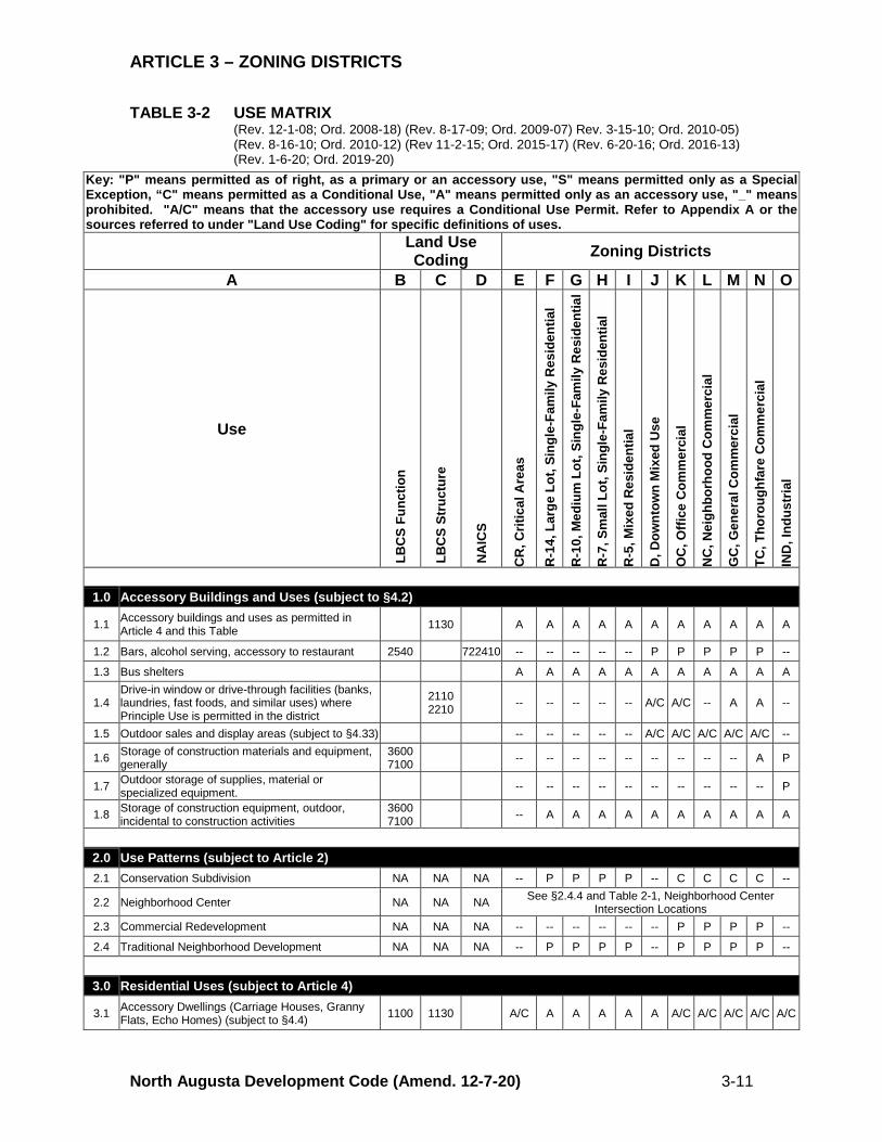
3.4 PERMITTED USES IN ZONING DISTRICTS 3.4.1 Generally No use shall be permitted pursuant to this Chapter, and no development permit authorizing a use may be authorized, issued, or approved by any officer, official, or agency, unless said use is listed as a Permitted Use, Conditional Use or a Special Exception in the Use Matrix, Table 3-2, and all applicable permits and approvals have been issued by the agency or official with final decision-making authority. Those uses permitted as principal uses or buildings within each zoning district shall be those uses listed in the Use Matrix, Table 3-2. 3.4.2 Interpretation The use categories listed in the Column A of the Use Matrix, Table 3-2, are defined in this Chapter, the Land-Based Classification Standards (LBCS) published by the American Planning Association (APA), the North American Industrial Classification System (NAICS), or in other resources cross-referenced in this Chapter. 3.4.3 Accessory and Temporary Uses Permitted accessory uses and permitted temporary uses are set forth in the Use Matrix, Table 3-2, and Article 4. If a use is listed as prohibited in a zoning district, but is permitted as an accessory use in §4.2, the use is permitted only as an accessory use to a principal use or principal building on the same lot, tract or parcel. Such uses cannot be established unless and until there is a principal use or principal building on the same lot, tract or parcel to which that use is accessory. 3.4.4 TND, P, PD, R-MH Districts Uses in the TND, Traditional Neighborhood Development; P, Public Use; PD, Planned Development; and R-MH Manufactured Home Residential are governed by their respective sections in this Chapter, and are not subject to the Use Matrix, Table 3-2. (Rev. 12-1-08; Ord. 2008-18) 3.4.5 Uses Not Listed 3.4.5.1 The Director shall make a determination if a use not mentioned in the Use Matrix, Table 3-2, can reasonably be interpreted to fit into a use category where similar uses are described. Interpretations may be ratified by the Planning Commission at a regularly scheduled meeting. It is the intent of this Article to group similar or compatible land uses into specific zoning districts, either as permitted uses or as uses authorized by a conditional use permit. Uses not listed as a permitted or conditional use are presumed to be prohibited from the applicable zoning district. In the event that a particular use is not listed in the Use Matrix, and such use is not listed as a prohibited use and is not otherwise prohibited by law, the Director shall determine whether a materially similar use exists in this section. Should the Director determine that a materially similar use does exist, the regulations governing that use shall apply to the particular use not listed and the Director’s decision shall be recorded in writing. Should the Director determine that a materially similar use does not exist, the matter may be referred to the Planning Commission for interpretation or for recommendation to the City Council for amendment to this Chapter to establish a specific listing for the use in question.
ARTICLE 3 – ZONING DISTRICTS
North Augusta Development Code (Amend. 12-7-20) 3-10
3.4.5.2 The Director may determine that a use is materially similar if: a. The use is listed as within the same structure or function classification as the use
specifically enumerated in the Use Matrix, Table 3-2, as determined by the LBCS of the APA. The use shall be considered materially similar if it falls within the same LBCS classification or meets the requirements of sections (b.) and (c.), below.
b. If the use cannot be located within one of the LBCS classifications pursuant to section (a.), above, the Director shall refer to the most recent edition of the North American Industry Classification Manual (Executive Office of the President, Office of Management and Budget, 1997) (NAICS), which document is hereby incorporated by this reference. The use shall be considered materially similar if it falls within the same industry classification of the NAICS, and meets the requirements of section (c.), below.
c. The proposed use shall not generate average daily trips exceeding other uses proposed in the zoning district by more than ten percent (10%), as determined by the most recent edition of the Institute of Transportation Engineers, Trip Generation (6th ed., 1997)(ITE Manual), which document is hereby incorporated by this reference. If the trip generation is not listed in the ITE Manual, the use shall be considered materially similar. The Director may also refer to similar local traffic studies to determine trip generation and average daily trips.
3.4.5.3 In order to assist in interpretation of the Use Matrix, Table 3-2, the LBCS and NAICS numbers precede each use in the Use Matrix. In interpreting the Use Matrix, the following rules of construction shall apply: a. If a use is listed for a specific classification, while a more general classification within
the same industry classification is also listed for another use, the specific classification governs. The specific use is not permitted in all districts where the uses coded to the general classification are permitted simply because they share a similar NAICS code number. The numbers increase as the classifications get more specific. (a) Example: Community Homes are coded as NAICS classification 623210. This is a specific subclass of group 623 entitled “Nursing and Residential Care Facilities.” Community Homes are permitted in the District X. However, other “Nursing and Residential Care Facilities” listed in NAICS group 623 are not permitted in District X. These uses will fall within the LBCS Function classifications 1210 (Retirement housing services), 1220 (Congregate living services), 1230 (Assisted-living services), 1240 (Lifecare or continuing care services), and 1250 (Skilled-nursing services).
b. Some uses are listed separately, but fall within the same LBCS or NAICS classification. The uses within one such classification are not permitted in all of the zoning districts as the others simply because they fall within the same LBCS or NAICS classification. (b) Example: “Restaurant, with incidental consumption of alcoholic beverages” is coded as LBCS Structure 2220. A “Restaurant, no consumption of alcoholic beverages permitted” is also coded as Structure 2220. The former is listed as a prohibited use in District X. It is not considered a permitted use in X simply because it falls within the same LBCS classification as the latter use.
ARTICLE 3 – ZONING DISTRICTS
North Augusta Development Code (Amend. 12-7-20) 3-11
TABLE 3-2 USE MATRIX (Rev. 12-1-08; Ord. 2008-18) (Rev. 8-17-09; Ord. 2009-07) Rev. 3-15-10; Ord. 2010-05)
(Rev. 8-16-10; Ord. 2010-12) (Rev 11-2-15; Ord. 2015-17) (Rev. 6-20-16; Ord. 2016-13) (Rev. 1-6-20; Ord. 2019-20)
Key: "P" means permitted as of right, as a primary or an accessory use, "S" means permitted only as a Special Exception, “C" means permitted as a Conditional Use, "A" means permitted only as an accessory use, "_" means prohibited. "A/C" means that the accessory use requires a Conditional Use Permit. Refer to Appendix A or the sources referred to under "Land Use Coding" for specific definitions of uses. Land Use
Coding Zoning Districts
A B C D E F G H I J K L M N O
Use
LB
CS
Func
tion
LB
CS
Stru
ctur
e
NA
ICS
CR
, Crit
ical
Are
as
R-1
4, L
arge
Lot
, Sin
gle-
Fam
ily R
esid
entia
l
R-1
0, M
ediu
m L
ot, S
ingl
e-Fa
mily
Res
iden
tial
R-7
, Sm
all L
ot, S
ingl
e-Fa
mily
Res
iden
tial
R-5
, Mix
ed R
esid
entia
l
D, D
ownt
own
Mix
ed U
se
OC
, Offi
ce C
omm
erci
al
NC
, Nei
ghbo
rhoo
d C
omm
erci
al
GC
, Gen
eral
Com
mer
cial
TC, T
horo
ughf
are
Com
mer
cial
IND
, Ind
ustr
ial
1.0 Accessory Buildings and Uses (subject to §4.2)
1.1 Accessory buildings and uses as permitted in Article 4 and this Table 1130 A A A A A A A A A A A
1.2 Bars, alcohol serving, accessory to restaurant 2540 722410 -- -- -- -- -- P P P P P --
1.3 Bus shelters A A A A A A A A A A A
1.4 Drive-in window or drive-through facilities (banks, laundries, fast foods, and similar uses) where Principle Use is permitted in the district
2110 2210 -- -- -- -- -- A/C A/C -- A A --
1.5 Outdoor sales and display areas (subject to §4.33) -- -- -- -- -- A/C A/C A/C A/C A/C --
1.6 Storage of construction materials and equipment, generally
3600 7100 -- -- -- -- -- -- -- -- -- A P
1.7 Outdoor storage of supplies, material or specialized equipment. -- -- -- -- -- -- -- -- -- -- P
1.8 Storage of construction equipment, outdoor, incidental to construction activities
3600 7100 -- A A A A A A A A A A
2.0 Use Patterns (subject to Article 2) 2.1 Conservation Subdivision NA NA NA -- P P P P -- C C C C --
2.2 Neighborhood Center NA NA NA See §2.4.4 and Table 2-1, Neighborhood Center Intersection Locations
2.3 Commercial Redevelopment NA NA NA -- -- -- -- -- -- P P P P --
2.4 Traditional Neighborhood Development NA NA NA -- P P P P -- P P P P --
3.0 Residential Uses (subject to Article 4)
3.1 Accessory Dwellings (Carriage Houses, Granny Flats, Echo Homes) (subject to §4.4) 1100 1130 A/C A A A A A A/C A/C A/C A/C A/C

ARTICLE 3 – ZONING DISTRICTS
North Augusta Development Code (Amend. 12-7-20) 3-12
Key: "P" means permitted as of right, as a primary or an accessory use, "S" means permitted only as a Special Exception, “C" means permitted as a Conditional Use, "A" means permitted only as an accessory use, "_" means prohibited. "A/C" means that the accessory use requires a Conditional Use Permit. Refer to Appendix A or the sources referred to under "Land Use Coding" for specific definitions of uses. Land Use
Coding Zoning Districts
A B C D E F G H I J K L M N O
Use
LB
CS
Func
tion
LB
CS
Stru
ctur
e
NA
ICS
CR
, Crit
ical
Are
as
R-1
4, L
arge
Lot
, Sin
gle-
Fam
ily R
esid
entia
l
R-1
0, M
ediu
m L
ot, S
ingl
e-Fa
mily
Res
iden
tial
R-7
, Sm
all L
ot, S
ingl
e-Fa
mily
Res
iden
tial
R-5
, Mix
ed R
esid
entia
l
D, D
ownt
own
Mix
ed U
se
OC
, Offi
ce C
omm
erci
al
NC
, Nei
ghbo
rhoo
d C
omm
erci
al
GC
, Gen
eral
Com
mer
cial
TC, T
horo
ughf
are
Com
mer
cial
IND
, Ind
ustr
ial
3.2 Duplex 1100 1121 -- -- -- P P P -- C C C --
3.3 Manufactured Home (see §3.6.5) A/C -- -- -- -- -- -- -- -- -- --
3.4 Multifamily Dwelling 1100 1200 -- -- -- -- P P P C P P --
3.5 Patio Homes 1100 1100 -- -- -- P P -- -- -- -- -- --
3.6 Quadruplex 1100 1204 -- -- -- -- P P -- -- P P --
3.7 Room renting, more than four tenants 1320 7213 -- -- -- -- C C -- -- P P --
3.8 Room renting, no more than four tenants 1320 7213 -- -- -- -- P P -- -- P P --
3.9 Single room occupancy units 1100 1340 -- -- -- -- P P -- -- -- -- --
3.10 Single-family detached dwelling 1100 1110 A/C P P P P P P P P P A
3.11 Townhouse 1100 1140 -- -- -- P P P P P P P --
3.12 Triplex 1100 1203 -- -- -- -- P P P P P P --
3.13 Zero Lot Line Units (See §3.5.14) -- -- -- P P P P P P P
4.0 Accommodations and Group Living 4.1 Bed and breakfast (subject to §4.7) 1310 721191 -- S S S S P -- P P P --
4.2 Boarding house 1320 721310 -- -- -- -- C P -- C C C --
4.3 Dormitories 1000 1320 72131 -- -- -- -- C C -- -- C C --
4.4 Group Homes, Non-Exempt (subject to §4.13) [Note: Exempt Group Homes are exempt from zoning subject to S.C. Code §6-29-770]
6520 6561 623220
623990 -- -- -- C P P -- P -- -- --
4.5 Hotels or motels 1330 -- -- -- -- -- P P -- P P --
4.6
Housing services for the elderly, including assisted-living services, retirement housing services, congregate living services, lifecare or continuing care services, skilled-nursing services, rest homes, or homes for the aged
1200-1240 623110 -- -- -- -- P P C C P P --
4.7 Tourist homes P P P P P P P P P P P
ARTICLE 3 – ZONING DISTRICTS
North Augusta Development Code (Amend. 12-7-20) 3-13
Key: "P" means permitted as of right, as a primary or an accessory use, "S" means permitted only as a Special Exception, “C" means permitted as a Conditional Use, "A" means permitted only as an accessory use, "_" means prohibited. "A/C" means that the accessory use requires a Conditional Use Permit. Refer to Appendix A or the sources referred to under "Land Use Coding" for specific definitions of uses. Land Use
Coding Zoning Districts
A B C D E F G H I J K L M N O
Use
LB
CS
Func
tion
LB
CS
Stru
ctur
e
NA
ICS
CR
, Crit
ical
Are
as
R-1
4, L
arge
Lot
, Sin
gle-
Fam
ily R
esid
entia
l
R-1
0, M
ediu
m L
ot, S
ingl
e-Fa
mily
Res
iden
tial
R-7
, Sm
all L
ot, S
ingl
e-Fa
mily
Res
iden
tial
R-5
, Mix
ed R
esid
entia
l
D, D
ownt
own
Mix
ed U
se
OC
, Offi
ce C
omm
erci
al
NC
, Nei
ghbo
rhoo
d C
omm
erci
al
GC
, Gen
eral
Com
mer
cial
TC, T
horo
ughf
are
Com
mer
cial
IND
, Ind
ustr
ial
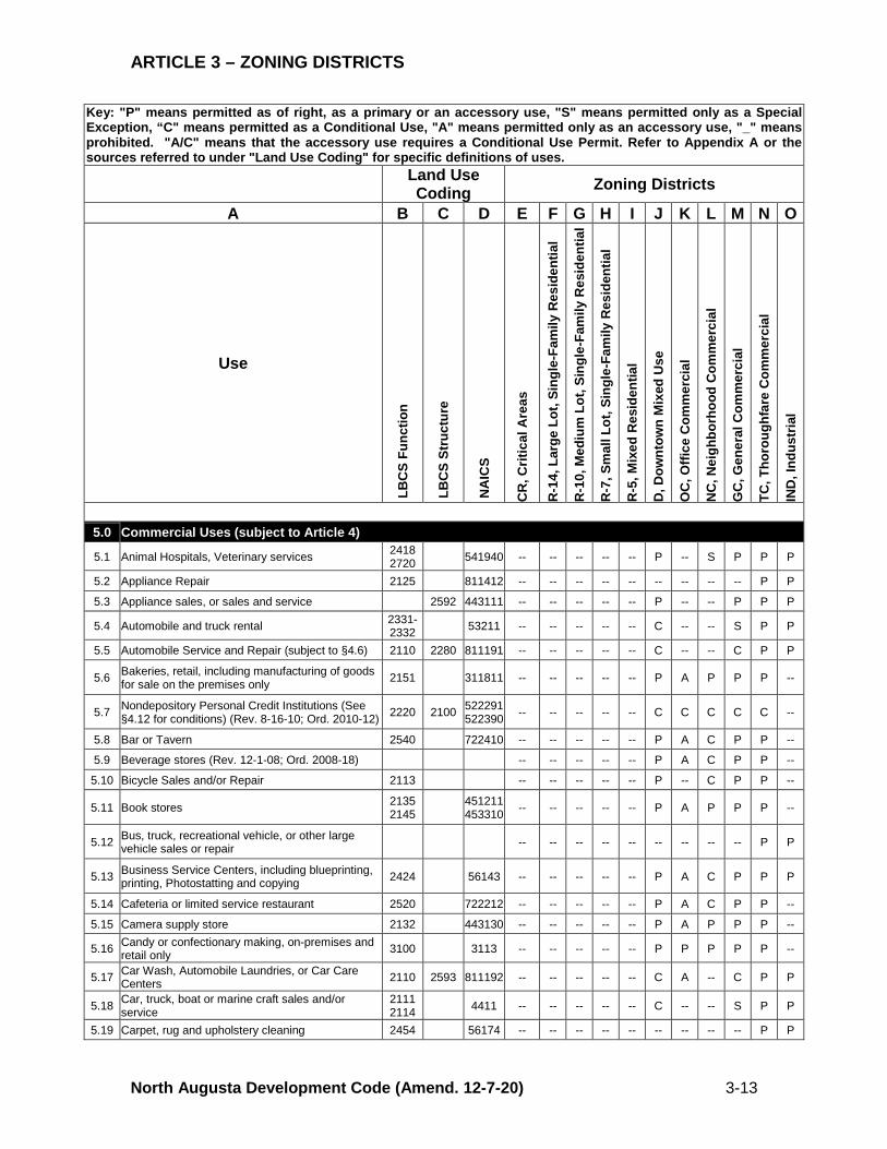
5.0 Commercial Uses (subject to Article 4)
5.1 Animal Hospitals, Veterinary services 2418 2720 541940 -- -- -- -- -- P -- S P P P
5.2 Appliance Repair 2125 811412 -- -- -- -- -- -- -- -- -- P P
5.3 Appliance sales, or sales and service 2592 443111 -- -- -- -- -- P -- -- P P P
5.4 Automobile and truck rental 2331-2332 53211 -- -- -- -- -- C -- -- S P P
5.5 Automobile Service and Repair (subject to §4.6) 2110 2280 811191 -- -- -- -- -- C -- -- C P P
5.6 Bakeries, retail, including manufacturing of goods for sale on the premises only 2151 311811 -- -- -- -- -- P A P P P --
5.7 Nondepository Personal Credit Institutions (See §4.12 for conditions) (Rev. 8-16-10; Ord. 2010-12) 2220 2100 522291
522390 -- -- -- -- -- C C C C C --
5.8 Bar or Tavern 2540 722410 -- -- -- -- -- P A C P P --
5.9 Beverage stores (Rev. 12-1-08; Ord. 2008-18) -- -- -- -- -- P A C P P --
5.10 Bicycle Sales and/or Repair 2113 -- -- -- -- -- P -- C P P --
5.11 Book stores 2135 2145 451211
453310 -- -- -- -- -- P A P P P --
5.12 Bus, truck, recreational vehicle, or other large vehicle sales or repair -- -- -- -- -- -- -- -- -- P P
5.13 Business Service Centers, including blueprinting, printing, Photostatting and copying 2424 56143 -- -- -- -- -- P A C P P P
5.14 Cafeteria or limited service restaurant 2520 722212 -- -- -- -- -- P A C P P --
5.15 Camera supply store 2132 443130 -- -- -- -- -- P A P P P --
5.16 Candy or confectionary making, on-premises and retail only 3100 3113 -- -- -- -- -- P P P P P --
5.17 Car Wash, Automobile Laundries, or Car Care Centers 2110 2593 811192 -- -- -- -- -- C A -- C P P
5.18 Car, truck, boat or marine craft sales and/or service
2111 2114 4411 -- -- -- -- -- C -- -- S P P
5.19 Carpet, rug and upholstery cleaning 2454 56174 -- -- -- -- -- -- -- -- -- P P
ARTICLE 3 – ZONING DISTRICTS
North Augusta Development Code (Amend. 12-7-20) 3-14
Key: "P" means permitted as of right, as a primary or an accessory use, "S" means permitted only as a Special Exception, “C" means permitted as a Conditional Use, "A" means permitted only as an accessory use, "_" means prohibited. "A/C" means that the accessory use requires a Conditional Use Permit. Refer to Appendix A or the sources referred to under "Land Use Coding" for specific definitions of uses. Land Use
Coding Zoning Districts
A B C D E F G H I J K L M N O
Use
LB
CS
Func
tion
LB
CS
Stru
ctur
e
NA
ICS
CR
, Crit
ical
Are
as
R-1
4, L
arge
Lot
, Sin
gle-
Fam
ily R
esid
entia
l
R-1
0, M
ediu
m L
ot, S
ingl
e-Fa
mily
Res
iden
tial
R-7
, Sm
all L
ot, S
ingl
e-Fa
mily
Res
iden
tial
R-5
, Mix
ed R
esid
entia
l
D, D
ownt
own
Mix
ed U
se
OC
, Offi
ce C
omm
erci
al
NC
, Nei
ghbo
rhoo
d C
omm
erci
al
GC
, Gen
eral
Com
mer
cial
TC, T
horo
ughf
are
Com
mer
cial
IND
, Ind
ustr
ial
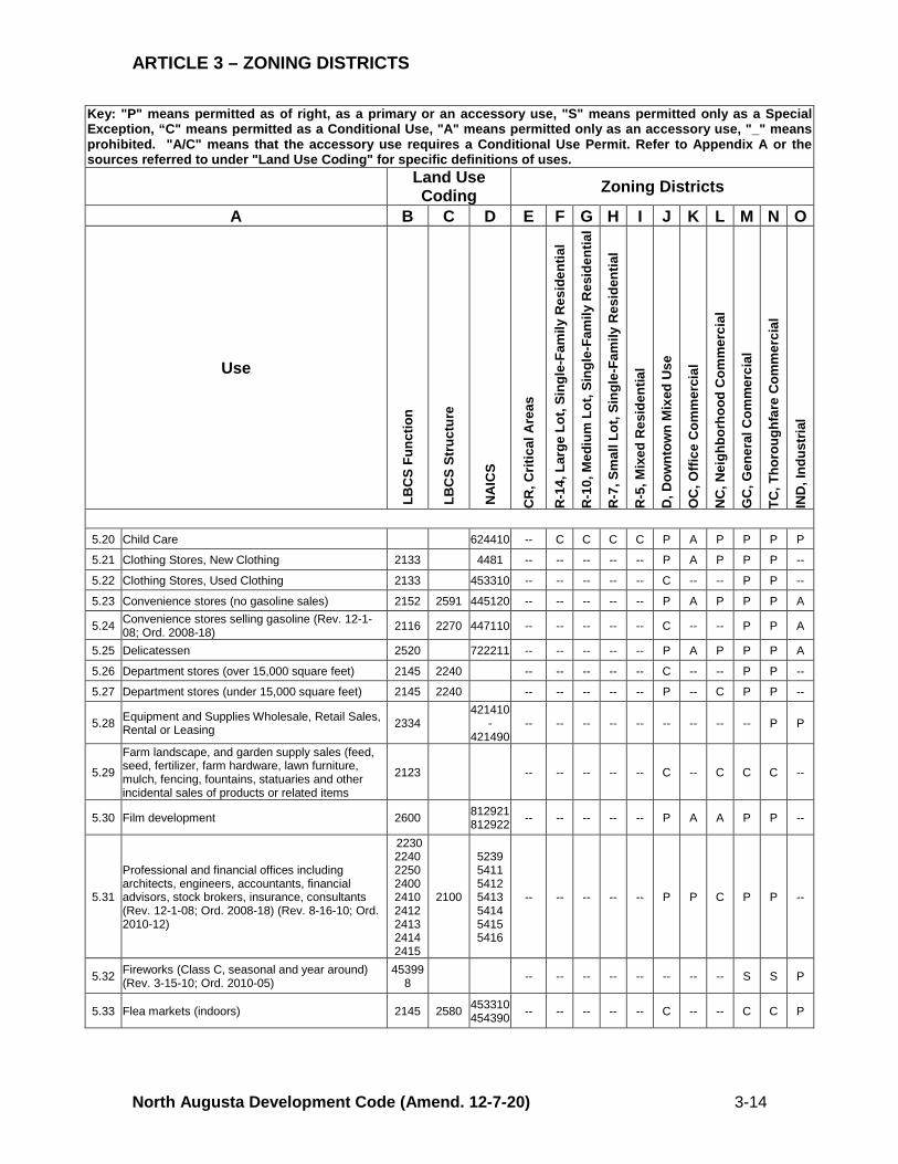
5.20 Child Care 624410 -- C C C C P A P P P P
5.21 Clothing Stores, New Clothing 2133 4481 -- -- -- -- -- P A P P P --
5.22 Clothing Stores, Used Clothing 2133 453310 -- -- -- -- -- C -- -- P P --
5.23 Convenience stores (no gasoline sales) 2152 2591 445120 -- -- -- -- -- P A P P P A
5.24 Convenience stores selling gasoline (Rev. 12-1-08; Ord. 2008-18) 2116 2270 447110 -- -- -- -- -- C -- -- P P A
5.25 Delicatessen 2520 722211 -- -- -- -- -- P A P P P A
5.26 Department stores (over 15,000 square feet) 2145 2240 -- -- -- -- -- C -- -- P P --
5.27 Department stores (under 15,000 square feet) 2145 2240 -- -- -- -- -- P -- C P P --
5.28 Equipment and Supplies Wholesale, Retail Sales, Rental or Leasing 2334
421410 -
421490 -- -- -- -- -- -- -- -- -- P P
5.29
Farm landscape, and garden supply sales (feed, seed, fertilizer, farm hardware, lawn furniture, mulch, fencing, fountains, statuaries and other incidental sales of products or related items
2123 -- -- -- -- -- C -- C C C --
5.30 Film development 2600 812921 812922 -- -- -- -- -- P A A P P --
5.31
Professional and financial offices including architects, engineers, accountants, financial advisors, stock brokers, insurance, consultants (Rev. 12-1-08; Ord. 2008-18) (Rev. 8-16-10; Ord. 2010-12)
2230 2240 2250 2400 2410 2412 2413 2414 2415
2100
5239 5411 5412 5413 5414 5415 5416
-- -- -- -- -- P P C P P --
5.32 Fireworks (Class C, seasonal and year around) (Rev. 3-15-10; Ord. 2010-05)
453998 -- -- -- -- -- -- -- -- S S P
5.33 Flea markets (indoors) 2145 2580 453310 454390 -- -- -- -- -- C -- -- C C P
ARTICLE 3 – ZONING DISTRICTS
North Augusta Development Code (Amend. 12-7-20) 3-15
Key: "P" means permitted as of right, as a primary or an accessory use, "S" means permitted only as a Special Exception, “C" means permitted as a Conditional Use, "A" means permitted only as an accessory use, "_" means prohibited. "A/C" means that the accessory use requires a Conditional Use Permit. Refer to Appendix A or the sources referred to under "Land Use Coding" for specific definitions of uses. Land Use
Coding Zoning Districts
A B C D E F G H I J K L M N O
Use
LB
CS
Func
tion
LB
CS
Stru
ctur
e
NA
ICS
CR
, Crit
ical
Are
as
R-1
4, L
arge
Lot
, Sin
gle-
Fam
ily R
esid
entia
l
R-1
0, M
ediu
m L
ot, S
ingl
e-Fa
mily
Res
iden
tial
R-7
, Sm
all L
ot, S
ingl
e-Fa
mily
Res
iden
tial
R-5
, Mix
ed R
esid
entia
l
D, D
ownt
own
Mix
ed U
se
OC
, Offi
ce C
omm
erci
al
NC
, Nei
ghbo
rhoo
d C
omm
erci
al
GC
, Gen
eral
Com
mer
cial
TC, T
horo
ughf
are
Com
mer
cial
IND
, Ind
ustr
ial
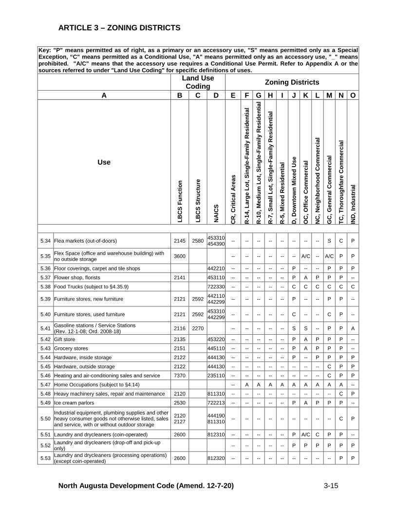
5.34 Flea markets (out-of-doors) 2145 2580 453310 454390 -- -- -- -- -- -- -- -- S C P
5.35 Flex Space (office and warehouse building) with no outside storage 3600 -- -- -- -- -- -- A/C -- A/C P P
5.36 Floor coverings, carpet and tile shops 442210 -- -- -- -- -- P -- -- P P P
5.37 Flower shop, florists 2141 453110 -- -- -- -- -- P A P P P --
5.38 Food Trucks (subject to §4.35.9) 722330 -- -- -- -- -- C C C C C C
5.39 Furniture stores, new furniture 2121 2592 442110 442299 -- -- -- -- -- P -- -- P P --
5.40 Furniture stores, used furniture 2121 2592 453310 442299 -- -- -- -- -- C -- -- C P --
5.41 Gasoline stations / Service Stations (Rev. 12-1-08; Ord. 2008-18) 2116 2270 -- -- -- -- -- S S -- P P A
5.42 Gift store 2135 453220 -- -- -- -- -- P A P P P --
5.43 Grocery stores 2151 445110 -- -- -- -- -- P A P P P --
5.44 Hardware, inside storage 2122 444130 -- -- -- -- -- P -- P P P P
5.45 Hardware, outside storage 2122 444130 -- -- -- -- -- -- -- -- C P P
5.46 Heating and air-conditioning sales and service 7370 235110 -- -- -- -- -- -- -- -- C P P
5.47 Home Occupations (subject to §4.14) -- A A A A A A A A A -- 5.48 Heavy machinery sales, repair and maintenance 2120 811310 -- -- -- -- -- -- -- -- -- C P
5.49 Ice cream parlors 2530 722213 -- -- -- -- -- P A P P P --
5.50 Industrial equipment, plumbing supplies and other heavy consumer goods not otherwise listed, sales and service, with or without outdoor storage
2120 2127 444190
811310 -- -- -- -- -- -- -- -- -- C P
5.51 Laundry and drycleaners (coin-operated) 2600 812310 -- -- -- -- -- P A/C C P P --
5.52 Laundry and drycleaners (drop-off and pick-up only) -- -- -- -- -- P P P P P P
5.53 Laundry and drycleaners (processing operations) (except coin-operated) 2600 812320 -- -- -- -- -- -- -- -- -- P P
ARTICLE 3 – ZONING DISTRICTS
North Augusta Development Code (Amend. 12-7-20) 3-16
Key: "P" means permitted as of right, as a primary or an accessory use, "S" means permitted only as a Special Exception, “C" means permitted as a Conditional Use, "A" means permitted only as an accessory use, "_" means prohibited. "A/C" means that the accessory use requires a Conditional Use Permit. Refer to Appendix A or the sources referred to under "Land Use Coding" for specific definitions of uses. Land Use
Coding Zoning Districts
A B C D E F G H I J K L M N O
Use
LB
CS
Func
tion
LB
CS
Stru
ctur
e
NA
ICS
CR
, Crit
ical
Are
as
R-1
4, L
arge
Lot
, Sin
gle-
Fam
ily R
esid
entia
l
R-1
0, M
ediu
m L
ot, S
ingl
e-Fa
mily
Res
iden
tial
R-7
, Sm
all L
ot, S
ingl
e-Fa
mily
Res
iden
tial
R-5
, Mix
ed R
esid
entia
l
D, D
ownt
own
Mix
ed U
se
OC
, Offi
ce C
omm
erci
al
NC
, Nei
ghbo
rhoo
d C
omm
erci
al
GC
, Gen
eral
Com
mer
cial
TC, T
horo
ughf
are
Com
mer
cial
IND
, Ind
ustr
ial
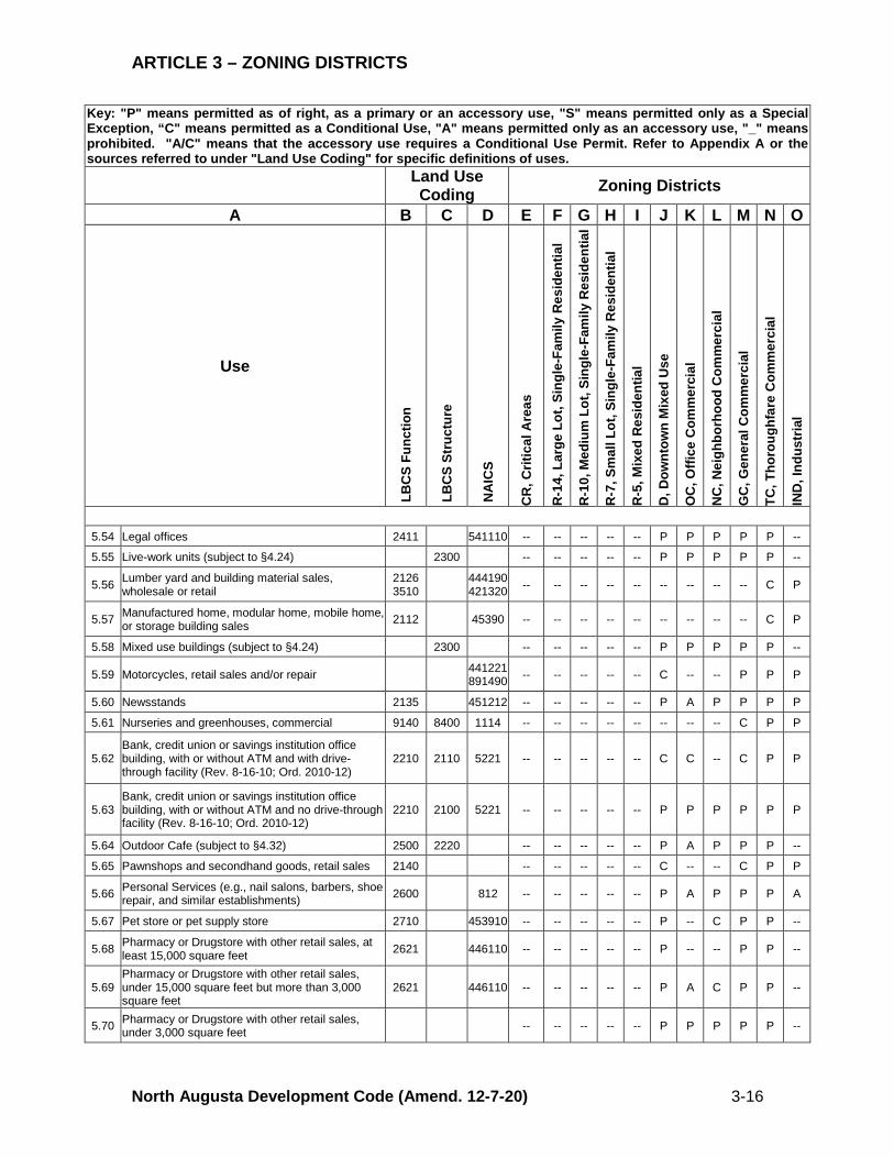
5.54 Legal offices 2411 541110 -- -- -- -- -- P P P P P --
5.55 Live-work units (subject to §4.24) 2300 -- -- -- -- -- P P P P P --
5.56 Lumber yard and building material sales, wholesale or retail
2126 3510 444190
421320 -- -- -- -- -- -- -- -- -- C P
5.57 Manufactured home, modular home, mobile home, or storage building sales 2112 45390 -- -- -- -- -- -- -- -- -- C P
5.58 Mixed use buildings (subject to §4.24) 2300 -- -- -- -- -- P P P P P --
5.59 Motorcycles, retail sales and/or repair 441221 891490 -- -- -- -- -- C -- -- P P P
5.60 Newsstands 2135 451212 -- -- -- -- -- P A P P P P
5.61 Nurseries and greenhouses, commercial 9140 8400 1114 -- -- -- -- -- -- -- -- C P P
5.62 Bank, credit union or savings institution office building, with or without ATM and with drive-through facility (Rev. 8-16-10; Ord. 2010-12)
2210 2110 5221 -- -- -- -- -- C C -- C P P
5.63 Bank, credit union or savings institution office building, with or without ATM and no drive-through facility (Rev. 8-16-10; Ord. 2010-12)
2210 2100 5221 -- -- -- -- -- P P P P P P
5.64 Outdoor Cafe (subject to §4.32) 2500 2220 -- -- -- -- -- P A P P P --
5.65 Pawnshops and secondhand goods, retail sales 2140 -- -- -- -- -- C -- -- C P P
5.66 Personal Services (e.g., nail salons, barbers, shoe repair, and similar establishments) 2600 812 -- -- -- -- -- P A P P P A
5.67 Pet store or pet supply store 2710 453910 -- -- -- -- -- P -- C P P --
5.68 Pharmacy or Drugstore with other retail sales, at least 15,000 square feet 2621 446110 -- -- -- -- -- P -- -- P P --
5.69 Pharmacy or Drugstore with other retail sales, under 15,000 square feet but more than 3,000 square feet
2621 446110 -- -- -- -- -- P A C P P --
5.70 Pharmacy or Drugstore with other retail sales, under 3,000 square feet -- -- -- -- -- P P P P P --
ARTICLE 3 – ZONING DISTRICTS
North Augusta Development Code (Amend. 12-7-20) 3-17
Key: "P" means permitted as of right, as a primary or an accessory use, "S" means permitted only as a Special Exception, “C" means permitted as a Conditional Use, "A" means permitted only as an accessory use, "_" means prohibited. "A/C" means that the accessory use requires a Conditional Use Permit. Refer to Appendix A or the sources referred to under "Land Use Coding" for specific definitions of uses. Land Use
Coding Zoning Districts
A B C D E F G H I J K L M N O
Use
LB
CS
Func
tion
LB
CS
Stru
ctur
e
NA
ICS
CR
, Crit
ical
Are
as
R-1
4, L
arge
Lot
, Sin
gle-
Fam
ily R
esid
entia
l
R-1
0, M
ediu
m L
ot, S
ingl
e-Fa
mily
Res
iden
tial
R-7
, Sm
all L
ot, S
ingl
e-Fa
mily
Res
iden
tial
R-5
, Mix
ed R
esid
entia
l
D, D
ownt
own
Mix
ed U
se
OC
, Offi
ce C
omm
erci
al
NC
, Nei
ghbo
rhoo
d C
omm
erci
al
GC
, Gen
eral
Com
mer
cial
TC, T
horo
ughf
are
Com
mer
cial
IND
, Ind
ustr
ial
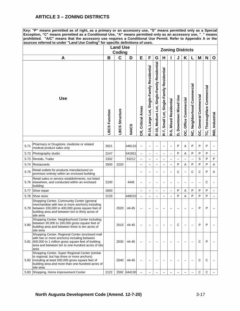
5.71 Pharmacy or Drugstore, medicine or related medical product sales only 2621 446110 -- -- -- -- -- P A P P P --
5.72 Photography studio 2147 541921 -- -- -- -- -- P A P P P --
5.73 Rentals, Trailer 2332 53212 -- -- -- -- -- -- -- -- S P P
5.74 Restaurants 2500 2220 -- -- -- -- -- P A P P P A
5.75 Retail outlets for products manufactured on premises entirely within an enclosed building -- -- -- -- -- C -- C C P A
5.76 Retail sales or service establishments, not listed elsewhere, and conducted within an enclosed building
2100 4445 -- -- -- -- -- -- -- -- -- C --
5.77 Shoe repair 2600 -- -- -- -- -- P A P P P --
5.78 Shoe store 2133 448210 -- -- -- -- -- P A P P P --
5.79
Shopping Center, Community Center (general merchandise with two or more anchors) including between 100,000 to 400,000 gross square feet of building area and between ten to thirty acres of site area
2520 44-45 -- -- -- -- -- -- -- -- P P --
5.80
Shopping Center, Neighborhood Center including between 30,000 to 100,000 gross square feet of building area and between three to ten acres of site area
2510 44-45 -- -- -- -- -- C -- -- P P --
5.81
Shopping Center, Regional Center (enclosed mall with two or more anchors) including between 400,000 to 1 million gross square feet of building area and between ten to one-hundred acres of site area
2530 44-45 -- -- -- -- -- -- -- -- C P --
5.82
Shopping Center, Super Regional Center (similar to regional, but has three or more anchors) including at least 500,000 gross square feet of building area and more than one-hundred acres of site area
2540 44-45 -- -- -- -- -- -- -- -- C C --
5.83 Shopping, Home improvement Center 2122 2592 444130 -- -- -- -- -- -- -- -- C C --
ARTICLE 3 – ZONING DISTRICTS
North Augusta Development Code (Amend. 12-7-20) 3-18
Key: "P" means permitted as of right, as a primary or an accessory use, "S" means permitted only as a Special Exception, “C" means permitted as a Conditional Use, "A" means permitted only as an accessory use, "_" means prohibited. "A/C" means that the accessory use requires a Conditional Use Permit. Refer to Appendix A or the sources referred to under "Land Use Coding" for specific definitions of uses. Land Use
Coding Zoning Districts
A B C D E F G H I J K L M N O
Use
LB
CS
Func
tion
LB
CS
Stru
ctur
e
NA
ICS
CR
, Crit
ical
Are
as
R-1
4, L
arge
Lot
, Sin
gle-
Fam
ily R
esid
entia
l
R-1
0, M
ediu
m L
ot, S
ingl
e-Fa
mily
Res
iden
tial
R-7
, Sm
all L
ot, S
ingl
e-Fa
mily
Res
iden
tial
R-5
, Mix
ed R
esid
entia
l
D, D
ownt
own
Mix
ed U
se
OC
, Offi
ce C
omm
erci
al
NC
, Nei
ghbo
rhoo
d C
omm
erci
al
GC
, Gen
eral
Com
mer
cial
TC, T
horo
ughf
are
Com
mer
cial
IND
, Ind
ustr
ial
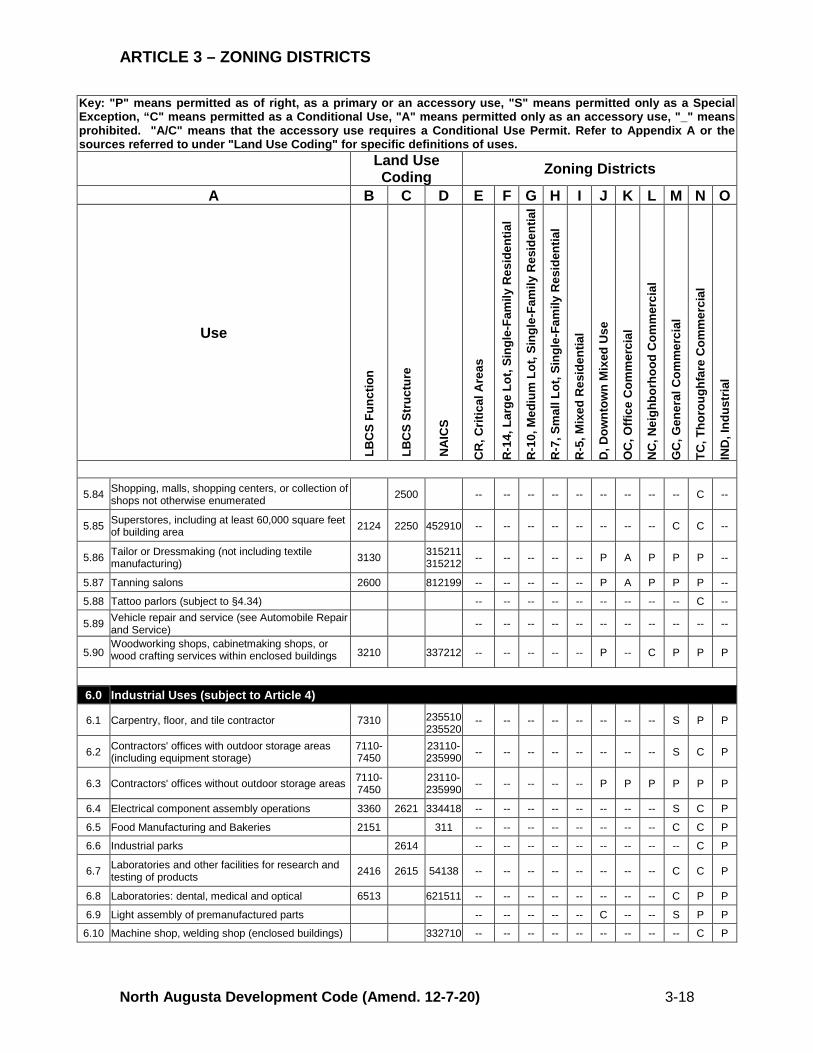
5.84 Shopping, malls, shopping centers, or collection of shops not otherwise enumerated 2500 -- -- -- -- -- -- -- -- -- C --
5.85 Superstores, including at least 60,000 square feet of building area 2124 2250 452910 -- -- -- -- -- -- -- -- C C --
5.86 Tailor or Dressmaking (not including textile manufacturing) 3130 315211
315212 -- -- -- -- -- P A P P P --
5.87 Tanning salons 2600 812199 -- -- -- -- -- P A P P P --
5.88 Tattoo parlors (subject to §4.34) -- -- -- -- -- -- -- -- -- C --
5.89 Vehicle repair and service (see Automobile Repair and Service) -- -- -- -- -- -- -- -- -- -- --
5.90 Woodworking shops, cabinetmaking shops, or wood crafting services within enclosed buildings 3210 337212 -- -- -- -- -- P -- C P P P
6.0 Industrial Uses (subject to Article 4)
6.1 Carpentry, floor, and tile contractor 7310 235510 235520
-- -- -- -- -- -- -- -- S P P
6.2 Contractors' offices with outdoor storage areas (including equipment storage)
7110-7450 23110-
235990 -- -- -- -- -- -- -- -- S C P
6.3 Contractors' offices without outdoor storage areas 7110-7450 23110-
235990 -- -- -- -- -- P P P P P P
6.4 Electrical component assembly operations 3360 2621 334418 -- -- -- -- -- -- -- -- S C P
6.5 Food Manufacturing and Bakeries 2151 311 -- -- -- -- -- -- -- -- C C P
6.6 Industrial parks 2614 -- -- -- -- -- -- -- -- -- C P
6.7 Laboratories and other facilities for research and testing of products 2416 2615 54138 -- -- -- -- -- -- -- -- C C P
6.8 Laboratories: dental, medical and optical 6513 621511 -- -- -- -- -- -- -- -- C P P
6.9 Light assembly of premanufactured parts -- -- -- -- -- C -- -- S P P
6.10 Machine shop, welding shop (enclosed buildings) 332710 -- -- -- -- -- -- -- -- -- C P
ARTICLE 3 – ZONING DISTRICTS
North Augusta Development Code (Amend. 12-7-20) 3-19
Key: "P" means permitted as of right, as a primary or an accessory use, "S" means permitted only as a Special Exception, “C" means permitted as a Conditional Use, "A" means permitted only as an accessory use, "_" means prohibited. "A/C" means that the accessory use requires a Conditional Use Permit. Refer to Appendix A or the sources referred to under "Land Use Coding" for specific definitions of uses. Land Use
Coding Zoning Districts
A B C D E F G H I J K L M N O
Use
LB
CS
Func
tion
LB
CS
Stru
ctur
e
NA
ICS
CR
, Crit
ical
Are
as
R-1
4, L
arge
Lot
, Sin
gle-
Fam
ily R
esid
entia
l
R-1
0, M
ediu
m L
ot, S
ingl
e-Fa
mily
Res
iden
tial
R-7
, Sm
all L
ot, S
ingl
e-Fa
mily
Res
iden
tial
R-5
, Mix
ed R
esid
entia
l
D, D
ownt
own
Mix
ed U
se
OC
, Offi
ce C
omm
erci
al
NC
, Nei
ghbo
rhoo
d C
omm
erci
al
GC
, Gen
eral
Com
mer
cial
TC, T
horo
ughf
are
Com
mer
cial
IND
, Ind
ustr
ial
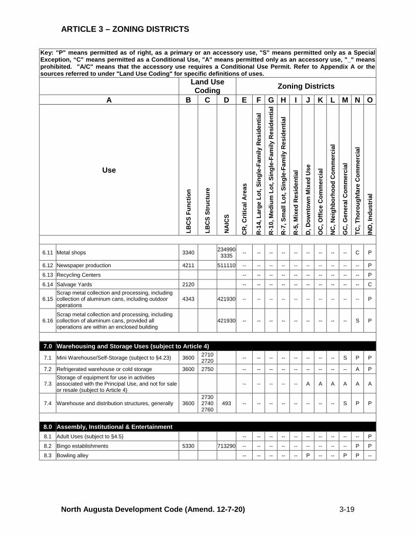
6.11 Metal shops 3340 234990 3335 -- -- -- -- -- -- -- -- -- C P
6.12 Newspaper production 4211 511110 -- -- -- -- -- -- -- -- -- -- P
6.13 Recycling Centers -- -- -- -- -- -- -- -- -- -- P
6.14 Salvage Yards 2120 -- -- -- -- -- -- -- -- -- -- C
6.15 Scrap metal collection and processing, including collection of aluminum cans, including outdoor operations
4343 421930 -- -- -- -- -- -- -- -- -- -- P
6.16 Scrap metal collection and processing, including collection of aluminum cans, provided all operations are within an enclosed building
421930 -- -- -- -- -- -- -- -- -- S P
7.0 Warehousing and Storage Uses (subject to Article 4)
7.1 Mini Warehouse/Self-Storage (subject to §4.23) 3600 2710 2720 -- -- -- -- -- -- -- -- S P P
7.2 Refrigerated warehouse or cold storage 3600 2750 -- -- -- -- -- -- -- -- -- A P
7.3 Storage of equipment for use in activities associated with the Principal Use, and not for sale or resale (subject to Article 4)
-- -- -- -- -- A A A A A A
7.4 Warehouse and distribution structures, generally 3600 2730 2740 2760
493 -- -- -- -- -- -- -- -- S P P
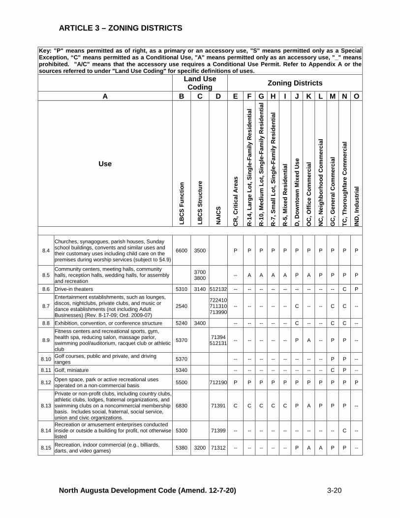
8.0 Assembly, Institutional & Entertainment 8.1 Adult Uses (subject to §4.5) -- -- -- -- -- -- -- -- -- -- P
8.2 Bingo establishments 5330 713290 -- -- -- -- -- -- -- -- -- P P
8.3 Bowling alley -- -- -- -- -- P -- -- P P --
ARTICLE 3 – ZONING DISTRICTS
North Augusta Development Code (Amend. 12-7-20) 3-20
Key: "P" means permitted as of right, as a primary or an accessory use, "S" means permitted only as a Special Exception, “C" means permitted as a Conditional Use, "A" means permitted only as an accessory use, "_" means prohibited. "A/C" means that the accessory use requires a Conditional Use Permit. Refer to Appendix A or the sources referred to under "Land Use Coding" for specific definitions of uses. Land Use
Coding Zoning Districts
A B C D E F G H I J K L M N O
Use
LB
CS
Func
tion
LB
CS
Stru
ctur
e
NA
ICS
CR
, Crit
ical
Are
as
R-1
4, L
arge
Lot
, Sin
gle-
Fam
ily R
esid
entia
l
R-1
0, M
ediu
m L
ot, S
ingl
e-Fa
mily
Res
iden
tial
R-7
, Sm
all L
ot, S
ingl
e-Fa
mily
Res
iden
tial
R-5
, Mix
ed R
esid
entia
l
D, D
ownt
own
Mix
ed U
se
OC
, Offi
ce C
omm
erci
al
NC
, Nei
ghbo
rhoo
d C
omm
erci
al
GC
, Gen
eral
Com
mer
cial
TC, T
horo
ughf
are
Com
mer
cial
IND
, Ind
ustr
ial
8.4
Churches, synagogues, parish houses, Sunday school buildings, convents and similar uses and their customary uses including child care on the premises during worship services (subject to §4.9)
6600 3500 P P P P P P P P P P P
8.5 Community centers, meeting halls, community halls, reception halls, wedding halls, for assembly and recreation
3700 3800 -- A A A A P A P P P P
8.6 Drive-in theaters 5310 3140 512132 -- -- -- -- -- -- -- -- -- C P
8.7
Entertainment establishments, such as lounges, discos, nightclubs, private clubs, and music or dance establishments (not including Adult Businesses) (Rev. 8-17-09; Ord. 2009-07)
2540 722410 711310 713990
-- -- -- -- -- C -- -- C C --
8.8 Exhibition, convention, or conference structure 5240 3400 -- -- -- -- -- C -- -- C C --
8.9
Fitness centers and recreational sports, gym, health spa, reducing salon, massage parlor, swimming pool/auditorium, racquet club or athletic club
5370 71394 512131 -- -- -- -- -- P A -- P P --
8.10 Golf courses, public and private, and driving ranges 5370 -- -- -- -- -- -- -- -- P P --
8.11 Golf, miniature 5340 -- -- -- -- -- -- -- -- C P --
8.12 Open space, park or active recreational uses operated on a non-commercial basis 5500 712190 P P P P P P P P P P P
8.13
Private or non-profit clubs, including country clubs, athletic clubs, lodges, fraternal organizations, and swimming clubs on a noncommercial membership basis. Includes social, fraternal, social service, union and civic organizations.
6830 71391 C C C C C P A P P P --
8.14 Recreation or amusement enterprises conducted inside or outside a building for profit, not otherwise listed
5300 71399 -- -- -- -- -- -- -- -- -- C --
8.15 Recreation, indoor commercial (e.g., billiards, darts, and video games) 5380 3200 71312 -- -- -- -- -- P A A P P --
ARTICLE 3 – ZONING DISTRICTS
North Augusta Development Code (Amend. 12-7-20) 3-21
Key: "P" means permitted as of right, as a primary or an accessory use, "S" means permitted only as a Special Exception, “C" means permitted as a Conditional Use, "A" means permitted only as an accessory use, "_" means prohibited. "A/C" means that the accessory use requires a Conditional Use Permit. Refer to Appendix A or the sources referred to under "Land Use Coding" for specific definitions of uses. Land Use
Coding Zoning Districts
A B C D E F G H I J K L M N O
Use
LB
CS
Func
tion
LB
CS
Stru
ctur
e
NA
ICS
CR
, Crit
ical
Are
as
R-1
4, L
arge
Lot
, Sin
gle-
Fam
ily R
esid
entia
l
R-1
0, M
ediu
m L
ot, S
ingl
e-Fa
mily
Res
iden
tial
R-7
, Sm
all L
ot, S
ingl
e-Fa
mily
Res
iden
tial
R-5
, Mix
ed R
esid
entia
l
D, D
ownt
own
Mix
ed U
se
OC
, Offi
ce C
omm
erci
al
NC
, Nei
ghbo
rhoo
d C
omm
erci
al
GC
, Gen
eral
Com
mer
cial
TC, T
horo
ughf
are
Com
mer
cial
IND
, Ind
ustr
ial
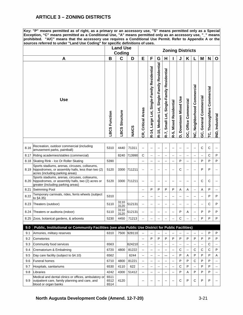
8.16 Recreation, outdoor commercial (including amusement parks, paintball) 5310 4440 71311 -- -- -- -- -- -- -- -- C C --
8.17 Riding academies/stables (commercial) 8240 713990 C -- -- -- -- -- -- -- -- C P
8.18 Skating Rink - Ice Or Roller Skating 5390 -- -- -- -- -- P -- -- P P P
8.19 Sports stadiums, arenas, circuses, coliseums, hippodromes, or assembly halls, less than two (2) acres (including parking areas)
5120 3300 711211 -- -- -- -- -- C -- -- P P --
8.20 Sports stadiums, arenas, circuses, coliseums, hippodromes, or assembly halls, two (2) acres or greater (including parking areas)
5120 3300 711211 -- -- -- -- -- -- -- -- C C --
8.21 Swimming Pool -- P P P P A A -- A P --
8.22 Temporary carnivals, rides, ferris wheels (subject to §4.35) 5310 -- -- -- -- -- -- -- -- -- P P
8.23 Theaters (outdoor) 5110 3110 3120 512131 -- -- -- -- -- -- -- -- -- C P
8.24 Theaters or auditoria (indoor) 5110 3110 3120 512131 -- -- -- -- -- P A -- P P P
8.25 Zoos, botanical gardens, & arboreta 5230 4450 71213 -- -- -- -- -- C -- -- P P P
9.0 Public, Institutional or Community Facilities (see also Public Use District for Public Facilities) 9.1 Armories, military reserves 6310 7500 928110 -- -- -- -- -- -- -- -- -- P P
9.2 Cemeteries -- P P P P P P P P P P
9.3 Community food services 6563 624210 -- -- -- -- -- -- -- -- -- C --
9.4 Crematorium & Embalming 6720 4800 81222 -- -- -- -- -- C -- C C C P
9.5 Day care facility (subject to §4.10) 6562 6244 -- -- -- -- -- P A P P P A
9.6 Funeral homes 6710 4800 81221 -- -- -- -- -- P P C P P --
9.7 Hospitals, sanitariums 6530 4110 622 -- -- -- -- -- C P -- P P --
9.8 Libraries 4242 4300 51412 -- -- -- -- -- P A P P P --
9.9 Medical and dental clinics or offices, ambulatory or outpatient care, family planning and care, and blood or organ banks
6511 6512 6514
4120 -- -- -- -- -- C P C P P --
ARTICLE 3 – ZONING DISTRICTS
North Augusta Development Code (Amend. 12-7-20) 3-22
Key: "P" means permitted as of right, as a primary or an accessory use, "S" means permitted only as a Special Exception, “C" means permitted as a Conditional Use, "A" means permitted only as an accessory use, "_" means prohibited. "A/C" means that the accessory use requires a Conditional Use Permit. Refer to Appendix A or the sources referred to under "Land Use Coding" for specific definitions of uses. Land Use
Coding Zoning Districts
A B C D E F G H I J K L M N O
Use
LB
CS
Func
tion
LB
CS
Stru
ctur
e
NA
ICS
CR
, Crit
ical
Are
as
R-1
4, L
arge
Lot
, Sin
gle-
Fam
ily R
esid
entia
l
R-1
0, M
ediu
m L
ot, S
ingl
e-Fa
mily
Res
iden
tial
R-7
, Sm
all L
ot, S
ingl
e-Fa
mily
Res
iden
tial
R-5
, Mix
ed R
esid
entia
l
D, D
ownt
own
Mix
ed U
se
OC
, Offi
ce C
omm
erci
al
NC
, Nei
ghbo
rhoo
d C
omm
erci
al
GC
, Gen
eral
Com
mer
cial
TC, T
horo
ughf
are
Com
mer
cial
IND
, Ind
ustr
ial
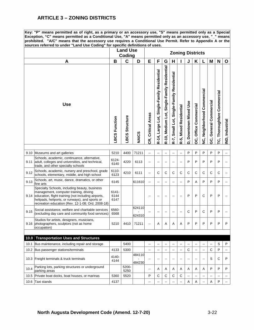
9.10 Museums and art galleries 5210 4400 71211 -- -- -- -- -- P P P P P --
9.11 Schools, academic, continuance, alternative, adult, colleges and universities, and technical, trade, and other specialty schools
6124-6140 4220 6113 -- -- -- -- -- P P P P P --
9.12 Schools, academic, nursery and preschool, grade schools, elementary, middle, and high school
6110-6123 4210 6111 -- C C C C C C C C C --
9.13 Schools, art, music, dance, dramatics, or other fine arts 6145 611610 -- -- -- -- -- P A P P P --
9.14
Specialty Schools, including beauty, business management, computer training, driving education, flight training (not including airports, helipads, heliports, or runways), and sports or recreation education (Rev. 12-1-08; Ord. 2008-18)
6141-6144 6147
-- -- -- -- -- P P C P P --
9.15 Social assistance, welfare and charitable services (excluding day care and community food services)
6560-6568
624110-
624310 -- -- -- -- -- C P C P P --
9.16 Studios for artists, designers, musicians, photographers, sculptors (not as home occupation)
5210 4410 71211 -- A A A A P P P P P P
10.0 Transportation Uses and Structures 10.1 Bus maintenance, including repair and storage 5400 -- -- -- -- -- -- -- -- -- S P
10.2 Bus passenger stations/terminals 4133 5300 -- -- -- -- -- C -- -- C P --
10.3 Freight terminals & truck terminals 4140-4144
484110-
484230 -- -- -- -- -- -- -- -- S C P
10.4 Parking lots, parking structures or underground parking areas 5200-
5250 -- A A A A A A A P P P
10.5 Private boat docks, boat houses, or marinas 5360 5520 P C C C C -- -- -- -- -- --
10.6 Taxi stands 4137 -- -- -- -- -- A A -- A P --
ARTICLE 3 – ZONING DISTRICTS
North Augusta Development Code (Amend. 12-7-20) 3-23
Key: "P" means permitted as of right, as a primary or an accessory use, "S" means permitted only as a Special Exception, “C" means permitted as a Conditional Use, "A" means permitted only as an accessory use, "_" means prohibited. "A/C" means that the accessory use requires a Conditional Use Permit. Refer to Appendix A or the sources referred to under "Land Use Coding" for specific definitions of uses. Land Use
Coding Zoning Districts
A B C D E F G H I J K L M N O
Use
LB
CS
Func
tion
LB
CS
Stru
ctur
e
NA
ICS
CR
, Crit
ical
Are
as
R-1
4, L
arge
Lot
, Sin
gle-
Fam
ily R
esid
entia
l
R-1
0, M
ediu
m L
ot, S
ingl
e-Fa
mily
Res
iden
tial
R-7
, Sm
all L
ot, S
ingl
e-Fa
mily
Res
iden
tial
R-5
, Mix
ed R
esid
entia
l
D, D
ownt
own
Mix
ed U
se
OC
, Offi
ce C
omm
erci
al
NC
, Nei
ghbo
rhoo
d C
omm
erci
al
GC
, Gen
eral
Com
mer
cial
TC, T
horo
ughf
are
Com
mer
cial
IND
, Ind
ustr
ial
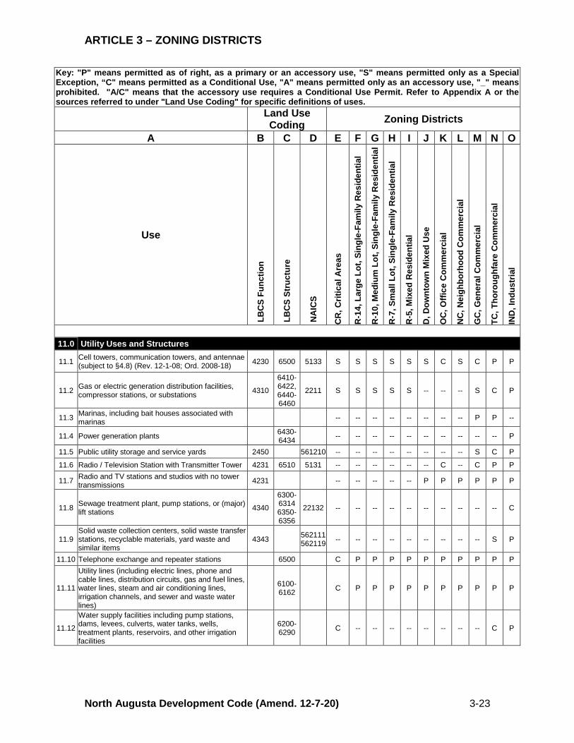
11.0 Utility Uses and Structures
11.1 Cell towers, communication towers, and antennae (subject to §4.8) (Rev. 12-1-08; Ord. 2008-18) 4230 6500 5133 S S S S S S C S C P P
11.2 Gas or electric generation distribution facilities, compressor stations, or substations 4310
6410-6422, 6440-6460
2211 S S S S S -- -- -- S C P
11.3 Marinas, including bait houses associated with marinas -- -- -- -- -- -- -- -- P P --
11.4 Power generation plants 6430-6434 -- -- -- -- -- -- -- -- -- -- P
11.5 Public utility storage and service yards 2450 561210 -- -- -- -- -- -- -- -- S C P
11.6 Radio / Television Station with Transmitter Tower 4231 6510 5131 -- -- -- -- -- -- C -- C P P
11.7 Radio and TV stations and studios with no tower transmissions 4231 -- -- -- -- -- P P P P P P
11.8 Sewage treatment plant, pump stations, or (major) lift stations 4340
6300-6314 6350-6356
22132 -- -- -- -- -- -- -- -- -- -- C
11.9 Solid waste collection centers, solid waste transfer stations, recyclable materials, yard waste and similar items
4343 562111 562119 -- -- -- -- -- -- -- -- -- S P
11.10 Telephone exchange and repeater stations 6500 C P P P P P P P P P P
11.11
Utility lines (including electric lines, phone and cable lines, distribution circuits, gas and fuel lines, water lines, steam and air conditioning lines, irrigation channels, and sewer and waste water lines)
6100-6162 C P P P P P P P P P P
11.12
Water supply facilities including pump stations, dams, levees, culverts, water tanks, wells, treatment plants, reservoirs, and other irrigation facilities
6200-6290 C -- -- -- -- -- -- -- -- C P
ARTICLE 3 – ZONING DISTRICTS
North Augusta Development Code (Amend. 12-7-20) 3-24
Key: "P" means permitted as of right, as a primary or an accessory use, "S" means permitted only as a Special Exception, “C" means permitted as a Conditional Use, "A" means permitted only as an accessory use, "_" means prohibited. "A/C" means that the accessory use requires a Conditional Use Permit. Refer to Appendix A or the sources referred to under "Land Use Coding" for specific definitions of uses. Land Use
Coding Zoning Districts
A B C D E F G H I J K L M N O
Use
LB
CS
Func
tion
LB
CS
Stru
ctur
e
NA
ICS
CR
, Crit
ical
Are
as
R-1
4, L
arge
Lot
, Sin
gle-
Fam
ily R
esid
entia
l
R-1
0, M
ediu
m L
ot, S
ingl
e-Fa
mily
Res
iden
tial
R-7
, Sm
all L
ot, S
ingl
e-Fa
mily
Res
iden
tial
R-5
, Mix
ed R
esid
entia
l
D, D
ownt
own
Mix
ed U
se
OC
, Offi
ce C
omm
erci
al
NC
, Nei
ghbo
rhoo
d C
omm
erci
al
GC
, Gen
eral
Com
mer
cial
TC, T
horo
ughf
are
Com
mer
cial
IND
, Ind
ustr
ial
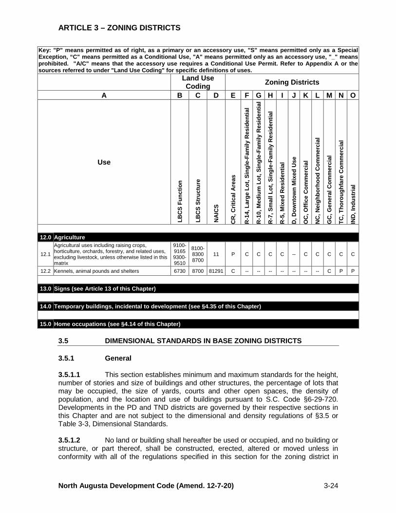
12.0 Agriculture
12.1
Agricultural uses including raising crops, horticulture, orchards, forestry, and related uses, excluding livestock, unless otherwise listed in this matrix
9100-9165 9300-9510
8100-8300 8700
11 P C C C C -- C C C C C
12.2 Kennels, animal pounds and shelters 6730 8700 81291 C -- -- -- -- -- -- -- C P P
13.0 Signs (see Article 13 of this Chapter)
14.0 Temporary buildings, incidental to development (see §4.35 of this Chapter)
15.0 Home occupations (see §4.14 of this Chapter) 3.5 DIMENSIONAL STANDARDS IN BASE ZONING DISTRICTS 3.5.1 General 3.5.1.1 This section establishes minimum and maximum standards for the height, number of stories and size of buildings and other structures, the percentage of lots that may be occupied, the size of yards, courts and other open spaces, the density of population, and the location and use of buildings pursuant to S.C. Code §6-29-720. Developments in the PD and TND districts are governed by their respective sections in this Chapter and are not subject to the dimensional and density regulations of §3.5 or Table 3-3, Dimensional Standards. 3.5.1.2 No land or building shall hereafter be used or occupied, and no building or structure, or part thereof, shall be constructed, erected, altered or moved unless in conformity with all of the regulations specified in this section for the zoning district in
ARTICLE 3 – ZONING DISTRICTS
North Augusta Development Code (Amend. 12-7-20) 3-25
which it is or will be located. No building permit shall be issued unless the proposed building or structure conforms to the standards established in this section. 3.5.2 Residential Density 3.5.2.1 No building, structure or land shall hereafter be used or occupied in excess of the prescribed density regulations, nor accommodate a greater number of dwelling units than prescribed for in the zoning district in which it is or will be located in accordance with the limitations established in Table 3-3, Dimensional Standards. 3.5.2.2 In computing density for large tracts or multi-unit housing projects, the density limits established by the zoning district apply. Densities may exceed the maximum on part of a tract, if the overall density on the total project site does not exceed the limits established by the zoning district. Applicants shall provide a concept plan consistent with Appendix A, Definitions, that provides an overall development plan and delineates the density for each phase of development. 3.5.2.3 For conventional subdivisions, this Chapter does not establish a maximum or minimum number of total permitted dwelling units, because the total number of dwelling units is governed by minimum lot size. Conservation subdivisions are not subject to minimum lot size requirements, but total permitted dwelling units shall not exceed the amount established as set forth in Table 3-3, Dimensional Standards. 3.5.3 Intensity in Nonresidential Districts Unless otherwise stated, all references to non-residential intensity shall be deemed to refer to Floor Area Ratio (FAR). Example of 0.5 FAR (10,000 sf floor area ÷ 20,000 sf lot area). 3.5.4 Dimensional Standards for Lots No permit for development shall be issued for a lot that does not meet the lot area requirements of Table 3-3, Dimensional Standards, except for Nonconforming Lots of Record, developments subject to use patterns, or developments subject to maximum density in lieu of minimum lot size requirements (see Table 3-3, Column C). 3.5.5 Dimensional Standards for Structures See §§3.5.5 through 3.5.14. 3.5.6 Setbacks, Generally Comment: “Setbacks” are the required distance between the lot line or right of way and structures. “Yards” are the areas within the setbacks. See Appendix A for definitions. 3.5.6.1 Building setbacks for each zoning district are set forth in Table 3-3, Dimensional Standards. 3.5.6.2 Setbacks for buildings or structures are measured as the distance between the furthest vertical wall plane of a principal structure and the property line of the lot on which the structure is located, except as modified by the standards of this section.
ARTICLE 3 – ZONING DISTRICTS
North Augusta Development Code (Amend. 12-7-20) 3-26
3.5.6.3 Where a yard abuts a street, the setback shall be measured from the abutting street right of way line. Whenever a lot abuts upon a service lane or an alley, one-half (1/2) of the service lane or alley width may be considered as a portion of the required yard provided that the resulting setback is no less than three (3) feet from the property line. (Rev. 12-1-08; Ord. 2008-18) Comment: Typically, the side and rear setback is measured from the property line, while the front setback is measured from the right of way because the front yard adjoins the street. 3.5.6.4 Setbacks shall be unobstructed from the ground to the sky except as specified in this section. 3.5.6.5 Whenever more than one (1) principal building is to be located on a lot, required front, side and rear setbacks shall be maintained around the group of buildings from all property lines as required by Table 3-3, Dimensional Standards. Buildings shall be separated internally by a horizontal distance of not less than one and one-half (1.5) times the amount of the required side setback. (Rev. 12-1-08; Ord. 2008-18) 3.5.7 Front Setbacks 3.5.7.1 The minimum or maximum front setback may be adjusted for any lot where the average established front setback on developed lots located within two hundred (200) feet on each side of such lot, and fronting on the same street as such lot, is less or more than the minimum or maximum required setback. In such cases, the minimum or maximum front setback on such a lot may be less or more than the required front setback, but shall not vary by more than three (3) feet from the average of the existing front setbacks on the developed lots within two hundred (200) feet of each side. Where the applicant requests an adjustment in the front setback, the applicant shall provide the average setback measurements based upon public records or actual measurements. Where the Director requires an adjustment in the maximum front setback, such information shall be provided by the Director. The Director is also authorized, but not required, to provide data pertaining to the average setback for designated areas of the city for purposes of this section. 3.5.7.2 Where a lot fronts on two (2) non-intersecting streets, or two (2) intersecting streets forming an angle of sixty (60) degrees or less, front yards setbacks shall be provided on both streets. 3.5.7.3 Where a principal use building or structure is oriented to face away from the street on which it fronts, said building or structure shall conform to the required front yard setback from the street for the district in which it is located. Any accessory use(s) prohibited from required front yards within such districts are prohibited within the required front yard setback from a principal use building or structure facing away from the street. (Rev. 12-1-08; Ord. 2008-18) 3.5.7.4 Where a frontage is divided among districts with different front yard requirements, the deepest front yard applies to the entire frontage.
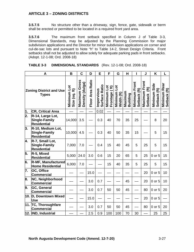
ARTICLE 3 – ZONING DISTRICTS
North Augusta Development Code (Amend. 12-7-20) 3-27
3.5.7.5 No structure other than a driveway, sign, fence, gate, sidewalk or berm shall be erected or permitted to be located in a required front yard area. 3.5.7.6 The maximum front setback specified in Column J of Table 3-3, Dimensional Standards, may be adjusted by the Planning Commission for major subdivision applications and the Director for minor subdivision applications on corner and cul-de-sac lots and pursuant to Note “h” to Table 14-2, Street Design Criteria. Front setbacks shall not be adjusted to allow solely for adequate parking pads in front setbacks. (Adopt. 12-1-08; Ord. 2008-18) TABLE 3-3 DIMENSIONAL STANDARDS (Rev. 12-1-08; Ord. 2008-18)
A B C D E F G H I J K L
Zoning District and Use Types
Min
imum
Lot
Si
ze (s
q. ft
) M
axim
um G
ross
D
ensi
ty (d
u/ga
)
Floo
r Are
a R
atio
Impe
rvio
us
Surf
ace
Rat
io
Min
imum
Lot
Fr
onta
ge (
ft)
Min
imum
Lot
W
idth
(ft)
Max
imum
B
uild
ing
M
inim
um F
ront
Se
tbac
k (ft
) M
axim
um F
ront
Se
tbac
k (f
t) M
inim
um S
ide
Setb
ack
(ft)
Min
imum
Rea
r Se
tbac
k (ft
)
1. CR, Critical Area –– –– –– 0.02 –– –– –– –– –– — –– 2. R-14, Large Lot,
Single-Family Residential
14,000 3.5 –– 0.3 40 70 35 25 –– 8 20
3. R-10, Medium Lot, Single-Family Residential
10,000 4.5 –– 0.3 40 50 35 15 –– 5 15
4. R-7, Small Lot, Single-Family Residential
7,000 7.0 –– 0.4 15 40 45 5 25 5 15
5. R-5, Mixed Residential 5,000 24.0 3.0 0.6 15 20 65 5 25 0 or 5 15
6. R-MF, Manufactured Home Residential 6,000 7.0 –– –– 15 40 35 5 25 5 15
7. OC, Office Commercial –– –– 15.0 –– –– –– –– –– 20 0 or 5 10
8. NC, Neighborhood Commercial –– –– 3.0 0.7 –– –– 45 –– 20 0 or 5 10
9. GC, General Commercial –– –– 3.0 0.7 50 50 45 –– 80 0 or 5 20
10. D, Downtown Mixed Use –– –– 15.0 –– — — –– –– 20 0 or 5 ––
11. TC, Thoroughfare Commercial –– –– 3.0 0.7 50 50 45 –– 80 0 or 5 20
12. IND, Industrial –– — 2.5 0.9 100 100 70 30 –– 25 25

ARTICLE 3 – ZONING DISTRICTS
North Augusta Development Code (Amend. 12-7-20) 3-28
Notes to Table 3-3: (Rev. 12-1-08; Ord. 2008-18) Generally the requirements for the parameters set forth in Columns B through L, above, relate to the zoning district specified in the row under Column A. A “—” indicates that the requirement does not apply within the particular zoning district. Fractions shall be rounded up. a. Column B: Minimum lot size requirements do not apply to conservation subdivisions
or TNDs, or to patio homes, duplexes, rowhouses, townhouses, apartments or any other multifamily dwelling units. The minimum lot size figures are expressed in square feet, unless otherwise indicated. Additional rules of interpretation for minimum lot area are set forth in §3.5.4.
b. Column C: The maximum density requirements are expressed in dwelling units per gross acre. Additional rules of interpretation are set forth in §3.5.
c. Columns D and E: The floor area ratio and impervious surface ratio are maximums and are expressed as a ratio (See Appendix A, Definitions).
d. Columns F – K: The dimensions specified in Columns F through K are expressed in feet. Rules of interpretation for setback and height requirements are set forth in §3.5. Where a zero side setback is permitted it is intended for the creation of a common wall with a structure on the adjacent parcel. If a zero setback is not used the minimum setback shall be five (5) feet.
e. Column L: For the GC and TC districts, the rear setback may be reduced to ten (10) feet if the building has access from an alley or service lane, or if no rear access is required for loading or vehicular access.
3.5.8 Corner Side Yards 3.5.8.1 Where a side yard abuts a street (corner lot), the minimum side yard shall be at least fifty percent (50%) of the front yard required on the lot lying to the rear when the rear lot faces the side street. No accessory building on the corner lot shall extend beyond the side yard lines. This section does not apply to the TND District. 3.5.8.2 Where a side yard abuts a street (corner lot), and the rear lot faces the opposite street, and in fact constitutes another corner lot, then the side yard setback for the district in which the lot is located shall prevail. This section does not apply to the TND District. 3.5.8.3 Accessory uses or accessory structures, other than fences, shall not be located in a side yard subject to §§3.5.8.1 or 3.5.8.2. 3.5.9 Setback Encroachments The following structures within the limits set forth may project into required yards: 3.5.9.1 Any buttress, chimney, cornice or pier may extend into a setback not more than two (2) feet. 3.5.9.2 Overhanging roofs, eaves, gutters, cornices, awnings and other architectural detail features, other than steps, stoops and porches described in §3.5.9.3 and door hoods and overhangs described in §3.5.9.4, may extend up to four (4) feet into the front setback and up to two (2) inches per foot of side yard into the side setback and up to two (2) inches per foot of rear yard into the rear setback provided that in no circumstance may the distance from the encroachment to the property line be less than three (3) feet.
ARTICLE 3 – ZONING DISTRICTS
North Augusta Development Code (Amend. 12-7-20) 3-29
3.5.9.3 Unenclosed steps, stoops and porches, either covered or uncovered, no higher than the ground floor level may extend up to three (3) feet into the side or rear setback or up to four (4) feet into the front setback provided that in no circumstance may the distance from the encroachment to the property line be less than three (3) feet. 3.5.9.4 A protective hood or overhang over a doorway may extend not more than three (3) feet into the side or rear setback or no more than four (4) feet into the front setback provided that in no circumstance may the distance from the encroachment to the property line be less than three (3) feet. 3.5.9.5 Bay windows, awnings and other structural overhangs may extend not more than three (3) feet into the side or rear setback or more than four (4) feet into the front setback provided that in no circumstance may the distance from the encroachment to the property line be less than three (3) feet. 3.5.9.6 Open fire escapes and handicap ramps for both existing and new buildings may extend not more than four (4) feet into any required setback. 3.5.9.7 Heating and cooling units may extend not more than three (3) feet into any setback. 3.5.9.8 Uncovered, unenclosed decks and terraces, no higher than twelve (12) inches above grade may extend no closer than five (5) feet to any front property and no closer than two (2) feet to any side or rear property line. 3.5.9.9 Retaining walls taller than six (6) inches above grade may be constructed no closer than eighteen (18) inches from a street right of way line or six (6) inches from a public alley or service lane right of way line. 3.5.9.10 Fences are allowed in accordance with §4.3, Fences and Walls. 3.5.9.11 Arbors, columns, pergolas, arches, fountains and statuary not exceeding eight (8) feet in height nor more than twelve (12) feet in length may be constructed in a required front yard setback as part of a fence or wall or as freestanding structures over walkways or driveways. Setbacks from property lines and rights of way shall be as provided in §4.3.4. (Adopt. 12-1-08; Ord. 2008-18) 3.5.9.12 Accessory buildings and uses customarily incidental to the permitted primary use or building are allowed in accordance with §4.2, Accessory Structures and Uses. 3.5.10 Height of Buildings and/or Structures 3.5.10.1 Height shall be measured as the vertical distance from grade plane to the average height of the highest roof surface. For purposes of this section, the “grade plane” means a reference plane representing the average of finished ground level adjoining the building at its exterior walls. Where the finished ground level slopes away from the exterior walls, the reference plane shall be established by the lowest points within the area between the building and the lot line or, where the lot line is more than
ARTICLE 3 – ZONING DISTRICTS
North Augusta Development Code (Amend. 12-7-20) 3-30
six (6) feet from the building, between the building and a point six (6) feet from the building. 3.5.10.2 Irrespective of the height limits prescribed in Table 3-3, Dimensional Standards, the following height limits shall apply to freestanding structures not intended for human occupancy as listed in Table 3-4, Exceptions to Height Limitations. TABLE 3-4 EXCEPTIONS TO HEIGHT LIMITATIONS
A B Structure Height Limit
1. Airway beacons
None
2. Construction cranes 3. Structures for essential
services 4. Windmills 5. Smokestacks 6. Antennae See §4.8 7. Transmission towers 8. Flagpoles The maximum height permitted in the
district or forty-five (45) feet, whichever is less.
9. Monuments
3.5.10.3 An overall height limit of one hundred thirty-three percent (133%) of the height of the structure shall apply to penthouses for electrical, mechanical, or elevator equipment, belfries, chimneys and chimney flumes, flagpoles, cupolas, domes or any bulkhead, water tank, statuary, monument or any similar structure, architectural detail or necessary mechanical appurtenance mounted on and extending above the roof of any building if such structure does not occupy more than thirty-three (33) percent of the area of the roof. 3.5.11 Visual Clearance at Intersections See Article 14, Streets. 3.5.12 Building Requirements in Established Flood Hazard Areas See Article 9, Floodplain Management. 3.5.13 Flag Lots 3.5.13.1 Not more than the following number of Flag Lots may be authorized to allow for the more efficient use of irregularly shaped parcels of land, or where the integrated nature of multiple buildings on a site dictates the need for such lots. Flag Lots may be used to better use irregularly shaped properties or sites with physical limitations. Flag Lots shall not be permitted where they will increase the number of lots that take their access from collector or arterial streets.

ARTICLE 3 – ZONING DISTRICTS
North Augusta Development Code (Amend. 12-7-20) 3-31
TABLE 3-5 MAXIMUM NUMBER OF FLAG LOTS
A B Size of Subdivision Maximum Number or Percentage (%) of Flag Lots
1. 10 or fewer lots 1 lot 2. 11 or more lots 10% of the total lots
3.5.13.2 The minimum frontage at the right of way line of the Flag Lot shall be fifteen (15) feet. The width of the flagpole between the right of way and the lot shall be no less than fifteen (15) feet at any point. 3.5.13.3 The area of the flagpole portion of the lot(s) shall not be considered in determining the area of any lot. 3.5.13.4 Wherever possible Flag Lots shall share the same flagpole and driveway through a shared access agreement. 3.5.13.5 In no event shall the length of the flagpole of a Flag Lot exceed one hundred fifty (150) feet 3.5.13.6 The minimum driveway width shall be ten (10) feet for driveways serving one (1) Flag Lot and twelve (12) feet for driveways serving more than one (1) lot. 3.5.13.7 Notwithstanding the provisions above, no more than three (3) lots may be served by a flagpole driveway. 3.5.14 Zero Lot Line Units 3.5.14.1 Purpose The purpose of this section is to provide reasonable design standards for detached single family dwelling development with zero lot lines. In a zero lot line development, houses are shifted to one side of the lot. This provides for greater usable yard space on each lot. These developments require that planning for all house locations in a subdivision are done at the same time. Because the exact location of each house is predetermined, greater flexibility in site development standards is possible while assuring that the single-family detached character of a neighborhood is maintained. 3.5.14.2 Applicable Standards Zero lot line homes shall conform to the standards contained in this section and all other applicable standards in this Chapter. 3.5.14.3 Overhang Easement Required The eaves on the side of a house with a reduced setback may project a maximum of eighteen (18) inches over the adjacent property line. In this case, an easement for the eave projection shall be recorded on the deed for the lot where the projection occurs. 3.5.14.4 Maintenance Easement Required An easement to allow for maintenance or repair shall be provided when the eaves or side wall of a house are within four (4) feet of the adjacent property line. The easement on the adjacent property shall provide at least five (5) feet of unobstructed space
ARTICLE 3 – ZONING DISTRICTS
North Augusta Development Code (Amend. 12-7-20) 3-32
between the furthermost projections of the structure and be wide enough to allow five (5) feet between the eaves or side wall and the edge of the easement. 3.5.14.5 Side Wall Windows If the side wall of the house is on the property line, or less than three (3) feet from the property line, windows or other openings that allow for visibility into the side yard of the adjacent lot are not permitted. Windows that do not allow visibility into the side yard of the adjacent lot, such as a clerestory window or a semi-transparent or opaque window, are allowed provided they are permitted by the International Building Code. 3.5.14.6 Minimum Distance between Structures In no case shall the reduced setbacks result in a distance of less than ten (10) feet between residential structures. 3.5.14.7 Setbacks Delineated The reduced setbacks shall be clearly denoted on the preliminary subdivision plan and final plat. 3.6 SPECIAL DISTRICTS 3.6.1 PD, Planned Development District 3.6.1.1 Purpose – The purpose of the PD District is to encourage flexibility in the development of land in order to promote its appropriate use; to improve the design, character and quality of new development; to facilitate the provision of streets and utilities; and to preserve the natural and scenic features of open space. This district is intended for use in the undeveloped areas of the city where planned development offers a superior response to less coordinated single-lot development, as permitted elsewhere in this Chapter. 3.6.1.2 Area and Ownership – In order to qualify as a PD District a project request shall meet the following requirements: 3.6.1.2.1 The site shall be in single ownership or control, or if in several ownerships, the application for amendment to this Chapter shall be filed jointly by all of the owners. 3.6.1.2.2 The site shall contain not less than ten (10) acres. 3.6.1.2.3 The proposed development shall be consistent with the Comprehensive Plan. 3.6.1.2.4 The applicant shall demonstrate that the proposed development accomplishes the objectives of §1.2 of this Chapter to a greater extent than land developed under any other zoning district, including a base zoning district or a TND District.
ARTICLE 3 – ZONING DISTRICTS
North Augusta Development Code (Amend. 12-7-20) 3-33
3.6.1.3 Procedures – The creation of a PD District designation is a process involving both a rezoning and General Development Plan approval. (Rev. 8-16-10; Ord. 2010-12) 3.6.1.3.1 A PD District may be established on the Official Zoning Map in the manner prescribed in §3.2 only after a General Development Plan that complies with the provisions of §5.7 of the Chapter has been reviewed by the Planning Commission, submitted to the City Council with a Planning Commission recommendation and approved by the City Council. Approval by the City Council must be in the form of an ordinance that approves the General Development Plan and applies the PD zoning designation to the property. Parcels of land that were zoned PD prior to the effective date of this section and for which a General Development Plan has been approved may continue to be developed in accordance with the approved plan. A major modification to a previously approved PD General Development Plan will require compliance with the mixed use provisions of §3.6.1.4. Parcels of land that were zoned PD prior to the effective date of this section and for which a General Development Plan has not been approved will retain the PD district zoning designation. Such PD zoned property may not be developed until a General Development Plan for such PD zoned property has been submitted in compliance with §3.6.1.4 and approved pursuant to §5.7. Alternatively, such PD zoned property may be rezoned to a different zoning district in accordance with the provisions of §5.3 and developed pursuant to the applicable procedures and approvals for that district. (Rev. 8-16-10; Ord. 2010-12) 3.6.1.3.2 The General Development Plan and administrative review requirements of this section are required after a map amendment is approved. Such requirements and all additional requirements of this section and §3.2 shall be addressed prior to the issuance of a building or development permit. A properly approved detailed site plan or subdivision (preliminary and final) or both shall be required prior to a request for a building or development permit. The requirements are specified in Article 5, Approval Procedures. 3.6.1.4 Permitted Uses – A PD district is specifically intended for development projects of housing of different types and densities and of compatible commercial uses, or shopping centers, office parks, and mixed-use developments characterized by a unified site design for a mixed use development. Any use included in the ordinance approving the General Development Plan and rezoning the site to the PD District is permitted in such district. A list of uses, hereinafter the “PD Use List,” including the types of uses, type and number of residential dwelling units and planned square footage of nonresidential uses within a particular PD District, shall be included in the ordinance approving the General Development Plan as part of the regulations applying to the district. (Rev. 8-16-10; Ord. 2010-12) 3.6.1.5 Private Streets – Private streets may be permitted in an approved PD District provided such streets meet the design and construction standards of public streets (see Article 14, Streets). 3.6.1.6 Criteria and Development Standards 3.6.1.6.1 Overall site design shall be harmonious in terms of landscaping, enclosure of principal and accessory uses, sizes of structures, street patterns, and use
ARTICLE 3 – ZONING DISTRICTS
North Augusta Development Code (Amend. 12-7-20) 3-34
relationships. A variety in building types, heights, facades, setbacks and size of open spaces shall be encouraged. 3.6.1.6.2 Permitted uses within a PD District are not subject to the restrictions of §3.4 or the Use Matrix, Table 3-2. However, the ordinance rezoning the tract and approving the General Development Plan shall include the PD Use List, a list of uses from the Use Matrix that are the only uses permitted in the specific PD District. The definition of uses included in the Use Matrix shall be used to interpret the PD Use List, unless a different definition is provided in the PD Use List. (Rev. 8-16-10; Ord. 2010-12) 3.6.1.6.3 The land uses within a PD District shall not be subject to any of the dimensional or density provisions of §3.5. Dimensional standards shall conform to the following, unless a different standard is included in the PD District rezoning ordinance: a. Maximum height is forty-five (45) feet, except where otherwise permitted by the
Comprehensive Plan. b. Maximum gross density is twenty-four (24) residential units per gross acre. c. The maximum floor area ratio for non-residential uses is two point four (2.4). A
minimum of ten percent (10%) and a maximum of seventy percent (70%) of the total project floor area shall be reserved for non-residential uses. For purposes of this Chapter, semi-detached and two-family dwelling units are presumed to have two thousand (2,000) square feet of floor area unless the specific dimensions are known at the time that the PD District rezoning is approved.
d. The maximum Impervious Surface Ratio is sixty percent (60%) of the total site area. 3.6.1.6.4 Open space, parks, and recreation shall comprise a minimum of twenty-five percent (25%) of the total site area. Portions of street rights of way that include street trees, sidewalks, and landscaped areas may be counted toward meeting open space requirements. 3.6.1.6.5 PD District zoning is intended to permit flexibility in the design, construction, and processing of mixed use developments of a quality that could not be achieved by complying with the design and development standards of another zoning district. Therefore, the design elements as set forth in Table 3-6 shall be adhered to in the design of a Planned Development and shall be used in the city’s review of proposed PD District projects. (Rev. 8-16-10; Ord. 2010-12) 3.6.1.6.6 In addition to the requirements of Article 12, Parking, areas designated for parking shall be physically separated from public streets and shall be designed in a manner conducive to safe ingress and egress. Access points to internal public streets or internal circulation drives should be no more than three hundred (300) feet apart. 3.6.1.6.7 In addition to the requirements of Article 10, Landscaping, buffer yards or landscaping may be required by the Planning Commission between uses within any PD District or along the perimeter of a PD District. 3.6.1.6.8 Urban design standards applicable to all of the structures to be developed in the planned development area are required and shall be submitted by the applicant or developer in conjunction with the application for a general development plan approval. The design elements specified in Table 3-6 shall be incorporated into the required urban design standards.
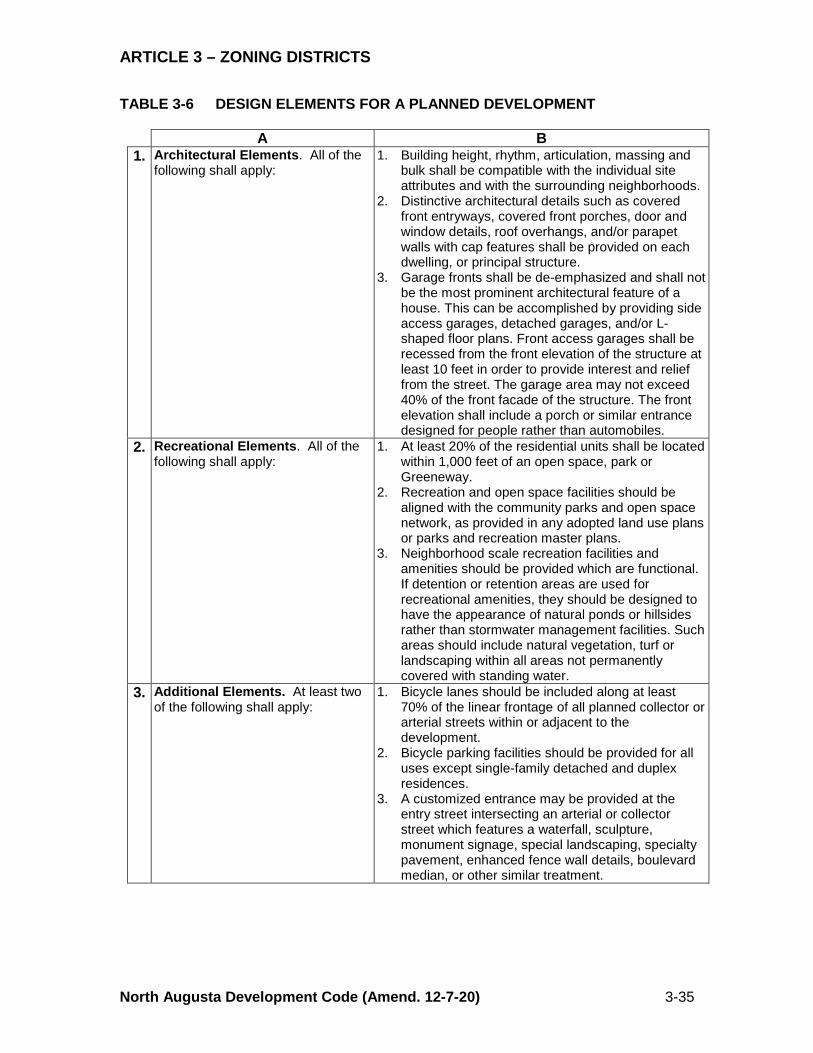
ARTICLE 3 – ZONING DISTRICTS
North Augusta Development Code (Amend. 12-7-20) 3-35
TABLE 3-6 DESIGN ELEMENTS FOR A PLANNED DEVELOPMENT
A B 1. Architectural Elements. All of the
following shall apply: 1. Building height, rhythm, articulation, massing and
bulk shall be compatible with the individual site attributes and with the surrounding neighborhoods.
2. Distinctive architectural details such as covered front entryways, covered front porches, door and window details, roof overhangs, and/or parapet walls with cap features shall be provided on each dwelling, or principal structure.
3. Garage fronts shall be de-emphasized and shall not be the most prominent architectural feature of a house. This can be accomplished by providing side access garages, detached garages, and/or L-shaped floor plans. Front access garages shall be recessed from the front elevation of the structure at least 10 feet in order to provide interest and relief from the street. The garage area may not exceed 40% of the front facade of the structure. The front elevation shall include a porch or similar entrance designed for people rather than automobiles.
2. Recreational Elements. All of the following shall apply:
1. At least 20% of the residential units shall be located within 1,000 feet of an open space, park or Greeneway.
2. Recreation and open space facilities should be aligned with the community parks and open space network, as provided in any adopted land use plans or parks and recreation master plans.
3. Neighborhood scale recreation facilities and amenities should be provided which are functional. If detention or retention areas are used for recreational amenities, they should be designed to have the appearance of natural ponds or hillsides rather than stormwater management facilities. Such areas should include natural vegetation, turf or landscaping within all areas not permanently covered with standing water.
3. Additional Elements. At least two of the following shall apply:
1. Bicycle lanes should be included along at least 70% of the linear frontage of all planned collector or arterial streets within or adjacent to the development.
2. Bicycle parking facilities should be provided for all uses except single-family detached and duplex residences.
3. A customized entrance may be provided at the entry street intersecting an arterial or collector street which features a waterfall, sculpture, monument signage, special landscaping, specialty pavement, enhanced fence wall details, boulevard median, or other similar treatment.
ARTICLE 3 – ZONING DISTRICTS
North Augusta Development Code (Amend. 12-7-20) 3-36
3.6.2 CR, Critical Areas District 3.6.2.1 Purpose – The purpose of this district is to preserve and/or control development within known and identifiable areas of the city that exhibit the following characteristics: a. Wetlands, water courses, and lands reserved or maintained for stormwater
management; b. Lands that serve as natural wildlife refuge areas; c. Environmentally sensitive lands and lands possessing great natural or historical
resources; d. Lands that are reserved for open space or future parks and recreational areas; and e. Passive park and recreational lands. 3.6.2.2 Mapped Critical Areas – Lands exhibiting these characteristics shall be mapped as CR on the Official Zoning Map. 3.6.2.3 Permitted Uses – Development shall be limited to uses listed in Table 3-2, Use Matrix. 3.6.2.4 Dimensional Standards – Dimensional standards shall be the same as those applicable to an R-14 District. 3.6.3 TND, Traditional Neighborhood Development District 3.6.3.1 Purpose – The purpose of this district is to provide for concentrated mixed residential, retail, service and office uses. This district does not regulate land uses but, instead, permits any use to be established subject to design standards established in Article 2, Use Patterns, for a TND. Urban design standards are required to be supplied by the applicant or developer prior to approval in order maintain a neighborhood commercial scale and to promote pedestrian activity. Pedestrian circulation and common parking areas are required. 3.6.3.2 Location Criteria – A TND District may be designated for areas: With an existing mix of retail, office, service, and residential uses located within a radius of one-quarter (¼) of a mile, or On a tract or parcel for which a TND Use Pattern is proposed. 3.6.3.3 Use Regulations – The Use Matrix does not apply to a TND District provided, however, that no building permit shall be issued unless the requested use conforms to a preliminary subdivision development plan approved pursuant to a rezoning to a TND District. A TND development that complies with the TND Use Pattern regulations in Article 2, Use Patterns, may be permitted in a TND District as of right. 3.6.3.4 Development Standards – See Article 2, Use Patterns, for TND regulations. 3.6.4 P, Public Use District 3.6.4.1 Purpose – The purpose of this district is to provide suitable locations for land and structures in the city of North Augusta used exclusively by the city of North Augusta, Aiken County, the State of South Carolina, the United States, or other
ARTICLE 3 – ZONING DISTRICTS
North Augusta Development Code (Amend. 12-7-20) 3-37
governmental jurisdictions and their instrumentalities; and as such shall be used in accordance with such regulations as may be prescribed by the government or instrumentality thereof using the property. This district is also applicable to land owned by public utilities and public service providers of water, sewer, electricity, natural gas, telephone, cable and internet and improved or utilized for the delivery of the public service (power generating or transforming stations, transmission and distribution lines and facilities, switching stations, etc.). Property owned by public utilities and utilized primarily for office, customer service or retail sales is not appropriate for the Public Use district. If Public Use zoned property is sold to a private individual or individuals, such property shall be rezoned to a classification that is compatible with the surrounding area. (Rev. 12-1-08; Ord. 2008-18) 3.6.4.2 Applicability – A P, Public Use District, designation may be applied to a use located on property used or reserved for a civic or public institutional purpose or for a major public facility, regardless of ownership of the land on which the use is located. A P, Public Use District designation may not be applied to government-owned property that is leased to a nongovernmental agency for a use other than a governmental service or for a use that supports a primary civic or public institutional use. 3.6.4.3 Permitted Uses – The uses listed in Table 3-7 are permitted in the P, Public Use District, subject to the issuance of a conditional use permit as required by Article 5, Approval Procedures. Public lands that are reserved or designated for environmental protection, open space or other natural state should be zoned in the CR, Critical Areas District, rather than the P, Public Use District. 3.6.4.4 Procedures – A site plan is required for uses permitted in the P, Public Use District, to the extent required by law. The site plan may be submitted concurrent with an application for rezoning. However, the Planning Commission and City Council may attach additional conditions to the approval of the district subject to a development agreement. In lieu of the application submittal requirements specified in Article 5, Approval Procedures, the applicant for rezoning to a P, Public Use District, shall address each of the review criteria of this section in their application materials. 3.6.4.5 Standards and Review Criteria 3.6.4.5.1 Review Criteria for Rezoning – In reviewing an application for a proposed P, Public Use District, the Planning Commission and City Council shall consider the following: a. Inter-jurisdictional Analysis – A review to determine the extent to which an inter-
jurisdictional approach may be appropriate, including consideration of possible alternative sites for the facility in other jurisdictions and an analysis of the extent to which the proposed facility is of a citywide, countywide, regional or state-wide nature, and whether uniformity among jurisdictions should be considered.
b. Financial Analysis – A review to determine if a negative financial impact upon the City of North Augusta can be reduced or avoided by intergovernmental agreement.
c. Special Purpose Districts – When the public facility is being proposed by a special purpose district including a school district, the city should consider the facility in the context of the district's overall plan and the extent to which the plan and facility are consistent with the Comprehensive Plan.
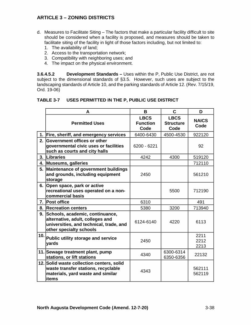
ARTICLE 3 – ZONING DISTRICTS
North Augusta Development Code (Amend. 12-7-20) 3-38
d. Measures to Facilitate Siting – The factors that make a particular facility difficult to site should be considered when a facility is proposed, and measures should be taken to facilitate siting of the facility in light of those factors including, but not limited to: 1. The availability of land; 2. Access to the transportation network; 3. Compatibility with neighboring uses; and 4. The impact on the physical environment.
3.6.4.5.2 Development Standards – Uses within the P, Public Use District, are not subject to the dimensional standards of §3.5. However, such uses are subject to the landscaping standards of Article 10, and the parking standards of Article 12. (Rev. 7/15/19, Ord. 19-06) TABLE 3-7 USES PERMITTED IN THE P, PUBLIC USE DISTRICT
A B C D
Permitted Uses LBCS
Function Code
LBCS Structure
Code NAICS Code
1. Fire, sheriff, and emergency services 6400-6430 4500-4530 922120 2. Government offices or other
governmental civic uses or facilities such as courts and city halls
6200 - 6221 92
3. Libraries 4242 4300 519120 4. Museums, galleries 712110 5. Maintenance of government buildings
and grounds, including equipment storage
2450 561210
6. Open space, park or active recreational uses operated on a non-commercial basis
5500 712190
7. Post office 6310 491 8. Recreation centers 5380 3200 713940 9. Schools, academic, continuance,
alternative, adult, colleges and universities, and technical, trade, and other specialty schools
6124-6140 4220 6113
10. Public utility storage and service yards 2450
2211 2212 2213
11. Sewage treatment plant, pump stations, or lift stations 4340 6300-6314
6350-6356 22132
12. Solid waste collection centers, solid waste transfer stations, recyclable materials, yard waste and similar items
4343 562111 562119
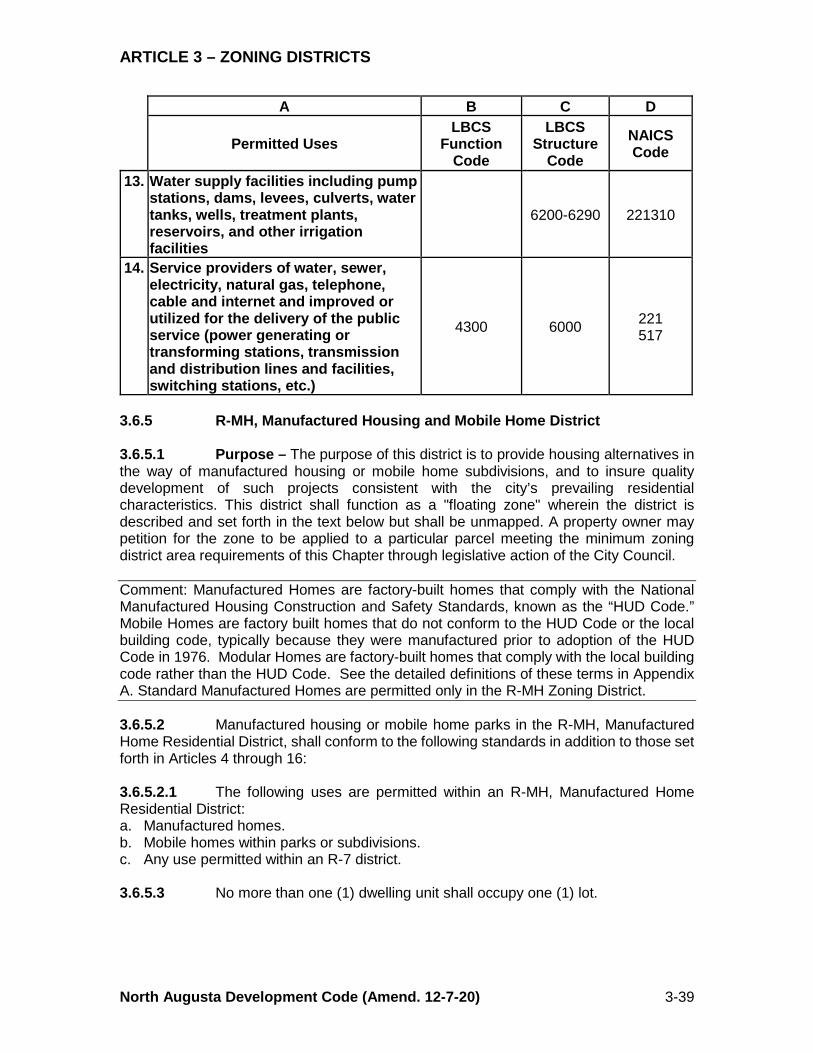
ARTICLE 3 – ZONING DISTRICTS
North Augusta Development Code (Amend. 12-7-20) 3-39
A B C D
Permitted Uses LBCS
Function Code
LBCS Structure
Code NAICS Code
13. Water supply facilities including pump stations, dams, levees, culverts, water tanks, wells, treatment plants, reservoirs, and other irrigation facilities
6200-6290 221310
14. Service providers of water, sewer, electricity, natural gas, telephone, cable and internet and improved or utilized for the delivery of the public service (power generating or transforming stations, transmission and distribution lines and facilities, switching stations, etc.)
4300 6000 221 517
3.6.5 R-MH, Manufactured Housing and Mobile Home District 3.6.5.1 Purpose – The purpose of this district is to provide housing alternatives in the way of manufactured housing or mobile home subdivisions, and to insure quality development of such projects consistent with the city’s prevailing residential characteristics. This district shall function as a "floating zone" wherein the district is described and set forth in the text below but shall be unmapped. A property owner may petition for the zone to be applied to a particular parcel meeting the minimum zoning district area requirements of this Chapter through legislative action of the City Council. Comment: Manufactured Homes are factory-built homes that comply with the National Manufactured Housing Construction and Safety Standards, known as the “HUD Code.” Mobile Homes are factory built homes that do not conform to the HUD Code or the local building code, typically because they were manufactured prior to adoption of the HUD Code in 1976. Modular Homes are factory-built homes that comply with the local building code rather than the HUD Code. See the detailed definitions of these terms in Appendix A. Standard Manufactured Homes are permitted only in the R-MH Zoning District. 3.6.5.2 Manufactured housing or mobile home parks in the R-MH, Manufactured Home Residential District, shall conform to the following standards in addition to those set forth in Articles 4 through 16: 3.6.5.2.1 The following uses are permitted within an R-MH, Manufactured Home Residential District: a. Manufactured homes. b. Mobile homes within parks or subdivisions. c. Any use permitted within an R-7 district. 3.6.5.3 No more than one (1) dwelling unit shall occupy one (1) lot.
ARTICLE 3 – ZONING DISTRICTS
North Augusta Development Code (Amend. 12-7-20) 3-40
3.6.5.4 Manufactured homes and mobile homes shall have their wheels and tongue removed upon arrival to the site and may not be occupied until the wheels and tongue have been removed. 3.6.5.5 Manufactured units or mobile homes shall be placed on a permanent foundation with all utilities (underground) already in place for each dwelling unit. The perimeter of the units shall be screened with permanent landscaping or fencing material consistent with the standards for building landscaping in Article 10, Landscaping. The units shall be anchored to the site in a manner approved by the city to protect against accidental movement. 3.6.5.6 Parking spaces shall be paved, properly marked, and lighted. 3.6.5.7 Concrete curbs shall be installed at the end of all "head-in" parking spaces. 3.6.5.8 All roadways shall have a minimum travel width of twenty (20) feet exclusive of parking. 3.6.5.9 A minimum of ten percent (10%) of the park site gross acreage shall be reserved and developed for recreational purposes. No recreation area shall be smaller than one-half (½) acre. 3.6.5.10 Accessory uses shall be limited to park offices, laundromats, meeting halls or activity centers, recreation facilities and maintenance buildings. Lots occupied by individual units may include one (1) accessory structure provided it is located behind the front elevation of the principal structure on the lot and a setback of three (3) feet is maintained on the side and rear. 3.6.5.11 Home occupations are permitted only within the dwelling units occupying each lot or dwelling site. 3.7 RESERVED 3.8 CORRIDOR OVERLAY DISTRICTS 3.8.1 Applicability 3.8.1.1 This section applies to any lot or parcel within the following Corridor Overlay Districts that are designated on the Official Zoning Map, with the exception of those lots or parcels zoned P. (Rev.7/15/19; Ord. 19-06) 3.8.1.2 In the event that the definite boundaries of the district cannot be ascertained, Corridor Overlay Districts shall be deemed to encompass the depth of the lots fronting on both sides of the corridor street up to three hundred (300) feet and all property within three hundred (300) feet of the edge of the right of way which utilizes the corridor street for direct access, unless otherwise specified, along specific sections of the corridor streets designated in §3.8.2, Establishment of Corridor Overlay Districts. 3.8.1.3 The streets designated in §3.8.2, Table 3-8, Column B, are referred to as Corridor Streets (see Figure 3-1).

ARTICLE 3 – ZONING DISTRICTS
North Augusta Development Code (Amend. 12-7-20) 3-41
3.8.1.4 A street that intersects a designated Corridor Street is referred to as an Intersecting Street (see Figure 3-1). FIGURE 3-1 CORRIDOR AND INTERSECTING STREETS
3.8.2 Establishment of Corridor Overlay Districts The following overlay districts are hereby established: TABLE 3-8 CORRIDOR DISTRICTS ESTABLISHED (Rev. 12-19-11; Ord. 2011-16)
(Rev. 6-20-16; Ord. 2016-14)
A B Overlay District Corridor Streets Generally
1. G, Georgia Avenue Overlay
1. Georgia Avenue north of the Greeneway to Spring Grove Avenue
2. HC, Highway
Corridor Overlay
1. Martintown Road between US 1 and Bama Avenue 2. The commercially zoned and utilized property on the
north side of Martintown Road between Hampton Avenue and River Bluff Drive
3. The south side of Martintown Road between West Avenue and River Bluff Drive
4. Martintown Road between Knobcone Avenue and the city limits
5. Knox Avenue/Edgefield Road (US 25) between Martintown Road and the city limits north of Walnut Lane
6. Jefferson Davis Highway (US 1) between Martintown Road and Atomic Road
7. Belvedere-Clearwater Road between Edgefield Road (US 25) and Old Sudlow Lake Road
8. The east side of Georgia Avenue between Marion Avenue and Knox Avenue/Edgefield Road (US 25)
9. The west side of Georgia Avenue between Hugh Street and Knox Avenue/Edgefield Road (US 25)
10. Five Notch Road Between Georgia Avenue and Walnut Lane
Corridor Street
Inte
rsec
ting
Stre
et
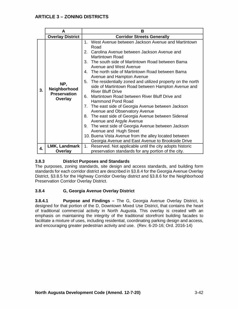
ARTICLE 3 – ZONING DISTRICTS
North Augusta Development Code (Amend. 12-7-20) 3-42
A B Overlay District Corridor Streets Generally
3. NP,
Neighborhood Preservation
Overlay
1. West Avenue between Jackson Avenue and Martintown Road
2. Carolina Avenue between Jackson Avenue and Martintown Road
3. The south side of Martintown Road between Bama Avenue and West Avenue
4. The north side of Martintown Road between Bama Avenue and Hampton Avenue
5. The residentially zoned and utilized property on the north side of Martintown Road between Hampton Avenue and River Bluff Drive
6. Martintown Road between River Bluff Drive and Hammond Pond Road
7. The east side of Georgia Avenue between Jackson Avenue and Observatory Avenue
8. The east side of Georgia Avenue between Sidereal Avenue and Argyle Avenue
9. The west side of Georgia Avenue between Jackson Avenue and Hugh Street
10. Buena Vista Avenue from the alley located between Georgia Avenue and East Avenue to Brookside Drive
4. LMK, Landmark Overlay
1. Reserved. Not applicable until the city adopts historic preservation standards for any portion of the city.
3.8.3 District Purposes and Standards The purposes, zoning standards, site design and access standards, and building form standards for each corridor district are described in §3.8.4 for the Georgia Avenue Overlay District, §3.8.5 for the Highway Corridor Overlay district and §3.8.6 for the Neighborhood Preservation Corridor Overlay District. 3.8.4 G, Georgia Avenue Overlay District 3.8.4.1 Purpose and Findings – The G, Georgia Avenue Overlay District, is designed for that portion of the D, Downtown Mixed Use District, that contains the heart of traditional commercial activity in North Augusta. This overlay is created with an emphasis on maintaining the integrity of the traditional storefront building facades to facilitate a mixture of uses, including residential, coordinating parking design and access, and encouraging greater pedestrian activity and use. (Rev. 6-20-16; Ord. 2016-14)
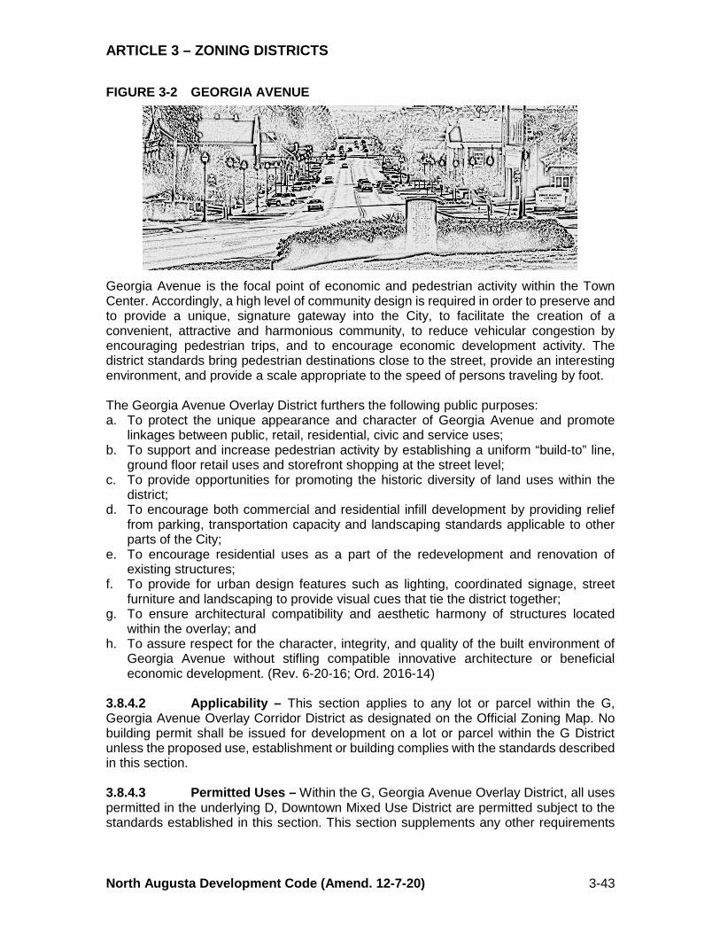
ARTICLE 3 – ZONING DISTRICTS
North Augusta Development Code (Amend. 12-7-20) 3-43
FIGURE 3-2 GEORGIA AVENUE
Georgia Avenue is the focal point of economic and pedestrian activity within the Town Center. Accordingly, a high level of community design is required in order to preserve and to provide a unique, signature gateway into the City, to facilitate the creation of a convenient, attractive and harmonious community, to reduce vehicular congestion by encouraging pedestrian trips, and to encourage economic development activity. The district standards bring pedestrian destinations close to the street, provide an interesting environment, and provide a scale appropriate to the speed of persons traveling by foot. The Georgia Avenue Overlay District furthers the following public purposes: a. To protect the unique appearance and character of Georgia Avenue and promote
linkages between public, retail, residential, civic and service uses; b. To support and increase pedestrian activity by establishing a uniform “build-to” line,
ground floor retail uses and storefront shopping at the street level; c. To provide opportunities for promoting the historic diversity of land uses within the
district; d. To encourage both commercial and residential infill development by providing relief
from parking, transportation capacity and landscaping standards applicable to other parts of the City;
e. To encourage residential uses as a part of the redevelopment and renovation of existing structures;
f. To provide for urban design features such as lighting, coordinated signage, street furniture and landscaping to provide visual cues that tie the district together;
g. To ensure architectural compatibility and aesthetic harmony of structures located within the overlay; and
h. To assure respect for the character, integrity, and quality of the built environment of Georgia Avenue without stifling compatible innovative architecture or beneficial economic development. (Rev. 6-20-16; Ord. 2016-14)
3.8.4.2 Applicability – This section applies to any lot or parcel within the G, Georgia Avenue Overlay Corridor District as designated on the Official Zoning Map. No building permit shall be issued for development on a lot or parcel within the G District unless the proposed use, establishment or building complies with the standards described in this section. 3.8.4.3 Permitted Uses – Within the G, Georgia Avenue Overlay District, all uses permitted in the underlying D, Downtown Mixed Use District are permitted subject to the standards established in this section. This section supplements any other requirements
ARTICLE 3 – ZONING DISTRICTS
North Augusta Development Code (Amend. 12-7-20) 3-44
of this Chapter, including any regulations or permissions relating to use, density or design established in the D, Downtown Mixed Use District. In order to promote pedestrian activity and to avoid the impacts of traffic crossing sidewalks, all uses and buildings shall conform to the following: All residential uses listed in Table 3-2, Use Matrix, for the D, Downtown Mixed Use District are permitted in the overlay district. a. The first floor (street level) of any multistory commercial building shall be devoted to
retail, commercial and service uses, as listed below. Such buildings shall include said uses along not less than fifty percent (50%) of their street frontage.
1. Convenience Retail 6. General Business Services 2. Food Stores, Bakery Shops 7. Personal Service Establishments 3. Museums, Art Galleries 8. Primary Retail Establishments 4. Restaurants, Bars, Ice Cream Parlors 9. Secondary Retail Establishments 5. Professional Office Uses 10. Movie Theaters
b. Residential dwellings shall be permitted above the first floor of any building with commercial and/or retail uses on the first floor.
c. No new auto oriented uses including auto repair, gasoline service stations and drive through uses will be allowed. Such existing uses are permitted and will be allowed to continue. No such nonconforming use shall be resumed if it has been abandoned for a continuous period of sixteen (16) months.
d. For purposes of this section, “abandon” or “abandonment” means discontinuance of the nonconforming use regardless of the property owner’s intent to relinquish the right to so use the property. A nonconforming use is considered abandoned when:
e. It has been intentionally discontinued, remains idle or unused; f. Necessary utilities, such as water, sewer or electricity have been discontinued for any
reason including a failure to pay fees, rates or other required charges lawfully established by the service provider; or
g. The principal buildings or structures are no longer actively occupied. h. Uses containing drive throughs will be allowed if the Director deems appropriate traffic
controls are installed. (Rev. 5-21-12; Ord. 2012-08) (Rev. 6-20-16; Ord. 2016-14) 3.8.4.4 Development Standards – Buildings that line Georgia Avenue should be located and designed so that they provide visual interest and create enjoyable, human-scale spaces. Key objectives include: a. Buildings should be designed to be compatible, in form and proportion, with the
traditional and historic pattern of development on the street. b. Buildings or groups of buildings should include a variety of forms, materials and colors,
while maintaining a unified appearance. c. Buildings should include a richness of architectural detail to help define their scale. d. Buildings should extend to the back of the sidewalk to create a uniform blockface. 3.8.4.4.1 Setbacks – Building facades shall comply with the following setback standards. Corner lots are deemed to have two (2) frontages and shall conform to the setback requirements for both facades. 3.8.4.4.1.1 Front Setback – Buildings shall be setback a minimum of zero (0) feet and a maximum of five (5) feet from the edge of the right of way. The maximum setback does not apply to the following elements: a. Any area not to exceed fifty percent (50%) or forty (40) lineal feet of frontage,
whichever is less, included within a courtyard; and
ARTICLE 3 – ZONING DISTRICTS
North Augusta Development Code (Amend. 12-7-20) 3-45
b. Any recessed entryway or outdoor dining area. c. No new doors shall swing into the minimum setback, except for emergency exit doors. d. Pedestrian areas, including plazas, street arcades, courtyards, and outdoor cafes may
be permitted within the sidewalk portion of the public right of way subject to any required encroachment permits or agreements from the city or the South Carolina Department of Transportation. Such areas shall be setback a minimum of five (5) feet from the back of the curb and are subject to the provisions of §§4.32 and 4.33.
3.8.4.4.1.2 Side Setbacks – Buildings shall be setback zero (0) feet from the side property line, except however that the setback may be between five (5) feet and ten (10) feet from the side lot line in order to accommodate a passageway between the street and the alley or a side entrance or a joint courtyard or plaza with an adjacent property. In no event will the side setback be between zero (0) feet and five (5) feet or more than ten (10) feet. 3.8.4.4.1.3 Rear Setbacks – Buildings shall be setback a minimum of three (3) feet from the rear property line. However, if parking, loading or vehicular access is provided to the rear of the principal structure, the minimum setback shall be ten (10) feet. Accessory buildings, including those on service lanes, shall be set back a minimum of three (3) feet from the rear property line. 3.8.4.4.2 Frontage – There is no minimum or maximum frontage established in these standards. However, buildings with large frontages are required to modulate their facades pursuant to §3.8.4.4.4.3.3. (Rev. 6-20-16; Ord. 2016-14) 3.8.4.4.3 Maximum and Minimum Height – The maximum height shall be as provided for the D, Downtown Mixed Use District in Table 3-3, Dimensional Standards. The minimum height shall be eighteen (18) feet above the elevation of the sidewalk along the entire frontage. (Rev. 6-20-16; Ord. 2016-14) 3.8.4.4.4 Building Design – 3.8.4.4.4.1 Orientation – Buildings shall be oriented to the street. A building is oriented to the street where: a. The setback standards established in §3.8.4.4.1, are met. b. Entrances to buildings face a street or open to a square, plaza, or sidewalk. c. At least one entrance shall be provided to each street frontage. d. All street level uses with sidewalk frontage are furnished with an individual entrance
and direct access to the sidewalk in addition to any other access that may be provided. e. Off-street parking does not lie between the building’s principal entrance and the street. f. Pedestrian access from the public sidewalk, street right of way, or driveway to the
principal structure is provided on a hard surface. (Rev. 6-20-16; Ord. 2016-14) 3.8.4.4.4.2 Grade – Buildings shall be aligned with the finished grade of the street except as otherwise provided herein. The principal entry for a civic use or a civic building may include a stoop, portico, colonnade or a portal.
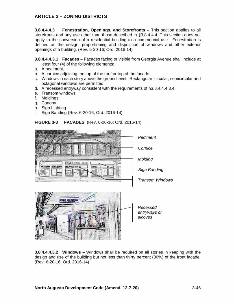
ARTICLE 3 – ZONING DISTRICTS
North Augusta Development Code (Amend. 12-7-20) 3-46
3.8.4.4.4.3 Fenestration, Openings, and Storefronts – This section applies to all storefronts and any use other than those described in §3.8.4.4.4. This section does not apply to the conversion of a residential building to a commercial use. Fenestration is defined as the design, proportioning and disposition of windows and other exterior openings of a building. (Rev. 6-20-16; Ord. 2016-14) 3.8.4.4.4.3.1 Facades – Facades facing or visible from Georgia Avenue shall include at
least four (4) of the following elements: a. A pediment. b. A cornice adjoining the top of the roof or top of the facade. c. Windows in each story above the ground level. Rectangular, circular, semicircular and
octagonal windows are permitted. d. A recessed entryway consistent with the requirements of §3.8.4.4.4.3.4. e. Transom windows f. Moldings g. Canopy h. Sign Lighting i. Sign Banding (Rev. 6-20-16; Ord. 2016-14) FIGURE 3-3 FACADES (Rev. 6-20-16; Ord. 2016-14)
3.8.4.4.4.3.2 Windows – Windows shall be required on all stories in keeping with the design and use of the building but not less than thirty percent (30%) of the front facade. (Rev. 6-20-16; Ord. 2016-14)
Pediment
Cornice
Molding
Transom Windows
Recessed entryways or alcoves
Sign Banding
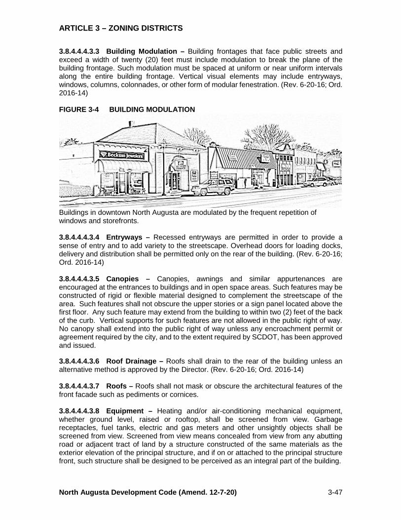
ARTICLE 3 – ZONING DISTRICTS
North Augusta Development Code (Amend. 12-7-20) 3-47
3.8.4.4.4.3.3 Building Modulation – Building frontages that face public streets and exceed a width of twenty (20) feet must include modulation to break the plane of the building frontage. Such modulation must be spaced at uniform or near uniform intervals along the entire building frontage. Vertical visual elements may include entryways, windows, columns, colonnades, or other form of modular fenestration. (Rev. 6-20-16; Ord. 2016-14) FIGURE 3-4 BUILDING MODULATION
Buildings in downtown North Augusta are modulated by the frequent repetition of windows and storefronts. 3.8.4.4.4.3.4 Entryways – Recessed entryways are permitted in order to provide a sense of entry and to add variety to the streetscape. Overhead doors for loading docks, delivery and distribution shall be permitted only on the rear of the building. (Rev. 6-20-16; Ord. 2016-14) 3.8.4.4.4.3.5 Canopies – Canopies, awnings and similar appurtenances are encouraged at the entrances to buildings and in open space areas. Such features may be constructed of rigid or flexible material designed to complement the streetscape of the area. Such features shall not obscure the upper stories or a sign panel located above the first floor. Any such feature may extend from the building to within two (2) feet of the back of the curb. Vertical supports for such features are not allowed in the public right of way. No canopy shall extend into the public right of way unless any encroachment permit or agreement required by the city, and to the extent required by SCDOT, has been approved and issued. 3.8.4.4.4.3.6 Roof Drainage – Roofs shall drain to the rear of the building unless an alternative method is approved by the Director. (Rev. 6-20-16; Ord. 2016-14) 3.8.4.4.4.3.7 Roofs – Roofs shall not mask or obscure the architectural features of the front facade such as pediments or cornices. 3.8.4.4.4.3.8 Equipment – Heating and/or air-conditioning mechanical equipment, whether ground level, raised or rooftop, shall be screened from view. Garbage receptacles, fuel tanks, electric and gas meters and other unsightly objects shall be screened from view. Screened from view means concealed from view from any abutting road or adjacent tract of land by a structure constructed of the same materials as the exterior elevation of the principal structure, and if on or attached to the principal structure front, such structure shall be designed to be perceived as an integral part of the building.

ARTICLE 3 – ZONING DISTRICTS
North Augusta Development Code (Amend. 12-7-20) 3-48
3.8.4.4.4.3.9 Wall Materials – Hard surfaced exterior wall materials permitted for downtown buildings include brick, limestone, architectural split-face concrete blocks, parged block, painted brick, stone, terra cotta, stucco, plaster, fiber cementious board siding and drainage-backed Exterior Insulation Finishing Systems (EIFS). The use of EIFS is limited to the area eight (8) feet or more above the adjacent grade, except as decorative elements around doors and windows. Vinyl, wood, plastic, metal, structural or unfinished concrete, painted concrete blocks, and tinted or reflective glass are not permitted as the primary exterior finish surface. However, vinyl, wood, plastic, or glass block may be used as accent elements surrounding a doorway or window. (Rev. 6-20-16; Ord. 2016-14) 3.8.4.4.4.3.10 Number of Materials – Not more than three (3) materials may be used on the exterior front facade (excluding windows, doorways and awnings). 3.8.4.4.4.3.11 Window Frames – Window frames should be metal, wood or vinyl, and must be painted or vinyl clad. 3.8.4.4.4.3.12 Doors – Doors may be solid or hollow core metal, aluminum, fiberglass or wood, and may be either solid or have glass or louvers. Glass in any door shall be transparent or leaded glass. Doorframes may be metal or wood, and must be painted or stained. Solid doors shall have raised panels and/or louvers. 3.8.4.4.4.4 Canopies, Arcades and Awnings for Civic Buildings and Uses – Canopies, arcades, awnings, and similar appurtenances may be constructed over the entrance to any building, and/or over windows subject to the criteria established in §3.8.4.4.4.3.5. 3.8.4.5. Outdoor Display and Sale – Goods shall not be displayed or stored on the exterior of the building except under a porch roof, eave or overhang permanently affixed to the building. Outdoor displays shall not restrict free pedestrian movement and a walkway of not less than five (5) feet wide shall be maintained between the doorway(s), exit(s) and the public sidewalk. Exterior merchandise displays are not permitted on the right of way, front or side yards, open porches or other outside areas except for forty-eight (48) hours during permitted special events for no longer than forty-eight (48) hours. Longer term or permanent exterior merchandise displays may be permitted if the outdoor display or sale, or both, is conditionally approved pursuant to §4.34. (Rev. 2-4-20; Ord 2020-01) 3.8.4.6 Utilities and Trash Receptacles – 3.8.4.6.1 Utility Structures – All new transformer vaults, utility structures, utility service meters, air vents, backflow preventers and any other similar devices, including these facilities when located below grade, must be located behind the front setback or the front facade, whichever is furthest from the front property line. In the event such facilities cannot physically be located in conformance with this section they must be adequately screened to minimize the visual impact. 3.8.4.6.2 Dumpsters and Roll Carts – Trash receptacles including dumpsters and roll carts and utility equipment shall be either located in an alley, or screened so as not to be visible from the public right of way.
ARTICLE 3 – ZONING DISTRICTS
North Augusta Development Code (Amend. 12-7-20) 3-49
3.8.4.7 Off-Street Parking – 3.8.4.7.1 Principal Use – Parking is not permitted as a principal use. 3.8.4.7.2 Amount Required – No off-street parking is required for any use. 3.8.4.7.3 Location – No off-street parking shall be permitted between a principal structure and any street. No surface parking area shall adjoin Georgia Avenue. All off-street parking shall be located in the rear of buildings. 3.8.4.7.4 Landscaping – Surface parking areas, including but not limited to all parking for parcels and buildings fronting on Georgia Avenue, are subject to the landscaping standards in this section and the requirements of Article 10, Landscaping. 3.8.4.7.5 Screening – Parking areas shall be screened along any road or street right of way with a permanent wall, fence or vegetative screen between thirty (30) and forty-eight (48) inches in height. This subsection does not apply to alley rights of way, structured parking areas, or parking areas that are screened from the view of public streets by buildings. 3.8.4.7.6 Setbacks – Parking shall be set back at least five (5) feet from a property line provided, however, that if the parking lot abuts an alley, no setback is required unless a front or side yard of a residentially used property is located across the alley from the parking lot. 3.8.4.7.7 Loading – Loading/unloading areas shall be located only in the rear of a building or in a side yard behind the front facade of the building. Loading areas shall be screened in the same manner as parking areas. 3.8.4.7.8 Surface Treatment – Parking areas shall have a paved or other approved hard surface. Ground surface areas not covered with a paved or other approved hard surface shall be restricted from parking by signage and curbing, fencing, or other physical barriers. 3.8.4.7.9 Access – Driveways and access points to public and private parking lots,
loading areas and service areas shall adhere to the following: a. The Director and City Engineer must approve all driveways, access points and curb
cuts from any public right of way. b. Driveways providing ingress and egress onto side streets and alleys are preferred.
Existing or newly created alleys from a side street are the preferred access drive to parking areas. Only one (1) access point to a parking, loading or service area (other than an alley) shall be permitted per block face from any side street adjoining Georgia Avenue. There is no limit on the number of openings or access points from an alley and alleys may function as parking area drive aisles.
c. No driveway or access point shall exceed twenty (20) feet in width. d. Separation of driveways or access points from an alley, if permitted, shall be no less
than twenty-four (24) feet. e. No driveway or access point from any public right of way that reduces on-street parking
shall be permitted except for parking areas that are available for use by the general public. (Rev. 6-20-16; Ord. 2016-14)
ARTICLE 3 – ZONING DISTRICTS
North Augusta Development Code (Amend. 12-7-20) 3-50
3.8.4.8 Landscaping – North Augusta’s traditional downtown is characterized by buildings arranged on small lots with buildings typically consuming the entire street frontage at or very close to the property line. Parcels developed or redeveloped with structures or uses that do not consume the entire street frontage or are set back, such as parking, whether landscaped or not, can create undesirable appearances. Accordingly, no landscaping is required for lots or parcels abutting Georgia Avenue except as provided in this section. 3.8.4.8.1 Setbacks – Existing buildings that are set back further than three (3) feet from the front or side property line shall provide a buffer strip along the front or side lot line of the setback area consistent with the landscaping standards contained in Article 10, Landscaping. The buffer strip shall be the full width of the setback for setbacks of less than five (5) feet in width, and a full five (5) feet for setbacks exceeding five (5) feet in width. 3.8.4.8.2 Unpaved Areas – All lot areas not covered by buildings, hard surfaces including entryways, pedestrian plaza areas or paved surfaces shall be landscaped. 3.8.4.8.3 Street Trees and Plantings – One (1) street tree shall be planted for every forty (40) feet of street (Georgia Avenue or side street) frontage unless existing trees are in place that meet this standard. At planting, each tree must have a minimum height of six (6) feet and a three (3) inch caliper. Required trees and plantings shall be planted on the right of way or in the setback as determined by the Director and Director of Public Works. 3.8.4.8.4 Parking Lot Landscaping – A minimum of one (1) medium or large shade tree shall be planted for every ten (10) parking spaces. Trees shall be located in islands interspersed throughout the parking lot. At planting, each tree must have a minimum height of six (6) feet and a two (2) inch caliper. Parking lot islands shall cover an area of not less than one hundred twenty-five (125) square feet with no dimension less than nine (9) feet. Comment: The City Code provides in §19-18, Damaging trees, shrubs, etc., along streets: Except as otherwise provided, it shall be unlawful for any person to cut, break, mutilate, deface or in any manner destroy or damage any tree, flower, vine, plant or shrub, or any boxing, pot or other thing provided for the protection thereof in or upon any street, alley, square or sidewalk in the city. 3.8.4.9 Lighting – Lighting shall be installed above front entrances to buildings. Lighting sources shall provide a minimum of 0.5 foot-candles at the building entrance. All lighting shall be directed on-site or onto adjacent walkways and shall be shielded from direct off-site viewing.
ARTICLE 3 – ZONING DISTRICTS
North Augusta Development Code (Amend. 12-7-20) 3-51
3.8.5 HC, Highway Corridor Overlay District 3.8.5.1 Purpose – The purpose of the Highway Corridor Overlay District is to promote development that is compatible with the function, capacity and design of major arterial roadways and remains sensitive to abutting properties. Another purpose of the Highway Corridor Overlay District is to augment dimensional and access management standards and establish design standards for commercial and mixed use development within corridors that are predominantly classified as arterial. The permitted uses, dimensional standards and site development standards for the Highway Corridor Overlay District are the same as the underlying base district unless a different standard is established in this section. 3.8.5.2 Permitted Uses – Uses permitted in the Highway Corridor Overlay District are provided in Table 3-2, Use Matrix, for the underlying base district. (Rev. 12-1-08; Ord 2008-18) 3.8.5.3 Dimensional Standards – 3.8.5.3.1 The dimensional standards for the Highway Corridor Overlay District are established in Table 3-9. TABLE 3-9 DIMENSIONAL STANDARDS FOR THE HIGHWAY CORRIDOR
OVERLAY DISTRICT (Rev. 12-1-08; Ord. 2008-18) A B
1. Maximum Height 70 feet 2. Minimum Height 14 feet 3. Minimum Front Setback 5 feet or 30 feet 4. Maximum Front Setback 90 feet 5. Minimum Side Setback Required buffer, 0 feet or 10 feet 6. Minimum Rear Setback Required buffer, 20 feet or 10 feet from an alley 7. Maximum Floor Area Ratio 3.0 8. Minimum Frontage Buildout 30%
3.8.5.3.2 Minimum frontage buildout means the portion of the corridor street frontage of the parcel or parcels included in the development that is occupied by a principal structure at the front setback line. (Example: A parcel that is 200 feet in length requires a building or combination of buildings that total no less than 60 (sixty) feet in length and is set back from the street the minimum setback, either 5 (five) feet or 30 (thirty) feet, but not more than the maximum set back of 90 (ninety) feet.) (Rev. 12-1-08; Ord. 2008-18) 3.8.5.3.3 Where an existing building is located on a parcel and the site development plan includes the utilization of the existing building as a principal structure, the existing setback may be provided. The front setback landscaping requirements specified in this section shall be applied for the provision that most closely matches the existing setback. 3.8.5.3.4 Where a parcel in the Highway Corridor is a through lot that fronts on two Highway Corridor streets, the maximum front setback and minimum frontage buildout shall be applicable to only one frontage. Both the maximum front setback and minimum frontage build out criteria shall be applied to the same frontage. (Adopt. 12-1-08; Ord. 2008-18)
ARTICLE 3 – ZONING DISTRICTS
North Augusta Development Code (Amend. 12-7-20) 3-52
3.8.5.3.5 Gasoline service stations with pump islands perpendicular to the edge of right of way shall maintain a setback of not less than thirty-five (35) feet between the pump islands and right of way. 3.8.5.4 Access – 3.8.5.4.1 Purpose – This section is designed to improve the efficiency of traffic flows and to avoid traffic accidents and unsafe traffic conditions by minimizing and optimizing the use of curb cuts along corridor streets. 3.8.5.4.2 Generally – New curb cuts and access points on corridor streets are subject to the requirements of this section and Article 14, Streets. In the event of a conflict between the provisions of this section and Article 14, Streets, the more restrictive shall apply. 3.8.5.4.3 Number of Access Points – Access points are permitted from public streets as provided herein. a. No more than one (1) curb cut is permitted for any lot or parcel on any corridor street,
except as provided in sections (b.) and (c.); b. More than one (1) curb cut is permitted if the requirements of sections (1.) and (2.)
are satisfied. 1. The proposed development has frontage on more than one (1) public street. 2. The need for additional curb cuts is demonstrated in a traffic impact analysis (TIA)
approved pursuant to Article 14, Streets. The applicant must demonstrate that additional access points will not cause a reduction in the LOS including any mitigation agreed to by the applicant and attached as a condition of approval.
c. If two (2) or more parcels existing as of the effective date of this Chapter are placed under common ownership and/or control, the parcel assembly may be granted additional access points if: 1. Only one (1) direct access point is permitted for the corridor street; and 2. The additional access points are created for new streets or maintained for existing
streets internal to the boundaries of the overall development plan. d. One (1) additional right-in/right-out access point is permitted on the corridor street
where a center median exists or is included in a capital improvements program, or a similar barrier to access from more than one (1) direction exists.
3.8.5.4.4 Indirect Access – Access shall be provided to lots or outparcels internal
to a development that are not permitted direct access to a corridor road: a. The internal circulation of a shopping center, office complex, or similar group of
buildings having direct access in accordance with an approved TIA; or b. Use of shared entrances with those established or likely to be required on adjacent
sites. 3.8.5.4.5 Access Spacing on Public Streets – a. Access points from a public road or street shall not be located closer to an existing or
proposed intersection than one hundred fifty (150) feet or the property line, whichever is greater.
b. Access points must be located on side streets, an alley or a joint parking area that connects to a side street, if available.
c. The minimum and maximum access widths measured from face of curb to face of curb shall be as follows:
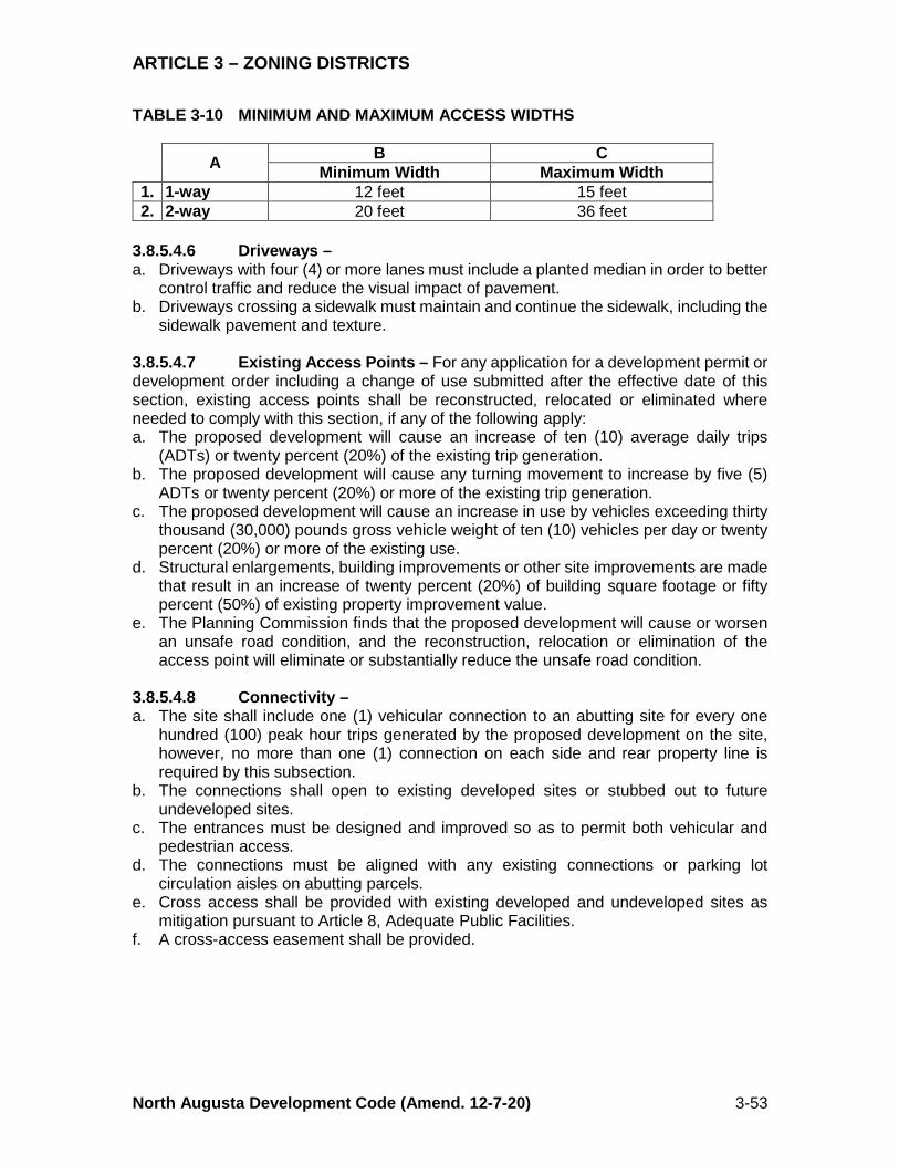
ARTICLE 3 – ZONING DISTRICTS
North Augusta Development Code (Amend. 12-7-20) 3-53
TABLE 3-10 MINIMUM AND MAXIMUM ACCESS WIDTHS
A B C Minimum Width Maximum Width
1. 1-way 12 feet 15 feet 2. 2-way 20 feet 36 feet
3.8.5.4.6 Driveways – a. Driveways with four (4) or more lanes must include a planted median in order to better
control traffic and reduce the visual impact of pavement. b. Driveways crossing a sidewalk must maintain and continue the sidewalk, including the
sidewalk pavement and texture. 3.8.5.4.7 Existing Access Points – For any application for a development permit or development order including a change of use submitted after the effective date of this section, existing access points shall be reconstructed, relocated or eliminated where needed to comply with this section, if any of the following apply: a. The proposed development will cause an increase of ten (10) average daily trips
(ADTs) or twenty percent (20%) of the existing trip generation. b. The proposed development will cause any turning movement to increase by five (5)
ADTs or twenty percent (20%) or more of the existing trip generation. c. The proposed development will cause an increase in use by vehicles exceeding thirty
thousand (30,000) pounds gross vehicle weight of ten (10) vehicles per day or twenty percent (20%) or more of the existing use.
d. Structural enlargements, building improvements or other site improvements are made that result in an increase of twenty percent (20%) of building square footage or fifty percent (50%) of existing property improvement value.
e. The Planning Commission finds that the proposed development will cause or worsen an unsafe road condition, and the reconstruction, relocation or elimination of the access point will eliminate or substantially reduce the unsafe road condition.
3.8.5.4.8 Connectivity – a. The site shall include one (1) vehicular connection to an abutting site for every one
hundred (100) peak hour trips generated by the proposed development on the site, however, no more than one (1) connection on each side and rear property line is required by this subsection.
b. The connections shall open to existing developed sites or stubbed out to future undeveloped sites.
c. The entrances must be designed and improved so as to permit both vehicular and pedestrian access.
d. The connections must be aligned with any existing connections or parking lot circulation aisles on abutting parcels.
e. Cross access shall be provided with existing developed and undeveloped sites as mitigation pursuant to Article 8, Adequate Public Facilities.
f. A cross-access easement shall be provided.
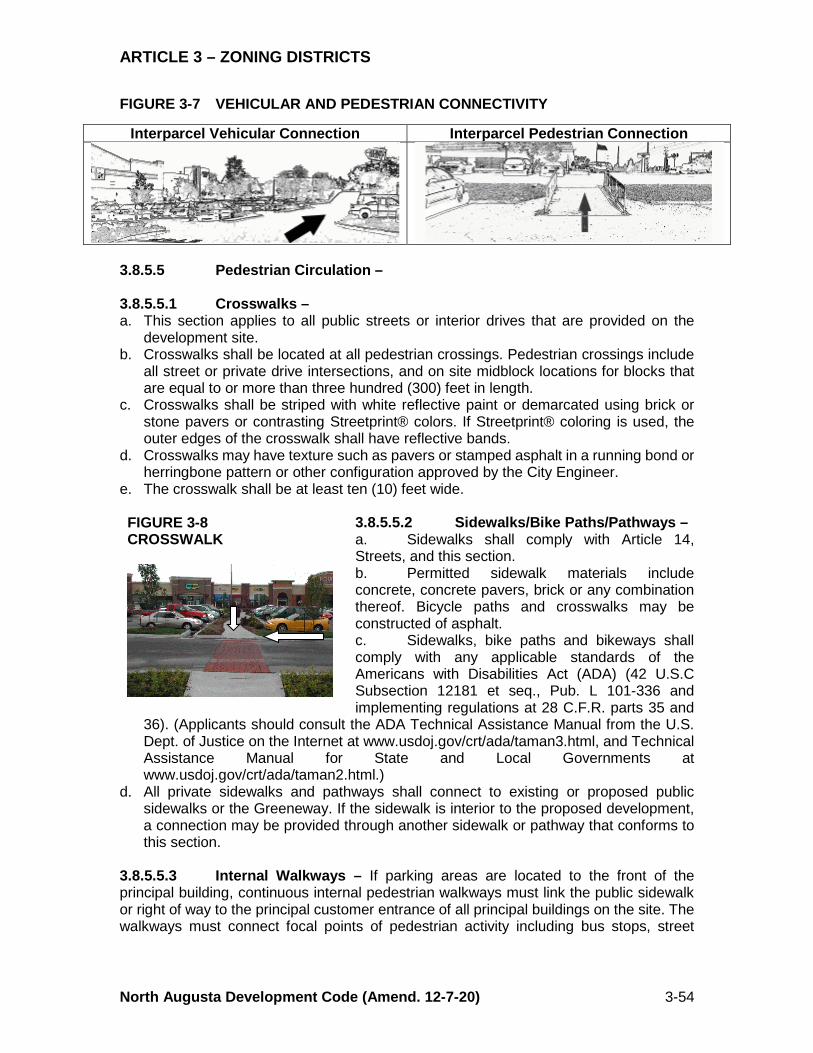
ARTICLE 3 – ZONING DISTRICTS
North Augusta Development Code (Amend. 12-7-20) 3-54
FIGURE 3-7 VEHICULAR AND PEDESTRIAN CONNECTIVITY
3.8.5.5 Pedestrian Circulation – 3.8.5.5.1 Crosswalks – a. This section applies to all public streets or interior drives that are provided on the
development site. b. Crosswalks shall be located at all pedestrian crossings. Pedestrian crossings include
all street or private drive intersections, and on site midblock locations for blocks that are equal to or more than three hundred (300) feet in length.
c. Crosswalks shall be striped with white reflective paint or demarcated using brick or stone pavers or contrasting Streetprint® colors. If Streetprint® coloring is used, the outer edges of the crosswalk shall have reflective bands.
d. Crosswalks may have texture such as pavers or stamped asphalt in a running bond or herringbone pattern or other configuration approved by the City Engineer.
e. The crosswalk shall be at least ten (10) feet wide.
3.8.5.5.2 Sidewalks/Bike Paths/Pathways – a. Sidewalks shall comply with Article 14, Streets, and this section. b. Permitted sidewalk materials include concrete, concrete pavers, brick or any combination thereof. Bicycle paths and crosswalks may be constructed of asphalt. c. Sidewalks, bike paths and bikeways shall comply with any applicable standards of the Americans with Disabilities Act (ADA) (42 U.S.C Subsection 12181 et seq., Pub. L 101-336 and implementing regulations at 28 C.F.R. parts 35 and
36). (Applicants should consult the ADA Technical Assistance Manual from the U.S. Dept. of Justice on the Internet at www.usdoj.gov/crt/ada/taman3.html, and Technical Assistance Manual for State and Local Governments at www.usdoj.gov/crt/ada/taman2.html.)
d. All private sidewalks and pathways shall connect to existing or proposed public sidewalks or the Greeneway. If the sidewalk is interior to the proposed development, a connection may be provided through another sidewalk or pathway that conforms to this section.
3.8.5.5.3 Internal Walkways – If parking areas are located to the front of the principal building, continuous internal pedestrian walkways must link the public sidewalk or right of way to the principal customer entrance of all principal buildings on the site. The walkways must connect focal points of pedestrian activity including bus stops, street
Interparcel Vehicular Connection Interparcel Pedestrian Connection
FIGURE 3-8 CROSSWALK
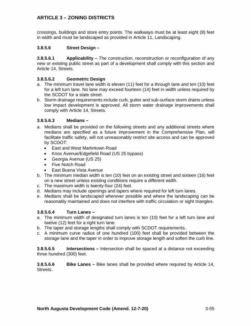
ARTICLE 3 – ZONING DISTRICTS
North Augusta Development Code (Amend. 12-7-20) 3-55
crossings, buildings and store entry points. The walkways must be at least eight (8) feet in width and must be landscaped as provided in Article 11, Landscaping. 3.8.5.6 Street Design – 3.8.5.6.1 Applicability – The construction, reconstruction or reconfiguration of any new or existing public street as part of a development shall comply with this section and Article 14, Streets. 3.8.5.6.2 Geometric Design a. The minimum travel lane width is eleven (11) feet for a through lane and ten (10) feet
for a left turn lane. No lane may exceed fourteen (14) feet in width unless required by the SCDOT for a state street.
b. Storm drainage requirements include curb, gutter and sub-surface storm drains unless low impact development is approved. All storm water drainage improvements shall comply with Article 14, Streets.
3.8.5.6.3 Medians – a. Medians shall be provided on the following streets and any additional streets where
medians are specified as a future improvement in the Comprehensive Plan, will facilitate traffic safety, will not unreasonably restrict site access and can be approved by SCDOT: • East and West Martintown Road • Knox Avenue/Edgefield Road (US 25 bypass) • Georgia Avenue (US 25) • Five Notch Road • East Buena Vista Avenue
b. The minimum median width is ten (10) feet on an existing street and sixteen (16) feet on a new street unless existing conditions require a different width.
c. The maximum width is twenty-four (24) feet. d. Medians may include openings and tapers where required for left turn lanes. e. Medians shall be landscaped wherever possible and where the landscaping can be
reasonably maintained and does not interfere with traffic circulation or sight triangles. 3.8.5.6.4 Turn Lanes – a. The minimum width of designated turn lanes is ten (10) feet for a left turn lane and
twelve (12) feet for a right turn lane. b. The taper and storage lengths shall comply with SCDOT requirements. c. A minimum curve radius of one hundred (100) feet shall be provided between the
storage lane and the taper in order to improve storage length and soften the curb line. 3.8.5.6.5 Intersections – Intersection shall be spaced at a distance not exceeding three hundred (300) feet. 3.8.5.6.6 Bike Lanes – Bike lanes shall be provided where required by Article 14, Streets.
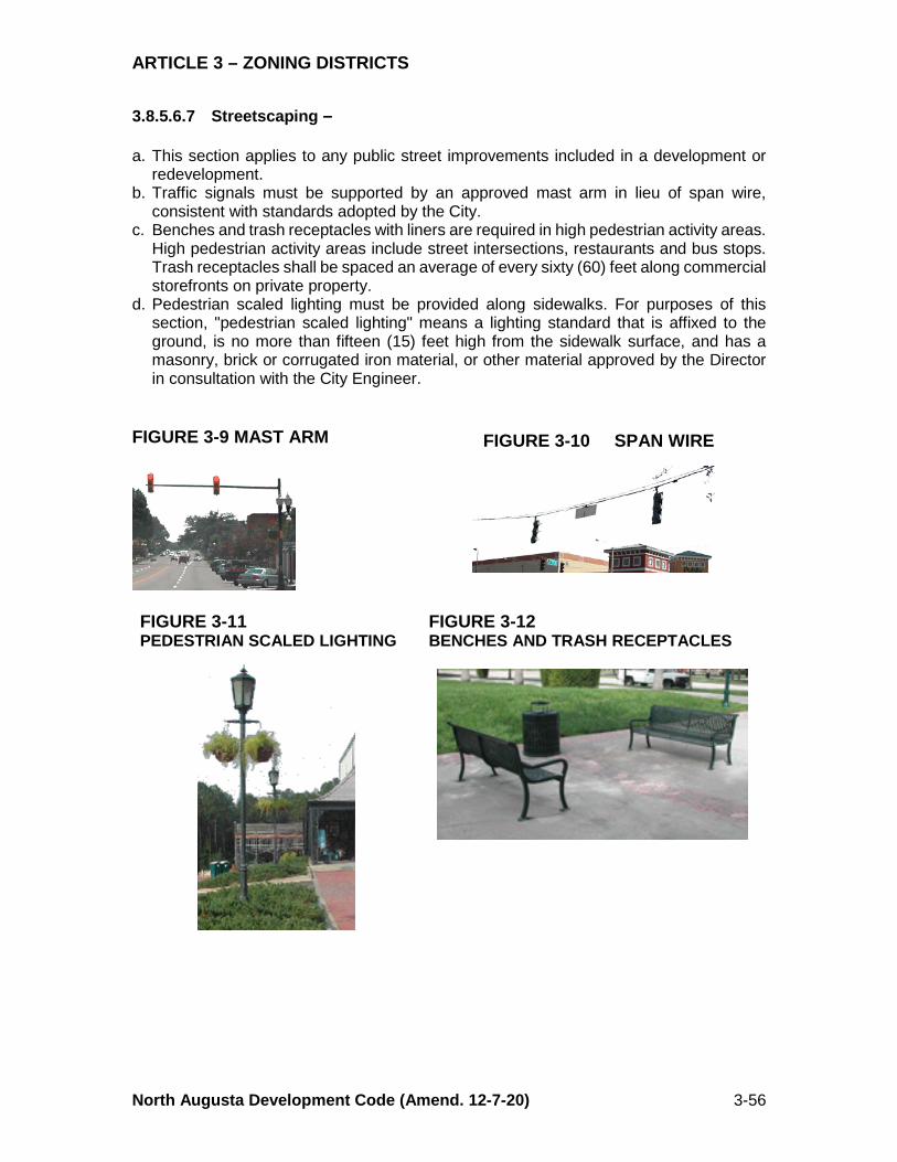
ARTICLE 3 – ZONING DISTRICTS
North Augusta Development Code (Amend. 12-7-20) 3-56
3.8.5.6.7 Streetscaping –
a. This section applies to any public street improvements included in a development or redevelopment.
b. Traffic signals must be supported by an approved mast arm in lieu of span wire, consistent with standards adopted by the City.
c. Benches and trash receptacles with liners are required in high pedestrian activity areas. High pedestrian activity areas include street intersections, restaurants and bus stops. Trash receptacles shall be spaced an average of every sixty (60) feet along commercial storefronts on private property.
d. Pedestrian scaled lighting must be provided along sidewalks. For purposes of this section, "pedestrian scaled lighting" means a lighting standard that is affixed to the ground, is no more than fifteen (15) feet high from the sidewalk surface, and has a masonry, brick or corrugated iron material, or other material approved by the Director in consultation with the City Engineer.
FIGURE 3-9 MAST ARM
FIGURE 3-11 PEDESTRIAN SCALED LIGHTING
FIGURE 3-12 BENCHES AND TRASH RECEPTACLES
FIGURE 3-10 SPAN WIRE

ARTICLE 3 – ZONING DISTRICTS
North Augusta Development Code (Amend. 12-7-20) 3-57
3.8.5.7 Stormwater Management – a. Detention and retention ponds shall be screened from view at the street right of way
by five (5) gallon evergreen shrubs and vines that will, at maturity, block at least fifty percent (50%) of the view of the detention pond and fencing from the property line.
b. Detention and retention ponds shall be located to the side or rear of the principal buildings whenever possible.
c. Detention and retention ponds shall not disrupt sidewalks, bikeways or pedestrian paths, or be located so as to require a circuitous route for pedestrian travel.
d. The Director and City Engineer may approve a detention or retention pond in the front setback area if the applicant demonstrates, as part of a site plan application, that the location is required by unique topographical considerations. Ponds located in the front setback or in front of the principal building shall be completely screened by a landscape strip planted in accordance with section (a.), above.
e. The minimum slope and size of detention and retention ponds shall conform to Article 15, Stormwater Management, and the regulations of the SCDHEC (SC ADC §72-307).
f. Fencing consistent with the standards in this section is required when the side slopes of a pond exceed one to one (1:1). Fencing shall be located on the inside slope approximately five (5) feet below the top edge of the pond. Fencing materials shall be a material permitted by this section, or black vinyl clad chain link. Barb wire fencing is prohibited. The minimum fencing height is five (5) feet.
3.8.5.8 Site Elements – 3.8.5.8.1 Retaining Walls – The surface treatment for retaining walls higher than eighteen (18) inches above the finished grade shall be: a. A veneer of brick, stone or synthetic stone; b. Stamped concrete with brick or stone texture; c. Stacked, stamped concrete or textured blocks; or d. An alternative material that achieves the same
finish quality and approved by the Director. 3.8.5.8.2 Fencing – In addition to the fencing provisions contained in §4.3, fences may be constructed of the following materials: a. Black vinyl clad chain link; b. Wood; c. Brick; d. Stone or synthetic stone; e. Wrought iron; and f. Block or stucco that matches an approved facade building material on the principal
structure. 3.8.5.8.3 Loading Areas – All loading areas shall be located no closer to the street than the front wall of the principal structure located closest to the street and shall be screened from view from all street frontages and parking areas.
FIGURE 3-13 TEXTURED BLOCK RETAINING WALL
ARTICLE 3 – ZONING DISTRICTS
North Augusta Development Code (Amend. 12-7-20) 3-58
3.8.5.8.4 Dumpsters – a. Solid waste dumpsters shall be located no closer to the street than the front wall of the
principal structure located closest to the street and shall be screened as provided in this section.
b. Dumpsters shall not encroach on a curb, sidewalk, public right of way or a vehicle sight triangle.
c. The dumpster location shall not require the service vehicle to back up for a distance exceeding ten (10) feet.
d. The area around the dumpster for a distance of twenty-five (25) feet must be clear of low overhead branches, overhangs and utility lines.
e. Dumpsters must be screened from view from all street frontages and parking areas on three (3) sides. Screening can consist of primary buildings, fences, walls or landscaping consistent with the standards required by this Chapter. Screening must be a minimum of six (6) feet in height or a height sufficient to screen the dumpster.
f. A concrete pad and apron is required to prevent the dumpster and the service vehicle from damaging the asphalt pavement. The pad and apron must: 1. Have a level surface; 2. Have a minimum area of ten (10) feet wide and twenty (20) feet deep; 3. Be constructed a minimum of eight (8) inches thick and reinforced with #4
reinforcing bar on twelve (12) inch centers; and 4. Contain a back curb at the rear of the dumpster enclosure. (Rev. 11-2-15; Ord.
2015-17)
3.8.5.8.5 Front Setback Landscaping – a. Landscaping shall be provided on the site and parking areas in accordance with the
provisions of Article 10, Landscaping, and this section. b. If a front setback of five (5) feet is utilized the front setback shall be landscaped to the
standards of a Type A buffer or paved as a widened extension of the public sidewalk. c. If a front setback of thirty (30) feet is utilized the first twenty (20) feet measured from
the property line shall be landscaped to the standards of a Type A buffer. (Rev. 12-1-08; Ord. 2008-18)
d. If the front setback exceeds thirty (30) feet, the first twenty-five (25) feet measured from the property line shall be landscaped to the standards of a Type B buffer.
e. If the front setback exceeds thirty (30) feet and parking or a drive aisle is provided between the front property line and a structure, the first twenty (20) feet measured from the property line shall be landscaped to the standards of a Type D buffer. (Rev. 12-1-08; Ord. 2008-18)
3.8.5.9 Signs – Signs are permitted in accordance with the provisions of Article 13, Signs, for the base zoning district. (Rev. 2-21-11; Ord. 2011-01, Rev. 2-4-20; Ord 2020-01) 3.8.5.10 Building Design and Materials – 3.8.5.10.1 Architectural Plans – Architectural plans of all elevations of proposed structures shall be submitted with a site plan application. Architectural plans shall include relationships to public views and vistas, construction materials, photographs or perspective drawings indicating visual relationships to adjoining properties and spaces.

ARTICLE 3 – ZONING DISTRICTS
North Augusta Development Code (Amend. 12-7-20) 3-59
3.8.5.10.2 Wall Detail and Fenestration – All walls visible from a street, parking area or other public space shall include windows, entryways or other wall details equal to twenty percent (20%) of the wall surface in order to break up large expanses of blank wall surfaces. 3.8.5.10.3 Facade Modulation – Facade modules shall not exceed eighty (80) feet in width and the average of all facade modules on a building may not exceed forty (40) feet. FIGURE 3-14 LARGE BUILDING BROKEN INTO SEPARATE FACADE MODULES
3.8.5.10.4 Permitted Materials – The following building exterior wall materials are permitted: a. Brick b. Split-face concrete block c. Parged block d. Glass block e. Decorative concrete masonry units (CMUs) (i.e. textured, glazed and other special
treatments or materials) f. Stone g. Terra cotta h. Fiber cementious board siding materials i. Traditional (real) stucco or plaster j. Carrera glass k. Windows, window glazing and architectural glass panels l. Architectural metal panels, laminated or otherwise m. Exterior finish wood materials as approved by the Department. (Rev. 2-21-11; Ord.
2011-01) 3.8.5.10.5 Permitted Materials With Limitations – The following building exterior
wall materials are permitted with limitation in the Highway Corridor Overlay District: a. Ceramic tile as an accent on up to ten percent (10%) of the wall area. b. Metal siding applied to single-family detached and attached dwelling units only. c. Vinyl siding for single-family detached and attached dwelling units only. d. Drainage-backed synthetic stucco (Drainage-Backed Exterior Insulation Finishing
System [Drainage-Backed EIFS]) may be applied to any wall surface eight feet or more above the adjacent grade. (Rev. 2-21-11; Ord. 2011-01) (Rev. 5-16-16; Ord. 2016-09)
ARTICLE 3 – ZONING DISTRICTS
North Augusta Development Code (Amend. 12-7-20) 3-60
3.8.6 NP, Neighborhood Preservation Corridor Overlay District 3.8.6.1 Purpose – The Neighborhood Preservation Corridor Overlay District applies to areas of the city that are located on collector and arterial streets and are in transition between traditional residential and commercial uses. Structures in the corridor are predominantly if not exclusively residential in character. Parcel size is relatively small. The underlying zoning in the corridor includes a variety of both commercial and residential districts. The continued residential use of some parcels may not be economically feasible. It is anticipated that conversion of single-family residences to commercial and office establishments will continue. Demolition of existing residential structures is inconsistent with policies expressed in the Comprehensive Plan and contemporary commercial development for new retail uses and office buildings is inappropriate. New high-density residential development is also inappropriate. Alternative uses of existing residential buildings provides a more orderly and reasonable transition for the surrounding neighborhood. With appropriate restrictions, the conversion of houses to office and small personal service uses is suitable and provides for economically feasible uses of parcels in the corridor. This overlay is, therefore, created with an emphasis on preserving the residential character of the corridors, protecting the unique design features and local architecture vernacular, and protecting the property values and health, safety and general welfare of surrounding neighborhoods. The Neighborhood Preservation Corridor Overlay District is established to preserve and protect residential neighborhoods while accommodating some transitional commercial uses at an appropriate scale in locations zoned for commercial uses. It is the intent of the Neighborhood Preservation Overlay Corridor District to maintain the residential appearance of existing structures and the residential setting of any building converted to a nonresidential use so that the converted dwelling will be compatible with neighboring residential property. To maintain residential character, lots shall not be developed or redeveloped solely for the purpose of providing parking. 3.8.6.2 Permitted Uses – Uses permitted in the Neighborhood Preservation Corridor Overlay District are provided in Table 3-2, Use Matrix, for the underlying base district. (Rev. 12-1-08; Ord. 2008-18) 3.8.6.2.1 Permitted nonresidential uses may be located on the first floor only. Upper stories may be used for residential and accessory storage uses only unless allowed by Special Exception. Parking is not permitted as a principal use. (Rev. Ord. 2020-34, 12-7-2020) 3.8.6.2.2 Uses that are not permitted are: a. Drive-in, drive-up and drive-through facilities; b. Indoor or outdoor sales of equipment, motorcycles or automobiles; c. Gasoline sales and automobile service stations; or d. Automobile and motorcycle repair. 3.8.6.2.3 Uses which require a special exception may be granted by the Board of Zoning Appeals with conditions. (Rev. Ord. 2020-34, 12-7-2020) 3.8.6.2.4 No use may be established unless and until it complies with the standards established in this section and other applicable standards contained in this Chapter. 3.8.6.2.5 No existing structure may be demolished until a site plan for the parcel has been approved. If the demolition of an existing structure is anticipated an evaluation of the
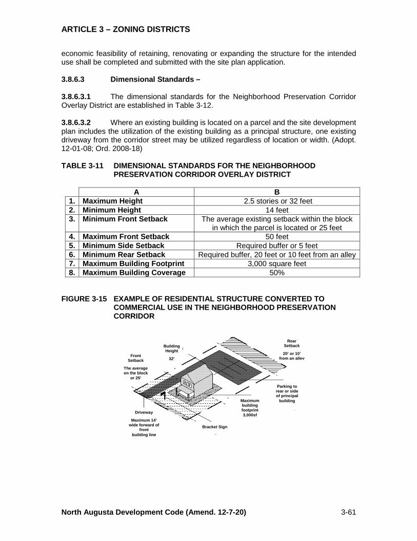
ARTICLE 3 – ZONING DISTRICTS
North Augusta Development Code (Amend. 12-7-20) 3-61
economic feasibility of retaining, renovating or expanding the structure for the intended use shall be completed and submitted with the site plan application. 3.8.6.3 Dimensional Standards – 3.8.6.3.1 The dimensional standards for the Neighborhood Preservation Corridor Overlay District are established in Table 3-12. 3.8.6.3.2 Where an existing building is located on a parcel and the site development plan includes the utilization of the existing building as a principal structure, one existing driveway from the corridor street may be utilized regardless of location or width. (Adopt. 12-01-08; Ord. 2008-18) TABLE 3-11 DIMENSIONAL STANDARDS FOR THE NEIGHBORHOOD
PRESERVATION CORRIDOR OVERLAY DISTRICT
A B 1. Maximum Height 2.5 stories or 32 feet 2. Minimum Height 14 feet 3. Minimum Front Setback The average existing setback within the block
in which the parcel is located or 25 feet 4. Maximum Front Setback 50 feet 5. Minimum Side Setback Required buffer or 5 feet 6. Minimum Rear Setback Required buffer, 20 feet or 10 feet from an alley 7. Maximum Building Footprint 3,000 square feet 8. Maximum Building Coverage 50%
FIGURE 3-15 EXAMPLE OF RESIDENTIAL STRUCTURE CONVERTED TO
COMMERCIAL USE IN THE NEIGHBORHOOD PRESERVATION CORRIDOR
Building Height
32’
Front Setback
The average on the block
or 25’
Rear Setback
20’ or 10’
from an alley
Parking to rear or side of principal
building Maximum building footprint 3,000sf
Bracket Sign
Driveway
Maximum 14’ wide forward of
front building line
ARTICLE 3 – ZONING DISTRICTS
North Augusta Development Code (Amend. 12-7-20) 3-62
3.8.6.4 Building Design – 3.8.6.4.1 Building entrances shall face the corridor street or a park. 3.8.6.4.2 Not less than forty percent (40%) of the front facade of new buildings shall include doors or windows. 3.8.6.4.3 The slope of an existing roof shall be retained in any reconstruction or addition. The slopes of roofs on new buildings shall match the average of the roof pitches on buildings within the block. 3.8.6.4.4 The existing facade facing or visible from the street, including existing doors and windows shall be retained. 3.8.6.5 Access and Parking – 3.8.6.5.1 Not more than one (1) access to a street shall be permitted per lot or parcel. There is no restriction on the number of access points to an alley. 3.8.6.5.2 The maximum driveway width between right of way and the front of any building is fourteen (14) feet. 3.8.6.5.3 Off-street parking shall be provided as set forth in Article 14, Parking. No above-ground structured parking is permitted, except for a residential garage that was constructed as an accessory use to a dwelling prior to its conversion to a non-residential use. 3.8.6.5.4 Parking shall not be permitted between structures and the corridor street. Parking shall be located on the side or in the rear of buildings only. Parking visible from the front shall be screened with a permanent wall, fence or hedge not less than forty-two (42) and no more than sixty (60) inches in height. 3.8.6.5.5 Parking areas shall be setback at least five (5) feet from the property line provided, however, that if the property line abuts an alley, no setback is required unless the alley abuts a front or side yard of a parcel that is zoned residential or in a residential use. 3.8.6.5.6 Parking areas shall be improved with an approved surface pursuant to the provisions of Article 12, Parking. Ground surface areas not covered with an approved surface shall be restricted from parking by signage and curbing, fencing or other physical barriers. 3.8.6.6 Landscaping Requirements – 3.8.6.6.1 Street Trees and Plantings – One (1) street tree shall be planted for every forty (40) feet of frontage on the corridor street in accordance with Article 10, Landscaping, unless existing trees are in place and meet the standard. Required trees and plantings shall be planted between the sidewalk and curb where there is adequate space. In the event there is inadequate space between the sidewalk and curb as determined by the Director, the required trees may be planted behind the sidewalk in the front setback. If

ARTICLE 3 – ZONING DISTRICTS
North Augusta Development Code (Amend. 12-7-20) 3-63
planted in the front setback the general alignment of street trees in the corridor shall be maintained to the extent practicable. Comment: City Code §19-18 provides: Damaging trees, shrubs, etc., along streets. Except as otherwise provided, it shall be unlawful for any person to cut, break, mutilate, deface or in any manner destroy or damage any tree, flower, vine, plant or shrub, or any boxing, pot or other thing provided for the protection thereof in or upon any street, alley, square or sidewalk in the city. 3.8.6.6.2 General Lot Landscaping – See Article 10, Landscaping. 3.8.6.6.3 Parking Lot Landscaping – See Article 10, Landscaping. 3.8.6.7 Lighting – All lighting shall be directed on-site or onto adjacent walkways and shall be shielded from interfering with corridor traffic and direct off-site viewing. 3.8.6.8 Signs – 3.8.6.8.1 Signs are permitted in accordance with the provisions of Article 13, Signs.
(Rev. 2-4-20; Ord 2020-01) 3.8.6.9 Utilities and Trash Receptacles – All trash receptacles and utility equipment shall be located in the side or rear yard. Trash receptacles and utility equipment shall be screened so as not to be visible from the public right of way. 3.8.6.10 Business Operations for Nonresidential Uses – 3.8.6.10.1 Business hours of operation shall be limited to the period from 7:00 a.m. to 9:00 p.m. 3.8.6.10.2 Goods shall not be displayed or stored on the premises in a manner that is visible from the exterior of the building. Merchandise displays are not permitted on the right of way, or in any yard or setback, or on any open porch. Merchandise displays are permitted on covered porches. Window displays shall not exceed ten (10) square feet per display and shall not cumulatively exceed twenty (20) square feet or five percent (5%) of the area of the front facade, whichever is greater. 3.8.7 LMK, Landmark Overlay District (RESERVED)