Embed Size (px)
Citation preview

C hap te r 59: Z o n i n g C o d eM o nt go m e r y C o u nt y, M ar y l an d
6 – 1 16 J u l y 201 2 | D R A F T
Consolidated Review Dra
ARTICLE 59-6. OPTIONAL METHOD REGULATIONSDIV. 6.1. MPDU DEVELOPMENT IN RURAL AND RESIDENTIAL ZONES
SEC. 6.1.1. DEVELOPMENT REQUIREMENTS ....................................................6 - 2
SEC. 6.1.2. DEVELOPMENT ST NDARDS .........................................................6 - 2
SEC. 6.1.3. GENERAL SITE AND BUILDIN T PE MIX.........................................6 - 3
SEC. 6.1.4. DETACHED HOUSE .......................................................................6 - 4
SEC. 6.1.5. DUPLEX ......................................................................................6 - 5
SEC. 6.1.6. TOWNHOUSE ...............................................................................6 - 6
SEC. 6.1.7. APARTMENT/CONDO ....................................................................6 - 7
DIV. 6.2. CLUSTER DEVELOPMENT IN RURAL AND RESIDENTIAL ZONES
SEC. 6.2.1. DEVELOPMENT REQUIREMENTS ....................................................6 - 8
SEC. 6.2.2. DEVELOPMENT STANDARDS .........................................................6 - 8
SEC. 6.2.3. GENERAL SITE, BUILDING TYPE MIX AND HEIGHT STANDARDS.........6 - 9
SEC. 6.2.4. DETACHED HOUSE AND DUPLEX ................................................6 - 10
SEC. 6.2.5. TOWNHOUSE .............................................................................6 - 11
DIV. 6.3. TRANSFERABLE DEVELOPMENT RIGHTS TDR SEC. 6.3.1. DEVELOPMENT REQUIREMENTS...................................................6 - 12
DIV. 6.4. COMMERCIAL/RESIDENTIAL ZONES SEC. 6.4.1. DEVELOPMENT REQUIREMENTS .................................................6 - 15
SEC. 6.4.2. DEVELOPMENT STANDARDS .......................................................6 - 15
DIV. 6.5. EMPLOYMENT ZONES SEC.6.5.1. DEVELOPMENT REQUIREMENTS ...................................................6 - 16
SEC.6.5.2. DEVELOPMENT STANDARDS ........................................................6 - 16
DIV.6.6. OPTIONAL METHOD PUBLIC BENEFITS SEC. 6.6.1 GENERAL PROVISIONS ................................................................6 - 18
SEC. 6.6.2 PUBLIC BENEFIT APPLICABILITY....................................................6 - 18
SEC.6.6.3. PUBLIC BENEFIT DESCRIPTIONS AND CRITERIA ..............................6 - 19
The following Article is part of the Consolidated Draft. Please be advised that it is in draft form; all references to Divisions and Sections have not been cross-checked in this draft. Editor's notes in red text and highlighted in yellow, [Editor's Note], appear throughout the draft to inform the reader of areas that may require additional research and editing.

C hap te r 59: Z o n i n g C o d eM o nt go m e r y C o u nt y, M ar y l an d
6 – 2D R A F T | 16 J u l y 201 2
Consolidated Review Dra
Div. 6.1. MPDU Development in Rural and Residenti al ZonesSec. 6.1.1. In General Where moderately priced dwelling units (MPDUs) are included in a development above the minimum required by Chapter 25A , as amended, this optional method of development is permitted in order to facilitate the construction of those units.
A. Development Approval ProcedureA Site Plan must be submitted under Sec. 8.3.4.
B. MPDU Development Across Diff erent Zones MPDU Optional Method Development may occur across diff erent zones, each of which has provisions for MPDU development, under the following limitations:
1. The variously zoned areas must share a common boundary;
2. Uses and building types are governed by the zone; and
3. Total density and open space must be calculated for each area under Sec. 6.1.2., but must not exceed the maximum density or provide less than the minimum open space if the variously zoned areas were developed indi-vidually; and
4. The allowed number of units and required open space may be distributed across the variously zoned areas.
C. Usable Area The usable area upon which the density of development is calculated is deter-mined by deducting from the gross tract area the following:
1. all land indicated on the master plan of highways as a right-of-way of 100 feet in width or more; and
2. all land within areas within environmental buff ers exceeding 50% of the site.
D. Requirements for MPDU Projects with 20 or Fewer Dwelling Units An applicant who voluntarily provides at least 12.5% MPDUs in a development with 20 or fewer dwelling units may use the optional method development standards of Sec. 6.1.2., except: (1) any perimeter lot that is adjacent, abutting, or confronting one or more existing detached house dwellings must conform to
the dimensional standards under the standard method of development; (2) the MPDU buildings must be similar in size and height to the market rate dwellings in that development; and (3) the maximum percentage of townhouses must not exceed 40% of the total residential dwellings in that development; however, the Planning Board may approve a development in which up to 100% of the units consist of townhouses, if the Planning Board fi nds that the increased use of townhouses is more desirable for environmental reasons and the increased use of townhouses is compatible with adjacent development.

C hap te r 59: Z o n i n g C o d eM o nt go m e r y C o u nt y, M ar y l an d
6 – 3 16 J u l y 201 2 | D R A F T
Consolidated Review Dra
E. Building Types Allowed by ZoneBuilding types are allowed in Optional Method MPDU Development as follows:
DetachedHouse Duplex Townhouse Apartment/Condo
Rural ZonesRural Neighborhood Cluster (RNC) A A A --
Residenti al Detached ZonesResidenti al Estate - 2C (RE-2C) A A A --Residenti al Estate - 1 (RE-1) A A A --Residenti al Low Density - 20 (RLD-20) A A A --Residenti al Medium Density - 9 (RMD-9) A A A --Residenti al Medium Density - 6 (RMD-6) A A A --Residenti al Medium Density - 4 (RMD-4) A A A --
Residenti al Townhouse ZonesTownhouse Low Density (TLD) A A A --Townhouse Medium Density (TMD) A A A --Townhouse High Density (THD) A A A --
Residenti al Multi -Unit ZonesResidenti al High Density - 3 (RHD-3) A A A AResidenti al High Density - 2 (RHD-2) A A A AResidenti al High Density - 1 (RHD-1) A A A AKEY: A = Allowed to accomodate permitted, limited, and conditional uses -- = Not allowed
C hap te r 59: Z o n i n g C o d eM o nt go m e r y C o u nt y, M ar y l an d
6 – 4D R A F T | 16 J u l y 201 2
Consolidated Review Dra
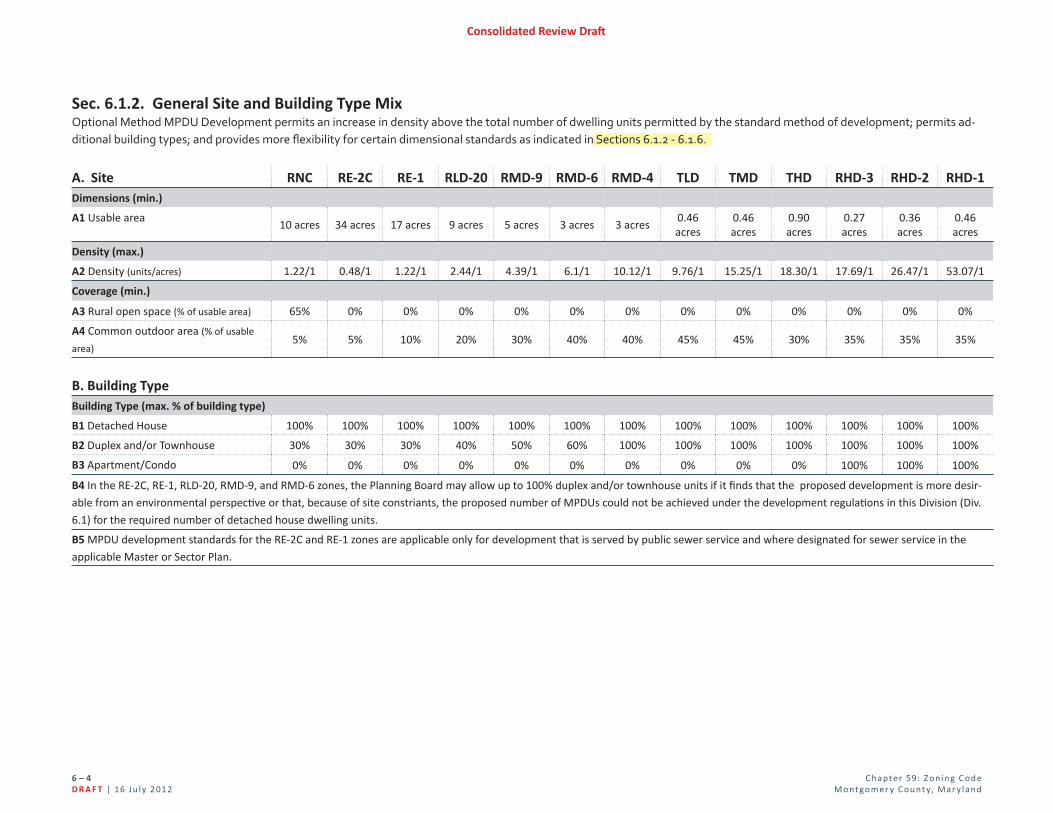
Sec. 6.1.2. General Site and Building Type MixOptional Method MPDU Development permits an increase in density above the total number of dwelling units permitted by the standard method of development; permits ad-ditional building types; and provides more fl exibility for certain dimensional standards as indicated in Sections 6.1.2 - 6.1.6.
A. Site RNC RE-2C RE-1 RLD-20 RMD-9 RMD-6 RMD-4 TLD TMD THD RHD-3 RHD-2 RHD-1Dimensions (min.)
A1 Usable area10 acres 34 acres 17 acres 9 acres 5 acres 3 acres 3 acres
0.46 acres
0.46 acres
0.90 acres
0.27 acres
0.36 acres
0.46 acres
Density (max.)
A2 Density (units/acres) 1.22/1 0.48/1 1.22/1 2.44/1 4.39/1 6.1/1 10.12/1 9.76/1 15.25/1 18.30/1 17.69/1 26.47/1 53.07/1
Coverage (min.)
A3 Rural open space (% of usable area) 65% 0% 0% 0% 0% 0% 0% 0% 0% 0% 0% 0% 0%
A4 Common outdoor area (% of usable
area)5% 5% 10% 20% 30% 40% 40% 45% 45% 30% 35% 35% 35%
B. Building TypeBuilding Type (max. % of building type)
B1 Detached House 100% 100% 100% 100% 100% 100% 100% 100% 100% 100% 100% 100% 100%
B2 Duplex and/or Townhouse 30% 30% 30% 40% 50% 60% 100% 100% 100% 100% 100% 100% 100%
B3 Apartment/Condo 0% 0% 0% 0% 0% 0% 0% 0% 0% 0% 100% 100% 100%
B4 In the RE-2C, RE-1, RLD-20, RMD-9, and RMD-6 zones, the Planning Board may allow up to 100% duplex and/or townhouse units if it fi nds that the proposed development is more desir-
able from an environmental perspecti ve or that, because of site constriants, the proposed number of MPDUs could not be achieved under the development regulati ons in this Division (Div.
6.1) for the required number of detached house dwelling units.
B5 MPDU development standards for the RE-2C and RE-1 zones are applicable only for development that is served by public sewer service and where designated for sewer service in the
applicable Master or Sector Plan.

C hap te r 59: Z o n i n g C o d eM o nt go m e r y C o u nt y, M ar y l an d
6 – 5 16 J u l y 201 2 | D R A F T
Consolidated Review Dra
Sec. 6.1.3. Detached House
A. Lot RNC RE-2C RE-1 RLD-20 RMD-9 RMD-6 RMD-4 TLD TMD THD RHD-3 RHD-2 RHD-1Dimensions (min.)
A1 Lot area 4,000 SF 12,000 SF 9,000 SF 6,000 SF 4,000 SF 3,000 SF 3,000 SF 3,000 SF 2,000 SF 1,500 SF 1,500 SF 1,000 SF 1,000 SF
A2 Lot width at front setback line (feet) Established at Site Plan
A3 Lot width at property line 25' 25' 25' 25' 25' 25' 25' 15' 15' 15' 15' 15' 15'
A4 Frontage on street or open space Required
B. PlacementPrincipal Building Setbacks (min.)
B1 Front setback from public street 15' 35' 35' 25' 25' 20' 20' 10' 10' 10' 10' 10' 10'
B1 Front setback from private street or
open space15' 10' 10' 10' 10' 10' 10' 6' 6' 6' 6' 6' 6'
B2 Side street setback 15' 20' 20' 15' 15' 15' 15' 10' 10' 10' 10' 10' 10'
B3 Side or rear setback, interior Established at Site Plan
B4 Side or rear setback, abutti ng property
not included in applicati onEqual to required setback of abutti ng lot
B5 Rear setback, alley 4' or 20'
Accessory Structure Setbacks (min.)
B6 Front setback, behind front building line 5' 5' 5' 5' 5' 5' 5' 5' 5' 5' 5' 5' 5'
B7 Side street setback Side street setback for principal building plus 5'
B8 Side or rear setback, interior Established at Site Plan
B9 Side or rear setback, abutti ng property
not included in applicati onEqual to required setback of abutti ng lot
B10 Rear setback, alley 4' 4' 4' 4' 4' 4' 4' 4' 4' 4' 4' 4' 4'
Coverage (max.)
B11 Roofed buildings and structures 35% 35% 35% 35% 50% 60% 60% 60% 60% 75% 75% 75% 75%
C. HeightBuilding Height (max.)
C1 Principal building 35' 40' 40' 40' 40' 40' 40' 40' 40' 40' 40' 40' 40'
C2 Accessory structure 25' 25' 25' 25' 25' 25' 25' 25' 25' 25' 25' 25' 25'
Where a setback is represented as one of two numbers separated by "or" (such as 4' or 20'), this represents a build to line (fi rst number menti oned), or a minimum (second number men-ti oned).

C hap te r 59: Z o n i n g C o d eM o nt go m e r y C o u nt y, M ar y l an d
6 – 6D R A F T | 16 J u l y 201 2
Consolidated Review Dra
Sec. 6.1.4. Duplex
A. Lot RNC RE-2C RE-1 RLD-20 RMD-9 RMD-6 RMD-4 TLD TMD THD RHD-3 RHD-2 RHD-1Dimensions (min.)
A1 Lot area 3,500 SF 7,500 SF 4,500 SF 3,000 SF 2,000 SF 1,500 SF 1,500 SF 1,500 SF 1,000 SF 1,000 SF 1,000 SF 800SF 800 SF
A2 Lot width at front building line Established at Site Plan
A3 Lot width at front property line 25' 25' 25' 25' 25' 25' 25' 15' 15' 15' 15' 15' 15'
A4 Frontage on street or open space Required
B. PlacementPrincipal Building Setbacks (min.)
B1 Front setback from public street 15' 35' 35' 25' 25' 20' 20' 10' 10' 10' 10' 10' 10'
B1 Front setback from private street or
open space15' 10' 10' 10' 10' 10' 10' 6' 6' 6' 6' 6' 6'
B2 Side street setback 15' 20' 20' 15' 15' 15' 15' 10' 10' 10' 10' 10' 10'
B3 Side or rear setback, interior Established at Site Plan
B4 Side or rear setback, abutti ng property
not included in applicati onEqual to required setback of abutti ng lot
B5 Rear setback, alley 4' or 20'
Accessory Structure Setbacks (min.)
B6 Front setback, behind front building line 5' 5' 5' 5' 5' 5' 5' 5' 5' 5' 5' 5' 5'
B7 Side street setback Side street setback for principal building plus 5'
B8 Side or rear setback, interior Established at Site Plan
B9 Side or rear setback, abutti ng property
not included in applicati onEqual to required setback of abutti ng lot
B10 Rear setback, alley 4' 4' 4' 4' 4' 4' 4' 4' 4' 4' 4' 4' 4'
Coverage (max.)
B11 Roofed buildings and structures 35% 35% 35% 35% 50% 60% 60% 60% 60% 75% 75% 75% 75%
C. HeightBuilding Height (max.)
C1 Principal building 35' 40' 40' 40' 40'' 40'' 40'' 40' 40' 40' 40' 40' 40'
C2 Accessory structure 25' 25' 25' 25' 25' 25' 25' 25' 25' 25' 25' 25' 25'
Where a setback is represented as one of two numbers separated by "or" (such as 4' or 20'), this represents a build to line (fi rst number menti oned), or a minimum (second number men-ti oned).

C hap te r 59: Z o n i n g C o d eM o nt go m e r y C o u nt y, M ar y l an d
6 – 7 16 J u l y 201 2 | D R A F T
Consolidated Review Dra
Sec. 6.1.5. Townhouse
A. Lot RNC RE-2C RE-1 RLD-20 RMD-9 RMD-6 RMD-4 TLD TMD THD RHD-3 RHD-2 RHD-1Dimensions (min.)
A1 Lot area 1,500 SF 1,500 SF 1,500 SF 1,200 SF 1,000 SF 1,000 SF 1,000 SF 800 SF 800 SF 800 SF 800 SF 800 SF 800 SF
A2 Lot width at front building line Established at Site Plan
A3 Lot width at front property line 14' 14' 14' 14' 14' 14' 14' 14' 14' 14' 14' 14' 14'
A4 Frontage on street or open space Required
B. PlacementPrincipal Building Setbacks (min.)
B1 Front setback from public street 15' 35' 35' 25' 25' 20' 20' 10' 10' 10' 10' 10' 10'
B1 Front setback from private street or
open space15' 10' 10' 10' 10' 10' 10' 6' 6' 6' 6' 6' 6'
B2 Side street setback 15' 20' 20' 15' 15' 15' 15' 10' 10' 10' 10' 10' 10'
B3 Side or rear setback, interior Established at Site Plan
B4 Side or rear setback, abutti ng property
not included in applicati onEqual to required setback of abutti ng lot
B5 Rear setback, alley 4' or 20'
Accessory Structure Setbacks (min.)
B6 Front setback, behind front building line 5' 5' 5' 5' 5' 5' 5' 5' 5' 5' 5' 5' 5'
B7 Side street setback Side street setback for principal building plus 5'
B8 Side or rear setback, interior Established at Site Plan
B9 Side or rear setback, abutti ng property
not included in applicati onEqual to required setback of abutti ng lot
B10 Rear setback, alley 4' 4' 4' 4' 4' 4' 4' 4' 4' 4' 4' 4' 4'
Coverage (max.)
B11 Roofed buildings and structures 50% 50% 50% 50% 60% 60% 60% 60% 60% 75% 75% 75% 75%
C. HeightBuilding Height (max.)
C1 Principal building 35' 40' 40' 40' 40' 40' 40' 40' 40' 40' 40' 40' 40'
C2 Accessory structure 25' 25' 25' 25' 25' 25' 25' 25' 25' 25' 25' 25' 25'
Where a setback is represented as one of two numbers separated by "or" (such as 4' or 20'), this represents a build to line (fi rst number menti oned), or a minimum (second number men-ti oned).

C hap te r 59: Z o n i n g C o d eM o nt go m e r y C o u nt y, M ar y l an d
6 – 8D R A F T | 16 J u l y 201 2
Consolidated Review Dra
Sec. 6.1.6. Apartment/Condo
A. Lot RHD-3 RHD-2 RHD-1Dimensions (min.)
A1 Lot area 12,000 SF 16,000 SF 20,000 SF
A2 Lot width at front property line 50' 50' 50'
B. PlacementPrincipal Building Setbacks (min.)
B1 Front setback from public street Established at Site Plan
B2 Side street setback Established at Site Plan
B3 Side or rear setback, interior Established at Site Plan
B4 Side or rear setback, abutti ng property not included in applicati on Equal to required setback of abutti ng zone
Parking Setbacks (min.)
B5 Front setback 30' 30' 30'
B6 Side street setback 10' 10' 10'
B7 Side or rear setback, interior 0' 0' 0'
B8 Side or rear setback, abutti ng property not included in applicati on Equal to required setback of abutti ng zone
Coverage (max.)
B9 Roofed buildings and structures 18% 18% 12%
C. HeightBuilding Height (max.)
C1 Principal building 35' 80' 100'
C2 Accessory structure 25' 25' 25'

C hap te r 59: Z o n i n g C o d eM o nt go m e r y C o u nt y, M ar y l an d
6 – 9 16 J u l y 201 2 | D R A F T
Consolidated Review Dra
Div. 6.2. Cluster Development in Rural and Residenti al Zones Sec. 6.2.1. In General The purpose of the cluster method of development is to provide an optional method of development that encourages the provision of community open space for active or passive recreation as well as the preservation and enhancement of natural resources. Optional Method Cluster Development provides for fl exibility in lot layout and for variety in the types of residential buildings while preserving the same limitations on density of dwelling units per acre as normally permitted in the respective zones; protecting the character of existing neighborhoods; and providing open space for common use. In order to accomplish this purpose, certain changes in lot areas and dimensions are permitted and a greater variety of building types are allowed. The use of this method of development, and Site Plan approval for portions
of such development, are subject to approval by the Planning Board.
A. Development Approval Procedure A Site Plan must be submitted under Sec. 8.3.4 for any development on a prop-erty with an approved Sketch Plan.
B. Community Water and Sewer Land in the Residential Detached zones is prohibited from developing under this method and no building permit shall be issued unless the resulting development will be connected to community water supply and sewerage systems, except that land in the RE-2C zone that is not served by community sewer may be de-veloped under this method if it meets all of the following conditions:
1. An approved and adopted Master or Sector Plan specifi cally recommends cluster development with community water but not community sewer;
2. The resulting development will be connected to community water; and
3. The resulting development meets all of the requirements for individual sewerage systems outlined in the most recent county comprehensive water supply and sewerage systems plan and Executive Regulation No. 5-79, as amended, on individual water supply and sewage disposal systems.
C. Building Types Allowed by ZoneBuilding types are allowed in Optional Method MPDU Development as follows:
DetachedHouse Duplex Townhouse
Rural ZonesRural Cluster (RC) A -- --Residenti al Detached ZonesResidenti al Estate - 2C (RE-2C) A -- --Residenti al Estate - 1 (RE-1) A -- --Residenti al Low Density - 20 (RLD-20) A -- --Residenti al Medium Density - 9 (RMD-9) A A AResidenti al Medium Density - 6 (RMD-6) A A AKEY: A = Allowed to accomodate permitted, limited, and conditional uses -- = Not allowed
Sec. 6.2.2. Development Standards Optional method cluster development must comply with the requirements of Sec. 6.2.2.A. to Sec. 6.2.2.E (below).
A. Master Plan and Design Guidelines
1. Development must be consistent with the applicable master or sector plan.
2. Development must address any design guidelines approved by the Planning Board that implement the applicable Master or Sector Plan.
B. Cluster Development Across Diff erent Zones Optional method cluster development may occur across diff erent zones under the following limitations:
1. The variously zoned areas must share a common boundary;
2. Uses and building types are governed by the zone; and
3. Total density and common outdoor area must be calculated for each area under Sec. 6.2.3, but must not exceed the maximum density or provide less than the minimum common outdoor area if the variously zoned areas were developed individually; and
4. The allowed number of units and required common outdoor area may be distributed across the variously zoned areas.

C hap te r 59: Z o n i n g C o d eM o nt go m e r y C o u nt y, M ar y l an d
6 – 10D R A F T | 16 J u l y 201 2
Consolidated Review Dra
C. Usable Area The usable area upon which the density of development is calculated is deter-mined by deducting from the gross tract area the following:
1. all land indicated on the master plan of highways as a right-of-way of 100 feet in width or more; and
2. all land within areas within environmental buff ers exceeding 50% of the site.
D. Dedicated LandLand dedicated to public use for school and park sites may be included in the calculation of the density of development; provided that development of the remaining land can be accomplished in compliance with the requirements of this Section (Sec. 6.2.2).
E. Lots Fronti ng on Private Cul-de-Sacs in RE-2C ZoneIn the RE-2C zone, lots may front on a private cul-de-sac if the Planning Board fi nds, as part of the cluster subdivision plan approval, that the private cul-de-sac:
1. provides safe and adequate access;
2. has suffi cient width to accommodate the dwelling units proposed;
3. will better protect signifi cant environmental features on- and off -site than would a public road; and
4. has proper drainage. Each private cul-de-sac must comply with the requirements of Section 50-25(h) of the subdivision regulations pertaining to private roads. A subdivision with lots fronting on a private cul-de-sac may also be required to comply with Site Plan under Sec. 8.3.4.
Sec. 6.2.3. General Site, Building Type Mix, and Height Standards Optional Method Cluster Development permits permits additional building types and provides more fl exibility for certain dimensional standards as indicated in Sec-tions 6.2.3 - 6.2.5.
A. Site RC RE-2C RE-1 RLD-20 RMD-9 RMD-6Dimensions (min.)
A1 Usable area n/a 50 acres 50 acres 5 acres 5 acres 5 acres
A1 The Planning Board may allow development to proceed under the Opti onal Method Cluster
Development on sites less than stated above if the subject property is recommneded for
cluster development in an approved and adopted Master or Sector Plan or if it fi nds that cluster
development on a smaller site would be more suitable than standard method development for
environmental reasons.
Density (max.)
A2 Density (units/acres of
usable area)1/5 0.4/1 1/1 2/1 3.6/1 5/1
Coverage (min.)
A3 Rural open space
(% of property) 60% n/a n/a n/a n/a n/a
A3 Common outdoor area
(% of usable area) n/a 5% 10% 20% 30% 40%
B. Building TypeBuilding Type (max. % of
building type)
B1 Detached House 100% 100% 100% 100% 100% 100%
B2 Duplex and/or
Townhouse 0% 0% 0% 0% 100% 100%
C. HeightBuilding Height (max.)
C1 Principal Building 50' 40' 40' 40' 35' 35'
C2 Accessory Structure 50' 25' 25' 25' 25' 25'

C hap te r 59: Z o n i n g C o d eM o nt go m e r y C o u nt y, M ar y l an d
6 – 11 16 J u l y 201 2 | D R A F T
Consolidated Review Dra
Sec. 6.2.4. Detached House and Duplex
A. Lot RC RE-2C RE-1 RLD-20 RMD-9 RMD-6Dimensions (min.)
A1 Lot area for detached house 40,000 SF 15,000 SF 12,000 SF 9,000 SF 5,000 SF 3,000 SF
A1 Lot area for duplex n/a 7,500 SF 6,000 SF 4,500 SF 2,500 SF 1,500 SF
A2 Lot width at front building line 125' n/a n/a n/a n/a n/a
A3 Lot width at front property line 25' 25' 25' 25' 25' 25'
A4 Frontage on street or open space Required
B. PlacementPrincipal Building Setbacks (min.)
B1 Front setback from public street 50' 35' 35' 25' 25' 20'
B1 Front setback from private street or open space 50' 10' 10' 10' 10' 10'
B2 Side street setback 50' 20' 20' 15' 15' 15'
B3 Side or rear setback, interior Established at Site Plan
B4 Side setback, abutti ng property not included in applicati on 17' Equal to required setback of abutti ng lot
B5 Rear setback, abutti ng property not included in applicati on 35' 50' 50' 40' 30' 30'
B5 Rear setback, alley 4' or 20'
Accessory Structure Setbacks (min.)
B5 Front setback, behind front building line 30' 20' 20' 10' 10' 10'
B6 Side street setback Side street setback for principal building plus 5'
B8 Side or rear setback, interior Established at Site Plan
B9 Side or rear setback, abutti ng property not included in
applicati onEqual to required setback of abutti ng lot
B10 Rear setback, alley 4' 4' 4' 4' 4' 4'
Coverage (max.)
B11 Roofed buildings and structures 10% 15% 15% 25% 30% 35%
Development in the RLD-20, RMD-9, and RMD-6 may also have to satisfy the coverage restrictions of Sec. 4.1.5.C, Residential Infi ll Compatibility
Where a setback is represented as one of two numbers separated by "or" (such as 4' or 20'), this represents a build to line (fi rst number menti oned), or a minimum (second number menti oned).
C hap te r 59: Z o n i n g C o d eM o nt go m e r y C o u nt y, M ar y l an d
6 – 12D R A F T | 16 J u l y 201 2
Consolidated Review Dra
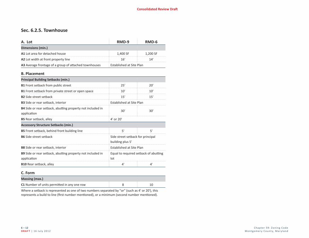
Sec. 6.2.5. Townhouse
A. Lot RMD-9 RMD-6Dimensions (min.)
A1 Lot area for detached house 1,400 SF 1,200 SF
A2 Lot width at front property line 16' 14'
A3 Average frontage of a group of att ached townhouses Established at Site Plan
B. PlacementPrincipal Building Setbacks (min.)
B1 Front setback from public street 25' 20'
B1 Front setback from private street or open space 10' 10'
B2 Side street setback 15' 15'
B3 Side or rear setback, interior Established at Site Plan
B4 Side or rear setback, abutti ng property not included in
applicati on30' 30'
B5 Rear setback, alley 4' or 20'
Accessory Structure Setbacks (min.)
B5 Front setback, behind front building line 5' 5'
B6 Side street setback Side street setback for principal
building plus 5'
B8 Side or rear setback, interior Established at Site Plan
B9 Side or rear setback, abutti ng property not included in
applicati on
Equal to required setback of abutti ng
lot
B10 Rear setback, alley 4' 4'
C. FormMassing (max.)
C1 Number of units permitt ed in any one row 8 10
Where a setback is represented as one of two numbers separated by "or" (such as 4' or 20'), this represents a build to line (fi rst number menti oned), or a minimum (second number menti oned).

C hap te r 59: Z o n i n g C o d eM o nt go m e r y C o u nt y, M ar y l an d
6 – 1 3 16 J u l y 201 2 | D R A F T
Consolidated Review Dra
Div. 6.3. Transferable Development Rights (TDR) Overlay Sec. 6.3.1. In GeneralThe purpose of the TDR Overlay optional method of development is to permit an increase in the maximum density of development established in Sec. 4.8.4., Transferable Development Rights Overlay, provided the development conforms to the regulations for optional method development using Transferable Development Rights this Section (Sec. 6.3.1).
A. ApplicabilityThe procedures and regulations in Sec. 6.3.1. apply to the transfer of develop-ment rights from land classifi ed in the AR zone to land classifi ed in a Transferable Development Rights (TDR) Overlay zone. The Planning Board may approve sub-division of such land at densities not to exceed the maximum density permitted in the applicable TDR Overlay zone and conforming to the guidelines contained in the applicable Master Plan.
B. General Provisions
1. The development density of a property under the TDR Overlay optional method may not be increased above the maximum density permitted in the zone nor beyond the density or number of dwelling units recommended for such property by the applicable Master Plan.
2. A property developed with the transfer of development rights must conform to the requirements of Chapter 25A requiring MPDU's. The applicability of Chapter 25A and the MPDU density increase provided by Sec. 6.1.2.A must be calculated after the base density of a property has been increased by a transfer of development rights. The density increase provided by Sec. 6.1.2.A may be made without the acquisition of additional development rights.
C. Recording of Development Right
1. A development right must be created, transferred, and extinguished by means of an easement that limits the future construction of detached hous-es on a property in the AR zone to the total number of development rights allowed under the standards of the AR zone minus all development rights
previously transferred under this Section (Sec. 6.3.1), the number of develop-ment rights to be transferred by the instant transaction, and the number of existing detached houses on the property.
2. The transfer of development rights must be recorded in the land records of the county.
3. Prior to recordation of a fi nal record plat for a subdivision using transferred development rights, an easement to the Montgomery County Government limiting future construction of dwellings on a property in the AR zone by the number of development rights received must be recorded among the land records of the county.
4. A fi nal record plat for a subdivision using transferred development rights must contain a statement setting forth the development proposed, the zon-ing classifi cation of the property, the number of development rights used, and a notation of the recordation of the conveyance as required by Sec. 6.3.1.
D. Density Designati on
1. Residenti al Detached and Residenti al Multi -Unit Zones:
a. Land designated in a TDR Overlay zone is assigned a number, as recom-mended in the applicable Master or Sector Plan, that delineates the maximum number of units per acre that may be built through the pur-chase of TDRs up to the following limits:
Zones TDR Density (max. units/acre)
RE-2 4
RE-2C 2
RE-1 2
RLD-20 11
RMD-9 28
RMD-6 28
RHD-3 40
RHD-2 50
RHD-1 100

C hap te r 59: Z o n i n g C o d eM o nt go m e r y C o u nt y, M ar y l an d
6 – 14D R A F T | 16 J u l y 201 2
Consolidated Review Dra
b. TDR Overlay zones are delineated as the overlay zone symbol (TDR) followed by the TDR density designation (1 through 100) on the zoning
map, [TDR-#].
2. Commercial/Residenti al and Employment Zones:
a. Land designated in a TDR Overlay zone may use TDRs under the optional method of development under Div. 6.4.
b. TDR Overlay zones are delineated as the overlay zone symbol (TDR) on the zoning map.
E. Calculati on of TDRs Required in the Residenti al Detached or Residental Multi -Unit ZonesDevelopment using TDRs must include at least two-thirds of the number of development rights designated unless the Planning Board fi nds that for environ-mental or compatibility reasons a lower density is more appropriate.
1. In the Residential Detached and Residential Multi-Unit zones, the following building types require a minimum percent of total units indicated, and where applicable a maximum allowed (noted in parentheses). In addition, the mini-mum amount of common outdoor area required is indicated:
TDR Density
Designati on
Size of
Development
Building Type
(minimum required as a percentage of total units)
Common
Outdoor
Area
(min.)Detached
House
Duplex Townhouse Apartment/
Condo
1 Any size 100% 0% 0% Not permitt ed 0%
2 Any size 100% 0% 0% Not permitt ed 0%
3-5< 800 units 30% 0% 0% Not permitt ed 35%
800+ units 30% 0% 0% 0% (20% max.) 35%
6-10< 200 units 15% 0% 0% Not permitt ed 40%
200+ units 15% 0% 0% 0% (35% max.) 40%
11-15< 200 units 0% 0% 0% 0% 50%
200+ units 0% 0% 0% 35% (60% max.) 50%
16-28< 200 units 0% 0% 0% 0% 50%
200+ units 0% 0% 0% 25% (60% max.) 50%
> 28 Any size 0% 0% 0% 25% 50%
a. The apartment/condo building type is permitted only where specifi cally recommended in the area Master or Sector Plan for the receiving area. In any instance where the minimum percentage requirement would yield a total of 150 units or less, this requirement does not apply, and no such units are required. Whenever the minimum percentage would yield 151 units or more, the full number must be required except where the Plan-ning Board fi nds otherwise, see Sec. 6.3.1.B.3.c.
b. A duplex or townhouse building type may be substituted for all or part of the apartment/condo requirement.
c. An apartment/condo building type is limited to a maximum building height of 40'. The height limit may be waived upon a fi nding by the Plan-ning Board that a proposed development can achieve greater compat-ibility with adjacent development than would result from adherence to the standards.
2. Each single TDR purchased allows the construction of the following number of units up to the TDR density designation:
a. one detached house unit;
b. 2 units in a duplex or townhouse building type; or
c. 3 units in an apartment/condo building type.
3. The Planning Board may waive the minimum required or maximum allowed number of units if it fi nds that for environmental or compatibility reasons a diff erent mix of building types is appropriate.
F. Development StandardsThe following table indicates the required development standards for each TDR density designation:
TDR Density Designati on
Development Standards
1Same as for a detached house building type under standard method in
the RE-1 zone, see Div. 4.4
2Same as for a detached house building type under standard method in
the RLD-20, see Div. 4.4
3-5 May uti lize the RMD-6 Opti onal Method MPDU standards, see Div. 6.1
6 or more Determined at Site Plan

C hap te r 59: Z o n i n g C o d eM o nt go m e r y C o u nt y, M ar y l an d
6 – 1 5 16 J u l y 201 2 | D R A F T
Consolidated Review Dra
G. Development with Moderately Priced Dwelling Units
1. Any property developed under this Section (Sec. 6.3.1) must conform to the requirements of Chapter 25A.
2. Any density bonus allowed under Chapter 25A is calculated after the base density of the property has been increased under this Section (Sec. 6.3.1)through acquisition of TDRs. The increase in density attributed to Optional Method MPDU Development must not exceed 22% of the TDR density.
3. Development using TDRs and providing MPDUs above 12.5% must be under Div. 6.1., MPDU Development in Rural and Residential zones.
H. Additi onal FindingsIn addition to the fi ndings required under Sec. 8.3.4., Site Plan, for projects developed under this Division (Div. 6.3), the Planning Board must fi nd that the proposed development:
1. Provides the appropriate range of housing types;
2. Takes advantage of existing topography and environmental features; and
3. Achieves a mutually compatible relationship between the proposed develop-ment and adjoining land uses.

C hap te r 59: Z o n i n g C o d eM o nt go m e r y C o u nt y, M ar y l an d
6 – 16D R A F T | 16 J u l y 201 2
Consolidated Review Dra
Div. 6.4. Commercial/Residenti al ZonesSec. 6.4.1. Requirements
A. Density, Mix, and Height In the CRT and CR zones, the maximum total, nonresidential, and residential FARs and height for any property is set by the zone as shown on the zoning map.
B. Procedure for Approval A Sketch Plan must be submitted under Sec. 8.3.3. A Site Plan must be sub-mitted under Sec. 8.3.4. for any development on a property with an approved Sketch Plan.
C. Public Benefi t Points and Categories Public benefi ts under Div. 6.6 must be provided as follows:
Zone Site Size Public Benefi t
Points (min.)
Number of Benefi t
Categories (min.)
CRT
< 10,000 SF of gross tract area
OR with < 1.5 max. FAR25 2
≥ 10,000 SF of gross tract area
OR with ≥ 1.5 max. FAR50 3
CR
< 10,000 SF of gross tract area
OR with < 1.5 max. FAR50 3
≥ 10,000 SF of gross tract area
OR with ≥ 1.5 max. FAR100 4
Sec. 6.4.2. Development Standards Optional Method development in all CRT and CR zones must comply with the re-quirements of Section 6.4.2.A through Section 6.4.2.D.
A. Master Plan and Design Guidelines
1. Development must be consistent with the applicable Master or Sector Plan.
2. Development must comply with any design guidelines approved by the Plan-ning Board that implement the applicable Master or Sector Plan.
B. Public Use Space Public use space must be provided based on the lot size and number of front-ages as described in the table below. The required public use space must meet the criteria established under Div. 7.3.
Lot Size
(net tract area)
# of Existi ng, Proposed, and Master-Planned Right-of-Way Frontages
1 2 3 4 or more
% of Site Required to be Dedicated for Public Use Space
≤ 0.50 acres 0% 0% 0% 5%
0.51 to 1.00 acres 0% 0% 5% 10%
1.01 to 3.00 acres 0% 5% 10% 10%
3.01 to 6.00 acres 5% 10% 10% 10%
≥ 6.01 acres 10% 10% 10% 10%
C. Building Type All building types and the respective dimensional standards allowed under Div. 4.5 are allowed in the CRT and CR zones under optional method development.
D. Neighborhood Compati bility Where a property abuts or confronts an AR, RR, RC, RNC, RE, RLD, or RMD zoned property that is vacant or improved with an agricultural or residential use, any building must comply with the setback and angular plane restrictions under Sec. 4.5.3.D.

C hap te r 59: Z o n i n g C o d eM o nt go m e r y C o u nt y, M ar y l an d
6 – 17 16 J u l y 201 2 | D R A F T
Consolidated Review Dra
Div. 6.5. Employment ZonesSec. 6.5.1. Requirements
A. Density and Height In the ELS and EOF zones, the maximum total FAR and height for any property is set by the zone as shown on the zoning map.
B. Procedure for Approval A Sketch Plan must be submitted under Sec. 8.3.3. A Site Plan must be sub-mitted under Sec. 8.3.4. for any development on a property with an approved Sketch Plan.
C. Public Benefi t Points and CategoriesPublic benefi ts under Div. 6.6. must be provided as follows:
Zone Site Size Public Benefi t
Points (min.)
Number of Benefi t
Categories (min.)
ELS
< 10,000 SF of gross tract area
OR with < 1.5 max. FAR15 1
≥ 10,000 SF of gross tract area
OR with ≥ 1.5 max. FAR30 2
EOF
< 10,000 SF of gross tract area
OR with < 1.5 max. FAR30 2
≥ 10,000 SF of gross tract area
OR with ≥ 1.5 max. FAR60 3
Sec. 6.5.2. Development Standards Optional Method development in all ELS and EOF zones must comply with the requirements of Section 6.5.2.A through Section 6.5.2.D.
A. Master Plan and Design Guidelines
1. Development must be consistent with the applicable Master or Sector Plan.
2. Development must comply with any design guidelines approved by the Plan-
ning Board that implement the applicable Master or Sector Plan.
B. Public Use Space Public use space must be provided based on the lot size and number of front-ages as described below. The required public use space must meet the criteria established under Div. 7.3.
Lot Size
(net tract area)
# of Existi ng, Proposed, and Master-Planned Right-of-Way Frontages
1 2 3 4 or more
% of Site Required to be Dedicated for Public Use Space
≤ 0.50 acres 0% 0% 0% 5%
0.51 to 1.00 acres 0% 0% 5% 10%
1.01 to 3.00 acres 0% 5% 10% 10%
3.01 to 6.00 acres 5% 10% 10% 10%
≥ 6.01 acres 10% 10% 10% 10%
C. Building Type All building types and the respective dimensional standards allowed under Div.
4.6. are allowed in the ELS and EOF zones under optional method development.
D. Neighborhood Compati bility Where a property abuts or confronts an AR, RR, RC, RNC, RE, RLD, or RMD zoned property that is vacant or improved with an agricultural or residential use, any building must comply with the setback and angular plane restric-tions under Sec. 4.6.3.D.

C hap te r 59: Z o n i n g C o d eM o nt go m e r y C o u nt y, M ar y l an d
6 – 18D R A F T | 16 J u l y 201 2
Consolidated Review Dra
Div. 6.6. Opti onal Method Public Benefi tsSec. 6.6.1. General Provisions
A. Public Benefi t Categories
1. Public benefi ts must be provided that enhance or contribute to the objec-tives of the zone in some or all of the following categories:
a. Major Public Facilities;
b. Transit Proximity;
c. Connectivity and Mobility;
d. Diversity of Uses and Activities;
e. Quality Building and Site Design; and
f. Protection and Enhancement of the Natural Environment.
2. Section 6.6.2. indicates the individual public benefi ts that may be accepted in each of these categories in each zone.
B. General Public Benefi t Considerati ons Granting points for the provision of any benefi t otherwise required by law is prohibited. In approving any incentive FAR based on the provision of public benefi ts, the Planning Board must consider:
1. the recommendations and objectives of the applicable Master or Sector Plan;
2. the CR Zone Incentive Density Implementation Guidelines;
3. any design guidelines adopted for the applicable master plan area;
4. the size and confi guration of the tract;
5. the relationship of the site to adjacent properties;
6. the presence or lack of similar public benefi ts nearby; and
7. enhancements beyond the elements listed in an individual public benefi t that increase public access to, or enjoyment of, the benefi t.
C. Public Benefi t Implementati on Guidelines The Planning Board must adopt, publish, and maintain guidelines that detail the standards and requirements for public benefi ts. The guidelines must:
1. be consistent with the objectives of this Division (Div. 6.6);
2. be in addition to any standards, requirements, or rules of incentive density calculation included in this Division (Div. 6.6), but may not confl ict with those provisions; and
3. only allow incentive FAR for those public benefi ts listed in Sec. 6.6.3.

C hap te r 59: Z o n i n g C o d eM o nt go m e r y C o u nt y, M ar y l an d
6 – 19 16 J u l y 201 2 | D R A F T
Consolidated Review Dra
Sec. 6.6.2. Public Benefi t Applicability Various public benefi ts may be accepted in each zone according to the following table:
Benefi t Zone or Opti onal Method Type
CRT CR ELS EOF
Major Public Facility Y Y Y Y
Transit Proximity Y Y Y Y
Connecti vity & Mobility
Advance Dedicati on Y Y Y Y
Minimum Parking Y Y Y Y
Neighborhood Services Y Y
Public Parking Y Y Y Y
Through-Block Connecti on Y Y Y Y
Transit Access or Streetscape Im-
provement
Y Y Y Y
Trip Miti gati on Y Y Y Y
Way-Finding Y Y Y Y
Diversity of Uses & Acti viti es
Adapti ve Buildings Y Y Y Y
Aff ordable Housing Y Y Y Y
Care Centers Y Y Y Y
Dwelling Unit Mix Y Y Y Y
Enhanced Accessibility for the Dis-
abled
Y Y Y Y
Enhanced Visibility for Seniors/Dis-
abledY Y Y Y
Live/Work Y Y Y Y
Small Business Opportunity Y Y Y Y
Quality Building and Site Design
Architectural Elevati ons Y Y Y Y
Enhanced Recreati on Faciliti es Y
Benefi t Zone or Opti onal Method Type
CRT CR ELS EOF
Excepti onal Design Y Y Y Y
Historic Resource Protecti on Y Y Y Y
Public Art Y Y Y Y
Public Open Space Y Y Y Y
Structured Parking Y Y Y Y
Tower Step-Back Y Y Y Y
Protecti on and Enhancement of the Natural Environment
Building Lot Terminati ons Y Y Y Y
Building Reuse Y Y Y Y
Cool Roof Y Y Y Y
Energy Conservati on Y Y Y Y
Energy Generati on Y Y Y Y
Habitat Preservati on and Restorati on Y Y Y Y
Recycling Facility Plan Y Y Y Y
Transferable Development Right Y Y Y Y
Tree Canopy Y Y Y Y
Vegetated Area Y Y Y Y
Vegetated Roof Y Y Y Y
Vegetated Wall Y Y Y Y
KEY: Y = Acceptable Public Benefi t

C hap te r 59: Z o n i n g C o d eM o nt go m e r y C o u nt y, M ar y l an d
6 – 20D R A F T | 16 J u l y 201 2
Consolidated Review Dra
Sec. 6.6.3. Public Benefi t Descripti ons and Criteria
A. Major Public Faciliti es
1. Major public facilities include, but are not limited to, such facilities as schools, libraries, recreation centers, parks, county service centers, public transportation or utility upgrades, or other resources delineated in an appli-cable master or sector plan. Major public facilities provide public services at convenient locations where increased density creates a greater need for civic uses and greater demands on public infrastructure.
2. Where a major public facility is not recommended in the applicable Master or Sector Plan, the Planning Board must fi nd that the facility or improvement provides the community with a resource that is at least as benefi cial as other major public facilities recommended in the applicable Master or Sector Plan. Additionally, any infrastructure upgrade may only receive incentive density for improvements beyond those required by any applicable adequate public facilities requirement to complete the proposed development.
3. Due to their signifi cance in placemaking, the Planning Board may approve incentive FAR for the conveyance of a site or fl oor area for the construction of or making a payment for a major public facility that is accepted for use or operation by an appropriate public agency, community association, or nonprofi t organization.
a. The following number of points may be awarded provided the require-ments of Sec. 6.6.3.A.3 (above) are met:
i. 20 points in an ELS zone;
ii. 40 points in an EOF or CRT zone; and
iii. 70 points in a CR zone.
B. Transit Proximity
1. Development near transit facilities encourages greater use of transit, controls sprawl, and reduces vehicle miles traveled, congestion, and carbon emissions, and is eligible for incentive density.
2. Transit proximity points are granted for proximity to existing or master planned transit stops based on transit service level and CRT and CR zones.
a. Transit proximity is categorized in 2 levels:
i. Level 1 is proximity to an existing or master planned Metrorail Sta-tion.
ii. Level 2 is proximity to an existing or master planned station or stop along a rail or bus line with a dedicated, fi xed path; excluding a site that is within one mile of a MARC station and that is more than one mile from any other transit station serving a dedicated, fi xed path transit facility.
b. A project is adjacent to or confronting a transit station or stop if it shares a property line or easement line, or is separated only by a right-of-way from an existing or master-planned transit station or stop, and 100 per-cent of the gross tract area in a single sketch plan application is within ¼ mile of the transit portal.
c. For split proximity-range projects:
i. If at least 75 percent of the gross tract area in a single sketch plan application is within the closer of two proximity ranges, the entire project may take the points for the closer range;
ii. If less than 75 percent of the gross tract area in a single sketch plan is within the closer of 2 proximity ranges, the points must be calculated as the weighted average of the percentage of area in each range.
Proximity Adjacent or
confronti ng
Within 1/4
mile
Between 1/4
and 1/2 mile
Between 1/2
and 1 mile
Transit Service
Proximity Level1 2 1 2 1 2 1 2
ELS 10 5 8 4 6 2 4 0
EOF or CRT 25 15 20 12.5 15 10 10 7.5
CR 50 30 40 25 30 20 20 15

C hap te r 59: Z o n i n g C o d eM o nt go m e r y C o u nt y, M ar y l an d
6 – 21 16 J u l y 201 2 | D R A F T
Consolidated Review Dra
C. Connecti vity and Mobility Development that enhances connectivity between uses and amenities; increases mobility options; encourages walking, cycling and transit; facilitates social interaction; provides opportunities for healthier living; and stimulates local busi-nesses.
1. Advance Dedication: Up to 8 points in the ELS zone, 15 points in the EOF and CRT zones, and 30 points in the CR zone for dedicating or providing a reservation for dedication for master-planned rights-of-way in advance of a preliminary or Site Plan application.
2. Minimum Parking: Up to 10 points for providing less than the maximum allowed number of parking spaces, where a maximum is applicable.
3. Neighborhood Services: When fewer than 10 diff erent basic services are within ¼ mile, up to 10 points for providing retail bays resulting in at least 10 diff erent basic services on-site or within ¼ mile, of which at least 4 have a retail bay fl oor area of no greater than 5,000 square feet.
4. Networked Street Pattern: Up to 15 points for locating or designing the project such that a through-street and/or non-motorized right of way intersects or terminates at the project boundary at least every 400 feet or at existing abutting street intervals and intersections, whichever is the shorter distance. Includes a pedestrian or bicycle through-connection in at least 90% of any new culs-de-sac. This does not apply to portions of the boundary where connections cannot be made because of physical obstacles, such as prior platting of property, construction of existing buildings or other barriers, slopes over 15%, wetlands and water bodies, railroad and utility rights-of-way, existing limited-access motor vehicle rights-of-way, and parks and dedicated open space.
5. Public Parking: Up to 25 points for providing up to the maximum number of parking spaces allowed in the zone as public parking.
6. Through-Block Connections: Up to 10 points for safe and attractive pedes-trian connections between streets.
7. Transit Access or Streetscape Improvement: Up to 20 points for creating new or improving existing transit access or for construction of off -site im-provements, excluding any streetscape improvements otherwise required.
8. Trip Mitigation: Up to 15 points for entering into a binding Traffi c Mitiga-tion Agreement to reduce the number of weekday morning and evening peak hour trips attributable to the site in excess of any other regulatory requirement; the agreement must result in a reduction of at least 50% for trips attributable to the site.
9. Way-Finding: Up to 5 points for design and implementation of a way-fi nd-ing system orienting pedestrians and cyclists to major open spaces, cultural facilities and transit opportunities.
D. Diversity of Uses and Acti viti es Development that increases the variety and mixture of land uses, types of hous-ing, economic variety and community activities; contributes to development of more effi cient and sustainable communities; reduces the necessity for automo-bile use; and facilitates healthier lifestyles and greater social interaction.
1. Adaptive Buildings: Up to 10 points for constructing commercial or mixed use buildings with minimum fl oor-to-fl oor heights of at least 15 feet on any fl oor that meets grade and 12 feet on all other fl oors. Internal structural systems must be able to accommodate various types of use with only minor modifi cations.
2. Aff ordable Housing
a. If providing no more than 12.5% Moderately Priced Dwelling Units (MP-DUs), all development must comply with the applicable requirements of Chapter 25A.
b. If providing more than 12.5% MPDUs in an ELS, EOF, CRT, or CR zone, 12 points are granted for every 1% of MPDUs greater than 12.5%. Any frac-tion of 1% increase in MPDUs entitles the applicant to an equal fraction of 12 points.
c. Above 15% of MPDUs, each 1% of additional MPDUs entitles the ap-plicant to an additional 2 benefi t points. Any fraction of 1% increase in MPDUs entitles the applicant to an equal fraction of 2 points.
d. In any case, for density and points to be awarded, at least one more MPDU than would be required at 12.5% must be provided to take advan-tage of the MPDU optional method or points in any zone.

C hap te r 59: Z o n i n g C o d eM o nt go m e r y C o u nt y, M ar y l an d
6 – 22D R A F T | 16 J u l y 201 2
Consolidated Review Dra
3. Care Centers: Up to 20 points for constructing a child or adult day care facil-ity accommodating at least 15 users in accordance with state standards.
4. Dwelling Unit Mix: Up to 10 points for integrating a mix of residential unit types with at least 7.5% effi ciency units, 8% one- and two-bedroom units and 5% three- or more bedroom units.
5. Enhanced Accessibility for Seniors or the Disabled: Up to 20 points for constructing dwelling units with interiors that satisfy American National Standards Institute A117.1 Residential Type A standards or an equivalent county standard.
6. Enhanced Visitability for Seniors or the Disabled: Up to 20 points for constructing dwelling units in accordance with ANSI A117.1, Type C, Visitable Unit, each of which has a kitchen, dining area, living area, full bathroom, and bedroom on the accessible level.
7. Live/Work: Up to 10 points for developments of up to 2.0 FAR total allowed density that provide at least 3 units or, for developments allowed greater than 2.0 FAR, 10% of the total unit count as live/work units.
8. Small Business Opportunities: Up to 20 points for providing on-site space for small, neighborhood-oriented businesses.
E. Quality Building and Site Design High quality design is especially important in urban, integrated-use settings to ensure that buildings and uses are visually compatible with each other and adja-cent communities and to provide a harmonious pattern of development. Due to increased density in these settings, buildings tend to be highly visible and high quality design helps attract residents, patrons and businesses to these areas. Location, height, massing, façade treatments and ornamentation of buildings all aff ect sense of place, orientation and the perception of comfort and con-venience. The quality of the built environment aff ects light, shadow, wind and noise, as well as the functional and economic value of property.
1. Architectural Elevations: Up to 20 points for providing elevations of archi-tectural facades and agreeing to be bound by particular elements of design that exceed the requirements of this Division, such as minimum amount of transparency, maximum separation between doors, awning provisions,
sign restrictions, or lighting parameters that aff ect the perception of mass, pedestrian comfort or enhance neighborhood compatibility.
2. Enhanced Recreation Facilities: Up to 10 points for providing on-site recre-ation facilities above the supply required by Div. 7.4.
3. Exceptional Design: Up to 10 points for building or site design whose visual and functional impacts enhance the character of a setting per the purposes delineated in this Division (Div. 6.6).
4. Historic Resource Protection: Up to 20 points for the preservation or en-hancement of, or payment towards preservation or enhancement of, a his-toric resource or a contributing element within an historic district designated in the Master Plan for Historic Preservation.
5. Open Space: Up to 20 points for providing, or making a payment for, the ap-plicable type of open space in excess of any open space requirement of the zone.
6. Public Art: Up to 15 points for installing public art reviewed for comment by, or paying a fee accepted by, the Public Arts Trust Steering Committee.
7. Structured Parking: Up to 20 points for placing parking within, above or below grade parking structures.
8. Tower Step-Back: Up to 5 points for stepping back a building’s upper fl oors by a minimum of 6 feet behind the fi rst fl oor facade. The step-back must
begin at a height no greater than 72 feet.
F. Protecti on and Enhancement of the Natural Environment Protection and enhancement of natural systems and decreases in energy con-sumption help mitigate or reverse environmental impacts such as heat island eff ects from the built environment, inadequate carbon-sequestration, habitat and agricultural land loss, and air and water pollution caused by reliance on the automobile.
1. Agricultural Land Preservation: Up to 10 points for designing or locating the project development footprint such that it does not disturb prime agri-cultural soil or existing farmland.
2. Building Lot Termination (BLT): Up to 30 points for the purchase of BLT easements or payment to the Agricultural Land Preservation Fund (ALPF).

C hap te r 59: Z o n i n g C o d eM o nt go m e r y C o u nt y, M ar y l an d
6 – 2 3 16 J u l y 201 2 | D R A F T
Consolidated Review Dra
The fi rst 5 points are mandatory for all developments in the CRT and CR zone; up to 25 additional points are allowed as an option.
a. In the CR zone, an applicant must purchase BLT easements, or make payments to the ALPF, in an amount equal to 5% of the incentive density fl oor area under the following parameters:
i. One BLT must be purchased or equivalent payment made for every 20,000 square feet of gross fl oor area to qualify for the fi rst 5% incen-tive density fl oor area;
ii. Any private BLT easement must be purchased in whole units; or
iii. BLT payments must be made to the ALPF, based on the amount established by Executive Regulations under Chapter 2B; if a fraction of a BLT easement is needed, a payment based on the gross square footage of incentive density must be made for at least the fraction of the BLT easement.
b. Up to 25 points for the purchase of BLTs or equivalent payments to the ALPF may be made for any incentive density above 5%. Each BLT ease-ment purchase or payment is equal to 30,000 square feet of gross fl oor area, or such proportionate square footage represented by a fractional BLT purchase or payment. This is converted into points by dividing the incentive density fl oor area covered by the purchase or payment by the total square feet of the incentive density area.
c. In the CRT zones, BLT payments are optional; each BLT easement purchase or payment is equal to 30,000 square feet of gross fl oor area, or such proportionate square footage represented by a fractional BLT purchase or payment.
[Editor's note: BLT requirements specifi c to ELS zone to be added]
3. Building Reuse: up to 100 points for reuse of an existing building subject to the following:
a. 75% of the structural system of the building must be retained; and
b. An architectural deconstruction company must be used to remove reus-able and recyclable materials prior to any demolition.
c. Although 100 points may be obtained, public benefi t category minimums must be met.
4. Cool Roof: Up to 5 points for constructing any roof area that is not covered by a vegetated roof with a minimum solar refl ectance index (SRI) of 75 for roofs with a slope at or below a ratio of 2:12, and a minimum SRI of 25 for slopes above 2:12.
5. Energy Conservation: Up to 10 points for constructing buildings that exceed the energy-effi ciency standards for the building type by 17.5% for new build-ings or 10% for existing buildings.
6. Energy Generation: Up to 15 points for providing renewable energy genera-tion facilities on-site or within 2,640 feet of the site for a minimum of 2.5% of the projected energy requirement for the development.
7. Habitat Preservation and Restoration: Up to 20 points for protection, res-toration or enhancement of natural habitats, on-site or within the same local watershed, which are in addition to requirements of the Forest Conservation Law or other county laws.
8. Recycling Facility Plan: Up to 5 points for providing a recycling facility plan to be approved as part of a site plan for buildings that complies with Montgomery County Executive Regulation 15-04AM or Montgomery County Executive Regulation 18-04.
9. Transferable Development Right: Up to 20 points for the purchase of or payment towards TDRs. Every TDR purchased is worth 1 point and allows 3,500 square feet of development above the density allowed under the stan-dard method of development. If a site is within a TDR Overlay zone, TDRs must be purchased as recommended by the Master Plan or, if no recommen-dation is made, at least 5 points must be provided through the purchase of or payment towards TDRs.
10. Tree Canopy: Up to 10 points for protecting tree canopy coverage with at least 20 years of growth per Trees Technical Manual approved by the Plan-ning Board, as amended, on at least 25% of the on-site open space.
11. Vegetated Area: Up to 5 points for installation of plantings in a minimum of 12 inches of soil, covering at least 5,000 square feet. No individual area can

C hap te r 59: Z o n i n g C o d eM o nt go m e r y C o u nt y, M ar y l an d
6 – 24D R A F T | 16 J u l y 201 2
Consolidated Review Dra
be less than 500 square feet. This does not include vegetated roofs or storm-water management facilities.
12. Vegetated Roof: Up to 10 points for installation of a vegetated roof with a soil depth of at least four inches covering at least 33% of a building’s roof, excluding space for mechanical equipment.
13. Vegetated Wall: Up to 5 points for the installation and maintenance of a vegetated wall that covers at least 30% of any blank wall or parking garage facade that is at least 300 square feet in area and is visible from a public street or open space.

C hap te r 59: Z o n i n g C o d eM o nt go m e r y C o u nt y, M ar y l an d
6 – 2 5 16 J u l y 201 2 | D R A F T
Consolidated Review Dra
PAGE LEFT INTENTIONALLY BLANK

![[[Article 59-6. Optional Method Requirements 59: Zoning Code6 Montgomery County, Maryland – 6 [[December 16 [May 2], 2013]] March 5, 2014](https://img.pdfslide.net/doc/110x75/5adbac687f8b9a4a268ba81b/article-59-6-optional-method-59-zoning-code6-montgomery-county-maryland-.jpg)