Embed Size (px)
Citation preview
37th AMS Conference on Radar Meteorology 14-‐18 September 2015, Norman, OK, USA
203.3
Evaluation of the QPE integration by Poisson’s Equation using Radar Reflectivity, MPE Eumetsat and Rain Gauge Network on
a subtropical basin in Brazil Leonardo Calvetti1*, Réverton Luis Neundorf1, Cesar Beneti1, Rafael Toshio1, Tiago Noronha1, João Eduardo Lopes2, Argemiro Fernandes3 e Maurilio Eijin
Katekawa3 1 SIMEPAR, Curitiba-PR, Brazil; 2Unicamp, Campinas-SP, Brazil; 3Duke Energy
Brazil, Chavantes-SP, Brazil.
1. Introduction
Nowadays, Quantitative Precipitation Estimation (QPE) integration methods are non-trivial tasks due to the large volume of precipitation data with hourly input of several sensors and formats, specially if taking into account an analysis approach that retains physical characteristics of the raw data with minimum smoothing and random errors. A better representation of rainfall spatial distribution is crucial for accurate forecasts of river discharges and hydrodynamic simulations. The integration of remote sensing estimation with rain gauges improves the accuracy of hydrological models when compared to a model using gauge data only (Kitzmiller et al., 2013). Besides hydrological purposes, QPE can also be used for operational forecasts of rainfall rates and raining areas in nowcasting up to 4h (Li et al., 2013) and the growth and decay patterns can be predictable up to two hours. Sophisticated methods of data assimilation (4DVAR) in numerical weather models use precipitation data to produce more accurate surface water and energy budgets.
* Corresponding author address: Leonardo Calvetti, Meteorological System of Paraná, Curitiba, PR, Brazil; e-mail: [email protected]
While rain gauges are usually installed in some points over the watersheds, nowadays it is possible to retrieve a 1km x 1km grid from the radar data. Therefore, the best way to get operationally high-resolution spatial distribution of precipitation is to combine rain gauge data with radar and satellite estimations.
Radar estimations of QPE are very useful information for hydrological applications because of high spatial and temporal resolution improving runoff forecasts and reducing model dependence on unreliable parameter estimates of watershed characteristics (Krajewski et al., 2010). However, radar QPE depends on the calibration, good adjustment with rain gauges, filtering, distance from the radar, orography, signal propagation (Zhang et al., 2005).
The present work aims to evaluate the integration of radar mosaic, satellite QPE and raingauge network, named Siprec, which uses the Poisson equation and multigrid method to solve the Laplacian. The 1km2 gridded precipitation field has been used as a input in the SMAP (Soil Moisture Accounting-Procedure) hydrological model (Lopes et al., 1982).
37th AMS Conference on Radar Meteorology 14-‐18 September 2015, Norman, OK, USA
2. Methodology The Siprec is a multi-sensor QPE that uses radar mosaic, satellite and raingauge network blended by the Poisson’s Equation numerically solved by the parallel Multigrid algorithm (Briggs et al., 2000). To blend radar (R), gauge (G) and satellites (S) QPE the algorithm of Reynolds was used (Reynolds, 1988; Xie and Arkin, 1996). Similar to a data assimilation technique, this algorithm uses a boundary condition field as a truth to combine the analysis. First, the radar mosaic QPE is blended with raingauge network by assuming that the shape satisfies the Poisson’s equation: ∇2BG = R where BG is the boundary condition, in this case, the hourly precipitation measured by the raingauge network and R is the hourly Radar Mosaic QPE which uses the ZR relationship with parameters a=52 and b= 2.8. This solution generates a new gridded field PR where radar and rain gauge QPE are combined. Satellite QPE S is added to the PR grid using again the Poisson`s equation: ∇2BPR = S where BPR is the hourly radar-gauge analysis and S is the hourly Satellite QPE that can be any technique. Here it has been used Meteosat MPE (Heinemann et al., 2002). To solve the Laplacian ∇2, a multigrid numerical method was used with a group of algorithms to solve differential equations using a hierarchy of discretizations (Briggs et al., 2000). The main goal of using a multigrid method is to accelerate the convergence of a basic iterative method by global correction from time to time, accomplished by solving a coarse problem. For all the events studied, the technique converged quickly to the solution, even when running in a 4-core 2.2
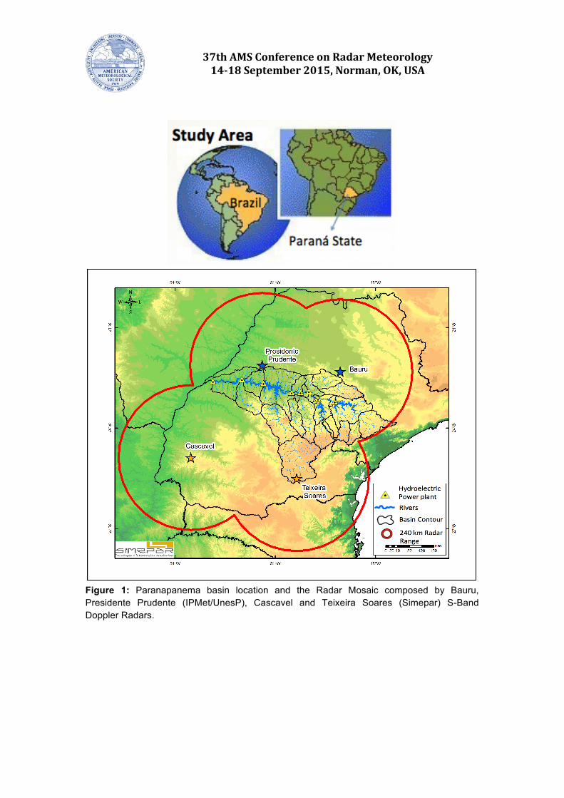
GHz processor computer, which is appropriate for operational usage. The idea of this method is to impose a high convergence to the raingauge precipitation amplitude (the rain gauge was used as a boundary condition) and to keep down the mesoscale signature captured by radar and satellite, modifying only the amplitude of the precipitation. The Siprec has been used to guide hydrological simulations over Paranapanema Basin in Southern Brazil. The Paranapanema basin has 105,000 km2 covering north of Parana State and South of São Paulo State (Figure 1). For hydrological purposes the area was divided in 22 watersheds according to runoff and terrain elevation. The SMAP hydrological model was applied over 11 watersheds where streamflow measurements are made. An evaluation of the streamflow simulations was made from September 2013 to July 2015 to compare the streamflow simulations using different input data. He first model, named operational, is the hydrological model that runs on the Duke Energy Brazil since 2010. Second, the optimized model uses rain gauge data with a posteriori adjusted weights (ideal case), Finally, Siprec ad Siprec with bias correction are the same hydrological model using Siprec QPE and Siprec corrected by bias removal. The result was divided in four categories that indicate if the model was very good (vg), good (g), acceptable (a) and unacceptable (ua) according the methodology of Moriasi et al., 2007, which uses Nash-Sutcliffe Efficiency number and percent bias as a classifiers.
37th AMS Conference on Radar Meteorology 14-‐18 September 2015, Norman, OK, USA
Figure 1: Paranapanema basin location and the Radar Mosaic composed by Bauru, Presidente Prudente (IPMet/UnesP), Cascavel and Teixeira Soares (Simepar) S-Band Doppler Radars.

37th AMS Conference on Radar Meteorology 14-‐18 September 2015, Norman, OK, USA
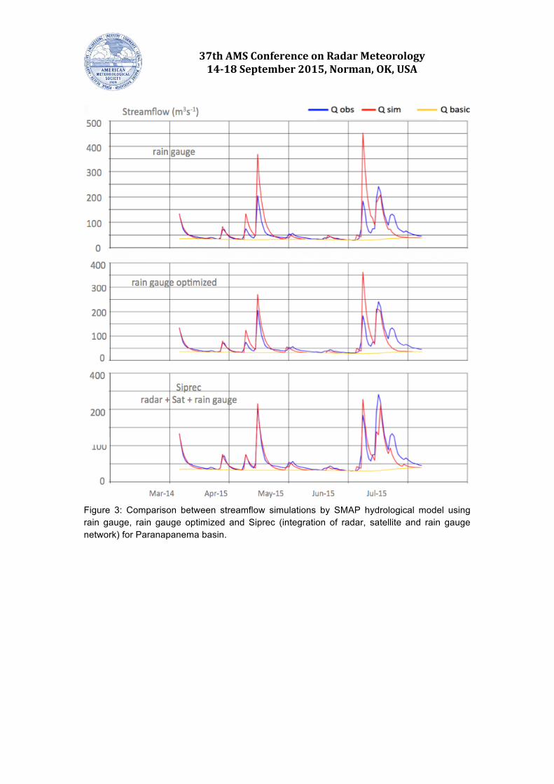
3. Results Comparing daily accumulations (figure 2), an area with high precipitation was amplified in the Siprec when compared to the satellite and some areas with precipitation greater than 100 mm h-1 were reduced in radar and satellite estimates. At the west, the precipitation nucleus estimated by the satellite was reduced, when compared to the rain gauge and radar patterns. On the south region, the rain gauges were crucial to yield realistic intensities above 80 mm day-1 while radar and satellite QPE indicated values below 60 mm day-1. However, the Siprec algorithm presented more realistic mesoscale precipitation signatures than the rain gauges that have poor spatial representation. An example of the comparison between streamflow simulations by SMAP hydrological model using rain gauge, rain gauge optimized and Siprec for the Jataizinho watershed (one of the 11 watersheds of the Paranapanema basin) was illustrated in figure 3. The streamflow prediction using Siprec takes advantage to another simulations correcting the peaks in May and July 2015. An evaluation of the streamflow simulations using the SMAP hydrological model over 11 watersheds over Paranapanema basin from September 2013 to July 2015 was made to compare the streamflow simulations using different input data (table 2). The operational is the hydrological model that runs on the Duke Energy Brazil, the optimized is the same model with adjusted weights in rain gauge data (ideal case), Siprec ad Siprec with bias correction are the same model but using Siprec QPE and Siprec corrected by bias removal.
The criteria of verification were following Moriasi et al., 2007 where the categories Very good (vg), good (g), acceptable (a) and unacceptable (ua) were introduced according Nash-Sutcliffe Efficiency number and percent bias results. Its possible observe that Siprec with bias correction improve the streamflow simulations in several watershed, except TBO. From images (not showed here) it was possible observe that the ground clutter leading the errors in the QPE for this region. Another important result is that the bias correction must be applied on the Siprec data, because the difference was significant in at least 50% of the watersheds. 4. Conclusions The Siprec provides high temporal (1h) and spatial (1km2) QPE integrating radar, raingauge and satellite data by the Poisson’s Equation. The solution of the integration was tested on the SMAP hydrological model over Paranapanema basin getting very encouraging results. The streamflow simulations using Siprec as a precipitation input data got better scores than using only rain gauges information because it improved the spatial identification of the rain over the watersheds. But, a correction of the bias is necessary to aims good results.

37th AMS Conference on Radar Meteorology 14-‐18 September 2015, Norman, OK, USA
Figure 2: Accumulated daily precipitation (mm day-1) from satellite MPE (upper left), rain gauge (upper right), Siprec (bottom left) and radar mosaic (bottom right) for 08 June 2014. Table 1: Performance Rating categories used to evaluate the hydrological model (adapted from Moriasi et al., 2007)
Table 2: Evaluation of the streamflow simulations using the SMAP hydrological model over 11 watersheds over Paranapanema basin from September 2013 to July 2015.
37th AMS Conference on Radar Meteorology 14-‐18 September 2015, Norman, OK, USA
Figure 3: Comparison between streamflow simulations by SMAP hydrological model using rain gauge, rain gauge optimized and Siprec (integration of radar, satellite and rain gauge network) for Paranapanema basin.
37th AMS Conference on Radar Meteorology 14-‐18 September 2015, Norman, OK, USA
5. References Briggs, W.L., V.E. Henson, S.F and
McCormick,2000: A Multigrid Tutorial, second ed., SIAM, Philadelphia.
Chen, S., J.J. Gouley, Y. Hong, P.E. Kirstetter, J. Zhang, K. Howard, Z. L. Flaming, J. Hu and Y. Qi, 2013: Evaluation and uncertainty estimation of NOAA/NSSL Next Generation National Mosaic QPF product (Q2) over the continental USA. J. Hydrometeor, 14, 1308-1322
Heinemann, T., A. Lattanzio and F. Roveda. 2002: The Eumetsat multi-sensor precipitation estimate (MPE). 1st IPWG Workshop, Madrid, Spain.
Kitzmiller, D., Miller, D., Fulton, R., and Ding, F. (2013). ”Radar and Multisensor Precipitation Estimation Techniques in National Weather Service Hydrologic Operations.” J. Hydrol. Eng., 18(2), 133–142.
Krajewski, W. F., Villarini, G. and Smith, J. A. (2010). “RADAR-Rainfall Uncertainties.” Bull. Amer. Meteor. Soc., 91, 87–94.
Li, H., Corzo Perez, G., Martinez, C., and Mynett, A. (2013). ”Self-Learning Cellular Automata for Forecasting Precipitation from Radar Images.” J. Hydrol. Eng., 18(2), 206–211.
Lopes, J., Braga, B.P.F, and Conejo, J. (1982). SMAP - A Simplified Hydrological Model Applied Modeling in Catchment Hydrology. Water Resources Publications.
Moriasi, D.N., Arnold, J.G., Van Liew, M.W.,
Bingner, R.L., Harmel, R.D. and Veith, T.L.(2007). Model Evaluation Guidelines for Systematic Quantification of Accuracy in Watershed Simulations. Transactions of the ASABE , 50 (3), pp. 885-900.
Pereira Filho, A. J., 2004: Integrating Gauge, Radar and Satellite Rainfall. Proceedings of the 2nd Workshop of the International Precipitation Working Group.
Reynolds, R.W., 1988: A Real-Time Global Sea Surface Temperature Analysis. Journal of Climate, vol 1, 75-86.
Xie P., and P. A. Arkin, 1996: Global precipitation: a 17-year monthly analysis based on gauge observations, satellite estimates, and numerical model outputs. Bull. Amer. Meteor. Soc., 78, 2539-2558.
Zhang, J., K. Howard and JJ. Gourley,, 2005: Constructing Three-Dimensional Multiple-Radar Reflectivity Mosaics: Examples of Convective Storms and Stratiform Rain Echoes. J. Appl. Meteor, 22, 30-42.