Embed Size (px)
Citation preview

Ashburton North Strategic Industrial Area Structure Plan
October 2011


DOCUMENT HISTORY AND STATUS
09/051 – Ashburton North Strategic Industrial Area Structure Plan Revision Date Issued
Prepared By: Taylor Burrell Barnett Town Planning and Design 187 Roberts Road SUBIACO WA 6008 Phone: 9382 2911 Fax: 9382 4586 [email protected] In Association with: AECOM Environmental Assessment Serling Consulting Service Infrastructure Assessment ENV Australia District Water Management Strategy Arup Traffic and Transportation Assessment Coakes Consulting Social Impact Statement SVT Noise Assessment SKM Air Quality Assessment URS Surface Water Studies
0 27.08.10 1 03.09.10 2 19.09.10 3 01.11.10 4 18.11.10 5 21.12.10 6 28.03.11 7 14.06.11 8 06.07.11 9 10.07.11
10 12.07.11 11 15.07.11 12 22.07.11 13 27.07.11 14 29.07.11 15 30.07.11 16 2.08.11 17 3.08.11 18 03.10.11
19 04.10.11

Ashburton North Strategic Industrial Area Structure Plan Schedule of Modifications
Mod. No. Description Date
1. Figure 8 Condition 12 – Insert modified Condition 12 as follows: The Development Plan(s) for all stages will reference where opportunities may exist for a co-ordinated approach to servicing and address a collaborative approach to the provision of water supply and other infrastructure in the future to the requirements of DSD, to the satisfaction of the Shire of Ashburton.
12.10.11

TABLE OF CONTENTS
1 INTRODUCTION 1 1.1 LOCATION AND LEGAL DESCRIPTION 2 1.2 BACKGROUND 4 1.3 STRUCTURE OF REPORT 4
2 ASHBURTON NORTH STRATEGIC INDUSTRIAL AREA PLANNING FRAMEWORK 5 2.1 AMENDMENT NO. 9/APPENDIX 11 OF LPS7 7 2.2 ANSIA STRUCTURE PLAN 7 2.3 DEVELOPMENT PLANS 7 2.4 AMENDMENT NO. 10 9 2.5 APPROACH 10
3 STATUTORY PLANNING FRAMEWORK 12 3.1 STATE PLANNING POLICIES 12
3.1.1 STATEMENT OF PLANNING POLICY NO. 1 – STATE PLANNING FRAMEWORK POLICY 12 3.1.2 STATE PLANNING POLICY NO. 2 – ENVIRONMENT AND NATURAL RESOURCES 12 3.1.3 STATE PLANNING POLICY NO. 2.6 – STATE COASTAL PLANNING 13 3.1.4 STATE PLANNING POLICY NO. 3.4 – NATURAL HAZARDS AND DISASTERS 13 3.1.5 STATE PLANNING POLICY NO. 4.1 – STATE INDUSTRIAL BUFFER POLICY 14 3.1.6 STATE PLANNING POLICY NO. 4.1 – STATE INDUSTRIAL BUFFER (AMENDED)
(DRAFT) 14 3.2 REGIONAL/LOCAL PLANNING FRAMEWORK 15
3.2.1 PILBARA FRAMEWORK 15 3.2.2 ONSLOW STRUCTURE PLAN (2003) 16 3.2.3 ONSLOW TOWNSITE STRATEGY 2010 17 3.2.4 ONSLOW STORM SURGE STUDIES AND INVESTIGATIONS 19
3.3 SHIRE OF ASHBURTON LOCAL PLANNING SCHEME NO. 7 20 3.3.1 ONSLOW COASTAL HAZARD AREA SPECIAL CONTROL AREA 20
3.4 LOCAL PLANNING POLICIES 20 3.4.1 LOCAL PLANNING POLICY 20 – SOCIAL IMPACT ASSESSMENT 20 3.4.2 LOCAL PLANNING POLICY 13 – TRANSIENT WORKFORCE ACCOMMODATION 20 3.4.3 LOCAL PLANNING POLICY 17 – CONSULTATION FOR PLANNING PROPOSALS 22
4 CONTEXT 23 4.1 REGIONAL CONTEXT 23 4.2 LOCAL CONTEXT 23
4.2.1 ONSLOW TOWNSITE 23 4.2.2 OLD ONSLOW TOWNSITE 23 4.2.3 ONSLOW SALT 24 4.2.4 ASHBURTON RIVER/CAMPING 25 4.2.5 EXISTING ONSLOW STRATEGIC INDUSTRIAL AREA 25 4.2.6 ACCESS 26
5 ISSUES AND OPPORTUNITIES 27 5.1 ENVIRONMENT 27
5.1.1 FLORA 27 5.1.2 VEGETATION 28 5.1.3 MANGROVES 28 5.1.4 FAUNA 29 5.1.5 ABORIGINAL HERITAGE 29 5.1.6 EUROPEAN HERITAGE 29
5.2 CUMULATIVE IMPACTS 31

5.2.1 NOISE 31 5.2.2 AIR QUALITY 31 5.2.3 RISK 31 5.2.4 SUMMARY 32
5.3 WATER MANAGEMENT 32 5.3.1 SURFACE WATER 32 5.3.2 GROUNDWATER 33 5.3.3 LANDFORM 33 5.3.4 SUMMARY OF ENVIRONMENTAL MANAGEMENT CONDITIONS 34
5.4 SERVICING 34 5.5 SPATIAL LANDUSE CONSIDERATIONS/COMPONENTS OF THE STRUCTURE PLAN 34
5.5.1 FUTURE PORT/COMMON USER COASTAL AREA 34 5.5.2 ACCESS AND INFRASTRUCTURE CORRIDORS 34 5.5.3 ONSLOW SALT 35 5.5.4 TRANSIENT WORKFORCE ACCOMMODATION 36
5.6 SOCIAL IMPACTS 36 5.6.1 LAND AVAILABILITY 36 5.6.2 INFRASTRUCTURE AND COMMUNITY SERVICES 37 5.6.3 HOOLEY CREEK 38
6 ASHBURTON NORTH STRATEGIC INDUSTRIAL AREA STRUCTURE PLAN 39 6.1 VISION 39 6.2 OBJECTIVES 39
6.2.1 DEVELOPMENT OBJECTIVES 39 6.3 STRUCTURE PLAN ELEMENTS 41
6.3.1 PORT/COMMON USER COASTAL AREA 42 6.3.2 HYDROCARBON INDUSTRY PRECINCT 42 6.3.3 FUTURE INDUSTRY AREA 43 6.3.4 GENERAL INDUSTRY AREA 44 6.3.5 MULTI-USER ACCESS AND INFRASTRUCTURE CORRIDOR 44 6.3.6 UNALLOCATED LAND (STAGE 2) 48 6.3.7 TRANSIENT WORKFORCE ACCOMMODATION 48 6.3.8 OPERATIONS WORKFORCE 49 6.3.9 SERVICING 49 6.3.10 INDICATIVE SECONDARY LINK ACCESS ROAD 50
6.4 DISTRICT WATER MANAGEMENT STRATEGY 50 6.5 SERVICING 50
6.5.1 EXISTING DOMESTIC GAS PIPELINE (BHP BP LPG) 51 6.5.2 WATER 51 6.5.3 EFFLUENT DISPOSAL 51 6.5.4 POWER 51 6.5.5 GAS 51 6.5.6 TELECOMMUNICATIONS 51 6.5.7 WASTE DISPOSAL 52 6.5.8 FENCING 52
6.6 MOVEMENT NETWORK AND ROAD UPGRADES 52 6.6.1 MUAIC 53 6.6.2 ONSLOW ROAD 54 6.6.3 ROAD UPGRADES IMPLEMENTATION 55 6.6.4 ROAD UPGRADES PRIOR TO DEVELOPMENT PLAN 56
6.7 LAND USE SEPARATION 56 6.7.1 OVERVIEW 56 6.7.2 MEASURES TO ACHIEVE LAND USE SEPARATION 57
6.8 STAGING 58

7 INFRASTRUCTURE COST SHARING 59 7.1 STATUTORY MECHANISMS 59
7.1.1 LOCAL PLANNING SCHEME NO. 7 – AMENDMENT NO. 9 60 7.1.2 STATE DEVELOPMENT AGREEMENT (SDA) 60
7.2 IMPLEMENTING A PROPONENT CONTRIBUTION ARRANGEMENT THROUGH SDAS 61 7.3 FORM OF A PROPONENT CONTRIBUTION PLAN 61
7.3.1 PRINCIPLES 61 7.4 SUMMARY 62
8 IMPLEMENTATION 63 8.1 ANSIA STRUCTURE PLAN 63
8.1.1 CONSULTATION 63 8.1.2 APPROVAL PROCESS 63
8.2 SOCIAL IMPACT STATEMENT 64 8.3 DEVELOPMENT PLANS 64
8.3.1 TECHNICAL STUDIES 66 8.4 SCHEME AMENDMENT 67 8.5 DISTRICT WATER MANAGEMENT STRATEGY 67 8.6 LOCAL WATER MANAGEMENT STRATEGY 67 8.7 ENVIRONMENTAL MANAGEMENT PLANS 68
8.7.1 ACID SULFATE SOILS 69 8.7.2 CUMULATIVE AIR QUALITY RESULTS 70 8.7.3 CUMULATIVE RISK, NOISE IMPACTS AND MANAGEMENT 70
8.8 HERITAGE 70 8.9 LAND ASSEMBLY AND ADMINISTRATION 70 8.10 SUBDIVISION AND DEVELOPMENT 71
9 CONCLUSION 72
FIGURES
Figure 1 Location Plan Figure 2 Planning Framework Figure 3 Shire of Ashburton Town Planning Scheme No. 7 Figure 4 Context Plan Figure 5 Site Location Plan Showing Sites Outside of Old Onslow Figure 6 Issues and Opportunities Plan Figure 7 Proposed Project Footprint in Relation to HCWA Registered Curtilige Figure 8 Ashburton North Strategic Industrial Area Structure Plan Figure 9 Main Hydrocarbon Proponents Figure 10 Indicative 210 m Multi User Access and Infrastructure Corridor Cross-Section Figure 11 Indicative 300 m Multi User Access and Infrastructure Corridor Cross-Section Figure 12 Land Use Separation Plan Figure 13 Indicative Staging

APPENDICES
APPENDIX A AMENDMENT 9/APPENDIX 11 – LPS 7 APPENDIX A-A CHEVRON WORKING GROUP TERMS OF REFERENCE APPENDIX B ANSIA SOCIAL IMPACT STATEMENT APPENDIX C ENVIRONMENTAL ASSESSMENT REPORT APPENDIX C-A CUMULATIVE AIR QUALITY MODELLING REPORT APPENDIX C-B CUMULATIVE NOISE IMPACT ASSESSMENT APPENDIX C-C MINUTES OF RISK MEETING APPENDIX C-D DISTRICT WATER MANAGEMENT STRATEGY APPENDIX C-E ANSIA SURFACE WATER CUMULATIVE IMPACTS STUDY APPENDIX C-F ACCESS ROAD DESIGN FLOOD MODELLING AND IMPACT ASSESSMENT APPENDIX D CHEMICALS SUBJECT TO CONDITION 19 OF THE ANSIA STRUCTURE PLAN APPENDIX E TRANSPORT AND ACCESS REPORT APPENDIX E-A TRAFFIC IMPACT ASSESSMENT FOR WHEATSTONE PROJECT LNG PLANT (ARUP, AUGUST 2011) APPENDIX F SERVICE INFRASTRUCTURE REPORT
Ashburton North Strategic Industrial Area Structure Plan
09/051 1 | P a g e
1 INTRODUCTION
In 2008, the State Government, in response to recent substantial gas discoveries off the Western Australian coast near Onslow, determined that a new hydrocarbon processing precinct should be established to derive maximum benefit from the resource. In December 2008, the Premier announced that:
“...a new Strategic Industrial Area would be created at Ashburton North, 10 km south-west of Onslow. This would provide the opportunity to establish processing facilities for the commercialisation of recent and expected future gas discoveries”.
In February 2010, the Shire of Ashburton took the final step in formalising the location of the Ashburton North Strategic Industrial Area (ANSIA) by initiating Amendment 9 to the Shire of Ashburton Local Planning Scheme No. 7 (LPS7) to classify the designated area as a ‘Special Control Area’ (SCA) and thereby establishing clear criteria to progress Scheme Amendments and development proposals.
The ANSIA Structure Plan represents the next formal step in the statutory planning process. This Structure Plan has been prepared for the purpose of:
facilitating development of the ANSIA; and complying with the requirements of the then Amendment 9, now Appendix 11 of LPS7 – ANSIA Special
Control Area.
Given the scale of the proposed industrial area, the ANSIA Structure Plan is a higher level document focusing on the multi-user port and strategic industrial area to accommodate Liquefied Natural Gas (LNG) and other hydrocarbon-based processing industries, including natural gas processing for Western Australia’s domestic gas supply, together with a future industrial area.
The Structure Plan has been prepared in accordance with the provisions of the SCA for the ANSIA, as discussed in more detail below. The Structure Plan has been prepared by Taylor Burrell Barnett with specialist inputs provided by the following consultants:
AECOM Environmental Assessment Serling Consulting Service Infrastructure Assessment ENV Australia District Water Management Strategy Arup Traffic and Transportation Assessment Coakes Consulting Social Impact Statement SVT Noise Assessment SKM Air Quality Assessment URS Surface Water Studies
Much of the environmental analysis is referenced to the Wheatstone Environmental Impact Statement/ Environmental Review and Management Plan (Wheatstone EIS/ERMP), which has been produced by Chevron, as the Foundation Proponent, to support its development proposal. Where appropriate, additional advice has been provided in respect to specific issues for the ANSIA, such as:
noise; air quality; water; and flood management.
2 | P a g e
Public advertisement of the Draft EIS/ERMP is complete and the final response to submissions has been released. These are referred to as the Draft Environmental Impact Statement/Environmental Review and Management Programme for the Proposed Wheatstone Proposal, Chevron Australia Pty Ltd (July 2010) and the Final Environmental Impact Statement/Response to Submissions on the Environmental Review and Management Programme for the Proposed Wheatstone Proposal, Chevron Australia Pty Ltd (February 2011).
For the purpose of this report, the documents and process are collectively referred to as the ‘Wheatstone EIS/ERMP’. Having obtained State approval, effective 30 August 2011, and subsequently Federal approval was granted in September 2011.
1.1 LOCATION AND LEGAL DESCRIPTION
The proposed ANSIA comprises approximately 8,000 hectares (ha) of land located 10 km south-west of Onslow and 2 km east of the Ashburton River (refer Figure 1) on the Pilbara Coast. The ANSIA encompasses land from both the Urala and Mindaroo Pastoral Stations. The nearest population centres are Onslow, Exmouth (100 km to the south-west) and Dampier/Karratha (approximately 311 km by road). The land can be legally described as follows:
Portion of Lot 152 Vol LR3098 Folio 710 Portion of Lot 153 Vol LR3135 Folio 585 Lot 238 Vol LR3118 Folio 396 Portion of Lot 301 Vol LR3159 Folio 151 Portion of Lot 302 Vol LR3159 Folio 152 Portion of Lot 350 Vol LR3159 Folio 154 Pt Lot 500 Vol 2750 Folio 209 Portion of Lot 505 Vol LR3160 Folio 535 Lot 506 Vol LR3159 Folio 679 Lot 507 Vol LR3159 Folio 680 Lot 508 Vol LR3159 Folio 681 Lot 509 Vol LR3160 Folio 536 Portion of Lot 510 Vol LR3160 Folio 537 Lot 518 Vol LR3159 Folio 682 Lot 519 Vol LR3160 Folio 540 Lot 520 Vol LR3159 Folio 683 Portion of Lot 524 Vol LR3160 Folio 541 Lot 530 Vol LR3160 Folio 546
Lot 535 Vol LR3160 Folio 548 Lot 536 Vol LR3160 Folio 545 Lot 540 Vol LR3159 Folio 686 Lot 541 Vol LR3159 Folio 687 Portion of Road 258 (comprises PIN 11732819, 11732821, 11732822, 11732820) Portion of Road 8399 (comprises PIN 11730554 and 11730555) Portion of Road 8400 (comprises PIN 11732817 and 11732816)

LOCATION PLANs: NTSd: Sept 11j: 09/051
Copyright Taylor Burrell Barnett. All rights reserved. No part of this document may be reproduced in any form or by any other means, electronic, mechanical, photocopying, microcopying or recording without permission in writing from Taylor Burrell Barnett. All areas and dimensions displayed are subject to detail survey.
01figureAshburton North Strategic Industrial Area Structure Plan
Copyright Taylor Burrell Barnett. All rights reserved. No part of this document may be reproduced in any form or by any other means, electronic, mechanical, photocopying, microcopying or recording without permission in writing from Taylor Burrell Barnett. All areas and dimensions displayed are subject to detail survey.
LEGEND
Structure Plan boundary
Old OnslowTownsite
OnslowSalt
Onslow Town Site
Old Onslow RoadAshburton River
Ons
low
Roa
d
Onslow Road
Twitc
hin
Road
Ons
low
Roa
d
Seaview D
rive
HooleyCreek
Indian Ocean
Four Mile Creek
MACEDONDOMESTIC GAS PLANT
FUTURE INDUSTRYAREA
SCARBOROUGHLNG PLANT
WHEATSTONELNG PLANT
GENERAL INDUSTRYAREA
FUTUREPORT
COMMON USER COASTAL
AREA
Middle Creek
Lot 303
Lot83
Lot185
Lot301
Lot132
Lot 16
Lot15
Lot306
Lot 149
Lot 524
UCL
Lot 305Lot238
Lot 301
Lot 507
Lot 506Lot 541
Lot 302
Lot 350
UCLLot153
Lot 153
Lot 699
Lot 979
Lot 152
Lot 152
Lot 153
Lot 500
Lot 508
Lot 518
Lot 520
Lot 5
05
Lot 540
ROAD No. 8400
ROAD No. 258
ROAD No. 8399
Lot 162
Lot 510Lot 530Lot 535Lot 536
Lot 519
Lot 509
Lot 152
Lot 509
NOTE: THE ACCURACY OF SOME OF THE PLOTTED DATA PRESENTLY CANNOT BE GUARANTEED. WHILST THE INTENT OF THE STRUCTURE PLAN IS NOT AFFECTED, SOME INFORMATION SHOULD BE VERIFIED THROUGH MORE ACCURATE SURVEY.

4 | P a g e
1.2 BACKGROUND
In December 2008, Hon. Colin Barnett MLA, Premier of Western Australia and Minister for State Development notified the foundation proponents that the State agreed to commence planning for the ANSIA and that land had been allocated to the proponents for the purpose of progressing engineering studies and detailed investigations for LNG and domestic gas projects.
The continued development of hydrocarbon extraction industries off the Onslow coast has seen the need to develop industrial areas for hydrocarbon processing, LNG storage and exportation, and other industrial uses offering synergistic services and/or facilities to existing and potential operations. To date, the State has allocated land to three proponents within the ANSIA to undertake investigatory works associated with the development of the following projects:
Wheatstone LNG and Domestic Gas Project – Chevron; Scarborough LNG Project – ExxonMobil and BHP Billiton Petroleum (BHPBP) Joint Venture; and Macedon Domestic Gas Project – BHPBP.
1.3 STRUCTURE OF REPORT
This report has been structured as follows:
Section 1 outlines the area over which the Structure Plan applies and provides background to the ANSIA. Section 2 outlines the broad planning framework for the ANSIA. Section 3 provides a detailed description of the statutory planning framework. Section 4 provides a detailed description of the context for the ANSIA. Section 5 documents the issues and opportunities based on the information contained in the appended
technical documents. Section 6 describes the Structure Plan. Section 7 outlines the infrastructure cost sharing framework. Section 8 provides an overview of the implementation requirements for the ANSIA.
Various technical studies have contributed to the development of the Structure Plan; these studies are appended to this report. Where further information or studies are required in relation to the General Industry Areas and second Transient Workforce Accommodation (TWA) site, these will be finalised through the Development Plan and Planning Application process; this is discussed in more detail in section 8.3.

Ashburton North Strategic Industrial Area Structure Plan
09/051 5 | P a g e
2 ASHBURTON NORTH STRATEGIC INDUSTRIAL AREA PLANNING FRAMEWORK
Simultaneous with the technical assessment of the site, the State and Council of the Shire of Ashburton has agreed to an overall planning process to deliver the outcomes in a comprehensive and efficient manner. This will ensure a comprehensive approach to planning for the area, as described below in Flowchart 1:
Flowchart 1: ANSIA Overall Planning Process
As illustrated above, the process can be described as:
Gazettal of Amendment No. 9 to LPS7; LPS7 defines the ANSIA Special Control Area; Appendix 11 to LPS7 establishes the Policy Statement and Planning Requirements for the preparation of an
ANSIA Structure Plan for a defined area (Stages 1A, 1B and 1C as shown in Figure 2); Preparation of a Scheme Amendment(s) to facilitate development in accordance with ANSIA Structure Plan; Preparation of stage specific Development Plan(s) within the ANSIA; Planning Applications for specific proposals.
The Chevron Wheatstone LNG and Domestic Gas project and Port/CUCA Scheme Amendment is referred to as Scheme Amendment No. 10 to LPS7. This is the first rezoning to be initiated by the Shire and will reflect the adopted ANSIA Structure Plan. It is anticipated that the Chevron Wheatstone LNG and Domestic Gas project Development Plan (Stage 1A), will be the first of the Development Plans. It is likely that the State/proponents will progress the preparation of a Scheme Amendment(s), Development Plan(s), and Planning Applications for the Future Industry Area, Scarborough LNG Plant, the second TWA site and the General Industry Area, as part of a separate process.
The Dampier Port Authority (DPA) is responsible for preparing a detailed Ashburton North Land Use and Infrastructure Master Plan for the Port/Common User Coastal Area (CUCA). While the ANSIA Structure Plan refers to the entire ANSIA, it is recognised that the Port/CUCA will be under the control of the DPA, pursuant to the Port Authority Act 1999. Approval of the DPA will be required for all development within the Port/CUCA/northern portion of the eastern MUAIC
PLANNING FRAMEWORKs: 1:80,000@A4d: Sept 11j: 09/051
Copyright Taylor Burrell Barnett. All rights reserved. No part of this document may be reproduced in any form or by any other means, electronic, mechanical, photocopying, microcopying or recording without permission in writing from Taylor Burrell Barnett. All areas and dimensions displayed are subject to detail survey.
02figure
0km 1.5km0.5 1
Ashburton North Strategic Industrial Area Structure Plan
Copyright Taylor Burrell Barnett. All rights reserved. No part of this document may be reproduced in any form or by any other means, electronic, mechanical, photocopying, microcopying or recording without permission in writing from Taylor Burrell Barnett. All areas and dimensions displayed are subject to detail survey.
NOTE: THE ACCURACY OF SOME OF THE PLOTTED DATA PRESENTLY CANNOT BE GUARANTEED. WHILST THE INTENT OF THE STRUCTURE PLAN IS NOT AFFECTED, SOME INFORMATION SHOULD BE VERIFIED THROUGH MORE ACCURATE SURVEY.
LEGENDStage 1AScheme Amendment and Development Plan
Development within the Port / CUCA is under the control of the DPA.
Stage 1B
Stage 1C
Stage 2Subject to Future Structure Plan
ANSIA Special Control Area ANSIA Structure Plan boundaryANSIA Structure Plan (Stage 1 and 2)
Old OnslowTown Site Onslow
Salt
Old Onslow Road
Ons
low
Roa
dAshburton River
Twitc
hin
Roa
d
Seavie
w Drive
HooleyCreek Four Mile
Creek
MACEDONDOMESTIC GAS PLANT
FUTURE INDUSTRYAREA
WHEATSTONE TRANSIENT
WORKFORCEACCOMMODATION
SCARBOROUGHLNG PLANT
WHEATSTONELNG PLANT
FUTUREPORT
COMMON USER COASTAL
AREAMiddle Creek
Indian Ocean
Multi-User Access & Infrastructure Corridor
STAGE 1A
STAGE 1A
SECONDARYTRANSIENT
WORKFORCEACCOMMODATION
STAGE 1B
STAGE 1B
STAGE 2
STAGE 2
STAGE 2
Multi-User Access & Infrastructure
Corridor
GENERAL INDUSTRYAREA
Ashburton North Strategic Industrial Area Structure Plan
09/051 7 | P a g e
2.1 AMENDMENT NO. 9/APPENDIX 11 OF LPS7
The Shire of Ashburton initiated Amendment No. 9 to its LPS7 to place a SCA classification over the ANSIA.
The key deliverable of the SCA is the preparation of a comprehensive structure plan to be adopted by the Shire of Ashburton and endorsed by the Western Australian Planning Commission (WAPC).
Amendment No. 9 was gazetted on 21 December 2010. The ‘Policy Statement’ and ‘Planning Requirements’ of Amendment No. 9 are included in Appendix 11 of LPS7.
As a result of the Amendment, LPS7 requires a structure plan to be prepared either prior to, or in association with, the rezoning of specific sites in line with standard processes. Any application to rezone a specific site must be consistent with the approved ANSIA Structure Plan.
This Structure Plan has been prepared in accordance with the provisions of LPS7 – Appendix 11. A copy of the Scheme text provisions for Appendix 11 are included as Appendix A.
2.2 ANSIA STRUCTURE PLAN
This Plan, to be referred to as the Ashburton North Strategic Industrial Area Structure Plan (ANSIA Structure Plan) complies with the provisions of the ‘Special Control Area’ by defining the ANSIA sites for Liquefied Natural Gas (LNG) development, hydrocarbon industry, port/Common User Coastal Area (CUCA) area, Multi User Access and Infrastructure Corridor (MUAIC), TWA site, general industry and infrastructure contribution arrangements for both the ANSIA and Onslow.
The ANSIA Structure Plan addresses the provisions of the ANSIA SCA, including:
Context, issues and opportunities; Environmental impacts; Movement network; Cumulative impacts; Proposed land uses; Servicing and staging of development; District water management; and Implementation.
The manner in which the ANSIA Structure Plan has been formulated and the degree of detail applied to different components of the ANSIA Structure Plan area is explained further in section 2.5.
2.3 DEVELOPMENT PLANS
In relation to the preparation of structure plans, it is intended that two ‘levels’ of structure planning will be required.
The ANSIA Structure Plan is the higher level structure plan, while plans for specific sites defined within the ANSIA Structure Plan, will be referred to as Development Plans. Table 1, from the Amendment No. 9 Scheme Report, identifies the difference(s) between the two levels of structure planning required.

8 | P a g e
TABLE 1: DIFFERENCE(S) BETWEEN THE TWO LEVELS OF STRUCTURE PLANNING WITHIN THE ANSIA
ASHBURTON NORTH STRATEGIC INDUSTRIAL AREA STRUCTURE PLAN/S
(PROPONENT) DEVELOPMENT PLANS
Matters to be considered
• The area to which the Amendment applies.
• Key opportunities and constraints of the site, including: landform; topography; hydrology; landscape; vegetation; soils; conservation and heritage values; ownership; land use; roads and services.
• State Planning Policies. • The planning context for the site including relevant
strategies, Scheme provisions and policies, indicating how the Amendment is to be integrated into the surrounding area and is to be reflected in an Ashburton North Strategic Industrial Area Structure Plan.
• Proposed major land uses/s. • Planning of the multi-user infrastructure corridor/s
in its totality and reflecting the needs defined in the Policy Statement and representing the known needs of all users.
• Industrial buffers, both within and outside the site (where buffers are proposed outside the boundary of the site, the method of control and ownership of land affected by the buffer will be required to be addressed).
• Cumulative impacts of development within the whole area.
• The proposed indicative lot pattern (if appropriate) and general location of any major buildings.
• Estimates of future employment numbers; • The provision of suitable short and long term
worker accommodation.
• The provision for major infrastructure, including main drainage, sewerage, water supply and other key infrastructure services.
• Proposed road networks. • The timeframe and staging of development along
with an anticipated schedule for decommissioning.
• Social impact assessment identifying pressures on community facilities within Onslow, along with the method of implementation for funding social infrastructure.
Matters to be considered
• The adopted Ashburton North Strategic Industrial Area Structure Plan and specific Scheme provisions.
• Onsite specific risk assessment. • Infrastructure networks within lots.
• Site specific statutory approvals. • Information to feed into DA. • Policy implications SPP, local planning policy within
lots. • A focus on the impacts from the indirect,
consequential and opportunistic worker population.
Ashburton North Strategic Industrial Area Structure Plan
09/051 9 | P a g e
ASHBURTON NORTH STRATEGIC INDUSTRIAL AREA STRUCTURE PLAN/S
(PROPONENT) DEVELOPMENT PLANS
Output
• Ashburton North Strategic Industrial Area Structure Plan – adopted by Council and endorsed by the WAPC
Output
• Development plans that adhere to the relevant Ashburton North Strategic Industrial Area Structure Plan and adopted by Council and endorsed by the WAPC.
Responsibility to Prepare
• Proponent for the initial rezoning of the Ashburton North Strategic Industrial Area
Responsibility to Prepare
• Proponent wanting to develop individual lots.
Source: Amendment No. 9 Scheme Report
Development Plans will be prepared in accordance with the requirements of clause 6.4, Appendix 7 and Appendix 11 of LPS7. A Development Plan will address all aspects of the intended development and use of the site. For the ANSIA, Development Plans shall have particular regard (but not limited) to:
Site specific risk assessment; Preparation of studies to requirements; Integration with Port/CUCA (where applicable) and the ‘Other Purposes – Infrastructure’ reserve (MUAIC); Water Management; Assessment/mitigation of traffic impacts; Servicing/Staging; and Any other information considered relevant or complementary for future Planning Applications.
2.4 AMENDMENT NO. 10
As an outcome of the ANSIA Structure Plan, a further amendment to LPS7 is being progressed to facilitate the Wheatstone LNG and domestic gas project, including the CUCA. Specifically, the amendment seeks to:
Rezone portion of Lot 152 and portion of Lot 153 Onslow Road and portion of Lots 301, 302, 510 and 524 and Lots 238, 509, 519, 530, 535 and 536 and portion of Road 8399 from ‘Rural’ zone and ‘Conservation, Recreation and Natural Landscapes’ reserve to ‘Strategic Industry’ zone and ‘Other Purposes – Infrastructure’ reserve.
Rezone portion of Lot 152 Onslow Road and portion of Road 8400 from ‘Rural’ zone to ‘Special Use – Transient Workforce Accommodation’ zone.
Insert Special Use 2 provisions into Schedule 2 of the Scheme relating to the ‘Special Use – Transient Workforce Accommodation’, which will (amongst other things) limit the establishment of transient workforce accommodation in portion of Lot 152 Onslow Road and portion of Road 8400 to construction workforce only.

10 | P a g e
2.5 APPROACH
The preparation of the ANSIA Structure Plan has been guided by a Working Group comprising:
Chevron; Shire of Ashburton; Department of Planning; Environmental Protection Authority; Department of State Development; LandCorp; Dampier Port Authority; and Consultants to Chevron.
Specific technical input has been sought from:
Department of Conservation and Environment; Main Roads Western Australia; Department of Transport Water Corporation; Horizon Power; and Department of Water.
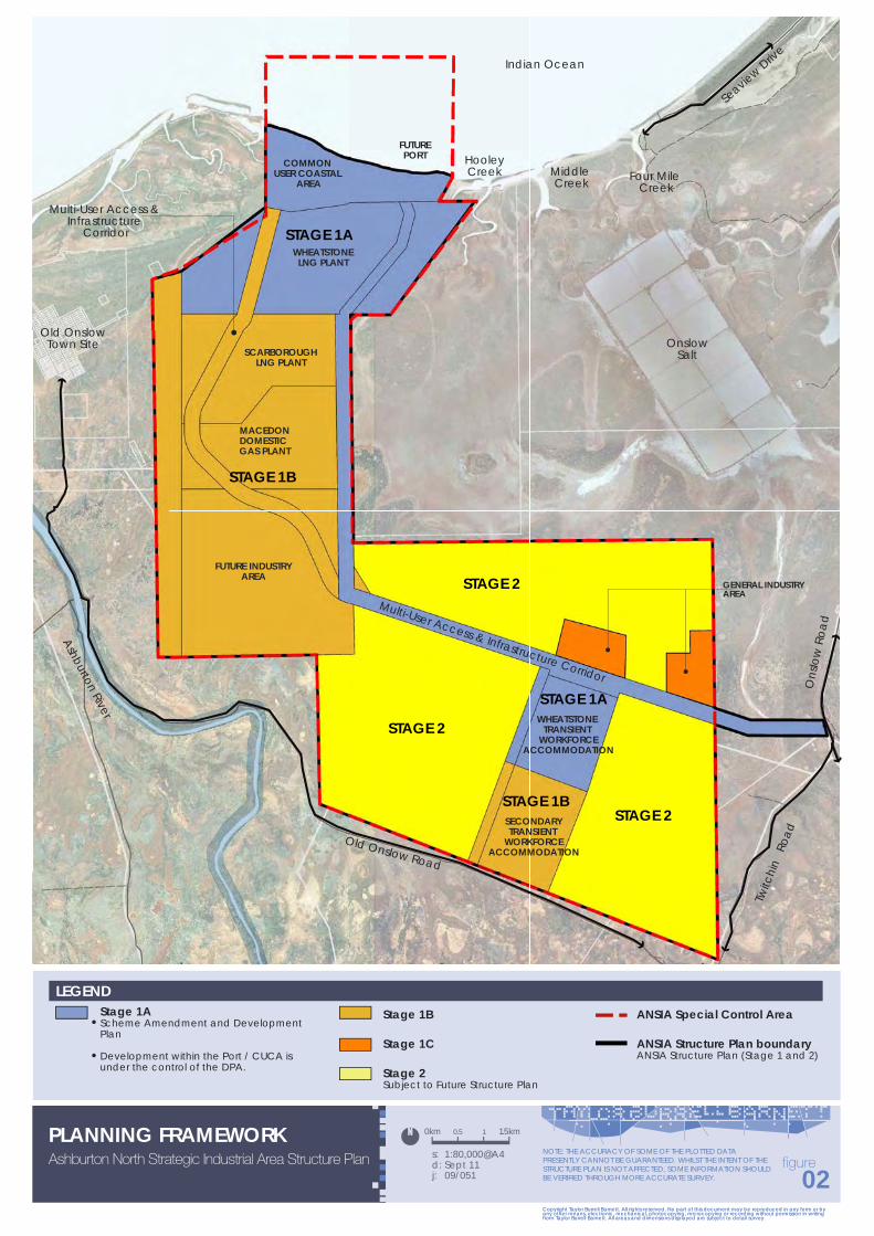
The Terms of Reference for the Working Group are included within Appendix A-A. The Working Group comprised representatives of the various government departments, and has provided advice in relation to the preparation of the ANSIA Structure Plan where appropriate. The Working Group is not a decision-making authority. Given the overall magnitude of the ANSIA Structure Plan area, and longer term nature of some of its parts, the Working Group recognised it would be appropriate that the level of information and analysis provided in the Structure Plan would vary for different parts of the ANSIA Structure Plan area. On this basis, the Working Group agreed that the area be divided into stages (refer Figure 2). The stages are defined as follows:
Stage 1, being the area the subject of known development interests. This area is further divided into sub-stages:
− Stage 1A: The area within which the foundation project (Wheatstone) is planned to develop. Given the advanced planning for this project, more detailed information is able to be provided for this stage including the CUCA/Port.
− Stage 1B: The area identified for the development of the Scarborough LNG Plant, the Macedon Domestic Gas Plant, the Future Industry Area and the second TWA site, for which varying amounts of information are available, but where further detailed planning can be expected in the near future.
− Stage 1C: The balance of Stage 1 identified for General Industry development for which varying amounts of information are available, but where further detailed planning can be expected in the future.
Stage 2, being the long term development area with no current development intention.

Ashburton North Strategic Industrial Area Structure Plan
09/051 11 | P a g e
The ANSIA Structure Plan focuses on the Stage 1 area and identifies the principles for the preparation of a subsequent Structure Plan for the Stage 2 area. Accordingly, a further Structure Plan will need to be prepared for Stage 2 which will utilise and reflect the planning undertaken for Stages 1A, 1B and 1C. Accordingly, reference to Stage 2 on the Structure Plan is for information purposes only.
It is noted that a portion of Stage 1B runs adjacent to the western boundary of Stage 1A. This area reflects the extent of the Notice of Intention to Take in Land to confer interests under the Land Administration Act 1997 and Native Title Act 1993 by the Minister for Lands. It has not been assessed in the Proponent’s Wheatstone EIS/ERMP process for Stage 1A. Additionally, the second TWA and Stage 1C areas have been the subject of detailed environmental investigations which will support applications for the rezoning and the preparation of Development Plans for these areas.

12 | P a g e
3 STATUTORY PLANNING FRAMEWORK
3.1 STATE PLANNING POLICIES
The WAPC has adopted a range of State Planning Policies (SPPs) which are to be taken into account when making planning decisions, as prescribed in the SPPs themselves and clause 5.9 ofLPS7. A number of SPPs have direct relevance to this Structure Plan as outlined below.
3.1.1 STATEMENT OF PLANNING POLICY NO. 1 – STATE PLANNING FRAMEWORK POLICY
The Western Australian Planning Commission (WAPC) prepared and adopted the ‘State Planning Strategy’ in 1997. It sets out the key principles relating to environment, community, economy, infrastructure and regional development which should guide the way in which future planning decisions are made. It also provides a range of strategies and actions that support these principles generally and for each of the ten regions of Western Australia.
The State Planning Strategy provides the overall vision and will be further articulated and applied by policies and plans dealing with particular planning issues or regions of the State. SPP1 – State Planning Framework Policy unites existing State and regional policies, strategies and guidelines within a central framework that provides a context for decision-making on land use and development in Western Australia.
It informs the WAPC, local government and others involved in the planning process on those aspects of State level planning policy that are to be taken into account, and given effect to, in order to ensure integrated decision-making across all spheres of planning. In relation to the proposed Scheme Amendment, and the subject land generally, the following WAPC Policies and Regional Strategies should be addressed:
State Planning Policy No. 2 – Environment and Natural Resources; State Planning Policy No. 2.6 – State Coastal Planning; State Planning Policy No. 3.4 – Natural Hazards and Disasters; State Planning Policy No. 4.1 – State Industrial Buffer; and State Planning Policy No. 4.1 – State Industrial Buffer (Amended) (Draft).
3.1.2 STATE PLANNING POLICY NO. 2 – ENVIRONMENT AND NATURAL RESOURCES
This Policy recognises the importance of minerals and petroleum resources in the State. With particular regard to the petroleum industry, the Policy advises:
“The Western Australian Petroleum Industry accounts for a substantial portion of the State’s earnings from resources development. Onshore gas fields and pipelines carrying gas to domestic markets, processing plants and other industrial sites require protection in the form of setback distances and dedicated easements that safeguard the infrastructure and the safety of local communities. The activities of the oil and gas industries are administered by the Department of Mineral and Petroleum Resources (now Department of Mines and Petroleum), using petroleum legislation and regulations.”
The sites of the proposed gas plants are generally remote from any urban area, being 10 km south-west of the nearest town, Onslow. They are within an area earmarked to become a Strategic Industrial Area which is to be zoned accordingly. The sites will therefore have adequate protection, securing their usage into the longer term and ensuring adequate buffering from sensitive land uses.
Ashburton North Strategic Industrial Area Structure Plan
09/051 13 | P a g e
Similarly, pipeline routes are to be contained in easements and proposed to be accommodated within reserves under LPS7.
3.1.3 STATE PLANNING POLICY NO. 2.6 – STATE COASTAL PLANNING
The Policy addresses land use planning and development issues specifically as they relate to the protection and management of the coast. The Policy requires strategic plans to guide local planning, development setbacks for protection against coastal processes such as erosion and storms, and the provision of coastal foreshore reserves.
Guidance is provided on determining setbacks. The preparation of coastal planning strategies or coastal foreshore management plans in partnership with the broader community is also strongly advocated.
The objectives of this Policy are to:
“protect, conserve and enhance coastal values, particularly in areas of landscape, nature conservation, indigenous and cultural significance;
provide for public foreshore areas and access to these on the coast;
ensure the identification of appropriate areas for the sustainable use of the coast for housing, tourism, recreation, ocean access, maritime industry, commercial and other activities; and
ensure that the location of coastal facilities and development takes into account coastal processes including erosion, accretion, storm surge, tides, wave conditions, sea level change and biophysical criteria.”
Schedule 1, Item G (c) of the State Coastal Planning Policy identifies the following exemption from the coastal processes setback determination:
“Industrial and commercial development that is demonstrably dependent on a foreshore location. Such development may include, for example, marinas, cage based aquaculture operations, port facilities and associated infrastructure”.
The State Coastal Planning Policy therefore is applicable to the ANSIA for the purposes of considering the impact of sea level rise on storm surge levels, which will contribute to the establishment of development levels.
3.1.4 STATE PLANNING POLICY NO. 3.4 – NATURAL HAZARDS AND DISASTERS
This Policy addresses, for development within an area prone to cyclonic activity, the requirements for “structures to be able to withstand cyclonic winds and rain contained within the Building Codes of Australia”.
All components of the project will be required to be constructed in accordance with the Building Code of Australia and/or relevant/applicable Australian Standards.
SPP 3.4 also recognises the potential impact of storm surge, advising that:
“Where storm surge studies have been undertaken and show that inundation may occur, new permanent buildings should be constructed to take account of the effects of storm surge (including wind and wave set-up).”

14 | P a g e
The impacts of extreme weather conditions will need to be considered in planning for the development, with minimum site levels established for buildings and other infrastructure.
Furthermore, development of the ANSIA will need to be managed to ensure protection of infrastructure from natural events.
3.1.5 STATE PLANNING POLICY NO. 4.1 – STATE INDUSTRIAL BUFFER POLICY
SPP4.1 – State Industrial Buffer Policy applies to all industries including resource processing. Since publication of this SPP in 1997, a draft review of the Policy was released in July 2004 and remains to be finalised (refer following section). The SPP requires the assessment of buffer requirements as necessary on a case-by-case basis. A major factor in respect of oil and gas industries is risk assessment and this assessment has been undertaken as part of the Wheatstone EIS/ERMP.
The objectives of this Policy are to:
“provide a consistent State-wide approach for the definition and securing of buffer areas around industry, infrastructure and some special uses;
protect industry, infrastructure and special uses from the encroachment of incompatible land uses;
provide for the safety and amenity of land uses surrounding industry, infrastructure and special uses; and
recognise the interests of existing landowners within buffer areas who may be affected by residual emissions and risks, as well as the interests, needs and economic benefits of existing industry and infrastructure which may be affected by encroaching incompatible land uses.”
In the absence of agreed alternative buffer requirements, the Policy refers to generic buffers recommended by the EPA (EPA Guidance Statement No. 3 – Separation Distances Between Sensitive Land Uses). For ‘Oil and Gas Production’ and/or ‘Oil or Gas Refineries’, the generic buffer is 2,000 metres. For ‘Gas Distribution’ (works to supply mains) the generic buffer is 300 metres.
The ANSIA is some 10 km to the south-west of the town of Onslow and therefore well clear of the major population centre in the locality. It is also approximately 1 km from Old Onslow and 2 km east of the Ashburton River, being areas attracting some visitation. Gas mains associated with the ANSIA will be well over 300m from any of these areas.
3.1.6 STATE PLANNING POLICY NO. 4.1 – STATE INDUSTRIAL BUFFER (AMENDED) (DRAFT)
Whilst the draft amended Policy was originally released in 2004, an updated version was released in 2009 for comment but is still not finalised. This Policy is based on an assumption that routine industrial emissions and risk factors are identified during planning and environmental assessment processes and managed in accordance with licence conditions or statutory environmental conditions. Where licences and statutory environmental conditions are not applicable, high standards of environmental management should be adopted by industry and infrastructure providers.
Objectives of this Policy are to:

Ashburton North Strategic Industrial Area Structure Plan
09/051 15 | P a g e
“avoid conflict between industry and/or essential infrastructure and sensitive land uses;
protect industry and/or essential infrastructure from encroachment by those land uses that would be sensitive to impacts and adversely impact the efficient operations;
provide for the development of industry and/or the provision of essential infrastructure in a way that maximises amenity, minimises environmental and health impacts and takes account of risk to nearby sensitive land uses; and
promote compatible uses in areas affected by off-site impacts of industry and/or essential infrastructure.”
Given that the land within the ANSIA and the immediately surrounding landholding is under the control of the state it is not considered necessary to strictly apply SPP 4.1. Rather than buffers, land use separation area externally and internally to the ANSIA have been determined and are referenced within section 6.7 of this report.
3.2 REGIONAL/LOCAL PLANNING FRAMEWORK
3.2.1 PILBARA FRAMEWORK
The Western Australian Planning Commission (WAPC) has prepared and released for public comment the draft Pilbara Planning and Infrastructure Framework (Framework) which seeks to define a strategic direction for the future development of the Pilbara region, over the next 25 years. The Framework concludes that:
“….by 2035, the region will have a resident population of more than 140 000, based on a more diverse economy that has capitalised on its competitive advantages. As part of the Pilbara Cities vision, the Pilbara will have two cities: Karratha and Port Hedland, each with a population of 50 000. These would be supported by the Newman sub-regional centre with a population of 15 000 and the major towns of Tom Price, Onslow and Wickham.”
Under the Framework, Onslow is defined as a ‘major town’. The Framework observes that:
“…..Onslow, will also expand and have new roles. This will involve an investment partnership between government and the private sector.”
Programs and development referred to in the Framework directly identified with Onslow are as follows:
“identify new water source − Cane River borefields, Birdrong aquifer or an alternative − to service Onslow.
Expansion of Onslow Primary School to a District High School.
Provision of a swimming pool in Onslow.
Investigate upgrading Onslow Airport to service the Ashburton North Strategic Industrial Area.
Onslow may triple in size if the Ashburton North Strategic Industrial Area is developed to its full potential. It may, however, only experience more moderate growth if development is more subdued.

16 | P a g e
In terms of housing, the latent demand within the town is estimated to be 105 houses. Total future demand for housing calculated between 2009-2015 is between 107 (low growth) and 913 (high growth).”
“Future role and character Onslow’s future is largely dependent on the construction of processing facilities for off-shore hydrocarbons at the proposed Ashburton North Strategic Industrial Area. While a permanent workforce in Onslow is encouraged, growth will be largely dependent on the proportion of fly-in fly-out workers during the construction and operations phases. Onslow will continue to depend on Karratha for higher order community and commercial facilities. The Onslow townsite was established at its current location in 1925.
The Shire of Ashburton had its main administrative centre in the town, until it relocated to Tom Price in 1990. Currently, the town’s principal economic drivers are Onslow Solar salt, fishing, off-shore marine servicing and tourism.
Onslow’s current resident population is estimated to be in the order of 700 but this can vary due to the high mobility of the indigenous population. The town is on the threshold of a significant expansion as the locality is considered a favourable area to establish gas processing industries to monetise gas resources from the North West Shelf by production of LNG for exportation to overseas markets and domestic gas for the local market. However, the upfront capital required to establish these industries and constant fluctuations in overseas demand create uncertainty in regard to the scale and timing of potential venture(s).
There is currently no dedicated fly-in fly-out accommodation in Onslow. However, a significant number of transient workers occupy rooms and units in the town’s commercial visitor accommodation and private dwellings. Residential development in Onslow will tend to follow similar forms to the existing pattern. There is, however, likely to be a larger proportion of townhouses and other forms of medium-density living. Average densities are likely to increase from R25 to R40 and maximum building heights will increase from two storeys to three storeys. To meet demand, permanent dwelling stock is anticipated to increase from around 270 to 770.”
Under the heading “Wheatstone Project”, the Framework notes:
“The Wheatstone LNG and gas project is being developed by Chevron Australia. An LNG processing plant is planned to be located at Ashburton North 12 kilometres to the west of Onslow. The plant will initially comprise two LNG trains, each with a capacity of 4.3 Mtpa, together with a domestic gas plant. Supplied from the Wheatstone and Iarge off-shore gas fields, it will eventually have a 15 Mtpa processing capacity.”
3.2.2 ONSLOW STRUCTURE PLAN (2003)
The Onslow Structure Plan (2003) was developed to facilitate the accommodation of emerging and strategic industrial opportunities at Onslow, with a particular focus on local and regional resources such as salt and natural gas.
The Plan was intended to have an outlook of 20-25 years, however, the recent discovery of additional large off-shore gas supplies and improved economic outlook have identified future opportunities that were not considered in the development of the Onslow Structure Plan 2003. A review of the Structure Plan was commenced in 2006 to address the implications of the possible development of gas processing in the Strategic Industrial Area south of the town. The review has been replaced by the Onslow Townsite Strategy, refer section 3.2.3 below.

Ashburton North Strategic Industrial Area Structure Plan
09/051 17 | P a g e
3.2.3 ONSLOW TOWNSITE STRATEGY 2010
The Onslow Townsite Strategy (2010) was adopted by Council in July 2010 and endorsed by the WAPC in March 2011. As a consequence of the ANSIA development, Onslow will experience significant population growth and significant reorientation of Onslow’s urban structure will be required to accommodate the residential, community and civic needs of the anticipated residential population expansion.
In relation to TWA, the Onslow Townsite Strategy states that:
“Economic Vitality: Provide for ‘transient workforce accommodation’ only where it ensures social, amenity and architectural cohesion”.
The Onslow Townsite Strategy continues, pages 9/10:
“N2.10 Transient Workforce Accommodation currently within the Onslow townsite and under the Shire of Ashburton Town Planning Scheme No. 7 ('Scheme'), only the Residential and Tourism zones provide the opportunity to develop land for Transient Workforce Accommodation. The Scheme does not provide guidance as to the form such development may take. Experience elsewhere has generally resulted in the blighted development of camps of questionable quality and poor social interface with the existing community.
Development Principles
It is appropriate that any such Transient Workforce Accommodation be of a very high quality for the benefit of occupiers, as well as the community.
Motel style development, with significant landscaping, quality design and materials, will be encouraged.
A limitation on the overall proportion (%) of Transient Workforce Accommodation within a development should also be a consideration of the Amendment.
Desired Future Character: A modification to the Scheme to reflect this desired outcome of design and development is recommended. In addition, it is noted that the Commercial and Civic zone prohibits Transient Workforce Accommodation. In this regard, it is appropriate that the Shire consider amending the Scheme to allow Transient Workforce Accommodation in this zone on the basis referred to above".
The Onslow Townsite Strategy seeks to balance pressure for the establishment of new living areas with the need to revitalise and, where appropriate, restructure the existing residential precincts. Introducing higher densities in the existing residential areas will provide the opportunity to:
“Make these areas more viable in terms of urban and community services; Reduce the urban footprint thus conserving land with high biodiversity, cultural and pastoral value;
and Identify under-utilised land for community purposes, for residential use.”

18 | P a g e
3.2.3.1 NEW RESIDENTIAL AREAS
A total area of 140 ha has been identified for the potential development of new living areas. This is noted on the Strategy Map and will be determined in the future structure planning for the town. This land will be developed as a number of residential precincts.
The Onslow Townsite Strategy identifies the following development principles for new residential areas:
“Develop new residential or living areas will be developed generally in accordance with the WAPC Liveable Neighbourhoods principles.
Provide safe, convenient and attractive residential precincts that provide lifestyle choice. Minimise non-renewable energy use and car dependence. Provide a coherent system of compact walkable precincts, which cluster to form neighbourhoods. Adopt a site responsive approach to precinct layout design. Incorporate a movement network that has a clear hierarchy which distinguishes between different
levels of vehicle penetration to residential areas. Provide for a network of well-distributed parks and recreation areas to an extent suitable for
Onslow’s climatic conditions. Respect environmental and hazard constraints, including soil erosion, flood and bushfire risk. Adopt best-practice approaches to urban water management. Respect the biodiversity values of the locality. Provide public utilities in a timely, cost-effective and coordinated manner.”
According to a review of the Onslow Structure Plan, development areas in Onslow could potentially yield up to 370 or more dwelling units (WAPC 2003). However, the rate at which residential land can be made available is a significant issue. Most of the identified future development areas are located on unallocated crown land, which is likely to be subject to native title considerations. Land assembly processes may be lengthy and land may not be available in time to meet demand. In addition, land supply in Onslow is constrained by flooding, the airport, noise and buffer impacts associated with the Onslow Salt Works. Therefore, it is anticipated that any further population influx into the town will require adequate time for planning and development.
In order to provide the opportunity for a variety of residential development, together with a tourist focus, a residential tourist marina is considered to be an acceptable form of development for Onslow. This is in accordance with the direction provided by the Council’s Strategic Plan (2007-2011) and reflected in the Shire’s Onslow Marina Feasibility Study. In this regard, it is likely that a potential marina would seek direct waterway access from Beadon Creek.
3.2.3.2 TRANSIENT WORKFORCE ACCOMMODATION
LPS7 presently only permits Transient Workforce Accommodation (TWA) within the Residential and Tourism zones in Onslow. The LPS7 does not provide guidance as to the form such development may take. Experience elsewhere, however, has generally resulted in the blighted development of villages of questionable quality and poor social interface with the existing community.
The Onslow Townsite Strategy (2010) identifies the following development principles with respect to TWA:
“It is appropriate that any such Transient Workforce Accommodation be of a very high quality for the benefit of occupiers, as well as the community.

Ashburton North Strategic Industrial Area Structure Plan
09/051 19 | P a g e
Motel style development, with significant landscaping, quality design and materials, will be encouraged.
A limitation on the overall proportion (%) of Transient Workforce Accommodation within a development should also be a consideration.“
The Onslow Townsite Strategy recommends a modification to the Scheme to reflect this desired outcome.
3.2.3.3 ONSLOW AIRPORT AREA
The Onslow Townsite Strategy notes that that the Onslow Airport is an underutilised transport facility, however it is anticipated that the demand for air transport will increase dramatically with the development of the ANSIA. To accommodate large jet passenger aircrafts, such as a Boeing 737, there will be a need for the existing main runway to be extended from 1,600 to at least 2,000 metres.
There may be scope to increase the length of the runway by a further 600 metres (to 2,200 metres) depending upon the relocation of the Onslow Salt access road on the Shire airport land. With the further development of the ANSIA, there may be a need in the future to establish an alternative airport site to the south of the township. This would only occur with the direct support of the operators within the ANSIA and the State Government.
The Onslow Townsite Strategy identifies the following development principles:
“The potential expanded function and operation of the airport will require the imposition of setbacks from the airport for sensitive land uses, with respect to increased noise levels (setbacks and attenuation) and changes to development height limitations. If a decision is made to relocate Onslow's airport, this area is likely to be used for non-residential activities.
In this regard, the current airport site is approximately 530 ha and provides the opportunity for the Shire to establish larger transport related industries without impacting on the airport. These larger lots are considered necessary for the development of ANSIA support businesses. Importantly, these lots can be established in the short and medium term to meet the anticipated demand.”
3.2.4 ONSLOW STORM SURGE STUDIES AND INVESTIGATIONS
Two significant storm surge studies and investigations have been undertaken for the Onslow District. These are:
Onslow Storm Surge Study (Halpern Glick and Maunsell 2000); and Onslow Foreshore Investigations (MP Rogers & Associates 2002).
The first study sought to more accurately define the flood risk in Onslow, which is notionally identified by the Onslow Coastal Hazard Area in LPS7. The second study investigated coastal processes, flooding regimes and options for coastal protection.

20 | P a g e
3.3 SHIRE OF ASHBURTON LOCAL PLANNING SCHEME NO. 7
LPS7 covers the entire Shire and is the primary statutory control for land use and development. The Scheme currently makes allowance for a range of zones and reserves. LPS7 presently identifies the ANSIA as a combination of ‘Rural’ zoned land and ‘Conservation, Recreation and Natural Landscapes’ Reserve (refer Figure 3).
The Shire of Ashburton adopted Amendment No. 9 to LPS7, which was gazetted on 21 December 2010. The intent of the Amendment is to establish the ANSIA within a planning precinct, in the form of a SCA and introduce the requirements for a Structure Plan.
The Coastal Hazard Area SCA as identified in LPS7 may impact the ANSIA, as outlined below.
3.3.1 ONSLOW COASTAL HAZARD AREA SPECIAL CONTROL AREA
The ‘Coastal Hazard Area SCA’ applies to all land up to 4m AHD in the coastal zone and 5m AHD in the frontal dune areas of the townsite, between Four Mile Creek in the south west and Beadon Creek in the north-east, including land located within the ANSIA. When considering development proposals where the land is not subject to the above requirements, if the Local Government considers the form of development to be potentially incompatible with, and prone to, flood and storm surge events, it may have regard to the requirements as it assesses the planning application. This will be particularly relevant to the Port/CUCA area.
3.4 LOCAL PLANNING POLICIES
LPS7 is supported by a number of Local Planning Policies. A summary of the relevant policies is outlined below.
3.4.1 LOCAL PLANNING POLICY 20 – SOCIAL IMPACT ASSESSMENT
This Policy requires a Social Impact Assessment and preparation of a Social Impact Statement (SIS) for the following:
“All development proposals that are subject to community consultation or advertising processes, pursuant to the Zoning Table of the Scheme;
All proposals for rezoning or amending the Scheme; and All proposals for strategic level development planning.”
The Policy states that the primary purpose of the SIS is to bring about better planning decisions and a more sustainable and equitable ecological and human environment. This is achieved by describing the potential impacts of a proposed project, demonstrating how issues and concerns raised during the community consultation will be addressed. In relation to development within the ANSIA, it is necessary to not only comply with the provisions of LPP 20 but also the relevant provisions of Appendix 11.
A SIS has been prepared for the ANSIA in accordance with this Policy (refer Appendix B).
3.4.2 LOCAL PLANNING POLICY 13 – TRANSIENT WORKFORCE ACCOMMODATION
This Policy recognises the limited benefits FIFO operations have to the economic and social value of the Shire, but acknowledges that there are circumstances where TWA is necessary. The Policy states:

LEGEND
LOCAL SCHEME RESERVES
ZONES
Conservation, Recreation & Natural Landscapes
Rural
OTHERAshburton North Strategic Industrial Area - SCA
Onslow Strategic Industrial Buffer - SCA
Tidal Inundation Area Special Control Area
Structure Plan boundary
REFER TO MAP 2, 3 AND 4
Ashburton North Strategic Industrial Area Structure Plan
EXTRACT OF SHIRE OF ASHBURTON TOWN PLANNING SCHEME No. 7 s: NTS
d: Sept 11j: 09/051
Copyright Taylor Burrell Barnett. All rights reserved. No part of this document may be reproduced in any form or by any other means, electronic, mechanical, photocopying, microcopying or recording without permission in writing from Taylor Burrell Barnett. All areas and dimensions displayed are subject to detail survey.
03figure
Copyright Taylor Burrell Barnett. All rights reserved. No part of this document may be reproduced in any form or by any other means, electronic, mechanical, photocopying, microcopying or recording without permission in writing from Taylor Burrell Barnett. All areas and dimensions displayed are subject to detail survey.
NOTE: THE ACCURACY OF SOME OF THE PLOTTED DATA PRESENTLY CANNOT BE GUARANTEED. WHILST THE INTENT OF THE STRUCTURE PLAN IS NOT AFFECTED, SOME INFORMATION SHOULD BE VERIFIED THROUGH MORE ACCURATE SURVEY.

22 | P a g e
“The Council of the Shire of Ashburton acknowledges that “fly- in, fly-out” workforce operations are an important factor in developing the resources of the Pilbara. Transient workforce accommodation generally falls into two workforce categories:
construction workforce; and operational workforce.
The Council acknowledges that there will be circumstances such as remoteness and limited life of a particular activity that result in a need for transient workforce accommodation camps to be established outside of the townsites. These camps will normally be construction workforce transient workforce accommodation and for a limited time period.
Construction workforce transient workforce accommodation will usually be for a limited time (short term construction period) and reasonably be placed in close proximity to the specific development. Normally the construction workforce is much larger than an operational workforce. An operational workforce however is normally for an indefinite period of time and therefore should as far as practical, be housed within an existing town. The desire is to incorporate the workforce with the community thus adding to the vibrancy and economic sustainability of the towns of Tom Price, Onslow Paraburdoo and Pannawonica.
Operational transient workforce accommodation within townsites will be of a very high quality for the benefit of occupiers, as well as the community, generally motel style development, with significant landscaping, quality design and materials, will be encouraged. The Council may seek to place a limit on the overall proportion (%) of transient workforce accommodation within a development.”
Advice from Chevron, the ‘Foundation Proponent within the ANSIA is that development of the LNG facilities and CUCA will employ between 5000-7000 persons at one time. In terms of their impact on social and hard infrastructure, Onslow could not cope with that number of people. Accordingly, two TWA sites are identified on the Structure Plan for the purpose of providing accommodation for the extensive construction workforce numbers. Proposed Scheme Amendment(s) and Development Plan(s) will need to address the requirements of this Policy, as well as ensure that practical measures are in place to guarantee that proponents are totally responsible for housing their own direct construction employees, along with their contractors, subcontractors and authorised visitors associated with their respective developments.
3.4.3 LOCAL PLANNING POLICY 17 – CONSULTATION FOR PLANNING PROPOSALS
The Policy establishes how the Shire will advise and consult with the community about land uses and developments, in an endeavour to ensure openness and accountability in the decision-making processes and to gauge public opinion.
It establishes a method by which Scheme Amendments and draft Development Plans can be classified according to their likely impact and defines the different levels of consultation that will be undertaken.
Due to the extensive consultation program required to engage the community of Onslow and indeed, Western Australia, it is appropriate that the advertising period of the draft ANSIA Structure Plan (and draft Planning Scheme Amendment No. 10) is 42 days as the draft ANSIA Structure Plan and draft Scheme Amendment No. 10 represents the most significant development within the Shire, generally and Onslow in particular. Accordingly, it is appropriate to ensure that the community of Onslow, the Shire and Western Australia are given every opportunity to review the documentation (which is in excess of 600 pages of reports and attachments) and make a submission.

Ashburton North Strategic Industrial Area Structure Plan
09/051 23 | P a g e
4 CONTEXT
The regional and local context for the ANSIA is described in further detail below and identified on Figure 4.
4.1 REGIONAL CONTEXT
Onslow is a coastal community that forms part of the Pilbara Region. The region includes the Pilbara coastal plain, and the system of off-shore islands that include Barrow Island and the Mackerel Islands, and the extensive arid, inland area. Onslow is approximately 311 km by road from Karratha, and 100 km by air from Exmouth.
Onslow is served by the Karratha airport, (located some 14km from the Karratha Town Centre). Karratha airport provides the West Pilbara with scheduled air services to Perth and other destinations in Australia. Onslow has a sealed landing strip which is managed by the Shire of Ashburton.
4.2 LOCAL CONTEXT
The ANSIA is located approximately 10 km south-west of the Onslow townsite and approximately 2 km east of the Ashburton River.
4.2.1 ONSLOW TOWNSITE
Onslow is a small town situated on the coast 82 km from the Onslow Road turn-off on the North West Coastal Highway. The town’s population has, in recent times fluctuated between 600 and 900 people, partly due to the relatively mobile nature of the local indigenous population. Despite its rather isolated location, the town attracts many tourists travelling the North West Coastal Highway and is a popular holiday and recreation centre for the residents of the inland mining towns.
Onslow developed on its current site between Beadon Creek and Beadon Point in 1925, after the port facilities at the mouth of the Ashburton were affected by the silting up of the river causing more and more problems in the loading and unloading of visiting ships. Surveys proved that there was deep water at Beadon Point and so the town was moved to the east, where it is today. It has a primary school, hospital, shops, hotel/motels, a caravan park, and other forms of holiday accommodation. Onslow has a small fishing industry and is a service centre for the surrounding pastoral industry as well as nearby offshore oil and gas exploration and development activity. Beadon Creek has been developed as a safe anchorage for boats and provides wharf facilities for the fishing industry.
4.2.2 OLD ONSLOW TOWNSITE
The Old Onslow Townsite, located 1 km west of the ANSIA (refer Figure 5), is a permanent entry on the Register of Heritage Places (P3444 2006). It is also listed on the Shire of Ashburton’s Municipal Heritage Inventory.
The principal elements of the Old Onslow Townsite are the courthouse, the hospital, the police station police quarters and gaol (1893; 1906/1907), telegraph station (1885), cemetery (1897), an associated river landing (1886, 1894)), a coastal jetty site (1899) and the remains of a tramway alignment (1900), which marks the progress of a tramline that connected the jetty to the town. These are contained within a registered curtilage, part of which, including sections of the tramway alignment and the jetty site, lies inside the ANSIA. This will be discussed further in section 5.1.6.

s: 1:80,000@A3d: Sept 11j: 09/051
Copyright Taylor Burrell Barnett. All rights reserved. No part of this document may be reproduced in any form or by any other means, electronic, mechanical, photocopying, microcopying or recording without permission in writing from Taylor Burrell Barnett. All areas and dimensions displayed are subject to detail survey.
Ashburton North Strategic Industrial Area Structure PlanCONTEXT PLAN
04figure
Copyright Taylor Burrell Barnett. All rights reserved. No part of this document may be reproduced in any form or by any other means, electronic, mechanical, photocopying, microcopying or recording without permission in writing from Taylor Burrell Barnett. All areas and dimensions displayed are subject to detail survey.
0km 1.5km0.5 1
NOTE: THE ACCURACY OF SOME OF THE PLOTTED DATA PRESENTLY CANNOT BE GUARANTEED. WHILST THE INTENT OF THE STRUCTURE PLAN IS NOT AFFECTED, SOME INFORMATION SHOULD BE VERIFIED THROUGH MORE ACCURATE SURVEY.
Structure Plan boundary
Existing Road
Agreed access point to ANSIA from Onslow Road
LEGENDREGIONAL CONTEXT
ONSLOW TOWNSITE
EXMOUTH TOWNSITE
DAMPIER TOWNSITE
KARRATHA TOWNSITE
TALANDJI
INDIAN OCEAN
North
Wes
t Coa
stal H
wy
Approx 90kmfrom Onslow
Approx 60kmfrom Onslow
Approx 200km from Onslow
Approx 225km from Onslow
Old OnslowTown Site
Onslow Town Site
OnslowSalt
Existing Onslow Industrial Area
Old Onslow Road
Ons
low
Roa
d
Onslow Peedamulla Road
Onslow Road
Twitc
hin
Road
Seavie
w Drive
HooleyCreek
Four Mile Creek
OnslowAirport
WHEATSTONELNG PLANT
SCARBOROUGH LNG PLANT
MACEDON DOMESTICGAS PLANT
FUTURE INDUSTRIAL AREA
FUTURE PORT
COMMON USER COASTAL
AREAMiddle Creek
Indian Ocean
Ashburton River
Approx 60km to North
West Coastal Highway
App
rox
18km
to O
nslo
w
Tow
n Sit
e
GENERAL INDUSTRYAREA

24 | P a g e
Figure 5: Site Location Plan Showing Sites Outside of Old Onslow [Source: Nayton 1991]
4.2.3 ONSLOW SALT
Onslow Salt operates a 2.5 million tonne per annum solar salt field, comprising a wash plant, salt stockpile area, ship loading jetty and loading platform to the west of Beadon Creek. The operation incorporates 8,000 ha of salt ponds and a 10 km navigation channel for shipping in the nearshore area. The project has provided a significant boost to the Onslow economy, and has contributed to considerable social and economic activity in the town.
Onslow Salt is the nearest operating industrial facility to the ANSIA; these operations are located approximately 5 km east of the ANSIA.
Onslow Salt was established under a State Agreement, which covers all aspects of its operations including requirements for ponds, crystallisers, haul road and cleaning facilities. The Onslow Salt leases include the ponds and haul road and have an area of approximately 475 ha. Onslow Salt has interests within the ANSIA and negotiations with the company are required in order to develop the ANSIA. A portion of the ANSIA is located on land covered by the Onslow Solar Salt State Agreement Act 1992. Commercial arrangements are in place for this land to be incorporated into the ANSIA.

Ashburton North Strategic Industrial Area Structure Plan
09/051 25 | P a g e
4.2.4 ASHBURTON RIVER/CAMPING
The Ashburton River is one of the Pilbara region’s most significant river systems. It meanders through the plains of the northern part of the region in a north-north-west direction for about 110 km to where it meets the Indian Ocean at a point close to Onslow. The river is utilised for informal camping and fishing by locals and tourists and is accessed locally via Old Onslow Road that extends along the southern boundary of the proposed ANSIA.
As advised by the Department of Environment, the informal camping areas along the Ashburton River would not be classified as sensitive receptors as there are no permanent buildings or facilities associated with the land use.
4.2.5 EXISTING ONSLOW STRATEGIC INDUSTRIAL AREA
The existing Onslow Strategic Industrial Area (SIA) is identified in the Department for Planning and Infrastructure’s Onslow Structure Plan (2003). The current Onslow SIA is approximately 475 ha in area and there is a 3,000 m buffer zone separating the site from other land uses, as indicated on the Onslow Structure Plan and LPS7 maps. Located to the south-west of the existing Onslow townsite, the Onslow SIA is loosely bound by the existing Onslow Salt haul road and ponds/crystallisers, on some of the highest land available. The Onslow SIA is bounded by Conservation and Recreation reserved areas to the north and west, the Onslow Salt evaporation ponds to the west, and low-lying wetlands to the south (refer Figure 4).
As outlined within the Onslow Townsite Strategy (Shire of Ashburton, April 2010/WAPC March 2011):
“Onslow is a strategic location of interest to resource companies due to factors such as its location, deep-water access and proximity to offshore gas reserves. A number of industry feasibility studies have identified the Onslow area in their assessments. The recent proposal to locate LNG facilities at the Ashburton North Strategic Industrial Area provides the impetus for a significant expansion of the town to accommodate LNG plant workers and their families. The ultimate development of Ashburton North will include a new port and general industry area that will provide the support to the LNG facilities, port and Onslow.”
A set of actions were identified within the Strategy to protect the character and viability of Onslow. This was reinforced in the Onslow Regional Hotspots Land Supply Update prepared by the Department of Planning in February 2010, which identified the likely rezoning of the existing Onslow SIA given development of the Ashburton North SIA. Rezoning of the existing SIA at Onslow to ‘Special Use’ will make the area available to support growth in Onslow.
Given the constraints placed by the location of the Onslow SIA on the townsite expansion, coupled with the provision of some 8,000 ha of strategic industrial land at Ashburton North, it has been concluded that the existing SIA in Onslow is surplus to the town’s industrial requirements. In this regard, it is acknowledged that the Shire is progressing a Scheme Amendment (No. 11) to rezone the Onslow SIA to allow for the expansion of the Onslow townsite. At its meeting of 15 December 2010, the Shire initiated the rezoning of the Onslow SIA to include it within the Rural zone and delete the Buffer Area to the Onslow SIA.
The EPA responded to the statutory referral of Amendment No. 11 and advised that the Amendment does not require formal assessment under the Environmental Protection Act 1986. The desired timing of Amendment No. 11 is for it to be considered and advertised in concert with the draft Amendment No.10 and associated Structure Plan for the ANSIA.
At the meeting of Council on 15 June 2011, Council resolved to adopt to advertise Amendment No. 11 in accordance with the Town Planning Regulations 1967 and in concert with Amendment No. 10.

26 | P a g e
4.2.6 ACCESS
Onslow Road is the main access road into the Onslow Townsite and serves to connect the townsite to the North West Coastal Highway, some 80 km south-east of the town. Much of the road seal of Onslow Road is approximately 6.5m wide. Any development at the ANSIA will require significant upgrade of Onslow Road to cater for the anticipated traffic associated with the LNG facilities, CUCA and general industry.
Twitchin Road connects to Onslow Road in close vicinity of the proposed connection to the proposed Eastern MUAIC of the ANSIA. The turn-off to Old Onslow Road is located approximately 19 km south of Onslow and forms the southern boundary of the ANSIA.
Both Twitchin Road and Old Onslow Road will be severely impacted upon during the initial years of development within the ANSIA. These roads are presently used for access to the Ashburton River and are frequented by retirees seeking to camp in the river environs. The Shire of Ashburton is entrusted with the care and control of Old Onslow Road and Twitchin Road.
The existing road network and intended upgrades are discussed in more detail in section 6.6 of this report.

Ashburton North Strategic Industrial Area Structure Plan
09/051 27 | P a g e
5 ISSUES AND OPPORTUNITIES
Outlined below and documented on Figure 6 is a summary of the issues and opportunities recognised in the preparation of the ANSIA Structure Plan. These have been identified following a synthesis of the various technical studies undertaken in relation to the Foundation Proponent’s land, along with the proposed area for the CUCA and MUAIC. As noted on the ANSIA Structure Plan (refer Figure 8), this land is referred to as ‘Strategic Industry Stage 1’. In this regard, all other areas and any proposed Scheme Amendments will need to be accompanied by extensive environmental assessments to the requirements and satisfaction of the EPA.
The technical studies undertaken in relation to the ANSIA Structure Plan are included as separate appendices to this document.
5.1 ENVIRONMENT
An Environmental Assessment Report that directly relates to areas associated with the Wheatstone project and proposed area for CUCA and MUAIC has been prepared by AECOM Australia Pty Ltd (refer Appendix C). Much of the information in the AECOM report is summarised from the EIS/ERMP and the advice provided by Chevron in response to matters raised as a result of the public advertising period. In addition, the report addresses air and noise impacts, water and flood management. A summary of the issues and opportunities in relation to the environment is documented below.
5.1.1 FLORA
No species listed as rare and endangered by the Wildlife Conservation Act 1950 were located in the ANSIA. Flora species of conservation significance were located within the ANSIA. These include five species listed as Priority under the Western Australian Wildlife Conservation Act 1950 (WC Act), one of which, Eleocharis papillose, is also listed as Vulnerable under the Environmental Protection and Biodiversity Conservation Act 1999 (EPBC Act). A further five species were identified as being either undescribed (new), poorly represented/described or a variance to the known information.
Although some priority flora and potentially undescribed flora may have to be cleared, all of these flora have also been recorded outside of the Project area. In addition, the Project will require the clearing of over 44 per cent of locally significant vegetation unit C3 (low Tecticornia shrubland in slaine claypans) in a “maximum clearance scenario”. The actual proportional clearing of vegetation unit C3 would be expected to be considerably less than 40 per cent. Although some vegetation communities are classified as locally significant, none are declared matters of national environmental significance under the EPBC Act 1999.
Given the detailed level of information that exists on the flora within the ANSIA, there is an opportunity for regional data to be collected by future ANSIA proponents. Chevron and BHP Billiton have undertaken extensive vegetation and flora surveys within the ANSIA and this information will assist future ANSIA proponents. Given these proponents may not be required to invest in flora and vegetation assessments for their sites, it may be appropriate for these proponents to contribute to additional regional flora and vegetation surveys, to better understand the range and distribution of the species and communities located within the ANSIA.
The information collected by any additional regional surveys should be provided in Development Plans. This should include information that describes the regional context of the Priority Flora and undescribed/poorly described flora species identified as being present in the ANSIA. This information should include an understanding of the landform and vegetation types with which they are associated.

Old OnslowTownsite
OnslowSalt
Old Onslow Road
Ons
low
Roa
d
Twitc
hin
Road
HooleyCreek Four Mile
CreekMiddle Creek
Indian Ocean
Ashburton River
NOTES
Future Port
Common User Coastal Area
Wheatstone LNG Plant site
Scarborough LNG site
Macedon Domestic Gas site
Future Industry Area
General Industry Area
Stage 2 - Subject to Future Structure Plan
1
2
3
4
5
6
7
8
12
3
5
6
8
8
77
8
4
ACID SULFATE SOILSLEGEND
Structure Plan boundary
Heritage Reserve P3444 (HCWA, 2008)
4m-6m AHD viable development area
7m+ AHD more viable development area
Linkage
Eastern Multi-User Access & Infrastructure Corridor
Western Multi-User Access & Infrastructure Corridor
Wheatstone Transient WorkforceAccommodation site
Secondary Transient Workforce Accommodation site
Existing Fuel/Gas Pipeline
Onslow Salt use restrictions
Minor Watercourse (URS 2010)
Surface Water Preferential Pathway - low ARI Events
Priority FloraEremophila forrestii subsp. viridisTriumfetta echinataAtriplex flabelliformis
Undescribed Flora
Mangroves
Distance from sensitive use to Strategic Industry area boundary
Risk, noise and air buffers to conform with requirements of EPA Guidance Statement 2 and EPA Act Noise and Air Quality Regulations in relation to sensitive uses.
Potential Acid Sulfate Soils - High Risk
Possible Acid Sulfate Soils - High Risk (Unsurveyed)
xkm
LAND USE
ENVIRONMENTAL
2.5km
1kk1k1km
1km
1km
1
3.7km
Seavie
w Drive
s: 1:80,000@A3d: Sept 11j: 09/051
Copyright Taylor Burrell Barnett. All rights reserved. No part of this document may be reproduced in any form or by any other means, electronic, mechanical, photocopying, microcopying or recording without permission in writing from Taylor Burrell Barnett. All areas and dimensions displayed are subject to detail survey.
Ashburton North Strategic Industrial Area Structure PlanISSUES AND OPPORTUNITIES PLAN
figure06
Copyright Taylor Burrell Barnett. All rights reserved. No part of this document may be reproduced in any form or by any other means, electronic, mechanical, photocopying, microcopying or recording without permission in writing from Taylor Burrell Barnett. All areas and dimensions displayed are subject to detail survey.
0km 1.5km0.5 1
NOTE: THE ACCURACY OF SOME OF THE PLOTTED DATA PRESENTLY CANNOT BE GUARANTEED. WHILST THE INTENT OF THE STRUCTURE PLAN IS NOT AFFECTED, SOME INFORMATION SHOULD BE VERIFIED THROUGH MORE ACCURATE SURVEY.

28 | P a g e
5.1.2 VEGETATION
No vegetation units of regional significance were identified within the survey area. That is, none of the vegetation units identified in the survey area are recognised by State or Commonwealth legislation or policy as being Threatened Ecological Communities (TECs) or Priority Ecological Communities (PECs). Six of the 30 vegetation units are, however, identified by the botanical consultants (Biota) as having some degree of local significance (high or moderate) as they:
either support, or potentially support, Threatened Flora, Priority Flora or other flora species of interest; are particularly susceptible to erosion and/or weed invasion following disturbance; contain a number of poorly recognised species; or are in very good condition, as defined by Trudgen (1988 [Biota 2009]).
The six vegetation units identified as having local environment significance are:
CP1 – Sporobolus mitchellii, Eriachne aff. benthamii, E. benthamii, Eulalia aurea tussock grassland on low-lying clayey plains.
C3 – Tecticornia spp. low shrubland in saline claypans. ID4 – Grevillea stenobotrya tall open shrubland with Acacia stellaticeps over Triodia epactica and *Cenchus
ciliaris open tussock grassland. ID 2 – G. stenobotrya tall open shrubland over C. cunninghamii, Hibiscus brachychlaenus open shrubland
over Triodia schinzii, (T. epactia) open hummock grassland on red sand dunes. ID 1 – Grevillea stenobotrya tall open shrubland over C. cunninghamii, T. zeylanicum var. grandiflorum open
shrubland over T. epactia open hummock grassland on red sand dunes. T2 – Avicennia marina open scrub along tidal creeks.
Development within the vegetation units identified as having local environment significance should consider opportunities to reduce clearing and these considerations should be articulated in Management Plans. Management considerations relevant to erosion prone landforms and significant priority flora will, by association, achieve management consideration of the locally significant vegetation units.
5.1.3 MANGROVES
The mangrove communities on the boundary and adjacent to the ANSIA have the potential to be impacted directly by construction activities or indirectly by changes to the hydrological regime. Modelling by URS (2010) of the cumulative impacts of the development of the ANSIA on the 1:100 year ARI flood indicate that indirect impacts represent a limited risk to the mangrove communities.
The Foundation Proponent will fund a monitoring program as required by its environmental approval, and other proponents will contribute as they undertake development within the ANSIA. The monitoring and management program should be designed to achieve the required management outcomes, for example:
Ashburton River Delta mangrove system – no long term (>5 years) net detectable loss of Mangrove habitat. Hooley Creek – Four Mile Creek mangrove system – not more than 5% long term (>5 years) loss of
mangrove habitat.
The term of the monitoring program is yet to be defined and will be developed in consultation with the EPA and the DEC.

Ashburton North Strategic Industrial Area Structure Plan
09/051 29 | P a g e
5.1.4 FAUNA
The removal of suitable habitat is likely to be the main impact on the six threatened terrestrial fauna species recorded within the project area. However, all of the terrestrial fauna habitats to be cleared in the ANSIA are well represented in the locality and wider region, and are not of elevated conservation significance.
Three previously uncollected and undescribed species were recorded in naturally occurring claypans. Whilst the species detected are previously undescribed, large areas of claypans exist on the Ashburton floodplain within the ANSIA and surrounding area. These seasonally ephemeral freshwater systems are highly interconnected at a landscape scale during floods and invertebrate species contained therein are not expected to be restricted to the claypans of the ANSIA.
5.1.5 ABORIGINAL HERITAGE
There are 76 known Site records from the Register of Aboriginal Sites located within the ANSIA. Heritage surveys have so far found another 78 previously unrecorded archaeological sites. Given the scale of the Structure Plan being in excess of 3,800 ha in Stage 1, it is more appropriate that each proponent be responsible for undertaking the necessary archaeological and ethnographic surveys and that this work contribute to the preparation of the Development Plans. The Foundation Proponent (Chevron) is responsible for delivering facilities as part of the Port/CUCA, infrastructure corridors and the Wheatstone project site and will comply with the terms of the Aboriginal Heritage Act 1972 (WA) including conducting heritage surveys in relation to the delivery of these facilities. The Department of Indigenous Affairs encourages development of Aboriginal Heritage Management Plans for the areas with the relevant traditional owner groups to outline a method of dealing with impacts during operations.
5.1.6 EUROPEAN HERITAGE
The Old Onslow Townsite is registered as place 3444 on the Western Australian Register of Heritage Places. The Heritage Council of Western Australia (HCWA) registered curtilige consists of a town site area, the line of a former tramway and jetty area. The registered area associated with the former jetty consists of both land and sea bed areas. The site is also listed on the Shire of Ashburton’s municipal inventory.
A detailed archaeology field study and site excavations were commissioned by Chevron in August 2010. This work confirmed the extent, character and significance of the previously identified terrestrial archaeology sites associated with the remains of the tramline and the base of the historic jetty (1899) and carried out investigations to mitigate the impact of development on the sites. Importantly the work led to the identification of new archaeology sites. Of these the most important was a second historic jetty site (1896) and the remains, nearby, of an onshore navigation beacon. These sites may be incorporated into the registered curtilige once investigations are complete and HCWA has assessed their significance.
The tramway, telegraph line and jetty sites fall within the ANSIA. The reserve, which contains both the Old Onslow Townsite and Old Onslow Cemetery, falls outside of ANSIA. Figure 7 overleaf shows the key European cultural heritage features within the area as they relate to the Old Onslow Townsite. This shows that the Project will have an impact on the northern part of the HCWA registered curtilige.

30 | P a g e
All endeavours should be made to protect the European cultural heritage in the ANSIA as far as reasonably practicable; however, some sites and their associated artefacts will be affected by construction activities in the Stage 1 development. The Structure Plan area boundary is approximately 1 km from the Old Onslow town and cemetery.
The main heritage impact is likely to be on the archaeological heritage of the 1901 to 1925 sea jetty and port, and associated tramway and telegraph line. There will also be some impacts on former pastoral sites; however, these have little archaeological significance. Research has identified a series of crop marks within four areas along the tramline. They were associated with little surface or subsurface artefactual material and therefore have low archaeological potential.
The physical presence of industries in the ANSIA will have some visual impacts; construction-related traffic along the existing tracks may increase noise and dust in the south-east corner of the HCWA registered curtilige; and there will be an increase in noise levels when weather conditions carry noise from the industries further than normal.
Figure 7: Proposed Project Footprint in Relation to HCWA Registered Curtilige [Source: Nayton 2009]
Proposed management measures for European heritage include the following measures which will be implemented during construction:
All impacts on European cultural heritage sites and artefacts will be managed in accordance with relevant legislative requirements.

Ashburton North Strategic Industrial Area Structure Plan
09/051 31 | P a g e
The Foundation Proponent will prepare an Old Onslow Townsite (3444) Development Impact Mitigation Plan in consultation with the Shire of Ashburton, HCWA and the Western Australian Maritime Museum.
5.2 CUMULATIVE IMPACTS
The following section identifies the significant environmental and social values of the ANSIA and surrounding area and proposes measures for their consideration and management by future proponents of the ANSIA.
5.2.1 NOISE
The proposed land-use zoning of an area needs to consider EPA Guidance Statement 3 – Separation Distances Between Industrial and Sensitive Land Uses (EPA 2005). All proponents in the ANSIA should demonstrate individual and cumulative conformance to the noise level requirements at the sensitive receptors. A cumulative noise impact assessment has been undertaken by SVT Engineering Consultants, refer Appendix C-B. A scenario was modelled in order to demonstrate the effect that the location of the known and indicative industries would have on predicted noise levels at key noise sensitive receptors. The modelling concluded that:
“The noise modelling results concluded that the cumulative noise impacts at Onslow townsite and Onslow Salt are well below environmental noise limits at these locations. The predicted level at the Transient Workforce Accommodation was also at acceptable levels.”
SVT concluded that predicted noise levels are within environmental limits and that due consideration of plant and equipment with regard to noise emissions may also provide further noise reductions. This is described in more detail in section 6.7 of this report.
5.2.2 AIR QUALITY
The cumulative air quality assessment undertaken in support of the ANSIA Structure Plan concluded that, under normal conditions throughout the year the cumulative emissions of the modelled industries produced no exceedances of the relevant air quality standards for any of the pollutants studied. In accordance with EPA requirements the following pollutants were studied – ozone, nitrogen dioxide, particulates, carbon monoxide, sulfur dioxide, benzene, toluene and xylene. These are outlined in more detail in Appendix C-A Cumulative Air Quality Modelling for Stage 1 of the ANSIA.
At a Structure Plan level it was considered appropriate to only model normal operations and to ensure no ‘fatal flaws’ in developing the ANSIA.
Whilst this conclusion is considered sufficient and appropriate to support the Structure Plan, further dispersion modelling will have to be conducted by the proponent(s) of the future facilities with more detailed emission characteristics and under upset conditions. This modelling should be undertaken in support of Development Plans or Planning Applications.
5.2.3 RISK
Quantitative risk modelling has not been undertaken for the ANSIA given the level of uncertainty surrounding the specifics of the industries that may ultimately reside at the ANSIA.

32 | P a g e
Risk assessment to satisfy the requirements of Guidance Statement 2 – Guidance for Risk Assessment and Management: Off-site individual risk from Hazardous Industrial Plant is required to be undertaken by each proponent in support of their Planning Application.
5.2.4 SUMMARY
The industrial uses proposed for the ANSIA will be considered for their individual and collective risk, noise and air quality impacts. This will be defined within the Development Plan process when more details on the industry types will be addressed. The separation of land uses to the ANSIA are discussed in more detail in section 6.7 and illustrated in Figure 12.
5.3 WATER MANAGEMENT
An Environmental Assessment Report has been prepared by AECOM Australia Pty Ltd (refer Appendix C) and a summary of the issues and opportunities in relation to water management is documented below.
5.3.1 SURFACE WATER
5.3.1.1 ASHBURTON RIVER DELTA
The Ashburton River Delta is a highly dynamic system. Catchment divides between the Ashburton River Mouth, Southwest Catchment and Hooley Creek Catchment are of comparatively low topographical relief. As such, the catchment divides are frequently (ARI of less than two years) over-topped during flood events. Consequently, the Ashburton River in flood may affect flood levels and stream flow in both the Southwest and Hooley Creek catchments (URS 2010).
The dynamic nature of the system and the volumes of water involved in large events provide management challenges to development in the area, however, the very dynamic nature of the system limits the potential for development to pose significant environmental impacts. Being dynamic, the locations of channels have changed historically in response to events. This generally reflects the combination of the limited relief and mobility in the landforms and surface geology. The Ashburton River Delta is, therefore, in effect a system equipped to adapt to the changes presented by the development of the ANSIA.
5.3.1.2 MANAGEMENT OF THE DELTA
An assessment of the topographical features and flood modelling (URS 2010) of Stage 1 of the ANSIA has identified preferential drainage pathways.
Development within the ANSIA will increase topographical relief in localised areas, thus altering local surface water flows. Development within the ANSIA should permit, as much as possible the natural flow direction to enable the sub catchments to maintain their regimes for the 1:1 year ARI event and the 1:100 year ARI event. This criteria is particularly relevant to the construction of linear infrastructure.
Existing channels should be maintained as much as possible and projected post development flows into those channels should be modelled prior to development in order to anticipate any increase in volumes or velocity. The risk of significant increases in volumes, holding times and velocity is, however, considered limited following modelling undertaken by URS (2010).

Ashburton North Strategic Industrial Area Structure Plan
09/051 33 | P a g e
5.3.1.3 TIDAL VARIATION AND STORM SURGE
Storm surge represents a potentially significant constraint to development within the ANSIA and in the context of predicted rising sea levels and increased cyclonic events, it is a constraint that requires a predictive response when considering the life of the ANSIA. Under conditions whereby the largest recorded storm surge and the 1:100 year ARI event occur simultaneously, it is the storm surge level that determines the maximum flood depth, with an estimated level of 4.8m AHD.
Modelling of tidal inundation and storm surge by URS has incorporated the revised sea level rise requirements articulated in State Planning Policy 2.6 – State Coastal Planning (SPP 2.6). Additional or supplementary storm surge modelling undertaken by ANSIA proponents in support of their Local Water Management Strategy is required to incorporate the revised sea level rise requirements of SPP 2.6.
Whilst an issue requiring detailed consideration, it is not considered to be a fatal flaw and engineering solutions are anticipated to enable safe and workable development of the area.
5.3.1.4 ACCESS ROAD FLOOD MODELLING
In addition to the above considerations, an Access Road Design and Flood Modelling and Impact Assessment has been prepared by URS, refer Appendix C-F. The purpose of this study is to validate the current design criteria for the access road within the ANSIA and to evaluate several scenarios resulting in an optimized road design including, an assessment of impacts on existing infrastructure, refer Appendix C-F. The report concluded that based on the design scenarios investigated, that the road within the MUAIC can be constructed and not adversely impact on Onslow Road.
5.3.2 GROUNDWATER
Groundwater does not generally represent a constraint to development. Requirements for separation distances between groundwater and the natural surface are not prescribed by any State policy for this region of WA. Areas of limited separation correspond to low laying areas that are anticipated to be built up by way of fill if developed, thus increasing the separation distance.
Groundwater quality and availability limit the potential for use of this resource. Shallow groundwater available in the ANSIA has elevated levels of naturally occurring salt and heavy metals. The Department of Water has indicated that limited quantities of groundwater are available under licence within the ANSIA on the basis of the amount available.
Impacts to groundwater may occur as a result of development in the ANSIA, which will be managed through each proponent preparing a Local Water Management Strategy.
5.3.3 LANDFORM
Landforms providing topographical elevation represent an opportunity for development. Given the hydrological conditions of the site and the impact of inundation from storm surge and flooding events (URS flood modelling predicting the potential for a maximum flood depth of 4.8m AHD for a combined 100 year storm surge and 1:100 year ARI event), development will be concentrated in areas of elevation in order to limit the requirement for fill. Figure 6 indicates land that is above 4m AHD and therefore expected to be prioritised for development.

34 | P a g e
5.3.4 SUMMARY OF ENVIRONMENTAL MANAGEMENT CONDITIONS
A summary of the environmental management commitments are outlined within the Implementation section of this report, refer section 8.7 of this report.
5.4 SERVICING
The only known services are a disused LPG line which runs to a loading facility on Onslow Road and a small diameter natural gas pipeline that runs to the power station in Onslow. This line traverses the site centrally and in an east-west direction, refer Figure 6. Development adjacent to the existing pipelines will need to have regard to the requirements of a risk assessment as it relates to the constraints on development. A pipeline protection plan may also be required.
Initially, the Foundation Proponent is to provide services to its development. Meanwhile, the State is working with proponents and service providers to explore the integrated servicing opportunities for the ANSIA. Services to the Port will be captured through the Port Facilities Agreement and the SDA. This will be discussed further in section 6.5.
5.5 SPATIAL LANDUSE CONSIDERATIONS/COMPONENTS OF THE STRUCTURE PLAN
Given the extent of State involvement in the project, there are a number of predetermined elements to be included within the Structure Plan, these are detailed below.
5.5.1 FUTURE PORT/COMMON USER COASTAL AREA
Integral to the development of the ANSIA is the access to the coast and future Port. Together with the identification of the ANSIA was the designation of a CUCA for shared infrastructure and an associated Port, refer Figure 6. The Port/CUCA/northern portion of the eastern MUAIC will come under the jurisdiction of the DPA. The DPA’s approval is required for all development within the Port/CUCA/northern portion of the eastern MUAIC. Facilities within the Port/CUCA are likely to include:
Shipping channel; Turning basin and berthing pockets; Product Loading Facility (jetty).Facilities (Jetty); Breakwaters; Materials offloading facility (MOF) including roll-on/roll-off (ROR) facility; Tug Berth; Incoming trunklines (but not tie-in to slug catchers, and not slug catchers); Provision for services infrastructure.; and Provision for road access from both the western and eastern infrastructure/access corridors to the jetty and
MOF areas.
5.5.2 ACCESS AND INFRASTRUCTURE CORRIDORS
Access and infrastructure corridors are to be provided for access and carriage of infrastructure to the Port/CUCA, and for the carriage of products between the LNG facilities, the future industry area, the general industry areas and within the ANSIA and beyond. The corridors would also be the primary route for essential utility infrastructure including water supply, sewerage and electricity.
Ashburton North Strategic Industrial Area Structure Plan
09/051 35 | P a g e
These corridors and roads include:
Eastern MUAIC; Western MUAIC; Indicative Secondary Link Access Road (linking the eastern and western MUAIC). This requires further
investigation.
The site will be serviced by a 20 km primary access road located within the MUAIC, extending westwards from Onslow Road, servicing both the accommodation villages and the plant sites. This road will continue through to the Port/CUCA. Roads will extend from the primary access road to provide access to individual sites, refer section 6.3.5.
Section 6.3.5 discusses in more detail the form and function of the MUAICs.
5.5.3 ONSLOW SALT
Onslow Salt operates a 2.5 million tonne per annum solar salt field, comprising a wash plant, salt stockpile area, ship loading jetty and loading platform to the west of Beadon Creek. It incorporates 8,000 ha of salt ponds and a 10 km navigation channel for shipping in the nearshore area. The project has provided a significant boost to the Onslow economy, and generates considerable social and economic activity in the town.
Onslow Salt is the nearest operating industrial facility to the ANSIA and is located approximately 5 km east of it. Onslow Salt has indicated that the carriage of certain chemicals should be restricted along the eastern MUAIC (refer section 6.3.5). It will be necessary for the Foundation Proponent and subsequent proponents to minimise any off site impacts from development at the ANSIA on the operations of Onslow Salt.
A portion of the strategic industrial area and the eastern MUAIC traverses land leased by Onslow Salt under the Onslow Solar Salt Agreement Act 1992. This land needs to be surrendered by Onslow Salt to facilitate the Wheatstone plant site and the eastern MUAIC. This is a matter for the State, Onslow Salt and the Proponent.
Importantly, section 21 of the Onslow Solar Salt Agreement Act 1992 states:
“Zoning
21. The State shall ensure after consultation with the relevant local authority that the mining leases and any lands the subject of any Crown Grant lease licence or easement granted to the Company under this Agreement shall be and remain zoned for use or otherwise protected during the currency of this Agreement so that the activities of the Company hereunder may be undertaken and carried out thereon without any interference or interruption by the State or by any State agency or instrumentality or by any local or other authority of the State on the ground that such activities are contrary to any zoning by-law regulation or order.”
The ANSIA Structure Plan details the management arrangements to ensure unencumbered access to the Port, refer section 6.3.5.1.

36 | P a g e
5.5.4 TRANSIENT WORKFORCE ACCOMMODATION
Given the scale of the construction required for hydrocarbon uses, accommodation is required to be provided for construction workers. In the case of the Foundation Proponent, planning for the accommodation village is likely to be developed in stages over a period of approximately 24 months, beginning with an initial construction village with accommodation for 100 people, then a fly village with accommodation for about 500 site workers and expanding to accommodate between 3,000 and 5,000 workers at peak. The Second TWA site will be capable of accommodating a similar number of workers. It is anticipated that personnel will work a fly-in, fly-out roster, commuting to and from the Project area by air from Australian metropolitan areas.
The villages will be self contained with their own water and power supplies, waste management, medical and fire services. They will also provide workers with recreational and entertainment facilities as well as dining, laundry and other domestic requirements.
Access to both TWAs shall be provided from the secondary road located to the west of the TWA site. Should the WTWA be developed first, construction of the road will be at the cost of the proponent and extend to the boundary of STWA. Details will be provided in Development Plan(s). As a condition of any Planning Approval, all access will be constructed to the requirements of the Shire of Ashburton.
The development and use of the Foundation Proponent’s TWA will be undertaken in accordance with Special Use provisions introduced into the Scheme as part of Amendment No. 10. The Second TWA site will require an additional amendment to LPS7.
Importantly, a ‘Workforce Management Plan’ (WMP) will be required to be prepared as part of a Development Plan and detailed in any subsequent planning application. The WMP will address the impacts from the extensive numbers of workers associated with the development of the LNG facilities, CUCA and general industry on Onslow and clearly demonstrate that the proponent is responsible to ensure that all workers under their respective control (including the direct workforce, contractors, sub-contractors and authorised visitors who have direct involvement with the development) are housed either at the ANSIA or in Council approved accommodation. The essence of the WMP is to lessen the social burden on Onslow resulting from the development of the ANSIA.
5.6 SOCIAL IMPACTS
5.6.1 LAND AVAILABILITY
As a result of the ANSIA development and resultant expansion in Onslow, the town is likely to experience increased demand for housing. Should ExxonMobil/BHP Billiton proceed with their proposed Scarborough LNG plant development and Onslow Salt increase its production, it is estimated that a further 230 dwellings (excluding Wheatstone) will be required after taking into account direct, indirect and consequential employment (Landcorp, DSD, DOP, 2011). Also, no more housing is to be built in the Bindi Bindi Aboriginal reserve. Therefore further land and/or housing may be required for Aboriginal families.
Commencement of operations for the ANSIA is likely to see a further increase in demand for residential dwellings within the town. More recent indications are that these estimates are conservative compared to the Onslow Townsite Strategy (2010). There are currently few houses available for rent in Onslow, and the inability of local housing market to absorb any significant increase in residential workforce means new accommodation will need to be built specifically to meet the needs of development in the ANSIA. There is also a current lack of temporary accommodation within the town.

Ashburton North Strategic Industrial Area Structure Plan
09/051 37 | P a g e
According to a review of the Onslow Structure Plan, development areas in Onslow could potentially yield up to 370 or more dwelling units (WAPC 2003). However, the rate at which residential land can be made available is a significant issue. Most of the identified future development areas are located on unallocated crown land, which is likely to be subject to Native Title considerations. Land assembly processes may be lengthy and land may not be available in time to meet demand. In addition, land supply in Onslow is constrained by flooding, airport, noise and buffer impacts. Therefore, it is anticipated that with any further population influx into the area, adequate time for planning and development needs to be allocated.
As discussed within the Structure Plan report, whilst those workers involved in the construction of development within the ANSIA will be housed within TWA, operational staff will be housed in Onslow. Staff specifically required for defined ‘shut-down’/expansion purposes once the plants are operational could be housed in the TWA, subject to Shire approval.
Any amendment sought for LPS7 that seeks to allow TWA within the ANSIA will prohibit operational staff and provide provisions that will reflect this outcome.
The likely accommodation requirements in Onslow are discussed in more detail in section 6.3.8 of this report.
5.6.2 INFRASTRUCTURE AND COMMUNITY SERVICES
Onslow is a remote community and consequently social infrastructure and community services are limited. Therefore, an increase in population would add pressure to already stretched infrastructure and community services unless these services are upgraded and/or extended. In accordance with the Shire’s requirements, a Social Impact Statement (SIS) has been prepared for Stage 1 (refer Appendix B).
The SIS identifies the need for additional infrastructure resulting from the overall development of the ANSIA. The table below lists the types of infrastructure needs that have been identified through a number of mechanisms including community consultation, population projection modelling scenarios and strategic planning documents by a whole of government response (refer Appendix B). The Shire of Ashburton also produced a 2011 Onslow Social Infrastructure Investment Strategy. Proponents within the ANSIA should use Table 1 as a guide to potential contributions to social and critical services infrastructure for Onslow. It is emphasised that the list is not exhaustive and will be determined on a ‘project by project’ basis.
TABLE 1 INFRASTRUCTURE REQUIREMENTS OF ONSLOW
Social Infrastructure Critical Services Infrastructure
4 Mile Creek picnic area and playground Health services upgrade including dental clinic
Pilbara underground power and street lighting contribution
Shire of Ashburton Customer Service Centre, visitors centre, Council Chambers and library
Aquatic and Recreational centre TAFE expansion
Childcare facilities Onslow Road – pre construction upgrade and post construction upgrade
Aged care facilities Police and Emergency Services expansion

38 | P a g e
Social Infrastructure Critical Services Infrastructure
Old Onslow conservation and tourism development
Waste water - decommission of Bindi Bindi plant and expansion
Town master plan and improvements Waste management
Community Development Fund Power Upgrade
Onslow Ring Road Land development costs for upgrades to Government services facilities and Government services employee housing
Peedamulla Road upgrade Housing for additional government services employees
Onslow Sports Club upgrade Water supply/desalination plant
Airport upgrade Expansion of school
Northwest Coastal Highway modifications
5.6.3 HOOLEY CREEK
The ANSIA SCA special provisions requires that, “should Hooley Creek be unavailable for the community to freely access, suitable alternative arrangements providing unlimited access to the coast shall be determined”. Hooley Creek is located to the immediate east of the ANSIA in close proximity to the future Port. Currently, Hooley Creek is accessed by vehicles via tracks extending through the ANSIA. Given the proximity of Hooley Creek to the future Port and with the ultimate development of the ANSIA and MUAIC, vehicle access to Hooley Creek will be unavailable. BHP Billiton Petroleum, as holder of the Urala pastoral lease, has provided in-principle support to reasonable ongoing access to the beach through Urala.
Prior to the adoption of the ANSIA Structure Plan, the location of an alternate access to Hooley Creek will form part of the consultation to be undertaken. This aspect of the ANSIA Structure Plan will be updated as part of addressing any submissions from the community.
As the lead government agency for the ANSIA, the Department of State Development is responsible for this consultation which will involve community discussion regarding BHP Billiton Petroleum’s in-principle support and workshopping in Onslow, together with letter drops and formal written correspondence regarding Hooley Creek. This consultation strategy will ultimately be determined jointly with the Shire of Ashburton, as discussed in more detail in section 8.1.1.

Ashburton North Strategic Industrial Area Structure Plan
09/051 39 | P a g e
6 ASHBURTON NORTH STRATEGIC INDUSTRIAL AREA STRUCTURE PLAN
Planning for the ANSIA has been the subject of substantial negotiation between the State Government, Shire of Ashburton and various future proponents including Chevron, BHP Billiton and LandCorp. It is expected that the negotiations will eventually result in formal agreements, known as State Development Agreement (SDA) (refer section 7.1.2), between government and proponents. The SDAs will have the objective of collaboratively delivering a world’s best practice hydrocarbon production precinct.
The first of such agreements, between the State and the Foundation Proponent, has been prepared in draft form; while the content is still being negotiated, the Chevron SDA contains a development vision and objectives that are considered to express the broadly agreed intent for the ANSIA, and it is anticipated that the same vision and objectives, once finalised, will also appear in future SDAs. Whilst they are not directly applicable, as a foundation for the ANSIA Structure Plan, it is appropriate to maintain consistency, as much as possible, between the various planning and implementation instruments. In this regard, the following vision and objectives have been formulated, having regard for the vision and objectives contained in the draft SDA.
6.1 VISION
The strategic vision for the ANSIA is:
To create a major hydrocarbon processing hub of State and National significance, fostering a secure environment for major gas processing industries, surrounded by infrastructure, services and related industries to deliver maximum benefit from the resource to the community, at both micro and macro levels, in a sustainable manner.
To achieve the vision of a sustainable hydrocarbon processing precinct at the Ashburton North Strategic Industrial Area, planning for the estate will aim to optimise the clustering of hydrocarbon processing and related activities to achieve a high level of functionality and sustainability. Design will be built on flexibility and spatial, physical and operational foundations and the utilization of emerging best practice to maximise opportunities to adapt to meet future changes in industry needs and policy settings. Facilitation and management of the estate in this manner may focus on cross flow of product and feedstock, encouraging energy and water efficiency, waste reduction and efficient and equitable access to export and import facilities. Engagement with the wider Onslow community and economy will seek to enhance the benefits and reduce adverse impacts on the community in the short and long term.
6.2 OBJECTIVES
6.2.1 DEVELOPMENT OBJECTIVES
The ANSIA Structure Plan provides an integrated planning framework, designed to guide individual development initiatives to achieve the following objectives:
Ensure land will be specifically allocated for long term industrial development of regional, state or national significance, primarily to facilitate major hydrocarbon processing industries, and also industries that realise productivity and efficiency gains through proximity to the LNG plants located within the ANSIA.
Ensure land will be specifically allocated for industrial development that supports the ongoing operation of hydrocarbon activities within the ANSIA and the Port/CUCA.

40 | P a g e
Protect the primacy of the hydrocarbon industry by ensuring inappropriate or conflicting land uses that may adversely affect the key hydrocarbon processing uses are not be permitted. In particular, no land use or development should:
− limit the ability of the key hydrocarbon processing industries or associated infrastructure to achieve their ultimate planned capacity and operating efficiency; or
− cause an unacceptable off-site impact on the amenity, health, safety and security of the ANSIA.
Ensure the efficient use of available land is encouraged, as well as collaboration between industries, in order to minimise waste production and promote re-use and recycling of waste.
Ensure development is planned and managed to minimise impact on surrounding uses such as Onslow Salt, including minimising flood impacts.
Ensure that all impacts on the Onslow community are suitably managed, and deliver social and economic benefits to the township.
Ensure development is subject to arrangements that clearly demonstrate how arrangements will be in place to limit the social and hard infrastructure impacts on Onslow. In particular, proponents are to be responsible for the accommodation of all workers (including the direct workforce, contractors, sub-contractors and authorised visitors who have direct involvement with the development) are housed either at the ANSIA or Council approved accommodation.
Ensure environmental values and community safety are properly recognised and respected through the Scheme Amendment, Structure Plan, Development Plan and Planning Application process.
Ensure development of individual sites within the ANSIA is considered in the context of the preferred ultimate development to ensure all users can be appropriately serviced by essential infrastructure, including:
− water supply and sewerage infrastructure; − electricity infrastructure; and − roads which are constructed to an acceptable standard.
Ensure funding and development of multi-user infrastructure within the ANSIA reflects arrangements between the State and proponents.
The DPA has also prepared objectives for the Port, land, port waters and associated facilities under its control. The following are the guiding principles from the Port Authorities Act 1999 that forms the Port Authority’s objectives for its operation:
To facilitate trade within and through the Port and plan for the future growth and development of the Port;
To undertake or arrange for activities that will encourage and facilitate the development of trade and commerce generally for the economic benefit of the State through the use of the Port and related facilities;
To control business and other activities in the Port or in connection with the operation of the Port;
To be responsible for the safe, secure and efficient operation of the Port;
To be responsible for the maintenance and preservation of vested property and other property held by it; and

Ashburton North Strategic Industrial Area Structure Plan
09/051 41 | P a g e
To protect the environment of the Port and minimise the impact of Port activities on that environment.
6.3 STRUCTURE PLAN ELEMENTS
The high risk nature of LNG developments, the constrained area of coastal land at Ashburton North and differing proponent timeframes, means that successful development of the ANSIA in order to allow all proponents to efficiently and sustainably use the site will be a complex task requiring well thought out planning and design outcomes.
The ANSIA Structure Plan, shown in Figure 8, provides a planning framework to:
ensure that development and land use by the various stakeholders is properly integrated in order to fulfil the project objectives in the most effective and sustainable manner; and
to enable an equitable approach to the provision of community services and infrastructure, within both the ANSIA and Onslow Township, as made necessary by the development.
The Structure Plan is broadly divided into two main sections:
Stage 1 – which encompasses both known LNG facilities (comprising Wheatstone, Macedon and Scarborough), TWA and indicative future industries associated with the hydrocarbon processing function and also General Industry Areas to support the key industries in the ANSIA and MUAIC; and
Stage 2 – an additional area to be set aside for strategic industrial expansion into the longer term. The potential use of this area is presently not defined, and is unlikely to become apparent in the short to medium term; therefore, it will be subject to further detailed consideration at some time in the future.
More specifically, the Structure Plan is divided into a number of discrete planning precincts that are generally distinguished by different land use functions, as outlined below:
Port/Common User Coastal Area (Port/CUCA): this area comes under the jurisdiction of the DPA. The DPA will prepare a Port of Onslow Development Plan, and an Ashburton North Land Use and Infrastructure Master Plan to guide development within this area.
Hydrocarbon Industry: consisting of dedicated proponent site sand some unallocated land areas.
Future Industry: a proposed multi-user estate for other industrial uses for the downstream processing of domestic gas and/or industries offering synergistic services and/or facilities to existing and potential operations within the region.
Transient Workforce Accommodation: two transient workforce accommodation sites for construction workers are provided for the hydrocarbon industry and general industry.
General Industry: multi-user estate for general industrial uses that support the ANSIA and the Onslow townsite.
Multi-User Access and Infrastructure Corridor(s): including transport corridors, domgas pipeline(s) and services.
Unallocated Land: additional land set aside for future potential industrial expansion (Stage 2) if and when the demand arises.

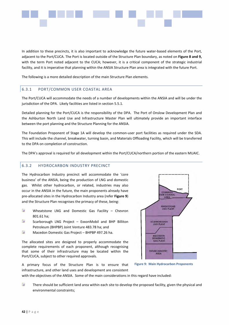
42 | P a g e
In addition to these precincts, it is also important to acknowledge the future water-based elements of the Port, adjacent to the Port/CUCA. The Port is located outside of the Structure Plan boundary, as noted on Figure 8 and 9, with the term Port noted adjacent to the CUCA; however, it is a critical component of the strategic industrial facility, and it is imperative that planning within the ANSIA Structure Plan area is integrated with the future Port.
The following is a more detailed description of the main Structure Plan elements.
6.3.1 PORT/COMMON USER COASTAL AREA
The Port/CUCA will accommodate the needs of a number of developments within the ANSIA and will be under the jurisdiction of the DPA. Likely facilities are listed in section 5.5.1.
Detailed planning for the Port/CUCA is the responsibility of the DPA. The Port of Onslow Development Plan and the Ashburton North Land Use and Infrastructure Master Plan will ultimately provide an important interface between the port planning and the Structure Planning for the ANSIA.
The Foundation Proponent of Stage 1A will develop the common-user port facilities as required under the SDA. This will include the channel, breakwater, turning basin, and Materials Offloading Facility, which will be transferred to the DPA on completion of construction.
The DPA’s approval is required for all development within the Port/CUCA/northern portion of the eastern MUAIC.
6.3.2 HYDROCARBON INDUSTRY PRECINCT
The Hydrocarbon Industry precinct will accommodate the ‘core business’ of the ANSIA, being the production of LNG and domestic gas. Whilst other hydrocarbon, or related, industries may also occur in the ANSIA in the future, the main proponents already have pre-allocated sites in the Hydrocarbon Industry area (refer Figure 9) and the Structure Plan recognises the primacy of these, being:
Wheatstone LNG and Domestic Gas Facility – Chevron 801.61 ha;
Scarborough LNG Project – ExxonMobil and BHP Billiton Petroleum (BHPBP) Joint Venture 483.78 ha; and
Macedon Domestic Gas Project – BHPBP 497.26 ha.
The allocated sites are designed to properly accommodate the complete requirements of each proponent, although recognising that some of their infrastructure may be located within the Port/CUCA, subject to other required approvals.
A primary focus of the Structure Plan is to ensure that infrastructure, and other land uses and development are consistent with the objectives of the ANSIA. Some of the main considerations in this regard have included:
There should be sufficient land area within each site to develop the proposed facility, given the physical and environmental constraints;
Figure 9: Main Hydrocarbon Proponents

Ashburton North Strategic Industrial Area Structure Plan
09/051 43 | P a g e
There should be appropriate separation and control between proponent land uses and other surrounding uses;
All sites should have adequate road and infrastructure access to the Onslow Port and the regional road network; and
Related service and production industries with synergies with the key proponents and/or the Port/CUCA should be able to locate in close proximity, whilst ensuring that they don’t hamper their operation in any way.
Detailed planning for each of the key proponents’ sites is being undertaken by the individual proponents, and will require the preparation and approval of Development Plans prior to obtaining Planning and Building approvals.
6.3.3 FUTURE INDUSTRY AREA
The Future Industry Area (FIA) has been strategically located immediately to the south of the proposed hydrocarbon processing industries to provide the opportunity for the development of other industrial uses offering synergistic services and/or facilities to existing and potential operations. This area is proposed to be developed as an industrial estate with potential for future hydrocarbon industrial uses as well as other related industrial uses including downstream gas processing (e.g. gas-to-liquids, petrochemicals), fertiliser production and other non-LNG based hydrocarbon industries. Other potential uses will be limited to those that, either, provide services or products required for the operation of the hydrocarbon industries, or derive a direct benefit from the close proximity to the gas supply and/or the Port/CUCA facility.
The range of possible industries for the ANSIA was determined through consultation with State agencies and industry as part of the ANSIA concept plan (Arup, 2010). The range of preferred land uses within the FIA will include:
Urea and ammonia plant; Ammonia nitrate plant; Methanol plant; Co-generation plant; Gas power station; Water reclamation facility; Water supply utility; and Sewerage treatment utility.
More detailed planning of the FIA, including internal movement system and lot layout, together with the developable areas (based on hydrology) and those suitable for development, will be provided at the Development Plan stage, as required by clause 6.4 of LPS7. In addition to the general requirements for Development Plans, the FIA Development Plan should specifically address land use control to ensure that no development will be permitted that:
does not demonstrate a direct relationship with the hydrocarbon processing industry; might place undue risk upon the Hydrocarbon Industry precinct, or compromise the operation of any of the
gas processing industries; or might place undue risk upon the TWA area while in operation.

44 | P a g e
6.3.4 GENERAL INDUSTRY AREA
In order to support the ANSIA, 200 ha of land has been identified for the development of a General Industry Area (GIA) which will accommodate support services of the ANSIA during construction and operation. A GIA is imperative for the effective and efficient functioning of the ANSIA. It is anticipated the demand for the GIA will be generated by businesses such as the transport and logistics industry, vehicle repair, pipeline integrity services, and other industries that will provide support to the precinct services.
LandCorp will develop the GIAs which will be located across two portions of land, approximately 100 hectares each in area. They have been located in this way to obtain maximum benefit from the hydrology and cut and fill opportunities. The areas were also located in relatively close proximity to Onslow Road in order to support an effective transport network and maintain the integrity of the FIA which is being planned for heavy (hydrocarbon) industrial uses.
The GIA will not adversely impact on the operation of the TWA. Any amendment to LPS7 and any Development Plan will have to identify means that ensure that uses will not impact the function of the TWA nor impact the visual amenity of Onslow Road. In regard to the TWA, a 1 km Land Use Separation Plan will surround the sites; this is discussed further in section 6.7.1.
In accordance with Clause 6.4 of LPS7, more detailed planning of the GIA indicating internal movement systems and lot layout will be provided at the Scheme Amendment and Development Plan stage.
6.3.5 MULTI-USER ACCESS AND INFRASTRUCTURE CORRIDOR
The MUAIC system is designed to accommodate the various requirements for transport and transmission of utilities/products within the ANSIA. The corridors will allow transportation and connectivity between the industries, joint or shared operations, and will provide unencumbered access/ connectivity to the Port/CUCA.
The eastern MUAIC will provide the primary road artery connecting all of the industrial uses with the Port/CUCA facilities, the TWA, and the regional road network. The eastern MUAIC is approximately 300m in width (reducing to approximately 210m at the southern boundary of the Wheatstone site). This eastern corridor will be created by the Foundation Proponent.
The eastern MUAIC dividing Wheatstone reduces to 210 m, as agreed with the State. The corridor will provide for the provision of planned and future access, both of vehicles and infrastructure, for the medium to long term development in the ANSIA. In addition to the eastern MUAIC, there is also unencumbered access to the Port via a western MUAIC that will provide future access to the Port in response to further development of the ANSIA. The future western MUAIC is proposed to be 300m in width. The identification of two corridors providing access to the Port is considered to be sufficiently robust at this stage of the strategic planning for the ANSIA. The indicative cross-section for the 210m section of the eastern MUAIC is illustrated in Figure 10 and the cross-section for the 300m section of the eastern MUAIC is illustrated in Figure 11.

Ashburton North Strategic Industrial Area Structure Plan
09/051 45 | P a g e
Figure 10: Indicative 210 m Multi User Access and Infrastructure Corridor Cross-Section
Figure 11: Indicative 300 m Multi User Access and Infrastructure Corridor Cross-Section
The secondary western MUAIC (300 m) will ultimately be designed to serve a similar function as the eastern MUAIC, although its primary purpose is to provide an alternative connection, by road and for other utilities, between the gas producers, future industrial uses and the Port/CUCA. This corridor will not be created in the first development stage; it will be created at a future stage of development, as and when demand necessitates. Whilst initially the western MUAIC extended north south along the western boundary of Stage 1A, the western alignment has been modified. This is in response to further detailed engineering investigations, in particular the landform and natural drainage/water pathways and ensuring the alignment respects the proposed Macedon development and the second LNG site. This alignment, whilst still indicative, more closely resembles the final alignment. The final alignment will be identified in the subsequent Stage 1B Development Plan(s).

46 | P a g e
An Indicative Secondary Link Access Road provides an east-west road connection between the main eastern MUAIC, and the secondary western MUAIC. It is intended to be 60m wide containing a 40m road reserve on the south and 20m utility corridor on the north. The 40m road reserve will be incorporated into the Exxon MobilBHP site if and when it is progressed. If the 20m utility corridor is vacant at that time, an assessment will also be undertaken as to whether the 20m utility corridor could also be incorporated to the Exxon MobilBHP site.
A portion of the strategic industrial area and the eastern MUAIC traverses land leased by Onslow Salt under the Onslow Solar Salt Agreement Act 1992. This land needs to be surrendered by Onslow Salt to facilitate the Wheatstone plant site, the eastern MUAIC and part of the CUCA. This is a matter for the State, Onslow Salt and the proponent to resolve.
To ensure that there is no adverse impact on the quality of salt produced by Onslow Salt, DSD advise that there are agreements in place which will restrict the use of the eastern MUAIC where it divides the Wheatstone site . Condition 19 has therefore been imposed on the Structure Plan that states:
“The eastern MUAIC dividing the Wheatstone project site will be available for authorised users. DPA will operate and manage this section of the MUAIC with a gatehouse at the southern boundary of the Wheatstone project site, thereby allowing authorised users to access the Port. Prior to entering the eastern MUAIC dividing the Wheatstone project site, users will be required to complete an online DPA induction training package that highlights Onslow Salt’s sensitivity to certain chemicals. DPA will ensure that (i) all users of the Port are inducted or escorted on site, and (ii) a sign is erected at the security gate highlighting the sensitivity of certain chemicals being transported and used within that section of the eastern MUAIC.”
After lengthy dialogue with the State Agencies, notably DSD and with Chevron Australia, it is considered that the strategic and statutory direction of the ANSIA Structure Plan is not in conflict with section 21 of the Onslow Solar Salt Agreement Act 1992.
Indicative Secondary Access Roads have been designed to allow access to the western side of the Port and ANSIA in the absence of the Western Corridor. The link will be removed when access to the western side is provided by the western corridor. No product pipelines are to be located within that link.
Appendix E addresses the corridors in more detail, in terms of their role in the overall movement and infrastructure network.
6.3.5.1 CONDITIONS OF USE - EASTERN MULTI-USER ACCESS AND INFRASTRUCTURE CORRIDOR CONNECTION
The State has negotiated the controlled use of the eastern MUAIC with the Foundation Proponent and Onslow Salt to ensure that there is limited opportunity for offsite impacts on Onslow Salt’s operations. The details below outline the nature of this use.
The Dampier Port Authority will site a security gate across the eastern infrastructure corridor in the vicinity of the southern boundary of the Chevron Wheatstone Plant site to ensure only authorised users access the Ashburton North Port.
The security gate will be manned by the Dampier Port Authority or its contractors.

Ashburton North Strategic Industrial Area Structure Plan
09/051 47 | P a g e
The eastern infrastructure corridor from the security gate north to the start of the CUCA will be vested in the Dampier Port Authority. This acknowledges that the Dampier Port Authority will administer this section of the eastern infrastructure corridor.
All users of the Ashburton North Port will be required to complete an online Dampier Port Authority induction training package prior to using the section of the eastern infrastructure corridor administered by the Dampier Port Authority. As part of the induction package there will be a module specifically highlighting Onslow Salt Pty Ltd’s sensitivity of certain chemicals being transported and used within this section of the eastern infrastructure corridor.
Dampier Port Authority will ensure all users of the Port are inducted or escorted on site; however DPA will not accept any liability for port user’s activities or actions that may impact on the operations of Onslow Salt Pty Ltd.
Dampier Port Authority will ensure that a sign is erected at the security gate highlighting the sensitivity of certain chemicals being transported and used within that section of the eastern infrastructure corridor.
With these conditions in place, the State considers the eastern MUAIC to have unencumbered access.
6.3.5.2 TENURE AND CONTROL
The ultimate tenure and control of the land within the MUAIC is still under consideration. Possible scenarios include:
Roads:
− Dedicated road reserve under the control of Main Roads WA up until the Port gate. At this point the MUAIC, including the road will be vested with the DPA through to the CUCA. All land within the CUCA will be vested with the DPA.
− Any access/easements/corridors/licences within the DPA controlled MUAIC will be issued by DPA.
Utility/service corridors:
− Crown land, with easements leased to individual proponents at the discretion of the Authority; or − Pipeline licences (as per the Pipeline Corridor Easement as defined in the SDA) under the control of
an appropriate authority, granted to individual proponents at the discretion of the Authority; or − Freehold title granted to LandCorp with tenure granted to individual proponents at the discretion of
LandCorp.
Under any of these scenarios a number of criteria must be satisfied, in order for the corridors to properly fulfil their intended function, including:
Access to the shared road system should be open to all stakeholders at all times;
The road system must be maintained to an acceptable standard at all times by the controlling authority;

48 | P a g e
The utility easements must be regarded as a secure area, and appropriately fenced, if required. Access should be limited to only those stakeholders that have right to use the easement;
Each individual stakeholder with right to use the utility easement must be able to provide additional security for their own infrastructure, as long as they do not restrict access to other infrastructure by the respective owners.
Whilst the cost of constructing shared infrastructure in the ANSIA may be initially borne by a Foundation Proponent, such cost arrangements should be undertaken in accordance agreed arrangements with the State and the Foundation Proponent. Servicing matters not directly addressed by the State should be achieved through a Proponent Contribution Plan (refer to section 7).
6.3.6 UNALLOCATED LAND (STAGE 2)
Unallocated land within the ANSIA is set aside for a possible future Stage 2 extension subject to demand for land within the FIA. A further Structure Plan will be required to progress Stage 2. The vision and objectives of the Stage 1 Structure Plan will also form the basis of the Stage 2 Structure Plan.
6.3.7 TRANSIENT WORKFORCE ACCOMMODATION
The Wheatstone TWA site is strategically located approximately 4 km from the proposed Future Industry Area and approximately 6 km from the nearest gas production site. It is designed to accommodate between 3,000 and 5,000 (at peak) workers during the first construction stage of the Port/CUCA and Wheatstone development. The purpose of this site is to provide construction workforce accommodation and to limit the impact of a significantly large construction workforce on Onslow township, which simply cannot cope with the influx of workers due to the lack of facilities, resources and land. The TWA is for workers contracted as part of the construction workforce. The site has been positioned to enable the Foundation Proponent’s construction workforce to be accommodated as close as possible to their workplace but maintaining sufficient separation to avoid any conflict in terms of industrial buffer separation requirements to construction workforce areas. The TWA buffer is discussed in detail in section 1.1. The location along the main transport corridor also provides the workforce with good road connection to the Onslow airport.
Importantly, the Wheatstone TWA will cater for all construction workers (including contractors) associated with the development of Stage 1A. In this regard, the Development Plan/s will define the practical arrangements for the number of persons employed and indirectly employed by the Foundation Proponent that will be permitted in Onslow at any one time. This will include (but may not be limited to) preparation of a Workforce Management Plan (WMP) that addresses the impact of the overall development on Onslow (in particular on services and accommodation) and implements appropriate contributions. At the planning approval stage, the Shire and proponent/s may enter into a binding legal agreement to enforce the above restrictions.
A Second TWA site is located immediately south of the Wheatstone TWA. The Wheatstone peak construction period is likely to coincide with other major proponents, necessitating a second TWA site. Like the Wheatstone TWA, the Second TWA is likely to accommodate between 3,000-5,000 workers at peak. This TWA will cater for all construction workers associated with Stage 1B or may be utilised to accommodated workers associated with infrastructure construction not associated with the Wheatstone project such as the airport upgrade, power, roads etc. This may therefore, provide accommodate in excess of 7000 workers at the peak of construction.

Ashburton North Strategic Industrial Area Structure Plan
09/051 49 | P a g e
The Development Plan/s for Stage 1B will cover the same requirements as referred to above (Stage 1A). The requirement for any additional construction accommodation for Stage 2 would be addressed within a future ANSIA Structure Plan (for Stage 2).
Although the shared use of ANSIA TWA’s will not be a statutory planning condition, it is anticipated that the State through DSD and other agencies will seek to ensure that the proponents for TWA‘s will be encouraged to allow for other proponents to utilise the area for other construction villages. This would be a matter for other operators to pursue, however it would be a practical means of providing overall construction workforce accommodation.
6.3.7.1 SITE DETAILS
The construction accommodation village for the Foundation Proponent is likely to be developed in stages over a period of approximately 24 months, beginning with an initial construction village with accommodation for 100 people, then followed by a fly village with accommodation for about 500 site workers and expanding to accommodate approximately 3,000-5,000 workers at peak. It is anticipated that personnel will work a fly-in, fly-out roster, commuting to and from the project area by air from Australian metropolitan areas.
The TWA will be self-contained with its own services. It will also provide workers with recreational and entertainment facilities as well as dining, laundry and other domestic requirements. The village will be designed to provide a safe haven in the event of a cyclone event, so that personnel can remain on site. The identified site is considered to be sufficient to accommodate the peak requirement during the most active stage of construction.
Detailed planning of the second TWA will occur during Development approvals of the heavy industry proponent who develops within that site. It is likely to take a similar form to the Wheatstone TWA, as described above, including recreational and entertainment facilities and domestic requirements, in the event that additional workforce accommodation is required beyond the capacity of the identified site, it may be possible for the area set aside for the second TWA to be used for the Wheatstone project
6.3.8 OPERATIONS WORKFORCE
The SIS has determined a population projection scenario for Onslow based on the operational workforce associated with Stage 1 development of the ANSIA. The impacts from the development of the ANSIA will be significant in terms of population increase along with impacts on social and hard infrastructure. The workforce projections are based on the known and indicative industries selected for Stage 1. As part of the Scheme Amendment and Development Plan process, all proponents will be required to prepare an SIS. This issue is addressed in the complete SIS included as Appendix B.
6.3.9 SERVICING
The TWA accommodation villages for construction workforce in the ANSIA will essentially be self contained with their own water and power supplies, waste management, medical and fire services. Operation and management of these services, particularly the provision of power and water should be integrated with the servicing of the LNG facility projects or other projects. Details of servicing which will amongst other matters, address servicing arrangements will form part of the respective Development Plans.

50 | P a g e
6.3.10 INDICATIVE SECONDARY LINK ACCESS ROAD
Two indicative secondary link access roads are identified on the ANSIA Structure Plan (Figure 08). One of these link roads extends east-west and may provide another means of access to adjoining hydrocarbon industry areas, also providing a link between the proposed Western MUAIC and Eastern MUAIC.
The second indicative secondary access road may provide access along the western boundary of the TWA sites. Subject to the consent of the Shire of Ashburton, the indicative secondary link access road west of the TWA sites may also provide temporary access to the TWA site while the Eastern MUAIC is being constructed. No development will be permitted to commence that will result in the use of the Shire controlled road system until proponents have negotiated a local road management and maintenance plan with the Shire.
The circulation network throughout the ANSIA is indicated in Figure 8 Structure Plan. The Development Plan/s will provide typical sections and upgrades (at the proponents cost) for the secondary road and connections to Old Onslow Road and Twitchin Road.
These links are indicative and as part of any Development Plan/s, a comprehensive traffic impact assessment will be required that addresses the details of these links and in particular the impacts on regional and local roads. Further secondary access roads may be identified within a Development Plan/s which is likely for Stage 1B, particularly within the FIA.
6.4 DISTRICT WATER MANAGEMENT STRATEGY
A District Water Management Strategy has been prepared for the ANSIA, refer Appendix C-D. The DWMS has been prepared in accordance with the Better Water Management Guidelines. All future Scheme Amendments, Development Plans and subdivisions are required to comply with the requirements of the DWMS.
A separate DWMS will be required for the Stage 2 ANSIA Structure Plan. The Department of Water has agreed to a water framework, as described in section 8.6 of the report.
The Department of Water requires habitable developments to be constructed 0.5m above the 1:100 ARI event flood level. Changes to surface water regimes in individual project areas should not impact on adjoining project or common use areas.
6.5 SERVICING
A Service Infrastructure Report has been prepared by Serling Consulting and the investigations are detailed below, with the full report contained in Appendix F. The report addresses the onshore aspects of the project including, among other things, the following onshore infrastructure:
Upgrade of Onslow Road; Telecommunication system; Power generation; Water supply infrastructure; Wastewater facilities; Access roads; GIA; The accommodation village/s (construction purposes); and The MUAIC.

Ashburton North Strategic Industrial Area Structure Plan
09/051 51 | P a g e
All proponents locating within the ANSIA will investigate shared utilities and negotiate with the State the extent to which their development will contribute.
6.5.1 EXISTING DOMESTIC GAS PIPELINE (BHP BP LPG)
As noted in section 5.4, an existing domestic gas pipeline (BHPB and BP LPG Pipeline) traverses the FIA and Unallocated Land area in an east-west direction. This has been identified on the ANSIA Structure Plan in order to highlight the potential constraint to future development in these areas. The specific nature and extent of constraint was not available at the time of writing this report. This will require further investigation by affected proponents in preparing future Scheme Amendments and Development Plans.
6.5.2 WATER
It is desirable that an integrated water supply scheme be established for the ANSIA. The outcome of the opportunity for an integrated water supply scheme shall be negotiated with the lead State Agency, DSD. The issue of an integrated water supply scheme will be addressed by the proponent in the respective Development Plan/s. The most likely source of water is from desalination. Seawater could be acquired via a pipeline extending into the ocean, or through bores along the coast. Discharge of produced brine would need to be investigated requiring either an outfall to the sea, or an arrangement with Onslow Salt for disposal into their evaporation ponds.
6.5.3 EFFLUENT DISPOSAL
It is not intended that an integrated effluent disposal scheme be established at the inception of the ANSIA, however each proponent will be responsible for the collection, treatment and disposal of waste water and sewerage effluent from their operations to the satisfaction of the approving authorities. This will be addressed by the proponent in the respective Development Plan/s.
6.5.4 POWER
It is desirable that an integrated power supply will be established for the ANSIA. The opportunity for an integrated power supply will be negotiated with the lead State Agency DSD, Horizon Power and proponents.
The issue of an integrated power supply will be addressed by the proponent in the Development Plan. The primary power supply is likely be provided by a series of gas turbine driven generators. Essential power during outages, emergencies, and start up will be most likely be provided by separate diesel engine driven generator units.
6.5.5 GAS
The proponents will be responsible to secure and supply gas to their own operations.
6.5.6 TELECOMMUNICATIONS
Existing communications available in the Onslow townsite includes telephone landlines, ADSL, wireless and satellite Internet access, and a mobile phone network. In addition, there are a number of communications towers in the town for television, emergency services and other functions.

52 | P a g e
LandCorp has allocated a 20m common utilities corridor on the south side of the MUIAC. The Telstra 36 bit core fibre line will be located within this corridor, supplying BHPB initially. No other land/areas are presently identified for communications infrastructure in the ANSIA. Land requirements for communications infrastructure will be negotiated by the communications provider, LandCorp and any other relevant State agency. The communications provider will be responsible for their own site approvals. Individual proponents will provide communications infrastructure on their own lease/land as required for their projects.
6.5.7 WASTE DISPOSAL
Each of the proponents shall be responsible for the collection and disposal of all the wastes generated by their operations to the statutory requirements. Wastes can be segregated into recyclable and dispose only materials. Recyclable materials include:
Economically recyclable – materials that provide a positive economic return, accounting for transport costs to the recycling markets in Perth, the Eastern States or overseas. In broad terms, recyclables will include ferrous and non-ferrous scrap metal, heavy casing filters, some plastics and certain electronic goods. These materials may be crushed to provide maximum transport densities;
Uneconomically recyclable – materials may include inert solids, such as concrete batch plant residue, glass, decontaminated ceramics, and compostable materials such as paper, green waste, bio solids, putrescibles and timber (not treated with methyl bromide or copper/chrome/arsenate);
Controlled recyclable – materials that are controlled wastes requiring initial pre-treatment to allow recovery of all or most of the waste. Such wastes may be economic, such as aerosol cans or uneconomic such as activated carbon;
Dispose only – Controlled wastes are materials that are defined by legislation to be too hazardous to be disposed to Class I, II or III landfills without treatment or encapsulation, or to be disposed to a sewer as a trade waste. Controlled wastes, above a minimal threshold volume, must be packaged appropriately.
The Onslow Townsite Strategy provides the indicative location of potential future waste sites, however such sites are unlikely to be able to cater for all wastes produced.
6.5.8 FENCING
Fencing of developments to protect pastoral activities will be addressed at the detailed planning stages. Such fencing needs to be of sufficient standard to provide an adequate barrier to stock. In addition, the Shire has advised that it will not be responsible for enforcing a requirement of fencing and that any contractual arrangements with the State and developers in the ANSIA should include fencing as part of these negotiations.
6.6 MOVEMENT NETWORK AND ROAD UPGRADES
Onslow Road is the main arterial and freight transport route to Onslow from North West Coastal Highway (NWCH). Onslow road:
is approximately 79.4 SLK from the intersection with NWCH to Beadon Creek Rd intersection; traverses a number of floodways and was built in the 1980s; pavement was designed and constructed with a 20 year life and the planned asset life has been exceeded;

Ashburton North Strategic Industrial Area Structure Plan
09/051 53 | P a g e
has a nominal formation width of 8.6 metres with 6.2 metre seal and 9.0 metre sealed floodways; only has line marking for the first 1.04 km; and currently Restricted Access Vehicle (RAV) category 9, which allows road trains to 53.5m.
The development of the ANSIA, both during construction and operational phases, will result in increased traffic volumes placing additional pressure on the road network leading to the ANSIA primarily on Onslow Road.
Arup undertook a Transport and Access report (refer Appendix E) that considered the adequacy of the road network serving the ANSIA during its operational phase up to 2025. In response to the Shire’s request during the advertising of the Structure Plan a Traffic Impact Assessment (TIA) for the Wheatstone Project LNG Plant (Arup, Aug 2011) has been prepared addressing the construction phase of the project. This report supersedes the Wheatstone Project Transport Assessment (Transcore, 2009) that was included within the advertised Structure Plan (refer Appendix E-A), and the Arup TIA is included as Appendix E-A
The reports recognise that in developing the ANSIA, the two-lane road within the MUAIC is constructed, and improvements are undertaken to Onslow Road and various intersections to ensure the road network can provide a high level of safety for all road users. Importantly, the Arup TIA addresses the necessary improvements and upgrades to Onslow Road, Twitchin Road and Old Onslow Road as part of the construction of the ANSIA.
The Arup TIA report findings indicate that the peak traffic activity generated by the construction of the Macedon project will occur at a different time to the Wheatstone peak. The Macedon project is significantly smaller than Wheatstone and as a result, the Wheatstone peak, which occurs after the Macedon project is completed, remains the critical consideration. However, the issue of the impact on the road formation of both Old Onslow Road and Twitchin Road with such heavy and extensive loads along with the duration of the road usage will need to be carefully assessed by the Shire. It is likely that the Shire may seek full construction of these roads and a pro-rata cost to Chevron and BHPB. This will be the subject of a further report to Council after negotiations with Chevron and BHPB have reached an appropriate stage.
6.6.1 MUAIC
BHPB has obtained approval to commence construction (target of Q3 2011) of the MUAIC carriageway to support development of the Macedon project. The planning approval for the BHPB access road is to allow it to be designed and approved as a ‘fit for purpose’ road with limited heavy vehicle numbers on Twitchin Road and Old Onslow Road. In clearing this condition of the planning approval for Macedon, the Shire advised BHPB that it was aware that discussions between Chevron and BHPB were underway to construct a far more substantial access road that would eventually service the whole ANSIA. BHPB were advised that the ANSIA designed road will be subject to a detailed traffic management plan and requires the further consent from the Shire and other agencies.
The BHPB constructed road is planned to be upgraded by Chevron to a final two lane carriageway design in accordance with MRWA requirements and Shire approval. The design of the road will be agreed with MRWA prior to / or when proponents seek planning approval. The two lane carriageway will not be completed until after the first two LNG trains are completed, to minimise the impact of construction traffic on the pavement.
It is anticipated that proponents will seek agreement with MRWA on the handover specifications to ensure that the final road and associated intersections are in accordance with MRWA requirements.

54 | P a g e
6.6.2 ONSLOW ROAD
As discussed, Onslow Road will require modifications/upgrade to accommodate both construction and operation related traffic from the ANSIA. This will also ensure that the various road users including heavy haulage vehicle directly associated with the development of the ANSIA, commercial vehicles and tourists, most notably ‘grey nomads’ (tourists who seek to holiday in Onslow and surrounding areas and who generally tow caravans) can move safely through the area. With respect to Onslow Road, the WAPC’s “Regional HotSpots Land Supply Update – Onslow” noted as early as November 2008:
“With maintenance, Onslow Road is considered adequate to service Onslow in the short term. If industrial and residential expansion occurs, there will be a requirement to improve large sections of Onslow Road to North West Coastal Highway to allow the expansion to take place. This will include pavement rehabilitation, widening and some realignment where there is inadequate road geometry.”
The key road design issues that have been identified by MRWA include:
Inadequate culvert cover; Widening of Onslow Road; Substandard vertical geometry; Substandard cross fall; Culvert joins within wheel paths; Redundant culvert types; and Pavement life.
Peak construction traffic is predicted to occur during development of the initial infrastructure to support the ANSIA which includes the Port/CUCA, MUAIC and the Wheatstone LNG facilities. On completion of the Port/CUCA this will provide opportunities for equipment and material to be brought in by sea, rather than using NWCH and Onslow Road. In recognition of the proposed timing of development in the ANSIA, the following minimum modifications/upgrades are required to ensure Onslow Road can be used safely by all road users during the construction phase, which will last many years.
To ensure a safe, reliable and efficient road transport solution during the construction and operation phase of the ANSIA, the following minimum modifications/upgrades are required by Main Roads WA and the Shire of Ashburton to ensure Onslow Road can be used safely by all road users during the construction phase:
Traffic management plan that details the upgrade and rehabilitation of Onslow Road prior to construction; A minimum of two (2) passing lanes in both directions of Onslow Rd between North West Coastal Highway
(NWCH) and the proposed ANSIA intersection. Nominally these will be placed at approximately 15 straight line kilometres (SLK) and 41 SLK from the NWCH intersection;
Existing 6.2 m seal upgraded with 1m sealed shoulders, with some unsealed shoulder; Shoulders of both sides of Onslow Rd rehabilitated (stiffened, repaired or select replacement) and sealed to
reduce the wear on the soft shoulders and increase lane width; Upgrade the NWCH/Onslow Rd intersection and Beadon Creek Road Onslow Rd intersection; Some sections of pavement is likely to require overlay; Centre and edge lines to be applied. Edge posts and additional signage; Select Intersection improvements including intersection lighting; Select culvert drainage replacement from NWCH to Beadon Creek road intersections; and A flexible MRWA maintenance schedule will need to be established to ensure the road condition is safe for
all road users during construction.

Ashburton North Strategic Industrial Area Structure Plan
09/051 55 | P a g e
It is also imperative that a flexible maintenance schedule is established with Main Roads WA for the anticipated continuous state of repair. The development of ‘ANSIA road’ in a joint arrangement with BHPB/Chevron is supported in principle however the issue of road safety for Onslow Road, Old Onslow Road and Twitchin Road is a matter of a priority for the Shire.
In addition any proposal will need to include an access road flood modelling & impact assessment study that relates to the revised road design proposals.
Accordingly, proponents will reach agreement with MRWA on the required improvements to Onslow Road in consultation with the Shire of Ashburton prior to commencement of construction.
The Shire is unlikely to support any approvals, albeit a Development Plan or Planning Application involving the development of the ANSIA, unless the above improvements to Onslow Road are undertaken.
6.6.3 ROAD UPGRADES IMPLEMENTATION
Critical to the Shire is the implementation of road upgrades as described above. This will be controlled through the dual approval of Main Roads WA and the Shire in compliance with the planning phases established in the ANSIA Structure Plan, as discussed below.
Section 2.3 states that each proponent is required to prepare a Development Plan. Section 8.3 states that:
“Development Plans will be required for individual projects in accordance with the requirements of Clause 6.4 of the LPS7, thus defining in detail, planning for selected phases of the ANSIA to facilitate subdivision and development. .... The broad principles and guidelines outlined in the Structure Plan Report are likely to be refined through the Development Plan process...”
Addressing road upgrade requirements at the Development Plan phase is highly transparent on and within the Structure Plan. Condition 13 of the ANSIA Structure Plan states:
“13. Prior to the approval of a Development Plan(s) or consideration of a Planning Approval as referred to in Condition 5, the proponent will prepare a comprehensive traffic impact assessment, addressing the impacts on regional and local roads, particularly Onslow Road, Old Onslow Road and Twitchin Road including anticipated traffic volumes, vehicle size (i.e. large haulage/freight vehicles) and the timing of peak traffic and duration of traffic during both the construction and operational phase of the development. As part of any Planning Approval, the Shire will require the following to be provided prior to the commencement of any use or development that may lead to the use of large freight/haulage vehicles in the construction or operational phase or where excessive use of existing roads is required:
No development will be permitted to commence that will result in the use of the Shire controlled road system until proponents have negotiated a local road management and maintenance plan with the Shire”
In addition to the matters stated above, the Structure Plan in section 8.3 also requires:
Information as to the road design and construction as follows:
“access from the facility and connection to Onslow Road is to be designed, constructed with road signage, markings and necessary street lighting particularly the Onslow Road intersection and provided by the proponent;

56 | P a g e
the design of the road should include a reasonable number of crossing points so that livestock and vehicles can freely cross from one side to the other; and
the road being fenced at the cost of the Applicant in the form of stock proof fencing constructed in the same style as existing boundary fencing.”
Compliance with the ANSIA Structure Plan and subsequent Development Plan(s) will require proponents to provide the Shire and MRWA with a traffic impact and road condition assessment report and a Traffic Management Plan for approval. This will ensure that traffic volumes, traffic routes, road conditions and management strategies associated with any development is clearly understood prior to commencement of development. The outcomes of the Traffic Impact Assessment mentioned above to be undertaken at the Development Plan stage, may then be imposed by the Shire as conditions of Planning Approval.
It is considered that the dual process through Main Roads control of Onslow Road, together with the management requirements identified via the Development Plan process, will ensure that the findings of the Traffic Management Reports may be readily implemented by the Shire and / or Main Roads for any development within the ANSIA.
Should planning approval be sought for minor developments prior to a Development Plan, the information required as part of the application for approval will mirror that of a Development Plan as relevant to the application.
6.6.4 ROAD UPGRADES PRIOR TO DEVELOPMENT PLAN
In the event that development is proposed prior to the approval of a Development Plan each proponent will be required to seek approval from MRWA on the road improvements required to be undertaken prior to the commencement of construction.
6.7 LAND USE SEPARATION
6.7.1 OVERVIEW
Appendix 11 of LPS 7 states:
“When considering a request to initiate rezoning of land within the Ashburton North Strategic Industrial Area to ‘Strategic Industry’, the local government shall only initiate an Amendment when it is satisfied that the proponent has prepared a structure plan dealing with the following matters:
Industrial land use separation both within and outside the site (where buffers are proposed outside the boundary of the site, the method of control and ownership of land affected by the buffer will be required to be addressed).”
Since the inception of the Ashburton North proposal the Shire of Ashburton has worked closely with a number of key State agencies, including the Office of Environmental Protection, to devise a planning regime that is inclusive of environment issues of individual proponents as well as considering the cumulative risks of the ANSIA estate. The Structure Plan reflects both levels of consideration and defines the issues that need to be addressed as part of developing more detailed plans and applications.

Ashburton North Strategic Industrial Area Structure Plan
09/051 57 | P a g e
The ANSIA is significantly different to other strategic industrial areas as the ANSIA and surrounding land, is owned and totally controlled by the State of Western Australia where the ‘lead’ agency is DSD. The land tenure for operators within the ANSIA is leasehold. It is therefore, considered that any planning applications would need to be supported by the State. Whilst development outside of the ANSIA is currently not contemplated, if a Planning Application was made in proximity to the ANSIA, any application is only likely to be for a use that is compatible with the ANSIA. In this regard, there is little foreseeable chance for an application that is contrary to the ANSIA.
On this basis, it is considered that there is not the need for the strict application of SPP 4.1 State Industrial Buffer Policy as the Policy is more applicable to areas where land within the industrial area “buffer” is in private ownership. Should circumstances change and DSD seek to promote ‘freehold’ land tenure, then it would be incumbent on DSD to undertake appropriate arrangements to request the Shire initiate a Scheme Amendment that establishes a formal Scheme buffer.
Importantly, the principles of the Policy are recognised and adhered to in relation to minimising off-site impacts. For this reason, rather than identifying a buffer to the ANSIA, a Land Use Separation Area is identified and discussed in more detail below.
6.7.2 MEASURES TO ACHIEVE LAND USE SEPARATION
The identification of appropriate land use separation is illustrated on the Land Use Separation Plan, refer Figure 12. Two areas of land use separation apply, one externally and one internally. The main purpose of the Land Use Separation is to protect the ANSIA from the establishment of sensitive use receptors within a distance that may limit the development or operational requirements of industries within the ANSIA.
It can be seen from Figure 12 that no sensitive use receptors are located within close proximity to the ANSIA. Existing recreational land uses fall within the areas modelled or indicated as being affected by the off-site requirements of the ANSIA. These areas are namely the 5 Mile Pool and other informal campsites along the Ashburton River and the Old Onslow Townsite. The informal camping areas have been confirmed by the Department of Environment and Conservation to not constitute sensitive uses given their informal nature and the absence of any permanent structures. As such, commercial noise levels (60dB(A)) are presented as appropriate noise goals. These existing land uses have been accommodated as far as is practicable in the land use separation area.
For the ANSIA, the criteria relevant to the land use separation have been determined as being:
Noise – as defined by the Environmental Protection (Noise) Regulations 1997;
Risk – as defined by the EPA Guidance Statement 2 – Guidance for Risk Assessment and Management: Off-site Individual Risk from Hazardous Industrial Plant, with ‘buffers’ formed in accordance with the EPA Guidance Statement 3 – Separation Distance Between Industrial and Sensitive Land Uses;
Air Quality – as defined by the draft State Environmental (Air Quality) Policy 2009 and the Ambient Air Quality National Environmental Protection Measures (NEPM).Cumulative modelling for noise and air quality was undertaken by SVT and SKM respectively for indicative industries for Stage 1 of the ANSIA. The modelling provides guidance on the potential off-site impacts and therefore the establishment of the proposed land use separation area and associated performance criteria. See Appendices C-A and C-B for the outcome of this modelling.
In relation to the above considerations, land use separation has been identified as follows:

s: 1:80,000@A3d: Sept 11j: 09/051
Copyright Taylor Burrell Barnett. All rights reserved. No part of this document may be reproduced in any form or by any other means, electronic, mechanical, photocopying, microcopying or recording without permission in writing from Taylor Burrell Barnett. All areas and dimensions displayed are subject to detail survey.
Ashburton North Strategic Industrial Area Structure PlanA Chevron Project
LAND USE SEPARATION PLAN
12figure
Copyright Taylor Burrell Barnett. All rights reserved. No part of this document may be reproduced in any form or by any other means, electronic, mechanical, photocopying, microcopying or recording without permission in writing from Taylor Burrell Barnett. All areas and dimensions displayed are subject to detail survey.
0km 1.5km0.5 1
NOTE: THE ACCURACY OF SOME OF THE PLOTTED DATA PRESENTLY CANNOT BE GUARANTEED. WHILST THE INTENT OF THE STRUCTURE PLAN IS NOT AFFECTED, SOME INFORMATION SHOULD BE VERIFIED THROUGH MORE ACCURATE SURVEY.
LAND USE SEPARATION NOTES LEGEND
LOCAL SCHEME RESERVES
ZONES
OTHER
The Land Use Separation Areas form part of the Ashburton North Strategic Industrial Area Structure Plan, and refer to the following definitions:
Land Use Separation Area - is the area within which sensitive uses are either restrictred or prohibited.Sensitive Use - includes residential dwellings, major recreational areas, hospitals, schools and other institutional uses involving accommodation.
The Land Use Separation Areas include a general 3000m ‘Risk, Noise and Air Quality’ area around the Strategic Industrial Area and a 1000m Land Use Separation in relation to the Wheatstone Transient Workforce Accommodation.
Future Scheme Amendments within the Structure Plan area are required to demonstrate, to the satisfaction of the EPA/DEC, conformance to the minimum requirements for the described sensitive land use, for the factors as prescribed by the following guidance documents:
Risk – Guidance Statement No. 2 - Guidance for Risk Assessment and Management: Offsite individual risk from Hazardous Industrial PlantNoise – Environmental Protection (Noise) Regulations 1997 Air Quality – Draft State Environmental (Air Quality) Policy 2009.
Development and uses are to be located, designed and operated to minimise adverse impacts on:
Existing environmental conditions relating to air, water and soil;The efficient and safe operation of the movement systems in the ANSIA;The amenity of adjacent properties, and areas of high ecological significance;The health and safetey of people using the ANSIA; andThe establishment and use of the Transient Workforce Accomodation sites.
Any development within the ‘Risk, Noise and Air Quality’ Land Use Separation Area must comply with the performance criteria discussed in section 6.7 of the ANSIA Structure Plan report, which includes:Land Use Separation Area Boundary Criteria (3000m):
Noise levels at sensitive land uses, levels being 35dB(A); andA risk level of one in a million per year or less.
Other PurposesDenoted as Follows:
Infrastructure (Multi-User Access and Infrastructure Corridor)
Strategic IndustryStage 1
IndustryStage 1 - refer Structure Plan Conditions No. 24, 25 & 26
Special Use WTWA - Wheatstone Transient Workforce AccommodationSTWA - Secondary Transient Workforce AccommodationRefer Structure Plan Conditions No. 24, 25 & 26
Risk, Noise & Air Quality Land Use Separation Area
1000m Land Use Separation
Port / Common User Coastal AreaUnder the control of the Dampier Port Authority
ANSIA Stage 2 Subject to Future Structure Plan
Indicative Secondary Link Access Road(Public)
Access to PortAlignment is indicative only - refer Structure Plan Condition No.9
Structure Plan boundary
1.
2.
3.
4.
5.
I
I
I
II
I
Old OnslowTown Site Onslow
Salt
Old Onslow Road
Ons
low
Roa
d
Onslow Road
Twitc
hin
Road
Onslow
Road
Seavie
w Driv
e
HooleyCreek
Eastern Multi-User Access and Infrastructure Corridor - Refer
Structure Plan Condition No. 19
Western Multi-User Access and Infrastructure Corridor
Four Mile Creek
FUTURE INDUSTRYAREA
HYDROCARBON INDUSTRY
HYDROCARBON INDUSTRY
PORTCOMMON USER COASTAL
AREA Middle Creek
Indian Ocean
Ashburton River
3000
m La
nd U
se Se
para
tion
3000m Land Use Separation
WTWA
STWA
GENERAL INDUSTRYAREA

58 | P a g e
In relation to the external land use separation, an indicative area of 3km from the outer permitter of the ANSIA has been selected as an acceptable limit.
In relation to the internal land use separation between the General Industrial Area and the Wheatstone TWA, a 1000m separation is identified.
It is considered that the Land Use Separation Plan will provide guidance to the preparation of the more detailed Development Plans and subsequent Planning Applications.
6.8 STAGING
Development within the ANSIA will not all occur at the same time, rather a staged development is likely to take place, as illustrated in Figure 13. The dates provided are projected commencement dates only with completion of development in the ANSIA likely in 2025. These dates are indicative only and should be updated as development progresses.
Figure 13: Indicative Staging Strategy
Ashburton North Strategic Industrial Area Structure Plan
09/051 59 | P a g e
7 INFRASTRUCTURE COST SHARING
It is a well established principle that proponents should contribute funding towards the provision of infrastructure, to the extent that the need for infrastructure is generated by that development. State and Local Government regulators seek to ensure the cost-efficient provision of infrastructure and facilities such as roads, water supply, sewerage, electricity, schools, health, community and recreation facilities. The careful planning and timely delivery of infrastructure is fundamental to the economic and social wellbeing of any community.
In relation to Stage 1, DSD, in consultation with the Shire, State Government Agencies and the foundation Proponent (Chevron) has categorised the required infrastructure into:
Critical Services Infrastructure Project Infrastructure Social Infrastructure.
Examples of the items within each category include (but are not limited to:
Critical Services - for example: upgrades to key physical networks (water, power, wastewater, roads) and structures (education facilities, childcare).
Project - for example: workforce accommodation, roads within the ANSIA, the port, service corridor. Social - town site enhancements and community service upgrades.
The main impacts of the ANSIA in terms of demands for additional services and facilities are actually remote from the site, in the nearby Onslow township. There are some key services within the ANSIA itself that could be the subject of cost sharing considerations, however this will be determined by the State in negotiations with the proponents. In the case of the ANSIA, all development, including necessary road, drainage and other infrastructure upgrades shall be the direct responsibility of the proponents and the State. It is also relevant that the form and magnitude of development within the ANSIA is such that, whilst there will only be a small number of proponents within the area, the projects will be substantial, as will be the potential impacts on demand for services and facilities in and around the Onslow community.
Proponents will be required to commit to providing social and hard infrastructure for Onslow, to the extent that is appropriate for individual developments. It is likely that separate agreements with the proponent and the State (as with the Foundation Proponent and the State) will be negotiated that satisfactorily involve the Shire. Should future agreements not include the Shire, separate arrangements with the proponent and the Shire will be necessary before a Scheme Amendment is initiated by the Shire.
7.1 STATUTORY MECHANISMS
Local Planning Schemes are usually the means by which the equitable contribution of funds from proponents for infrastructure provision is identified and achieved. However, with the role and direction of the State in the ANSIA, a State based SDA will be prepared for major developments. In relation to Onslow, the Shire expects that the SDA will cover the necessary State and proponent obligations that will ensure that Onslow will have the necessary social and hard infrastructure for existing and future residents.
Prior to initiation of a Scheme Amendment for any stage of the Structure Plan or advertising of the accompanying Development Plan/s, the Shire will require that the level and extent of contributions to social infrastructure for Onslow will form part of the Scheme Amendment report. In addition, defined and enforceable commitments will be established that address the necessary social infrastructure for Onslow.

60 | P a g e
The Shire acknowledges that for major proponents the SDA may not cover the necessary micro infrastructure needs. Accordingly, a separate agreement with proponents may be necessary, however this will not be determined until the level of Shire input into the preparation of the relevant SDA is determined. In this regard, the Council will not initiate a Scheme Amendment until it is satisfied that proponents have committed to a level of social and hard infrastructure for Onslow.
A SDA negotiated for the ANSIA will include the necessary provisions to permit recouping of costs by the foundation proponents (in negotiation with Landcorp, DSD and DPA under relevant mechanisms). The following sections 7.1.1 and 7.1.2 describe the statutory mechanisms associated with the ANSIA.
7.1.1 LOCAL PLANNING SCHEME NO. 7 – AMENDMENT NO. 9
Amendment No. 9 to LPS7 (gazetted 23 December 2010) introduced, among other things, a SCA over the ANSIA, together with a comprehensive set of planning requirements to support the future rezoning and development of the area. Among those requirements is the following:
“9) When considering a request to initiate rezoning of land within the ANSIA to “Strategic Industry” or other zone or reservation identified within the ANSIA Structure Plan, the local government shall only initiate an Amendment when it is satisfied that the proponent has prepared a structure plan dealing with the following matters:
q) Undertaking a social impact assessment identifying pressures on community facilities and services within Onslow, along with the method of implementing funding developer contributions as identified in the ANSIA;”
The infrastructure requirements referred in the SIS for Stage 1 is considered to be the minimum requirements associated with the appropriate development of Onslow. It is acknowledged that larger, more significant developments (such as an LNG Plant) will have a higher level of infrastructure requirements for Onslow, than (say) a smaller development that has few construction and operational staff.
7.1.2 STATE DEVELOPMENT AGREEMENT (SDA)
A SDA will be formulated as an agreement between the State and Proponents of major developments within the ANSIA and would include commitments agreed with the State. The SDA would specify the contributions of major developments to the ANSIA and Onslow, and is designed to empower the State to take appropriate action if a proponent defaults on any of its commitments, including ensuring local content, providing domestic gas, and the management of social infrastructure requirements.
For example, Chevron as proponent of the Wheatstone project has negotiated an SDA with the State, including the social infrastructure contributions in relation to Onslow townsite. The specific social infrastructure contributions associated with the Wheatstone development will be detailed in the relevant Scheme Amendment documentation. In the future, subsequent SDAs will be executed by the State with major proponent s within the ANSIA. Importantly, whilst each agreement will vary according to the unique circumstances of the project, there is also the prospect of including common provisions across all agreements that set equal rules and obligations.
In relation to the implementation of a proponent contribution arrangement, the SDA or other similar mechanism with the same intent is considered to be the most appropriate vehicle to bind all proponents to a plan to properly manage the equitable funding and orderly delivery of community services and facilities relative to development within the ANSIA.

Ashburton North Strategic Industrial Area Structure Plan
09/051 61 | P a g e
7.2 IMPLEMENTING A PROPONENT CONTRIBUTION ARRANGEMENT THROUGH SDAS
In any cost sharing arrangement, the central component is a Proponent Contribution Plan (PCP) for the ANSIA, which sets out the purpose and principles of the plan, and describes the various infrastructure works and other cost items that are to be funded (partially or wholly) by proponent contributions. The PCP may also define a method of apportionment and include (or refer to) a cost schedule and actual contribution sums.
A PCP will likewise be necessary for the ANSIA to enunciate the cost sharing commitments and to document the process for equitable and timely provision of funds. While the PCP provides the detailed rules and requirements to be followed by all proponents, it relies on some form of legal instrument for enforcement. This is typically done by provisions within a Local Planning Scheme, but can also be achieved through private agreement or some other legally binding instrument (particularly when there is only a small number of participants involved). In any event, the Shire of Ashburton will not be responsible for the implementation of any PCP.
As previously discussed, it is considered that for major developments in the ANSIA, the most appropriate vehicle is the SDA. Whilst the content of each SDA will differ, they will follow the principles as detailed in 7.3.1 and it will be possible to include common provisions within each agreement. In relation to a proponents contribution arrangement, it is proposed that each SDA will bind proponents to comply with the contributions detailed in the SDA.
7.3 FORM OF A PROPONENT CONTRIBUTION PLAN
7.3.1 PRINCIPLES
In any proponent contribution arrangement there is a common set of principles that typically form the foundation of any such arrangement. Those principles have most recently been enunciated in the WAPC State Planning Policy 3.6 – Development Contributions for Infrastructure.
7.3.1.1 ANSIA
Should the State consider a PCP to be necessary for the ANSIA the precise mechanism for determining the level and requirement of proponent contributions for the initial infrastructure needs for the ANSIA proponent will be determined in negotiations between the State, Landcorp (the estate manager of the ANSIA), the DPA (the manager of the Port), the DSD, proponents and the Shire of Ashburton. Accordingly, the PCP will only be applicable for proponents and as a result of any cost sharing arrangements as determined through negotiations with the respective parties and may not necessarily form part of the planning scheme process. Identified key infrastructure items within the ANSIA that may need to be considered for inclusion in any SDA or PCP, include:
Electricity supply infrastructure; Water supply infrastructure; Any other services and facilities that will ultimately assist future proponents; and Costs associated with planning and related studies necessary to introduce the planning framework to
facilitate the ANSIA.
It is not possible to present a complete PCP at the Structure Plan stage given that the details of works to be funded will be addressed in current and future SDAs for major proponents and through the Scheme Amendment/ Development Plan process for any development not the subject of an SDA.

62 | P a g e
While it is recognised that the SDA will be the most appropriate vehicle for broader developments to be covered under the Proponent Contribution Plan (PCP) in the ANSIA, any infrastructure works in the Port area under the jurisdiction of the DPA will be administered under the DPA's Development Application and Approval Process, the Port Facilities Agreement (PFA) and other relevant agreements between the DPA and CVX. If a PCP is required for developments in the Port, any associated contributions will be appropriately negotiated under the PFA with prospective proponents.
7.3.1.2 ONSLOW
Much of the work needed to establish impacts and demands upon the town’s social infrastructure for Stage 1, has been undertaken through the SIS appended to this report (refer Appendix B).
The costs, apportionment between government and proponents within Onslow will be addressed through the SDA process (major proponents) and/or via the Scheme Amendment and development process. Should the Shire not be satisfied with its degree of input into the SDA or failure of the SDA to provide the necessary infrastructure for Onslow, the Shire will seek its own separate agreement with the respective proponent.
7.4 SUMMARY
The role and direction of the State in the planning and development of the ANSIA will result in a SDA being prepared for major developments.
In relation to the ANSIA, major proponents SDA(s) will be comprehensive and cover the necessary infrastructure. Major proponents in the ANSIA will address contributions via the SDA process with the State and depending upon the outcome of negotiations, it should have the support of the Shire. The Shire will not have responsibility for the establishment of the ANSIA infrastructure, as this will be directly negotiated with the State and proponents.
In relation to Onslow, the Shire expects that the SDA will cover the necessary State and proponent obligations that will ensure that Onslow will have the necessary social and hard infrastructure for existing and future residents. However, in the case of any development not the subject of an SDA, it will be necessary for those obligations that would have otherwise been provided for in the SDA to be included within a Scheme Amendment. Should Council not be satisfied with its degree of input into the SDA or failure of the SDA to provide the necessary infrastructure for Onslow, the Shire will seek its own separate agreement with the proponent before it will initiate an amendment to the Scheme.
Prior to initiation of a Scheme Amendment for any stage of the Structure Plan or advertising of the accompanying Development Plan/s, the Shire will require that the level and extent of contributions to social and hard infrastructure form part of the Scheme Amendment report. This will allow the community of Onslow to have scrutiny of the draft social and hard infrastructure arrangements negotiated on behalf of the community. The approach outlined for infrastructure cost sharing in the ANSIA and for the Onslow townsite provides both certainty and flexibility to the community, Shire, State and proponents.

Ashburton North Strategic Industrial Area Structure Plan
09/051 63 | P a g e
8 IMPLEMENTATION
8.1 ANSIA STRUCTURE PLAN
The ANSIA Structure Plan is intended to be as a broad district level land use strategy defining the strategic planning framework for the project area. The ANSIA Structure Plan (report and plan) form the framework for more detailed Development Plans over discrete parts of the ANSIA. The Development Plan(s) will be prepared to reflect the requirements of the future uses consistent with the objectives of the ANSIA as a hydrocarbon precinct.
The ANSIA Structure Plan is a robust planning document that will be refined by the more detailed Development Plans with elements contained in the Plan changing in response to more detailed analysis and changing trends.
It is a requirement of the Scheme that the Structure Plan is adopted by the Shire of Ashburton and the WAPC.
The Structure Plan provisions in LPS7 for the ‘Ashburton North Strategic Industrial Area’ have been used as the basis for the preparation and adoption of this Structure Plan. These provisions are outlined below:
“7.9.1 In addition to such other provisions of the Scheme as may affect it, land included in the Ashburton North Strategic Industrial Area (ANSIA) shall be subject to those provisions set out in Appendix 11. No subdivision or development may occur within the ANSIA unless the land is zoned in accordance with the Ashburton North Strategic Industrial Area Structure Plan (ANSIA Structure Plan)”
This Structure Plan has been prepared in accordance with clauses 6.4 and 7.9.1 of LPS7.
8.1.1 CONSULTATION
In accordance with clause 5.7.3 of LPS7, the Shire may advertise a Structure Plan for a minimum period of 14 days. Given the scale of the project and the direction of Local Planning Policy - Consultation for Planning Proposals, a longer period of consultation has been adopted by Council for the ANSIA Structure Plan and draft Amendment No. 10.
It is reasonable that advertising of the Structure Plan reflect the same statutory period of a Scheme Amendment (42 days) and in this regard, be advertised concurrent with any Scheme Amendment.
Effective community engagement for both the Structure Plan and Scheme Amendment is vital. In this regard, the Council has requested the proponent along with State agencies such as DSD, DPA, LandCorp and the DoP undertake a community forum in Onslow in order to explain the proposals and the community benefit. This consultation will also address the issue of coastal access, as discussed in section 5.6.3. A suitable consultation strategy will be determined in agreement with the Shire, DSD and the Foundation Proponent, prior to community consultation.
It is likely that a similar period of consultation and need for community forum may be sought for a proposed Development Plan.
8.1.2 APPROVAL PROCESS
Clause 5.5.2(c) of LPS7 also provides for the Structure Plan to be adopted by the Council, on behalf of the Shire, with or without modification. In accordance with these provisions, this Structure Plan is presented for adoption by Council to facilitate development of the ANSIA.

64 | P a g e
Clause 6.4.6 of LPS7 also provides for the Council to request the WAPC to adopt the Structure Plan as the basis for prerequisite to consideration and assessment of the Development Plan.
8.2 SOCIAL IMPACT STATEMENT
The SIS identifies the need for additional infrastructure resulting from development of the ANSIA for Stage 1 (refer Appendix B Social Impact Statement).
The SIS will be adopted concurrent with the ANSIA Structure Plan. In accordance with section 8.3 below, there is also the requirement for a SIA to be prepared in support of individual Development Plans.
8.3 DEVELOPMENT PLANS
Following determination of the ANSIA Structure Plan, Development Plans will be required for individual projects in accordance with the requirements of clause 6.4 of the LPS7, thus defining in detail, planning for selected phases of the ANSIA to facilitate subdivision and development. The timing and relevant areas contained within the Development Plans is likely to be determined by the staging of the Structure Plan. The broad principles and guidelines outlined in the Structure Plan Report are likely to be refined through the Development Plan process. A Development Plan is required to address the following matters:
Proposed private road design and construction that addresses the following:
− the proposed road in a location that fits into the overall concept plan for the MUAIC currently being established by LandCorp;
− the proposed road and the gas sales pipeline alignment planned such that it does not limit the available space within the infrastructure corridor; and
− cross sections and further detail of the alignments.
Flood water risk mitigation strategy that takes a strategic approach to flood mitigation and addresses how future cumulative impacts from flood water are to be managed.
Drainage strategy (including road construction) that ensures that the water quality targets are met for the stormwater outflow from the proposed development in respect of the suspended solids, phosphorous and nitrogen, in order to preserve health of the receiving waters.
Local Water Management Strategy to the requirements of the Department of Water in relation to the impacts of development, with specific consideration being given to but not limited to:
− site constraints; − flood risks; − water management; − fit-for-purpose water source planning; − design and management objectives; and − sharing of infrastructure, such as the pipeline, along with information showing the location where
there is a provision for future connection(s).

Ashburton North Strategic Industrial Area Structure Plan
09/051 65 | P a g e
Comprehensive traffic impact assessment, addressing the impacts on regional and local roads, particularly Onslow Road, Old Onslow Road and Twitchin Road including anticipated traffic volumes and the timing of peak traffic:
− during both the construction and operational phase of the development. − peak traffic on the ANSIA access road; − potential impact on other users of the ANSIA; and − the preparation of a traffic management/consultation plans.
Assessment to the requirements of the Department of Indigenous Affairs pursuant to the Aboriginal Heritage Act 1972.
Dust management plan to address the construction phase of the development.
Plans showing finished ground levels.
SIA identifying pressures on community facilities and services within Onslow, along with the method of implementing funding by proponent contributions, as identified by the Shire of Ashburton.
WMP that addresses the impact of the overall development on Onslow (in particular on services and accommodation) an implements appropriate contributions. The WMP will cater for all for construction workers (including contractors) associated with the development of the TWA and define the practical arrangements for the limiting the extent to which those persons employed and indirectly employed by the proponent are permitted in Onslow at any one time.
Acknowledge that a legal agreement is to be prepared at the Applicant's expense (including legal expenses incurred by the Shire) for the purposes of the following:
− All TWA being used only for the accommodation of construction staff, subject to maintenance staff being permitted but only for a 3 week period (after 12 months of operation) when the plant is closed down for maintenance activity. The TWA will be a temporary village facility and remain in-situ for a defined period where all operational staff reside in Onslow.
− Ensuring the necessary arrangements to limit access to Old Onslow for those persons employed and indirectly employed by the proponent along with methods to actively assist in the conservation of Old Onslow are in place.
− Ensuring the necessary arrangements for the limitation of those persons employed and indirectly employed by the proponent to be permitted in Onslow at any one time are in place.
− Ensuring the necessary arrangements for the implementation of a WMP that addresses the impact of the overall development on Onslow (in particular on services and accommodation) and implements appropriate contributions are in place.
Information as to the road design and construction as follows:
− access from the facility and connection to Onslow Road is to be designed, constructed with road signage, markings and necessary street lighting particularly the Onslow Road intersection and provided by the proponent;

66 | P a g e
− the design of the road should include a reasonable number of crossing points so that livestock and vehicles can freely cross from one side to the other; and
− the road being fenced at the cost of the applicant in the form of stock proof fencing constructed in the same style as existing boundary fencing.
Fire Management Plan and Emergency Services Plan.
Acknowledgement that the development will be designed and constructed to allow easy access for people with disabilities.
Consideration of the minimum number of car/4x4 and bus parking bays with parking area(s), driveway(s) and point(s) of ingress and egress [including crossover(s)] designed, constructed, sealed, drained, marked and thereafter maintained.
Demonstrate the land suitability for onsite effluent disposal.
Define appropriate land areas for communications infrastructure.
Details of the means and method of providing a potable water supply.
Landscape assessment and concept in order to reduce the visual impact of the development from outside the ANSIA.
Assess the impact of lighting and noise at the Ashburton River within the buffer zone from the proposed port and Wheatstone development.
Development Plan(s) that includes the GIAs, the Development Plan(s) shall address the Land Use Separation Plan and ensure that any development is appropriately location from any known sensitive land use.
Development Plan that includes the WTWA, shall locate sensitive land uses generally to the south of the site so as not to liming the development and use of the GIA and the STWA.
Development Plan that includes the STWA shall locate sensitive land uses generally to the north of the site so as not to limit the development and use of the WTWA.
In the first instance, it is likely that a Development Plan will be prepared for Stage 1A which includes all aspects of the Wheatstone project, comprising the eastern MUAIC, the TWA site, and Wheatstone Plant. Further Development Plans will be prepared for:
Stage 1B including Scarborough, the FIA, the Second TWA site; Stage 1C GIA; and Ultimately the Stage 2 Strategic Industry Area following preparation of a Structure Plan.
8.3.1 TECHNICAL STUDIES
The technical information/studies required in relation to the GIA, Second TWA and eastern MUAIC truncation will be finalised through the Development Plan process. This approach has been agreed to by the Shire of Ashburton. These studies include, but are not limited to:

Ashburton North Strategic Industrial Area Structure Plan
09/051 67 | P a g e
Social Impact Statement; Environmental Assessment; Cumulative Air Quality Modelling; Cumulative Noise Impact Assessment; District Water Management Strategy; Hydrology; and Transport and Access.
The need or otherwise for these studies/updates to be prepared shall be negotiated with the Shire of Ashburton and relevant State agencies.
8.4 SCHEME AMENDMENT
In order to implement the proposals contained within the ANSIA Structure Plan, modifications to the Shire of Ashburton LPS7 will be required. This is likely to take the form of multiple Scheme Amendments as staged development within the ANSIA occurs.
The purpose of the amendment(s) will be:
To rezone/reserve the land identified within the ANSIA in accordance with the requirements of the Structure Plan; and
Undertake any necessary text modifications.
8.5 DISTRICT WATER MANAGEMENT STRATEGY
The water management framework proposed for the ANSIA has been discussed and agreed with the Department of Water, as follows:
District Water Management Strategy – accompanying the Structure Plan and providing an overarching management framework for surface and groundwater in the ANSIA. The DWMS will guide information requirements for subsequent development phases.
Local Water Management Strategy – provided by each proponent or body submitting a draft Development Plan. The LWMS is required to provide detail of water management strategies relevant to infrastructure, maintenance of natural flow regimes and water quality treatment measures.
Planning Applications – lot level detail of management actions demonstrating implementation of LWMS.
Environmental Management Plans – commitments of detailed ongoing management responses where these cross over with aspects contained in the LWMS or relevant to a Water Management issue.
8.6 LOCAL WATER MANAGEMENT STRATEGY
A Local Water Management Strategy (LWMS) providing site specific details to ensure total water cycle management shall accompany a draft Development Plan and shall demonstrate the means by which the LWMS will be implemented.

68 | P a g e
8.7 ENVIRONMENTAL MANAGEMENT PLANS
Where necessary a Construction Environmental Management Plan shall be prepared in accordance with the EPA’s requirements and shall address the following:
Vegetation Management; Mangrove Communities; and Soil Erosion Risk Management.
ENVIRONMENTAL MANAGEMENT FRAMEWORK - TABLE OF COMMITMENTS
Management Requirement Issue Managed Responsibility
Timing – Document to
Support Referral Agency
Air Quality Dispersion Modelling – Industry specific and cumulative. Associated management actions to contain air emissions in the event of predicted exceedances of air quality limits.
Detailed air quality emission characteristics for individual industries and updated cumulative air quality emission modelling.
Proponents outside of FIA Proponents within the FIA
Development Plan Planning Application
Department of Environment and Conservation Shire of Ashburton
Noise Modelling. Associated management actions to contain noise emissions in the event of predicted exceedances of noise limits established by the Structure Plan.
Noise emissions for individual industries and cumulative noise modelling to demonstrate conformance to noise buffer requirements
Proponents outside of FIA Proponents within FIA
Development Plan Planning Application
Department of Environment and Conservation Shire of Ashburton
Risk Assessment. Associated management actions to manage within the limits established by the Structure Plan.
Individual and cumulative risk profile of industries at Lot/Site boundaries (internal and external).
Proponents outside of FIA Proponents within the FIA
Development Plan Planning Application
Office of the EPA Department of Mines and Petroleum Shire of Ashburton
Mangrove Management Plan
Mangroves in the Ashburton River delta (and Hooley Ck if considered required). Management Plan to establish management objectives, proponent requirements to achieve management, contingencies and funding framework for long term implementation.
Chevron Structure Plan (or commitment for Management Plan to follow within agreed timeframe)
Office of the EPA Department of Environment and Conservation Shire of Ashburton or LandCorp (depending on who is proposed for receiving financial contributions and managing program)
Construction Environmental Management Plan (CEMP)
Soil Erosion - demonstrate the application of management strategies in the identified susceptible landform units that limit the risk of erosion during vegetation clearance, including stabilisation of
Proponents Planning Application
Department of Environment and Conservation Shire of Ashburton

Ashburton North Strategic Industrial Area Structure Plan
09/051 69 | P a g e
Management Requirement
Issue Managed Responsibility Timing –
Document to Support
Referral Agency
units post clearing.
Flora Management Priority and undescribed flora species – provision of regional context of species, proposed impact and management strategies.
Proponents Planning Application
Department of Environment and Conservation
Office of the EPA
Vegetation Communities of Local Environment Significance – Opportunities to reduce clearing in Vegetation Communities identified in Figure 13 of Appendix C described.
Proponents Planning Application
Department of Environment and Conservation
Office of the EPA
Mangrove Management – Detail of actions to comply with over‐arching Mangrove Management Plan.
Proponents Planning Application
Department of Environment and Conservation
Shire of Ashburton or LandCorp
Fauna –Description of actions designed to preserve and maintain as much Claypan habitat as possible.
Proponents Planning Application
Department of Environment and Conservation
Acid Sulfate Soil Site Investigation
Acid Sulfate Soils in areas mapped as supporting a medium or high risk of PASS.
Proponents Planning Applications
Department of Environment and Conservation
Local Water Management Strategy
Detailed water management strategies relevant to infrastructure, maintenance of natural flow regimes and water quality treatment measures
Proponents Planning Application or Development Plan id detail available to proponent
Department of Water
Shire of Ashburton
LandCorp – for FIA proponents
8.7.1 ACID SULFATE SOILS
The site has been assessed as supporting large areas of potential acid sulfate soil (PASS). A high to moderate risk
for PASS is classified as material within 3m of natural soil surface that could be disturbed by most and
development activities. Development occurring within areas mapped as supporting a medium or high risk of PASS
that proposes to disturb the natural surface, require an assessment of the site’s Acid Sulfate Soil (ASS). The
assessment should be consistent with the Department of Environment and Conservation’s Guideline for the
Assessment and Management of Acid Sulfate Soil (2009). A description of the assessment and proposed
management responses should be provided in support of Planning Applications.

70 | P a g e
8.7.2 CUMULATIVE AIR QUALITY RESULTS
The cumulative air quality assessment concluded that, throughout the year, the cumulative emissions of the modelled industries produced no exceedances of the relevant air quality standards for any of the pollutants studied.
Whilst this conclusion is considered sufficient and appropriate to support the Structure Plan, further dispersion modelling will have to be conducted by the proponent/s of the future facilities with more detailed emission characteristics. This modelling should be undertaken in support of Development Plans or Planning Applications in the case of industries proposed for the Future Industry Area.
8.7.3 CUMULATIVE RISK, NOISE IMPACTS AND MANAGEMENT
The proposed land-use zoning of an area will need to satisfy the requirements of EPA Guidance Statement 2 – Guidance for Risk Assessment and Management: Offsite Individual Risk from Hazardous Industrial Plant to be undertaken by each proponent in support of their Development Plans or Planning Applications. The assessment should consider the risk at the outer ANSIA boundaries. Residual risk will be required to demonstrate conformance to Guidance Statement 2 – Guidance for Risk Assessment and Management: Off-Site Individual Risk from Hazardous Industrial Plant.
8.8 HERITAGE
Development Plans for all stages will address impacts on European cultural heritage sites and artefacts in accordance with relevant legislative requirements. In this regard, all Development Plans will be referred to the Heritage Council for comment and assessment prior to adoption of a Development Plan.
Development plans will also address impacts on Aboriginal heritage sites and artefacts in accordance with the Aboriginal Heritage Act 1972 (AHA). Archaeological and ethnographic surveys will contribute to the preparation of Development plans and inform applications under section 18 of the AHA to impact sites.
8.9 LAND ASSEMBLY AND ADMINISTRATION
Following a review of the discussions and statements provided within the SDA, outlined below is the current understanding of the intended land assembly and administration/governance within the ANSIA Structure Plan.
SIA Component Principal Tenure Encumbrances
SIA Land Allocation Freehold to LandCorp 1. Leases from LandCorp to each individual proponent.
Transient Workforce Accommodation
Freehold to LandCorp 1. Leases from LandCorp to each individual proponent
Common User Coastal Area
Crown Reserve – Management Order to Dampier Port Authority
1. Dampier Port Authority to control use of land in Port/CUCA including granting rights of access and leasing areas to individual proponents.

Ashburton North Strategic Industrial Area Structure Plan
09/051 71 | P a g e
SIA Component Principal Tenure Encumbrances
MUAIC Gatehouse and north of gatehouse Crown Reserve – Management Order to Dampier Port Authority.
Eastern 1. Dampier Port Authority to control gatehouse
and north of gatehouse including granting access to authorised users.
Eastern
South of gatehouse freehold to LandCorp. Road within corridor – Dedicated Road Reserve.
2. Tenure from LandCorp to each individual proponent Public Road under care control maintenance of Main Roads.
Onslow Road to Macedon turn-off – central 200m will be Crown Land under the management of the Department of Regional Development and Lands. Balance 100m, i.e. 50m either side of 200m, will be freehold to LandCorp.
3. Central 200m will be under the control of the Department of Regional Development and Lands.
4. Tenure from LandCorp to each individual proponent.
Freehold to LandCorp. Road within corridor - Dedicated Road Reserve and/or Access Agreement and Easement.
Western 1. It is likely that the Future Road will be a
public road, however it is yet to be resolved and will be addressed in the relevant Development Plan. .
Western
Pipelines within corridor – Pipeline Easements or leases/ licenses
2. Pipeline corridor easements or leases/licenses in favour of individual proponents.
Utilities within corridor – Utilities Easement or leases/ licenses
3. Utilities easements or leases/licenses in favour of individual proponents.
8.10 SUBDIVISION AND DEVELOPMENT
The ANSIA Structure Plan must be adopted by the Shire and endorsed by the WAPC prior to the approval of a Development Plan/s or a Scheme Amendment to LPS7.
Subdivision and development shall be in accordance with the approved ANSIA Structure Plan, respective Development Plan/s and LPS7. The Shire may approve some minor use or development prior to the approval of a Development Plan in the form of roads, service infrastructure and TWA.

72 | P a g e
9 CONCLUSION
The primary objective of this ANSIA Structure Plan report is to establish the strategic planning direction for the ANSIA and to ensure that any development within the ANSIA does not have a detrimental impact upon the community and environment, in and around Onslow. The ANSIA Structure Plan report will also provide guidance to achieve Scheme Amendment/s and Development Plan/s that will ultimately result in the opportunity for the Shire to favourably consider planning applications within the ANSIA.
The Structure Plan, formally shown in Figure 8, and expanded upon within this report seeks to outline the planning, environmental and engineering (including traffic) and heritage issues, and provide a design response to these issues for the ANSIA. Importantly, the ANSIA SIS, has outlined the hard and social infrastructure required for Onslow, particularly for Stage 1 and where the construction workforce associated with the ANSIA will reside. The timely provision of the identified infrastructure associated with Onslow is essential for the community and for proponents within the ANSIA.
The development of the ANSIA, in accordance with this Structure Plan, Scheme Amendment/s and future Development Plan/s will ensure the long term sustainability of Ashburton North as a Strategic Industrial Area, providing the full range of facilities and infrastructure required to support:
Port/CUCA; Hydrocarbon facilities; GIA; TWA; MUAICs.
The ANSIA Structure Plan is consistent with the strategic planning direction of the State Government and of the Shire of Ashburton.