Embed Size (px)
Citation preview

© Biosis September 2012 – Leading ecology and heritage consultants 1
Ashfield Commuter Car Park
Flora and Fauna Assessment FINAL REPORT
Prepared for Transport for NSW
11 May 2016

© Biosis 2016 – Leaders in Ecology and Heritage Consulting www.biosis.com.au i
Biosis offices
AUSTRALIAN CAPITAL TERRITORY
Canberra
Floor 1, Unit 3, 38 Essington Street
Mitchell ACT 2911
Phone: (02) 6241 2333
Fax: (03) 9646 9242
Email: [email protected]
NEW SOUTH WALES
Sydney
Unit 14, 17-27 Power Avenue
Alexandria NSW 2015
Phone: (02) 9690 2777
Fax: (02) 9690 2577
Email: [email protected]
Wollongong
8 Tate Street
Wollongong NSW 2500
Phone: (02) 4229 5222
Fax: (02) 4229 5500
Email: [email protected]
QUEENSLAND
Brisbane
Suite 4 First Floor, 72 Wickham Street
Fortitude Valley QLD 4006
Phone: (07) 3831 7400
Fax: (07) 3831 7411
Email: [email protected]
VICTORIA
Ballarat
506 Macarthur Street
Ballarat VIC 3350
Phone: (03) 5331 7000
Fax: (03) 5331 7033
Email: [email protected]
Melbourne (Head Office)
38 Bertie Street
Port Melbourne VIC 3207
Phone: (03) 9646 9499
Fax: (03) 9646 9242
Email: [email protected]
Wangaratta
16 Templeton Street
Wangaratta VIC 3677
Phone: (03) 5721 9453
Fax: (03) 5721 9454
Email: [email protected]
Document information
Report to: Transport for NSW
Prepared by: Nicola Trulock
Luke Stone
Biosis project no.: 20551
File name:
20551.TfNSW.Ashfield.Station.Upgrade.FFA.FIN01.20160502.docx
Citation: Biosis (2016). Ashfield Commuter Car Park Flora and Fauna
Assessment. Report for Transport for NSW. Authors: N Trulock & L Stone,
Biosis Pty Ltd, Sydney Office. Project no. 20551
Document control
Version Internal reviewer Date issued
Draft version 01 Jane Raithby-Veall 18/03/2016
Final version 01 Jane Raithby-Veall 11/05/2016
Acknowledgements
Biosis acknowledges the contribution of the following people and
organisations in undertaking this study:
Catherine Barlow (Transport for NSW)
Office of Environment and Heritage for access to the Atlas
of NSW Wildlife
The following Biosis staff were involved in this project:
James Shepherd and Lauren Harley for mapping
Jane Raithby-Veall for quality assurance
Biosis Pty Ltd
This report (Flora and Fauna Impact Assessment Report) has been prepared by Biosis Pty Ltd
(Biosis) for Transport for NSW (TfNSW) and may be used and relied on by TfNSW. Preparation of
this Report is a requirement of the Professional Services Contract (PSC) between TfNSW and Biosis
in relation to Ashfield Accessibility Upgrade (Project). In accordance with the PSC, this Report may
be used in whole or in part and relied on by TfNSW and subcontractors or sub-consultants of
TfNSW (Third Parties). With the exception of Third Parties, the contents of this Report are not to be
used in whole or in part, by or for the benefit of others without the express written permission of
Biosis
Disclaimer:
Biosis Pty Ltd has completed this assessment in accordance with the relevant federal, state and
local legislation and current industry best practice. The company accepts no liability for any
damages or loss incurred as a result of reliance placed upon the report content or for any purpose
other than that for which it was intended.

© Biosis 2016 – Leaders in Ecology and Heritage Consulting II
Contents
Summary ................................................................................................................................................................ vi
Introduction ............................................................................................................................................................ 1
1.1 Project background ...................................................................................................................................................... 1
1.2 Scope of assessment ................................................................................................................................................... 1
1.3 Location of the study area .......................................................................................................................................... 2
2. Methods ........................................................................................................................................................ 4
2.1 Nomenclature ............................................................................................................................................................... 4
2.2 Literature and database review ................................................................................................................................ 4
2.3 Site investigation ........................................................................................................................................................... 5
2.3.1 Flora assessment .............................................................................................................................................. 5
2.3.2 Fauna assessment ............................................................................................................................................ 5
2.3.3 Permits and Licences ....................................................................................................................................... 5
2.4 Limitations...................................................................................................................................................................... 5
2.5 Legislation and policy .................................................................................................................................................. 6
2.6 Mapping .......................................................................................................................................................................... 6
3. Results ........................................................................................................................................................... 7
3.1 Ecological Results ......................................................................................................................................................... 7
3.2 Site context and connectivity ..................................................................................................................................... 7
3.3 Vegetation and fauna habitat .................................................................................................................................... 8
3.4 Threatened flora, fauna and ecological communities ...................................................................................... 10
3.4.1 Threatened species ....................................................................................................................................... 10
3.4.2 Threatened ecological communities ......................................................................................................... 12
3.5 Tree Assessment ....................................................................................................................................................... 12
3.6 Noxious weeds ........................................................................................................................................................... 35
4. Potential impacts and recommended mitigation measures ............................................................ 40
4.1 Potential Impacts ....................................................................................................................................................... 40
4.1.1 Direct impacts ................................................................................................................................................. 40
4.1.2 Indirect impacts.............................................................................................................................................. 40
4.2 Recommended mitigation measures ................................................................................................................... 42
5. Biodiversity Legislation and Government Policy ................................................................................. 44
5.1 Commonwealth ......................................................................................................................................................... 44
5.1.1 Environment Protection and Biodiversity Conservation Act, 1999 .................................................... 44
5.2 State .............................................................................................................................................................................. 44
5.2.1 Threatened Species Conservation Act, 1995 ........................................................................................... 44
5.2.2 Environmental Planning and Assessment Act, 1979 ............................................................................. 46
5.2.3 Native Vegetation Act, 2003 ........................................................................................................................ 46

© Biosis 2016 – Leaders in Ecology and Heritage Consulting III
5.2.4 Noxious Weeds Act 1993 ............................................................................................................................. 46
6. Conclusion .................................................................................................................................................. 47
References ............................................................................................................................................................. 48
Appendices ............................................................................................................................................................ 49
Appendix 1: Flora .................................................................................................................................................. 50
Appendix 2: Fauna ................................................................................................................................................ 60
List of Figures
Figure 1: Location of the study area, Ashfield, NSW........................................................................................... 3
Figure 2: Ecological values of the study area..................................................................................................... 36
Figure 3: Threatened flora within 5kilometers of the study area ................................................................... 38
Figure 4: Threatened fauna within 5kilometres of the study area ................................................................. 39
List of Tables
Table 1: Database searches completed for the report ...................................................................................... 4
Table 2: Vegetation Community Description – Urban natives and exotics ..................................................... 9
Table 3: Physical characteristics of the study area ............................................................................................. 9
Table 4: Summary of threatened species likely to occur in proximity to the study area ............................ 11
Table 5: Tree Assessment: trees to be removed ............................................................................................... 12
Table 6: Tree assessment: trees to be retained ................................................................................................ 18
Table 7: Noxious weeds recorded within the study area ................................................................................ 35
Table 8: Assessment of the Project against the EPBC Act ............................................................................... 44
Table 9: KTPs listed under the TSC Act with potential to be exacerbated by the Project ........................... 45
Table 10: Flora species recorded from the study area .................................................................................... 51
Table 11: Threatened flora species recorded / predicted to occur within 5 km of the study area ............ 54
Table 12: Vertebrate fauna recorded from the study area ............................................................................. 61
Table 13: Threatened fauna species recorded, or predicted to occur, within 5 km of the study area ..... 62
Table 14: Migratory avifauna species recorded or predicted to occur within 5 km of the study area ..... 77
List of Plates
Plate 1: Dense understorey providing potential refuge for gregarious avifauna ........................................ 41

© Biosis 2016 – Leaders in Ecology and Heritage Consulting IV
Glossary
Acronym Terminology
AoS Assessment of Significance – formerly the seven part test
Biota Flora, fauna. populations or ecological communities
CBD Central Business District
CCP Commuter Car Park
CMA Catchment Management Authority
DBH Diameter at Breast Height
DPI Department of Primary Industries
DoE Department of the Environment
EEC Endangered Ecological Community
EP&A Act Environmental Planning and Assessment Act 1979
EPBC Act Environment Protection and Biodiversity Conservation Act 1999
FM Act Fisheries Management Act 1994
GIS Geographic Information System
GPS Global Positioning System
km kilometres
KTP Key Threatening Process
LEP Local Environment Plan
LGA Local Government Area
Locality The area within a 5 kilometre radius of the Ashfield Station commuter car park study area
NES Matters of National Environmental Significance
NSW New South Wales
NV Act Native Vegetation Act 2003

© Biosis 2016 – Leaders in Ecology and Heritage Consulting V
Acronym Terminology
NW Act Noxious Weeds Act, 1993
OEH Office of Environment and Heritage
Proposal/Project Ashfield Station commuter car park accessibility upgrade.
REF Review of Environmental Factors
RoTAP Rare or Threatened Australian Plant
SEPP State Environmental Planning Policy
SIC assessment Significant Impact Criteria assessment
SIS Species Impact Statement
study area The area of direct impact for the proposed works
TEC Threatened Ecological Community
TfNSW Transport for New South Wales
TPZ Tree Protection Zone
TSC Act Threatened Species Conservation Act 1995
© Biosis 2016 – Leaders in Ecology and Heritage Consulting vi
Summary
Biosis Pty Ltd was commissioned by Transport for NSW (TfNSW) to undertake a terrestrial flora and fauna
assessment of the Ashfield Commuter Car Park (CCP), Ashfield. TfNSW is currently implementing the
Transport Access Program which aims to improve the accessibility of existing stations across the network. A
Review of Environmental Factors (REF) is to be submitted to assess potential impacts on the environment, as
part of the approval process under Part 5 of the Environmental Planning and Assessment Act 1979 (EP&A Act).
This report forms the terrestrial flora and fauna component of the REF.
Ecological values
Key ecological values identified within the study area include:
0.74 hectares of Urban Natives and Exotics vegetation community of which 0.05 hectares lies within
the proposed works footprint.
Three unsound trees, all of which are dead and will require removal before they become a hazard to
the public.
Habitat trees that may provide marginal quality foraging habitat for the threatened Grey-headed
flying-fox.
Three flora species listed as noxious within the Ashfield Local Government Area (LGA).
Government legislation and policy
An assessment of the Project against key biodiversity legislation and policy is provided and summarised
below.
Legislation / Policy Relevant ecological
feature on site
Permit / Approval
required
Notes
Environmental
Protection and
Biodiversity
Conservation Act
1999 (EPBC Act)
The study area is
considered unlikely to
provide potential habitat
for any matters listed
under the EPBC Act.
An EPBC referral is not
required.
Rationale for the likely
occurrence of threatened
flora, fauna and ecological
communities is addressed
in Appendix 1: Table 11
and Appendix 2: Table 13.
NSW Threatened
Species
Conservation Act
1995
(TSC Act)
The study area is
considered unlikely to
provide potential habitat
for any flora, fauna or
ecological communities
listed under the TSC Act.
The completion of a
Species Impact Statement
is not required.
Rationale for the likely
occurrence of threatened
flora, fauna and ecological
communities is addressed
in Appendix 1: Table 11
and Appendix 2: Table 13.
Fisheries
Management Act
1994 (FM Act)
No watercourses were
located within or adjacent
to the study area.
NA NA
Environmental
Planning &
No threatened flora
species or Ecological
The completion of a
Species Impact Statement
Rationale for the likely
occurrence of threatened

© Biosis 2016 – Leaders in Ecology and Heritage Consulting vii
Legislation / Policy Relevant ecological
feature on site
Permit / Approval
required
Notes
Assessment Act 1979
(EP&A Act)
Communities were
recorded or considered
likely to occur within the
study area.
is not required. flora, fauna and ecological
communities is addressed
in Appendix 1: Table 11
and Appendix 2: Table 13.
Noxious Weeds Act
1993 (NW Act)
Noxious weeds recorded
include:
Asparagus – Asparagus
aethiopicus
Broad-leaved Privet
Ligustrum lucidum.
Trailing Lantana
Lantana montevidensis
Noxious weeds should be
controlled according to
their control class. The
requirements for each
species are outlined in
Section 3.5.
N/A
Note: Guidance provided in this report does not constitute legal advice.
Recommendations
The principal means to reduce impacts on biodiversity values within the study area will be to avoid and
minimise removal of native vegetation, street trees and habitat.
The current reference design is relatively sympathetic to the ecological constraints within the study area.
Recommendations to minimise impacts on biodiversity include the replanting of 56 trees as per TfNSW
Vegetation Offset Guide (TfNSW 2014), installation of Tree Protection Zones according to Australian Standard
(2009), implementing hygiene protocols and appropriately managing noxious weeds. These, along with other
recommendations, are further outlined in Section 4.2.
Conclusions
The overall impact of the proposed upgrade of the Ashfield Station CCP to native flora and fauna is
considered to be low. It is unlikely that the proposed works will result in a significant impact to threatened
species, populations or communities and therefore additional approvals such as a Species Impact Statement
or EPBC Referral are not required.

© Biosis 2016 – Leaders in Ecology and Heritage Consulting 1
Introduction
1.1 Project background
Biosis Pty Ltd was commissioned by Transport for NSW (TfNSW) to undertake a terrestrial flora and
fauna assessment of Ashfield Commuter Car Park (CCP), Ashfield. TfNSW is proposing a number of
upgrades to the existing infrastructure of Ashfield CCP conducted as a part of the Transport Access
Program, currently being rolled out across the network (the Proposal). Proposed upgrades to the
existing infrastructure of Ashfield CCP include the construction of a ground plus two level CCP,
installation of access ramps and two lifts and an upgrade to the car park entrance off Brown
Street. Proposed works also include the construction of High Voltage (HV) power lines across the
car park and along Brown Street as well as the construction of temporary ancillary facilities and a
construction compound area (proposed works footprint). Two options are being considered for
the construction of the HV power lines, Option 1a which involves trenching/GST troughing and
Option 1b which involves under boring, with Option 1b the preferred option.
A Review of Environmental Factors (REF) is to be submitted as part of the approval process under
Part 5 of the Environmental Planning and Assessment Act 1979 (EP&A Act). This report forms the
terrestrial flora and fauna component of the REF.
1.2 Scope of assessment
The objectives of this flora and fauna assessment are to:
Undertake database searches to determine the potential for NSW or Commonwealth
threatened flora, fauna, populations or ecological communities (biota) to occur within the
study area.
Describe the vascular flora (ferns, conifers, flowering plants) and vertebrate fauna (birds,
mammals, reptiles, frogs, fish).
Map ecological values and constraints (e.g. threatened flora/fauna presence, large
infestations of noxious weeds, hollow-bearing trees, rock outcrops etc.).
Identify and map fauna habitat present within the study area.
Determine the potential for the study area to provide habitat for threatened species.
Confirm the presence/absence of any Threatened Ecological Communities (TEC).
Confirmation of tree species within the CCP that are proposed for removal.
Undertake searches for evidence of occupation by threatened fauna, particularly the
Powerful Owl and Grey-headed Flying-fox.
Determine potential impacts to ecological values present, or likely to be present, within the
study areas, and identify potential mitigation measures
Assess the Project against relevant biodiversity legislation, including:
– Environment Protection and Biodiversity Conservation Act 1999 (EPBC Act)
– NSW Threatened Species Conservation Act 1995 (TSC Act)
– Environmental Planning and Assessment Act 1979

© Biosis 2016 – Leaders in Ecology and Heritage Consulting 2
– Fisheries Management Act 1994 (FM Act)
– National Parks and Wildlife Act 1974 (NPW Act)
Review the implications of relevant biodiversity legislation and policy.
Identify potential implications of the proposed development and provide recommendations
to assist with development design.
Provide recommendations for the Project, including justification for further assessment (if
required) and mitigation measures (if any) required for the works to proceed, developed in
accordance with best practice and project requirements, e.g. consideration of the TfNSW
Vegetation Offset Guide (TfNSW 2014).
1.3 Location of the study area
The study area is located in Ashfield, approximately 7.5 kilometres east-south-east of the Sydney
Central Business District (CBD) and part of the Ashfield Local Government Area (LGA), (Figure 1). The
study area is defined as the area of potential direct and indirect impact of the proposed works, and
includes a 50 metre buffer of the entire area of the proposed works footprint consisting of the
Ashfield CCP including the entrance off Brown Street and the footprint of the proposed HV power
under boring/troughing. The study area encompasses 5.04 hectares of public and private land and
adjacent road reserves and is currently zoned B4 Mixed Use according to the Ashfield Local
Environmental Plan (LEP) (2013).
The study area is within the:
Sydney Basin Bioregion
Port Jackson/Georges River catchment
Sydney Metro Catchment Management Area (CMA)
Ashfield LGA

BURWOODBURWOOD
CANTERBURYCANTERBURY
UNINCORPORATEDUNINCORPORATED
MARRICKVILLEMARRICKVILLE
ASHFIELDASHFIELD
LEICHHARDTLEICHHARDT
CANADACANADABAYBAY
Illawarra
Road
Hawth
orne P
arade
Hens
on St
reet
Burw
ood R
oad
Que e
n St re
e t
Alt
Street
Hardy
Street
Flood
Stree
t
Keir
Aven
ue
Seaview Street
Queen Street
Chelt
enha
m Ro
ad
Kingst
on St
reet
Lyons Road
Luca
s Roa
d
Willia
mStre
etCro
ydon R
oad
Parramatta Road
Fore Street
South Parade
Gould Street
Princess Street
Duke Street
Croyd
on Av
enue
Permanent Avenue
Evaline Street
Brigh
tonStr
eet
St Davi
dsRoad
Nowra Lane
Kensington Road
EwartStreet
North Parade
Moore Street
Crief
f Stre
et
Clissold Parade
Old Canterbury Road
Crinan Street
Byron Street
Garnet Street
Arthur Street
Acton
Stree
t
Canterbury Road
Henley Marin
e Drive
Parramatta Road Elswick Street
Queens Road
Alt Street
O'connor Street
Liverpool Road
Brent Street
Dalmar Street
Victoria Street
NortonStreet
Pine Street
Crane StreetHunter Street
Elm Street
West Street
Bay Street
Lyons Road
Oak StreetPro
spec
tRoa
d
Robert Lane
Webb
Stree
t
Marrickville Road
Queens Road
Beau
fort S
treet
Kings RoadLoftus Street
Clements S treet
Frede
rick St
reet
Gree
nhills
Stree
t
Clissold StreetBoyle
Stree
t
Harri
s Roa
dFifth Street
Gipps Street
Luke
Aven
ue
Culdees Road
Frederick Street
Murray Street
Moon
bie St
reet
First Street
Park Lane
Bland
Stree
t
Foste
r Stre
etThe Boulevarde
East
Stree
t
Beach Road
Starke
y Stre
et
Barre Street
West
Stree
t
Scott S
treet
Cobar Street
Nield Avenue
Rega
tta Ro
ad
City-westLink RoadEsher
Stree
t
Ash Lane
Pigott Street
Heath Street
Clunes Lane
Ettr ic
kStr e
et
Orpington Street
Kintore Street
Empir
e Stre
et
Alt St
reet
Pine A
venu
e
Stanton Road
Tahlee
Stree
tFitzroy StreetTin
tern R
oad
Yule Street
Ormond Street
Holbo
row St
reet
Bur nell Street
Curt Street
Hamp
tonStr
eet
Edith
Stree
t
Dobroyd Parade
Park Street
Forbe
s Stre
et
Bland Street
Palace Lane
Rawson
Stree
t
Stanley Street
Paisley Road
Cecil Street
Pile StreetGeorge Street
Cana
l Roa
d
King S
treet
Ingha
m Av
enue
Brigh
tonAv
e nue
Dalho
usie S
treet
Beamish StreetFlo
od St
reet
Holde
n Stre
et
K ingStreet
Shaft
esbu
ry Ro
adWe
ldon S
treet
Darley Road
Rose
Stree
t
WindsorRoad
Milton Street
Melford
Street
Youn
g Stre
et
Grea
tNort
h Roa
d
Bayvi
ew R
oad
Church Stree
t
Hay S
treet
Marce
au
Drive
Grosvenor Crescent
Park
Road
Foord
Aven
ue
Cooks River
Hawt
horne
Cana
l
Iron Cove Creek Dobroyd Point
Johnstones Corner
MoreeBourke
Parkes
CanberraSydney
WollongongAlbury
Ballina
BrokenHill
Newcastle
Acknowledgement: Topo (c) NSW Land and Planning Information (2011); Overivew (c) State of NSW (c.2003)
Matter: 20551Date: 15 March 2016,Checked by: NRT, Drawn by: LH, Last edited by: lharleyLocation:P:\20500s\20551\Mapping\
LegendStudy area
Scale 1:25,000 @ A4, GDA 1994 MGA Zone 56
0 250 500 750 1,000
Metres ±Biosis Pty LtdBallarat, Brisbane, Canberra, Melbourne, Newcastle, Sydney, Wangaratta & Wollongong
Figure 1: Location of the study area

© Biosis 2016 – Leaders in Ecology and Heritage Consulting 4
2. Methods
2.1 Nomenclature
The flora taxonomy (classification) used in this report follows the most recent Flora of NSW (Harden,
2002). Where nomenclature was uncertain, species names were verified with the on-line Australian
Plant Name Index (Australian National Botanic Gardens, 2007). In the text of this report, flora species
are referred to by both their common and scientific names when first mentioned and common
names only thereafter. Flora common names, where available, have been included in threatened
species tables and the complete flora list in Appendix 1: Table 10.
Names of vertebrates follow the Census of Australian Vertebrates maintained by the Commonwealth
Department of Environment (DEWHA 2009). In the body of this report vertebrates are referred to by
both their common and scientific names when first mentioned. Subsequent references to these
species cite the common name only. Common and scientific names are included in the fauna list in
Appendix 2: Table 12.
2.2 Literature and database review
In order to provide a context for the study area, information about flora and fauna from within 5
kilometres of the study area (the ‘locality') was obtained from relevant public databases. Records
from the databases outlined in Table 1 were collated and reviewed.
Table 1: Database searches completed for the report
Database Records Accessed Search
radius
Date of
access
Department of Environment Protected
Matters Search Tool Database
Records of Matters of National
Environmental Significance
(NES) listed under the
provisions of the EPBC Act.
5 km March
2016
Office of Environment and Heritage
(OEH) Atlas of NSW Wildlife
Records of threatened flora and
fauna species listed on the
schedules of the TSC and EPBC
Acts.
5 km March
2016
Birds Australia, New Atlas of
Australian Birds
Records of threatened and
migratory bird species.
5 km March
2016
PlantNet, Rare or Threatened
Australian Plants listing
Rare or Threatened Australian
Plants.
Ashfield
LGA
March
2016
Department of Primary Industries
(DPI), Noxious Weeds Database
Noxious weeds. Ashfield
LGA
March
2016

© Biosis 2016 – Leaders in Ecology and Heritage Consulting 5
Other sources of biodiversity information reviewed for this report include:
Relevant vegetation mapping, consisting of :
– The Native Vegetation of the Sydney Metropolitan Area (OEH, 2013)
The following was also reviewed:
Ashfield Station TAP-Commuter Car Park. Drawing TAP-0299-AR-212001 (ARUP 2015).
2.3 Site investigation
2.3.1 Flora assessment
The flora assessment was undertaken on 8 March 2016 by Nicola Trulock (Ecologist) of Biosis, who
assessed the vegetation communities of the study area using the random meander survey method
(Cropper, 1993) to determine the vegetation assemblage and the relevant classification, present
within the study area. An additional assessment was undertaken on 11 May 2016 by Nicola Trulock
to assess the vegetation existing to the east of the Brown Street tunnel.
A list of flora species was compiled (Appendix 1: Table 10). The general condition, structure and
connectivity of native vegetation were recorded, as well as the effects of current seasonal conditions.
Notes were made on specific issues such as noxious weeds, evidence of management works and
general impacts.
Flora records will be submitted to OEH for incorporation into the Atlas of NSW Wildlife.
2.3.2 Fauna assessment
The fauna assessment was undertaken on 8 March 2016 by Nicola Trulock (Ecologist) of Biosis, to
determine fauna habitat values present within the study area. This was determined primarily on the
basis of the types and qualities of habitat(s) present. All species of fauna observed or heard during
the assessment were recorded (Appendix 2: Table 12) and active searches for direct and indirect
traces of fauna were undertaken. This included direct observation, active searches under rocks and
logs, examination of tracks and scats, searches for nests and feeding scars and identifying calls.
Particular attention was given to searching for evidence of microbat roosts, raptor nests significant
species and their habitats, particularly those outlined in Section 1.2. Fauna species were recorded
with a view to characterising the values of the site and the investigation was not intended to provide
a comprehensive survey of all fauna that has potential to utilise the study area over time.
Fauna records will be submitted to OEH for incorporation into the Atlas of NSW Wildlife.
2.3.3 Permits and Licences
The flora and fauna assessment was conducted under the terms of Biosis's Scientific Licence issued
by OEH under the NP&W Act (SL100758). Fauna survey was conducted under approval TRIM 14/271
from the NSW Animal Care and Ethics Committee.
2.4 Limitations
Ecological surveys provide a sampling of flora and fauna at a given time and season. There are a
number of reasons why not all species will be detected in a study area during survey, such as species
dormancy, seasonal conditions, ephemeral status of waterbodies and migration and breeding
behaviours of some fauna. In many cases these factors do not present a significant limitation to
assessing the overall biodiversity values of the study area.

© Biosis 2016 – Leaders in Ecology and Heritage Consulting 6
The current flora and fauna assessment was conducted near the end of summer, which is an optimal
time for survey as the majority of flora species were in flower and readily identifiable and
herpetofauna, avifauna and vertebrate mammals were not in torpor and were more likely to be
active. The field investigation was conducted on a warm day during clement weather at a time when
resident species were more likely to be active. The survey effort of 4 hours expended on the study
area is determined to be more than adequate to determine the presence of flora and fauna species
including threatened species as the area surveyed comprised predominantly of 5.04 hectares
including 0.74 hectares of street trees and various landscape plantings.
Limitations to this assessment primarily consist of the inability to assess the presence of nocturnal
fauna species which may utilise the study area as survey was conducted during diurnal hours.
Database searches, and associated conclusions on the likelihood of species to occur within the study
area, are reliant upon external data sources and information managed by third parties.
2.5 Legislation and policy
The implications for the Project were assessed in relation to key biodiversity legislation and policy
including:
Environment Protection and Biodiversity Conservation Act, 1999 (EPBC Act).
Environmental Planning and Assessment Act, 1979 (EP&A Act), including
– State Environmental Planning Policy No. 19 – Bushland in Urban Areas.
Threatened Species Conservation Act, 1995 (TSC Act).
Native Vegetation Act, 2003 (NV Act).
Noxious Weeds Act, 1993 (NW Act).
National Parks and Wildlife Act, 1974 (NP&W Act).
Ashfield LEP 2013.
2.6 Mapping
Mapping was conducted using a Samsung Tablet uploaded with ArcGIS Collector (uncorrected)
(GDA94) and incorporating an aerial photo of the study area produced by NearMap (NearMap 2016).
The study area was digitised from the PDF map displaying the Ashfield Site Plan provided by TfNSW
on 7 March 2016 as part of the brief and uploaded onto the tablet. The accuracy of this mapping is
therefore subject to the accuracy of the GPS units (generally ± 7 metres) and dependent on the
limitations of aerial photo rectification and registration.
Mapping has been produced using a Geographic Information System (GIS). Electronic GIS files which
contain our flora and fauna spatial data are available to incorporate into design concept plans.
However this mapping may not be sufficiently precise for detailed design purposes.

© Biosis 2016 – Leaders in Ecology and Heritage Consulting 7
3. Results
3.1 Ecological Results
The ecological values of the study area are described below and mapped in Figure 2.
A total of 52 flora species (17 native and 35 exotic) as well as three fauna species were recorded
within the study area during the current assessment. Species recorded during the flora and fauna
assessment are listed in Appendix 1 (flora) and Appendix 2 (fauna). Unless of particular note, these
species are not discussed further.
A list of threatened species recorded or predicted to occur in the local area is also provided in those
appendices, along with an assessment of the likelihood of the species occurring within the study
area.
3.2 Site context and connectivity
The study area comprises of a 50 metre buffer of the Ashfield CCP proposed works footprint and HV
power under boring/troughing across the car park and along the Brown Street frontage, from the
CCP to Bland Street located in the suburb of Ashfield, NSW (Figure 2). The study area is bounded by
Station Street and the backyards of properties along Elizabeth Street to the north, Ashfield Public
School to the east, the buildings along the southern side of Brown Street and the buildings along the
western side of Brown/Bland Street. Ashfield is predominately a residential suburb, containing
remnant trees in gardens and along streets along with a number of small reserves consisting of
natural bushland areas.
The study area was aligned exactly with the proposed works footprint which is bound by rail
infrastructure to the north, rail outbuildings and track access to the east, Brown Street and Orchard
Crescent to the south and Brown Street/Bland Street to the west. Vegetation within the study area
has undergone removal in the past during construction of the at-grade CCP and surrounding
residential and commercial development, as well as rail infrastructure. Existing vegetation is highly
fragmented and consists of a mixture of planted native and exotic ornamental species and street
plantings as well as self-seeded weed species. Surrounding land use includes road and rail
infrastructure, and commercial/retail.
Regional soil landscape mapping indicates that the study area occurs on the Blacktown residual soil
landscape (Chapman and Murphy 1989). The Blacktown soil landscape is characterised by gently
undulating rises on Wianamatta Group shales with red and brown podzolic soils on crests and yellow
podzolic soils in valleys (Chapman and Murphy 1989). Limitations of the Blacktown soil landscape
include poor drainage, low soil fertility and moderate erodibility. The soils within the study area bear
a marginal resemblance to the original mapped soil profile, being disturbed and containing fill
resulting from past CCP construction and the long term history of urban development. The
composition of the soil is highly influential on the vegetation within the communities observed.
Nearest remnant vegetation occurs in the riparian corridors of the Cooks River 2.2 kilometres to the
south-west and the Hawthorne Canal located 1.7 kilometres to the east. Both riparian corridors
provide limited connectivity to native vegetation facilitating the movement of fauna throughout the
landscape. However, most of the study area occurs in cleared areas with no connectivity to native
bushland in the landscape.

© Biosis 2016 – Leaders in Ecology and Heritage Consulting 8
3.3 Vegetation and fauna habitat
The vegetation and fauna habitat throughout the majority of the study area has been modified by
changes in land use throughout the local area. Remnant vegetation has predominantly been cleared
to make way for residential and commercial development. Such development includes the at-grade
CCP, Ashfield Mall, Ashfield Station including the rail corridor and the Ashfield Public School.
No avifauna nests were visible in trees within the proposed works footprint. No scats or tracks were
visible and no scratches or feeding scars were present within any of the trees within the proposed
works footprint. Feathers originating from Noisy Miner Manorina melanocephala were present under
Crimson Bottlebrush shrubs recorded within the proposed works footprint.
No hollow-bearing trees or microbat habitat was recorded within the proposed works footprint.
Crimson Bottlebrush shrubs within the study area potentially form marginal foraging habitat for non-
threatened avifauna and the threatened Grey-Headed Flying-fox, although the loss of some of these
shrubs is not considered important as the species are transient and forage over great distances and
there are numerous shrubs and trees from the Myrtaceae family growing throughout the region.
No rocky outcrops or waterways were present within the proposed works footprint. A list of all fauna
species recorded within the study area is outlined in Appendix 2: Table 12.
The study area supports one vegetation community based on condition and floristic composition,
being Urban Natives and Exotics which is consistent with the vegetation community classification
defined in previous mapping undertaken within the study area and immediate surrounds (OEH
2013). The floristic composition, associated soil type and location for this community is detailed in
Tables 2 and 3 and outlined in Figure 2.

© Biosis 2016 – Leaders in Ecology and Heritage Consulting 9
Table 2: Vegetation Community Description – Urban natives and exotics
Stratum Height
Class
% Cover
Dominant Species
Canopy 10-30 meters 5 %-10 %
Native species include Narrow-leaved Scribbly Gum
Eucalyptus racemosa and Prickly-leaved Tea Tree
Melaleuca styphelioides. Exotic species include;
Camphor Laurel Cinnamomum camphora, Jacaranda
Jacaranda mimosifolia and London Plane Tree Platanus
hispanica Acerifolia.
Upper Midstorey 5-10 meters 10 % Native species include Black She-Oak Allocasuarina
littoralis, Broad-leaved Paperbark Melaleuca
quinquenervia, Crimson Bottlebrush Callistemon citrinus,
Hickory Wattle Acacia implexa, Sweet Pittosporum
Pittosporum undulatum and Brush Box Lophostemon
confertus.
Lower Midstorey 2-5 meters 10 %
Native species include Fringed Wattle Acacia fimbriata
and White Wattle Acacia linifolia. Exotic species include
African Olive Olea europaea subsp. cuspidata and
Japanese Sacred Bamboo Nandina domestica.
Groundstorey <1 meter 25 % Native species include Pigweed Portulaca oleracea,
Spiny-headed Mat-rush Lomandra longifolia and
Windmill Grass Chloris truncata. Exotic species include
Asparagus Fern Asparagus aethiopicus, Cobblers Pegs
Bidens pilosa, Common Sowthistle Sonchus oleraceus,
Fat Hen Chenopodium album, Fleabane Conyza sp.,
Madiera Vine Anredera cordifolia, Panic Veldt Grass
Ehrharta erecta, Prairie Grass Bromus catharticus,
Redroot Amaranth Amaranthus retroflexus and Summer
Grass Digitaria sanguinalis.
Table 3: Physical characteristics of the study area
Physical
Characteristic
Description
Topography,
geology and soils
The highly modified community, Urban Natives and Exotics is distributed around the
margins of the existing CCP, in between areas of hardstand and the rail corridor,
Orchard Crescent and Brown Street. These underlying soils of the Blacktown Landscape
bear a marginal resemblance to the undisturbed soil profile given the level of previous
disturbance.
Condition and
weed presence
The Urban Native and Exotics vegetation community is comprised of a highly disjunct
canopy containing secondary regrowth Narrow-leaved Scribbly Gum along with Prickly-
leaved Paperbark and a planted London Plane Tree. The upper midstorey lined the
northern and southern margins of the car park and was dominated by tall shrubs such
as Hickory Wattle Crimson Bottlebrush and Sweet Pittosporum. The lower midstorey
and groundstorey are composed almost entirely of exotic ornamental and weed species

© Biosis 2016 – Leaders in Ecology and Heritage Consulting 10
Physical
Characteristic
Description
such as Panic Veldtgrass, Cobblers Pegs, Prairie Grass and the noxious Asparagus Fern.
Native species are limited to Spiny-headed Mat-rush planted along the northern
interface with the rail corridor and a small patch of Windmill Grass located along the
southern margin of the study area.
Occurrence
within the study
area
Approximately 0.74 hectares of Urban Natives and Exotics vegetation community was
recorded within the study area, 0.05 hectares of which is in the proposed works footprint
(Figure 2).
Fauna habitat
features
The Urban Natives and Exotics vegetation community is severely modified, consisting of
one Narrow-leaved Scribbly Gum and secondary growth Hickory Wattle set amidst
plantings of Crimson Bottlebrush, Sacred Japanese Bamboo and a London Plane Tree.
This area does not provide permanent habitat for threatened species although it does
form marginal quality foraging habitat for transient threatened avifauna and the Grey-
headed Flying-fox.
Conservation
status
Commonwealth EPBC Act: Not listed
NSW TSC Act: Not listed
Image
3.4 Threatened flora, fauna and ecological communities
3.4.1 Threatened species
No EPBC Act or TSC Act listed threatened flora or fauna species were identified during the study area
assessment conducted by Biosis on 8 March 2016.
Threatened species recorded or predicted to occur within 5 kilometres of the study area are listed in
Appendix 1: Table 11 (flora) and Appendix 2: Table 13 (fauna) and mapped in Figure 3 (flora) and
Figure 4 (fauna). An assessment of the likelihood of these species occurring in the study area, and an
indication of which habitats or habitat features are likely to support the species is included in
Appendix 1: Table 11 (flora) and Appendix 2: Table 13 (fauna).

© Biosis 2016 – Leaders in Ecology and Heritage Consulting 11
Listed migratory species are not considered in this report given the complete absence of suitable
habitat in the study area for these species. A summary of those species is provided in Appendix 2.3:
Table 14 and Table 4.
Table 4: Summary of threatened species likely to occur in proximity to the study area
Name Area of value within the study area
Threatened ecological communities No threatened ecological communities were recorded or
considered likely to occur within the study area.
Threatened flora No threatened flora was recorded or considered likely to
occur within the study area.
Threatened fauna No threatened fauna species were considered to have a
medium potential of being impacted by the proposed works

© Biosis 2016 – Leaders in Ecology and Heritage Consulting 12
3.4.2 Threatened ecological communities
Background research prior to the site investigation did not identify any threatened ecological
communities previously mapped in or adjacent to the study area (OEH 2013). The results of the
current flora and fauna assessment have confirmed the absence of any threatened ecological
communities within the study area.
3.5 Tree Assessment
The table below outlines an assessment of the 92 planted native and exotic trees within the
proposed works footprint which are to be removed or retained (Figure 2). Trees were identified and
the following parameters recorded: species, endemism, diameter at breast height (DBH), significance
rating, condition and Tree Protection Zone (to include, primary and critical root zone) (Tables 5 and 6).
Table 5: Tree Assessment: trees to be removed
Figure 1
reference
number
Native
tree
yes/no
Species Assessment Criteria Photo
13 No African Olive
Olea europaea
subsp. cuspidata
DBH: 6cm
TPZ: 2 m diameter
Significance rating: none
Condition: good
Fauna features: foraging
Offset Requirement: 2 trees
14 Yes Prickly-leaved Tea
Tree
Melaleuca
styphelioides
DBH: 14 cm
TPZ: 2 m diameter
Significance rating: none
Condition: good
Fauna features: foraging
Offset Requirement: 2 trees
15 Yes White Wattle
Acacia linifolia
DBH: 4 cm
TPZ: 2 m diameter
Significance rating: none
Condition: good
Fauna features: foraging
Offset Requirement: 2 trees

© Biosis 2016 – Leaders in Ecology and Heritage Consulting 13
Figure 1
reference
number
Native
tree
yes/no
Species Assessment Criteria Photo
16 Yes Crimson
Bottlebrush
Callistemon citrinus
DBH: 6 cm
TPZ: 2 m diameter
Significance rating: none
Condition: good
Fauna features: foraging
Offset Requirement: 2 trees
17 Yes Fringed Wattle
Acacia fimbriata
DBH: 8 cm
TPZ: 2 m diameter
Significance rating: none
Condition: good
Fauna features: foraging
Offset Requirement: 2 trees
18 Yes Crimson
Bottlebrush
Callistemon citrinus
DBH: 6 cm
TPZ: 2 m diameter
Significance rating: none
Condition: good
Fauna features: foraging
Offset Requirement: 2 trees
19 Yes Fringed Wattle
Acacia fimbriata
DBH: 10 cm
TPZ: 2 m diameter
Significance rating: none
Condition: good
Fauna features: foraging
Offset Requirement: 2 trees

© Biosis 2016 – Leaders in Ecology and Heritage Consulting 14
Figure 1
reference
number
Native
tree
yes/no
Species Assessment Criteria Photo
20 Yes Crimson
Bottlebrush
Callistemon citrinus
DBH: 4 cm
TPZ: 2 m diameter
Significance rating: none
Condition: good
Fauna features: foraging
Offset Requirement: 2 trees
21 No Large-leaved Privet
Ligustrum lucidum
DBH: 6 cm
TPZ: 2 m diameter
Significance rating: none
Condition: good
Fauna features: foraging
Offset Requirement: 2 trees
22 Yes Crimson
Bottlebrush
Callistemon citrinus
DBH: 8 cm
TPZ: 2 m diameter
Significance rating: none
Condition: good
Fauna features: foraging
Offset Requirement: 2 trees
24 No Camphor Laurel
Cinnamomum
camphora
DBH: 18 cm
TPZ: 2.16 m diameter
Significance rating: none
Condition: good
Fauna features: Perching
Offset Requirement: 4 trees

© Biosis 2016 – Leaders in Ecology and Heritage Consulting 15
Figure 1
reference
number
Native
tree
yes/no
Species Assessment Criteria Photo
26 No Jacaranda
Jacaranda
mimosifolia
DBH: 21 cm
TPZ: 2.52 m diameter
Significance rating: none
Condition: good
Fauna features: foraging
Offset Requirement: 4 trees
27 Yes Prickly-leaved Tea
Tree
Melaleuca
styphelioides
DBH: 35 cm
TPZ: 2 m diameter
Significance rating: none
Condition: good
Fauna features: foraging
Offset Requirement: 4 trees
28 Yes Prickly-leaved Tea
Tree
Melaleuca
styphelioides
DBH: 23 cm
TPZ: 2.73 m diameter
Significance rating: none
Condition: good
Fauna features: foraging
Offset Requirement: 4 trees
71 Yes Kanooka
Tristianopsis laurina
DBH: 12 cm
TPZ: 2 m diameter
Significance rating: none
Condition: good
Fauna features: foraging
Offset Requirement: 2 trees

© Biosis 2016 – Leaders in Ecology and Heritage Consulting 16
Figure 1
reference
number
Native
tree
yes/no
Species Assessment Criteria Photo
72 Yes Kanooka
Tristianopsis laurina
DBH: 14 cm
TPZ: 2.64 m diameter
Significance rating: none
Condition: good
Fauna features: foraging
Offset Requirement: 2 trees
73 Yes Kanooka
Tristianopsis laurina
DBH: 4 cm
TPZ: 2 m diameter
Significance rating: none
Condition: good
Fauna features: foraging
Offset Requirement: 2 trees
74 Yes Kanooka
Tristianopsis laurina
DBH: 1cm
TPZ: 2 m diameter
Significance rating: none
Condition: good
Fauna features: foraging
Offset Requirement: 2 trees
75 Yes Kanooka
Tristianopsis laurina
DBH: 14 cm
TPZ: 2 m diameter
Significance rating: none
Condition: good
Fauna features: foraging
Offset Requirement: 2 trees

© Biosis 2016 – Leaders in Ecology and Heritage Consulting 17
Figure 1
reference
number
Native
tree
yes/no
Species Assessment Criteria Photo
76 Yes Kanooka
Tristaniopsis laurina
DBH: 12 cm
TPZ: 2 m diameter
Significance rating: none
Condition: good
Fauna features: foraging
Offset Requirement: 2 trees
77 No London Plane Tree
Platanus hispanica
Acerifolia
DBH: 43 cm
TPZ: 5.16 m diameter
Significance rating: none
Condition: good
Fauna features: foraging
Offset Requirement: 4 trees
78 Yes Crimson
Bottlebrush
Callistemon citrinus
DBH: 0 cm
TPZ: 2 m diameter
Significance rating: none
Condition: good
Fauna features: foraging
Offset Requirement: 2 trees
79 Yes Crimson
Bottlebrush
Callistemon citrinus
DBH: 0cm
TPZ: 2 m diameter
Significance rating: none
Condition: good
Fauna features: foraging
Offset Requirement: 2 trees

© Biosis 2016 – Leaders in Ecology and Heritage Consulting 18
Table 6: Tree assessment: trees to be retained
Figure 1
reference
number
Native
tree
yes/no
Species Assessment Criteria Photo
1 Yes Canary Island Date
Palm
Phoenix canariensis
DBH: 135 cm
TPZ: 15 m diameter
Significance rating: none
Condition: good
Fauna features: perching
Offset Requirement: 8 trees
2 Yes Sweet Wattle
Acacia suaveolens
DBH: 8.5 cm
TPZ: 2 m diameter
Significance rating: none
Condition: good
Fauna features: foraging
Offset Requirement: 2 trees
3 Yes Crimson
Bottlebrush
Callistemon citrinus
DBH: 43 cm
TPZ: 5.2 m diameter
Significance rating: none
Condition: good
Fauna features: foraging
Offset Requirement: 4 trees
4 Yes Brush Box
Lophostemon
confertus
DBH: 25 cm
TPZ: 3 m diameter
Significance rating: none
Condition: good
Fauna features: foraging
Offset Requirement: 4 trees

© Biosis 2016 – Leaders in Ecology and Heritage Consulting 19
Figure 1
reference
number
Native
tree
yes/no
Species Assessment Criteria Photo
5 Yes Brush Box
Lophostemon
confertus
DBH: 28 cm
TPZ: 3.36 m diameter
Significance rating: none
Condition: good
Fauna features: foraging
Offset Requirement: 4 trees
6 Yes Brush Box
Lophostemon
confertus
DBH: 30 cm
TPZ: 3.60 m diameter
Significance rating: none
Condition: good
Fauna features: foraging
Offset Requirement: 4 trees
7 Yes Brush Box
Lophostemon
confertus
DBH: 23 cm
TPZ: 2.76 m diameter
Significance rating: none
Condition: good
Fauna features: foraging
O Yes ffset Requirement: 4
trees
8 No Pepper Tree
Schinus molle
DBH: 50 cm
TPZ: 6.00 m diameter
Significance rating: none
Condition: good
Fauna features: foraging
Offset Requirement: 4 trees

© Biosis 2016 – Leaders in Ecology and Heritage Consulting 20
Figure 1
reference
number
Native
tree
yes/no
Species Assessment Criteria Photo
9 Yes Crimson
Bottlebrush
Callistemon citrinus
DBH: 5.8 cm
TPZ: 2 m diameter
Significance rating: none
Condition: good
Fauna features: foraging
Offset Requirement: 2 trees
10 No African Olive
Olea europaea
subsp. cuspidata
DBH: 4.6 cm
TPZ: 2 m diameter
Significance rating: none
Condition: good
Fauna features: foraging
Offset Requirement: 2 trees
11 Yes White Wattle
Acacia linifolia
DBH: 2.5 cm
TPZ: 2 m diameter
Significance rating: none
Condition: good
Fauna features: foraging
Offset Requirement: 2 trees
12 Yes White Wattle
Acacia linifolia
DBH: 7.6 cm
TPZ: 2 m diameter
Significance rating: none
Condition: good
Fauna features: foraging
Offset Requirement: 2 trees

© Biosis 2016 – Leaders in Ecology and Heritage Consulting 21
Figure 1
reference
number
Native
tree
yes/no
Species Assessment Criteria Photo
23 Yes Fringed Wattle
Acacia fimbriata
DBH: 15.3 cm
TPZ: 2 m diameter
Significance rating: none
Condition: good
Fauna features: foraging
Offset Requirement: 2 trees
25 Yes Needlebush
Hakea sericea
DBH: 6 cm
TPZ: 2 m diameter
Significance rating: none
Condition: good
Fauna features: foraging
Offset Requirement: 2 trees
29 Yes Crimson
Bottlebrush
Callistemon citrinus
DBH: 16 cm
TPZ: 2 m diameter
Significance rating: none
Condition: good
Fauna features: foraging
Offset Requirement: 2 trees
30 Yes Narrow-leaved
Scribbly Gum
Eucalyptus racemosa
DBH: 40 cm
TPZ: 4.86 m diameter
Significance rating: none
Condition: good
Fauna features: foraging
Offset Requirement: 4 trees

© Biosis 2016 – Leaders in Ecology and Heritage Consulting 22
Figure 1
reference
number
Native
tree
yes/no
Species Assessment Criteria Photo
31 Yes Crimson
Bottlebrush
Callistemon citrinus
DBH: 2 cm
TPZ: 2 m diameter
Significance rating: none
Condition: good
Fauna features: foraging
Offset Requirement: 2 trees
32 N/A Stag
DBH: 26 cm
TPZ: 3.16 m diameter
Significance rating: none
Condition: good
Fauna features: foraging
Offset Requirement: 4 trees
33 Yes Crimson
Bottlebrush
Callistemon citrinus
DBH: 22 cm
TPZ: 2.64 m diameter
Significance rating: none
Condition: good
Fauna features: foraging
Offset Requirement: 4 trees
34 Yes Crimson
Bottlebrush
Callistemon citrinus
DBH: 20 cm
TPZ: 2.40 m diameter
Significance rating: none
Condition: good
Fauna features: foraging
Offset Requirement: 4 trees

© Biosis 2016 – Leaders in Ecology and Heritage Consulting 23
Figure 1
reference
number
Native
tree
yes/no
Species Assessment Criteria Photo
35 N/A Stag
DBH: 35 cm
TPZ: 4.20 m diameter
Significance rating: none
Condition: good
Fauna features: foraging
Offset Requirement: 4 trees
36 Yes Crimson
Bottlebrush
Callistemon citrinus
DBH: 28 cm
TPZ: 3.42 m diameter
Significance rating: none
Condition: good
Fauna features: foraging
Offset Requirement: 4 trees
37 Yes Hickory wattle
Acacia implexa
DBH: 19cm
TPZ: 2.30 m diameter
Significance rating: none
Condition: good
Fauna features: foraging
Offset Requirement: 4 trees
38 Yes Hickory wattle
Acacia implexa
DBH: 9 cm
TPZ: 2 m diameter
Significance rating: none
Condition: good
Fauna features: foraging
Offset Requirement: 2 trees

© Biosis 2016 – Leaders in Ecology and Heritage Consulting 24
Figure 1
reference
number
Native
tree
yes/no
Species Assessment Criteria Photo
39 Yes Prickly-leaved Tea
Tree
Melaleuca
styphelioides
DBH: 24 cm
TPZ: 2.88 m diameter
Significance rating: none
Condition: good
Fauna features: foraging
Offset Requirement: 4 trees
40 Yes Hickory wattle
Acacia implexa
DBH: 45 cm
TPZ: 5.40 m diameter
Significance rating: none
Condition: good
Fauna features: foraging
Offset Requirement: 4 trees
41 Yes Hickory wattle
Acacia implexa
DBH: 19 cm
TPZ: 2.28 m diameter
Significance rating: none
Condition: good
Fauna features: foraging
Offset Requirement: 4 trees
42 Yes Hickory wattle
Acacia implexa
DBH: 27 cm
TPZ: 3.24 m diameter
Significance rating: none
Condition: good
Fauna features: foraging
Offset Requirement: 4 trees

© Biosis 2016 – Leaders in Ecology and Heritage Consulting 25
Figure 1
reference
number
Native
tree
yes/no
Species Assessment Criteria Photo
43 Yes Hickory wattle
Acacia implexa
DBH: 50 cm
TPZ: 6.00 m diameter
Significance rating: none
Condition: dead
Fauna features: N/A
Offset Requirement: 4 trees
44 Yes Hickory wattle
Acacia implexa
DBH: 5 cm
TPZ: 2 m diameter
Significance rating: none
Condition: good
Fauna features: foraging
Offset Requirement: 2 trees
45 Yes Hickory wattle
Acacia implexa
DBH: 3 cm
TPZ: 2 m diameter
Significance rating: none
Condition: good
Fauna features: foraging
Offset Requirement: 2 trees
46 Yes Hickory wattle
Acacia implexa
DBH: 3 cm
TPZ: 2 m diameter
Significance rating: none
Condition: good
Fauna features: foraging
Offset Requirement: 2 trees

© Biosis 2016 – Leaders in Ecology and Heritage Consulting 26
Figure 1
reference
number
Native
tree
yes/no
Species Assessment Criteria Photo
47 Yes Black She-Oak
Allocasuarina
littoralis
DBH: 2 cm
TPZ: 2 m diameter
Significance rating: none
Condition: good
Fauna features: foraging
Offset Requirement: 2 trees
48 Yes Hickory wattle
Acacia implexa
DBH: 4 cm
TPZ: 2 m diameter
Significance rating: none
Condition: good
Fauna features: foraging
Offset Requirement: 2 trees
49 Yes Hickory wattle
Acacia implexa
DBH: 4 cm
TPZ: 2 m diameter
Significance rating: none
Condition: good
Fauna features: foraging
Offset Requirement: 2 trees
50 Yes Hickory wattle
Acacia implexa
DBH: 4 cm
TPZ: 2 m diameter
Significance rating: none
Condition: good
Fauna features: foraging
Offset Requirement: 2 trees

© Biosis 2016 – Leaders in Ecology and Heritage Consulting 27
Figure 1
reference
number
Native
tree
yes/no
Species Assessment Criteria Photo
51 Yes Hickory wattle
Acacia implexa
DBH: 6 cm
TPZ: 2 m diameter
Significance rating: none
Condition: good
Fauna features: foraging
Offset Requirement: 2 trees
52 Yes Hickory wattle
Acacia implexa
DBH: 5 cm
TPZ: 2 m diameter
Significance rating: none
Condition: good
Fauna features: foraging
Offset Requirement: 2 trees
53 Yes Hickory wattle
Acacia implexa
DBH: 5 cm
TPZ: 2 m diameter
Significance rating: none
Condition: good
Fauna features: foraging
Offset Requirement: 2 trees
54 Yes Hickory wattle
Acacia implexa
DBH: 6 cm
TPZ: 2 m diameter
Significance rating: none
Condition: good
Fauna features: foraging
Offset Requirement: 2 trees

© Biosis 2016 – Leaders in Ecology and Heritage Consulting 28
Figure 1
reference
number
Native
tree
yes/no
Species Assessment Criteria Photo
55 Yes African Olive
Olea europaea
subsp. cuspidata
DBH: 1.5 cm
TPZ: 2 m diameter
Significance rating: none
Condition: good
Fauna features: foraging
Offset Requirement: 2 trees
56 Yes Narrow-leaved
Ironbark
Eucalyptus crebra
DBH: 45 cm
TPZ: 2 m diameter
Significance rating: none
Condition: good
Fauna features: foraging
Offset Requirement: 4 trees
57 Yes Hickory wattle
Acacia implexa
DBH: 9 cm
TPZ: 2 m diameter
Significance rating: none
Condition: good
Fauna features: foraging
Offset Requirement: 2 trees
58 Yes Sweet Pittosporum
Pittosporum
undulatum
DBH: 5 cm
TPZ: 2 m diameter
Significance rating: none
Condition: good
Fauna features: foraging
Offset Requirement: 2 trees

© Biosis 2016 – Leaders in Ecology and Heritage Consulting 29
Figure 1
reference
number
Native
tree
yes/no
Species Assessment Criteria Photo
59 No Hickory wattle
Acacia implexa
DBH: 7 cm
TPZ: 2 m diameter
Significance rating: none
Condition: good
Fauna features: foraging
Offset Requirement: 2 trees
60 Yes Sweet Pittosporum
Pittosporum
undulatum
DBH: 4 cm
TPZ: 2 m diameter
Significance rating: none
Condition: good
Fauna features: foraging
Offset Requirement: 2 trees
61 Yes Hickory wattle
Acacia implexa
(Dead)
DBH: 6 cm
TPZ: 2 m diameter
Significance rating: none
Condition: good
Fauna features: foraging
Offset Requirement: 2 trees
62 Yes Hickory wattle
Acacia implexa
DBH: 6 cm
TPZ: 2 m diameter
Significance rating: none
Condition: good
Fauna features: foraging
Offset Requirement: 2 trees

© Biosis 2016 – Leaders in Ecology and Heritage Consulting 30
Figure 1
reference
number
Native
tree
yes/no
Species Assessment Criteria Photo
63 Yes Hickory wattle
Acacia implexa
DBH: 11 cm
TPZ: 2 m diameter
Significance rating: none
Condition: good
Fauna features: foraging
Offset Requirement: 2 trees
64 Yes Prickly-leaved Tea
Tree
Melaleuca
styphelioides
DBH: 12 cm
TPZ: 2 m diameter
Significance rating: none
Condition: good
Fauna features: foraging
Offset Requirement: 2 trees
65 Yes Hickory wattle
Acacia implexa
DBH: 18 cm
TPZ: 2 m diameter
Significance rating: none
Condition: dead
Fauna features: N/A
Offset Requirement: 4 trees
66 Yes Black Wattle
Acacia decurrens
DBH: 16 cm
TPZ: 2.16 m diameter
Significance rating: none
Condition: good
Fauna features: foraging
Offset Requirement: 4 trees

© Biosis 2016 – Leaders in Ecology and Heritage Consulting 31
Figure 1
reference
number
Native
tree
yes/no
Species Assessment Criteria Photo
67 Yes Black Wattle
Acacia decurrens
DBH: 9 cm
TPZ: 2 m diameter
Significance rating: none
Condition: good
Fauna features: foraging
Offset Requirement: 2 trees
68 Yes Narrow-leaved
Ironbark
Eucalyptus crebra
DBH: 15 cm
TPZ: 2 m diameter
Significance rating: none
Condition: good
Fauna features: foraging
Offset Requirement: 4 trees
69 Yes Black She-Oak
Allocasuarina
littoralis
DBH: 14 cm
TPZ: 2 m diameter
Significance rating: none
Condition: good
Fauna features: foraging
Offset Requirement: 2 trees
70 Yes Sweet Pittosporum
Pittosporum
undulatum
DBH: 8 cm
TPZ: 2 m diameter
Significance rating: none
Condition: good
Fauna features: foraging
Offset Requirement: 2 trees

© Biosis 2016 – Leaders in Ecology and Heritage Consulting 32
Figure 1
reference
number
Native
tree
yes/no
Species Assessment Criteria Photo
80 Yes Crimson
Bottlebrush
Callistemon citrinus
DBH: 10 cm
TPZ: 2 m diameter
Significance rating: none
Condition: good
Fauna features: foraging
Offset Requirement: 2 trees
81 Yes Kanooka
Tristaniopsis laurina
DBH: 3 cm
TPZ: 2 m diameter
Significance rating: none
Condition: good
Fauna features: foraging
Offset Requirement: 2 trees
82 Yes Crimson
Bottlebrush
Callistemon citrinus
DBH: 11 cm
TPZ: 2 m diameter
Significance rating: none
Condition: good
Fauna features: foraging
Offset Requirement: 2 trees
83 Yes Crimson
Bottlebrush
Callistemon citrinus
DBH: 10 cm
TPZ: 2 m diameter
Significance rating: none
Condition: good
Fauna features: foraging
Offset Requirement: 2 trees

© Biosis 2016 – Leaders in Ecology and Heritage Consulting 33
Figure 1
reference
number
Native
tree
yes/no
Species Assessment Criteria Photo
84 Yes Crimson
Bottlebrush
Callistemon citrinus
DBH: 1 cm
TPZ: 2 m diameter
Significance rating: none
Condition: good
Fauna features: foraging
Offset Requirement: 2 trees
85 Yes Crimson
Bottlebrush
Callistemon citrinus
DBH: 9 cm
TPZ: 2 m diameter
Significance rating: none
Condition: good
Fauna features: foraging
Offset Requirement: 2 trees
86 Yes Crimson
Bottlebrush
Callistemon citrinus
DBH: 12 cm
TPZ: 2 m diameter
Significance rating: none
Condition: good
Fauna features: foraging
Offset Requirement: 2 trees
87 Yes Crimson
Bottlebrush
Callistemon citrinus
DBH: 1 cm
TPZ: 2 m diameter
Significance rating: none
Condition: good
Fauna features: foraging
Offset Requirement: 2 trees

© Biosis 2016 – Leaders in Ecology and Heritage Consulting 34
Figure 1
reference
number
Native
tree
yes/no
Species Assessment Criteria Photo
88 Yes Crimson
Bottlebrush
Callistemon citrinus
DBH: 1 cm
TPZ: 2 m diameter
Significance rating: none
Condition: good
Fauna features: foraging
Offset Requirement: 2 trees
89 Yes Crimson
Bottlebrush
Callistemon citrinus
DBH: 7 cm
TPZ: 2 m diameter
Significance rating: none
Condition: good
Fauna features: foraging
Offset Requirement: 2 trees
90 Yes Crimson
Bottlebrush
Callistemon citrinus
DBH: 2 cm
TPZ: 2 m diameter
Significance rating: none
Condition: good
Fauna features: foraging
Offset Requirement: 2 trees
91 Yes Crimson
Bottlebrush
Callistemon citrinus
DBH: 2 cm
TPZ: 2 m diameter
Significance rating: none
Condition: good
Fauna features: foraging
Offset Requirement: 2 trees

© Biosis 2016 – Leaders in Ecology and Heritage Consulting 35
Figure 1
reference
number
Native
tree
yes/no
Species Assessment Criteria Photo
92 Yes Crimson
Bottlebrush
Callistemon citrinus
DBH: 2 cm
TPZ: 2 m diameter
Significance rating: none
Condition: good
Fauna features: foraging
Offset Requirement: 2trees
As outlined in Tables 5 and 6 a large proportion of the trees were found to be in moderate health
with no sign of insect invasion or plant pathogens present.
In addition, with reference to the TfNSW Vegetation Offset Guide (TfNSW 2014) and Vegetation Offset
Calculator, the five trees potentially being removed with DBH between15cm and 60cm would require
20 trees to be planted and the 18 small trees being removed with DBH less than 15 cm would require
36 trees to be planted. This amounts to a total of 56 trees which may be required to be replanted,
depending on the extent of the proposed works, as offsets will be triggered by the removal of
vegetation.
3.6 Noxious weeds
Three species listed as noxious within the Ashfield LGA were recorded within the study area (DPI,
2016). The details of these species, along with the legal requirements, are outlined in Table 7 below.
Table 7: Noxious weeds recorded within the study area
Common
Name
Scientific Name Class Legal Requirement
Asparagus
Fern
Asparagus
aethiopicus
4 The plant must not be sold, propagated or knowingly
distributed.
Broad-leaved
Privet
Ligustrum
lucidum
4 The growth of the plant must be managed in a manner
that continuously inhibits the ability of the plant to
spread.
Trailing
Lantana
Lantana
motevidensis
4 The growth of this plant must be managed in a manner
that continuously inhibits the ability of the plant to
spread.
A full list of exotic species, including declared noxious weeds identified in the study area, is listed in
Appendix A1: Table 10.
")
")
")
GF
GFGF
GF
GF
GF
GF
GF
GFGF
GF
GFGF
GF
GFGF
GF
GFGF
GF
GF
GF
GF
GF
GF
GF
GF
GF
GFGF
GF
GF
GF
GF
GF
GF
GFGF
GF
GF
Liverpool Road
Elizabeth Street
Station Street
Drakes Lane
Bland
Stree
t
The Esplanade
Fox Lane Hercu
les St
reet
Deng
ate Av
enue
Charl
otte S
treet
Drakes
Lane
Brown Street
Main Suburban Railway
UGOHPole 25
1
23
4
5
6
7
8
0 7 14 21 28 35
Metres
LegendStudy areaProposed works footprintWorks zoneAerial feeder
") UGOH polesGF Tree to be retainedGF Tree to be removedD Unsound tree") Stag
Noxious weeds - individualAsparagus FernBroad-leaved Privet
Noxious weeds - patchAsparagus Fern
Vegetation communityUrban natives and exotics
±Matter: 20551Date: 12 May 2016, Checked by: NRT, Drawn by: LH, Last edited by: lharleyLocation:P:\20500s\20551\Mapping\20551_F2_EcoValues
Biosis Pty LtdBallarat, Brisbane, Canberra, Melbourne, Newcastle, Sydney, Wangaratta & Wollongong
Scale: 1:700 @ A3
Figure 2.1: Ecological valuesof the study area
Coordinate System: GDA 1994 MGA Zone 56
Acknowledgements: Imagery (c) Nearmap 2016; Basemap © Land and Property Information 2015

")
")
")
")
GFGF
GF
GFGF GF
GFGF
GFGFGFGF
D
GF
GFGF
GF
GF
GF
GF
GF
GFD
GF
GFGF
GFGFGF
GFGF
GFGF
DGFGFGFGF
GFGFGFGFGFGFGFGFGFGFGFGFGFGFGFGFGFGFGF
GF
GF
GF
GFGF
GFGF
GFGF
GFGF
GFGF
GFGF
GFGF
GFGF
GFGF
GFGFGFGF
GF
GFGFGFGF
GF
GFGFGF
GF
GF GF
GFGF
GF
GFGF
GF
GF
GF
GF
GF
GFGF
GF
GF
GF
GF
GF
GF
GF GF
GF
GFGF
GF
GF GF
GFGF
GFGF
GF
GF
GF
GF
GF
GF
GFGF
GF
GFGF
GF
GF
GFGF
GF
GF
GFGF
GFGF
GF
GF
GF
GF
GF
GF
GF
GF
GF
GF
GF
GF
Brow
n Stre
et
Orpin
gton S
treet
Elizabeth Street
Orchard Crescent
Orchard CrescentMu
rrell S
treet
Main Suburban Railway88
8791
84
6768 65
64
61
59
58
56
55
54
53
525150
49
48
474643
4445
40 38
34
2119
181716
10
UGOHPole 21
89
78
8685
90
8382
81
92
80
7977
76
75
74
73
72
71
69
70
6663
62 60 57
4241
39
37
3635
333231
3029
2827
2625
24
2322
20
15
14
1312119
0 7 14 21 28 35
Metres
LegendStudy areaProposed works footprintWorks zoneAerial feeder
") UGOH polesGF Tree to be retainedGF Tree to be removedD Unsound tree") Stag
Noxious weeds - individualAsparagus FernBroad-leaved Privet
Noxious weeds - patchAsparagus Fern
Vegetation communityUrban natives and exotics
±Matter: 20551Date: 12 May 2016, Checked by: NRT, Drawn by: LH, Last edited by: lharleyLocation:P:\20500s\20551\Mapping\20551_F2_EcoValues
Biosis Pty LtdBallarat, Brisbane, Canberra, Melbourne, Newcastle, Sydney, Wangaratta & Wollongong
Scale: 1:700 @ A3
Figure 2.2: Ecological valuesof the study area
Coordinate System: GDA 1994 MGA Zone 56
Acknowledgements: Imagery (c) Nearmap 2016; Basemap © Land and Property Information 2015

GF
GF
GF
GF
GF
GF
GF
GF
GF
GF
GF
GFGFGF
GFGFGF
GF
GF
GF
GF
GF
GFGFGF
GF
GF
GF
GFGF GFGFGF
GF
GF
GF
1937
2234
2234
2234
6206
6206
6206
6206
6206
6206 6206
6206
62066206
6206
6206 6206
6206
3728
3728
3857
3857
3860
3860
3860
3860
4134
4134
42484248 4248
4248
4248
4293
4293
6965
0 400 800 1,200 1,600 2,000
Metres
LegendStudy areaSearch area
Threatened FloraGF 1937 - Wahlenbergia multicaulisGF 2234 - Wilsonia backhouseiGF 3728 - Acacia bynoeanaGF 3857 - Acacia prominensGF 3860 - Acacia pubescensGF 4134 - Eucalyptus nicholiiGF 4248 - Melaleuca deaneiGF 4293 - Syzygium paniculatumGF 6206 - Tetratheca junceaGF
6965 - Pimelea curviflora var. curviflora
4386 - Caladenia tessellata*5458 - Persoonia hirsuta*
±Ma tter: Da te : 10 M a rch 2016, Ch ecked by: 08 /03/20 16, D raw n b y: LH , Las t edited by: lha rleyLocation :P:\20500s\20551\M a pp in g\20551_F3 _ThrFlora
Biosis Pty LtdBallarat, Brisbane, Canberra, Melbourne,
Sydney,Wangaratta & Wollongong
Scale: 1:40,000 @ A3
Figure 3: Threatened Florawithin 5km of the studyarea
Coordinate System: GDA 1994 MGA Zone 55
Acknowledgements: © Land and Property Information (a division of the Department of Finance and Services) 2012;NSW Office of Environment and Heritage's Atlas of NSW Wildlife, which holds data frmo a number of custodians. Data obtained 08/03/2016
* Record is listed as sensitive under OEH's SensitiveSpecies Data Policy and cannot be shown at this scale

!(
!(
!(
!(
!(
!(
!(!(
!(
!(
!(
!(
!(
!(
!(
_̂
_̂
_̂
_̂ _̂
_̂
_̂_̂
_̂
_̂
_̂
_̂
_̂
_̂
_̂ _̂
_̂̂_
_̂
_̂̂_
_̂_̂
_̂
_̂
_̂̂_̂_̂_
_̂
_̂
_̂
_̂_̂̂_
_̂_̂̂_̂_̂_̂_̂_̂_̂_̂_̂_̂_̂_̂_̂_̂_̂_̂_̂_̂_̂_̂_̂_̂_̂_̂_̂_̂_̂_̂_̂_̂_̂_̂_̂_
_̂̂__̂
_̂
_̂
_̂
_̂
_̂
_̂
_̂
_̂̂_̂_̂_̂_̂_̂_̂_
_̂
_̂̂__̂̂_̂_
_̂̂_
_̂̂_̂__̂̂_
_̂
_̂
_̂
_̂
_̂
_̂
_̂̂_̂_
_̂̂_̂_̂__̂̂_̂_
_̂
_̂
_̂_̂
_̂
_̂̂_̂_̂_
_̂
_̂
_̂
_̂
_̂_̂_̂̂_
_̂
_̂
_̂
_̂
_̂
_̂̂_
_̂
_̂
_̂
_̂
_̂
_̂
_̂
_̂ _̂
_̂
_̂
_̂
XW
XWXW
XWXW
XWXW
XWXWXWXW
XWXW
XWXWXWXW XWXW
XWXW
XWXWXWXW
XWXW
XW
XWXW
XWXW
XWXW
XWXWXWXW
XWXW
XW
XW
XWXWXW
XWXWXWXW
XWXW
XWXWXWXWXWXW
XW
XW
XW
XW
XWXWXWXWXW
XW
XWXWXW
XWXW
XW
XW
XW
XW
XW
XW
XW
XW
XW
XWXWXWXWXWXWXWXWXWXWXWXWXWXWXWXWXWXWXWXWXWXWXWXWXWXWXWXWXWXWXWXWXWXWXWXWXW
XW
XWXW
XW
XW
XW
XW
XW
XWXW
XW
_̂
_̂
_̂̂_
_̂̂_̂_
_̂_̂
_̂̂_ _̂̂_̂_
_̂
_̂
_̂̂_̂_̂_
_̂̂_
_̂
_̂
_̂̂_̂_
_̂_̂̂_̂_̂_̂_̂_̂_̂_̂_̂_̂_̂_̂_̂_̂_̂_̂_̂_̂_̂_̂_̂_̂_̂_̂_̂_̂_̂_̂_̂_̂_̂_̂_̂_̂_̂_̂_̂_̂_̂_̂_̂_̂_̂_̂_̂_̂_̂_̂_̂_̂_̂_̂_̂_̂_̂_̂_̂_̂_̂_̂_̂_̂_̂_̂_̂_̂_̂_̂_̂_̂_̂_̂_̂_̂_̂_̂_̂_̂_̂_̂_̂_̂_̂_̂_̂_̂_̂_̂_̂_̂_̂_̂_̂_̂_̂_̂_
_̂
_̂
_̂̂_̂_̂_̂_̂_
_̂̂_
_̂
_̂_̂
_̂
_̂
_̂
_̂̂_̂_
_̂
_̂
_̂
_̂
_̂̂_̂_̂_
_̂
_̂̂_̂_̂_
_̂
_̂̂_
_̂
_̂
_̂
_̂
_̂̂_̂_
_̂
_̂
_̂̂_̂_̂_̂_̂_
3166
3166
3166 3166
3166
3166
3166
0023
0023
0225
0174
8006
8006
0163 0161
0162
0153
0153
0153
0112
0953
0953
0953
0953
0603
0603
0362
0362
0380
0382
1009
1097
1097
1097
1097
1097
1097
1097
10971097
10971097
1097
1097
1097
1097
1097
1097
1097
1097
1097
1097
1097
1097
1097
1280
1280
1280
1280
1280
12801280
1280
1280 1280
1280
1280
1280
1280
1280
1280
1280
1280
1280
1346
1834
1834
1834
1834
0153
0161
8712
87120362
0163
01630161
01530153
0241
0164
0279
03620373
0005
0005
8712
0270
0153
0366
0130
0334 8712
0130
0163
8712
8712
0152
0 380 760 1,140 1,520 1,900
MetresLegendThreatened Fauna!( Amphibians_̂ BirdsXW Mammals
Search areaStudy area
±Ma tter: 20551Da te : 10 M a rch 2016, Ch ecked by: 08 /03/20 16, D raw n b y: LH , Las t edited by: lha rleyLocation :P:\20500s\20551\M a pp in g\20551_F4 _ThrFa un a
Biosis Pty LtdBallarat, Brisbane, Canberra, Melbourne,
Sydney,Wangaratta & Wollongong
Scale: 1:38,000 @ A3
Figure 4: Threatened Faunawithin 5km of the studyarea
Coordinate System: GDA 1994 MGA Zone 55
Acknowledgements: © Land and Property Information (a division of the Department of Finance and Services) 2012;NSW Office of Environment and Heritage's Atlas of NSW Wildlife, which holds data frmo a number of custodians. Data obtained 08/03/2016
Species listAmphibians3166 - Green and Golden Bell Frog
Birds0005 - Little Penguin0023 - Superb Fruit-Dove0117 - Little Tern0130 - Pied Oystercatcher0149 - Eastern Curlew0152 - Black-tailed Godwit0160 - Terek Sandpiper0161 - Curlew Sandpiper0174 - Bush Stone-curlew0225 - Little Eagle0241 - Osprey0248 - Powerful Owl*0250 - Masked Owl*0270 - Major Mitchell's Cockatoo0279 - Princess Parrot0302 - Turquoise Parrot*0380 - Scarlet Robin0382 - Flame Robin0603 - Regent Honeyeater
Mammals1009 - Eastern Quoll1097 - Long-nosed Bandicoot1280 - Grey-headed Flying-fox1346 - Little Bentwing-bat1834 - Eastern Bentwing-bat
* Record is listed as sensitive under OEH's SensitiveSpecies Data Policy and cannot be shown at thisscale

© Biosis 2016 – Leaders in Ecology and Heritage Consulting 40
4. Potential impacts and recommended mitigation measures
This section identifies the potential impacts of the proposed Ashfield CCP upgrade on the ecological values of
the study area (Section 4.1) and includes recommendations to assist TfNSW to avoid and minimise the
impacts on ecological values (Section 4.2).
4.1 Potential Impacts
4.1.1 Direct impacts
The direct impact zone is defined as the proposed works footprint, essentially the entire CCP which is bound
by Brown Street to the west, the rail corridor to the north, a fenced off rail corridor entrance to the east and
Orchard Crescent to the south, in addition to the HV power under boring /troughing between the CCP and the
corner of Brown Street/Bland Street (Figure 2).
The proposed construction of the ground plus two storey CCP upgrade, inclusive of ramps, two lifts,
ancillary facilities and construction compound areas and upgrade to the Brown Street car park entry would
require the removal of up to 0.05 hectares of Urban Natives and Exotics vegetation community, inclusive of
23 trees and shrubs, assuming that all trees within 1.5 metres of the fence-line demarcating the railway
corridor and within the existing carpark boundary, specifically along the Orchard Crescent interface.
The proposed installation of the HV easement along Brown Street frontage will not directly impact overhead
trees if under boring (Option 1b) remains the preferred construction option.
The current scope of the Project does not include the removal of trees or shrubs which are rooted outside of
the proposed works footprint. Recommendations regarding the protection of vegetation to be retained
adjacent to the study area are listed in Section 4.2.
4.1.2 Indirect impacts
The indirect impact zones are the areas where impacts are likely to be temporary and restricted to the
construction phase of the upgrade.
Indirect impacts are likely to be greatest in close proximity to the study area, however the Proposal has the
potential to have indirect impacts at greater distance particularly where stockpiling or equipment storage is
required. Potential indirect impacts to vegetation include the following:
Damage to remnant native trees by construction machinery and plant.
Damage to native vegetation resulting from machinery and soil compaction.
Introduction of noxious weed species or spread of those currently occurring within the study area
construction plant and equipment.
The introduction of soil pathogens.
Soil contamination resulting from fuel spills or other contamination.
According to the site plans provided by the Client on 7 March 2016 as part of the brief, the indirect impact
zone is considered to include the entirety of the study area (less the proposed works footprint), totaling
approximately 4.30 hectares of largely landscaped exotic vegetation, including 0.69 hectares of Urban Natives
and Exotics vegetation community.

© Biosis 2016 – Leaders in Ecology and Heritage Consulting 41
Amelioration measures to minimise the potential for indirect impacts on the vegetation to be retained are
discussed in Section 4.2.
4.1.3 Impacts to threatened flora and ecological communities
No TSC act or EPBC Act listed TECs were recorded within the study area.
No threatened flora species were identified during the site assessment or are considered likely to occur
within the study area, and therefore no direct or indirect impacts are anticipated.
There is potential for removal of a number of small trees and tall shrubs within the proposed works footprint
including numerous Crimson Bottlebrush trees which do not form habitat for any threatened species but
may form potential foraging resources of marginal quality for the transient Grey-headed Flying-fox.
4.1.4 Impacts to fauna habitat
The proposed Ashfield CCP upgrade will cause some localised disturbance to potential fauna habitat
associated with the railway corridor, including:
Foraging resources, such as the Crimson Bottlebrush and Hickory Wattle, which may support a variety
of nectivorous birds.
There is a very low potential for Injury or death of resident or transient fauna resulting from the clearing of
vegetation. The majority of the species utilising the study area are readily able to evade injury via flight. Less
mobile species such as the small skinks present within the study area are less likely to move quickly enough
to avoid being injured.
.
Plate 1: Dense understorey providing potential
refuge for gregarious avifauna

© Biosis 2016 – Leaders in Ecology and Heritage Consulting 42
4.1.5 Habitat fragmentation and increased edge effects
Habitat fragmentation is the division of a single large patch of habitat with a low perimeter to area ratio into
two or more smaller patches both with high perimeter to area ratios. The vegetation communities within the
study area are currently highly fragmented and edge affected, showing a high proportion of exotic species.
The Project is unlikely to further increase fragmentation or edge effects on these communities since the patch
sizes are small and have evidence of disturbance throughout.
As the site is highly urbanised it is unlikely that the Proposal would create or extend any barriers to
movement for flora and fauna.
4.2 Recommended mitigation measures
The principal mechanism to reduce impacts on ecological values within the study area would be to minimise
removal of native vegetation and fauna habitat by restricting the encroachment of the works on adjacent
native vegetation.
The principal means to reduce impacts on ecological values within the study area will be to avoid and
minimise removal of native vegetation and habitat.
The majority of the study area was determined to be of relatively low ecological value because of historic
disturbance which has led to broad scale clearing of native vegetation and subsequent planting of
ornamental natives and recruitment of exotic species.
The following mitigation measures would be implemented to avoid and minimise potential impacts to
ecological values during and after the construction phase of the proposed upgrade:
Existing native vegetation to be retained where possible
The three trees identified as unsound trees are to be removed to ensure the continued safety of the
public
If at all possible, ensure under boring associated with the construction of any HV power lines is deep
enough to avoid impacts to the root systems of overhead trees.
Tree felling is to be undertaken by an appropriately trained and qualified arborist
Any branch trimming within the study area is to be undertaken by accredited and experienced
arborists using cleaned and sterilised equipment to prevent the transmission of plant pathogens
All green waste resulting from vegetation removal is to be mulched and disposed of accordingly
Tree Protection Zones (TPZs), including root protection zones and canopy protection zones, should be
established around remnant trees in accordance with Australian Standard (AS4970-2009) Protection
of Trees on Development Sites (Australian Standard 2009). These protection zones should be fenced
off with signage installed designating them as environmental exclusion zones.
Offset the removal of trees and shrubs by replanting as per TfNSW Vegetation Offset Guide (TfNSW
2014)
Construction staff would be inducted to an appropriate level and made aware of the location and
extent of vegetation designated as to be retained.
Any construction compounds associated with the Proposal should be located in areas where impacts
to retained native vegetation are minimised. The removal of native or mature canopy species for
compound purposes should be avoided.

© Biosis 2016 – Leaders in Ecology and Heritage Consulting 43
Prevent the dispersal of weed seed or soil-born pathogens into native vegetation through the
implementation of vegetation hygiene protocols for footwear, vehicles, heavy plant and machinery.
Appropriately designed sediment and erosion controls should be installed and maintained during
excavation works to prevent any potential sediment runoff entering nearby stormwater drains.
Three noxious weeds listed within the Ashfield LGA were recorded within the study area. These
noxious weed species will require management as per control class recommendations stipulated by
NSW DPI (DPI 2016) and within the Noxious and Environmental Weed Control Handbook (DPI 2014).
In line with vegetation to be removed, the TfNSW Vegetation Offset Guide (TfNSW 2014) stipulates an offset
ratio for the replanting of vegetation. Plants species used in revegetation for the Proposal should be chosen
based on suitable native and endemic species for the LGA.

© Biosis 2016 – Leaders in Ecology and Heritage Consulting 44
5. Biodiversity Legislation and Government Policy
This section provides an assessment of the Project against key biodiversity legislation and government policy.
Where available, links to further information are provided. This section does not describe the legislation and
policy in detail and guidance provided here does not constitute legal advice.
5.1 Commonwealth
5.1.1 Environment Protection and Biodiversity Conservation Act, 1999
The EPBC Act applies to developments and associated activities that have the potential to significantly impact
on Matters of National Environmental Significance (NES) protected under the Act.
Link for further information including a guide to the referral process is available at:
http://www.environment.gov.au/epbc/index.html
Matters of NES relevant to the Project are summarised in Table 8. It includes an assessment against the EPBC
Act policy statements published by the Australian Government which provide guidance on the practical
application of EPBC Act including.
Table 8: Assessment of the Project against the EPBC Act
Matter of NES Project specifics Assessment against Guidelines
Threatened
species and
ecological
communities
17 fauna and 2 flora species have been
recorded or predicted to occur in the study
area. The likelihood of these species
occurring in the study area based on lack
of suitable habitat is assessed in Appendix
1 (flora) and Appendix 2 (fauna).
None of these species are likely to occur
and the proposed works are unlikely to
constitute a significant impact to any
transient threatened biota.
Migratory
species
13 migratory species have been recorded
or predicted to occur in the locality.
While some of these species would be
expected to use the study area on
occasions, their presence is transient only
and the habitat is not considered
ecologically significant for these species.
No threatened biota listed in Table 8 or in the likelihood of occurrence tables located in Appendix 1: Table 11
and Appendix 2: Table 13 has a moderate or higher likelihood of occurrence within the study area or
immediate surrounds therefore a SIC assessment under the EPBC Act will not be required.
5.2 State
5.2.1 Threatened Species Conservation Act, 1995
The TSC Act provides for the protection and conservation of biodiversity in NSW through the listing of
threatened biota; key threatening processes; and critical habitat for threatened biota.
Native vegetation within the study area is not a listed community; however it does contain marginal quality
foraging habitat for the transient Grey-headed Flying-fox. Impacts associated with removal of this marginal

© Biosis 2016 – Leaders in Ecology and Heritage Consulting 45
quality foraging habitat are low and is unlikely to cause any significant impacts to the Grey-headed Flying-fox
as flowering trees and shrubs from the Myrtaceae family are used as street plantings throughout the region.
Therefore it is not necessary to assess this species through the Assessment of Significance (AoS) (formerly
known as the “7-part test”) process under Section 5A of the EP&A Act (refer to Section 5.2.2 below).
Habitat critical to the survival of an endangered or critically endangered biota can be identified under the TSC
Act and listed on the Register of Critical Habitat kept by the OEH. The study area does not contain any
declared ‘critical habitat’.
A licence to harm/pick/damage habitat of a threatened species, population or community or damage critical
habitat is not required.
Key Threatening Processes (KTP), defined as a process that threatens, or could threaten, the survival or
evolutionary development of species, populations or ecological communities, are identified under the TSC Act
and considered during the AoS. The proposed upgrade has the potential to constitute or exacerbate KTPs
outlined in Table 9.
Table 9: KTPs listed under the TSC Act with potential to be exacerbated by the Project
Key threatening process Activity like to constitute or exacerbate the KTP
Clearing of native vegetation The proposal will result in the clearing of native trees
and shrubs in the Urban Native and Exotics
vegetation community.
Infection of native plants by Phytophthora
Phytophthora cinnamomi or Pythium Pythium sp.
No Phytophthora or Pythium was identified during
the site assessment however the introduction of
personnel and construction equipment to the study
area has the potential to establish it amongst
adjacent areas containing vegetation to be retained.
Introduction and Establishment of Exotic Rust
Fungi of the order Pucciniales pathogenic on
plants of the family Myrtaceae
No exotic rust fungi was identified during the site
survey, however the introduction of personnel and
construction equipment to the study area has the
potential to establish it.
Invasion and establishment of exotic vines and
scramblers
Exotic vines and scramblers including Moth Vine,
Morning Glory and Asparagus Fern are present on
site and the construction work has the potential to
further spread these.
Invasion of native plant communities by African
Olive Olea europaea subsp. cuspidata
Numerous African Olive plants were recorded within
the study area however the proposed upgrade has
the potential to introduce it.
Invasion of native plant communities by exotic
perennial grasses
Various exotic grasses were identified during the site
assessment, particularly along the northern and
southern boundaries of the study area.
Aggressive exclusion of birds by Noisy Miners
Manorina melanocephala
Noisy Miners were recorded within the study area,
which in turn was devoid of small insectivorous birds.
The Project proposes to remove a portion of the
dense shrub layer which may potentially form refuge
for small insectivorous birds.

© Biosis 2016 – Leaders in Ecology and Heritage Consulting 46
The proposed upgrade does have the potential to trigger a number of KTP's; however based on the
historically disturbed nature of the study area and the restricted nature of vegetation removal, it is unlikely
that any potential increase will be significant.
5.2.2 Environmental Planning and Assessment Act, 1979
The EP&A Act was enacted to encourage the proper consideration and management of impacts of proposed
development or land-use changes on the environment (both natural and built) and the community. The Act is
administered by the NSW Department of Planning and Environment.
Sections of the EP&A Act of primary relevance to the natural environment are considered further below in
relation to the current proposal.
5.2.2.1 State Environmental Planning Policies
State Environmental Planning Policies (SEPPs) outline policy objectives relevant to state wide issues. The
following SEPPs are relevant to the current development:
State Environmental Planning Policy No 19 - Bushland in Urban Areas: This policy regulates the removal of
bushland in urban areas within LGAs which are listed in Schedule 1. This policy is not relevant to the study
area as whilst Ashfield LGA is listed in Schedule 1, there is no remnant native vegetation representative of the
original vegetation communities within the study area.
5.2.3 Native Vegetation Act, 2003
The NV Act provides for, encourages and promotes the management of native vegetation on a regional basis.
Under the NV Act no clearing of native vegetation is allowed except in accordance with prior development
consent from the relevant Council or under a Property Vegetation Plan.
Under Part 3 of Schedule 1 of the NV Act, the Ashfield LGA is classified as an urban area and exempt from the
provisions of the Act.
5.2.4 Noxious Weeds Act 1993
The NW Act was enacted to provide for the identification, classification and control of noxious weeds. Plants
declared as noxious weeds are currently listed under Weed Control Order No. 30 Declaring Certain Plants to
be Noxious Weeds published in the New South Wales Government Gazette No. 23 (Department of Premier
and Cabinet, 2014). Link for further information: http://www.dpi.nsw.gov.au/aboutus/about/legislation-
acts/noxious-weeds
Three species listed as noxious within the Ashfield LGA were recorded within the study area (DPI, 2016). The
details of these along with the legal requirements are outlined in Section 3.5. A full list of exotic species,
including declared noxious weeds identified in the study area are listed in Appendix 1: Table 10.

© Biosis 2016 – Leaders in Ecology and Heritage Consulting 47
6. Conclusion
The study area supports one vegetation community, Urban Natives and Exotics. This vegetation community is
considered to be in poor condition due to past disturbance and of limited ecological value.
The study area is of limited ecological value for threatened species, with no TECs or flora species recorded or
considered likely to occur. The study area does not support permanent habitat for threatened fauna species
but may provide potential marginal foraging habitat for the transient Grey-headed Flying-fox in the form of
flowering shrubs of the Myrtaceae family. The Grey-headed flying-fox was considered to be unlikely to occur
within the study area and removal of these shrubs was not considered to be of concern due to the transient
nature of the species.
Three species listed as noxious within the Ashfield LGA were recorded within the study area.
The proposed upgrade of the Ashfield CCP will result in the removal of up to 0.05 hectares of vegetation
containing planted native species (Urban Natives and Exotics) including the clearing of up to 23 trees, within
and immediately adjacent to the proposed CCP construction footprint. Any trees removed would be subject
to offset vegetation clearance as per the TfNSW Vegetation Offset Guide (TfNSW 2014).
The overall impact of the proposed upgrade of the Ashfield CCP to native flora and fauna is considered to be
low. Measures to avoid and mitigate impacts are outlined in Section 4.
It is unlikely that the proposed works will result in a significant impact to threatened biota and therefore any
further approvals are not required.

© Biosis 2016 – Leaders in Ecology and Heritage Consulting 48
References
ARUP 2015. Ashfield Station TAP-Commuter Carpark. Drawing TAP-0299-AR-212001.
Ashfield Council 2013. Ashfield Local Environmental Plan 2013. Accessed on 14/03/2016 from URL:
http://www.ashfield.nsw.gov.au/page/planning_controls.html
Ashfield Council. 2013, Draft Local Environmental Plan - Land Zoning Map - Sheet
0150_COM_LZN_001_010_20151210
Australian Standard 2009. Protection of Trees on Development Sites (AS4970-2009). Standards Australia.
Chapman G & Murphy C. 1989. Soil Landscapes of the Sydney 1:100 000 Sheet. Soil Conservation Service of
NSW: Sydney, NSW.
Cropper S. 1993. Management of Endangered Plants. East Melbourne, Victoria: CSIRO.
Department of Premier and Cabinet, 2014. Government Gazette of the State of New South Wales Number 23.
Accessed on 16/03/2016 from URL:
http://www.gazette.legislation.nsw.gov.au/so/download.w3p?id=Gazette_2014_2014-23.pdf
DoE 2013. Significant Impact Criteria Guidelines. Accessed on 18/03/2016 from URL:
http://www.environment.gov.au/system/files/resources/42f84df4-720b-4dcf-b262-48679a3aba58/files/nes-
guidelines_1.pdf
DPI 2016. Noxious Weed Declarations: The Council of the Municipality of Ashfield LGA. NSW Department of
Primary Industries.
DPI 2014. Noxious and Environmental Weed Control Handbook. NSW Department of Primary Industries, Sydney.
ISSC 2005. ISSC 3 Guidelines for Managing Vegetation Near Power Lines. Industry Safety Steering Committee,
Sydney.
NearMap 2016. Accessed 07/03/2016 from URL: http://au.nearmap.com/
OEH (2013) The Native Vegetation of the Sydney Metropolitan Area. Volume 1: Technical Report. Version 2.0.
Office of Environment and Heritage, Department of Premier and Cabinet, Sydney.
TfNSW 2014. Vegetation Offset Guide. Transport for New South Wales, Sydney.

© Biosis 2016 – Leaders in Ecology and Heritage Consulting 49
Appendices

© Biosis 2016 – Leaders in Ecology and Heritage Consulting 50
Appendix 1: Flora
Notes to tables:
EPBC Act:
CR - Critically Endangered
EN - Endangered
VU - Vulnerable
TSC Act:
C1 – critically endangered
E1 – endangered (Part 1, Schedule 1)
E2 – endangered (Part 2, Schedule 1)
E4 – presumed extinct (Part 4, Schedule 1)
V1 – vulnerable (Part 1, Schedule 2)
# - Native species outside natural range
** - noxious weed species declared under the
Noxious Weeds Act
Noxious weed status:
SP State prohibited species (Class 1)
RP Regionally prohibited species (Class 2)
RC Regionally controlled species (Class 3)
RR Regionally restricted species (Class 4)
R Restricted plant (Class 5)

© Biosis 2016 – Leaders in Ecology and Heritage Consulting 51
A1.1 Flora species recorded from the study area
Table 10: Flora species recorded from the study area
Status Scientific name Common name
Native
species
Acacia implexa Hickory Wattle
Acacia linifolia White Wattle
Acacia suaveolens Sweet Wattle
Allocasuarina littoralis Black She-Oak
Callistemon citrinus Crimson Bottlebrush
Chloris truncata Windmill Grass
Eucalyptus racemosa Narrow-leaved Scribbly Gum
Hakea sericea Needlebush
Kunzea ambigua Tickbush
Lomandra longifolia Spiny-headed Mat-rush
Melaleuca quinquenervia Broad-leaved Paperbark
Melaleuca styphelioides Prickly-leaved Tea Tree
Pittosporum undulatum Sweet Pittosporum
Portulaca oleracea Pigweed
Tristaniopsis laurina Kanooka
Cupaniopsis anacardioides Tuckeroo
Westringia fruticosa Coastal Rosemary
Exotic
species
Acetosa sagittata
Agave americana Century Plant
Ageratina adenophora Crofton Weed
Amaranthus retroflexus Redroot Amaranth
Anredera cordifolia Madeira Vine
N4 Asparagus aethiopicus Asparagus Fern
Araujia sericifera Moth Plant
Bidens pilosa Cobbler's Pegs
Bromus catharticus Prairie Grass
Buxus sp

© Biosis 2016 – Leaders in Ecology and Heritage Consulting 52
Status Scientific name Common name
Chenopodium album Fat Hen
Cinnamomum camphora Camphor Laurel
Conyza bonariensis Fleabane
Digitaria sanguinalis Crab Grass
Ehrharta erecta Panic Veldtgrass
Jacaranda mimosifolia Jacaranda
N4 Lantana montevidensis Trailing Lantana
N4 Ligustrum lucidum Large-leaved Privet
Malva sp. Native Hollyhock
Melilotus indicus Hexham Scent
Melinus repens Red Natal Grass
Monstera deliciosa Fruit Salad Plant
Nandina domestica Japanese Sacred Bamboo
Nothoscordum gracile
Ochna serrulata Mickey Mouse Plant
Olea europaea subsp. cuspidata African Olive
Parietaria judaica Asthma Weed
Phoenix canariensis Canary Island Date Palm
Platanus hispanica acerifolia London Plane Tree
Plumeria sp. Frangipani
Schefflera actinophylla Umbrella Tree
Schinus molle Pepper Tree
Solanum nigrum Black-berry Nightshade
Sonchus oleraceus Common Sowthistle
Strelitzia reginae Bird of Paradise

© Biosis 2012 – Leaders in Ecology and Heritage Consulting 53
A1.2 Threatened flora species
The following table includes a list of the threatened flora species that have potential to occur within the study area. The list of species is sourced from the Atlas of
NSW Wildlife and the Protected Matters Search Tool (DoE; accessed on 08/03/2016).
Likelihood of
occurrence
Potential criteria
High Species recorded on site during current or previous assessment/s.
Aquatic species recorded from connected waterbodies in close proximity to the site during current or previous assessment/s.
Sufficient good quality habitat is present on site or in connected waterbodies in close proximity to the site (aquatic species).
Site is within species natural distributional range (if known).
Species has been recorded within 5 km or from the relevant catchment/basin.
Medium Records of terrestrial species within 5 km of the site or of aquatic species in the relevant basin/neighbouring basin.
Habitat limited in its capacity to support the species due to extent, quality, or isolation.
Low No records within 5 km of the site or for aquatic species, the relevant basin/neighbouring basin.
Marginal habitat present (low quality & extent).
Substantial loss of habitat since any previous record(s).
Negligible Habitat not present on site
Habitat for aquatic species not present in connected waterbodies in close proximity to the site.
Habitat present but sufficient targeted survey has been conducted at an optimal time of year and species wasn’t recorded.

© Biosis 2012 – Leaders in Ecology and Heritage Consulting 54
Table 11: Threatened flora species recorded / predicted to occur within 5 km of the study area
Scientific name Common name EPBC TSC
Most
recent
record
Other
sources
Likely
occurrence
in study area
Rationale for
likelihood
ranking
Habitat description*
Acacia bynoeana Bynoe's Wattle VU E1 1913 Negligible Over a century
has elapsed
since most
recent record.
No habitat
present within
study area.
Semi prostrate shrub growing in central eastern NSW
spanning from the Hunter District, west to the Blue
Mountains and south to the Southern Highlands. Grows in a
variety of communities including; Southern Tableland Dry
Sclerophyll Forests, Sydney Hinterland Dry Sclerophyll
Forests, Coastal Valley Grassy Woodlands and Sydney
Coastal Heaths. Prefers open, slightly disturbed sites on
sandy soils.
Acacia prominens Gosford Wattle E2 2010 Low No habitat
present within
study area.
Erect or spreading tree growing in a few sites at Carss Park
and along the railway line at Penshurst. Grows in a variety of
communities including Cumberland Dry Sclerophyll Forests,
Sydney Coastal Dry Sclerophyll Forests, Eastern Riverine
Forests and Northern Hinterland Wet Sclerophyll Forests.
Grows in moist, protected areas in loamy and clay soils.
Acacia pubescens Downy Wattle VU V 1999 Low No habitat
present within
study area.
A spreading shrub primarily confined to the Bankstown-
Fairfield-Rookwood area and the Pitt Town area, with
outliers at Barden Ridge, Oakdale and Mountain Lagoon.
Grows in Cooks/River Castlereagh Ironbark Forest,
Shale/Gravel Transition Forest and Cumberland Plain
Woodland, usually within roadside and bushland remnants.
Grows on shale, sandstone, alluvium and gravely soils, often
including ironstone.
Allocasuarina
glareicola
EN E1 # Negligible No habitat
present within
study area. No
Small, depauperate shrub restricted to a few populations in
the Richmond district with an outlier population at Voyager
Point in Liverpool. Grows in Castlereagh Woodlands,

© Biosis 2012 – Leaders in Ecology and Heritage Consulting 55
Scientific name Common name EPBC TSC
Most
recent
record
Other
sources
Likely
occurrence
in study area
Rationale for
likelihood
ranking
Habitat description*
recent records
of this species.
Cumberland Dry Sclerophyll Forest, Sydney Hinterland Dry
Sclerophyll Forest, Sydney Sand Flats Dry Sclerophyll
Forests. Grows in lateritic soil.
Caladenia
tessellata
Thick Lip Spider
Orchid
VU E1 2008# Negligible No habitat
within study
area. Regular
disturbance
present. No
evidence of a
functional
mycorrhizal
network.
Small orchid recorded from the Wyong, Ulladulla and
Braidwood regions with the Kiama and Queanbeyan
populations believed to be extinct. Found in a wide variety
of communities including Central Gorge Dry Sclerophyll
Forests, Cumberland Dry Sclerophyll Forests, Coastal
Floodplain Woodlands and Subalpine Woodlands. Grows on
clay loam or sandy soils.
Cryptostylis
hunteriana
Leafless Tongue
Orchid
VU V # Negligible No habitat
within study
area. Regular
disturbance
present. No
evidence of a
functional
mycorrhizal
network.
Orchid with a distribution spanning from Gibraltar Range
National Park southwards to the coastal area near Orbost in
Victoria. Grows in a variety of communities including Sydney
Coastal Dry Sclerophyll Forests, Coastal Heath Swamps,
New England Dry Sclerophyll Forests and Sydney Coastal
Heaths. Grows in sandy soils.
Eucalyptus nicholii Narrow-leaved
Black Peppermint
VU V 2006 Low No plantings
of Narrow-
leaved Black
Peppermint
within the
study area or
Medium sized tree, sparsely distributed from Nundle
through to the north of Tenterfield, also in urban tree
plantings. Grows on slopes and ridges in a variety of
communities including New England Dry Sclerophyll Forests,
Western Slopes Dry Sclerophyll Forests, New England
Grassy Woodlands and Tableland Clay Grassy Woodlands.

© Biosis 2012 – Leaders in Ecology and Heritage Consulting 56
Scientific name Common name EPBC TSC
Most
recent
record
Other
sources
Likely
occurrence
in study area
Rationale for
likelihood
ranking
Habitat description*
surrounds. Grows on shallow, infertile soils on shale substrates.
Genoplesium
baueri
Bauer's Midge
Orchid
EN E1 # Negligible No habitat
within study
area. Regular
disturbance
present. No
evidence of a
functional
mycorrhizal
network.
Terrestrial orchid with 13 populations totalling 200 plants
distributed between Ulladulla and Port Stephens. Grows on
moss gardens in a variety of communities including Sydney
Coastal Dry sclerophyll Forests, Sydney Coastal Heaths,
Sydney Montane Heaths, Southern Lowland Wet Sclerophyll
Forests and Sydney Hinterland Dry Sclerophyll Forests.
Grows on sandstone substrates
Melaleuca deanei Deane's
Paperbark
VU V 1912 Negligible No habitat
within the
study area.
Over a century
has elapsed
since most
recent record.
Medium sized shrub found growing in two distinct
populations in the Ku-ring-gai/Berowra and
Holsworthy/Wedderburn areas along with a few outliers at
Springwood and in the Wollemi National Park, Yalwal and
the Central Coast regions. Grows in ridgetop woodland in a
variety of communities including Sydney Coastal Dry
Sclerophyll Forests, South East Dry Sclerophyll Forests,
Sydney Hinterland Dry Sclerophyll Forests, Coastal Valley
Grassy Woodlands, Sydney Coastal Heaths. Grows on
sandstone substrates in alluvial soils.
Persoonia hirsuta Hairy Geebung EN E1 1898 Negligible No habitat
within the
study area.
Over a century
has elapsed
since most
Spreading, hairy shrub with a scattered distribution
throughout Sydney from Singleton to the north, the east
coast of Bargo to the south and the Blue Mountains to the
west. Grows at elevations between 350 - 600 metres in a
variety of communities including Southern Tableland Dry
Sclerophyll Forests, Sydney Hinterland Dry Sclerophyll
Forests, Western Slopes Dry Sclerophyll Forests, Coastal

© Biosis 2012 – Leaders in Ecology and Heritage Consulting 57
Scientific name Common name EPBC TSC
Most
recent
record
Other
sources
Likely
occurrence
in study area
Rationale for
likelihood
ranking
Habitat description*
recent record. Valley Grassy Woodlands, Sydney Coastal Heaths and
Southern Escarpment Wet Sclerophyll Forests. Grows in
sandy soils on sandstone substrates.
Pimelea curviflora
var. curviflora
VU V 1907 Negligible No habitat
within the
study area.
Over a century
has elapsed
since most
recent record.
Small to medium sized shrub restricted to the coastal areas
of Sydney between northern Sydney and Maroota with an
outlying population at Croom Reserve near Albion Park in
the Illawarra region. Grows on ridgetops and upper slopes
amongst grasses and sedges in a variety of communities
including Cumberland Dry Sclerophyll Forests, Sydney
Hinterland Dry Sclerophyll Forests, Coastal Valley Grassy
Woodlands, Sydney Coastal Heaths and Northern
Hinterland Wet Sclerophyll Forests. Can be inconspicuous
amongst grasses and sedges although easier to find in
October to May when flowering. Grows on sandstone
substrates in shale/lateritic soils and shale/sandstone
transition soils.
Pimelea spicata Spiked Rice-flower EN E1 # Negligible No habitat
within the
study area.
Regular
disturbance.
Small erect or spreading shrub with populations occurring
in two disjunct areas, one occurring on the Cumberland
Plain from Marayong and Prospect Reservoir south to
Narellan and Douglas Park, and the other occurring in the
Illawarra from Landsdowne to Shellharbour and north
Kiama. Grows in Maritime Grasslands and Coastal Valley
Grassy Woodlands including Cumberland Plain Woodlands
and Moist Shale Woodlands within the Cumberland Basin
and in Coast Banksia Open Woodland Coastal Grasslands in
the Illawarra region. Grows on well structured clay soils.

© Biosis 2012 – Leaders in Ecology and Heritage Consulting 58
Scientific name Common name EPBC TSC
Most
recent
record
Other
sources
Likely
occurrence
in study area
Rationale for
likelihood
ranking
Habitat description*
Syzygium
paniculatum
Magenta Lilly Pilly VU E1 1987 Low No planted
Magenta Lilly
Pilly's present
within the
study area or
surrounds.
Small to medium sized rainforest tree restricted to a narrow,
linear coastal strip from Upper Lansdowne to Conjola State
Forest. Found growing on stabilized dunes near the sea in
South Coast Sands Dry Sclerophyll Forests, Coastal Swamp
Forests, Coastal Headland Heaths, Littoral Rainforests,
Northern Hinterland Wet Sclerophyll Forests and Southern
Lowland Wet Sclerophyll Forests. Grows on grey sandy,
gravelly, silty or clay soils over sandstone substrates.
Tetratheca juncea Black-eyed Susan VU V 1905 Negligible No habitat
within the
study area.
Over a century
has elapsed
since most
recent record.
Small shrub confined to the northern area of the Sydney
Basin bioregion and the southern area of the North Coast
bioregion in the Wyong, Lake Macquarie, Newcastle, Port
Stephens, Great Lakes and Cessnock Local Government
Areas. Found growing at well drained sites which experience
annual rainfall levels between 1000 and 1200 mm at
elevations below 200 metres in swampy heath and moist
forests. Usually found growing in soils from the Awaba soil
landscape comprising of low nutrient sandy, skeletal soils,
sandy loam soils and clay soils on sandstone or
conglomerate substrates.
Thesium australe Austral Toadflax VU V # Negligible Habitat is not
present within
the study area.
Small, straggling herb with a distribution comprising of small
populations scattered along the coast of eastern NSW
including the Northern and Southern Tablelands, Tasmania,
Queensland and eastern Asia. A root parasite found
growing on damp sites in grassland, grassy woodlands and
coastal headlands often in association with Kangaroo Grass
Themeda triandra in a variety of communities including
New England Dry Sclerophyll Forests, Western Slopes

© Biosis 2012 – Leaders in Ecology and Heritage Consulting 59
Scientific name Common name EPBC TSC
Most
recent
record
Other
sources
Likely
occurrence
in study area
Rationale for
likelihood
ranking
Habitat description*
Grasslands, Northern Tableland Wet Sclerophyll Forests,
Brigalow Clay Plain Woodlands, Subalpine Woodlands and
Maritime Grasslands.
Wahlenbergia
multicaulis
Tadgell's Bluebell E2 1917 Low Habitat not
present within
the study area.
Medium sized, perennial tufted herb confined to 13 sites
located at Thornleigh, Mount Ku-ring-gai, Rookwood,
Chullora, Bass Hill, Bankstown, Georges Hall, Campsie,
South Granville and Greenacre. Found growing in forests,
woodlands, grasslands, wetlands, adjacent to watercourses
and disturbed sites in a variety of communities including
Sandstone Gully Forest, Cooks River / Castlereagh Ironbark
Forest, Cumberland Dry Sclerophyll Forests, Coastal
Floodplain Wetlands, Coastal Valley Grassy Woodlands and
Southern Lowland Wet Sclerophyll Forests. Grows on poorly
drained, yellow podsolic soils interspersed with
concretionary ironstone such as the Villawood soil series or
Hawkesbury soil landscape.
Wilsonia
backhousei
Narrow-leafed
Wilsonia
V 1965 Negligible Habitat not
present within
the study area.
Small, sprawling, matted shrub confined to the coastal
between Mimosa Rocks National Park and Wamberal north
of Sydney including Nelson's Lake, Potato Point, Sussex
Inlet, Wowly Gully, Parramatta River at Ermington, Clovelly,
Voyager Point, Wollongong and Royal National Park. Found
growing on the margins of coastal saltmarshes and lakes in
Coastal Floodplain Wetlands, Temperate Montane
Grasslands, Mangrove Swamps and Saltmarshes.

© Biosis 2012 – Leaders in Ecology and Heritage Consulting 60
Appendix 2: Fauna
Below is a list of fauna species recorded from the study area during the present assessment and a list
of significant fauna species recorded or predicted to occur within 5 kilometers of the study area.
Notes to tables:
EPBC Act: TSC Act:
EX - Extinct
CR - Critically Endangered
EN - Endangered
VU - Vulnerable
CD - Conservation dependent
C1 – critically endangered
E1 – endangered (Part 1, Schedule 1)
E2 – endangered (Part 2, Schedule 1)
E4 – presumed extinct (Part 4, Schedule 1)
V1 – vulnerable (Part 1, Schedule 2)
* - introduced species
Fauna species in these tables are listed in alphabetical order within their taxonomic group.

© Biosis 2012 – Leaders in Ecology and Heritage Consulting 61
A2.1 Fauna species recorded from the study area
Table 12: Vertebrate fauna recorded from the study area
Status Scientific name Common name
Bird
Strepera graculina Pied Currawong
Corvus coronoides Australian Raven
Manorina melanocephala Noisy Miner
© Biosis 2012 – Leaders in Ecology and Heritage Consulting 62
A.2.2 Threatened fauna species
The following table includes a list of the threatened fauna species that have potential to occur within the study area. The list of species is sourced from the
OEH Bionet Atlas of NSW Wildlife (NSW OEH, 2014, and the Protected Matters Search Tool (DoE; accessed on 08/03/2016).
The most recent record relates to:
# species predicted to occur by the DoEC database (not recorded on other databases)
## species predicted to occur based on natural distributional range and suitable habitat despite lack of records in the databases searched
Year recorded on databases listed above
Table 13: Threatened fauna species recorded, or predicted to occur, within 5 km of the study area
Scientific name Common name EPBC TSC Most recent
record
Likely
occurrenc
e in study
area
Rationale for
likelihood ranking Habitat description
Mammals
Chalinolobus dwyeri Large-eared Pied Bat VU V # Low Roosting habitat not
present within the study
area.
Occurs from the Queensland border to Ulladulla,
with largest numbers from the sandstone
escarpment country in the Sydney Basin and
Hunter Valley. Primarily found in dry sclerophyll
forests and woodlands, but also found in
rainforest fringes and subalpine woodlands.
Forages on small, flying insects below the forest
canopy. Roosts in colonies of between three and
80 in caves, Fairy Martin nests and mines, and
beneath rock overhangs, but usually less than 10
individuals. Likely that it hibernates during the
cooler months. The only known existing
maternity roost is in a sandstone cave near

© Biosis 2012 – Leaders in Ecology and Heritage Consulting 63
Scientific name Common name EPBC TSC Most recent
record
Likely
occurrenc
e in study
area
Rationale for
likelihood ranking Habitat description
Coonabarabran.
Dasyurus maculatus Spotted-tailed Quoll EN V # Negligible Habitat not present
within the study area.
Occurs along the east coast of Australia and the
Great Dividing Range. Uses a range of habitats
including sclerophyll forests and woodlands,
coastal heathlands and rainforests. Occasional
sightings have been made in open country,
grazing lands, rocky outcrops and other treeless
areas. Habitat requirements include suitable den
sites, including hollow logs, rock crevices and
caves, an abundance of food and an area of
intact vegetation in which to forage. Seventy per
cent of the diet is medium-sized mammals, and
also feeds on invertebrates, reptiles and birds.
Individuals require large areas of relatively intact
vegetation through which to forage. The home
range of a female is between 180 and 1000 ha,
while males have larger home ranges of between
2000 and 5000 ha. Breeding occurs from May to
August.
Dasyurus viverrinus Eastern Quoll EN E1 1863 Negligible Habitat not present
within the study area.
Over a century has
elapsed since most
recent record.
This species occurs in a variety of habitats
including scrub, heathland, cultivated land and
dry sclerophyll forest (Strahan 1995; NPWS 1999).
Den sites can consist of a number of chambers in
range of structure from underground burrows,
hollow logs, rock piles and hay sheds. The Eastern
Quoll is a solitary feeder with males often
travelling over a kilometre in a night to forage
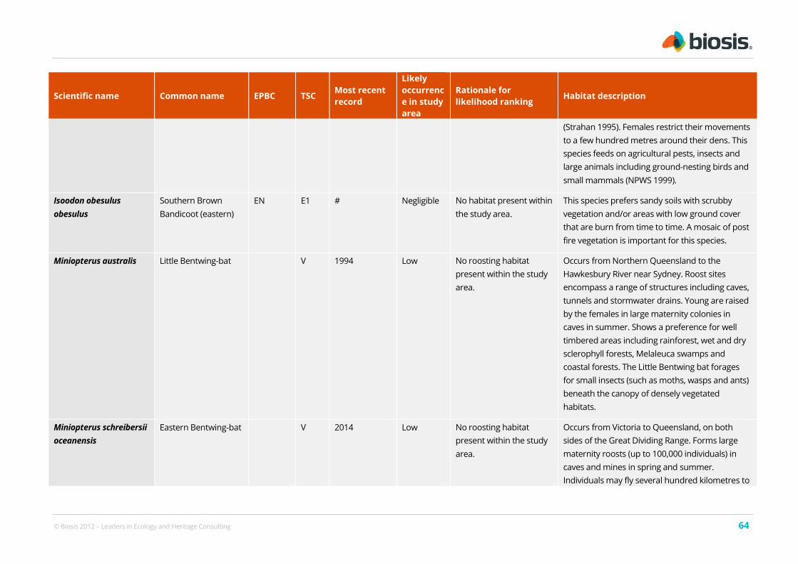
© Biosis 2012 – Leaders in Ecology and Heritage Consulting 64
Scientific name Common name EPBC TSC Most recent
record
Likely
occurrenc
e in study
area
Rationale for
likelihood ranking Habitat description
(Strahan 1995). Females restrict their movements
to a few hundred metres around their dens. This
species feeds on agricultural pests, insects and
large animals including ground-nesting birds and
small mammals (NPWS 1999).
Isoodon obesulus
obesulus
Southern Brown
Bandicoot (eastern)
EN E1 # Negligible No habitat present within
the study area.
This species prefers sandy soils with scrubby
vegetation and/or areas with low ground cover
that are burn from time to time. A mosaic of post
fire vegetation is important for this species.
Miniopterus australis Little Bentwing-bat V 1994 Low No roosting habitat
present within the study
area.
Occurs from Northern Queensland to the
Hawkesbury River near Sydney. Roost sites
encompass a range of structures including caves,
tunnels and stormwater drains. Young are raised
by the females in large maternity colonies in
caves in summer. Shows a preference for well
timbered areas including rainforest, wet and dry
sclerophyll forests, Melaleuca swamps and
coastal forests. The Little Bentwing bat forages
for small insects (such as moths, wasps and ants)
beneath the canopy of densely vegetated
habitats.
Miniopterus schreibersii
oceanensis
Eastern Bentwing-bat V 2014 Low No roosting habitat
present within the study
area.
Occurs from Victoria to Queensland, on both
sides of the Great Dividing Range. Forms large
maternity roosts (up to 100,000 individuals) in
caves and mines in spring and summer.
Individuals may fly several hundred kilometres to

© Biosis 2012 – Leaders in Ecology and Heritage Consulting 65
Scientific name Common name EPBC TSC Most recent
record
Likely
occurrenc
e in study
area
Rationale for
likelihood ranking Habitat description
their wintering sites, where they roost in caves,
culverts, buildings, and bridges. They occur in a
broad range of habitats including rainforest, wet
and dry sclerophyll forest, paperbark forest and
open grasslands. Has a fast, direct flight and
forages for flying insects (particularly moths)
above the tree canopy and along waterways.
Perameles nasuta Long-nosed
Bandicoot
E2 2015 Low No habitat present within
the study area.
The Long-nosed Bandicoot (inner west
population) is found within the LGAs of
Marrickville and Canada Bay and may extend into
the surrounding LGAs of Canterbury, Ashfield
and Leichardt. Individuals mostly shelter under
older houses and buildings, and forage for
invertebrates, plant roots, and hypogeal fungi in
parklands and back-yards. The population is
threatened by collision with vehicles; predation
by dogs, cats and foxes; renovation of old
buildings preventing access to nest sites; removal
of vegetation; and is at risk of extinction due to
local fluctuations in mortality and fecundity.
Pteropus poliocephalus Grey-headed Flying-
fox
VU V 2014# Low Marginal quality foraging
habitat present within
the study area.
Occurs along the NSW coast, extending further
inland in the north. This species is a canopy-
feeding frugivore and nectarivore of rainforests,
open forests, woodlands, melaleuca swamps and
banksia woodlands. Roosts in large colonies
(camps), commonly in dense riparian vegetation.
Bats commute daily to foraging areas, usually

© Biosis 2012 – Leaders in Ecology and Heritage Consulting 66
Scientific name Common name EPBC TSC Most recent
record
Likely
occurrenc
e in study
area
Rationale for
likelihood ranking Habitat description
within 15 km of the day roost although some
individuals may travel up to 70 km.
Birds
Anthochaera phrygia Regent Honeyeater CE E4A 1996# Low No preferred Eucalyptus
species present within
the study area.
A semi-nomadic species occurring in temperate
eucalypt woodlands and open forests. Most
records are from box-ironbark eucalypt forest
associations and wet lowland coastal forests. Key
eucalypt species include Mugga Ironbark, Yellow
Box, Blakely's Red Gum, White Box and Swamp
Mahogany. Also utilises: E. microcarpa, E. punctata,
E. polyanthemos, E. mollucana, Corymbia robusta, E.
crebra, E. caleyi, C. maculata, E. mckieana, E.
macrorhyncha, E. laevopinea and Angophora
floribunda. Nectar and fruit from the mistletoes A.
miquelii, A. pendula, A. cambagei are also eaten
during the breeding season. Regent Honeyeaters
usually nest in horizontal branches or forks in tall
mature eucalypts and sheoaks. Also nest in
mistletoe haustoria. An open cup-shaped nest is
constructed of bark, grass, twigs and wool by the
female.
Botaurus poiciloptilus Australasian Bittern EN E1 # Low No habitat present within
the study area.
The Australasian Bittern is distributed across
south-eastern Australia. Often found in terrestrial
and estuarine wetlands, generally where there is
permanent water with tall, dense vegetation
including Typha spp. and Eleoacharis spp..

© Biosis 2012 – Leaders in Ecology and Heritage Consulting 67
Scientific name Common name EPBC TSC Most recent
record
Likely
occurrenc
e in study
area
Rationale for
likelihood ranking Habitat description
Typically this bird forages at night on frogs, fish
and invertebrates, and remains inconspicuous
during the day. The breeding season extends
from October to January with nests being built
amongst dense vegetation on a flattened
platform of reeds.
Burhinus grallarius Bush Stone-curlew E1 2008 Low No habitat present within
the study area.
Lightly timbered open forest and woodland, or
partly cleared farmland with remnants of
woodland, with a ground cover of short sparse
grass and few or no shrubs where fallen
branches and leaf litter are present.
Calidris ferruginea Curlew Sandpiper CE E1 2010 Low No habitat present within
the study area.
The Curlew Sandpiper is found on intertidal
mudflats of estuaries, lagoons, mangroves, as
well as beaches, rocky shores and around lakes,
dams and floodwaters. Its breeding habitat is the
lowland tundra of Siberia. Infrequently recorded
inland.
Dasyornis brachypterus Eastern Bristlebird EN E1 # Negligible No habitat present within
the study area.
The Eastern Bristlebird inhabits a broad range of
vegetation communities with a variety of plant
species compositions that are generally defined
by a similar structure of low, dense, ground or
understorey vegetation. Such as coastal
woodlands, dense scrub and heathlands,
particularly where it borders taller woodlands.
Eudyptula minor Little Penguin E2 2009 Negligible No habitat present within
the study area.
The Manly endangered population of Little
Penguin is the only known breeding population

© Biosis 2012 – Leaders in Ecology and Heritage Consulting 68
Scientific name Common name EPBC TSC Most recent
record
Likely
occurrenc
e in study
area
Rationale for
likelihood ranking Habitat description
on the mainland in NSW. A range of nest sites are
utilised by the penguins at Manly including under
rocks on the foreshore, under seaside houses
and structures, such as stairs, in wood piles and
under overhanging vegetation including lantana
and under coral tree roots. Male penguins start
returning to the colony in May/June to find or
reconstruct a suitable burrow for nesting and to
attract females. At this time they may spend all
day in their burrows. Time of egg-laying varies
slightly from year to year but has been recorded
at Manly as early as the first week of June. The
peak breeding season however is generally from
July to December.
Grantiella picta Painted Honeyeater VU V # Negligible Only one Eucalyptus tree
present within the study
area.
Found mainly in dry open woodlands and forests,
where it is strongly associated with mistletoe.
Often found on plains with scattered eucalypts
and remnant trees on farmlands.
Haematopus longirostris Pied Oystercatcher E1 2013 Low No habitat present within
the study area.
An intertidal forager found on undisturbed sandy
beaches and spits, tidal mudflats and estuaries.
Its food supply (beach macroinvertebrates) have
been negatively affected by human impacts. The
Pied Oystercatcher is restricted to the littoral
zone of beaches and estuaries, nesting on the
ground above the tideline. A pair will re-nest in
the same spot each year, rarely shifting their
territory. Occasionally the Pied Oystercatcher is

© Biosis 2012 – Leaders in Ecology and Heritage Consulting 69
Scientific name Common name EPBC TSC Most recent
record
Likely
occurrenc
e in study
area
Rationale for
likelihood ranking Habitat description
found in paddocks near the coast.
Hieraaetus morphnoides Little Eagle V 1986 Low No habitat present within
the study area.
The Little Eagle is most abundant in lightly
timbered areas with open areas nearby providing
an abundance of prey species. It has often been
recorded foraging in grasslands, crops, treeless
dune fields, and recently logged areas. The Little
Eagle nests in tall living trees within farmland,
woodland and forests.
Lathamus discolor Swift Parrot EN E1 # Negligible Only one Eucalyptus tree
present within the study
area.
The Swift Parrot occurs in woodlands and forests
of NSW from May to August, where it feeds on
eucalypt nectar, pollen and associated insects.
The Swift Parrot is dependent on flowering
resources across a wide range of habitats in its
wintering grounds in NSW. Favoured feed trees
include winter flowering species such as Swamp
Mahogany Eucalyptus robusta, Spotted Gum
Corymbia maculata, Red Bloodwood C. gummifera,
Mugga Ironbark E. sideroxylon, and White Box E.
albens. Commonly used lerp infested trees
include Grey Box E. microcarpa, Grey Box E.
moluccana and Blackbutt E. pilularis. This species
is migratory, breeding in Tasmania and also
nomadic, moving about in response to changing
food availability.
Limosa limosa Black-tailed Godwit V 2009 Negligible No habitat present within
the study area.
In Australia the Black-tailed Godwit has a
primarily coastal habitat environment. The

© Biosis 2012 – Leaders in Ecology and Heritage Consulting 70
Scientific name Common name EPBC TSC Most recent
record
Likely
occurrenc
e in study
area
Rationale for
likelihood ranking Habitat description
species is commonly found in sheltered bays,
estuaries and lagoons with large intertidal
mudflats or sandflats, or spits and banks of mud,
sand or shell-grit; occasionally recorded on rocky
coasts or coral islets. The use of habitat often
depends on the stage of the tide. It is also found
in shallow and sparsely vegetated, near-coastal,
wetlands; such as saltmarsh, saltflats, river pools,
swamps, lagoons and floodplains. There are a
few inland records, around shallow, freshwater
and saline lakes, swamps, dams and bore-
overflows. They also use lagoons in sewage farms
and saltworks.
Lophochroa leadbeateri Major Mitchell's
Cockatoo
V 2012 Low No roosting habitat
present within the study
area.
Found mainly in semi-arid and arid regions, in dry
woodlands, particularly mallee - casuarina
assemblages. They breed in the hollows of large
trees, often near watercourse.
Neophema pulchella Turquoise Parrot V 2005 Negligible Only one Eucalyptus
species present within
the study area.
Occurs in open woodlands and eucalypt forests
with a ground cover of grasses and understorey
of low shrubs. Generally found in the foothills of
the Great Divide, including steep rocky ridges and
gullies. Nest in hollow-bearing trees, either dead
or alive; also in hollows in tree stumps. Prefer to
breed in open grassy forests and woodlands, and
gullies that are moist.
Ninox strenua Powerful Owl V 2012 Low No roosting habitat The Powerful Owl occupies wet and dry eucalypt
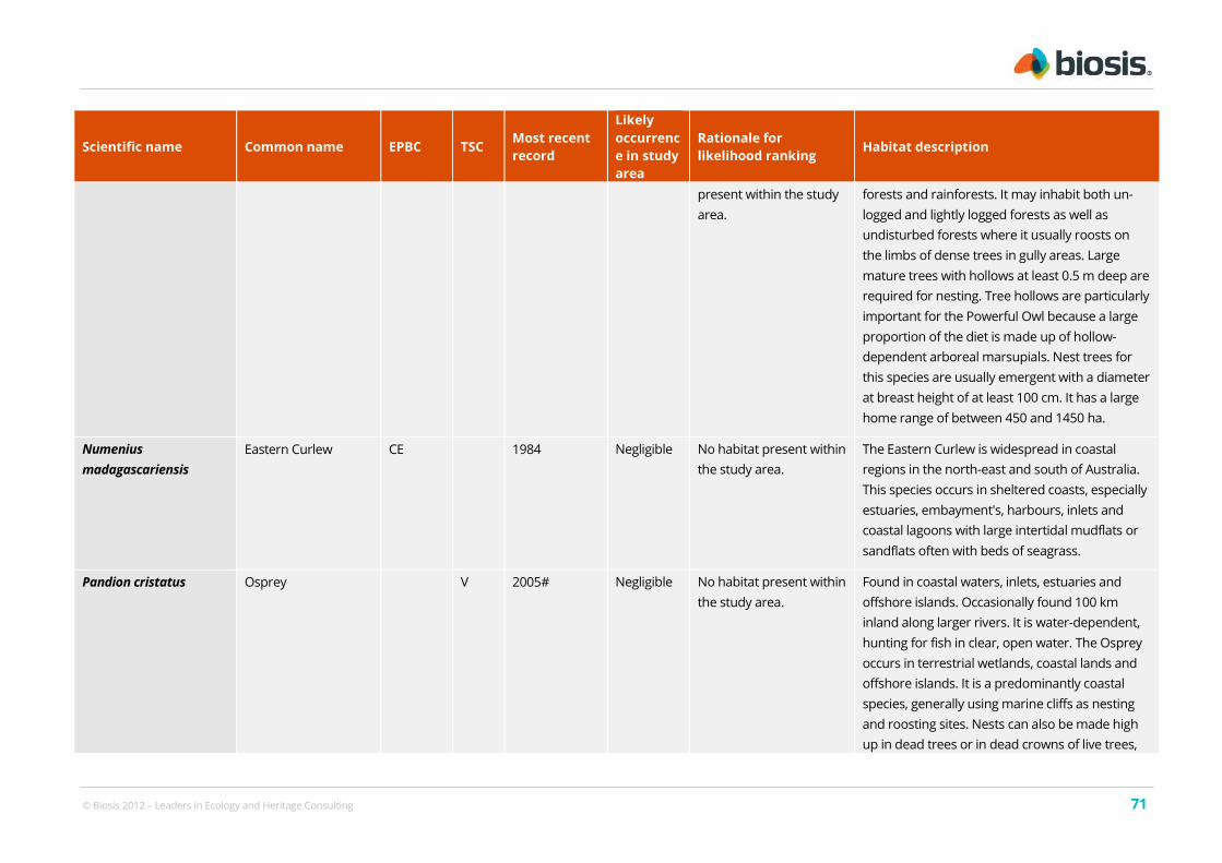
© Biosis 2012 – Leaders in Ecology and Heritage Consulting 71
Scientific name Common name EPBC TSC Most recent
record
Likely
occurrenc
e in study
area
Rationale for
likelihood ranking Habitat description
present within the study
area.
forests and rainforests. It may inhabit both un-
logged and lightly logged forests as well as
undisturbed forests where it usually roosts on
the limbs of dense trees in gully areas. Large
mature trees with hollows at least 0.5 m deep are
required for nesting. Tree hollows are particularly
important for the Powerful Owl because a large
proportion of the diet is made up of hollow-
dependent arboreal marsupials. Nest trees for
this species are usually emergent with a diameter
at breast height of at least 100 cm. It has a large
home range of between 450 and 1450 ha.
Numenius
madagascariensis
Eastern Curlew CE 1984 Negligible No habitat present within
the study area.
The Eastern Curlew is widespread in coastal
regions in the north-east and south of Australia.
This species occurs in sheltered coasts, especially
estuaries, embayment's, harbours, inlets and
coastal lagoons with large intertidal mudflats or
sandflats often with beds of seagrass.
Pandion cristatus Osprey V 2005# Negligible No habitat present within
the study area.
Found in coastal waters, inlets, estuaries and
offshore islands. Occasionally found 100 km
inland along larger rivers. It is water-dependent,
hunting for fish in clear, open water. The Osprey
occurs in terrestrial wetlands, coastal lands and
offshore islands. It is a predominantly coastal
species, generally using marine cliffs as nesting
and roosting sites. Nests can also be made high
up in dead trees or in dead crowns of live trees,

© Biosis 2012 – Leaders in Ecology and Heritage Consulting 72
Scientific name Common name EPBC TSC Most recent
record
Likely
occurrenc
e in study
area
Rationale for
likelihood ranking Habitat description
usually within one kilometre of the sea.
Petroica boodang Scarlet Robin V 2013 Low Marginal quality habitat
present within the study
area. No large woody
debris within study area.
Regular disturbance.
During the breeding season the Scarlet Robin is
found in eucalypt forests and temperate
woodlands, often on ridges and slopes. During
autumn and winter it moves to more open and
cleared areas. It has dispersive or locally
migratory seasonal movements. The Scarlet
Robin forages amongst logs and woody debris for
insects which make up the majority of its diet.
The nest is an open cup of plant fibres and
cobwebs, sited in the fork of a tree (often a dead
branch in a live tree, or in a dead tree or shrub)
which is usually more than 2 m above the
ground. It is conspicuous in open and suburban
habitats.
Petroica phoenicea Flame Robin V 1969 Negligible No habitat present within
the study area.
Flame Robins are found in a broad coastal band
from southern Queensland to just west of the
South Australian border. The species is also
found in Tasmania. The preferred habitat in
summer includes moist eucalyptus forests and
open woodlands, whilst in winter prefers open
woodlands and farmlands. It is considered
migratory. The Flame Robin breeds from about
August to January.
Polytelis alexandrae Princess Parrot VU 2008 Negligible No habitat present within
the study area.
The Princess Parrot inhabits sand dunes and
sand flats in the arid zone of western and central

© Biosis 2012 – Leaders in Ecology and Heritage Consulting 73
Scientific name Common name EPBC TSC Most recent
record
Likely
occurrenc
e in study
area
Rationale for
likelihood ranking Habitat description
Australia. It occurs in open savanna woodlands
and shrublands that usually consist of scattered
stands of Eucalyptus, Casuarina or Allocasuarina
trees; an understorey of shrubs such as Acacia,
Cassia, Eremophila, Grevillea, Hakea and Senna. It
also frequents Eucalyptus or Allocasuarina trees
in riverine or littoral areas.
Ptilinopus superbus Superb Fruit-Dove V 1996 Negligible No habitat present within
the study area.
The Superb Fruit Dove’s NSW distribution ranges
from northern NSW to as far south as Moruya. It
is found in rainforests, closed forests (including
mesophyll vine forests) and sometimes in
eucalypt and acacia woodlands where there are
fruit-bearing trees. It forages in the canopy of
fruiting trees such as figs and palms. Nests are
constructed high in the canopy throughout
September to January.
Rostratula australis Australian Painted
Snipe
EN E1 # Negligible No habitat present within
the study area.
Usually found in shallow inland wetlands
including farm dams, lakes, rice crops, swamps
and waterlogged grassland. They prefer
freshwater wetlands, ephemeral or permanent,
although they have been recorded in brackish
waters.
Sternula albifrons Little Tern E1 1997 Negligible No habitat present within
the study area.
The Little Tern favours sheltered coasts,
harbours, bays, lakes, inlets, estuaries, coastal
lagoons and ocean beaches especially with sand-
spits and sand islets. It forages over shallow

© Biosis 2012 – Leaders in Ecology and Heritage Consulting 74
Scientific name Common name EPBC TSC Most recent
record
Likely
occurrenc
e in study
area
Rationale for
likelihood ranking Habitat description
waters close inshore or over sandbars and reefs.
Tyto novaehollandiae Masked Owl V 1985 Negligible No habitat present within
the study area.
The Masked Owl may be found across a diverse
range of wooded habitat that provide tall or
dense mature trees with hollows suitable for
nesting and roosting. It has mostly been recorded
in open forests and woodlands adjacent to
cleared lands. They nest in hollows, in trunks and
in near vertical spouts or large trees, usually living
but sometimes dead. The nest hollows are
usually located within dense forests or
woodlands. Masked Owls prey upon hollow-
dependent arboreal marsupials, but terrestrial
mammals make up the largest proportion of the
diet.
Xenus cinereus Terek Sandpiper V 1999 Negligible No habitat present within
the study area.
The Terek Sandpiper mostly forages in the open,
on soft wet intertidal mudflats or in sheltered
estuaries, embayment's, harbours or lagoons.
The species has also been recorded on islets,
mudbanks, sandbanks and spits, and near
mangroves. Birds are seldom near the edge of
water. Occasionally, on sandy beaches, among
seaweed and other debris and in rocky areas.
Less often seen on sandy or shingle beaches, or
on rock or coral reefs or platforms, Terek
Sandpipers are occasionally sighted around
drying sewage ponds and saltpans if surrounded
by mudflats. The species is also found around

© Biosis 2012 – Leaders in Ecology and Heritage Consulting 75
Scientific name Common name EPBC TSC Most recent
record
Likely
occurrenc
e in study
area
Rationale for
likelihood ranking Habitat description
brackish coastal swamps, lagoons and dune-
lakes; and also on gravel or rocky edges of
estuarine pools and freshwater river-pools. Very
occasionally, birds use swampy, grassy or
cultivated paddocks near the coast.
Reptiles
Hoplocephalus
bungaroides
Broad-headed Snake VU E1 # Negligible No habitat present within
the study area.
Mainly occurs in association with communities
occurring on Triassic sandstone within the
Sydney Basin. Typically found among exposed
sandstone outcrops with vegetation types
ranging from woodland to heath. Within these
habitats they generally use rock crevices and
exfoliating rock during the cooler months and
tree hollows during summer.
Frogs
Heleioporus
australiacus
Giant Burrowing
Frog VU V # Negligible No habitat present within
the study area.
Prefers hanging swamps on sandstone shelves
adjacent to perennial non-flooding creeks. Can
also occur within shale outcrops within
sandstone formations. Known from wet and dry
forests and montane woodland in the southern
part range. Individuals can be found around
sandy creek banks or foraging along ridge-tops
during or directly after heavy rain. Males often
call from burrows located in sandy banks next to
water. Spends the majority of its time in non-

© Biosis 2012 – Leaders in Ecology and Heritage Consulting 76
Scientific name Common name EPBC TSC Most recent
record
Likely
occurrenc
e in study
area
Rationale for
likelihood ranking Habitat description
breeding habitat 20-250m from breeding sites.
Litoria aurea Green and Golden
Bell Frog VU E1 2013# Negligible No habitat present within
the study area.
Most existing locations for the species occur as
small, coastal, or near coastal populations, with
records occurring between south of Grafton and
northern VIC. The species is found in marshes,
dams and stream sides, particularly those
containing bullrushes or spikerushes. Preferred
habitat contains water bodies that are unshaded,
are free of predatory fish, have a grassy area
nearby and have diurnal sheltering sites nearby
such as vegetation or rocks, although the species
has also been recorded from highly disturbed
areas including disused industrial sites, brick pits,
landfill areas and cleared land. Breeding usually
occurs in summer. Tadpoles, which take
approximately 10-12 weeks to develop, feed on
algae and other vegetative matter. Adults eat
insects as well as other frogs, including juveniles
of their own species.

© Biosis 2012 – Leaders in Ecology and Heritage Consulting 77
A2.3 Migratory species (EPBC Act listed)
Includes records from the following sources:
Atlas of NSW Wildlife (refer to Section 2.1)
Department of Environment database (accessed on 08/03/2016)
BirdLife Australia data search
Current survey
Table 14: Migratory avifauna species recorded or predicted to occur within 5 km of the study area
Scientific name Common name Conservation status Most recent
record
Actitis hypoleucos Common Sandpiper Mi 2007
Apus pacificus Fork-tailed Swift Mi 2010#
Ardea ibis Cattle Egret Mi 1986#
Ardea modesta Eastern Great Egret Mi #
Arenaria interpres Ruddy Turnstone Mi 1994
Calidris acuminata Sharp-tailed Sandpiper Mi 2007
Calidris canutus Red Knot Mi 2011
Calidris ferruginea Curlew Sandpiper CE, Mi E1 2010
Calidris ruficollis Red-necked Stint Mi 1994
Cuculus optatus Oriental Cuckoo Mi #
Gallinago hardwickii Latham's Snipe Mi #
Hirundapus caudacutus White-throated Needletail Mi 2013#
Hydroprogne caspia Caspian Tern Mi 2007
Limosa lapponica Bar-tailed Godwit Mi 2013
Limosa limosa Black-tailed Godwit Mi V 2009
Merops ornatus Rainbow Bee-eater Mi #
Monarcha melanopsis Black-faced Monarch Mi 2011#
Motacilla flava Yellow Wagtail Mi #
Myiagra cyanoleuca Satin Flycatcher Mi 2012#
Numenius madagascariensis Eastern Curlew CE, Mi 1984
Numenius minutus Little Curlew Mi 1958
Numenius phaeopus Whimbrel Mi 1991
Pandion cristatus Osprey Mi V 2005#

© Biosis 2012 – Leaders in Ecology and Heritage Consulting 78
Scientific name Common name Conservation status Most recent
record
Pluvialis fulva Pacific Golden Plover Mi 2013
Pluvialis squatarola Grey Plover Mi 1989
Rhipidura rufifrons Rufous Fantail Mi 2013#
Sterna hirundo Common Tern Mi 2002
Sternula albifrons Little Tern Mi E1 1997
Tringa brevipes Grey-tailed Tattler Mi 1995
Tringa nebularia Common Greenshank Mi 1986#
Tringa stagnatilis Marsh Sandpiper Mi 2005