Embed Size (px)
Citation preview
Assessing population size and spatial distribution o f m arine mammals andsea turtles in the Northern Gulf of Mexico
Prepared by:Dr. Lance P. Garrison
National Marine Fisheries Service Southeast Fisheries Science Center
305-361-4488 (voice)(cell)
Lance. Garrison @noaa. gov
Document Date: 23 January-2011 Version Number: 2.3
DWH-AR0100582
Assessmg population size and spatial distribution of marine mamma! s andsea turtles in tlie Northern Gulf of Mexico
Approval of this work plan is for the patposes of obtaining data for tiie Natoral Rcsoiticc Damage Assessment Each party reserves its right to prodace its own jndependent tateipretaticm aad analysis of any data collected pursuant to this work pkn.
The trostees have developed a preiimiaaiy conceptual model of ihe DWH release, potential palhways and routss of exposure, and potential recqjtois. This pielimiaary model has informed the trastees’ dec.Bton to pursue the stitdies ontlined in the wo* plan. By sigsing this woifc p!aa and agreeing lo &M ihe wo* outlia^J, BP is not eadoising the model arficiilated in * e woA plan.
Tliia pka will be iaiptoinented coasisieit with exfeting trustee reguktioas and ,polfcies. All appIteaKe state aai federal p ^ i i s must he obtaiaed prior to conduciag work. This project wiU be Gendttcted uador Marine Mammal Protection Act lesearoh Featiit #779-1633-00 and Eadaagered Species Act pmnit.#! 551 issaed to the Southeast Fisheries Science CcEter.
I / 1 3 I z x j i iof Commerce Trusti^ Repo^^B^tlv'e Oats
Louisiana resentaiive Date
Texas Trustee Represeatative I LDafe
n i . - H /
Date
DWH-AR0100583
L -E atu ral Resources Being Addressed
This project will conduct aerial surveys to document seasonal abundance and spatial distribution of protected marine mammal and sea turtle populations that potentially have been exposed to MC252 oi trom the DWH event. Pre-assessment aerial survey data demonstrated that bottlenose dolphin
™ ndley turtle populations were in coastal and estuarine waters near’the DWH site where oil and response activities occurred. Secondary impacts may also injure these populations through depletion of prey resources or other types of habitat degradation. These impacts may be manifested through changes m population size or shifts in spatial distribution relative to baselme conditions. This project will assess the overall abundance and seasonal spatial distribution ot bottlenose dolphin, other cetaceans and marine turtle populations in the Northern Gulf of Mexico during the sWdy period. These data will be compared with similar data collected in the summer andn S ? n A il" survey data collected during the pre-assessment phase of the
between May and August 2010 in coastal and estuarine waters near the DWH site,
II. Study Purpose and Qhieetives
The objective ofthis study is tocollect data that will help assess potential injuiy from MC 252 oil on continental shelf and inner continental slope populations of marine mammals (see Appendix 1) and sea tm les in the northem^ Gulf of Mexico. Obtaining the data pertaining to abundance and distribution of these species will assist in better understanding how to protect and manage these resources. The study will address two primary objectives:
Collect data on the seasonal abundance and spatial distribution of marine mammals and turtles over the continental shelf in the Northern Gulf of Mexico.
Collect data on the seasonal abundance and spatial distribution o f marine mammals near the shelf-break m the north-central Gulf of Mexico.
These objectives will be accomplished by conducting aerial visual line-transect surveys using the “Distance Sampling'’ approach (Buckland et ah, 2001; Laake and Borchers, 2004 ).
III. Study Methods and Sampling
Survey Platform and ScheduleThe surv'eys will be conducted aboard a DeHavilland Twin Otter (DHC-6) airplane. This is a high- wing, twm-engme, turbo-prop with the required capabilities to conduct these surveys Specifically the aircraft must be capable of surveying at low altitude (600 feet) and speeds of approximately 100 knots and capable of carrying up to 6 scientists for durations of at least 4 hours in the air. The aircraft will be fitted with “Bubble” windows at 3-4 observer stations and a belly port to allow' visibility beneath the aircraft and the deployment of camera stations. The aircraft and pilots are required to meet all applicable NOAA Aircraft Safety Policy Standards. NOAA Twin Otter aircraft have been used m support of similar missions. Charter aircraft that are suitable for the work are also available through a private company (Twin Otters International).
1)
2)
DWH-AR0100584
or
Four seasonal surveys beginning as soon as possible after the approval ofthis plan will be conducted. Each seasonal survey will require a 60-day window to complete all transects (approximately 150 flight hours).
Following these surveys, the data will be evaluated by the Trustees and BP, and additional years seasons of surveys will be proposed as an addendum to this plan if needed for the purposes of ongoing injury assessment.
Data Collection
The surveys will follow standard methods for visual protected species line transect surveys employed by NMFS. The surc'ey is conducted along tracklines flown at an altitude of 6ob ft (183 m) and an airspeed of 100 knots (185 km hr ). Data acquisition and recording is accomplished usin^ a laptop computer connected to the aircraft’s GPS system. Time, position, speed, and heading “ mtormation are recorded automatically at 10 second intervals throughout the flight. Data are also recorded on factors that may affect visibility including sea state, weather, glare, water color cloud cover, and other conditions that may influence sighting probabilities as conditions change during the survey. Sea surface temperature is measured using an infrared thermometer stationed iri the belly port and fed into the data acquisition program. Survey altitude will likewise be verified with a radar effo rt^^ ^ looking laser range finder and recorded constantly throughout survey
The survey crew consists of 6 scientists operating as two independent survey teams. The forward team includes an observer on each side o f the aircraft stationed in “bubble windows” and a data recorder. The aft team consists of an observer looking downward in the belly window and an observer on one side of the aircraft stationed at a bubble window. The aft team also includes a second data recorder. The forward and aft teams are separated visually and are isolated on separate intercoms. Observers search for marine mammals and turtles from directly beneath the aircraft to a perpendicular distance o f approximately 1500 m away from the trackline. On sighting a marine rnammal group the observer measures the angle of the sighting when the group is perpendicular to me trackline either using a digital inclinometer or marks on the windows placed at 10 degree intervals. The observer waits until the group is well aft of the aircraft before informing the pilots recorder, and the other team of the observation in order to allow both teams an opportunity to view the group independently. On notification that a marine mammal group is sighted, the aircraft circles to reacquire the group and make group size estimates and verify species identification.
p e surv'ey design follows the recommendations of Buckland et a l (2001) for line-transect “D is p c e ’’ ^m pling and the use o f the independent observer approach to correct for visibility bias p aak e a p Borchers, 2004). The independent observer approach is required to address a negative p s in abundance estimates where the probability^ of observing animals on the trackline is less than 1. In this case, the approach will correct for the probability that animals available to be observed (I.e., on the surface) were missed by the obsert^ers. Data from tag-telemetry studies will be used to correct for the probability that animals were on the surface, and this correction is particularly important for marine turtles that spend long periods o f time underwater.
Photogrammetric methods will be developed to estimate the size o f sea turtles and marine mammals detected and to verify species identification. Photogrammetry will be conducted from a fixed, downward looking camera mount with associated sensors for altitude and aircraft orientation (pitch, roll, and yaw). Image analysis methods from either single or multiple images with precise
4
DWH-AR0100585
information on relative camera location can then be used to estimate the size o f observed animals. Similar methods have been used to assess the size of dolphins and large marine mammals (e.g., Perryman and Westlake, 1998); however, they have not yet been applied to turtles. Therefore, during the initial surveys, photogrammetric methodologies will be developed and tested to evduate their effectiveness. The Principal Investigator and Trustees will provide BP with preliminary reports on the outcomes of the flights and will consider comments from BP in determining if additional methods development is warranted. Any such developments will be submitted as addenda to this plan. Metrics o f size are particularly important for turtles because different life-history stages use different habitats and may have behavioral differences that impact their detection by the aircraft. It is expected that turtles <30 cm in carapace length will not be effectively observed during these surveys (NMFS, Northeast Fisheries Science Center, unpublished data). The lower size limit of turtles that are observed during this study will be determined based on the data collected.
Survey Design
The survey is designed with two major components to assess the habitat and spatial distribution ofdifferent groups of marine mammals and sea turtles. Both sections of the .surc^ey will be covered during each season.
0 Broadscale continental shelf surveyThe bulk o f survey effort will be over the continental shelf ranging from Brownsville. TX (the U.S./Mexico border) to north of the Dry Tortugas (Figure 1). Tracklines will be oriented perpendicular to the shoreline and bathymetry gradient and spaced 15 km apart throughout most of the survey. Survey tracklines follow uniform spacing from a random start point and are divided into strata to accommodate changes in the orientation of the coastline. The broad spatial extent reflects the ranges o f the sea turtle and marine mammal populations that occur in continental shelf waters of the Northern Gulf of Mexico. The primary marine mammal species that will be observed with this survey are bottlenose dolphins (coastal and continental shelf stocks. Appendix I). The primary sea turtles will be loggerhead and Kemp’s ridley turtles. In the Louisiana-Mississippi region, the survey will include the same tracklines flown during pre-assessment surveys conducted from May- September 2010 (Figure 1). Limited effort will be expended in major bays and sounds (e.g., Tampa Bay, Mississippi Sound, and Florida Bay). The broadscale continental shelf survey encompasses approximately 11,500 nautical miles of survey effort.
2) Shelf-break Surveys
A second component o f the survey will focus on the shelf-break and inner continental slope waters of the north-central Gulf in two focal areas. The first straddles the 1,000 m isobaths (bottom depths ranging from 800m to 1500m) along the southern coast of Louisiana and also covers the Mississippi and DeSoto Canyons (Figure 2). This region includes the DWH site along with habitats of sperm whales and other oceanic marine mammals (Appendix I). The second surv'ey area includes waters off the west coast o f Florida between the 200-400m isobaths. This region covers the habitats of Bryde s whales. These areas will be surveyed along evenly spaced zig-zag tracklines oriented
DWH-AR0100586
perpendicular to the bathymetry. The survey includes approximately 1,100 nautical miles of trackline. The survey tracks will document the distribution and abundance o f oceanic marine mammals in the shelf-break area and will allow comparison to marine mammal occurrence patterns as documented by passive acoustic monitoring moorings that are distributed along the 1000m isobaths (Figure 2).
y i . Disposition of Collected Data
Data collected during this study will include digital records of survey data (i.e., position, environmental conditions, marine mammal and turtle sightings), digital photographs and associated paper logs, and paper records of observations of mammal/turtle behaviors. Copies o f all data collected will be made available to BP or its representative in a timely manner.
Digiial photographs and paper records will be logged and maintained following chain of custody procedures per NRDA requirements.
Each laboratory shall simultaneously deliver raw data, including all necessary’ metadata, generated as part ofthis work plan as a Laboratory Analytical Data Package (LADP) to the trustee Data Management Team (DMT), the Louisiana Oil Spill Coordinator's Office (LOSCO) on behalf of the State o f Louisiana and to BP (or ENTRIX on behalf of BP), The electronic data deliverable (EDD) spreadsheet with pre-validated analytical results, which is a component o f the complete LADP, will also be delivered to the secure FTP drop box maintained by the trustees' Data Management Team (DMT). Any preliminary data distributed to the DMT shall also be distributed to LOSCO and to BP (or ENTRIX on behalf of BP). Thereafter, the DMT will validate and perform quality assurance/quality control (QA/QC) procedures on the LADP consistent with the authorized Analytical Quality Assurance Plan, after which time the validated/QA/QC'd data shall be made available simultaneously to all trustees and BP (or ENTRIX on behalf o f BP). Any questions raised on the validated/QA/QC results shall be handled per the procedures in the Analytical Quality Assurance Plan and the issue and results shall be distributed to all parties. In the interest of maintaining one consistent data set for use by all parties, only the validated/QA/QC’d data set released by the DMT shall be considered the consensus data set. In order to assure reliability o f the consensus data and full review by the parties, no party shall publish consensus data until 7 days after such data has been made available to the parties. Also, the LADP shall not be released by the DMT, LOSCO, BP or ENTRIX prior to validation/QA/QC absent a showing o f critical operational need. Should any party show a critical operational need for data prior to validation/QA/QC, any released data will be clearly marked "preliminary/unvalidated" and will be made available equally to all trustees and to BP (or ENTRIX on behalf o f BP).
Weekly updates will be provided to the Trustees and BP or its representative on the progress of each survey as it is conducted, including maps of areas surveyed and summaries of numbers of animals observed. Summary reports of survey efforts and results will be provided to BP or its representative and to the trustees within j O days after the completion of each seasonal survey.
DWH-AR0100587
L iterature Cited
Buckland, S.T. Anderson, D.R., Burnham, K.P., Laake, J.L., Borchers, D.L. and Thomas, L. 2001. i .tioduction to distance sampling: Estimating abundance o f biological populations Oxford
University Press, 432 pp. r r
Laake, J.L. and Borchers, D.L. 2004. Methods for incomplete detection at distance zero. In: Advanced Distance Sampling. Buckland, S.T., Anderson, D.R., Burnham, K.P., Laake, J.L., and fhomas, L. (eds.). Oxford University Press, 411 pp.
Perryman, W.L. and Westlake, R.L. 1998. A new geographic form of the spinner dolphin Stenella longirostris detected with aerial photogrammetry. Marine Mammal Science 14; 38-50.
DWH-AR0100588
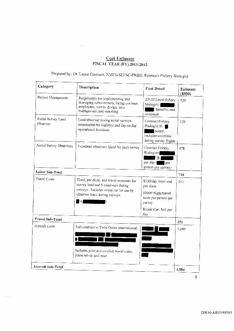
Cost Estimate FISCAL YEAR (FY) 2011-2012
Prepared by: Dr. Lance Garrison, NMFS-SEFSC-PRBD, Research Fishery Biologist
Category Description Cost Detail EstimatefSOOO)
Project Management Responsible for implementing and managing sub-contracts, hiring contract employees, survey design, data management and reporting
ZP-Ill Level fishery biologist;
benefits, and overhead
120
Aerial Survey Lead Observer
Lead observer during aerial surveys responsible for logistics and day-to-day operational decisions
Contract Fishery Biologist II: |
salary, includes overtime during surv'ey flights
120
Aerial Survey Observ'ers 5 contract observ'ers hired for each surveys Contract Fishery Biologists
per day per person per survey)
478
Labor Sub-Total718
Travel Costs
....
Hotel, per diem, and travel expenses for survey lead and 5 observers during surveys. Includes rental car for use by observer team during surv'cys
$ 150/day hotel and per diem
$1000 flight/travel costs per person per survey
Rental Car; $45 per day
251
Travel Sub-Total251
Aircraft Costs Sub-contract to Twin Otters International.
Includes pilot and co-pilot travel costs, 3lane set-up and misc.
1,084 1
Aircraft Sub-TotaP1,084
DWH-AR0100589

Equipment and Supplies 2 Toughbook durable computers @ $5,000 each
$5,000 each 10
Equipment and Supplies Cameras and lenses, mounting brackets, memory cards and supplies for photogrammetr}'
2 Cameras @ $3,000
$500 in misc. supplies
6.5
Equipment and Supplies Photo-analysis software ] .5Equipment and Supplies Infra-red temperature probe 1.5Equipment and Supplies Precision laser rangefmder/altimeter 2.0Equipment and Supplies Miscellaneous Expendable supplies 1.0Equipment and Supplies Sub-Total 22.5Administrative Costs and Overhead 340Total Cost Estimate ($000) 2,415.5' be funded directly through a NOAA contract since it will be flying belm floor for aircraft operation under BP contracts.
V the 1,000 ft
The Parties acknowledge that this budget is an estimate, and that actual costs may prove to be higher. BP’s commitment to fund the costs of this work includes any additional reasonable costs within the scope of this work plan that may arise. The trustees will make a good faith effort to notify BP in advance of any such increased costs.
DWH-ARO100590
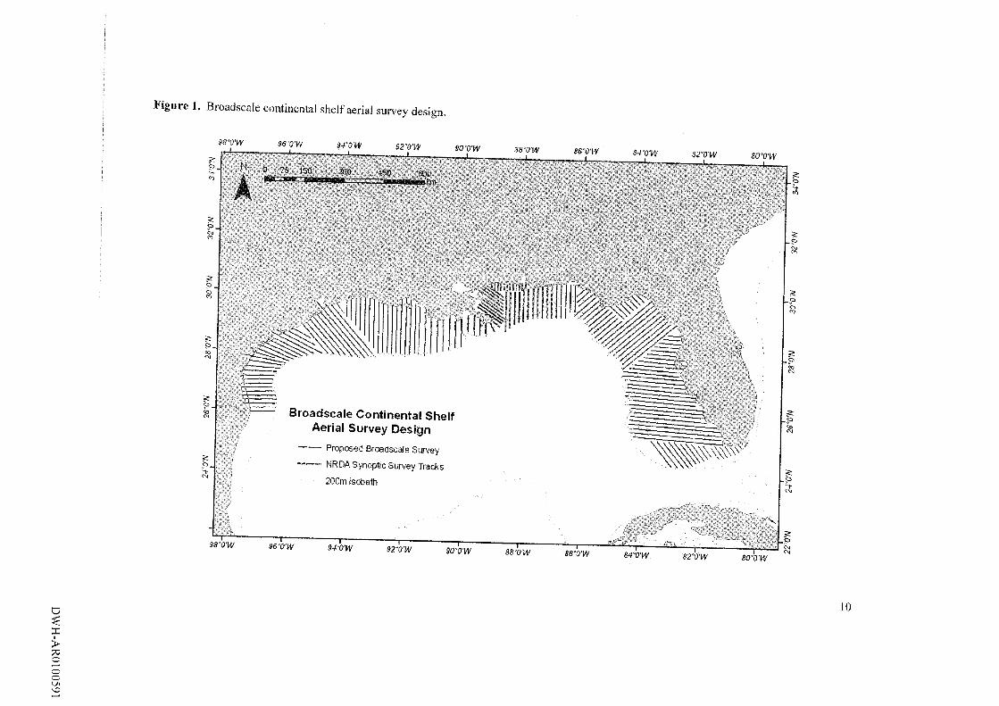
Figu re 1. Broadscale continental shelf aerial survey design.
0 75 150: 600TlMlllWIHllllTII
Broadscale Continental Shelf Aerial Survey Design
Proposed Broadscale Survey
— NRDA Synopllc Survey Tracks 200m Isobath
96'0'W 92VW 90VW B8"0'W
a
I>ooo'O
10
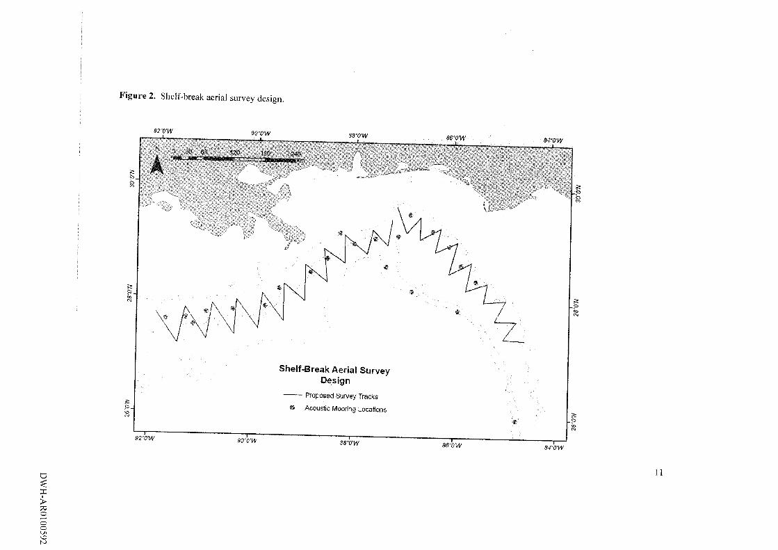
F igu re 2. Shelf-break aerial survey design.
I>oooLn\DK)
S2"0'W 90’0'W S8'0'W 86’0'W 84'0'W
Shelf-Break Aerial Survey Design
Proposed Survey Tracks
* Acoustic Mooring Locations
92'0'W 90"0'W SSV'W row — r84'‘0W
11
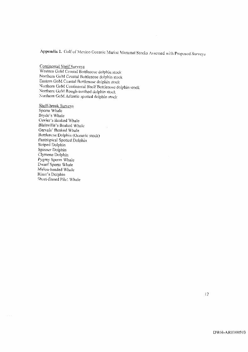
Appendix I. Gulf of Mexico Oceanic Marine Mammal Stocks Assessed with Proposed Surveys
Continental Shelf SurvevsWestern GoM Coastal Bottlenose dolphin stockNorthern GoM Coastal Bottleoose dolphin stockEastern GoM Coastal Bottlenose dolphin stockNorthern GoM Continental Shelf Bottlenose dolphin stockNorthern GoM Rough-toothed dolphin stockNorthern GoM Atlantic spotted dolphin stock
Shelf-break Survevs Sperm Whale Bryde’s Whale Cuvier’s Beaked Whale Blainville’s Beaked Whale Gervais’ Beaked Whale Bottlenose Dolphin (Oceanic stock)Pantropical Spotted Dolphin Striped Dolphin Spinner Dolphin Clymene Dolphin Pygmy Sperm Whale Dwarf Sperm Whale Melon-headed Whale Risso’s Dolphin Short-finned Pilot Whale
12
DWH-ARO 100593