Embed Size (px)
Citation preview
Florida Chapter of The Nature Conservancy December 2009
Assessment and Revision of the
Florida Ecoregional Portfolio
Conservation Science and December 2009 Strategies Department
1
Assessment and Revision of the Florida Ecoregional Portfolio
The Florida Ecoregional Portfolio (portfolio) is the combined product of individual ecoregional assessments (EAs) conducted between 2001 and 2005 for the Tropical Florida, Florida Peninsula, East Gulf Coastal Plain and South Atlantic Coastal Plain ecoregions. After an assessment of the impacts of land development and projected sea-level rise on the portfolio1, the Florida Conservation Science and Strategies Department determined that the impacts were not sufficient to merit revision of the EAs; however, several revisions of the portfolio were recommended based on the results of the assessment. These revisions were applied solely to the Florida portfolio despite the multi-state components of the East Gulf Coastal Plain and South Atlantic Coastal Plain. The most substantial revision to the portfolio was the removal of 949,384 acres (6% of the original portfolio) as a result of development or land conversion of such intensity that the sites were no longer considered suitable for conservation (see Table 1). The portfolio was also expanded through the addition of lands that were not included in the original portfolio but have been placed in protected conservation status since completion of the EAs. These additions totaled 942,930 acres (6% of revised portfolio). A final category of revisions consisted of additions designed to enhance the portfolio’s resilience to climate change by expanding connectivity. A sea level rise of 1 m was incorporated into our designation of additions to expand connectivity in order to account for areas where 1 m of inundation would sever upland connections. These additions totaled 116,491 acres (0.7% of revised portfolio). The net result of the revisions was a 109,038-acre increase in the total size of the portfolio (0.7% change relative to the original portfolio). The revisions do not include all areas identified as critical for coastal water or freshwater conservation, which are being identified in Conservation Blueprints prepared independently of this effort (see below). Table 1 summarizes the areal extent of all revisions made to the portfolio in conjunction with the assessment. The revised portfolio provides an updated depiction of lands with conservation value. At this point, a full reassessment of targets associated with the portfolio has not been conducted. The assessment of impacts to the portfolio as a result of land conversion revealed almost no shifts in the ability of the remaining portfolio to meet goals for targets for which goals were initially met1; therefore, we made the assumption that the changes to the portfolio will not significantly change target status.
Methodology for Implementing Revisions
The initial step in revision of the portfolio consisted of removing sites that had been developed since completion of the EAs. A statewide spatial dataset developed by the GeoPlan Center at the University of Florida was used to distinguish lands that have
1 See The Impact of Development and Projected Sea-Level Rise on Florida’s Ecoregional Portfolio,
prepared by Florida Conservation Science in March 2009 and attached as an appendix to this report.
Conservation Science and December 2009 Strategies Department
2
been altered by high-intensity development or intensive agricultural usage. Developed sites greater than 10 acres in size that fell within the original ecoregional portfolio were deleted. Lands in silviculture, and those that had been converted to improved pastureland, were retained in the portfolio. The original portfolio had substantial acreage in those land uses, which often support multiple conservation targets.
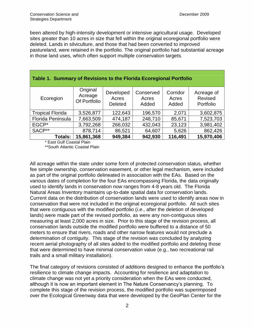
Table 1. Summary of Revisions to the Florida Ecoregional Portfolio
Ecoregion
Original Acreage
Of Portfolio
Developed Acres
Deleted
Conserved Acres Added
Corridor Acres Added
Acreage of Revised Portfolio
Tropical Florida 3,526,877 122,643 196,570 2,071 3,602,875
Florida Peninsula 7,663,509 474,187 248,710 85,671 7,523,703
EGCP* 3,792,268 266,032 432,043 23,123 3,981,402
SACP** 878,714 86,521 64,607 5,626 862,426
Totals: 15,861,368 949,384 942,930 116,491 15,970,406 * East Gulf Coastal Plain **South Atlantic Coastal Plain
All acreage within the state under some form of protected conservation status, whether fee simple ownership, conservation easement, or other legal mechanism, were included as part of the original portfolio delineated in association with the EAs. Based on the various dates of completion for the four EAs encompassing Florida, the data originally used to identify lands in conservation now ranges from 4-8 years old. The Florida Natural Areas Inventory maintains up-to-date spatial data for conservation lands. Current data on the distribution of conservation lands were used to identify areas now in conservation that were not included in the original ecoregional portfolio. All such sites that were contiguous with the modified portfolio (i.e., after the deletion of developed lands) were made part of the revised portfolio, as were any non-contiguous sites measuring at least 2,000 acres in size. Prior to this stage of the revision process, all conservation lands outside the modified portfolio were buffered to a distance of 50 meters to ensure that rivers, roads and other narrow features would not preclude a determination of contiguity. This stage of the revision was concluded by analyzing recent aerial photography of all sites added to the modified portfolio and deleting those that were determined to have minimal conservation value (e.g., two recreational rail trails and a small military installation). The final category of revisions consisted of additions designed to enhance the portfolio’s resilience to climate change impacts. Accounting for resilience and adaptation to climate change was not yet a priority consideration when the EAs were conducted, although it is now an important element in The Nature Conservancy’s planning. To complete this stage of the revision process, the modified portfolio was superimposed over the Ecological Greenway data that were developed by the GeoPlan Center for the
Conservation Science and December 2009 Strategies Department
3
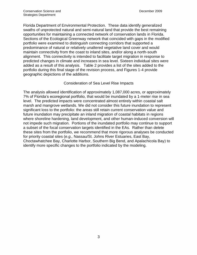
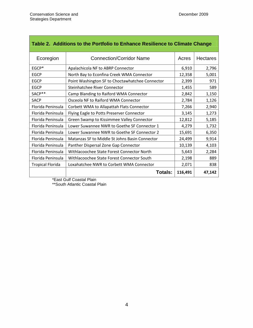
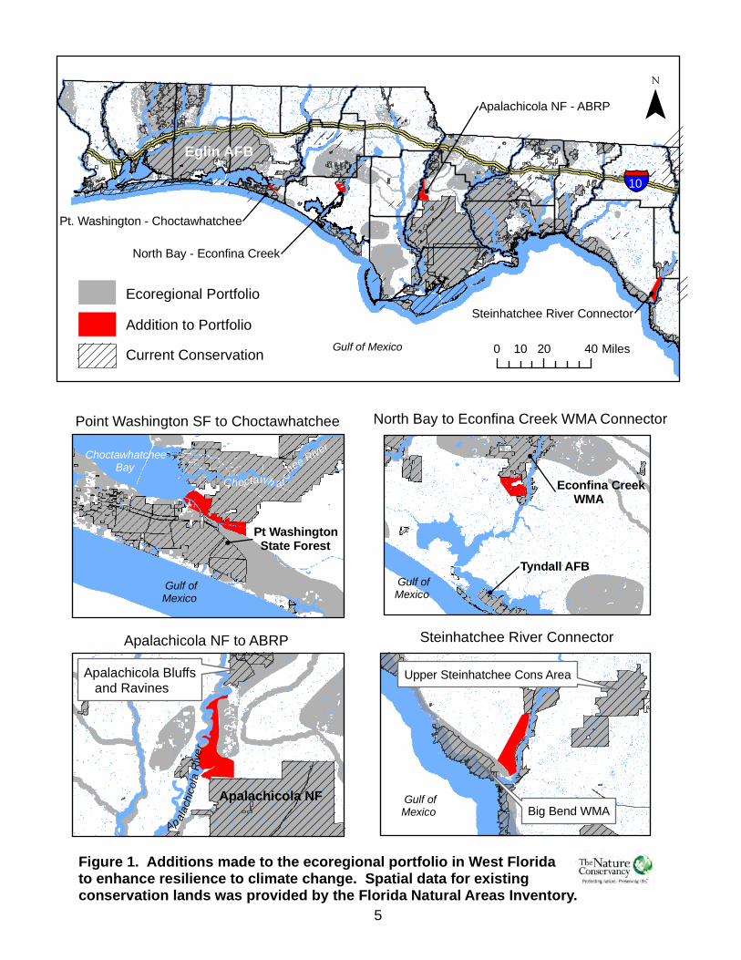
Florida Department of Environmental Protection. These data identify generalized swaths of unprotected natural and semi-natural land that provide the best remaining opportunities for maintaining a connected network of conservation lands in Florida. Sections of the Ecological Greenway network that coincided with gaps in the modified portfolio were examined to distinguish connecting corridors that supported a predominance of natural or relatively unaltered vegetative land cover and would maintain connectivity from the coast to inland sites, and/or along a north-south alignment. This connectivity is intended to facilitate target migration in response to predicted changes in climate and increases in sea level. Sixteen individual sites were added as a result of this analysis. Table 2 provides a list of the sites added to the portfolio during this final stage of the revision process, and Figures 1-4 provide geographic depictions of the additions.
Consideration of Sea Level Rise Impacts
The analysis allowed identification of approximately 1,087,000 acres, or approximately 7% of Florida’s ecoregional portfolio, that would be inundated by a 1-meter rise in sea level. The predicted impacts were concentrated almost entirely within coastal salt marsh and mangrove wetlands. We did not consider this future inundation to represent significant loss to the portfolio: the areas still retain current conservation value and future inundation may precipitate an inland migration of coastal habitats in regions where shoreline hardening, land development, and other human-induced conversion will not impede such migration. Portions of the inundated portfolio may continue to support a subset of the focal conservation targets identified in the EAs. Rather than delete these sites from the portfolio, we recommend that more rigorous analyses be conducted for priority coastal sites (e.g., Nassau/St. Johns River Estuaries, East Bay, Choctawhatchee Bay, Charlotte Harbor, Southern Big Bend, and Apalachicola Bay) to identify more specific changes to the portfolio indicated by the modeling.
Conservation Science and December 2009 Strategies Department
4
Table 2. Additions to the Portfolio to Enhance Resilience to Climate Change
Ecoregion Connection/Corridor Name Acres Hectares
EGCP* Apalachicola NF to ABRP Connector 6,910 2,796
EGCP North Bay to Econfina Creek WMA Connector 12,358 5,001
EGCP Point Washington SF to Choctawhatchee Connector 2,399 971
EGCP Steinhatchee River Connector 1,455 589
SACP** Camp Blanding to Raiford WMA Connector 2,842 1,150
SACP Osceola NF to Raiford WMA Connector 2,784 1,126
Florida Peninsula Corbett WMA to Allapattah Flats Connector 7,266 2,940
Florida Peninsula Flying Eagle to Potts Preserver Connector 3,145 1,273
Florida Peninsula Green Swamp to Kissimmee Valley Connector 12,812 5,185
Florida Peninsula Lower Suwannee NWR to Goethe SF Connector 1 4,279 1,732
Florida Peninsula Lower Suwannee NWR to Goethe SF Connector 2 15,691 6,350
Florida Peninsula Matanzas SF to Middle St Johns Basin Connector 24,499 9,914
Florida Peninsula Panther Dispersal Zone Gap Connector 10,139 4,103
Florida Peninsula Withlacoochee State Forest Connector North 5,643 2,284
Florida Peninsula Withlacoochee State Forest Connector South 2,198 889
Tropical Florida Loxahatchee NWR to Corbett WMA Connector 2,071 838
Totals: 116,491 47,142
*East Gulf Coastal Plain **South Atlantic Coastal Plain
Steinhatchee River Connector
Point Washington SF to Choctawhatchee North Bay to Econfina Creek WMA Connector
Upper Steinhatchee Cons Area
Steinhatchee River Connector
0 20 4010 Miles
Figure 1. Additions made to the ecoregional portfolio in West Floridato enhance resilience to climate change. Spatial data for existingconservation lands was provided by the Florida Natural Areas Inventory.
Addition to PortfolioEcoregional Portfolio
Current Conservation
Tyndall AFB
Gulf of Mexico
Eglin AFB
Gulf ofMexico Big Bend WMA
North Bay - Econfina Creek
Pt. Washington - Choctawhatchee
Apalachicola NF - ABRP
10
Gulf of Mexico
Apalachicola NF
Apalachicola NF to ABRPApalachicola Bluffs and Ravines
Ap alach
icola
River
Econfina Creek WMA
Gulf ofMexico Gulf of
Mexico
Choctawhatchee Bay
Choctawh at chee River
Pt Washington State Forest
5
Matanzas - Middle St. Johns
Osceola NF
CampBlanding
Osceola NF to Camp Blanding Connectors Matanzas SF - Lower St. Johns Connector
Goethe State Forest
Lower Suwannee NWR - Goethe SF Connectors 1&2
0 10 205 Miles
Figure 2. Additions to the ecoregional portfolio in North Florida toenhance resilience to climate change. Spatial data for existingconservation lands was provided by the Florida Natural Areas Inventory.
Addition to PortfolioEcoregional Portfolio
Current Conservation
Matanzas SF
Osceola NF - Raiford WMA
Camp Blanding - Raiford WMA
Atlantic Ocean
Gulf of Mexico Lower Suwannee NWR - Goethe SF, 1 & 2
OcalaNational Forest
Osceola NF 10
9575
Raiford WMA
Jennings SFAtlantic Ocean
Faver Dykes-Pellicer Creek-Flagler Coastal Greenway
Matanzas - Lower St. Johns
2-meter inundation zone
Gulf ofMexico
Lower Suwannee NWR
6
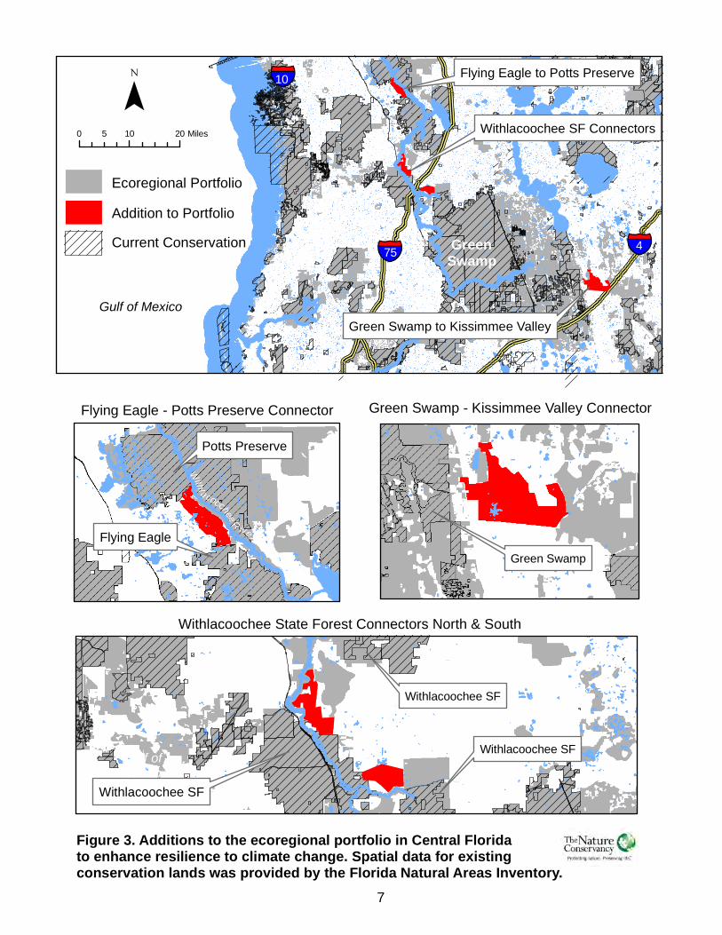
Flying Eagle - Potts Preserve Connector Green Swamp - Kissimmee Valley Connector
Withlacoochee SF
Withlacoochee State Forest Connectors North & South
0 10 205 Miles
Figure 3. Additions to the ecoregional portfolio in Central Floridato enhance resilience to climate change. Spatial data for existingconservation lands was provided by the Florida Natural Areas Inventory.
Addition to PortfolioEcoregional Portfolio
Current Conservation
Withlacoochee SF Connectors
Flying Eagle to Potts Preserve
Gulf of MexicoGreen Swamp to Kissimmee Valley
GreenSwamp
10
Flying Eagle
Potts Preserve
Green Swamp
Withlacoochee SF
Gulf ofMexico
475
Withlacoochee SF
Withl a coochee R iver
7
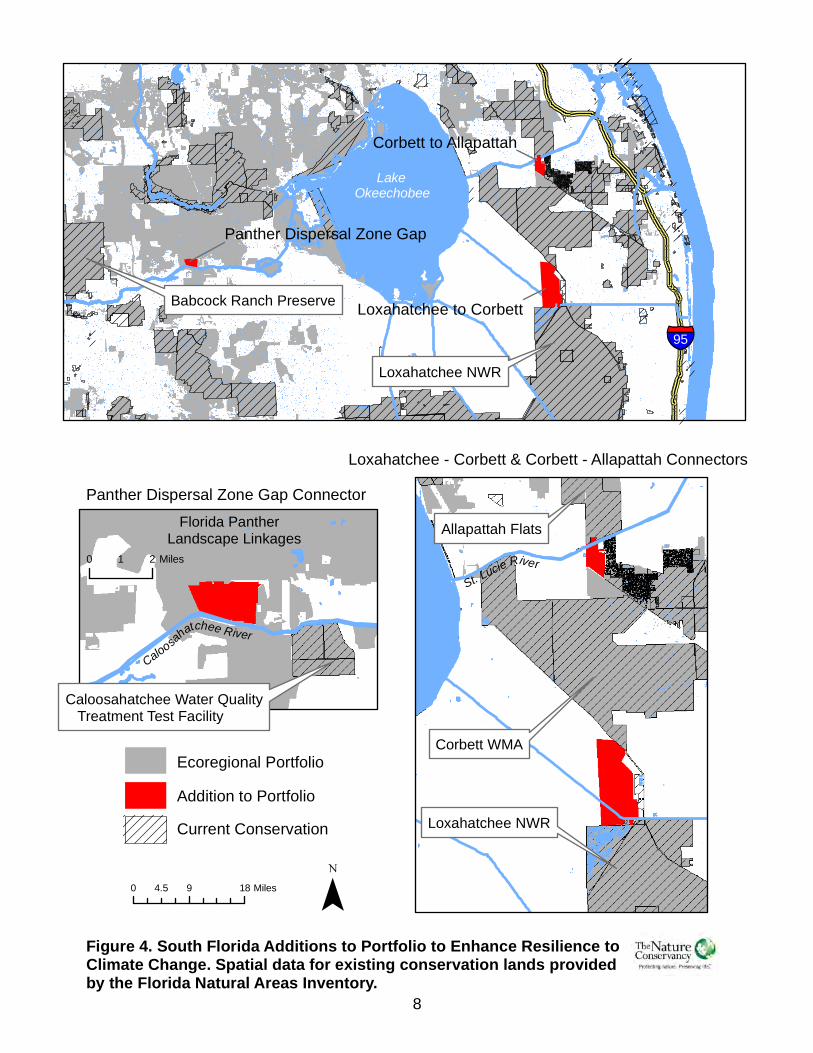
Panther Dispersal Zone Gap ConnectorLoxahatchee - Corbett & Corbett - Allapattah Connectors
0 9 184.5 Miles
Figure 4. South Florida Additions to Portfolio to Enhance Resilience toClimate Change. Spatial data for existing conservation lands providedby the Florida Natural Areas Inventory.
Addition to PortfolioEcoregional Portfolio
Current Conservation
Babcock Ranch Preserve
Loxahatchee NWR
Caloosahatchee Water Quality Treatment Test Facility
Allapattah Flats
95
Loxahatchee NWR
Corbett WMA
LakeOkeechobee
Florida PantherLandscape Linkages
Caloosahatchee River
0 21 MilesSt. Lucie River
8
Loxahatchee to Corbett
Corbett to Allapattah
Panther Dispersal Zone Gap
Conservation Science and December 2009 Strategies Department
9
The Sea Level Affecting Marshes Model (SLAMM)2 has been used to complete an analysis of sea-level rise impacts to coastal habitat distribution on Big Pine Key3, and in a pilot analysis of a portion of the Southern Big Bend coastline4. The SLAMM analyses account for potential inland migration of coastal wetlands and will provide a more accurate prediction of the severity of sea-level rise impacts to ecoregional targets, and will thereby support more informed decision-making about potential additions or deletions to the portfolio to account for those impacts. The two SLAMM analyses mentioned above benefited from the availability of a LiDAR-derived digital elevation model which provided much greater vertical accuracy than the elevation data that were used in previously conducted SLAMM analyses of Florida estuaries. The Florida Chapter will conduct SLAMM analyses of additional priority coastal sites as LiDAR-derived DEMs and funding become available for those locations.
Accounting for the Conservation of Freshwater and Marine Resources Although the ecoregional portfolio includes many sites of significance to the protection of freshwater and marine systems, it was essentially designed to advance the conservation of Florida’s terrestrial systems. This decision was partially based on inadequate data for aquatic targets. To account for potential gaps in the identification of lands important to the conservation of coastal and freshwater targets, the Florida Chapter is preparing separate Conservation Blueprints for these systems. Integration of the Conservation Blueprints with the Ecoregional Portfolio will be considered after they have been completed. The revised portfolio provides an interim update for the four ecoregions within Florida (Figures 5 and 6). This revision does not constitute a full reassessment. It was conducted in recognition of the extensive land use changes experienced in Florida and the need to better incorporate impacts of climate change and sea level rise. An analogous reassessment may be appropriate for the other states within the East Gulf Coastal Plain and South Atlantic Coastal Plain ecoregions.
2 http://www.warrenpinnacle.com/prof/SLAMM/index.html
3 Clough, J.S. 2008, Application of the sea-level rise affecting marshes model (SLAMM 5.0) to National
Key Deer National Wildlife Refuge. Warren Pinnacle Consulting, Inc. Warren, Vermont. 4 Geselbracht L, K Freeman, E Kelly. July 2009. Application of the Sea level Affecting Marshes Model to
Coastal Hernando County, Florida. The Nature Conservancy, Altamonte Springs, Florida.
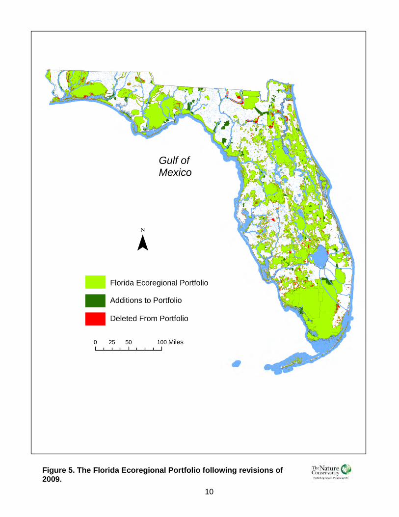
0 50 10025 Miles
Figure 5. The Florida Ecoregional Portfolio following revisions of2009.
Gulf ofMexico
10
Florida Ecoregional PortfolioAdditions to PortfolioDeleted From Portfolio
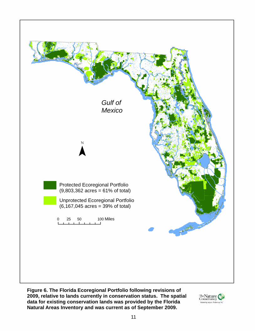
Figure 6. The Florida Ecoregional Portfolio following revisions of2009, relative to lands currently in conservation status. The spatialdata for existing conservation lands was provided by the FloridaNatural Areas Inventory and was current as of September 2009.
Gulf ofMexico
11
0 50 10025 Miles
Unprotected Ecoregional Portfolio(6,167,045 acres = 39% of total)
Protected Ecoregional Portfolio(9,803,362 acres = 61% of total)
Conservation Science and Strategies - Conservation Planning
March 2009
1
Appendix 1 The Impact of Development and Projected Sea-Level Rise
on Florida’s Ecoregional Portfolio
The Florida Portfolio is the combined product of individual ecoregional assessments conducted for
the Tropical Florida, Florida Peninsula, East Gulf Coastal Plain and South Atlantic Coastal Plain
ecoregions. We have examined the impact of land development and projected sea-level rise (SLR)
on the ability of the portfolio to effectively conserve the ecoregional conservation targets by
comparing land cover composition of the portfolio when it was initially mapped (1995-1999,
depending on the ecoregion) with more current compositioni, and by identifying portions of the
portfolio that would be inundated by a 1-meter rise in sea-level. Because we had insufficient data to
include impacts of storm surge, erosion, etc. that are associated with SLR, direct inundation is the
only impact addressed.
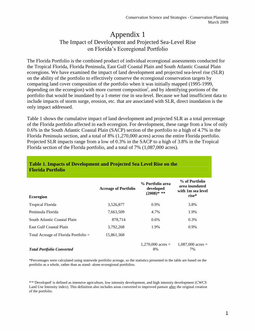
Table 1 shows the cumulative impact of land development and projected SLR as a total percentage
of the Florida portfolio affected in each ecoregion. For development, these range from a low of only
0.6% in the South Atlantic Coastal Plain (SACP) section of the portfolio to a high of 4.7% in the
Florida Peninsula section, and a total of 8% (1,270,000 acres) across the entire Florida portfolio.
Projected SLR impacts range from a low of 0.3% in the SACP to a high of 3.8% in the Tropical
Florida section of the Florida portfolio, and a total of 7% (1,087,000 acres).
Table 1. Impacts of Development and Projected Sea Level Rise on the
Florida Portfolio
Ecoregion
Acreage of Portfolio
% Portfolio area
developed
(2008)*, **
% of Portfolio
area inundated
with 1m sea level
rise*
Tropical Florida 3,526,877 0.9% 3.8%
Peninsula Florida 7,663,509 4.7% 1.9%
South Atlantic Coastal Plain 878,714 0.6% 0.3%
East Gulf Coastal Plain 3,792,268 1.9% 0.9%
Total Acreage of Florida Portfolio = 15,861,368
Total Portfolio Converted
1,270,000 acres =
8%
1,087,000 acres =
7%
*Percentages were calculated using statewide portfolio acreage, so the statistics presented in the table are based on the
portfolio as a whole, rather than as stand- alone ecoregional portfolios.
*'*‘Developed' is defined as intensive agriculture, low intensity development, and high intensity development (CWCS
Land Use Intensity index). This definition also includes areas converted to improved pasture after the original creation
of the portfolio.
Conservation Science and Strategies - Conservation Planning
March 2009
2
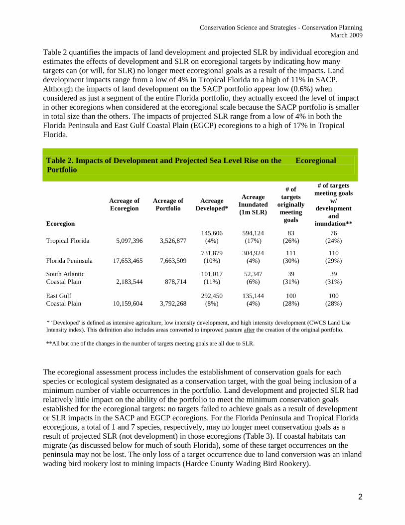
Table 2 quantifies the impacts of land development and projected SLR by individual ecoregion and
estimates the effects of development and SLR on ecoregional targets by indicating how many
targets can (or will, for SLR) no longer meet ecoregional goals as a result of the impacts. Land
development impacts range from a low of 4% in Tropical Florida to a high of 11% in SACP.
Although the impacts of land development on the SACP portfolio appear low (0.6%) when
considered as just a segment of the entire Florida portfolio, they actually exceed the level of impact
in other ecoregions when considered at the ecoregional scale because the SACP portfolio is smaller
in total size than the others. The impacts of projected SLR range from a low of 4% in both the
Florida Peninsula and East Gulf Coastal Plain (EGCP) ecoregions to a high of 17% in Tropical
Florida.
Table 2. Impacts of Development and Projected Sea Level Rise on the Ecoregional
Portfolio
Ecoregion
Acreage of
Ecoregion
Acreage of
Portfolio
Acreage
Developed*
Acreage
Inundated
(1m SLR)
# of
targets
originally
meeting
goals
# of targets
meeting goals
w/
development
and
inundation**
Tropical Florida 5,097,396 3,526,877
145,606
(4%)
594,124
(17%)
83
(26%)
76
(24%)
Florida Peninsula 17,653,465 7,663,509
731,879
(10%)
304,924
(4%)
111
(30%)
110
(29%)
South Atlantic
Coastal Plain 2,183,544 878,714
101,017
(11%)
52,347
(6%)
39
(31%)
39
(31%)
East Gulf
Coastal Plain 10,159,604 3,792,268
292,450
(8%)
135,144
(4%)
100
(28%)
100
(28%)
* ‘Developed' is defined as intensive agriculture, low intensity development, and high intensity development (CWCS Land Use
Intensity index). This definition also includes areas converted to improved pasture after the creation of the original portfolio.
**All but one of the changes in the number of targets meeting goals are all due to SLR.
The ecoregional assessment process includes the establishment of conservation goals for each
species or ecological system designated as a conservation target, with the goal being inclusion of a
minimum number of viable occurrences in the portfolio. Land development and projected SLR had
relatively little impact on the ability of the portfolio to meet the minimum conservation goals
established for the ecoregional targets: no targets failed to achieve goals as a result of development
or SLR impacts in the SACP and EGCP ecoregions. For the Florida Peninsula and Tropical Florida
ecoregions, a total of 1 and 7 species, respectively, may no longer meet conservation goals as a
result of projected SLR (not development) in those ecoregions (Table 3). If coastal habitats can
migrate (as discussed below for much of south Florida), some of these target occurrences on the
peninsula may not be lost. The only loss of a target occurrence due to land conversion was an inland
wading bird rookery lost to mining impacts (Hardee County Wading Bird Rookery).
Conservation Science and Strategies - Conservation Planning
March 2009
3
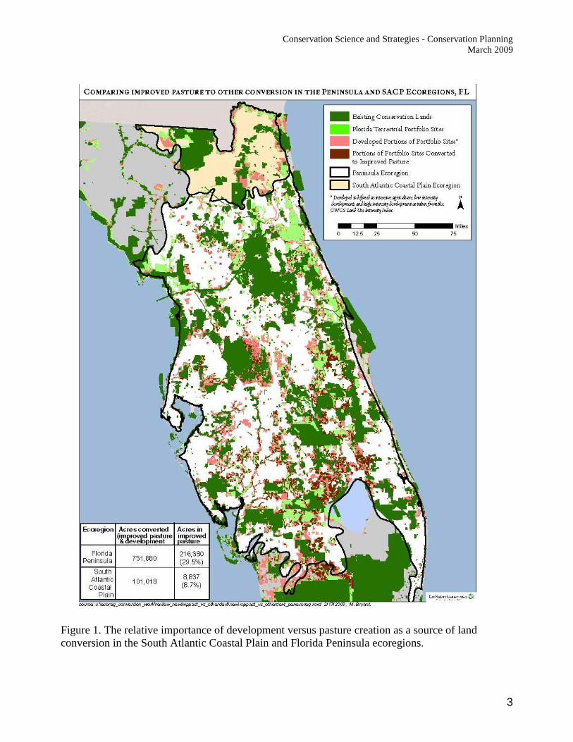
Figure 1. The relative importance of development versus pasture creation as a source of land
conversion in the South Atlantic Coastal Plain and Florida Peninsula ecoregions.
Conservation Science and Strategies - Conservation Planning
March 2009
4
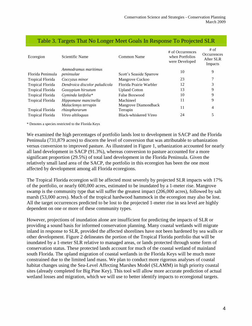
Table 3. Targets That No Longer Meet Goals In Response To Projected SLR
Ecoregion Scientific Name Common Name
# of Occurrences
when Portfolios
were Developed
# of
Occurrences
After SLR
Impacts
Florida Peninsula
Ammodramus maritimus
peninsulae Scott’s Seaside Sparrow 10 9
Tropical Florida Coccyzus minor Mangrove Cuckoo 23 7
Tropical Florida Dendroica discolor paludicola Florida Prairie Warbler 12 3
Tropical Florida Gossypium hirsutum Upland Cotton 13 9
Tropical Florida Gyminda latifolia* False Boxwood 10 9
Tropical Florida Hippomane mancinella Machineel 11 9
Tropical Florida
Malaclemys terrapin
rhizophorarum
Mangrove Diamondback
Terrapin 11 4
Tropical Florida Vireo altiloquus Black-whiskered Vireo 24 5
* Denotes a species restricted to the Florida Keys
We examined the high percentages of portfolio lands lost to development in SACP and the Florida
Peninsula (731,879 acres) to discern the level of conversion that was attributable to urbanization
versus conversion to improved pasture. As illustrated in Figure 1, urbanization accounted for nearly
all land development in SACP (91.3%), whereas conversion to pasture accounted for a more
significant proportion (29.5%) of total land development in the Florida Peninsula. Given the
relatively small land area of the SACP, the portfolio in this ecoregion has been the one most
affected by development among all Florida ecoregions.
The Tropical Florida ecoregion will be affected most severely by projected SLR impacts with 17%
of the portfolio, or nearly 600,000 acres, estimated to be inundated by a 1-meter rise. Mangrove
swamp is the community type that will suffer the greatest impact (206,000 acres), followed by salt
marsh (53,000 acres). Much of the tropical hardwood hammock in the ecoregion may also be lost.
All the target occurrences predicted to be lost to the projected 1-meter rise in sea level are highly
dependent on one or more of these community types.
However, projections of inundation alone are insufficient for predicting the impacts of SLR or
providing a sound basis for informed conservation planning. Many coastal wetlands will migrate
inland in response to SLR, provided the affected shorelines have not been hardened by sea walls or
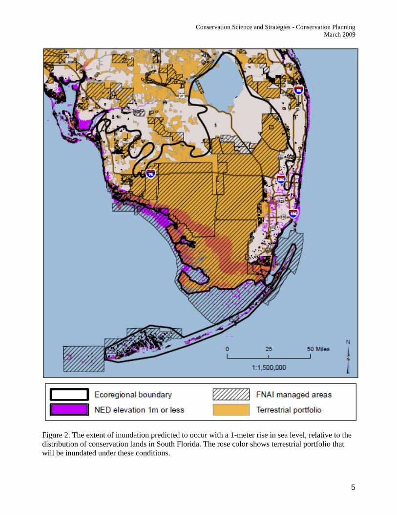
other development. Figure 2 delineates the portion of the Tropical Florida portfolio that will be
inundated by a 1-meter SLR relative to managed areas, or lands protected through some form of
conservation status. These protected lands account for much of the coastal wetland of mainland
south Florida. The upland migration of coastal wetlands in the Florida Keys will be much more
constrained due to the limited land mass. We plan to conduct more rigorous analyses of coastal
habitat changes using the Sea-Level Affecting Marshes Model (SLAMM) in high priority coastal
sites (already completed for Big Pine Key). This tool will allow more accurate prediction of actual
wetland losses and migration, which we will use to better identify impacts to ecoregional targets.
Conservation Science and Strategies - Conservation Planning
March 2009
5
Figure 2. The extent of inundation predicted to occur with a 1-meter rise in sea level, relative to the
distribution of conservation lands in South Florida. The rose color shows terrestrial portfolio that
will be inundated under these conditions.
Conservation Science and Strategies - Conservation Planning
March 2009
6
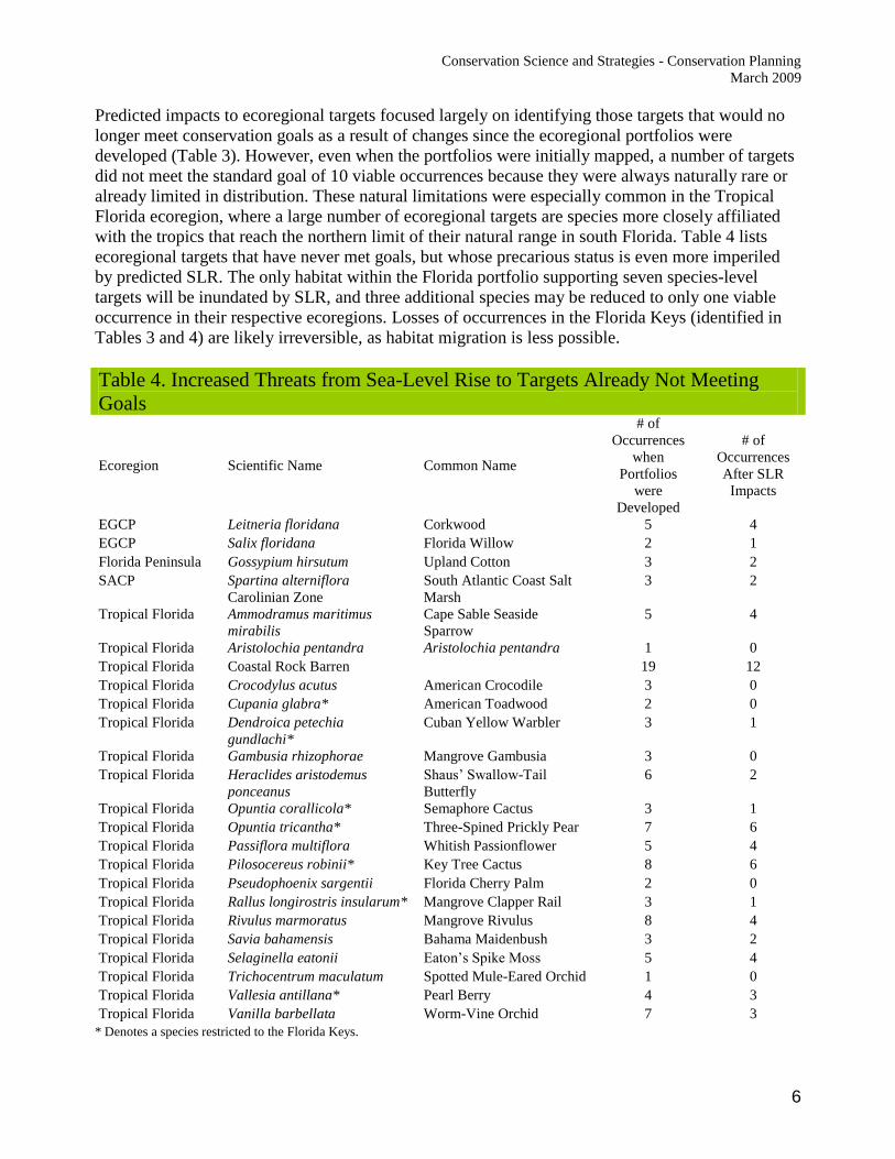
Predicted impacts to ecoregional targets focused largely on identifying those targets that would no
longer meet conservation goals as a result of changes since the ecoregional portfolios were
developed (Table 3). However, even when the portfolios were initially mapped, a number of targets
did not meet the standard goal of 10 viable occurrences because they were always naturally rare or
already limited in distribution. These natural limitations were especially common in the Tropical
Florida ecoregion, where a large number of ecoregional targets are species more closely affiliated
with the tropics that reach the northern limit of their natural range in south Florida. Table 4 lists
ecoregional targets that have never met goals, but whose precarious status is even more imperiled
by predicted SLR. The only habitat within the Florida portfolio supporting seven species-level
targets will be inundated by SLR, and three additional species may be reduced to only one viable
occurrence in their respective ecoregions. Losses of occurrences in the Florida Keys (identified in
Tables 3 and 4) are likely irreversible, as habitat migration is less possible.
Table 4. Increased Threats from Sea-Level Rise to Targets Already Not Meeting
Goals
Ecoregion Scientific Name Common Name
# of
Occurrences
when
Portfolios
were
Developed
# of
Occurrences
After SLR
Impacts
EGCP Leitneria floridana Corkwood 5 4
EGCP Salix floridana Florida Willow 2 1
Florida Peninsula Gossypium hirsutum Upland Cotton 3 2
SACP Spartina alterniflora
Carolinian Zone
South Atlantic Coast Salt
Marsh
3 2
Tropical Florida Ammodramus maritimus
mirabilis
Cape Sable Seaside
Sparrow
5 4
Tropical Florida Aristolochia pentandra Aristolochia pentandra 1 0
Tropical Florida Coastal Rock Barren 19 12
Tropical Florida Crocodylus acutus American Crocodile 3 0
Tropical Florida Cupania glabra* American Toadwood 2 0
Tropical Florida Dendroica petechia
gundlachi*
Cuban Yellow Warbler 3 1
Tropical Florida Gambusia rhizophorae Mangrove Gambusia 3 0
Tropical Florida Heraclides aristodemus
ponceanus
Shaus’ Swallow-Tail
Butterfly
6 2
Tropical Florida Opuntia corallicola* Semaphore Cactus 3 1
Tropical Florida Opuntia tricantha* Three-Spined Prickly Pear 7 6
Tropical Florida Passiflora multiflora Whitish Passionflower 5 4
Tropical Florida Pilosocereus robinii* Key Tree Cactus 8 6
Tropical Florida Pseudophoenix sargentii Florida Cherry Palm 2 0
Tropical Florida Rallus longirostris insularum* Mangrove Clapper Rail 3 1
Tropical Florida Rivulus marmoratus Mangrove Rivulus 8 4
Tropical Florida Savia bahamensis Bahama Maidenbush 3 2
Tropical Florida Selaginella eatonii Eaton’s Spike Moss 5 4
Tropical Florida Trichocentrum maculatum Spotted Mule-Eared Orchid 1 0
Tropical Florida Vallesia antillana* Pearl Berry 4 3
Tropical Florida Vanilla barbellata Worm-Vine Orchid 7 3
* Denotes a species restricted to the Florida Keys.
Conservation Science and Strategies - Conservation Planning
March 2009
7
Recommendations
1) Although portfolio has been lost to development in all ecoregions, the overall loss is less than
10% and has had negligible impact on our ability to meet goals for ecoregional targets. As a
result, we do not recommend revision of the ecoregional assessments to address development
impacts. However, the relatively high development that has increased fragmentation in the SACP
Ecoregion suggests that we prioritize protection within that ecoregion and watch for continued
loss that might suggest the need for review of the portfolio across the OUs involved.
2) The impacts of a projected 1-meter rise in sea level are concentrated primarily on a small subset
of coastal habitats (mangroves and salt marsh). The species-level targets dependent on these
systems may suffer severe impacts and possible extirpation. Fortunately, the largest expanse of
coastal wetlands in the Tropical Florida ecoregion occurs in the Everglades area, where
contiguity of the coastal wetlands with protected conservation lands may be especially conducive
to accommodating wetland migration. The same may be true of other sections of priority
coastline (e.g., the Big Bend), where publicly protected conservation lands adjoin the shoreline.
As a result, we do not recommend revision of the ecoregional assessments based on these data.
However, the small land mass and insular nature of the Florida Keys will limit the ability of
additional protected conservation lands to abate the impacts of SLR in that landscape.
We will undertake a more rigorous analysis in priority coastal sites (e.g., Nassau/St. Johns River
Estuaries, East Bay, Choctawhatchee Bay, Charlotte Harbor, Southern Big Bend, and
Apalachicola Bay; Big Pine Key analysis already completed) that allows for potential inland
migration of coastal wetlands in response to SLR to more accurately predict the severity of
impacts to ecoregional targets and to support informed decisions about making additions or
deletions to the portfolio.
3) We recommend up-dating the ecoregional portfolios to:
a. remove areas that have been subjected to the most intensive forms of land conversion since
the original assessments were produced, while retaining new pasture areas in the portfolio
since they still provide habitat value for some targets and could be identified for protection
and restoration;
b. incorporate the Active Rivers Area assessments to refine the boundaries of portfolio sites
around the Choctawhatchee, Nassau and St. Mary’s Rivers and Pensacola Bay; and
c. incorporate managed areas and TNC preserves acquired since the portfolio was assembled
that are not currently part of the portfolio, provided they are contiguous with current
portfolio or meet a minimum size threshold.
4) Florida’s ecoregional portfolios were assembled prior to the consideration of climate change
strategies. Beyond the analysis of SLR impacts associated with climate change, the Chapter
could consider possible additions to the portfolio that improve coastal–inland and north-south
connectivity for potential migration of targets in response to changes. Portions of the Florida
Greenways layer may provide basis for these additions.
i Land developed or converted to pasture was determined using Tom Hoctor’s Land Use Intensity Index, developed for TNC under our FWCC contract on the Comprehensive Wildlife Conservation Strategy (2005). As he reported, the data were "from WMDs where 2004 data is available (SJRWMD, SWFWMD, and part of SFWMD) and then a hybrid between either 1995 or 2000 land use, the 2003 FWC landcover data, and the 2004 FNAI development layer wherever 2004 land use data was not available."