Embed Size (px)
Citation preview

Technical Report HCSU-013
ASSESSMENT OF FUELS, POTENTIAL FIRE BEHAVIOR, AND MANAGEMENT OPTIONS IN SUBALPINE VEGETATION
ON MAUNA KEA VOLCANO, HAWAI`I
Jarrod M. Thaxton1
James D. Jacobi2
1Hawai`i Cooperative Studies Unit, University of Hawai`i at Hilo, Pacifi c Aquaculture and Coastal Resources Center, P.O. Box 44, Hawai`i Volcanoes National Park, HI 96718
2U.S. Geological Survey, Pacifi c Island Ecosystems Research Center,677 Ala Moana Blvd., Suite 615, Honolulu HI 96813
Hawai`i Cooperative Studies UnitUniversity of Hawai`i at Hilo
Pacifi c Aquaculture and Coastal Resources Center (PACRC)200 W. Kawili St.
Hilo, HI 96720(808) 933-0706
November 2009

The views and conclusions contained in this document are those of the authors and should not be interpreted as representing the opinions or policies of the U.S. Government. Mention of trade names or commercial products does not constitute their endorsement by the U.S. Government.

Technical Report HCSU-013
ASSESSMENT OF FUELS, POTENTIAL FIRE BEHAVIOR, AND MANAGEMENT OPTIONS IN SUBALPINE VEGETATION ON MAUNA KEA VOLCANO, HAWAI‘I
Jarrod M. Thaxton1 James D. Jacobi2
1Hawai‘i Cooperative Studies Unit, University of Hawai‘i at Hilo, Pacific Aquaculture and Coastal Resources Center, P.O. Box 44, Hawai‘i National Park, HI 96718
2U.S. Geological Survey, Pacific Island Ecosystems Research Center,
677 Ala Moana Blvd., Honolulu, HI 96813
Hawai‘i Cooperative Studies Unit University of Hawai‘i at Hilo
Pacific Aquaculture and Coastal Resources Center (PACRC) 200 W. Kawili St.
Hilo, Hawai‘i 96720 808-933-0706
NOVEMBER 2009

This product was prepared under Cooperative Agreement CA03WRAG0036
for the Pacific Island Ecosystems Research Center of the U.S. Geological Survey

TABLE OF CONTENTS ABSTRACT ......................................................................................................................... viii
INTRODUCTION ................................................................................................................... 1
Background .................................................................................................................... 1
Research Focus .............................................................................................................. 1
Objectives ...................................................................................................................... 3
METHODS ............................................................................................................................ 3
Study Sites and Fire History ............................................................................................. 3
Field and Analysis Methodology ....................................................................................... 5
RESULTS AND DISCUSSION .................................................................................................. 7
Fuel Loads and Groundcover Vegetation Across an Elevation Gradient ............................... 7
Plot Level Canopy Cover Effects on Fuels and Groundcover Vegetation .............................. 8
Fine Fuel Loading Under and Away from Tree Crowns ..................................................... 10
Fuel Moisture Under and Away from Tree Crowns ........................................................... 11
Fuel Types and Fire Behavior Modelling .......................................................................... 12
DISCUSSION AND MANAGEMENT OPTIONS ......................................................................... 13
Options for Fuelbreaks .................................................................................................. 14
Potential for Restoration to Reduce Grass Fuels .............................................................. 18
Other Recommendations ............................................................................................... 19
ACKNOWLEDGEMENTS ....................................................................................................... 20
LITERATURE CITED ........................................................................................................... 21
iii

LIST OF TABLES
Table 1: Fuel loading (kg/m2) for three primary fuel types on west slope of Mauna Kea………….…………………………………………………………………………………………….25 Table 2: Predicted flame lengths and fire intensity for three primary fuel types on west slope of MaunaKea……………………………………………………………………...…………………….25 Table 3: Table 3: Firebreak breach probabilities by community type for 10-40 m wide breaks during fires predicted under average (50th percentile) or extreme (97th percentile) weather conditions.………………………………………………………….…….26
LIST OF FIGURES Figure 1: Location of Forest Bird Survey transects within Palila critical habitat on Mauna Kea………………………………………………………………………………………………….….27 Figure 2: Locations of 0.4 ha plots for initial fuel and vegetation survey within Ka‘ohe Game Management Area, Ka‘ohe Mitigation Parcel and Mauna Kea Forest Reserve within and adjacent to Palila core population area…..…………………………………………….28 Figure 3: Configuration of 0.4 ha fuel sample plot.…………………………………………………………….29 Figure 4: Average fine and woody fuel loads across an elevation gradient from 1,850 m to 2,900 m on the west slope of Mauna Kea…………………….……………….………….30 Figure 5: Cover of native grass, non-native grass and fireweed (Senecio madagascariensis) across an elevation gradient from 1,850 m to 2,900 m on the west slope of Mauna Kea,,,,……31
Figure 6: Tree canopy (>2 m) cover in vegetation/fuel survey plots across an elevation gradient on the west slope of Mauna Kea……………………………………………………………………………….………32 Figure 7: Fine and woody fuel loading within low (<25%) and high (≥25%) canopy cover plots across an elevation gradient from 1,850-2,900 m on the west slope of Mauna Kea……………………………………………………………………………………………………..……………..32 Figure 8: Percent cover of native grass, non-native grass and fireweed (Senecio madagascariensis) within high and low tree canopy cover plots across an elevation gradient on the west slope of Mauna Kea………………………………………………………………………….33 Figure 9: Standing dead grass biomass (mean + SE) for plots located either directly under tree canopy or away from the tree canopy along transects at 1,950, 2,300, and 2,700 m ……………………………………………………………………………………………………….34
iv

Figure 10: Percent cover of grass (both native and non-native) and fireweed (Senecio madagascariensis) with plots either directly under tree canopy or away from tree canopy along transects at 1,950, 2,300 and 2,700 m…………………………………..35 Figure 11: Temporal changes in (a) live fuel moisture for naio, māmane and ‘a‘ali‘i and (b) live and dead fuel moisture for grasses under and away from tree canopy on the west slope of Mauna Kea from April-July 2008……………………………….36 Figure 12: Simple vegetation cover classification of the Mauna Kea study area based on IKONOS imagery………………………………………………………………………………………………37 Figure 13: Average fuel loads (kg/m2) within grassland, mixed māmane-naio and open māmane forest types...…..…………………………………………………………………………………38 Figure 14: Fuel type map and recommended fuelbreak locations on Mauna Kea……………………39
v

vi

ABSTRACT
Fire is a major threat to habitat for the endangered Palila (Loxioides bailleui) within sub-
alpine vegetation on Mauna Kea volcano, Hawai‘i. The presence of large amounts of fine fuel
from grasses, dry climate, and human ignition sources produces a significant risk of wildfire in
this area year-round. The purpose of this report is to provide information on fuels and
potential fire behavior that will contribute to fire management of Palila habitat. Recommended
actions will contribute to the conservation of these native forests and facilitate restoration in
degraded areas.
To assess the effects of grass invasion on fuel conditions and potential fire danger, we
quantified vegetation and fuels across an elevation gradient from grasslands into sub-alpine
forests on the west slope of Mauna Kea. Our results indicated that grass cover was reduced
under tree canopy in plots below ~2,500 m elevation, but at higher elevations grass cover was
higher under trees than in the open. However, tree canopy cover below 2,500 m elevation was
not high enough overall (~25% on average) to result in significant reductions in fine fuels at
the landscape level. Sampling directly under and away from tree crowns at multiple elevations
suggested that below ~2,500 m, the presence of tree canopy cover can reduce grass fuels
significantly. Furthermore, moisture content of live surface fuels was increased under tree
canopy compared with open areas. These results suggest that restoration of forest cover may
have the potential to alter grass fuels in ways that decrease the threat of fire in some sub-
alpine forests. Fire behavior estimates based on fuel data from grasslands, mixed forest and
māmane forest indicated the need for fuelbreaks of at least 20-30 m to limit fire spread in most
areas. In many cases, breaks as wide as 40 m are required to limit fire spread risk under
extreme weather conditions.
Based on our fuels data and fire behavior predictions, recommended actions include: (1)
construction of new or expansion of existing fuelbreaks to immediately reduce fire risk to the
most sensitive areas adjacent to the core Palila population on the southwest slope and the
translocated Palila population on the north slope of Mauna Kea, (2) enhancement of forest
restoration activities to increase fuel moisture and reduce grass fuel loads (3) installation of
water sources (diptanks) in both areas to decrease firefighter response time, and (4) increased
public education and awareness with regard to fire danger on Mauna Kea.
vii

viii
1
INTRODUCTION
Background
Throughout Hawai‘i, human activities and grass invasion have altered the natural
fire regimes. Limited non-human ignition sources (localized lava and infrequent cloud-
to-ground lightning) coupled with a relatively non-fire adapted native flora suggest that
fire was not frequent or widespread enough to be a major evolutionary force in pre-
human Hawai‘i (Mueller-Dombois 1981, Smith and Tunison 1992). However, both
archaeological evidence and writings of early explorers indicate that an increase in fire
frequency began with first human contact (Kirch 1982). During the 20th century,
dramatic increases in fire frequency and size occurred in many areas. These changes
appear to be coincident with changes in human land use and the introduction and
spread of fire-adapted alien grasses.
The invasion of alien grasses into many native forests has initiated a fire/grass
cycle that results in repeated fires and degradation of native forests (D’Antonio and
Vitousek 1992). This cycle has been particularly well-documented in Hawai‘i Volcanoes
National Park, where alien grass invasion in seasonal sub-montane woodlands has
resulted in dramatic increases in area burned and loss of forest cover (Smith and
Tunison 1992). Grasses increase fine fuel loads and alter fuel structure in ways that
increase the likelihood of fire ignition and spread (Fujioka and Fujii 1980, Hughes et al.,
1991). Fire effects and post-fire environmental conditions promote further recruitment
of alien grasses and inhibit recruitment of native woody species (D’Antonio et al., 2000).
These changes in community structure and composition produce fuel and microclimate
conditions that increase the likelihood of subsequent fire (Freifelder et al., 1998) and
can result in the conversion of native forests to alien-dominated grasslands. For these
reasons, developing management strategies that help break the grass/fire cycle is a
major need for restoration and conservation of dryland vegetation in Hawai‘i and
throughout the tropics.
Research Focus
Sub-alpine vegetation in Hawai‘i has experienced grass invasion and increased
fire danger, but relatively little quantitative information exists to guide fire management
2
in these areas. Grazing by introduced ungulates such as feral sheep (Ovies aries), feral
goats (Capra hircus) and Mouflon sheep (Ovis musimons) has suppressed tree
regeneration in the subalpine forests on Mauna Kea on the island of Hawai‘i, and caused
declines in forest cover (Scowcroft 1983, Scowcroft and Sakai 1983). Invasion by non-
native grasses in this habitat further suppresses forest regeneration (Hess et al., 1999).
Finally, the presence of grasses, ample anthropogenic ignition sources, and dry climate
increases the likelihood of fires that kill native plants and may convert forest to alien-
dominated grassland (Smith and Tunison 1992). Remnant sub-alpine forests on Mauna
Kea that are dominated by māmane (Sophora chrysophylla) are of extremely high
conservation value because they contain the only extant populations of the endangered
bird Palila (Loxioides bailleui), as well as many rare plant species. Thus, understanding
the factors that affect fire behavior in sub-alpine vegetation and predicting the potential
for high severity fire are critically important to management and restoration of these
communities and their endangered taxa.
Restoration of woody canopy cover may be a useful approach to reducing fire
risk in sub-alpine forests by altering microclimate and fuel conditions. Previous studies
both in Hawai‘i and elsewhere have indicated that woody canopy cover can alter
important microclimate variables in ways that reduce the likelihood of fire ignition and
spread. For example, wind speed, generally one of the most important variables for
predicting fire spread, is often twice as high in open grasslands as in open-canopy
woodlands in Hawai‘i (Freifelder et al., 1998). Furthermore, grasses provide much of
the fine fuel component in sub-alpine dry forests. Increases in shade may decrease
grass productivity (Knapp and Medina 1999). Finally, several factors suggest that pre-
human natural fires may have been somewhat more common in the sub-alpine region
than at lower elevations in Hawai‘i (Vogl 1969, Mueller-Dombois 1981). These factors
include: pre-human charcoal deposits, historical prevalence of native grasses, persistent
dry conditions, higher incidence of lightning strikes at higher elevations, and resprouting
capacity among some common native species, such as māmane, koa (Acacia koa), ‘a‘ali‘i
(Dodonaea viscose), and ‘iliahi (Santalum ellipticum). While current fire regimes with
frequent anthropogenic fire are a major threat to these communities, some history of
natural fire in sub-alpine communities may imply that restoration of tree canopy cover
as a means to reduce flammability is feasible.

3
Objectives
The primary goals of this study were to assess current fuel conditions and model
potential fire behavior within sub-alpine vegetation in and immediately adjacent to Palila
critical habitat on Mauna Kea. Our specific objectives were the following:
(1) Quantify fuel conditions and groundcover vegetation across a >1,500m
elevation gradient spanning the transition from open grassland to dense
mixed forest to open māmane forest.
(2) Assess the potential for restoration of tree canopy cover to reduce grass fuel
loads and increase fuel moisture within forests on Mauna Kea.
(3) Develop custom fuel models and model potential fire behavior for the primary
fuel types (grassland, dense mixed forest and open māmane forest) found
within and adjacent to the area inhabited by the core Palila population.
(4) Develop a targeted fuelbreak strategy to protect the core Palila population
from fires likely to be ignited downslope.
The results of this research can be used by the Hawai‘i Division of Forestry, in
cooperation with the U.S. Fish and Wildlife Service and other adjacent landowners, to
develop a comprehensive fire management plan for the upper slopes of Mauna Kea.
METHODS
Study Sites and Fire History
This study was conducted on the upper slopes of Mauna Kea volcano on the
island of Hawai‘i. Study areas were within, or immediately adjacent to, federally
designated Palila critical habitat in the Mauna Kea Forest Reserve and the Ka‘ohe and
Pu‘u Mali mitigation parcels (Figure 1). These areas encompass a large elevation
gradient (1,600-3,200 m) and contain a variety of dry and mesic sub-alpine vegetation.
The entire area is dry with annual rainfall of 450-650 mm (Wakida 1997). Price et al.,
(2007) mapped this area as very dry to arid habitat. All land within the study area is
owned by the State of Hawai‘i Department of Land and Natural Resources. The Mauna
Kea forest reserve is managed by the Division of Forestry and Wildlife. The two
mitigation parcels are adjacent to the Mauna Kea Forest Reserve and are under the

4
jurisdiction of a multi-agency Saddle Road realignment mitigation agreement (U.S. Fish
and Wildlife Service 1998, Federal Highways Division 1999).
The upper slopes of Mauna Kea contain a variety of dry and mesic sub-alpine
vegetation types that span a large elevation gradient (1,600-3,200 m). Towards the
lower end of this gradient, formerly forested lands have been largely converted to
grasslands by grazing and ranching activities and fire. These grasslands are
overwhelmingly dominated by non-native pasture grasses and have a recent history of
fire (Wakida 1997). Forested areas are dominated by two native trees, naio (Myoporum
sandwicense) and māmane (Sophora chrysophylla). These forests range from dense
mixed species forests, found primarily at mid-elevations, to extensive open māmane
woodland at higher elevations that remain as the primary habitat for Palila. These forest
types as well have been invaded by many non-native grasses (e.g., Anthoxanthum
odoratum, Dactylis glomerata, Holcus lanatus, Sporobolus africanus) and forbs
(particularly fireweed Senecio madagascariensis, and mullein Verbascum thapsus) but
also contain a significant native grass component (e.g., Agrostis sandwicensis,
Dechampsia nubigena, Eragrostis atropioides).
Historical and current accounts indicate that fires have occurred in all sub-alpine
community types on Mauna Kea. Most fires recorded on Mauna Kea within the last 30
years have been anthropogenic and associated with roads or military training activities.
There are historical records of large fires (>400 ha) burning within pasture lands, but
most fires have been smaller. From 1971 to 1995, 21 fires occurred within the sub-
alpine habitats defined by the Mauna Kea working circle (Wakida 1997). Nineteen of
these were of anthropogenic origin and most burned less than 80 hectares. Seasonal
occurrence of these fires indicated that fires are possible year-round but peak during the
summer (particularly July-August). These patterns are consistent with fire records from
Pohakuloa Training Area where most fires are small and tend to be ignited in the
summer (Beavers and Burgan 2002). In particular, access points along Saddle Road
west of Pohakuloa Training Area have been a primary area for fire ignition (Wakida
1997). Fires have also occurred either within or adjacent to both the Pu‘u Mali and
Ka‘ohe mitigation parcels. A lightning fire ignited immediately outside and subsequently
burned into the Pu‘u Mali parcel in August 2006. In February 2007, an arson fire was
ignited along Saddle Road near the Kilohana Hunter Check station and burned land

5
adjacent to the Ka‘ohe mitigation parcel. These recent fires indicate the continued need
for prevention and pre-suppression actions to reduce fire danger to Palila critical habitat.
Field and Analysis Methodology
Fuel loads and vegetation across an elevation gradient:
We sampled vegetation and fuels on Mauna Kea between May and September
2007. Sampling occurred along previously established vegetation transects (Banko et
al., 2004) that span the entire elevation range of Palila critical habitat from lower slope
pastures to near treeline (Figure 1). Thirty-three transects are arrayed around the
entire mountain with vegetation survey stations located every 150 m for a total of >500
total stations. We focused our sampling on stations located within ~15 transects on the
north and west slopes adjacent to the Pu‘u Mali and Ka‘ohe mitigation parcels.
We randomly selected 42 of the previously established stations for fuel sampling
along transects (Figure 2). At each selected station, we established a 0.04 ha (11.3 m
diameter) circular plot. Plots were located a random distance away from the previously
established vegetation station (~10-30 m) in a randomly chosen direction perpendicular
to the transect (Figure 3). In each plot, all woody stems >1 cm diameter were
identified to species and counted. An estimate of crown area was obtained for each tree
or shrub >2 m height. Within each plot, we established 2 radial transects that
emanated from the plot center to the edge on randomly selected azimuths. We used a
point-intercept method, to quantify plant community composition and cover at 10 points
along each radial transect. For each point, we recorded the species of plants that
intercepted the pole at specific height strata (0-30 cm, 30cm – 1 m and >1m).
To measure fuel biomass, we harvested all vegetation living and dead within 2
randomly located quadrats (0.25 m2 each) along each azimuth transect (Figure 3). Also,
fuel bed height and duff thickness were measured at one corner of each fuel load
quadrat. All fuel collected was taken to the lab and immediately weighed before oven
dried at 75ºC for 3 days. Finally, fuels were sorted into categories (live herbaceous, live
woody, dead herbaceous, 1-hr dead wood, 10-hr dead wood, and 100-hr dead wood)
and weighed again. Data analyses were conducted using ANOVA, ANCOVA, and
multiple regression to assess the independent and interactive effects of tree cover,
community type, and elevation relative to collected fuel data.

6
Fuel loads under and away from tree crowns
In July 2007, we established several additional transects for the purpose of sampling
fuels under and away from trees. A total of three 400 m-long transects were
established, one at each of the following elevations: 1,950, 2,300, and 2,700 m within
the same area of Mauna Kea used for the larger survey of fuel loads and vegetation.
Each transect was oriented parallel to the elevation contour and no transect varied more
than 40 m in elevation change from beginning to end. Every 20 m along each transect
we randomly located the nearest tree > 2 cm dbh and > 2m height for fuel sampling.
At each of these trees, we sampled fuels in a random location under the tree crown and
at a random location 2 m away from the edge of the tree crown. This sampling regime
resulted in a total of 40 fuel samples per transect (20 each under and away from trees).
Fuel samples were collected as described above for Objective #1. We harvested all
vegetation living and dead within quadrats (0.25 m2 each). Fuels were returned to the
lab and immediately weighed before oven dried at 75ºC for 3 days. Finally, fuels were
sorted into categories (live herbaceous, live woody, dead herbaceous, 1-hr dead wood,
10-hr dead wood, and 100-hr dead wood) and weighed again. At each fuel sample
location, an estimate of cover by grass, fireweed, or litter was taken.
Temporal changes in fuel moisture under and away from tree crowns
We monitored live and dead fuel moisture from May to September 2007 with bi-
weekly grab samples. On each sampling date, we collected 3 samples of live foliage
(<30 g) from the 2 most common trees (māmane and naio) and a common shrub
(‘a‘ali‘i) at a site located at 2,000 m elevation. At the same site, we also collected both
live and dead grass samples (3 each) from directly under tree canopy and in canopy
gaps away from trees. All fuel moisture samples were collected at 1:00 pm, and placed
in airtight containers. Immediately upon return to the lab, samples were separated into
leaves and twigs (for live woody samples) or live and dead components (for grass
samples) and weighed. Samples were then oven-dried for 3 days at 75ºC and weighed
again. All live plant moisture sampling took place on the west side of Mauna Kea in the
Ka‘ohe mitigation parcel because of ease of access.

7
Custom fuel models and potential fire behavior
We developed fuel models for the three main community types encountered in the
study area (grassland, mixed dense forest, and open māmane forest). Data on fuel
loading of fine and woody fuels were obtained from our overall fuel survey sampling.
These fuel models were then used to parameterize the BehavePlus fire modeling system
(Andrews et al., 2005). BehavePlus is based on a form of the Rothermel (1972) fire
model and is widely used as a fire management and planning tool (Perry 1998). We
obtained weather data from a nearby long-term weather station at Pohakuloa Training
Area (PTA West NFDRS Station 499907) and predicted potential fire behavior for both
50th and 97th percentile weather. These conditions corresponded to windspeed of 11
mph and 1-hr fuel moisture of 9% for 50th percentile conditions and 18 mph windspeed
and 6% 1-hr fuel moisture for 97th conditions. We then used predictions of flame length
and fire intensity at these weather conditions to justify the width and location of
fuelbreaks to protect the core Palila population from fire. Recommended widths for
fuelbreaks were based on Byram (1959) and Wilson (1988).
RESULTS AND DISCUSSION
Fuel Loads and Groundcover Vegetation Across an Elevation Gradient
We measured fuels across an elevation gradient (1,850 m – 2,900 m) that
spanned multiple vegetation types including grasslands with scattered trees (hereafter
grassland), dense māmane-naio forest (hereafter mixed forest) and open māmane
forest (hereafter māmane forest). Average overall fuel loads (1.03 + 0.14 kg/m2,) were
sufficient to carry fire across the gradient, but both fine and woody fuels changed with
elevation (Figure 4). Elevation strata were delineated by dividing the gradient equally
into three groups (1,850-2,220 m, 2,201-2,550 m and 2,551-2,900 m). Fine fuel loads
(those most likely to influence ignition and spread) were highest at the lowest elevation
stratum (1.38 + 0.29 kg/m2) and averaged nearly twice that of higher elevation strata
(0.77 + 0.11, 0.12 + .05 respectively). These differences were marginally significant
(F=2.52,39; P=0.09). In contrast, woody fuels peaked at the mid-elevation strata and
were an order of magnitude greater than that of either lower or higher elevations. This
difference was highly significant (F=9.32,39; P<0.001).

8
Differences in groundcover vegetation across the elevation gradient reflected
differences in fine fuels; non-native grasses were associated with areas of high fuel
loads (Figure 5). Vegetation cover at ground level was dominated by non-native grasses
and the invasive non-native fireweed (Senecio madagascariensis). Non-native grasses
were particularly dominant in the lowest elevation strata. Non-native grass cover
averaged 70% below 2,200 m, 40% in mid-elevation strata and 50% above 2,550 m.
These differences were significant (F=3.22,39; P=0.05). In contrast, native grass cover
was uniformly very low, with an average of 5.4-7.5%, across elevation strata and
differences were not significant. The other primary component of the groundcover in
our plots was fireweed. Fireweed abundance was highest at mid-elevations (~30%)
and lowest above 2,550 m (~17%) but these differences were not significant.
Fine fuel loads are consistently high enough to pose a significant risk of fire
across the entire slope of Mauna Kea within and adjacent to the core Palila population.
Fuel loads were comparable to grassland and savanna ecosystems that experience
frequent fire (Stronach and McNaughton 1989, Thaxton and Platt 2006). Our elevation
strata generally coincide with a transition from dominance by grassland and grassland
with scattered trees (1,850-2,200 m) to dominance by mixed māmane-naio forest
(2,201-2,550 m) and finally to an open māmane woodland at the highest elevation.
Fuel loadings for each of these community types are discussed further later in this
report. Our results also indicate the contribution of non-native grasses to fuel loads
particularly at lower elevations, as well as the potential importance of fireweed as a fuel
source up to ~2,500 m elevation. Fuel loads across this elevation gradient on Mauna
Kea were comparable to fuel load values reported for other dryland vegetation types in
Hawai‘i (Wright et al. 2002).
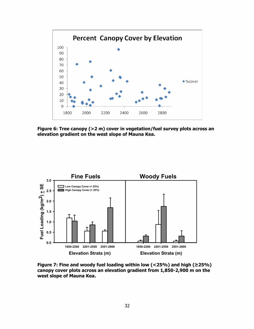
Plot Level Canopy Cover Effects on Fuels and Groundcover Vegetation
Differences in tree canopy cover contributed to some differences in fuels and
groundcover vegetation across the elevation gradient. Tree canopy cover was <25% in
most plots (Figure 6). Although canopy cover was not significantly correlated to
elevation, plots with the highest canopy cover tended to occur below 2,400 m,
particularly in areas of dense mixed forest located from 2000 to 2,400 m elevation.
Likewise, plots at the lowest elevations, below 1,900 m, tended to be in open grassland

9
with only scattered trees resulting very low percent canopy cover. Tree canopy cover
within plots averaged ~25% and was not strongly controlled by elevation (Figure 6). In
most plots, vegetation cover at ground level was >50% while tree canopy cover was
<25%. Tree canopy cover (> 2m height) at the plot level was not strongly controlled by
elevation, however all sampled plots with >50% canopy cover were located below 2,300
m elevation (Figure 6).
Fine fuels differed between plots with high tree canopy cover (>25%) and low
tree canopy cover (<25%), but this effect was primarily evident only in plots above
2,550 m (Figure 7). Among plots with <25% canopy cover, fine fuel loads were
significantly greater below 2,200 m than at higher elevations (F=4.552,39; P=0.02). At
elevations >2,550 m, plots with high canopy cover contained fine fuel loads
approximately three times that of plots with low canopy cover (F=4.622,39; P=0.02).
This increase appeared to be due to native grasses being clustered under tree canopies.
Woody fuel loads at the middle elevation stratum (2,201-2,550 m) were approximately
four times that of either the lowest or highest elevation strata. Furthermore the
difference between woody fuel loads in high and low canopy cover plots was greatest at
the lowest elevation stratum (1,850 -2,200 m).
Across all elevations, tree canopy cover >25% resulted in decreased non-native
grass cover (Figure 8). This difference was most pronounced above 2,550 m (F=5.5,39;
P=0.006), where native grasses were associated with tree canopy cover. Fireweed
cover averaged 25% and ranged from 10-40% across all elevational strata. At the
middle elevation stratum (2,200-2,550 m), fireweed cover was more than twice as high
in plots with high tree canopy cover as in plots with low tree canopy cover. This
difference was significant (F=4.52,39; P=0.02). Overall native grass cover tended to be
low (<10%) and was significantly controlled by canopy cover only at the highest
elevation strata (>2,550 m). At the highest elevation stratum, native grass cover
averaged 23% in plots with high tree canopy cover and only 6% in plots with low
canopy cover resulting in a significant difference (F=4.12,39 P=0.03).
Our results indicated a complex relationship between tree canopy cover, grass
cover and fuel loading. We hypothesized that plots with high canopy cover would have
lower grass cover and lower fine fuel loads compared to plots with low tree canopy
cover. Higher tree canopy cover was correlated with lower non-native grass cover, but

10
this did not translate into a decrease in fine fuels at the plot level. In fact, the only
significant effect of canopy cover on fine fuels that we detected was a significant
increase in fine fuels with high canopy cover at elevations >2,500 m. This increase may
indicate the role that trees play in intercepting fog drip and creating moist microsites
that are favorable for particularly native grasses (Juvik and Nullett 1995). Other factors
that may decouple the observed patterns of non-native grass cover and fine fuel loading
include the contribution of other species (i.e., native grasses and fireweed) to fuel loads
as well as low overall tree canopy cover. Native grass cover tended to be very low
(averaging <10%) in most plots but it was significantly higher within high canopy cover
plots at high elevation (>2,500 m). Furthermore, fireweed cover was relatively
unaffected by high canopy cover and may have contributed to fuel loads in areas where
non-native grasses were absent. Finally, average tree canopy cover was only ~25%
within our plots. This level of canopy cover may not be high enough to produce
decreases in grass fine fuels detectable at the landscape level.
Fine Fuel Loading Under and Away from Tree Crowns
Loading of standing dead fine fuels differed under and away from tree crowns
but this pattern changed with elevation (Figure 9). Standing dead fuels at both 1,950 m
and 2,700 m averaged more than 3 times those at 2,300 m elevation. The overall effect
of elevation was highly significant (F=14.42,114, P<0.001). However at 1,950 m,
standing dead fuel loads away from trees were twice those under trees (0.43 kg/m2 vs.
0.22 kg/m2), while at 2,700 m the pattern was reversed with standing dead fuel loads
under trees 0.47 kg/m2 and only 0.3 kg/m2 away from trees. These differences were
significant and contributed to a significant elevation by crown location interaction
(F=6.22,114, P=0.003). At 2,300 m elevation, overall standing dead fine fuel loads were
low and although loading away from tree crowns tended to be higher than that under
tree crowns, these differences were not significant.
Differences in grass cover and fireweed cover under and away from tree crowns
accounts for much of the observed variation in standing dead fuels (Figure 10). At
1,900 m elevation, grass cover was more than 3 times higher away from tree crowns
than under trees. In contrast, at 2,700 m elevation, ~50% higher under tree crowns
than away. At 2,300 m, grass cover was not significantly affected by tree canopy.

11
These patterns resulted in a significant elevation by crown interaction (F=7.042,114,
P=0.001). Fireweed also contributed to standing dead fuels and its cover was reduced
by tree canopy (Figure 10). At both 1,900 and 2,300 m elevations, fireweed cover was
significantly higher away from tree canopy. At 2,700 m, overall fireweed cover was low
and there was no significant difference under and away from canopy. This resulted in a
significant elevation by crown interaction (F=4.642,114, P=0.01).
Given the limitations of our initial fuel survey to detect tree canopy effects on
fuel loads, we followed this with a targeted approach of sampling under and away from
tree crowns. Our results indicated that standing dead fuels were significantly reduced
under tree crowns at low elevation (1,950 m) but significantly increased at high
elevation (2,700 m). These patterns were consistent with changes in percent grass
cover. At the mid-elevation transect (2,300 m) there were no significant effects of tree
crowns on standing dead fuels, but the majority of fuels at this elevation came from
fireweed instead of grasses. These results suggest that at least at low elevations (which
are primarily grassland with scattered trees) the presence of tree canopy has the ability
to reduce grass fuels. This is important since these are the fuels that are the most
directly associated with fire ignition and spread. At high elevations, this pattern is
reversed but in these sites, groundcover fuel loads are generally less continuous (higher
percentage of bare ground) and many of the grasses are native. At middle elevation in
dense forest, grass fuels are generally lower, but the invasion of fireweed has
contributed to increased fuel continuity particularly where there is no canopy. All of
these pieces of information point to the potential positive benefits of increasing tree
canopy cover on these sites.
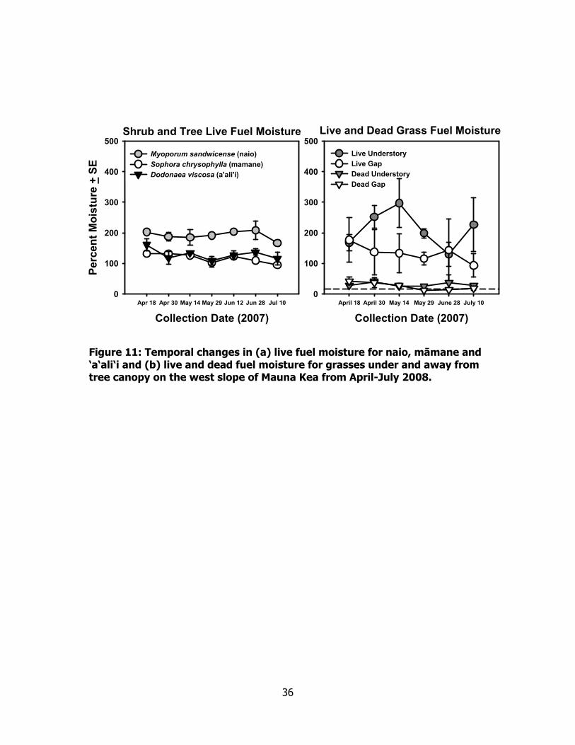
Fuel Moisture Under and Away from Tree Crowns
Live fuel moisture of the 3 woody species differed significantly over time, with
naio fuel moisture tending to be ~30% greater than that of either māmane or ‘a‘ali‘i
(Figure 11). Both differences over time and among species were significant (Time
F=3.36,19 P=0.03; Species F=17.56,39 P<0.001). Live fuel moisture of grasses was highly
variable over time (F=4.16,19 P=0.007), but averaged 60% greater under tree canopy
than in open gaps (F=13.96,39 P=0.001; Figure 11). Dead grass fuel moisture averaged
10-30%, but did not differ significantly between sites under and away from tree canopy.
12
Our results suggest that the presence of tree canopy may increase the moisture
level of live fuels (i.e., grasses) thereby reducing the likelihood of fire ignition and
spread. In particular, naio which has consistently higher live fuel moisture than
māmane, appears to be very good at producing dense shade that may increase fuel
moisture while limiting grass fuel accumulation. Taken together, these two effects
provide strong evidence for the benefits of restoration with naio in areas adjacent to
Palila habitat where naio is already a dominant component of the plant community.
Fuel Types and Fire Behavior Modelling
We collected fuels data for the three primary vegetation types (grassland with
scattered trees, mixed dense māmane-naio forest, and open māmane woodland)
encountered in and adjacent to Palila critical habitat. The location of these types
corresponds generally to the low, middle and high elevation strata presented earlier.
For this analysis, we used satellite imagery (Figure 12) and existing vegetation
classifications to allocate sample plots to each fuel type. The classified IKONOS image
in Figure 12 shows the relative dominance of each of these types within Ka‘ohe
mitigation parcel, Ka‘ohe Game Management Area and Mauna Kea Forest Reserve for
grassland, mixed dense forest and open forest respectively. The grassland type
contained some scattered trees (canopy coverage <10%) and was overwhelmingly
dominated by fine fuels (Table 1, Figure 13). Dead fine fuels in the grassland type were
40-50% higher than in either mixed māmane-naio forest or open māmane woodland.
Large woody fuels made up a larger proportion of the total fuel load in both forest
types, but even with the increased woody component, total fuel loads were highest in
the grassland type.
Using BehavePlus (Andrews et al., 2005), we modeled potential fire behavior for
all 3 community types under both average (50th percentile; 11 mph windspeed and 9 %
1-hr fuel moisture) and reasonable worst case (97th percentile, 18-mph windspeed and
6% 1-hr fuel moisture) weather conditions. Predicted flame lengths under 50th
percentile weather conditions ranged from 2.9 m in mixed forest to 4.2 m in grassland.
Similarly, under 97th percentile weather conditions, predicted flame lengths were as
much as 6.8 m in grassland and ~5 m for both forest types (Table 2). Likewise,
predicted fireline intensity was highest in grassland (5,939 and 17,002 KW/m for 50th

13
percentile and 97th percentile respectively) and lowest in dense māmane-naio forest
(2,723 KW/m and 7,719 KW/m). Based on 97th percentile weather conditions,
fuelbreaks need to be a minimum of 30 m width in grasslands and 20 m width in both
forest types to achieve a breach probability of <10% (Table 3) (Wilson 1988). To
reduce breach probability to <1% would require 35 m width breaks in grasslands and 25
m width in forests. Finally, to achieve <0.1% probability of breach would require 40 m
breaks in grasslands, 30 m in mixed forest and 35 m in māmane forest.
Our results point to the importance of fuel management activities within sub-
alpine vegetation on the west slope of Mauna Kea. All vegetation types in and adjacent
to the core Palila population area are capable of producing dangerous fire conditions
even when ignited under 50th percentile weather conditions. Grassland areas in
particular are particularly susceptible to extreme fire conditions, while upslope forests,
particularly dense māmane-naio, are likely to burn somewhat less intensely. The
presence of this forest type immediately downslope of the core Palila population area
may provide some measure of protection during many fire events. Most fires are likely
to be ignited downslope, so there is ample justification for a targeted fuelbreak strategy
that helps to isolate the māmane forest containing the core Palila population from more
fire prone areas. The presence of the māmane-naio forest between lower slope
grasslands and upper slope māmane forests may enhance the effectiveness of this
fuelbreak strategy.
DISCUSSION AND MANAGEMENT OPTIONS
The presence of significant fuel loading, ample ignition sources and a dry climate
mean that the area occupied by the core Palila population on Mauna Kea is at risk of
fire. In particular grasslands, with scattered trees that border Saddle Road and extend
to the lower reaches of the sub-alpine forest are at particularly high risk for continuing
to experience frequent fires. Conditions in these areas are likely to produce fast-
moving, high-intensity fires that can easily spread into sub-alpine forest upslope.
Although adjacent māmane-naio forests are likely to experience reduced spread rates,
lower flame lengths and less frequent fires, under dry conditions they may also burn
intensely. If fires reach the lower parts of the open māmane forest, the open structure
of this forest type with high grass fuel loading is likely to result in increased fire

14
intensity. Ultimately at the highest elevations, the fire threat is reduced as grass fuels
become more restricted to areas with trees, fuel continuity decreases and the likelihood
of large fires decreases. Regardless, any fires reaching into the māmane-naio forest or
māmane forest type is likely to result in habitat loss for Palila and increased chance of
future fires with subsequent colonization by alien grasses.
To manage fuels and reduce fire risk in these communities, aggressive pre-
suppression measures will be needed. Management options for reducing risk include 1)
establishing new fuelbreaks and maintenance of existing fuelbreaks will reduce the risk
of large fires spreading across the landscape from grassland, into dense māmane-naio
forest and ultimately into open māmane forest. 2) Implementing a long-term strategy
of fuel type conversion that focuses on increasing both naio and māmane tree cover
through restoration. Ths is the only way that sustainable alterations of fuels can be
made in a way that is consistent with habitat management for native species such as
Palila. It would be most effective if these pre-suppression actions occur concurrently
with activities that increase education and awareness among users and visitors to the
area regarding the danger of fire on Mauna Kea. These options are specific to the
following lands owned by the state of Hawai‘i: (1) part of Mauna Kea Forest Reserve
containing the core Palila population on Mauna Kea west slope, (2) Ka‘ohe Game
Management Area downslope from the core Palila population, (3) Ka‘ohe mitigation
parcel, (4) part of Mauna Kea Forest Reserve containing the translocated Palila
population on north slope of Mauna Kea, and (5) Pu‘u Mali mitigation parcel.
Options for Fuelbreaks
A series of targeted fuelbreaks would likely be an effective way to limit fire risk in
Palila habitat on Mauna Kea. Common fuel break construction methods include one or a
combination of the following: mechanical removal (i.e., bulldozing or clipping), herbicide
application, targeted grazing, or prescribed burning. In general methods chosen to
construct fuelbreaks should be based on a number of factors including: construction and
maintenance costs, effectiveness at limiting fire spread and minimizing effects on native
species and the local environment. Unfortunately, few replicated studies have been
carried out that assess efficiency of fuelbreak construction methods on the basis of the
combination of these factors.

15
Based on limited available information, each available fuelbreak construction
method appears to have both positive and negative aspects that must be considered.
Mechanical removal by bulldozing is widely used and has the benefit of immediately
reducing fuels in targeted areas. However, mechanical removal to bare soil may
enhance erosion on steep slopes and has been linked to increased invasion of non-
native species (Merriam et al., 2006). Prescribed burning can reduce fuels but will favor
regrowth of non-native grasses over native species and may initiate a grass/fire cycle
(D’Antonio and Vitousek 1992). Furthermore, burning on the scale required to maintain
fuelbreaks in or near Palila habitat while minimizing the risk of fire escape could be
logistically prohibitive. Although intense grazing can reduce fuel loads locally
(Blackmore and Vitousek 2000), grazing causes substantial damage to native vegetation
(Scowcroft 1983), contributes to loss of forest cover (Blackmore and Vitousek 2000) and
has been shown to be ineffective at reducing fire frequency and severity at landscape
scales (Williams et al., 2006). Finally, large-scale herbicide application is expensive and
likely to be difficult to implement safely in landscapes containing substantial numbers of
endangered native species. However, targeted application of herbicide may be
important for maintenance of breaks that have already been constructed.
We suggest maintaining a series of targeted fuelbreaks on the southwest and
north slopes to protect the core Palila population as well as the translocated population
(Figure 14). The fuelbreaks are located within two fire management units that are
recommended as focal points for pre-suppression activities. The West Slope Fire
Management Unit contains the Ka‘ohe mitigation parcel as well as adjacent portions of
the Ka‘ohe Game Management Area and Mauna Kea Forest Reserve that contain the
core Palila population. The North Slope Fire Management Unit contains the Pu‘u Mali
mitigation parcel and the portion of the Mauna Kea Forest Reserve that contains the
translocated Palila population. The fuelbreaks are prioritized from 1-7 in decreasing
priority and recommended widths are based on limiting the probability of breach to
<0.1% under 97th percentile weather conditions. Road number and type designations
are taken from information provided in Wakida (1997).
The exact method for construction of each fuelbreak should be determined by
site-specific factors such as proximity to roads, distance to core Palila population,
vegetation cover, and topography, but in most cases, we feel that bulldozing may be the

16
most effective method for initial break construction. Follow-up maintenance may be
accomplished with mechanical clipping or targeted herbicide application. In many
locations the fuelbreaks would take advantage of roads already present on the
landscape. In these cases, it may be possible to enhance the present road as a
fuelbreak by either mechanical or chemical treatment of roadside fuels. The fuelbreaks
are expected to not only decrease the probability of fire spread across the landscape
and into sensitive areas, but also increase access for firefighters responding to fire
events. Regardless of the construction method used, the minimum requirement for
each break would be that fuel is reduced to <30 cm height or ~20% continuity.
Recommended fuelbreak widths are based on reducing probability of breach to <0.1%
under 97th percentile weather conditions. Also, in some cases it may be necessary to
expand the breaks in areas where tallgrasses or shrubs with spotting potential are more
common.
The highest priority fuelbreaks (Fuelbreaks 1-4) are all located within the
proposed West Slope Fire Management Unit. Break #1 would be 40m wide and would
run along the recently realigned Saddle Road from near Mauna Kea State Park on the
east to the Ka‘ohe Mitigation Parcel on the west. This break is the highest priority due
to a history of human-caused ignition along Saddle Road and the potential for fires
ignited in this area to spot large distances and spread rapidly upslope. Our
recommended break width is based on reducing firebreak probability to <0.1% in
grassland fuels. In this case, the 40 m break would be adjacent to saddle road, which
will itself act as a firebreak. Also, the new Saddle Road will have features such as a
curb to catch cigarette butts and a fence to limit off-road access (J. Nelson, U.S. Fish
and Wildlife Service, Personal communication). These features combined with an
adjacent break should significantly limit both the likelihood of a fire spotting over Saddle
Road and spreading upslope, and the likelihood of either accidental or deliberate
human-caused ignitions. At least one study indicates that most arson fires are ignited
within 50 m of the road (McLean 2000). Bulldozing is recommended as the most
efficient method for constructing Break #1. However, targeted grazing might also be
effective in this area, but it would require building fences to limit the ability of animals to
enter the forests upslope.

17
Break #2 should be located along the boundary between Ka‘ohe GMA and Mauna
Kea Forest Reserve. This fuelbreak is intended to both minimize the likelihood of a fire
ignited within the Ka‘ohe GMA of spreading into the Mauna Kea Forest Reserve, as well
as to decrease the likelihood of ignition from activities along existing Road 13. This
fuelbreak would be developed as part of the existing road 13 that separates Ka‘ohe GMA
and Mauna Kea Forest Reserve. The minimum recommended width for this fuelbreak is
30-35 m. Given the existing road, this break could be constructed by either mechanically
or chemically removing grass and groundcover fuels in a strip ~10 wide on each side of
the road. We do not advocate removing māmane trees in this area given their
importance to Palila habitat. Trees within the strip needed for the fuelbreak could be
trimmed of all branches below 2 meters to minimize their likelihood of torching during
fire.
Break #3 would run along the northern boundary of the Ka‘ohe Mitigation
Parcel. This break is recommended to be at least 40 m wide to protect from fast-
moving grass fires moving from pastures downslope. Similar to Break #1, bulldozing is
likely to be the most effective method of creating this fuelbreak, but if erosion appears
to be a problem, other approaches such as targeted grazing or aerial spraying could be
considered.
Break #4 would widen Skyline Drive (Road 1) to 30 m width and protect the
western edge of the core Palila population. This break could be constructed in the same
manner as Break #2, by either mechanically or chemically removing grass along the
roadside. Over time and as resources permit, this break could be extended northward
continuing to follow Road 1 to protect the entire northwest flank of upper Mauna Kea
from fires ignited in pasturelands downslope.
The second set of proposed fuelbreaks (Breaks 5-7) would be located within a
North Slope Fire Management Unit that includes the Pu‘u Mali mitigation parcel and the
translocated Palila population within the adjacent Mauna Kea Forest Reserve. All breaks
on the north slope of Mauna Kea are of lower priority than those on the west slope
because of a wetter climate and history of fewer fires. Break #5 should be a minimum
of 25 m wide and generally follow the boundary between the Pu‘u Mali mitigation parcel
and the Mauna Kea Forest Reserve. From the southwestern boundary of the mitigation
parcel to near Pu‘u Mali itself, Skyline Road (Road 1) is near the lower boundary of the

18
Mauna Kea Forest Reserve. In this area, Break #5 could be established by physically or
chemically removing grasses from along the roadside. From the east of Pu‘u Mali
towards Pu‘u Kihe, it may be necessary to construct Break #5 along the forest reserve
boundary because the road moves farther upslope. Break #6 would run from Mana
Road directly upslope to the Mauna Kea Forest Reserve boundary. This would protect
the mitigation parcel from fires ignited to the east that could spread rapidly due to the
direction and magnitude of the prevailing tradewinds. Finally, break #7 would run along
Mana Road to protect the Pu‘u Mali parcel from fires ignited along the road. Both Breaks
6 and 7 could be created by bulldozing or also possibly by targeted grazing.
In addition to establishing new fuel breaks, it is important that they are
maintained so they can function effectively if a fire starts in the area. This can be
accomplished by several different means but the end result needs to be a wide zone
that has significantly reduced fuel load that can be used to slow the movement of a fire
across an area and aid with firefighting efforts.
Potential for Restoration to Reduce Grass Fuels
Restoration of woody canopy cover may also be an effective and sustainable way
to reduce flammability of grass fuels. Our results indicated that within vegetation types
found below ~2,500 m, the presence of tree canopy resulted in decreased cover of
grasses and decreased amount of standing dead fuels. Furthermore, the presence of
tree canopy increased the moisture levels of live grass fuels. In these two ways,
increasing forest cover is expected to decrease fire risk in the most flammable
vegetation types on the west slope of Mauna Kea. From the standpoint of reducing fire
risk, restoration activities should be targeted toward the vegetation types (i.e.,
grasslands with scattered trees) that are the most prone to fire and appear to be the
most positively affected by increased woody cover.
Current levels of canopy cover on the west slope of Mauna (average ~25%) are
not sufficient to reduce grass fuels at the landscape level. The process of restoring
canopy cover across the landscape to levels that will reduce grasses will take many
decades. Thus we recommend that restoration for the process of fuels management be
targeted in strips that will enhance pre-existing or proposed fuelbreaks. Naio appears to
be the most likely candidate species for establishing dense high moisture shade as

19
quickly as possible. However, māmane should be used as well since the presence of
māmane will also enhance Palila habitat. Reforestation with native species may be one
of the best approaches to simultaneously accomplishing the goals of reducing fire risk
and reestablishing functioning native plant communities that benefit native plants and
animals.
Other Recommendations
Human activity is the primary ignition source for almost all fires on Mauna Kea.
Human-caused fires may result from discarded cigarettes, unattended campfires, and
even catalytic converters on vehicles. Most fires in recent decades have been directly
attributable to military activity or traffic along Saddle Road (Wakida 1997). Both
education and enforcement are needed to prevent fires on Mauna Kea. Signage and
informational brochures (distributed locally at Mauna Kea State Park and Kilohana
Hunter Check Station) would educate users of the area about the threat of wildfire.
These materials should also provide numbers to call in case a fire or suspicious activity is
spotted. Also, all resource management professionals, researchers and hunters
accessing off-road areas should be well-educated regarding fire issues. During dry
conditions, care should be taken when camping or driving off-road. Driving through tall
grass should be avoided if possible due to the danger of fires ignited by the catalytic
converter on a vehicle. If it is necessary to drive under these conditions, a sweeper
should follow vehicles to watch for sparks. Parking areas maintained free of grass
should be developed at certain hunter access points along the roads from the Kilohana
hunter check station to Pu‘u Laau cabin. Increased enforcement would deter
unauthorized use of areas particularly on the southwest slope and reduce the threat of
fires from either carelessness or arson.
20
ACKNOWLEDGEMENTS
This research was made possible with support from U.S. Department of
Transportation (Cooperative Agreement X68000039), the U.S. Geological Survey Wildlife
- Terrestrial & Endangered Resources Program, and the Hawai‘i Cooperative Studies Unit
at the University of Hawai‘i at Hilo. Many people and agencies helped with the design,
implementation, and review of this research. We would particularly like to thank Roger
Imoto, Miles Nakahara, Jennifer Higashino, Jay Hatayama, and Steve Bergfeld of the
Hawai‘i Division of Forestry and Wildlife, Hawai‘i Island District for helping to formulate
the research objectives, providing additional data, and granting permission to conduct
this research within the Mauna Kea Forest Reserve. Boone Kauffman, Flint Hughes, and
Susan Cordell (U.S. Forest Service, Institute of Pacific Islands Forestry); Francis Fujioka
(U.S. Forest Service, Riverside Forest Fire Laboratory); Dawn Greenlee, Jay Nelson, and
Jeff Zimpfer (U.S. Fish and Wildlife Service, Pacific Islands Field Office); Paul Banko,
Chris Farmer, Stephen Ambagis, and Kevin Brinck (Hawai‘i Cooperative Studies Unit,
Kilauea Field Station); and Tim Tunison and Rhonda Loh (Hawai‘i Volcanoes National
Park) provided advice, encouragement, data, and reviews throughout the project. The
U.S. Forest Service, Institute of Pacific Islands Forestry graciously provided office space
for Jarrod Thaxton during the entire project. Jonathan Carbone and Martha Kawasaki
assisted collecting the field data. Administrative support for this project was provided by
the Hawai‘i Cooperative Studies Unit at the Pacific Aquaculture and Coastal Resources
Center, University of Hawai‘i, and the U.S. Geological Survey’s Pacific Island Ecosystems
Research Center.

21
LITERATURE CITED
Andrews, P. L., C. Bevins, and R. C. Servi. 2005. BehavePlus fire modeling system 3.0.
user’s guide. USDA Forest Service General Technical Report INT-GTR-367:134.
Banko, P. C., C. Farmer, S. Hess, K. Brinck, G. Beauprez, J. Castner, J. Crummer, R.
Danner, B. Hsu, K. Kozar, J. Leialoha, A. Lindo, B. Muffler, C. Murray, D. Nelson,
D. Pollock, M. Schwartzfeld, K. Rapozo, and E. Severson. 2004. Palila restoration
project: summary of results, 1996-2004. Technical Report U.S. Geological
Survey, Pacific Island Ecosystems Research Center, Kilauea Field Station, Hawai‘i
National Park.
Beavers, A. M., and R. E. Burgan. 2002. Analysis of fire history and management
concerns at Pohakuloa Training Area. CEMML TPS 02-02. Center for
Environmental Managment of Military Lands, Colorado State University, Fort
Collins.
Blackmore, M. & Vitousek, P.M. (2000) Cattle grazing, forest loss, and fuel loading in a
dry forest ecosystem at Pu‘u Wa‘aWa‘a Ranch, Hawai‘i. Biotropica 32(4):625-632.
Byram, G.M. 1959. Combustion of forest fuels. In: Davis, K.P., ed. Forest Fire: Control
and Use. New York: McGraw Hill.
D’Antonio, C. M., and P. M. Vitouek. 1992. Biological invasions by exotic grasses, the
grass-fire cycle, and global change. Annual Review of Ecology and Systematics
23:63-87.
D’Antonio, C.M., J.T. Tunison, and R.K. Loh. 2000. Variations in impact of exotic grasses
and fire on native plant communities in Hawai‘i. Journal of Australian Ecology 25:
507-522.
Federal Highways Division. 1999. Record of Decision; Saddle Road (State Route 200),
Mamalahoa Highway (State Route 190) to Milepost 6. County of Hawai‘i, State
of Hawai‘i. . U.S. Department of Transportation, Federal Highway
Administration, Central Federal Lands Highway Division, Lakewood, CO.
Freifelder, R. R., P. M. Vitousek, and C. M. D’Antonio. 1998. Microclimate change and
effect on fire following forest-grass conversion in seasonally dry tropical
woodland. Biotropica 30:286-297.
22
Fujioka, F. M. and D. M. Fujii. 1980. Physical characteristics of selected fire fuels in
Hawai‘i - some refinements on surface area-to-volume calculations. Research
Note PSW-348, U.S. Department of Agriculture, Forest Service, Pacific Southwest
Forest and Range Experiment Staion, Berkeley.
Hughes, R.F., P.M. Vitousek, and T. Tuniwon. 1991. Alien grass invasion and fire in the
seasonal submontane zone in Hawai‘i. Ecology 72:743-746.
Hess, S., P. C. Banko, G. J. Brenner, and J. D. Jacobi. 1999. Factors related to the
recovery of subalpine woodland on Mauna Kea, Hawai‘i. Biotropica 31:212-219.
Juvik, J. O. and D. Nullet. 1995. Relationships between rainfall, cloud-water
interception, and canopy throughfall in a Hawaiian montane forest. In: Lange,
O.L., H. A. Mooney, and H. Remmert, eds. Tropical Montane Cloud Forests.
New York: Springer-Verlag. pp. 165-182.
Kirch, P. V. 1982. The impact of the prehistoric polynesians on the Hawaiian ecosystem.
Pacific Science 34:1-14.
Knapp, A. K., and E. Medina. 1999. Success of C4 photosynthesis in the field: Lessons
from communities dominated by C4 plants. Pages 251-282 in R. F. Sage and R. K.
Monson, editors. C4 plant biology. Academic Press, San Diego.
McLean A. 2000. Wildfire arson in Victoria: analysis of crime patterns to assist
the development of specific prevention and enforcement strategies.
Unpublished, University of Melbourne.
Merriam, K.E., J.E. Keeley and J.L. Beyers. 2006. Fuel breaks affect non-native species
abundance in Californian plant communities. Ecological Applications 16: 515-527.
Mueller-Dombois, D. 1981. Fire in tropical ecosystems. in H. A. Mooney, T. M.
Bonnicksen, N. L. Christiansen, J. E. Lotan, and W. E. Teiners, editors.
Proceedings of the Conference in Fire Regimes and Ecosystem Properties. USDA
Forest Service, Washington, D.C.
Perry, G. L. W. 1998. Current approaches to modeling the spread of wildland fire: a
review. Progress in Physical Geography 22:222-245.
Price, J. P., S. M. Gon, III, J. D. Jacobi, and D. Matsuwaki. 2007. Modeling plant species
ranges in the Hawaiian Islands: Developing a methodology and associated GIS
layers. Technical Report HCSU-008, Hawai‘i Cooperative Studies Unit, University
of Hawai‘i at Hilo.

23
Rothermel, R. C. 1972. A mathematical model for predicting fire spread in wildland fuels.
USDA Forest Service Research Paper INT-115:40.
Scowcroft, P. G. 1983. Tree cover changes in Māmane (Sophora chrysophylla) forests
grazed by sheep and cattle. Pacific Science 37:109-119.
Scowcroft, P. G. and H. Sakai. 1983. Impact of feral herbivores on māmane forests of
Mauna Kea, Hawai‘i: Bark stripping and diamater class structure. Journal of
Range Management 36:495-498.
Smith, C. W., and J. T. Tunison. 1992. Fire and alien plants in Hawai‘i: research and
management implications for native ecosystems. in C. W. Smith and J. T.
Tunison, editors. Alien Plant Invasions in Native Ecosystems of Hawai‘i:
Management and Research. University of Hawai‘i Cooperative National Park
Resources Studies Unit, Honolulu, HI.
Stronach, N.R.H. and S.J. McNaughton. 1989. Grassland fire dynamics in the Serengeti
ecosystem, and a potential method of retrospectively estimating fire frequency.
Journal of Applied Ecology 26: 1025-1033.
Thaxton, J.M. and W.J. Platt. 2006. Small-scale fuel variation alters fire intensity and
shrub abundance in a pine savanna. Ecology 87: 1331-1337.
U.S. Fish and Wildlife Service. 1998. Biological Opinion of the U.S. Fish and Wildlife
Service for the Saddle Road Realignment and Improvement Project. U.S. Fish
and Wildlife Service, Honolulu, HI.
Vogl, R. J. 1969. The role of fire in the evolution of the Hawaiian flora and vegetation.
Pages 5-60 in Annual Tall Timbers Fire Ecology Conference, April 1969.
Wakida, C. 1997. Mauna Kea Ecosystem Wildland Fire Management Plan. Report State
of Hawai‘i Department of Land and Natural Resources, Division of Forestry and
Wildlife, Honolulu, HI.
Williams, R.J, C.-H. Wahren, R.A. Bradstock and W.J. Muller. 2006. Does alpine grazing
reduce blazing? A landscape test of a widely-held hypothesis. Austral Ecology 31:
925-936.
Wilson, A.G. 1988. Width of firebreak that is necessary to stop grass fires: some field
experiments. Canadian Journal of Forest Research 18(6): 682-687.

24
Wright, C.S., R.D. Ottmar, R.E. Vihnanek, and D.R. Wiese. 2002. Stereo photo series for
quantifying natural fuels: grassland, shrubland, woodland, and forest types in
Hawaii. General Technical Report PNW-GTR-545. Portland, OR: U.S. Department
of Agriculture, Forest Service, Pacific Northwest Research Station. 91 p.
25
Table 1: Fuel loading (kg/m2) for three primary fuel types on west slope of Mauna Kea.
Community Type
Fuel Loading (kg/m2) Grassland Mixed Forest Māmane Forest
Live Herbaceous 0.07 (+ 0.01) 0.03 (+ 0.01) 0.02 (+ 0.01)
Live Woody 0.01 (+ 0.01) 0.01 (+ 0.01) 0.01 (+ 0.01)
1 hr 1.19 (+ 0.10) 0.77 (+ 0.12) 0.79 (+ 0.11)
10 hr 0.02 (+ 0.02) 0.25 (+ 0.11) 0.05 (+ 0.01)
100 hr 0 0.07 (+ 0.04) 0.14 (+ 0.11)
Table 2: Predicted flame lengths and fire intensity for three primary fuel types on west slope of Mauna Kea. Fire behavior predictions are based on both average (50th percentile; 11 mph windspeed and 9% fuel moisture) and extreme (97th percentile; 18 mph and 6% fuel moisture) weather conditions. Potential Fire Behavior
Average Weather Conditions* Extreme Weather Conditions+
Flame length
(m)
Fireline Intensity (KW/m)
Flame length (m)
Fireline Intensity (KW/m)
Grassland 4.2 5939 6.8 17002
Mixed Forest 2.9 2723 4.8 7719
Māmane Forest 3.2 3244 5.1 9145
*Average Weather Conditions (50th percentile fire season weather) +Extreme Conditions (97th percentile fire season weather)

26
Table 3: Firebreak breach probabilities by community type for 10-40 m wide breaks during fires predicted under average (50th percentile) or extreme (97th percentile) weather conditions. Probabilities calculated from equations provided in Wilson (1988).
Grassland
Mixed
Forest
Mamane
Forest Grassland
Mixed
Forest
Mamane
Forest
10 m 42.17 18.72 21.62 97.54 58.22 69.76
15 m 9.83 3.33 3.96 85.57 17.25 25.65
20 m 1.60 0.51 0.61 47.00 3.02 4.91
25 m 0.24 0.08 0.09 11.71 0.46 0.77
30 m 0.04 0.01 0.01 1.95 0.07 0.12
35 m 0.01 <0.01 <0.01 0.30 0.01 0.02
40 m <0.01 <0.01 <0.01 0.04 <0.01 <0.01
* 50th percentile wind speed (11 mph) and fuel moisture (9%)# 97th percentile wind speed (18 mph) and fuel moisture (6%)
Average Weather Conditions* Extreme Weather Conditions#Firebreak Breach Probability

27
Figure 1: Location of Forest Bird Survey transects within Palila critical habitat (grey area) on Mauna Kea.
N
Mauna Kea Summit
Ka‘ohe Mitigation Unit
Pu‘u Mali Mitigation Unit

28
Figure 2: Locations of 0.4 ha plots for initial fuel and vegetation survey within Ka‘ohe Game Management Area, Ka‘ohe Mitigation Parcel and Mauna Kea Forest Reserve within and adjacent to Palila core population area.
29
Figure 3: Configuration of 0.4 ha fuel sample plot. Each plot is located a random distance (~10-30 m) from a vegetation survey sampling station. Within each plot, two random azimuth transects are established for sampling of downed or dead woody fuels. All live and dead fuels from ground level to 2 m height are sampled within 4 0.25-m2 quadrats randomly located along the transects.
11.3 m
Random azimuth transect for sampling of CWD
Standing fine fuel sample quadrat

30
Elevation
1850-2200 m 2201-2550 m 2551-2900 m
Fu
el lo
adin
g (
kg/m
2 ) +
SE
0.0
0.5
1.0
1.5
2.0Fine fuelsWoody fuels
Figure 4: Average fine and woody fuel loads across an elevation gradient from 1,850 m to 2,900 m on the west slope of Mauna Kea.

31
Elevation Strata (m)
1850-2200 m 2201-2550 m 2551-2900 m
Per
cen
t C
ove
r +
SE
0
20
40
60
80
100
Native Grass Alien Grass Fireweed
Figure 5: Cover of native grass, non-native grass and fireweed (Senecio madagascariensis) across an elevation gradient from 1,850 m to 2,900 m on the west slope of Mauna Kea.
32
Figure 6: Tree canopy (>2 m) cover in vegetation/fuel survey plots across an elevation gradient on the west slope of Mauna Kea.
Elevation Strata (m)
1850-2200 2201-2550 2551-2900
Elevation Strata (m)
1850-2200 2201-2550 2551-2900
Fu
el L
oad
ing
(kg
/m2 )
+ S
E
0.0
0.5
1.0
1.5
2.0
2.5
3.0
Low Canopy Cover (< 25%) High Canopy Cover (> 25%)
Fine Fuels Woody Fuels
Figure 7: Fine and woody fuel loading within low (<25%) and high (≥25%) canopy cover plots across an elevation gradient from 1,850-2,900 m on the west slope of Mauna Kea.

33
Native Grass
1850-2200 2201-2550 2551-2900
Per
cen
t C
ove
r +
SE
0
20
40
60
80
100
Low Canopy Cover ( < 25% )High Canopy Cover ( >25% )
Alien Grass
1850-2200 2201-2550 2551-2900
Per
cen
t C
ove
r +
SE
0
20
40
60
80
100
Fireweed (Senecio madagascariensis)
Elevation strata (m)
1850-2200 2201-2550 2551-2900
Per
cen
t C
ove
r +
SE
0
20
40
60
80
100
Figure 8: Percent cover of native grass, non-native grass and fireweed (Senecio madagascariensis) within high and low tree canopy cover plots across an elevation gradient on the west slope of Mauna Kea.

34
1950 m 2300 m 2700 m
Sta
nd
ing
Dea
d G
rass
(kg
/m2 )
0.0
0.1
0.2
0.3
0.4
0.5
0.6
0.7
Under CanopyNo Canopy
Figure 9: Standing dead grass biomass (mean + SE) for plots located either directly under tree canopy or away from the tree canopy along transects at 1,950, 2,300, and 2,700 m.

35
Elevation
1950 m 2300 m 2700 m
Per
cen
t C
ove
r +
SE
0
20
40
60
80
100
Grass Under Grass Away Fireweed Under Fireweed Away
Figure 10: Percent cover of grass (both native and non-native) and fireweed (Senecio madagascariensis) with plots either directly under tree canopy or away from tree canopy along transects at 1,950, 2,300 and 2,700 m.
36
Shrub and Tree Live Fuel Moisture
Collection Date (2007)
Apr 18 Apr 30 May 14 May 29 Jun 12 Jun 28 Jul 10
Per
cen
t M
ois
ture
+ S
E
0
100
200
300
400
500
Myoporum sandwicense (naio)
Sophora chrysophylla (mamane)
Dodonaea viscosa (a'ali'i)
Collection Date (2007)
April 18 April 30 May 14 May 29 June 28 July 100
100
200
300
400
500
Live Understory
Live Gap
Dead Understory
Dead Gap
Live and Dead Grass Fuel Moisture
Figure 11: Temporal changes in (a) live fuel moisture for naio, māmane and ‘a‘ali‘i and (b) live and dead fuel moisture for grasses under and away from tree canopy on the west slope of Mauna Kea from April-July 2008.

37
Figure 12: Simple vegetation cover classification of the Mauna Kea study area based on IKONOS imagery.
Red indicates shrub or canopy cover while areas in green or yellow are grassland

38
.
Fuel Type
Grassland Mixed Forest Mamane Forest
Fu
el lo
adin
g (
kg/m
2)
+ S
E
0.0
0.2
0.4
0.6
0.8
1.0
1.2
1.4
Fine FuelsWoody Fuels
Figure 13: Average fuel loads (kg/m2) within grassland, mixed māmane-naio and open māmane forest types. The dominance of these types generally changes from grassland to mixed forest to māmane forest with increasing elevation on the west slope of Mauna Kea.

39
Figure 14: Fuel type map and recommended fuelbreak locations on Mauna Kea.
Fuel Breaks
Fire management units
Mitigation lands
Fuel Type
Grassland
Mixed forest
Māmane Forest
Shrublands