Embed Size (px)
Citation preview
Assessment of Progress in Scientific, Technological and Resource Management Issues Related to the 1986 Review of Offshore Petroleum Exploration in British Columbia Waters
Prepared for
Province of British Columbia Ministry of Energy, Mines and Petroleum Resources Petroleum Geology Branch 1810 Blanshard Street Victoria B.C.
Submitted by
The Canadian Oceans Frontiers Research Foundation 4710 Kingsway Burnaby, B.C.
March 1996
The Canadian Ocean Frontiers Research Foundation is a society comprised of industrial, academic, individual and government members. The Foundation undertakes research and innovation in the major marine disciplines, and provides independent scientific reviews and opinions on contemporary marine issues. Information on the Foundation and its activities may be obtained by contacting the Executive Director at Suite 800, 4710 ~ i n ~ s w a ~ , Burnaby, BC-, V5H 4M2.
The report "Assessment of Progress in Scientific, Technological and Resource Management Issues Related to the 1986 Review of Offshore Petroleum Exploration in British Columbia Waters" was prepared by the following individuals:
Chris M. Campbell. Ph.D. Donald 0. Hodgins. Ph.D.. P.Eng
The report was reviewed by:
Christopher R. Barnes, Ph.D. Sandra L.M. Hodgins. M.A.Sc. Paul H. LeBlond, Ph.D.. FRSC John A. Spence. Ph.D.
Document reference: Report No. 9600 1 Date Issued: March 15, 1996
Executive S u m m a r y
In 1986 a joint federal-provincial panel handed down a report containing more than 80 recommendations related to offshore hydrocarbon exploration in British Columbia waters. Since that time the technologies used for offshore exploration, and the science base for assessing impacts has changed. In addition, mechanisms for involving the public in the review and approval of offshore activities have evolved substantially. The following report provides a review of these changes in relation to the Review Panel's recommendations. This report was commissioned by the Ministry of Energy, Mines and Petroleum Resources of the Province of British Columbia.
In broad terms. it has been found that technological progress, and regulatory requirements for equipment and safety certification. have alleviated many of the panel's concerns to d o with seismic surveying and drilling operations, including logistical support. It has also been found that federal and provincial research programs. and developments within the private sector. have provided some data and software tools to meet the requirements for contingency planning and emergency response in the event of oil spills. Some of the concerns raised regarding social and economic impacts from large offshore programs have either emerged as non-issues. o r have been mitigated through planning and education on Canada'a east coast. It is expected that similar approaches would be successful in British Columbia. I t has also been found that the joint offshore hydrocarbon resource management boards established o n the east coast have functioned well regulating the industry and in keeping the public involved and informed in the regulatory process. These boards could function as a useful model for British Columbia.
Two areas were identified as impediments to satisfying some of the key goals contained in the Review Panel's recommendations. First, information on the distribution. abundance and behaviour of biological species occupying northern British Columbia waters is deficient. This information. embodied into a comprehensive sensitivity mapping of coastal zone resources. is required to develop an environmental impact assessment for offshore exploration. Second. acceptable levels of environmental risk for an exploration program have not been established for British Columbia waters. such an expression of acceptable risk must recognize the move toward sustainable resource management involving all stakeholders in the Province. New modelling tools will be required ro quantify environmental risk from an exploration program.
overcoming these problems provides an opportunity to evolve and apply new processes for integrated resource management. The end result could well be new compliance standards meeting high public expectations for protection and sustainability, while at the same time providing a regulatory regime acceptable to the oil and gas industry. The expertise required to develop integrated resource management techniques is available in B.C. lodged within government. university and the ocean industry sector. This knowledge base could be tapped to give creative, provincially-relevant solutions in scientific areas through the joint-initiatives program of the Canadian Ocean Frontier Research Foundation, or other means.
. . . - 111 -
TABLE OF CONTENTS
Executive Summary
1.0 Introduction
2.0 Background to the Present Study
2.1 Sustainable Development and Public Involvement
2.2 An Evolving Government Role
2.3 International Experience
2.4 Evolving the B.C. Moratorium
3.0 Review of West Coast Hydrocarbon Resource Potential
3.1 Geological Survey Perspective
3.2 The Industry Position
4.0 Review of Progress in Key Areas of Concern Organization of an Environmental Impact Assessment 4.1.1 Key Recommendations 4.1.2 Development of Joint Management Boards
Seismic Surveying lmpacts 4.2.1 Panel Concerns 3.2.2 Changes in Technology 4.2.3 Progress on Impact Mitigation 4.2.4 Residual Issues
Environmental lmpacts on Drilling Operations 4.3.1 Panel Concerns 4.3.2 Progress in Mitigation of Impacts
Winds, Waves and Currents Earthquakes
Environmental Impacts Resulting from Dr~lling Operations 4.4.1 Panel Concerns 4.4.2 Progress in Assessment and Mitigation of Risks 4.4.3 Residual Issues
Potential Socio-economic Effects 4.5.1 Panel Concerns 4.5.2 Experience of Socio-economic Impacts 4.5.3 Residual Concerns
Risk Management 4.6.1 Panel Concerns
TABLE OF CONTENTS
4.6 .2 Progress in Mitigation of Panel Concerns The Requirement for Drilling Plans Advances in Contingency Planning Oil Spill Tracking Emergency Response Oil Spill Response Capabilities Risk of Collision
4.6.3 Residual Issues
4.7 Compensation for Unmitigated Impacts 4.7.1 Panel Concerns 4.7 .2 Progress in Fisheries Compensation 4.7 .3 Residual Issues
4.8 First Nations Issues 4.8.1 Panel Concerns 4 .8 .2 Evolution of the Role of First Nations 4.8.3 Residual Issues
5.0 Commentary on an Action Plan
5.1 Actions Required Before Seismic Surveying Begins
5.2 Actions Required for Approval of Exploratory Drilling
5.3 Actions Between Discovery and Completion of Delineation Drilling
5 .4 Actions Related to Development
6.0 Conclusions
Cited References Appendix 1 Summary of Recommendations
The Environmental Assessment and Review Process
Training and Drilling Exclusions
Seismic Surveying
Routine Drilling and Support Operations
Socio-economic Effects of Routine Operations
Hydrocarbon Blowouts
The Fate and Effects of Oil in the Marine Environment
Oil Blowout Contingency Planning and Countermeasures
Compensation
Managing for Environmental Protection
Appendix 2 List of Individuals Contacted / Interviewed
Appendix 3 Acronyms
Except for a brief period of exploratory drilling from 1966 to 1968 (six offshore wells in Hecate Strait, two in Queen Charlotte Sound and six off Vancouver Island) an effectively continuous moratorium on offshore exploration has been in place since 1959. Between 1984 and 1986 a joint federal-provincial review panel (the Review Panel) examined "the environmental and directly related socio-economic effects of offshore petroleum exploration" and presented "terms and conditions under which offshore petroleum exploration could proceed in a safe and environmentally responsible manner." The Review Panel's 1986 report reviewed issues raised during public hearings. made precautionary recommendations and identified areas of uncertainty. Both the provincial and federal governments have maintained an indefinite extension of the moratorium since that report was released, and no mechanism for review of the moratorium has been specified.
The 1993 Strategic Planning for Applied Research and Knowledge (SPARK) Oceans initiative of the Science Council of British Columbia identified offshore oil and gas as a potentially significant wealth generation opportunity. The ocean mineral and offshore hydrocarbon sector was estimated to be equivalent to all other ocean sector activities (e.g.. transportation. fisheries. and marine technology) and also was seen to be a significant lever to create markets for technology research and development by B.C. marine industries.
The Canadian Ocean Frontiers Research Initiative (COFRI) was launched in 1995 as a continuation of the strategic focus created by SPARK. The Canadian Ocean Frontiers Research Foundation forms an alliance of government. academic and industrial scientists and engineers who have an interest in expanding B.C.'s oceans economy. Marine geosciences and seismology. and coastal zone management form two imporrant components for the COFRI program. The initiative to develop new tools for integrated resource management in the coastal zone addresses many issues raised in the Review Panel's report.
I n 1995. the Ministry of Energy, Mines and Petroleum Resources (MEMPR) engaged C'OFRI to review progress in offshore drilling and production practice, and in scientific activities related to environmental impact assessment since the Review Panel's recommendations were issued in 1986 and the government's response was released in 1987. The following report presents the findings and conclusions of this review. One of the key objectives was to identify areas that continue to require attention. Chapter 2 presents a brief summary of changes in the social and government setting since 1986 that have a bearing on the Review Panel's recommendations. The offshore hydrocarbon potential in B.C. waters is reviewed in Chapter 3. noting the importance of recent work by the Geological Survey of Canada. and concludes with a summary of industry's position with respect to the moratorium. Chapter 4 presents a detailed review of progress since 1986, cross-referenced to specific Review Panel recommendations. A commentary on action items is then summarized in Chapter 5, organized in topics and linked to specific recommendations. I n the final chapter, two significant gaps in our knowledge, that must be addressed before an offshore exploration program is approved. are discussed. A possible role for COFRI. as an independent organization. to help meet the goals of an environmenral assessment process is identified.
2.0 BACKGROUND T O THE PRESENT STUDY
2.1 Sustainable Develo~rnent and Public Involvement
In several of its recommendations, the Review Panel emphasized public involvement in decision-making related to offshore exploration and possible production. Since the mid-1980s, B.C. communities have increasingly become better organized and involved with development issues in the province. Some of the more important trends are reviewed here to provide the setting for considering the Review Panel's recommendations. In addition, both senior levels of government have evolved new approaches to consolidating environmental reviews and incorporating public input. This process will continue as Canada's new Oceans Act clarifies the responsibilities of the federal government.
In the last five years many communities have engaged in defining sustainable development, in a process that goes beyond environmental awareness and seeks to provide sustainable ecosystems and economies. The B.C. Round Table on the Environment and the Economy (1993) led in the process by defining sustainable development as ensuring that our present use of resources and the environment does not damage the prospect of their being used by future generations. The Round Table has identified seven principles which lay the foundation for sustainable resource management:
Limit our impact on the living world to stay within its carrying capacity (its ability to renew itself from natural and human impacts).
Presewe and protect the environment.
Hold to a minimum the depletion of non-renewable resources.
Promote long-term economic development that increases the benefits from a given stock of resources without drawing down on our stocks of environmental assets.
Meet basic needs and aim for a fair distribution of the benefits and the costs of resource use and environmental assets.
Provide a system of decision-making and governance that is designed to address susrainable resource use.
Promote values that support sustainable development.
These principles were carried forward into the CORE process which worked toward a more regionally based, stakeholder inclusive approach to land and resource use management. These discussions aimed at consensus and represented the tide line between a frontier economy and a drive for sustainability. That the CORE process achieved some consensus that "the old ways have to change" is indicative of a maturing society. The issues came to revolve around how much and how fast change must come, rather than whether it should come: Pleas to modify or limit plans in order to sustain communities just sewed to emphasize how critical it is that balanced resource use is achieved.
In the context of development of non-renewable resources such as hydrocarbons. the challenge is clearly to adopt the spirit of these principles by ensuring that the activity does not impact
unduly on other sectors and by ensuring that oil and gas reserves are as fully utilized as possible.
During this same period, there has been a growing drive toward greater community and regional involvement coming from the "grass roots." Specifically, in coastal communities, we have seen a very active fisheries committee working under the auspices of the Alberni Clayoquot Economic Development Commission, the establishment of the Port Hardy Marine Resource Management Society, the growth of the Coastal Communities Network, the West Coast Sustainability Association, the Campbell River Fisheries Committee and the Save Georgia Strait Alliance. These are all organizations which have been formed to bring together groups, sometimes adversaries, into forums aimed at problem solving at the community or regional level. Similar initiatives have been pursued by government in a number of areas with the Skeena River Watershed Committee being a major example and the expansion of responsibilities for Regional District Boards being another. Such organizations would be in a good position to provide stakeholder viewpoints in a process leading to offshore development.
Three recent examples from the east coast can be given to illustrate how stakeholder input has benefited both public interests and the actions of production and drilling proponents.
Lasmo Resources has been producing oil off ova Scotia since 1992. Recognizing concerns over oil and fishing industry impacts, Lasmo formed a fisheries liaison committee a s well as designing an oil spill compensation package extending to both direct and indirect oil spill impacts. For two years they paid an observer from the fishing community to monitor production operations. They have implemented monitoring schemes to meet government requirements. and by using fish samples and cultured mussels, Lasmo maintains programs sensitive to tainting of fishery resources. These actions on Lasmo's part have eased concerns about production impacts on the fisheries.
Similar monitoring programs were implemented by the Hibernia Management and Development Company (HMDC) around the construction site for the gravity-based structure (GBS) in Bull Arm, Newfoundland. Monitoring was undertaken during construction of the facilities and during dredging for platform tow-out. The GBS is scheduled for placement at the production location on Grand Bank in 1997. Well in advance, HMDC designed a long- term monitoring program using both expert and public input, and has conducted baseline studies in 1994 and 1995.
Both Lasmo and HMDC are considered by the regulatory offshore petroleum boards to be acting in a responsible manner. No new significant public issues have emerged, although monitoring associated with land-based Hibernia construction has raised a concern over impacts on cetaceans from the use of explosives in marine construction.
In a third example, a recent seismic survey by Talisman Resources off the west coast Newfoundland was coordinated between an active crab fleet and seismic survey crews to minimize disruptions, to ensure effective communication and to compensate for any damage or lost fishing time. The survey was finished 10% ahead of schedule and fishermen acclaim the project as an example of the two industries successfully working together (S. Canning and R. Pitt, Canning and Pitt. pers. comm., 1995).
Although these examples are from early phases of production, and pre-exploratory drilling in Talisman's case, the indications are that stakeholder involvement provides valuable guidance for the industry, and that a mutually acceptable development plan can be achieved.
2.2 An Evolving Government Role
Over the past 15 years. senior governments have been striving to establish appropriate environmental assessment frameworks through promulgation of new federal and provincial acts andior regulations. In addition, they are moving toward combining government responsibilities into single amalgamated processes, as evidenced by the Texada Island Pipeline Review and the current Bamberton Village Review processes (P. Scott, B.C. Environmental Assessment Office. pers. comm.. 1995).
In terms of B.C. 's offshore. there is no agreement dealing with ownership and management of hydrocarbon resources. After many years of controversy, accords on management of offshore hydrocarbons were established between the federal government and the governments of Newfoundland and of Nova Scotia in the mid to late 1980s. It is these boards, made up of federal and provincial appointees. which issue permits for all offshore activities from seismic surveys to production operations. For the upcoming Terra Nova project on Grand Bank, a single environmental assessment process implemented by the Canada Newfoundland Offshore Petroleum Board (CNOPB) is expected to meet its own decision-making requirements, and those of the federal Environmental Assessment Act. The review of the Venture gas development off Nova Scotia may be more complex, because it will involve two provinces and direct export to the U.S.. but should be managed in the single-board framework. The moratorium to the year 2000 on hydrocarbon related activities on Canada's Georges Bank. legislated in the 1988 Canada-Nova Scotia Accord will be reviewed by a panel to be appointed in 1996. Given the evolution in public expectations. staff at Natural Resources Canada are anempting to develop a transparent process which might involve public competition for selection of panel members and round table processes to define information needs. plan research and allocate funding to fill knowledge gaps. These initiatives demonstrate an attempt to simplify procedures, build a greater public involvement and evolve a common understanding of risk and benefits. I n large measure. these initiatives have been successful.
As an alternative to the federal-provincial boards, SPARK Oceans called for creation of an Oceans and Coasral Forum, as a coordinated multi-jurisdictional, multi-disciplinary body to address issues such as the moratorium on hydrocarbon exploration. Canada's proposed Oceans Act outlines objectives for an Ocean Management Strategy as "sustainable development" with "integrated management of activities in estuaries, coastal waters and marine waters." While this act is still under review and subject to considerable discussion, the significance in the context of the SPARK recommendation is that the Minister of Oceans could be charged with leading "the development and implementation of plans for the integrated management of activities." The extent to which the federal Oceans Management Strategy might simplify or facilitate offshore hydrocarbon resource management remains to be seen.
2.3 International Emerience
Offshore oil and gas production is undertaken worldwide. Intense developments such as the U . K . North Sea typically give rise to localized (1.2 km radius) impacts on the sea floor but a review by the Royal Society of London concluded that the overall impacts were not significant
(Clarke, 1987). Despite the steady worldwide expansion in offshore exploratory drilling and production, there have been few catastrophic events such as blowout related spills. Improvements in technology and operation experience have undoubtedly contributed to the record.
Canada's west coast and Georges Bank are not the only areas in which moratoria against oil development are in place. Annually-renewable moratoria have largely limited U.S. offshore activity to the existing producing regions of Alaska. California and the Gulf of Mexico. In the summer of 1995 the U.S. Department of the Interior concluded agreements with license holders to buy back leases in Bristol Bay, Alaska, and off the Florida Everglades. Alaska's governor is quoted as reasoning that the balance of risk to the critical Bristol Bay fishery outweighed potential benefits from hydrocarbon development. While these buy-backs are effectively perpetual moratoria. the annual renewal process for other regions, such as California, is becoming more politically charged each year, and will likely become more difficult to manage in the future.
2.4 Evolvin~ the B.C. Moratorium
While the B.C. moratorium is in place. companies are not allowed to do any work on their leases. which obviously means that no specific exploration plans are submitted for review. Moreover, no revenues are received by government for those leases. Consequently, there is limited interest by government in ensuring that the research to meet the Review Panel's concerns is pursued.
Discussion of management regime options over continental shelf resources was adjourned in 1989. and a process to review the moratorium has not been defined. In order to initiate this review. a federallprovincial agreement on a proposed management regime would have to be achieved.
Based on east coast experience. there are workable Canadian models for shared resource management. and one alternate proposal suggested in the SPARK Oceans report.
3.0 REVIEW OF WEST COAST HYDROCARBON RESOURCE POTENTIAL
3.1 Geoloeical Suwev Perspective
The main focus of industry interest has been on the subsurface oil and gas potential of B.C.'s Queen Charlotte Basin which underlies Queen Charlotte Sound, Hecate Strait. Dixon Entrance and the eastern part of Graham Island. To date, no oil or gas discoveries have been made in the Queen Charlotte Basin. The first exploration well was drilled in 1913 near a gas seep on the west coast of Graham Island. Eight more wells were drilled on Graham Island between 1949 and 1971, and the most systematic onshore program was conducted by the Richfield Oil Corporation. One well on Graham Island has been drilled since 1969, by Bow Valley Industries.
Shell Canada Ltd. shot several thousand kilometres of seismic data and drilled 14 offshore wells between 1965 and 1969. They negotiated a farmout with Chevron Canada Ltd. that required Chevron to conduct a large seismic program and drill several wells. Only a portion of the seismic program was completed before the moratorium on offshore petroleum exploration came into effect.
The Geological Survey of Canada (GSC), as a part of the Frontier Geoscience Program, conducted 1.000 km of offshore seismic work in 1988 that, in turn, was incorporated into a comprehensive geological/geophysical study of the Queen Charlotte Basin and environs. Dietrich (1995) compiled and interpreted the seismic database acquired by the oil companies and by the GSC. With the support of his colleagues he has also incorporated all of the latest geology and geochemical work into his synthesis. In his study he has used the most modern techniques for seismic processing. source rock identification and quantification, thermal modelling. reservoir evaluation and petroleum assessment.
Based on that analysis, Dietrich appears to have provided a realistic assessment of the complicated structure of the basin. His interpretation appears valid and he has tied the entire region together: however. there are critical areas where there is no usable seismic data and much of the pre-1988 data ranges in quality from fair to poor. The reservoir and source rock attributes of the area are based on considerable amounts of outcrop and subsurface well data. His estimates of potential reservoir thickness and quality seem reasonable and the geochemical and thermal maturity interpretations appear to be founded on good data.
Using the GSC's patented PETRIMES hydrocarbon volume forecasting system, Dietrich determined that the basin has a medium estimate of total petroleum potential of 414x lo6 m3 (2.6 billion barrels) and 565x 109 m3 (20 TCF) of gas. Although these are only estimates and the chances of the reserves being either larger or smaller are high, there is a good potential for significant reserves of hydrocarbons in the Queen Charlotte Basin and these reserves are likely to be found in a number of moderate (?'Ox 106 m3) to smaller sized accumulations. Dietrich compares the Queen Charlotte Basin with the Cook Inlet Basin of Alaska, the California Borderland and the east coast of Canada. His most meaningful comparison is with the Cook lnlet Basin, since there is similarity in the ages and types of potential reservoir rocks, source rocks, and structure. The estimate of expected reserves in Cook lnlet is also similar (2.2 billion barrels of 011 and 10 TCF gas).
Although the provincial government has stated that no hydrocarbon exploration will be undertaken in the Strait of Georgia, it is noted that there are potentially valuable reserves in this area. and off the west coast of Vancouver Island. Dietrich (GSC, pers. comm., 1995) has indicated that completion of the analyses of the Vancouver Island offshore and the Strait of Georgia could identify smaller accumulations of "fair to good" resource potential.
I t is noted that methane hydrate reserves are found in some subsea sedimentary areas at water depths of about 800 m. These reserves are thought to represent a worldwide potential at least as great as the known terrestrial hydrocarbon reserves. Possible methane hydrate deposits were detected in 1985 surveys in a 30 km wide band off Vancouver Island. Seismic analysis of their potential distribution has begun and the Ocean Drilling Program has sampled the layer. Exploitation techniques are not yet developed nor is there any estimate of reserves off the B.C. coast (J. Spence, SPARK Oceans, pers. comm., 1995).
3.2 The Industrv Position
Shell Canada Ltd., Chevron Canada Ltd.. and Petro-Canada Resources have significant leases in the Queen Charlotte Basin. While all three companies expressed limited enthusiasm for west coast offshore hydrocarbon exploration, they all said they would consider business opportunities if the moratorium were lifted. They are not willing to assign staff and resources to studies of the Queen Charlotte Basin until there is a reasonable expectation that they will be able to undertake seismic exploration and drill in the area. During interviews the company representatives were reluctant to make any specific comments on what steps would need to be taken in order to make exploration off the west coast feasible for oil and gas companies.
The Chief Geologist with Shell Canada is well aware of the west coast moratorium and why it was initially established. and is aware of discussions regarding the review of the moratorium, but he stated that Shell does not have an immediate interest in the west coast (F. Frey, Shell, pers. comm., 1995). Like the other major companies, Shell is not interested in taking a proactive position. They are still waiting for Chevron to complete the work they had agreed to undertake in their farm out agreement. If work were allowed to commence, Shell would wait for Chevron's results before they made any decisions. Re-negotiating the land agreements with the federal government or a joint management board would likely take a year or two. which would provide Shell the time required to analyze their situation and choose a course of action.
Chevron's Frontier Division indicated that they are not doing any work at present on the west coast (D. Porvais, Chevron, pers. comm., 1995). If the moratorium were lifted they would review and re-evaluate the area and would consider west coast prospects at that time.
Petro-Canada conducted a review of their position in the Queen Charlotte Basin in the early 1980s (P. Rice, Petro-Canada, pers. comm., 1995). At that time the company decided that their other frontier regions were a higher priority and they ceased west coast activity. Dietrich's (1995) report h a been read by Petro-Canada personnel. Petro-Canada indicated it would certainly respond if the moratorium were lifted, either by divesting themselves of their rights in the area or by doing something more constructive such as more seismic evaluation.
An additional interview with F. Calverly, an experienced oil and gas professional who was directly involved with Petro-Canada's west coast operations until the late 1980s and was instrumental in Petro-Canada's work as a proponent to the Review Panel, provided further insight on the industry's thinking. From their perspective, governments cannot expect to impose regulations that are much more onerous than established regulations in similar international offshore regimes. If large economic penalties are perceived in one jurisdiction, investments will probably be made elsewhere. Because finding and developing an offshore hydrocarbon field takes 10 years or more, investors need assurance that the regulatory regime will not evolve to impose unreasonable financial hardship during the development cycle.
4.0 REVIEW OF PROGRESS IN KEY AREAS OF CONCERN
Recommendations from the Review Panel's 1986 report have been grouped and re-numbered i n Appendix 1 for convenient reference in the following discussion. Progress and new developments since 1986 are reviewed in this chapter, and residual issues are identified.
4.1 Oreanization of an Environmental Imoact Assessment
4.1.1 Key Recommendations
A quotation in the Review Panel's 1986 report stated "the people here are being asked to risk their livelihood ... so that somebody else can make a buck." That same observation has been made on Canada's east coast, and reflects the perception that exploratory drilling activities carry a high level of risk to the environment and to the way of life in small coastal communities.
The Review Panel made a series of recommendations to address public concerns about the impact assessment process. Essentially they proposed an initial environmental assessment, independent of any particular proponent, ensuring appropriate presentation of information and resulting in effective public participation, particularly by the First Nations communities (recommendations 1. 2, 5 and 6). They also recommended that intervenor funding be available to community groups to facilitate informed participation (recommendations 3 and 4). and they proposed regional environmental management groups made up of members nominated to bring local participation to the decision-making process (recommendations 80 to 82).
4.1.2 Development of Joint Management Boards
The concerns over the need to bring decision-making closer to the impacted areas are to a significant extent addressed by the establishment of federallprovincial management boards. On the east coast, their authority is broader than environmental issues, and the expertise of the board members reflects their range of responsibilities. The board procedures recognize that adequate information must be obtained for risk assessment. and that this information must be assessed by government scientists and engineers, as well as by the public, before any formal review occurs. As a result of this process, it is clearly in the proponent's interest to ensure that the public feels fully involved before any public hearings occur. In B.C., the effort to educate and involve people in the 1985 Panel Review has been lost since even the approved follow-up industrial activity did not take place and there is now no communication among government, industry. and the community on long-term interest in west coast exploration.
The (1996-2000) review of the Georges Bank moratorium may be a useful guide for B.C. There will be no industry proponent and no traditional intervenor funding, and a government agency is expected to lead the process. The review will result in a public re-assessment of risks and drilling impacts. The preliminary plans at Natural Resources Canada include the possibility of a review process in which communities nominate panel members, and there is the potential to use a round table process to involve the public, various interest groups and ocean users. All stakeholders will be involved in evaluating the available data, identifying information shortages and targeting research needed to develop the factual basis for environmental impact assessment. The process envisaged for Georges Bank, with a budget of
less than $4 million, will surely benefit from the nearly 20 years of discussion of these issues and direct involvement of the stakeholders from past reviews.
Thus, there are management regimes now in place, and proposed models for environmental impact review that could serve as prototypes for B.C.
4.2 Seismic Survevine Impacts
4.2.1 Panel Concerns
Panel recommendations 11-18 proposed that airgun seismic surveying be limited in time, space and intensity, and that the initial surveys on the west coast serve also as experimental opportunities to develop the knowledge to assess the likely impacts of further work. Recommendation 19 was to constrain use of explosives and recommendations 20 and 21 called for liaison with the fishing community to minimize potential operational conflicts.
4.2.2 Changes in Technology
Seismic data for oil and gas exploration are obtained using airguns as underwater sound sources. Airguns produce compression waves that transfer energy through the water into the earth below the seabed. Deep-water airgun technology in 1996 is much the same as in 1985. In shallow water. however. current technology allows nearshore "tie-ins" to be completed using modern airguns capable of working in reduced water depths. Therefore, the Review Panel recommendation regarding explosives used for shooting "tie-in" lines has been addressed by technical improvements.
Geophysical exploration has increasingly adopted 3-D seismic surveying which involves the same technique as 2-D seismic exploration although the lines are more closely spaced. and a great deal more information is acquired over a small area. The data are processed and interpreted to construct detailed contour maps of the strata below the seabed. This new method requires the close spacing of seismic lines (100 to 500 m apart), and some seismic vessels now carry out up to four lines at a time using four sets of airguns. The Review Panel recommendation restricting seismic line spacing to 3 km would not be compatible with current technology. The issue to be assessed is whether the greater rate of airgun firing over an intensive survey area results in greater impacts.
4.2.3 Progress on Impact Mitigation
The recommended west coast surveys by Chevron did not rake place and thus- no direct assessment of impacts in the region has been made. The GSC shot seismic in Hecate Strait in 1988, and a U.S. university consortium (ACCRETE) shot a line through Dixon Entrance in 1994. No effects monitoring was in place for either of these surveys.
Bibliographic searches have revealed little indication of progress in assessment of seismic survey impacts. A single Norwegian study has noted variable, but apparently real, fish dispersal reactions in areas within 5 km of seismic activity (Soldal and Loekkeborg, 1994). Another Norwegian report postulates the reduction of seismic survey impact risks to fish eggs. larvae and juveniles through knowledge of their distribution (Bjoerke et al., 1991); however. no new reporrs on the sensitivity of eggs and larvae to seismic signals or on any field measurement of impacts have been found.
Two arctic studies on the interaction of bowhead whales with seismic data collection suggest avoidance of seismic vessels by up to 10 km (Ljungblad et al.. 1985; Richardson et al., 1986).
4.2.4 Residual Issues
Since the Review Panel assessment, no significant new information has emerged to quantify impacts on fish eggs and larvae or on marine mammals from seismic surveying. The short exposure time and the small area of direct impact relative to coastwide distributions argue that impacts will be small. However, the apparent influence of seismic surveys on distributions of commercial groundfish raises the question of whether nearshore surveys could disrupt the migration of juvenile salmon and the returning adults. Presumably, impacts could be mitigated by avoiding high concentrations of migrating salmon.
There is no scientific basis for assessing potential impacts on fish eggs and larvae, nor on salmon migration and behaviour in B.C. waters. Since it has not been possible to mount experiments to monitor such impacts, remaining concerns should be addressed by ensuring that surveys do not expose significant portions of specific populations to acoustic wave impacts. Such a restriction requires temporal and spatial mapping of fish eggs and larvae distributions, although the existing database may be too limited for impact assessment or for planning seismic surveys. These issues remain to be addressed.
4.3 Environmental Impacts on Drilline Operations
4.3.1 Panel Concerns
The Review Panel was concerned about the ability to forecast storm and current impacts on drilling operations (recommendations 22 and 23). They were also concerned about the ability to assess risks for earthquake impacts (recommendation 24). Recommendation 25 emphasized the need for well sire surveying to test for shallow gas and other drilling hazards.
4.3.2 Progress in Mitigation of Impacts
Winds. Waves and Currents
Since the 1985 recommendations were handed down, there has been significant progress in understanding the potential environmental impacts of winds, waves and currents on west coast drilling operations.
Environment Canada has completed a number of data-based studies related to environmental extreme conditions (summarized by Hodgins and Hodgins, 1992). and a wind and wave hindcast study for the B.C. coast (Eid et al., 1993). These studies provide estimates of extreme wind and wave conditions at the 100-year return probability level, and the information generated has significantly improved understanding of environmental extremes that are likely to be encountered by drilling platforms. These studies are directed specifically at the coastal waters of Queen Charlotte Sound, Hecate Strait and Dixon Entrance as 'well as the exposed waters off the west coast of the Queen Charlotte Islands. Severe storm conditions were also investigated by the Department of Fisheries and Oceans (DFO) in studies related to optimum positioning of offshore meteorological observing stations (Hodgins and Nikleva, 1986).
Extreme current information is becoming available as data collected by the DFO under a PERD sponsored program (outlined in later sections of this report) are analyzed and correlated with storm winds. In general. studies conducted since 1985 have provided the data required for the conventional assessment of environmental conditions that will affect drilling. By 1997 the data collection studies by DFO will be complete, and even if the engineering analysis is incomplete ar that time. the data resources to allow an operator to derive operational criteria will be available.
Environment Canada is sensitive to marine weather forecasting requirements on this coast and has upgraded its forecasting accuracy over the last decade. The single most important improvement has been the installation of 13 offshore observing stations that measure both wind and wave conditions. as well as other meteorological data required for weather forecasting. These data are transmitted in real-time and enter the national meteorological dam network. Together with improvements in satellite imaging of weather systems. the in situ data increase the forecasting skill of the Pacific Weather Centre. The degree to which this skill improvement has been quantified. and whether or not it meets the 6-hour guideline for severe storm warning. has not been determined in this review. However, such a determination could be made fairly easily using drilling operations simulations and the in situ data now in hand.
On the Canadian east coast. drilling operators have normally contracted private sector weather forecasting offices to provide site-specific forecasts. Typically xhese firms used traditional weather forecasting rechniques and some proprietary models, coupled closely with the Environment Canada's data network and regional and hemispherical weather forecast services to derive a suite o i tailored products meeting offshore drilling requirements. Through lack o i demand. similar private sector capabilities have not been developed for the west coast. The Canadian Weather Service (CWS), whose forecasting experience is more extensive on this coast than any private sector service. will likely be the contractor providing weather forecasting support to drilling operators.
In the last iew years there has been a trend in the federal government to commercialize Environment Canada's services, and the Pacific Weather Centre appears to have moved a long way in this direction. Given the extensive data network required to support weather forecasting that is now in place and maintained by Environment Canada. and the access to numerical weather forecast products inside the federal service, these developments have the potential to provide operators with the best forecasts. Whether this is realized in practice will depend on the extent to which Environment Canada is willing to develop site-specific products for a single user. The cost of such data and forecasting products will be expensive compared with past practice on the east coast. ( I t is noted that these developments have not been confirmed with Mr. Gary Wells, Director. Pacific Weather Centre. who required a request from the B.C. Ministry of Energy. Mines and Petroleum Resources. The development scenario is based on information disseminated by the Canadian Weather Service for public awareness.)
Earthouakes
Pacific Geoscience Centre earthquake research has significantly advanced in the last decade (G. Rogers. H. Dragert and D. Weichert. GSC. pers. comm.. 1995: bibliography of approximately 60 journal publications and open files since 1983). Reanalysis of past earthquake locations and access to moniroring data from a new network of seismographs on the
Queen Charlotte Islands and in Hecate Strait provides a better basis for hazard assessment in this area. Further analysis of the data will result in a new seismic hazard evaluation. Recent GSC work indicates that there are risks from seismic activity in Hecate Strait but they are lower than envisaged by the Review Panel 10 years ago. On the other hand, the risks along the west side of Vancouver Island associated with earthquakes in the Cascadia Subduction zone are significantly higher than envisaged ten years ago.
The potential damage to wellheads from earthquake-induced turbidity flows was also a concern of the Review Panel. Wellhead and casing designs have not changed much over the last 10 years, and the possibility that they could be damaged by turbidity flows still exists.
4.4 Environmental Impacts Resultine from Drilline Owrations
4.4.1 Panel Concerns
Panel recommendations 26-30 were to constrain use of "high toxicity" and oil-based drilling muds. Recommendation 34 raised a concern over the potential exposure of abandoned well heads. The potential for disturbance of bird and sea mammal aggregations by flights and artificial lighting was addressed in recommendations 31 to 33.
4.4.2 Progress in Assessment and Mitigation of Risks
Today chrome-free lignosulphare mud is used by the majority of drilling operators. Similarly, it is common practice for operators to monitor the heavy metal content of drilling mud, and to ensure there levels stay at or near zero. Unless a gas pocket is encountered during the drilling, the heavy metal content in the drilling muds remains close to zero. Synthetic spotting oils are now used exclusively to help free stuck drilling collars, and here have been some improvements in drilling collar design which reduce the chance that the collar will stick. The Review Panel's concerns regarding drilling muds and spotting fluids have largely been addressed by the development of new products or technical/operating improvements.
Drilling operations are being managed with more environmental sensitivity than in 1985: for example. it is now mandatory for offshore rigs operating in the North Sea to run with zero discharges. As a result, any fluid that is used in the drilling process or any liquids that come in contact with the rig, must be collected. If, after the fluids have been treated on the rig, tests show that they meet minimum discharge standards. they can then be released into the water. By following internationally accepted standards and regulations, and by taking advantage of the latest drilling technologies, exploratory drilling operations should have a lower impact on the marine environment than was anticipated 10 years ago.
The measurement of impacts of drilling discharges has produced varied results depending on the intensity of drilling and environmental conditions. Discharged material has been detected close to well heads in some studies (NORDCO. 1984: Neff et al., 1989; Bothner et al., 1987; Tibbets and Large. 1986). Generally any accumulations are very local and, often short term. - Few studies have demonstrated biological impacts, although a recent report (Gray, quoted in New Scienrisr, May 1995) indicates impacts on brittle star populations related to discharge of cuttings and oil-based mud residues in a 1 to 2 km zone around multi-well production platforms in the North Sea. In Canada use of oil-based muds has been a rare and specifically-
permitted exception. Drilling operations currently proposed for the Canadian offshore do not anticipate use of these materials.
Industry is moving toward the conservation of expensive drilling fluids and avoidance of discharges (Minton, 1991; L. Grattan, HMDC, and C. Ross, Lasmo, pers. comm., 1995). Drilling rig operators are experimenting with reinjection of drill cuttings, production operations plan to reinject production waters, and even air emissions from gas turbine generators used on platforms have been the target of a minimum emission drive by industry.
Canadian offshore regulations require that exploration drilling sites be returned to "fishable" states. Indeed the Hibernia project has undertaken to survey development areas which are to be re-opened for fishing (Mobil et al., 1985). Industry codes of practice do not allow for discharge of debris on well sites. Abandoned wells are sealed and the well head is cut off to leave no residual obstruction.
The concern over lights and bird aggregation has not proven to be warranted in other offshore areas based on monitoring that has been carried out for most drilling operations. A literature search on birds and light interactions produced no significant publications.
Identification of sensitive bird population locations (B.C. Lands, Resources Inventory Initiative project using Canadian Wildlife Service dara) may allow flight operations to be planned to minimize incremental impacts over existing air traffic.
4.4.3 R6idual Issues
There do not appear to be residual issues that are not addressed by Canadian and provincial regulatory bodies. or by current Canadian offshore industry operating codes of practice.
4.5 Potential Socio-economic Effects
4.5.1 Panel Concerns
Recommendations 36 to 42 concern the ability of local personnel and businesses to benefit from exploration activity, and minimization of land use impacts in existing communities.
4.5.2 Experience of Socio-economic Impacts
Fifteen years ago the prospects of offshore oil development in Newfoundland and Nova Scotia were seen to offer a much needed economic diversification in coastal areas largely dependent on a single industry. An apparent discovery in west coast Newfoundland in 1995 has evoked the same response.
Experience on the east coast suggests that not all of the anticipated benefits are realized because of the mismatch between local capabilities and the capital-, technology- and experience-intensive activities of offshore oil exploration and development. A host of public and private investments (e.g., $40 million of public money in the Marystown shipyard) were not founded on the reality of exploration and development. Nevertheless, over the last fifteen years, companies and individuals have gained experience serving the offshore activity and have applied this knowledge to other markets (M. Shrimpton. Community Resource Services, pers. comm.. 1995).
Development of offshore supply bases, while anticipated by some in eastern Canada to be a regional economic lever, has focused on existing ports because of their accessible infrastruc- ture of sea, road and rail links and industrial land and warehousing. Supply base use and hazardous chemical handling are covered by federal and provincial environmental regulations.
It is noted that a major portion of the Grand Banks and Scotian Shelf environmental assessments was focused on the issue of maximizing economic benefits while minimizing negative socio-economic impacts. By appropriate planning and operational procedures this objective appears to have been achieved, even with the 4-5,000 person temporary construction project for Hibernia. A recent scoping study for an environmental assessment of the Terra Nova project on Grand Bank confirms that many of the concerns raised 10-15 years ago have proven to be non-issues (W. Robson, Petro-Canada, pers. comm., 1995). Reactivation of the Venture gas project and the Georges Bank moratorium review are expected to support this opinion.
On the east coast, federal and provincial concerns over employment and economic development have evolved into regulatory approaches by the joint management boards. Offshore operators are required to develop local suppliers, participate in a variety of local training initiatives, and maximize employment of local contractors. The boards monitor adherence to these preferential employment and purchasing policies to ensure compliance, within legal, fiscal and safety constraints.
4.5.3 Residual Concerns
Regulatory or operational planning has proven capable of dealing with potential negative socio- economic impacts. Access to information and knowledge of the realities of the offshore oil industry are essential to labour market, career and industry development planning.
4.6 Risk Management
4.6.1 Panel Concerns
A major concern was to ensure fitness of equipment and of personnel in order to minimize risks. Recommendations 8 and 44 address the concern that offshore operators use only fully qualified personnel to supervise drilling activities, and the requirement for the most suitable equipment was addressed by recommendations 8 and 45. It was recommended that regulators approve and monitor operational procedures to manage risk to drilling operations (recommendations 46. 47 and 60).
The Review Panel concluded that the risk of a blowout, and subsequent oil spill, was low but nevertheless proposed that contingency planning be in place for such a catastrophic event and that drilling be excluded from within a zone 20 km off shore (recommendation 9). Moreover, the Review Panel was concerned that contingency plans not be limited by a lack of data. They recommended that the toxic effects of oil on critical salmon life stages should be determined, and that a credible model of blowout impacts on sensitive fish species should be developed (recommendations 48 and 49). They were concerned that knowledge of sea bird distributions was inadequate (recommendation 51). They wanted to ensure the development of full coastal sensitivity mapping (recommendations 55 and 57). including food fishery and culturally
significant sites (recommendation 58). Development of a database on currents was deemed essential to contingency planning (recommendation 67).
The Review Panel envisaged that contingency plans should be based on trajectory modelling (recommendation 67) and that Coast Guard assume responsibility for coordination of oil spill response (recommendation 59) and have the equipment and personnel capability to respond to an oil spill (recommendation 69). Recommendations 64 to 68 emphasized ensuring that industry had the capacity to track an oil slick. Industry contingency plans should provide an approval plan for use of dispersants (recommendation 70), a plan for access to trained clean-up crews and a detailed clean-up plan (recommendations 61 and 71). The Review Panel proposed that the Department of Fisheries and Oceans develop a contingency plan to manage the commercial fishery after a catastrophic event (recommendation 54) and initiate an effects monitoring program (recommendation 50).
Recommendation 35 addressed a concern that marine traffic might be a hazard to a stationary drilling or production facilities.
4.6.2 Progress in Mitigation of Panel Concerns
The Requirement for Drillino Plans
Well-defined approval requirements in the 1980s under the Canadian Oil and Gas Lands Administration (now the National Energy Board) have been enhanced in their implementation by the east coast regulatory boards. Permits to drill are only issued after submission of a drilling plan which addresses risk to personnel and the environment, and includes contingency plans to drill relief wells and to deal with catastrophic events such as an oil spill.
For example, the Canada Newfoundland Offshore Petroleum Board will only issue a certificate of fitness to an operator upon a satisfactory inspection of a drilling unit carrying an accepted international certification. verification of the qualifications of key personnel (such as blowout prevention certification for drillers. ballast control certification for rig operators and safety certification for all personnel) and acceptance of a safety management plan. The board receives daily reports which note any extraordinary occurrences. These reports are audited regularly and the operation can be inspected at any time. Operators are required to test components of emergency procedures regularly and can be spot tested. Board Safety Officers have the discretion to order a cessation of operations over concern to personnel or environmental safety. Recognizing the stringency of this system, operators pass on similar requirements to their subcontractors. The Newfoundland regional board has operated this system for more than 40 wells involving about 10 mobile offshore drilling units.
Advances in Contineencv Planning
Resource Sensitivi~ Studies: In response to the Review Panel recommendations, studies by Environment Canada (CWS) and by DFO have begun to address some specific concerns. Rodway et al. (1988; 1991) have completed a four-season inventory of 'west coast seabirds, which is published as an atlas (Morgan et al., 1991). DFO (Healey. 1991) has added some knowledge to juvenile salmon migration through Hecate Strait and Hartt and Dell (1986) have produced a large scale distribution atlas based on four years of tagging in the 1960s. Groot and Margolis (1991) have reviewed all data on migration of adult and juvenile Pacific salmon.
DFO has also undertaken a study specifically to examine the impact of exposure to sublethal oil on the survival of juvenile pink salmon which suggests that sublethal effects may be marginal at life stages where natural mortality rates are already high. Studies of sublethal effects on herring and evaluation of potential for tainting of herring roe are soon to be published ( R . Wilson. DFO. pers. comm.. 1995).
Coastal Sensirivip Mapping: As of this review detailed coastal sensitivity mapping of the north coast has not been undertaken. However, there has been a major development in multimedia resource information mapping using GIs techniques by the Land Use Office of the B.C. Ministry of Environment. Lands and Parks since the Review Panel recommendations were presented. This development provides both the sensitivity models and the computer technology that will be useful for the north coast. The initial focus has been to develop an oil spill response information system (OSRIS) capable of addressing concerns over the potential for tanker and barge spills in the Strait of Georgia. Some key innovations in OSRlS include: 1 ) a data schema for shoreline classification for oiling sensitivity, countermeasures planning and inregraced resource management: 2) a wave exposure index related to biological community structure and hence spill sensitivity: 3) an oil residence index modelled from the mapping data and the wave exposure: and 4) shoreline treatment options (Harper et al., 1991). The system integrates map. satellite image. aerial video. spatial resource and text information into a map referenced database. At this time three products have been derived: a Coastal Resource and Oil Spill Response Atlas for the Southern Strait of Georgia, a shoreline clean-up manual to accompany the atlas. and a portable. computerized mapping tool for planning and emergency use in this geographical area. This last tool is intended to provide users with a multi-window display allowing visualization of separate elemenrs such as shoreline sensitivity superimposed on satellite imagery, critical biological resources displayed on hydrographic charts. attributes of the biological resources. and relevant portions of the clean-up manual.
OSRIS has been designed to accept a wide range of data types. including biological (bird. mammal. fish distributions and seasonal variations), human use (archaeological sites. food and commercial fishery sites. aquaculture sites). and tourism information. The project has defined data collection standards, and piloted partnership arrangements with government and non- government (e.g.. First Nations) in collection of required data.
The system has also incorporated an oil spill model to aid in contingency planning and emergency response. The SPILLSIM model (Hodgins et al.. 1991a) was selected for this purpose. and was implemented with a tidal current database for the Strait of Georgia and Juan de Fuca Strait. The oil spill model computes the trajectory of the oil governed by currents and wind. and the weathering properties of the particular hydrocarbon product. The system will provide the oil slick and its properties as a layer in the GIs for superimposition on OSRIS resource maps.
The OSRIS project was begun in 1990 and the sensitivity mapping now covers the southern Strait of Georgia. Work is presently underway on the northern strait. I t is anticipated that the system will be operable for the west coast of Vancouver Island by 1998, the mid-coast by 2001. and the north coast, including the Queen Charlotte Islands. by 2004.
There have been a number of important developments in the private sector which also contribute to improving shoreline and resource sensitivity mapping. Some have emerged in conjunction with OSRIS and others independently. Morris et al. (1995) and Harper and
Reimer (1995) report on the use of aerial video imagery for biotic mapping, and Aitken and Borstad (1995) discuss the use of airborne multi-spectral imagery for classifying intertidal marsh habitat. Other technologies which are reaching commercial application include seabed classification using echo sounding principles (R. Inkster, Quester-Tangent, pers. comm., 1995). and seabed classification using Lidar combined with precise video imagery (R. Quinn, Terra Surveys, pers. comm., 1995). The application of synthetic aperture radar imaging from satellites launched in 1995-96 may also play a role in shoreline mapping.
Oil Spill Modelling: Trajectory and fate modelling forms a fundamental element of contingency planning, and there have been several important developments, in both government and the private sector, since the Review Panel presented its recommendations in 1986. There is an important distinction between oil spill modelling for contingency planning and for emergency response. In broad terms, modelling for planning purposes is usually performed on a statistical basis. either through the use of many discrete scenarios or long-term simulations using environmental data input. The outcome is often expressed as a probability of shoreline contact or environmental damage, and the results are used to develop a strategy for deployment and mobilization of clean-up resources, and to develop training exercises. On the other hand, emergency response modelling seeks to determine where and actual spill will move in the future based on present knowledge of the spill situation. The emphasis falls on forecast data for winds and currents, and on slick tracking and observing technologies. This section examines the status of modelling within the contingency planning context. The next section discusses emergency response modelling.
In 1986 little was known of the surface circulation in northern B.C. waters. Observations were sparse and unsystematically collected, and modelling studies were just beginning. In light of the Review Panel recommendations 23, 49 and 67, a PERD sponsored program (682003) was commenced in 1990 on surface currents in Queen Charlotte Sound, Hecate Strait and Dixon Entrance. This program involved an intensive program of conventional oceanographic measurements spanning several seasons, and application of two numerical circulation research models. Outcomes to date include a computerized database of monthly mean currents at specific locations. Current atlas products are planned for 1997. These products and the raw data form a valuable data set and should provide adequate input for contingency planning.
In parallel with the oceanographic studies AES has deployed and maintained a series of observing buoys along the west coast. The wind data observed over the past five years also form an imporrant data set for contingency planning. These data can be used in conjunction with boundary layer models to provide the input to an oil spill model.
The SPlLLSlM model, developed in the private sector (Hodgins et a]., 1991a). has been widely applied for contingency planning, and has been implemented for the entire B.C. coast. It was applied in 1990 to examine the risk of environmental damage in the Port of Vancouver, and later in 1991 for Transport Canada to examine the impacrs of spills at four locations along the outer coast (H~dgins et al.. 1991b). Other applications include scenario hindcasting for the Low Point crude oil terminal proposal in Juan de Fuca Strait, and probabilistic hindcasting for oil spills in Santa Barbara Channel. A second model (TRAJECT) has also been developed for long-term statistical analysis of trajectories from either platforms or shipping routes by Seaconsult in Vancouver. This model conforms to the U.S. Minerals Management Service
approach for evaluating the risk associated with oil spills and blowouts. These models can readily accept the current and wind input data developed by DFO.
Risk analysis procedures have also been developed for assessing damage of oil spills (see for example. Hodgins et al.. 1 9 9 1 ~ ) and applied in B.C. waters. These models seek to express environmental damage in monetary units as a probability function. They are used to assess potential compensation, and to optimize response strategies to minimize damage.
These databases and technologies significantly contribute to the ability of any proponent to develop a useful contingency plan, and they are accessible through the private sector and government in British Columbia. Moreover, there is a strong convergence of the technologies into software tools that provide integrated resource planning functions, combined with powerful graphical displays for use in agency review and public forums. Once completed these tools will provide the means for extensive testing of planning options with a high level of confidence, at reasonable cost.
Oil Soill Tracking
Panel recommendations 64 to 68 relate to the tracking of spilled oil, and, by inference, the ability to predict where the oil will move and how to respond. Recommendation 68, in particular, emphasizes the use of radio-tracking buoys for updating spill locations. Over the past 10 years considerable effort has been directed at the development of oil following buoys, particularly incorporating global positioning systems (GPS) for frequent location fixing. In large measure this effort has been financed by oil companies. A recent review by Goodman et al. (1995) shows that some progress has been made, but that the most reliable oil follower is the small Orion discuss-shaped buoy that has been available for nearly 20 years. The main limitations with this buoy are short transmission range and poor positional accuracy. Recent developments to combine GPS with the Orion hull should see a technology emerge that is suitable for use in the open waters along the B.C. coast. These technologies are available through the private sector.
Oil following buoys are only meant to give a rough idea of where oil is located, usually overnight or during periods of poor weather. The main reconnaissance tools are still visual sighting from aircraft, supplemented by a range of new remote sensing technologies (Goodman et al.. 1995; Brown et al., 1995; Giammona et al., 1995: MacDonald et al., 1995). all designed to give digital imaging information on the distribution and/or thickness of oil on the sea surface. While the scientific developments described in these papers demonstrate real progress in evolving sensors and data analysis, their routine integration into response activities is still in the future. Data downlink capabilities, on-scene display and full integration with oil spill models remain to be implemented; however, these issues can all be addressed and the impetus provided by an exploratory drilling program would likely lead to their solution through commercial service providers.
Emereencv Resuonse
Another aspect of emergency response deals with slick prediction, which is done using oil spill models that accept real-time input data. The same basic physics is used in the spill model for both contingency planning and emergency response; the differences lie in the way the model is run and the treatment of the input data. The most important input data are, first, the actual

and forecast winds, and second, the actual and forecast surface currents. The SPILLSIM model referred to previously is now implemented as an emergency response system. accepting a variety of real-time wind and current inputs, including remotely sensed currents.
The Canadian Weather Service is responsible for providing digital weather forecasts, and these are generated at the Canadian Meteorological Centre (CMC) in Dorval, Quebec, using numerical models. Forecast winds from CMC are used currently by the Canadian Coast Guard for search and rescue, and are downloaded twice daily to B.C.. Work by DFO in northern B.C. waters on surface currents involved an assessment of the numerical wind fields: these data were found to be unreliable (W. Crawford, DFO, pers. comm., 1995), and it is generally acknowledged that a mesoscale regional wind model will be required to achieve an acceptable level of accuracy for oil spill prediction.
At present there is no surface current forecasting capability for northern B.C. waters. Two significant projects are underway, however, to address this general need. The first is the SEACAST project (Hodgins and Tinis, 1995) being carried out by Seaconsult Marine Research Ltd. in Vancouver, leading to the implementation of a general ocean circulation model for the B.C. shelf waters. This type of model assimilates satellite data to improve predictions, and provides to type of output data required for an oil spill model. The circulation model will be implemented in 1996. and the system is scheduled to become operational in 1997. Of importance to offshore drilling activities, the SPILLSIM oil spill model is embedded into the SEACAST system; thus, within two years an on-line forecasting system is anticipated. The SEACAST project is funded in part by the Science Council of British Columbia, and in part by the federal government.
The second project is the development of the numerical tidal and circulation models within DFO. referred to earlier under the PERD project on surface currents. , In principle these models could be adapted for forecasting purposes.
Circulation models will have limited accuracy, and can be augmented using remote sensing techniques to measure surface currents. The most highly developed method is the use of high- frequency shore-based radars, and a system suitable for deployment in B.C. waters was developed in the period 1988-1993 (Hodgins, 1991; 1994). An application in the Queen Charlotte Islands is described by Hodgins et al. (1992). This type of system provides hourly real-time current information with coverages exceed 1000 km2, at distances up to 50-70 km from shore. The radars could, for example, be deployed between a drilling operation and sensitive shoreline areas. With data on-line to the oil spill model, predictions could be generated within minutes of a spill for the potential arrival time and location of oil. I t is important to realize that timely forecasts are necessary for effective response; in Hecate Strait the lead times are likely to be only a few hours and real-time data provide the only viable method for achieving rapid predictions.
Radar systems and the supporting communications and modelling software interfaces are available through the private sector in British Columbia.
Oil S ~ i l l Resvonse Ca~abilities
Canadian petroleum regulators require plans which include response plans for potential oil spills. Industry accepts the primary responsibility for oil spill response with the joint
management boards playing a monitoring role. On the east coast an industry response organization has had equipment and a trained response auxiliary for close to 15 years. Only recently has the Canada Shipping Act precipitated the formalization of such an industry response system to support oil transportation activities.
The Western Spill Response Corporation (colloquially still known as Burrard Clean) is developing contingency plans using the link between the B.C. Land Use Office Corporate Resources Inventory Initiative sensitivity mapping system and SPILLSIM. This capability is designed to respond to a 10,000 tonne spill and will have a 6 hour (southern Strait of Georgia ) to 72 hour (Prince Rupert) response time. To date the Western Spill Response Corporation has focused on spills associated with tanker and barge movement. With no interest in offshore development, there has been no impetus to extend their capabilities to respond to blow-out scenarios. The corporation might provide an offshore operator with an alternative response capability.
The current contingency plans being written now, in response to the new draft Canada Shipping Act provisions, by oil transporter, oil handling facilities and the spill response organization is building a west coast familiarity with the planning and review processes. They address all of the technical and organizational issues raised by the Review Panel. In principle. requirements being met by oil exploration and production proponents on the east coast have been at least as rigorous.
The Review Panel's concern over ability to track oil slicks has been largely addressed by the development of new GPS-positioned buoys and remote sensing technologies and the development of SPILLSIM. Additional DFO work to monitor surface and subsurface currents has also contributed to the ability of any proponent to develop a useful contingency plan.
Risk of Collision
Based on east coast experience, risk of collision is low since it is standard practice to have standby vessels with drilling units that can alert transiting ships when close approaches are foreseen.
The Canadian Coast Guard will complete the integration of its Coast Guard radio and vessel traffic management functions within the next three years. The result should be a significant reduction in risk through better communication and coordination. However, radar coverage is restricted to the area from southern Texada Island to Tofino. The Prince Rupert region which extends from northern Vancouver Island to Alaska has no radar coverage at present. Coast Guard is experimenting with remote radar technology and with GPSlradio transponders on local traffic.
4.6.3 Residual Issues
Discussions with regulators and the offshore industry emphasize that the ability to contain and clean up after a major oil spill is at best incomplete. The equipment has advanced somewhat in the last decade but industry is convinced that their only real alternative is to avoid the spill through operational approaches to risk reduction. Despite this approach, public pressure is to make oil spill contingency planning a priority.
The initial bird distribution databases and several others have been improved but they have not yet been incorporated into coastwide sensitivity maps, although the tools to do so now exist. Meeting the Review Panel's recommendations would require the completion of sensitivity mapping to the extent that existing databases allow. At the very least a data gap analysis should be completed using the Corporate Resources Inventory Initiative approach to define the data and additional processing that a regulator might impose on any proponent of drilling activity.
The potential impact on industry plans of a 20 km zone to exclude nearshore drilling is not expected to be high but cannot be examined without detailed seismic analysis. If necessary, this issue could be addressed by setting acceptable levels of risk to be met in any specific drilling permit requests. Advancement of the sensitivity analysis tools might be combined with detailed site inventory to assess whether a plan for drilling in this zone could be approved subject to an appropriate contingency plan. Submission in the fall of 1995 of a plan for nearshore drilling off western Newfoundland may provide a suitable case study.
Oil spill modelling for contingency planning purposes can be carried out with reasonable confidence using the new data resources described above. For emergency response the situation differs considerably. Many of the required computer tools (particularly SPILLSIM and OSRIS) have been developed as isolated components. but their integration is incomplete and an effective response capability does not exist at present, either within government or industry. The highest priorities for putting an effective system in place include integration with the weather service for on-line wind data: completion of software integration combining the oil spill and current models. the sensitivity resource mapping functions. and response equipment inventories and disposition within a suitable (e.g., OSRIS) hardwarelsoftware environment: and integration of remote sensing capabilities (airborne slick sensing and radar surface current mapping) with prediction models. To be effective such an oil spill modelling system must be maintained on-line, manned throughout the drilling periods. An integrated system of this nature is feasible and could be assembled given the need from an exploratory drilling program.
4.7 Comoensation for Unmitigated 1m~act.s
4.7.1 Panel Concerns
The Review Panel recommended a compensation scheme covering attributable and non- attributable damage losses and any loss of income (recommendation 72) and a specific oil spill compensation plan prior to drilling approval (recommendations 74 and 73). They proposed a resource rehabilitation component of this plan (recommendations 76-78) and a compensation board to be established "if and when a significant blowout occurs" (recommendation 79). They also proposed that government (without specifying which level of government) accept a 25 % responsibility for loss compensation and a 50% responsibility for rehabilitation programs (recommendations 76 and 77).
4.7.2 Progress in Fisheries Compensation
For almost a decade. the east coast industry has had a compensation program and an administration board to deal with attributable and non-attributable claims (Grattan, 1989a). A fishery liaison plan. including a compensation plan for any catastrophic impacts, is a
requirement for development plan approval. Neither federal nor provincial governments have thus far entered into any responsibility for compensation related to offshore oil related impacts. These plans and relationships have now been tested in a number of cases, particularly in nearshore situations such as the Hibernia construction site and the Talisman Resources seismic project (Grattan. 1989b; R. Pitt, Canning and Pitt, pers. comm., 1995). Potential impacts have been mitigated and residual losses have been compensated in ways which encourage conflict resolution rather than adversarial processes.
By contrast, the public view of compensation issues is dominated by the Erron Valdez spill aftermath, which is an entirely litigative process. The Canadian approach to establishment of plans and resolution mechanisms allows recourse to the courts, but presumably as a last resort.
4.7.3 Residual Issues
There has been no experience in negotiation of a preemptive compensation plan with the west coast fishing industry, even when actions by other industries have resulted in fishery closures. Given the current conflicts. rivalries and sensitivities, any attempt to negotiate such a plan would be a lengthy process. Collaborative planning of seismic activity would be a first logical step in this process. and one that could draw on the positive experience in eastern Canada of fishermen working with the oil industry for mutual benefit.
A number of computer models have been developed to help assess impacts of discharges on fishery resources and activities in other areas (Spaulding et a1..1985; Grigalunas, 1988; Reed, 1988). Use of similar tools might prove beneficial in assessing risk and developing a west coast compensatory scheme.
4.8 First Nations Issues
4.8.1 Panel Concerns
The Review Panel noted that First Nations ownership or resource sharing claims were excluded from its mandate. Nevertheless, their report highlights the presentations made by First Nations representatives concerning the risks associated with adoption of new offshore oil activities. Many of the recommendations for ensuring public involvement in decision-making and management reflect a conviction that First Nations will need a higher level of involvement (recommendations 3, 4, 5 , 6 . 40, 41 and 53).
4.8.2 Evolution of the Role of F i Nations
The activity of the B.C. Treaty Commission in the early 1990s has begun a process to clarify First Nations rights. The established process has five steps of preparation, negotiation and acceptance. which are expected to take up to ten years. Few First Nations have progressed beyond the stage of preparation. Clearly this is a long and complex task.
The federal government's comprehensive land claims policy notes that arrangements may be anticipated for participation by First Nations in environmental management regimes and resource revenue sharing. This is envisaged to allow First Nations participation in advisory committees, boards and other decision-making bodies and the payment of a share of royalties. There is no intent by the Government of Canada to cede ownership of any subsea rights.
Recent Northwest Territories and Nunavut agreements include these resource sharing formulas (Tungavik Federation. 1990; Gwich'in Tribal Council, 1991) but a more recent agreement (Champagne and Aishinik, 1995) added the complexity of potentially passing royalty rights, and obligations for sharing them with First Nations. to the territorial government.
4.8.3 Residual Issues
The comprehensive federal land claims policy emphasizes that its objective is to eliminate uncertainty and confusion over rights and ownership. Discussion with the Federal Treaty Office (L. Gregor. Federal Treaty Office, pers. comm., 1995) indicated that, in this era with no current commercial interest in offshore hydrocarbons, neither governments nor First Nations have focused on the need for treaties to deal with the issue. Any move to address the formal inclusion of First Nations in a moratorium review process, and the provision of a potential resource sharing mechanism should offshore exploitation occur, would meet the concerns outlined by the Review Panel. -
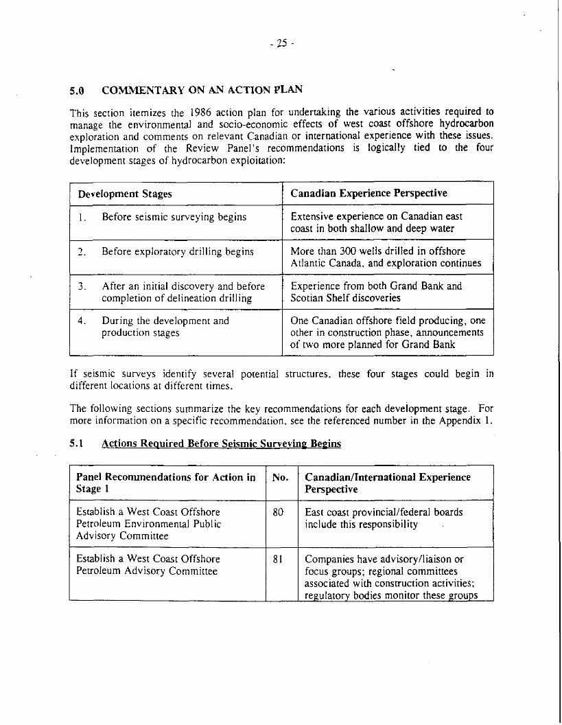
5.0 COMMENTARY ON AN ACTION PLAN
This section itemizes the 1986 action plan for undertaking the various activities required to manage the environmental and socio-economic effects of west coast offshore hydrocarbon exploration and comments on relevant Canadian or international experience with these issues. Implementation of the Review Panel's recommendations is logically tied to the four development stages of hydrocarbon exploitation:
2. Before exploratory drilling begins More than 300 wells drilled in offshore Atlantic Canada, and exploration continues
Development Stages
1. Before seismic surveying begins
3. After an initial discovery and before Experience from both Grand Bank and completion of delineation drilling Scotian Shelf discoveries 1
Canadian Experience Perspective
Extensive experience on Canadian east coast in both shallow and deep water
4. During the development and production stages
One Canadian offshore field producing, one other in construction phase, announcements of two more planned for Grand Bank
If seismic surveys identify several potential structures, these four stages could begin in different locations at different times.
The following sections summarize the key recommendations for each development stage. For more information on a specific recommendation, see the referenced number in the Appendix 1.
5.1 Actions Reouired Before Seismic Survevine Bepins
Establish a West Coast Offshore Petroleum Environmental Public Advisory Committee
CanadianIZnternational Experience Perspective
Panel Recommendations for Action in Stage 1
No.
80 East coast provinciallfederal boards include this responsibility
Establish a West Coast Offshore Petroleum Advisory Committee
81 Companies have advisorylliaison or focus groups; regional committees associated with construction activities: regulatory bodies monitor these groups
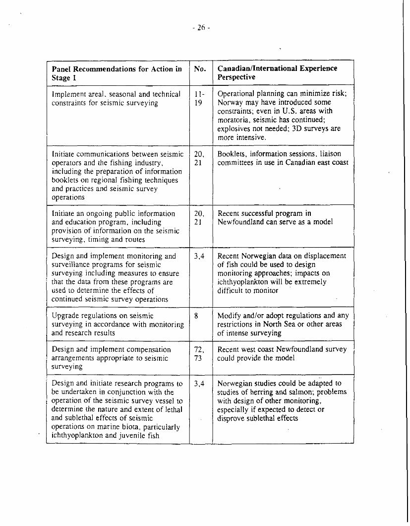
Panel Recommendations for Action in Stage 1
Implement areal. seasonal and technical constraints for seismic surveying
--
Initiate communications between seismic operators and the fishing industry, including the preparation of information booklets on regional fishing techniques and practices and seismic survey operations
Initiate an ongoing public information and education program, including provision of information on the seismic surveying, timing and routes
Design and implement monitoring and surveillance programs for seismic surveying including measures to ensure that the data from these programs are used to determine the effects of continued seismic survey operations
Upgrade regulations on seismic surveying i n accordance with monitoring and research results
Design and implement compensation arrangements appropriate to seismic surveying
Design and initiate research programs to be undertaken in conjunction with the operation of the seismic survey vessel to determine the nature and extent of lethal and sublethal effects of seismic operations on marine biota, particularly ichthyoplankton and juvenile fish
No.
1 I - 19
Caoadian/InternationaI Experience Perspective
Operational planning can minimize risk; Norway may have introduced some constraints; even in U.S. areas with moratoria, seismic has continued; explosives not needed; 3D surveys are more intensive.
20. 21
20, 21
Booklets, information sessions, liaison committees in use in Canadian east coast
Recent successful program in Newfoundland can serve as a model
3.4 Recent Norwegian dam on displacement of fish could be used to design monitoring approaches; impacts on ichthyoplankton will be extremely difficult to monitor
-
8 Modify and/or adopt regulations and any restrictions in North Sea or other areas of intense surveying
72, 73
Recent west coast Newfoundland survey could provide the model
3.4 Norwegian studies could be adapted to studies of herring and salmon; problems with design of other monitoring, especially if expected to detect or disprove sublethal effects
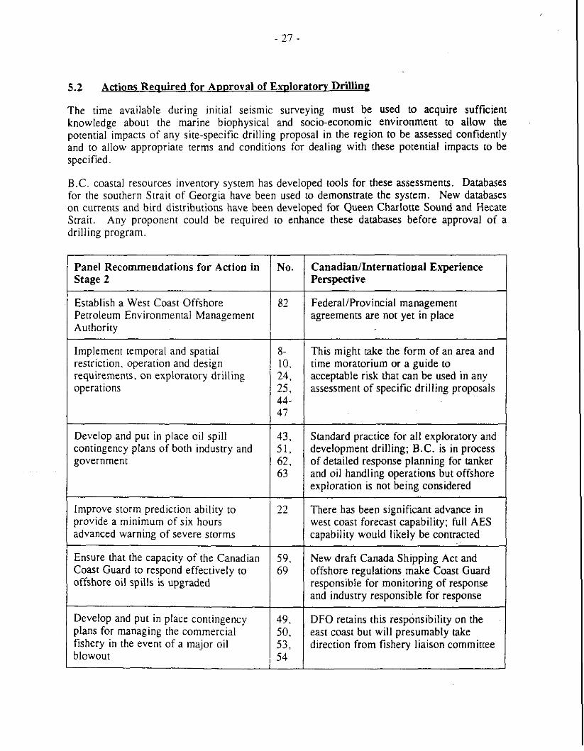
5.2 Actions Reauired for Aooroval of E X D ~ O ~ ~ ~ O N Drilling
The time available during initial seismic surveying must be used to acquire sufficient knowledge about the marine biophysical and socio-economic environment to allow the potential impacts of any site-specific drilling proposal in the region to be assessed confidently and to allow appropriate terms and conditions for dealing with these potential impacts to be specified.
B.C. coastal resources inventory system has developed tools for these assessments. Databases for the southern Strait of Georgia have been used to demonstrate the system. New databases on currents and bird distributions have been developed for Queen Charlotte Sound and Hecate Strait. Any proponent could be required to enhance these databases before approval of a drilling program.
Panel Recommendations for Action in Stage 2
Establish a West Coast Offshore Petroleum Environmental Management Authority
Implement temporal and spatial restriction, operation and design requirements, on exploratory drilling operations
Develop and put in place oil spill contingency plans of both industry and government
Improve storm prediction ability to provide a minimum of six hours advanced warning of severe storms
Ensure that the capacity of the Canadian Coast Guard to respond effectively to offshore oil spills is upgraded
Develop and put in place contingency plans for managing the commercial fishery in the event of a major oil blowout
No. CanadianIInternational Experience Perspective
FederalIProvincial management agreements are not yet in place
This might take the form of an area and time moratorium or a guide to acceptable risk that can be used in any assessment of specific drilling proposals
Standard practice for all exploratory and development drilling; B.C. is in process of detailed response planning for tanker and oil handling operations but offshore exploration is not being considered
There has been significant advance in west coast forecast capability; full AES capability would likely be contracted
New draft Canada Shipping Act and offshore regulations make Coast Guard responsible for monitoring of response and industry responsible for response
DFO retains this responsibility on the east coast but will presumably take direction from fishery liaison committee
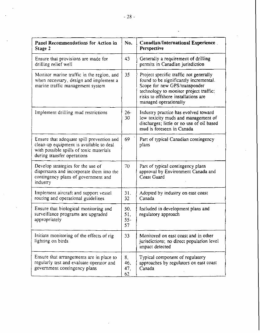
Panel Recommendations for Action in 1 Stage 2
Ensure that provisions are made for drilling relief well
Monitor marine traffic in the region, and when necessary. design and implement a marine traffic management system
Implement drilling mud restrictions
Ensure that adequate spill prevention and clean-up equipment is available to deal with possible spills of toxic materials during transfer operations
Develop strategies for the use of dispersants and incorporate them into the contingency plans of government and industry
Implement aircraft and support vessel routing and operational guidelines
Ensure that biological monitoring and surveillance programs are upgraded appropriately
Initiate monitoring of the effects of rig lighting on birds
Ensure that arrangements are in place to regularly test and evaluate operator and government contingency plans
No. Canadian/International Experience Perspective
Generally a requirement of drilling permits in Canadian jurisdiction - - -~ - - ~~ ~-
Project specific traffic not generally found to be significantly incremental. Scope for new GPS/transponder technology to monitor project traffic; risks to offshore installations are managed operationally
Industry practice has evolved toward low toxicity muds and management of discharges; little or no use of oil based mud is foreseen in Canada
Part of typical Canadian contingency plans
Part of typical contingency plans approval by Environment Canada and Coast Guard
Adopted by industry on east coast Canada
Included in development plans and regulatory approach
Monitored on east coast and in other jurisdictions; no direct population level impact detected
Typical component of regulatory approaches by regulators on east coast Canada
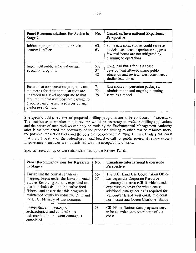
Panel Recommendations for Action in No. Stage 2
Initiate a program to monitor socio- economic effects
Implement public information and education programs
Ensure that compensation programs and the means for their administration are upgraded to a level appropriate to that required to deal with possible damage to property, income and resources during exploratory drilling
Canadianlhternational Experience Perspective
Some east coast studies could serve as models: east coast experience suggests few real issues are not mitigated by planning or operations
Long lead times for east coast development allowed major public education and review: west coast needs similar lead times
East coast compensation packages, administration and ongoing planning serve as a model
Site-specific public reviews of proposed drilling programs are to be conducted, if necessary. The decision as to whether public reviews would be necessary to evaluate drilling applications and the nature of such reviews can only be made by the Environmental Management Authority after it has considered the proximity of the proposed drilling to other marine resource users, the possible impacts on biota and the possible socio-economic impacts. On Canada's east coast it is the prerogative of the federaliprovincial board to call for public review if review experts in government agencies are not satisfied with the acceptability of risks.
Specific research topics were also identified by the Review Panel
Ensure that the coastal sensitivity mapping begun under the Environmental Studies Revolving Fund is expanded and that it includes data on the native food fishery, and ensure that this program is maintained jointly by industry, DFO and the B. C. Ministry of Environment
Panel Recommendations for Research in Stage 2
Ensure that an inventory of archaeological and cultural sites vulnerable to oil blowout damage is completed
No.
55- 57
Canadianlhternational Experience Perspective
The B.C. Land Use Coordination Office has begun the Corporate Resource Inventory Initiative (CRII) which needs expansion to cover the whole coast; additional data gathering is required for Vancouver Island west coast, mid coast, north coast and Queen Charlotte Islands
58 CRIIiFirst Nations data programs need to be extended into other parts of the coast
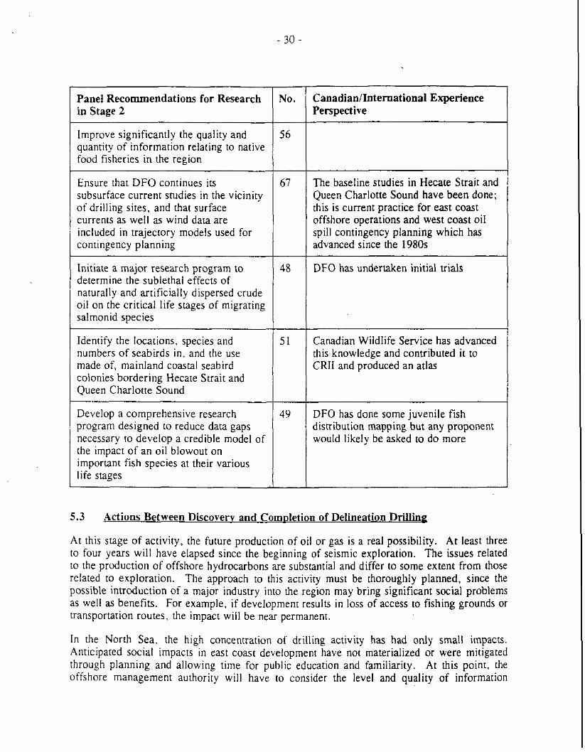
Panel Recommendations for Research in Stage 2
Improve significantly the quality and quantiry of information relating to native food fisheries in the region
Ensure that DFO continues its subsurface current studies in the vicinity of drilling sites, and that surface currents as well as wind data are included in trajectory models used for contingency planning
Initiate a major research program to determine the sublethal effects of naturally and artificially dispersed crude oil on the critical life stages of migrating salmonid species
Identify the locations, species and numbers of seabirds in. and the use made of, mainland coastal seabird colonies bordering Hecate Strait and Queen Charlotte Sound
Develop a comprehensive research program designed to reduce data gaps necessary to develop a credible model of the impact of an oil blowout on important fish species at their various life stages
CanadianlInternational Experience Perspective
The baseline studies in Hecate Strait and Queen Charlotte Sound have been done; this is current practice for east coast offshore operations and west coast oil spill contingency planning which has advanced since the 1980s
DFO has undertaken initial trials
Canadian Wildlife Service has advanced this knowledge and contributed it to CRIl and produced an atlas
DFO has done some juvenile fish distribution mapping but any proponent would likely be asked to do more
5.3 Actions Between Discovery and Com~let ion of Delineation Drilling
At this stage of activity, the future production of oil or gas is a real possibility. At least three to four years will have elapsed since the beginning of seismic exploration. The issues related to the production of offshore hydrocarbons are substantial and differ to some extent from those related to exploration. The approach to this activity must be thoroughly planned, since the possible introduction of a major industry into the region may bring significant social problems as well as benefits. For example, if development results in loss of access to fishing grounds or transportation routes, the impact will be near permanent.
In the North Sea. the high concentration of drilling activity has had only small impacts. Anticipated social impacts in east coast development have not materialized or were mitigated through planning and allowing time for public education and familiarity. At this point, the offshore management authority will have to consider the level and quality of information
needed to prepare for production and development. The east coast joint management boards demand a full development plan including EIS, SEIS, safety plan and Environmental Protection Plan. The B.C. Environmental Assessment Act requires a full environmental review of any application for offshore production.
5.4 Actions Related to Develooment
Once a commercial discovery is fully delineated, but prior to approval of development and production, the offshore management authority should ensure that focused guidelines to assess potential environmental and socio-economic impacts of proposed projects are promulgated. In east coast programs, it has been the responsibility of the proponent to identify the scope and issues be addressed. The joint management boards can accept the results after review by government agencies. In addition the authority should evaluate the applicability of research conducted throughout the exploration phase to the assessment and management of development and production. The east coast joint management boards require review by government experts and by the public prior to any permitting. West coast practice should follow an analogous process. including the formal public reviews of production and development proposals. The public must be fully informed about the procedures and proposed developments.
6.0 CONCLUSIONS
As the preceding discussion has demonstrated, many of the Review Panel's concerns have been addressed through advances in technology and through research programs initiated by provincial and federal government departments. In may areas, more work is required, but there has been significant development of new tools and databases. In addition, the Canadian practice of joint management boards has evolved successfully on the east coast, and new approaches are being formulated for the review of issues connected with exploration on Georges Bank. It is reasonable to expect thar an analogous approach; modified to B.C.'s needs would address the Review Panel's concerns for public involvement in resource management in this province.
Two technical topics have emerged, however, as areas of deficiency that will have to be addressed in order to show significant progress since the Review Panel report.
The first is lack of understanding of the biological resources at risk t6 offshore hydrocarbon activities. Discussion of the potential exploitation of west coast offshore hydrocarbon resources has focused on Hecate Strait and Queen Charlotte Sound, areas which are practically surrounded by coastline. The concern thar seismic and drilling activities may produce significant impacts on the nearshore zone (up to 10 km offshore) is based on an apparent concentration of migratory and non-migratory fish. mammals, birds and other biota in this zone. The impacts from an oil spill fouling these areas has been a focus of attention. not because of a high probability of occurrence, but because of the perception of large impacts on biological resources should such a rare event occur. The main difficulty in assessing impacts is the lack of quantitative information on these resources.
Progress has been made in developing resource inventory mapping systems, and some of the necessary databases have been enhanced. Nevertheless. a full sensitivity mapping of nearshore resources is not yet available. Shoreline video and biophysical characterization are required for the Queen Charlotte Islands. the mainland coast and the north end of Vancouver Island. There is a need to identify key areas of productivity. and areas that serve significant portions of populations for spawning, nursery or adult life stages.
The second area of deficiency concerns risk evaluation and determination of acceptable standards of risk in marine environmental assessment practice. There are formalized standards used in many aspects of our society; three examples are: building codes which address an acceptable level of structural failure; aircraft maintenance schedules that are designed to limit the probability of mechanical failure; and waterisediment quality standards that-assume an assimilative capability for specified effluent contaminant loadings. There are less well-defined standards used in harvesting natural resources in such industries as fishing-in this case society accepts that we change the ecosystem and reduce its resilience, but hopefully only to a level that allows long-term sustained yields. One approach to minimizing risk is to set "no net loss" policies, although they may set impractical goals and create the aberrant situation in which a "new" resource use, such as offshore oil development. is held accountablefor no net loss to an ecosystem, including preceding resource uses such as fishing. On the west coast, the lack of guidance on acceptable environmental risk will make the public review process difficult because many of the stakeholders have little familiarity with offshore oil activities and little experience in judging the probability of damage from those activities. New tools, with supporting data. are required to assess risk and express the results in a meaningful way.
I t is also clear that there is no priority to achieve progress in meeting the concerns of the Review Panel, and there is no process to undertake a review of the west coast moratorium on exploration. Industry has stated that it will not initiate action to resolve this impasse. Therefore, it is up to governments to provide a climate conducive to scientific research and further industry activity. To attract industry, the federal and provincial moratorium on exploration must be lifted.
Overcoming these problems presents an opportunity to evolve and apply new processes for integrated resource management built on the principles of sustainability. Such contemporary approaches could result in establishment of new compliance standards for prospective west coast offshore activity or new models for joint management boards. Based on the experience gained during the formation of COFRI, it is apparent that the expertise to develop these new processes and the scientific basis for new policies is available in B.C. with complementary knowledge in government, university and B.C.'s ocean industry. The lack of public knowledge about offshore hydrocarbon exploitation can be met it part through COFRI's plans for ocean industry-lead cooperative joint initiatives involving the three knowledge sectors. For example, COFRl's Georgia Basin Project is intended to integrate disparate facets of essential scientific research in the physical and biological sciences into a practical, working model of an ocean ecosystem. Such a model would provide a defensible basis for assessing impacts resulting from normal exploratory drilling activities, and from exceptional events like oil spills. Moreover, the model would be capable of presenting the information in a risk or probabilistic framework, dealing with the inherent uncertainties in the underlying science. Within COFRl's plans are ample opportunities for both peer review of the project's concepts and public education on the research issues and outcomes.
CITED REFERENCES
Aitken. J.A. and G.A. Borstad. 1995. Multispectral Classification of Intertidal Marsh Habitat. Proc. Third Thematic Conference on Remote Sensing for Marine and Coastal Environments. Sept. 18-20, 1995, Seattle, 315-321.
Bjoerke. H., J . Dalen, K. Bakkeplass, K . Hansen, and L. Rey, 1991. (Availability of seismic activities in relation to vulnerable fish resources.) Help Havforskningsinst Egg Larveprogram 1991 No. 38, 85 pp.
Bothner. M.H., E.Y. Campbell. G.P. DiLisio, C.M. Parmenter, and R.R. Rendigs, 1987. Analysis of trace metals in bottom sediments in support of deepwater biological processes studies on the U.S. Mid-Atlantic continental slope and rise. Final report March 1, 1984 - March 31, 1987. U.S. Geological Survey, Woods Hole, MA, 87 pp.
British Columbia Roundtable on the Environment and the Economy, 1993. An Economic Framework for Sustainabiliq.
Brown. C.E.. M. Fruhwirth. M.F Fingas, G. Vaudreuil, J.P. Monchalin, M. Choquet, R. Heon, C. Padioleau, R.H. Goodman, and J.V. Mullin, 1995. Oil slick thickness measurement: A possible solution to a long-standing problem. Proc. 18th Arctic and Marine Oil Spill Program Technical Seminar, June 14-16, 1995, Edmonton, 427-440.
Clark. R.B.. 1987. Summary and conclusions: Environmental effects of Nonh Sea oil and gas developments. Environmental EffecE Of Norrh Sea Oil And Gas Developments.
COGLA and Ministry of Energy, Mines and Petroleum Resources, 1987. Response and comments on the report of the west coast exploration environmental assessment. COGLA/MEMPR, Ottawa and Victoria.
Dietrich, J.R.. 1995. Petroleum resource potential of the Queen Charlotte Basin and Environs, West Coast Canada. Bull. Can. Petrol. Geol., 43(1), 20-34
Dobrocky Seatech Ltd., 1987. Wave climate study, northern coast of British Columbia. Environmental Studies Revolving Funds, Ottawa, 93 pp.
Eid, B.. C. Calnan, M. Henschel, and B. McGrath, 1993. Wind and Wave Climate Altas, Vol. 4, West Coast of Canada. Transportation Development Centre, Transport Canada. Montreal, Quebec.
Environment Canada, Energy Mines and Resources Canada. B.C. Ministry of Environment and B.C. Ministry of Energy. Mines and Petroleum, 1987. Report and recommendations of the west coast offshore exploration environmental assessment panel. Ottawa and Victoria.
Giammona. C.P., F.R. Engelhardt, K.S. Binkley, 1995. Airborne detection, imaging and telemetry of Oil and other spectral features on the ocean surface. Proc. 1995 int. Oil Spill Conf., Long Beach, CA. pp. 9-13,
Goodman, R., H. Brown, P. Nicholson, and S. Penny, 1995. Infrared cameras for the detection of oil-on-water. Proc. 18th Arctic and Marine Oil Spill Program Technical Seminar, June 14-16. 1995, Edmonton. 415-425.
Goodman. R.H., D. Simecek Beatty, and D.O. Hodgins, 1995. Tracking buoys for oil spills. Proc. 1995 inter. Oil Spill Conference, Feb. 27-Mart h 2, 1995, Long Beach, 3-8.
Grattan. L . , 1989a. The Hibernia project and the fishing industry. Proceedings Peuo Piscis 1. International Conference on Fisheries and Offshore Petroleum Exploitation, Bergen 23-25 October 1989, 34 pp.
Grattan, L., 1989b. Canada's east coast: The fishing industryloil industry interface 1980- 1989. Proceedings Petro Piscis 1, International Conference on Fisheries and Offshore Petroleum Exploitation, Bergen 23-25 October 1989, 12 pp.
Grigalunas, T.A.. J . J . Opaluch. D. French, M. Reed. 1988. Measuring damages to marine natural resources from pollution incidents under CERCLA: Applications of an integrated ocean systems/economic model. Mar. Resour. Econ., 5(1), 1-21.
Groot. C. and L. Margolis. 1991. Pac~Jic Salmon Life Histories. UBC Press, Vancouver, B.C., 608 pp.
Grover, S., W.G. Green. and J.R. Harper, 1988. Queen Charlotte Island coastal zone digital mapping and linked database system. Environmental Studies Revolving Funds, Ottawa. 115 pp.
Harper, J.R. and P.D. Reimer, 1995. Review of aerial video imagery (AVI) applications and development of AVI standards for the province of British Columbia. Proc. Third Thematic Conference on Remote Sensing for Marine and Coastal Environments, Sept. 18-20. 1995, Seattle, 700-709.
Harper. J.R., D. Howes, and P.D. Reimer, 1991. Shore-zone mapping systems for use in sensitivity mapping and shoreline countermeasures. Proc. 14th Arctic and Marine Oil Spill Program Technical Seminar, June 12-14, 1991, Vancouver, 509-523.
Hartley. J.P. and R.B. Clark, eds. 1987. Phil. Trans. R. Soc. Lond., Ser. B, 316B(1181), 669-677.
Hartt. A.C. and M.B. Dell, 1986. Early oceanic migrations and growth of juvenile Pacific salmon and steelhead trout. Int. N. Pac. Fish. Comm. Bull., 4 6 , 82 pp.
Healey, M.C., 1991. Diets and feeding rates of juvenile pink, chum, and sockeye salmon in Hecate Strait. British Columbia. Trans. Am. Fish. Soc., 120(3), 303-318.
Hodgins, D.O. and S. Nikleva, 1986. On the impact of new observing sites on severe sea state warnings for the B.C. coast. Prepared for Fisheries and Oceans Canada, by Seaconsult Marine Research Ltd., Vancouver, B.C.
Hodgins, D.O. and S.E. Tinis, 1995. SEACAST: A new concept for an integrated coastal zone monitoring and prediction system. Proc. Third Thematic Conference on Remote Sensing for Marine and Coastal Environments, Sept. 18-20, 1995, Seattle. 266-278.
Hodgins, D.O., 1991. New capabilities in real-time oil spill and fate prediction using HF radar remote sensing. Proc. 14th Arctic and Marine Oil Spill Program Technical Seminar, June 12-14, 1991, Vancouver. 527-539.
Hodgins. D.O., 1994. Remote sensing of ocean surface currents with the SeaSonde HF radar. Spill Science & Technology, 1(2), 109- 129.
Hodgins. D.O.. D.S. Dunbar, and J.H. Huang, 1991b. Commodity spill impact assessment for the east and west coasts of Canada. Prepared for Government Consulting Group, Ottawa. by Seaconsult Marine Research Ltd.. Vancouver, B.C.
Hodgins, D.O., J.H. Huang, and M.F. Fingas. 1992. Oil spill modelling using remote sensed surface currents. Proc. 15th Arctic and Marine Oil Spill Program Technical Seminar, June 10-12, 1992, Edmonton, 381-405.
Hodgins. D.O.. J.H. Huang, D.S. Dunbar, and S.L.M. Hodgins, 1991a. A high-resolution coupled hydrodynamic and oil spill modelling system applied to the port of Vancouver. Proc. 14th Arctic and Marine Oil Spill Program Technical Seminar, June 12-14, 1991. Vancouver, 39-56.
Hodgins, D.O.. S.L.M. Hodgins, and P.H. LeBlond, 1991c. A formalized risk analysis procedure for oil and chemical spills in coastal and inland waters. Proc. 14th Arctic and Marine Oil Spill Program Technical Seminar, June 12-14, 1991, Vancouver, 377- 390.
Hodgins. S.L.M. and D.O. Hodgins, 1992. Environmental criteria for Canadian waters: An assessment of data resources and design requirements. Prepared for Atmospheric Environment Service, Canadian Climate Centre, Downsview, Ont., by Seaconsult Marine Research Ltd., Vancouver, B.C.
Ljungblad, D.K. B. Wuersig, S.L. Swartz, J.M. Keene. 1985. Observations on the behavior of bowhead whales (Balaena mysricetus) in the presence of operating seismic exploration vessels in the Alaskan Beaufort Sea. Ocs Rep. U.S. Minerals Management Service, 88 pp.
MacDonald, M.C.. R. Prokop, R. Stampley, and F. Weinhaus, 1995. TRW airborne environmental surveillance system: SEASCAN 1992. Proc. Third Thematic Conference on Remote Sensing for Marine and Coastal Environments, Sept. 18-20. 1995, Seattle. 4 13-422.
Minton, R.C.. 1991. How to minimize drill fluid environmental impacts.' Ocean Ind., 26(6). 29-31. 33.
Mobil Oil Canada Ltd and Partners. 1985. Hibernia development project, environmental impact statement. Volume IV: Socio-economic assessment.
Morgan, K.H., K. Vermeer and R.W. McKelvey. 1991. Atlas of pelagic birds of western Canada. Can. Wildlife Service Occasional Paper No. 72, 72 pp.
Morris, M.. J.R. Harper. H.R. Frith, P.D. Reimer, and D. Howes, 1995. Coasral biotic mapping using aerial video imagery. Proc. Third Thematic Conference on Remote Sensing for Marine and Coastal Environments, Sept. 18-20, 1995, Seattle, 200-210.
Neff, J.M., M.H. Bothner, N.J. Maciolek, J.F. Grassle, 1989. Impacts of exploratory drilling for oil and gas on the benthic environment of Georges Bank. Mar. Environ. Res.. 27(2). 77 114.
NORDCO, 1984. Report on the study of residual toxicity and debris on Hibernia P-15, B-08, and K-18 well sites. Geol. Survey of Can. Open File Report 1127.
Reed. M.. 1988. The MMS coastal zone oil spill model. Alaska Ocs Region 1987 Arctic Information Transfer Meeting Conference Proceedings. pp. 39-42.
Richardson, W.J.. B. Wuersig, C.R. Greene, Jr., 1986. Reactions of bowhead whales, Balaena cst icetus, to seismic exploration in the Canadian Beaufort Sea. J. Acoust. Soc. Am., 19(4), 11 17-1 128.
Rodway. M.S., M.J.F. Lemon. G.W. Kaiser, 1988-1991. British Columbia seabird colony inventory: Reports ,914. Can. Wildlife Service Tech. Rep. Ser. No. 50, 65, 43, 86, 94, 95. 121 and 123.
Soldal, A.V.. and S. Loekkeborg, 1993. (Seismic exploration and fisheries catch rates. An analysis of collected data). Fisken-Havet. Bergen-Norway Havforskningsinstituttet No. 4. 44 pp.
SPARK. 1993. Ocean opportunities for the west coast of Canada. Science Council of B.C., Burnaby, B.C.
Spaulding. M.L.. M. Reed, E. Anderson. T. Isaji. J.C. Swanson, S.B. Saila, E. Lorda. and H. Walker, 1985. Oil spill fishery impact assessment model: Sensitivity to spill location and timing. Estuar. Coasr. ShelfSci., 20(1), 41-53.
Tibbetts. P.J.C., and R. Large, 1986. Degradation of low toxicity oil based drilling mud in benthic sediments around the Beatrice Oilfield. The marine environment of the Moray Firth. Proc. R. Soc. Edinb., Sect. B., 349-356.
[ Appendix I Summary of Recommendations 1
The following is a restatement of each of the Review Panel's recommendations. For ease of reference. the recommendations have been numbered by the author of this review.
The Environmental Assessment and Review Process
The Panel recommends that public environmental assessment reviews of broad industrial activities proposed within large.geographic regions be conducted in such a manner that government, through interdepartmental coordination, be required to prepare the environmental impact statement, and to present this information in the appropriate forum for public review.
The Panel recommends that a specific proponent not be designated for environmental assessment reviews unless the regulatory agencies have the capacity to enforce the proponent's continued participation.
The Panel recommends that:
1. The Governments of Canada and British Columbia develop policies on intervenor funding for formal public reviews that will enable funds to be made available to communities and organizations to participate effectively in public review processes; and
7 . financial assistance be directed to communities and groups to help them analyze and understand existing information. to develop and articulate positions and concerns, and to organize and present their own briefs.
The Panel recommends that a mechanism be established to ensure participation of the public of the region, in ways acceptable to them, in the management of decision- making related to offshore hydrocarbon exploration.
The Panel recommends that in designing programs and mechanisms for the involvement of the public of the region in the management and decision-making relating to offshore hydrocarbon exploration and its impact on marine resources, government develop means to ensure aboriginal peoples are involved.
The Panel recommends that a government compensation policy covering all stages in an exploration program be established before exploration activity begins.
T r a i n i o ~ and Drilline Exclusions
The Panel recommends that the regulatory authority ensure, as a paramount priority, a high level of training, experience and competence for drilling personnel and the highest standard of equipment; also that frequent inspections of systems, equipment, and personnel are carried out, and that a satisfactory level of weather forecasting is available to drilling operations.
The Panel recommends that drilling be prohibited within an exclusion zone of 20 km from any point of land for the protection of important marine life in the event of an offshore oil blowout.
The Panel recommends that exploratory drilling operations outside the 20 km exclusion zone be initially confined to the months of June to October inclusive to ensure weather more favorable to drilling operations, to mitigate the likelihood of an oil blowout and to protect important biological species during critical phases of their life cycles.
Seismic Surveving
The Panel recommends that:
1. a seismic survey program such as that proposed by Chevron be permitted to proceed, providing that half the program is conducted in the first year of operation and the remainder in the second year;
7 . the program be conducted with no less than a 3-km line spacing pattern, and a maximum survey length of 52,000 km;
3. during both seasons of seismic surveying, the Department of Fisheries and Oceans carry out extensive monitoring and experimentation in conjunction with the seismic survey vessel to determine the nature and extent of any resulting damage:
4. such date collection and experimentation be used by the regulatory authority to determine the likely long-term effects of seismic operations on marine biota. particularly eggs and larvae, and be applied in determining the appropriate controls and regulations to any future seismic surveys; and
5 . until such time as the results of monitoring and experimentation have been evaluated, no other marine seismic survey operations be permitted.
The Panel recommends that during the sensitive gray whale migration and herring spawning periods of March. April. May, November and December, seismic operations do not occur within 10 km of shore.
The Panel recommends that when marine mammals are observed within 2 km of the airgun array, the survey temporarily cease until the animals have moved out of the area.
The Panel recommends that, for purposes of general operations, seismic surveying be restricted to airguns only.
The Panel recommends that where the use of explosives in shallow water seismic surveys is required to connect land and sea surveys, approval only be granted where:
1. there are no alternative;
2. explosives are buried within boreholes within the sea floor; and
3. the program is subjected to specific approval from t h e ' ~ e ~ a r t m e n t of Fisheries and Oceans as to timing and location.
The Panel recommends that booklets be produced and widely distributed describing the fishing techniques employed on the British Columbia coast, illustrating the different methods and seasons used to catch fish and shellfish, and describing seismic survey operations.
The Panel recommends that the operators of the seismic vessels meet with the members of the fishing industry before surveying begins to identify potential heavy fishing areas and seasons and to familiarize themselves with the local fishing equipment and techniques.
Routine Drilling and S u o ~ o r t O~era t ions
The Panel recommends that regulatory authority not give approval to drill until the Atmospheric Environment Service of Environment Canada is satisfied that the capability exists to provide a minimum of 6 hours advance warning of severe storms to enable an offshore drilling operator sufficient time to safely and efficiently disconnect from the wellhead.
The Panel recommends that the Department of Fisheries and Oceans develop and implement a program to improve general knowledge of current movements in the region, and in particular, in the area of a drilling location when one is proposed.
The Panel recommends that before drilling occurs, a proposed site must be evaluated by the operator and the regulatory authority for its potential susceptibility to earthquake-induced turbidity flows, and that if the potential exists, wellhead design will be such that the well remains safely shut-in.
The Panel recommends that operators be required to undertake an extensive site survey of the seabed, including a seismic sparker survey, when investigating an area for a specific drilling location.
The Panel recommends that only chrome-free lignosulphonate be used for drilling muds in offshore exploratory drilling operations on the west coast.
The Panel recommends that the regulatory authority require industry to use only those drilling mud products with low to zero heavy metal content, and that industry routinely sample their supplies to ensure the approved standards are maintained.
The Panel recommends that, to reduce the need to use oil as a spotting fluid to fee stuck drilling collars, spiral or straight grooved drill collars to be used for all drilling operations.
The Panel recommends that if oil must be used to free collars, mineral oil or another nontoxic type of oil be used.
The Panel recommends, under special circumstances required the use of oil-based muds. that:
1. only mineral oil based muds be used;
1 -. a closed system be used in which no oil-based drilling muds are released into the sea; and
3. the amount of oil adhering to the cuttings be minimized by jet washing at the shale shaker and by collecting the oil.
The Panel recommends that. to minimize disturbance to marine mammals and birds from aircraft noise, the Canadian Wildlife Service of Environment Canada and the British Columbia Ministry of Environment develop guidelines to prevent disturbances to sensitive species. and that these guidelines be followed by aircraft operators involved in the west coast offshore exploration program.
The Panel recommends that Transport Canada develop a mechanism to ensure that flight constraints around sensitive marine mammal and bird areas be applied to all aircraft operators in the area.
The Panel recommends that
1. where feasible, drill rig marking lights consist of high intensity strobe or other types of intermittent lights;
1 . working lights be masked or shielded to minimize outward illumination; and
3. the attraction of birds to rig lights be monitored and repons published monthly on bird kills so that data is collected to better evaluate and mitigate potential problems.
The Panel recommends that where sediment removal processes are evident at a drill site, the wellhead cut-off point below the seabottom be increased to three metres.
The Panel recommends that the Canadian Coast Guard closely monitor any increase in ship traffic and, if and when offshore drilling is approved, develop and enforce the use of a marine traffic management system in the region.
Socio-economic Effects of Routine Overations
The Panel recommends that during exploration phase of offshore oil and gas activity, shorebase facilities be developed within the industrial zones of existing communities.
The Panel recommends that, in the event of expanded exploration, the Department of Indian Affairs and Northern Development and the British Columbia Ministry of Municipal Affairs provide funding and other assistance to potentially affected communities so that these communities can initiate ongoing monitoring programs related to the socio-economic effects of offshore hydrocarbon exploration and initiate programs to deal with these effects.
The Panel recommends that a public information and education program be initiated immediately through consultation with area residents, industry and the regulatory authority.
The Panel recommends that, as a condition of obtaining an Exploration Agreement, an operator establish a preferential hiring policy for employing local residents assuming equivalent skills, and that the operators ensure contractors follow the same policy.
The Panel recommends that government and industry review existing training programs, and if exploration activity is expanded, implement training to enable local residents to qualify for offshore petroleum-related jobs.
The Panel recommends that industry, in an expanded exploration program, develop programs in consultation with area residents that would enable them to pursue, as far as possible, traditional activities while employed in offshore exploration.
The Panel recommends that, as a condition of obtaining an Exploration Agreement, an operator establish policies giving preference to local suppliers of goods and services, and that the operator ensure contractors follow the same policy.
Hvdrocarbon Blowouts
43. The Panel recommends that the regulatory authority not approve the drilling of any exploratory well until the operator has proven that formal arrangements are in place to bring in a relief well drilling unit to a blowout site and begin drilling a relief well within 14 days of a decision to mobilize, regardless of inclement weather or other inhibiting factors. The arrangements to srart mobilizing a relief well unit are to be put into action within 48 hours of the start of a blowout.
The Panel recommends that, before exploratory drilling begins, the regulatory authority rakes steps to:
44. 1. directly asses the experience, training, testing, and supe~ i so ry capabilities of drilling personnel;
45. 2. ensure the best quality equipment, meeting the toughest standards of design, is used in all drilling and well-control operations:
46. 3. develop effective surveillance, inspection and enforcement programs and practices related to well control, and ensure that these programs and practices are carried out in a thoroughly and timely manner; and
47. 4. ensure that programs include frequent, unannounced inspections and exercises to ensure that appropriate drilling procedures, standards and regulations are being met, and to verify that drilling personnel and equipment are prepared for responding to drilling emergencies and blowouts.
The Fate and Effects of Oil in the Marine Environment
The Panel recommends that the Department of Fisheries and Oceans conduct research to determine the lethal and sublethal effects of naturally and artificially dispersed crude oil on critical life stages of migrating salmonid species.
The Panel recommends that the Department of Fisheries and Oceans, in cooperation with other agencies. develop a comprehensive research program designed to reduce data gaps necessary to develop a credible model of the impact of an oil blowout on important fish species at their various life stages.
The Panel recommends that, in the event of a blowout, the Department of Fisheriesand Oceans be prepared to immediately initiate a major research and monitoring program to gather information on the actual concentrations of dispersed oil in the water column and the lethal and sublethal effects on important west coast species, particularly salmon and herring. at critical life stages. in order to assess more accurately the effecrs of oil on these species.
The Panel recommends that. before exploratory drilling begins. Environment Canada (Canadian Wildlife Service), assisted by appropriate provincial agencies, undertake inventory surveys of the coastline of the region as well as adjacent shelf waters, to establish baseline information on the population, location and behaviour of coastal bird species for contingency planning purposes.
The Panel recommends that the operator, as part of its oil blowout contingency plan, identify experts on bird cleaning who will be available on call to direct local efforts to clean oiled birds.
The Panel recommends that programs be undertaken to improve the quality and quantity of information related to native food fisheries in the region.
The Panel recommends that. before exploratory drilling begins, the Department of Fisheries and Oceans develop a contingency plan for managing the commercial fishery after a blowout, including monitoring of fish for tainting and administration of closures.
Oil Blowout Contineencv Plannine and Countermeasures
The Panel recommends that, before exploratory drilling begins, the regulatory authority ensure that:
55. 1 . coastal sensitivity mapping begun under the Environmental Studies Revolving Fund is expanded to cover areas that are inadequately mapped;
56 . 2 . the native food fishery and resource harvesting activity are included within this mapping, with native people involved in acquiring and developing this information;
57. 3 . arrangements are in place to ensure that sensitivity mapping is maintained and updated jointly by the British Columbia Ministry of Environment. Environment Canada, the Department of Fisheries and Oceans and industry; and
58. 4. the Heritage Conservation Branch of the Government of British Columbia complete an inventory of archaeological and cultural sites vulnerable to oil and ensure that measures to protect these sites from inappropriate clean-up procedures are included in contingency plans.
The Panel recommends that, in the event of a blowout:
1. the Canadian Coast Guard coordinate government involvement in responses to an oil spill resulting from a blowout; and
3. the Canada Oil and Gas Land Administration and the British Columbia Ministry of Energy, Mines and Petroleum Resources coordinate government responsibilities for rig-related actions to control blowouts.
The Panel recommends that the regulatory authority ensure the establishment of programs to train, organize and equip local residents for participation in oil spill countermeasures and clean-up.
The Panel recommends that, before exploratory drilling is approved, the regulatory authority ensure that arrangements are in place to regularly test and evaluate operator and government contingency plans.
The Panel recommends that the regulatory authority ensure that at least orre full scale oil blowout response practice exercise is carried out during the initial exploration period, and if an extended exploration program takes place, that at least on exercise is carried out each year.
The Panel recommends that, before exploratory drilling is approved, the regulatory authority require operators to provide detailed description of:
64. 1. the monitoring and surveillance procedures and equipment that would be used to monitor the location of slicks from a blowout;
6 5 . 2. the location and availability of equipment and how it would be deployed; and
66. 3. the adequacy of these procedure and equipment for use in tracking slicks from a blowout at the specific drilling site.
67. The Panel recommends that at least one year before exploratory drilling begins, the Department of Fisheries and Oceans, in cooperation with industry, implement a surface current measuring program in the region of the drilling site, and that industry include surface current effects for the purpose of developing contingency plans.
68. The Panel recommends that during oil spill countermeasure operations, emphasis be placed on the use of radio-located tracking buoys as sensors to provide position updates for oil slick tracking.
69. The Panel recommends, that before exploratory drilling is approved, the Canadian Coast Guard upgrade its resources for responding effectively to offshore oil spills, including trained personnel. modern equipment. depots, communications systems, and the logistical capability to deploy these resources quickly.
70. The Panel recommends, before exploratory drilling begins, that:
1 . Environment Canada and the British Columbia Ministry of Environment clarify the circumstances under which their respective governments would permit or prohibit the use of dispersants, and in cooperation with industry, develop a strategy for the use of dispersants if these are not prohibited; and
7 . operators incorporate this dispersant strategy into their contingency plans.
71. The Panel recommends that, before exploratory drilling is approved, operators include specific strategies in their contingency plans, for cleaning up shorelines that are vulnerable to oil from a blowout at the proposed drilling site, including details on the types and availability of equipment that would be used, manpower requirements, training provisions, operational logistics and guidelines for cleaning up individual shoreline areas.
7 2 . The Panel recommends that a government compensation policy covering all stages in an exploration program be established before exploration activity begins, and that this policy be based upon the following basic principles:
I. Compensation is to be provided for situations involving loss of, or damage to. property or equipment:
2 . Compensation is to be provided for situations involving loss of income.
3. Compensation is to be provided for situations involving loSs of, or damage to. common property resources.
4. Attributable and nonattributable damages and losses are to be covered.
5 . The burden of proof in any dispute over compensation for damages or income loss is to rest with the oil companies rather than the claimant; the onus is to be on the companies to support their disclaimer "on the balance of probability".
6. As both the oil industry and government will share in benefits to be gained from the exploration program, both should share in the financial responsibility for any common property resource losses or damages incurred.
7. Compensation programs relating to common property resource losses should emphasize replacement of the resource rather than financial compensation.
73. The Panel recommends chat any disputes arising out of compensation claims relating to routine operations that cannot be resolved between the two parties be referred to third party arbitration.
74. The Panel recommends that a policy for compensating losses and damage resulting from significant oil well blowouts. following the basic principles set out by the Panel and containing the elements outlines by the Panel, be in place before any exploration drilling begins.
75. The Panel recommends that before any drilling begins. each operator be required to post a $40 million bond or irrevocable letter of credit.
76. The Panel recommends that government accept a financial liability of $10 million towards any resource rehabilitation programs that are found necessary to replace resources lost from an oil well blowout.
77. The Panel recommends that the absolute financial liabilities LO be borne by the operator and government for resource rehabilitation programs that are found necessary to replace resources lost from an oil well blowout.
78. The Panel recommends that in the event of a blowout, the need for resource rehabilitation programs be determined by government, and that these programs be designed and implemented by the appropriate government agencies.
79. The Panel recommends that a West Coast Offshore Compensation Board be appointed if and when a significant oil well blowout occurs.
The Panel recommends that the West Coast Offshore Compensation Board consist of at least three members, include representation from the oil industry and the fishing industry, and be headed by an independent Chairman.
Managing for Environmental Protection
The Panel recommends that a West Coast Offshore Petroleum Environmental Coordinating Committee be established immediately to ensure that the panel's recommendations relevant to the early stages of hydrocarbon exploitation are implemented.
The Panel recommends that the West Coast Offshore Petroleum Environmental Coordinating Committee created under the authority of the federal and British Columbia Ministers of the Environment include representation from the British Columbia Ministry of the Environment, Environment Canada (Pacific and Yukon Division), the Department of Fisheries and Oceans (Pacific and Yukon Region), the British Columbia Ministry of Municipal Affairs, the Department of Indian Affairs and Northern Development (B.C. Region), the Canada Oil and Gas Lands Administration and the British Columbia Ministry of Energy, Mines and Petroleum Resources. It should report to the two Ministers of Environment on a semi-annual basis and at threshold points throughout the early stages of exploration activity.
The Panel recommends that a three-person public advisory committee be appointed by the federal and British Columbia Ministers of Environment. This committee will be charged with advising the regulatory authority and the West Coast Offshore Petroleum Environmental Coordinating Committee about public concerns and with undertaking public education and information programs. Representation on this committee should include local. native and fishing interests.
The Panel recommends that a West Coast Offshore Petroleum Environmental Management Authority be appointed and assume its duties at such time as the first proposal for exploratory drilling is received by the regulatory authority.
The Panel recommends that the membership of the Management Authority shall comprise five representatives of the regional public appointed jointly by the Ministers of Environment for Canada and British Columbia upon nomination by the Offshore Alliance of Aboriginal Nations, the north coast grouping of the Union of British Columbia Municipalities, the British Columbia Ministry of the Environment. Environment Canada and the Department of Fisheries and Oceans.
--
Appendix 2 List of Individuals Contacted / Interviewed
J. Anderson. Environmental Affairs
R. Bekker. Manager. Marine Geophysics
B. Burd, Contract Biologist
D. Burley. Manager Environmenral Affairs
F. Calverly. former Petro-Canada Frontier Exploration Manager
S. Canning
D. Cioccio, Director
H. Dabaghi. Advisor
J .R. Dietrich, Senior Geophysicist
H. Dragert
J. Fitzgerald, Chair
F. Frey. Manager (Chief) Geologist
National Energy Board Calgary, Alberta
Gecko-Prakla (Geophysical Contractor) Houston,Texas
Institute of Ocean Sciences Fisheries and Oceans Canada
Sidney, B.C.
Canada Newfoundland Offshore Petroleum Board St John's, Newfoundland
2 170 Bow Valley Square IV Calgary, Alberta
Canning and Pitt St John's, Newfoundland
Frontier Lands Division Natural Resources Canada, Ottawa
Land Management and Revenues Frontier Lands Division
Natural Resources Canada, Ottawa
Geological Survey of Canada Calgary, Alberta
Geological Survey of Canada Pacific Geoscience Centre
Sidney, B.C.
Canada Newfoundland Offshore Petroleum Board St John's, Newfoundland
Shell Canada Calgary. Alberta
W. Fullerton
P. Golden, Director
L. Grattan. Manager Loss Prevention
L. Gregor
D. Hardie
M. Helmer. General hlanager Drilling
C. Hendry. President
D. Howes. Senior Resource Analyst
R. Hyndman (letter to SPARK Oceans)
M. Huard, Director Oceans Programs
L.A. Johnson. Manager Drilling Operations
G. Kaiser. Director
L. Kennedy. Director
D. Lyon, Business Manager Frontier Division
R. Mayzes, President
G. Okrainetz, Acting Manager Legislation and Intergovernmental Affairs
Traffic Services, Coast Guard Vancouver, B.C.
Emergency Response, Coast Guard Vancouver, B.C.
Hibernia Management and Development Ltd. St John's, Newfoundland
Federal Treaty Office Victoria, B.C.
Ecosystem Conservation Directorate Sustainability Branch, Environment Canada
Hull, Quebec
Canadian Marine Drilling Ltd. Calgary. Alberta
Western Spill Response Corporation Vancouver, B.C.
Land Use Coordination Office B.C. Ministry of Environment, Lands and Parks
Victoria, B.C.
Geological Survey of Canada Pacific Geoscience Centre. Sidney, B.C.
Habitat and Environmental Science Fisheries and Oceans Canada, Ottawa
Canadian Marine Drilling Ltd. Calgary, Alberta
Canadian Wildlife Service Delta, B.C.
B.C. Ministry of Environment, Lands-and Parks Victoria. B.C.
Chevron Calgary, Alberta
,Mayzes Consulting Calgary, Alberta
B.C. Ministry of Environment, Lands and Parks Victoria, B.C.
A. Parker, Manager Offshore Operations and Environmental Affairs
R. Pitt
D. Porvais. Business Unit Leader Frontier Division
P. Rice. Geology & Geophysics Unit Leader Frontier Division
R. Roblesky. Project Leader NWTiFrontier
W. Robson. Manager Environmental. Health and Safety, Terra Nova Project
G. Rogers. Head Earthquake Studies
K. Rohr. Senior Geophysicist
C. Ross, Environmental Manager
P. Scott. Director
M. Shrimpton
O.L. Slind. former Lead Geologist, Shell Canada West Coast Exploration and later Exploration Manager Frontier Regions
D. Stocker
Canada Nova Scotia Offshore Petroleum Board Halifax, Nova Scotia
Canning and Pitt St John's, Newfoundland
Chevron Calgary, Alberta
Petro-Canada Calgary, Alberta
Shell Canada Calgary, Alberta
Petro-Canada Calgary, Alberra
Geological Survey of Canada Pacific Geoscience Centre
Sidney, B.C.
Geological Survey of Canada Pacific Geoscience Centre
Sidney, B.C.
Lasmo Resources Hal ifax. Nova Scotia
B.C. Environmental Assessment Office Environment Canada
Vancouver, B.C.
Community Resource Services Ltd. St John's, Newfoundland
Alconsult International Ltd. Calgary, Alberta
Environmental A'ssessment Division Environment Canada
OttawalVancouver
H. van der Wal, former Vice- President Canadian Marine Drilling Ltd.
C. Watson. Exploration Operations Manager
D. Weichert
F. Weir. Chair
R.C.H. Wilson. Acting Manager Marine Environment and Habitat Science Division
Alconsult International Ltd. Calgary, Alberta
Shell Canada Calgary, Alberta
Geological Survey of Canada Pacific Geoscience Centre
Sidney. B.C.
Canada Nova Scotia Offshore Petroleum Board Halifax, Nova Scotia
Institute of Ocean Science Fisheries Oceans Canada
Sidney, B.C.
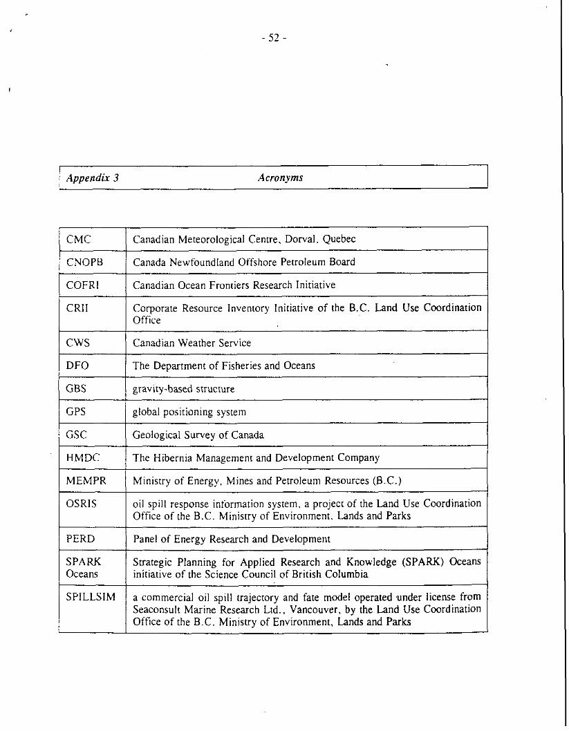
Appendix 3 Acronyms
COFRl I Canadian Ocean Frontiers Research Initiative
CMC
CNOPB
Corporate Resource Inventory Initiative of the B.C. Land Use Coordination Office
Canadian Meteorological Centre, Dorval. Quebec
Canada Newfoundland Offshore Petroleum Board
CWS ( Canadian Weather Service
GPS / global positioning system
DFO
GBS
The Department of Fisheries and Oceans
gravity-based structure
MEMPR 1 Ministry of Energy. Mines and Petroleum Resources (B.C.)
GSC
HMDC
OSRIS oil spill response information system, a project of the Land Use Coordination Office of the B.C. Ministry of Environment. Lands and Parks
Geological Survey of Canada
The Hibernia Management and Development Company
PERD 1 Panel of Energy Research and Development
SPARK Strategic Planning for Applied Research and Knowledge (SPARK) Oceans Oceans initiative of the Science Council of British Columbia
SPILLSIM a commercial oil spill trajectory and fate model operated under license from Seaconsult Marine Research Ltd., Vancouver, by the Land Use Coordination Office of the B.C. Ministry of Environment, Lands and Parks