Embed Size (px)
Citation preview
Assessment Report for De Beers Claim Areas CLM 436 and 109496 Leases
2014 Tango Extension Kimberlite Hydrogeology and Delineation Drilling Program
For the Period: January – April 2014
A Report Prepared for
De Beers – Mining Canada
Prepared by
Maylene G. Furigay, P.Geo.
Reviewed by
Peter Williamson, P. Geo.
Chris Wallace, P. Geo.
December 2015 Toronto, ON

1 | P a g e
Assessment Report 2014 CLM 436, 109496 De Beers – Mining Canada
SUMMARY
A scope of work was initiated and approved in January-February 2014 to undertake a spinner logging (Hydrogeology) and core drilling (Delineation) program. The former aimed to supplement or update previous Victor hydrogeological information necessary to develop a new regional groundwater flow model for the Victor Mine Extension Project while the latter aimed to test for flaring in the shallow portion of the Tango Extension pipe and geotechnically investigate the overburden in the area for a future trench/pit. During the months of March and April 2014, the following holes were drilled: two monitoring wells, a pump test well, two delineation holes, and one overburden hole. Collectively, a total of 809.74 meters were drilled within CLM 456 and 109496 claims. The hydrogeology holes were completed utilizing a Foremost dual rotary drill rig (DR-24HD) while the delineation holes were accomplished by employing De Beers’ owned Zinex A5-2 drill rig. Hydrogeology drilling was carried out by LBM (Les Forages LBM, Victoriaville QC) while Foraco (Foraco Canada, North Bay, ON) undertook delineation drilling. Project supervision and field geological logging for all holes were performed by De Beers’ staff. Golder Associates undertook overburden logging/sampling for geotechnical analysis. Ice thickness assessment necessary for access and drill pad preparation were contracted to Ausenco while hydrogeological drilling result interpretation was made by Itasca Consultants. The total project expenditure was CAD $1,546,475.00. The drilling program was completed with 0 LTI (Lost Time to Injury), 0 First Aid case, 0 incident requiring medical treatment, 0 incident causing damage to equipment, and 3 minor environmental incidents which were all reported and cleaned up.
KEYWORDS
Assessment Report, Attawapiskat, Ontario, CLM 436, 109496, Tango Extension, Kimberlite, Drilling, Delineation, Hydrogeology
2 | P a g e
Assessment Report 2014 CLM 436, 109496 De Beers – Mining Canada
Table of Contents
1.0 INTRODUCTION ........................................................................................................................... 4
1.1 Location and Access ............................................................................................................... 4
1.2 Dispositions and Ownership ................................................................................................... 5
1.3 Topography and Drainage ...................................................................................................... 6
1.4 Climate and Vegetation .......................................................................................................... 7
1.5 Planning, Permits and Environmental Management ............................................................. 8
2.0 GEOLOGY ..................................................................................................................................... 9
2.1 Previous Mapping .................................................................................................................. 9
2.2 Regional Geology and Tectonic Setting ................................................................................ 10
3.0 ECONOMIC GEOLOGY ............................................................................................................ 13
3.1 Previous Investigations Undertaken in the Tango Extension Kimberlite Bodies ................ 13
3.2 Geology of the Tango Extension Kimberlite ......................................................................... 14
4.0 INVESTIGATIONS ...................................................................................................................... 14
4.1 Ground Preparation ............................................................................................................. 14
4.2 Hydrogeology ....................................................................................................................... 15
4.3 Core Drilling (Delineation) .................................................................................................... 17
5.0 RESULTS ..................................................................................................................................... 18
5.1 Hydrogeology Holes ............................................................................................................. 18
5.2 Core Drilling (Delineation) .................................................................................................... 20
6.0 CONCLUSION ............................................................................................................................. 21
7.0 PERSONNEL ............................................................................................................................... 21
8.0 PROJECT COST ........................................................................................................................ 22
9.0 REFERENCES ............................................................................................................................ 22

3 | P a g e
Assessment Report 2014 CLM 436, 109496 De Beers – Mining Canada
LIST OF FIGURES
Figure 1. Tango Extension Kimberlite Work Site Location relative to Victor Mine Site ....................... 4 Figure 2. Tango Extension Winter Access Road (broken red line) from/to Victor Mine .................. 5 Figure 3. De Beers’ Tango Claims showing 2014 Holes .......................................................................... 6 Figure 4. Satellite Imagery of the Project Area ...................................................................................... 7 Figure 5. Average Daily Temperatures (⁰C) from Feb to Apr 2014 ........................................................ 8 Figure 6. De Beers Claim Holdings and Locations of 16 Kimberlites discovered in Attawapiskat Area10 Figure 7. Regional Geological Setting (McCrae, 2003) ......................................................................... 11 Figure 8. Major Subdivisions of the Superior Structural Province in Ontario ...................................... 12 Figure 9. Stratigraphic Sequence of Sediments surrounding the Attawapiskat Kimberlites ............... 13 Figure 10. Spinner Log .......................................................................................................................... 15 Figure 11. Planned Location of Hydrogeology Holes............................................................................ 15 Figure 12. Outline of Tango Extension Kimberlite with Location of Core Holes Planned .................... 17 Figure 13. 2014 Core Holes drilled showing Kimberlite Intersections ................................................ 21
LIST OF TABLES
Table 1. Tango Area List of Dispositions/Claims ..................................................................................... 5 Table 2. Climate Data Record from Feb to Apr 2014 ............................................................................. 7 Table 3. Hydrogeology Holes Planned Coordinates ............................................................................. 16 Table 4. Planned Core Hole Locations .................................................................................................. 17 Table 5. Surveyed Drillhole Location Summary for the Hydrogeology Holes ...................................... 18 Table 6. Surveyed Drillhole Location Summary for the 2014 Core Holes ............................................ 20 Table 7. Kimberlite Intersections at the Drilled Tango Extension Core Holes ...................................... 20
LIST OF APPENDIX
Appendix 1: 2014 Tango Extension Drill Plan (Large Scale Map 1:5000) Appendix 2: Tango Extension Holes Summary and Strip Logs Appendix 3: RACI Matrix Appendix 4: Statement of Costs
4 | P a g e
Assessment Report 2014 CLM 436, 109496 De Beers – Mining Canada
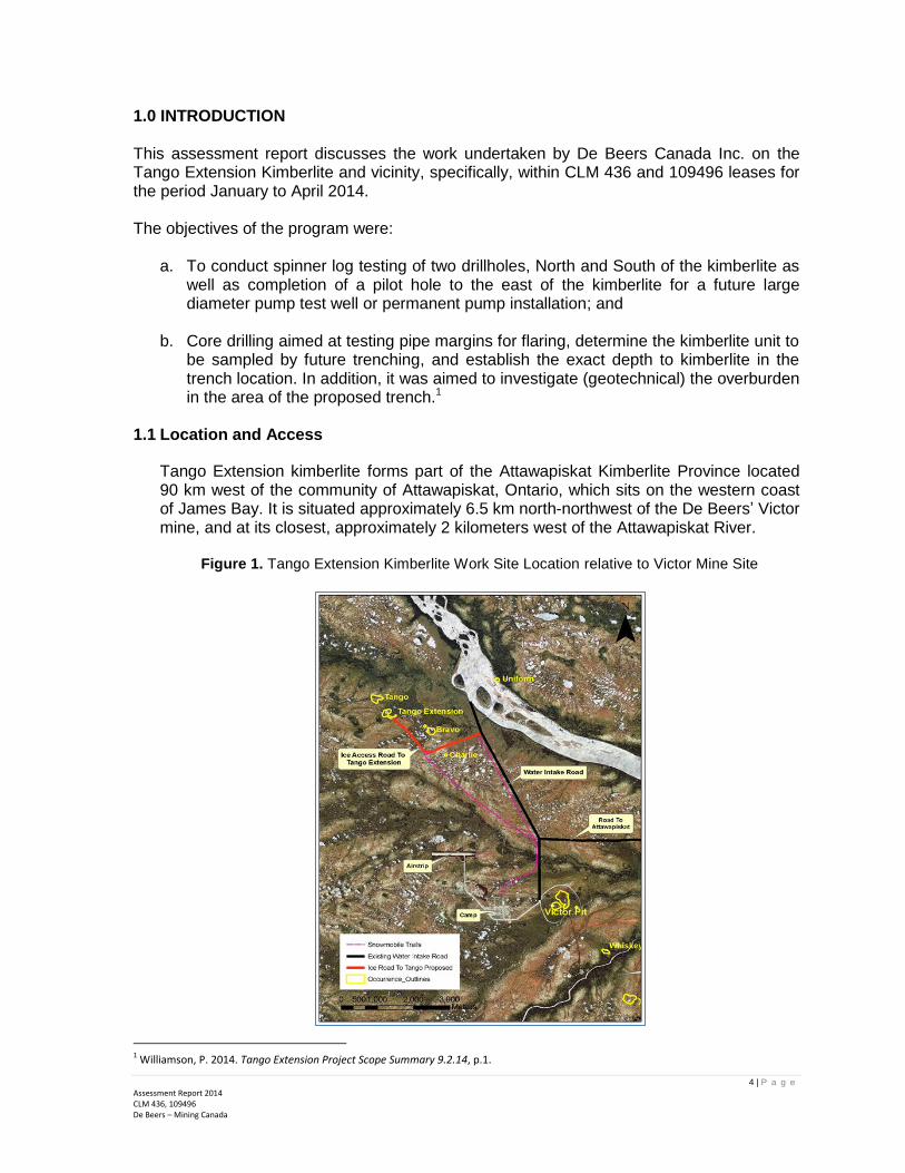
1.0 INTRODUCTION This assessment report discusses the work undertaken by De Beers Canada Inc. on the Tango Extension Kimberlite and vicinity, specifically, within CLM 436 and 109496 leases for the period January to April 2014. The objectives of the program were:
a. To conduct spinner log testing of two drillholes, North and South of the kimberlite as well as completion of a pilot hole to the east of the kimberlite for a future large diameter pump test well or permanent pump installation; and
b. Core drilling aimed at testing pipe margins for flaring, determine the kimberlite unit to be sampled by future trenching, and establish the exact depth to kimberlite in the trench location. In addition, it was aimed to investigate (geotechnical) the overburden in the area of the proposed trench.1
1.1 Location and Access
Tango Extension kimberlite forms part of the Attawapiskat Kimberlite Province located 90 km west of the community of Attawapiskat, Ontario, which sits on the western coast of James Bay. It is situated approximately 6.5 km north-northwest of the De Beers’ Victor mine, and at its closest, approximately 2 kilometers west of the Attawapiskat River.
Figure 1. Tango Extension Kimberlite Work Site Location relative to Victor Mine Site
1 Williamson, P. 2014. Tango Extension Project Scope Summary 9.2.14, p.1.

5 | P a g e
Assessment Report 2014 CLM 436, 109496 De Beers – Mining Canada
Access to the Victor mine is via Timmins, Ontario using a chartered commercial air flight provided by Air Creebec. Tango Extension kimberlite can then be accessed by road via travelling north for 5km on Victor Mine water intake road, then travelling west for 1.7km on the Tango Extension access spur road turning northward for ~1.3km on the Tango Extension access spur road and ending at Tango Extension.
Figure 2. Tango Extension Winter Access Road (broken red line) from/to Victor Mine
1.2 Dispositions and Ownership
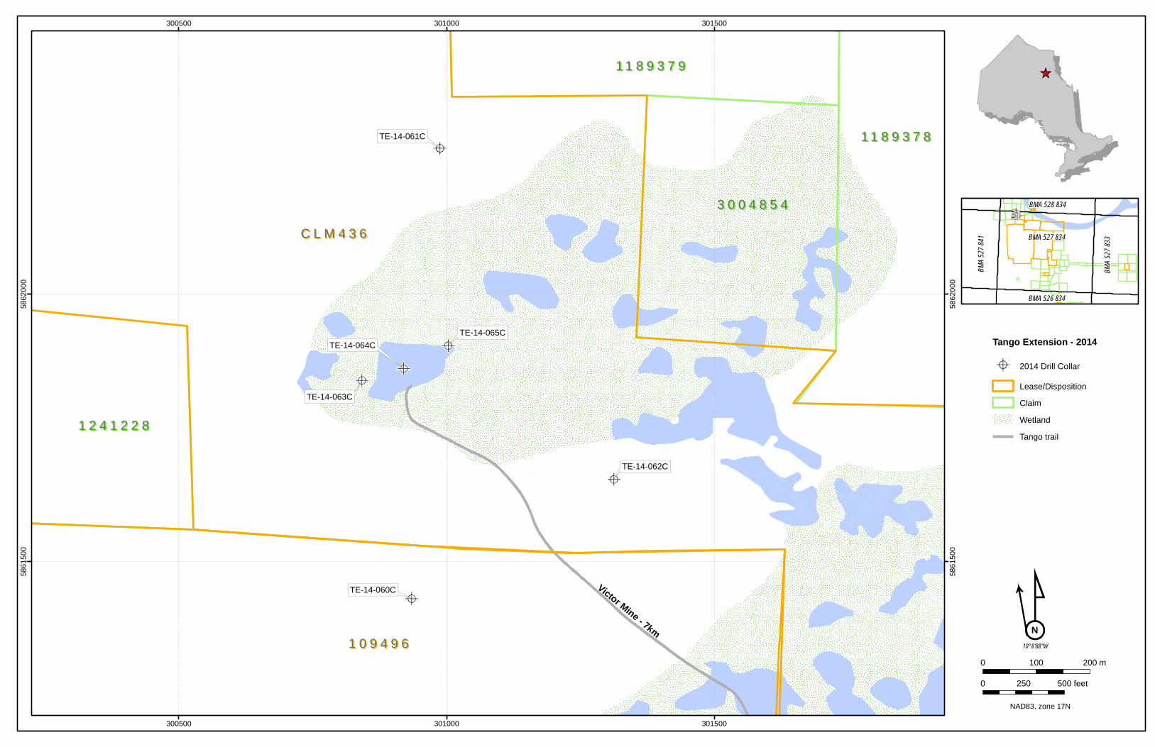
The Tango claim is linked by several mining permits identified as: CLM 436, P1241227, P1241228, 109495, and 109496. The holes drilled during the program lie within CLM 436 and 109496. The relative size and annual assessment requirement of the Tango claim is summarize in Table 1. Figure 3 shows the exact location of the drilled holes within CLM 436 and 109496 leases.
Table 1. Tango Area List of Dispositions/Claims
Project, Operation or
Mine
Magisterial District/Province
License/ Permit Type & Number
Claim Size (ha.)
Expiry Date
Assessment Commitments
($)
Tango/Bravo-1 Porcupine - BMA
527834 CLM 436 (Lease)
201.066 11/30/2024
Tango/Bravo-1 Porcupine - BMA
527834 P1241227 128 3/2/2016 3200
Tango/Bravo-1 Porcupine - BMA
527834 P1241228 16 3/2/2016 400
Tango/Bravo-1 Porcupine - BMA
527834 109495 (Lease)
14.057 7/2/2036
Tango/Bravo-1 Porcupine - BMA
527834 109496 (Lease)
210.526 7/2/2036

6 | P a g e
Assessment Report 2014 CLM 436, 109496 De Beers – Mining Canada
All of the claims are 100% owned by De Beers Canada Inc.
1.3 Topography and Drainage
The Tango Extension work area is situated within the Attawapiskat Watershed and is defined by a gently sloping topography that drains northwards into the Attawapiskat River, which ends at James Bay. The terrain is poorly drained due to the very low permeability of the marine silts and clays, and this same characteristic has allowed for the creation of aquifers at depth within the limestone sediments. Most of the small creeks barely dissect the terrain and are therefore isolated from the deeper groundwater aquifer.2
2 Murphy, C., et.al. Technical Report on Tango and Tango Extension Deep Kimberlites VicREP 2013, p. 26
Figure 3. De Beers’ Tango Claims showing 2014 Holes
7 | P a g e
Assessment Report 2014 CLM 436, 109496 De Beers – Mining Canada
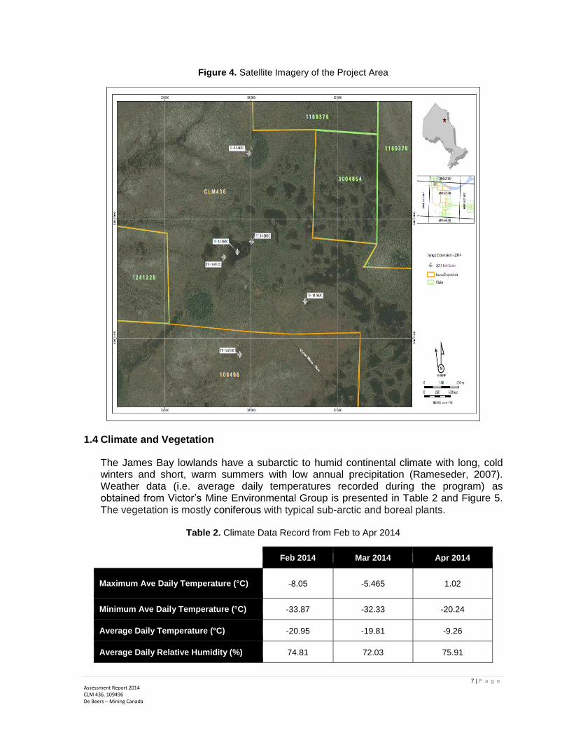
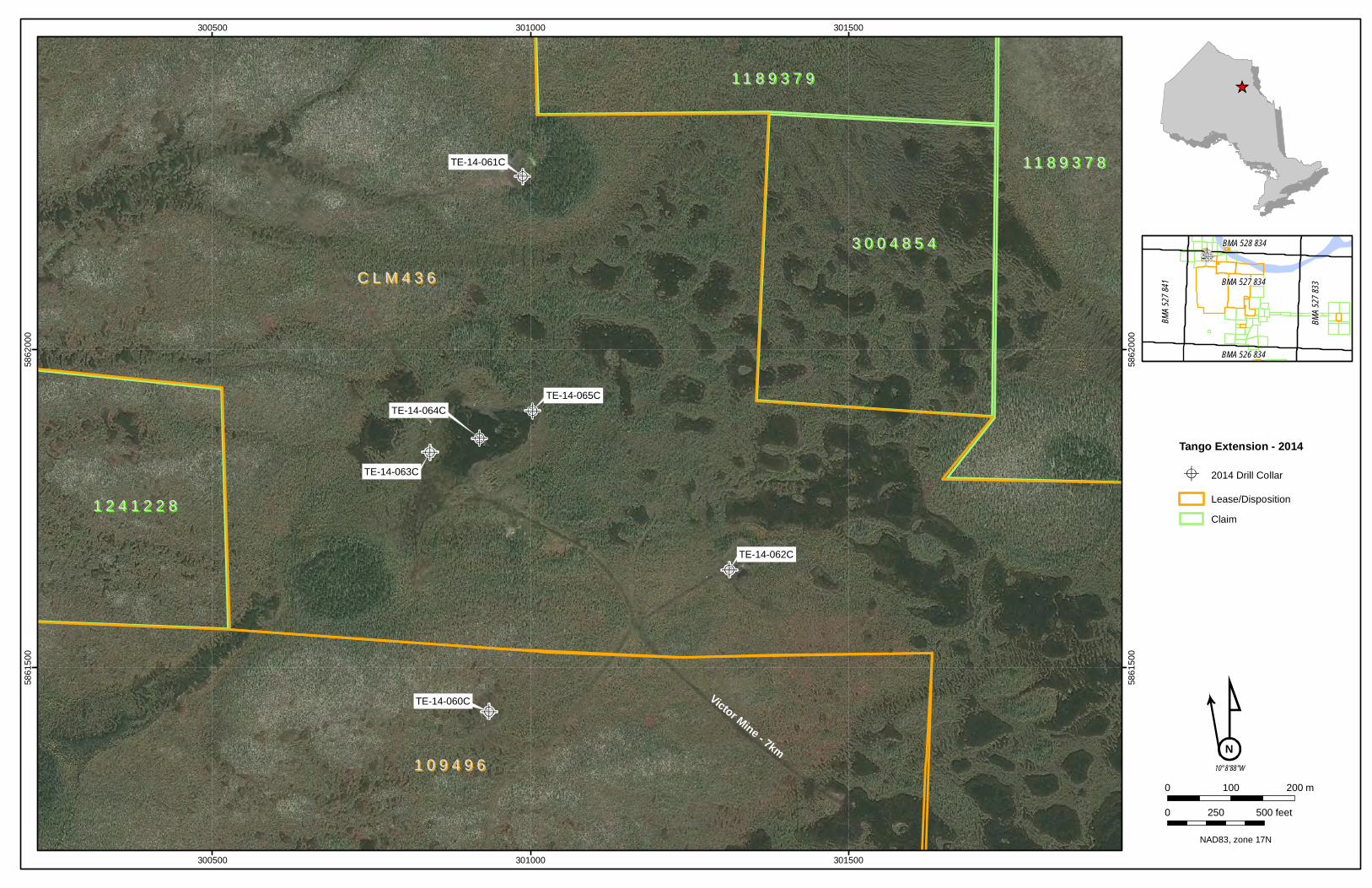
Figure 4. Satellite Imagery of the Project Area
1.4 Climate and Vegetation
The James Bay lowlands have a subarctic to humid continental climate with long, cold winters and short, warm summers with low annual precipitation (Rameseder, 2007). Weather data (i.e. average daily temperatures recorded during the program) as obtained from Victor’s Mine Environmental Group is presented in Table 2 and Figure 5. The vegetation is mostly coniferous with typical sub-arctic and boreal plants.
Table 2. Climate Data Record from Feb to Apr 2014
Feb 2014 Mar 2014 Apr 2014
Maximum Ave Daily Temperature (°C) -8.05 -5.465 1.02
Minimum Ave Daily Temperature (°C) -33.87 -32.33 -20.24
Average Daily Temperature (°C) -20.95 -19.81 -9.26
Average Daily Relative Humidity (%) 74.81 72.03 75.91

8 | P a g e
Assessment Report 2014 CLM 436, 109496 De Beers – Mining Canada
Figure 5. Average Daily Temperatures (⁰C) from Feb to Apr 2014
1.5 Planning, Permits and Environmental Management
The 2014 winter drilling program at Tango Extension was initiated, with approval, late in January 2014 following discussion with DBC Global Mining. Initial scope was to proceed with a three hole spinner logging program, however, in February additional scope was requested to consider to undertake limited core drilling as a test for flaring in the shallow portion of the pipe and also to geotechnically investigate the overburden in the area of the proposed trench, while also assessing the geotechnical aspect of the mudstone unit to the SW of the pipe for geotechnical characteristics and pit slope estimation3.
Permits and notices to drill were obtained prior to the program’s commencement and extended across the entire duration of the drilling activities. Notices include - Notice of Operation of a Core Drill and Notice of Project and Extended hours. Permits to take water and to discharge water were applied and subsequently granted by the Ministry of Environment on March 14, 2014. As an additional permit compliance item, an Operating Manual was developed and implemented for the pumping and discharge operation.
As part of De Beers’ ISO 14001 Environmental Management System (EMS) all work programs are required to adhere to all regulatory Acts, legislation and guidelines as they apply to waste management, storage and disposal. An Emergency Response Plan specifically for the 2014 program was developed. During the drill program, a SHE coordinator was engaged to supervise and support SHE programs of De Beers. Specifically, the following activities were carried out: a) Developed Safe Work Plans (SWP) b) Daily and weekly site inspections; c) Daily toolbox and weekly SHE meetings; d) Environmental site inspection and sign-off on all drill sites; e) Fire extinguishers, first aid kits, spill kits and eye wash stations were made available
at the drill sites and are regularly inspected; and
3 Williamson, P. 2014, Summary Report for the 2014 Winter Tango Extension Geohydrology and Delineation Drilling Program, p. 2.

9 | P a g e
Assessment Report 2014 CLM 436, 109496 De Beers – Mining Canada
f) Submitted daily reports on fuel consumption and water take records by drilling crew to Environment Department.
In addition, all personnel working on the program have undergone the following training (as required):
1. WHMIS 2. TDG – if working with or Transporting Dangerous Goods 3. Chainsaw license (only for personnel using chainsaws) 4. Spills containment and response (orientation/environment training modules) 5. Common Core – drillers and supervisors 6. Exposure to Exploration operating procedures relating to job activities (read/sign-off)
As a result, the drilling program was completed with 0 First Aid cases, 0 Medical Aid, 0 incident causing damage to equipment/property, and 3 minor environmental incidents which were all cleaned up and reported.
2.0 GEOLOGY 2.1 Previous Mapping
The Tango Extension kimberlite is within the so-called Attawapiskat kimberlite cluster (a cluster of 22 kimberlites) discovered in the late 1980’s. Eighteen (18) of which fall under the De Beers held claims and 4 lie within the KWG Resources held claims. All 18 kimberlites held by De Beers are diamondiferous, but little exploration work has been carried out on most, especially due to their small surface areas. The Attawapiskat kimberlites appear to cluster in a north-northwest elongated trend approaching 36 kilometers in length. Kimberlites discovered within the De Beers claims (refer to Figure 5) are: Alpha-1, Alpha-1 North, Bravo-1, Charlie-1, Delta-1, Golf-1, Golf Extension, India-1, Logan, Tango, Tango Extension, Uniform, Victor, Whiskey, X-Ray, X-Ray-1, Yankee and Zulu. The Victor kimberlite, currently under production and with reserves expected to have a mine life until the year 2018, has the largest surface area within the cluster at approximately 15 hectares.
The 4 remaining kimberlites fall under the KWG Resources. tenements and are: Good Friday, MacFayden 1, MacFayden 2, and MacFayden 2 south. Additional kimberlite bodies have been discovered by Navigator Resources on claims contiguous to De Beers (AT-56), but have been relinquished due to very small surface areas.

10 | P a g e
Assessment Report 2014 CLM 436, 109496 De Beers – Mining Canada
Figure 6. De Beers Claim Holdings and Locations of 16 Kimberlites discovered in Attawapiskat Area
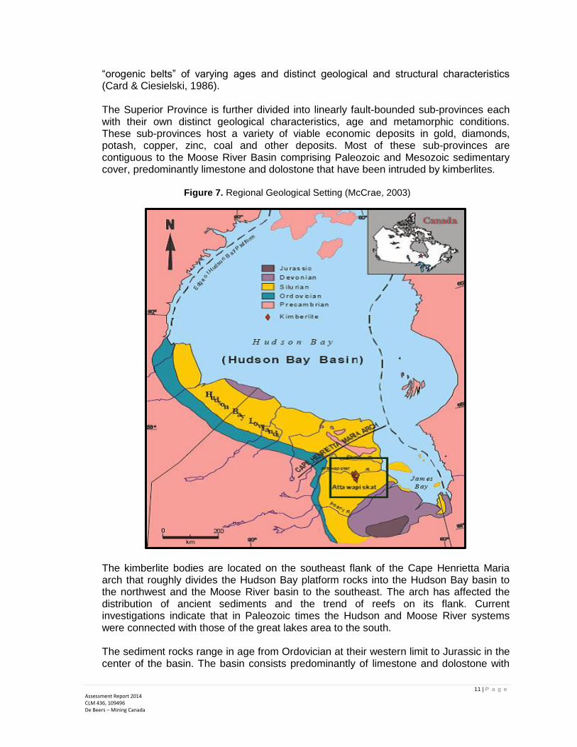
2.2 Regional Geology and Tectonic Setting
The Attawapiskat Kimberlite Province lies within the Western Superior Structural Province of the Canadian Shield. The Superior Province forms the core of the North American continent and is bound on all sides by cratons of Paleoproterozoic and Mesoproterozoic ages (Percival, Sanborn-Barrie, Stott, Helmsteadt, & Skulski, 2005). Current investigations indicate that the Superior Province is made up of a collage of tiny continental fragments of Mesoarchean age and Neoarchean oceanic plates with a complex history of aggregation between 2.72 and 2.68 Ga (Percival, Bleeker, Cook, Rivers, Ross, & Van Staal, 2004). The Superior Province is one of several Provinces that accreted and stabilized during the Wilson Cycle of “ocean closure” during the late Archean. These Archean Provinces are bound along their margins by structural
11 | P a g e
Assessment Report 2014 CLM 436, 109496 De Beers – Mining Canada
“orogenic belts” of varying ages and distinct geological and structural characteristics (Card & Ciesielski, 1986). The Superior Province is further divided into linearly fault-bounded sub-provinces each with their own distinct geological characteristics, age and metamorphic conditions. These sub-provinces host a variety of viable economic deposits in gold, diamonds, potash, copper, zinc, coal and other deposits. Most of these sub-provinces are contiguous to the Moose River Basin comprising Paleozoic and Mesozoic sedimentary cover, predominantly limestone and dolostone that have been intruded by kimberlites.
Figure 7. Regional Geological Setting (McCrae, 2003)
The kimberlite bodies are located on the southeast flank of the Cape Henrietta Maria arch that roughly divides the Hudson Bay platform rocks into the Hudson Bay basin to the northwest and the Moose River basin to the southeast. The arch has affected the distribution of ancient sediments and the trend of reefs on its flank. Current investigations indicate that in Paleozoic times the Hudson and Moose River systems were connected with those of the great lakes area to the south. The sediment rocks range in age from Ordovician at their western limit to Jurassic in the center of the basin. The basin consists predominantly of limestone and dolostone with
12 | P a g e
Assessment Report 2014 CLM 436, 109496 De Beers – Mining Canada
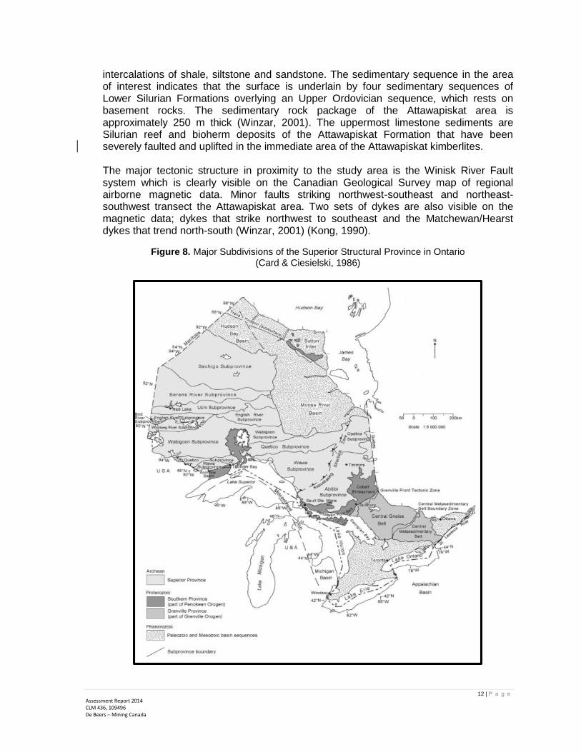
intercalations of shale, siltstone and sandstone. The sedimentary sequence in the area of interest indicates that the surface is underlain by four sedimentary sequences of Lower Silurian Formations overlying an Upper Ordovician sequence, which rests on basement rocks. The sedimentary rock package of the Attawapiskat area is approximately 250 m thick (Winzar, 2001). The uppermost limestone sediments are Silurian reef and bioherm deposits of the Attawapiskat Formation that have been severely faulted and uplifted in the immediate area of the Attawapiskat kimberlites. The major tectonic structure in proximity to the study area is the Winisk River Fault system which is clearly visible on the Canadian Geological Survey map of regional airborne magnetic data. Minor faults striking northwest-southeast and northeast-southwest transect the Attawapiskat area. Two sets of dykes are also visible on the magnetic data; dykes that strike northwest to southeast and the Matchewan/Hearst dykes that trend north-south (Winzar, 2001) (Kong, 1990).
Figure 8. Major Subdivisions of the Superior Structural Province in Ontario (Card & Ciesielski, 1986)
13 | P a g e
Assessment Report 2014 CLM 436, 109496 De Beers – Mining Canada
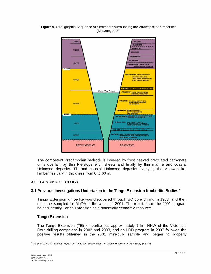
Figure 9. Stratigraphic Sequence of Sediments surrounding the Attawapiskat Kimberlites (McCrae, 2003)
The competent Precambrian bedrock is covered by frost heaved brecciated carbonate units overlain by thin Pleistocene till sheets and finally by thin marine and coastal Holocene deposits. Till and coastal Holocene deposits overlying the Attawapiskat kimberlites vary in thickness from 0 to 60 m.
3.0 ECONOMIC GEOLOGY
3.1 Previous Investigations Undertaken in the Tango Extension Kimberlite Bodies 4
Tango Extension kimberlite was discovered through BQ core drilling in 1988, and then mini-bulk sampled for MaDA in the winter of 2001. The results from the 2001 program helped identify Tango Extension as a potentially economic resource. Tango Extension The Tango Extension (TE) kimberlite lies approximately 7 km NNW of the Victor pit. Core drilling campaigns in 2002 and 2003, and an LDD program in 2003 followed the positive results obtained in the 2001 mini-bulk sample and began to properly
4 Murphy, C., et.al. Technical Report on Tango and Tango Extension Deep Kimberlites VicREP 2013, p. 34-35

14 | P a g e
Assessment Report 2014 CLM 436, 109496 De Beers – Mining Canada
delineate the body. A heli-portable LF-70 drill rig was utilized for the 2002 and 2003 core drilling, while the LDD drilling was completed using a Foremost CT550 rig that drilled three 24” diameter holes. A total of 193,650 kg of wet material (504.44 m of kimberlite) was shipped to Grande Prairie for processing, returning a grade of 18 cpht. The TE pipe model featuring the kimberlite’s internal geology was created after this drilling, and was later updated in 2009 by re-logging of existing 2003 cores. In 2010, another drill program consisting of four LDD holes (not including one LDD hole that was abandoned) and 18 HQ core holes was completed, adding further confidence to the kimberlite’s model and grade. The 18 core holes were drilled in clusters of 2, 3 or 4 in and around the body. Each cluster was planned with a vertical hole and 1, 2 or 3 angled holes drilled away from the center of the kimberlite pipe for modeling purposes. This core drilling was conducted with two Zinex A5 drill machines, designated A5-1 and A5-2, and it was during this program that the Tango Extension Deep structure was first encountered in hole TE-10-055C. Unfortunately, the hole intersected a large floating reef and was unable to prove the existence of undiluted kimberlite at depth, therefore generating the need for the VicREP 2013 program at Tango Extension Deep.
Tango Extension is currently undergoing a conceptual phase of engineering design in order to determine whether or not the body can economically produce material that will add to Victor’s life of mine.
3.2 Geology of the Tango Extension Kimberlite
The Tango Extension pipe has a surface area of approximately 7 ha, while the Tango Extension Deep structure’s gravity anomaly indicates a surface size of 17 hectares. Tango Extension is an amoeboid-shaped body showing no obvious trend, and the Tango Extension Deep structure is a NE-SW trending oval. The body outline was postulated from the interpretation of Geophysical surveys which cover Tango Extension.
4.0 INVESTIGATIONS5 4.1 Ground Preparation
Prior to drilling, Ausenco Sandwell was requested by De Beers to determine the required frozen ground thickness to support the drilling equipment transport and positioning. The assessment resulted in the following recommendations6:
Required frozen ground thickness for initial roadway opening using a CAT D5 (20,434 lbs.) is 14” (36cm);
Required frozen ground thickness for mobilizing the drill rig (72,000 lbs.) is 20 inches;
Required frozen ground thickness for the drill sites is 31” and 35” when using top drive and bottom drive pullback, respectively.
Once the recommended ice thickness was known, MKS Construction was contracted for actual ground works i.e. frost thickening and access pad preparation.
5 Williamson, P. Summary Report for the 2014 Winter Tango Extension Geohydrology and Delineation Drilling Program, p. 5-6. 6 Ausenco, Feb 2014. Assessment of the Required Frozen Ground Thickness, p. 4.

15 | P a g e
Assessment Report 2014 CLM 436, 109496 De Beers – Mining Canada
4.2 Hydrogeology7
The main component of the program was the spinner log testing of two drillholes north (TE-3) and south (TE-4) of Tango Extension kimberlite as well as completion of a pilot hole to the east (TE-P) of the kimberlite for a future large diameter pump test well or permanent pump installation. In a broader perspective, this drilling will provide additional information in the development of a new regional groundwater flow model for the Victor Mine Extension Project. An illustration of the spinner log is shown below:
Figure 10. Spinner Log
Location of the planned holes is shown in Figure 11 while the corresponding planned coordinates for these holes are provided in Table 3.
Figure 11. Planned Location of Hydrogeology Holes
7 Williamson, P. Summary Report for the 2014 Winter Tango Extension Geohydrology and Delineation Program, p. 3-5. Williamson, P. Tango Extension Project Scope Summary 9.2.14. p.1-3.
16 | P a g e
Assessment Report 2014 CLM 436, 109496 De Beers – Mining Canada
Table 3. Hydrogeology Holes Planned Coordinates
HOLE-ID Planned Hole ID
Easting Northing Elevation Length DH Type Azi Dip
TE-14-062C TE-P 301326 5861672 88 200 8.75-in 0 -90
TE-14-061C TE-3 300988 5862274 88 200 8.75-in 0 -90
TE-14-060C TE-4 300933 5861433 88 200 8.75-in 0 -90
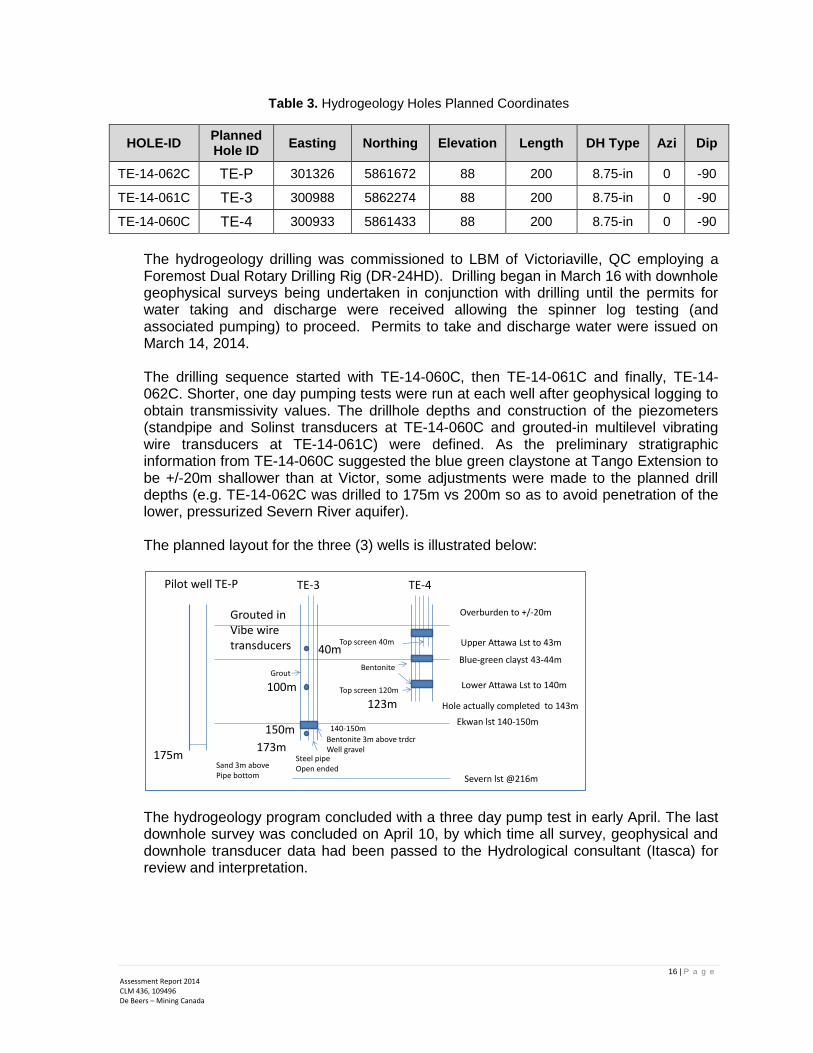
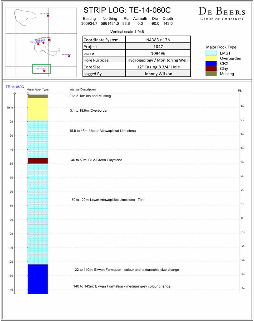
The hydrogeology drilling was commissioned to LBM of Victoriaville, QC employing a Foremost Dual Rotary Drilling Rig (DR-24HD). Drilling began in March 16 with downhole geophysical surveys being undertaken in conjunction with drilling until the permits for water taking and discharge were received allowing the spinner log testing (and associated pumping) to proceed. Permits to take and discharge water were issued on March 14, 2014.
The drilling sequence started with TE-14-060C, then TE-14-061C and finally, TE-14-062C. Shorter, one day pumping tests were run at each well after geophysical logging to obtain transmissivity values. The drillhole depths and construction of the piezometers (standpipe and Solinst transducers at TE-14-060C and grouted-in multilevel vibrating wire transducers at TE-14-061C) were defined. As the preliminary stratigraphic information from TE-14-060C suggested the blue green claystone at Tango Extension to be +/-20m shallower than at Victor, some adjustments were made to the planned drill depths (e.g. TE-14-062C was drilled to 175m vs 200m so as to avoid penetration of the lower, pressurized Severn River aquifer). The planned layout for the three (3) wells is illustrated below:
The hydrogeology program concluded with a three day pump test in early April. The last downhole survey was concluded on April 10, by which time all survey, geophysical and downhole transducer data had been passed to the Hydrological consultant (Itasca) for review and interpretation.
Pilot well TE-P TE-3 TE-4
Sand 3m above Pipe bottom
175m173m
Ekwan lst 140-150m
Severn lst @216m
Grouted inVibe wire transducers
Steel pipeOpen ended
Bentonite 3m above trdcrWell gravel
150m
100m
40m
Grout
140-150m
Blue-green clayst 43-44m
Overburden to +/-20m
Upper Attawa Lst to 43m
Lower Attawa Lst to 140mTop screen 120m
Bentonite
Top screen 40m
123m Hole actually completed to 143m

17 | P a g e
Assessment Report 2014 CLM 436, 109496 De Beers – Mining Canada
4.3 Core Drilling (Delineation)8 Two delineation core holes were planned, one in the west and another in the northeast to better constrain the shallow kimberlite contacts within Tango Extension. One additional vertical core hole was planned in the center of the pipe to determine overburden thickness and to provide samples for geotechnical characterization of the material.
Figure 12. Outline of Tango Extension Kimberlite with Location of Core Holes Planned
Note: UTM Projection & Datum NAD83 Canada Mean, Zone 17N.
There was a plan to drill a deeper geotechnical core hole to the SW of Tango Extension, but due to the slower than expected startup to the core drilling program, which was in part due to water supply pump delays, the originally planned deeper geotechnical hole could no longer be completed within the original budget and was not executed.
Table 4. Planned Core Hole Locations
Hole Objective Hole ID Planned Hole ID Easting Northing Elev. Azi Dip
Planned Depth
Delineation TE-14-063C TE-12-del1 300836 5861834 88 300 -47 100
Delineation TE-14-065C TE-12-del4 301003 5861905 88 65 -49 100
Overburden/ Geotech
TE-14-064C TE-14-TRENCH 300920 5861861 88 0 -90 30
Core drilling was manned by Foraco Drilling Company using De Beers’ owned A5-2 drill rig. Drilling started on the western delineation core hole TE-14-63C on March 16, 2014 on a double shift basis. The trench overburden geotechnical hole was drilled between March 21-25 on a single shift basis as a Geotechnical Engineer from Golder Associates had been brought to site to supervise the overburden drilling, Shelby Tube sampling, and Shear Vane testing. The northeasterly delineation hole TE-14-65C was completed from March 25-29.
8 Williamson, P. Summary Report for the 2014 Winter Tango Extension Geohydrology and Delineation Program, p. 5-6.

18 | P a g e
Assessment Report 2014 CLM 436, 109496 De Beers – Mining Canada
Core from the delineation holes was preliminarily logged at site, photographed, packaged and shipped to the DBC Sudbury warehouse for detailed logging and sampling while the samples collected from the trench overburden hole were sent to the Golder laboratory in Mississauga for geotechnical interpretation.
5.0 RESULTS 5.1 Hydrogeology Holes9
Table 5. Surveyed Drillhole Location Summary for the Hydrogeology Holes
Drillhole NAD 83 Zone 17
Azi Dip Start Date End Date EOH (m) Northing Easting Elev.
TE-14-060C 5861431 300934.7 88.779 0 -90 3/2/2014 3/5/2014 143
TE-14-061C 5862273 300987.9 88.195 0 -90 3/8/2014 3/10/2014 173.4
TE-14-062C 5861654 301312.5 87.98 0 -90 3/12/2014 3/16/2014 175.24
Total Meters Drilled 491.64
As part of the hydrogeological characterization at Victor Mine, borehole logging consisting of the following was conducted in TE-14-061C, TE-14-060C and TE-14-062C:
Caliper logs to assess borehole diameter and the locations of fractured zones in the bores;
Groundwater production (spinner) logs to assess the locations of groundwater inflow zones;
Groundwater electrical conductivity logs to assess groundwater characteristics in the various geologic formations penetrated by the bores; and
Natural gamma logs to locate stratigraphic marker horizons including overburden, the blue-green claystone, and the Attawapiskat–Ekwan River Formation contact.
Correspondingly, Itasca made the following interpretations based on the information collected: Characteristics identifiable on the three boreholes based on caliper logs are increased fracturing (or possibly solution cavity development) to a depth of at least 50 mbgs. This zone extends to approximately to 60mbgs in TE-14-060C and TE-14-061C and corresponds to the Upper Attawapiskat Unit. Fracturing is also observed in all three bores from approximately 120 to 130 mbgs, which corresponds to the Attawapiskat–Ekwan River Formation contact. The natural gamma logs are very similar for all three boreholes and clearly delineate geologic formation contacts. The logs indicate that the overburden extends to variable
9 Itasca, Denver Inc., April 2014. Predicted Dewatering and Hydrogeological Effects (Draft), p.10-14.
19 | P a g e
Assessment Report 2014 CLM 436, 109496 De Beers – Mining Canada
depths of approximately 30 mbgs at TE-14-061C, 20 mbgs at TE-14-060C, and 13 mbgs at TE-14-062C. The Upper Attawapiskat Unit extends from the bottom of the overburden to the top of the blue-green claystone at depths of approximately 45 to 50 mbgs. The Lower Attawapiskat Unit extends to the top of the Ekwan River Formation, which is clearly marked by gamma spikes at depths of approximately 125, 120, and 130 mbgs for TE-14-061C, TE-14-060C and TE-14-062C, respectively. This formation stratigraphy is exactly analogous to the stratigraphy at Victor Mine—which has similar overburden thicknesses, depth to the blue-green claystone, and depth to the Ekwan River Formation. The production logs were obtained by lowering the so-called “spinner” tool through the water column in the bore while pumping groundwater from the bore at a rate of 350 U.S. gallons per minute (gpm). An electrical submersible pump was set inside the surface casing at the top of each bore and the spinner tool was lowered at a constant rate from a depth just below the pump intake to the bottom of the bore. The production log indicates where groundwater production is occurring, as a percentage of total production over the length of the bore. The production log for TE-14-061C shows slightly increasing production up through the Ekwan River Formation, but this formation only accounts for approximately 18% of total flow. In the upper and Lower Attawapiskat Unit, production zones occur from 100 to 120 mbgs and from 65 to 40 mbgs. The Attawapiskat Formation produces approximately 82% of the flow in this bore. The production log for TE-14-060C shows very little production from the Ekwan River Formation, which accounts for less than 10% of borehole inflow. Production increases throughout the lower and Upper Attawapiskat Unit with marked increases in flow at 93 mbgs and between approximately 30 and 53 mbgs. The production log for TE-14-062C could only be run to a depth of 125 mbgs because of an obstruction in the borehole. The log shows steadily increasing production up through the Lower Attawapiskat Unit with an abrupt increase at 93 mbgs and another at approximately 63 mbgs from an interval located just below the blue-green claystone. Production is limited from approximately 40 to 61 mbgs but steadily increases between 40 and 20 mbgs. The logs for boreholes TE-14-061C and TE-14-060C are similar in form, showing conductivity increases at depths of about 110 to 120 mbgs. These depths correspond to the contact of the Lower Attawapiskat Unit with the Ekwan River Formation and indicate that higher conductivity groundwater is present in the Ekwan River Formation. The log for TE-14-062C does not indicate a conductivity increase at the lower Attawapiskat–Ekwan River contact as observed at TE-14-061C and TE-14-060C. As indicated by the associated natural gamma log, it does show conductivity increases associated with the interbedded fine-grained strata of the Ekwan River Formation. With the additional observations noted above and previous studies, a draft regional groundwater flow model for the Victor Mine Extension Project was generated.

20 | P a g e
Assessment Report 2014 CLM 436, 109496 De Beers – Mining Canada
5.2 Core Drilling (Delineation)
Table 6. Surveyed Drillhole Location Summary for the 2014 Core Holes
Hole Objective
Drillhole NAD 83 Zone 17
Azi Dip Start Date End Date EOH (m) Northing Easting Elev.
Delineation TE-14-063C
5861839 300842 88.278 306 -48.5 3/16/2014 3/21/2014 134
Overburden/Geotech
TE-14-064C
5861861 300920 88 0 -90 3/21/2014 3/25/2014 31.1
Delineation TE-14-065C
5861904 301003.
1 87.827 72.5 -50.6 3/25/2014 3/29/2014 153
Total Meters Drilled 318.1
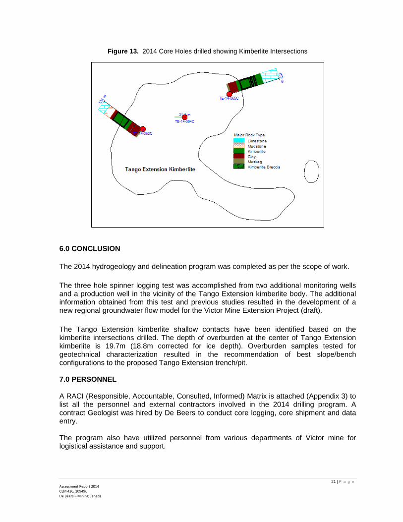
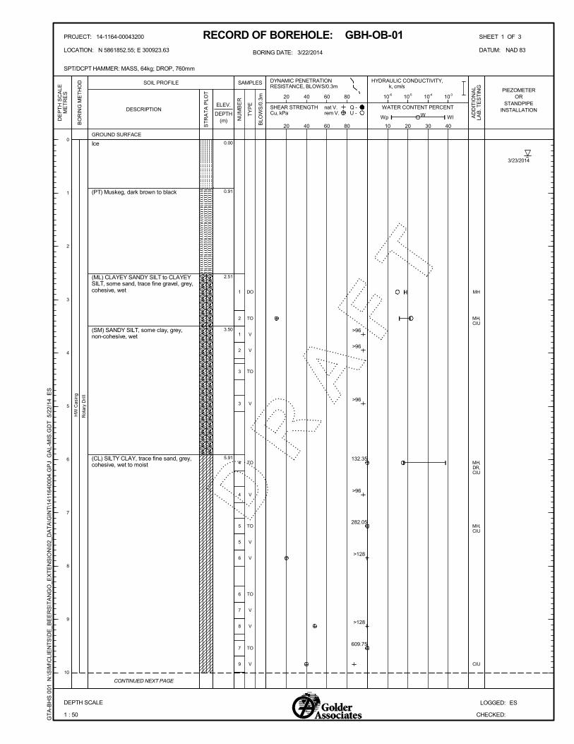
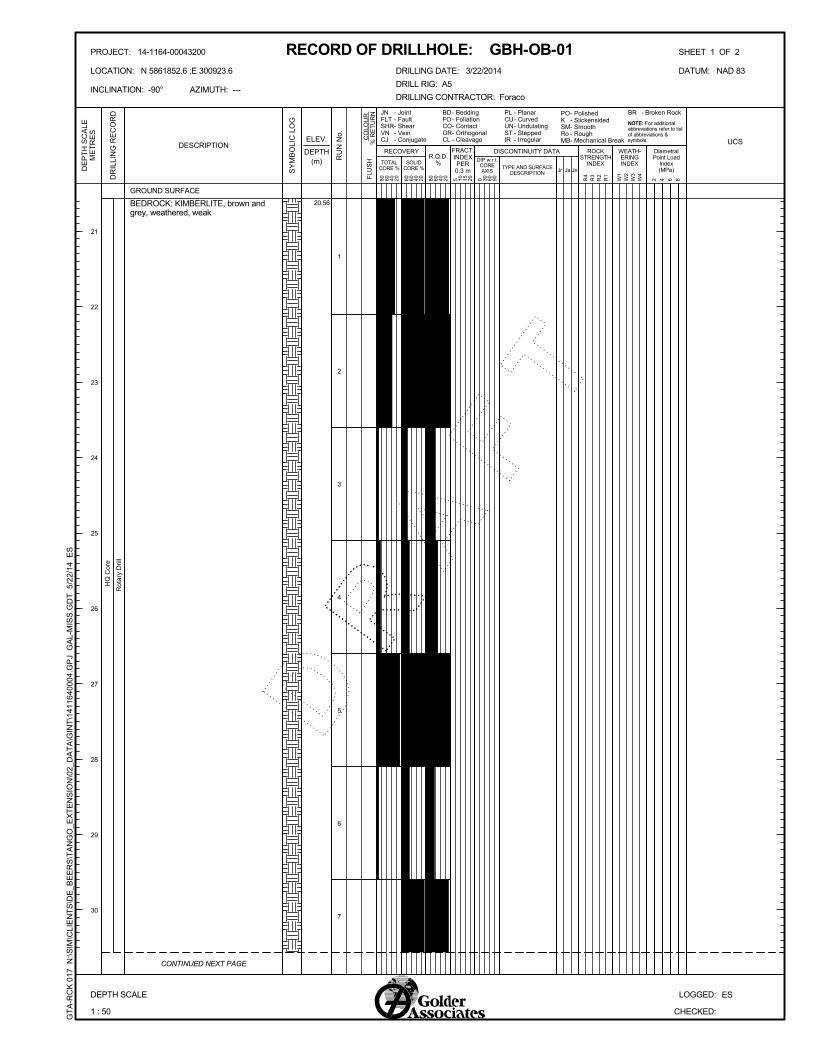
Overburden drilling in TE-14-064C was conducted by advancing HW casing and obtaining Shelby tube samples coupled with in-situ vane testing performed approximately 1m intervals for the first 10m and 2.5m intervals thereafter through the clay / till until bedrock was encountered, to delineate the overburden bedrock contact. Approximately 10.5m of HQ core was obtained to characterize the upper kimberlite zone prior to borehole completion. Total depth of the drilling was 31.1m, consisting of 19.7m of overburden and 10.5m of bedrock. It should be noted that the borehole was located overtop a small frozen pond with a depth of about 0.9m. The bedrock encountered is kimberlite which appears to be slightly-moderately to highly weathered towards the end of hole. Total Core Recovery ranged from 27-100% with an average of 73%. The Solid Core Recovery is from 0-65%, average 28% while RQD range from 0-75% and 32% average. Six (6) overburden samples were submitted to laboratory for testing of the following: moisture content, grain size distribution, Atterberg limits, specific gravity and consolidated undrained triaxial testing. Sampling results have led the Geotechnical consultants to come up with recommendations regarding future overburden slope design and excavation considerations.10 For the two holes drilled in pipe margins, TE-14-063C intersected kimberlite from 37 to 86m while TE-14-065C crossed kimberlite from 28.5 to 105m. Both characterize a weathered kimberlite near surface and brecciated kimberlite at depth. Kimberlite intersections for the three holes are listed in Table 7. A section of the holes in plan view is shown in Figure 13.
Table 7. Kimberlite Intersections at the Drilled Tango Extension Core Holes
Hole Objective Drillhole ID Kimberlite Intersection Kimberlite
Thickness (m) EOH (m)
Top (m) Bottom (m)
Delineation TE-14-063C 37 86 49 134
Overburden/Geotech TE-14-064C 19.7 31.1 11.4 31.1
Delineation TE-14-065C 28.5 105 76.5 153
Total Meters 136.9 318.1
10 Golder (2014). Updated Overburden Slope Stability Recommendations – Tango Extension, p. 2-3.
21 | P a g e
Assessment Report 2014 CLM 436, 109496 De Beers – Mining Canada
Figure 13. 2014 Core Holes drilled showing Kimberlite Intersections
6.0 CONCLUSION
The 2014 hydrogeology and delineation program was completed as per the scope of work.
The three hole spinner logging test was accomplished from two additional monitoring wells and a production well in the vicinity of the Tango Extension kimberlite body. The additional information obtained from this test and previous studies resulted in the development of a new regional groundwater flow model for the Victor Mine Extension Project (draft).
The Tango Extension kimberlite shallow contacts have been identified based on the kimberlite intersections drilled. The depth of overburden at the center of Tango Extension kimberlite is 19.7m (18.8m corrected for ice depth). Overburden samples tested for geotechnical characterization resulted in the recommendation of best slope/bench configurations to the proposed Tango Extension trench/pit. 7.0 PERSONNEL A RACI (Responsible, Accountable, Consulted, Informed) Matrix is attached (Appendix 3) to list all the personnel and external contractors involved in the 2014 drilling program. A contract Geologist was hired by De Beers to conduct core logging, core shipment and data entry. The program also have utilized personnel from various departments of Victor mine for logistical assistance and support.

22 | P a g e
Assessment Report 2014 CLM 436, 109496 De Beers – Mining Canada
8.0 PROJECT COST The total cost incurred for the project is CAD$1,546,475.00. The summary of expenses is tabulated in Appendix 4 – Statement of Costs. 9.0 REFERENCES Ausenco (2014). De Beers Canada Inc. Tango Ext. Drilling Program 2014 Assessment of the Required Frozen Ground Thickness, p. 1-21. Card, K. D., & Ciesielski, A. (1986). Subdivisions of the Superior Province of the Canadian Shield. Geoscience Canada 13, p. 5-13. Golder Associates (2014). Updated Overburden Slope Design Recommendations, Tango Extension Advanced Exploration Pit, De Beers Victor Mine, p. 1-9. Itasca Denver, Inc. (2014). Predicted Dewatering and Hydrogeological Effects: Victor Mine Extension Project, p. 10-14. Murphy, C., Sykes, M., Hunchak, A., et.al. (2013). Technical Report: Tango and Tango Extension Deep Kimberlites, VicREP 2013. De Beers Internal Report, p.1-83. Williamson P. (2014). Summary Report for the 2014 Winter Tango Extension Geohydrology and Delineation Drilling Program, p. 1-9. Williamson P. (2014). Tango Extension Scope Summary 9.2.14, p. 1-10. Winzar, D. (2001). 2001 Attawapiskat Mini-Bulk Sampling Drilling Report. De Beers Canada Internal Report. McCrae, S. (2003). Attawapiskat Geology and Mineral Chemistry. De Beers Internal Report.

23 | P a g e
Assessment Report 2014 CLM 436, 109496 De Beers – Mining Canada
Appendix 1: 2014 Tango Extension Drill Plans (Large Scale Map 1:5000)
Victor Mine - 7km
1 2 4 1 2 2 81 2 4 1 2 2 8
C L M 4 3 6C L M 4 3 6
1 1 8 9 3 7 91 1 8 9 3 7 9
3 0 0 4 8 5 43 0 0 4 8 5 4
1 1 8 9 3 7 81 1 8 9 3 7 8
1 0 9 4 9 61 0 9 4 9 6
TE-14-062C
TE-14-061C
TE-14-060C
TE-14-065CTE-14-064C
TE-14-063C
300500
300500
301000
301000
301500
301500
5861
500
5861
500
5862
000
5862
000
0 200100 m
Tango Extension - 2014
2014 Drill CollarLease/DispositionClaimWetlandTango trail
BMA 527 834
BMA 528 834
BMA 526 834
BMA 5
27 833
BMA 5
27 841
0 500250 feet
NAD83, zone 17N
10°8'88"WN
Victor Mine - 7km
1 2 4 1 2 2 81 2 4 1 2 2 8
C L M 4 3 6C L M 4 3 6
1 1 8 9 3 7 91 1 8 9 3 7 9
3 0 0 4 8 5 43 0 0 4 8 5 4
1 1 8 9 3 7 81 1 8 9 3 7 8
1 0 9 4 9 61 0 9 4 9 6
TE-14-062C
TE-14-061C
TE-14-060C
TE-14-065CTE-14-064C
TE-14-063C
300500
300500
301000
301000
301500
301500
5861
500
5861
500
5862
000
5862
000
0 200100 m
Tango Extension - 2014
2014 Drill CollarLease/DispositionClaim
BMA 527 834
BMA 528 834
BMA 526 834
BMA 5
27 833
BMA 5
27 841
0 500250 feet
NAD83, zone 17N
10°8'88"WN
26 | P a g e
Assessment Report 2014 CLM 436, 109496 De Beers – Mining Canada
Appendix 2: Tango Extension Holes Summary and Strip Logs

27 | P a g e
Assessment Report 2014 CLM 436, 109496 De Beers – Mining Canada
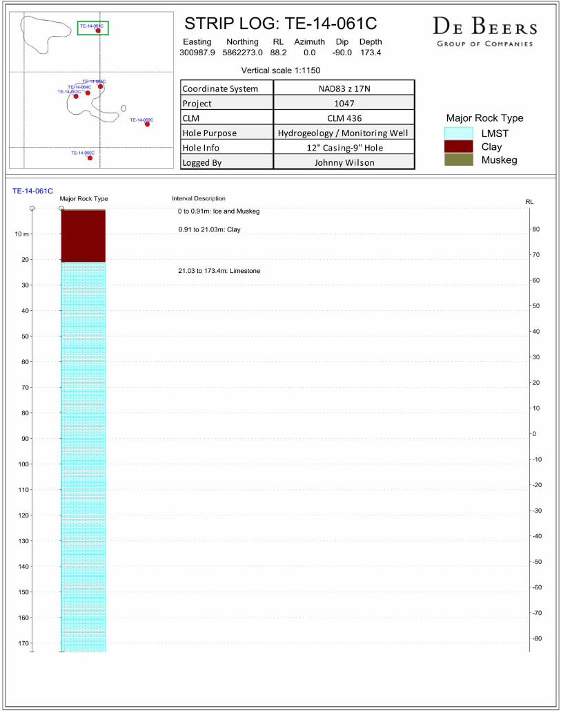
2.2 TE-14-060C Hole Summary
HOLE SUMMARY Hole ID TE-14-060C
Planned Hole ID TE-4
Hole Purpose Monitoring Well
Kimberlite Body Tango Extension
Start Date March 2, 2014
Finish Date March 5, 2014
Easting 300934.7
Northing 5861431
Elevation 88.779
Datum NAD 83, Zone 17N
Azimuth 0
Dip -90
Topography Land
Drilling Contractor LBM Les Forages
Drill Rig DR-24 HD
Drilling Method Reverse Circulation
Casing Diameter 12 inch
Casing Depth 24.2 m
Planned Depth 200 m
Final Depth 143 m
EOH Lithology Country Rock (CRX) Geologists Johnny Wilson
Top of Kimberlite None Project Manager Peter Williamson
Bottom of Kimberlite None
Kimberlite Drilled 0
Number of Core Boxes None
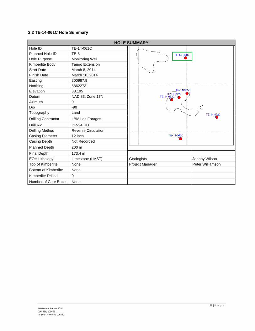
29 | P a g e
Assessment Report 2014 CLM 436, 109496 De Beers – Mining Canada
2.2 TE-14-061C Hole Summary
HOLE SUMMARY Hole ID TE-14-061C
Planned Hole ID TE-3
Hole Purpose Monitoring Well
Kimberlite Body Tango Extension
Start Date March 8, 2014
Finish Date March 10, 2014
Easting 300987.9
Northing 5862273
Elevation 88.195
Datum NAD 83, Zone 17N
Azimuth 0
Dip -90
Topography Land
Drilling Contractor LBM Les Forages
Drill Rig DR-24 HD
Drilling Method Reverse Circulation
Casing Diameter 12 inch
Casing Depth Not Recorded
Planned Depth 200 m
Final Depth 173.4 m
EOH Lithology Limestone (LMST) Geologists Johnny Wilson
Top of Kimberlite None Project Manager Peter Williamson
Bottom of Kimberlite None
Kimberlite Drilled 0
Number of Core Boxes None

31 | P a g e
Assessment Report 2014 CLM 436, 109496 De Beers – Mining Canada
2.5 TE-14-062C Hole Summary
HOLE SUMMARY Hole ID TE-14-062C
Planned Hole ID TE-PROTO
Hole Purpose Pump Test
Kimberlite Body Tango Extension
Start Date March 12, 2014
Finish Date March 16, 2014
Easting 301312.5
Northing 5861654
Elevation 87.98
Datum NAD 83, Zone 17N
Azimuth 0
Dip -90
Topography Land
Drilling Contractor LBM Les Forages
Drill Rig DR-24 HD
Drilling Method Rotary Casing then Tricone
Casing Diameter 23 inch & 8.75”
Casing Depth Not Recorded
Planned Depth 200 m
Final Depth 175.24 m
EOH Lithology Limestone (LMST) Geologists Johnny Wilson
Top of Kimberlite None Project Manager Peter Williamson
Bottom of Kimberlite None
Kimberlite Drilled 0
Number of Core Boxes None


33 | P a g e
Assessment Report 2014 CLM 436, 109496 De Beers – Mining Canada
2.6 TE-14-063C Hole Summary & Field Geology Log
HOLE SUMMARY Hole ID TE-14-063C
Planned Hole ID TE-12 del1
Hole Purpose Delineation
Kimberlite Body Tango Extension
Start Date March 16, 2014
Finish Date March 21, 2014
Easting 300842
Northing 5861839
Elevation 88.278
Datum NAD 83, Zone 17N
Azimuth 306
Dip -48.5
Topography Land
Drilling Contractor Foraco
Drill Rig A5-2
Drilling Method Core
Casing Diameter HWT
Core Size HQ
Planned Depth 100 m
Final Depth 134 m
EOH Lithology Limestone (LMST) Geologists Johnny Wilson
Top of Kimberlite 37 m Project Manager Peter Williamson
Bottom of Kimberlite 86 m
Kimberlite Drilled 49 m
Number of Core Boxes 31

35 | P a g e
Assessment Report 2014 CLM 436, 109496 De Beers – Mining Canada
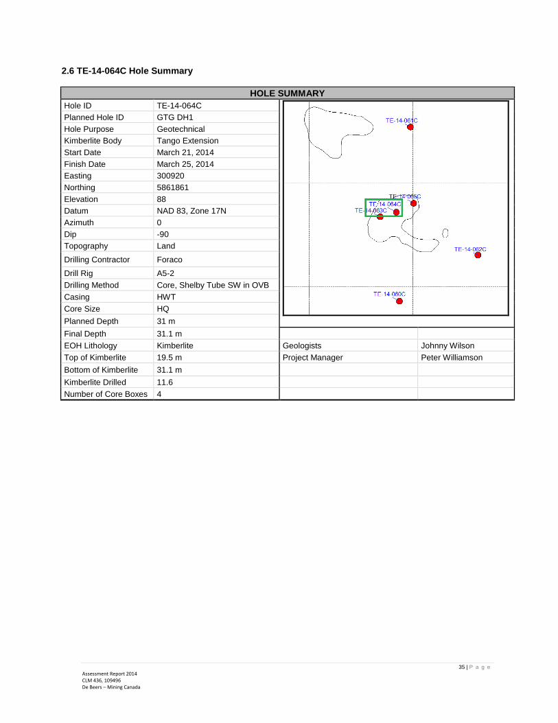
2.6 TE-14-064C Hole Summary
HOLE SUMMARY Hole ID TE-14-064C
Planned Hole ID GTG DH1
Hole Purpose Geotechnical
Kimberlite Body Tango Extension
Start Date March 21, 2014
Finish Date March 25, 2014
Easting 300920
Northing 5861861
Elevation 88
Datum NAD 83, Zone 17N
Azimuth 0
Dip -90
Topography Land
Drilling Contractor Foraco
Drill Rig A5-2
Drilling Method Core, Shelby Tube SW in OVB
Casing HWT
Core Size HQ
Planned Depth 31 m
Final Depth 31.1 m
EOH Lithology Kimberlite Geologists Johnny Wilson
Top of Kimberlite 19.5 m Project Manager Peter Williamson
Bottom of Kimberlite 31.1 m
Kimberlite Drilled 11.6
Number of Core Boxes 4

MH
MH,CIU
MH,DR,CIU
MH,CIU
CIU
DO
TO
V
V
TO
V
TO
V
TO
V
V
TO
V
V
TO
V
HW
Cas
ing
1
2
1
2
3
3
4
4
5
5
6
6
7
8
7
9
Rot
ary
Dri
ll
Ice
(PT) Muskeg, dark brown to black
(ML) CLAYEY SANDY SILT to CLAYEYSILT, some sand, trace fine gravel, grey,cohesive, wet
(SM) SANDY SILT, some clay, grey,non-cohesive, wet
(CL) SILTY CLAY, trace fine sand, grey,cohesive, wet to moist
0.91
2.51
3.50
5.91
3/23/2014
BLO
WS
/0.3
m
BORING DATE: 3/22/2014
NU
MB
ER
W
WATER CONTENT PERCENTELEV.
AD
DIT
ION
AL
LAB
. TE
ST
ING
DESCRIPTION
Wl
10 20 30 40ST
RA
TA
PLO
T
HYDRAULIC CONDUCTIVITY, k, cm/s
BO
RIN
G M
ET
HO
D
TY
PE
SAMPLES
DEPTH(m)
SOIL PROFILE
RECORD OF BOREHOLE: GBH-OB-01
Wp
SHEET 1 OF 3
PIEZOMETEROR
STANDPIPEINSTALLATION
10-6 10-5 10-4 10-3
SPT/DCPT HAMMER: MASS, 64kg; DROP, 760mm
DEPTH SCALE
1 : 50
GROUND SURFACE
DE
PT
H S
CA
LEM
ET
RE
S
0
1
2
3
4
5
6
7
8
9
10
CONTINUED NEXT PAGE
LOGGED:
CHECKED:
PROJECT: 14-1164-00043200
LOCATION: N 5861852.55; E 300923.63
0.00
ES
DATUM: NAD 83G
TA
-BH
S 0
01 N
:\SIM
\CLI
EN
TS
\DE
_B
EE
RS
\TA
NG
O_E
XT
EN
SIO
N\0
2_D
AT
A\G
INT
\141
1640
004
.GP
J G
AL-
MIS
.GD
T 5
/22
/14
ES
DYNAMIC PENETRATIONRESISTANCE, BLOWS/0.3m
nat V.rem V.
20 40 60 80
20 40 60 80
Q -U -
SHEAR STRENGTHCu, kPa
>96
>96
>96
>96
>128
>128
132.35
282.05
609.75

MH,CIU
CIU
MH,DR,CIU
CIU
V
TO
V
V
TO
V
V
TO
V
V
TO
V
V
TO
V
V
TO
V
V
HW
Cas
ing
10
8
11
12
9
13
14
10
15
16
11
17
18
12
19
20
13
21
22
Rot
ary
Dri
ll
(CL) SILTY CLAY, trace fine sand, grey,cohesive, wet to moist
(CL-ML) CLAY, some silt to CLAYEYSILT, grey, cohesive, moist
10.79
BLO
WS
/0.3
m
BORING DATE: 3/22/2014
NU
MB
ER
W
WATER CONTENT PERCENTELEV.
AD
DIT
ION
AL
LAB
. TE
ST
ING
DESCRIPTION
Wl
10 20 30 40ST
RA
TA
PLO
T
HYDRAULIC CONDUCTIVITY, k, cm/s
BO
RIN
G M
ET
HO
D
TY
PE
SAMPLES
DEPTH(m)
SOIL PROFILE
RECORD OF BOREHOLE: GBH-OB-01
Wp
SHEET 2 OF 3
PIEZOMETEROR
STANDPIPEINSTALLATION
10-6 10-5 10-4 10-3
SPT/DCPT HAMMER: MASS, 64kg; DROP, 760mm
DEPTH SCALE
1 : 50
DE
PT
H S
CA
LEM
ET
RE
S
10
11
12
13
14
15
16
17
18
19
20
CONTINUED NEXT PAGE
LOGGED:
CHECKED:
--- CONTINUED FROM PREVIOUS PAGE ---
PROJECT: 14-1164-00043200
LOCATION: N 5861852.55; E 300923.63
ES
DATUM: NAD 83G
TA
-BH
S 0
01 N
:\SIM
\CLI
EN
TS
\DE
_B
EE
RS
\TA
NG
O_E
XT
EN
SIO
N\0
2_D
AT
A\G
INT
\141
1640
004
.GP
J G
AL-
MIS
.GD
T 5
/22
/14
ES
DYNAMIC PENETRATIONRESISTANCE, BLOWS/0.3m
nat V.rem V.
20 40 60 80
20 40 60 80
Q -U -
SHEAR STRENGTHCu, kPa
117
>128
>128
>128
>128
>128
>128
>128
120.6
>128
>128
>128
>128
348.5
214.3

HW
Cas
ing
Rot
ary
Dri
ll (CL-ML) CLAY, some silt to CLAYEYSILT, grey, cohesive, moist
BLO
WS
/0.3
m
BORING DATE: 3/22/2014
NU
MB
ER
W
WATER CONTENT PERCENTELEV.
AD
DIT
ION
AL
LAB
. TE
ST
ING
DESCRIPTION
Wl
10 20 30 40ST
RA
TA
PLO
T
HYDRAULIC CONDUCTIVITY, k, cm/s
BO
RIN
G M
ET
HO
D
TY
PE
SAMPLES
DEPTH(m)
SOIL PROFILE
RECORD OF BOREHOLE: GBH-OB-01
Wp
SHEET 3 OF 3
PIEZOMETEROR
STANDPIPEINSTALLATION
10-6 10-5 10-4 10-3
SPT/DCPT HAMMER: MASS, 64kg; DROP, 760mm
DEPTH SCALE
1 : 50
DE
PT
H S
CA
LEM
ET
RE
S
20
21
22
23
24
25
26
27
28
29
30
LOGGED:
CHECKED:
--- CONTINUED FROM PREVIOUS PAGE ---
PROJECT: 14-1164-00043200
LOCATION: N 5861852.55; E 300923.63
ES
DATUM: NAD 83G
TA
-BH
S 0
01 N
:\SIM
\CLI
EN
TS
\DE
_B
EE
RS
\TA
NG
O_E
XT
EN
SIO
N\0
2_D
AT
A\G
INT
\141
1640
004
.GP
J G
AL-
MIS
.GD
T 5
/22
/14
ES
DYNAMIC PENETRATIONRESISTANCE, BLOWS/0.3m
nat V.rem V.
20 40 60 80
20 40 60 80
Q -U -
SHEAR STRENGTHCu, kPa
HQ
Cor
e
1
2
3
4
5
6
7
BEDROCK: KIMBERLITE, brown andgrey, weathered, weak
Rot
ary
Dril
l- Polished- Slickensided- Smooth- Rough- Mechanical Break
POKSMRoMB
- Broken Rock
RECORD OF DRILLHOLE: GBH-OB-01
DESCRIPTION
5 10 15 20
DISCONTINUITY DATA
1 : 50
CONTINUED NEXT PAGE
ESLOGGED:
CHECKED:
RECOVERY
JNFLTSHRVNCJ
FLU
SH
PLCUUNSTIR
DRILLING DATE: 3/22/2014
DRILL RIG: A5
DRILLING CONTRACTOR: Foraco
RU
N N
o.
SY
MB
OLI
C L
OG
SHEET 1 OF 2
NOTE: For additionalabbreviations refer to listof abbreviations &symbols.
SOLIDCORE %
PROJECT: 14-1164-00043200
LOCATION: N 5861852.6 ;E 300923.6
DE
PT
H S
CA
LEM
ET
RE
S
DATUM: NAD 83
DEPTH SCALE
21
22
23
24
25
26
27
28
29
30
- Joint- Fault- Shear- Vein- Conjugate
BDFOCOORCL
20406080
DEPTH(m) TOTAL
CORE %Index
BR- Planar- Curved- Undulating- Stepped- Irregular
- Bedding- Foliation- Contact- Orthogonal- Cleavage C
OLO
UR
%
RE
TU
RN
DR
ILLI
NG
RE
CO
RD
20406080
ELEV.
R.Q.D.%
20.56
GROUND SURFACE
Point LoadDiametral
20406080
INCLINATION: -90° AZIMUTH: ---
FRACT.INDEXPER0.3 m
DIP w.r.t.COREAXIS
0 30 60 90
TYPE AND SURFACEDESCRIPTION Jr JnJa (MPa)
WEATH-ERINGINDEX
W1
W2
W3
W4
R4
R3
R2
R1
ROCKSTRENGTH
INDEX
2 4 6 8
UCS
GT
A-R
CK
017
N
:\SIM
\CLI
EN
TS
\DE
_BE
ER
S\T
AN
GO
_EX
TE
NS
ION
\02_
DA
TA
\GIN
T\1
4116
4000
4.G
PJ
GA
L-M
ISS
.GD
T 5
/22/
14
ES

HQ
Cor
e
7
BEDROCK: KIMBERLITE, brown andgrey, weathered, weak
31.10
Rot
ary
Dril
l- Polished- Slickensided- Smooth- Rough- Mechanical Break
POKSMRoMB
- Broken Rock
RECORD OF DRILLHOLE: GBH-OB-01
DESCRIPTION
5 10 15 20
DISCONTINUITY DATA
1 : 50
ESLOGGED:
CHECKED:
RECOVERY
JNFLTSHRVNCJ
FLU
SH
PLCUUNSTIR
DRILLING DATE: 3/22/2014
DRILL RIG: A5
DRILLING CONTRACTOR: Foraco
RU
N N
o.
SY
MB
OLI
C L
OG
SHEET 2 OF 2
NOTE: For additionalabbreviations refer to listof abbreviations &symbols.
SOLIDCORE %
--- CONTINUED FROM PREVIOUS PAGE ---
PROJECT: 14-1164-00043200
LOCATION: N 5861852.6 ;E 300923.6
DE
PT
H S
CA
LEM
ET
RE
S
DATUM: NAD 83
DEPTH SCALE
31
32
33
34
35
36
37
38
39
40
- Joint- Fault- Shear- Vein- Conjugate
BDFOCOORCL
20406080
DEPTH(m) TOTAL
CORE %Index
BR- Planar- Curved- Undulating- Stepped- Irregular
- Bedding- Foliation- Contact- Orthogonal- Cleavage C
OLO
UR
%
RE
TU
RN
DR
ILLI
NG
RE
CO
RD
20406080
ELEV.
R.Q.D.%
Point LoadDiametral
20406080
INCLINATION: -90° AZIMUTH: ---
FRACT.INDEXPER0.3 m
DIP w.r.t.COREAXIS
0 30 60 90
TYPE AND SURFACEDESCRIPTION Jr JnJa (MPa)
WEATH-ERINGINDEX
W1
W2
W3
W4
R4
R3
R2
R1
ROCKSTRENGTH
INDEX
2 4 6 8
UCS
GT
A-R
CK
017
N
:\SIM
\CLI
EN
TS
\DE
_BE
ER
S\T
AN
GO
_EX
TE
NS
ION
\02_
DA
TA
\GIN
T\1
4116
4000
4.G
PJ
GA
L-M
ISS
.GD
T 5
/22/
14
ES

42 | P a g e
Assessment Report 2014 CLM 436, 109496 De Beers – Mining Canada
2.6 TE-14-065C Hole Summary
HOLE SUMMARY
Hole ID TE-14-065C
Planned Hole ID
Hole Purpose Delineation
Kimberlite Body Tango Extension
Start Date March 25, 2014
Finish Date March 29, 2014
Easting 301003.1
Northing 5861904
Elevation 87.827
Datum NAD 83, Zone 17N
Azimuth 72.5
Dip -50.6
Topography Land
Drilling Contractor Foraco
Drill Rig A5-2
Drilling Method Core
Casing HWT
Core Size HQ
Planned Depth 100 m
Final Depth 153 m
EOH Lithology Limestone (LMST) Geologists Johnny Wilson
Top of Kimberlite 28.5 Project Manager Peter Williamson
Bottom of Kimberlite 105
Kimberlite Drilled 76.44
Number of Core Boxes 48


Appendix 3. RACI Matrix
2014 TANGO EXTENSION GEOHYDROLOGY PROGRAM Responsible Accountable Consulted Informed
Program ManagementPeter Williamson,
PMO
Peter Williamson,
PMO
Leo Fusciardi,
Technical Services, Itasca
Tony Guthrie,
James Kirby,
Brad Wood, Glenn
Koropchuk
Program Administration (Budget, Schedule, Resourcing) Peter Williamson, PMO Peter Williamson, PMO
DBCI Technical,
Victor Mine Management,
DBCI FIC, HR, AA,
Leo Fusciardi,
Technical Services, Itasca
VM Environmental
Permitting AMEC E&IBrian Steinback,
Martin PodolskyVM Environmental
Leo Fusciardi,
Victor Mine Env Dept. MOL
Safety, Health & Risk Team Members Peter Williamson, PMO Victor Mine S,H & R Dept
Leo Fusciardi,
David Putnam,
James Kirby,
Doug Brown,
Brian Steinback
Environmental Team Members Peter Williamson, PMO Victor Mine Env Dept
Leo Fusciardi,
David Putnam,
James Kirby,
Doug Brown,
Brian Steinback
Drill Hole layout, provisional hole numbers, orientations & scopesHC Itasca, AMEC E&I
Golder
Peter Williamson,
Martin Podolsky.
Marc Ruest,
Patrick Rummel,
Brian Steinback,
MOE
Leo Fusciardi,
Brad Wood,
Brian Steinback,
MOE
Hydrogeology scopeHC Itasca Peter Williamson,
Brian Steinback
AMEC E&I
MOE, Victor Mine Env.
Dept.
Leo Fusciardi,
Brad Wood,
James Kirby,
MOE
Pump Test Equipment & Materials Mobilisation to Victor Logistics Program Management Nancy BilodeauBrian Steinback,
Patrick Rummel
Personnel travel to Timmins: De Beers De Beers personnel Peter Williamson, PMO Victor Travel HR & Training
Personnel travel to Timmins: LBM LBM Peter Williamson, PMO Victor Travel HR & Training
Personnel travel to Timmins: HC Itasca HC Itasca Peter Williamson, PMO Victor Travel HR & Training
Personnel travel ex. Attawapiskat: MKS to Victor MKS Peter Williamson, PMO Victor Travel HR & Training
Personnel travel to Site: Timmins - Victor HR & Travel Department Peter Williamson, PMO Victor Travel HR & Training
Accommodation on site HR / Camp Administration Peter Williamson, PMO HR Staff & Contractors
Equipment maintenance Mobile Equipment Maintenance Program Management
Contractors,
Program Supervisors,
SHE
Technical Services,
Mine Operations,
Logistics,
Projects
Program SHE OPs Program SHE Coordinator Program ManagementVictor SHE Department,
Program SupervisorsBrian Steinback
Training
Program SHE Coordinator,
Program Supervisors,
Training Department
Program Management SHE Department Program Workers
SHE Performance, SWPs Program SHE Coordinator Program ManagementSHE Department,
Program Supervisors
Program Workers,
Victor Mine Management,
DBCI SHE
Personnel Safety Program Workers & Supervisors
Program Management,
Program SHE
Coordinator
SHE Department
Program Workers,
Victor Mine Management,
DBCI SHE
Winter Muskeg Road AccecssMKS, LBM,
Program SupervisorsProgram Management
Ausenco, Mine
Operations,
Logistics
Technical Services,
Projects,
SHE Department
Drill Site Preparation
Program Supervisors,
Drill Contractor,
MKS
Program ManagementMine Operations,
Logistics, Ausenco
Technical Services,
Projects,
SHE Department
Transport of Personnel and Equipment to drill sites Workers & Supervisors,
LBMProgram Management
Logistics,
SHE DepartmentProtective Services,
8 3/4-inch Spinner Log wellsHC Itasca,
LBMProgram Management
VM Tech Services
Patrick Rummel,
AMEC E&I,
MOE
Brian Steinback,
Technical Services
Piezometer BoreholesPatrick Rummel, HC Itasca,
LBMProgram Management
VM Tech Services
Patrick Rummel,
AMEC E&I,
MOE
Brian Steinback,
Technical Services
Discharge of drilling water and drill chipsProgram SHE Coordinator,
Drill ContractorsProgram Management Victor Mine Env. Dept. MOE
Rig Movement between sitesDe Beers Supervisor
Drill ContractorsProgram Management
Logistics,
Mine Operations,
SHE Department
Brad Wood,
Brian Steinback,
Doug Brown,
Drill hole grouting procedure LBM, De beers Supervisors Peter Williamson Itasca, Technical Services Program Management
Drill hole grouting De Beers Supervisor,
Drill ContractorsProgram Management Technical Services,
Itasca,
SHE Department
Core Drilling Equipment Demobilisation to Victor Foraco Program ManagementLogistics,
SHE DepartmentTechnical Services
LDD Rig & Equipment Demobilisation to Victor LBM Program ManagementLogistics,
SHE DepartmentTechnical Services
QA/QC of Drill, Logging & Sampling Data Itasca, Patrick Rummel Program ManagementGroup MRM,
Technical Services
Mansour Shoari, VM Tech
Services
Geohydrology Model update HC Itasca Program Management
Patrick Rummel,
Technical Services, Amec
E & I
Leo Fusciardi,
Tech. Serv., B. Steinback,
Scott Ladd, Doug Scott
DBCI Technical

1. LABOUR & FIELD SUPERVISION 41,385.00 a. Geologists (Rate: $50/hr)
b. Assistants (Rate: $20/hr)
2. CONTRACTOR'S & CONSULTANT FEES 1,313,586.00 a. Ground Preparation
▪ Ausenco Sandwell (Ice Engineering Services) 25,700.00
b. Drilling
▪ LBM Rotary Drilling and General Services (Hydrogeology) 1,043,816.00
▪ Foraco (Core Drilling) 123,264.00
c. Environmental Monitoring Services 36,480.00
d. Hydrogeological Consultants 25,235.00
e. Geotechnical Consultant Services 59,091.00
3. SUPPLIES USED & EQUIPMENT RENTAL 132,949.00 a. Equipment Rental
▪ Submersible Pump Rental 13,000.00
▪ Downhole Instrument Rental 2,546.00
b. Transducer Purchase 5,434.00
c. Victor Dozer Charges 33,915.00
d. Fuel, Oil & Lubricant 40,838.00
e. VM Warehouse Items
▪ Radios (7 units) 8,400.00
▪ Absorbents and Spill Kits 7,000.00
▪ Miscellaneous Field Supplies 5,000.00
▪ Piezometer Materials and Equipment 15,000.00
▪ PPE and Signage 800.00
▪ Office Supplies 216.00
▪ Electrical and Mechanical Items 800.00
4. FOOD & LODGING 42,449.00 ▪ Victor Accommodation & Admin 42,449.00
5. TRANSPORTATION of PERSONS w/in ONTARIO to & from MINING LAND 12,106.00 ▪ Victor Air Charter 12,106.00
6. SHIPMENT OF SAMPLES 4,000.00 ▪ Freight - Air 4,000.00
Certification verifying costs:
___________________________ December 1, 2015 Signature Date
Appendix 4.
ASSESSMENT WORK STATEMENT OF COSTS
(CLM 436 and 109496 Leases)
TOTAL COSTS (in CAD$) 1,546,475.00
I, Peter Williamson, do hereby certify that the amounts shown are as accurate as may reasonably determined and the costs were
incurred while conducting assessment work on the Tango claim area. As Advanced Exploration Manager, I am authorized to make
this certification.
41,385.00