Embed Size (px)
Citation preview
NCEA Level 1 Geography (91010) 2018 — page 1 of 12
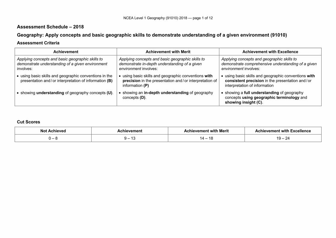
Assessment Schedule – 2018 Geography: Apply concepts and basic geographic skills to demonstrate understanding of a given environment (91010) Assessment Criteria
Achievement Achievement with Merit Achievement with Excellence
Applying concepts and basic geographic skills to demonstrate understanding of a given environment involves:
Applying concepts and basic geographic skills to demonstrate in-depth understanding of a given environment involves:
Applying concepts and geographic skills to demonstrate comprehensive understanding of a given environment involves:
• using basic skills and geographic conventions in the presentation and / or interpretation of information (B)
• using basic skills and geographic conventions with precision in the presentation and / or interpretation of information (P)
• using basic skills and geographic conventions with consistent precision in the presentation and / or interpretation of information
• showing understanding of geography concepts (U). • showing an in-depth understanding of geography concepts (D).
• showing a full understanding of geography concepts using geographic terminology and showing insight (C).
Cut Scores
Not Achieved Achievement Achievement with Merit Achievement with Excellence
0 – 8 9 – 13 14 – 18 19 – 24
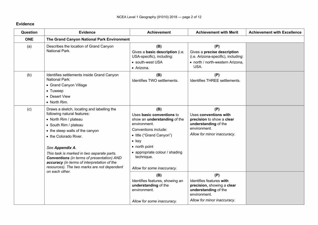
NCEA Level 1 Geography (91010) 2018 — page 2 of 12
Evidence
Question Evidence Achievement Achievement with Merit Achievement with Excellence
ONE The Grand Canyon National Park Environment
(a) Describes the location of Grand Canyon National Park.
(B) Gives a basic description (i.e. USA-specific), including: • south-west USA • Arizona.
(P) Gives a precise description (i.e. Arizona-specific), including: • north / north-western Arizona,
USA.
(b) Identifies settlements inside Grand Canyon National Park: • Grand Canyon Village • Tuweep • Desert View • North Rim.
(B) Identifies TWO settlements.
(P) Identifies THREE settlements.
(c) Draws a sketch, locating and labelling the following natural features: • North Rim / plateau • South Rim / plateau • the steep walls of the canyon • the Colorado River. See Appendix A. This task is marked in two separate parts. Conventions (in terms of presentation) AND accuracy (in terms of interpretation of the resources). The two marks are not dependent on each other.
(B) Uses basic conventions to show an understanding of the environment. Conventions include: • title (“Grand Canyon”) • key • north point • appropriate colour / shading
technique. Allow for some inaccuracy.
(P) Uses conventions with precision to show a clear understanding of the environment. Allow for minor inaccuracy.
(B) Identifies features, showing an understanding of the environment. Allow for some inaccuracy.
(P) Identifies features with precision, showing a clear understanding of the environment. Allow for minor inaccuracy.
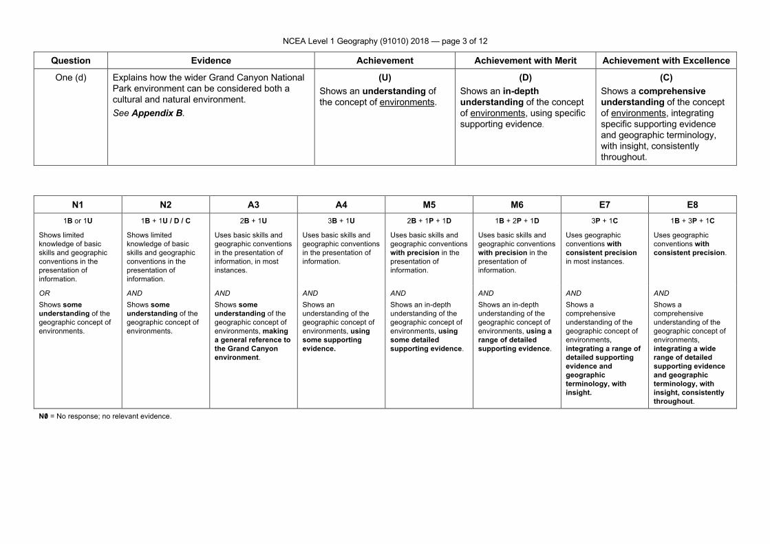
NCEA Level 1 Geography (91010) 2018 — page 3 of 12
Question Evidence Achievement Achievement with Merit Achievement with Excellence
One (d) Explains how the wider Grand Canyon National Park environment can be considered both a cultural and natural environment. See Appendix B.
(U) Shows an understanding of the concept of environments.
(D) Shows an in-depth understanding of the concept of environments, using specific supporting evidence.
(C) Shows a comprehensive understanding of the concept of environments, integrating specific supporting evidence and geographic terminology, with insight, consistently throughout.
N1 N2 A3 A4 M5 M6 E7 E8 1B or 1U 1B + 1U / D / C 2B + 1U 3B + 1U 2B + 1P + 1D 1B + 2P + 1D 3P + 1C 1B + 3P + 1C
Shows limited knowledge of basic skills and geographic conventions in the presentation of information.
Shows limited knowledge of basic skills and geographic conventions in the presentation of information.
Uses basic skills and geographic conventions in the presentation of information, in most instances.
Uses basic skills and geographic conventions in the presentation of information.
Uses basic skills and geographic conventions with precision in the presentation of information.
Uses basic skills and geographic conventions with precision in the presentation of information.
Uses geographic conventions with consistent precision in most instances.
Uses geographic conventions with consistent precision.
OR Shows some understanding of the geographic concept of environments.
AND Shows some understanding of the geographic concept of environments.
AND Shows some understanding of the geographic concept of environments, making a general reference to the Grand Canyon environment.
AND Shows an understanding of the geographic concept of environments, using some supporting evidence.
AND Shows an in-depth understanding of the geographic concept of environments, using some detailed supporting evidence.
AND Shows an in-depth understanding of the geographic concept of environments, using a range of detailed supporting evidence.
AND Shows a comprehensive understanding of the geographic concept of environments, integrating a range of detailed supporting evidence and geographic terminology, with insight.
AND Shows a comprehensive understanding of the geographic concept of environments, integrating a wide range of detailed supporting evidence and geographic terminology, with insight, consistently throughout.
N0/ = No response; no relevant evidence.
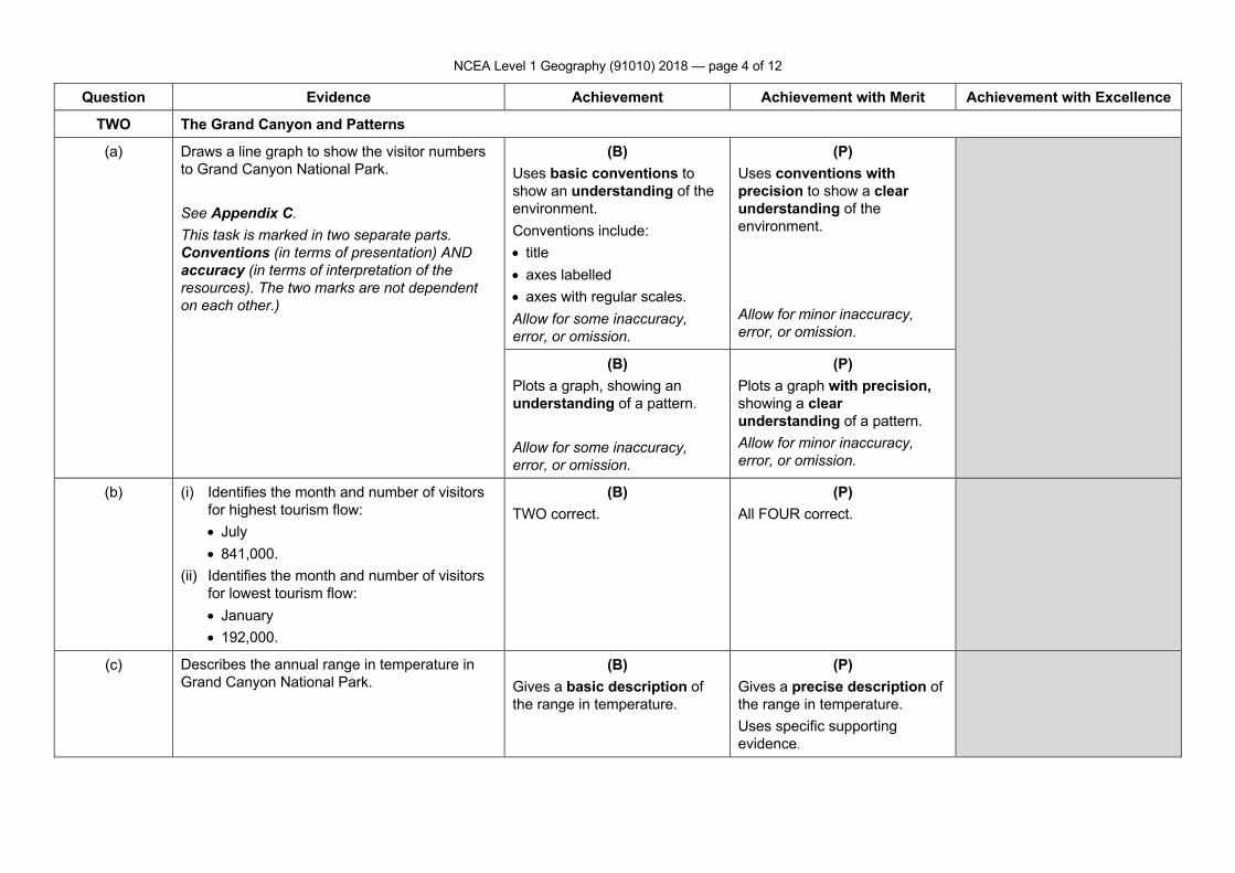
NCEA Level 1 Geography (91010) 2018 — page 4 of 12
Question Evidence Achievement Achievement with Merit Achievement with Excellence
TWO The Grand Canyon and Patterns
(a) Draws a line graph to show the visitor numbers to Grand Canyon National Park. See Appendix C. This task is marked in two separate parts. Conventions (in terms of presentation) AND accuracy (in terms of interpretation of the resources). The two marks are not dependent on each other.)
(B) Uses basic conventions to show an understanding of the environment. Conventions include: • title • axes labelled • axes with regular scales. Allow for some inaccuracy, error, or omission.
(P) Uses conventions with precision to show a clear understanding of the environment. Allow for minor inaccuracy, error, or omission.
(B) Plots a graph, showing an understanding of a pattern. Allow for some inaccuracy, error, or omission.
(P) Plots a graph with precision, showing a clear understanding of a pattern. Allow for minor inaccuracy, error, or omission.
(b) (i) Identifies the month and number of visitors for highest tourism flow: • July • 841,000.
(ii) Identifies the month and number of visitors for lowest tourism flow: • January • 192,000.
(B) TWO correct.
(P) All FOUR correct.
(c) Describes the annual range in temperature in Grand Canyon National Park.
(B) Gives a basic description of the range in temperature.
(P) Gives a precise description of the range in temperature. Uses specific supporting evidence.
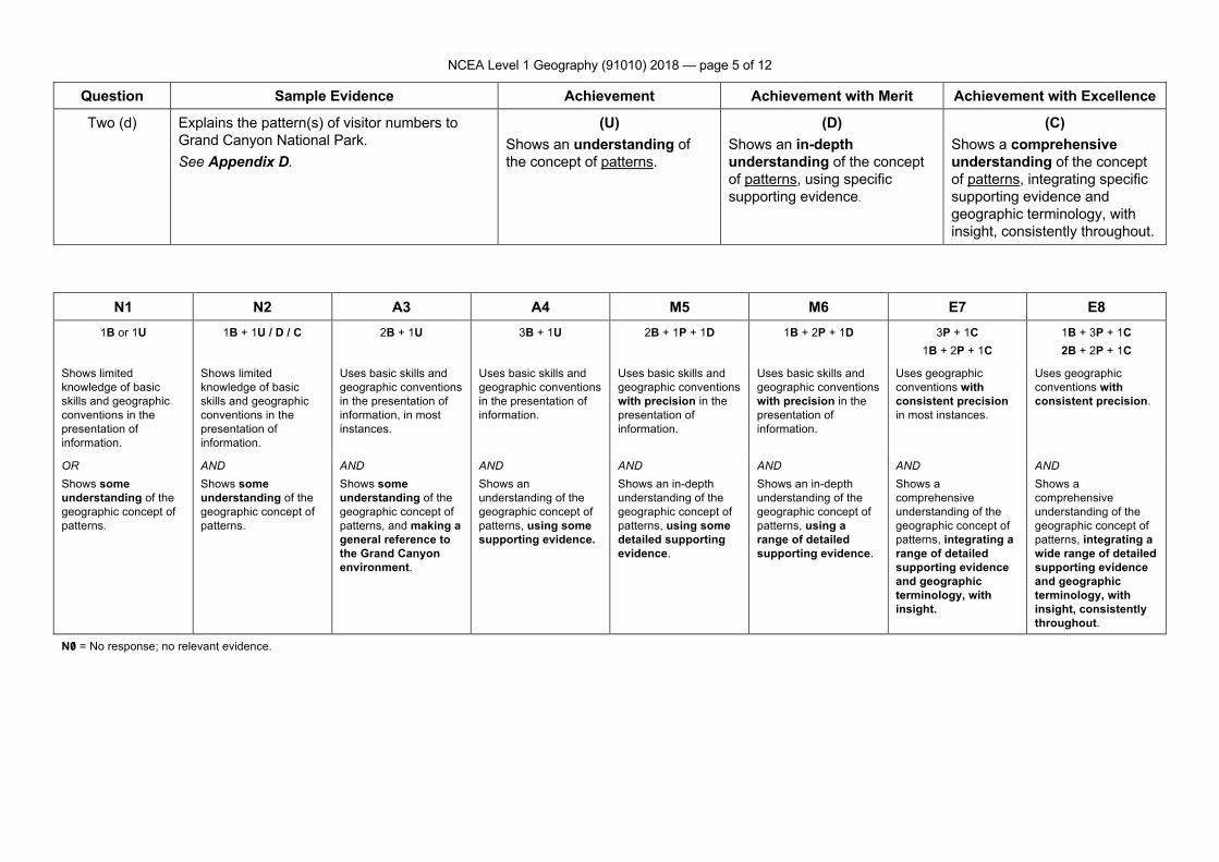
NCEA Level 1 Geography (91010) 2018 — page 5 of 12
Question Sample Evidence Achievement Achievement with Merit Achievement with Excellence
Two (d) Explains the pattern(s) of visitor numbers to Grand Canyon National Park. See Appendix D.
(U) Shows an understanding of the concept of patterns.
(D) Shows an in-depth understanding of the concept of patterns, using specific supporting evidence.
(C) Shows a comprehensive understanding of the concept of patterns, integrating specific supporting evidence and geographic terminology, with insight, consistently throughout.
N1 N2 A3 A4 M5 M6 E7 E8 1B or 1U 1B + 1U / D / C 2B + 1U 3B + 1U 2B + 1P + 1D 1B + 2P + 1D 3P + 1C
1B + 2P + 1C 1B + 3P + 1C 2B + 2P + 1C
Shows limited knowledge of basic skills and geographic conventions in the presentation of information.
Shows limited knowledge of basic skills and geographic conventions in the presentation of information.
Uses basic skills and geographic conventions in the presentation of information, in most instances.
Uses basic skills and geographic conventions in the presentation of information.
Uses basic skills and geographic conventions with precision in the presentation of information.
Uses basic skills and geographic conventions with precision in the presentation of information.
Uses geographic conventions with consistent precision in most instances.
Uses geographic conventions with consistent precision.
OR Shows some understanding of the geographic concept of patterns.
AND Shows some understanding of the geographic concept of patterns.
AND Shows some understanding of the geographic concept of patterns, and making a general reference to the Grand Canyon environment.
AND Shows an understanding of the geographic concept of patterns, using some supporting evidence.
AND Shows an in-depth understanding of the geographic concept of patterns, using some detailed supporting evidence.
AND Shows an in-depth understanding of the geographic concept of patterns, using a range of detailed supporting evidence.
AND Shows a comprehensive understanding of the geographic concept of patterns, integrating a range of detailed supporting evidence and geographic terminology, with insight.
AND Shows a comprehensive understanding of the geographic concept of patterns, integrating a wide range of detailed supporting evidence and geographic terminology, with insight, consistently throughout.
N0/ = No response; no relevant evidence.
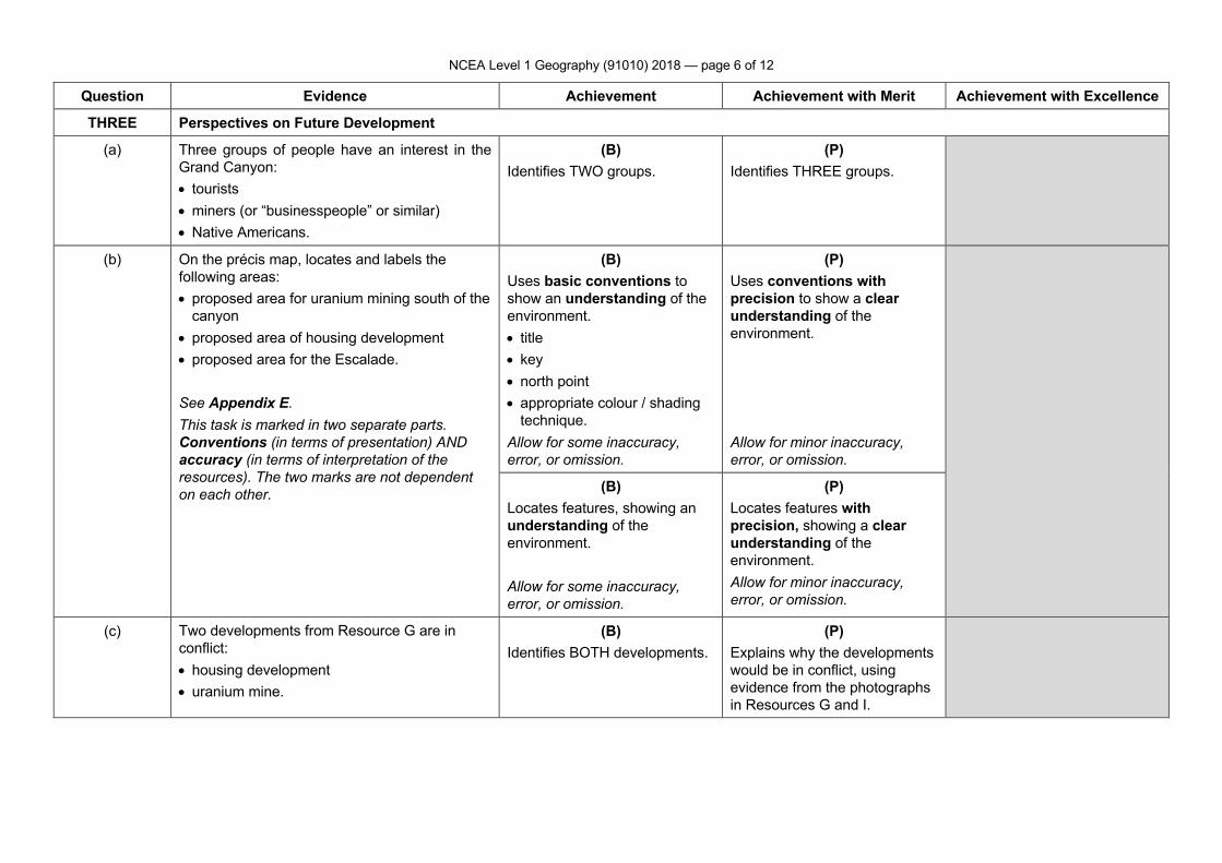
NCEA Level 1 Geography (91010) 2018 — page 6 of 12
Question Evidence Achievement Achievement with Merit Achievement with Excellence
THREE Perspectives on Future Development
(a) Three groups of people have an interest in the Grand Canyon: • tourists • miners (or “businesspeople” or similar) • Native Americans.
(B) Identifies TWO groups.
(P) Identifies THREE groups.
(b) On the précis map, locates and labels the following areas: • proposed area for uranium mining south of the
canyon • proposed area of housing development • proposed area for the Escalade. See Appendix E. This task is marked in two separate parts. Conventions (in terms of presentation) AND accuracy (in terms of interpretation of the resources). The two marks are not dependent on each other.
(B) Uses basic conventions to show an understanding of the environment. • title • key • north point • appropriate colour / shading
technique. Allow for some inaccuracy, error, or omission.
(P) Uses conventions with precision to show a clear understanding of the environment. Allow for minor inaccuracy, error, or omission.
(B) Locates features, showing an understanding of the environment. Allow for some inaccuracy, error, or omission.
(P) Locates features with precision, showing a clear understanding of the environment. Allow for minor inaccuracy, error, or omission.
(c) Two developments from Resource G are in conflict: • housing development • uranium mine.
(B) Identifies BOTH developments.
(P) Explains why the developments would be in conflict, using evidence from the photographs in Resources G and I.
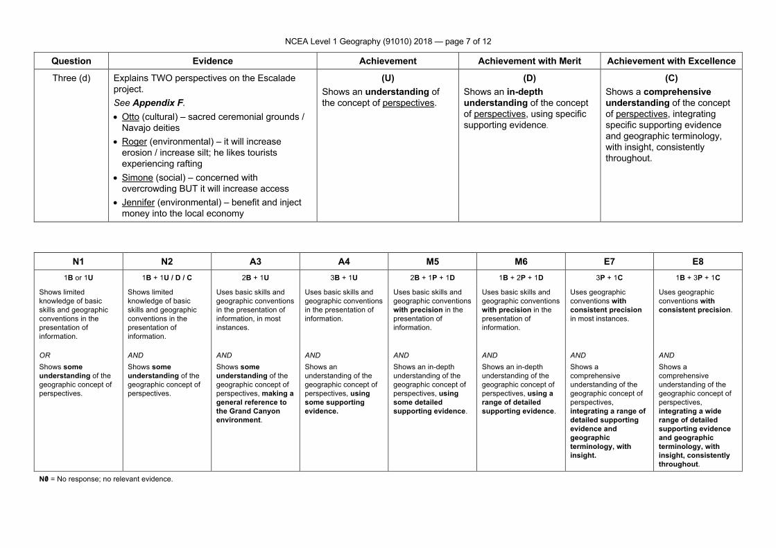
NCEA Level 1 Geography (91010) 2018 — page 7 of 12
Question Evidence Achievement Achievement with Merit Achievement with Excellence
Three (d) Explains TWO perspectives on the Escalade project. See Appendix F. • Otto (cultural) – sacred ceremonial grounds /
Navajo deities • Roger (environmental) – it will increase
erosion / increase silt; he likes tourists experiencing rafting
• Simone (social) – concerned with overcrowding BUT it will increase access
• Jennifer (environmental) – benefit and inject money into the local economy
(U) Shows an understanding of the concept of perspectives.
(D) Shows an in-depth understanding of the concept of perspectives, using specific supporting evidence.
(C) Shows a comprehensive understanding of the concept of perspectives, integrating specific supporting evidence and geographic terminology, with insight, consistently throughout.
N1 N2 A3 A4 M5 M6 E7 E8 1B or 1U 1B + 1U / D / C 2B + 1U 3B + 1U 2B + 1P + 1D 1B + 2P + 1D 3P + 1C 1B + 3P + 1C
Shows limited knowledge of basic skills and geographic conventions in the presentation of information.
Shows limited knowledge of basic skills and geographic conventions in the presentation of information.
Uses basic skills and geographic conventions in the presentation of information, in most instances.
Uses basic skills and geographic conventions in the presentation of information.
Uses basic skills and geographic conventions with precision in the presentation of information.
Uses basic skills and geographic conventions with precision in the presentation of information.
Uses geographic conventions with consistent precision in most instances.
Uses geographic conventions with consistent precision.
OR Shows some understanding of the geographic concept of perspectives.
AND Shows some understanding of the geographic concept of perspectives.
AND Shows some understanding of the geographic concept of perspectives, making a general reference to the Grand Canyon environment.
AND Shows an understanding of the geographic concept of perspectives, using some supporting evidence.
AND Shows an in-depth understanding of the geographic concept of perspectives, using some detailed supporting evidence.
AND Shows an in-depth understanding of the geographic concept of perspectives, using a range of detailed supporting evidence.
AND Shows a comprehensive understanding of the geographic concept of perspectives, integrating a range of detailed supporting evidence and geographic terminology, with insight.
AND Shows a comprehensive understanding of the geographic concept of perspectives, integrating a wide range of detailed supporting evidence and geographic terminology, with insight, consistently throughout.
N0/ = No response; no relevant evidence.
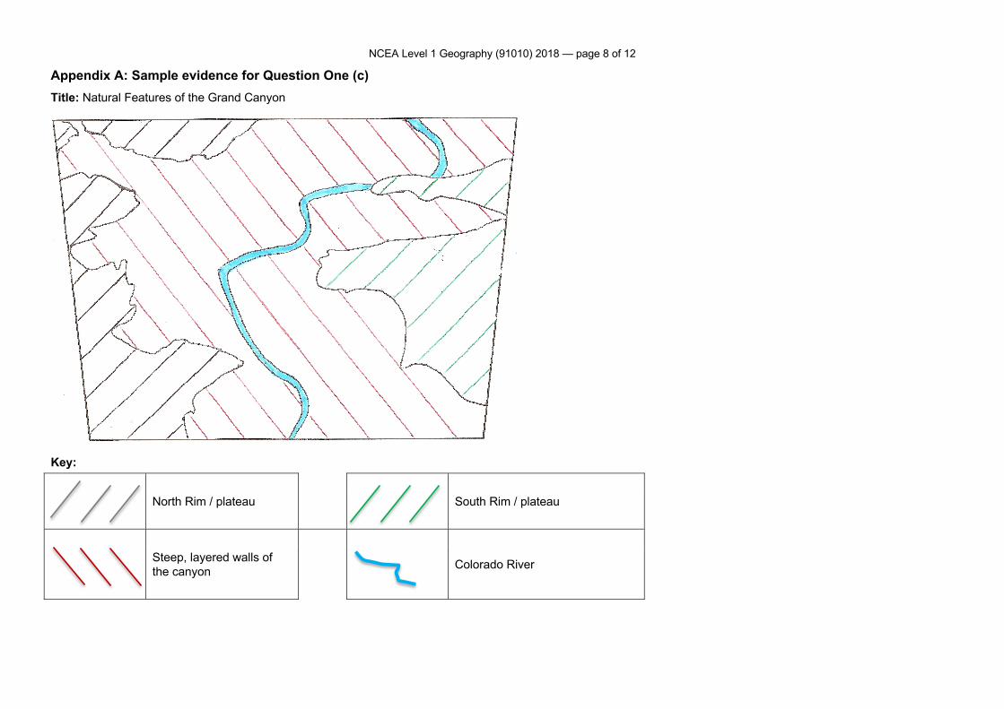
NCEA Level 1 Geography (91010) 2018 — page 8 of 12
Appendix A: Sample evidence for Question One (c) Title: Natural Features of the Grand Canyon
Key:
North Rim / plateau South Rim / plateau
Steep, layered walls of the canyon Colorado River
NCEA Level 1 Geography (91010) 2018 — page 9 of 12
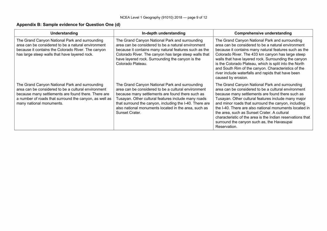
Appendix B: Sample evidence for Question One (d)
Understanding In-depth understanding Comprehensive understanding
The Grand Canyon National Park and surrounding area can be considered to be a natural environment because it contains the Colorado River. The canyon has large steep walls that have layered rock.
The Grand Canyon National Park and surrounding area can be considered to be a natural environment because it contains many natural features such as the Colorado River. The canyon has large steep walls that have layered rock. Surrounding the canyon is the Colorado Plateau.
The Grand Canyon National Park and surrounding area can be considered to be a natural environment because it contains many natural features such as the Colorado River. The 433 km canyon has large steep walls that have layered rock. Surrounding the canyon is the Colorado Plateau, which is split into the North and South Rim of the canyon. Characteristics of the river include waterfalls and rapids that have been caused by erosion.
The Grand Canyon National Park and surrounding area can be considered to be a cultural environment because many settlements are found there. There are a number of roads that surround the canyon, as well as many national monuments.
The Grand Canyon National Park and surrounding area can be considered to be a cultural environment because many settlements are found there such as Tusayan. Other cultural features include many roads that surround the canyon, including the I-40. There are also national monuments located in the area, such as Sunset Crater.
The Grand Canyon National Park and surrounding area can be considered to be a cultural environment because many settlements are found there such as Tusayan. Other cultural features include many major and minor roads that surround the canyon, including the I-40. There are also national monuments located in the area, such as Sunset Crater. A cultural characteristic of the area is the Indian reservations that surround the canyon such as, the Havasupai Reservation.
NCEA Level 1 Geography (91010) 2018 — page 10 of 12
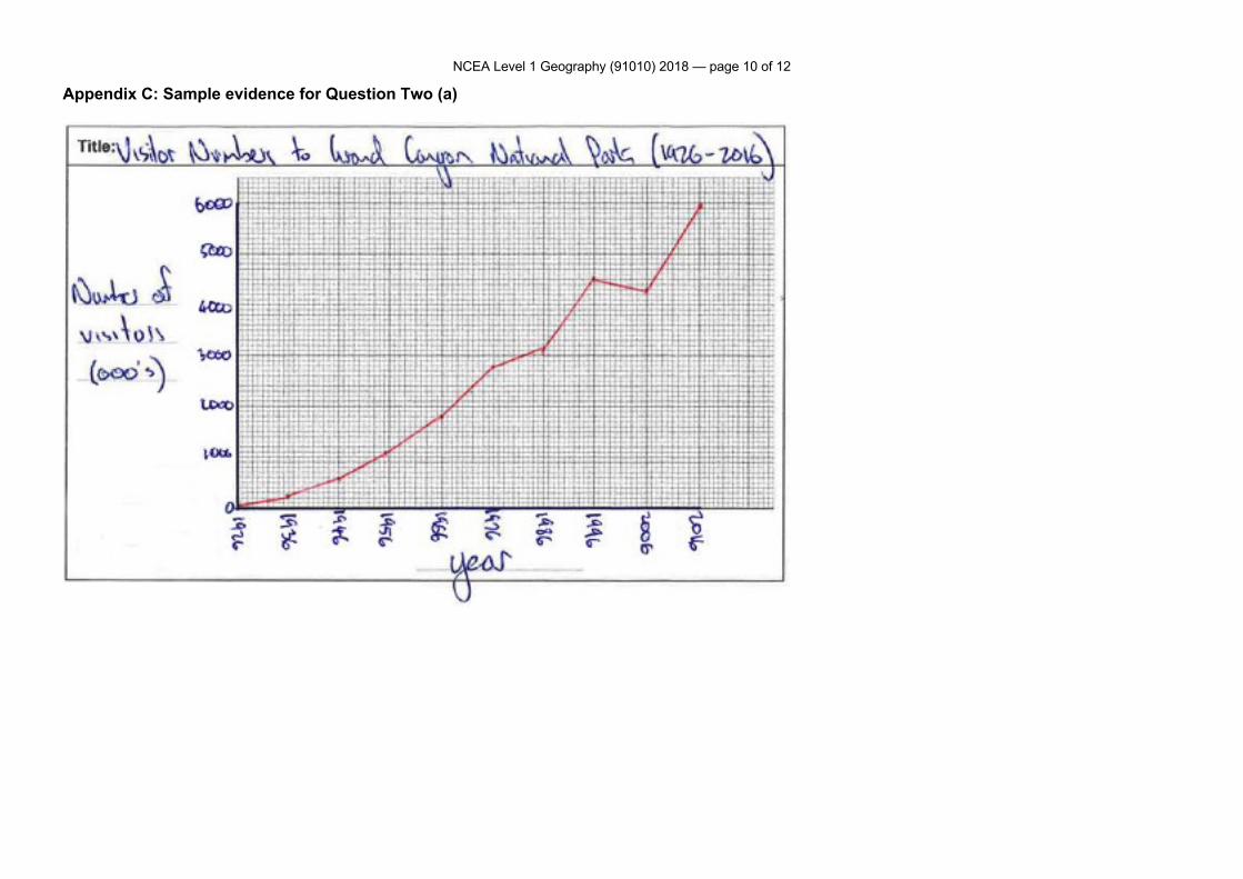
Appendix C: Sample evidence for Question Two (a)
NCEA Level 1 Geography (91010) 2018 — page 11 of 12
Appendix D: Sample evidence for Question Two (d)
Understanding In-depth understanding Comprehensive understanding
Pattern of visitor numbers 1926 – 2016 Visitor numbers have steadily increased since 1926. This is because the number of things to do in the park has increased, and this has made the Grand Canyon an exciting place to go to.
Pattern of visitor numbers 1926 – 2016 Visitor numbers have steadily increased from 140,000 1926 to almost 6 million in 2016. Reasons for this pattern include the increased number of things to do in the park, and this has made the Grand Canyon an exciting place to go to. The Skywalk, the Zip Line and rafting all make the Grand Canyon an exciting place to visit.
Pattern of visitor numbers 1926 – 2016 Visitor numbers have steadily increased from 140,000 1926 to almost 6 million in 2016. Reasons for this pattern include the increased number of things to do in the park, and this has made the Grand Canyon an exciting place to go to. Initially there was only hiking to attract tourists. However, rafting (1951), the Skywalk (2007), and the Zip Line (2014) all make the Grand Canyon an exciting place to visit.
Seasonal pattern of visitor numbers Visitor numbers are lower at the beginning and end of the year when temperatures are colder. They peak during the middle months when temperatures are at their warmest.
Seasonal pattern of visitor numbers Visitor numbers are lower at the beginning and end of the year when temperatures are colder. For example, in January temperatures are only 5°C. Visitor numbers peak during the middle months when temperatures are at their warmest (July temperatures are 29°C, and 841,000 people visit during this month).
Seasonal pattern of visitor numbers This is also a temporal pattern. Visitor numbers are lower at the beginning and end of the year when temperatures are colder. For example, in January temperatures are only 5°C, and visitor numbers are at their lowest of 192,000. Visitor numbers peak during the middle months when temperatures are at their warmest (July temperatures are 29°C and 841,000 people visit during this month). The fact that the canyon involves outdoor activities means that temperature is a major cause of this pattern.
NCEA Level 1 Geography (91010) 2018 — page 12 of 12
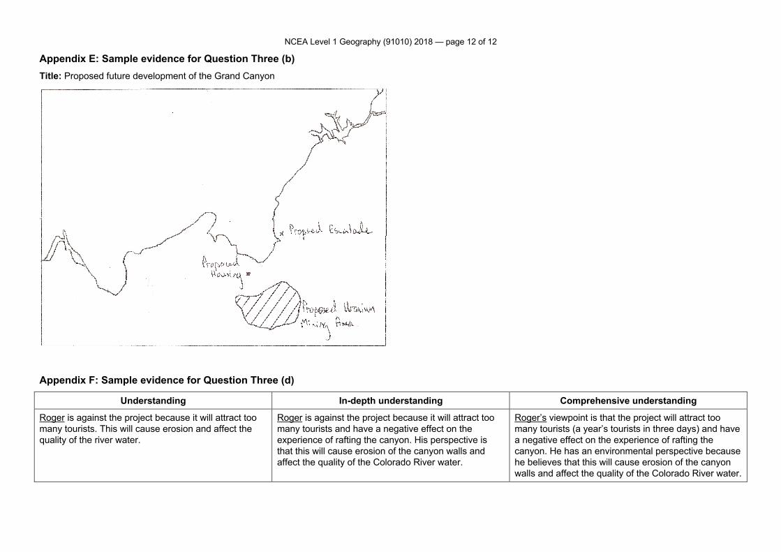
Appendix E: Sample evidence for Question Three (b) Title: Proposed future development of the Grand Canyon
Appendix F: Sample evidence for Question Three (d)
Understanding In-depth understanding Comprehensive understanding
Roger is against the project because it will attract too many tourists. This will cause erosion and affect the quality of the river water.
Roger is against the project because it will attract too many tourists and have a negative effect on the experience of rafting the canyon. His perspective is that this will cause erosion of the canyon walls and affect the quality of the Colorado River water.
Roger’s viewpoint is that the project will attract too many tourists (a year’s tourists in three days) and have a negative effect on the experience of rafting the canyon. He has an environmental perspective because he believes that this will cause erosion of the canyon walls and affect the quality of the Colorado River water.