Embed Size (px)
Citation preview

42A01NE2005 2 .18273 GRENFELL
ASSESSMENT WORK REPORT - 1997
NE GRENFELL TWP VALUER EXPLORATIONS
prepared by: L. Prevec, Oct. 1997
MAR - 4 1998
GEOSCIENCE ASSESSMENT OFFICE
RECEIVED
SCOPE OF THIS REPORT:
Operating under the collective name of Vallier Explorations, three prospectors (A. Carreau, L. Prevec, B. Vallier), with the financial assistance of an OPAP grant to Prevec, carried out a VLF survey on claim # 11 12058 to examine the region of intersection of the two major conductive zones on this claim in NE Grenfell Twp. We then contracted M. Boileau Diamond Drilling to drill a 450 foot (137 m) BQ hole.
This report comprises the results and interpretation of our VLF survey as well as the recorded log of the core from hole VE97-1 together with analysis.
L. Prevec was responsible for the core analysis and prepared this report. B. Vallier was responsible for the logistic support required for the driH crew and for storing and splitting core.
CLAIM OWNERSHIP:CLAIMS COVERED IN THIS APPLICATION ARE REGISTERED BSf THE NAME OF BLAINE VALLIER, OR IN THE NAME OF ALL THREE PROSPECTORS, AND ARE SHARED EQUALLY BY THE THREE INDIVIDUALS WHOSE NAMES AND HOME ADDRESSES APPEAR BELOW
Blake Vallier, 51 Second St., Kirkland Lake, Ontario, P2N 1R4 Prospectors Licence Number - K19101
Alain Carreau, 11 Queen St, Kirkland Lake, Ontario, P2N Prospectors Licence Number - K22280
Ludvik Prevec, 944 LaSafle Park Rd., Burlington, Ontario, L7T 1M9 Prospectors Licence Number - K20343

Vallier Explorations - 1995
LOCATION OF CLAIMS AND ACCESS
The claims covered in this report (Kapakita Creek) are located along Kapakita Creek, north
and west of Aimer Lake, at latitude 4810' N, longitude 800 10' W in the north-east corner of Grenfell
township, in the Larder Lake Mining District, in the District ofTemiskaming. Thirty three contiguous
claims now constitute the Kapakita Creek group. These are LI 112057, LI 112058 and LI 112059
(1990), L1169072, L1169148, L1169149, L1169150 (1991), L1180160 (1993) an 8 claim group
LI 180141 (1994) and 16 claim group L1180168 (1996) in Grenfell Twp and a single claim
LI 180150 in Teck Twp.
Access to these claims from the town of Kirkland Lake is by a northward bush road extension
from the Goldthorpe road to Armer Lake. This route can be traversed by ATV or with four wheel
drive in the drier seasons. The claims are easily accessed in winter by snowmobile. Alternative access
during the wet season is by boat and canoe via Weweghnok Lake. The large beaver meadow on
claim 1112059 is sometimes a readily walked wetland (1990) and sometimes inundated with water
(1991-94) depending on the height of the beaver dam located at the north end of the meadow.
BACKGROUND GEOLOGY AND GEOPHYSICS OF THE CLAIM AREA
The claims comprise a region of steeply dipping pillowed volcanics with associated interflow
tuffs and sediments in close proximity to the Winnie Lake intrusive. The dominant geology of the
region surrounding the intrusive consists of sequences of mafic fine-grained volcanics, frequently
pillowed, alternating with gabbroic or dioritic flows (Grant, 1963; Lovell, 1966; Rupert and Lovell,
1970). Steep folding of generally tholeiitic volcanics is common next to the intrusive body.
Cu, Zn, Ag and Au showings occur at many locations in Maisonville, Berhardt and Teck
Twps surrounding the Winnie Lake intrusive. The most significant finds to date were reported on
the Winnie Lake Mine property in Teck Twp immediately east of our claim area. A pod of massive
sulphides with high grade copper and zinc values was intersected within east-west trending interflow
zones in volcanics adjoining the intrusive (Northern Miner Mar. 15, 1990). Interesting sulphide
sequences have also been reported in similar tholeiitic volcanics in Robertson Twp, some 20 miles
west of these claims, by Queenston Exploration (Assessment Work Report by C. Forbes, 1992).
Previous work on or near our claims was carried out by New Kelore Mines hi 1954 (mag and
drilling near claims), INCO in 1965 (two drill holes), Kerr Addison in 1966 (one drill hole), Canton
Explorations in 1972 (mag, VLF) and Minorex in 1980-81 (geology, mag, VLF, drilling), Northcoast
Industries in 1988 (radiometer, mag and IP). The work by Minorex provided the basis for most of
our exploration of the northern portion of this property. The geophysical work of Northcoast on
the southern portion of the property should provide a basis for fiither exploration of this region.
Aerial geophysics over the claim area was carried out by OGS in 1979 (INPUT EM and
vertical intensity mag) and by the GSC in 1993. An interpretation of the OGS air survey data,
prepared for us by Mr. Robert de Carle of Geodatem, serves as the basis of our description of

Vallier Explorations - 1995 3
conductors not lying within our claim boundaries.
We staked our first claims in this area in 1990 and have carried out geophysical, geological and drilling exploration on the claims in the northernmost position of our current property. The claims to the south, which were previously held by Northcoast, have not been explored by us as yet. We have defined two major east-west conductive zones (identified as "N1 and'S'). The zones were detected by VLF and shown to extend to depth by Maxi-probe EM survey. The location and intensity of these conductors is in agreement with the GSC airborne EM survey of 1993. These conductors are continuous for some 1500 m (S conductor) and 1000 m (N conductor) across our claims. Magnetic anomalies parallel most of conductor'S* and are most intense in the region south of the beaver pond. Re-analysis of magnetic data obtained by Canton Exploration in 1973 (Assessment work file) confirms the presence of parallel magnetic highs in this region. The other major geophysical anomalies are IP conductors detected by Northcoast Industries just west of Armer Lake. The significance of these anomalies remains to be determined.
GEOLOGY OF THE 'N' AND 'S' CONDUCTORS
The N and S conductors fie within a region of steeply dipping, east-west trending, sediments and metavolcanics that have been highly altered through intimate contact with the Winnie Lake felsic intrusive which outcrops to the north with an arm extending south along the east side of this claim group. There is no outcrop of significant size between the N and S conductors on our claims, this region forming part of the Kapakita Creek channel and covered by overburden to 30 feet in other places. The N conductor has been intersected by BQ drill holes Minorex 81-07 and 81-12 and at depth by VE 92-1 and 95-1. The S conductor has been intersected by EX drill holes VE 91- 1,2,3,4,5,6; 94-1,2 and by BQ drffl holes VE 92-2,95-1 and possibly INCO 28476. Pillow volcanics, outcropping as low hiHs immediately south of the S conductor indicate a general east-west strike with tops to the north. Weathered bedding in chert outcrop associated with the S conductor, as well as bedding in drill core show that the S conductor associated sequences overlie the pillow volcanics to the south. The specific relationship, if any, between the N and S conductor is not clear, though a field analysis, carried out for us by Dr. David Good, suggests that the conductors are not arms of a syncline or anticline.
The S conductor is associated with sulphides within a silicified sedimentary mudstone or chert along its entire length. The principal sulphides in the west and middle of this conductor are pyrrhotite and pyrite. Stringers of po to 4" are intersected in holes VE 91-1, 3 and 6. Sphalerite becomes a significant component at the east end. Drill hole VE 94-1 intersected three stringers of sphalerite within chert and carbonate veins all within a silicified sedimentary sequence in the S conductor.
Minorex drill holes (identified as M81-7 and M81-12) drilled to intersect the N conductor discovered sections of silicified sediment and volcanics containing sphalerite and galena stringer veins. Hole M 8-12 yielded values that averaged about Q.5% Zn and 0. Wo Pb over a total of some 66 feet of core in four sections of 28, 12, 8 and 8 ft, while hole M81-7 had two sections of about 8 and 12 feet with Zn values of 1.40Xo and Q.48% respectively. Most of these Zn values were in sections of graphitic chert or silicified tuff.

Vallier Explorations - 1995 4
VE 95-1 was collared south of the S conductor 70 feet west of 94-1 and drilled north at 45
deg to intersect the S conductor near the surface and the downward dip extension of the N
conductor at depth. Mineralized silicified sediments were intersected between 60 and 201 feet and
between 484 and 582 feet. Sphalerite and galena in quartz-carbonate veins were present in the silica
rich sediments between 82 to 125 feet. Assays across this 41 foot section gave weighted average
values of G.4% Zn and Q.08% Pb. Values in the one foot sections including the stringers were some
y/o Zn. Comparable sphalerite, galena stringers and associated Zn and Pb values were seen in the
lower mineralized intersection.
Besides pervasive silication, hydrothermal alterations of the metavolcanics include numerous
quartz-epidote veins from 10 to 25 cm in width between 200 to 350 feet while biotite alterations form
a large proportion of the core from 350 feet to 450 feet and again from about 700 feet to the end of
the hole at 996 feet.
RATIONALE FOR, AND RESULTS OF, WORK CARRIED OUT IN 1997
From all the preceding work it was clear that the N and S conductive horizons represent zones
in which clusters of steeply dipping sulphide bearing veins are located. Progressing from west to east
across the property the dominant sulphides in the drill intersections through the veins change from
pyrrhotite and pyrite at the west to more sphalerite and galena with associated pyrite towards the east
half. Both conductors also have an associated graphitic segment which contributes to the overall
strength of the VLF and Maxiprobe signal across the property.
We reasoned that the N and S conductive horizons represented fracture zones within volcanic
and intervolcanic strata and that these fracture zones served as conduits for the transport of sulphide
bearing fluids presumably derived, at least in part, from a phase of the Winnie Lake intrusive complex.
On this basis it was possible that the point of intersection of the N and S horizons (on claim 1112058
at the east side of our property) might also be a fracture region in which greater amounts of sulphide
bearing fluid may have been deposited. We knew, from our previous work, that, at the juncture of
the two conductors the VLF signal weakened and became diffused over a greater width. The
reduction in VLF signal strength was not inconsistent with the possibility of economic amounts of
sphalerite in the area defined by the diffuse VLF signal while the increased width of the overall VLF
response could suggest a potential fracture zone.
Our work this year consisted in more detailed examination of this claim, first to see if there
were any outcrops which might have helped define the nature of the N and S fusion, or served as
points from which we might use our EX drill to explore the fusion region at depth. We also recut old
survey lines and carried out a more detailed VLF survey in the west half of claim 1112058 to see if
the specific fusion region might be better defined. On the basis of our results from this preliminary
surface examination we concluded that drilling was the best way to determine the economic potential
of this claim region. Since it was clear, from surface examination, that there was a significant depth
of overburden in the region of interest, we were unable to drill the site with our own EX drill. We
therefore contracted the drilling of a 450 foot (137 m) BQ hole - a length which we considered to

Vallier Explorations - 1995 5
be the minimal length required to get a valid assessment of the potential of the fusion region.
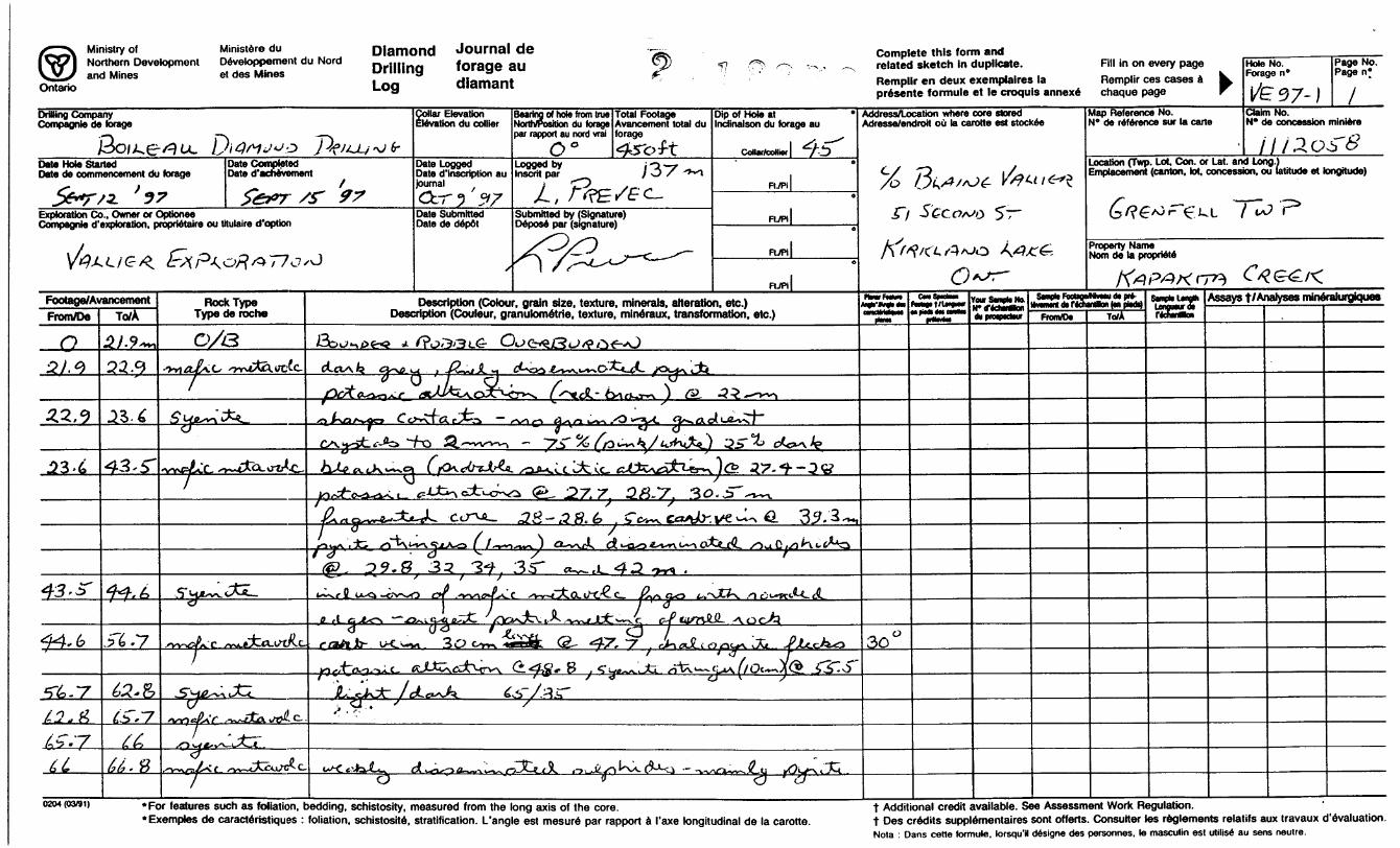
VLF Survey - Comparison with Maxiprobe survey carried out in 1991
The results of the VLF survey carried out on four lines hi claim #1112058 presented in the accompanying figure are in substantial agreement with our VLF survey of 1990. The N and S conductors clearly enter this claim at the west boundary and blend together 200 m east of this
boundary. The VLF signal becomes significantly weaker and diffuse at this location. Examination
of the Maxiprobe signal along this line shows an adequate single conductive response which also widens at depth. The VLF crossover location corresponds to the Maxiprobe signal peak. The four- point Fraser filter peaks are of minor significance since the VLF signal is weak and broad.
Since we were particularly interested in the region of intersection of the two conductors the
200 m line hi this claim appeared to be the appropriate drill site. We found no outcrops along this line k this claim, however in claim #11 12057, immediately south of this position, there is a large hill of outcrop. Examination of this outcrop showed mafic volcanics cut through by dikes of Winnie Lake
syenite. From this exposure we decided that a drill hole on line 200 east in claim #1112057 would still be principally within the altered volcanics but sufficiently close to the intrusive to provide information about alteration and possible mineral deposition hi the fracture zone adjacent to the intrusive.
Results from Core Log of BQ hole VE 97-1
As seen in the accompanying core log, hole VE 97-1 intersected altered mafic metavolcanics possibly underlying graphitic sediments and tuffs and capped by a more felsic volcanic. These sequences were cut by syenitic dikes or sills. From the outcrop on the hill hi claim #1112057 we
interpret the syenitic sections to represent dikes from the Winnie Lake stock which either entered the country rock volcanics along fractures or which enclose blocks of country rock which have been partly assimilated into the edge of the stock. The absence, hi most cases, of an obvious chilling margin at the syenite-volcanic boundary would suggest that the cooling effect of the country rock was minor and therefore suggests a reasonable volume of stock near these contacts and some depth at the time of assimilation of the country rock by the stock.
The one exception to the normal syenitic nature of the intrusive material (light to dark ratio of about 60:40) occurs about 88.5 m in the hole. Here the intrusive is highly siliceous and has been labelled aplite in the core log. The aplitic material intrudes a silica-rich, pyrrhotite rich, sedimentary sequence which I have labelled argillite. The dike contains fragments of wall rock (devoid of pyrrhotite) in the first meter down the hole but blends rather conformably with the silica rich, pyrrhotite-containing sediment at the downhole contact. This would seem to suggest that the iron sulphide was introduced into the sediment sometime after intrusion of the aplite.
The conductor detected by VLF and by Maxiprobe is thought to be represented by the

Vallier Explorations - 1995 6
graphitic fractured zone particularly between 112 and 115 m. As well as being graphitic this silica rich region contains numerous small chert or carbonate bearing microfractures with associated sulphides including pyrite, sphalerite and galena. Alignment of crystals along fracture planes in this material suggests a high degree of pressure metamorphism. At 111 and at 112 m carbonate veins have penetrated a zone of brecciated wall rock - the carbonate veins contain associated veins of galena. Other veins, some cherty, contain minor amounts of sphalerite. One pyrrhotite containing vein clearly cuts both wall rock and adjacent syenite suggesting introduction of the iron sulphides after consolidation of the stock.
The hole terminated at 137 m in a lighter volcanic which I have labelled felsic volcanic. This lighter coloured volcanic is more andesitic than rhyolitic. This material contains abundant pyrite hi the form of both numerous veinlets and in the form of small blebs (l-2mm dia.) or pockets of pyrite crystals (some S 0/* of the rock may be pyrite). Whether these disseminated sulphides contribute in any significant way to the Maxiprobe signal is not immediately apparent.
Conclusions and Recommendations:
VE 97-1 confirmed the continuity of sphalerite and galena bearing veins associated with the N and S conductors and seen in VE 95-1, some 400 m to the west. The exact relationship of the N and S conductors still remains unknown. The amount of galena and sphalerite recovered in this hole was less than that seen in the intersections of the N and S conductors in hole VE 95-1. Galena was clearly associated with carbonate-bearing veins while sphalerite was present in thin chert or quartz bearing veinlets. The direction of migration of the zinc and lead bearing solutions is also still unknown, though emplacement of some of the iron sulphides clearly occurred after solidification of the intrusive syenite dikes. It remains possible that economic amounts of sphalerite and/or galena are present within the planes of the N and S conductors or their intersections at depth. An IP survey carried out between and south of the locations of holes VE 95-1 and VE 97-1 and designed to detect conductive masses below 150 m would probably be the most useful follow-up to the work done to date on this property. In addition, hole VE 95-1, remains open for a downhole TEM survey.
Gold and silver assays on the carbonate vein in graphitic argillite and the pyrite-rich felsic volcanic detected no gold values, though as expected from previous holes, some silver values were associated with galena and sphalerite-rich regions. Since only minor amounts of the corresponding sulphides were present no assays for Zn, Pb or Cu were carried out on this core sample.
Statement of Qualifications:
I, Ludvik Prevec, have a Honours B. A. in Physics and Geology from U. of Toronto, and have been involved in mineral exploration over the past ten years. I have continued to upgrade my geological knowledge through courses in association with the Prospector's convention and at McMaster University.
Respectfully Submitted,

0M
WINNIE LAKE INTRUSIVE
GEOGRAPHIC LOCATION OF CLAIMS CURRENTLY HELD BY VALL EXPLORATIONS IN GRENFELL AND MAKQNVILLE TWPS
VE 1. - Kenogami Creek claims (Grenfell Twp)VE 2. - Kapakita Creek claims (Grenfell and Teck Twp) -4 VE 3. - Wewegimok Lake claims (Maisonville Twp)

Kapakita Creek Property NE Grenfell Twp
Ministry of Ministers duNorthern Development Devetoppement du Nordand Mines et des Mines
Ontario
Diamond Journal de Drilling forage au Log dlamant
Complete this form and related sketch in duplicate. Remplir en deux exemplaires la presente formule et le croquis annexe
Fill in on every page Remplir ces cases a chaque page
HoteNo.^ a9e n
^
Page No. Page n*
Drilling Company Compagnfe de forage
Date Hole StartedDate de commencement du forage
Date Completed Date d'achevement
Exploration Co., Owner or OptioneeCompagnle d'exptoration, proprietaire ou titulaire d'option
' 0
Collar Elevation Elevation du collier
Date LoggedDate d'inscription aujournal
Date Submitted Date de depot
Bearing of hote from true North/Position du forage par rapport au nord vrai0O,Logged by Inscrit par
Total Footage Avancement total du forage
Submitted by (Signature) Depose par (signature)
Dip of Hole at Indinaison du forage au
FUPi
FL/PI
Address/Location where core stored Adresse/endroit ou la carotte est stockee
Map Reference No.N* de reference sur la carte
Claim No.N* de concession miniere
Location (Twp. Lot, Con. or Lat. and Long.)Emplacement (canton, lot, concession, ou latitude et longitude)
0 r^: k L"P
Property Name Norn de la propriete
Footage/AvancementFrom/Do To/A
Rock Type Type de roche
Descriptton (Colour, grain size, texture, minerals, alteration, etc.) Description (Couleur, granulometric, texture, mineraux, transformation, etc.)
Your Smell No. "—mf* faauaMttm tt PT*-
ItvwinrtotridMrtloiiKBpKo*)From/D* To/A
Ltnp* tonowurdt rfcfanMn
Assays t/ Analyses mineralurgjques
O 0/322.9
-3** StL
*stA' *a-
-^ l
33 J251
.por features such as foliation, bedding, schistosity, measured from the tang axis of the core. Examples de caracteristiques : foliation, schistosite, stratification. L'angle est mesure par rapport a I'axe longitudinal de la carotte.
t Additional credit available. See Assessment Work Regulation.t Des credits supplementaires sont offerts. Consurter les reglements relatifs aux travaux d'evaluation.Nota : Dans cetle lormute. torsqu'K designe des personnes. le masculin est utilise au sens neutre.

Ministry of Northern and Mines
Ministers du Developpement du Nord et des Mines
Diamond Journal deDrilling forage auLog diamant
Complete this form andrelated sketch in duplicate. Fill in on every pageRemplir en deux exemplaires la Remplir ces cases a presente formule et le croquls annexe chaque page
Hole No. Forage n*
Page No. Page n*
DnHmg Company Compagnie de forage
Date Hole StartedDate de commencement du forage
Date Completed Date d'achevement
Exploration Co.. Owner or OptioneeCompagnie d'exploratJon. proprietaire ou titulaire d'optkxi
Collar Elevation Elevation du collier
Bearing of hole from true North/Position du forage par rapport au nord vrai0
Date LoggedDate d'inscription aujournal ,
Ccr? 37Date Submitted Date de depot
Logged by Insert par
Total Footage Avancement total du forage
JL. - -
i*5-r /O/
Submitted by (Signature) Depose par (signature)
Dip of Hole at Inctinalson du forage au
n'7Pi
F, -^ RJPi
FL/Pi
Address/Location where core stored Adresse/endroit oil la carotte est stockee
5'
Map Reference No.N* de reference sur la carte
Claim No.N* de concession miniere
- iLocation (Twp. Lot Con. or Lat. and Long' Emplacement (canton, lot, concession, ou
XL
et longitude)
Property Name Norn de la propriete
Fbotage/AvancementFrom/Oe To/A
Rock Type Type de roche
Description (Colour, grain size, texture, minerals, alteration, etc.) Description (Couleur. granukxnetrie. texture, mineraux, transformation, etc.) tfdfta
SMVfc FMttfflivMU dt M*." * r\kUmn(*ifr*n
FronVD* To/XLorigmurifc HcMm
Assays f /Analyses mineralurgiques
0 0//3
On/yiJC- ,X"fc\t-v\.q'JJl*Q ( /^-oxi^v ) 14 ~~ C) ^ - y
^i 0 /^5
'9.B. 31
. For features such as foliation, bedding, schistosity, measured from the long axis of the core.* Exemptes de caracteristiques : foliation, schistosite, stratification. L'angle est mesure par rapport d I'axe longitudinal de la carotte.
t Additional credit available. See Assessment Work Regulation.t Des credits supplementaires sont offerts. Consulter les reglements relatifs aux travaux devaluation.Nota : Dans cette formute. torsqu'il designe des personnes. le masculin est utilise au sens neutre.

Diamond Journal del AT J Nollliem Uwo'opn'""' Uevekjppenwnl du Moid nrillina forage au related sketch In duplicate. Fill in on every page Hole No. V W and Mines et des Mines uMiuniy si . Forage n' Ontario Loa dlamant Remplir en deux exemplaires la Remplir ces cases ^ b. ,
a presente formule et le croquls annexed chaque page r [/f-~cf 7- l
Drilling Company Collar Elevation Compagnle de forage Elevation du collier
Date Hole Started Date Completed Date Logged Date de commencement du forage Date d'achevement Date d'inscription au
journal
Exploration Co.. Owner or Optionee Date Submitted Compagnle d'exptoratton, proprietalre ou titulaire d'optkxi Date de depot
Footage/AvancementFrom/Do
J20
p*. 4
y'28-7
no
Sun
To/A
J33.&
)2.Br?/30
)^i,41*7
nrt#y
Rock Type Type de roche
o**\ c\*LJUL oCL^
rbicWvZt^
^-Hx^lJC^
Lci^dLajW/u//sV J[
c;- ^JtL.
"Tijtoi.C *w — tAcxvc'x
Ca^cJ-o^^ 7 )
- 7^; S HOLP t
Trt/ooucrti^S
i/'oio^A'/cs &S/9 S4*:-n.ohJ1/-WC/4V/CS f
(c^kLC'O fi
LJ/AAJ/C l/
v5^1 P/i 1 0Jf~?y
Bearing of hole from true Total Footage Dip of Hole at * North/Position du forage Avancement total du Indinaison du forage au par rapport au nord vrai forage
CoDar/coHnr)Logged by ' " Insortt par .
o
Submitted by (Signature) Fl ., 1
FUPl|o
Ft/Pi 1
Description (Colour, grain size, texture, minerals, alteration, etc.) Description (Couleur, granulometric, texture, mineraux, transformation, etc.)
otxr-c^ub ^-t^-v. j. _ ~~^oi X^^C,(^JQ^ GL, /a;-~vU f ^ ^
**- ^j^-^- x ^
, y"22'' y^Oy^0
i f? ̂ x^vvJ-^., (^iz ~*J ^ — x r^
(-XTV^.^^*- ij't-OV C^-W^Xfc C^^-^X^ tf-^-^N **^-vC-* -^"i C\^ fcO^V^^V.^^^ fc-%^^ Jx^^^s.*^v*^'-6L^^'X^iO
ff i**1* cV^ -t ^^4 LT*^ "^ * i/^^vwc1 U . . - . ^j
^^
^/?yc.CQri ^?"7* O^IST" JoyOCT7CX^ Oyr~ y t^?O SciJpslf&G " (3^^? ; *O6-
/1A50 AJ^Vr9 T^e B^c/^^A^y 0)^ A/eT^i^o^/^/oS-^^
ir j? 5" MA//5 J ri G: /Ax'71?*J^?-^O ^O/'v'/C^/fe J-t^f^f J57DC/C"..
3^r ^";JL;C^GJO /l^jO A^rrQrirt/^ArtoS^S M*af:i^
A/O fo\JCmLyj*JL ^) O/f-
P^yx.c/7^- y/^AO/c") /^/P
-^"TV r'o* JT^I f f^ U5"^ /V^^TO^ t
g r jLrr ^y n;A^G c ^ ̂ //rs OF
AT^S ^Txr^H^/Tt. 6'^Xf/^/y /77c S(*atr*\C-*J~i^S -cp/oO ^SSoc i^r^^i?
ffex}St4~5C~JT~ TH& P&Vvi^v/^ A-TT- C^AJOO CT^) /q- c; /'//o -n^^, )
Address/Location where core stored Adresse/endroit ou la carotte est stockee
RmtFMM
pM.^MkMOMM
IriM.
rwSnvtoN*.
dvpmpwtMV
44g
Page No. Page n* .
3Map Reference No. Claim No. N* de reference sur la carte N" de concession miniere
Location (Twp. Lot, Con. or Lat. and Long.) Emplacement (canton, lot, concession, ou latitude et longitude)
Property Name Norn de la propriete
Smib FMraMhMU di pr*- ItvMMrt (K M3i"lifcii te oirtl
From/D*
I'&.f
To/ALonguHtoi rfatatton
a/flu*.
Assays t/Analyses mineralurgiques
/^Q
CjfCH**' '
•^ Q'"J^
(3*j^.n/oA'
4.5"
u204(03#i) * For features such as foliation, bedding, schistosity, measured from the long axis of the core. v t Additional credit available. See Assessment Work Regulation. *Exemples de caracteristiques : foliation, schistosite, stratification. L'angle est mesure par rapport i I'axe longitudinal de la carotte. t Des credits supplementaires sont offerts. Consulter les reglements relatifs aux travaux devaluation.
Nota : Dans cetle formule, torsqu'il designe des personnes, le masculin est utilise au sens neutre.
Claim 1112058 #4 post
t/*
_ ,, - -— -. - ....._ji\...... . L. ___ —
V6
#3 post Qaim 1112058
60m east 120 m east 200 m east
VLF SURVEY Grenfell 1112058 1997
Instrument: Crone Radem VLF Source: Cutler, Maine
Observed Dip Angle - 4 pt Fraser Filter
Maxiprobe Anomalies - (from 1992 report)
ir-o--o-

MAXI-PROBE HIGH
CROSS SECTION OF DIAMOND DRILL HOLE VE 97-1
APPROXIMATE TOPOGRAPHY ONLY
LEGEND
OVERBURDEN
INTRUSIVESYENITE APLITE
METAVOI.CANIC MAFIC FELSIC
overburden
mafic metavolc. -
mafic metavolc.
syenite
mafic metavolc.
SEDIMENTARY OR PYROCLASTIC ARGILLITE Of? ARGILLITE/TUFF
SCALE
POSSIBLE DIP OF MAJOR CONDUCTIVE HORIZON
aplitic dike
'*- TUP
O
20 meters
syenite,
banded argute/tuff ̂
banded argiUite/tuJf^^
felsic metavolc.
r abundant pyrite
BOH

BECQUEREL LABORATORIES INC.6790 KITIMAT ROAD, UNIT 4
MISSISSAUGA, ONTARIO, L5N 5L9PHONE (905) 826-3080
FAX (905) 826-4151
Analysis of 3 Drill Core Samples 7 November 1997 for Gold by Fire Assay Analysis and Silver by Atomic Absorption
REPORT: T97-00431.0CLIENT:
Dr. Ludvik Prevec,944 Lasalle Park Rd.,Burlington, Ont. L7T 1M9tel: (905) 525-9140 ext.24578 FAX: (905) 521 -2995
Sample
363.5 - 364.5373445
FA-AAAuppb< 5<5<5
AAAappm0.80.4
<0.2
Samples received October 27,1997.
Please direct any inquiries to MR. STEVEN SIMPSON, Lab Manager.

BECQUEREL LABORATORIES INC. 6790 KITIMAT ROAD, UNIT 4 MISSISSAUGA, ONTARIO CANADA, L5N 5L9
07-NOV-1997
Mr. L. Prevec 944 Lasalle Pk Rd Burlington, Ontario L7T 1M9
INVOICE NO. T971145 Mr. L. Prevec
Batch No. T97-00431.0 $ 60.003 samples @ $ 15.00 ea. for Analysis for Gold 6 Silver
^ 5.00 ea. for Sample Preparation
Analysis for gold done by fire assay, Analysis for silver done by atomic absorption
Total Batches $ 60.00GST (R100448729) $ 4.20Subtotal S 64.20Grand Total ^ 64.20
Please remit to Becquerel Labs Canada in Canadian Funds. PAYMENT DUE, NET 30 DAYS
THANK YOU!

FORAGE M. BOILEAU INC.
871 le AvenueVald'Or, Quebec J9P1Y6
Val d'Or, September 15, 1997
LUDVICK PREVEC 944 Lasalle Park Road Burlington Ontario L7T1M9
INVOICE
OBJECT: Drilling Program ______Project; Hammer Lake
Telephone (819) 825-9806 Cell:856-7654 Fax (819) 825-1460
INVOICE: 97-20TPS: R101840841
Dossier: LUDVO-01
. Mobilization - Demobilization
Hole H-97-01 O m to 450 foot x 15,00 5/f
1195,00 S
6 750,00 S
TOTAL:
T.P.S.:
7945,00 S
556,15 S
AMOUNT TOTAL DUE: 8 500,00 S

Ministry ofNorthern Developmentand Mines
Declaration of Assessment Work Performed on Mining LandMining Act. Subeeetfon 69(2) Md 66(3), R.8.O. 1MO
.Pessaran wtaging
f subsections 65(2) and 66(3) of the Mining Act. Under section 8 of the evtaw the assessment work and correspond with the mining land holder. Recorder, Ministry of Northern Development and Mines. 6th Floor.
42A01NE2005 2 .18273 GRENFELL 900
Instructions: - For work performed on Crown Lands before recording a claim, use form 0240. - Please type or print in ink.
1. Recorded holder(s) (Attach a list if necessary) 2. l 827 3Name
\) \ t- .Address
S \
Client Number1
Telephone Number
Fax Number
K vi OName
Address
Client Number
Telephone Number
Fax Number
2. Type of work performed: Check ( ^ ) and report on only ONE of the following groups for this declaration.
Geotechnical: prospecting, surveys, assays and work under section 18 (regs)
Physical: drilling, stripping, trenching and associated assays Rehabilitation
Work Type
A S S W 5
)ftj
Dates Work Performed From JO ,
Day Month YearGlobal Positioning System Data (it available) Township/ Area
M or G-PInn Number
Office UseCommodity
Total S Value of Work Claimed
NTS Reference
Mining Division
Resident GeoloqislDistrict-Lake-
Please remember to: - obtain a work permit from the Ministry of Natural Resources as required;- provide proper notice to surface rights holders before starting work;- complete and attach a Statement of Costs, form 0212;- provide a map showing contiguous mining lands that are linked for assigning work;- include two copies of your technical report.
3. Person or companies who prepared the technical report (Attach a list if necessary)Name , ̂
L.U&VJK fyia/zc—Address ^—^ ,
94^?" ^-'^ 5"4ALS /AC ) )-C^Name
Address
Name
Address
RECEIVED- -
LARDER LAKEMININU utVISION
Dpr.pTx/Fn1 1 l i ̂ ^ "i~ i " ^ Tf )Vi
- "MAR -* 1998^
GEOSUItNUt Ab&ESSMEN OFFICF
WU"*" tW5/^. yo^^
Telephone Number
^ S~968^ax Number
1 ilephone Number
F ix Number
1 ilephone Number
Fax Number
4. Certification by Recorded Holder or Agent
l l ̂ \L ^ , do hereby certify that l have personal knowledge of the facts setl, VI \~ ^ v VN V- vX' - \l(Print Name)
forth in this Declaration of Assessment Work having caused the work to be performed or witnessed the same during or after its completion and, to the best of my knowledge, the annexed report Is true.
Signature e
Agent's Ad
S..),. ..
f Recorded Holder or Agent/ f
5 y/rV //Wy.y/ldress" - ' " ^
f -~"V \y \
D^eotelephone Number
1^-5LJ'^^1
Date -x
Fax Number x N \

S. Work to be recorded and distributed. the mining land where work was performed, must accompany this form.
Work can only be assigned to claims that aro contiguous (adjoining) to at the time ujorfc was perforjn^d^ njajp shewing the contiguous link
fc 0Mining Claim Number. Or if work was done on other eligible mining land, show in this column the location number Indicated on the claim map.
eg
eg
eg
1
2
3
4
5
6
7
8
9
10
11
12
13
14
15
TB 7827
1234567
1234568
±U*ott/IB&/68
Number of Claim Units. For other mining land, list hectares.
16 ha
12
2
\
16
Column Totals
Value of work performed on this claim or other mining land.
S26, 825
0
S 8, 892 (
H usj*
Jii^^
Value of work applied to this claim.
N/A
124,000
S 4,000
— -9. ^ ..
nit*^
Value of work assigned to other mining claims.
S24,000
0
"VvL
IIH6S&'-o
-— - -
l)\CZ^
Bank. Value of wor to be distributed at a future dale.
52,825
0
S4,892
0
V
O
l, V -K V V.\ V^ . \- L \ \ - ' . , do hereby certify that the above work credits are eligible unde
(Print Full Name)
subsection 7 (1) of the Assessment Work Regulation 6/96 for assignment to contiguous claims or for application to
the claim where the work was done.Signature of Recorded Holder or Agent A/Mhorlzea in Writing
//J lt Authorized
loJJ.
6. Instructions for cutting back credits that are not approved.
[Date .J' A
Some of the credits claimed in this declaration may be cut back. Please check ( ^ ) in the boxes below to show how
you wish to prioritize the deletion of credits:
d 1. Credits are to be cut back from the Bank first, followed by option 2 or 3 or 4 as indicated.
Q 2. Credits are to be cut back starting with the claims listed last, working backwards; or
D 3. Credits are to be cut back equally over all claims listed in this declaration; or
D A . Credits are to be cut bag c as^fifJQritJzeiLfln. the^attaeh* d appendix or as follows (describe):
MAR - 4 1998GEOSCIENCE ASSESSMENT
OrFlCFnsrNote: If you have not indicated how your credits ara 16 DS Tlllelefl, cTedits will be cut back from the Bank first followed by option number 2 if necessary.
For Office Use OnlyReceived Stamp RECEIVED
LARDER LAKE MINING DIVISION
MAR 3 1998
0241 (02/96)
Deemed Approved Date
Date Approved
Dale Notification Sent
Total Value of Credit Approved
Approved for Recording by Mining Recorder (Signature)

Ontario Ministry d Statement of Costs for Assessment Credit
Transaction Number (office use)
Personal information collected on this form is obtained under the authority of subsection 6 (1) of the Assessment Wbrk Regulation 6/96. Under section 8 of the Mining Act, this information is a public record. This information will be used to review the assessment work and correspond with the mining land holder. Questions about this collection should be directed to a Provincial Mining Recorder, Ministry of Northern Development and Mines, 3rd Floor, 933 Ramsey Lake Road, Sudbury, Ontario, P3E 6B5.
2.18273Work Type
Units of work .Depending on the type of work, list the number of hours/day worked, metres of drilling, kilometres of grid line, number of samples, etc.
Cost Per Unit of work
Total Cost
VLrL Co TT/ 'O 6- A 310^
ft /O 37 -7-0 7222.52
Associated Costs (e.g. supplies, mobilization and demobilization).
P5
Transportation Costs
, 3 /5VFood and Lodging Costs
390 2^
Calculations of Filing Discounts:
1 . Work filed within two years of perform 2. If work is filed after two years and up
Total Value of Assessment Work
MAR - ^ 1898
five veapsi Total Value of Assessment Work.
t can only be claimed at 500Xo of the TotalValue of Assessment Work. If this situation applies to your claims, use the calculation below:
TOTAL VALUE OF ASSESSMENT WORK x 0 .50 = Total S value of worked claimed.
Note:- Work older than 5 years is not eligible for credit.- A recorded holder may be required to verify expenditures claimed in this statement of costs within 45 days of a request for verification and/or correction/clarification. If verification and/or correction/clarification is not made, the Minister may reject all or part of the assessment work submitted.
Certification verifying costs:
l, ^ - \AXJ ' \J V^ "\ ,\ . do hereby certify, that the amounts shown are as accurate as may reasonably(please print full name)
be determined and the costs were incurred while conducting assessment work on the lands indicated on the accompanying
Declaration of Work form as I'.r. o, ft v o V-\ O l(recorded holder, agent, or state company position with signing authority)
l am authorized to make this certification.
0212 (03/97)
RECEIVEDLARDER LAKE
MINING DIVISION
Signature Date
MAR 3
/O1998

OntarioMinistry of Ministers duNorthern Dsvelopment Developpement du Nordand Mines et des Mines
Geoscience Assessment Office 933 Ramsey Lake Road May 20, 1998 6th FloorSudbury, OntarioSLAINE WILLIAM VALLIER P3E 6B5 51 SECOND STREET
KIRKLAND LAKE, Ontario Telephone: (888) 415-9846 P2N-1B4 Fax: (705)670-5881
Visit our website at: www.gov.on.ca/MNDM/MINES/LANDS/mlsmnpge.htm
Dear Sir or Madam: Submission Number: 2 .18273
Status Subject: Transaction Number(s): W9880.00150 Deemed Approval
We have reviewed your Assessment Work submission with the above noted Transaction Number(s). The attached summary page(s) indicate the results of the review. WE RECOMMEND YOU READ THIS SUMMARY FOR THE DETAILS PERTAINING TO YOUR ASSESSMENT WORK.
If the status for a transaction is a 45 Day Notice, the summary will outline the reasons for the notice, and any steps you can take to remedy deficiencies. The 90-day deemed approval provision, subsection 6(7) of the Assessment Work Regulation, will no longer be in effect for assessment work which has received a 45 Day Notice. Allowable changes to your credit distribution can be made by contacting the Geoscience Assessment Office within this 45 Day period, otherwise assessment credit will be cut back and distributed as outlined in Section #6 of the Declaration of Assessment work form.
Please note any revisions must be submitted in DUPLICATE to the Geoscience Assessment Office, by the response date on the summary.
If you have any questions regarding this correspondence, please contact Lucille Jerome by e-mail at [email protected] or by telephone at (705) 670-5858.
Yours sincerely,
ORIGINAL SIGNED BYBlair KiteSupervisor, Geoscience Assessment OfficeMining Lands Section
Correspondence ID: 12297
Copy for: Assessment Library

Work Report Assessment Results
Submission Number: 2 .18273
Date Correspondence Sent: May 20, 1998 Assessor: Lucille Jerome
Transaction Number
W9880.00150
Section:
14 Geophysical VLF 16 Drilling PDRILL
First Claim Number
1112058
Township(s) l Area(s)
GRENFELLStatus
Deemed Approval
Approval Date
May 19, 1 998
Correspondence to:Resident Geologist Kirkland Lake, ON
Assessment Files Library Sudbury, ON
Recorded Holder(s) and/or Agent(s):SLAINE WILLIAM VALLIER KIRKLAND LAKE, Ontario
Page: 1Correspondence ID: 12297
ro o oUl
ro o o
8B4000IT1EBO0 16'
ZONE 17
NVILLE
1156798- l IIJ*T97 l-r., " '
-'? r-''k rO ,— .'
' N \ -.-" . . 7
1^25130
Ig0?49fl
-J— L
r- i :v ~r-
V 1802440-
L \\\\ L8306 ... ai03 \,
U;u\ V
L TL w * *** * -6si S,W^^bJ ^g^
1217666f- -k iy l L 69 OO f Jr .,^--^ 1^1 ^ /-/j
m ,^t^
1219941.1206394
EBY TOWNSiHIP
80- 16'
SMD 3212ZONE l? 9O IO
Ministry ofNaturalResources
Ministry ofNorthern Developmentand Mines
Ontario
INDEX TO LAND DISPOSITION
PLAN
6-5212TOWNSHIP
GRENFELL
M.N.R. ADMINISTRATIVE DISTRICT
KIRKLAND LAKEMINING DIVISION '
LARDER LAKELAND TITLES/REGISTRY DIVISION
TIMISKAMING
Scale 1:20 000
1000 1000 2000Metre* Metre*
1000 1000 2000 3000 4000 5000 6000 7000 8000FM!
9000 10000 i .. F**t
Contour Interval 10 Metres
SYMBOLS
-BoundaryTownship, Meridian, Baseline.
Road allowance; surveyed... shoreline...
Lot/Concession; surveyed, unsurveyed
Parcel; surveyedunsurveyed
Right-of-way; road railway utility.
Reservation
Cliff, Pit, Pile
Contour Interpolated Approximate Depression.
Control point (horizontal)
Flooded land.................. .1.
Mine head frame
Pipeline (above ground)
Railway; single track, double track abandoned
Road; highway, county, township access trail, bush
Shoreline (original).
Transmission line
Wooded area
...... A
DISPOSITION OF CROWN LANDS*Patent
Surface 4 Mining RightsSurface Rights OnlyMining Rights Only.......... ...........'...............
LeaseSurface 4 Mining Rights Surface Rights Only Mining Rights Only
Licence of Occupation
Order-in-Council.
Cancelled
Reservation.......... ...................................
Sand & G ravel.
...H....B....T
...OC
ARCHIVED JUNE 1C, |99C
CIRCULATED AUG. H, 1992 B.R.B,nr.i iivrn
AREAS WITHDRAWN FROM DISPOSITION
MRO- Mjning Rights OnlySflO- Surface Rights OnlyM 4- S - Mining and Surface Rights
DMcDptkm Order No.
SAND AND GRAVEL) GRAVEL FIE 127356 SGRAVEL FILE 12778-4 JM.T.C. GRAVEL PIT
WVEL FIL^ 64647
Date Dtoportton Flto
"ACE RIGHTS
TCPL { PIPELINE } APPLICATION FOR RIGHT OF WAY
lttOV RlffllB wlolVVMI IMA
Th. MM* Act (tS-0. 19*0, OKXft Ma W-OI/H/ONT
(Tram CM** ffpiihi MeM * We* w* 9uff w
pvttwtariy 4O*fi iwtan w Of ft. mj. j A^^^b^ l^km J di^bl ^wt W QMHffV Mv W fflpH Vi
SURFACE AND MINING RIGHTS WITHDRAWN FROM PROSPECTING. STAKING OUT. SALE OR LEASE SECTION. THE MINING ACT. RSO I99O
NOTESALL ISLANDS IN SESEKtNIKA LAKE ARE WITHDRAWN FROM
STAKING BY OROEN -IN-COUNCIL DATE DECEMBER 7,1921
NOTICE OF FORESTRY ACTIVITY
THIS TOWNSHIP/AREA FALLS WITHIN THE TIMISK AMINO
MANAGEMENT UNIT AND MAY BE SUBJECET TO FORESTRY
OPERATIONS. THE MNR UNIT FORESTER FOR THIS ARtA CAN
BE CONTACTED AT- P.O.BOX 129
SWASTIKA , ONTARIO
POK -ITO
705-842-3^22
DATE OF ISSUE
THE INFORMATION THAT APPEARS ON THIS MAP HAS BEEN COMPILED FROM VARIOUS SOURCES, AND ACCURACY IS NOT GUARANTEED. THOSE WISHING TO STAKE MIN ING CLAIMS SHOULD CON SULT WITH THE MINING RECORDER. MINISTRY OF NORTHERN DEVELOP MENT AND MINES, FOR AD DITIONAL INFORMATION ON THE STATUS OF THE LANDS SHOWN HEREON.
Map base and land disposition drafting by Surveys and Mapping Branch, Ministry of Natural Resources.
The disposition of land, location of lot fabric and parcel 'xiundaries on this index was compiled for administrative purposes r nly.
ol
C*J POro
o :o m̂"Hrn
o iOJ!\} no

80*12*
2 . 1 82-3*4
r P\ HJXU-+- -L -4-v-f-TrrD—TT
T225 39
i ;)3 00/4 ;] D OJO O *^T-^
32}
42A01NE2005 2 .18273 GRENFELL

Claim 1H 2058 #4 post
#3 post Claim 1112058
60 m east 120 m east
IOLL4* St 97' l
HA
200 m east
VLF SURVEY Grenfell 1112058 1997
Instrument: Crone Radem VLF Source: Cutler, Maine
Observed Dip Angle - 4 pt Fraser Filter
Maxiprobe Anomalies - (from 1992 report)
-O—
42A01NE2005 2 .18273 GRENFELL 220

MAXI-PROBE HIGH
CROSS SECTION OF DIAMOND DRILL HOLE VE 97-1
APPROXIMATE TOPOGRAPHY ONLY
2. l 8 273
LEGEND
OVERBURDEN
INTRUSIVESYENITE APLITE
METAVOLCANIC MAFIC FELSIC
overburden
mafic metavolc.syenite
mafic metavolc. x
mafic metavolc.
SEDIMENTARY OR PYROCLASTIC ARGILLITE O-fl ARGILLITE/TUFF
SCALE
argillite
syenite argutite
mafic metavolc.syenite
mafic metavolc.
aplitic dike
abundant pyrrhotite
i
POSSIBLE DIP OF MAJOR CONDUCTIVE HORIZON
l f
20 meters
galena/sphalerite
ighly graphitic
banded argfflite/tuff ^ syenite
banded argillite/tuff syenite
felsic metavolc.
l *
-Q*^
abundant pyrite
EOhj
199-7
42A01NE2005 2.18273 GRENFELL 230