Embed Size (px)
Citation preview

Asset Management andAsset Management andSewer Engineering Using GIS Integrated Sewer Engineering Using GIS Integrated
with Document Management in San Franciscowith Document Management in San Francisco
Greg Braswell - City & County of San Francisco, Bureau of Engineering
Bijoy Nair - ValueCAD

March 8, 2002 City & County of San Francisco BOE - ValueCAD
2
Asset Management andAsset Management andSewer Basemap Project ReportSewer Basemap Project Report
Outline
•Background/History of Sewer Mapping/Engineering in San Francisco
•Data Requirements, Problems and Solutions
•As-Built Viewer
•Conversion Methods and Processes
•Current Status and Future Plans

Owns and Operates the Water Distribution Owns and Operates the Water Distribution Network And San Francisco’s Sewer SystemNetwork And San Francisco’s Sewer System

Responsible for maintaining information Responsible for maintaining information about City of San Francisco Sewer Systemabout City of San Francisco Sewer System

History of SF Sewers
• Started in 1850’s
• Approx 15% older then 100 years
• Many large, complicated structures that have been modified many tims
• Many Non-typical connections
• “900” miles of sewer• Combined system

History of Sewer Mapping
•Typical Paper Mapping System•All Information Lost in 1906 Fire•1909-1934 Inspection Books•1934-1940 WPA effort•Section Maps•Map Books (Atlas)
•Different versions with different Man Hole Numbers•1989 Earthquake
•First Electronic Version•14 separate ACAD files
•1994 Sink Hole•Field data collection and corrected approx 200 blocks
•North Beach Area•Marked on aerial photos
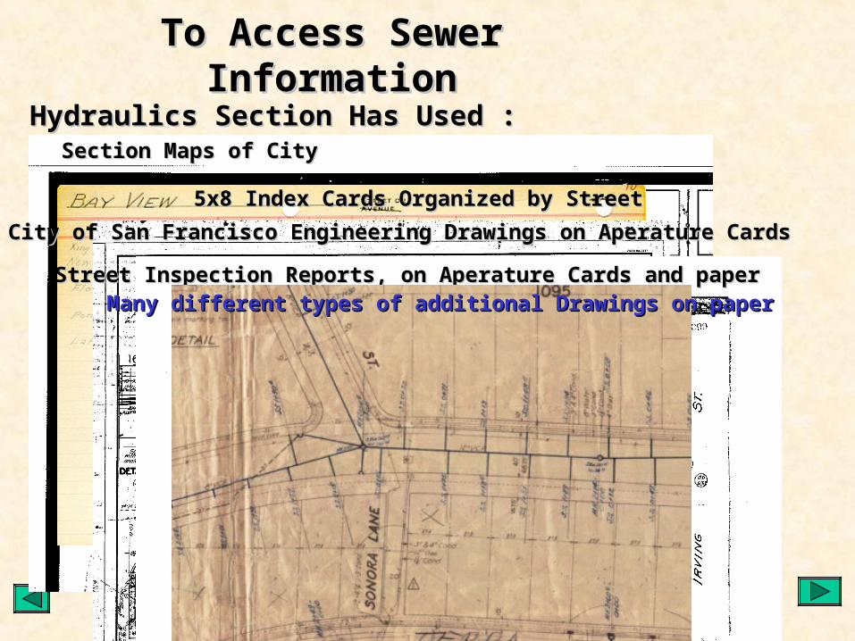
Section Maps of CitySection Maps of City
5x8 Index Cards Organized by Street5x8 Index Cards Organized by Street
City of San Francisco Engineering Drawings on Aperature CardsCity of San Francisco Engineering Drawings on Aperature Cards
Street Inspection Reports, on Aperature Cards and paperStreet Inspection Reports, on Aperature Cards and paper
To Access Sewer InformationTo Access Sewer Information
Hydraulics Section Has Used :Hydraulics Section Has Used :
Many different types of additional Drawings on paperMany different types of additional Drawings on paper

• Creation of CCSF Basemap (1993-5)– Aerial Photos– Parcels– Features– Street Centerlines– Major portion of funding from Clean Water
Program
City Wide Basemap by ValueCAD

• Updating Sewer Basemap (1998-Present)– Combine previous ACAD files– Reference to City Basemap
• (NAD83CaStPlIII)
– Rubbersheet to correct location– Add attributes in object data to pipes from annotation– Renumber Manholes– Processes automated to reduce cost
ValueCAD’s First Sewer Basemap Efforts

Decision Time• Sewer Basemap Obviously Lacked a large number of manholes
– “Schematic map” not useful for asset mgmt.• Basic attributes incomplete or outdated
– Material – Size - Date
• No Hydraulic modeling information– Rim– Invert
• Investigate GPS – Survey– $$$$$$$$$$$– Pipes the priority
• AsBuilts?– 50 engineeering Drawings tested– $$$$$

On Site Investigation• Contractor to sit and work with Hydraulic Staff to:
– Evaluate alternatives for sewer basemap data collection and conversion– Work with city staff, evaluate processes and business needs
• Document Management– Not as easy as city staff thought– Engineering AsBuilts represent less then 15% of possible data– Wide variety of document types with different data value
• Evaluate Variety of Needs– Engineers view Vs. Citywide view
• Develop Possible Uses and Prototypes• Set Goals and Standards for GIS efforts• “Balkanized” City Departments

Cost effectiveness – relative return on investment• Document Management $$• Engineering Decision Support $$$
– Provide engineers with efficient access to all available information, not replace good engineering… METADATA – engineer understands the value and completeness of the information to make the best engineering decisions
• Hydraulic Modeling – Master Planning $$• Asset Management - $$$$$$
– Public decision making– Cost effectiveness of engineering and maintenance decision– Management of maintenance efforts
• Integrate Asset Management with Engineering Process $• Information Organized in one place for various agencies $$• Emergency Response/ Environmental/ Waste Management
Goals for Sewer GIS Basemap Project

Goals for Data Collection and Conversion
• Efficiency – Speed
– Accuracy
• Multiple Uses of Data Collected• Sustainable Pace and Budget• “Do-able” – Reasonable Expectations• Exception Process• Flexible

All Sewer related drawings have been collected All Sewer related drawings have been collected and Scannedand Scanned
Drawings Were Indexed by StreetDrawings Were Indexed by Street
New sewer GIS map and sewer information have New sewer GIS map and sewer information have been developed block by block using the original been developed block by block using the original drawings.drawings.
Pipes, manholes and structure information Pipes, manholes and structure information collected have been automatically linked to as built collected have been automatically linked to as built drawings or best available documents.drawings or best available documents.

To Access the Scanned DrawingsTo Access the Scanned DrawingsHydraulics Developed and is Using the Hydraulics Developed and is Using the
As Built ViewerAs Built Viewer

Hydraulics Has Been Able to Link To the Hydraulics Has Been Able to Link To the Index CardsIndex Cards
– Index Cards had been transferred to Excel Spreadsheet called SMS IndexIndex Cards had been transferred to Excel Spreadsheet called SMS Index– SMS Index turned into Access Database table and cleaned upSMS Index turned into Access Database table and cleaned up– Drawings that the SMS Index referenced were picked first to be scannedDrawings that the SMS Index referenced were picked first to be scanned– Links made between scanned drawings and SMS IndexLinks made between scanned drawings and SMS Index– Links made between SMS and Centerline fileLinks made between SMS and Centerline file– Spatial Join between Streets and Pipes to put SMS information onto pipesSpatial Join between Streets and Pipes to put SMS information onto pipes
So Now We can Look Up So Now We can Look Up Pipe Information and drawings by StreetPipe Information and drawings by Street

We can use the Viewer to Insert We can use the Viewer to Insert the Drawings Into AutoCADthe Drawings Into AutoCAD
1.Select a point on the Image1.Select a point on the Image2. Select corresponding 2. Select corresponding point in AutoCADpoint in AutoCAD
3. Select 2nd point 3. Select 2nd point on imageon image4. Select 2nd point 4. Select 2nd point
in ACADin ACAD
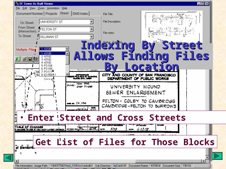
• Enter Street and Cross Streets
Get List of Files for Those Blocks
Indexing By Street Allows Indexing By Street Allows Finding Files By LocationFinding Files By Location

• Linked To Blocks and Intersections By “CNN”
All Files Are Linked To All Files Are Linked To CCSF BasemapCCSF Basemap
Street Centerline networkStreet Centerline network
• Allows look up for cross street

ValueCAD Data Conversion Process
• Divide into subsections based on Drainage basins• Use asbuilt viewer to select correct document • Enter correct location of pipes and manholes • Add pipe and manholes if required• Enter additional attribute data• Automatic link of data collected to documents• Exception Handling to increase efficiency and accuracy• Automated using AutoCAD vba

Current Efforts and Future Directions – Spring-Summer 2003
• QA/QC– Large Pipes and Structures– Automated QA/QC– Exceptions
• Automation of CAD to integrate Engineering Design and Maintenance of Asset Management Database - Oracle
• Integrate with Sewer TV Tape, Inspections, Asset Management
• Major Structures – East Side• Web based applications

Current Efforts and Future Directions Spring-Summer 2003
• Catch Basins – ArcPad • Storm Water Discharge Permits• Integrate AWSS


Thank YouThank You