Embed Size (px)
Citation preview

Astley Lane, Bedworth
Ecological Appraisal
A Report on behalf of the Arbury Estate February 2015
30 Brock Street Bath BA1 2LN
tel: 01225 445548 fax: 01225 312387
www.npaconsult.co.uk

Arbury Estates Ecological Appraisal Astley Lane, Bedworth
AE/NPA/10747 NICHOLAS PEARSON ASSOCIATES Astley Lane Ecological Appraisal.doc
CONTENTS
1.0 Introduction
2.0 Appraisal
2.1 Habitats
2.2 Amphibians
2.3 Reptiles
2.4 Bats
2.5 Water Vole & Otter
2.6 Badgers
2.7 Birds
2.8 Invertebrates
3.0 Conclusion
Figures
Nature Conservation Designations within 1km
References
Appendices
I: Ecology Surveys of Land Off Astley Lane
II: Biodiversity Impact Assessment
III: Offsite Habitat Survey
IV: Bat Internal/External Assessment

Arbury Estates Ecological Appraisal Astley Lane, Bedworth
AE/NPA/10747 1/12 NICHOLAS PEARSON ASSOCIATES Astley Lane Ecological Appraisal.doc
1.0 INTRODUCTION
This document has been prepared by Nicholas Pearson Associates (NPA) on behalf of the
Arbury Estate who propose to submit an outline planning application for up to 180
residences (and related infrastructure) on approximately 11.6 ha of land (identified on the
Location Plan, dwg No. 15 0076) to the north of Astley Lane, Bedworth.
A report detailing the results of ecological surveys undertaken on Site has been prepared by
Ecological Services Ltd (ESL) and should be read in conjunction with this appraisal. As such it
is included in Appendix 1 for ease of reference. In addition two further ecological surveys
have been carried out by NPA, namely off-Site habitat surveys to inform biodiversity
offsetting proposals (see Appendix III) and bat internal/external inspections of properties on
and near the south-east corner of the Site (see Appendix IV).
This appraisal sets out a summary of the baseline conditions, the ecological mitigation and
enhancements proposed, and how the proposals accord with national and local planning
policy and legislation.
2.0 APPRAISAL
A number of valued ecological receptors were identified within the ESL report and this
section outlines the proposed mitigation/approach to each.
2.1 Habitats
Baseline Summary
The Site, with the exception of approximately 2ha of improved grassland that forms the
western field (see Warwickshire Biological Records Centre nature conservation designation
map in Appendix I), is part of the Newdigate Colliery Local Wildlife Site (LWS) (The nature
conservation designations figure is provided in the figures section of this report for erase of
reference). The LWS covers 34.9 ha in total and is designated for its large area of
semi-improved grassland, pioneer habitats, scrub and plantation woodland.

Arbury Estates Ecological Appraisal Astley Lane, Bedworth
AE/NPA/10747 2/12 NICHOLAS PEARSON ASSOCIATES Astley Lane Ecological Appraisal.doc
In addition the following UK and/or Warwickshire Biodiversity Action Plan (BAP) habitats
have been recorded on Site; Hedgerows, Ponds, Woodland, Neutral Grassland and Disused
Industrial and Railway Land.
Key Legislation and Planning Policy
Whilst LWS’s do not receive statutory protection, the policies in Table 1 below are included
in the National Planning Policy Framework (NPPF) and the emerging local plan.
Table 1: Key Planning Policy relevant to Local Wildlife Sites
Document Policy
NPPF Paragraph 109:
“The planning system should contribute to and enhance the natural and local
environment by …minimising impacts on biodiversity and providing net gains in
biodiversity where possible, contributing to the Government’s commitment to
halt the overall decline in biodiversity, including establishing coherent ecological
networks that are more resilient to current and future pressures”
Paragraph 1118:
“if significant harm resulting from a development cannot be avoided (thorough
locating on an alternative site with less harmful impacts), adequately mitigated,
or as a last resort, compensated for, then planning permission should be
refused.”
Nuneaton and
Bedworth
Borough Plan:
Preferred
Options
Env1-Biodiversity and Geodiversity Policy
Ecological Network
“… Within locally designated sites show that the benefits of the development
proposals outweigh the biodiversity or geodiversity value of the site, otherwise
the development proposal will not be permitted”.
“Ensure a net gain in biodiversity by firstly avoiding any adverse impacts, or,
where this is not possible, ensure adverse impacts are mitigated.”
Biodiversity Mitigation
“Require developers to use the Biodiversity Offsetting Metrics to replace any
loss of habitats due to their development. If the habitat loss cannot be replaced
on site, the replacement habitat should, firstly, be provided on a biodiversity
offsetting strategic location, secondly, where offset location buffers, links,
restores or expands a habitat out a strategic location; and lastly, where the
offset location does not contribute to the offsetting strategy.”
Arbury Estates Ecological Appraisal Astley Lane, Bedworth
AE/NPA/10747 3/12 NICHOLAS PEARSON ASSOCIATES Astley Lane Ecological Appraisal.doc
Whilst the UK BAP partnership no longer operates following the publication of the UK
Post-2010 Biodiversity Framework, the principles of the UK BAP still remain of use, for
example the background information on UK BAP priority habitats and species which still
form the basis of much biodiversity work at country level. The habitats and species listed as
having principle importance for the purpose of conserving biodiversity within the Natural
Environmental and Rural Communities (NERC) Act 2006 continue to be regarded as
conservation priorities in the new Framework and these are the species and habitats
requiring action under the UK BAP. As such, the species list on the UK BAP and LBAP list
have been taken into consideration.
Mitigation
The proposals (see Illustrative Masterplan and Proposed Habitats Plan) have sought to
avoid/minimise impacts on the LWS, and those considered to qualify as local/UK BAP
habitats, as far as practicable. In addition the Masterplan has sought to maximise habitat
enhancement and creation. As such the Masterplan proposals include the:
Retention of all/ the vast majority of woodland, hedgerows, hardstanding associated
with former colliery railway and ponds,
Creation and/or enhancement of 6ha of semi-improved grassland to mitigate for the
loss of 4ha of semi-improved grassland,
Creation of three new ponds, and
Enhancement of brook along the northern edge of the development
In accordance with local planning policy the Biodiversity Offsetting Metrics were used to
assess if the proposals would provide net gains in biodiversity. The assessment and results of
the Biodiversity Offsetting Metrics are detailed within Appendix II. In summary they
demonstrate that whilst there would be a loss of habitats from within the LWS, overall net
gains in habitat biodiversity would be achieved through the mitigation measures outlined
above. In addition the proposal would provide certainty that habitat would be managed in
the long term for the benefit of biodiversity (as it is noted that currently the land owner is
under no obligation to do so).
The approach to the mitigation, including the location and proposals for the off Site
mitigation, has been subject to consultation with the Local Planning Authority (Nuneaton

Arbury Estates Ecological Appraisal Astley Lane, Bedworth
AE/NPA/10747 4/12 NICHOLAS PEARSON ASSOCIATES Astley Lane Ecological Appraisal.doc
and Bedworth Borough Council, NBBC), Warwickshire County Council (WCC) and
Warwickshire Wildlife Trust (WWT).
The consultation focused on retention and/or enhancement of important habitats on Site
and then sought to identify further areas off-Site which could be improved to achieve net
biodiversity gains. The area chosen for off-site mitigation has been identified as it adjoins the
northern boundary of the Newdigate Colliery LWS, is within 500m of the land to be
affected, would provide buffer habitat to the adjacent woodland and would not fragment
connectivity to other nature conservation designations in the area.
It is considered that the mitigation measures outlined above, and detailed within the
biodiversity impact assessment, together with the certainty of future land management,
would increase the resilience of the LWS to current and future pressures.
2.2 Amphibians
Baseline Summary
In 2007 prior to the development of the housing estate that adjoins the eastern boundary of
the Site, Great Crested Newts Triturus cristatus (GCN) were recorded in ponds 6, 7 & 8 (see
ESL Figure 2), with peak counts of 8, 8 and 3 recorded respectively in each pond, with a
total peak count for the ponds of 11 GCN (i.e. just falling within the 11-100 category to be
considered a medium population size class).
A period of trapping and translocation under a Natural England EPS mitigation licence was
then undertaken between 2007 and 2010, with at least 21 GCN translocated to a receptor
site in the north eastern spur of the current application Site, with pond 5 created as part of
the mitigation works.
Environmental DNA (eDNA) surveys of ponds 1-6 (see ESL Figure 2) in June 2014 recorded
GCN present in each of ponds with the exception of pond 3. Ponds 7 & 8 could not be
surveyed using the eDNA method due to their shallowness and high levels of organic
matter.
Key Legislation and Planning Policy

Arbury Estates Ecological Appraisal Astley Lane, Bedworth
AE/NPA/10747 5/12 NICHOLAS PEARSON ASSOCIATES Astley Lane Ecological Appraisal.doc
GCN receive protection under the Habitats and Species Regulations 2010 (Habitat
Regulations). As the proposals, in the absence of mitigation, could lead to the killing, injury
and/or disturbance of GCN the local authority, and later Natural England licensing, will need
to be confident that the following three tests of the Habitat Regs can satisfied:
i. The development must meet a purpose of preserving public health or public safety, or
other imperative reasons of overriding public interest, including those of social or
economic nature and beneficial consequences of primary importance for the
environment; and
ii. There is no satisfactory alternative, and
iii. The action authorised will not be detrimental to the maintenance of the population of
the species concerned as a favourable conservation status in their natural range.
Natural England’s Standing Advice on GCN states that if habitat is to be affected
“compensation should ensure, once completed, there will be no net loss of breeding or resting sites.
In fact where significant impacts are predicted there will be an expectation that compensation will
provide an enhanced habitat (in terms of quality or area) compared with that to be lost.”
Mitigation
The need for residential development in the area and the lack of satisfactory alternative sites
are discussed within the Planning Statement that accompanies this application.
The proposals, as shown in the Illustrative Masterplan and Proposed Habitats Figure,
incorporate the following key mitigation measures to avoid detrimental affecting the GCN
conservation status.
Development within the eastern Public Open Space (POS)/Persimmon GCN receptor
area avoided/minimised as far as practicable,
o Proposals in this area would be limited to upgrading of the existing footpath to a
cycle way and creation of a short length of new sewer.
o Existing ponds in the area which appear to have been neglected would be
subject to enhancement measures that would be detailed within a Site
management plan (e.g. thinning/removal of over-shading vegetation, removal of
encroaching vegetation and removal of accumulated silt).

Arbury Estates Ecological Appraisal Astley Lane, Bedworth
AE/NPA/10747 6/12 NICHOLAS PEARSON ASSOCIATES Astley Lane Ecological Appraisal.doc
Provision of optimal GCN habitat corridor to the north of the proposed residential
area.
o This corridor would link existing GCN habitat in the east to that proposed in
the west, through the retention/enhancement of terrestrial habitat and creation
of a pond specifically designed for GCN.
Creation of optimal GCN habitat in the western field.
o Habitat to include an additional two ponds specifically designed for GCN, dense
and scattered scrub, log piles, hibernacula and long grassland.
o The proposed ponds would act as “stepping stones“ so the GCN population
would have connectivity to additional woodland habitat outside their recognised
range of 500m and potentially to GCN populations to the north-west (Ponds 1
& 2, ESL Figure 2) and south-west (Pond 4, ESL Figure 2). The brook to the
north of the western field is not considered a barrier to GCN movement given
its slow flow and relatively narrow (approx. 3m) width. Astley Lane is not
considered an absolute barrier to GCN movement given the absence of kerbs in
some locations and only low kerbs present elsewhere.
Whilst the proposals would damage/destroy approximately 4ha of semi-improved grassland
(considered to provide foraging habitat for GCN), and 1ha of broad-leaved plantation, scrub,
tall ruderal and gardens which (considered to provided foraging and resisting habitat for
GCN) the mitigation strategy would lead to:
No loss of existing core GCN habitat (i.e. habitat within 50m of existing GCN pond).
Creation of:
o an additional 1.9ha of core habitat, suitable for breeding, resting and foraging
(around three proposed ponds), leading to an increase of breeding and resting
sites.
o approximately 0.7ha of scrub, which would provide resting and foraging habitat,
and include hibernacula and log piles,
o approximately 1.2ha grassland to be managed as a hay meadow, which would
provide foraging habitat,
o 3 ponds, specifically designed for GCN, within 250m of each other and/or
existing GCN ponds, providing GCN with connectivity to two additional GCN
populations and significant additional terrestrial habitat.

Arbury Estates Ecological Appraisal Astley Lane, Bedworth
AE/NPA/10747 7/12 NICHOLAS PEARSON ASSOCIATES Astley Lane Ecological Appraisal.doc
To avoid the potentially killing or injury of GCN a trapping programme would be
undertaken prior to construction to trap GCN out of suitable habitat which would be
affected and/or isolated. Trapping would utilize exclusion fencing and pitfall traps (in
accordance with the designs given in Natural England’s GCN Mitigation Guidelines) and
habitat manipulation. Captured GCN and other herpetofauna would either be translocated
to the existing receptor area or adjacent to ponds in the western field.
Construction boundary exclusion fencing would remain in place throughout construction to
avoid the killing and/or injury of GCN. Regular visits would be undertaken throughout the
construction period by a suitably licensed GCN ecologist and post construction monitoring
would be undertaken in accordance with the guidance within Natural England’s GCN
Mitigation Guidelines.
It is considered that the existing survey information and the detail provided regarding the
proposals and mitigation is sufficient to determine that the proposals will not be detrimental
to the favorable conservation status of the GCN population and indeed would provide
significantly enhanced habitat. However it is recognised that to apply for a Natural England
EPS mitigation licence, Natural England will require update population size class assessments
survey data to inform the licence, in particular to ascertain the number of appropriate
trapping days required and the appropriate level of post construction monitoring.
2.3 Reptiles
Baseline Summary
The reptile surveys recorded a Grass Snake Natrix natrix, on two occasions, approximately
20m from pond 5. However the baseline survey report does note that some of the surveys
were carried out in sub-optimal months and may have resulted in an under recording of
reptiles at the Site.
Key Legislation and Planning Policy
Common reptile species (Grass Snake, Slow-Worm, Common Lizard and Adder) are
protected under the Wildlife and Countryside Act (1981) against killing and injury.
Mitigation

Arbury Estates Ecological Appraisal Astley Lane, Bedworth
AE/NPA/10747 8/12 NICHOLAS PEARSON ASSOCIATES Astley Lane Ecological Appraisal.doc
The proposals (see Illustrative Masterplan and Proposed Habitats Plan) have sought to avoid
and minimise impacts on areas considered suitable for reptiles. The terrestrial habitat
requirements for common reptiles are very similar to those required by GCN (with the
notable exception that reptiles require areas for basking). As such it is considered that the
avoidance and mitigation measure described for GCN above will avoid the killing and/or
injury of reptiles and provide them with significant habitat enhancements, especially Grass
Snake for which waterbodies are an important habitat.
2.4 Bats
Baseline Summary
Bat surveys recorded at least six different species of bat (Common Pipistrelle Pipistrellus
pipistrellus, Soprano Pipistrelle Pipistrellus pygmaeus, Noctule Nyctalus noctula, Brown
Long-eared Plecotus Auritus, Leisler’s Nyctalus leisleri and at least one species of Myotis bat
Myotis sp.) foraging across the Site, with the majority of activity being associated with the
vegetated Site boundaries. Building inspections undertaken on Police Cottage and Colliery
Cottages (see Appendix IV) have recorded the presence, confirmed by DNA analysis of
droppings, of Brown Long-eared and Whiskered Bat Myotis mystacinus roosts respectively at
these properties.
Key Legislation and Planning Policy
All bats receive protection under the Habitats and Species Regulations 2010. This protection
includes making it an offence to disturb them (in particular any disturbance which is likely to
impair their ability to survive, to breed or reproduce, or hibernate), significantly affect their
local distribution or damage/destroy their roosts.
Mitigation
Given that a bat roost has been recorded at Police Cottage, this dwelling is proposed to be
retained along with Colliery Cottages. In addition the network of proposed vegetated
corridors in the Masterplan, which will allow for bat commuting across the Site and the
wider landscape, includes a strong vegetated corridor from Police Cottage and Colliery
Arbury Estates Ecological Appraisal Astley Lane, Bedworth
AE/NPA/10747 9/12 NICHOLAS PEARSON ASSOCIATES Astley Lane Ecological Appraisal.doc
Cottages to the woodland in the north and to the enhanced habitat in the western field and
beyond.
To ensure the continued suitability of these corridors for bats, no lighting is proposed in the
POS in west, east and along the northern corridor, and the design allows for darkened bat
corridors from the bat roosts identified in/near the south east of Site. Section B-B’ in the
Design and Access Statement shows how retention of the southern hedgerow and a
proposed hedge with trees would form a darkened bat corridor along this boundary.
It is considered that the measures above and the proposed creation of significant areas of
optimal bat habitat (including ponds, hedgerows, diverse grassland and scrub) on and off Site
would provide an enhanced habitat for bats.
2.5 Water Vole and Otter
Baseline Summary
As the lower banks of the brook are devoid of vegetation and are of a stony substrate the
brook is considered generally unsuitable for Water Vole.
As the brook does not have close connectivity to any rivers or major watercourses and
appears to lack food resources for Otter, it is considered to be of low biodiversity value for
this species.
Key Legislation and Planning Policy
Otter are a European Protected Species and receive the same legal protection as bats and
GCN.
Water Vole are protected under the Wildlife and Countryside Act 1981, which includes
making it an offence to disturb, damage, destroy or block access to their places of shelter.
Mitigation
The proposals allow for a 20-30m buffer from the brook to the nearest proposed road or
housing parcel and as such the majority of potential direct impacts on the brook would

Arbury Estates Ecological Appraisal Astley Lane, Bedworth
AE/NPA/10747 10/12 NICHOLAS PEARSON ASSOCIATES Astley Lane Ecological Appraisal.doc
avoided. Best practice measures would be implemented to avoid pollution events during
construction and/or operation to the watercourse.
In addition it is proposed to enhance the biodiversity value of the brook through
thinning/removal of over shading scrub/trees to allow more light to reach the brook and it
banks, and through the addition of in-channel features (e.g. faggots, small boulders) to keep a
reasonable flow in the brook even in low flow conditions.
2.6 Badger
Baseline Summary
No evidence of Badgers was recorded on or adjacent to the Site during the Extended Phase
1 Habitat Survey.
Key Legislation and Planning Policy
Badgers are protected by the Protection of Badgers Act 1992, which protects their setts
from damage or destruction.
Mitigation
The proposals retain large areas of habitat suitable for sett building and foraging, and allow
for Badger movement across the Site. Although no badger setts were identified on Site,
given the presence of habitat on and adjacent to Site suitable for future sett creation, further
checks would be undertaken prior to construction.
2.7 Birds
Baseline Summary
No birds listed on Schedule 1 of the of Wildlife and Countryside Act or Section 41 of the
Natural Environmental and Rural Communities (NERC) Act were returned from the local
biological record centre. Incidental sightings of a range of common and widespread species
were made during various other surveys undertaken on Site, but no breeding bird surveys
have been undertaken to date.

Arbury Estates Ecological Appraisal Astley Lane, Bedworth
AE/NPA/10747 11/12 NICHOLAS PEARSON ASSOCIATES Astley Lane Ecological Appraisal.doc
Anecdotal records from people visiting the Site include S41 and Local BAP species Reed
Bunting Emberiza schoeniclus, Song Thrush Turdus philomelos and Yellow Hammer Emberiza
citrinella.
It is considered that the various habitats across Site are likely to support a broad assemblage
of birds.
Key Legislation and Planning Policy
Under the Wildlife and Countryside Act it is an offence to damage or destroy an active
bird’s nest.
Species listed on Section 41 of the NERC Act and Local BAP are conservation priorities.
Mitigation
The proposals allow for the retention and creation of significant areas of suitable habitat.
Habitats to be created include ponds, semi-improved grassland, scrub, hedgerows and trees.
It is considered that the habitats created (most notably in the western field and off Site)
would be of benefit to the bird population present.
Disturbance to and displacement of breeding birds would be avoided by undertaking
vegetation clearance outside of the bird breeding season (March – September inclusive) or
with a prior check for active birds’ nests.
Whilst the above measures are considered sufficient to demonstrate the bird assemblage
present will not be detrimentally affected, it is recommended that breeding bird surveys are
undertaken to inform detailed mitigation measures (e.g. bird box specification, proposed
plant species).
2.8 Invertebrates
Baseline Summary
Local record centre returned on Site records for Dingy Skipper (UK and LBAP), Small Heath
(UK BAP) and Latticed Heath (UK BAP). The locations for the Dingy Skipper records are

Arbury Estates Ecological Appraisal Astley Lane, Bedworth
AE/NPA/10747 12/12 NICHOLAS PEARSON ASSOCIATES Astley Lane Ecological Appraisal.doc
from an old pit siding in the north east of the Site and a spoil bank between the two main
fields.
Key Legislation and Planning Policy
Species listed on the UK and Local BAP are conservation priorities.
Mitigation
The Masterplan retains areas where Dingy Skipper have been recorded and proposes the
enhancement and creation of grassland areas, which would contain the larval foodplants and
nectar sources of the Dingy Skipper.
It is considered that the retention, enhancement and creation of significant habitat areas
(including ponds, semi-improved grassland, scrub, hedgerows, trees and south facing scallops
in the woodland to the north of the brook) would also benefit a wide range of other
invertebrate species.
3.0 CONCLUSION
The proposals have sought to avoid and minimise impacts on the LWS as far as practicable
and maximise habitat enhancement and creation. As such the proposals include the key
mitigation measures below:
Retention of existing GCN core habitat and creation of additional ponds and terrestrial
habitat to maintain the favourable conservation status of the newts.
Retention of on Site roost for bats and provision of a network of darkened vegetated
corridors to maintain connectivity across the Site and to the wider landscape.
Creation/enhancement of 6ha of semi-improved grassland to mitigate for loss of 4ha of
existing semi-improved grassland, as well creating/enhancing a range of other habitats, to
provide a net biodiversity gain.
The above measures, and those detailed within the report, would ensure that net
biodiversity gains would be achieved, favourable conservation status of species would be
maintained and the proposal accord with all relevant legislation and planning policy.


Arbury Estates Ecological Appraisal Astley Lane, Bedworth
AE/NPA/10747 NICHOLAS PEARSON ASSOCIATES Astley Lane Ecological Appraisal.doc
APPENDIX I: ECOLOGICAL SURVEYS OF LAND OFF ASTLEY LANE

Arbury Estates Ecological Appraisal Astley Lane, Bedworth
AE/NPA/10747 NICHOLAS PEARSON ASSOCIATES Astley Lane Ecological Appraisal.doc
APPENDIX II: BIODIVERISTY IMPACT ASSESSMENT CALCUALTIONS

v. 18.3 08/08/2014Amendment from v18.2 only affects green roofs, for otPlease fill in both tables
KEYNo action requiredEnter valueDrop-down menuCalculationAutomatic lookupResult
T. Note code Phase 1 habitat descriptionHabitat area (ha) Distinctiveness Score Condition Score Area (ha) Existing value Area (ha) Existing value Area (ha) Existing value
Direct Impacts and retained habitats A B C A x B x C = D E A x B x E = F G A x B x G = HB22 Grassland: Semi-improved neutral grassland 4.80 Medium 4 Moderate 2 0.44 3.52 0.23 1.84 4.13 33.04B6 Grassland: Poor semi-improved grassland 0.08 Medium-Low 3 Moderate 2 0.04 0.24 0.04 0.24B4 Grassland: Improved grassland 1.92 Low 2 Poor 1 0.16 0.32 1.43 2.86 0.33 0.66A111 Woodland: Broad-leaved semi-natural woodland 0.66 High 6 Moderate 2 0.66 7.92A112 Woodland: Broad-leaved plantation 1.54 Medium 4 Moderate 2 1.24 9.92 0.06 0.48 0.24 1.92A21 Woodland: Dense continuous scrub 1.19 Medium-Low 3 Moderate 2 0.85 5.10 0.34 2.04A22 Woodland: Scattered scrub 0.29 Medium 4 Moderate 2 0.29 2.32G2 Wetland: Running water 0.23 High 6 Poor 1 0.23 1.38G1 Wetland: Standing water 0.08 High 6 Poor 1 0.08 0.48C31 Other: Tall ruderal 0.23 Medium-Low 3 Moderate 2 0.08 0.48 0.15 0.90n/a Built Environment: Gardens (lawn and planting) 0.51 Low 2 Poor 1 0.06 0.12 0.10 0.20 0.35 0.70n/a Built Environment: Buildings/hardstanding 0.01 none 0 Moderate 2 0.01 0.00J4 Other: Bare ground 0.01 Low 2 Good 3 0.01 0.06B4 Grassland: Improved grassland 5.01 Low 2 Poor 1 5.01 10.02
Total 16.56 Total 3.84 30.00 7.14 17.26 5.58 39.50∑D + ∑F + ∑H
86.76Indirect Negative Impacts Value of loss from indirect impactsIncluding off site habitats
KK x A x B= Li, Lii Li - Lii
Before After
Before After
Before After
Before After
Before After
Total 0.00 M 0.00 HIS = J + M39.50
Nuneaton & BedworthLocal Planning Authority:
Habitats to be retained with no change within
development
Date:
Existing habitats on sitePlease enter all habitats within the site boundary Habitat distinctiveness Habitat condition
Before/after impact
Site name:To condense the form for display hide vacant Please do not edit the formulae or structure
Warwickshire Coventry and Solihull - Biodiversity Impact Assessment Calculator
Astley LanePlanning application reference number:
rows, do not delete themIf additional rows are required,or to provide feedback on the calculatorplease contact WCC Ecological Services
Habitat Biodiversity Value
Site habitat biodiversity value
Habitats to be lost within development
Assessor:
Habitat Impact Score (HIS)
Habitats to be retained and enhanced within
development

T. Note code Phase 1 habitat description Area (ha) Distinctiveness Score Condition Score Time (years) Score Difficulty ScoreHabitat Creation
N O P Q R(N x O x P) /
Q / RB22 Grassland: Semi-improved neutral grassland 0.40 Medium 4 Moderate 2 10 years 1.4 Medium 1.5 1.52J12 Grassland: Amenity grassland 0.50 Low 2 Poor 1 5 years 1.2 Low 1 0.83n/a Built Environment: Gardens (lawn and planting) 1.21 Low 2 Poor 1 5 years 1.2 Low 1 2.02n/a Built Environment: Buildings/hardstanding 3.24 none 0 Poor 1 5 years 1.2 Low 1 0.00G1 Wetland: Standing water 0.11 High 6 Good 3 10 years 1.4 Medium 1.5 0.94J4 Other: Bare ground 0.12 Low 2 Poor 1 5 years 1.2 Low 1 0.20
Total 5.58Habitat Enhancement Existing value
S ( = F )(( N x O x P) - S) /
Q / RB22 Grassland: Semi-improved neutral grassland 0.23 Medium 4 Good 3 1.84 5 years 1.2 Low 1 0.77B22 Grassland: Semi-improved neutral grassland 0.76 Medium 4 Good 3 1.52 20 years 2 Low 1 3.80A22 Woodland: Scattered scrub 0.67 Medium 4 Moderate 2 1.34 10 years 1.4 Low 1 2.87G2 Wetland: Running water 0.23 High 6 Good 3 1.38 10 years 1.4 Medium 1.5 1.31G1 Wetland: Standing water 0.08 High 6 Good 3 0.48 10 years 1.4 Medium 1.5 0.46A112 Woodland: Broad-leaved plantation 0.10 Medium 4 Moderate 2 0.20 10 years 1.4 Low 1 0.43A112 Woodland: Broad-leaved plantation 0.06 Medium 4 Good 3 0.48 5 years 1.2 Low 1 0.20B22 Grassland: Semi-improved neutral grassland 5.01 Medium 4 Good 3 10.02 15 years 1.7 Low 1 29.47
Total 7.14 Trading down correction value -1.69Habitat Mitigation Score (HMS) 43.14
HBIS = HMS - HISHabitat Biodiversity Impact Score 3.64
Percentage of biodiversity impact loss
KEYNo action requiredAction requiredDrop-down menuCalculationAutomatic lookup
Loss to biodiversityGain to biodiversity
Proposed habitats on site(Onsite mitigation)
Overall Result
Time till target conditionHabitat
biodiversity value
Difficulty of creation / restoration
Target habitats distinctiveness Target habitat condition

ther habitats v18.2 still usable.
Comment
The 0.44ha retained is the GCN receptor area.
0.16ha to be retained around NEAP and LEAP
Ponds 1,2, 5 & 6
Bare ground considered in Good condition for it's importnace to Dingy SkipperOff site mitigation fieldsJ

Comment
Around boundary of main development and in SUDs feature
45% of housing blocks (2.68ha * 0.45) likely to be lawn/planting. Adjacent development measured at ~47% planting/lawn1.62ha of roads plus remaining 55% housing block (0.55 * 2.68)
Area enhanced to north and west of main dev through annual hay cut & collectionIn western improved field. Through cessation of fertiliser input, hay cut and collectionIn western improved field.Through allowing more light to stream and improving flowOpen water areas created in Ponds 1,2, 5 & 6 and more light allowed to reach pondsTree and shrub planting in south east corner of SiteWoodland scallops created north of the brookOff site mitigation fields. Aim to achieve target in 10 years, but allow 15 as a safety factor.
Gain

Please fill in both tables
KEYNo action required Linear FeaturesEnter valueDrop-down menuCalculationAutomatic lookupResult
T. Note code Phase 1 habitat descriptionFeature length (km) Distinctiveness Score Condition Score Length (km) Existing value Length (km) Existing value Length (km) Existing value Comment
Direct Impacts and retained features A B C A x B x C = D E A x B x E = F G A x B x G = HJ21 Hedges: Intact hedge 0.45 Medium 4 Moderate 2 0.43 3.47 0.02 0.12J26 Ditches: Dry ditch 0.20 Low 2 Poor 1 0.09 0.18 0.11 0.22
Total 0.65 Total 0.52 3.65 0.00 0.00 0.13 0.34 J∑D + ∑F + ∑H
3.99Indirect Negative Impacts Value of loss from indirect impacts
KK x A x B= Li, Lii Li - Lii
Before After
Before After
Before After
Before After
Before After
Total 0.00 M 0.00 HIS = J + M0.34
CAUTION - Destruction of features of medium or high distinctiveness, e.g. hedgerows and streams, may be against local policy. Has the mitigation hierarchy been followed, can impact to these habitats be avoided?Any unavoidable loss of valuable habitats must be replaced like-for-like. E.G. Loss of hedgerows must be replaced with similar or better hedgerows. All newly planted hedges should be native species-rich hedgerows.
T. Note code Phase 1 habitat description Length (km) Distinctiveness Score Condition Score Time (years) Score Difficulty Score CommentLinear Creation
N O P Q R(N x O x P) /
Q / RJ23 Hedges: Hedge with trees 0.10 Medium-High 5 Moderate 2 10 years 1.4 Low 1 0.71 On eastern boundary, adjacent to Persimmon development
Total 0.10Linear Enhancement Existing value
S ( = F )(( N x O x P) - S) /
Q / R
Total 0.00 Trading down correction value 0.00Linear Mitigation Score (LMS) 0.71
LBIS = LMS - LISLinear Biodiversity Impact Score 0.37 Gain
Percentage of linear impact loss
KEYNo action requiredAction requiredDrop-down menuCalculationAutomatic lookup
Loss to biodiversityGain to biodiversity
Linear biodiversity value
Overall Result
Hedges and other linear features can offer a higher biodiversity value per length than a standard area of habitat due to factors such as connectivity and must therefore be compensated for in parallel to the standard metric.
Linear Impact Score (LIS)
Proposed linear features on site(Onsite mitigation)
Target linear distinctiveness Target linear condition
Before/after impact
Linear Biodiversity Value
Existing linear features on site Linear distinctivenessLinear features to be lost within
development
Time till target condition
Warwickshire Coventry and Solihull - Biodiversity Impact Assessment Calculator - Linear Features
Site Linear Biodiversity Value
Difficulty of creation / restoration
Linear conditionLinear features to be retained
with no change within development
Linear features to be retained and enhanced within
development
Please do not edit the formulae or structureTo condense the form for display hide vacant
or to provide feedback on the calculatorplease contact WCC Ecological Services
rows, do not delete themIf additional rows are required,

Site name:Planning reference number:
Habitats Area (ha)Habitat
Biodiversity Value
16.56 86.76
5.58 39.50
12.72 43.14
3.64
Linear features Length (km)Linear
Biodiversity Value
0.65 3.99
0.13 0.34
0.10 0.71
0.37
email: [email protected]: 01926 418060
email: [email protected]: 01926 412772
Habitats negatively impacted by development Habitat Impact Score
Total existing area onsite
Total existing length onsite
Percentage of biodiversity impact
Habitat Biodiversity Impact Score If -ve further compensation required
On site habitat mitigation Habitat Mitigation Score
For any questions with regard to biodiversity impact and this development please contact Warwickshire County Council Ecological Services:
If there is an anticipated loss to biodiversity and no further ecological enhancements can be incorporated within the development it may be possible to compensate for this loss through a biodiversity offsetting scheme.
Please contact The Environment Bank for discussions on potential receptor sites in your area:
Biodiversity Impact Assessment Summary
Percentage of linear biodiversity impact
Linear Biodiversity Impact ScoreIf -ve further compensation required
On site linear mitigation Linear Mitigation Score
Linear features negatively impacted by development Linear Impact Score
Astley Lane

Arbury Estates Ecological Appraisal Astley Lane, Bedworth
AE/NPA/10747 App 111/1 NICHOLAS PEARSON ASSOCIATES Astley Lane Ecological Appraisal.doc
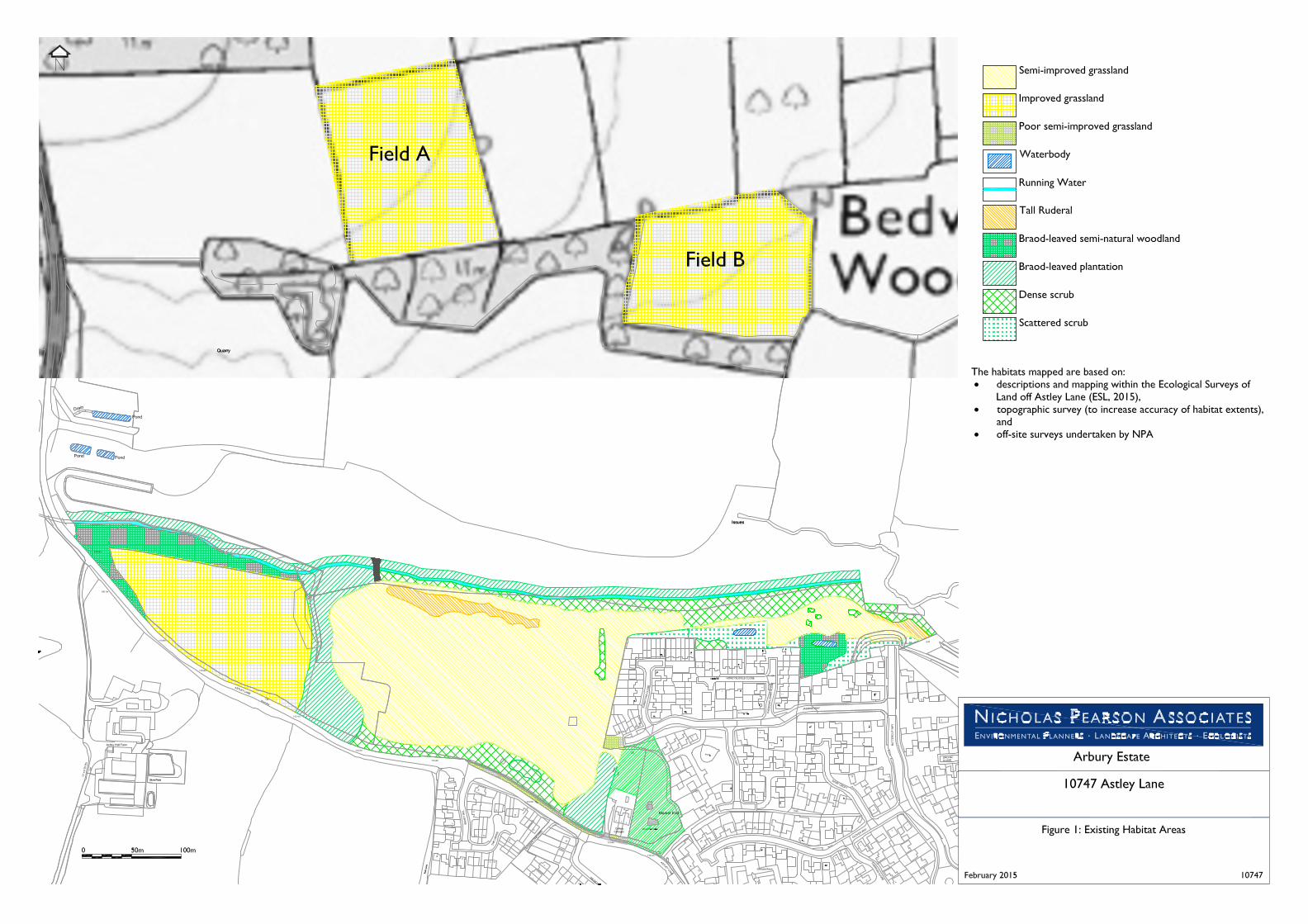
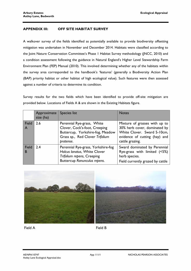
APPENDIX III: OFF SITE HABITAT SURVEY
A walkover survey of the fields identified as potentially available to provide biodiversity offsetting
mitigation was undertaken in November and December 2014. Habitats were classified according to
the Joint Nature Conservation Committee’s Phase 1 Habitat Survey methodology (JNCC, 2010) and
a condition assessment following the guidance in Natural England’s Higher Level Stewardship Farm
Environment Plan (FEP) Manual (2010). This involved determining whether any of the habitats within
the survey area corresponded to the handbook’s ‘features’ (generally a Biodiversity Action Plan
(BAP) priority habitat or other habitat of high ecological value). Such features were then assessed
against a number of criteria to determine its condition.
Survey results for the two fields which have been identified to provide off-site mitigation are
provided below. Locations of Fields A & are shown in the Existing Habitats figure.
Field A Field B
Approximate size (ha)
Species list Notes
Field A
2.6 Perennial Rye-grass, White Clover, Cock's-foot, Creeping Buttercup, Yorkshire-fog, Meadow Grass sp., Red Clover Trifolium pratense.
Mixture of grasses with up to 30% herb cover, dominated by White Clover. Sward 5-10cm, evidence of cutting (hay) and cattle grazing.
Field B
2.4 Perennial Rye-grass, Yorkshire-fog Holcus lanatus, White Clover Trifolium repens, Creeping Buttercup Ranunculus repens.
Sward dominated by Perennial Rye-grass with limited (<5%) herb species. Field currently grazed by cattle
Arbury Estates Ecological Appraisal Astley Lane, Bedworth
AE/NPA/10747 App 111/2 NICHOLAS PEARSON ASSOCIATES Astley Lane Ecological Appraisal.doc
Using the FEP grassland key 2a, both fields can be categorised as species-poor improved
grassland, having two or more of the following attributes:
Cover of Rye-grasses and White Clover >30%;
Species-poor sward (up to 8 species/m2); and/or
Low wildflower cover (<10% excluding White Clover, Creeping Buttercup and injurious
weeds).
No condition assessment is available for this grassland type in the FEP, however considering
the grassland fails to meet criteria for any higher quality grasslands, both fields are
considered to be in ‘Poor’ condition.

Arbury Estates Ecological Appraisal Astley Lane, Bedworth
AE/NPA/10747 App 1V/1 NICHOLAS PEARSON ASSOCIATES Astley Lane Ecological Appraisal.doc
APPENDIX IV: BAT INTERNAL/EXTERNAL ASSESSMENT An external and internal assessment of Colliery Cottage and Police Cottage to assess their
potential to support roosting bats was undertaken in December 2014. The location of the
properties is shown on the Red Line Plan.
During the external building survey, the perimeter of the buildings were walked and the exterior
assessed for features that could provide roosting features for bats and/or features that could allow
bats access to the building.
The internal building survey searched through the roof spaces for evidence of bats (e.g. droppings,
feeding remains, scratch marks, staining and sightings), features suitable for roosting bats and
potential access points for roosting bats.
Colliery Cottages (no.’s 1, 2 & 3)
External
Redbrick, two storey building with pitched roof. Brick work in good condition. UPVC windows with concrete and brick lintels. Clay tiles. Two chimney breasts with lead flashing. Wooden fascia boards and open eaves. Roof in average condition with numerous slipped tiles (in particular on the southern aspect). Two single storey out buildings to the north with pitched tiled roofs.

Arbury Estates Ecological Appraisal Astley Lane, Bedworth
AE/NPA/10747 App 1V/2 NICHOLAS PEARSON ASSOCIATES Astley Lane Ecological Appraisal.doc
Internal Open to the tile and batten. Ridge height approx. 4m. Roof void width approx. 9m. Patchy insulation (fibre glass). Large wooden ridge and purlins. Uncluttered with no trusses. Droppings recorded within roof void of number 1 below ridge (confirmed as Whiskered Bat
via DNA analysis). Draughty due to numerous slipped tiles. Large jackdaw nest within roof spaces of number 1 & 3. Access to roof void under tiles and eaves. Access for bats between all three roof voids.
Confirmed Whiskered Bat Roost
Police Cottage
External One property but similar age and construction to Colliery Cottages Police Cottage has three chimneys, each with lead flashing (raised in areas) and hanging tiles. Numerous slipped tiles present.
Internal Construction and condition as Colliery Cottages. Clustered bat dropping at each gable end and scattered under ridge. Droppings confirmed as
Brown Long-eared via DNA analysis. Confirmed Brown Long-eared Bat Roost