Embed Size (px)
Citation preview

ASX announcement
SOR Pilbara Gold Rocklea Dome Update 26 November 2018: Strategic Elements (ASX:SOR) a registered pooled development fund Backing Australian innovation is pleased to provide an exploration update on Maria Resources (100% owned) gold exploration projects in the Pilbara, Western Australia.
Rocklea Dome Highlights The Company has received strong encouragement from the sampling it conducted around the historic Beasley Workings and other locations in the West Rocklea Dome Project. High grade gold from quartz vein sampling will be followed up with further exploration to assess the extent of the vein system and soil sample in the areas of cover. The highly anomalous soil values, reported by previous explorers at West Rocklea have also been supported by the Companies own soil sampling. The cause of the significant number of prospecting pits, source of the gold nuggets recovered by the Company (and prospectors) will be investigated further. Reconnaissance sampling of a small area of the Hardey Formation for conglomerate gold at West Rocklea Dome detected slightly anomalous gold in soil and streams. Conglomerate units were also identified within the Hardey Formation. This has given the Company confidence to follow up with a wider program of sampling of the approx. 10km of Hardey Formation present at West Rocklea. A short visit to confirm the accuracy of government mapping was conducted to the East Rocklea Prospecting Permits. Although no gold was detected at this stage as time was very limited, prospective geology was identified. Once the Milli Milli Dome project to the southeast is granted to the Company, exploration in the eastern projects are expected to progress in tandem. Managing Director Mr Charles Murphy said “We are at a very early stage with the Pilbara gold projects but there are some very encouraging signs. There are clearly a number of different styles of gold mineralisation around the Rocklea Dome, from lode gold to signs of conglomerate gold. The conglomerate gold story is still unfolding in the Pilbara and it is important to leverage knowledge from what the leading companies are doing. It was very pleasing to recently win the East Marble Bar ballot for some exploration ground containing promising geology related to conglomerate gold. We look forward to the grant of our license applications and the progression of work in particular at the Rocklea Dome”.
Buck Rogers Vein System The field team has discovered a new mineralised quartz vein system it has named “Buck Rogers”. In two locations reconnaissance sampling returning high gold grades of 9.7g/t Au and 47.9 g/t Au. Fine visible gold is contained within the quartz material as seen in the image below.
There is a suggestion that there is also some gold deposition in the wall rock with anomalous gold values of 0.022 g/t contained in a single sericite altered vein selvedge material. The quartz veins occur within host rocks that comprise of basalts, variably amygdaloidal and porphyritic and minor dolerite.
For
per
sona
l use
onl
y
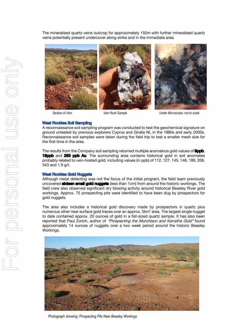
The mineralised quartz veins outcrop for approximately 150m with further mineralised quartz veins potentially present undercover along strike and in the immediate area.
West Rocklea Soil Sampling A reconnaissance soil sampling program was conducted to test the geochemical signature on ground untested by previous explorers Cyprus and Giralia NL in the 1980s and early 2000s. Reconnaissance soil samples were taken during the field trip to test a smaller mesh size for the first time in the area. The results from the Company soil sampling returned multiple anomalous gold values of 9ppb, 18ppb and 283 ppb Au. The surrounding area contains historical gold in soil anomalies probably related to vein-hosted gold, including values (in ppb) of 112, 127, 145, 146, 189, 206, 343 and 1.9 g/t.
West Rocklea Gold Nuggets Although metal detecting was not the focus of the initial program, the field team previously uncovered sixteen small gold nuggets (less than 1cm) from around the historic workings. The field crew also observed significant dry blowing activity around historical Beasley River gold workings. Approx. 75 prospecting pits were identified to have been dug by prospectors for gold nuggets. The area also includes a historical gold discovery made by prospectors in quartz plus numerous other near surface gold traces over an approx. 5km2 area. The largest single nugget to date contained approx. 20 ounces of gold in a fist-sized quartz sample. It has also been reported that Paul Zorich, author of “Prospecting the Murchison and Karratha Gold” found approximately 14 ounces of nuggets over a two week period around the historic Beasley Workings.
Section of Vein Vein Rock Sample Under Microscope -not to scale
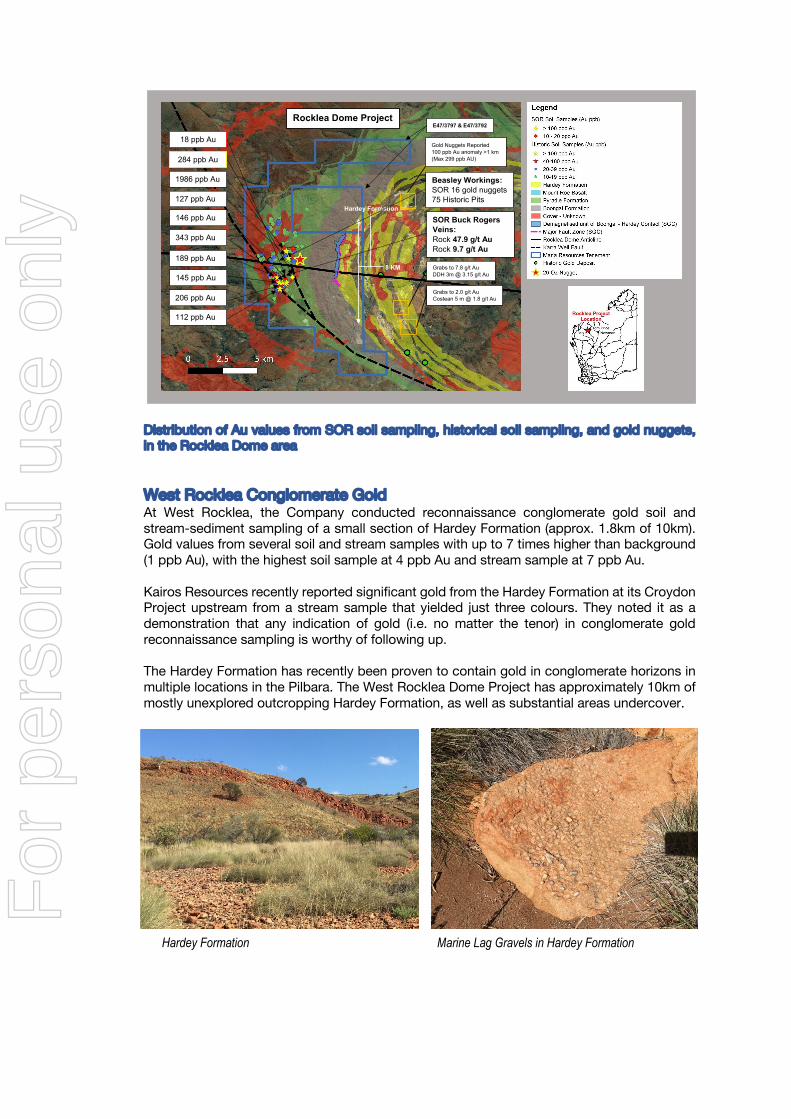
Photograph showing: Prospecting Pits Near Beasley Workings
For
per
sona
l use
onl
y
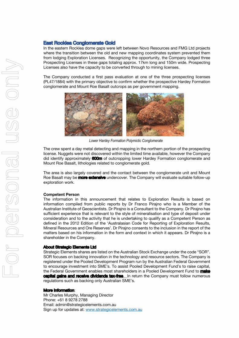
Distribution of Au values from SOR soil sampling, historical soil sampling, and gold nuggets, in the Rocklea Dome area
West Rocklea Conglomerate Gold At West Rocklea, the Company conducted reconnaissance conglomerate gold soil and stream-sediment sampling of a small section of Hardey Formation (approx. 1.8km of 10km). Gold values from several soil and stream samples with up to 7 times higher than background (1 ppb Au), with the highest soil sample at 4 ppb Au and stream sample at 7 ppb Au.
Kairos Resources recently reported significant gold from the Hardey Formation at its Croydon Project upstream from a stream sample that yielded just three colours. They noted it as a demonstration that any indication of gold (i.e. no matter the tenor) in conglomerate gold reconnaissance sampling is worthy of following up. The Hardey Formation has recently been proven to contain gold in conglomerate horizons in multiple locations in the Pilbara. The West Rocklea Dome Project has approximately 10km of mostly unexplored outcropping Hardey Formation, as well as substantial areas undercover.
Hardey Formation
8 KM
Rocklea Dome Project
1986 ppb Au
127 ppb Au
343 ppb Au
146 ppb Au
112 ppb Au
206 ppb Au
145 ppb Au
189 ppb Au
Grabs to 2.0 g/t Au Costean 5 m @ 1.8 g/t Au
Grabs to 7.8 g/t Au DDH 3m @ 3.15 g/t Au
Gold Nuggets Reported 100 ppb Au anomaly >1 km (Max 299 ppb AU)
Beasley Workings: SOR 16 gold nuggets 75 Historic Pits
SOR Buck Rogers Veins: Rock 47.9 g/t Au Rock 9.7 g/t Au
284 ppb Au
18 ppb Au
E47/3797 & E47/3792
Hardey Formation Marine Lag Gravels in Hardey Formation
For
per
sona
l use
onl
y
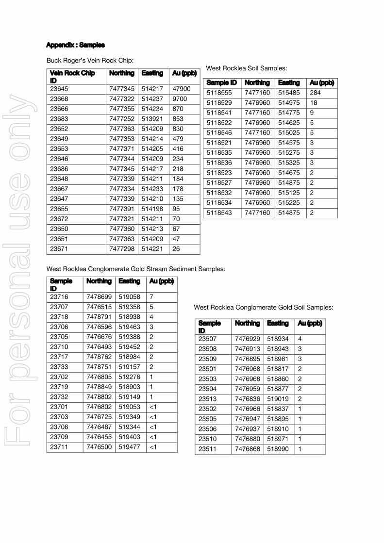
East Rocklea Conglomerate Gold In the eastern Rocklea dome gaps were left between Novo Resources and FMG Ltd projects where the transition between the old and new mapping coordinates system prevented them from lodging Exploration Licenses. Recognizing the opportunity, the Company lodged three Prospecting Licenses in these gaps totaling approx. 17km long and 150m wide. Prospecting Licenses also have the capacity to be converted through to mining licenses. The Company conducted a first pass evaluation at one of the three prospecting licenses (PL47/1884) with the primary objective to confirm whether the prospective Hardey Formation conglomerate and Mount Roe Basalt outcrops as per government mapping. The crew spent a day metal detecting and mapping in the northern portion of the prospecting license. Nuggets were not discovered within the limited time available, however the Company did identify approximately 600m of outcropping lower Hardey Formation conglomerate and Mount Roe Basalt, lithologies related to conglomerate gold. The area is also largely covered and the contact between the conglomerate unit and Mount Roe Basalt may be more extensive undercover. The Company will evaluate suitable follow-up exploration work.
Competent Person The information in this announcement that relates to Exploration Results is based on information compiled from public reports by Dr Franco Pirajno who is a Member of the Australian Institute of Geoscientists. Dr Pirajno is a Consultant to the Company. Dr Pirajno has sufficient experience that is relevant to the style of mineralisation and type of deposit under consideration and to the activity that he is undertaking to qualify as a Competent Person as defined in the 2012 Edition of the ‘Australasian Code for Reporting of Exploration Results, Mineral Resources and Ore Reserves’. Dr Pirajno consents to the inclusion in the report of the matters based on his information in the form and context in which it appears. Dr Pirajno is a shareholder in the Company.
About Strategic Elements Ltd Strategic Elements shares are listed on the Australian Stock Exchange under the code “SOR”. SOR focuses on backing innovation in the technology and resource sectors. The Company is registered under the Pooled Development Program run by the Australian Federal Government to encourage investment into SME’s. To assist Pooled Development Fund’s to raise capital, the Federal Government enables most shareholders in a Pooled Development Fund to make capital gains and receive dividends tax-free. In return the Company must follow numerous regulations such as backing only Australian SME’s. More Information: Mr Charles Murphy, Managing Director Phone: +61 8 9278 2788 Email: [email protected] Sign up for updates at: www.strategicelements.com.au
Lower Hardey Formation Polymictic Conglomerate
For
per
sona
l use
onl
y
Appendix : Samples Buck Roger’s Vein Rock Chip:
West Rocklea Soil Samples:
West Rocklea Conglomerate Gold Stream Sediment Samples:
West Rocklea Conglomerate Gold Soil Samples:
Sample ID
Northing Easting Au (ppb)
23507 7476929 518934 4 23508 7476913 518943 3 23509 7476895 518961 3 23501 7476968 518817 2 23503 7476968 518860 2 23504 7476959 518877 2 23513 7476836 519019 2 23502 7476966 518837 1 23505 7476947 518895 1 23506 7476937 518910 1 23510 7476880 518971 1 23511 7476868 518990 1
Vein Rock Chip ID
Northing Easting Au (ppb)
23645 7477345 514217 47900 23668 7477322 514237 9700 23666 7477355 514234 870 23683 7477252 513921 853 23652 7477363 514209 830 23649 7477353 514214 479 23653 7477371 514205 416 23646 7477344 514209 234 23686 7477345 514217 218 23648 7477339 514211 184 23667 7477334 514233 178 23647 7477339 514210 135 23655 7477391 514198 95 23672 7477321 514211 70 23650 7477360 514213 67 23651 7477363 514209 47 23671 7477298 514221 26
Sample ID Northing Easting Au (ppb) 5118555 7477160 515485 284 5118529 7476960 514975 18 5118541 7477160 514775 9 5118522 7476960 514625 5 5118546 7477160 515025 5 5118521 7476960 514575 3 5118535 7476960 515275 3 5118536 7476960 515325 3 5118523 7476960 514675 2 5118527 7476960 514875 2 5118532 7476960 515125 2 5118534 7476960 515225 2 5118543 7477160 514875 2
Sample ID
Northing Easting Au (ppb)
23716 7478699 519058 7 23707 7476515 519358 5 23718 7478791 518938 4 23706 7476596 519463 3 23705 7476676 519388 2 23710 7476493 519452 2 23717 7478762 518984 2 23733 7478751 519157 2 23702 7476805 519276 1 23719 7478849 518903 1 23732 7478802 519149 1 23701 7476802 519053 <1 23703 7476725 519349 <1 23708 7476487 519344 <1 23709 7476455 519403 <1 23711 7476500 519477 <1 F
or p
erso
nal u
se o
nly
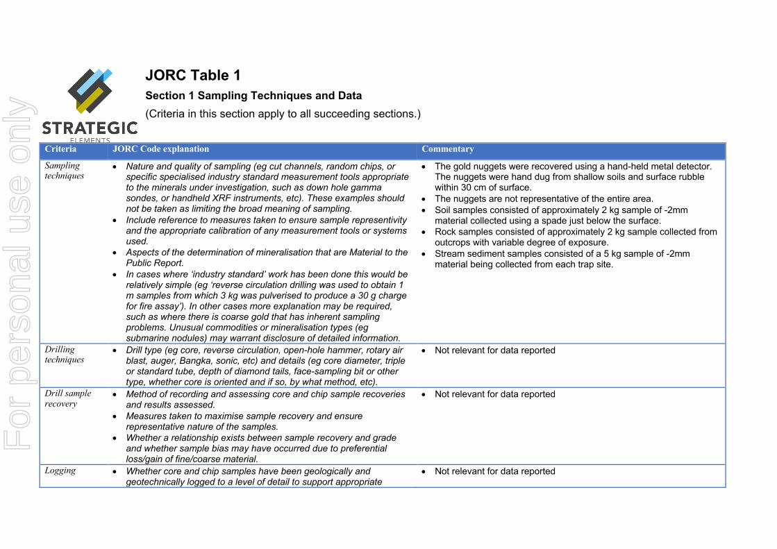
JORC Table 1 Section 1 Sampling Techniques and Data (Criteria in this section apply to all succeeding sections.)
Criteria JORC Code explanation Commentary
Sampling techniques
• Nature and quality of sampling (eg cut channels, random chips, or specific specialised industry standard measurement tools appropriate to the minerals under investigation, such as down hole gamma sondes, or handheld XRF instruments, etc). These examples should not be taken as limiting the broad meaning of sampling.
• Include reference to measures taken to ensure sample representivity and the appropriate calibration of any measurement tools or systems used.
• Aspects of the determination of mineralisation that are Material to the Public Report.
• In cases where ‘industry standard’ work has been done this would be relatively simple (eg ‘reverse circulation drilling was used to obtain 1 m samples from which 3 kg was pulverised to produce a 30 g charge for fire assay’). In other cases more explanation may be required, such as where there is coarse gold that has inherent sampling problems. Unusual commodities or mineralisation types (eg submarine nodules) may warrant disclosure of detailed information.
• The gold nuggets were recovered using a hand-held metal detector. The nuggets were hand dug from shallow soils and surface rubble within 30 cm of surface.
• The nuggets are not representative of the entire area. • Soil samples consisted of approximately 2 kg sample of -2mm
material collected using a spade just below the surface. • Rock samples consisted of approximately 2 kg sample collected from
outcrops with variable degree of exposure. • Stream sediment samples consisted of a 5 kg sample of -2mm
material being collected from each trap site.
Drilling techniques
• Drill type (eg core, reverse circulation, open-hole hammer, rotary air blast, auger, Bangka, sonic, etc) and details (eg core diameter, triple or standard tube, depth of diamond tails, face-sampling bit or other type, whether core is oriented and if so, by what method, etc).
• Not relevant for data reported
Drill sample recovery
• Method of recording and assessing core and chip sample recoveries and results assessed.
• Measures taken to maximise sample recovery and ensure representative nature of the samples.
• Whether a relationship exists between sample recovery and grade and whether sample bias may have occurred due to preferential loss/gain of fine/coarse material.
• Not relevant for data reported
Logging • Whether core and chip samples have been geologically and geotechnically logged to a level of detail to support appropriate
• Not relevant for data reported
For
per
sona
l use
onl
y
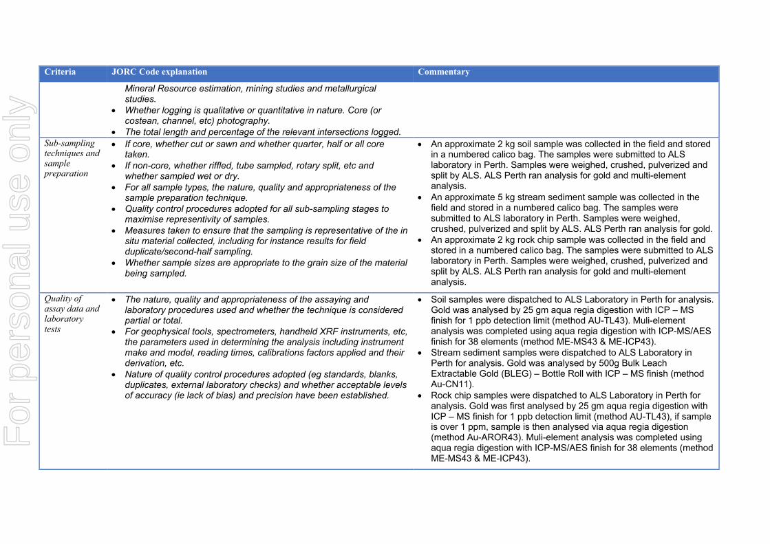
Criteria JORC Code explanation Commentary
Mineral Resource estimation, mining studies and metallurgical studies.
• Whether logging is qualitative or quantitative in nature. Core (or costean, channel, etc) photography.
• The total length and percentage of the relevant intersections logged. Sub-sampling techniques and sample preparation
• If core, whether cut or sawn and whether quarter, half or all core taken.
• If non-core, whether riffled, tube sampled, rotary split, etc and whether sampled wet or dry.
• For all sample types, the nature, quality and appropriateness of the sample preparation technique.
• Quality control procedures adopted for all sub-sampling stages to maximise representivity of samples.
• Measures taken to ensure that the sampling is representative of the in situ material collected, including for instance results for field duplicate/second-half sampling.
• Whether sample sizes are appropriate to the grain size of the material being sampled.
• An approximate 2 kg soil sample was collected in the field and stored in a numbered calico bag. The samples were submitted to ALS laboratory in Perth. Samples were weighed, crushed, pulverized and split by ALS. ALS Perth ran analysis for gold and multi-element analysis.
• An approximate 5 kg stream sediment sample was collected in the field and stored in a numbered calico bag. The samples were submitted to ALS laboratory in Perth. Samples were weighed, crushed, pulverized and split by ALS. ALS Perth ran analysis for gold.
• An approximate 2 kg rock chip sample was collected in the field and stored in a numbered calico bag. The samples were submitted to ALS laboratory in Perth. Samples were weighed, crushed, pulverized and split by ALS. ALS Perth ran analysis for gold and multi-element analysis.
Quality of assay data and laboratory tests
• The nature, quality and appropriateness of the assaying and laboratory procedures used and whether the technique is considered partial or total.
• For geophysical tools, spectrometers, handheld XRF instruments, etc, the parameters used in determining the analysis including instrument make and model, reading times, calibrations factors applied and their derivation, etc.
• Nature of quality control procedures adopted (eg standards, blanks, duplicates, external laboratory checks) and whether acceptable levels of accuracy (ie lack of bias) and precision have been established.
• Soil samples were dispatched to ALS Laboratory in Perth for analysis. Gold was analysed by 25 gm aqua regia digestion with ICP – MS finish for 1 ppb detection limit (method AU-TL43). Muli-element analysis was completed using aqua regia digestion with ICP-MS/AES finish for 38 elements (method ME-MS43 & ME-ICP43).
• Stream sediment samples were dispatched to ALS Laboratory in Perth for analysis. Gold was analysed by 500g Bulk Leach Extractable Gold (BLEG) – Bottle Roll with ICP – MS finish (method Au-CN11).
• Rock chip samples were dispatched to ALS Laboratory in Perth for analysis. Gold was first analysed by 25 gm aqua regia digestion with ICP – MS finish for 1 ppb detection limit (method AU-TL43), if sample is over 1 ppm, sample is then analysed via aqua regia digestion (method Au-AROR43). Muli-element analysis was completed using aqua regia digestion with ICP-MS/AES finish for 38 elements (method ME-MS43 & ME-ICP43).
For
per
sona
l use
onl
y
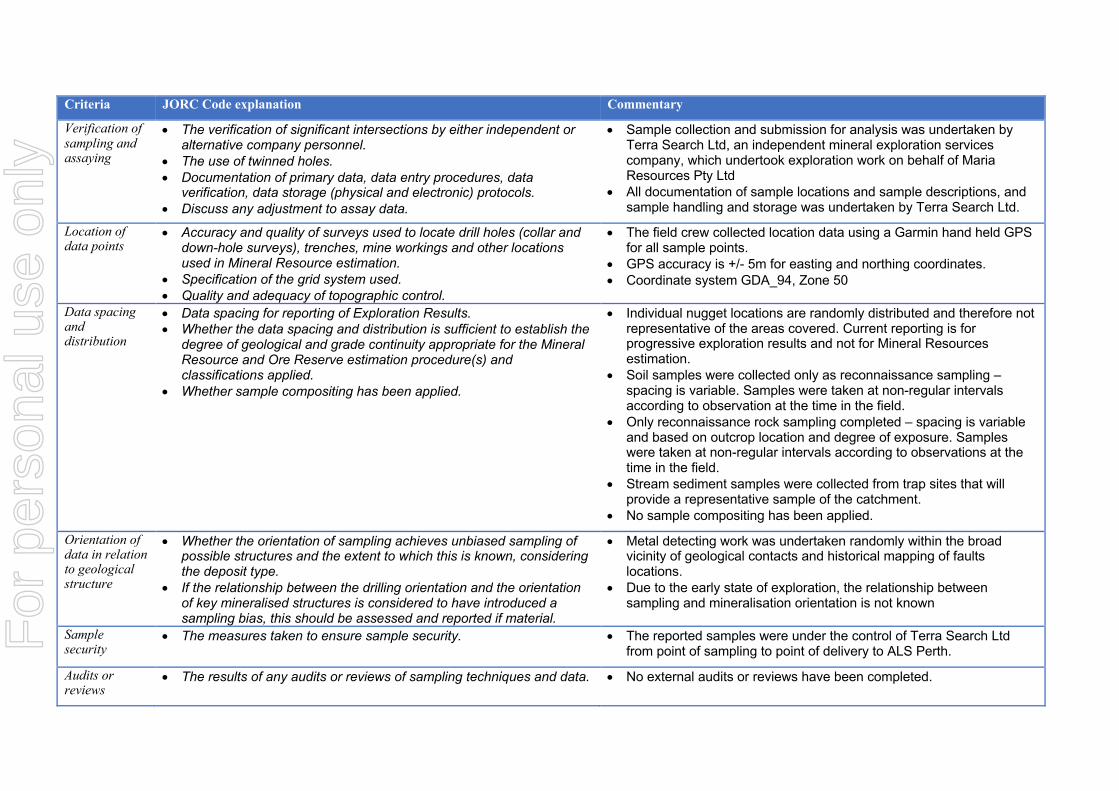
Criteria JORC Code explanation Commentary
Verification of sampling and assaying
• The verification of significant intersections by either independent or alternative company personnel.
• The use of twinned holes. • Documentation of primary data, data entry procedures, data
verification, data storage (physical and electronic) protocols. • Discuss any adjustment to assay data.
• Sample collection and submission for analysis was undertaken by Terra Search Ltd, an independent mineral exploration services company, which undertook exploration work on behalf of Maria Resources Pty Ltd
• All documentation of sample locations and sample descriptions, and sample handling and storage was undertaken by Terra Search Ltd.
Location of data points
• Accuracy and quality of surveys used to locate drill holes (collar and down-hole surveys), trenches, mine workings and other locations used in Mineral Resource estimation.
• Specification of the grid system used. • Quality and adequacy of topographic control.
• The field crew collected location data using a Garmin hand held GPS for all sample points.
• GPS accuracy is +/- 5m for easting and northing coordinates. • Coordinate system GDA_94, Zone 50
Data spacing and distribution
• Data spacing for reporting of Exploration Results. • Whether the data spacing and distribution is sufficient to establish the
degree of geological and grade continuity appropriate for the Mineral Resource and Ore Reserve estimation procedure(s) and classifications applied.
• Whether sample compositing has been applied.
• Individual nugget locations are randomly distributed and therefore not representative of the areas covered. Current reporting is for progressive exploration results and not for Mineral Resources estimation.
• Soil samples were collected only as reconnaissance sampling – spacing is variable. Samples were taken at non-regular intervals according to observation at the time in the field.
• Only reconnaissance rock sampling completed – spacing is variable and based on outcrop location and degree of exposure. Samples were taken at non-regular intervals according to observations at the time in the field.
• Stream sediment samples were collected from trap sites that will provide a representative sample of the catchment.
• No sample compositing has been applied.
Orientation of data in relation to geological structure
• Whether the orientation of sampling achieves unbiased sampling of possible structures and the extent to which this is known, considering the deposit type.
• If the relationship between the drilling orientation and the orientation of key mineralised structures is considered to have introduced a sampling bias, this should be assessed and reported if material.
• Metal detecting work was undertaken randomly within the broad vicinity of geological contacts and historical mapping of faults locations.
• Due to the early state of exploration, the relationship between sampling and mineralisation orientation is not known
Sample security
• The measures taken to ensure sample security. • The reported samples were under the control of Terra Search Ltd from point of sampling to point of delivery to ALS Perth.
Audits or reviews
• The results of any audits or reviews of sampling techniques and data. • No external audits or reviews have been completed.
For
per
sona
l use
onl
y
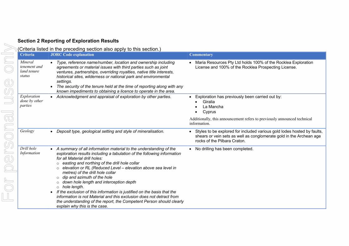
Section 2 Reporting of Exploration Results (Criteria listed in the preceding section also apply to this section.)
Criteria JORC Code explanation Commentary
Mineral tenement and land tenure status
• Type, reference name/number, location and ownership including agreements or material issues with third parties such as joint ventures, partnerships, overriding royalties, native title interests, historical sites, wilderness or national park and environmental settings.
• The security of the tenure held at the time of reporting along with any known impediments to obtaining a licence to operate in the area.
• Maria Resources Pty Ltd holds 100% of the Rocklea Exploration License and 100% of the Rocklea Prospecting License.
Exploration done by other parties
• Acknowledgment and appraisal of exploration by other parties. • Exploration has previously been carried out by: • Giralia • La Mancha • Cyprus
Additionally, this announcement refers to previously announced technical information.
Geology • Deposit type, geological setting and style of mineralisation. • Styles to be explored for included various gold lodes hosted by faults, shears or vein sets as well as conglomerate gold in the Archean age rocks of the Pilbara Craton.
Drill hole Information
• A summary of all information material to the understanding of the exploration results including a tabulation of the following information for all Material drill holes: o easting and northing of the drill hole collar o elevation or RL (Reduced Level – elevation above sea level in
metres) of the drill hole collar o dip and azimuth of the hole o down hole length and interception depth o hole length.
• If the exclusion of this information is justified on the basis that the information is not Material and this exclusion does not detract from the understanding of the report, the Competent Person should clearly explain why this is the case.
• No drilling has been completed.
For
per
sona
l use
onl
y

Criteria JORC Code explanation Commentary
Data aggregation methods
• In reporting Exploration Results, weighting averaging techniques, maximum and/or minimum grade truncations (eg cutting of high grades) and cut-off grades are usually Material and should be stated.
• Where aggregate intercepts incorporate short lengths of high grade results and longer lengths of low grade results, the procedure used for such aggregation should be stated and some typical examples of such aggregations should be shown in detail.
• The assumptions used for any reporting of metal equivalent values should be clearly stated.
• No weighting or cutting of gold values. • No aggregation is relevant to reporting of nugget occurrences, which
by their nature are random and unrepresentative. • No metal equivalents have been used. • No weighed grade results have been reported for the nuggets.
Relationship between mineralisation widths and intercept lengths
• These relationships are particularly important in the reporting of Exploration Results.
• If the geometry of the mineralisation with respect to the drill hole angle is known, its nature should be reported.
• If it is not known and only the down hole lengths are reported, there should be a clear statement to this effect (eg ‘down hole length, true width not known’).
• No drilling was completed.
Diagrams • Appropriate maps and sections (with scales) and tabulations of intercepts should be included for any significant discovery being reported These should include, but not be limited to a plan view of drill hole collar locations and appropriate sectional views.
• Maps and photos are reported in this release.
Balanced reporting
• Where comprehensive reporting of all Exploration Results is not practicable, representative reporting of both low and high grades and/or widths should be practiced to avoid misleading reporting of Exploration Results.
• Reporting of all relevant results has been provided in this announcement in the appendix.
Other substantive exploration data
• Other exploration data, if meaningful and material, should be reported including (but not limited to): geological observations; geophysical survey results; geochemical survey results; bulk samples – size and method of treatment; metallurgical test results; bulk density, groundwater, geotechnical and rock characteristics; potential deleterious or contaminating substances.
• All relevant and meaningful data has been reported.
Further work • The nature and scale of planned further work (eg tests for lateral extensions or depth extensions or large-scale step-out drilling).
• Diagrams clearly highlighting the areas of possible extensions, including the main geological interpretations and future drilling areas, provided this information is not commercially sensitive.
• Commence further on ground exploration of the tenements. This may include geological mapping, metal detecting, geophysical, geochemical and rock chip sampling.
For
per
sona
l use
onl
y