Embed Size (px)
Citation preview
FY 2011 Annual PlanAtchafalaya Basin Program
Lo
ui
si
an
a
De
pa
rt
me
nt
o
f
Na
tu
ra
l
Re
so
ur
ce
s

Our mission is to Conserve,
Restore, and Enhance the natural
habitat of the Atchafalaya Basin and
give all people the opportunity to enjoy
the Atchafalaya Experience.
Louisiana Department of naturaL resources
atchafaLaya Basin program
Stephen Chustz, Acting DirectorAntoinette DeBosier, Resource ScientistAnnette Wiegleb, Administrative Specialist
Research and Promotion Board AppointeesLouis Buatt / Chair, Dept. of Natural ResourcesGerald Alexander / Vice-Chair, Atchafalaya Levee BoardAlex Appeaning, Dept. of Environmental Quality Guy Cormier, St. Martin Parish (non-voting)Cynthia Duet, Office of the GovernorDavid Guilbeau, Dept. of Health and HospitalsStuart Johnson, Dept. of Culture, Recreation & TourismPaul Naquin, St. Mary Parish (non-voting)J. Mitchell Ourso, Jr., Iberville Parish (non-voting)Nick Rabalais, Dept. of Transportation & DevelopmentBrad Spicer, Dept. of Agriculture & ForestryCharles St. Romain, State Land OfficeGary Tilyou, Dept. of Wildlife & FisheriesMarty Triche, Assumption Parish (non-voting)
Technical Advisory GroupMike Wood / Chair, Dept. of Wildlife & FisheriesGlenn Constant, U.S. Fish & Wildlife ServiceCharlie Demas, U.S. Geological SurveyLamar Hale, U.S. Army Corps of EngineersDr. Bill Kelso, LSU Renewable Natural ResourcesLori LeBlanc, Dept. of Natural ResourcesChris Piehler, Dept. of Environmental QualityMike Thomas, Dept. of Agriculture & ForestryMike Walker, Dept. of Wildlife & FisheriesSpecial thanks to these scientists who contributed to the TAG in an ex-officio capacity:Dr. Richard Keim, LSU Renewable Natural ResourcesDan Kroes, U.S. Geological SurveyDavid Walther, U.S. Fish and Wildlife Service
Atchafalaya Basin Program Legislative Oversight Committee:
Rep. Karen St. Germain, Chair Rep. Simone Champagne, Vice-Chair
Sen. Jody AmedeeSen. Butch GautreauxSen. Nick GautreauxSen. Elbert Guillory
Sen. Troy HebertSen. Eric LaFleur
Sen. Rob MarionneauxRep. Elton AubertRep. Bobby BadonRep. Taylor Barras
Rep. Mickey GuilloryRep. Joe Harrison
Rep. Robert Johnson Rep. Sam Jones
Rep. Bernard LeBasRep. Fred Mills
Rep. Major ThibautRep. Ledricka Thierry
2
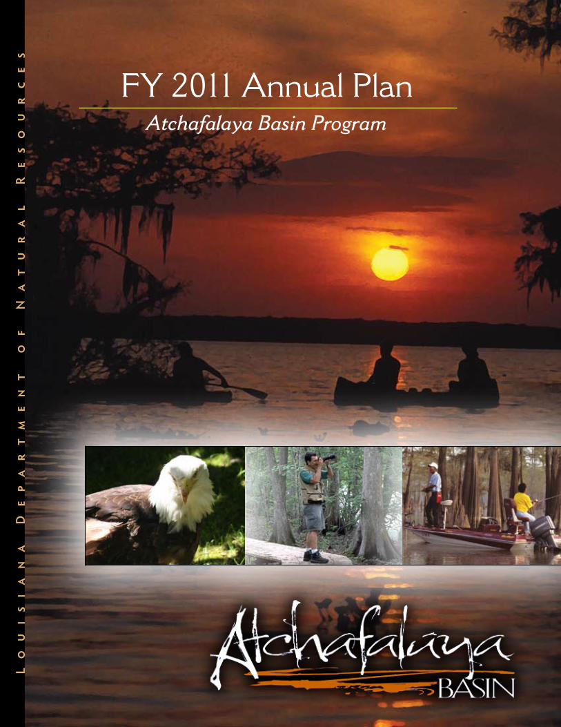
Dear Members of the Louisiana Legislature,
It is with pride that I submit, for your consideration, the FY 2011 Atchafalaya Basin Annual Plan. It was developed in accordance with Act 606 of the 2008 Regular Session of the Louisiana Legislature, which requires the Atchafalaya Basin Program to focus on the management of and access to Basin resources. The Plan identifies projects related to water quality and water management in the Basin, as well as access and recreational projects that will enhance the public’s opportunities to enjoy the natural resources of the Basin.
As Louisianans, we are stewards of wonderfully unique landscapes and fertile habitats that make this state an alluring destination for naturalists, hunters, fishermen, campers and birdwatchers. One of our natural gems is the Atchafalaya Basin, the most productive swamp in the world. Encompassing nearly one million acres of bottomland hardwoods, swamps, bayous and backwater lakes in eight parishes, the Basin is home to over 250 species of birds and more than 100 species of fish. Ensuring that this natural treasure continues to serve as a productive animal and fisheries habitat, that its natural beauty is preserved, and that residents and visitors alike are provided recreational access to the Basin are goals of the Atchafalaya Basin Program and this FY 2011 Annual Plan.
The true test of our success in preserving and managing the Atchafalaya Basin will come in the decades that follow us, as our own children and grandchildren explore this unique region from Simmesport to Morgan City and the Gulf of Mexico. That is why the projects we undertake now are so important. By allocating state resources to the Basin Program for implementation of water quality/water management, access and recreation projects, Louisiana sends a clear message to its citizens and the entire country that America’s largest river swamp is worth saving.
I want to recognize the staff of the Louisiana Department of Natural Resources (DNR) Atchafalaya Basin Program and members of the Technical Advisory Group who devoted so much time to identify and assess the projects listed in this document. I want to thank the members of the program’s Research & Promotion Board for all of their assistance in compiling the final Plan, and Basin stakeholders who took time to attend our public meetings and suggest projects to be considered in the Plan. I also thank you, our legislators, for your support of the Atchafalaya Basin Program over the years. We look forward to working with you to secure funding to implement these important Basin projects.
You and all of the citizens of Louisiana can be assured that we are moving forward under a governance that makes the resources of the Atchafalaya Basin the top priority, encourages public input, and allows the best science to prevail with regard to restoration and conservation of the unique Basin environment.
Thank you.
Scott A. Angelle, SecretaryLousiana Department of Natural Resources
from Dnr secretary scott angeLLe
3

4
photo creDits
Greg Guirard
Antoinette DeBosier
Matthew Armand
Andrew D. Lytle Collection, LSU Libraries
LA Dept. of Natural Resources
U.S. Army Corps of Engineers
LA Dept. of Culture, Recreation & Tourism
puBLication preparation
Design & Copywriting by
Armand Creative, LLC
Houma, LA
Editor: Jennifer Armand
Table of ContentsWhat is the Atchafalaya Basin? page 5
Atchafalaya Basin Milestones page 8
People, Wildlife & Economy of the Basin page 10
Atchafalaya Basin Program page 14
Current Challenges in the Basin page 15
The FY 2011 Annual Plan Process page 16
Project Funding & Prioritization page 18
FY 2011 Project List page 20
Project Descriptions page 24
Appendix page 35
References page 42
5
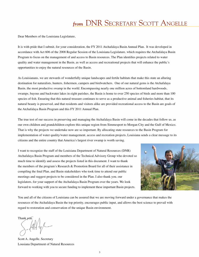
in the Beginning The story of the Atchafalaya Basin begins over a half of a million years ago, when melting glaciers and rising oceans created what we now call the Mississippi River. Over thousands of years, the Mississippi River actually built South Louisiana, transporting sediment from upriver and depositing the rich silt as the river meandered across the delta, changing course, always in search of a shorter path and steeper gradient to the Gulf of Mexico. Fol-lowing decades of flood events, the river’s path changed, resulting in the formation of distributary channels and natural levees. Over time, floodplain processes created a thriving environment for plant, animal and marine life that remains with us today.
the atchafaLaya river From its start at the Old River Control Structure to its mouth at the Gulf of Mexico, the Atchafalaya River is now
the largest distributary stream of the Mississippi River. The navigable river is approximately 170 miles long and provides a significant industrial shipping channel for the state of Louisiana and is the flowing lifeline of the nation’s largest river swamp – the Atchafalaya Basin. The Atchafalaya River has its origin near Simmesport, Louisiana, in Avoyelles Parish at the confluence of the Red River with the Mississippi, where the Mississippi connects to the Red by the seven-mile channelized Old River. It receives the water of the Red as well as part of the water of the Mississippi, which itself continues in its main channel to the southeast. It meanders through extensive levees and floodways before emptying into the Gulf at Atchafalaya Bay, approximately 15 miles south of Morgan City, Loui-siana. The river is now forming new deltas in Atchafalaya Bay – the most successful land-building process in the nation.
What is the Atchafalaya Basin?

6
AmericA’s LArgest river BAsin
The Atchafalaya Basin is the river’s floodway, bound by natural ridges to the east and west formed as the Mississippi River changed its course as much as 4,500 years ago. Encompassing 838,000 acres of forests, bayous, swamp and lakes, it extends south from the Old River Control Structure approximately140 miles to Morgan City. The Basin represents the largest contiguous bottomland hardwood forest, and overflow, alluvial swamp remaining in the United States. Approximately 400,000 acres of the Basin are publicly owned, including Wildlife Mangement Areas, National Wildlife Refugees and state water bottoms. The remaining 438,000 acres are privately owned lands, including upland forest habitats as well as deep-water swamps. Home to some of Louisiana’s signature wildlife like alligators, roseate spoonbills, water moccasins and crawfish, plant life like cypress trees and water hyacinths, and abundant fish and marine life, the Atchafalaya Basin has long captured the interest of fishermen, photographers, hunters and those who simply enjoy the sights and sounds of nature. For centuries, people have adopted features of the Basin as part of their heritage, including the Native Americans who made their homes among the bottomland hardwoods, and the loggers and fishermen who made their livelihoods by harvesting the natural riches of the Atchafalaya Basin.
chAnneLing the Power of nAture
Until a monumental U.S. Army Corps of Engineers (USACE) project was completed in the 1960’s to regulate water flow in the Atchafalaya River, the unpredictable flow caused the residents and landowners of the area many problems. The river was not much more than a bayou in the mid-1800’s when a thirty-mile obstruction of logs and
debris known as “the raft” was removed from the upper reaches of the river, dramatically increasing the river flow. Over the next century, flooding in the Atchafalaya Basin be-came more severe. The Great Flood of 1927 is the worst flood on record in the lower Mississippi River. It put the entire Atchafalaya Basin, nearby communities and rural areas under water. In reaction to this natural catas-trophe, the federal government took steps to protect lives and property in
the Basin, as well as preserve the river as a shipping channel. As part of the USACE flood control plan, the Atchafa-laya swamp was formally designated as a “spillway,” to provide an outlet for diverted Mississippi River water in times of flooding. Extensive artificial levees were built to enclose the designated spillway area, distributary channels of the Atchafalaya River within the Basin were closed, the river was enlarged to handle increased capacity, and new diver-sion channels were created to provide for maximum discharge of floodwaters. In addition, a variety of dikes, dams, drainage canals, floodgates, pumping stations, locks, levees and floodwalls were built to aid in navigation and flood control. The unintended consequence of these actions was an increase of sediment flow-ing into the Basin, turning many swampy areas into dry land. The physiography, hydrology, water quality, landscape and habitats of the Basin were changed significantly.
The Atchafalaya Basin is the nation’s largest river swamp,
containing almost one million acres of America’s
most significant bottomland hardwoods, swamps,
bayous and backwater lakes.
It is larger than the Florida Everglades.
A levee break during the Great Flood of 1927

In 1963, the USACE opened the Old River Control Structure to regulate the flow of water into the Atchafalaya River from the Red and Mississippi Rivers. Ten years later, a catastrophic failure of the control structure during the height of a spring flood nearly resulted in the Atchafalaya River claiming over 70 percent of Mississippi River flow and virtually changing the course of the Mississippi River once again. Today, the Old River Control Structure directs 30 percent of Mississippi River flow into the Atchafalaya River.
“The huge trunks of the cypress trees, which stand four and five feet asunder, shot up to a height of fifty feet, entirely free from branches, which then, however, spread out at right angles to the stem, making the trees appear like gigantic umbrellas, and covering the whole morass with an impenetrable roof, through which not even a sunbeam could find passage. Within this realm could be found thousands, tens of thousands, of birds and reptiles, alligators, enormous bullfrogs, night owls, anhingas, herons (all of) whose dwellings were in the mud of the swamp or its leaky roof, (and) now lifted up their voices bellowing, hooting, shrieking, and groaning. Bursting forth from the obscene retreat in which they had hitherto lain hidden, the alligators raided their hideous snouts of the green coating of the swamp, gnashing their teeth, and straining toward us, while the owls and other birds circled round our head, flap-ping and striking us with wings as they passed.”AUTHOR UNKNOWN – circa 1842
The Atchafalaya Basin begins near Simmesport
and stretches 140 miles southward to
the Gulf of Mexico.
Atchafalaya Basin Parishes:
• Assumption Parish• Avoyelles Parish
• Iberia Parish• Iberville Parish
• Pointe Coupee Parish• St. Landry Parish• St. Martin Parish• St. Mary Parish
7
8
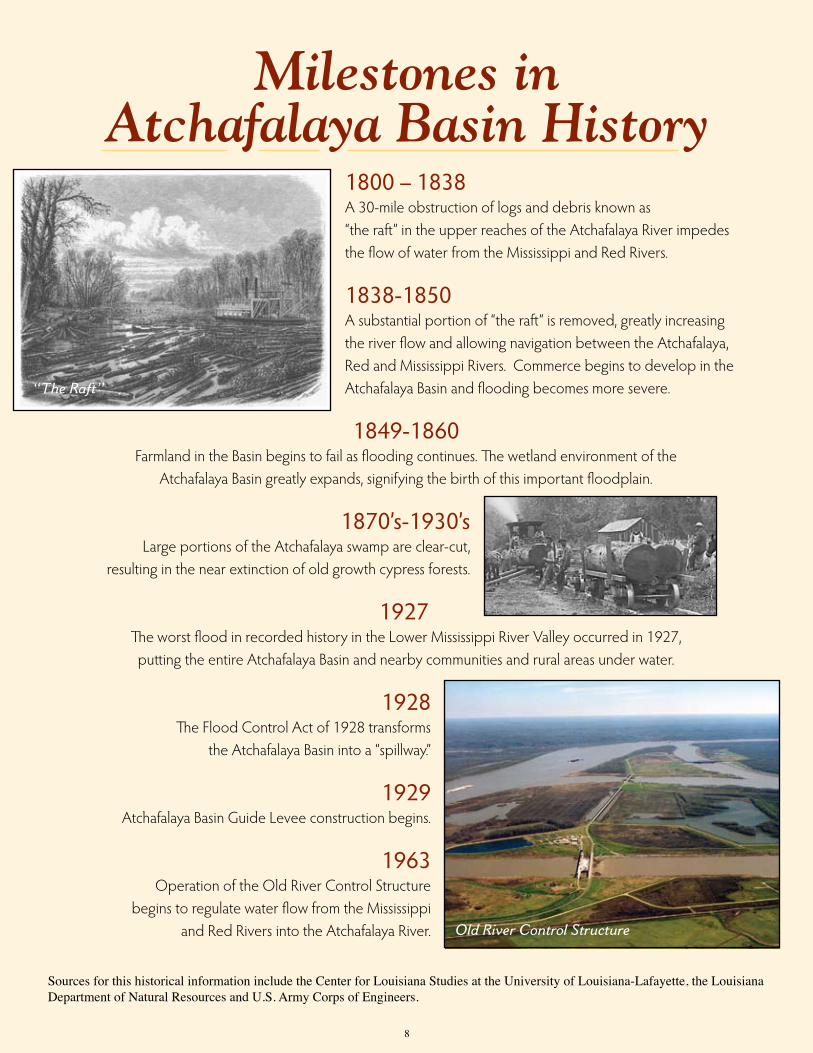
1800 – 1838A 30-mile obstruction of logs and debris known as “the raft” in the upper reaches of the Atchafalaya River impedes the flow of water from the Mississippi and Red Rivers.
1838-1850A substantial portion of “the raft” is removed, greatly increasing the river flow and allowing navigation between the Atchafalaya, Red and Mississippi Rivers. Commerce begins to develop in the Atchafalaya Basin and flooding becomes more severe.
1849-1860Farmland in the Basin begins to fail as flooding continues. The wetland environment of the
Atchafalaya Basin greatly expands, signifying the birth of this important floodplain.
1870’s-1930’sLarge portions of the Atchafalaya swamp are clear-cut,
resulting in the near extinction of old growth cypress forests.
1927The worst flood in recorded history in the Lower Mississippi River Valley occurred in 1927, putting the entire Atchafalaya Basin and nearby communities and rural areas under water.
1928The Flood Control Act of 1928 transforms
the Atchafalaya Basin into a “spillway.”
1929Atchafalaya Basin Guide Levee construction begins.
1963Operation of the Old River Control Structure
begins to regulate water flow from the Mississippi and Red Rivers into the Atchafalaya River.
“The Raft”
Old River Control Structure
Milestones in Atchafalaya Basin History
Sources for this historical information include the Center for Louisiana Studies at the University of Louisiana-Lafayette, the Louisiana Department of Natural Resources and U.S. Army Corps of Engineers.

1970Louisiana Governor John McKeithen creates
the first Atchafalaya Basin Commission.
1972-1980Boat ramps are built, recreational facilities are planned, and
the State begins purchasing land for state parks.
1973The Interstate 10 elevated expressway over the Basin is completed.
1981The “Treen Agreement”(Governor Dave Treen) is negotiated between landowners
and environmental groups and is presented to Congress.
1985Congress enacts the Multipurpose Plan, authorizing the U.S. Army Corps of Engineers
to spend $250 million, subject to future appropriations, to preserve and restore the Basin ecosystem.
1998The Atchafalaya Basin Program is created within the Louisiana Department of Natural Resources.
1999The Louisiana Legislature unanimously approves the State Master Plan for the Atchafalaya Basin Program and $85 million, subject to future appropriations, over 15 years for access, easements, water management and recreation projects.
2004Atchafalaya Welcome Center in Butte LaRose opens.
2007 Congress directs an investigation and study of the maximum effective use of the water and sediment of the Mississippi and Atchafalaya Rivers for coastal restoration purposes consistent with flood control and navigation and an investigation and assessment of alterations in the operation of the Old River Control Structure.
2008The Louisiana Legislature adopts Act 606, authorizing the Secretary of the Department of Natural Resources, through the Atchafalaya Basin Program, to submit to the legislature each year an Annual Plan for the Basin that will include water management and access projects, such as boat launches, and other projects consistent with the mission statement of the Atchafalaya Basin Master Plan. Act 606 also creates the Atchafalaya Basin Conservation Fund.
2009 The Louisiana Legislature approves $3,500,000 in state funding for water quality/water management, access and habitat restoration projects identified in the FY 2010 Atchafalaya Basin Program Annual Plan, the first since adoption of Act 606.
Welcome Center
Recreational Boat Ramp
9

The People,
Wildlife and
Economy of
the Basin
10
The Atchafalaya Basin’s cultural history goes back at least 2,500 years, when Native Americans were living in the Basin along natural levees and along the bay-ous. Archeological research by Dr. Mark Rees of the University of Louisiana – Lafayette indicates that many mound sites and villages on natural levees and along bayous within the Basin date from A.D. 700-1700. Villagers harvested and hunted fish, shellfish, reptiles, birds, deer and small mammals that were plentiful in the area. Tribes with a history in the Atchafalaya Basin include the Chitimacha, Attakapas, Opelousa, Houma, Coushatta and Alabama, Tunica-Biloxi and Avoyel, and Taensas. Native American association with the “great swamp” is evidenced by many place names in the modern Basin, including Atchafalaya (hacha falaia), bayou (bayuk), Catahoula (oka hullo), Chacahoula (chukka hullo), Plaquemine (piakimin), and Whiskey Bay (oski abeha).

In the early 1700’s, French settlers and slaves arrived in the Atchafalaya Basin to trade with the Native Ameri-cans, primarily in the fur trade. In 1755, however, one of the most culturally significant migrations into the Atchafa-
laya Basin occurred when refugees expelled from the Canadian province of Acadia found a home here. These immigrants quickly adapted to their new environment and developed skills that allowed them to survive in the challenging, yet fertile, swamp. As the years went by, they intermarried with other settlers of the area, including Hispanics, Old World and Cana-dian French, Anglo-Americans and Native Americans, resulting in a people and culture referred to as “Cajun.” Many residents in the region surrounding the Basin, in fact, can trace their roots back to the Acadians, and the unique Cajun heritage is expressed in the food, music and traditions of the area. Other ethnic groups who immigrated to the area over the years include Creoles, African Americans, Colonial Spanish and Islenos, Italians and Asians, with each contributing their own cultural “seasonings,” so to speak, to the Atchafalaya Basin region’s cultural “gumbo.” In the early years, the one element that seemed to tie all of the Basin settlers together was the bountiful resources of the hardwood forests, cypress swamps, bayous, and marshes, and the utilization of these resources for subsistence and com-merce. Logging, agriculture and cattle farming were staples of life in the Basin. Based on an 1874 river commerce survey report, “The products of the Atchafalaya country are cotton, sugar, molasses, moss, lumber, staves and shingles. The cot-ton is all grown above the Courtableau and is sent to New Orleans by the two steamers that run to Washington, or the one that makes a 10-day trip to the Teche country.” Today, people from across South Louisiana and beyond continue to rely on these natural resources for their livelihood and for recreation. According to a USDA Census of Agriculture report, the market value of all agricultural products sold in the area totals almost $900 million, about 45 percent of the state’s total. The value of live-stock and livestock products sold totals about $168 million, or 28 percent of the Louisiana total. While much of the Basin today is unsuitable for farming due to its wetland status, major crops include sugarcane, rice, soybeans and cotton. The Atchafalaya Basin contains three distinct areas of landscape that provide some of the country’s most productive wildlife and fish habitats. These areas include the northern region composed of bottomland hardwood forest, the middle region composed of cypress-willow-tupelo swamps, and the lower region of freshwater and brackish marsh. The Atchafalaya Basin is five times more productive than any other river Basin in North America, and is probably the most productive swamp in the world.
Forty-five species of mammals inhabit the Basin, including bobcat, coyote, fox, armadillo, opossum and beaver. Small game animals like the fox squirrel, gray squir-rel and swamp rabbit live here, as well as white-tailed deer, the principal big-game species. Raccoon, mink and nutria are so abundant in the swamps and marshes that Louisiana was ranked as the number one fur producer until the downturn of the industry about 15 years ago. Parts of the Basin are also home to the Bald Eagle, in addition to the endangered Louisiana Black Bear, Florida Panther, Peregrine Falcon and Bachman’s Warbler. In fact, it is a haven for an estimated nine federal- and state-recognized endangered/threatened wildlife species, six endangered/threatened bird species, and 29 rookeries. Over 40 reptilian species, including the American alligator and western cottonmouth can be found in the Basin, along with twenty species of amphibians.
Over 250 species of birds, including the Bald Eagle,
Great Blue Heron and the Peregrine Falcon, can be
found in this productive region.
Animals in the Basin include
the Louisiana Black Bear,
Florida Panther, white-tailed
deer, nutria, bobcat, mink,
fox, muskrat, and beaver.
11

12
the peopLe, WiLDLife anD economy of the Basin (continueD)
The wetlands of the Atchafalaya Basin provide excellent feeding and resting areas for migratory waterfowl, making the area an important wintering area for mallards and gadwalls. Over 250 species of birds can be found in the Basin, including wood ducks, great blue herons and great egrets, which are common inhabitants of the shallow lakes and bayous. With over 100 species of fish, crawfish, shrimp and crabs, recreational and commercial
fishing play a significant role in the economy of the Atchafalaya Basin. Commercial fishing began here in 1873, and by the early 1900’s, it became a booming enterprise with catfish as the most popular catch. Thousands of sport fishermen traverse the Basin’s waterways each year with the hopes of hooking yellow, striped or large-mouth bass, and white and black crappie. According to the Louisiana Department of Wildlife and Fisheries, the commercial fishing industry in the Atchafalaya Basin is valued at $95.7 million per year and the recreational fishing industry is valued at $47 million. Crawfish are commonly associated with the cultural heritage of South Louisiana and the Basin, with images of craw-fishermen and crawfish boils common to any story about the Cajun people. However, while crawfish have been eaten in Louisiana since before the arrival of the Europeans, the successful “mudbug” industry in the Atchafalaya Basin did not take off until the 1950’s. According to the Louisiana Department of Wildlife and Fisheries, crawfishermen harvest an average of 10-15 million pounds of crawfish each year, making this the most profitable industry in the Basin. Alligators, turtles and bullfrogs are also commercially and recreationally harvested along the Atchafalaya, and crabbing and trapping remain integral parts of the Basin culture and economy, along with recreational pursuits like boating, water skiing, bird-watching, hiking and camping. The landscape has changed since Native Americans first made their home on the grassy prairies and along the bay-ous of the Atchafalaya River Basin, but its natural beauty, ecological value and economic significance have endured for centuries. The current generation is challenged to preserve this unique Louisiana treasure so that many more generations of Louisianans can enjoy all that it has to offer.
• The Atchafalaya Basin is five times more productive than any other river Basin in North America.
• According to the La. Department of Wildlife & Fisheries, the commercial and recreational fishing industries in the Atchafalaya Basin are valued at approximately $95 million and $47 million a year.
• 100 species of fish and aquatic life can be found in the Basin.
• From January to May 2009, over 8.7 million pounds of wild crawfish were harvested in the Basin with a dockside value of more than $7.5 million, according to the La. Department of Wildlife & Fisheries.
A hoopnet fisherman harvests Catfish, Garfish and Gasper Goo, or Freshwater Drum. A bountiful crawfish harvest.(right) Each sack holds about 40 lbs. of crawfish.
13
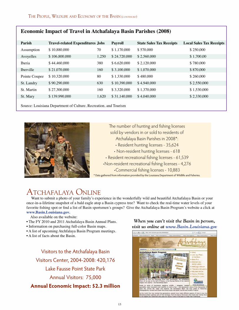
The number of hunting and fishing licenses sold by vendors in or sold to residents of
Atchafalaya Basin Parishes in 2008*:• Resident hunting licenses - 35,624
• Non-resident hunting licenses - 618• Resident recreational fishing licenses - 61,539
•Non-resident recreational fishing licenses - 4,276•Commercial fishing licenses - 10,883
* Data gathered from information provided by the Louisiana Department of Wildlife and Fisheries.
Economic Impact of Travel in Atchafalaya Basin Parishes (2008)
Parish Travel-related Expenditures Jobs Payroll State Sales Tax Receipts Local Sales Tax Receipts
Assumption $ 10,880,000 70 $ 1,170,000 $ 570,000 $ 250,000
Avoyelles $ 106,800,000 1,250 $ 24,720,000 $ 2,560,000 $ 1,700,00
Iberia $ 44,460,000 380 $ 6,620,000 $ 2,120,000 $ 780,000
Iberville $ 21,070,000 160 $ 3,100,000 $ 1,070,000 $ 870,000
Pointe Coupee $ 10,320,000 80 $ 1,330,000 $ 480,000 $ 260,000
St. Landry $ 90,290,000 630 $ 10,390,000 $ 4,940,000 $ 2,550,000
St. Martin $ 27,300,000 160 $ 3,320,000 $ 1,370,000 $ 1,530,000
St. Mary $ 139,990,000 1,620 $ 31,140,000 $ 4,040,000 $ 2,330,000
Source: Louisiana Department of Culture, Recreation, and Tourism
Visitors to the Atchafalaya Basin Visitors Center, 2004-2008: 420,176
Lake Fausse Point State ParkAnnual Visitors: 75,000
Annual Economic Impact: $2.3 million
the peopLe, WiLDLife anD economy of the Basin (continueD)
atchafaLaya onLine Want to submit a photo of your family’s experience in the wonderfully wild and beautiful Atchafalaya Basin or your once-in-a-lifetime snapshot of a bald eagle atop a Basin cypress tree? Want to check the real-time water levels of your favorite fishing spot or find a list of Basin sportsmen’s groups? Give the Atchafalaya Basin Program’s website a click at www.Basin.Louisiana.gov. Also available on the website:• The FY 2010 and 2011 Atchafalaya Basin Annual Plans.• Information on purchasing full-color Basin maps.• A list of upcoming Atchfalaya Basin Program meetings.• A list of facts about the Basin.
When you can’t visit the Basin in person, visit us online at www.Basin.Louisiana.gov

the atchafaLaya Basin program
Louisianans have long recognized the ecological value of the
Atchafalaya Basin and, as early as the 1960’s, began efforts to attract federal support for its restoration. The federal govern-ment’s interest in the Atchafalaya Basin Floodway, however, was primarily focused on its value as a flood control and navigation asset. With the adoption of the Water Resources Development Act,
and subsequent legislation, in 1985 and 1986, the U.S. Congress established as public policy the need for the nation to invest in public access, acquisition of environmental easements, water management projects, and recreational opportunities in the Atchafalaya Basin. In response to this expanded focus on the ecology of the Atchafalaya Basin, the Louisiana Department of Natural Resources (LDNR), in 1996, was named lead state agency in the development of a plan to protect and develop the Atchafalaya Basin as directed by Congress, in conjunction with the U.S. Army Corps of Engineers (USACE). The Louisiana Legislature created the Atchafalaya Basin Program and its advisory Research and Promotion Board in 1998. The State Master Plan for the Atchafalaya Basin was completed that same year and approved unanimously by the legislature in 1999. Act 3 and Act 920 of the 1999 Louisiana Legislature empowered the Atchafalaya Basin Program to act on behalf of the State to implement and man-age a comprehensive State Master Plan for the Atchafalaya Basin. To that end, the program staff regularly meets with USACE representatives regarding activities and projects in the Basin. Over the years, the Atchafalaya Basin Program has also entered into agreements with the USACE, Basin parishes, area towns and cities, the Atchafalaya Basin Levee District and several state agencies involved in the Basin Program to advance conservation, restoration, recreation, and enhancement projects. These state agencies include Agriculture and Forestry; Culture, Recreation and Tourism; Environmental Quality; Health and Hospitals; Natural Resources; Transporta-tion and Development; Wildlife and Fisheries; and the State Land Office. The Atchafalaya Basin Program office is located in the LaSalle Building on N. Third Street in Baton Rouge.
The Bayou Teche National Wildlife Refuge in Franklin,
Louisiana, is home to the largest concentration of Louisiana Black Bears
in America.
Atchafalaya Basin Program Staff:
Stephen Chustz, Acting Director
Antoinette DeBosier, Resource Scientist
Annette Wiegleb, Administrative Specialist
Contact Us:
P.O. Box 94396, Baton Rouge, LA 70804-9396
Phone: (225) 342-6437 · Fax: (225) 342-6887
E-mail: [email protected]
14
The Atchafalaya Basin Program was primarily focused
on the recreational component of the Atchafalaya Basin
Master Plan from its inception through 2005, when the
focus transitioned to water resource management and
enhanced water access. Recognizing the need to codify
this shift in public policy, the LDNR took a lead
role in working with the legislature to draft and en-
act Act 606 of the 2008 Regular Legislative Ses-
sion. This Annual Plan is a direct result of that effort.

15
Current Challenges in the BasinThe Atchafalaya Basin is the nation’s largest river swamp and one of America’s most valued ecological resources. However, like many of America’s water resources, this system faces many stresses and challenges, including several cited in a 2001 U.S.Geological Survey fact sheet, “The Atchafalaya Basin – River of Trees.” • Ever-Changing Hydrology – Natural changes and human-induced modifications have resulted in the alteration of the ecology of this resource and will continue to do so. • Sedimentation – Since 1932, there has been a net accretion of nearly 2.5 billion cubic meters of sediment in the Basin floodway, converting much open water and cypress swamps to bottomland forest. • Hypoxic Conditions – Spoil banks, oilfield canals and natural levees inhibit the historical sheeting pattern of water flow, causing hypoxic conditions (poor water quality) within nearly all of the large, interior swamps. • Invasive Exotic Plant Species – Massive growth of hydrilla, salvinia, giant salvinia and water hyacinth restricts access to many areas in the Basin and exacerbates hypoxic conditions in the swamps. • Land Use/Resource Issues – Diverse and sometimes conflicting activities within the Basin occur with regard to flood control, commercial fisheries, navigational, petrochemical, silviculture, recreational, environmental, and cultural interests. • Subsidence and Land Loss – Areas within the Basin but outside the floodway lack sufficient sediment, resulting in subsidence and land-loss problems.
The Atchafalaya Basin Annual Plan process is the key to the sustainable future of the Atchafalaya Basin’s ecology and economy. The focus on science-based decisions for water management will ensure that projects selected for implementation will be beneficial to the
ecological health of the Basin. Successful project implementation will lead to improved habitat, improved water quality and a more vibrant ecological community.
Collaboration between Basin stakeholders and State and Federal agencies will ensure that limited resources and restoration efforts are coordinated and focused to maximize results
and provide a healthy ecosystem in the Atchafalaya Basin for generations to come.

16
“Atchafalaya” is
derived from the
Choctaw words
“hatcha” (river) and
“falaia” (long), meaning,
“long river.”
FY 2011 AnnuAl PlAn Process
Act 606 of the 2008 Regular Session of the Louisiana Legislature specifically mandates that the Secretary of the Louisiana Department of Natural Resources (LDNR) present an Annual Basin Plan to the Louisiana Legislature at least thirty days before the start of each regular legislative session for the legislature’s review and approval. The plan identifies all projects or stages of projects in the Atchafalaya Basin Floodway System and surrounding areas that will be proposed for funding in that fiscal year. It is divided into water management projects, access projects, and other projects consistent with the mission of the Atchafalaya Basin Master Plan. Water management projects aim to accelerate restoration of the Atchafalaya Basin by facilitating improvement in wa-ter quality, interior circulation, water access, or improving the general ecosystem through sediment reduction, removal or diversion. Public access projects are focused on enhancing public use of the recreational opportunities, such as the construction or renovation of a boat launch or a roadway that provides access to areas of the Atchafalaya Basin, acquisi-tion of a maximum of 1,500 acres, or other projects consistent with the mission of the Atchafalaya Basin Master Plan.
structure In order to develop the Annual Plan, Act 606 activates a 14-member Atchafalaya Basin Program Research and Pro-motion Board and creates a nine-member Technical Advisory Group (TAG), chaired by the Louisiana Department of Wildlife and Fisheries. LDNR is the lead agency for the development of the Annual Plan. The Research and Promotion Board oversees the Atchafalaya Basin Program, approving projects in the Annual Plan that enhance, protect and preserve this unique natural treasure of Louisiana. This board is charged with adopting criteria to be used in determining the eligibility of projects listed in the Annual Plan, identifying access projects for the plan, conducting public hearings prior to adoption of the plan, publishing the plan and submitting the final plan to the LDNR Secretary. The TAG is a group of resource experts responsible for reviewing, evaluating and approving all water management and water quality projects for the Basin Program’s Annual Plan. The makeup of the TAG is intended to ensure that the best science is used in focusing on restoration and preservation of the Basin ecosystem. TAG members are confirmed by the Atchafalaya Basin Oversight Committee of the Louisiana Legislature.
The FY 2011 Annual Plan Process (continued)
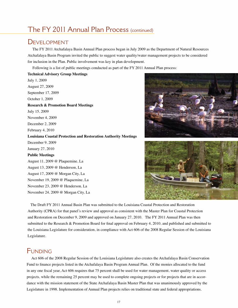
DeveloPment The FY 2011 Atchafalaya Basin Annual Plan process began in July 2009 as the Department of Natural Resources Atchafalaya Basin Program invited the public to suggest water quality/water management projects to be considered for inclusion in the Plan. Public involvement was key in plan development. Following is a list of public meetings conducted as part of the FY 2011 Annual Plan process:Technical Advisory Group MeetingsJuly 1, 2009 August 27, 2009 September 17, 2009 October 1, 2009 Research & Promotion Board MeetingsJuly 15, 2009November 4, 2009December 2, 2009February 4, 2010Louisiana Coastal Protection and Restoration Authority MeetingsDecember 9, 2009January 27, 2010Public MeetingsAugust 11, 2009 @ Plaquemine, LaAugust 13, 2009 @ Henderson, LaAugust 17, 2009 @ Morgan City, LaNovember 19, 2009 @ Plaquemine, LaNovember 23, 2009 @ Henderson, LaNovember 24, 2009 @ Morgan City, La
The Draft FY 2011 Annual Basin Plan was submitted to the Louisiana Coastal Protection and Restoration Authority (CPRA) for that panel’s review and approval as consistent with the Master Plan for Coastal Protection and Restoration on December 9, 2009 and approved on January 27, 2010. The FY 2011 Annual Plan was then submitted to the Research & Promotion Board for final approval on February 4, 2010, and published and submitted to the Louisiana Legislature for consideration, in compliance with Act 606 of the 2008 Regular Session of the Louisiana Legislature.
17
Funding Act 606 of the 2008 Regular Session of the Louisiana Legislature also creates the Atchafalaya Basin Conservation Fund to finance projects listed in the Atchafalaya Basin Program Annual Plan. Of the monies allocated to the fund in any one fiscal year, Act 606 requires that 75 percent shall be used for water management, water quality or access projects, while the remaining 25 percent may be used to complete ongoing projects or for projects that are in accor-dance with the mission statement of the State Atchafalaya Basin Master Plan that was unanimously approved by the Legislature in 1998. Implementation of Annual Plan projects relies on traditional state and federal appropriations.
In order to provide transparency in government, the Louisiana Legislature through the passage of Act 606 of the 2008 regular legislative session, requires multiple public meetings for the development and review of the Annual Basin Plan and subsequent approval by the Atchafalaya Basin Research and Promotion Board and the Coastal Protection and Restoration Authority all to be completed at least thirty (30) days prior to com-mencement of the regular legislative session. Therefore, it is required that the Annual Plan be drafted prior to the development of the appropriation bill that funds the plan. While it is certainly appropriate to have a public vetting prior to submittal of the Annual Basin Plan to the Louisiana Legislature, one of the challenges of the process is determining the level of funding that will be provided. Until such time as appropriations are final-ized, the level of funding for projects and the number of projects in the Plan that may be funded is uncertain. The Louisiana Legislature has recognized this challenge and enacted House Bill 765 (Act 541) during the 2009 regular legislative session that will bring a constitutional amendment before the voters of Louisiana in 2010 that, if passed, will provide a dedicated source of funding that will allow for predictable funding levels for future plans. The water quality / water management and access projects that are listed in this Annual Plan are listed in order of priority as established by the Atchafalaya Basin Research and Promotion Board. It is intended that projects will be constructed based upon that prioritization and consideration of the funding provided through Capital Outlay to the Atchafalaya Basin Conservation fund with 75% of the funding being used for water management, water quality or access projects and the remaining 25% used to complete ongoing projects and for projects that are in accordance with the mission statement of the State Master Plan for the Atchafalaya Basin as required by Act 606. Adaptive management is a key component of ecosystem restoration in the Atchafalaya Basin and, as such, funding flexibility and project implementation flexibility must exist to ensure that projects in the Annual Plan are implemented in a way that will maximize our resources. It is recognized that some projects may encounter unforeseen circumstances that will hinder project imple-mentation such as access, land rights, availability of federal matching funds, and costs that were not antici-pated. Those projects that are listed and are subject to these circumstances will be deferred until such time as those issues are resolved or additional funding is obtained to address the circumstances. In which case, funds that are provided for implementation of this Annual Plan may be used for funding other projects included in the Annual Plan that would not have otherwise been funded based on the appro-priation. In addition, based on the level of funding provided, it may be necessary to fund portions of projects to ensure that these projects move forward despite the lack of adequate funding to complete all projects. Once funding levels for the FY2011 Annual Plan are determined and project costs detailed, projects that are proposed for funding will be brought before the Atchafalaya Basin Research and Promotion Board with proposed budgets for approval. Any subsequent significant changes to the approved budgets or project scope will also be brought before the Research and Promotion Board for approval. Some projects that have been deferred as part of this Annual Plan process may later be identified for implementation. Should funding become available, previously deferred projects may be implemented pro-vided that they are approved by the Technical Advisory Group, Atchafalaya Basin Research and Promotion Board, and the Joint Legislative Committee on Natural Resources; consistent with the language of Act 606 of the 2008 Regular Session of the Louisiana Legislature; and meet one or more of the following qualifications: 1. Part of the Basin Master Plan; 2. Part of the Atchafalaya Basin Floodway System, Louisiana Project; 3. Water management or water quality project that meets the criteria developed by the board for inclusion in the Annual Plan and has been approved through the procedures adopted by the board for inclusion of a project in the Annual Plan, including public hearings; 4. Consistent with the mission statement contained in the Basin Master Plan; 5. A project to be completed which was previously approved by the Board.
project funDing anD prioritization
18

19
Atchafalaya Basin WMU’s

fy 2011 project List
Water Quality / Water ManageMent Projects
This category includes activities such as dredging, diversions, construction of cuts and gaps; data collection, evaluation and monitoring; and related planning, engineering and design within the Atchafalaya Basin’s 13 Water Management Units.
PRIORITY PROJECT NAME PROJECT NUMBER STATUS 1. Cocodrie Swamp 200915 & 200916 Proposed for Funding
2. Open Location Canal into Swamp North Bayou Sorrel 200941 Proposed for Funding
3. Open Brown Bayou to the I-10 Canal 200931 Proposed for Funding
4. Bayou Fourche 200925 Proposed for Funding
5. Dredge Big Bayou Pigeon 200918 Proposed for Funding
6. Dredge Little Bayou Pigeon 200921 Proposed for Funding
7. Dredge Entrance of 16” & 21” Pipeline Canals 200919 Proposed for Funding
20
The projects listed above are referenced by their project numbers on the map displayed to the right:
>>>

21
Project Number:
FY 2011 Water Quality/Water Management Projects Proposed for Funding

access Projects
This category includes the construction or renovation of boat launches that provide public access to areas in and adjacent to the Atchafalaya Basin.
PRIORITY PROJECT NAME STATUS
1. Bayou Sorrel Landing Proposed for funding 2. Butte La Rose Landing Proposed for funding
3. King’s Ditch Landing Proposed for funding 4. Wilson’s Landing Proposed for funding
22

The Atchafalaya Basin Program has a number of ongoing recreation projects. These projects, or stages of projects, are already funded, and Cooperative Endeavor Agreements already exist. These projects include: Assumption Veterans Park, Avoyelles Interpretive Plaza, Avoyelles Sarto Bridge, Avoyelles Simmesport Park, Belle River Park, Camp Atchafalaya, Cajun Coast Tourism Center, Catahoula Park Improvements, Dick Davis Park, Eagle Point Park, Harry Hewes House, Iberville Welcome Center, Lake End Park, LePromenade de Pont Breaux, Opelousas Gateway, Pointe Coupee Doris Park and Stephensville Park.
Other projects and initiatives, as well as additional phases of some ongoing projects, are proposed for funding in FY 2011. These projects are part of the State Master Plan, part of the legislation, ongoing projects previously approved by the Research and Promotion Board, and/or consistent with the mission statement of the State Mas-ter Plan. These projects are listed alphabetically as follows: Assumption Veterans Park, Basin Clean Up, Basin Outreach, Belle River Park, Camp Atchafalaya, Engineering, Lake End Cabins, Morgan City Interpretive Center, Primitive Campground, Sediment Management Plan and Stephensville Park.
Based upon the level of funding provided, projects that are proposed for funding will be brought before the Atchafalaya Basin Program’s Research and Promotion Board for approval.
other Projects and initiatives consistent With the
Mission stateMent of the state Master Plan
23

24
FY 2011 Water Quality/Water Management Projects Proposed for Funding
Project DescriPtions
Cocodrie Swamp Project (200915 and 200916)Bayou LaRose, in the Cocodrie Swamp Water Management Unit in St. Martin Parish, was once a very significant, commercially navi-gable waterway and the main source of freshwater for the swamp area. The cutting of oil and gas canals and USACE channel training has caused Bayou LaRose to silt up in many places and has resulted in portions of the bayou and the surrounding swamp being cut off from fresh water and devoid of plant and marine life. The goal of the project is to open natural waterways that are currently blocked to improve freshwater flow and navigation and to promote forest health.
The work would include directing water through two existing deltas south of Bayou Garofier and possibly through Bayou LaRose by removing sediment from the main channels and near the mouths of the bayous and removing impediments to water flow throughout the length of the canals. Other work involves removing the plug from Old Bayou LaRose at the Pantec Canal, opening old Bayou Cocodrie to allow water to enter the swamp to the east, and overall drainage improvements in the project area.
Open Location Canal into Swamp North of Bayou Sorrel (200941)Bayou Sorrel is located in the Pigeon Bayou Water Management Unit in Iberville Parish. Poor water quality has resulted in poor fishing conditions and fish kills, and the original lakes in the Sorrel Oil Field are and north are nearly gone. What remains is cut off from freshwater flow.
This project would include opening Location Canal south of the pipeline along the Upper Grand River exten-sion to increase freshwater flow into the area north of Bayou Sorrel Oil Field. An opening from Upper Grand River just south of the Location Canal that flows into two ponding areas would function as vegetated sediment filtration zones.
Open Brown Bayou to the I-10 Canal (200931)When the canal between the I-10 spans and the Work Canal in Iberville Parish was dug, Brown Bayou and several other natural waterways were cut off, eliminating access and a route for freshwater flow to interior lakes and swamps. The Technical Advisory Group recommends clearing Brown Bayou to the I-10 Canal. This action will re-establish flow south into Brown Bayou. The work area is the Bayou Des Glaises Water Management Unit. Brown Bayou
Cocodrie Swamp

25
Bayou Fourche (200925)There is no longer any water flow at any river stage in Bayou Fourche below Bayou Postillion, in the Flat Lake/East Grande Lake Water Man-agement Unit in Iberville Parish. This project would involve clearing or dredging the existing canal to promote flow into the area from the Gulf Intracoastal Waterway.
Dredge Big Bayou Pigeon (200918)Sediment has built up along nearly seven miles of the main channel of Big Bayou Pigeon in Iberia Parish, reducing water flow and impairing navigation. The project area is in the Upper Belle River Water Management Unit.
The Technical Advisory Group recommended dredging Bayou Pigeon to no more than the width of the channel at low or intermediate river stage (roughly 80 feet wide) and only as far downstream as needed to provide for small boat passage at low water (low water level to be determined.) The bottom contour of the channel shall mimic natural channel side-slope, and the channel depth shall provide three feet of access depth at low river stage. Sediment reduction will be achieved with a mid channel dug deeper than the rest of the bayou within the first half-mile of the dredging operation, and the sediment trap should have a five-year life expectancy. Spoil disposal options shall be in a manner that is beneficial to the surrounding forest and does not increase the eleva-tion of existing flow barriers. Project details will be further developed during the engineering phase with review by the TAG.
Dredge Little Bayou Pigeon (200921)Silt has built up in Little Bayou Pigeon from the crossover to Grand Lake in the Upper Belle River Water Management Unit in Iberia and St. Martin Parishes. This project would involve clearing debris and vegetation from Little Bayou Pigeon east from East Grand Lake and dredging, if necessary, to provide access to the lake.
Dredge entrance of 16” and 21” Pipeline Canals (200919)Sediment from dredging the Gulf Intracoastal Waterway has silted up the mouth of 21” and 16” canals, leaving the water in the canals with poor quality and no fresh water moving through system. Additionally, more cuts are needed along the canal banks to allow for historical sheet flow of water through this vast swamp area, located in the Upper Belle River Management Unit in St. Martin Parish.
The Technical Advisory Group recommends that the entrance to both pipelines be dredged only to the degree necessary to facilitate access into the areas. The dimensions of dredging will have to be designed to safely clear around existing pipelines.
Bayou Fourche
Little Bayou Pigeon

26
ongoing Water QuaLity / Water management projects
a revieW of fy 2010 annual Plan Projects that Were aPProved and funded
Atchafalaya Basin Natural Resource Inventory & Assessment System The Atchafalaya Basin is a resource that must be managed on a system-wide basis to ensure this invaluable national resource is pro-tected and restored. It is recognized that we must develop better tools for managing the Basin and that data evaluation is necessary to ensure sound decision-making. The natural resource inventory and assessment system that was approved and funded in the FY 2010 Annual Plan will serve as the primary tool for decision making in the Basin. The system will provide a means for scientists to access relevant project data for the Basin and to request and fund data acquisition, monitoring, and data analysis to be used in project plan-ning. This will be critical in providing information necessary for the development and approval of specific projects to be included for construction in future Annual Plans, projects that meet the needs of Louisiana’s citizens and protect our our natural resources.
This system will also assist in evaluating how the Atchafalaya Basin may interconnect with Coastal Protection and Restoration Au-thority projects by providing sediment and fresh water to nurture emerging marsh habitat without having an adverse impact on Basin resources. According to the Louisiana Comprehensive Master Plan for a Sustainable Coast, “The Atchafalaya River delta is the only region of coastal Louisiana that is building land naturally, and the master plan seeks to take maximum advantage of this resource.”
Status Report: Development of the system continues. It was used, in part, to identify and evaluate projects included in the FY 2011 Annual Plan. The Atchafalaya Basin Program is in the process of developing interagency cooperative agreements that will provide services for further development of the system. Data needs are being identified and plans for data acquisition are being developed.
Dog Leg Canal Sediment Trap Maintenance DredgingThe Dog Leg Canal was previously opened to the Atchafalaya River, at the request of the commercial fishing industry, to allow fresh-water to flow into this area of the Basin and improve water quality, primarily dissolved oxygen levels. A natural sediment trap existed near the Dog Leg cut that is believed to be in part responsible for the success of the project. That sediment trap is now almost com-pletely filled and has caused transportation of sediment further into the canal. This sedimentation of the canal has decreased the ca-nal’s ability to transport freshwater into the adjoining swamp. Maintenance dredging of the Dog Leg Canal sediment trap will restore the functionality of the sediment trap and prolong the transport of freshwater from the Atchafalaya River to the swamp.
Status Report: An engineering firm has been selected for project design. Once design is complete, permitting will follow and then bids will be requested to conduct the dredging project, followed by construction and project monitoring.
Development of a Complete and Specific Plan to Address Water Quality and Sedimentation in East Grand Lake/Flat Lake/Upper Belle River Management Units Through Modification of Water & Sediment InputsThe East Grand Lake/Flat Lake/Upper Belle River WMU’s have degraded due to water movement being blocked by sediment and spoil deposition, thereby causing low oxygen levels and loss of habitat. This project will analyze water flow and sediment deposi-tion throughout the study area including analysis of five inputs into the system: American Pass, Bayou Sorrel, Blue Point Chute, Coon Trap Weir, Dog Leg Canal and Indigo Bayou. A plan will be developed to realign water flow patterns and strategically redirect sediment. The result of this action will be a specific list of construction items to accomplish water and sediment realignment in these WMU’s, and thereby improve water quality and habitat and reduce the sedimentation of waterways and lakes.
Status Report: The Atchafalaya Basin Program has worked with the Technical Advisory Group and is in the process of developing scopes of services and interagency agreements to implement the project. Data collection efforts will soon be initiated. Data will be made part of the Atchafalaya Basin National Resource and Assessment System that will be used to assist the technical advisory group and hydrologists in plan development.

27
ongoing Projects
Prior to the enactment of Act 606 of the 2008 Regular Session of the Louisiana Legislature, the water quality/water manage-ment projects listed below were initiated, and in part funded, with federal and local partnerships by the State of Louisiana. It is the policy of the Atchafalaya Basin Program to submit these projects to the Technical Advisory Group for approval prior to any additional obligation or additional funding by the State of Louisiana not contracted as of the effective date of Act 606.
Buffalo Cove Water Management ProjectThe Buffalo Cove Water Management Project was designed to improve water circulation and sediment management in the Buffalo Cove Water Management Unit in an effort to enhance fish and wildlife resources. The project includes the improvement of interior circulation within the swamp; the removal of barriers to north-south flow; the input of oxygenated, low temperature river water; and the prevention or management of sediment input into the interior swamps.
The project location is the lower Basin in Iberia, St. Martin and St. Mary parishes. The U.S. Army Corps of Engineers (USACE) began construction on Buffalo Cove in 2004, and the project was estimated to benefit more than 7,500 acres initially and 53,000 to 58,000 acres eventually.
Status Report: Constructed elements include 1,8, 9-1 and 7. (See map.) The USACE received funding through the American Recov-ery and Reinvestment Act of 2009 to complete construction of additional elements of the project. A construction contract has been awarded for Element 9-2 in the Buffalo Cove Water Management Unit, and benefits of this feature should be realized in the near future. The USACE is in the process of easement acquisition for the remaining elements. Once the last element is constructed, the USACE is required to monitor the project’s effectiveness for a five-year period.

28
Henderson Water Management Unit (WMU)In an October 2006 scoping report, the U.S. Army Corps of Engineers (USACE) identified three major challenges within the Henderson WMU in St. Martin and St. Landry Parishes: hydrology, environment/habitat, and environmental quality. With regard to hydrology, the use, control, and function of the water control structures at the northern and southern end of the WMU was the main concern, followed by restoring the area’s water flow patterns. Constructing a freshwater distribution structure to increase water flow throughout the WMU was an additional concern. Habitat issues that are considered a primary component of the project include the control of invasive aquatic vegetation, protecting the native habitat, and the effects of initiating these activities.
Status Report: This project is in the planning stage. Proposed actions, benefits, and alternatives are being identified, as well as additional details such as dredging dimensions and the size of gaps to be cut to restore water flow patterns. The USACE planning group, consisting of state and federal agencies, is holding regular meetings to complete the planning documents.
Sherburne Freshwater Diversion Structure at Big Alabama BayouThis project was authorized by the Water Resource Development Act of 1986 in accordance with the plan recommended in the February 1983 Chief’s Report. The plan included construction of freshwater distribution structures from the Atchafalaya River to provide water inflow into the Alabama Bayou area. To date, no funds have been budgeted for or allocated to this effort by the U.S. Army Corps of Engineers (USACE); however, the Atchafalaya Basin Program is actively working with the USACE New Orleans District to move this project forward.
Status Report: This project is in the planning stage. Discussions with the USACE have taken place to provide future fund-ing for the project.
Beau Bayou Swamp Hydrologic RestorationBeau Bayou Swamp is located in the west central region of the Atchafalaya Basin in St. Martin Parish. Once known as a highly productive fisheries area, hydrologic manipulation within the Atchafalaya Basin from levee construction, pipeline canal spoil banks, sediment diversions, and channelization of the Atchafalaya River led to hypoxic conditions within Beau Bayou Swamp, along with many of the Basin’s other interior swamps. Most of the natural bayous and man-made canals flowing into Beau Bayou Swamp carry significant amounts of sediment adding to the already degraded condition of the swamp. The proposed Beau Bayou hydrologic restoration project would include: • Dredging of Beau Bayou through the center of the swamp, along with dredging of some of the natural waterways. Dredged material is to be used beneficially to address subsidence problems within the adjacent swamp. Any exposed spoil is to be vegetated with native plants. • Gapping of the natural levee along the northern east section of Bayou L’Embarras to allow for the exchange of freshwater and nutrients into the swamp. • Creation of inline sediment traps to reduce the sediment load currently flowing into Beau Bayou Swamp.
St. Martin Parish has been approved to receive $ 4,707,000 in Coastal Impact Assistance Program funds to advance the Beau Bayou project.
Status Report: St. Martin Parish has selected an engineering firm for the project and is currently in the planning stage.
Henderson Lake Access ChannelsThis project is being implemented through a cooperative endeavor agreement between the Atchafalaya Basin Program and St. Martin Parish Government. It consists of dredging canals from the existing boat launches on the West Guideline Levee of the Atchafalaya Basin into Lake Henderson in St. Martin Parish to facilitate boat traffic during low water periods that are due to the annual lowering of lake levels for the ongoing hydrilla control project. Dredging will also create deepwater fish habitat during low water periods.
Status Report: Work continues to obtain permits and environmental easements needed to complete project.

29
FY 2011 Access Projects Proposed for Funding
Project DescriPtions
Bayou Sorrel Boat LaunchThe Bayou Sorrel Boat Launch project in Iberville Parish is the subject of a cooperative agreement between the State of Louisiana and Iberville Parish Government. The U.S. Army Corps of Engineers is expected to provide the federal match for construction. The Re-search and Promotion Board approved this project in 2005. The proposed project consists of two new concrete ramps with five-lanes each, a new floating courtesy dock adjacent to one of the ramps, and a relocated floating courtesy dock adjacent to the other ramp; concrete landings adjacent to the boat ramps; expanding and improving a crushed stone parking area; security and restroom shelter; access roads; demolition of the existing ramp; electrical service to power and light the security building and restrooms and light the parking area and boat ramp. Matching funds have been provided to the Corps for project design by the Atchafalaya Basin Program. Matching funds for construction of the launch will be required.
Butte LaRose Boat Launch This project will upgrade the Butte LaRose boat launch into the Atchafalaya River. The upgrade to this landing would involve extend-ing the launch out into the river an additional 15 feet to accommodate safe launching when the River falls below 3 to 4 feet at the Butte LaRose gauge.
King’s Ditch Boat LaunchThis project will be to design and construct a small boat landing south of Ramah at Kings Ditch. Commercial and recreational fisher-men use this area to launch boats. Fishermen report that the next landing from Ramah is at Grand River and is not convenient for those from this area.
Wilson’s Landing Boat LaunchProposed renovations to this landing include bringing in fill material (as yet an unknown quantity) to raise the elevation of the present “low-water launch” so that it can function at higher River stages as well. In addition, the ramp(s) may need to be extended farther out into the water to facilitate safe launching at lower River stages.

Krotz Springs temporary boat launch
ongoing access projects a revieW of fy 2010 annual Plan Projects that Were aPProved and funded
Krotz Springs Boat LaunchThe Krotz Springs Boat Launch project in St. Landry Parish is the subject of a cooperative agreement between the State of Louisiana and the Greater Krotz Springs Port Commission. The facility will consist of coordinated signage to the site and improved access from the service road, construction of a new concrete three-lane boat launch with floating courtesy dock, renovation of the existing launch into a canoe launch, expansion of parking area, security lighting, landscaping and curbing.
Status Report: The U.S. Army Corps of Engineers has installed a temporary launch at this location. Plans are being developed for the permanent launch that is to be constructed.
Big Alabama Boat Launch Phase IIThe Sherburne Wildlife Management Area, which is operated and maintained by the Louisiana Department of Wildlife and Fisheries, has between 30,000 and 40,000 visitors annually. The first phase of this boat launch project which renovated the existing boat launch did not contain adequate funds for other needed improvements. This second phase will include improve-ments to the boat launch parking lot, the addition of a handicapped accessible fishing pier, and a modular restroom facility.
Status Report: The Atchafalaya Basin Program is working with the Louisiana Department of Wildlife and Fisheries on a Scope of Work for the project, as well as with the Division of Administration, Office of Facility Planning and Control to final-ize design specifications for the additional features at the boat launch.
ongoing Projects
Bayou Amy Boat LaunchThis new boat launch facility is already funded and will be constructed on Bayou Amy, directly across from the Atchafalaya Basin western guide levee in Henderson, Louisiana. The project will include a new boat launch, parking area, and docking facility. Additional improvements are being designed at this site, and that component will be funded with CIAP funds. That portion of the project will include an educational pavillion, self guided nature boardwalk, and a restroom facility.
Status Report: An engineering firm has been selected. Project design and acquisition of environmental easements is underway.
Myette Point Boat LaunchThe Myette Point Boat Launch project is the subject of a coop-erative agreement between the U.S. Army Corps of Engineers (USACE) and the St. Mary Parish Government. The project area is in the vicinity of the town of Charenton, Louisiana, in St. Mary Parish. Construction began in September 2007. The purpose of the proposed action is to provide a point of entry into the Lower Atchafalaya Basin Floodway for recreational fishing vessels, commercial fishing vessels, hunters, crew boats, federal and state government personnel, and others. Myette Point boat launch nears completion.
30

31
This project consists of a new concrete boat ramp with five lanes (four lane boat launch and one canoe launch) to be constructed; a new floating courtesy dock adjacent to the ramp; a concrete apron adjacent to the boat ramp that will be constructed by pre-loading the site and installing wick drains; a comfort station (restroom); a crushed stone parking area; upgrading of existing public roads used for ingress and egress; partial demolition and partial removal of an existing boat ramp with the remainder of said ramp converted into a canoe launch; water service for the comfort station; a sewage treat-ment plant; electrical service to power and light the comfort station and service to light the parking area and boat ramp; and landscaping.
Status Report: The USACE anticipated completion of the facility by the end of January 2010; however, high water has once again delayed completion of the project. The completion date for the launch is now projected for Summer 2010.
Big Alabama Boat Launch Phase IThis new two-lane boat launch, with a center pedestrian pier is located in Pointe Coupee Parish in the state owned Sherburne Wildlife Management Area, located in the Morganza Floodway system of the Atchafalaya Basin. The Sherburne WMA adjoins other properties, including the lands owned by the U.S. Fish and Wildlife Service and the Corps of Engineers. The total site including all three government properties totals 44,000 acres.
Status Report: Construction has been completed and facility is in use.
Bayou Benoit Boat LaunchThe improvements to this boat launch are already funded and are cur-rently being designed; final plans should be ready soon. This launch was originally constructed with grant funds from a Wallop-Breaux Grant. Planned improvements will consist of the construction of a floating dock to allow boaters to tie up their boats while parking trailers.
Status Report: Construction has been completed and facility is in use.
Belle River Boat LaunchThis project is already funded and involves the installation of restroom facilities at the existing Belle River boat launch. The boat launch is operated and maintained by the Atchafalaya Basin Levee District.
Status Report: Project is being advertised for bids to construct.
Big Alabama I boat launch is complete.
Bayou Benoit boat launch is complete.
Other FY 2011 Projects and Initiatives Proposed for Funding
Project DescriPtions
Basin Clean Up This project will allow the Basin Program to participate in clean up efforts around the Basin and address issues that are brought to its attention regarding trash and garbage within the Basin.
Basin Outreach Project This project includes the program’s outreach efforts regarding the Atchafalaya Basin Program. Funding will be used for items such as educational materials, development of annual plans and reports, signage, etc.
Belle River ParkThis is an ongoing project to provide a recreation facility for visitors and residents of lower St. Martin Parish in the Belle River Area. Work completed to date includes earth work and a walking trail. Work remaining to be completed includes a roadway, parking, drain-age, trails, landscaping, playground equipment, lighting, pavilion, meeting hall, building utilities and sewer treatment. The design of this project was funded through the Atchafalaya Basin Program and a Trails Grant.
Camp AtchafalayaCamp Atchafalaya is a project to construct a facility to provide the Atchafalaya Basin Experience to those individuals who are physi-cally challenged. The goal of this project is to create a universally accessible environment for people with disabilities to connect back to nature. This facility shall be constructed in its entirety as a barrier free and completely accessible park. The Park shall be void of any designation of handicap signage, areas and identifications, because the park and anything in it will be designed accordingly for access. Users will be able to do any activity that would be normally done on a typical State Park no matter what their disability. They will be able to hike, bike, canoe, fish, bird watch, view wildlife, enjoy water facilities, boat ride, etc. This project will ensure that everyone will have access to what Louisiana and the Atchafalaya basin has to offer. The Office of State Parks is currently working on design and planning of this project with funding that has been provided by the Atchafalaya Basin Program and additional funding may be needed to complete the planning process.
Engineering This project will provide engineering assistance to the Technical Advisory Group for project design and scoping as well as cost esti-mates.
Lake End Park CabinsThis project will be to construct cabins at Lake End Park in Morgan City along the shore of Lake Palourde. Shoreline stabilization has been completed as well as cabin design. The Federal Emergency Management Agency (FEMA) has completed the infrastructure for RV trailers including water and sewer lines consistent with the master plan that was developed for Lake End Park.
Morgan City Interpretive PlazaThis project would be a cooperative effort with the United States Army Corps of Engineers. The concept of this project is for design of a building that would show-case the cultural aspects of the lower Atchafalaya along with other projects, both existing and proposed, that have been constructed by the United States Army Corps of Engineers. The funding provided for this project would be used as matching funds for the development of the Engineering Design Report (EDR) by the Corps.
32

Primitive CampgroundsThese campgrounds are proposed to support needed recreational opportunities in and around the Wildlife Management Areas within the Basin. They will include fire rings and leveled areas for tents only. Some proposed locations being considered are areas near Bayou Pigeon, East Grand Lake, Simmesport, and Indian Bayou.
Sediment Management Plan This project will be to develop a comprehensive sediment management plan for the Atchafalaya Basin that will ensure that projects are properly planned and managed so that sediment is directed in a way that will be beneficial to the ecology of the Basin. The sediment management plan should be designed to maximize sediment transport to coastal Louisiana and reduce the amount of sediment that is deposited in the Atchafalaya Basin. Location and design of sediment traps to reduce sediment flow into the interior basin as well as a maintenance program for the sediment traps will be integral components of the plan.
Stephensville ParkThis is an ongoing project to provide a recreation facility for visitors and residents of lower St. Martin Parish in the Stephensville area. Phase I of this project has been completed and included earth work, ballfields, walking trail, parking area, playground and a picnic shelter. Work remaining to be completed includes ball field lighting, concession stand, restroom, landscaping, bleachers, playground equipment, parking, tennis court and sewage treatment.
Veterans ParkThis is an ongoing project to provide a recreation facility for visitors and residents of the Pierre Part area in Assumption Parish. Phase I and II of this recreational facility have been completed. The facility includes baseball fields, tennis courts, concession stand, walking trail and a playground.
Work remaining to be completed includes additional landscaping and lighting for baseball fields, tennis courts, walking trail and the parking lot. Also planned are bleachers, concession stand equipment, batting cages and sidewalk canopies, waterfront dock, spray water park, shuffleboard and volleyball court(s).
33

34
u.s. army corps of engineers puBLic access & acQuisition of environmentaL easements
Fee Purchase
The Atchafalaya Basin Floodway System authorization requires that the Public Access feature provide for fee lands to be purchased from non-governmental, willing sellers. To date, the U.S. Army Corps of Engineers has acquired ownership of 47,297 acres for public access lands toward a total authorized 70,000 acres.
Acquisition of Environmental Easements Acquisition of environmental easements refers to the purchase of federal easements in the Atchafalaya Basin for the purposes of developmental control and environmental protection. To date, the U.S. Army Corps of Engineers has acquired 111,689 acres of comprehensive easement toward an authorized 367,000 acres.
View Proposed Basin Projects and Other Basin Maps Online
The Atchafalaya Basin Program is now on the maps section
of the Department of Natural Resources’ SONRIS site, at
the interactive maps link under the GIS section. The Basin
Program information is listed under the Coastal group in
that section. You will be able to see the project location and project details using this tool. You can also see
the boundaries of the Atchafalaya Basin area, water management units and links to proposed projects. Toggle
text labels are available for Basin Program projects and the water management unit layers. The map section
includes a tutorial for those unfamiliar with navigating the site and using the maps.
Direct: http://sonris-www.dnr.state.la.us/gis/sonris/or
SONRIS main: http://sonris-www.dnr.state.la.us/www_root/sonris_portal_1.htm

35
appenDix

Project Title/Number - Cocodrie Swamp Project (200915 and 200916)
Type of Problem - Access and Water Quality
Nominating Party - Mike Bievenue for LCPA West
Statement of Problem – Open all natural waterways blocked by the spoil banks on the Panotec Canal. The banks have cut off water flow and cause sectioning off of once very productive swamps. Bayou LaRose was once a very significant, commercially navigable water way, alterations (oil and gas canals mainly) such as the Corps Channel Training caused it to silt up in many places. Bayou LaRose was the main source of fresh water each year for these swamps. Now we have sectioned off lands with rotten water that sits and gets hot and nothing lives there anymore.
Proposed Work Area – Cocodrie Swamp Water Management Unit in St. Martin Parish
Proposed Action Description – Where possible, knock down spoil banks. Cut through spoil banks and where possible use spoil to repair degraded forests or build islands for wildlife. Make cuts in the Wanda at the South end to keep sheet flow moving south. Dig a sediment trap at the mouth at Bayou Garofier. Leave the north most mouth plugged until you dredged the high spots from the old natural channel, then open the plug up north and let the water go. Remove the 4-wheeler bridges and earth dams that the hunting clubs put in. Shave the banks of LaRose in some spots to let water spill over into the swamps at a lower river stage. This will greatly improve fisheries and forest habitat throughout the Cocodrie swamp and allow for navigation.
TAG Analysis and Recommendation:
• Segments A, E, F– These swamp segments are ponded and require drainage. Preliminary evaluation indicates that drainage barriers (A-F, F-C, F-K) prevent water from entering the area from the south for river stages less that 10 ft on the BLR gage. Ponded water in the segment also remains for much lower river stages. The subcommit-tee’s initial recommendation was to improve drainage to promote forest health and to facilitate the flow of additional water through the system from the possible additional new water sources to the system. Discussion with the sponsor indicated that this area was not within the intended the target area of the initial project proposal. • Segments B and L – Limited benefits to aquatic habitat are expected by attempting to connect these segments to the other segments of the area considering the elevation of the bounding features and the large amount of material that would require movement in that effort. These are low priority areas and are not included the list of areas to be modified in the project.• Segment C - Intended to be the primary area of improvement where the proposal recommends the direct of water through two existing deltas south of Bayou Garofier and also possibly through Bayou Larose. Improvements to both bayous would include removal of sediment from the main channels near the mouths and possibly clearing throughout the length of the canal to remove intermittent flow impediments. The bottom elevation of water delivery channels should be lowered to allow water into the area at or about the same elevation that water enters the lower portion of the area to reduce the residency time of stagnant water in the swamp. There is a remnant “board road” just south of the proposed delivery site that will require removal or gapping with small track excavation equipment. The northwestern barrier of segment G will also require similar flow improvements.• Segment G – Water quality in this segment is expected to be improved through the input of water into segment C and improvements to barrier C-G. Improved drainage at the southwest boundary of G will assist in draining the area and • Segments K and M - The boundary between K and M is the remnant of Old Bayou LaRose. The proposal rec-ommends removing the plug from the bayou at the Pantec Canal to the north of K and M and allowing water from the river to enter the segments through the Pantec Canal.• Segment N – The remnant of Bayou Cocodrie enter the segment from an canal to the west side of the segment. The proposal recommends opening the bayou to allow water to enter the swamp to the east through the remains of the old Bayou Cocodrie.• Segments J and H – Drainage to the south through both of these segments is currently efficient and requires no modification. There are two pipelines that cross these segments that will require evaluation and possibly modifica-tion where possible.
36

Project Title/Number - Open Location Canal into Swamp North of Bayou Sorrel (P200941)
Type of Problem – Water Quality
Nominating Party – Don Erwin - Bass fisherman
Statement of Problem – Poor water quality has made the fishing pretty bad in the Sorrel Oil Field and north. The old original lakes are mostly gone. What’s left has been cut off from fresh water flow. A couple of fish kills have occurred this year.
Proposed Work Area – Pigeon Bay Water Management Unit in Iberville Parish
Proposed Action Description – Dredge to reconnect the oil field channels to one another and reconnect the pipeline just south of Grand River to the GIWW to get flow coming in from the north through the channels down to Spike Bay and Berry Lake.
TAG Analysis and Recommendation - The TAG recommends opening the location canal south of the pipeline along the extension of the Upper Grand River to get water into the area north of the Bayou Sorrel Oil Field. In addi-tion, there should also be an opening from Upper Grand River just south of the location canal into two ponded areas that will function as vegetated sediment filtration zones.
___________________________________
Project Title/Number - Open Brown Bayou to the I-10 Canal (200931)
Type of Problem – Water Quality
Nominating Party – Jody Meche, Crawfisherman
Statement of Problem – Poor water quality in Brown Bayou. When the canal between the I-10 spans and the Work Canal was dug, Brown Bayou and several other natural waterways were closed off. This cut off a critical access pas-sage and a passage for freshwater to the interior lakes and swamps.
Proposed Action Description – Dredge mouth of Brown Bayou south of I-10. This will allow fresh water to go into lower Bayou Des Glaises management unit. The Bayou should be cleaned all the way to Billy Little’s Lake.
Proposed Work Area – Bayou Des Glaises in Iberville Parish
TAG Analysis and Recommendation – The TAG recommends that Brown Bayou be cleared to the I-10 Canal. There are nonfunctional culverts that need to be replaced with new culverts or possibly a bridge.
37

Project Title/Number - Bayou Fourche (200925)
Type of Problem – Water Quality
Nominating Party – Harvey Hebert, East side WMG
Statement of Problem – Bayou Fourche below Bayou Postillion. No flow at any river stage anymore.
Proposed Work Area – Flat Lake/East Grande Lake Water Management Unit in Iberville Parish
Proposed Action Description – Dredge opening of Bayou Fourche at GIWW all the way to Old River. This will get fresh water down thru east side of Postillion area. Put the spoil in the GIWW to go south to the coast.
TAG Analysis and Recommendation – The TAG recommends clearing, and possibly dredging, the existing canal to the degree necessary to promote flow into the area from the GIWW.
________________________________
Project Title/Number - Dredge Big Bayou Pigeon (200918)
Type of Problem – Access and Water Quality
Nominating Party – Booster Breaux, Fisherman
Statement of Problem – 6.7 miles of sediment has built up in the main channel reducing flow and ability to navigate at low water.
Proposed Work Area – Upper Belle River Water Management Unit in Iberia Parish
Proposed Action Description – Build sand trap at mouth of Big Pigeon (at Little Pigeon). Dredge the main channel. Use spoil in swamp where trees are dead. This project will improve navigation in the Bayou, improve water quality in several areas to the south, and will let water flow into Mallet area.
TAG Analysis and Recommendation - The TAG recommends dredging Bayou Pigeon to no more than the width of the channel at low or intermediate river stage (roughly 80 feet wide) and only as far downstream as needed to provide for small boat passage at low water (low water elevation to be determined). The width recommendation comes with the condition that the bottom contour of the channel should mimic natural channel side-slope and be restricted to a minimum slope (to be determined). At low water, the channel depth should provide 3 ft of access depth at low river stage (BLR to be determined in subsequent analysis using Inventory and Assessment Tool). Sediment reduction features should include a mid channel within the first half mile of the dredge operation where the channel should be widened to the full width of the existing banks at high water, deeper than the proposed dredge depth of the rest of the bayou, and should be long enough to provide for a 5 year life expectancy of the sediment trap. Spoil disposal options should be in a manner that is beneficial to surrounding for-est and does not increase the elevation of existing flow barriers. Because LDWF data indicates that the unaltered section of Big Bayou Pigeon south of the proposed dredge area is one of the most productive fish habitats in the basin, the committee recommends caution in developing this project and suggests that contingency plans be put in place for unanticipated sedi-ment accretion that may threaten habitat integrity. The contingency plan should provide mandatory adaptive management alternatives for reducing sediment if predefined limits of accretion are reached. Both sediment reduction alternatives and minimal acceptable levels of accretion are to be determined.
38

39
Project Title/Number – Dredge Little Bayou Pigeon (200921)
Type of Problem – Access and Water Quality
Nominating Party – Harvey Hebert East side WMG
Statement of Problem – Pigeon from the crossover to Grand Lake had silted up.
Proposed Work Area – Upper Belle River Water Management Unit in Iberia and St. Mary Parishes
Proposed Action Description – Open Crossover Canal at Pigeon. Clean Pigeon down to Grand Lake. Remove the Berlin Wall from location (2 miles south of crossover Bayou.) This project will greatly improve access and fisheries production both to and in Grand Lake.
TAG Analysis and Recommendation - The TAG recommends to clear debris and vegetation from Little Bayou Pigeon east from East Grand Lake. If dredging is necessary for access to the lake, the spoil should be disposed in a manner that does not increase the elevation of spoil banks along any part of the bayou.
____________________________________
Project Title/Number - Dredge entrance of 16” and 21” Pipeline Canals (200919)
Type of Problem – Access and Water Quality
Nominating Party – Booster Breaux, Fisherman East side WMG
Statement of Problem – Sediment from dredging the GIWW (spillway) has silted up the mouth of 21” and 16” canals leaving the water in the canals of poor quality and no fresh water moving through system. Additionally, more cuts are needed along the canal banks to allow for historical sheet flow of water through this vast swamp area.
Proposed Work Area – Upper Belle River Water Management Unit in St. Martin Parish
Proposed Action Description – Wheel-wash or otherwise clean openings at GIWW. Cut big gaps in spoil banks along 16” and 21” canals. This will improve water quality and fisheries habitat to south regions of Upper Belle River.
TAG Analysis and Recommendation - The TAG recommends that the entrance to both pipelines be dredged only to the degree necessary to facilitate access into the areas. The dimensions of dredging will have to be designed to safely clear around existing pipelines.

Bayou Des Glaises WMU• 200908 Kings Ditch Landing • 200911 Reopen East Fork • 200929 Dredge Work Canal • 200931 Dredge Brown Bayou at I-10• 200933 Reopen Bayou Des Glaises at I-10
Beau Bayou Swamp WMU• 200914 Reopen Bayou De Plomb• 200928 Reopen Old Bayou LaRompe at River• 200936 Reopen 400 Dollar Bayou and Little Bayou LaRose at Bayou De Plomb
Big Alabama WMU• 200901 Upper Pointe Coupee Parish (UPCP) Water Management Study• 200907 Restock Fisheries• 200927 Reopen Bayou Des Ourses at Big Alabama• 200934 Reconnect Big Alabama and Little Alabama• 200940 Water Diversion into Big Alabama
Buffalo Cove WMU• 200903 Sediment Traps• 200904 Phillips Canal Closure• 200910 Dredge Bayou Chene• 200937 Close Cut at GA• 200938 Remove Logjam at Buffalo Cove• 200939 Bayou Eugene Water Quality
Cocodrie Swamp WMU• 200915 Panotec Cuts• 200916 Bayou Larose Water Quality
Flat Lake/East Grand Lake WMU• 200925 Dredge Bayou Fouchea
Grand Lake WMU• 200905 Dredge American Pass• 200906 Dredge Taylor Pointcut• 200913 Close American Pass• 200932 Dredge Six Mile Lake
Henderson Lake WMU• 200902 Henderson Water Quality/Hydrilla Control• 200922 Lake Henderson Water Quality• 200935 Open North/South Henderson Gates
Pigeon Bay WMU• 200909 Dredging North of Hog Island• 200912 Close Coon Trap• 200923 Reopen Coon Trap• 200924 Bee Bayou Indigo Area Water Quality• 200926 Reopen Shell Field at Bayou Sorrel• 200941 Sorrel Oil Field Water Quality
Upper Belle River WMU• 200917 Reconnect Postillion to Old River• 200918 Dredge Big Bayou Pigeon• 200919 Dredge 21 and 16-Inch Canals• 200920 Dredge Little Bayou Long from 21 to Duck Lake• 200921 Dredge Pigeon to Grand Lake• 200930 Connect 21 and 16-Inch Canals
Potential FY 2011 Atchafalaya Basin Water Management Projects Identified by Stakeholders and Presented to the Technical Advisory Group
Maps identifying all nominated projects can be viewed online: http://sonris-www.dnr.state.la.us/gis/sonris/
orhttp://sonris-www.dnr.state.la.us/www_root/sonris_portal_1.htm
40

41
FY 2011 Projects Nominated by Public

references
The following publications and sources were referenced in the development of the FY 2011 Atchafalaya Basin Annual Plan:
Guirard, Greg, C. Ray Brassieur, and Louisiana Dept. of Natural Resources. Inherit the Atchafalaya. New York: University of Louisiana at Lafayette, Center for Louisiana Studies, 2007.
U.S. Army Corps of Engineers, New Orleans District. The Atchafalaya Basin Project. Brochure. New Orleans: Author.
“La DNR - Office of the Secretary - Atchafalaya Basin Program.” Louisiana Department of Natural Resources. 27 Oct. 2009 <http://dnr.louisiana.gov/atchafalaya>.
Atchafalaya Basinkeeper. 29 Jan. 2009 <http://www.basinkeeper.org>.
“Atchafalaya Basin: Summary of Basin Plan.” LaCoast.gov. The Louisiana Coastal Wetlands Conservation and Restoration Task Force web site. 29 Jan. 2009 <http://www.lacoast.gov/landchange/basins/at/atchsum.htm>.
U.S. Geological Survey. The Atchafalaya Basin - River of Trees. Brochure. Baton Rouge: Au-thor, 2001.
U.S. Travel Association. The Economic Impact of Travel on Louisiana Parishes 2008. Rep. Louisiana Office of Tourism, Oct. 2009. Web. 30 Nov. 2009. <http://www.crt.state.la.us/tourism/research/documents.aspx>.
Wlf.louisiana.gov. Louisiana Department of Wildlife & Fisheries. Web. 19 Oct. 2009. <http://www.wlf.louisiana.gov/education/economics/>.
2007 Plaquemine Mounds of the Western Atchafalaya Basin. In Plaquemine Archaeology, edited by Mark A. Rees and Patrick C. Livingood, pp. 66-93. University of Alabama Press, Tuscaloosa.
42
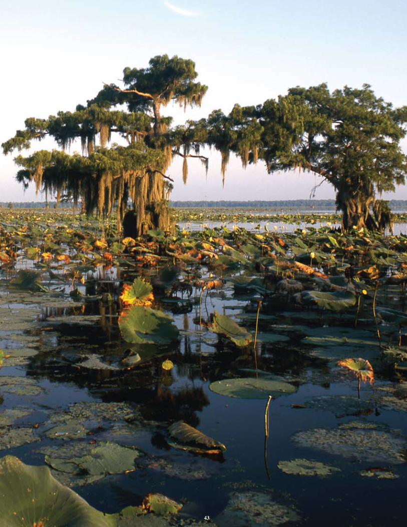
43

Atchafalaya Basin ProgramLouisiana Department of Natural ResourcesP.O. Box 94396Baton Rouge, LA 70804-9396phone: (225) 342-6437 • fax: (225) 342-6887http://dnr.louisiana.gov/atchafalaya
This document was published at a total cost of $980.00. Three hundred fifty copies of this public document were published in the first printing at a cost of $980.00. The total cost of all printings of this document, including reprints, is $980.00. This document was published in-house by the Louisiana Department of Natural Resources, Atchafalaya Basin Program to comply with Act 606 of the 2008 Regular Session of the Loui-siana Legislature, which requires the development and publication of an Annual Plan for the Atchafalaya Basin Program. This material was printed in accordance with the standards for printing by state agencies established pursuant to R.S. 43:31.