Embed Size (px)
Citation preview
Interim OverviewInterim OverviewAtlantic Tsunami / Storm Surge Atlantic Tsunami / Storm Surge
Warning SystemWarning SystemEast Coast Canada
C. O'ReillyC. O'Reilly11
P. MacAulayP. MacAulay11
G. ParkesG. Parkes2211Canadian Hydrographic Service / AtlanticCanadian Hydrographic Service / Atlantic
Bedford Institute of OceanographyBedford Institute of Oceanography22Meteorlogical Services CanadaMeteorlogical Services Canada
A Progress Report A Progress Report with contributions from: with contributions from: G. Pearson, G. Pearson, EnvEnv. Can.. Can.D. McCormack, Allison Bent, D. McCormack, Allison Bent, NRCanNRCanW. W. LumsdenLumsden, Consultant, ConsultantJ. Rhoades, NOAAJ. Rhoades, NOAA

AssumptionsAssumptions
•• Politically drivenPolitically driven•• No new moneyNo new money•• Low probability / high impact of a major Low probability / high impact of a major
basin scale tsunamibasin scale tsunami•• Continuous 7/24 operation requiredContinuous 7/24 operation required•• FederalFederal--provincial cooperationprovincial cooperation
-- DFO, DFO, NRCanNRCan, PSEPC, , PSEPC, EnvEnv. Canada. Canada-- EMOsEMOs of NS, NB, PEI, NFLDof NS, NB, PEI, NFLD
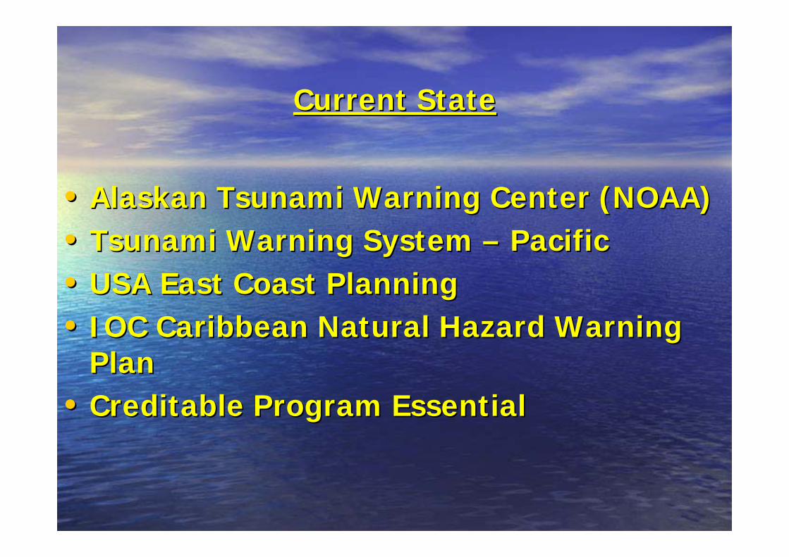
Current StateCurrent State
•• Alaskan Tsunami Warning Center (NOAA)Alaskan Tsunami Warning Center (NOAA)•• Tsunami Warning System Tsunami Warning System –– PacificPacific•• USA East Coast PlanningUSA East Coast Planning•• IOC Caribbean Natural Hazard Warning IOC Caribbean Natural Hazard Warning
PlanPlan•• Creditable Program EssentialCreditable Program Essential
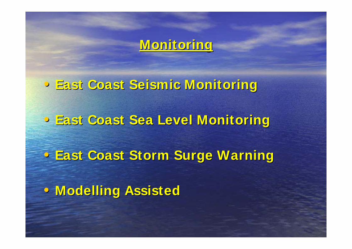
MonitoringMonitoring
•• East Coast Seismic MonitoringEast Coast Seismic Monitoring
•• East Coast Sea Level MonitoringEast Coast Sea Level Monitoring
•• East Coast Storm Surge WarningEast Coast Storm Surge Warning
•• ModellingModelling AssistedAssisted

PreparednessPreparedness
•• Warning the Warning the ““WarnersWarners””
•• Public Warning DisseminationPublic Warning Dissemination
•• Outreach/EducationOutreach/Education
•• Horizontal Risk AssessmentHorizontal Risk Assessment
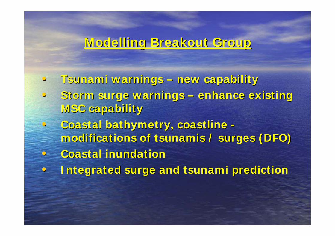
ModellingModelling Breakout GroupBreakout Group
•• Tsunami warnings Tsunami warnings –– new capabilitynew capability•• Storm surge warnings Storm surge warnings –– enhance existing enhance existing
MSC capabilityMSC capability•• Coastal bathymetry, coastline Coastal bathymetry, coastline --
modifications of tsunamis / surges (DFO)modifications of tsunamis / surges (DFO)•• Coastal inundation Coastal inundation •• Integrated surge and tsunami predictionIntegrated surge and tsunami prediction

NRCanEastern Canada
SeismicNetwork
Government ofCanada
Operation Centre
InternationalSeismic & Sea Level
Network
US NOAAAlaska TsunamiWarning Center
ECAtlantic Storm
Prediction Centre
CHS/DFOEastern Canada
Sea LevelNetwork
Provincial EMO Operation CentresMedia
Atlantic Tsunami WarningProcess Diagram
Figure 1
Seismic Event
Initial Warning
Atlantic Warning

Message Alert SeverityMessage Alert Severity
•• Warning:Warning: Earthquake occurred. Tsunami may Earthquake occurred. Tsunami may have been generated. Arrival times <2 hourshave been generated. Arrival times <2 hours
•• Watch:Watch: Earthquake occurred. Potential Earthquake occurred. Potential resultant tsunami not measured. Arrival times > resultant tsunami not measured. Arrival times > 3 to 6 hours3 to 6 hours
•• Info Bulletin:Info Bulletin: Earthquake occurred but not Earthquake occurred but not sufficient to generate a damaging tsunamisufficient to generate a damaging tsunami
•• Info Message:Info Message: Earthquake occurred but not Earthquake occurred but not magnitude too weak to generate tsunami.magnitude too weak to generate tsunami.

MessagesMessages
•• As RecAs Rec’’d from ATWCd from ATWC
•• WEXX20 Tsunami Warning WEXX20 Tsunami Warning –– large message with large message with breakpointsbreakpoints
•• WEXX20 Tsunami WatchWEXX20 Tsunami Watch•• WEXX22 Tsunami WEXX22 Tsunami
Information BulletinInformation Bulletin•• SEXX20 Tsunami SEXX20 Tsunami
Information MessageInformation Message
•• As Issued from ASPCAs Issued from ASPC
•• WECN41 Tsunami WECN41 Tsunami Warning Warning –– Shorter Shorter message with message with FcstFcst. . RgnsRgns..
•• WECN41 Tsunami WatchWECN41 Tsunami Watch•• WECN43 Tsunami Info. WECN43 Tsunami Info.
BulletinBulletin•• SECN43 Tsunami Info. SECN43 Tsunami Info.
MessageMessage

Current Message FormatCurrent Message Format
•• Based on current Weather Warning messages.Based on current Weather Warning messages.–– HeaderHeader–– Message titleMessage title–– Issue time / dateIssue time / date–– Regions affectedRegions affected–– DiscussionDiscussion–– Estimated times of arrivalEstimated times of arrival–– In effect duration timeIn effect duration time–– Contact info. Contact info.

ProgressProgress
•• Message FormatMessage Format–– Internal coding work in progress (processing of ATWC messages Internal coding work in progress (processing of ATWC messages
and reand re--transmission)transmission)–– Need to finalize message wording (esp. for translation purposes)Need to finalize message wording (esp. for translation purposes)–– Need to finalize short message format for Need to finalize short message format for WxWx Radio and ATADSRadio and ATADS
•• Testing of Communications systemTesting of Communications system•• Operating Procedures for ASPC (being drafted)Operating Procedures for ASPC (being drafted)
–– Infrequent eventInfrequent event–– Bulletin preparationBulletin preparation–– Getting the message out Getting the message out –– Tidal gauge verificationTidal gauge verification
•• Contingency Plans for ASPC operationsContingency Plans for ASPC operations•• Dissemination MethodologyDissemination Methodology

Seismic MonitoringSeismic Monitoring
•• Continuous data sent to two independent data Continuous data sent to two independent data centre (PGC, OBScentre (PGC, OBS--OTT) OTT)
•• Multiple Multiple commscomms paths (Cpaths (C--band, Kuband, Ku--band VSAT, band VSAT, terrestrial IP WAN, IP over VSAT)terrestrial IP WAN, IP over VSAT)
•• 24/7 automated analysis and alerting 24/7 automated analysis and alerting –– 33--5 minutes5 minutes
•• 2 seismologists2 seismologists--onon--call (call (SOCsSOCs) ) –– 1 PGC based1 PGC based–– 1 Ottawa based 1 Ottawa based
•• CREST data flow to ATWC is not currently robustCREST data flow to ATWC is not currently robust

•Pacific Tsunami Center
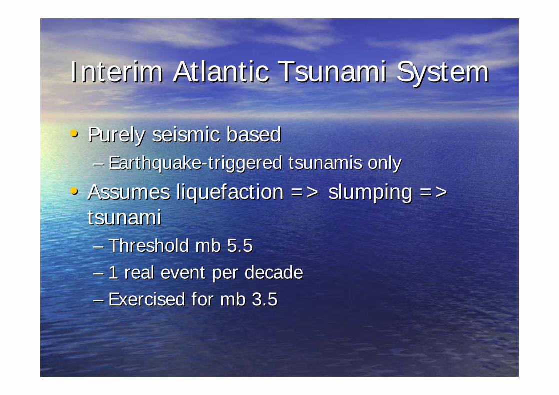
Interim Atlantic Tsunami SystemInterim Atlantic Tsunami System
•• Purely seismic basedPurely seismic based–– EarthquakeEarthquake--triggered tsunamis onlytriggered tsunamis only
•• Assumes liquefaction => slumping => Assumes liquefaction => slumping => tsunamitsunami–– Threshold Threshold mbmb 5.55.5–– 1 real event per decade1 real event per decade–– Exercised for Exercised for mbmb 3.53.5

•GB map

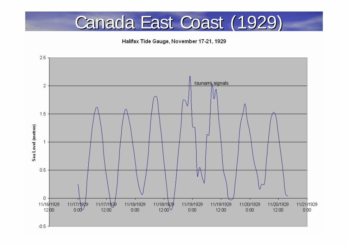
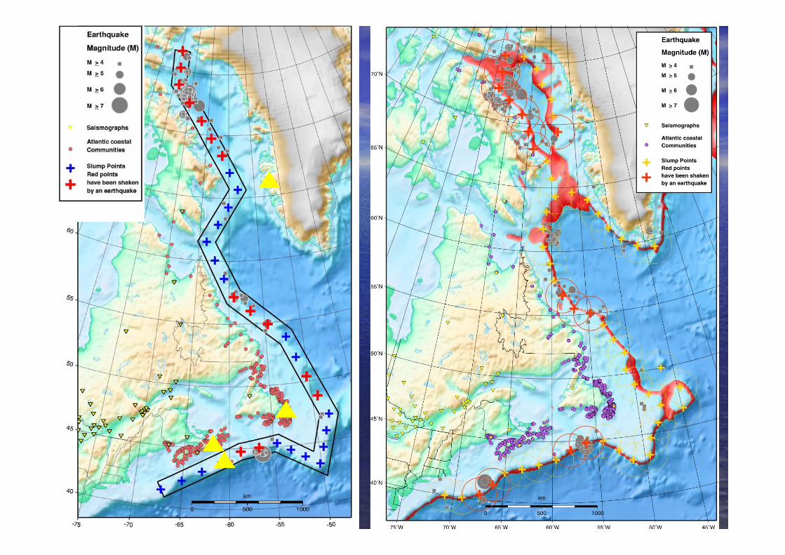
Canada East Coast (1929)Canada East Coast (1929)
tsunami signals
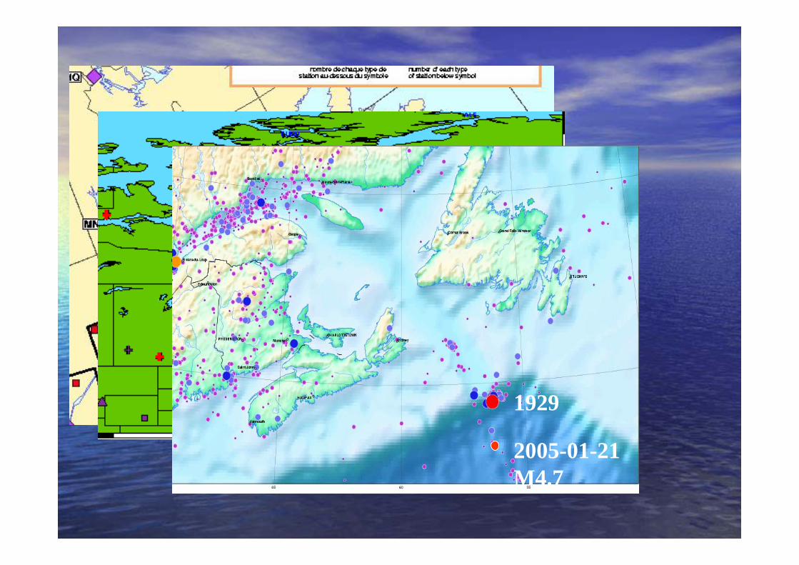
1929
2005-01-21 M4.7

TEST ATWS Earthquake and Possible Tsunami Notice
EARTHQUAKE REPORT
Date : 2005/02/03 Time/Heure : 00:00:44 UT
Epicenter : 45.07 -55.63 Region : Newfoundland and Labrador
Magnitude : 5.0 Richter Status : Q25 /OA
33 KM SW of SOMEWHERE
-----------------------------------------------------------------------
Action
PRECAUTIONARY TSUNAMI WATCH
until verification has been completed and appropriate confirmation
issued by proper authority
Possible extreme wave activity may be experienced
From/de To/à at Community
Between 00:42 and 03:01 (UT) at St. Shott's Nfld.
Between 00:43 and 02:44 (UT) at Point Lance Nfld.
Between 00:45 and 03:10 (UT) at St. Vincent's-St.Stephen's Nfld.
Between 00:46 and 02:56 (UT) at Branch Nfld
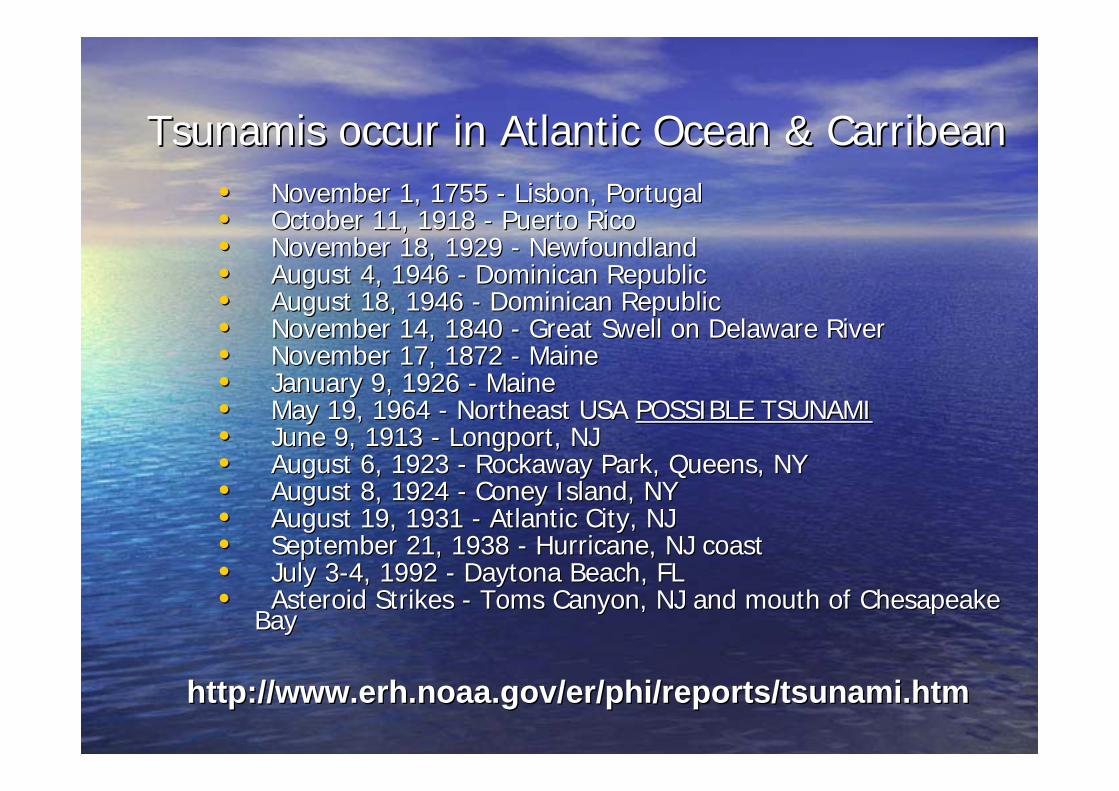
Tsunamis occur in Atlantic Ocean & Tsunamis occur in Atlantic Ocean & CarribeanCarribean•• November 1, 1755 November 1, 1755 -- Lisbon, Portugal Lisbon, Portugal •• October 11, 1918 October 11, 1918 -- Puerto Rico Puerto Rico •• November 18, 1929 November 18, 1929 -- Newfoundland Newfoundland •• August 4, 1946 August 4, 1946 -- Dominican Republic Dominican Republic •• August 18, 1946 August 18, 1946 -- Dominican Republic Dominican Republic •• November 14, 1840 November 14, 1840 -- Great Swell on Delaware River Great Swell on Delaware River •• November 17, 1872 November 17, 1872 -- Maine Maine •• January 9, 1926 January 9, 1926 -- Maine Maine •• May 19, 1964 May 19, 1964 -- Northeast USA Northeast USA POSSIBLE TSUNAMIPOSSIBLE TSUNAMI•• June 9, 1913 June 9, 1913 -- Longport, NJ Longport, NJ •• August 6, 1923 August 6, 1923 -- Rockaway Park, Queens, NY Rockaway Park, Queens, NY •• August 8, 1924 August 8, 1924 -- Coney Island, NYConey Island, NY•• August 19, 1931 August 19, 1931 -- Atlantic City, NJ Atlantic City, NJ •• September 21, 1938 September 21, 1938 -- Hurricane, NJ coastHurricane, NJ coast•• July 3July 3--4, 1992 4, 1992 -- Daytona Beach, FL Daytona Beach, FL •• Asteroid Strikes Asteroid Strikes -- Toms Canyon, NJ and mouth of Chesapeake Toms Canyon, NJ and mouth of Chesapeake
Bay Bay
http://http://www.erh.noaa.gov/er/phi/reports/tsunami.htmwww.erh.noaa.gov/er/phi/reports/tsunami.htm

-65˚ -60˚ -55˚ -50˚
45˚
50˚
55˚
k
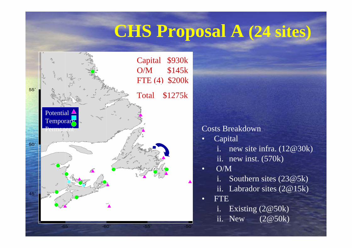
CHS Proposal C (14 sites)
PotentialTemporaryPermanent Costs Breakdown
• Capital i. new site infra. (2@30k)ii. new inst. (250k)
• O/M i. Southern sites (14@5k)ii. Labrador sites (1@20k)
• FTEi. Existing (2@50k)
Capital $310k O/M $90k FTE (3) $100k
Total $500k
-65˚ -60˚ -55˚ -50˚
45˚
50˚
55˚
k
CHS Proposal A (24 sites)
PotentialTemporaryPermanent
Capital $930k O/M $145k FTE (4) $200k
Total $1275k
Costs Breakdown• Capital
i. new site infra. (12@30k)ii. new inst. (570k)
• O/M i. Southern sites (23@5k)ii. Labrador sites (2@15k)
• FTEi. Existing (2@50k)ii. New (2@50k)

-65˚ -60˚ -55˚ -50˚
45˚
50˚
55˚
k
CHS Proposal B (19 sites)
PotentialTemporaryPermanent
Capital $630k O/M $115k FTE (3) $150k
Total $895k
Costs Breakdown• Capital
i. new site infra. (7@30k)ii. new inst. (420k)
• O/M i. Southern sites (17@5k)ii. Labrador sites (2@15k)
• FTEi. Existing (2@50k)ii. New (1@50k)

Deep Ocean Tsunami DetectionDeep Ocean Tsunami Detection
••Monitors rapid pressure changesMonitors rapid pressure changes••NOAA is increasing 5 to 35 in Pacific, NOAA is increasing 5 to 35 in Pacific, plus 6 new plus 6 new deployments in Atlanticdeployments in Atlantic

Indian Ocean TsunamiIndian Ocean TsunamiWave Propagation in HoursWave Propagation in Hours

Magnitude of Magnitude of
Earthquakes and EffectsEarthquakes and Effects

Pacific Tide Gauges (CHS)Pacific Tide Gauges (CHS)
Sumatra Event - Indian Ocean Sites
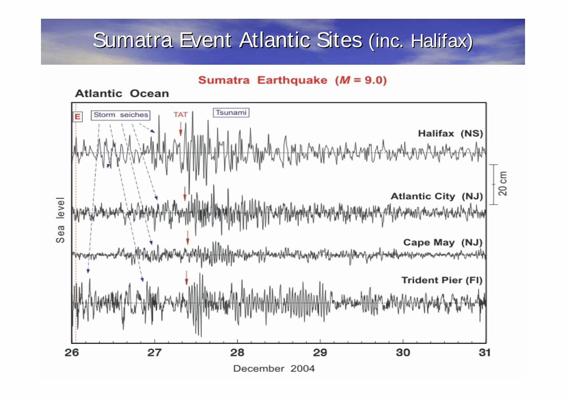
Sumatra Event Atlantic Sites Sumatra Event Atlantic Sites (inc. Halifax)(inc. Halifax)

Halifax
-1000
-500
0
500
1000
1500
2000
2500
00:0
0"
02:0
0"
04:0
0"
06:0
0"
08:0
0"
10:0
0"
12:0
0"
14:0
0"
16:0
0"
18:0
0"
20:0
0"
22:0
0"
00:0
0"
02:0
0"
04:0
0"
06:0
0"
08:0
0"
10:0
0"
12:0
0"
14:0
0"
16:0
0"
18:0
0"
20:0
0"
22:0
0"
00:0
0"
02:0
0"
04:0
0"
06:0
0"
08:0
0"
10:0
0"
12:0
0"
14:0
0"
16:0
0"
18:0
0"
20:0
0"
22:0
0"
00:0
0"
02:0
0"
04:0
0"
06:0
0"
Water LevelPredicted TideResidualPredicted Storm SurgeAdjusted Residual
26 Dec
Sumatra Event Sumatra Event -- HalifaxHalifax
tsunami signalstsunami signals

Wave trainsWave trains
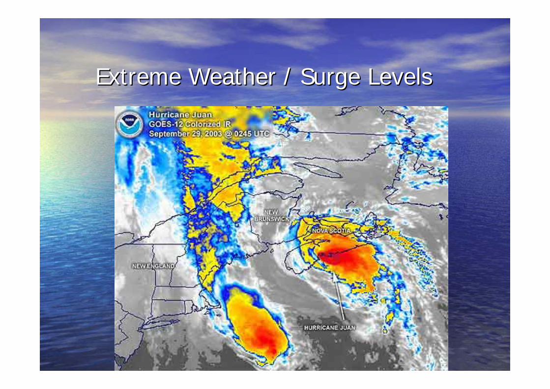
Extreme Weather / Surge LevelsExtreme Weather / Surge Levels

Latitude 40 to 47 NorthLongitude 63 to 71 WestWind Speed >=60 Knots
Tropical Weather System Database Query(1885-1996) All data are extracted from the
National Hurricane Centre’sofficial tropical storm track file.
Track segments are displayed on the map to the left. These were the storms that moved through the bounding box (blue) at some point in their life cycle and had maximum wind speeds of at least 60 knots at some point while inside of the box.

Surge Forecast Surge Forecast --Atlantic CanadaAtlantic Canada (24 Hr)(24 Hr)Jan 20, 2000Jan 20, 2000
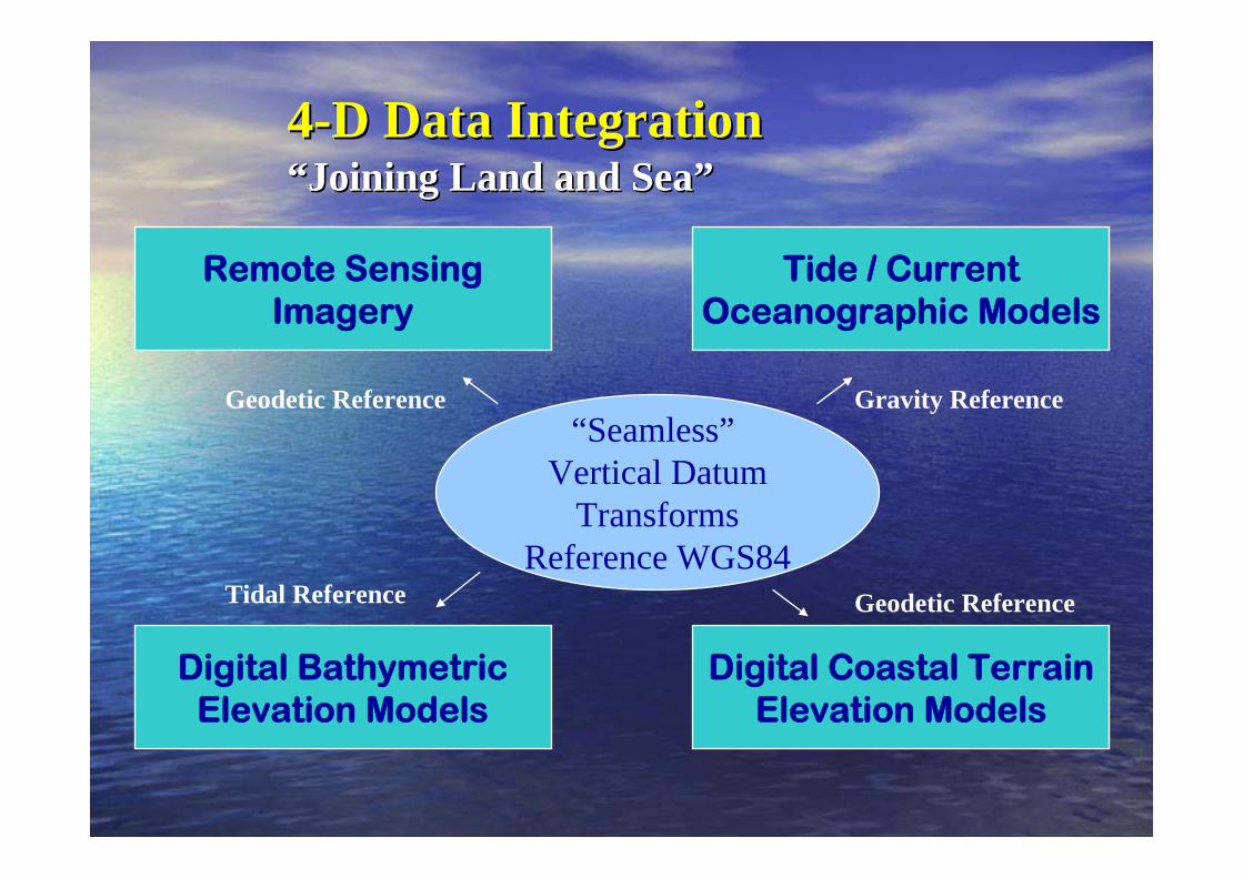
44--D Data IntegrationD Data Integration““Joining Land and SeaJoining Land and Sea””
Tide / CurrentOceanographic Models
Digital BathymetricElevation Models
Digital Coastal TerrainElevation Models
Remote SensingImagery
“Seamless”Vertical Datum
TransformsReference WGS84
Geodetic Reference Gravity Reference
Tidal Reference Geodetic Reference
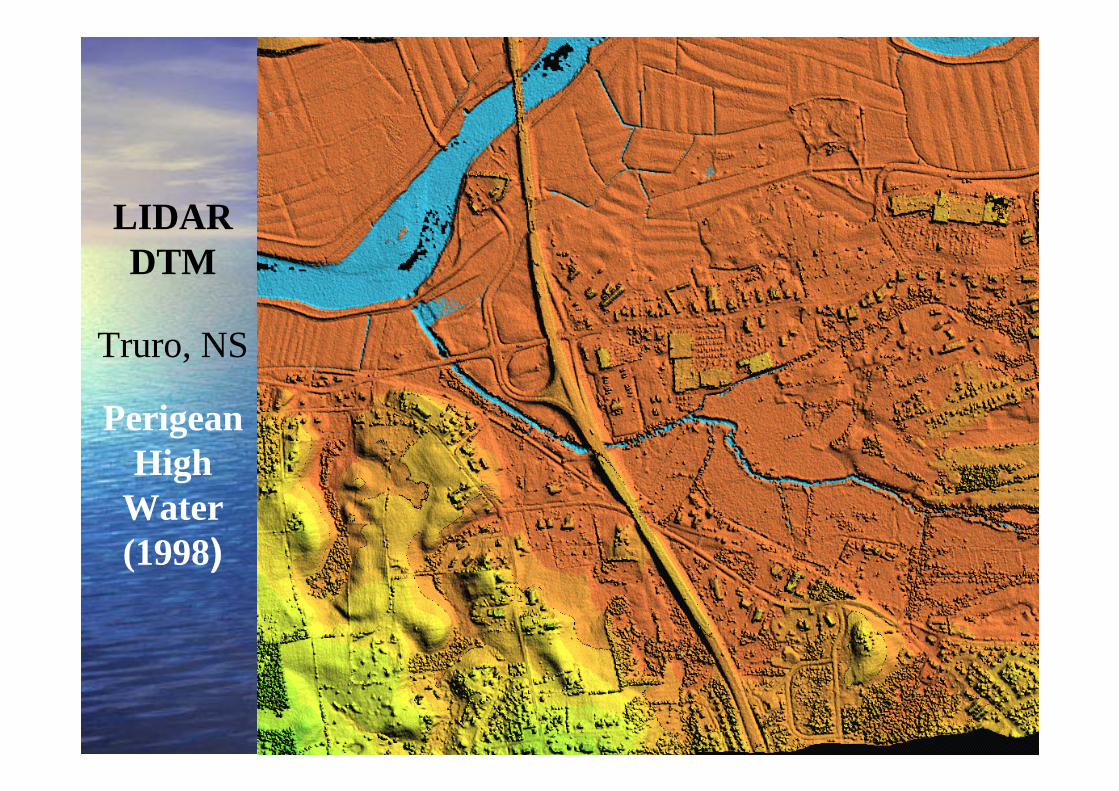
LIDAR DTM
Truro, NS
PerigeanHigh
Water (1998)
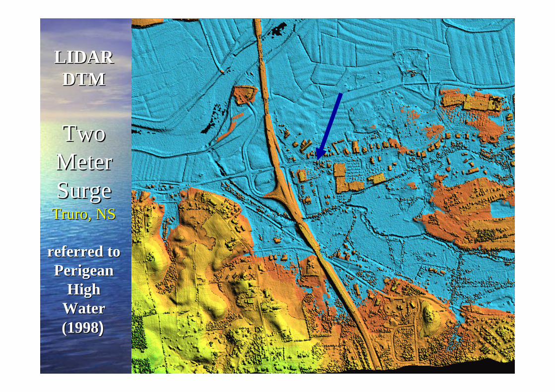
LIDAR LIDAR DTMDTM
Two Two Meter Meter SurgeSurge
Truro, NSTruro, NS
referred to referred to PerigeanPerigean
High High Water Water (1998(1998))

Saxby Flood LevelSaxby Flood LevelTruro (Truro (RobieRobie Street)Street)
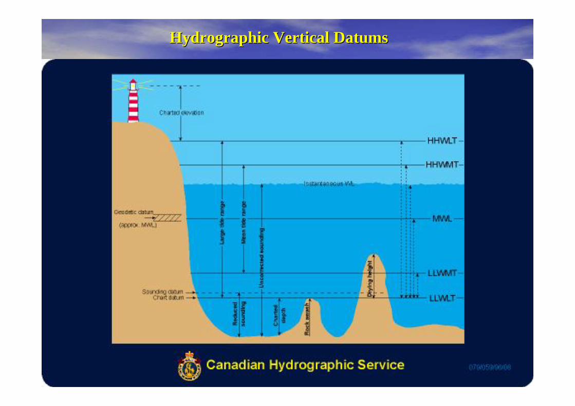
Hydrographic Vertical DatumsHydrographic Vertical Datums
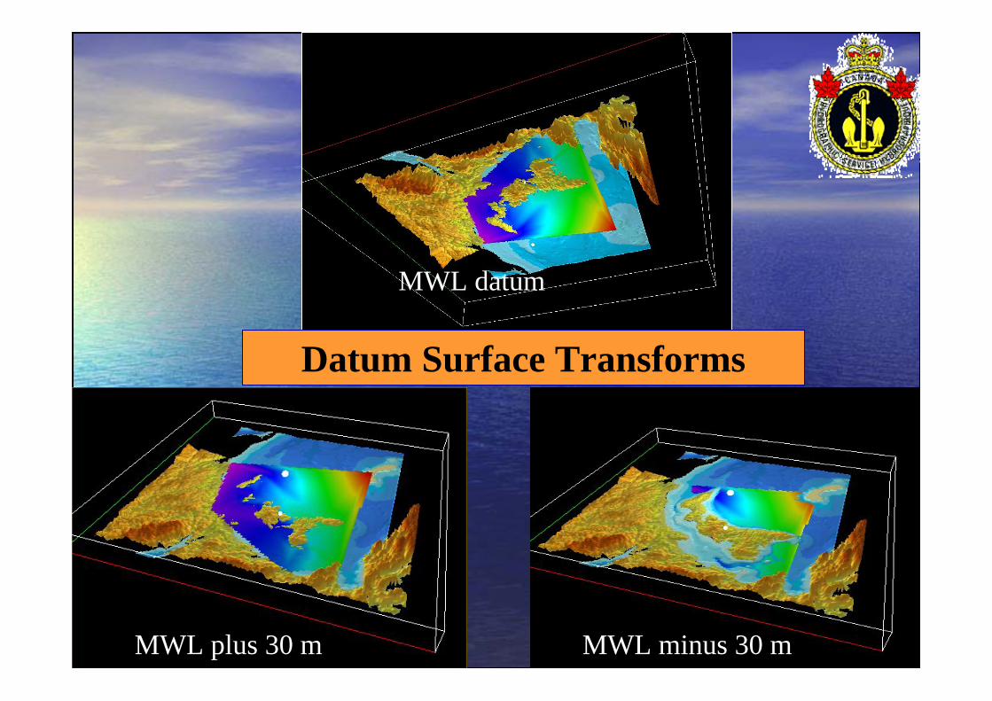
MWL minus 30 m
MWL datum
Datum Surface Transforms
MWL plus 30 m

Extracted 3D Shorelines Extracted 3D Shorelines (Take Your Pick!)(Take Your Pick!)

Defences and MitigationDefences and Mitigation
•• Warning systems Warning systems (several hours possible)(several hours possible)–– seismometers and special tide gaugesseismometers and special tide gauges–– Presently in Pacific Ocean (since 1946) Presently in Pacific Ocean (since 1946) –– Western Canada (CHS has 3 gauges)Western Canada (CHS has 3 gauges)–– Expand to Indian Ocean and Atlantic (Global system ?)Expand to Indian Ocean and Atlantic (Global system ?)–– Media and Air Raid SirensMedia and Air Raid Sirens
•• Public Education Public Education •• Evacuation plans and building codesEvacuation plans and building codes•• Restricted Coastal Zone DevelopmentRestricted Coastal Zone Development•• Coastal Flood MappingCoastal Flood Mapping -- Digital Terrain ModelsDigital Terrain Models

NOAANOAAWhat is TsunamiReady?What is TsunamiReady?
•• ““Grass rootsGrass roots”” program that promotes tsunami program that promotes tsunami hazard readiness.hazard readiness.
•• Collaborative effort between federal, state, and local Collaborative effort between federal, state, and local emergency management, and the public.emergency management, and the public.
•• Improves public safety during tsunami emergencies.Improves public safety during tsunami emergencies.•• Prepares communities for tsunami hazard.Prepares communities for tsunami hazard.•• Part of the NWS Part of the NWS StormReadyStormReady Program.Program.
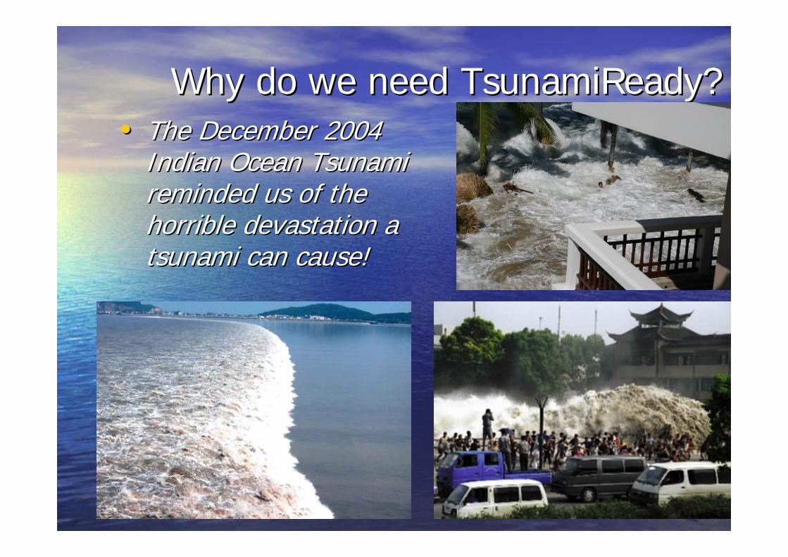
Why do we need Why do we need TsunamiReadyTsunamiReady??•• The December 2004 The December 2004
Indian Ocean Tsunami Indian Ocean Tsunami reminded us of the reminded us of the horrible devastation a horrible devastation a tsunami can cause!tsunami can cause!

TsunamiReady ObjectivesTsunamiReady Objectives
–– Create Create minimum standard community minimum standard community guidelinesguidelines for adequate tsunami readiness. for adequate tsunami readiness.
–– Increase Increase public awarenesspublic awareness and and understanding of tsunami hazard. understanding of tsunami hazard.
–– Improve Improve community precommunity pre--planningplanning for for tsunami disasterstsunami disasters ..
–– Encourage Encourage consistency in educationalconsistency in educationalmaterials and response. materials and response.
–– Recognize Recognize communities that have adoptedcommunities that have adoptedTsunamiReady guidelines. TsunamiReady guidelines.

How does a CommunityHow does a Communitybecome TsunamiReady? become TsunamiReady? (contd)(contd)
•• Increase Community PreparednessIncrease Community Preparedness–– NWS staff provide Tsunami safety presentationsNWS staff provide Tsunami safety presentations–– Designate/establish tsunami area in safe zoneDesignate/establish tsunami area in safe zone–– Designate tsunami evacuation areas and Designate tsunami evacuation areas and
evacuation routes, and install evacuation route evacuation routes, and install evacuation route signssigns
–– Provide written, locality specific, tsunami hazard Provide written, locality specific, tsunami hazard response material to publicresponse material to public
–– Schools: encourage tsunami hazard curriculum, Schools: encourage tsunami hazard curriculum, practice evacuations, and provide safety practice evacuations, and provide safety material to staff and studentsmaterial to staff and students
TsunamiReady RecognitionTsunamiReady RecognitionProcessProcess
•• Community applies to local NOAA NWS Office.Community applies to local NOAA NWS Office.•• Local TsunamiReady Advisory Board reviews Local TsunamiReady Advisory Board reviews
application.application.•• Local Local TsunamiReadyTsunamiReady Advisory Board performs onAdvisory Board performs on--
site verification visit.site verification visit.•• If guidelines are not met, Local If guidelines are not met, Local TsunamiReadyTsunamiReady
Advisory Board suggests improvements and works Advisory Board suggests improvements and works to implement changes.to implement changes.
•• Once guidelines are met, a recognition Ceremony Once guidelines are met, a recognition Ceremony and Press Conference is held for community.and Press Conference is held for community.
•• Similar to ISO9000 processSimilar to ISO9000 process

Successful Applicants Receive:Successful Applicants Receive:•• TsunamiReady recognition TsunamiReady recognition -- valid for 3 years.valid for 3 years.•• Two official TsunamiReady signs.Two official TsunamiReady signs.•• Authorization to use the TsunamiReady logo.Authorization to use the TsunamiReady logo.•• Instructions for acquiring additional signs.Instructions for acquiring additional signs.•• Information on how to notify the ISO for Information on how to notify the ISO for
possible flood insurance rate adjustment (for possible flood insurance rate adjustment (for StormReady).StormReady).
•• Listing on Listing on StormReadyStormReady, Pacific Tsunami Warning , Pacific Tsunami Warning Center, and West Coast Alaska Tsunami Center, and West Coast Alaska Tsunami Warning Center web sites.Warning Center web sites.
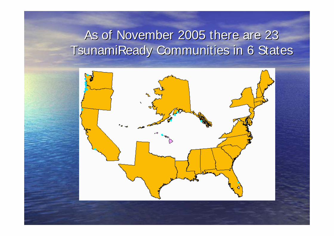
As of November 2005 there are 23 As of November 2005 there are 23 TsunamiReadyTsunamiReady Communities in 6 StatesCommunities in 6 States

Tsunami AnimationsTsunami Animations
•• 1929 1929 NfldNfld EventEvent•• Canary Islands EventCanary Islands Event•• Asteroid EventAsteroid Event

Thank YouThank You
Questions ?Questions ?
“Tsu” = “Harbour”
“Nami” = “Wave”

Surge / Tsunami WebsiteSurge / Tsunami Website
•• http://bluefin.mar.dfohttp://bluefin.mar.dfo--mpo.gc.ca/rtwl/indexmpo.gc.ca/rtwl/index--e.jspe.jsp