Embed Size (px)
Citation preview

Everglades Protection Area Tributary Basins Long-Term Plan for
Achieving Water Quality Goals
Revised Part 3 of the Long-Term Plan Post-2006 Strategies, Non-ECP Basins 3-i October 17, 2006
Attachment A – Revised Part 3 of Long-Term Plan
Table of Contents
3. POST-2006 STRATEGIES, NON-ECP BASINS........................................................................... 3-1
3.1. ACME IMPROVEMENT DISTRICT, BASIN B .................................................................................. 3-4
3.2. NORTH SPRINGS IMPROVEMENT DISTRICT (NSID) [BD08]......................................................... 3-4 3.2.1. Recommended Strategies in 2003 Long-Term Plan............................................................... 3-6
3.2.2. Additional Analysis and Findings Following 2003 Long-Term Plan .................................... 3-7
3.2.3. Recommended Improvements and Strategies......................................................................... 3-8
3.2.4. Additional Estimated Cost and Projected Expenditures [Bd08] ........................................... 3-9
3.3. NORTH NEW RIVER CANAL BASIN (NNRC) [BD08] ................................................................ 3-10 3.3.1. Recommended Strategies in 2003 Long-Term Plan............................................................. 3-11
3.3.2. Additional Analysis and Findings Following 2003 Long-Term Plan .................................. 3-12
3.3.3. Recommended Improvements and Strategies....................................................................... 3-13
3.3.4. Additional Estimated Cost and Projected Expenditures [Bd08] ......................................... 3-14
3.4. C-11 WEST BASIN [BD08] ........................................................................................................ 3-14 3.4.1. Recommended Strategies in 2003 Long-Term Plan and revisions ...................................... 3-16
3.4.2. Additional Analysis and Findings Following 2003 Long-Term Plan .................................. 3-17
3.4.3. Recommended Improvements and Strategies....................................................................... 3-18
3.4.4. Additional Estimated Cost and Projected Expenditures [Bd08] ......................................... 3-19
3.5. L-28 BASIN............................................................................................................................... 3-19 3.5.1. Alternatives Considered in Basin-Specific Feasibility Studies ............................................ 3-23
3.5.2. Recommended Strategy in 2003 Long-Term Plan ............................................................... 3-24
3.5.3. Additional Analysis and Findings Following 2003 Long-Term Plan .................................. 3-26
3.5.4. Review and Disaggregation of Baseline Data ..................................................................... 3-27
3.5.5. Initial Conceptual Design, Miccosukee Tribal STA............................................................. 3-30
3.5.6. Initial Conceptual Design, Seminole Tribal STA................................................................. 3-32
3.5.7. Revised Implementation Schedule ....................................................................................... 3-36
3.5.8. Projected Expenditures........................................................................................................ 3-38
3.6. FEEDER CANAL BASIN [BD09] ................................................................................................. 3-39 3.6.1. Alternatives Considered in Basin-Specific Feasibility Studies ............................................ 3-43
3.6.2. Recommended Strategy in 2003 Long-Term Plan ............................................................... 3-44
3.6.3. Additional Analysis and Findings Following 2003 Long-Term Plan .................................. 3-46
3.6.4. Recommended Improvements and Strategies ...................................................................... 3-48
3.6.5. Projected Expenditures [Bd09] ........................................................................................... 3-49
3.7. SUMMARY OPINION OF COST AND EXPENDITURES ................................................................... 3-49

Everglades Protection Area Tributary Basins Long-Term Plan for
Achieving Water Quality Goals
Revised Part 3 of the Long-Term Plan Post-2006 Strategies, Non-ECP Basins 3-ii October 17, 2006
List of Tables
TABLE 3.1 NON-ECP BASINS INCLUDED IN LONG-TERM PLAN................................................... 3-1
TABLE 3.5 OPINION OF PROBABLE CAPITAL COST, MICCOSUKEE TRIBAL STA .................. 3-31
TABLE 3.6 OPINION OF AVG. ANNUAL O&M COST, MICCOSUKEE TRIBAL STA ................... 3-32
TABLE 3.7 PRELIMINARY TREATMENT ESTIMATES, SEMINOLE TRIBAL STA ...................... 3-34
TABLE 3.8 OPINION OF PROBABLE CAPITAL COST, SEMINOLE TRIBAL STA ........................ 3-35
TABLE 3.9 OPINION OF AVG. ANNUAL O&M COST, SEMINOLE TRIBAL STA......................... 3-36
TABLE 3.10 PROJECTED EXPENDITURES, MICCOSUKEE TRIBAL STA IN L-28 BASIN .......... 3-38
TABLE 3.11 PROJECTED EXPENDITURES, SEMINOLE TRIBAL STA IN L-28 BASIN................ 3-39
TABLE 3.12 PROJECTED LONG-TERM PLAN EXPENDITURES FY2007-2010, NON-ECP BASINS (FY 2006 $) ............................................................................................................................................... 3-49
List of Figures
FIGURE 3.1 NON-ECP BASIN LOCATIONS.......................................................................................... 3-2
FIGURE 3.4 NORTH SPRINGS IMPROVEMENT DISTRICT BASIN MAP ......................................... 3-5
FIGURE 3.5 NORTH NEW RIVER CANAL BASIN MAP.................................................................... 3-10
FIGURE 3.6 C-11 WEST BASIN MAP ................................................................................................... 3-15
FIGURE 3.7 L-28 BASIN MAP ............................................................................................................... 3-21
FIGURE 3.8 FEEDER CANAL BASIN MAP ......................................................................................... 3-40

Everglades Protection Area Tributary Basins Long-Term Plan for
Achieving Water Quality Goals
3. POST-2006 STRATEGIES, NON-ECP BASINS
This revised Part 3 defines strategies and approaches for water quality improvement in discharges
from the Everglades Stormwater Program (ESP) Basins recommended for completion after
December 31, 2006. The ESP basins are those basins discharging to the Everglades Protection
Area (EPA) but are not part of the Everglades Construction Project (ECP). They are also known
as the Non-ECP Basins. It should be anticipated that further refinements to the Non-ECP Basins
Projects and activities recommended herein may be made as more scientific and engineering
information is obtained.
There remains uncertainty concerning the efficacy of some and recommended improvements and
strategies and CERP adaptations. It is for those reasons that the Process Development and
Engineering (PDE) component of the Long-Term Plan continues in the Post-2006 timeframe. If,
as a result of future performance data and forecasts, it is found necessary to take additional
actions to provide adequate assurance of an ability to meet the planning objectives, those actions
will be based on the findings and conclusions of the PDE effort. Additional post-2006 steps
would include identification and adaptive implementation of additional water quality
improvement measures that may then be considered necessary to meet the planning objective.
The Non-ECP Basins include a total of eight basins; six of those basins are addressed in this Part
3 and are listed in Table 3.1; the overall boundaries of those basins are shown in Figure 3.1.
Table 3.1 Non-ECP Basins Included in Long-Term Plan
Hydrologic Basin Acme Improvement District, Basin B North Springs Improvement District
North New River Canal C-11 West
L-28 Feeder Canal
Revised Part 3 of the Long-Term Plan Post-2006 Strategies, ESP Basins 3-1 October 17, 2006

Everglades Protection Area Tributary Basins Long-Term Plan for
Achieving Water Quality Goals
Revised Part 3 of the Long-Term Plan Post-2006 Strategies, ESP Basins 3-2 October 17, 2006
Figure 3.1 Non-ECP Basin Locations
The two remaining Non-ECP Basins, the C-111 Basin and the Boynton Farms Basin, are being
addressed by other District and Federal programs.
The primary source of the information and data contained in this revised Part 3 is the October 23,
2002, Basin Specific Feasibility Studies, Everglades Stormwater Program Basins prepared for the
South Florida Water Management District by Brown & Caldwell as well as other subsequent
analyses completed by the District or its consultants after the development of the October 27,

Everglades Protection Area Tributary Basins Long-Term Plan for
Achieving Water Quality Goals
Revised Part 3 of the Long-Term Plan Post-2006 Strategies, ESP Basins 3-3 October 17, 2006
2003 Long-Term Plan. In certain instances, the recommendations presented herein include certain
modifications to and additional steps beyond the alternatives discussed or contemplated in the
2002 reference and the October 23, 2003 Long-Term Plan. All such modifications and additional
steps are specifically identified and discussed herein.
Each of the Non-ECP Basins is scheduled to receive one or more projects under the
Comprehensive Everglades Restoration Plan (CERP). In general, the recommended strategy in
the Non-ECP basins is to rely upon source controls and full integration with CERP to achieve
water quality standards and the improvement goals of the Everglades Forever Act, to the extent
that this is consistent with state and federal authorization, and will require close coordination with
the PDT process.
Additional guidance for implementation of the recommended strategy was provided by the
Florida Legislature in its 2003 amendment of the Everglades Forever Act (373.4592 F.S.), which
states:
(c) It is the intent of the Legislature that implementation of the Long-Term Plan shall be integrated and consistent with the implementation of the projects and activities in the Congressionally authorized components of the CERP so that unnecessary and duplicative costs will be avoided. Nothing in this section shall modify any existing cost share or responsibility provided for projects listed in s. 528 of the Water Resources Development Act of 1996 (110 Stat. 3769) or provided for projects listed in section 601 of the Water Resources Development Act of 2000 (114 Stat. 2572). The Legislature does not intend for the provisions of this section to diminish commitments made by the State of Florida to restore and maintain water quality in the Everglades Protection Area, including the federal lands in the settlement agreement referenced in paragraph (4)(e).
It is intended that the stormwater treatment areas and other works recommended herein be
operated to maximize the amount of water treated; e.g., no bypass of the treatment areas should
be permitted except under extreme circumstances in which the hydraulic capacity of the works is
exceeded. It is further intended that the operation of the treatment works not negatively impact
flood protection. Ancillary uses of the treatment areas for purposes other than water quality
improvement should be limited to those that do not negatively impact treatment performance.

Everglades Protection Area Tributary Basins Long-Term Plan for
Achieving Water Quality Goals
Revised Part 3 of the Long-Term Plan Post-2006 Strategies, ESP Basins 3-4 October 17, 2006
3.1. Acme Improvement District, Basin B
Revisions to this section of the October 27, 2003 version of the Long-Term Plan were
developed in a separate document dated March 15, 2006. The revised Section 3.1 is posted
at: http://www.sfwmd.gov/org/erd/longtermplan/documents.shtml.
3.2. North Springs Improvement District (NSID) [Bd08]
The NSID Basin covers an area of approximately 7,400 acres (11 square miles) in northern
Broward County. The basin is bounded on the north by the Palm Beach County line and on the
west by the L-36 Borrow Canal and Water Conservation Area (WCA) 2A. The Sawgrass
Expressway (Florida Highway 869) runs in an east-west direction through the basin, turning south
along the basin’s western border as it approaches WCA-2A. The City of Coral Springs comprises
much of the southern half of the basin. The City of Parkland comprises much of the northern half
of the basin. A map illustrating the boundaries of the NSID Basin is presented in Figure 3.4.
Land use in the NSID Basin consists primarily of urban residential development. Most of the
land in the southern half of the basin is heavily developed with residential subdivisions. The
northern portion of the basin is currently in the process of being converted from agricultural to
urban land use as new residential development continues. It is expected that over the next 5 to 10
years, most of the remaining undeveloped agricultural land in the basin will be developed into
urban residential land use.
Drainage from the NSID Basin is managed in a network of interconnected lakes and canals that
are operated by the NSID to provide flood protection throughout the basin. Two pumping
stations, NSID Pump Station No. 1 and NSID Pump Station No. 2, are used to discharge
stormwater north through the L-36 Borrow Canal (L-36N) and then into the Hillsboro Canal
through a series of culverts (S-39A). The Hillsboro Canal conveys stormwater to the east,
eventually discharging excess flow to tide. However, when the L-36N Canal and the Hillsboro
Canal are not capable of accepting additional flow, water from the NSID Basin is discharged into
WCA-2A through NSID Pump Station No. 1.

Everglades Protection Area Tributary Basins Long-Term Plan for
Achieving Water Quality Goals
Figure 3.4 North Springs Improvement District Basin Map
Palm Beach County
Broward County
A large water impoundment is being planned on the north side of the Hillsboro Canal, just north
of the NSID Basin, as part of Component M, Part 1, of the Comprehensive Everglades
Restoration Plan (CERP). The Hillsboro Site 1 Impoundment CERP Project, currently scheduled
for completion under the Acceler8 Program in December 2009, will supplement water deliveries
to the Hillsboro Canal during dry periods, thereby reducing demands on Lake Okeechobee and
the Loxahatchee National Wildlife Refuge. Water from the Hillsboro Canal will be pumped into
the reservoir during the wet season or periods when excess water is available and be released
back to the Hillsboro Canal to help maintain canal stages during the dry-season. The 2003 Long-
Term Plan assumed this project was to be completed by December 2007. The relationship of the
North Springs Improvement District to the Hillsboro Site 1 Impoundment CERP Project is
defined in the following excerpt from that document:
Revised Part 3 of the Long-Term Plan Post-2006 Strategies, ESP Basins 3-5 October 17, 2006

Everglades Protection Area Tributary Basins Long-Term Plan for
Achieving Water Quality Goals
Revised Part 3 of the Long-Term Plan Post-2006 Strategies, ESP Basins 3-6 October 17, 2006
“This separable element includes canal and structure relocations, canal conveyance improvements, water control structures and an aboveground impoundment with a total storage capacity of approximately 13,500 acre-feet located in the Hillsboro Canal Basin in southern Palm Beach County. The design of the impoundment included one compartment totaling 1,600 acres with water levels fluctuating up to eight feet above grade. The S-39A structure will be replaced and redesignated as S-527B. North Springs Improvement District flows were redirected from Water Conservation Area (WCA) 3 into the Hillsboro Canal and then to the impoundment. The conveyance capacity of the Hillsboro Canal will be increased from the impoundment inflow structure east to the Lake Worth Drainage District E-1 canal to allow backpumping of additional flows from the western Hillsboro Canal basin.”
More detailed planning and design of the Hillsboro Site 1 Impoundment CERP Project is
included in the overall scope of the October, 2001 Central and Southern Florida Project, Water
Preserve Areas, Draft Integrated Feasibility Report, Supplemental Environmental Impact
Statement.
3.2.1. Recommended Strategies in 2003 Long-Term Plan
A total of three alternatives for the NSID were evaluated in the October 23, 2002, Basin Specific
Feasibility Studies, Everglades Stormwater Program Basins. Alternative No. 3, with certain
adjustments, was recommended for implementation. Component elements of Alternative No. 3
included:
Implementation of source controls;
Assist Broward County in coordinating a county-wide working group to develop a
comprehensive pollution prevention plan with specific water quality goals and
milestones;
Diversion of current NSID releases made to WCA-2A from WCA-2A to the
Hillsboro Site 1 Impoundment CERP Project by December 2007;
Conduct of an hydraulic evaluation of storm events in the basin to determine if there
would be any negative impacts from redirecting water currently discharged to WCA-
2A to the Hillsboro Canal east of S-39 (Evaluation would include an assessment of

Everglades Protection Area Tributary Basins Long-Term Plan for
Achieving Water Quality Goals
Revised Part 3 of the Long-Term Plan Post-2006 Strategies, ESP Basins 3-7 October 17, 2006
the potential for connecting adjacent sand mines to the NSID water management
system for additional surface water storage).
Projected expenditures under the 2003 Long-Term Plan for the NSID Basin (Long-Term Plan
Project referred to as “Bc71”) were limited to those necessary for conducting a hydraulic
evaluation.
3.2.2. Additional Analysis and Findings Following 2003 Long-Term Plan
As recommended by the 2003 Long-Term Plan, the District hired a consultant to perform a
hydraulic evaluation of storm events in the basin to determine if there would be any negative
impacts from redirecting water currently discharged to WCA-2A to the Hillsboro Canal east of S-
39. This evaluation was completed in July 2004. In formulating the assumptions for the
evaluation, it was determined through coordination with the CERP PDT that the Hillsboro Site 1
Impoundment CERP Project’s design does not include impoundment storage capacity reserved
for storm event flows from NSID, and therefore cannot be depended on for flood protection
purposes. The hydraulic/hydrologic evaluation, based on a single event analysis, therefore
excluded flow into the impoundment and predicted the water elevations in the Hillsboro Canal
would increase under these circumstances during large storm events.
The District performed further analysis through a second consultant contract to evaluate potential
mitigation measures and to estimate the 50-year present value cost associated with such
alternatives. This evaluation, completed in October 2005, conceptually estimated costs in 2006
dollars for improvements for conveyance to the canals and the G-56 tidal structure at almost $17
million. Alternatively, costs for an impoundment site were estimated to be between $57 million
and $133 million depending largely on land acquisition costs.
The expenditure for these mitigation measures is considered to be infeasible and impractical
considering the relatively small TP load estimated to be diverted from the EPA. During a large
storm event, the existing NSID system may be required to discharge to the EPA to avoid flooding
impacts in the Hillsboro Canal basin. The District has therefore evaluated the potential TP loads

Everglades Protection Area Tributary Basins Long-Term Plan for
Achieving Water Quality Goals
Revised Part 3 of the Long-Term Plan Post-2006 Strategies, ESP Basins 3-8 October 17, 2006
that could be expected to enter the EPA during large storm events. Based on recent TP
concentration data, specifically Water Year (WY) 2001-WY2005, during flow events and flow
data from a recent South Florida Water Management Model (SFWMM) simulation, the average
annual TP load to the EPA from NSID is estimated at 7 kg. This load is significantly less than
the estimation from the 2002 Basin Specific Feasibility Studies (BSFS), which calculated annual
loads of 293 kg based on a TP concentration of 39 ppb. The previous estimates used for 2003
Long-Term Plan recommendations are no longer valid due to improved water quality and revised
operational criteria for NSID, which includes coordination with SFWMD operations staff to
monitor stages downstream in the Hillsboro Canal. It should be noted that since discharge would
be based on extreme storm conditions that are not anticipated every year, individual annual
stormwater discharge volumes are expected to range from 0 to approximately 3,800 acre-ft with
an average of 305 acre-ft.
Despite the inability to depend entirely on the Hillsboro Site 1 Impoundment CERP Project for
protection during large storm events, completion of the project should further reduce discharges
from NSID to the EPA. Operation of the impoundment’s intake pumps during large storm
events, when the impoundment has storage capability, will effectively increase the capacity of the
Hillsboro Canal for NSID discharges.
The 2003 Long-Term Plan assumed the Hillsboro Site 1 Impoundment CERP Project was to be
completed by December 2007, but the Acceler8 schedule for project completion is currently
December 2009.
3.2.3. Recommended Improvements and Strategies
The following improvements and strategies that incorporate additional analysis and findings
consistent with the 2003 Long-Term Plan are recommended:
Reinforce the implementation requirements of source control programs through
existing regulatory programs such as the Environmental Resource Permit (ERP)
process;

Everglades Protection Area Tributary Basins Long-Term Plan for
Achieving Water Quality Goals
Revised Part 3 of the Long-Term Plan Post-2006 Strategies, ESP Basins 3-9 October 17, 2006
Continue to assist Broward County in coordinating a county-wide working group to
develop a comprehensive pollution prevention plan for the NSID Basin with specific
water quality goals and milestones;
Provide additional funding (Fiscal Year 2007 through Fiscal Year 2010) for the
continued implementation of source controls;
Rely on the diversion of current NSID releases made to WCA-2A from WCA-2A to
the Hillsboro Canal and Hillsboro Site 1 Impoundment CERP Project to be
completed by December 2009, except as necessary to maintain regional flood
protection.
More details and updates of the District’s involvement in source control programs for this basin
can be found in the 2006 SFER and subsequent annual reports.
3.2.4. Additional Estimated Cost and Projected Expenditures [Bd08]
Extending the source control program beyond Fiscal Year (FY) 2006 for the NSID Basin is
recommended utilizing a comprehensive program for all Broward County basins tributary to the
EPA (Broward County Source Controls Project – Project code “Bd08”). A projected source
control program expenditure total of $534,000 (in FY 2006 dollars) is recommended for NSID,
North New River Canal (NNRC), and C-11 West Basins for the period including FY 2007
through FY 2010. The projected expenditure is summarized in Table 3.14.
The conveyance of NSID flows to the Hillsboro Site 1 Impoundment CERP Project is part of the
Water Preserve Areas CERP component. Accordingly, it is assumed that all such conveyance
improvements, including any required modifications or expansions to the existing NSID pumping
stations, improvements to the L-36N and Hillsboro Canals, and improvements to existing water
control structures will be made by CERP. Under this assumption, there would be no additional
project elements necessary to implement the NSID portion of the Water Preserve Areas CERP
component.

Everglades Protection Area Tributary Basins Long-Term Plan for
Achieving Water Quality Goals
3.3. North New River Canal Basin (NNRC) [Bd08]
The NNRC Basin covers an area of about 19,000 acres (30 square miles) in eastern Broward
County. The basin is located southeast of Water Conservation Area (WCA) 2B, west of the
Florida Turnpike and north of Interstate 595, in Broward County. The NNRC Basin is located
immediately to the north of the C-11 West Basin, separated from that basin by the North New
River Canal which runs generally east-west along the southern boundary of the NNRC Basin.
Revised Part 3 of the Long-Term Plan Post-2006 Strategies, ESP Basins 3-10 October 17, 2006
Figure 3.5 North New River Canal Basin Map
Land use in the NNRC Basin is almost entirely urban residential and commercial development.
Portions of the Cities of Sunrise and Plantation comprise the area of the basin north of the North
New River Canal. Bonaventure, a densely developed commercial and residential area, makes up

Everglades Protection Area Tributary Basins Long-Term Plan for
Achieving Water Quality Goals
Revised Part 3 of the Long-Term Plan Post-2006 Strategies, ESP Basins 3-11 October 17, 2006
the small area located south of the North New River Canal. Small amounts of agricultural and
undeveloped land still exist, but land values in the basin continue to rise as development
continues. A map of the NNRC Basin is presented in Figure 3.5.
The G-123 structure, located at SR 27 and I-595, discharges water from this basin to WCA-3A.
This structure is mainly used for water supply to WCA-3A and is not intended to be used for
flood control. However, during large storm events, when storage is available in the water
conservation areas, G-123 may be operated to provide some relief. This basin is primarily served
by the G-54 structure located just west of the turnpike, which discharges to tide.
A Comprehensive Everglades Restoration Plan (CERP) Project will impact future management of
surface water flows from the NNRC Basin. Component YY4 of the C&SF Restudy (Central and
Southern Florida Project, Comprehensive Review Study, Final Integrated Feasibility Report and
Programmatic Environmental Impact Statement, April 1999), referred to herein as WCA-2 and
WCA-3 Diversion CERP Project, includes the construction of a new basin divide structure across
the North New River Canal at Markham Park. This CERP project is currently scheduled for
CERP Band 4 (2020-2025) and will include canals to reroute urban runoff from the Bonaventure
pump stations to the North New River Canal downstream (east) of the new divide structure. The
2003 Long-Term Plan assumed this CERP project was to be completed by 2018. The new divide
structure will effectively eliminate urban runoff from the NNRC Basin from discharging to the
EPA. Seepage from WCA 2B that is collected in the L-35 Borrow Canal will be redirected into
new canals which will convey it south to the Everglades National Park. After the CERP project is
completed, it is anticipated that all flows to WCA 3A through the G-123 pump station will be
eliminated.
3.3.1. Recommended Strategies in 2003 Long-Term Plan
A total of three alternatives for the NNRC Basin were evaluated in the October 23, 2002, Basin
Specific Feasibility Studies, Everglades Stormwater Program Basins. Alternative No. 3, with
certain adjustments, was recommended for implementation. Component elements of Alternative
No. 3 included:
Implementation of source controls;

Everglades Protection Area Tributary Basins Long-Term Plan for
Achieving Water Quality Goals
Revised Part 3 of the Long-Term Plan Post-2006 Strategies, ESP Basins 3-12 October 17, 2006
Assist Broward County in coordinating a county-wide working group to develop a
comprehensive pollution prevention plan with specific water quality goals and
milestones;
Discontinue the use of G-123 after December 31, 2006, other than as may be
absolutely necessary for water supply emergencies (it was assumed the WCA-2 and
WCA-3 Diversion CERP Project was to be completed by 2018);
Prior to discontinuing the use of the G-123 pump station, perform a detailed flood
impact analysis to ensure that the basin's current level of flood protection is
maintained (Basin stakeholders had expressed concerns that discontinuing the use of
the G-123 pump station may reduce flood protection in the basin).
Projected expenditures under the 2003 Long-Term Plan for the NNRC Basin (Long-Term Plan
Project referred to as “Bc72”) were limited to those necessary for conducting a detailed flood
impact analysis.
3.3.2. Additional Analysis and Findings Following 2003 Long-Term Plan
As recommended by the 2003 Long-Term Plan, the District hired a consultant to perform a
detailed flood impact analysis to ensure that the basin's current level of flood protection is
maintained. The analysis, completed in September 2005, determined that the G-123 pump station
has historically provided flood relief under emergency conditions, as permitted by downstream
stages. Furthermore, discontinuing the use of G-123 for flood protection would adversely affect
flood stages and in severe storm events and increase the likelihood of property damage within the
basin.
As part of the flood impact analysis, a preliminary cost of $47,000,000 was estimated for
conveyance improvements to the NNRC and C-42 canals resulting in an alternative that is close
to fully mitigating the flood impact resulting from the non-use of G-123 in the future. As an
alternative to such a costly interim improvement, the analysis recommended a combination of
thorough canal maintenance with investigation of potential obstructions and restriction of the
flow together with revised operating protocols to reduce overall volumes discharged through

Everglades Protection Area Tributary Basins Long-Term Plan for
Achieving Water Quality Goals
Revised Part 3 of the Long-Term Plan Post-2006 Strategies, ESP Basins 3-13 October 17, 2006
G-123 to the EPA. A reduction in annual volumes together with source controls to reduce
nutrient concentrations is anticipated to minimize nutrient load to the EPA until flows are
completely diverted through the CERP project.
In order to forecast the long-term TP levels discharged from G-123 to WCA-3A, an analysis of
the historic data for the WY1994-WY2006 period was conducted by District staff to
approximate G-123 pumping for NNRC Basin’s flood protection based on the current operating
criteria. The resulting estimated annual average TP load was 30 kg/yr with an average discharge
volume of 1,099 acre-ft/yr resulting in a calculated annual flow-weighted mean TP concentration
of 22 ppb. It should also be noted that since discharge would be based on extreme storm
conditions that are not anticipated every year, individual annual stormwater discharge volumes
are expected to range from 0 to approximately 4,554 acre-ft.
The 2003 Long-Term Plan assumed the WCA-2 and WCA-3 Diversion CERP Project was to be
completed by 2018. However, this CERP project is currently scheduled for CERP Band 4
(2020-2025).
3.3.3. Recommended Improvements and Strategies
The following improvements and strategies that incorporate additional analysis and findings
consistent with the 2003 Long-Term Plan are recommended:
Continue implementation of source controls and, as necessary, include through ERP
requirements implementation of appropriate source control programs (i.e., BMPs) to
achieve water quality goals;
Continue to assist Broward County in coordinating a county-wide working group to
develop a comprehensive pollution prevention plan for the NNRC Basin with specific
water quality goals and milestones;
Provide additional funding (FY 2007 through FY 2010) for the continued
implementation of source controls;

Everglades Protection Area Tributary Basins Long-Term Plan for
Achieving Water Quality Goals
Revised Part 3 of the Long-Term Plan Post-2006 Strategies, ESP Basins 3-14 October 17, 2006
Discontinue the use of G-123 after December 31, 2006, other than as may be
absolutely necessary for water supply emergencies or emergency flood protection
within the basin (WCA-2 and WCA-3 Diversion CERP Project completion assumed
by 2020-2025).
More details and updates of the District’s involvement in source control programs for this basin
can be found in the 2006 SFER and subsequent annual reports.
3.3.4. Additional Estimated Cost and Projected Expenditures [Bd08]
Extending the source control program beyond FY 2006 for the NNRC Basin is recommended
utilizing a comprehensive program for all Broward County basins tributary to the EPA (Broward
County Source Controls Project Bd08). A projected source control program expenditure total of
$534,000 (in FY 2006 dollars) is recommended for NSID, NNRC, and C-11 West Basins for the
period including FY 2007 through FY 2010. The projected expenditure is summarized in Table
3.14.
3.4. C-11 West Basin [Bd08]
The C-11 West Basin covers an area of about 46,000 acres (72 square miles) in south central
Broward County. Current water management activities in the basin provide flood protection,
drainage, water supply, protection from saltwater intrusion and seepage collection from Water
Conservation Area (WCA) 3A. The four primary canals in the basin are the C-11 West, the C-11
South, the L-37 Borrow Canal, and the section of the L-33 Borrow Canal between the C-11 West
Canal and Pines Boulevard. Currently, stormwater runoff from the C-11 West Basin is pumped
into WCA 3A through the District’s S-9 pump station. Seepage flows from WCA 3A are also
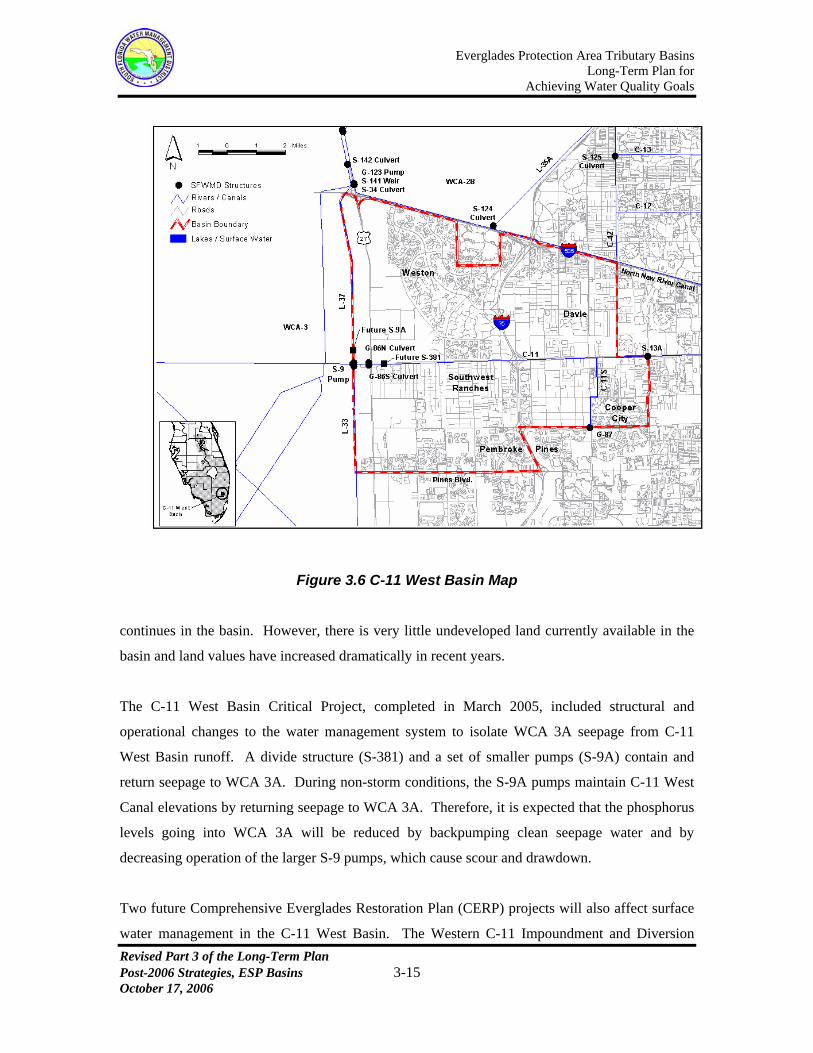
returned through the S-9 pump station. A map of the C-11 West Basin is presented in Figure 3.6.
Land use in the C-11 West Basin is primarily urban residential and commercial development.
Agricultural and rural land uses continue to be converted to urban land uses as land development
Everglades Protection Area Tributary Basins Long-Term Plan for
Achieving Water Quality Goals
Figure 3.6 C-11 West Basin Map
continues in the basin. However, there is very little undeveloped land currently available in the
basin and land values have increased dramatically in recent years.
The C-11 West Basin Critical Project, completed in March 2005, included structural and
operational changes to the water management system to isolate WCA 3A seepage from C-11
West Basin runoff. A divide structure (S-381) and a set of smaller pumps (S-9A) contain and
return seepage to WCA 3A. During non-storm conditions, the S-9A pumps maintain C-11 West
Canal elevations by returning seepage to WCA 3A. Therefore, it is expected that the phosphorus
levels going into WCA 3A will be reduced by backpumping clean seepage water and by
decreasing operation of the larger S-9 pumps, which cause scour and drawdown.
Two future Comprehensive Everglades Restoration Plan (CERP) projects will also affect surface
water management in the C-11 West Basin. The Western C-11 Impoundment and Diversion Revised Part 3 of the Long-Term Plan Post-2006 Strategies, ESP Basins 3-15 October 17, 2006

Everglades Protection Area Tributary Basins Long-Term Plan for
Achieving Water Quality Goals
Revised Part 3 of the Long-Term Plan Post-2006 Strategies, ESP Basins 3-16 October 17, 2006
Canal CERP Project (a.k.a. the Broward County Water Preserve Area CERP Project), currently
scheduled for completion under the Acceler8 Program in December 2009, consists of a 1,600-
acre stormwater treatment area/impoundment within the C-11 West Basin and approximately 8
miles of canal that will divert flood waters to the proposed C-9 Impoundment and another CERP
storage area. The Western C-11 Impoundment will be located north of the C-11 West Canal and
east of U.S. Highway 27. The 2003 Long-Term Plan assumed the Broward County Water
Preserve Area (BCWPA) CERP Project was to be completed by January 2006. In addition, the
North Lake Belt Storage CERP Project, scheduled for completion in June 2036, will also affect
the amount of stormwater flows pumped into WCA-3A through S-9 and seepage flows returned
to WCA 3A through S-9A.
3.4.1. Recommended Strategies in 2003 Long-Term Plan and Revisions
A total of three alternatives for the C-11 West Basin were evaluated in the October 23, 2002,
Basin Specific Feasibility Studies, Everglades Stormwater Program Basins. Alternative No. 3,
with certain adjustments, was recommended for implementation. Component elements of
Alternative No. 3 include:
Implementation of source controls;
Assist Broward County in coordinating a county-wide working group to develop a
comprehensive pollution prevention plan with specific water quality goals and
milestones;
Reliance on the CERP projects as the primary means of reducing total phosphorus
loads discharged to WCA-3A from the C-11 West Basin (it was assumed the
BCWPA CERP Project was to be completed by January 2006, and the North Lake
Belt Storage CERP Project was to be completed by June 2036);
Conduct analyses of potential connection between the Western C-11 Impoundment
and the WCA 3A/3B Levee Seepage Management CERP projects and potential
internal enhancements to the Western C-11 Impoundment for water quality
improvement.
Everglades Protection Area Tributary Basins Long-Term Plan for
Achieving Water Quality Goals
Revised Part 3 of the Long-Term Plan Post-2006 Strategies, ESP Basins 3-17 October 17, 2006
Projected expenditures under the 2003 Long-Term Plan for the C-11 West Basin (Long-Term
Plan Project referred to as “Bc73”) were limited to those necessary for conducting additional
analyses and assisting local communities in developing, evaluating and implementing source
controls (Best Management Practices).
A revision to the C-11 West Basin section of the October 27, 2003, version of the Long-Term
Plan was developed in a separate document dated July 28, 2006. The revised strategy
recommended including the C-11W and C-9 CERP Projects (Part of the BCWPA CERP
Project) in the Long-Term Plan. The revised section is posted at:
http://www.sfwmd.gov/org/erd/longtermplan/documents.shtml.
3.4.2. Additional Analysis and Findings Following 2003 Long-Term Plan
As recommended in the 2003 Long-Term Plan, the District hired consultants to conduct analyses
of potential connection between the Western C-11 Impoundment and the WCA 3A/3B Levee
Seepage Management CERP projects and potential internal enhancements to the Western C-11
Impoundment for water quality improvement. The results of the analyses conducted to date
indicate that the most effective strategy for reducing TP discharges at S-9 will consist of
minimizing S-9 discharge volumes (through operational changes) in lieu of attempting TP
reduction in the impoundment (Burns & McDonnell, Broward County Water Preserve Areas
Stormwater Treatment Potential of C-11 Impoundment, May 12, 2006). These analyses are being
conducted in coordination with the CERP project implementation team and the District’s
Acceler8 team, and are currently being evaluated for incorporation into the design of the project
features.
The District has also updated the flow estimates at the S-9 complex (i.e., the larger pumps at S-9
and the smaller pumps at S-9A) using the South Florida Water Management Model (SFWMM,
version 5.4). As simulated by the SFWMM model, the yearly average flows at the S-9 complex
will decrease to 96,839 acre-ft once the BCWPA CERP Project is completed. The existing
conditions yearly average flows at the S-9 complex, as simulated by the SFWMM model, is
175,160 acre-ft. Further reductions in the S-9 Complex flows and TP loads beyond the 96,839

Everglades Protection Area Tributary Basins Long-Term Plan for
Achieving Water Quality Goals
Revised Part 3 of the Long-Term Plan Post-2006 Strategies, ESP Basins 3-18 October 17, 2006
acre-ft estimate are anticipated should the recommendations from the analyses become part of the
final design of the BCWPA CERP Project.
Also as recommended by the 2003 Long-Term Plan, the District assisted Broward County in
coordinating a county-wide working group to develop a comprehensive pollution prevention plan
with specific water quality goals and milestones. This working group developed a document
titled “Broward County C-11 West Basin Pollution Reduction Action Plan” in April 2006
(http://www.sfwmd.gov/org/erd/longtermplan/pdfs/C-11April_06_v2_wAppendix.pdf). The
District will assist Broward County and all stakeholders in the implementation of the action plan
for the C-11 West Basin.
The 2003 Long-Term Plan assumed the BCWPA CERP Project was to be completed by January
2006, but the Acceler8 schedule for project completion is currently December 2009.
3.4.3. Recommended Improvements and Strategies
The following improvements and strategies that incorporate additional analysis and findings
consistent with the 2003 Long-Term Plan are recommended:
Continue implementation of source controls and, as necessary, include through ERP
requirements implementation of appropriate source control programs (i.e., BMPs) to
achieve water quality goals;
Assist Broward County and all stakeholders in the implementation of the Broward
County C-11 West Basin Pollution Reduction Action Plan;
Provide additional funding (FY 2007 through FY 2010) for the continued
implementation of source controls;
Rely on the CERP projects as the primary means of reducing total phosphorus loads
discharged to WCA-3A from the C-11 West Basin (BCWPA CERP Project
completion assumed by December 2009 and North Lake Belt Storage CERP Project
completion assumed by June 2036).

Everglades Protection Area Tributary Basins Long-Term Plan for
Achieving Water Quality Goals
Revised Part 3 of the Long-Term Plan Post-2006 Strategies, ESP Basins 3-19 October 17, 2006
3.4.4. Additional Estimated Cost and Projected Expenditures [Bd08]
Extending the source control program beyond FY 2006 for the C-11 West Basin is recommended
utilizing a comprehensive program for all Broward County basins tributary to the EPA (Broward
County Source Controls Project “Bd08”). A projected source control program expenditure total
of $534,000 (in FY 2006 dollars) is recommended for NSID, NNRC, and C-11 West Basins for
the period including FY 2007 through FY 2010. The projected expenditure is summarized in
Table 3.14.
3.5. L-28 Basin
The L-28 Basin covers an area of about 72,000 acres (113 square miles). It is located west of
Water Conservation Area (WCA) 3A and south of the Everglades Agricultural Area (EAA) at the
northeast corner of the Big Cypress National Preserve in Broward, Hendry and Collier Counties.
Two of the largest landowners within this basin are the Seminole Tribe of Florida and the
Miccosukee Tribe of Indians of Florida. A small portion of the Big Cypress National Preserve is
also located in the basin.
The L-28 Basin is entirely occupied by four landowners. The C-139 Annex (approximately 25%
of the basin) is comprised of the U.S. Sugar Corporation’s Southern Division Ranch, Unit 1. The
Seminole Tribe’s Big Cypress Reservation occupies approximately 34% of the basin.
Approximately 28% of the basin is situated in the Miccosukee Indian Reservation. The remaining
13% of the basin is within the Big Cypress National Preserve.
The surface water management system in the L-28 Basin provides drainage and flood protection
in addition to providing water to WCA-3A when necessary for water supply purposes. The L-28
Borrow Canal is the primary drainage canal, running north/south for a distance of approximately
10 miles along the eastern border of the basin. The L-28 Borrow Canal conveys stormwater
runoff to the S-140 pump station which discharges it directly into WCA-3A. The S-140 pump
station has three pumps with a combined pumping capacity of 1,300 cubic feet per second (cfs).
The nominal capacity of S-140 was established to provide an average removal rate from the L-28
Basin of 7/16” per day. The L-28 Interceptor Canal, which borders the basin on the southwest,

Everglades Protection Area Tributary Basins Long-Term Plan for
Achieving Water Quality Goals
Revised Part 3 of the Long-Term Plan Post-2006 Strategies, ESP Basins 3-20 October 17, 2006
conveys discharges from the S-190 Structure (Feeder Canal Basin) to WCA-3A and is separated
from the L-28 Basin by a levee. Wetland and agricultural land uses account for approximately 96
percent of the basin area. A map of the L-28 Basin is presented in Figure 3.7.
The C-139 Annex presently drains to the L-28 Borrow Canal at the north boundary of the Big
Cypress Reservation. Runoff from the C-139 Annex will be diverted to STA-6 in concert with the
presently planned construction of STA-6, Section 2 (scheduled to be flow capable by December
31, 2006). The diversion will effectively reduce the total area of the L-28 Basin that drains to
WCA-3A from 71,790 acres to approximately 53,000 acres. The ERP for the C-139 Annex
surface water management system (ERP No. 26-00094-S) stipulates that a best management
practices plan be developed to ensure that discharges from the C-139 Annex are maintained at or
below historic levels. The permit also stipulates implementation of a compliance monitoring plan
to ensure adherence to the TP load limitations.
There are two Central and South Florida Restoration Critical Projects planned for the L-28 Basin,
the Miccosukee Water Management Plan (WMP) and a Comprehensive Everglades Restoration
Plan (CERP) project planned to expand and relocate the S-140 pump station. In addition, the Big
Cypress-Seminole Indian Reservation Water Conservation Plan (WCP) is to be implemented
under the National Resource Conservation Service (NRCS) PL 83-566 Small Watershed Project
Program.

Everglades Protection Area Tributary Basins Long-Term Plan for
Achieving Water Quality Goals
Revised Part 3 of the Long-Term Plan Post-2006 Strategies, ESP Basins 3-21 October 17, 2006
Figure 3.7 L-28 Basin Map

Everglades Protection Area Tributary Basins Long-Term Plan for
Achieving Water Quality Goals
Revised Part 3 of the Long-Term Plan Post-2006 Strategies, ESP Basins 3-22 October 17, 2006
The basic nature of the overall plan on the Big Cypress Reservation was originally defined in a
February 6, 1995, Conceptual Water Conservation System Design, prepared for the Seminole
Tribe of Florida by AMS Engineering and Environmental of Punta Gorda, Florida. That
document suggests the development of three Water Resource Areas (WRAs) in that part of the
Big Cypress Reservation lying in the L-28 Basin. Those areas (WRA-5, WRA-6 and WRA-7)
were intended to treat an average annual volume of 32,418 acre-feet per year, consisting of runoff
from a total contributing area of 13,957 acres. The total phosphorus load in those inflows was
estimated to average 12.327 tons (11,183 kilograms) per year, equivalent to a flow-weighted
mean TP concentration of 280 ppb. However, that estimated TP inflow load was based on
generalized estimates of runoff concentration by land use; the primary land use in lands tributary
to these three WRA’s is improved pasture, which was assigned a mean TP concentration in runoff
of 300 ppb. The total area identified for the three WRA’s was 3,835 acres (with 3,257 in the
largest, WRA-7). These WRA’s were not included in either Phase I or Phase II of the Critical
Restoration Project. Funding for these WRA’s has been obtained through the NRCS PL 83-566
Small Watershed Project Program. Final design of WRA’s 5 and 6 is scheduled to be completed
by September 2007. Final design for WRA-7 is currently scheduled to be completed by late
2008. Construction completion of WRA’s 5, 6, and 7 is currently scheduled by 2010.
The Miccosukee WMP is a CERP Project to construct a managed wetland on the Miccosukee
Tribe’s 76,800-acre reservation in western Broward County. The Miccosukee Tribe is the local
sponsor for this CERP Project. The project will convert 900 acres of pastureland on the
reservation into wetland retention and detention areas. The project will provide water storage
capacity as well as water quality enhancement for water that will be discharged to WCA 3A
through the S-140 pump station. This project is being designed to accommodate flows and loads
from reservation lands only. Completion of improvements is currently planned after 2015 (CERP
Band 3, 2015-2020). Funding for this CERP project has not yet been authorized.
CERP Component RR4 includes expanding the S-140 pump station from a capacity of 1,300 cfs
to a capacity of 2,000 cfs and relocating it approximately 8 miles to the south. The purpose of the
project is to improve hydropattern in the western area of WCA 3A and to provide increased water
supply to the area. This project also complements the Big Cypress/L-28 Interceptor Modifications
CERP Project that will degrade the west berm of the L-28 Interceptor Canal to allow for the sheet

Everglades Protection Area Tributary Basins Long-Term Plan for
Achieving Water Quality Goals
Revised Part 3 of the Long-Term Plan Post-2006 Strategies, ESP Basins 3-23 October 17, 2006
flow of water from the Feeder Canal Basin into the Big Cypress National Preserve south of the
Big Cypress Reservation. The Big Cypress/L-28 Interceptor Modifications CERP Project will
eliminate a point-source discharge into WCA 3A. Therefore, CERP Component RR4 will offset
the water supply to the western section of WCA 3A that will be lost when the west berm of the L-
28 Interceptor Canal is degraded. An estimated 285,000 acre-feet per year of additional water
from STA-3/4 will be conveyed to the new S-140 pump station. The planning process for
determination of the manner in which this flow will be conveyed to the new S-140 pump station
is not complete.
3.5.1. Alternatives Considered in Basin-Specific Feasibility Studies
The following is a discussion of alternatives for the L-28 Basin considered in the October 23,
2002, Basin Specific Feasibility Studies, Everglades Stormwater Program Basins, Brown &
Caldwell. Those alternatives consisted of hypothetical projects developed and evaluated for
comparison purposes only.
In that study, it was not considered possible to quantify the effects of the two Critical Projects on
the future quantity and quality of stormwater discharges from the L-28 Basin. Therefore for the
purposes of evaluating alternatives in that investigation, it was assumed that there would be no
reduction in either the baseline flows or phosphorus loads predicted for the L-28 Basin over the
31-year period of simulation as a result of these projects.
The SFWMD used historical rainfall, flow and water quality data to develop simulated 31-year
baseline flows and TP loads from the L-28 Basin (Baseline Data for the Basin Specific Feasibility
Studies to Achieve the Long-Term Water Quality Goals for the Everglades, SFWMD, May 2001).
Simulated flows ranged from about 50,000 to 130,000 acre-feet per year (average 83,806 acre-
feet per year). (Note: Stormwater runoff from the C-139 Annex was conveyed to STA 6 in the
model simulation used for the Basin Specific Feasibility Studies.) Simulated phosphorus loads
ranged from about 2,300 to 6,200 kilograms (kg) TP per year (average 3,982 kg TP per year).
The flow-weighted mean TP concentration over the 31-year period of simulation was estimated to
be 39 ppb. That estimate was based on analysis of available water quantity and quality data over
the period encompassing water years 1990 to 1999.

Everglades Protection Area Tributary Basins Long-Term Plan for
Achieving Water Quality Goals
Revised Part 3 of the Long-Term Plan Post-2006 Strategies, ESP Basins 3-24 October 17, 2006
Two alternatives were considered in the Basin Specific Feasibility Studies. Alternative 1
combined source controls with biological treatment in an STA to reduce phosphorus loads in
discharges from the L-28 Basin. Alternative 2 considered source controls only, and is not further
discussed herein.
As structured in the Basin Specific Feasibility Studies, the STA in Alternative 1 was intended to
treat all discharges from the L-28 Basin in a single facility. That facility was estimated to require
an effective treatment area of 1,088 acres, the upstream half of which would be developed in
Submerged Aquatic Vegetation (SAV), with the remainder developed as a Periphyton Stormwater
Treatment Area (PSTA). The estimated capital cost of the STA was $35.70 million; average
annual operation and maintenance costs were estimated to average $0.40 million. The estimated
implementation schedule suggested that the facility could not be fully operational (e.g., meeting
final water quality standards) until mid-2011, given a January 2003 start.
Because so few details associated with the CERP Projects and non-CERP Projects in this basin
were available at the time of the Basin Specific Feasibility Studies, an assumption was made that
the proposed STA would need to treat all of the basin flows and loads, even though it was
suspected that these projects will have an impact on these flows and loads. For this reason, it was
concluded that a potential exists for cost savings by integrating with the CERP and Critical
Projects to meet the goals of all the projects.
3.5.2. Recommended Strategy in 2003 Long-Term Plan
Because of the considerable uncertainty in the scope, schedule, funding and interaction of the
various CERP projects in the L-28 Basin, at the time the 2003 Long-Term Plan was developed,
the basic strategy recommended for this basin was continued reliance on CERP. However, an
additional alternative was developed to be forwarded to the CERP Project Development Team
(PDT) for its specific consideration. That alternative contemplated two primary components:

Everglades Protection Area Tributary Basins Long-Term Plan for
Achieving Water Quality Goals Accelerated construction of the Miccosukee 900-acre STA by the USACE (which at
the time was planned for completion in 2010). That STA will capture and treat runoff
from Miccosukee tribal lands. Preliminary construction costs were estimated in the
CERP documents as approximately $25 million, with a 50/50 cost share between the
federal government and the Miccosukee Tribe. The Tribe has indicated its intent to
dedicate a 900-acre parcel of land located north of Interstate 75 and just west of the
existing S-140 Pumping Station;
The Seminole Tribe had executed a scope of work with the NRCS for the
development of a project that will route, detain and treat runoff from the Big Cypress
Seminole Indian Reservation prior to its discharges to (1) Big Cypress National
Preserve (BCNP), (2) BCNP and Miccosukee Tribe of Indians lands, and (3) the L-28
Borrow Canal, through WRAs 5, 6, and 7, respectively. This project, proposed for
implementation under the NRCS PL 83-566 Small Watershed Project Program, had
not yet been authorized or funded. This project was being designed to accommodate
flows and loads only from the Seminole Reservation lands. The 2003 Long-Term
Plan recommended modifying the Seminole WCP project to convert WRA-7 to an
STA by 2010 at a cost of approximately $20 million. No funding was provided in the
2003 Long-Term Plan to implement the recommendation as it was assumed the
project scope of work would be modified to include the conversion.
The District initiated coordination with the tribes, the USACE and the federal
interest in the Big Cypress National Preserve in June, 2003. Additional
coordination is still necessary to integrate the various projects in the basin. The
remaining discussion of the L-28 Basin presented in the following sections is
intended to provide an update on findings and additional analysis done by the
District following the 2003 Long-Term Plan, to update project schedules, to
generally suggest technical steps necessary in the coordination, and to
preliminarily quantify probable costs.
Revised Part 3 of the Long-Term Plan Post-2006 Strategies, ESP Basins 3-25 October 17, 2006

Everglades Protection Area Tributary Basins Long-Term Plan for
Achieving Water Quality Goals
Revised Part 3 of the Long-Term Plan Post-2006 Strategies, ESP Basins 3-26 October 17, 2006
Final selection of the specific plan of improvement in the L-28 Basin and determination of
the implementation schedule will be accomplished through the CERP and NRCS planning
processes. In the L-28 Basin, the two tribes are expected to fulfill the role of local sponsor to the
federal initiatives.
3.5.3. Additional Analysis and Findings Following 2003 Long-Term Plan
During the development of the 2003 Long-Term Plan, the SFWMD used historical rainfall, flow
and water quality data to develop simulated 31-year baseline flows and TP loads from the L-28
Basin. Simulated flows ranged from about 50,000 to 130,000 acre-feet per year (average 83,806
acre-feet per year). Simulated flow data from the most recent SFWMM model run (36-year
simulation) completed in 2005 estimated the average flow for the basin at 93,571 acre-feet per
year (ranging from about 41,782 to 156,358 acre-feet per year). The 2003 Long-Term Plan
assumed a flow-weighted mean TP concentration of 39 ppb, based on water quality data over the
period encompassing WY1990-WY1999. Flow-weighted mean TP concentration based on water
quality data from the period WY1998-WY2006 was calculated as 37 ppb. Calculations assumed
stormwater runoff from the C-139 Annex is conveyed to STA-6.
As of July 2006, the scope of the Seminole WCP project has not been modified to convert WRA-
7 to an STA. No plans or funding has been authorized to implement this Long-Term Plan
recommendation.
Also, as of July 2006, funding for the Miccosukee WMP CERP Project has not been authorized.
Completion of the project is currently planned after 2015 (CERP Band 3, 2015-2020). Therefore,
the 2003 Long-Term Plan recommendation to accelerate completion of the project by 2010 is
unlikely to be implemented.
The District, through its coordination with the Seminole and Miccosukee tribes, continues to
pursue the implementation of the 2003 Long-Term Plan recommendations for the Seminole WCP
and Miccosukee WMP projects.

Everglades Protection Area Tributary Basins Long-Term Plan for
Achieving Water Quality Goals
Revised Part 3 of the Long-Term Plan Post-2006 Strategies, ESP Basins 3-27 October 17, 2006
3.5.4. Review and Disaggregation of Baseline Data
Although flows and TP concentrations for the basin were updated as described in Sub-section
3.5.3, the updated values are not significantly different from the baseline data used in the 2003
Long-Term Plan. Therefore, the review and disaggregation of data below and in following sub-
sections continues to utilize the base line data presented in the 2003 Long-Term Plan.
As noted earlier, the District’s Baseline Data for the L-28 Basin presented in the 2003 Long-
Term Plan suggests a simulated average annual discharge from the L-28 Basin of 83,806 acre feet
at a flow-weighted mean TP concentration of 39 ppb (3,982 kg TP per year). The 31-year
simulation on which the hydrologic data is based was conducted assuming that the C-139 Annex
had been diverted to STA-6. No runoff from that part of the (historic) L-28 Basin was considered
in the simulation. The estimated flow-weighted mean TP concentration was based on analysis of
actual discharge from the entire L-28 Basin (including the C-139 Annex) over the period water
years 1990-1999.
During development of final water quality improvement strategies in the L-28 Basin, it will be
necessary to further refine estimated runoff volumes and loads to be treated in (1) the Miccosukee
Tribe’s STA; and (2) the Seminole Tribe’s STA, discussed herein as a potential addition to, or
addition within, the Seminole Tribe’s proposed WRAs 5, 6 and 7, which are scheduled to be
implemented under NRCS PL 83-566 Small Watershed Project Program, due to the following:
The flow-weighted mean concentration in L-28 Basin discharges was developed
including discharges from the C-139 Annex, which, for much of the period
considered, had been developed in citrus and fitted with an extensive stormwater
management system;
Approximately half of the overall area of the L-28 Basin consists of natural areas,
primarily wetlands. It would be expected that these natural areas contribute but a
small fraction of the overall TP load discharged from the basin;
Everglades Protection Area Tributary Basins Long-Term Plan for
Achieving Water Quality Goals
Revised Part 3 of the Long-Term Plan Post-2006 Strategies, ESP Basins 3-28 October 17, 2006
Given the anticipated presence of at least two STAs in the overall plan of
improvement, it will be necessary to develop separate estimates of inflows to be
accommodated in those treatment areas.
That further refinement of estimated runoff and TP loads to be accommodated in the treatment
areas will require the conduct of a detailed watershed assessment prior to finalizing plans for
improvement. A starting point for that watershed assessment is available in the January 1993,
Western Basins Environmental Assessment, prepared for SFWMD by Mock, Roos & Associates,
Inc. of West Palm Beach. That updated watershed assessment would benefit greatly from use of
extensive water quality data that is believed to have been accumulated by both the Miccosukee
and Seminole tribes over the almost thirteen years subsequent to publication of the Environmental
Assessment.
The following is an initial approximation of the runoff volumes and loads to be treated in those
STAs. It can be considered only an initial approximation due to the significant assumptions
necessarily made in the absence of more definitive data. The most significant assumptions
include:
An assumption that it will not be necessary to treat runoff from native lands on which
no external source of phosphorus is present (e.g., water quality in runoff from those
areas generally parallels historic runoff, that is, prior to drainage and development in
the basin);
An assumption that the overall flow-weighted mean TP concentration in basin runoff
(including native areas) will be approximately 39 ppb, but that the bulk of the
associated TP load is discharged from agricultural areas in the basin;
An assumption that each tribal STA will treat only runoff from the respective tribe’s
lands.
Data presented in the 1993 Western Basins Environmental Assessment indicates that a total of
26,532 acres are tributary to the L-28 Borrow Canal on and adjacent to the Seminole Tribe’s Big

Everglades Protection Area Tributary Basins Long-Term Plan for
Achieving Water Quality Goals
Revised Part 3 of the Long-Term Plan Post-2006 Strategies, ESP Basins 3-29 October 17, 2006
Cypress Reservation (tertiary basins b51-b55, inclusive and b63). A total of 26,926 acres are
shown as being tributary to the L-28 Borrow Canal along the Miccosukee Tribe’s Reservation
(tertiary basins b66-b86). Given an average annual runoff of 83,806 acre-feet (taken from the
District’s Baseline Data) from the entire 52,504-acre area, the average annual runoff depth from
the basin is estimated to be 1.65 ft. (19.8”). In the absence of more definitive data, that average
annual depth of runoff is considered as uniformly applied to the entire basin.
Of the 26,926 acres tributary to the L-28 Borrow Canal along the Miccosukee Reservation,
approximately 16,160 acres are considered to be native lands for which no treatment is required.
Those lands include approximately 7,880 acres in tertiary basin b80 (primarily the Big Cypress
Federal Preserve; roughly 1,520 acres of Tribal lands in this basin west of Snake Road are
improved pasture for which treatment is needed) and tertiary basins b82, b84 and b86 (native
lands south of Alligator Alley). As a result, it is presently anticipated that the Miccosukee Tribal
STA will need to treat runoff from a total contributing area (including the STA itself) of 10,766
acres (primarily improved pasture).
Of the 26,532 acres tributary to the L-28 Borrow Canal on and adjacent to the Big Cypress
Reservation, approximately 8,740 acres are considered to be native lands for which no treatment
is required (primarily in tertiary basin b55). As a result, it is anticipated that the Seminole Tribal
STA will need to treat runoff from a total contributing area (including the STA itself) of 17,792
acres (primarily improved pasture).
For the basin as a whole, 24,900 acres are considered to be native lands for which no treatment is
required, with the remaining 28,558 acres effectively contributing to the two tribal STAs. The
average annual runoff volume to be accommodated in the two STAs is then estimated to be
approximately 44,800 acre-feet (53% of the simulated discharge volume at Pumping Station S-
140). In the absence of more definitive data, the entire estimated average annual TP load of 3,982
kg per year discharged at S-140 in the Baseline Data is assigned to those inflows, yielding a flow-
weighted mean inflow concentration of approximately 72 ppb.

Everglades Protection Area Tributary Basins Long-Term Plan for
Achieving Water Quality Goals
Revised Part 3 of the Long-Term Plan Post-2006 Strategies, ESP Basins 3-30 October 17, 2006
3.5.5. Initial Conceptual Design, Miccosukee Tribal STA
Given the above approximations, it is presently anticipated that the Miccosukee Tribal STA may
be required to treat an average annual inflow volume of approximately 15,260 acre-feet per year
(20.1% of the total simulated runoff volume from the L-28 Basin) at a flow-weighted mean
inflow TP concentration of approximately 72 ppb.
It is assumed that the Miccosukee Tribal STA will be developed on a 900-acre parcel of land
lying adjacent to the L-28 Borrow Canal just north of Interstate 75 and west of existing Pumping
Station S-140. It is anticipated that approximately 800 acres of effective treatment area can be
developed on that site. The treatment area would consist of three parallel flow paths, with two
cells in series in each flow path. The most upstream cells (approximately 40% of the effective
area) are assumed to consist of emergent macrophyte vegetation. The downstream cells
(approximately 60% of the effective area) would be developed in Submerged Aquatic Vegetation
(SAV).
The majority of lands served by this STA presently drain directly to the L-28 Borrow Canal. It is
anticipated that the project would include approximately 4.5 miles of interceptor canal along the
west side of and immediately adjacent to the L-28 Borrow Canal. The function of that canal
would be to intercept runoff from the Tribal lands prior to its discharge to the L-28 Borrow Canal,
and convey that runoff to the STA for treatment.
A preliminary treatment projection was prepared employing the same analytical tool (the
DMSTA model) employed in the Basin Specific Feasibility Studies. Daily inflows to the STA
over the 31-year period of simulation were established at 20.1% of the S-140 daily discharge, and
assigned a uniform TP concentration of 72 ppb. In that analysis, the treatment parameter data set
for NEWS (Nonemergent Wetland Systems) was employed in the downstream SAV cells. Based
on that analysis, it was concluded that, given the assigned inflow data, the long-term mean
concentrations in discharges from the STA would meet the planning objective (10 ppb geometric
mean), and would result in a flow-weighted mean TP concentration of 14 ppb (lowest sustainable
concentration anticipated in the biological treatment system). The actual computed values were a

Everglades Protection Area Tributary Basins Long-Term Plan for
Achieving Water Quality Goals geometric mean TP concentration of 9.6 ppb, and a flow-weighted mean TP concentration of 12.2
ppb.
For reasons subsequently discussed in this section, it is recommended that additional watershed
assessment and analysis be conducted prior to finalizing the design of the Miccosukee Tribal
STA. However, the results of the preliminary treatment performance projection suggest that it
would not be unreasonable to establish projected expenditures for development of the
Miccosukee Tribal STA on the basis of the analyses presented herein.
An opinion of the probable capital cost for the Miccosukee Tribal STA (stated in FY 2003
dollars) is presented in Table 3.5.
Table 3.5 Opinion of Probable Capital Cost, Miccosukee Tribal STA
Item Description Estimated Unit Estimated Estimated RemarksNo. Quantity Unit Cost Total Cost1 New Inflow Pumping Station 260 cfs $9,900 $2,574,0002 Gated Water Control Culverts 12 Ea. $25,000 $300,000 Approx. 48" dia. With gates
3 Outlet Control Structures 6 Ea. $30,000 $180,000Approx. 48" diameter with control weir structures
4 Power Line to Pump Station 1.5 Mi. $80,000 $120,000Assumed to come from Snake Road to vic. L-28
5 Exterior Levee, 9' Height 2.8 Mi. $562,000 $1,573,6006 Exterior Levee, 8' Height 3.3 Mi. $485,000 $1,600,5007 Interior Levee, 7' Height 3.3 Mi. $390,000 $1,287,0008 Interior Land Preparation 800 Ac. $60 $48,000
9Interceptor Canal along L-28, approx. 4.5 Mi. length 200000 Cu. Yd. $3.50 $700,000
Subtotal, Estimated Construction Costs $8,383,100 $8,400,000Planning, Engineering & Design 10 % $838,310 $840,000Program & Construction Management 10 % $838,310 $840,000Total Estimated Cost, Without Contingency $10,059,720 $10,080,000Contingency 30 % $3,017,916 $3,000,000Land Acquisition 900 Ac. $1,000 $900,000 $1,100,000Land Acquistion Contingency 20 % $180,000TOTAL ESTIMATED CAPITAL COST $14,157,636 $14,180,000
An opinion of the probable average annual cost for operation and maintenance of the
Miccosukee Tribal STA (stated in FY 2003 dollars) is presented in Table 3.6.
Revised Part 3 of the Long-Term Plan Post-2006 Strategies, ESP Basins 3-31 October 17, 2006
Everglades Protection Area Tributary Basins Long-Term Plan for
Achieving Water Quality Goals
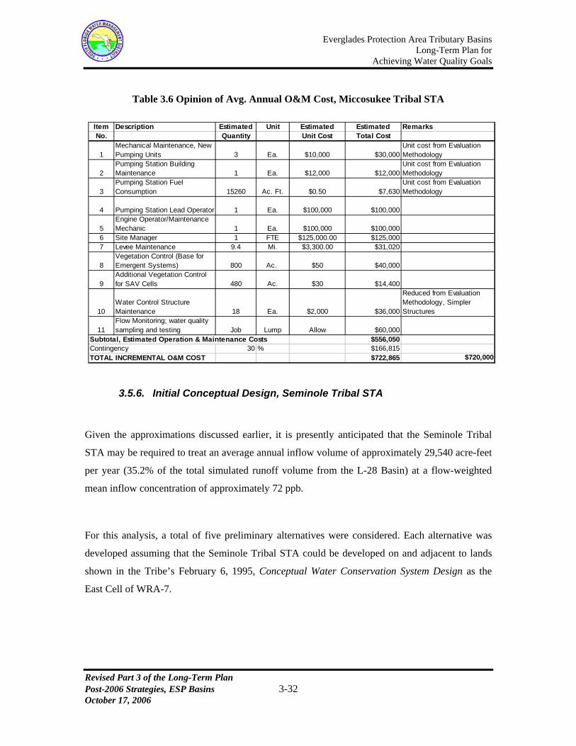
Table 3.6 Opinion of Avg. Annual O&M Cost, Miccosukee Tribal STA
Item Description Estimated Unit Estimated Estimated RemarksNo. Quantity Unit Cost Total Cost
1Mechanical Maintenance, New Pumping Units 3 Ea. $10,000 $30,000
Unit cost from Evaluation Methodology
2Pumping Station Building Maintenance 1 Ea. $12,000 $12,000
Unit cost from Evaluation Methodology
3Pumping Station Fuel Consumption 15260 Ac. Ft. $0.50 $7,630
Unit cost from Evaluation Methodology
4 Pumping Station Lead Operator 1 Ea. $100,000 $100,000
5Engine Operator/Maintenance Mechanic 1 Ea. $100,000 $100,000
6 Site Manager 1 FTE $125,000.00 $125,0007 Levee Maintenance 9.4 Mi. $3,300.00 $31,020
8Vegetation Control (Base for Emergent Systems) 800 Ac. $50 $40,000
9Additional Vegetation Control for SAV Cells 480 Ac. $30 $14,400
10Water Control Structure Maintenance 18 Ea. $2,000 $36,000
Reduced from Evaluation Methodology, Simpler Structures
11Flow Monitoring; water quality sampling and testing Job Lump Allow $60,000
Subtotal, Estimated Operation & Maintenance Costs $556,050Contingency 30 % $166,815TOTAL INCREMENTAL O&M COST $722,865 $720,000
3.5.6. Initial Conceptual Design, Seminole Tribal STA
Given the approximations discussed earlier, it is presently anticipated that the Seminole Tribal
STA may be required to treat an average annual inflow volume of approximately 29,540 acre-feet
per year (35.2% of the total simulated runoff volume from the L-28 Basin) at a flow-weighted
mean inflow concentration of approximately 72 ppb.
For this analysis, a total of five preliminary alternatives were considered. Each alternative was
developed assuming that the Seminole Tribal STA could be developed on and adjacent to lands
shown in the Tribe’s February 6, 1995, Conceptual Water Conservation System Design as the
East Cell of WRA-7.
Revised Part 3 of the Long-Term Plan Post-2006 Strategies, ESP Basins 3-32 October 17, 2006

Everglades Protection Area Tributary Basins Long-Term Plan for
Achieving Water Quality Goals
Revised Part 3 of the Long-Term Plan Post-2006 Strategies, ESP Basins 3-33 October 17, 2006
Alternative 1 considered an effective treatment area of 2,500 acres, all in emergent
macrophyte vegetation, on a total land area of 2,800 acres. For that alternative, the
East Cell in total was used, and extended easterly to abut the L-28 Borrow Canal;
Alternative 2 considered an effective treatment area of 2,500 acres, occupying the
same general footprint as Alternative 1. The upstream 40% of the treatment area was
considered to consist of emergent macrophyte vegetation, with the downstream 60%
in Submerged Aquatic Vegetation (SAV);
Alternative 3 was similar to Alternative 2, with the exception that the footprint was
limited to those areas lying north of the Tribe’s E-1 and E-2 ditches. The estimated
effective treatment area was 1,660 acres on a total land area of approximately 1,870
acres;
Alternative 4 was similar to Alternative 3, with the exception that the lands
considered were limited to those shown in the East Cell of WRA-7 north of the
Tribe’s E-1 and E-2 ditches. The estimated effective treatment area was 1,050 acres;
Alternative 5 assumed that the total effective treatment area was established at 3,582
acres on a total land area of 3,835 acres, distributed among three Water Resource
Areas as developed in the Conceptual Water Conservation System Design. For
analysis, those three areas were conceptualized as a single area similar in footprint to
Alternative 1.
Preliminary treatment projections were prepared for each alternative employing the same
analytical tool (the DMSTA model) employed in the Basin Specific Feasibility Studies. Daily
inflows to the STA over the 31-year period of simulation were established at 35.2% of the S-140
daily discharge, and assigned a uniform TP concentration of 72 ppb. In that analysis, the
treatment parameter data set for NEWS (Nonemergent Wetland Systems) was employed in the
downstream SAV cells.
A summary of the results of those analyses is presented in Table 3.7.

Everglades Protection Area Tributary Basins Long-Term Plan for
Achieving Water Quality Goals
Revised Part 3 of the Long-Term Plan Post-2006 Strategies, ESP Basins 3-34 October 17, 2006
Table 3.7 Preliminary Treatment Estimates, Seminole Tribal STA
Long-Term TP Conc. (ppb)
Alt. No. Effective Area (ac.)
Vegetation Type
F.W. Mean Geo. Mean
1 2,500 100% Emergent 18.7 18.0
2 2,500 40% Emergent, 60% NEWS 14* 10*
3 1,660 40% Emergent, 60% NEWS 14* 10*
4 1,050 40% Emergent, 60% NEWS 14.2 11.1
5 3,582 100% Emergent 15.5 14.9
* Computed value outside calibration range, used lowest sustainable concentration
On the basis of those preliminary treatment projections, Alternative 3 was selected as
representative of the requirements for a possible Seminole Tribal STA. The basic layout of the
STA was assumed to present three parallel flow paths, with two cells in series in each flow path.
The most downstream cells (approximately 60% of the total effective treatment area) would be
developed in SAV; the upstream cells were considered to consist of emergent macrophyte
vegetation.
It should here be noted that Alternative 5 as generally described above represents the current
conceptual design for the Seminole Tribe’s projects scheduled to be implemented under the
NRCS PL 83-566 Small Watershed Project Program.
For reasons subsequently discussed in this section, it is recommended that additional watershed
assessment and analysis be conducted prior to finalizing the design of the Seminole Tribal STA.
However, the results of the preliminary treatment performance projection suggest that it would
not be unreasonable to establish projected expenditures for development of the Seminole Tribal
STA on the basis of the analyses presented herein.

Everglades Protection Area Tributary Basins Long-Term Plan for
Achieving Water Quality Goals An opinion of the probable capital cost for a possible Seminole Tribal STA (stated in FY 2003
dollars), if structured as described above for Alternative 3, is presented in Table 3.8. It should be
noted that funding for the Seminole Tribe’s presently intended project (e.g., Alternative 5 as
described above) has been obtained through the NRCS PL 83-566 Small Watershed Project
Program, and final design for WRA-7 is currently scheduled to be completed by late 2008.
Therefore, no concrete financial or design details were available as of August 2006. The
Seminole Tribe is moving forward with the study of the features represented in Alternative 5 to
implement its project in this basin. As such, the information presented in Table 3.8 is different
from those under consideration by the Seminole Tribe.
Table 3.8 Opinion of Probable Capital Cost, Seminole Tribal STA (Alt. No. 3)
Item Description Estimated Unit Estimated Estimated RemarksNo. Quantity Unit Cost Total Cost1 New Inflow Pumping Station 460 cfs $9,900 $4,554,0002 Gated Water Control Culverts 12 Ea. $30,000 $360,000 Approx. 60" dia. With gates
3 Outlet Control Structures 6 Ea. $35,000 $210,000Approx. 60" diameter with control weir structures
4 Power Line to Pump Station 0.1 Mi. $80,000 $8,000Assumed available in close proximity to pump station
5 Exterior Levee, 9' Height 4 Mi. $562,000 $2,248,0006 Exterior Levee, 8' Height 4 Mi. $485,000 $1,940,0007 Interior Levee, 7' Height 4 Mi. $390,000 $1,560,0008 Interior Land Preparation 1660 Ac. $60 $99,600
Subtotal, Estimated Construction Costs $10,979,600 $11,000,000Planning, Engineering & Design 10 % $1,097,960 $1,100,000Program & Construction Management 10 % $1,097,960 $1,100,000Total Estimated Cost, Without Contingency $13,175,520 $13,200,000Contingency 30 % $3,952,656 $4,000,000Land Acquisition 1870 Ac. $1,000 $1,870,000 $2,200,000Land Acquistion Contingency 20 % $374,000TOTAL ESTIMATED CAPITAL COST $19,372,176 $19,400,000
An opinion of the probable average annual cost for operation and maintenance of a possible
Seminole Tribal STA (stated in FY 2003 dollars), structured as described above for Alternative 3,
is presented in Table 3.9. It should be noted that funding for the Seminole Tribe’s presently
intended project (e.g., Alternative 5 as described above) has been obtained through the NRCS PL
83-566 Small Watershed Project Program, and final design for WRA-7 is currently scheduled to
be completed by late 2008. Therefore, no concrete financial or design details are available at this
time. The Seminole Tribe is moving forward with the study of the features represented in
Alternative 5 to implement its project in this basin. As such, the information presented in Table
3.9 is different from those under consideration by the Seminole Tribe.
Revised Part 3 of the Long-Term Plan Post-2006 Strategies, ESP Basins 3-35 October 17, 2006
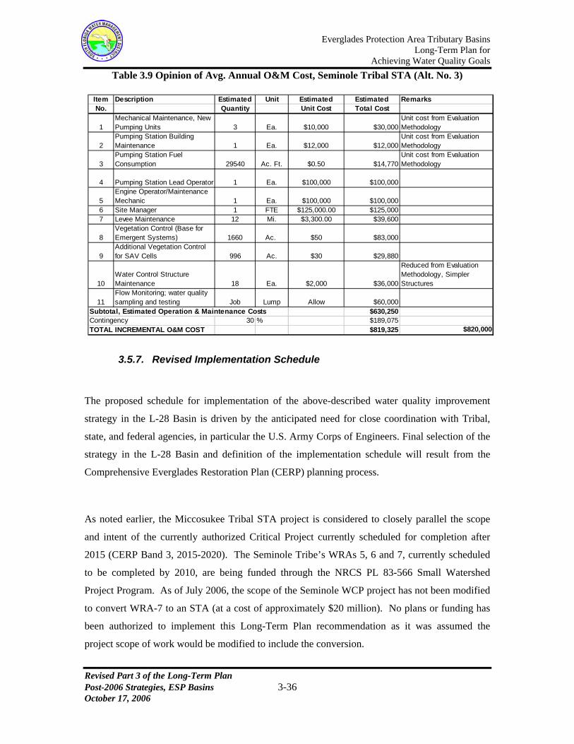
Everglades Protection Area Tributary Basins Long-Term Plan for
Achieving Water Quality Goals Table 3.9 Opinion of Avg. Annual O&M Cost, Seminole Tribal STA (Alt. No. 3)
Item Description Estimated Unit Estimated Estimated RemarksNo. Quantity Unit Cost Total Cost
1Mechanical Maintenance, New Pumping Units 3 Ea. $10,000 $30,000
Unit cost from Evaluation Methodology
2Pumping Station Building Maintenance 1 Ea. $12,000 $12,000
Unit cost from Evaluation Methodology
3Pumping Station Fuel Consumption 29540 Ac. Ft. $0.50 $14,770
Unit cost from Evaluation Methodology
4 Pumping Station Lead Operator 1 Ea. $100,000 $100,000
5Engine Operator/Maintenance Mechanic 1 Ea. $100,000 $100,000
6 Site Manager 1 FTE $125,000.00 $125,0007 Levee Maintenance 12 Mi. $3,300.00 $39,600
8Vegetation Control (Base for Emergent Systems) 1660 Ac. $50 $83,000
9Additional Vegetation Control for SAV Cells 996 Ac. $30 $29,880
10Water Control Structure Maintenance 18 Ea. $2,000 $36,000
Reduced from Evaluation Methodology, Simpler Structures
11Flow Monitoring; water quality sampling and testing Job Lump Allow $60,000
Subtotal, Estimated Operation & Maintenance Costs $630,250Contingency 30 % $189,075TOTAL INCREMENTAL O&M COST $819,325 $820,000
3.5.7. Revised Implementation Schedule
The proposed schedule for implementation of the above-described water quality improvement
strategy in the L-28 Basin is driven by the anticipated need for close coordination with Tribal,
state, and federal agencies, in particular the U.S. Army Corps of Engineers. Final selection of the
strategy in the L-28 Basin and definition of the implementation schedule will result from the
Comprehensive Everglades Restoration Plan (CERP) planning process.
As noted earlier, the Miccosukee Tribal STA project is considered to closely parallel the scope
and intent of the currently authorized Critical Project currently scheduled for completion after
2015 (CERP Band 3, 2015-2020). The Seminole Tribe’s WRAs 5, 6 and 7, currently scheduled
to be completed by 2010, are being funded through the NRCS PL 83-566 Small Watershed
Project Program. As of July 2006, the scope of the Seminole WCP project has not been modified
to convert WRA-7 to an STA (at a cost of approximately $20 million). No plans or funding has
been authorized to implement this Long-Term Plan recommendation as it was assumed the
project scope of work would be modified to include the conversion.
Revised Part 3 of the Long-Term Plan Post-2006 Strategies, ESP Basins 3-36 October 17, 2006

Everglades Protection Area Tributary Basins Long-Term Plan for
Achieving Water Quality Goals
Revised Part 3 of the Long-Term Plan Post-2006 Strategies, ESP Basins 3-37 October 17, 2006
Implementation of the water quality improvement strategy in the L-28 Basin includes the
following steps:
Finalize the strategy, in close coordination with the appropriate Tribal, state and
federal agencies, for water quality improvement initiatives in the L-28 Basin. The
strategy should either confirm or modify the remaining steps;
Conduct the necessary additional watershed assessment;
Complete all necessary planning, engineering and design for the two projects. All
necessary lands should be dedicated or acquired;
Complete construction of both projects.
Following completion of construction, it is anticipated that an additional period of approximately
two years would be required for full maturation and stabilization of the biological treatment
process.
The watershed assessment and planning efforts are considered critical to the proper development
of both projects. Development of the initial conceptual designs of the two Tribal STAs presented
herein required a number of key assumptions, approximations and generalizations. It is the intent
that the watershed assessment and related planning work further define and more fully document
the requirements for these projects and their projected performance.
The watershed assessment should take full advantage of all available water quality data that can
be obtained from the two Tribes, and should consider in detail the influence of seepage from
WCA-3A to the L-28 Borrow Canal on both measured and simulated discharges from Pumping
Station S-140. In addition, assessment should consider the influence of the Tribes’ water
conservation plans and intended Reservation operations on the overall water and phosphorus load
balance in the L-28 Basin.
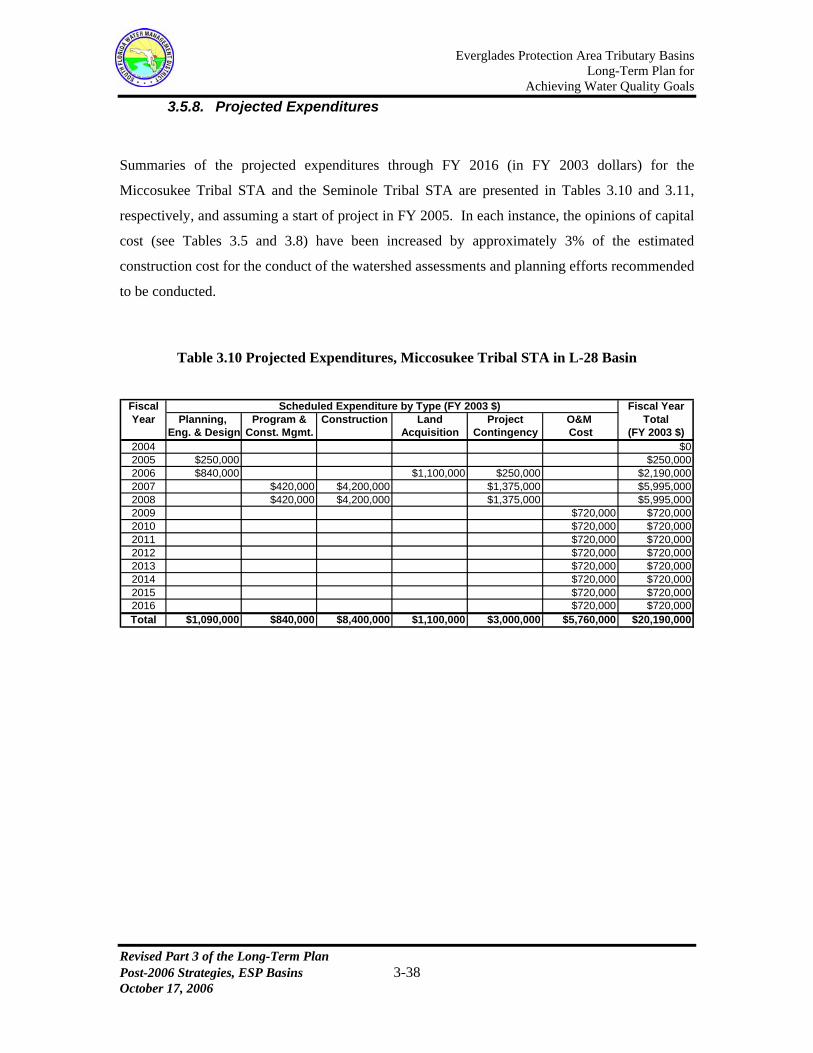
Everglades Protection Area Tributary Basins Long-Term Plan for
Achieving Water Quality Goals 3.5.8. Projected Expenditures
Summaries of the projected expenditures through FY 2016 (in FY 2003 dollars) for the
Miccosukee Tribal STA and the Seminole Tribal STA are presented in Tables 3.10 and 3.11,
respectively, and assuming a start of project in FY 2005. In each instance, the opinions of capital
cost (see Tables 3.5 and 3.8) have been increased by approximately 3% of the estimated
construction cost for the conduct of the watershed assessments and planning efforts recommended
to be conducted.
Table 3.10 Projected Expenditures, Miccosukee Tribal STA in L-28 Basin
Fiscal Scheduled Expenditure by Type (FY 2003 $) Fiscal YearYear Planning, Program & Construction Land Project O&M Total
Eng. & Design Const. Mgmt. Acquisition Contingency Cost (FY 2003 $)2004 $02005 $250,000 $250,0002006 $840,000 $1,100,000 $250,000 $2,190,0002007 $420,000 $4,200,000 $1,375,000 $5,995,0002008 $420,000 $4,200,000 $1,375,000 $5,995,0002009 $720,000 $720,0002010 $720,000 $720,0002011 $720,000 $720,0002012 $720,000 $720,0002013 $720,000 $720,0002014 $720,000 $720,0002015 $720,000 $720,0002016 $720,000 $720,000Total $1,090,000 $840,000 $8,400,000 $1,100,000 $3,000,000 $5,760,000 $20,190,000
Revised Part 3 of the Long-Term Plan Post-2006 Strategies, ESP Basins 3-38 October 17, 2006

Everglades Protection Area Tributary Basins Long-Term Plan for
Achieving Water Quality Goals Table 3.11 Projected Expenditures, Seminole Tribal STA in L-28 Basin
Fiscal Scheduled Expenditure by Type (FY 2003 $) Fiscal YearYear Planning, Program & Construction Land Project O&M Total
Eng. & Design Const. Mgmt. Acquisition Contingency Cost (FY 2003 $)2004 $02005 $330,000 $330,0002006 $1,100,000 $2,200,000 $330,000 $3,630,0002007 $550,000 $5,500,000 $1,835,000 $7,885,0002008 $550,000 $5,500,000 $1,835,000 $7,885,0002009 $820,000 $820,0002010 $820,000 $820,0002011 $820,000 $820,0002012 $820,000 $820,0002013 $820,000 $820,0002014 $820,000 $820,0002015 $820,000 $820,0002016 $820,000 $820,000Total $1,430,000 $1,100,000 $11,000,000 $2,200,000 $4,000,000 $6,560,000 $26,290,000
It is anticipated that more detailed planning and design of the water quality improvement strategy
in the L-28 Basin will be effected through the CERP and NRCS planning processes, involving the
two tribes as local sponsors. The information presented in this section was developed to assist the
CERP Project Development Team (PDT) and the NRCS in their development, evaluation and
final definition of the strategy, implementation schedule, and projection of expenditures.
3.6. Feeder Canal Basin [Bd09]
The Feeder Canal Basin covers an area of about 72,000 acres (113 square miles) in southeastern
Hendry County. It is located west of Water Conservation Area (WCA) 3A, southwest of the
Everglades Agricultural Area (EAA), and north of the Big Cypress National Preserve. A portion
of the Big Cypress Seminole Indian Reservation (approximately 13,500 acres) is located in the
southeast corner of the basin. A map of the Feeder Canal Basin is presented in Figure 3.8.
Revised Part 3 of the Long-Term Plan Post-2006 Strategies, ESP Basins 3-39 October 17, 2006

Everglades Protection Area Tributary Basins Long-Term Plan for
Achieving Water Quality Goals
Figure 3.8 Feeder Canal Basin Map
A number of ongoing and planned future projects have the potential to significantly reduce the
baseline phosphorus load currently being generated in the Feeder Canal Basin. These include (1)
a major source control project on the McDaniel Ranch property, (2) a Central and South Florida
Restoration Critical Project on the Big Cypress Seminole Indian Reservation, and (3) the Big
Cypress/L-28 Interceptor Canal Modifications Comprehensive Everglades Restoration Plan
(CERP) Project.
McDaniel Ranch is a large area of privately owned land (34 sections) in the northeastern portion
of the basin that is a primary contributor of runoff to the North Feeder Canal. Annual flow-
weighted mean TP concentrations in runoff from this area have averaged 160 ppb over the period
WY2002-WY2006. McDaniel Ranch executed a landowners’ agreement with the Seminole Tribe
Revised Part 3 of the Long-Term Plan Post-2006 Strategies, ESP Basins 3-40 October 17, 2006

Everglades Protection Area Tributary Basins Long-Term Plan for
Achieving Water Quality Goals
Revised Part 3 of the Long-Term Plan Post-2006 Strategies, ESP Basins 3-41 October 17, 2006
that requires the implementation of BMPs on the McDaniel Ranch, and further requires
stormwater discharges to meet a 50 ppb TP concentration target. McDaniel Ranch is
implementing the BMP plan required under the existing landowners’ agreement. A system to
provide stormwater detention and pre-treatment prior to discharge is currently being partially
implemented. ERP No. 26-00623-P, issued on July 12, 2006, requires that the construction of the
remaining stormwater system (McDaniel Ranch project) be completed by June 2007. A portion
of the original McDaniel Ranch (3,256.8 acres) has been sold. The new owners are proposing a
low density residential development that includes equine land use. The District will require the
new landowner to address water quality concerns through the existing ERP regulatory review
process which will include appropriate design and construction of a stormwater management
system, implementation of an approved BMP plan, and automatic monitoring of total phosphorus
concentration and quantity of flow discharged offsite. The District will evaluate the new
landowner’s contribution to the downstream water quality and require implementation of
additional measures as necessary to reduce the mean TP concentration in discharges from the
Feeder Canal Basin to the assumed long-term flow-weighted mean target of 50 ppb.
The Seminole Tribe Big Cypress Reservation Water Conservation Plan (WCP) is a Federal
Critical Restoration Project being funded by the U.S. Army Corps of Engineers (USACE) under
Section 528 of the Water Resources Development Act (WRDA) of 1996. Phase I of the WCP,
completed 2003, includes canal improvements designed to ensure delivery of water supply from
the G-409 pump station to the reservation. Phase II of the WCP, currently scheduled for
completion by late 2008, involves improvements designed to improve water quality, restore
wetland hydrology, increase water storage capacity and enhance flood protection within the
reservation. Phase II improvements include four Water Resource Areas (WRAs), WRA’s 1, 2, 3,
and 4) and related water storage facilities in the Feeder Canal Basin to provide detention of
stormwater for various flood protection and ecological purposes, and to provide treatment of
runoff to be discharged from the Reservation. Although the District has not received any estimate
of annual flows or TP levels anticipated as a result of the Seminole WCP, it is assumed that
following completion of the WCP, discharges from the Big Cypress Seminole Indian Reservation
will comply with the 50 ppb TP concentration limit included in the USACE permit for the
project. Design of Phase II improvements have been completed by the Jacksonville District, U.S.
Army Corps of Engineers. Construction completion of WRA’s 1 and 4 is scheduled for

Everglades Protection Area Tributary Basins Long-Term Plan for
Achieving Water Quality Goals
Revised Part 3 of the Long-Term Plan Post-2006 Strategies, ESP Basins 3-42 October 17, 2006
November 2007 and May 2007, respectively. Construction completion of WRA’s 2 and 3 is
scheduled by late 2008.
The basic nature of the overall plan on the Big Cypress Reservation was originally defined in a
February 6, 1995, Conceptual Water Conservation System Design, prepared for the Seminole
Tribe of Florida by AMS Engineering and Environmental of Punta Gorda, Florida. That
document suggests the development of four WRA’s in that part of the Big Cypress Reservation
lying in the Feeder Canal Basin. Those areas (WRA-1, WRA-2, WRA-3 and WRA-4) were
intended to treat an average annual volume of 19,126 acre-feet per year, consisting of runoff from
a total contributing area of 7,998 acres. The total phosphorus load in those inflows was estimated
to average 3.936 tons (3.57 tonnes) per year, equivalent to a flow-weighted mean TP
concentration of 151 ppb. However, that estimated TP inflow load was based on generalized
estimates of runoff concentration by land use. The total area identified for the four WRA’s was
1,291 acres.
The current planning for the Phase II improvements includes the construction of three inverted
siphons to carry discharges from the three most southerly WRA’s beneath the West Feeder Canal,
discharging to forested wetland systems on the Reservation immediately south of the West Feeder
Canal. Those discharges will then be carried south across that part of the Reservation lying south
of the West Feeder Canal approximately 2.5 miles to the Big Cypress National Preserve.
The Big Cypress/L-28 Interceptor Modifications CERP Project is currently planned to be
completed after 2020 (CERP Band 4, 2020-2025) and is intended to work in conjunction with the
Seminole Tribe’s WCP. As currently planned, this project would include three primary
components: (1) degradation of berms along the L-28 Interceptor Canal to allow for the sheet
flow of water into the Big Cypress National Preserve south of the Big Cypress Reservation, (2)
conversion of the S-190 Structure from a gated spillway to a pump station, and (3) construction of
two STAs to meet applicable water quality standards in downstream receiving water bodies
including WCA 3A.

Everglades Protection Area Tributary Basins Long-Term Plan for
Achieving Water Quality Goals
Revised Part 3 of the Long-Term Plan Post-2006 Strategies, ESP Basins 3-43 October 17, 2006
3.6.1. Alternatives Considered in Basin-Specific Feasibility Studies
The following is a discussion of alternatives for the Feeder Canal Basin considered in the October
23, 2002, Basin Specific Feasibility Studies, Everglades Stormwater Program Basins, Brown &
Caldwell. Those alternatives consisted of hypothetical projects developed and evaluated for
comparison purposes only.
In that study, it was not considered possible to quantify the effects of the presently planned
projects on the future quantity and quality of stormwater discharges from the Feeder Canal Basin.
For the purpose of evaluating alternatives in that investigation, it was assumed that there would
be no reduction in the 31 years (1956-1995) of SFWMM simulated flows. It was further assumed
that TP concentrations in future discharges from the entire Feeder Canal Basin (after December
31, 2006) would be consistent with the limits established in the landowners’ agreement for the
McDaniel Ranch and the discharge permit for the Seminole Tribe’s WCP. Based on those
assumptions, the SFWMD projected an average annual phosphorus load of 5,563 kg per year
from the Feeder Canal Basin for use in the evaluation of alternatives. That average annual load
equates to a long-term flow-weighted mean concentration of 58 ppb in the estimated average
annual discharge of 77,179 acre-feet per year from the Feeder Canal Basin. In comparison, the
estimated long-term flow-weighted mean TP concentration prior to completion of those planned
efforts was 156 ppb.
Two alternatives were considered in the Basin Specific Feasibility Studies. Alternative 1
combined the above described source controls with biological treatment in an STA to reduce
phosphorus loads in discharges from the Feeder Canal Basin. Alternative 2 considered the above-
described source controls only, and is not further discussed herein.
As structured in the Basin Specific Feasibility Studies, the STA in Alternative 1 was intended to
treat all discharges from the Feeder Canal Basin in a single facility. The conceptual design of the
STA was developed to result in a long-term geometric mean TP concentration in discharges from
the Feeder Canal Basin of 10 ppb (the estimated long-term flow-weighted mean concentration
was 26 ppb). The STA in Alternative 1 was structured to provide an effective treatment area of

Everglades Protection Area Tributary Basins Long-Term Plan for
Achieving Water Quality Goals
Revised Part 3 of the Long-Term Plan Post-2006 Strategies, ESP Basins 3-44 October 17, 2006
865 acres preceded by a 1,442-acre reservoir (flow-equalization basin). The 865-acre effective
treatment area was structured to consist of Submerged Aquatic Vegetation (SAV). The estimated
capital cost of the STA was $91.95 million; average annual operation and maintenance costs were
estimated at $0.66 million per year. The estimated implementation schedule suggested that the
facility could not be fully operational (e.g., meeting the phosphorus criterion established in Rule
62-302.540 F.A.C.) until mid-2010, assuming a January 2003 start.
No information was provided in the Basin Specific Feasibility Studies to identify a proposed
location for the STA, which could only be considered as a hypothetical alternative to the CERP
Critical Project described earlier. No further investigation of this alternative is presently
underway or planned.
3.6.2. Recommended Strategy in 2003 Long-Term Plan
A basic criterion employed in the conduct of the Basin Specific Feasibility Studies was that the
water quality improvement strategy in the Feeder Canal Basin be structured to obtain a long-term
geometric mean TP concentration in basin discharges of 10 ppb. That criterion results from the
observation that, in advance of the completion of the Big Cypress/L-28 Interceptor Modifications
CERP Project (currently scheduled after 2020), discharges from the Feeder Canal Basin would
continue to be directed to WCA-3A as a point-source discharge down the L-28 Interceptor Canal.
Upon completion of the Big Cypress/L-28 Interceptor Modifications CERP Project, those point-
source discharges would be eliminated; all Feeder Canal Basin discharges would be distributed to
the Seminole Reservation native areas and the Big Cypress National Preserve downstream (south)
of the West Feeder Canal. Those discharges would then be carried in the natural system in those
areas (undisturbed cypress domes and wet prairie sloughs), eventually discharging to WCA-3A in
the “Gap” area (an approximate seven-mile long uncontrolled connection between the L-28
Tieback Basin, which consists primarily of the Big Cypress National Preserve, and WCA-3A).
The basic strategy for the Feeder Canal Basin recommended in the 2003 Long-Term Plan was
based on the principal assumption that long-term water quality standards for discharges to the
undisturbed cypress domes and wet prairie sloughs downstream of the West Feeder Canal will not

Everglades Protection Area Tributary Basins Long-Term Plan for
Achieving Water Quality Goals
Revised Part 3 of the Long-Term Plan Post-2006 Strategies, ESP Basins 3-45 October 17, 2006
be as restrictive as those for discharges to the EPA. The primary basis for this assumption was
recognition that the surface water quality standard for the Big Cypress Seminole Indian
Reservation is a narrative criterion which states that in no case shall nutrient concentrations of a
body of water be altered so as to cause an imbalance in natural populations of aquatic flora or
fauna. The USACE permit for the Seminole Tribe WCP does not require that discharges from the
project meet a long-term flow weighted mean TP concentration of 50 ppb. The WCP, which is
designed to accommodate flows and loads from reservation lands only, has a project goal to
achieve discharges of 50 ppb. Only those direct discharges to the EPA from the Feeder Canal
Basin will be required to comply with the 10 ppb phosphorus criterion adopted by the
Environmental Regulation Commission on July 8, 2003. The recommended strategy included the
following primary components:
Accelerated completion of Big Cypress/L-28 Interceptor Modifications CERP Project
by 2009;
Confirmation of the acceptability of the assumed 50-ppb flow-weighted mean TP
concentration as a target for discharges to the undisturbed areas south of the West
Feeder Canal. Should a substantially lower TP concentration be found necessary, it
would be necessary to develop additional treatment capacity in the basin, potentially
similar in nature to the alternative discussed in Section 3.6.1 of the 2003 Long-Term
Plan;
Confirmation that, after having passed through the presently undisturbed cypress
domes and wet prairie slough systems downstream of the West Feeder Canal, the
discharges to WCA-3A in the “Gap” area would be projected to meet final water
quality standards for discharges to the EPA;
Implementation of the additional measures necessary to reduce the mean TP
concentration in discharges from the Feeder Canal Basin to the assumed long-term
flow-weighted mean target of 50 ppb.
The additional measures recommended by the 2003 Long-Term Plan included funding from FY
2004 through FY 2006 to assist in the development and implementation of the BMP program in
the West Feeder Canal sub-basin with the goal of achieving a long-term flow-weighted mean TP

Everglades Protection Area Tributary Basins Long-Term Plan for
Achieving Water Quality Goals concentration in sub-basin discharges of 50 ppb. This recommendation was based on the
assumption that the water quality monitoring for this sub-basin over the period encompassing
WY1998-WY2001 had an overall flow-weighted mean TP concentration of 62 ppb, and that a
reduction of roughly 20% in total phosphorus loads discharged from the West Feeder Canal sub-
basin (e.g., from 62 ppb to 50 ppb) was within the probable range of performance that might be
anticipated from the implementation of a Best Management Practices (BMPs) program in the sub-
basin.
A similar assumption for discharge concentrations was made in the 2003 Long-Term Plan
regarding the McDaniel Ranch project and the Seminole WCP.
The District initiated coordination with the Seminole Tribe, the USACE and the
federal interest in the Big Cypress National Preserve in June 2003. Additional
coordination is still necessary to integrate the various projects in the basin. The
remaining discussion of the Feeder Canal Basin presented in the following
sections is intended to provide an update on findings and additional analysis
done by the District following the 2003 Long-Term Plan, to update project
schedules, to generally suggest technical steps necessary in the coordination, and
to preliminarily quantify probable costs.
Final selection of the specific plan of improvement in the Feeder Canal Basin and
determination of the implementation schedule will be accomplished through the CERP
planning process. The Seminole Tribe is expected to fulfill the role of local sponsor to the
federal initiative.
3.6.3. Additional Analysis and Findings Following 2003 Long-Term Plan
As recommended by the 2003 Long-Term Plan, the District evaluated the potential acceleration
of the Big Cypress/L-28 Interceptor Modification CERP Project. It was determined that it was not
possible to accelerate and complete the project by 2009 due to schedule and funding constraints.
Revised Part 3 of the Long-Term Plan Post-2006 Strategies, ESP Basins 3-46 October 17, 2006

Everglades Protection Area Tributary Basins Long-Term Plan for
Achieving Water Quality Goals
Revised Part 3 of the Long-Term Plan Post-2006 Strategies, ESP Basins 3-47 October 17, 2006
This CERP project is currently planned to be completed after 2020 (CERP Band 4, 2020-2025).
The District also met with stakeholders in early 2004 to discuss the benefits of an interim pump at
S-190, with an associated downstream plug to encourage sheetflow into Big Cypress National
Preserve. However, after further investigation, it was determined the interim project was not
feasible, primarily because of the Preserve’s concerns over the level of TP concentrations.
The District continues to pursue the acceleration of the Big Cypress/L-28 Interceptor
Modification CERP Project, so that it might be completed prior to the currently scheduled date
after 2020.
The 2003 Long-Term Plan assumed completion of the McDaniel Ranch project and the Seminole
WCP by December 2006. As mentioned above, the Seminole WCP is currently scheduled to be
completed by late 2008. Also, the McDaniel Ranch project is now scheduled to be completed by
June 2007 (ERP No. 26-00623-P, issued on July 12, 2006). Further, a portion of land (3,256.8
acres) formerly owned by McDaniel Ranch is planned for conversion of land use from intensive
agricultural use to residential equine development. As of August 2006, an ERP application for
the development was under review by the District and would require a surface water management
system that would address water quality concerns from the proposed land use.
As recommended by the 2003 Long-Term Plan, the District implemented a BMP grant program,
for implementation of voluntary source controls, or BMPs, for the basin in partnership with
NRCS, the Florida Department of Agriculture and Consumer Services (FDACS), and the Hendry
Soil and Water Conservation District. The BMP grant program is expected to end in FY07.
Flow-weighted mean TP concentrations for this basin (measured at S-190) over the period
encompassing WY1998-WY2006 averaged 109 ppb. It is assumed that annual TP concentrations
for the Feeder Canal Basin will be in the same range until the end of 2008. After that time, the
TP levels will be a function of the flow volumes and concentration reductions achieved by the
various elements discussed above (all of which assumed a long-term flow-weighted mean TP
target of 50 ppb). The Big Cypress/L-28 Interceptor CERP project, scheduled for completion
after 2020, will eliminate the point-source discharges into WCA-3A.
Everglades Protection Area Tributary Basins Long-Term Plan for
Achieving Water Quality Goals
Revised Part 3 of the Long-Term Plan Post-2006 Strategies, ESP Basins 3-48 October 17, 2006
3.6.4. Recommended Improvements and Strategies
The following improvements and strategies that incorporate additional analysis and findings
consistent with the 2003 Long-Term Plan are recommended:
Rely on compliance with ERP No. 26-00623-P, issued on July 12, 2006, which
requires implementation of McDaniel Ranch project by June 2007;
Rely on compliance with the landowners’ agreement between McDaniel Ranch and
the Seminole Tribe, which requires the continued implementation of BMPs on the
McDaniel Ranch and meeting a 50 ppb TP concentration target in stormwater
discharges from the McDaniel Ranch;
Rely on ERP water quality and BMP implementation requirements for any proposed
activities on lands formerly owned by McDaniel Ranch;
Rely on ERP water quality requirements and source controls, that is BMP
implementation through ERP conditions, for the western portion of the Feeder Canal
Basin to ensure that the TP water quality goals for the Feeder Canal Basin are met;
Rely on implementation of Seminole WCP by late 2008;
Rely on implementation of Big Cypress/L-28 Interceptor Modification CERP Project,
including its two planned STA within the basin, after 2020;
Seek acceleration of CERP project to an earlier date; and
Provide additional funding (FY 2007 through FY 2009) for the continued
implementation of source controls beyond FY 2006.
The proposed strategies will require close coordination with the appropriate Tribal, state and
federal agencies, as well as other stakeholders in the Feeder Canal Basin.

Everglades Protection Area Tributary Basins Long-Term Plan for
Achieving Water Quality Goals
Revised Part 3 of the Long-Term Plan Post-2006 Strategies, ESP Basins 3-49 October 17, 2006
3.6.5. Projected Expenditures [Bd09]
Extending the source control programs beyond WY2006 for the Feeder Canal Basin is now
recommended (Project “Bd09”). A projected source control expenditure total of $150,000 (in FY
2006 dollars) is recommended for the period including Fiscal Year 2007 through Fiscal Year
2009. The projected expenditure is summarized in Table 3.14.
With the exception of the additional funding (Fiscal Year 2007 through Fiscal Year 2009) for the
implementation of source controls, each of the recommended components of the overall water
quality improvement strategy for the Feeder Canal Basin can properly be considered as base
requirements for the Big Cypress/L-28 Interceptor Modifications CERP Project, the McDaniel
Ranch project and the Seminole WCP.
3.7. Summary Opinion of Cost and Expenditures
A summary opinion of the total estimated expenditures for the recommended water quality
improvement strategies in the Non-ECP Basins for FY 2007 through FY 2010 (in FY 2006
dollars) is presented in Table 3.12.
Table 3.12 Projected Long-Term Plan Expenditures FY2007-2010, Non-ECP Basins (FY 2006 $)
Projected Expenditure by Basin (FY 2006 Dollars)
Fiscal Year
Broward County Basins NSID, NNRC, C-11W
[ Bd08 ] Feeder Canal Basin
[ Bd09 ]
Total Fiscal Year
Expenditure 2007 $74,000 $50,000 $124,000
2008 $230,000 $50,000 $280,000
2009 $130,000 $50,000 $180,000
2010 $100,000 $100,000
Total $534,000 $150,000 $684,000
Note: All projected expenditures are in FY 2006 dollars

Everglades Protection Area Tributary Basins Long-Term Plan for
Achieving Water Quality Goals
Revised Part 3 of the Long-Term Plan Post-2006 Strategies, ESP Basins 3-50 October 17, 2006
The above projected expenditures exclude those for completion of CERP projects in the
Non-ECP basins on which the water quality improvement strategies in this Part 3 are
based. Should one or more of those projects eventually not proceed to completion as envisioned
herein, the projected expenditures for attaining water quality standards in discharges from the
Non-ECP basins would increase dramatically.