Embed Size (px)
Citation preview
ABSTRACT - The article describes geologic evidence, derivedfrom field survey, remote sensing analysis and study of dig-ital terrain models, for post-glacial movement on the GreatGlen Fault (GGF), the most pronounced tectonic structurein Scotland. It describes evidence of recent slip on thefault, which is to be found not only at one spot, but alongthe entire length of the structure. Fluted terrain morpholo-gies related to the Last Glacial Maximum (ca. 28 to 18 kaBP) are truncated by slip on the fault. Moraines and fluvialdeposits related to the Ardesier and Loch Lomond read-vance glaciers (ca. 13 and 10 ka BP, respectively), as well asactive alluvial fans, are faulted. The fault also appears ca-pable of moderate earthquakes, like the events of 1901(M=5) or 1816 (M=5.1). Ancient local legends are interpreted as indicating historicalseismicity of this fault. In addition, it appears that memo-ries of an earthquake on the GGF, with epicentre betweenLoch Ness and Inverness, here referred to as the “St.Columba earthquake”, are preserved in the 6th century leg-ends of the journey of St. Columba in Scotland.Activity of this fault appears to play a pivotal role in the ex-istence of the ancient myth of the Loch Ness Monster. Pre-vious studies at other ancient sanctuaries have concluded thatrelationships exist between myths, cult-sites and local seismicfaults, deriving from peculiar natural phenomena on faults’trace (e.g., Delphi, Ephesus, Cnidus, Monte Sant’Angelo, andothers). Direct correspondence of myth, cult-site and activefault exists also in the case of the Monster of Loch Ness,whose liar sits directly on the most seismic sector of theGGF.
KEY WORDS: Active faults, Earthquakes, Glacio-seismotec-tonis, Great Glen Fault, Loch Ness monster
RIASSUNTO - L’articolo, descrive evidenze geologiche di movi-mento post-glaciale lungo la Great Glen Fault (GGF), la strutturatettonica più marcata della Scozia, ricavate da rilievi sul terreno,analisi di telerilevamento e studi di modelli digitali del terreno.Il lavoro mette in luce evidenze di attivazione recente dellafaglia visibili non in un solo punto, ma su tutta la lunghezzadella struttura. Morfologie glaciali del terreno relative all’ul-timo massimo glaciale (ca. 28-18 ka BP) risultano troncatedalla faglia. Morene e depositi fluviali correlati al riavanza-mento dei ghiacciai Ardesier e Loch Lomond (ca. 13 e 10 kaBP, rispettivamente), così come conoidi attivi, sono dislocatidal movimento della faglia. La faglia risulta essere la proba-bile sorgente di eventi sismici di moderata entità quali quellidel 1901 (M=5) o 1816 (M=5.1).Antiche leggende locali possono essere interpretate come indica-zione della attività sismica recente di questa faglia. In particolare,memorie di un terremoto sulla GGF, con epicentro fra il LochNess e Inverness, sembrano essere presenti nelle leggende del VIsec. riguardanti il viaggio di San Colombano in Scozia. Questoevento è qui indicato come il terremoto di “SanColombano”.L’attività di questa faglia ha inoltre giocato un ruolo impor-tante nella nascita dell’antico mito del mostro di Loch Ness.Studi precedenti hanno infatti messo in luce la corrispon-denza e le relazioni esistenti fra miti, luoghi di culto e fagliesismiche locali, derivanti dai particolari fenomeni goelogiciche si verificano lungo le tracce delle faglie attive (es. Delfi,Efeso, Cnido, Monte Sant’Angelo e altri). La corrispondenzadiretta tra mito, luogo di culto e faglia attiva esiste anche nelcaso del mostro di Loch Ness, il cui sito è ubicato diretta-mente nel settore a più elevata sismicità del GGF.
PAROLE CHIAVE: faglie attive, terremoti, glacio-sismotettonica,Great Glen Fault, Mostro di Loch Ness
Post-glacial activity and earthquakes of the Great Glen Fault (Scotland)Attività postglaciale e terremoti della Great Glen Fault (Scozia)
PICCARDI L. (*)
(*) C.N.R. – Istituto di Geoscienze e Georisorse, Via G. La Pira 4, 50121 Firenze, Italy. [email protected]
Mem. Descr. Carta Geol. d’It.XCVI (2014), pp. 431-446,
figg. 10
1. - INTRODUCTION
In most sanctuaries of antiquity sacredness was notlimited to temples and altars. Every natural feature waspart of a sacred geography. A special reverence was dueto seismic faults, peculiar geologic elements apparentlyendued with proper life, because of their associationwith earthquakes and related phenomena (e.g. under-ground sounds and rumblings, ground ruptures, light-ning phenomena, sudden variations in the activity ofsprings, hydrothermal manifestations, etc.). These awe-some and fearful aspects impressed past cultures and at-tracted mythological explanations, and became the kernelaround which many myths nucleated. Therefore, severalsanctuaries of antiquity were deliberately positioned di-rectly above active fault traces (PICCARDI, 2001). Knowl-edge of earthquake geology allows us to recognize howthese faults became the kernel around which a mainmyth nucleated during centuries. Most common attribu-tion of these ruptures was to be gates to Hades, “Ditisspiracula”, Hell’s mouth or Heavens’ doors: in any case apassageway from the upper- to the lower-world, the fer-tile womb of Mother Earth (PICCARDI, 2000 a). Also, theoccurrence of such unusual telluric manifestations hasoften induced the belief in subterranean beings, monsteror divinities, and these places were indicated as dragon’slairs (PICCARDI, 2000 b).To investigate how geological phenomena may have
influenced similar legendary attribution is not easy. Onecan study such a remote and uncertain process only bycomparative analysis of similar cases, to highlight pos-sible analogies. This work has a twofold aim. On the one hand, it
documents for the first time clear geological evidencefor post-glacial slip on the Great Glen Fault, a stillmuch debated question. Our observations imply thatthe fault is capable of seismic slip, although small. Onthe other hand, it analyses if local legends may containuseful information on historical seismicity of the area.We finally also investigate the belief in the Loch Nessmonster, and conclude that it may be similar in originto other ancient geo-myths related to seismic faults andearthquakes (PICCARDI, 2001).
1.1. - EARTH DRAGONS AND EARTHQUAKES
The dragon of the Earth, the chthonic monster sofrequently indicated as the shaker of earth, is a very an-cient and complex image, common to almost all culturesin the world. This archetypal figure is the product of along and complex cultural evolution, the slaying of thesedragons reflecting a cultural/religious evolution. In fact,mayor myths show a marked religious stratification, inwhich new elements are over-imposed on an older struc-ture, reworking religious traditions, symbols and ritualsof a sacred place, from the pre-existing cult into the newreligion. In our society this implied the conversion from
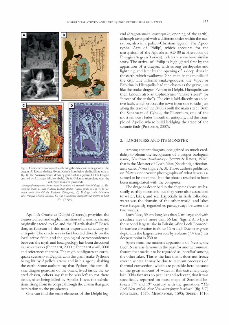
pagan cults to Christianity, while in pre-historic times asimilar passage occurred from the cult of chthonic Earthdivinities, often related to unexplained telluric forces (Cy-clops, Tytans, dragons, and so on) to a more heavenly re-ligion (the Olympians in the Mediterranean area). Thetelluric creatures were subjugated by the new divinity.The underworld, once their kingdom, becomes theirprison. Their sudden roars and powerful shakings con-tinue to make the earth tremble. So we have Apep over-thrown by Ra in ancient Egypt, Python slain by Apolloin Greece, Typhon overcast by Zeus in Sicily, Ravanapinned down by Shiva in India (fig. 1 A), Namazucrushed by Kashima in Japan (fig. 1 B), Michael defeatingthe Dragon in Italy (fig. 1 C), the Whale overcome byThunderbird in North America, and many others.The “sanctuaries” of these telluric monsters,
guardians of the gates to Hades, were therefore neces-sarily related to the presence of openings on the under-world. These sacred creatures of the underworld wereassociated to special places, Hades’ doors”, indicated astheir lair, their grave or the way through which theycame to the surface. An interdisciplinary survey on theseancient sacred sites, performed here in particular in theEast Mediterranean region, reveals that the close corre-spondences between the cult-sites and the local activefaults, so frequently observed, appears to be intentionaland significantly motivated (PICCARDI, 2001).Myths often associate the earth-shaking dragons
with a specific place, and in some case the geographicalreference may become accurate, linking the myth to aspecific spot. For instance, the flaming tongue of theChimaera, indestructible fire-breathing dragon killed byGreek hero Bellerofron, remained after her death in theform of an inextinguishable flame burning methane,which exhales out of the ground along a major activefault south of Antalya (Turkey). Similarly, the Hydra ofLerna (offspring of Typhon and Echidna and siblingof Chimaera and Cerberus) had his liar in the small Al-cyonian Lake, in the east coast of Peloponnesus, a fa-mous entrance to Hades, positioned above a seismicfault (PICCARDI, 2005 a). In many cases, sanctuaries have been built to pre-
serve the venerated spot, so that the geologic fulcrumof the cult remains incorporated into the sacred archi-tecture. Monte Sant’Angelo, in southern Italy, providesa brilliant example of such a kind of cult-site. Here thesanctuary was said to have been built expressly to pre-serve unusual “traces”, not better specified in the leg-end, found impressed in the rock after an earthquakeand interpreted as the “footprints” of ArchangelMichael. The connections of the sacred place withearthquakes, clearly highlighted in the myth, find strik-ing correspondences in local geology and arrangementof the sanctuary. The sacred “footprints” result to besmall seismic fractures, interpreted as supernatural bylocal people, opened at the entrance of what was al-ready a sacred cave (PICCARDI, 2005 b).
L. PICCARDI 432
Apollo’s Oracle at Delphi (Greece), provides theclearest, direct and explicit mention of a seismic chasm,originally sacred to Ge and the “Earth-shaker” Posei-don, as fulcrum of this most important sanctuary ofantiquity. The oracle was in fact located directly on thelocal active fault, and the geological correspondencesbetween the myth and local geology has been discussedin earlier works (PICCARDI, 2000 c; PICCARDI et alii, 2008and references therein). The myth configures an earth-quake scenario at Delphi, with the giant snake Pythonebeing hit by Apollo’s arrow and in his agony shakingthe earth. Some authors say that Python, the semi-di-vine dragon guardian of the oracle, lived inside the sa-cred chasm, others say that he was left to rot thereinside, after being killed by Apollo. It was the exhala-tions rising from its corpse through the chasm that gaveinspiration to the prophetess. One can find the same elements of the Delphi leg-
end (dragon-snake, earthquake, opening of the earth),although arranged with a different order within the nar-ration, also in a palaeo-Christian legend. The Apoc-rypha ‘Acts of Philip’, which accounts for themartyrdom of the Apostle in AD 80 at Hierapolis ofPhrygia (Aegean Turkey), relates a somehow similarstory. The arrival of Philip is highlighted first by theapparition of a dragon, with strong earthquake andlightning, and later by the opening of a deep abyss inthe earth, which swallowed 7000 men, in the middle ofthe city. The infernal snake-goddess, the Viper orEchidna in Hierapolis, had the chasm as the grave, justlike the snake-dragon Python in Delphi. Hierapolis wasthen known also as Ophioryme: “Snake street” (or“street of the snake”). The city is laid directly on an ac-tive fault, which crosses the town from side to side. Justalong the trace of the fault is built the main street. Boththe Sanctuary of Cybele, the Plutonium, one of themost famous Hades’ mouth of antiquity, and the Tem-ple of Apollo where build bridging the trace of theseismic fault (PICCARDI, 2007).
2. - LOCH NESS AND ITS MONSTER
Among ancient dragons, one gained so much cred-ibility to obtain the recognition of a proper biologicalname, Nessiteras rhombopteryx (SCOTT & RINES, 1976):that is the Monster of Loch Ness (Scotland), affection-ately called Nessie (figs. 2 A, 3). Those authors publishedon Nature underwater photographs of what it was as-sumed to be an animal, but the photos resulted to havebeen manipulated with the computer. The dragons described in the chapter above are ba-
sically earthly monsters, but they were also associatedto water, lakes, and sea. Especially in Irish folk-tales,water was the domain of the other-world, and lakeswere frequently regarded as passageways between thetwo worlds. Loch Ness, 39 km-long, less than 2 km-large and with
a surface area of more than 56 km² (figs. 2 A, 3 B), isthe second largest lake in Britain, after Loch Lomond.Its surface elevation is about 16 m a.s.l. Due to its greatdepth it is the largest reservoir by volume (7.4 km3). Itsdeepest point is 230 m.Apart from the modern apparitions of Nessie, the
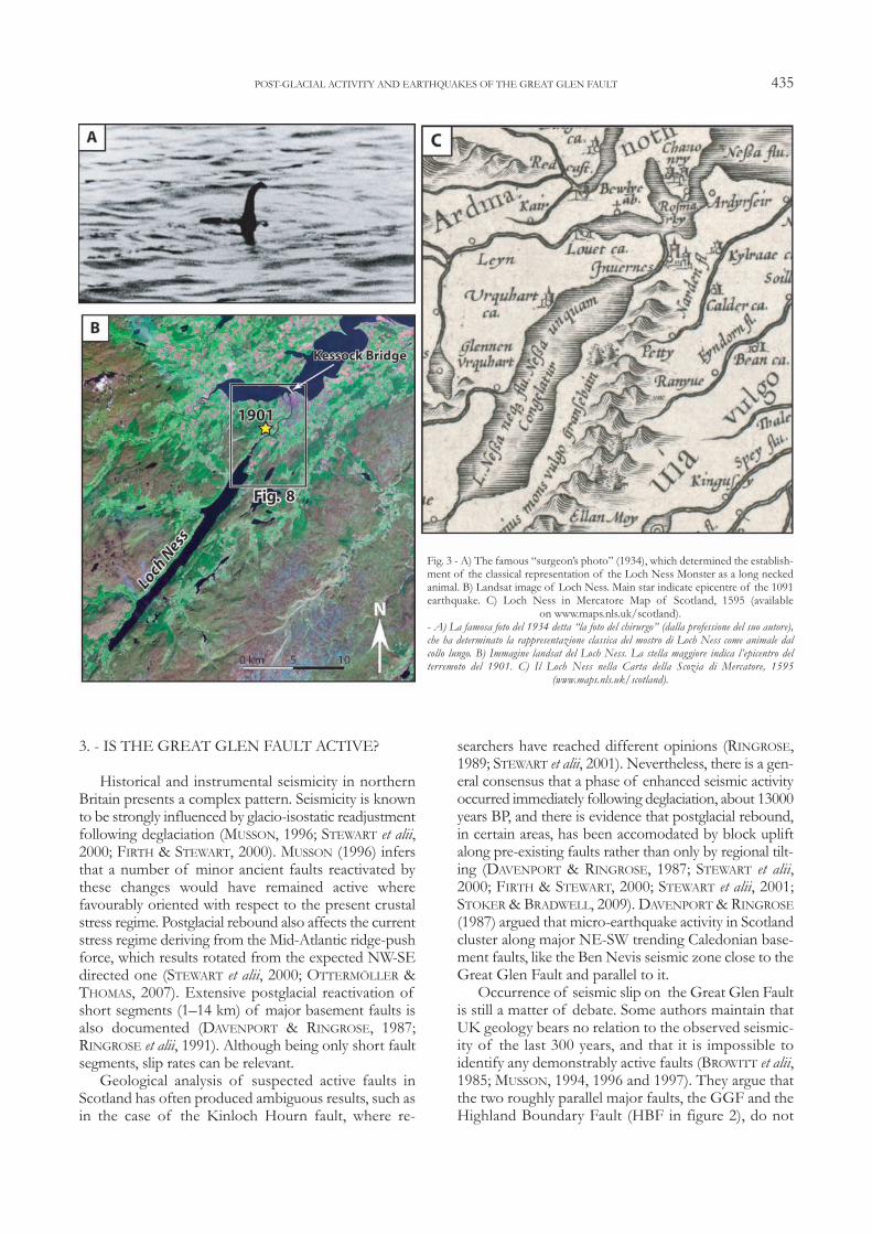
Loch Ness was famous in the past for another unusualfeature that made it to be regarded as ‘peculiar’ amongthe other lakes. This is the fact that it does not freezeover in winter. It may be due to relevant processes ofthermal convection, which are possible here becauseof the great amount of water in this extremely deeplake. This fact was so peculiar and relevant, that it wasspecifically reported on most maps of Scotland be-tween 17th and 19th century, with the quotation: “TheLoch Ness and the river Ness never frozen in winter” (fig. 3 C)(ORTELIUS, 1573; MERCATORE, 1595; SPEED, 1610;
POST-GLACIAL ACTIVITY AND EARTHQUAKES OF THE GREAT GLEN FAULT 433
Fig. 1 - Comparative iconographies showing the defeat and subjugation of thedragon. A) Ravana shaking Mount Kailash from below (India, Ellora cave n.16). B) The Namazu pinned down by god Kashima (Japan). C) The Dragoncrushed by Archangel Michael (Italy). D) St. Columba triumphing over the
Loch Ness monster (Scotland).- Iconografie comparate che mostrano la sconfitta e la sottomissione del drago. A) Ra-vana che scuote da sotto il Monte Kailash (India, Ellora, grotta n. 16). B) Il Na-mazu schiacciato dal dio Kashima (Giappone). C) Il drago schiacciato sottoall’Arcangelo Michele (Italia). D) San Colombano trionfante sul mostro di Loch
Ness (Scozia).
HONDIUS 1636; CORONELLI, 1696; available onwww.maps.nls.uk/scotland).
2.1. - NESSIE SIGHTINGS
The modern belief in Nessie mostly spread out in1933, after the road A82 was opened to traffic allowingtravel along the coast of the lake. Famous sightings,such as the so-called “surgeon’s photo” in 1934, con-solidated its iconography as the long necked ple-siosaurus familiar to most of us. Since then, there havebeen a large number of alleged sightings of the mon-ster, but none has produced convincing evidence of abeast. The photographs taken above water are all quitedifferent, showing a variety of creatures of differentsize and shape. Differing from what one could expect,the number of sightings seems to go down the morethe Loch is visited, so that we have now less picturesdocumenting Nessie than in the early years of the phe-nomenon. MACKAL (1976) studied a collection of ca. 10,000
reported sightings, the strongest evidence being by along the eyewitness reports. Out of these, after criticalexamination, he reduced the number of valid obser-vations, meaning that could not be accounted for byany other simple explanation, to less than 250. Ex-cluding from these deliberate hoaxes, misinterpretedspotting of animals or objects, and mirages due to airrefraction (e.g. LEHN, 1979), the predominance ofsightings resulted related to anomalous wave-wakes.
2.2. - LOCH NESS AND THE GREAT GLEN FAULT(GGF)
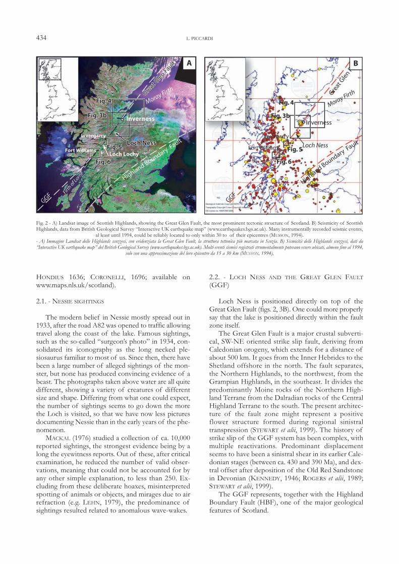
Loch Ness is positioned directly on top of theGreat Glen Fault (figs. 2, 3B). One could more properlysay that the lake is positioned directly within the faultzone itself. The Great Glen Fault is a major crustal subverti-
cal, SW-NE oriented strike slip fault, deriving fromCaledonian orogeny, which extends for a distance ofabout 500 km. It goes from the Inner Hebrides to theShetland offshore in the north. The fault separates,the Northern Highlands, to the northwest, from theGrampian Highlands, in the southeast. It divides thepredominantly Moine rocks of the Northern High-land Terrane from the Dalradian rocks of the CentralHighland Terrane to the south. The present architec-ture of the fault zone might represent a positiveflower structure formed during regional sinistraltranspression (STEWART et alii, 1999). The history ofstrike slip of the GGF system has been complex, withmultiple reactivations. Predominant displacementseems to have been a sinistral shear in its earlier Cale-donian stages (between ca. 430 and 390 Ma), and dex-tral offset after deposition of the Old Red Sandstonein Devonian (KENNEDY, 1946; ROGERS et alii, 1989;STEWART et alii, 1999).The GGF represents, together with the Highland
Boundary Fault (HBF), one of the major geologicalfeatures of Scotland.
L. PICCARDI 434
Fig. 2 - A) Landsat image of Scottish Highlands, showing the Great Glen Fault, the most prominent tectonic structure of Scotland. B) Seismicity of ScottishHighlands, data from British Geological Survey “Interactive UK earthquake map” (www.earthquakes.bgs.ac.uk). Many instrumentally recorded seismic events,
al least until 1994, could be reliably located to only within 30 to of their epicentres (MUSSON, 1994). - A) Immagine Landsat delle Highlands scozzesi, con evidenziata la Great Glen Fault, la struttura tettonica più marcata in Scozia. B) Sismicità delle Highlands scozzesi, dati da“Interactive UK earthquake map” del British Geological Survey (www.earthquakes.bgs.ac.uk). Molti eventi sismici registrati strumentalmente potevano essere ubicati, almeno fino al 1994,
solo con una approssimazione del loro epicentro da 15 a 30 km (MUSSON, 1994).
3. - IS THE GREAT GLEN FAULT ACTIVE?
Historical and instrumental seismicity in northernBritain presents a complex pattern. Seismicity is knownto be strongly influenced by glacio-isostatic readjustmentfollowing deglaciation (MUSSON, 1996; STEWART et alii,2000; FIRTH & STEWART, 2000). MUSSON (1996) infersthat a number of minor ancient faults reactivated bythese changes would have remained active wherefavourably oriented with respect to the present crustalstress regime. Postglacial rebound also affects the currentstress regime deriving from the Mid-Atlantic ridge-pushforce, which results rotated from the expected NW-SEdirected one (STEWART et alii, 2000; OTTERMÖLLER &THOMAS, 2007). Extensive postglacial reactivation ofshort segments (1–14 km) of major basement faults isalso documented (DAVENPORT & RINGROSE, 1987;RINGROSE et alii, 1991). Although being only short faultsegments, slip rates can be relevant.Geological analysis of suspected active faults in
Scotland has often produced ambiguous results, such asin the case of the Kinloch Hourn fault, where re-
searchers have reached different opinions (RINGROSE,1989; STEWART et alii, 2001). Nevertheless, there is a gen-eral consensus that a phase of enhanced seismic activityoccurred immediately following deglaciation, about 13000years BP, and there is evidence that postglacial rebound,in certain areas, has been accomodated by block upliftalong pre-existing faults rather than only by regional tilt-ing (DAVENPORT & RINGROSE, 1987; STEWART et alii,2000; FIRTH & STEWART, 2000; STEWART et alii, 2001;STOKER & BRADWELL, 2009). DAVENPORT & RINGROSE(1987) argued that micro-earthquake activity in Scotlandcluster along major NE-SW trending Caledonian base-ment faults, like the Ben Nevis seismic zone close to theGreat Glen Fault and parallel to it.Occurrence of seismic slip on the Great Glen Fault
is still a matter of debate. Some authors maintain thatUK geology bears no relation to the observed seismic-ity of the last 300 years, and that it is impossible toidentify any demonstrably active faults (BROWITT et alii,1985; MUSSON, 1994, 1996 and 1997). They argue thatthe two roughly parallel major faults, the GGF and theHighland Boundary Fault (HBF in figure 2), do not
POST-GLACIAL ACTIVITY AND EARTHQUAKES OF THE GREAT GLEN FAULT 435
Fig. 3 - A) The famous “surgeon’s photo” (1934), which determined the establish-ment of the classical representation of the Loch Ness Monster as a long neckedanimal. B) Landsat image of Loch Ness. Main star indicate epicentre of the 1091earthquake. C) Loch Ness in Mercatore Map of Scotland, 1595 (available
on www.maps.nls.uk/scotland).- A) La famosa foto del 1934 detta “la foto del chirurgo” (dalla professione del suo autore),che ha determinato la rappresentazione classica del mostro di Loch Ness come animale dalcollo lungo. B) Immagine landsat del Loch Ness. La stella maggiore indica l’epicentro delterremoto del 1901. C) Il Loch Ness nella Carta della Scozia di Mercatore, 1595
(www.maps.nls.uk/scotland).
show sign of present activity (MUSSON 1996, 1997,2001). They attribute, for instance, the 1901 earthquaketo a N-S oriented fault, supposed but apparently nototherwise documented, splaying from the GGF in thevicinity of Inverness (MUSSON, 1996, 1997; MUSSON,2001). Most authors consider instead the GGF to beactive and capable of seismic slip, as for instance in the1901 event (DAVISON, 1906, 1924; KENNEDY, 1946;LILWALL, 1976; WILLMORE et alii, 1977; PRENCE, 1995;COOPER & O’SULLIVAN, 1998; STEWART et alii, 1999;OTTERMÖLLER & THOMAS, 2007). STEWART et alii(1999), describe earthquake-related slump structures inunconsolidated glacial deposits adjacent to the shearzone, as evidence of present activity of the GGF. Achaotic layer ca. 35 cm thick, located at ca. 1.2 m depth,found in two drillings in the sediments at the bottomof Loch Ness, has been attributed to a slumping eventfrom the steep lake shores about 4000 yr BP (COOPER& O’SULLIVAN, 1998). Also other studies have indicatedthat these two major faults, the GGF and the HBF, areactive structures. In particular, OTTERMÖLLER &THOMAS (2007), studying the Aberfoyle earthquake se-quence of June-September 2003, concluded that theWSW–ENE striking causative fault was associated withthe HBF zone.Although many earthquakes initially located in the
Great Glen, like the 1934 event (August 16, M=4.1),have been later relocated (MUSSON, 1994), the area be-tween Loch Ness and Inverness remains one of themost seismically active ones in Great Britain. In the lasttwo centuries, at least three earthquakes hit this area(www.earthquakes.bgs.ac.uk): in 1816 (August 13, M =5.1, the strongest shock in Scotland), in 1890 (Novem-ber 16, M = 3.5) and in 1901 (September 18, I=VIII,M = 5).The September 18, 1901 Inverness earthquake
(Mk=5) deserves particular attention because it is thesecond strongest event in Scotland, and a largeamount of first-hand macroseismic data is available(figs. 3B and 8). The area was the object of a carefulpost-seismic survey, and the seismic sequence and itseffects were monitored by contemporaneous witnessand described in detail (e.g. DAVISON, 1906). Therewas about ten foreshocks and a very large number ofaftershocks (more than 50), whose sequence contin-ued until 12 November 1901 (MUSSON et alii, 1987).According to the macro-seismic observations, theearthquake was due to slip on the Great Glen Fault,and the fault had a vertical slip, albeit minimal, withdownthrown of its southern block (DAVISON, 1905,1906, 1915). The epicentre was determined about 2.5km ENE of Dochgarroch (figs. 3 B and 8). The focusof the tremor extended for about 8 km, from LochNess to Inverness. A break in the ground, a few cmwide and about 500 m long, was described along thenorthern bank of the Canal (v. fig. 8). Although sur-face faulting was excluded as origin of this crack, it
indicates the maximum intensity area.Because of the uncertainties of epicentre locations
ranging between 15 to 30 km until 1994 (MUSSON, 1994),it has often been difficult to assign single shocks to a de-termined fault. The recent earthquake of October 4, 2013,with a ML = 2.4, has instead been precisely located(www.earthquakes.bgs.ac.uk/earthquakes/recent_events/20131004204901.html#page=additional). It occurred onthe west bank of Loch Ness, at the very shallow depth of2 km, at the head of Urquhart Bay, which associate it withthe Great Glen Fault. The shock was felt up to 25 kmfrom the epicentre all along the Loch Ness and Invernessarea. Associated to ground shaking, many people de-scribed a sound like “a big rumbling bang”, “an explosion” or“a loud rumble”.(www.earthquakes.bgs.ac.uk/earthquakes/recent_events/.Despite the great interest for assessing active slip
on the GGF, discussion has generally been based onspeculations about epicentre locations (e.g. MUSSON,1997), and little field investigation has been devoted tothis specific aim. Much of the debate also focused intrying to distinguish between seismotectonic andglacio-seismotectonic activity, that is movement onfaults due to regional tectonics or due to post-glacialisostatic rebound. Defining the triggering cause of themovement remains beyond the scope of the presentwork. The area is subject to tectonic stress due both toexpansion of Atlantic Ocean and to glacial rebound,and most quakes are likely to be the result of the inter-play between these forces. The aim of the paper is onlyto assess whether post-glacial movement may have oc-curred on the GGF, i.e. if the fault is active and maytherefore originate earthquakes, although moderate.Our observations are consistent with the fact that atleast some slip may still presently occurs along theGGF, either due to tectonic stress or/and to postglacialrebound.
3.1. - EVIDENCE FOR POST-GLACIAL MOVEMENT ON THEGREAT GLEN FAULT
The Great Glen, the most prominent valley in Scot-land, is a rectilinear deep valley that runs for over 100km between Fort Williams and Inverness along theGGF zone. Much of the fault zone is submerged be-neath a series of elongated lakes. It is a fact that mostof present-day morphology of the Great Glen resultsfrom enhancement due to glacial erosion along theshattered rock of the fault zone, but this process alonecannot explain all of the present-day morphologies vis-ible along the fault. This paper presents geologic and geomorphic data
to show that slip, although at a slow rate, occurs alongthe GGF. Although movement may take place by in-dependent reactivation of blocks, evidence of slip is tobe seen all along the fault. Examples from key sites aredescribed here below.
L. PICCARDI 436
In the northeast sector the effects of ice-sheet flowand single glaciers are well preserved and constrained(fig. 4). The two sides of the GGF are visibly asymmet-ric, with a sharp rectilinear cliff on the north but not
on the south. Ice stream flow during the Last GlacialMaximum (LGM) is documented by the diffused andconsistent glacial streamlined landforms, such as flutingsand drumlins (e.g. CLARK et alii, 2004; FINLAYSON &
POST-GLACIAL ACTIVITY AND EARTHQUAKES OF THE GREAT GLEN FAULT 437
Fig. 4 - A) Digital elevation model of the Loch Ness-Moray Firth area, derived from the USGS/NASA SRTM data (JARVIS et alii, 2008), elaborated with GlobalMapper v8.01. Flutings and drumlins fields document the flow direction of the Moray Firth Ice Stream. B) Schematic representation of streamlined landforms
truncated by the Great Glen Fault, and flow direction of the Ardesier glacier.-A) Modello digitale del terreno dell’area Loch Ness-Moray Firth, dati USGS/NASA SRTM (JARVIS et alii, 2008) elaborati con Global Mapper v8.01. morfologie glaciali (flutingsand drumlins) documentano la direzione di flusso della corrente glaciale di Moray Firth. B) Rappresentazione schematica delle morfologie glaciali troncate dalla Great Glen Fault, e la
direzione di flusso del ghiacciaio di Ardesier.
BRADWELL, 2008). Fluted morphologies make an anglewith the fault, resulting truncated in correspondenceof it. This demonstrates the independence of this es-carpment from ice flow pattern and relative scouring,constraining activity of the GGF to be at least post-Last Glacial Maximum (LGM, from about 28 to 18 kaBP, e.g. EVANS et alii, 2005). Such linear cliff cannot bedue to sea erosion. Nor it can be due to action of thereadvancing Ardesier glacier shortly after 13000 yearsBP. Decay of the main Late Devensian ice sheet wasinterrupted by a series of readvances and stillstands.During the Ardesier Readvance (ca. 13 ka BP), iceflowed via the Beauly Firth and Great Glen to createthe ice-pushed front moraines forming the curvedArdesier Peninsula (e.g. PEACOCK & HARKNESS, 1990;
MERRIT et alii, 1995). The GGF escarpment results un-influenced by extent of that glacier. Moreover, NE ofInverness at Fortrose, and SW of it between Dochgar-roch and Torvean, the fault trace is marked by a scarp atthe contact between the substratum and the glacial de-posits, consistent with post-13 ka BP activity of theGGF. Also the bottlenecks of the Beauly and CromartyFirths glacial valleys at crossing the fault, provide furtherindication of post-glacial uplift of the GGF.In the central sector of the Great Glen, the clearest
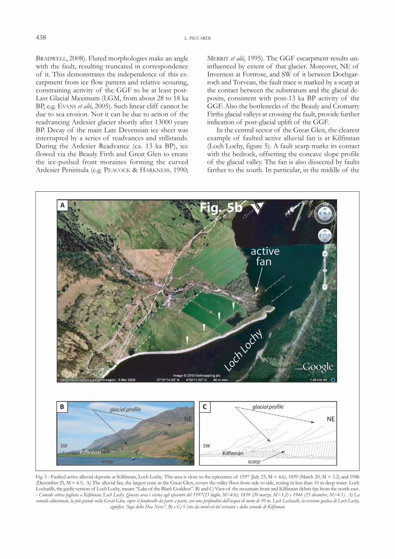
example of faulted active alluvial fan is at Kilfinnan(Loch Lochy, figure 5). A fault scarp marks its contactwith the bedrock, offsetting the concave slope profileof the glacial valley. The fan is also dissected by faultsfarther to the south. In particular, in the middle of the
L. PICCARDI 438
Fig. 5 - Faulted active alluvial deposits at Kilfinnan, Loch Lochy. This area is close to the epicentres of 1597 (July 23, M = 4.6), 1839 (March 20, M = 3.2) and 1946(December 25, M= 4.1). A) The alluvial fan, the largest cone in the Great Glen, covers the valley floor from side to side, resting in less than 10 m deep water. LochLochaidh, the gaelic version of LochLochy, means “Lakeof theBlack Goddess”. B) and C)Viewof the mountain front and Kilfinnan debris fan from the north-east.- Conoide attiva fagliata a Kilfinnan, Loch Lochy. Questa area è vicina agli epicentri del 1597(23 luglio, M=4.6), 1839 (20 marzo, M=3.2) e 1946 (25 dicembre, M=4.1). A) Laconoide alluvionale, la più grande nella Great Glen, copre il fondovalle da parte a parte, con una profondità dell’acqua di meno di 10 m. Loch Lochaidh, la versione gaelica di Loch Lochy,
significa “lago della Dea Nera”. B) e C) Vista da nord-est del versante e della conoide di Kilfinnan.
valley, a small graben structure, making an angle withthe main direction of GGF, controls on-going deposi-tion. This attests the present-day activity of these faults. Also in the southwest sector there is a marked asym-
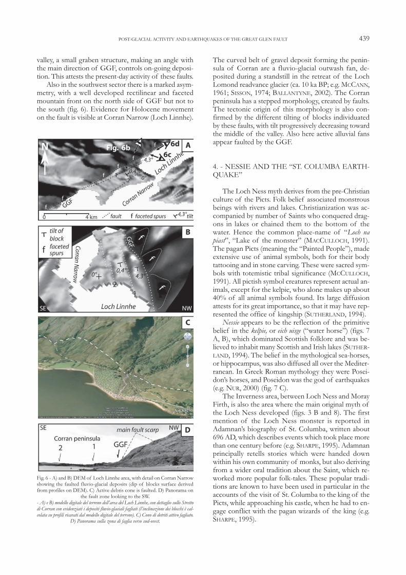
metry, with a well developed rectilinear and facetedmountain front on the north side of GGF but not tothe south (fig. 6). Evidence for Holocene movementon the fault is visible at Corran Narrow (Loch Linnhe).
The curved belt of gravel deposit forming the penin-sula of Corran are a fluvio-glacial outwash fan, de-posited during a standstill in the retreat of the LochLomond readvance glacier (ca. 10 ka BP; e.g. MCCANN,1961; SISSON, 1974; BALLANTYNE, 2002). The Corranpeninsula has a stepped morphology, created by faults.The tectonic origin of this morphology is also con-firmed by the different tilting of blocks individuatedby these faults, with tilt progressively decreasing towardthe middle of the valley. Also here active alluvial fansappear faulted by the GGF.
4. - NESSIE AND THE “ST. COLUMBA EARTH-QUAKE”
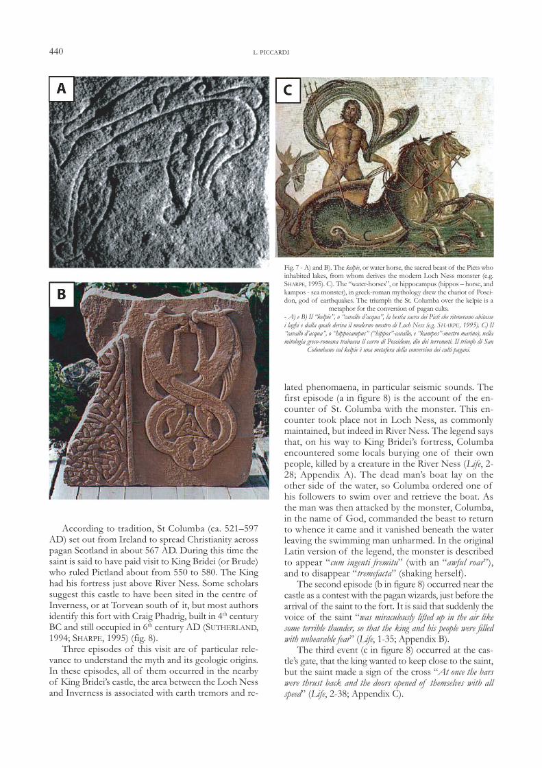
The Loch Ness myth derives from the pre-Christianculture of the Picts. Folk belief associated monstrousbeings with rivers and lakes. Christianization was ac-companied by number of Saints who conquered drag-ons in lakes or chained them to the bottom of thewater. Hence the common place-name of “Loch napiast”, “Lake of the monster” (MACCULLOCH, 1991).The pagan Picts (meaning the “Painted People”), madeextensive use of animal symbols, both for their bodytattooing and in stone carving. These were sacred sym-bols with totemistic tribal significance (MCCULLOCH,1991). All pictish symbol creatures represent actual an-imals, except for the kelpie, who alone makes up about40% of all animal symbols found. Its large diffusionattests for its great importance, so that it may have rep-resented the office of kingship (SUTHERLAND, 1994). Nessie appears to be the reflection of the primitive
belief in the kelpie, or eich uisge (“water horse”) (figs. 7A, B), which dominated Scottish folklore and was be-lieved to inhabit many Scottish and Irish lakes (SUTHER-LAND, 1994). The belief in the mythological sea-horses,or hippocampus, was also diffused all over the Mediter-ranean. In Greek Roman mythology they were Posei-don’s horses, and Poseidon was the god of earthquakes(e.g. NUR, 2000) (fig. 7 C).The Inverness area, between Loch Ness and Moray
Firth, is also the area where the main original myth ofthe Loch Ness developed (figs. 3 B and 8). The firstmention of the Loch Ness monster is reported inAdamnan’s biography of St. Columba, written about696 AD, which describes events which took place morethan one century before (e.g. SHARPE, 1995). Adamnanprincipally retells stories which were handed downwithin his own community of monks, but also derivingfrom a wider oral tradition about the Saint, which re-worked more popular folk-tales. These popular tradi-tions are known to have been used in particular in theaccounts of the visit of St. Columba to the king of thePicts, while approaching his castle, when he had to en-gage conflict with the pagan wizards of the king (e.g.SHARPE, 1995).
POST-GLACIAL ACTIVITY AND EARTHQUAKES OF THE GREAT GLEN FAULT 439
Fig. 6 - A) and B) DEM of Loch Linnhe area, with detail on Corran Narrowshowing the faulted fluvio-glacial deposits (dip of blocks surface derivedfrom profiles on DEM). C) Active debris cone is faulted. D) Panorama on
the fault zone looking to the SW. - A) e B) modello digitale del terreno dell’area del Loch Linnhe, con dettaglio sullo Strettodi Corran con evidenziati i depositi fluvio-glaciali fagliati (l’inclinazione dei blocchi è cal-colata su profili ricavati dal modello digitale del terreno). C) Cono di detriti attivo fagliato.
D) Panorama sulla zona di faglia verso sud-ovest.
According to tradition, St Columba (ca. 521–597AD) set out from Ireland to spread Christianity acrosspagan Scotland in about 567 AD. During this time thesaint is said to have paid visit to King Bridei (or Brude)who ruled Pictland about from 550 to 580. The Kinghad his fortress just above River Ness. Some scholarssuggest this castle to have been sited in the centre ofInverness, or at Torvean south of it, but most authorsidentify this fort with Craig Phadrig, built in 4th centuryBC and still occupied in 6th century AD (SUTHERLAND,1994; SHARPE, 1995) (fig. 8). Three episodes of this visit are of particular rele-
vance to understand the myth and its geologic origins.In these episodes, all of them occurred in the nearbyof King Bridei’s castle, the area between the Loch Nessand Inverness is associated with earth tremors and re-
lated phenomaena, in particular seismic sounds. Thefirst episode (a in figure 8) is the account of the en-counter of St. Columba with the monster. This en-counter took place not in Loch Ness, as commonlymaintained, but indeed in River Ness. The legend saysthat, on his way to King Bridei’s fortress, Columbaencountered some locals burying one of their ownpeople, killed by a creature in the River Ness (Life, 2-28; Appendix A). The dead man’s boat lay on theother side of the water, so Columba ordered one ofhis followers to swim over and retrieve the boat. Asthe man was then attacked by the monster, Columba,in the name of God, commanded the beast to returnto whence it came and it vanished beneath the waterleaving the swimming man unharmed. In the originalLatin version of the legend, the monster is describedto appear “cum ingenti fremitu” (with an “awful roar”),and to disappear “tremefacta” (shaking herself).The second episode (b in figure 8) occurred near the
castle as a contest with the pagan wizards, just before thearrival of the saint to the fort. It is said that suddenly thevoice of the saint “was miraculously lifted up in the air likesome terrible thunder, so that the king and his people were filledwith unbearable fear” (Life, 1-35; Appendix B).The third event (c in figure 8) occurred at the cas-
tle’s gate, that the king wanted to keep close to the saint,but the saint made a sign of the cross “At once the barswere thrust back and the doors opened of themselves with allspeed” (Life, 2-38; Appendix C).
L. PICCARDI 440
Fig. 7 - A) and B). The kelpie, or water horse, the sacred beast of the Picts whoinhabited lakes, from whom derives the modern Loch Ness monster (e.g.SHARPE, 1995). C). The “water-horses”, or hippocampus (hippos – horse, andkampos - sea monster), in greek-roman mythology drew the chariot of Posei-don, god of earthquakes. The triumph the St. Columba over the kelpie is a
metaphor for the conversion of pagan cults.- A) e B) Il “kelpie”, o “cavallo d’acqua”, la bestia sacra dei Picti che ritenevano abitassei laghi e dalla quale deriva il moderno mostro di Loch Ness (e.g. SHARPE, 1995). C) Il“cavallo d’acqua”, o “hippocampus” (“hippos”-cavallo, e “kampos”-mostro marino), nellamitologia greco-romana trainava il carro di Poseidone, dio dei terremoti. Il trionfo di San
Colombano sul kelpie è una metafora della conversion dei culti pagani.
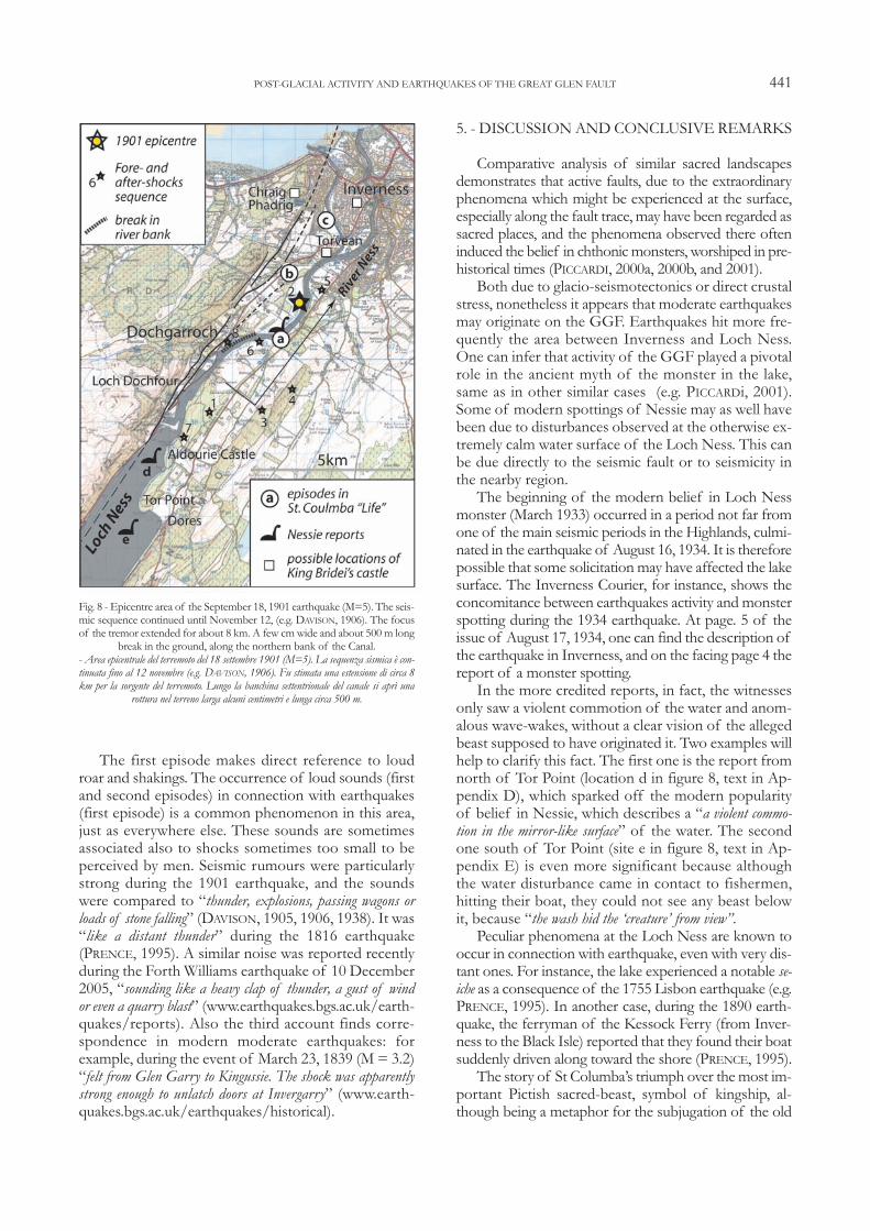
The first episode makes direct reference to loudroar and shakings. The occurrence of loud sounds (firstand second episodes) in connection with earthquakes(first episode) is a common phenomenon in this area,just as everywhere else. These sounds are sometimesassociated also to shocks sometimes too small to beperceived by men. Seismic rumours were particularlystrong during the 1901 earthquake, and the soundswere compared to “thunder, explosions, passing wagons orloads of stone falling” (DAVISON, 1905, 1906, 1938). It was“like a distant thunder” during the 1816 earthquake(PRENCE, 1995). A similar noise was reported recentlyduring the Forth Williams earthquake of 10 December2005, “sounding like a heavy clap of thunder, a gust of windor even a quarry blast” (www.earthquakes.bgs.ac.uk/earth-quakes/reports). Also the third account finds corre-spondence in modern moderate earthquakes: forexample, during the event of March 23, 1839 (M = 3.2)“felt from Glen Garry to Kingussie. The shock was apparentlystrong enough to unlatch doors at Invergarry” (www.earth-quakes.bgs.ac.uk/earthquakes/historical).
5. - DISCUSSION AND CONCLUSIVE REMARKS
Comparative analysis of similar sacred landscapesdemonstrates that active faults, due to the extraordinaryphenomena which might be experienced at the surface,especially along the fault trace, may have been regarded assacred places, and the phenomena observed there ofteninduced the belief in chthonic monsters, worshiped in pre-historical times (PICCARDI, 2000a, 2000b, and 2001).Both due to glacio-seismotectonics or direct crustal
stress, nonetheless it appears that moderate earthquakesmay originate on the GGF. Earthquakes hit more fre-quently the area between Inverness and Loch Ness.One can infer that activity of the GGF played a pivotalrole in the ancient myth of the monster in the lake,same as in other similar cases (e.g. PICCARDi, 2001).Some of modern spottings of Nessie may as well havebeen due to disturbances observed at the otherwise ex-tremely calm water surface of the Loch Ness. This canbe due directly to the seismic fault or to seismicity inthe nearby region.The beginning of the modern belief in Loch Ness
monster (March 1933) occurred in a period not far fromone of the main seismic periods in the Highlands, culmi-nated in the earthquake of August 16, 1934. It is thereforepossible that some solicitation may have affected the lakesurface. The Inverness Courier, for instance, shows theconcomitance between earthquakes activity and monsterspotting during the 1934 earthquake. At page. 5 of theissue of August 17, 1934, one can find the description ofthe earthquake in Inverness, and on the facing page 4 thereport of a monster spotting.In the more credited reports, in fact, the witnesses
only saw a violent commotion of the water and anom-alous wave-wakes, without a clear vision of the allegedbeast supposed to have originated it. Two examples willhelp to clarify this fact. The first one is the report fromnorth of Tor Point (location d in figure 8, text in Ap-pendix D), which sparked off the modern popularityof belief in Nessie, which describes a “a violent commo-tion in the mirror-like surface” of the water. The secondone south of Tor Point (site e in figure 8, text in Ap-pendix E) is even more significant because althoughthe water disturbance came in contact to fishermen,hitting their boat, they could not see any beast belowit, because “the wash hid the ‘creature’ from view”.Peculiar phenomena at the Loch Ness are known to
occur in connection with earthquake, even with very dis-tant ones. For instance, the lake experienced a notable se-iche as a consequence of the 1755 Lisbon earthquake (e.g.PRENCE, 1995). In another case, during the 1890 earth-quake, the ferryman of the Kessock Ferry (from Inver-ness to the Black Isle) reported that they found their boatsuddenly driven along toward the shore (PRENCE, 1995).The story of St Columba’s triumph over the most im-
portant Pictish sacred-beast, symbol of kingship, al-though being a metaphor for the subjugation of the old
POST-GLACIAL ACTIVITY AND EARTHQUAKES OF THE GREAT GLEN FAULT 441
Fig. 8 - Epicentre area of the September 18, 1901 earthquake (M=5). The seis-mic sequence continued until November 12, (e.g. DAVISON, 1906). The focusof the tremor extended for about 8 km. A few cm wide and about 500 m long
break in the ground, along the northern bank of the Canal.- Area epicentrale del terremoto del 18 settembre 1901 (M=5). La sequenza sismica è con-tinuata fino al 12 novembre (e.g. DAVISON, 1906). Fu stimata una estensione di circa 8km per la sorgente del terremoto. Lungo la banchina settentrionale del canale si aprì una
rottura nel terreno larga alcuni centimetri e lunga circa 500 m.
religion, nevertheless contains information on an ancientsacred belief, based on telluric manifestations and local-ized at River Ness, the dragon’s lair. It cannot be ignoredthat this place is the sector of the Great Glen Fault morefrequently hit by the strongest earthquake in the past (fig.3B). The localization of the victory of the Saint over thekelpie at this site, points to this place as particularly im-portant in the ancient cult at that time, indicating that thisarea was already experienced at that time as a seismic one.The GGF shows geologic and geomorphic evi-
dence of active slip, although at a slow rate, and maygenerate moderate earthquakes. In the NE sector ofGGF, the fault post-date both the streamlined land-forms of Last Glacial Maximum (28-18 ka BP), as wellas the Ardesier readvance moraines and the glacial de-posits SW of Inverness (ca. 13 ka BP). Dissectedglacio-fluvial deposits at Corran Narrow indicate slipon the fault to post-date the Loch Lomond readvancephase (10 ka BP). Faulted active alluvial fans at LochLochy and Loch Linnhe, central and southwest sectorsrespectively, reveal that movement is still ongoing. In fact, the Kessock Bridge (fig. 3B), opened in 1982
to carry the A9 road north from Inverness to the BlackIsle across the Great Glen Fault, is the only bridge inGreat Britain built with anti-earthquake buffers, in-stalled in the north abutment, right above the fault.Similarly, a project for a sewage water seabed pipelinestraddling the GGF line at Kessock has been designed,in September 2008, with a degree of flexibility to copewith earthquakes.Major evidence of active slip occur on the northern
side of the GGF, a south facing sub-vertical fault, whichseems therefore to be the main active fault of the GGFsystem. The possible inference of a small component ofdextral slip, as could be envisaged by arrangement ofsplay structures (figs. 5 and 8), remains speculative.We cannot unambiguously discern if an earthquake
actually occurred at the time of St. Columba, or if thestory reworked instead folk-tales containing memoriesof a past earthquake. Both possibilities remain open.Nevertheless, this legend reveals that an earthquake mayhave occurred about that time, or little earlier, with epi-centre in the area of River Ness, where the episodes arelocated. The phenomena reported in the legend corre-spond to facts historically observed here during earth-quakes of magnitude 3 to 5, like codified images of realseismic phenomena. This event, that we may indicate asthe “St. Columba earthquake”, appears therefore to besomehow similar to the 1901 event, documenting an an-cient (6th century?) seismic slip on the Great Glen Fault.Some of modern spotting of the Nessie may as well
have been due to disturbances observed at the otherwiseextremely calm water surface of the Loch Ness. This canbe due directly to the seismic fault or to seismicity in thenearby region (or even distant, as in the case of the localseiche consequent to the 1755, Lisbon earthquake (e.g.PRENCE, 1995).
5.1. - OTHER EXAMPLES OF TELLURIC FAMOUS LAKEMONSTERS
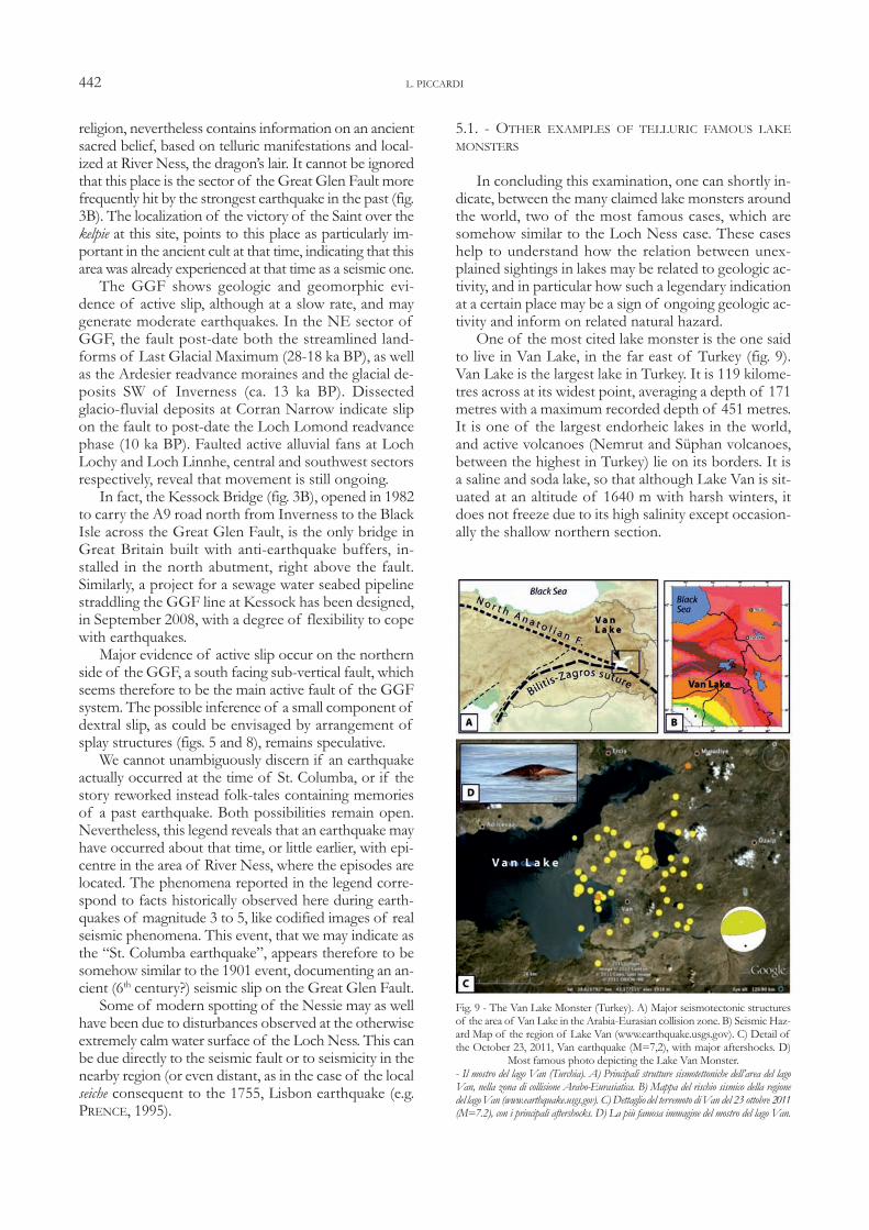
In concluding this examination, one can shortly in-dicate, between the many claimed lake monsters aroundthe world, two of the most famous cases, which aresomehow similar to the Loch Ness case. These caseshelp to understand how the relation between unex-plained sightings in lakes may be related to geologic ac-tivity, and in particular how such a legendary indicationat a certain place may be a sign of ongoing geologic ac-tivity and inform on related natural hazard.One of the most cited lake monster is the one said
to live in Van Lake, in the far east of Turkey (fig. 9).Van Lake is the largest lake in Turkey. It is 119 kilome-tres across at its widest point, averaging a depth of 171metres with a maximum recorded depth of 451 metres.It is one of the largest endorheic lakes in the world,and active volcanoes (Nemrut and Süphan volcanoes,between the highest in Turkey) lie on its borders. It isa saline and soda lake, so that although Lake Van is sit-uated at an altitude of 1640 m with harsh winters, itdoes not freeze due to its high salinity except occasion-ally the shallow northern section.
L. PICCARDI 442
Fig. 9 - The Van Lake Monster (Turkey). A) Major seismotectonic structuresof the area of Van Lake in the Arabia-Eurasian collision zone. B) Seismic Haz-ard Map of the region of Lake Van (www.earthquake.usgs.gov). C) Detail ofthe October 23, 2011, Van earthquake (M=7,2), with major aftershocks. D)
Most famous photo depicting the Lake Van Monster.- Il mostro del lago Van (Turchia). A) Principali strutture sismotettoniche dell’area del lagoVan, nella zona di collisione Arabo-Eurasiatica. B) Mappa del rischio sismico della regionedel lagoVan (www.earthquake.usgs.gov). C) Dettaglio del terremoto diVan del 23 ottobre 2011(M=7.2), con i principali aftershocks. D) La più famosa immagine del mostro del lago Van.
The Lake Van Monster was not reported until 1995,but there are now more than 1000 people claiming tohave witnessed the beast, which is reported to measurearound fifteen meters long, with spikes on its back, andappears similar to a Plesiosaur or Ichthyosaurus. Re-searches showed creature first mentioned on Saadetnewspaper’s (a newspaper published at Istanbul at thetime) April, 29, 1889 issue, says that the creaturedragged a man into lake. Following these reports theTurkish government sent an official scientific surveygroup to the lake who failed to spot the creature. In1997 a teaching assistant at Van University, claimed tohave captured the creature on video, which was sentfor analysis, but his video is under constant criticism.The Van Lake is situated in one of the most tecton-
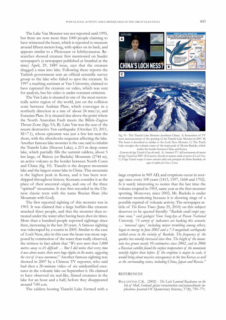
ically active region of the world, just on the collisionzone between Arabian Plate, which converges in anortherly direction at a rate of about 24 mm/yr, andEurasian Plate. It is situated due above the point wherethe North Anatolian Fault meets the Bilitis-ZagrosThrust Zone (figs. 9A, B). Lake Van was the seat of therecent destructive Van earthquake (October 23, 2011,M=7.1), whose epicentre was just a few km near theshore, with the aftershocks sequence affecting the lake. Another famous lake monster is the one said to inhabitthe Tianchi Lake (Heaven Lake), a 213 m deep craterlake, which partially fills the summit caldera, about 5km large, of Baitou (or Baekdu) Mountain (2744 m),an active volcano at the border between North Coreaand China (fig. 10). Tianchi is the deepest mountainlake and the largest crater lake in China. This mountainis the highest peak in Korea, and it has been wor-shipped throughout history. Koreans consider it as theplace of their ancestral origin, and one of the three“spirited” mountains. It was first recorded in the Chi-nese classic texts with the name Buxian Shan (theMountain with God).The first reported sighting of this monster was in
1903. It was claimed that a large buffalo-like creatureattacked three people, and that the monster then re-treated under the water after having been shot six times.More than a hundred people reported sightings sincethen, increasing in the last 20 years. A famous sightingwas videotaped by a tourist in 2005. Similar to the caseof Loch Ness, also in this case the beast was more sup-posed by commotion of the water than really observed,the witness in fact admit that “We were more than 1,000metres away so it’s difficult … But I did notice that every timeit was above water, there were huge ripples in the water, suggestingthe rest of it was enormous.” Another famous sighting wasshowed in 2007 by a Chinese TV reporter, who saidhad shot a 20-minute video of six unidentified crea-tures in the volcanic lake on September 6. He claimedto have observed six seal-like, finned creatures in thelake for an hour and a half, before they disappearedaround 7:00 a.m. The caldera hosting Tianchi Lake formed with a
large eruption in 969 AD, and eruptions occur in aver-age once every 100 years (1413, 1597, 1668 and 1702).Is it surely interesting to notice that the last time thevolcano erupted in 1903, same year as the first monsterspotting. Moreover, since 2002, Mt. Baekdu is underconstant monitoring because it is showing sings of apossible reprisal of volcanic activity. The newspaper ar-ticle of The Korea Times (June 25, 2010) on this subjectdeserves to be quoted literally: “Baekdu could erupt any-time soon,” said geologist Yoon Sung-hyo at Pusan NationalUniversity. “A variety of indicators are backing this scenario.… ‘unusual signs,’ including minor trembling among others,began to emerge in June 2002 and a 7.3-magnitude earthquakerattled areas in the vicinity of Baekdu. The frequency of thequakes has notably increased since then. The height of the moun-tain has grown nearly 10 centimetres since 2002, and in 2006a Russian satellite found the surface temperature of the mountainnotably higher than before. If the eruption is major in scale, itwould bring about massive consequences to the two Koreas as wellas the surrounding states, including China, Japan and Russia.”
REFERENCES
BALLANTYNE C.K. (2002) - The Loch Lomond Readvance on theIsle of Mull, Scotland: glacier reconstruction and palaeoclimatic im-plications. Journal Of Quaternary Science, 17(8), 759–771.
POST-GLACIAL ACTIVITY AND EARTHQUAKES OF THE GREAT GLEN FAULT 443
Fig. 10 - The Tianchi Lake Monster (northern China). A) Screenshot of TVnews announcement of the spotting of the Tianchi Lake Monster in 2007. B)The beast is described as similar to the Loch Ness Monster. C) The TiachiLake occupies the volcanic crater of the main peak of Mount Baekdu, which
marks the border between China and Korea.- Il mostro del lago Tianchi (Cina del nord). A) Annuncio TV dell’avvistamento del mostrodel lago Tianchi nel 2007. B) Il mostro è descritto in maniera simile al mostro di Loch Ness.C) Il lago Tianchi occupa il cratere vulcanico della vetta principale del Monte Baedkdu, che
segna il confine fra Cina e Corea.

BROWITT C.W.A., TURBITT T. & MORGAN S.N. (1985) - Inve-stigation of British earthquakes using the national monitoring net-work of the British Geological Survey. In: EarthquakeEngineering in Britain. Thomas Telford Ltd., London,pp. 33}47.
CAMPBELL S. (1996) - The Loch Ness Monster: the evidence. Re-vised from the 1986 first edition, (Ed.) Birlinn Ltd, Edin-bourgh, 128 pp.
CLARK C.D., EVANS D.J.A., KHATWA A., BRADWELL T., JOR-DAN C.J., MARSH S.H., MITCHELL W.A. & BATEMAN M.D.(2004) - Map and GIS database of glacial landforms and featuresrelated to the last British Ice Sheet. Boreas, 33, 359–375.
COOPER M.C. & O’SULLIVAN P.E. (1998) - The laminated sedi-ments of Loch Ness, Scotland: preliminary report on the construc-tion of a chronology of sedimentation and its potential use inassessing Holocene climatic variability. Palaeogeography, Pala-eoclimatology, Palaeoecology, 140, 23-31.
DAVENPORT C.A. & RINGROSE P.S. (1987) - Deformation ofScottish Quaternary sediment sequences by strong earthquake mo-tions. In: M.E. JONES & R.M.F. PRESTON (Eds.), “Defor-mation of Sediments and Sedimentary Rocks”, The GeologicalSociety, London, Special Publication, 29, 299-314.
DAVISONC. (1905) - A study of recent earthquakes. The Walter ScottPublishing Co., London and Newcastle-on-Tyne, 355 pp.
DAVISON C. (1906) - Earthquake of 18th September 1901. Tran-saction of the Inverness Scientific Society and Field Club,6, 192-204.
DAVISON C. (1915) - Earthquakes in Great Britain (1889-1914).The Geographical Journal, 46, 5, 357-374.
DAVISON C. (1924) - A history of British earthquakes. Cam-bridge University Press, Cambridge, 416 pp.
DAVISON C. (1938) - Earthquake sounds. Bulletin of the Seismo-logical Society of America. 28, 3, 147-161.
EVANS D.J.A., CLARK C.D. & MITCHELL W.A. (2005) - Thelast British ice sheet: a review of the evidence utilised in the compi-lation of the Glacial Map of Britain. Earth-Science Review,70, 253-312.
FINLAYSON A.W. & BRADWELL T. (2008) - Morphological cha-racteristics, formation and glaciological significance of Rogen mo-raine in northern Scotland. Geomorphology, 101, 607-617.
FIRTH C.R. & STEWART I.S. (2000) - Postglacial tectonics of theScottish glacio-isostatic uplift centre. Quaternary Science Re-views, 19, 1469-1493.
KENNEDYW.Q. (1946) - The Great Glen Fault. The Quarterly Jour-nal of Geological Society of London, 102, 1, n. 405, 41-76.
JARVIS A., REUTER H.I., NELSON A. & GUEVARA E. (2008) -Hole-filled seamless SRTM data V4. International Centre forTropical Agriculture (CIAT), available fromhttp://srtm.csi.cgiar.org.
LEHN W.H. (1979) - Atmospheric refraction and lake monsters.Science, 205, p. 183-185.
LILWALL R.C. (1976) - Seismicity and seismic hazard in Britain. Sei-smological Bulletin, Institute of Geological Sciences, 4, 9 pp.
MCCANN S.B. (1961) - Some supposed “raised beach” deposits atCorran, Loch Linnhe and Loch Etive. Geological Magazine,98 (2), 131-142.
MACCULLOCH J.A. (1991) - The religion of ancient Celts. Con-stable & Co. (Ed.), London, 399 pp.
MACKAL R. (1976) - The Monster of Loch Ness. Swallow PressInc., Chicago.
MERRIT J.W., AUTON C.A. & FIRTH C.R. (1995) - Ice-proximalgraciomarine sedimentation and sea-level change in the Invernessarea, Scotland: a review of the deglaciation of a major ice streamof the British Late Devensian ice sheet.
MUSSON R.M.W. (1994) - A catalogue of British earthquakes.BGS Global Seismology Report WL/94/04, 99 pp.
MUSSON R.M.W. (1996) - The seismicity of the British Isles. An-nali di Geofisica, 39, 3, 463-469.
MUSSON R.M.W. (1997) - Seismic hazard studies in the U.K.: sourcespecification problems of intraplate seismicity. Natural hazards,15, 105-119.
MUSSON R.M.W. (2001) - Letter to “The Times”. 30 June 2001(also as BGS News Release,http://www.bgs.ac.uk/scripts/news/view_news.cfm?id=114, on June 28, 2001).
NUR A. (2000) - Poseidon’s Horses: Plate Tectonics and EarthquakeStorms in the Late Bronze Age Aegean and Eastern Mediterra-nean. Journal of Archaeological Science, 27, 43-63.
OTTERMÖLLER L. & THOMAS C.W. (2007) - Highland BoundaryFault Zone: tectonic implications of the Aberfoyle earthquake se-quence of 2003. Tectonophysics, 430, 83-95.
PEACOCK J.D. & HARKNESS D.D. (1990) - Radiocarbon ages andthe full-glacial to Holocene transition in seas adjacent to Scotlandand southern Scandinavia: A review. Transactions of theRoyal Society of Edinburgh: Earth Sciences, 81, 385-396.
PICCARDI L. (2000a) - Adoration of active faults in the East Mediter-ranean region. Abstracts CD-ROM, 31st International Geo-logical Congress, Brasile, Rio de Janeiro, August 5-15, 2000.
PICCARDI L. (2000b) - Mythology of active faults: the dragon’s lair.1st Stephan Mueller Conference of the European Geo-physical Society: “From Continental Breakup to Collision”,Israele, Dead Sea, June 11-16, 2000.
PICCARDI L. (2000c) - Active faulting at Delphi: seismotectonic re-marks and a hypothesis for the geological environment of a myth.Geology, 28, 651-654.
PICCARDI L. (2001) - Fault-Related Sanctuaries. Eos. Trans.AGU, 82 (47), Fall Meet. 2001, U52B-03.
PICCARDI L. (2005a) - The head of the Hydra of Lerna (Greece).In: Section 11, The Bronze Age in Europe and the Me-diterranean, Acts of the 14th UISPP Congress, Liège, 2-8 Settembre 2001, Archaeopress, British ArchaeologicalReports, International Series N° 1337/2005, 179-186.
PICCARDI L. (2005b) - Paleoseismic evidence of legendary earth-quakes: the apparition of Archangel Michael at Monte Sant’An-gelo (Gargano, Italy). Tectonophysics, 408, 113-128.
PICCARDI L. (2007) - The AD 60 Denizli Basin earthquake andthe apparition of Archangel Michael at Colossae (Aegean Tur-key). In: L. PICCARDI & W.B. MASSE (Eds.), 2007: Mythand Geology. Geological Society, London, Special Publica-tions, 273, 95-105.
PICCARDI L., MONTI C., VASELLI O., TASSI F., GAKI-PAPANA-STASSIOU K. & PAPANASTASSIOU D. (2008) - Scent of amyth: tectonics, geochemistry and geomythology at Delphi (Greece).Journal of the Geological Society, London, 165, 5-18.
PRENCE R. (1995) - Earthquakes in the Inverness area. ScottishAssociation of Geography Teachers’ Joural, 24, 43-53.
RINGROSE P.S. (1989) - Recent fault movement and palaeoseismicityin western Scotland. Tectonophysics, 163, 305-314.
RINGROSE P.S., HANCOCK O.L., FENTON C. & DAVENPORTC.A. (1991) - Quaternary tectonic activity in Scotland. In: FOSTERA., CULSHAW M.G., CRIPPS J.C., LITTLE J.A. & MOON C.F.(Eds.) “Quaternary Engineering geology”, Geological Society,Engineering Geology Special Publication, 7, 679-686.
ROGERS D.A., MARSHALL J.E.A. & ASTIN T.R. (1989) - Shortpaper: Devonian and later movements on the Great Glen fault sy-stem, Scotland. Journal of Geological Society, London, 146,369-372.
SCOTT P., RINES R. (1976) - Naming the Loch Ness monster. Na-ture, 258, 466-468.
SHARPE R. (1995) - Adomnan of Jona, Life of St Columba. Pen-guin Books Ltd, London, 1995, 406 pp.
SISSON J.B. (1974) - The Quaternary in Scotland: a review. Journalof Geology, 10, 311-337.
STEWART M., STRACHAN R.A. & HOLDSWORTH R.E. (1999) -Structure and early kinematic history of the Great Glen FaultZone, Scotland. Tectonics, 18, 326-342.
L. PICCARDI 444
STEWART I.S., SAUBER J. & ROSE J. (2000) - Glacio-seismotecto-nics: ice sheets, crustal deformation and seismicity. QuaternaryScience Reviews, 19, 1367-1389.
STEWART I.S., FIRTH C.R., RUST D.J. & COLLINS P.E.F., FIRTHJ.A. (2001) - Postglacial fault movement and palaeoseismicity inwestern Scotland: a reappraisal of the Kinloch Hourn fault, Kin-tail. Journal of Seismology, 5, 307-328.
STOKER M. & BRADWELL T. (2009) - Neotectonic deformation ina Scottish fjord, Loch broom, NW Scotland. Scottish Journalof Geology, 45, 2, 107-116.
SUTHERLAND E. (1994) - In search of the Picts. Constable andCo. (Ed.), London, 263 pp.
WILLMORE P.L., HOWELLS D.A. & CORKETON P.A. (1977) -Earthquake hazards: nuclear power stations and offshore structuresin the UK. Proceedings of the Institution of Civil Engi-neers., part 1, 62, Aug., 521-522.
APPENDIX
Appendix A
Biography of St. Columba (SHARPE, 1995)
Chapter 2-27HOW AN AQUATIC MONSTER WAS DRIVENOFF BY VIRTUE OF THE BLESSED MAN’S PRA-YER
On another occasion also, when the blessed manwas living for some days in the province of the Picts,he was obliged to cross the river Nesa (the Ness); andwhen he reached the bank of the river, he saw someof the inhabitants burying an unfortunate man, who,according to the account of those who were buryinghim, was a short time before seized, as he was swim-ming, and bitten most severely by a monster that livedin the water; his wretched body was, though too late,taken out with a hook, by those who came to his assi-stance in a boat. The blessed man, on hearing this, wasso far from being dismayed, that he directed one of hiscompanions to swim over and row across the coble thatwas moored at the farther bank. And Lugne Mocuminhearing the command of the excellent man, obeyed wi-thout the least delay, taking off all his clothes, excepthis tunic, and leaping into the water. But the monster,which, so far from being satiated, was only roused formore prey, was lying at the bottom of the stream, andwhen it felt the water disturbed above by the manswimming, suddenly rushed out, and, giving an awfulroar, darted after him, with its mouth wide open, as theman swam in the middle of the stream. Then the bles-sed man observing this, raised his holy hand, while allthe rest, brethren as well as strangers, were stupefiedwith terror, and, invoking the name of God, formedthe saving sign of the cross in the air, and commandedthe ferocious monster, saying, “Thou shalt go no fur-ther, nor touch the man; go back with all speed.” Thenat the voice of the saint, the monster was terrified, and
fled more quickly than if it had been pulled back withropes, though it had just got so near to Lugne, as heswam, that there was not more than the length of aspear-staff between the man and the beast. Then thebrethren seeing that the monster had gone back, andthat their comrade Lugne returned to them in the boatsafe and sound, were struck with admiration, and gaveglory to God in the blessed man. And even the barba-rous heathens, who were present, were forced by thegreatness of this miracle, which they themselves hadseen, to magnify the God of the Christians.
DE CUJUSDAM AQUATILIS BESTIAE VIRTUTE ORATIONIS BEATI VIRI REPULSIONE
ALIO quoque in tempore, cum vir beatus in Pictorum pro-vincia per aliquot moraretur dies, necesse habuit fluvium transireNesam: ad cujus cum accessisset ripam, alios ex accolis aspicitmisellum humantes homunculum; quem, ut ipsi sepultores fere-bant, quaedam paulo ante nantem aquatilis praeripiens bestiamorsu momordit saevissimo: cujus miserum cadaver, sero licet,quidam in alno subvenientes porrectis praeripuere uncinis. Vir econtra beatus, haec audiens, praecipit ut aliquis ex comitibus ena-tans, caupallum, in altera stantem ripa, ad se navigando reducat.Quo sancti audito praedicabilis viri praecepto, Lugneus Mocu-min, nihil moratus, obsecundans, depositis excepta vestimentistunica, immittit se in aquas. Sed bellua, quae prius non tam sa-tiata, quam in praedam accensa, in profundo fluminis latitabat,sentiens eo nante turbatam supra aquam, subito emergens, nata-tilis ad hominem in medio natantem alveo, cum ingenti fremitu,aperto cucurrit ore. Vir tum beauts videns, omnibus qui inerant,tam barbaris quam etiam fratribus, nimio terrore perculsis, cumsalutare, sancta elevata manu, in vacuo aere crucis pinxisset si-gnum, invocato Dei nomine, feroci imperavit bestiae dicens, Nolesultra progrdi, nec hominem tangas; retro citius revertere. Tumvero bestia, hac Sancti audita voce, retrorsum, ac si funibus re-traheretur, velociori recursu fugit tremefacta: quae prius Lugneonanti eo usque appropinquavit, ut hominem inter et bestiam nonamplius esset quam unius contuli longitudo. Fratres tum, reces-sisse videntes bestiam, Lugneumque commilitonem ad eos intac-tum et incolumem in navicula reversum, cum ingenti admirationeglorificaverunt Deum in beto viro. Sed et gentiles barbari, qui adpraesens inerant, ejusdem miraculi magnitudine, quod et ipsi vi-derant, compulsi, Deum magnificaverunt Christianorum.
Appendix B
Biography of St. Columba (SHARPE, 1995)
Chapter 1-37HOW THE HOLY MAN’S SPIRIT BROUGHTCOMFORT TO WORKING MONKS ON THEROAD
Again, I cannot remain silent about the occasionwhen his voice was uplifted in this extraordinary way, sowe are told, near the fort of King Bridei. The saint was
POST-GLACIAL ACTIVITY AND EARTHQUAKES OF THE GREAT GLEN FAULT 445
saying vespers as usual with a few brethren, outside theking’s fort, and some wizard came quite close to them,trying as best as they could to make them stop. For theywere afraid that the heathen people would hear thesound of God’s praise from the brethren’s mouths. Kno-wing this, St Columba began to chant the forty-fourthpsalm, and at that moment his voice was miraculouslylifted up in the air like some terrible thunder, so that theking and his people were filled with unbearable fear.
Appendix C
Biography of St. Columba (SHARPE, 1995)
Chapter 2-35HOW THE GATES OF THE ROYAL FORTRESSSUDDENLY OPENED ON THEIR OWN
Once, the first time St Columba climbed the steeppath to King Bridei’s fortress, the king, puffed up withroyal pride, acted aloofly and would not have the gatesof his fortress opened at the first arrival of the blessedman. The man of God, realizing this, approached thevery doors with his companions. First he signed themwith the sign of the Lord’s cross and only then did heput his hand to the door to knock. At once the barswere thrust back and the doors opened of themselveswith all speed. Whereupon St Columba and his com-panions entered.
Appendix D
“In March 1933 John Mackay and his wife, then te-nants of the Drumnadrochit Hotel, were returningfrom Inverness, driving along the old narrow road nearthe seven-mile stone, opposite Aldourie Castle at thevery northern tip of the lake, when Mrs Mackay shou-
ted to her husband to stop and look at an enormousblack body rolling up and down. By the time he hadstopped the car all he could see were ripples, but heknew that something ‘big’ was out there, ‘about a mileand a half [2,5 km] away’. According to Gould, MrsMackay caught sight of a violent commotion in themirror-like surface about 100 m from the shore. Thecommotion subsided and a big wake became visible,apparently caused by something large moving along justbelow the surface. This wake went away across thewater towards Aldourie Pier. Then, about halfway(some 450 m) the cause of the wake emerged, showingas two black humps moving in line, the rear one some-what larger. They moved forward in a rolling motionlike whales or porpoises, but no fins were visible. Theyrose and sank in an undulating manner. After sometime the object turned sharply to port and, after descri-bing a half circle, sank suddenly with considerablecommotion” (CAMPBELL, 1996).
Appendix E
“At about 8.15 p.m. on 22 July 1930 three young an-glers (one was Ian Milne who later kept a gunsmith’sshop in Inverness) were fishing in a dead calm off TorPoint near Dores when they heard a great noise andsaw much commotion in the water about 600 m awaydown the lake (southwards). This commotion, throw-ing spray up into the air, advanced to within 300 m oftheir boat and then seemed to turn aside into the bayabove Dores. Their boat rocked violently as a 75 cmhigh wave passed. They claimed that although they de-tected a wriggling motion, the wash hid the ‘creature’from view. Milne stated that the object travelled at aspeed of 7 m/sec with an undulating motion; he com-pared it to an enormous conger eel, and was sure thatit was neither a seal nor an otter“ (CAMPBELL, 1996).
L. PICCARDI 446