Embed Size (px)
Citation preview

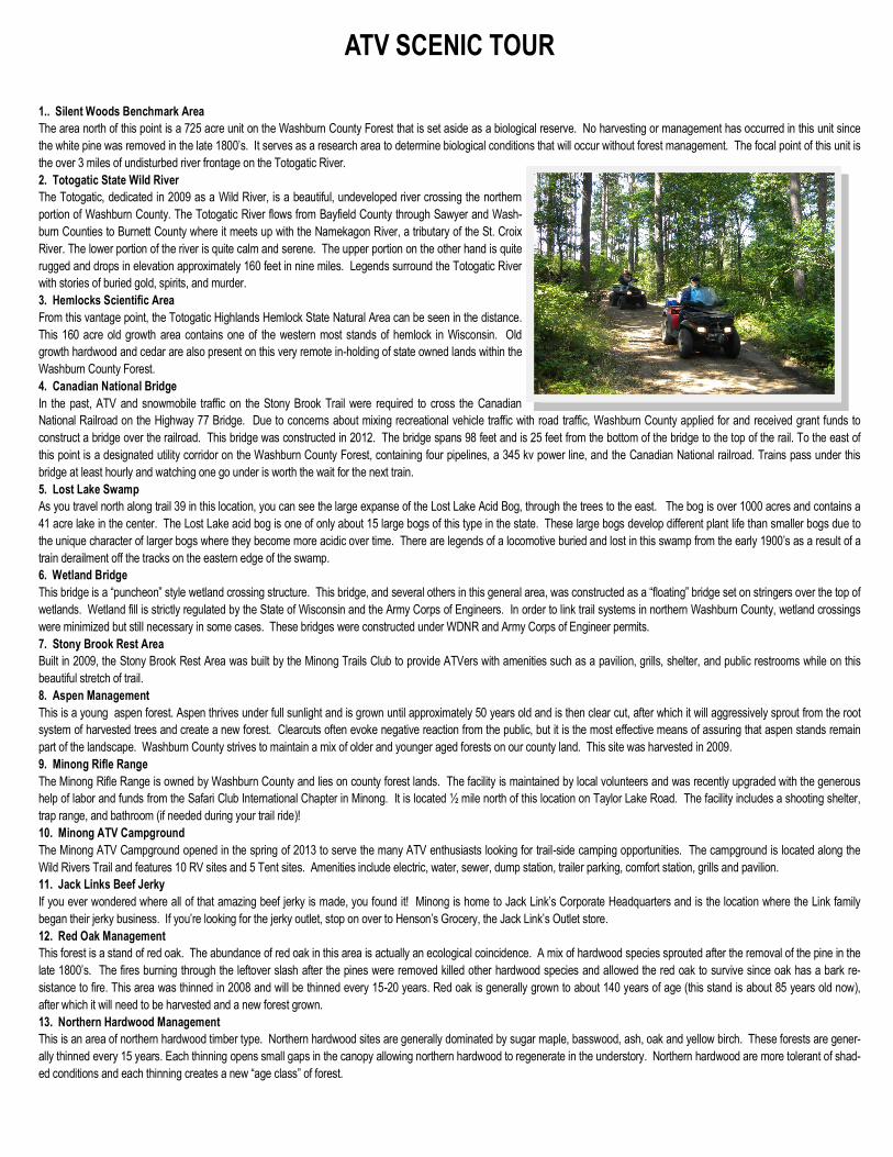
ATV SCENIC TOUR
1.. Silent Woods Benchmark Area
The area north of this point is a 725 acre unit on the Washburn County Forest that is set aside as a biological reserve. No harvesting or management has occurred in this unit since
the white pine was removed in the late 1800’s. It serves as a research area to determine biological conditions that will occur without forest management. The focal point of this unit is
the over 3 miles of undisturbed river frontage on the Totogatic River.
2. Totogatic State Wild River
The Totogatic, dedicated in 2009 as a Wild River, is a beautiful, undeveloped river crossing the northern
portion of Washburn County. The Totogatic River flows from Bayfield County through Sawyer and Wash-
burn Counties to Burnett County where it meets up with the Namekagon River, a tributary of the St. Croix
River. The lower portion of the river is quite calm and serene. The upper portion on the other hand is quite
rugged and drops in elevation approximately 160 feet in nine miles. Legends surround the Totogatic River
with stories of buried gold, spirits, and murder.
3. Hemlocks Scientific Area
From this vantage point, the Totogatic Highlands Hemlock State Natural Area can be seen in the distance.
This 160 acre old growth area contains one of the western most stands of hemlock in Wisconsin. Old
growth hardwood and cedar are also present on this very remote in-holding of state owned lands within the
Washburn County Forest.
4. Canadian National Bridge
In the past, ATV and snowmobile traffic on the Stony Brook Trail were required to cross the Canadian
National Railroad on the Highway 77 Bridge. Due to concerns about mixing recreational vehicle traffic with road traffic, Washburn County applied for and received grant funds to
construct a bridge over the railroad. This bridge was constructed in 2012. The bridge spans 98 feet and is 25 feet from the bottom of the bridge to the top of the rail. To the east of
this point is a designated utility corridor on the Washburn County Forest, containing four pipelines, a 345 kv power line, and the Canadian National railroad. Trains pass under this
bridge at least hourly and watching one go under is worth the wait for the next train.
5. Lost Lake Swamp
As you travel north along trail 39 in this location, you can see the large expanse of the Lost Lake Acid Bog, through the trees to the east. The bog is over 1000 acres and contains a
41 acre lake in the center. The Lost Lake acid bog is one of only about 15 large bogs of this type in the state. These large bogs develop different plant life than smaller bogs due to
the unique character of larger bogs where they become more acidic over time. There are legends of a locomotive buried and lost in this swamp from the early 1900’s as a result of a
train derailment off the tracks on the eastern edge of the swamp.
6. Wetland Bridge
This bridge is a “puncheon” style wetland crossing structure. This bridge, and several others in this general area, was constructed as a “floating” bridge set on stringers over the top of
wetlands. Wetland fill is strictly regulated by the State of Wisconsin and the Army Corps of Engineers. In order to link trail systems in northern Washburn County, wetland crossings
were minimized but still necessary in some cases. These bridges were constructed under WDNR and Army Corps of Engineer permits.
7. Stony Brook Rest Area
Built in 2009, the Stony Brook Rest Area was built by the Minong Trails Club to provide ATVers with amenities such as a pavilion, grills, shelter, and public restrooms while on this
beautiful stretch of trail.
8. Aspen Management
This is a young aspen forest. Aspen thrives under full sunlight and is grown until approximately 50 years old and is then clear cut, after which it will aggressively sprout from the root
system of harvested trees and create a new forest. Clearcuts often evoke negative reaction from the public, but it is the most effective means of assuring that aspen stands remain
part of the landscape. Washburn County strives to maintain a mix of older and younger aged forests on our county land. This site was harvested in 2009.
9. Minong Rifle Range
The Minong Rifle Range is owned by Washburn County and lies on county forest lands. The facility is maintained by local volunteers and was recently upgraded with the generous
help of labor and funds from the Safari Club International Chapter in Minong. It is located ½ mile north of this location on Taylor Lake Road. The facility includes a shooting shelter,
trap range, and bathroom (if needed during your trail ride)!
10. Minong ATV Campground
The Minong ATV Campground opened in the spring of 2013 to serve the many ATV enthusiasts looking for trail-side camping opportunities. The campground is located along the
Wild Rivers Trail and features 10 RV sites and 5 Tent sites. Amenities include electric, water, sewer, dump station, trailer parking, comfort station, grills and pavilion.
11. Jack Links Beef Jerky
If you ever wondered where all of that amazing beef jerky is made, you found it! Minong is home to Jack Link’s Corporate Headquarters and is the location where the Link family
began their jerky business. If you’re looking for the jerky outlet, stop on over to Henson’s Grocery, the Jack Link’s Outlet store.
12. Red Oak Management
This forest is a stand of red oak. The abundance of red oak in this area is actually an ecological coincidence. A mix of hardwood species sprouted after the removal of the pine in the
late 1800’s. The fires burning through the leftover slash after the pines were removed killed other hardwood species and allowed the red oak to survive since oak has a bark re-
sistance to fire. This area was thinned in 2008 and will be thinned every 15-20 years. Red oak is generally grown to about 140 years of age (this stand is about 85 years old now),
after which it will need to be harvested and a new forest grown.
13. Northern Hardwood Management
This is an area of northern hardwood timber type. Northern hardwood sites are generally dominated by sugar maple, basswood, ash, oak and yellow birch. These forests are gener-
ally thinned every 15 years. Each thinning opens small gaps in the canopy allowing northern hardwood to regenerate in the understory. Northern hardwood are more tolerant of shad-
ed conditions and each thinning creates a new “age class” of forest.

ATV SCENIC TOUR
14. Tranus Lake Natural Area
This site marks the western boundary of the Tranus Lake State Natural Area on the Washburn County Forest. Tranus Lake is a 174 acre shallow soft water drainage lake with abun-
dant aquatic vegetation, including wild rice. The Natural Area designation is for the purpose of assessing the management of shallow drainage lakes containing wild rice. The area
west of Tranus Lake is managed with special techniques to protect the lake.
15. Biological Community Change
Wisconsin is split into numerous ecological landscapes that group common attributes such as soils, habitats and land forms. This point is a general boundary between the Northwest
Sands and North Central Forest landscapes. The Northwest Sands are dominated by sandy soils, low in organic material. The North Central Forest soils are richer and dominated by
loams and silts. As you travel north or south from this point along Trail 39, you will note that the forests are dominated by oak and northern hardwood as you move north; and by jack
pine, red pine and aspen as you move south. These distinct changes directly relate to the soil types and were influenced by the area’s glacial activity.
16. Red Pine Management
This is a forest of planted red pine. Red pine was generally planted in areas of old farm fields or in some cases replanted on poor quality sites for other species. Red pine was
planted on this site in 1976. Once these forests reach 30 years of age, they are thinned every 8 to 10 years until they reach 120 to 140 years of age, at which time they will be
harvested and re-planted.
17. Lampson “Mall”
If you’re looking for a great photo opportunity, be sure to visit the Lampson “Mall”, Lampson’s claim to fame.
18. Hendricks Memorial
This area of red pine is designated as a memorial to Joseph Hendricks and the Hendricks Family. Joe spent most of his life as a logger, harvesting many timber sales on the
Washburn County Forest. The memorial recognizes his and his family’s conservation ethic. The red pine on this site was planted in 1951 and the first three thinnings were
harvested by Joe Hendricks.
19. Jack Pine Management
Jack pine is a species that is adapted to fire and generally thrives in dry sandy soils. Jack pine evolved to survive and regenerate in fire prone areas. Cones from a jack pine are
tightly closed with resin and will only open after being exposed to significant heat. Jack pine is decreasing across Wisconsin, primarily because we have eliminated wildfire from
our landscape. When jack pine sites are mature, a dozer is used to expose as much bare soil within the stand as possible. When the site is harvested, the branches, with
cones, are scattered on the bare soil. The full sunlight on the bare soil opens the cones and seeds drop into the soil. The result is a young and vigorous forest of jack pine in
about 5 years. This site was harvested in 2013.
20. National Wild & Scenic River Overlook
The Namekagon River is a 95 mile long river which is a tributary to the St. Croix River and is protected under
the St. Croix National Scenic River way. Most of the Namekagon portion of the river way is entirely undevel-
oped, offering kayakers and canoeists a genuine wilderness experience. The riverbanks are abundant with
deer, muskrat, beaver, turtles and blue herons. Here on the Great South Bend of the Namekagon was a natural
camp-site, home of a band of Chippewa Indians and long used by explorers, missionaries, and fur-traders trav-
eling the Namekagon route between the St. Croix and Chippewa rivers. During the 1870’s, ox teams hauled
logging supplies on the tote road from Stillwater to Veazie Settlement, located two miles upriver where the great
Veazie Dam impounded water for log drives down the Namekagon to Stillwater.
21. Excursion Train
Hop on board a historic train car and take a tour of Wisconsin’s beautiful North woods. Wisconsin Great North-
ern Railroad is a historical excursion train operating on approximately 20 miles of former Chicago & North West-
ern track between the Northern Wisconsin towns of Spooner/Trego and Springbrook along the picturesque Namekagon River.
22. Giant Cowboy
The giant cowboy on the North side of Spooner has made Spooner his home for over 40 years. He started out at Mel’s Truck Stop on the south end of Spooner. In recent years,
he moved to his current residence where he stands proudly at Bulik’s Amusement Center and reminds passersby of the annual professional rodeo held in Spooner every July.
23. Railroad Museum
The Railroad Memories Museum in Spooner makes its home in the original Chicago & Northwestern railway depot and is open from Memorial Day to Labor Day. Spooner was
known as the Crossroads of the North and was the main crossroads of the trains coming to NW Wisconsin. The final passenger train passed through Spooner on May 4, 1961.
The museum allows visitors to take a step into the past and discover the many artifacts and memorabilia from days gone by.
24. Long Lake, Walleye Capital of Wisconsin
Over 19 miles in length, Long Lake is known as the Walleye Capital of Wisconsin. This picturesque spring fed 3,300 acre lake is located in the southeastern part of Washburn
County. Created by glaciers millions of years ago, it reaches depths of over 70 feet. Long Lake’s cool deep bays, gravel bars and rocky shorelines provide excellent walleye
structure.
25. Homestead Site
This open area once contained a farm and home. Little detail is known about this specific site, but you can see remnants of foundations from buildings and the open area was
once cleared for farming. After the pine was removed in the late 1800’s and early 1900’s, many of the cleared areas were settled as farms. The light soils and abundance of
rock and stumps made farming very difficult. The potential for farming was minimal at best and the drought years and depression of the 1930’s likely made farming impossible.
Old homestead and settler sites like this are common across Washburn County.
26. Grouse Management Unit
This sign marks the southern boundary of the Harmon Lake Grouse Management Unit. Aspen management is a focus for this unit and forestry techniques are altered to provide
for smaller harvest units with more frequent timber sales in order to create a multitude of differing ages of aspen that benefit grouse and other wildlife species.

ATV SCENIC TOUR
27. White Birch Management
This is a stand of young white birch. White birch is a species that requires disturbance to sprout new trees. Historically this disturbance was fire. White birch generally lives to
about 70 years of age. Most of our existing stands of white birch in northern Wisconsin are older than that and trees are rapidly dying across the area. When white birch sites are
mature, we use a dozer blade with teeth on the bottom to mix white birch seeds into the leaf litter on the forest floor. When the stands are harvested, white birch seedlings will
thrive in the open sunlight. If you look carefully, you can see the tell-tale white bark characteristic on some of the larger white birch saplings. There are many other species that
thrived after this white birch treatment, including red oak, butternut, black cherry, and others.
28. Beaverbrook Wildlife Area
Beaver Brook Wildlife Area is a 1,964 acre property located in south central Washburn County. Beaver Brook is one of the areas premiere Class I brook and brown trout streams,
fed along its course by 10 spring ponds and many bank seeps. Numerous wetlands associated with the brook, springs and lakes can be found throughout the property. Red oak
stands, aspen, mixed hardwoods, upland and lowland brush, swamp hardwood and conifer, tamarack, pine, old fields and openings make up the other habitats of the wildlife area.
Remnants of several homesteads can be found on the property, and remnants of an old logging dam built in 1870 and removed in 1910 are still visible near the mouth of Beaver
Brook.
29. Washburn County Forest
A majority of the ATV trails in Washburn County lie on County Forest lands. The Washburn County Forest has existed since 1929, when the county first took possession of abandoned properties under tax
delinquency. Today, the Washburn County Forest is 150,000 acres and part of a larger County Forest system totaling 2.4 million acres. These lands are sustainably managed for forest products along with a
wide variety of recreational opportunities, such as the ATV trail you are riding. These lands are established under a permanent program within Wisconsin Statutes called the County Forest Law.
30. Stone Archway
At this location, you may want to carefully make your way down the side of the railroad grade to view a hand crafted stone archway that serves as a bridge over a dry wash (drains water during spring months).
This archway appears to be hand crafted and fitted with limestone, which is not readily available anywhere in Washburn County. The archway is high enough to walk through and view the unique fitting of
blocks into a curved ceiling.
31. Shell Lake Walleye
Shell Lake’s mascot, the walleye, is located along Hwy 63 greeting visitors to this beautiful downtown park area. You are sure to notice that there is something special about this fish; not only does he have one
tail, he has two!
32. Bobcat Pond Outdoor Classroom
Across the road from the trail is the Bobcat Pond Outdoor Classroom. This property serves as the Birchwood School Forest and is located on Washburn County Forest lands. The property is not open to
motorized vehicles. Feel free, however, to park your ATV and take a short walk on the property. An outdoor classroom, complete with desks, is a short walk from the gate. Numerous classes from the Birch-
wood School use this facility for conservation and outdoor education.
33. Birchwood Lakes
The southeastern portion of Washburn County, and the Washburn County Forest, lies within a geographical area termed the Birchwood Lakes. There are more than 125 lakes larger than 10 acres within this
area. Many of the lakes are extremely deep (over 60 feet) and most have populations of panfish and bass. The lakes were formed during the last glacial period on terminal end moraines. One unique feature
of many of the deeper lakes is that they are set in sheltered basins with heavily timbered shorelines. This particular lake is Elbow Lake and has a public boat launch.
34. Berry Road Rest Area
In 2012, Washburn County constructed a trailhead and rest area at this location using user generated ATV grant funds. The facility includes a bathroom, pavilion, parking area, fire rings, grills, and picnic
tables.
35. Town of Sarona
Sarona, located in southern Washburn County is home to abundant farm land, wildlife, lakes, and north woods. The first house was built in Sarona in 1899. The railroad depot in Sarona was closed in 1958.
36. Giant Bluegill
As you enter the village of Birchwood on the Tuscobia State Trail, you’ll be sure to notice the giant bluegill waiting to greet you. Birchwood is known as the Bluegill Capital of Wisconsin due to the incredible
fishing in the area lakes.
To order your copy of the ATV Scenic Tour, call 1-800-367-3306 or
visit: http://www.washburncounty.org/request-info