Embed Size (px)
Citation preview

ANNUAL OPERATING PLANFRYINGPAN-ARKANSAS PROJECTWATER YEAR 2007 OPERATIONS
I. GENERAL
This is the 38th annual operating plan for the Fryingpan-Arkansas Project. The project,completed in 1990, imports spring snowmelt runoff from Colorado's west slope to thesemi-arid Arkansas River basin on Colorado's east slope. The project consists offederally owned dams, reservoirs, stream diversion structures, conduits, tunnels,pumping plants, a pumped-storage powerplant, electric transmission lines, substations,and recreation facilities. These features are located in the Fryingpan River andHunter Creek watersheds of the upper Colorado River basin, and in the Arkansas Riverbasin in central and southeastern Colorado. The project provides water for irrigation,municipal and industrial use, hydroelectric power generation, recreation, and wildlifehabitat. The project also provides for flood control.
The project was authorized under Public Law 87-590 on August 16, 1962. This lawprovides that the project will be operated under the operating principles adopted by theState of Colorado on April 30, 1959, as amended on December 30, 1959, and onDecember 9, 1960. These operating principles were published as HouseDocument 130 (87th Congress, 1st Session), and are included in Appendix E.
This annual operating plan is a summary of the actual project operation in water year2007 (October 1, 2006 through September 30, 2007).
II. PROJECT FEATURES IN OPERATION DURING WATER YEAR 2007
Ruedi Dam and Reservoir are located on the Fryingpan River, a tributary of the RoaringFork River, on Colorado's west slope about 13 miles east of Basalt, Colorado. RuediReservoir has a total capacity of 102,373 acre-feet at a water surface elevation of7766.0 feet. The reservoir is operated on an annual cycle. Steady winter releases draftthe reservoir such that it is filled with the spring snowmelt runoff, while releases to theFryingpan River are maintained below the safe channel capacity. The reservoirprovides replacement water for out-of-priority depletions to the Colorado River by theproject as well as water for west slope irrigation, municipal, and industrial uses on acontractual basis. The reservoir is also operated to provide for recreation, wildlifehabitat, and flood control.
The west slope collection system, located upstream of Ruedi Reservoir in the upperFryingpan River and Hunter Creek watersheds, is a series of 16 stream diversionstructures and 8 tunnels. The system collects spring snowmelt runoff for diversion, bygravity, to the inlet of the Charles H. Boustead Tunnel. The Boustead Tunnel conveyswater collected by the west slope collection system under the continental divide andinto Turquoise Lake on the east slope. The tunnel is 5 miles long and has a waterconveyance capacity of 945 cubic feet per second (cfs).
1

Sugarloaf Dam and Turquoise Lake are located on Lake Fork Creek, a tributary of theArkansas River, about 5 miles west of Leadville, Colorado. The lake has a totalcapacity of 129,398 acre-feet at a water surface elevation of 9869.4 feet. The lake isoperated to provide regulation of both project and non-project water imported from thewest slope. Turquoise Lake is operated on an annual cycle, as is Ruedi Reservoir.The lake is drafted through the Mt. Elbert Conduit during the winter to provide adequatespace for the spring imports of west slope water. Most of the native inflow from LakeFork Creek is impounded in the lake and returned to the Arkansas River via the Mt.Elbert Conduit, the Mt. Elbert Powerplant, and Twin Lakes. The lake is also operated toprovide for recreation and wildlife habitat.
The Mt. Elbert Conduit conveys project, non-project, and native Lake Fork Creek waterfrom Turquoise Lake to Twin Lakes. The conduit is 10.7 miles long and has a waterconveyance capacity of 370 cfs. Native water from Halfmoon Creek is also added tothe conduit and returned to the Arkansas River from Twin Lakes Dam. All conduit flowwhich reaches the Mt. Elbert Forebay is used to generate electricity at the Mt. ElbertPowerplant as it is delivered to Twin Lakes.
The Mt. Elbert Powerplant is a pumped-storage facility located on the shore of TwinLakes. It has two 100-megawatt turbine generators, which can be reversed and usedas 340,000-horsepower pumps. In addition to being used to generate energy with theMt. Elbert Conduit flow, the plant is used to follow daily peak power loads. This loadfollowing is accomplished by pumping water to the Mt. Elbert Forebay, an 11,143-acre-foot regulating pool at the terminus of the Mt. Elbert Conduit, from Twin Lakes duringoff-peak load hours using surplus or low cost energy. That water is then returned toTwin Lakes through the turbines during peak load hours, along with the Mt. ElbertConduit flow. The energy generated at the plant is transmitted and marketed by theWestern Area Power Administration, with the revenues applied to the repayment of theproject.
Twin Lakes Dam and Twin Lakes are located on Lake Creek, a tributary of theArkansas River, about 13 miles south of Leadville, Colorado. Twin Lakes has acapacity of 140,855 acre-feet at a maximum water surface elevation of 9200 feet. Thereservoir is operated to regulate both project and non-project water imported from thewest slope. The project water stored in the reservoir is released to Lake Creek forstorage in Pueblo Reservoir during the winter months, in anticipation of spring importsfrom the west slope. Native inflows into Turquoise Lake, native flows diverted fromHalfmoon Creek, and native inflows into Twin Lakes, are all released to Lake Creekfrom the Twin Lakes Dam. The cities of Colorado Springs and Aurora take directdelivery of water from the reservoir through the Otero Pipeline. The operation of TwinLakes also provides for recreation and wildlife habitat.
Pueblo Dam and Reservoir are located on the Arkansas River 6 miles west of the city ofPueblo, Colorado. The reservoir is the terminal storage facility for the Fryingpan-Arkansas Project and has a total storage capacity of 349,940 acre-feet at a water
2

surface elevation of 4898.7 feet. The upper 26,991 acre-feet of storage space arereserved for flood control at all times, and an additional 66,000 acre-feet of space arereserved from April 15 through November 1. Non-project water may be stored in thereservoir under temporary contract. Native inflow can be stored when the projectstorage right is in priority or under the winter water storage program (WWSP). Underthe WWSP, irrigators are permitted to store native Arkansas River water in PuebloReservoir during the winter months for an additional supply of irrigation water, on thecondition that the water is used before May 1 of the next water year. The majority ofproject water deliveries is made from the reservoir. The Fountain Valley Authority, thePueblo West Metropolitan District, and the Pueblo Board of Water Works take directdelivery of municipal water through the south outlet works and joint-use manifold. Adirect irrigation delivery is made to the Bessemer Ditch. Other project deliveries aremade as releases to the Arkansas River for diversion downstream. Pueblo Reservoir isalso operated to provide for recreation and wildlife habitat.
III. HYDROLOGIC CONDITIONS AND MAJOR WEATHER EVENTS — WATERYEAR 2007
Water year 2007 presented a below average winter, spring and summer for theFryingpan River basin. The water year began with above average precipitation whichlasted until March. Even with precipitation below average, Ruedi Reservoir was able tofill and the collection system was able to divert approximately 54,000 acre-feet to theeast slope.
Given the below average precipitation over the area during the winter months, inflow toRuedi remained normal through the season. As temperatures began to rise in earlyApril, so did the runoff. Initially most of the runoff came from the lower elevations.Once the snow in the higher elevations began to melt, most of the runoff was capturedby the Fryingpan-Arkansas Project west slope collection system.
As spring progressed, the below average conditions in the basin remained the same.By September the total precipitation for the water year was 57 percent of average. Themonths of July, August and September were extremely dry months and dropped whatwas a 78 percent of average precipitation total to the 57 percent level.
The inflow for the year was sufficient to bring the reservoir level within one acre-foot ofthe top of the spillway. Inflow total for October of 2006 through September of 2007 was83 percent of average, with an accumulated total volume of 107,600 acre-feet.
IV. REPORT ON OPERATIONS DURING WATER YEAR 2007
A. Ruedi Reservoir
Ruedi Reservoir began water year 2007 with a storage content of 82,064 acre-feet,which is 87 percent of average. Precipitation over the Fryingpan River basin was belowaverage during the winter and early spring months. By April 1 the snow-water content
3

in the Fryingpan River Basin was estimated at 11.60 inches, which represents 79percent of average, higher than the previous year. Releases during the winter andspring months were made through the city of Aspen's hydroelectric powerplant.
The spring forecast for runoff in the Fryingpan River basin predicted below averageinflows for Ruedi Reservoir in water year 2007, even though the previous three springshad experienced high inflows; there was below average snowpack collected during themonths of November through January. A decent runoff season was considered to be apossibility for water year 2007. Winter releases at Ruedi Reservoir began higher thannormal and were increased as winter progressed. The releases for November were setat 80 cfs and increased in early February to 120 cfs. On February 14 releases out ofRuedi were increased once again to 140 cfs, and continued at that rate until April. ByApril 12 Ruedi Reservoir had reached its lowest water surface level of water year 2007,an elevation of 7727.60 feet with a storage content of 68,527 acre-feet. That elevationrepresented 113 percent of average predicated on a 30-year average. On April 13releases were dropped to 85 cfs. On May 1 the minimum instream flow at theFryingpan below Ruedi gage increased to 110 cfs and the releases were increased toapproximately 100 cfs, which combined with the Rocky Fork Creek contribution to meetthe instream flow. As Ruedi Reservoir began to reach a physical fill, the releases wereadjusted to keep Ruedi from spilling and averaged 200 cfs through July. RuediReservoir did reach a maximum elevation of 7765.95 feet and 102,323 acre-feet onJune 29, which was one acre-foot from being full, and was at 105 percent of average atthe end of June. The reservoir never spilled, as it remained over 102,000 acre-feetuntil July 30. During that time period, the inflows steadily dropped off and RuediReservoir began to drop in storage.
The reservoir storage observed this summer was deemed adequate to make the 4-out-of-5-year 5,000 acre-feet pool available to the endangered fish this year. The totalvolume of water released from Ruedi to support the target flows at the 15-Mile Reach inGrand Junction was 14,273 acre-feet, which included 5,000 acre-feet from the firm fishpool and 9,273 acre-feet from the 10,825 acre-feet of mitigation water. The 4-out-of-5year 5,000 acre-feet pool was never used because the water was then left in storage toincrease the winter releases to help with fish spawning and redds. Flow down theColorado River was sufficient during most of the summer to keep the 15-Mile Reachwell above the required level at the Palisade stream gage. Flow augmentation releasesfor the endangered fish began August 8 and continued through September 26. The5,000 acre-feet of water in the firm fish pool were exhausted by August 20, and the10,825 acre-feet of mitigation water were never fully used. That follows the order ofrelease from the various sources of Ruedi water available to support the endangeredfish. Since the Shoshone Powerplant was down, the Cameo call came on August 13 toAugust 23, and then again on August 31 to September 21. Contract releases weremade during the call periods for a total of 884 acre-feet. Ruedi Reservoir finished thewater year with 86,044 acre-feet in storage, which is 98 percent of average. Totalcumulative precipitation for the year was 9.64 inches, or 56 percent of average.Discretionary releases for the water year totaled 19,013 acre-feet.
4
B. West Slope Collection System and Project Diversions
The import of project water through the Boustead Tunnel began on April 20, 2007, andconcluded on August 21, 2007. The daily discharge record for the diversion structuresis included as Appendix D. A total of 54,248 acre-feet was imported during the 2007water year, which is 112 percent of average. There was no Busk-Ivanhoe waterimported through the Boustead Tunnel. The maximum mean daily import was 700 cfson June 17, 2007. The most probable forecasts for the first of February, March, April,and May were 59,800 acre-feet, 55,100 acre-feet, 51,300 acre-feet, and 49,700 acre-feet, respectively.
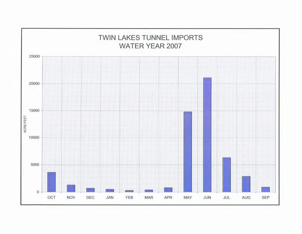
The total imports for the water year; the accumulated imports to the Arkansas River; thewater used for the Twin Lakes Reservoir and Canal Company exchange; and theimport water available for allocations by the Southeastern Colorado Water ConservancyDistrict, are shown on Table 4. The 36 years of accumulated imports total 1,753,000acre-feet, for an average of 48,694 acre-feet per year. A plot of the Boustead Tunnelimports during water year 2007 is shown on Exhibit 5.
C. Twin Lakes Reservoir and Canal Company/Fryingpan-Arkansas ProjectExchange
The Bureau of Reclamation is obligated to maintain minimum streamfiows in theRoaring Fork River by the authorizing legislation of the project. This is accomplishedthrough an exchange of water with the Twin Lakes Reservoir and Canal Company. OnOctober 1, 2006, the company began bypassing water into the Roaring Fork River onthe west slope in exchange for project water stored in Twin Lakes on the east slope.The total amount of the exchange at Twin Lakes Reservoir was 3,000 acre-feet. Theoperating criteria and the monthly summary of the exchange are shown in Appendix C.
D. Turquoise Lake
On September 30, 2006, there were 109,720 acre-feet (elevation 9858.13 feet) of waterstored in Turquoise Lake, which is 124 percent of average. Releases made to TwinLakes through the Mt. Elbert Conduit drafted Turquoise Lake to 65,929 acre-feet(elevation 9830.49 feet), the lowest storage of the water year, by April 18, 2007. Therewere 123,626 acre-feet (elevation 9866.15 feet) of water in storage at the end of thewater year, which is 139 percent of average.
Homestake Tunnel imports totaled 20,700 acre-feet during the water year, 119 percentof average. Busk-Ivanhoe imports totaled 4,210 acre-feet, 81 percent of average, andwere divided between the Pueblo Board of Water Works and the City of Aurora.Project water imports through the Boustead Tunnel totaled 54,248 acre-feet, which is111 percent of average.
Exhibits 8 and 9 show the precipitation and pan evaporation at Turquoise Lake.Exhibits 5, 6, and 7 show the monthly imports through the Boustead, Homestake, and
5
Busk-Ivanhoe Tunnels, respectively. Table 5 and Exhibit 10 depict the monthlyoperation of Turquoise Lake during the 2007 water year.
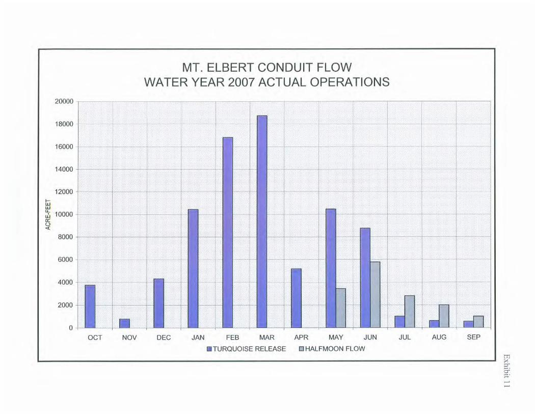
E. Mt. Elbert Conduit/Halfmoon Creek Diversion
During water year 2007, 81,415 acre-feet of water released from Turquoise Lake, and15,036 acre-feet of water diverted from Halfmoon Creek, were conveyed through theMt. Elbert Conduit to the Mt. Elbert Forebay, and subsequently to Twin Lakes throughthe Mt. Elbert Powerplant. An additional 3,910 acre-feet of water were released into theconduit from Turquoise Lake for use by the Leadville Federal Fish Hatchery. The waterdelivered to the hatchery was returned to the Arkansas River and stored inPueblo Reservoir.
F. Twin Lakes/Mt. Elbert Forebay and Mt. Elbert Pumped-Storage Powerplant
The storage in Twin Lakes was 121,850 acre-feet (elevation 9192.71 feet) onSeptember 30, 2006. The combined storage of Twin Lakes and the Mt. Elbert Forebaywas 129,440 acre-feet. Twin Lakes Reservoir releases to Lake Creek were madethroughout the winter to pass the entire flow of the Mt. Elbert Conduit, and to transferthe project water stored in the reservoir to Pueblo Reservoir. The native inflow wasstored in the Twin Lakes Reservoir and Canal Company storage space from November15 through March 15. A total of 33,958 acre-feet of project water was released to LakeCreek during this time. This water was released such that the flow in the ArkansasRiver at the Wellsville gage was maintained as close to the average October 15 toNovember 15 trout-spawning flow as possible. The combined reservoir and forebaystorage reached a low point of 112,916 acre-feet on January 29, 2007, and was at itshigh point of 141,445 acre-feet on July 3, 2007. A total of 2,219 acre-feet of projectwater was released beginning on July 15 and ending on August 3, to augment raftingflows in the Arkansas River.
At least one generating/pumping unit was available at the Mt. Elbert Powerplantthroughout the 2007 water year. The capacity of one unit is greater than the capacity ofthe Mt. Elbert Conduit. A total of 313,466 megawatt-hours of energy was generated atthe powerplant, with 920,589 acre-feet of water; 98,078 acre-feet came through the Mt.Elbert Conduit; and 829,773 acre-feet were first pumped to the Mt. Elbert Forebay fromTwin Lakes during off-peak electric demand hours. Table 7 depicts the monthlypowerplant operation for the 2007 water year.
G. Pueblo Reservoir
The storage content of Pueblo Reservoir was 117,913 acre-feet (elevation 4842.03feet) on September 30, 2006, which is 88 percent of average. Project water releasedfrom Turquoise Lake, through the Leadville Federal Fish Hatchery, and from TwinLakes, was stored in Pueblo Reservoir through the winter and spring. A total of 51,140acre-feet of native inflow was stored in the reservoir under the winter water storageprogram from November 15, 2006, through March 14, 2007. During the water year, a
6

total of 23,653 acre-feet of winter water and 7,045 acre-feet of winter water carryoverwere released, and 3,011 acre-feet evaporated. The reservoir reached a high point instorage of 198,865 acre-feet (elevation 4866.63 feet) on June 30, 2007. There were154,384 acre-feet (elevation 4854.09 feet) in storage on September 30, 2007. This is115 percent of average, and 102,565 acre-feet less than a full conservation pool.
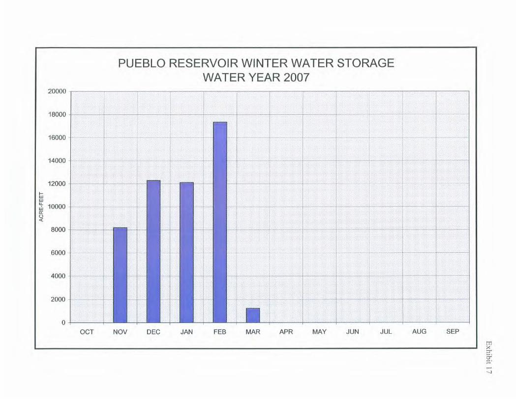
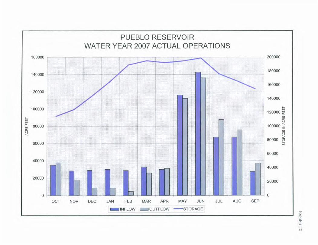
Table 8 and Exhibit 20 depict Pueblo Reservoir monthly operations during the 2007water year. The 2006-07 winter water storage is shown on Exhibit 17, and the winterwater releases are shown on Exhibit 18. The pan evaporation at the reservoir is shownon Exhibit 19.
H. Storage Contracts
There were eight contracts for storage of non-project water in project storage space onthe east slope in effect in water year 2007. Six of those were long-term contracts: theTwin Lakes Reservoir and Canal Company for 54,452 acre-feet; the City of ColoradoSprings for 17,416 acre-feet; the City of Aurora for 5,000 acre-feet; the Pueblo Board ofWater Works for 5,000 acre-feet; Busk-Ivanhoe, Inc., for 10,000 acre-feet; and theHomestake Project for 30,000 acre-feet. There were two long-term, non-firm contracts-- Pueblo Board of Water Works and City of Aurora. The remaining contracts wereinterim one-year contracts for "if-and-when" storage space. Under "if-and-when"contracts, non-project water may be stored in project storage space as long as thatstorage space is not required for project water.
I. Project Water Sales and Deliveries
The project made available 40,400 acre-feet of water to the Southeastern ColoradoWater Conservancy District during water year 2007. The district purchased 35,351acre-feet and called for 18,693 acre-feet of project and project carryover water duringthe year. Evaporation reduced the project water in storage by 5,885 acre-feet. By theend of the water year (September 30, 2007), the district had 24,888 acre-feet of 2007allocated water and 80,231 acre-feet of carryover water remaining in storage. Of the18,693 acre-feet of project water released, 2,912 acre-feet were for municipal andindustrial use, and 15,781 acre-feet were for irrigation. The monthly release of projectwater from Pueblo Reservoir is shown on Exhibit 21.
J. Reservoir Storage Allocation Data
Table 9 presents the reservoir storage allocations for the five project reservoirs.
K. Reservoir Evaporation and Precipitation
Tables 11 and 12 present the monthly average evaporation and precipitation at thefour weather stations near project facilities. When an evaporation pan is not in serviceand a reservoir is not completely ice-covered, the daily water surface evaporation iscomputed using seasonal evaporation factors. Those factors are listed in Table 10. It
7
is assumed that there is no evaporation from a reservoir water surface when thereservoir is completely covered by ice.
L. Flood Control Benefits
The Corps of Engineers determined that Ruedi Reservoir prevented flood damage inwater year 2007.
Ruedi Reservoir provided limited flood protection to properties, local residents, and thegeneral public along the Fryingpan River by attenuating the peak flows during the runoffseason and capturing significant volumes of inflow during the spring months. Thereservoir prevented $103,000 in flood damages during water year 2007, according tothe U.S. Army Corps of Engineers, Sacramento District. Since impoundment, RuediReservoir has prevented a total of $9,946,300 in flood damages.
Table 13 shows the historic flood control benefits provided by Pueblo and Ruedi Dams.
8

Table 1
Ruedi ReservoirWater Year 2007 Operations
Unit: 1,000 Acre-Feet
End of Month Water SurfaceYear Month Inflow Evaporation Outflow Content Elevation
(FEET)
2006 Sep 82.2 7744.37Oct 7.3 0 8.2 81.4 7743.35Nov 4.5 0 4.9 81.0 7742.91Dec 3.1 0 4.7 79.4 7741.02
2007 Jan 2.5 0 5.0 76.9 7738.08Feb 2.6 0 7.5 72.1 7732.12Mar 5.3 0 8.5 68.8 7728.00Apr 9.2 0 6.2 71.9 7731.87May 24.5 0 6.0 90.4 7753.49Jun 23.4 0.5 11.0 102.3 7765.94Jul 11.3 0.3 11.7 101.6 7765.24Aug 8.4 0 17.0 92.9 7756.22Sep 5.6 0 12.5 86.0 7748.69
Total 107.7 0.8 103.2

FRYINGPAN-ARKANSAS PROJECTRUEDI RESERVOIR
RELEASES FOR ENDANGERED FISHWATER YEAR 2007
April-07
FRYINGPAN RUEDI REQUIREDTOTAL ROCKY RIVER ;ALLED OUT MIN FLOW REQUIRED CUMULATIVE
RESERVOIR FORK GAGE (1= YES) BELOW RUED FISH FISH PALISADE
ELEV. STORAGE INFLOW EVAP. RELEASE CREEK BELOW DAM (0= NO) w/o FISH REL RELEASE RELEASE GAGEDAY DATE FT) (AC-FT (CFS) CFS (CFS) (CFS) CFS CFS) CFS (AC-FT (CFS)
SUN 4/1/2007 7,727.89 68,750.27 90.69 0.00 133.41 4.43 137.84 N 39.00 0.00 0.00 0.00
MON 4/2/2007 7,727.78 68,665.35 90.68 0.00 133.49 4.37 137.86 N 39.00 000 0.00 0.00
TUE 4/3/2007 7,727.71 68,611.66 106.28 0.00 133.35 4.38 137.73 N 39.00 0.00 0.00 0.00
WED 4/4/2007 7,727.64 68,557.99 106.43 0.00 133.49 4.27 137.75 N 39.00 0.00 0.00 0.00
THU 4/5/2007 7,727.63 68,550.11 129.55 0.00 133.53 4.45 137.97 N 39.00 0.00 0.00 0.00
FRI 4/6/2007 7,727.59 68,519.35 117.73 0.00 133.24 4.59 137.84 N 39.00 0.00 0.00 0.00
SAT 4/7/2007 7,727.59 68,519.35 133.14 0.00 133.14 4.64 137.78 N 39.00 0.00 0.00 0.00
SUN 4/8/2007 7,727.58 68,511.85 129.32 0.00 133.10 4.65 137.75 N 39.00 0.00 0.00 0.00
MON 4/9/2007 7,727.57 68,503.98 129.11 0.00 133.08 4.70 137.78 N 39.00 0.00 0.00 0.00
TUE 4/10/2007 7,727.55 68,488.61 125.26 0.00 133.01 4.83 137.84 N 39.00 0.00 0.00 0.00
WED 4/11/2007 7,727.55 68,488.61 123.43 0,00 123.43 4.86 128.29 N 39.00 0.00 0.00 0.00
THU 4/12/2007 7,727.60 68,527.23 97.52 0.00 78,05 4.86 82.91 N 39.00 0.00 0.00 0.00
FRI 4/13/2007 7,727.63 68,550.11 91.52 0.00 79.99 4.66 84.65 N 39.00 0.00 0.00 0.00
SAT 4/14/2007 7,727.64 68,557.99 91.44 0.00 87.47 4.54 92.00 N 39.00 0.00 0.00 0.00
SUN 4/15/2007 7,727.67 68,580.88 99.10 0.00 87.56 4.43 91.99 N 39.00 0.00 0.00 0.00
MON 4/16/2007 7,727.76 68,649.95 122.42 0.00 87.60 4.42 92.02 N 39.00 0.00 0.00 0.00
TUE 4/17/2007 7,727.92 68,773.21 149.81 0.00 87.66 4.42 92.09 N 39.00 0.00 0.00 0.00
WED 4/18/2007 7,728.07 68,888.72 145.77 0.00 87.54 4.43 91.96 N 39.00 0.00 0.00 0.00
THU 4/19/2007 7,728.21 69,000.00 143.68 0.00 87.58 4.43 92.00 N 39.00 0.00 0.00 0.00
FRI 4/20/2007 7,728.35 69,105.06 140.46 0.00 87.49 4.48 91.97 N 39.00 0.00 0.00 0.00
SAT 4/21/2007 7,728.61 69,306.02 188.79 000 87.48 4.71 92.18 N 39.00 0.00 0.00 0.00SUN 4/22/2007 7,728.85 69,492.23 181.02 0.00 87.14 4.88 92.02 N 39.00 0.00 0.00 0.00
MON 4/23/2007 7,729.13 69,709.55 196.88 0.00 87.32 5.12 92.44 N 39.00 0.00 0.00 0.00TUE 4/24/2007 7,729.50 69,997.77 233.25 0.00 87,94 5.53 93.47 N 39.00 0.00 0.00 0,00
WED 4/25/2007 7,729.74 70,185.31 182.25 0.00 87.70 5.87 93.57 N 39.00 0.00 0.00 0.00THU 4/26/2007 7,729.96 70,357.16 173.99 0.00 87.35 6.21 93.56 N 39.00 0.00 0.00 0.00
FRI 4/27/2007 7,730.20 70,545.38 182.07 0.00 87.17 6.40 93.57 N 39.00 0.00 0.00 0.00SAT 4/28/2007 7,730.56 70,827.97 229.59 0.00 87.12 6.65 93.77 N 39.00 0.00 0.00 0.00
SUN 4/29/2007 7,731.14 71,285.13 321.06 0.00 90.57 6.76 97.33 N 39.00 0.00 0.00 0.00
MON 4/30/2007 7,731.87 71,863.30 398.32 0.00 106.83 7.46 114.30 N 39.00 0.00 0.00 0.00
Averages 7,728.48 69,212.34 155.02 0.00 104.13 5.01 109.14 0.00 0
Totals (acft) 9,224 0 6,196 298 6,494 0 0 0
NOTES:

FRYINGPAN-ARKANSAS PROJECTRUEDI RESERVOIR
RELEASES FOR ENDANGERED FISHWATER YEAR 2007
May-07
FRYINGPAN RUEDI REQUIREDTOTAL ROCKY RIVER :ALLED OUT MIN FLOW ENDANGEREC:UMULATIVE
RESERVOIR FORK GAGE (1= YES) BELOW RUED FISH FISH PALISADE
ELEV. STORAGE INFLOW EVAP. RELEASE CREEK BELOW DAM (0= NO) w/o FISH REL RELEASE RELEASE GAGE
DAY DATE (FT) AC-FT) CFS) CFS) (CFS (CFS) (CFS) (CFS) (CFS) (AC-FT) (CFS)
TUE 5/1/2007 7,732.65 72,484.44 421.74 3.53 105.05 10.30 115.36 N 110.00 0.00 0.00 0.00
WED 5/2/2007 7,733.52 73,181.84 459.79 3.53 104.66 14.87 119.52 N 110.00 0.00 0.00 0.00
THU 5/3/2007 7,734.40 73,891.70 456.75 3.53 95.34 17.77 113.11 N 110.00 0.00 0.00 0.00
FRI 5/4/2007 7,735.22 74,557.67 434.75 3.53 95.47 19.79 115.25 N 110.00 0.00 0.00 0.00
SAT 5/5/2007 7,735.91 75,120.77 382.84 3.53 95.42 19.36 114.78 N 110.00 0.00 0.00 0.00
SUN 5/6/2007 7,736.44 75,554.98 318.70 3.53 96.27 17.79 114.06 N 110.00 0.00 0.00 0.00
MON 5/7/2007 7,736.89 75,925.19 286.48 3.53 96.30 16.07 112.37 N 110.00 0.00 0.00 0.00
TUE 5/8/2007 7,737.24 76,213.86 245.15 3.53 96.09 14.33 110.42 N 110.00 0.00 0.00 0.00
WED 5/9/2007 7,737.65 76,552.53 270.65 3.53 96.38 13.04 109.42 N 110.00 0.00 0.00 0.00
THU 5/10/2007 7,738.04 76,875.93 262.36 3.53 95.79 12.54 108.33 N 110.00 0.00 0.00 0.00
FRI 5/11/2007 7,738.54 77,291.64 309.17 3.53 96.05 12.87 108.93 N 110.00 0.00 0.00 0.00
SAT 5/12/2007 7,739.19 77,834.08 373.66 3,53 96.66 14.65 111.31 N 110.00 0.00 0,00 0.00
SUN 5/13/2007 7,740.02 78,530.34 451.67 3.53 97.11 19.05 116.16 N 110.00 0.00 0.00 0.00
MON 5/14/2007 7,740.95 79,315.32 495.40 3.53 96.12 28.24 124.36 N 110.00 0.00 0.00 0.00
TUE 5/15/2007 7,741.95 80,165.02 528.52 3.53 96.61 32.01 128.62 N 110.00 0.00 0.00 0.00
WED 5/16/2007 7,743.00 81,063.50 553.62 3.53 97.12 33.77 130.89 N 110.00 0.00 0.00 0.00
THU 5/17/2007 7,743.93 81,865.12 505.34 3.53 97.66 34.17 131.84 N 110.00 0.00 0.00 0.00
FRI 5/18/2007 7,744.75 82,575.94 459.52 3.53 97.62 33.74 131.36 N 110.00 0.00 0.00 0.00
SAT 5/19/2007 7,745.64 83,352.16 493.71 3.53 98.84 35.61 134.45 N 110.00 0.00 0.00 0.00
SUN 5/20/2007 7,746.57 84,167.47 514.28 4.03 99.20 36.63 135.83 N 110.00 0.00 0.00 0.00
MON 5/21/2007 7,747.50 84,987.88 517.81 4.03 100.15 36.96 137.12 N 110.00 0.00 0.00 0.00
TUE 5/22/2007 7,748.44 85,821.64 525.07 4.03 100.69 38.47 139.16 N 110.00 0.00 0.00 0.00
WED 5/23/2007 7,749.17 86,472.45 430.87 4.03 98.72 34.21 132.93 N 110.00 0.00 0.00 0.00
THU 5/24/2007 7,749.77 87,009.62 372.63 4.03 97.78 30.33 128.12 N 110.00 0.00 0.00 0.00
FRI 5/25/2007 7,750.28 87,467.48 333.23 4.03 98.36 27.01 125.37 N 110.00 0.00 0.00 0.00
SAT 5/26/2007 7,750.75 87,891.19 315.70 4.03 98.05 25.31 123.36 N 110.00 0,00 0.00 0.00
SUN 5/27/2007 7,751.21 88,306.94 311.47 4.03 97.83 25.14 122.97 N 110,00 0.00 0.00 0.00
MON 5/28/2007 7,751.74 88,787.81 344.84 4.03 98.37 26.51 124.88 N 110.00 0.00 0.00 0.00
TUE 5/29/2007 7,752.36 89,351.87 386.98 4.03 98.57 29.52 128.09 N 110.00 0.00 0.00 0.00
WED 5/30/2007 7,752.95 89,891.38 374.85 4.03 98.82 29.96 128.77 N 110.00 0.00 0.00 0.00
THU 5/31/2007 7,753.49 90,386.77 353.19 4.03 99.40 30.71 130.11 N 110.00 0.00 0,00 0.00
Averages 7,743.23 81,383.69 402.93 3,72 97.95 24.86 122.81 0.00 0
Totals (acft) 24,775 229 6,023 1,529 7,552 0 0 0
NOTES:

FRYINGPAN-ARKANSAS PROJECTRUEDI RESERVOIR
RELEASES FOR ENDANGERED FISHWATER YEAR 2007
June-07
FRYINGPAN RUEDI REQUIREDTOTAL ROCKY RIVER :ALLED OUT MIN FLOW ENDANGEREE.',UMULATIVE
RESERVOIF FORK GAGE (1= YES) BELOW RUED FISH FISH PALISADE
ELEV. STORAGE INFLOW EVAP. RELEASE CREEK BELOW DAM (0= NO) w/o FISH REL RELEASE RELEASE GAGEDAY DATE FT) (AC-FT) (CFS) ICES) (CFS) ( CFS) (CFS) (CFS) ( CFS) (AC-FT) (CFS)
FRI 6/1/2007 7,754.09 90,938.86 387.52 9.58 99.60 31.42 131.03 N 110.00 0.00 0.00 0.00
SAT 6/2/2007 7,754.72 91,521.59 403.56 9.58 100.19 32.35 132.54 N 110.00 0.00 0.00 0.00
SUN 6/3/2007 7,755.40 92,152.63 429.11 10.08 100.89 33.96 134.85 N 110.00 0.00 0.00 0.00
MON 6/4/2007 7,756.12 92,824.48 450.03 10.08 101.23 34.19 135.42 N 110.00 0,00 0.00 000
TUE 6/5/2007 7,756.85 93,508.84 455.48 10.08 100.37 35.31 135.68 N 110.00 0.00 0.00 0.00
WED 6/6/2007 7,757.62 94,234.44 495.66 10.08 119.76 36.79 156.56 N 110.00 0.00 0.00 0.00
THU 6/7/2007 7,758.09 94,678.93 419.97 10.08 185.79 34.89 220.68 N 110.00 0.00 0.00 0.00FRI 6/8/2007 7,758.43 95,001.85 397.58 10.08 224.70 31.96 256.66 N 110.00 0.00 0.00 0.00
SAT 6/9/2007 7,758.72 95,277.65 374.30 10.08 225.17 30.07 255.25 N 110.00 0.00 0.00 0.00
SUN 6/10/2007 7,759.07 95,610.80 402.71 10.08 224.67 29.37 254.04 N 110.00 0.00 0.00 0.00
MON 6/11/2007 7,759.46 95,983.49 422.11 10.08 224.13 28.99 253.12 N 110.00 0.00 0.00 0.00
TUE 6/12/2007 7,760.10 96,597.13 544.66 10.08 225.21 31.81 257.02 N 110.00 0.00 0.00 0.00
WED 6/13/2007 7,760.54 97,020.34 440.38 10.08 216.93 32.70 249.63 N 110.00 0.00 0.00 0.00
THU 6/14/2007 7,761.09 97,550.93 455.26 10.08 177.68 31.69 209.37 N 110.00 0.00 0.00 0.00FRI 6/15/2007 7,761.58 98,025.62 427,57 10.08 178.17 30.82 208.99 N 110.00 0.00 0.00 0.00
SAT 6/16/2007 7,762.10 98,530.77 443.19 10.08 178.43 30.24 208.67 N 110.00 0.00 0.00 0.00
SUN 6/17/2007 7,762.61 99,027.59 439.11 10.08 178.55 29.57 208.12 N 110.00 0.00 0.00 0.00
MON 6/18/2007 7,763.11 99,516.45 435.18 10.59 178.13 29.16 207.29 N 110.00 0.00 0.00 0.00
TUE 6/19/2007 7,763.56 99,957.95 410.73 10.59 177.56 27.81 205.37 N 110.00 0.00 0.00 0.00
WED 6/20/2007 7,763.93 100,321.85 371.46 10.59 177.41 26.03 203.44 N 110.00 0.00 0.00 0.00
THU 6/21/2007 7,764.34 100,725,77 392.73 10.59 178.51 24.31 202.82 N 110.00 0.00 0.00 0,00
FRI 6/22/2007 7,764.69 101,071.66 363.43 10.59 178.45 22.99 201.45 N 110.00 0,00 0.00 0.00
SAT 6/23/2007 7,765.02 101,397.92 353.58 10.59 178.51 21.54 200.05 N 110.00 0.00 0.00 0.00
SUN 6/24/2007 7,765.32 101,696.23 340.26 10.59 179.28 19.95 199,23 N 110,00 0.00 0.00 0.00
MON 6/25/2007 7,765.61 101,985.00 351.35 10.59 195.18 18.50 213.68 N 110.00 0.00 0.00 0.00
TUE 6/26/2007 7,765.77 102,144.17 326.22 10.59 235.38 16.44 251.82 N 110.00 0.00 0,00 0.00
WED 6/27/2007 7,765.86 102,233,00 318.33 10.59 262.96 15.03 277.99 N 110,00 0.00 0.00 0.00
THU 6/28/2007 7,765.90 102,273.41 306.48 10.59 275.53 14.18 289.71 N 110.00 0,00 0.00 0.00
FRI 6/29/2007 7,765,95 102,323.45 312.33 10.59 276.52 13.53 290.04 N 110.00 0.00 0.00 0.00SAT 6/30/2007 7,765.94 102,313.24 302.69 10.59 297.25 12.92 310.17 N 110.00 0.00 0.00 0.00
Averages 7,761.39 97,881.54 399.10 10.27 188.40 26.95 215.36 0,00 0
Totals (acft) 23,748 611 11,211 1,604 12,815 0 0 0
NOTES:

FRYINGPAN-ARKANSAS PROJECTRUEDI RESERVOIR
RELEASES FOR ENDANGERED FISHWATER YEAR 2007
July-07
FRYINGPAN RUEDI REQUIREDTOTAL ROCKY RIVER ALLED OUT MIN FLOW ENDANGEREEMMULATIVE
RESERVOIR FORK GAGE (1= YES) BELOW RUED FISH FISH PALISADEELEV. STORAGE INFLOW EVAP. RELEASE CREEK BELOW DAM (0= NO) w/o FISH REL RELEASE RELEASE GAGE
DAY DATE FT) (AC-FT) ( CFS) ( CFS) (CFS) _ (CFS) CFS) (CF) (CFS) (AC-FT (CFS)
SUN 7/1/2007 7,765.79 102,164.09 240.94 9.58 306.56 12.36 318.92 N 110.00 0.00 0.00 0.00MON 7/2/2007 7,765.66 102,034.86 191.02 9.58 246.59 11.82 258.41 N 110.00 0.00 0.00 0.00TUE 7/3/2007 7,765.63 102,004.00 195.89 9.58 201.87 11.14 213.01 N 110.00 0.00 0.00 0.00WED 7/4/2007 7,765.58 101,954.00 186.20 9.58 201.83 10.72 212.55 N 110.00 0.00 0.00 0.00THU 7/5/2007 7,765.63 102,004.00 237.06 9.58 202.28 10.19 212.46 N 110.00 0.00 0.00 0.00FRI 7/6/2007 7,765.62 101,994.00 190.46 9.58 185.92 9.70 195.63 N 110.00 0.00 0.00 0.00SAT 7/7/2007 7,765.63 102,004.00 188.65 9.58 174.03 9.49 183.52 N 110.00 0.00 0.00 0.00SUN 7/8/2007 7,765.65 102,024.00 192.92 9.58 173.26 9.33 182.59 N 110.00 0.00 0.00 0.00MON 7/9/2007 7,765.64 102,014.00 167.73 9.58 163.19 8.96 172.15 N 110.00 0.00 0.00 0.00TUE 7/10/2007 7,765.68 102,054.00 179.05 9.58 149.30 8.64 157.95 N 110.00 0.00 0.00 0.00WED 7/11/2007 7,765.72 102,094.00 178.99 9.58 149.25 8.32 157.57 N 110.00 0.00 0.00 0.00THU 7/12/2007 7,765.79 102,163.00 192.97 9.58 148.61 8.07 156.68 N 110.00 0.00 0.00 0.00FRI 7/13/2007 7,765.84 102,213.64 183.52 9.58 148.41 7.70 156.11 N 110.00 0.00 0.00 0.00SAT 7/14/2007 7,765.84 102,213.64 166.88 9.58 157.31 7.62 164.92 N 110.00 0.00 0.00 0.00SUN 7/15/2007 7,765.81 102,184.01 165.67 9,58 171.03 7.69 178,72 N 110.00 0.00 0.00 0.00MON 7/16/2007 7,765,78 102,153,88 165.60 9.58 171.21 7.54 178.75 N 110.00 0.00 0.00 0.00TUE 7/17/2007 7,765.73 102,104.33 156.06 9.58 171.46 7.26 178.72 N 110.00 0.00 0.00 0.00WED 7/18/2007 7,765.71 102,084,41 171.21 9,58 171.67 6.96 178.63 N 110.00 0.00 0.00 0.00THU 7/19/2007 7,765.69 102,064.49 172.65 9.58 173.12 6.87 179.98 N 110.00 0.00 0.00 0.00FRI 7/20/2007 7,765.67 102,044.00 174.12 9.58 174.87 6,68 181.55 N 110.00 0.00 0.00 0,00SAT 7/21/2007 7,765.79 102,163.00 245.80 9.58 176.23 7.09 183.31 N 110.00 0.00 0.00 0.00SUN 7/22/2007 7,765.82 102,193.00 199.35 9,58 174.64 7.03 181.67 N 110.00 0.00 0.00 0.00MON 7/23/2007 7,765.86 102,233.00 204,49 9.58 174.74 6.84 181.58 N 110.00 0.00 0.00 0.00TUE 7/24/2007 7,765.84 102,213,00 174.76 9.58 175.26 6.68 181.94 N 110.00 0.00 0.00 0.00WED 7/25/2007 7,765.87 102,243.00 213.02 9.58 188,31 6.54 194.86 N 110.00 0.00 0.00 0.00THU 7/26/2007 7,765.80 102,173.00 173.09 9.58 198.81 6.40 205.21 N 110.00 0.00 0.00 0.00FRI 7/27/2007 7,765.80 102,173,00 209.20 9.58 199.62 6.38 205.99 N 110.00 0.00 0.00 0.00SAT 7/28/2007 7,765.80 102,173.00 228.41 9.58 218.83 6.18 225.01 N 110.00 0.00 0.00 0.00SUN 7/29/2007 7,765.64 102,014.00 186,56 9.58 257.14 6.13 263.27 N 110.00 0.00 0.00 0.00MON 7/30/2007 7,765.45 101,825.00 171.52 9.58 257.23 6.12 263.35 N 110.00 0.00 0.00 0.00TUE 7/31/2007 7,765,24 101,617.03 162.27 9,58 257.54 5.92 263.46 N 110.00 0.00 0.00 0.00
Averages 7,765.71 102,083.56 189.23 9.58 190.97 8.01 198.98 0.00 0Totals (ac(t) 11,635 589 11,743 493 12,235 0 0 0
NOTES:

FRYINGPAN-ARKANSAS PROJECTRUEDI RESERVOIR
RELEASES FOR ENDANGERED FISHWATER YEAR 2007
August-07
FRYINGPAN RUEDI REQUIREDTOTAL ROCKY RIVER :ALLED OUT MIN FLOW ENDANGEREL2AJMULATIVE
RESERVOIR FORK GAGE (1= YES) BELOW RUED FISH FISH PALISADE
ELEV. STORAGE INFLOW EVAP. RELEASE CREEK BELOW DAM (0= NO) w/o FISH REL RELEASE RELEASE GAGE
DAY DATE FT) AC-FT) CFS) CFS) (CFS) ( CFS) (CFS) (CFS) ( CFS) (AC-FT) (CFS) _
WED 8/1/2007 7,765.01 101,387.72 148.64 6.55 257.70 5.84 263.54 N 110.00 100.00 198.35 0.00
THU 8/2/2007 7,764.76 101,140.65 139.67 6.55 257.67 5.60 263.27 N 110.00 100.00 396.70 0.00
FRI 8/3/2007 7,764.60 100,982.90 184.62 6.55 257.59 5.36 262.95 N 110.00 100.00 595.05 0.00
SAT 8/4/2007 7,764.41 100,795.23 168.51 6.55 256.57 5.23 261.80 N 110.00 100.00 793.40 0.00
SUN 8/5/2007 7,764.25 100,637.00 183.55 6.55 256.77 5.10 261.87 N 110.00 100.00 991.75 0.00
MON 8/6/2007 7,764.14 100,529.00 208.25 6.55 256.15 5.03 261.18 N 110.00 100.00 1,190.10 0.00
TUE 8/7/2007 7,764.03 100,420.00 206.75 6.55 255.15 4.99 260.14 N 110.00 100.00 1,388.45 0.00
WED 8/8/2007 7,763.94 100,331.09 216.24 6.55 254.51 5.21 259.73 N 110.00 149.73 1,685.43 0.00
THU 8/9/2007 7,763.75 100,144.75 167.24 6.55 254.63 5.36 259.99 N 110.00 149.99 1,982.94 0.00
FRI 8/10/2007 7,763.48 99,879.32 151.78 6.55 279.05 5.23 284.27 N 110.00 174.27 2,328.61 0.00
SAT 8/11/2007 7,763.15 99,555.66 138.11 6.55 294.74 4.96 299.69 N 110.00 189.69 2,704.86 0.00
SUN 8/12/2007 7,762.80 99,213.11 128.43 6.55 294.57 4.76 299.33 N 110.00 189.33 3,080.40 0.00
MON 8/13/2007 7,762.45 98,871.80 129.08 6.55 294.60 4.53 299.14 Y 133.61 155.26 3,388.36 0.00
TUE 8/14/2007 7,762.11 98,540.27 133.33 6.55 293.92 4.43 298.34 Y 137.76 150.32 3,686.53 0.00
WED 8/15/2007 7,761.78 98219.41 137.45 655 292.66 4.32 296.98 Y 141.76 145.01 3,974,15 0.00
THU 8/16/2007 7,761.50 97,947.98 162.16 6.55 292.45 4.21 296.66 Y 166.37 120.13 4,212.43 0.00
FRI 8/17/2007 7,761.26 97,715.30 181.11 6.55 291.86 4.21 296.07 Y 185.32 100.52 4,411,81 0.00
SAT 8/18/2007 7,760.96 97,425.42 151.84 6.55 291.43 4.21 295.64 Y 156.05 129.33 4,668.33 0.00
SUN 8/19/2007 7,760.61 97,087,63 127.13 6.55 290.88 4.21 295.09 Y 131.34 153.53 4,972.86 0.00
MON 8/20/2007 7,76027 96,760.45 131.57 6.55 289.97 4.15 294.12 Y 135.73 148.38 5,267.16 0.00
TUE 8/21/2007 7,759.88 96,385.73 107.14 6.55 289.50 4.07 293.57 Y 111.21 163.07 5,590.60 0.00
WED 8/22/2007 7,759.50 96,021.80 112.53 6.55 289.46 4.00 293.46 V 116.53 163.02 5,913.95 0.00
THU 8/23/2007 7,759.12 95,658.79 112.74 6.55 289.20 3.89 293.08 Y 116.63 161.71 6,234.71 0.00
FRI 8/24/2007 7,758.77 95,325.06 127.01 6.55 288.71 3.81 292.52 N 110.00 182.52 6,596.73 0.00
SAT 8/25/2007 7,758.38 94,954.09 106.45 655 286.93 3.66 290.59 N 110.00 176.93 6,947.67 0.00
SUN 8/26/2007 7,757.96 94,555.88 92.70 6.55 286.91 3.60 290.51 N 96.30 176.91 7,298.57 0.00
MON 8/27/2007 7,757.58 94,196.62 111.73 6.55 286.31 3.60 289.90 N 110.00 176.31 7,648.28 0.00
TUE 8/28/2007 7,757.19 93,828.61 107.03 6.55 286.02 3.60 289.61 N 110.00 176.02 7,997.40 0.00
WED 8/29/2007 7,756.85 93,508.84 123.37 6.55 278.02 3.60 281.62 N 110.00 171.62 8,337.81 0.00
THU 8/30/2007 7,756.53 93,208.13 100.15 6.55 245.20 3.60 248.80 N 103.75 135.61 8,606.80 0.00
FRI 8/31/2007 7,756.22 92,918.13 105.52 655 245.17 3.60 248.77 Y 109.11 130.27 8,865.19 0.00
Averages 7,761.20 97,682.14 141.99 6.55 276.91 4.45 281.36 144.18 0
Totals (acft) 8,731 403 17,027 274 17,301 8,865 8,865 0
NOTES:

FRYINGPAN-ARKANSAS PROJECTRUEDI RESERVOIR
RELEASES FOR ENDANGERED FISHWATER YEAR 2007September-07
FRYINGPAN RUEDI REQUIREDROCKY RIVER :ALLED OUT MIN FLOW ENDANGERECCUMULATIVE
TOTAL FORK GAGE (1= YES) BELOW RUED FISH FISH PALISADEELEV. STORAGE INFLOW EVAP. RELEASE CREEK BELOW DAM (0= NO) w/o FISH REL RELEASE RELEASE GAGE
DAY DATE (FT) SAC-FT) _(CFS (CFS) _(CFS) (CFS) _SCES) (CFS) (CF) SAC-FT) (CFS)
SAT 9/1/2007 7,755.89 92,609.59 93.29 4.03 244.81 3.60 248.40 Y 96.88 134.81 9,132.57 0.00SUN 9/2/2007 7,755.55 92,292.19 88.52 4.03 244.51 3.60 248.11 Y 92.12 134.79 9,399.94 0.00MON 9/3/2007 7,755.22 91,985.52 93.58 4.03 244.15 3.52 247.67 Y 97.10 134.15 9,666.02 0.00
TUE 9/4/2007 7,754.90 91,688.14 98.41 4.03 244.31 3.41 247.71 Y 101.82 134.31 9,932.42 0.00WED 9/5/2007 7,754.58 91,391.84 98.30 4.03 243.65 3.43 247.08 Y 101.73 133.65 10,197.51 0.00THU 9/6/2007 7,754.30 91,132.69 115.86 4.03 242.49 3.41 245.89 Y 119.27 116.90 10,429.39 0.00FRI 9/7/2007 7,753.98 90,837.55 98.84 4.03 243.61 3.43 247.04 Y 102.27 133.61 10,694.39 0.00SAT 9/8/2007 7,753.63 90,515.16 85.79 4.03 244.30 3.60 247.89 Y 89.39 134.30 10,960.77 0.00SUN 9/9/2007 7,753.29 90,202.93 91.94 4.03 245.32 3.60 248.91 Y 95.53 135.32 11,229.17 0.00MON 9/10/2007 7,752.93 89,873.05 82.06 4.03 244.34 3.57 247.91 Y 85.63 134.34 11,495.64 0.00TUE 9/11/2007 7,752.55 89,525.23 72.16 4.03 243.49 3.42 246.91 Y 75.59 133.49 11,760.41 0.00WED 9/12/2007 7,752.08 89,096.89 31.15 4.03 243.06 3.32 246.39 Y 34.47 133.17 12,024.56 0.00THU 9/13/2007 7,751.70 88,751.45 71.14 4.03 241.26 3.22 244.48 Y 74.36 131.26 12,284.92 0.00FRI 9/14/2007 7,751.32 88,406.43 70.79 3.53 241.21 3.22 244.43 Y 74.01 131.21 12,545.17 0.00SAT 9/15/2007 7,750.95 88,071.98 75.85 3.53 240.94 3.20 244.14 Y 79.05 130.94 12,804.89 0.00SUN 9/16/2007 7,750.63 87,782.83 98.13 3.53 240,38 3.19 243,57 Y 101.32 130.38 13,063.50 0.00MON 9/17/2007 7,750.57 87,728.68 216.67 3.53 240.44 3.36 243.80 Y 220.03 13.40 13,090.08 0.00TUE 9/18/2007 7,750.39 87,566.80 162.03 3.53 240.12 3.32 243.44 V 165.35 67.72 13,224.40 0.00
WED 9/19/2007 7,750.12 87,323.91 121.77 3.53 240.70 3.95 244,65 Y 125.72 108.56 13,439.72 0.00
THU 9/20/2007 7,749.86 87,090.21 115.31 3.53 229.60 4.43 234.02 Y 119.73 103.90 13,645.81 0.00FRI 9/21/2007 7,749.69 86,937.83 96.02 3.53 169.32 4.43 173.74 Y 100.45 59.32 13,763.46 0.00
SAT 9/22/2007 7,749.53 86,794.34 93.40 3.53 162.21 4.16 166.37 N 97.56 52.28 13,867.16 0.00SUN 9/23/2007 7,749.40 86,678.09 106.71 3.53 161.79 3.92 165.71 N 110.00 51.80 13,969.90 0.00MON 9/24/2007 7,749.28 86,570.65 110.72 3.53 161.36 3.69 165.05 N 110.00 51.36 14,071.77 0.00TUE 9/25/2007 7,749.14 86,445.84 101.41 3.53 160.80 3.58 164.38 N 104.99 50.80 14,172.53 0.00
WED 9/26/2007 7,748.97 86,294.12 87.94 3.53 160.90 3.50 164.41 N 91.44 50.90 14,273.50 0.00THU 9/27/2007 7,748.89 86,222.67 80.61 3.53 113.10 3.41 116.51 N 84.02 0.00 14,273.50 0.00FRI 9/28/2007 7,748.82 86,159.96 82.51 3.53 110.59 3.41 114.00 N 85.91 0.00 14,273.50 0.00
SAT 9/29/2007 7,748.76 86,106.42 87.23 3.53 110.69 3.39 114.08 N 90.62 0.00 14,273.50 0.00SUN 9/30/2007 7,748.69 86,044.20 82.12 3.53 109.96 3.28 113.25 N 85.41 0.00 14,273.50 0.00
Averages 7,751.52 88,604.24 97.01 3.75 208.78 3.55 212.33 90.89 0
Totals (acft) 5,773 223 12,423 211 12,635 5,408 14,273 0
NOTES:

Table 3
Fryingpan-Arkansas ProjectTransmountain Diversions
Water Year 2007Unit: Acre-Feet
Diversion Apr May Jun Jul Aug. Sep Total
No Name 1,508 768 55 2,331Hunter 1,666 3,522 108 5,296Sawyer 12 585 1,056 163 1,816Midway 1 1,652 829 1 2,483Chapman' 70 1,963 1,900 107 4,040South Fork 60 3,230 5,197 583 9,070
Subtotal 143 10,604 13,272 1,017 25,036
Carter 15 950 871 83 1,919North Fork 205 348 25 578Mormon 45 1,270 850 7 2,172N. Cunningham 10 691 661 1,362M. Cunningham 1 614 956 1,571Ivanhoe 175 2,226 2,207 108 4,716Lily Pad 19 465 445 38 967Granite 13 804 1,109 283 118 2,327Fryingpan 114 4,712 6,522 1,472 12,820
Subtotal 392 11,937 13,969 2,016 118 28,432
Total 535 22,541 27,241 3,033 118 53,468
Boustead Tunnel 3555 22,553 27,831 3,094 128 23 54,184
1 Does not include No Name, Hunter, Sawyer and Midway
2Includes South Cunningham
3The difference between total diversion and Charles H. Boustead Tunnel results from the accuracy limitations of themeasurement

Table 4Fryingpan-Arkansas Project ImportsCharles H. Boustead Tunnel Outlet
Unit: 1,000 Acre-feet
Acumulated Twin Lakes Available for
Year Imports Imports Exchange Allocations
1972 32.0 32.0 0 0.0
1973 36.8 68.8 0 16.01974 34.1 102.9 0 18.61975 37.2 140.1 0 25.01976 26.9 167.0 0 24.01977 11.4 178.4 0 25.01978 49.2 227.6 0 25.01979 53.7 281.3 0 25.61980 55.7 337.0 0 70.01981 34.6 371.6 0 25.01982 75.2 446.8 2.7 68.01983 90.8' 537.6 0.3 125.01984 110.12 647.7 1.9 210.01985 70.2 717.9 1.7 289.91986 30.3 748.2 1.5 300.31987 2.2 750.4 1.1 288.01988 13.4 763.8 2.0 247.81989 36.2 800.0 1.7 197.61990 46.6 846.6 1.7 142.11991 59.1 905.7 1.5 58.71992 54.8 960.5 1.2 32.91993 86.6 1,047.1 2.3 70.11994 52.2 1,099.3 1.3 51.71995 90.5 1,189.8 2.3 55.01996 36.9 1,226.7 1.8 110.01997 78.6 1,305.3 1.8 116.01998 51.3 1,356.6 2.6 102.01999 40.8 1,397.4 2.1 127.52000 44.8 1,442.2 1.7 171.62001 45.3 1,487.5 2.1 67.52002 13.2 1,500.7 1.5 8.52003 54.9 1,555.6 2.4 37.52004 27.4 1,583.0 1.3 15.32005 54.6 1,637.6 3.0 40.82006 61.2 1,698.8 3.0 49.22007 54.2 1,753.0 3.0 40.4
Restriction: Not to exceed 120,000 acre-feet in 1 year but not to exceed 2,352,800 acre-feetin 34 consecutive years.
1 Includes 3,120 acre-feet imported through Twin Lakes Tunnel
2 Includes 2,080 acre-feet imports through Boustead Tunnel in October and 420 acre-feet in November.All other years are water year totals.

Turquoise LakeWater Year 2007 Operations
Unit: 1,000 Acre-Feet
Inflow
Busk-Ivanhoe Homestake Project Native Total Total End of Month Water SurfaceImports Imports Imports Inflow Inflow Evap Outflow Content Elevation
(FEET)Through Through
Year Month Carlton Boustead
2006 Sep 109.7 9858.13Oct 0.1 0 0 0 1.2 1.3 0.4 4.8 105.8 9855.82Nov 0.1 0 0 0 0.6 0.7 0.2 1.3 105.0 9855.35Dec 0.1 0 0 0 0.8 0.9 0 4.8 101.1 9852.99
2007 Jan 0.1 0 0 0 1.0 1.1 0 11.0 91.2 9846.99Feb 0.1 0 0 0 1.3 1.4 0 17.3 75.3 9836.87Mar 0.1 0 9.7 0.1 1.7 11.6 0 19.3 67.7 9831.70Apr 0.1 0 2.5 0.5 2.1 5.2 0.1 5.6 67.2 9831.35May 1.3 0 8.5 22.6 8.4 40.8 0.3 11.6 96.0 9849.93Jun 1.5 0 0 27.8 7.7 37.0 0.7 10.3 122.1 9865.30Jul 0.4 0 0 3.1 2.1 5.6 0.5 2.3 124.9 9866.89Aug 0.2 0 0 0.1 1.4 1.7 0.3 1.9 124.5 9866.63Sep 0.1 0 0 0 0.7 0.8 0.4 1.3 123.6 9866.15
Subtotal 4.2 0
Total 4.2 20.7 54.2 29.0 108.1 2.9 91.5

Twin Lakes/Mt. Elbert ForebayWater Year 2007 Operations
Unit: 1,000 Acre-Feet
InflowTwin Lakes Native Total Total End of Month Water Surface
Canal Company Mt. Elbert Conduit Inflow Inflow Evap Outflow Content' Elevation2(FEET)
ProjectYear Month Imports Other Halfmoon Water
2006 Sep 129.4 9192.71Oct 3.6 2.1 0 3.8 3.9 13.4 0.6 12.3 129.9 9192.15Nov 1.3 1.3 0 0.8 1.2 4.6 0.3 7.0 127.2 9191.37Dec 0.7 2.2 0 4.3 0 7.2 0 14.4 118.9 9187.77
2007 Jan 0.5 1.2 0 10.4 0 12.1 0 17.7 112.9 9184.79Feb 0.3 1.0 0 16.8 0 18.1 0 16.8 113.4 9185.15Mar 0.4 0.5 0 18.7 0 19.6 0 12.9 120.1 9188.16Apr 0.8 0 0 5.2 2.1 8.1 0.4 7.5 120.3 9187.61May 14.8 0.7 3.4 10.5 17.0 46.4 0.9 36.5 129.3 9192.71Jun 21.1 0.6 5.8 8.7 23.7 59.9 1.3 47.8 140.1 9196.56Jul 6.3 0.5 2.8 1.0 11.3 21.9 1.1 23.1 137.7 9196.04Aug 2.9 0.8 2.0 0.6 6.1 12.4 0.7 17.4 132.0 9193.81Sep 0.9 0.8 1.0 0.6 3.5 6.8 0.8 3.6 134.5 9194.84
Subtotal 53.6 11.7 15.0 81.4
Total 65.3 96.4 68.8 230.5 6.1 217.0
' Contents of both Twin Lakes and Mt. Elbert Forebay
2 Elevation of Twin Lakes

Table 7
Mt. Elbert Pumped-Storage Powerplant OperationsWater Year 2007
Mt. ElbertConduit Water Pumped
Inflow to from Twin Lakes Water Megawatt-Mt. Elbert to Mt. Elbert through Hours Net
Forebay Forebay Generator Generation*Year Month (acre-ft) (acre-ft) (acre-ft) (mWh)
2006 Oct 3,960 47,673 49,456 16,375Nov 978 45,669 47,239 15,432Dec 4,521 51,618 55,185 18,332
2007 Jan 10,759 59,778 69,287 23,490Feb 17,131 50,130 66,512 22,761Mar 18,992 56,483 73,836 25,740Apr 5,108 57,001 60,149 20,286May 13,866 67,639 81,016 28,485Jun 14,731 98,641 112,634 38,862Jul 3,847 93,764 98,634 33,592Aug 2,596 94,763 98,306 33,425Sep 1,589 106,614 108,335 36,666
Total 98,078 829,773 920,589 313,446
*Net Generation is gross plant generation less station service.

Pueblo ReservoirWater Year 2007 Operations
Unit: 1,000 Acre-Feet
InflowProject Total Evapo- End of month Water surface
Year Month Water Other Native Inflow ration Outflow content elevation(FEET)
2006 Sep 117.9 4842.03Oct 0.3 2.8 31.8 34.9 0.8 37.7 114.4 4840.77Nov 0.8 2.4 25.2 28.4 0.4 18.0 124.4 4844.31Dec 5.9 2.4 20.6 28.9 0.4 8.8 144.1 4850.86
2007 Jan 8.4 2.2 19.4 30.0 0.2 8.6 165.3 4857.36Feb 7.9 1.1 19.7 28.7 0.3 4.7 189.0 4864.01Mar 5.5 4.4 23.0 32.9 1.1 25.9 194.9 4865.60Apr 0.5 5.4 24.0 29.9 1.5 31.1 192.2 4864.88May 0.3 6.1 109.9 116.3 1.5 112.3 194.7 4865.54Jun 2.2 11.7 128.7 142.6 2.3 136.2 198.9 4866.63Jul 1.6 6.1 59.7 67.4 2.6 87.7 176.0 4860.45Aug 1.0 5.7 60.7 67.4 2.0 75.6 165.7 4857.49Sep 0.3 3.1 24.1 27.5 1.8 37.1 154.4 4854.09
Subtotal 34.7 53.4 546.8
Total 634.9 14.9 583.7

Table 9
Fryingpan-Arkansas ProjectReservoir Storage Allocation Data
Unit: Acre-Feet
TotalActive Joint Flood capacity
Reservoir Dead Inactive conservation use control storage
Ruedi 63 1,095 101,278 0 0 102,373'
Turquoise 2,810 8,920 120,478 0 0 129,398'
Pueblo 2,329 28,121 228,828 66,000 26,991 349,9402
Twin Lakes 63,324 72,938 67,917 0 0 140,855
Mt. ElbertForebay 561 3,825 7,318 0 0 11,143'
' New area-capacity tables (1984)
2 New area-capacity table (1994)
Note: Inactive includes dead storage

Table 10
Fryingpan-Arkansas ProjectMonthly Evaporation Factors
Meredith Sugar Loaf Twin Lakes Pueblo
Month Factor Factor Factor Factor
Oct 1/ .220 .220 .247
Nov .100 .100 .155
Dec .030 .030 .133
Jan .050 .050 .128
Feb .080 .080 .173
Mar .140 .140 .280
Apr .233 .233 .308
May .363 .363 -
Jun .448 .448 -
Jul .405 .405 -
.318 .318-
Aug
Sep .290 .290 -
Note: Factor is used when pan is not in operation. Factor divided by number of days in the month times reservoirarea not covered by ice equals daily water surface evaporation in acre-feet.
1/ Factors have not been determined for Meredith. Factors from Twin Lakes are used for Meredith.
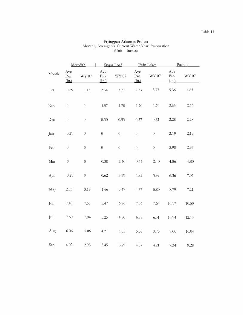
Table 11
Fryingpan-Arkansas ProjectMonthly Average vs. Current Water Year Evaporation
(Unit = Inches)
Meredith I Sugar Loaf Twin Lakes Pueblo
Month Ave Ave Ave AvePan WY 07 Pan WY 07 Pan WY 07 Pan WY 07(In.) (In.) (In.) (In.)
Oct 0.89 1.15 2.34 3.77 2.73 3.77 5.36 4.63
Nov 0 0 1.57 1.70 1.70 1.70 2.63 2.66
Dec 0 0 0.30 0.53 0.37 0.53 2.28 2.28
Jan 0.21 0 0 0 0 0 2.19 2.19
Feb 0 0 0 0 0 0 2.98 2.97
Mar 0 0 0.30 2.40 0.54 2.40 4.86 4.80
Apr 0.21 0 0.62 3.99 1.85 3.99 6.36 7.07
May 2.33 3.19 1.66 5.47 4.57 5.80 8.79 7.21
Jun 7.49 7.57 5.47 6.76 7.36 7.64 10.17 10.50
Jul 7.60 7.04 5.25 4.80 6.79 6.31 10.94 12.13
Aug 6.06 5.06 4.21 1.55 5.58 3.75 9.00 10.04
Sep 4.02 2.98 3.45 3.29 4.87 4.21 7.34 9.28

Table 12
Fryingpan-Arkansas ProjectMonthly Average Vs. Current Water Year Precipitation
(Unit = Inches)
Meredith Sugar Loaf Twin Lakes Pueblo Rocky Ford
Month Avg. WY 07 Avg. WY 07 Avg. WY 07 Avg. WY 07 Avg. WY 07
Oct 1.46 1.57 0.97 1.16 0.64 0.90 0.65 2.39 0.78 2.30
Nov 1.11 1.36 1.28 1.38 0.51 0.70 0.54 0.28 0.46 0.15
Dec 1.22 0.73 1.23 0.75 0.47 0.28 0.37 0.95 0.32 1.64
Jan 1.20 1.12 1.43 1.18 0.40 0.48 0.28 0.33 0.26 0.35
- Feb 1.01 0.70 1.21 1.31 0.49 0.33 0.25 0.13 0.29 0.13
Mar 1.13 0.74 1.46 0.57 0.73 0.47 0.85 0.45 0.68 0.11
Apr 1.26 1.68 1.42 2.19 0.76 1.12 1.36 2.56 1.32 2.21
May 1.38 0.80 1.27 1.02 0.92 0.72 1.58 5.11 1.83 1.48
Jun 1.38 0.42 1.15 0.38 0.87 0.62 1.34 1.66 1.40 3.27
Jul 1.63 0.34 1.97 1.20 1.59 0.82 1.94 2.44 1.97 0.39
Aug 1.73 0.04 2.01 3.42 1.51 1.84 1.93 3.76 1.54 2.08
Sep 1.64 0.11 1.35 1.06 0.96 1.03 0.93 0.26 0.90 0.85
Total 1116.15 9.61 16.75 15.62 I 9.85 9.31 I 12.02 20.32 ' 11.75 I 14.96
Max. / 26.70 (1984) I 25.95 / (1957) 17.27 (1952) ' 20.32 (2007) 22.75 (1999)Annual

Table 13
Fryingpan-Arkansas ProjectFlood Control Benefits in Dollars
Ruedi Reservoir Pueblo ReservoirAccumulated Accumulated
Benefits Benefits Benefits Benefits
1976 320,000 320,0001979 90,000 410,0001980 86,000 496,0001981 111,000 607,0001982 836,000 1,443,0001983 80,000 80,000 47,000 1,490,0001984 330,000 410,000 1,039,000 2,529,0001985 91,000 501,000 234,000 2,763,0001986 70,000 571,000 0 2,763,0001987 0 571,000 90,000 2,853,0001988 0 571,000 0 2,853,0001989 0 571,000 0 2,853,0001990 0 571,000 0 2,853,0001991 0 571,000 482,000 3,335,0001992 0 571,000 266,000 3,601,0001993 4,000 575,000 496,000 4,097,0001994 280,000 855,000 290,000 4,387,0001995 1,770,000 2,625,000 832,000 5,219,0001996 1,550,000 4,175,000 0 5,219,0001997 1,207,000 5,382,000 320,200 6,539,2001998 0 5,382,000 0 6,539,2001999 116,000 5,498,000 4,778,000 11,317,2002000 1,061,000 6,559,000 0 11,317,2002001 0 6,559,000 0 11,317,2002002 0 6,559,000 0 11,317,2002003 1,515,100 8,074,100 0 11,317,2002004 0 8,074,100 0 11,317,2002005 970,200 9,044,300 0 11,317,2002006 799,000 9,843,300 20,159,000 31,476,2002007 103,000 9,946,300 0 31,476,200


Twin Lakes Reservoir and Canal Company Exchangewith Fryingpan-Arkansas Project Water
2006-2007Units = Acre-Feet
Lincoln Creek Roaring Fork Twin Lakesbelow Grizzly River above Total Storage
Reservoir Lost Man Creek (1 + 2) (3) x 0.9913'(1) (2) (3) (4)
October 210 0 210 208November 150 0 150 149December 169 0 169 167January 164 0 164 163February 155 0 155 154March 171 0 171 169April 169 0 169 168May 170 0 170 168June 199 128 327 324July 226 229 455 451August 220 160 380 377September 411 69 480 476
Total 2,414 586 3,000 2,974
' .87% transit loss from the outlet of Twin Lakes Tunnel to Twin Lakes normally taken on all Twin LakesReservoir and Canal Company imported water.

OPERATING CRITERIA
1. The water exchange will be implemented October 1 through September 30.
2. The releases to the Roaring Fork River at the Roaring Fork Diversion Dam and Lincoln Creek at theGrizzly Diversion Dam shall be accounted as follows:
Month Grizzly Diversion(es) Roaring Fork D version(ft3/s)
October 3.0 0.0November 3.0 0.0December 3.0 0.0January 3.0 0.0February 3.0 0.0March 3.0 0.0April 3.0 0.0May 3.0 0.0June 4.0 4.0July 4.0 4.0August 4.0 3.0September 4.0 3.0
3. At any time the Twin Lakes Reservoir and Canal Company (Company) is bypassing water, in additionto that designated above, it will be assumed that the Company could not have diverted that water and willnot receive any credit for exchange in excess of the above amounts.
4. In the event less water than the above amounts is bypassed, only the amount actually bypassed will becredited.
5. The total volume of the release at both gages combined shall not exceed 3,000 acre-feet in any onewater year.
6. No credit for exchange will be made on days when there is no documentation of such bypasses.
7. No credit will be given for water bypassed when diversions are called out by the State Engineer.


Appendix I) (I of 15)Carter Creek Feeder Conduit near Norrie, CO
Location. --Lat 39°22'00", long 106°32'40", Eagle County, Hydrologic Unit 14010004, on left bank at concrete diversion structure, and 6.7 minortheast of Norrie, and 0.6 mi above confluence with North Fork Fryingpan River.Gage.—Water-stage recorder and standard 8 foot suppressed rectangular weir. Elevation of gage is 10,125 ft from topographic map.Remarks.—This is a trans-mountain diversion from Carter Creek in the Roaring Fork Basin through the Fryingpan-Arkansas Project Collectionsystem and Charles H. Boustead tunnel to the Arkansas River basin. Diversion began 30-April-2007 and ceased 09-July-2007. Recorder wasoperated 06-April-2007 through 10-September-2007. Record is complete and reliable.

Appendix D (2 of 15)North Fork Fryingpan River Feeder Conduit near Norrie, CO
Location. --Lat 39°21'42", long 106°32'16", Eagle County, Hydrologic Unit 14010004, on left bank at concrete diversion structure, and 6.7 mi northeastof Norrie, and 0.2 mi above confluence with Mormon Creek.Gage.—Water-stage recorder and standard 6 foot suppressed rectangular weir. Elevation of gage is 10,200 feet from topographic map.Remarks.—This is a trans-mountain diversion from the North Fork Fryingpan River in the Roaring. Fork Basin through the Fryingpan-Arkansas ProjectCollection system and Charles H. Boustead tunnel to the Arkansas River basin. Diversion began 29-April-2007and ceased 13-July-2007. Recorder wasoperated 06-April-2007 through 10-September-2007. Record is complete and reliable.

Appendix D (3 of 15)Mormon Creek Feeder Conduit near Norrie, CO
Location. --Lat 39°21'19", long 106°32'02", Pitkin County, Hydrologic Unit 14010004, on left bank at concrete diversion structure, 0.5 miupstream from unnamed tributary, 1.0 mi above Carter Creek and 6.8 mi northeast of Non - ie.Gage.—Water-stage recorder and standard 5 foot suppressed rectangular weir. Elevation of gage is 10.090 ft from topographic map.Remarks.—This is a trans-mountain diversion from Mormon Creek in the Roaring Fork Basin through the Fryingpan-Arkansas ProjectCollection system and Charles H. Boustead tunnel to the Arkansas River basin. Diversion began 28-April-2007 and ceased 07-July-2007.Recorder was operated 05-April-2007 through 10-September-2007. Record is complete and reliable, except for 28-April through 17-May when itis fair due to gage-height corrections.
Appendix D (4 of 15)North Cunningham Feeder Conduit near Norrie, CO
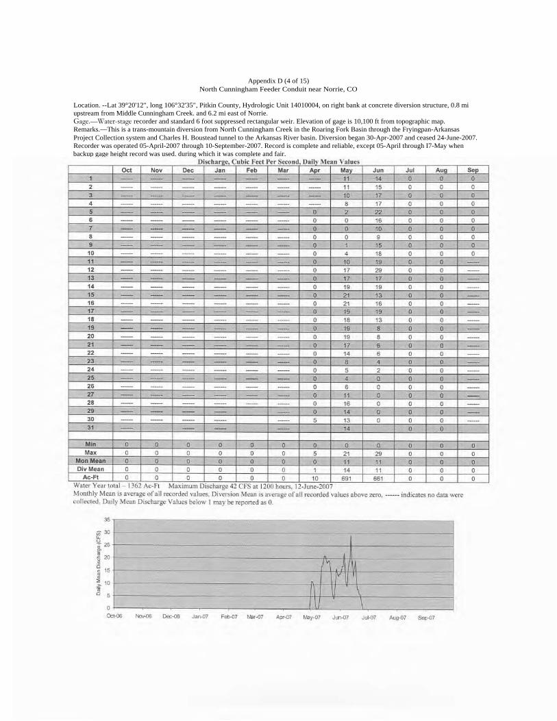
Location. --Lat 39°20'12", long 106°32'35", Pitkin County, Hydrologic Unit 14010004, on right bank at concrete diversion structure, 0.8 miupstream from Middle Cunningham Creek. and 6.2 mi east of Norrie.Gage.—Water-stage recorder and standard 6 foot suppressed rectangular weir. Elevation of gage is 10,100 ft from topographic map.Remarks.—This is a trans-mountain diversion from North Cunningham Creek in the Roaring Fork Basin through the Fryingpan-ArkansasProject Collection system and Charles H. Boustead tunnel to the Arkansas River basin. Diversion began 30-Apr-2007 and ceased 24-June-2007.Recorder was operated 05-April-2007 through 10-September-2007. Record is complete and reliable, except 05-April through I7-May whenbackup gage height record was used. during which it was complete and fair.

Appendix D (5 of 15)Middle Cunningham Feeder Conduit near Norrie, CO
Location. --Lat 39°19'43", long 106°33'08", Pitkin County, Hydrologic Unit 14010004, on left bank at concrete diversion structure, 0.4 miupstream from Cunningham Creek, and 5.7 mi east of Norrie.Gage.—Water-stage recorder and standard 5 foot suppressed rectangular weir. Elevation of gage is 10,050 ft from topographic map.Remarks.—This is a trans-mountain diversion from Middle Cunningham Creek in the Roaring Fork Basin through the Fryingpan-ArkansasProject Collection system and Charles H. Boustead tunnel to the Arkansas River basin. Diversion began 29-April-2007 and ceased 24-June-2007.Recorder was operated 09-April-2007 through 10-September-2007. Record is complete and reliable, except 09-April through 17-May, when it isfair due to gage height corrections.
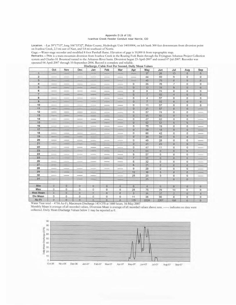
Appendix D (6 of 15)Ivanhoe Creek Feeder Conduit near Norrie, CO
Location. --Lat 39°17'15", long 106°33'32", Pitkin County, Hydrologic Unit 14010004, on left bank 300 feet downstream from diversion pointon Ivanhoe Creek, 2.3 mi east of Nast, and 5.8 mi southeast of Norrie.Gage.—Water-stage recorder and modified 8 foot Parshall flume. Elevation of gage is 10,000 ft from topographic map.Remarks.—This is a trans-mountain diversion from Ivanhoe Creek in the Roaring Fork Basin through the Fryingpan-Arkansas Project Collectionsystem and Charles H. Boustead tunnel to the Arkansas River basin. Diversion began 23-April-2007 and ceased 07-Jul-2007. Recorder wasoperated 04-April-2007 through 10-September-2006. Record is complete and reliable.

Appendix D (7 of 15)Lily Pad Creek Feeder Conduit near Norrie, CO
Location. --Lat 39°15'32", long 106°32'16", Pitkin County, Hydrologic Unit 14010004, on right bank at concrete diversion structure, 200 feetdownstream from diversion point on Lily Pad Creek, and 7.7 mi southwest of Norrie.Gage.—Water-stage recorder and standard 5 foot suppressed rectangular weir. Elevation of gage is 10,200 ft from topographic map.Remarks.—This is a trans-mountain diversion from Lily Pad Creek in the Roaring Fork Basin through the Fryingpan-Arkansas ProjectCollection system and Charles H. Boustead tunnel to the Arkansas River basin. Diversion began on 23-April-2007 and ceased on 21-July-2007.Recorder was operated 03-April-2007 through 10-September-2007. Record is complete and reliable.

Appendix D (8 of 15)Granite Creek Feeder Conduit near Norrie, CO
Location. --Lat 39°16'03", long 106°33'15", Pitkin County, Hydrologic Unit 14010004, on right bank at concrete adit structure, LO mi throughsiphon from diversion point on Granite Creek. and 6.7 mi southeast of Norrie.Gage.—Water-stage recorder and standard 3 foot Parshall flume. Elevation of aage is 10,000 ft from topographic map.Remarks.—This is a trans-mountain diversion from Granite Creek in the Roaring Fork Basin through the Fiyingpan-Arkansas Project Collectionsystem and Charles H. Boustead tunnel to the Arkansas River basin. Diversion began 28-April-2007 and ceased 21-August-2007. Recorder wasoperated 04-April-2007 through 10-September-2007. Record is complete and reliable.

Appendix D (9 of 15)No Name Creek Feeder Conduit near Norrie, CO
Location. --Lat 39°11'00", long 106°43'12", Pitkin County, Hydrologic Unit 14010004, on right bank at concrete diversion structure. 0.9 miupstream from mouth, and 5.5 mi southeast of Aspen.Gage.—Water-stage recorder and standard 8 foot suppressed rectangular weir. Elevation of gage is 10,165 ft from topographic map.Remarks. This is a trans-mountain diversion from No Name Creek in the Roaring Fork Basin through the Fryingpan-Arkansas ProjectCollection system and Charles H. Boustead tunnel to the Arkansas River basin. Diversion began 02-May-2007 and ceased 04-July-2007.Reel-writ, urac nnpratpri 1 1-Anril-7M7 thrn iah 12Cpritprnhor_7f17 F? pre-Irri is onmnInte. ri 7,d iahl.

Appendix D (10 of 15)Midway Creek Feeder Conduit near Norrie, CO
Location. --Lat 39°11'26", long 106°41'07", Pitkin County, Hydrologic Unit 14010004, on right bank at concrete diversion structure, 0.8 miupstream from mouth, and 8.3 mi east of Aspen.Gage.—Water-stage recorder and standard 8 foot suppressed rectangular weir. Elevation of gage is 10,180 ft from topographic map.Remarks.—This is a trans-mountain diversion from Midway Creek in the Roaring Fork Basin through the Fryingpan-Arkansas ProjectCollection system and Charles H. Boustead tunnel to the Arkansas River basin. Diversion began 29-April-2007 and ceased 03-July-2007.Recorder was operated 12-April-2007 through I l-Sentemher-2007. Record is complete and reliable.

Appendix D (11 of 15)Hunter Creek Feeder Conduit near Norrie, CO
Location. --Lat 39°12'28", long 106°40'44", Pitkin County, Hydrologic Unit 14010004, on right bank at concrete diversion structure, 0.9 miupstream from confluence with Midway Creek, and 8.3 nil east of Aspen.Gage.—Water-stage recorder and standard 8 foot suppressed rectangular weir. Elevation of gage is 10,180 ft from topographic map.Remarks.—This is a trans-mountain diversion from Hunter Creek in the Roaring Fork Basin through the Fryingpan-Arkansas Project Collectionsystem and Charles H. Boustead tunnel to the Arkansas River basin. Diversion began 02-May-2007 and ceased 06-July-2007. Recorder wasoperated 12-April-2007 through 11-Sentember-2007. Record is complete and reliable.
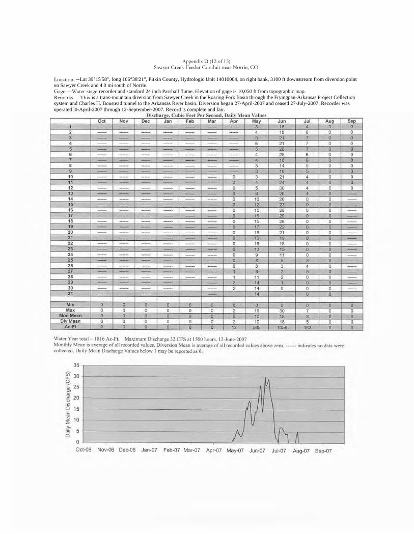
Appendix D (12 of 15)Sawyer Creek Feeder Conduit near Norrie, CO
Location. --Lat 39°15'58", long 106°38'21", Pitkin County, Hydrologic Unit 14010004, on right bank, 3100 ft downstream from diversion pointon Sawyer Creek and 4.0 mi south of Norrie.Gage.—Water-stage recorder and standard 24 inch Parshall flume. Elevation of gage is 10,050 ft from topographic map.Remarks.—This is a trans-mountain diversion from Sawyer Creek in the Roaring Fork Basin through the Fryingpan-Arkansas Project Collectionsystem and Charles H. Boustead tunnel to the Arkansas River basin. Diversion began 27-April-2007 and ceased 27-July-2007. Recorder wasoperated l0-April-2007 through 12-September-2007. Record is complete and fair.

Appendix D (13 of 15)Chapman Gulch Feeder Conduit near Norrie, CO
Location. --Lat 39°15'46", long l06°37'52", Pitkin County, Hydrologic Unit 14010004, on right bank. 180 ft downstream from diversion pointon Chapman Gulch and 4.9 mi south of Norrie.Gage.—Water-stage recorder and modified 10 ft Parshall tlume. Elevation of gage is 10,050 ft from topographic map.Remarks.—This is a trans-mountain diversion from Chapman Gulch. Sawyer Creek, Hunter Creek, Midway Creek, and No Name Creek in theRoaring Fork Basin through the Fryingpan-Arkansas Project Collection system and Charles H. Boustead tunnel to the Arkansas River basin.Diversion began on 27-April-2007 and ceased 27-July-2007. Recorder was operated 09-April-2007 through 12-September-2007. Record iscomplete and reliable.
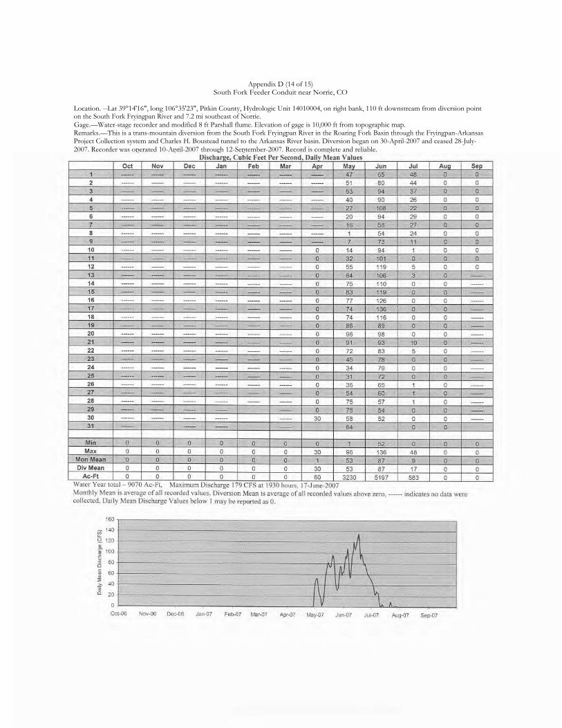
Appendix D (14 of 15)South Fork Feeder Conduit near Norrie, CO
Location. --Lat 39°14'16", long 106°35'23", Pitkin County, Hydrologic Unit 14010004, on right bank, 110 ft downstream from diversion pointon the South Fork Fryingpan River and 7.2 mi southeast of Norrie.Gage.—Water-stage recorder and modified 8 ft Parshall flume. Elevation of gage is 10,000 ft from topographic map.Remarks.—This is a trans-mountain diversion from the South Fork Fryingpan River in the Roaring Fork Basin through the Fryingpan-ArkansasProject Collection system and Charles H. Boustead tunnel to the Arkansas River basin. Diversion began on 30-April-2007 and ceased 28-July-2007. Recorder was operated 10-April-2007 through 12-September-2007. Record is complete and reliable.

•
Appendix D (15 of 15)Fryingpan Feeder Conduit near Norrie, CO
Location. --Lat 39°14'42", long 106°31'52", Pitkin County, Hydrologic Unit 14010004, on right bank, 210 ft downstream from diversion pointon the Fryingpan River and 9.1 mi southeast of Norrie.Gage.—Water-stage recorder and modified 12 ft Parshall flume. Elevation of gage is 9950 ft from topographic map.Remarks.—This is a trans-mountain diversion from the Fryingpan River in the Roaring Fork Basin through the Fryingpan-Arkansas ProjectCollection system and Charles H. Boustead tunnel to the Arkansas River basin. Diversion began on 28-April-2007 and ceased 23-July-2007.Recorder was operated 03-April-2007 through 10-September-2007. Record is complete and reliable.

87 th Congress, 1 5t Session - - - - - - - - - - - - - - - - - - - - - - - - - - House Document No. 130
OPERATING PRINCIPLES
FRYINGPAN-ARKANSAS PROJECT
ADOPTED BY THE STATE OF COLORADO
APRIL 30, 1959
(As amended December 30, 1959,and December 9, 1960)
MARCH 15, 1961----Ordered to be printed
U. S. GOVERNMENT PRINTING OFFICEWASHINGTON: 1961
H. RES. 91In the House of Representatives, U. S.,
March 15, 1961.
Resolved, That there be printed as a House document the publication entitled"Operating Principles, Fryingpan-Arkansas Project, Adopted by the State of Colorado,April 30, 1959 (as amended December 30, 1959, and December 9, 1960)", and that therebe printed for the use of the Committee on Interior and Insular Affairs one thousandadditional copies.
Attest:Ralph R. Roberts, Clerk.

OPERATING PRINCIPLES, FRYINGPAN-ARKANSAS PROJECT
ADOPTED BY THE STATE OF COLORADO, APRIL 30, 1959
(As Amended December 30, 1959, and December 9, 1960)
The construction and operation of the project involve the diversion of water fromthe headwaters of the Fryingpan River and other tributaries of the Roaring Fork River tothe Arkansas River Basin. The project contemplates—
(a) The maximum conservation and use of water;(b) The protection of western Colorado water uses, both existing and
potential, in accordance with the declared policy of the State of Colorado;and
(c) The preservation of recreational values.In order to accomplish such purposes, the project shall be operated by the United
States in compliance with the Federal reclamation laws, the laws of the State of Coloradorelating to the appropriation, use, or distribution of water, and the following operatingprinciples:1. As used herein:
(a) "Project" means that certain enterprise planned and designed by theBureau of Reclamation, Department of the Interior, for the transmountaindiversion of water from the headwaters of the Fryingpan River and othertributaries of the Roaring Fork River to the basin of the Arkansas River,together with all of its appurtenant works and facilities in both easternand western Colorado.
(b) "Eastern Colorado" means that portion of the State of Colorado lyingwithin the natural drainage basin of the Arkansas River.
(c) "Western Colorado" means that portion of the State of Colorado lyingwithin the natural drainage basin of the Colorado River and served bydiversions made from the Colorado River, or its tributaries, above itsconfluence with the Gunnison River.
(d) "Southeastern Colorado Water Conservancy District" means that entitycreated to contract for payment to the United States of an appropriateportion of project cost allocated to certain water uses in eastern Colorado.
(e) "Colorado River Water Conservation District" means that entity createdby Colorado Revised Statutes 1953, 149-8, as amended.
(f) "Southwestern Water Conservation District" means that entity created byColorado Revised Statutes 1953, 149-9, as amended.
(g) "Ruedi Reservoir" means the reservoir presently planned for constructionon the Fryingpan River above the town of Basalt as part of the project.
(h) "Ashcroft Reservoir" means not only the reservoir contemplated forconstruction on Castle Creek, a tributary of the Roaring Fork River, butalso, unless the context requires otherwise, any other reservoir that may beconstructed in the Roaring Fork basin above the town of Aspen in lieu ofthat reservoir.
(i) "cfs" means cubic feet of water per second of time.
1

2. The Ruedi Reservoir shall be constructed and maintained on the Fryingpan Riverabove the town of Basalt with an active capacity of not less than 100,000 acre-feet. In addition thereto and in order to offset adverse streamflow conditions onthe Roaring Fork River above the town of Aspen which might occur as a result ofthe project enlargement of the Twin Lakes Reservoir, the Ashcroft Reservoir onCastle Creek, or some reservoir in lieu thereof, shall be constructed on theRoaring Fork drainage above Aspen to a capacity of approximately 5,000 acre-feet: Providing, However, That the Ashcroft Reservoir shall be constructed onlyif the Secretary of the Interior after appropriate study shall determine that itsbenefits exceed the costs: And providing further, That no part of the construction,operation, or maintenance of said Ashcroft Reservoir shall be chargeable to theFryingpan-Arkansas project.All of such stored water shall be released under the conditions and limitations
hereinafter set forth.3. The receipts from the sale of water from Ruedi Reservoir, as permitted in
paragraph 6(b) hereof, shall be applied solely to the operation and maintenancecosts and to those reimbursable construction costs of said reservoir which exceed$7,600,000. The cost of perpetual operation and maintenance of the RuediReservoir shall be borne by users of project water and users of water stored inRuedi Reservoir in such proportion as may be determined by the Secretary of theInterior.
4. The inclusion of the Ruedi Reservoir in the project shall not preclude theconstruction of any other replacement or regulatory reservoirs on the Colorado
River or its tributaries above Cameo gaging station.5. The Ruedi Reservoir shall be completed and in operation before any water is
diverted to eastern Colorado by means of the project.6. (a) The replacement capacity of Ruedi Reservoir, and any reservoir
constructed in addition thereto, is that portion of the total reservoircapacity required to permit project diversions at times when suchdiversions could not otherwise be made because of simultaneous demandsof senior diversions in western Colorado existing at the time of theadoption of these operating principles, and shall be so operated toaccomplish this purpose. Water stored in such capacity shall be releasedby the United States, upon the request of the Colorado State engineer, tothe extent that water would have been available to said decreed rightsexcept for stream depletion resulting from diversions by this project to theArkansas Valley.
(b) The regulatory capacity of Ruedi Reservoir, and any reservoir constructedin addition thereto, is that portion of the total reservoir capacity not neededfor replacement purposes. Water stored in such category may be sold orleased by the United States to water users in Colorado for any purposerecognized by the laws of the United States: Provided, That the sale ofwater for use outside the natural basin of the Colorado River can only bemade with the consent of the Colorado River Water Conservation District.Charges for the use of such water shall be established by the Secretary of
2

the Interior by appropriate contract in accordance with the payment abilityof such water users.
7. The primary purpose of Ruedi Reservoir, and any reservoir constructed inaddition thereto, is to furnish, to the extent of its capacity, in like manner as if theproject were constructed by a water conservancy district organized pursuant to thelaws of the State of Colorado, the water required for the protection of westernColorado water users by the provisions of Colorado Revised Statutes 1953, 149-6-13, reading as follows:However, any works or facilities planned and designed for the exportation of
water from the natural basin of the Colorado River and its tributaries in Colorado, by anydistrict created under this article, shall be subject to the provisions of the Colorado RiverCompact and the Boulder Canyon Project Act. Any such works or facilities shall bedesigned, constructed and operated in such a manner that the present appropriations ofwater, and in addition thereto prospective uses of water for irrigation and other beneficialconsumptive use purposes, including consumptive uses for domestic, mining, andindustrial purposes, within the natural basin of the Colorado River in the State ofColorado, from which water is exported, will not be impaired nor increased in cost at theexpense of the water users within the natural basin. The facilities and other means for theaccomplishment of said purpose shall be incorporated in, and made a part of any projectplans for the exportation of water from said natural basin in Colorado.8. Project diversions from Lime Creek shall be made only in the months of May and
June of each year, unless the Colorado River Water Conservation District shall,by written communication, advise the Colorado State engineer that additionaldiversions can be made.
9 The respective decrees which may be or have been awarded to the parties heretoas a part of the Fryingpan-Arkansas project and Basalt project shall beadministered by the proper officials of the State of Colorado, in accordance withthe applicable laws of the State of Colorado, and with the following principles andprocedures, to wit:(1) That the demand on the waters available under such decrees shall be
allocated in the following sequence:(a) For diversion to the Arkansas Valley through the collection system
and the facilities of the Fryingpan-Arkansas project in an amountnot exceeding an aggregate of 120,000 acre-feet of water in anyyear, but not to exceed a total aggregate of 2,352,800 acre-feet inany period of 34 consecutive years reckoned in continuingprogressive series starting with the first full year of diversions,both limitations herein being exclusive of Roaring Fork exchangesas provided in (c) below, and exclusive of diversions for the Busk-Ivanhoe decree; and with the further and absolute limitation that inorder to protect existing and future beneficial uses of water inWestern Colorado, including recreational and fishing values, theState engineer shall so regulate the transmountain diversions abovereferred to, to the end that no diversions shall be made which willreduce the remaining aggregate streamflows to less than either ofthe following minimum standards:
3

(i) The Fryingpan collection system at the points of diversioncollectively, exclusive of Lime Creek: 15 cfs October 1through March 31; 30 cfs April 1 through September 30.
(ii) Near Norrie (immediately below the junction of North Forkand Fryingpan River): 30 cfs October 1 through March 31;100 cfs April 1 through April 30; 150 cfs May 1 throughMay 31; 200 cfs June 1 through June 30; 100 cfs July 1through July 31; 75 cfs August 1 through August 31; 65 cfsSeptember 1 through September 30.
In maintaining the above minimum standards, the project diversions shall beregulated, so far as is practicable, in such a manner that the North Fork of the FryingpanRiver, the Fryingpan River, and each of the tributaries of those streams, shall contributeto the residual streamflows required by those minimum standards quantities of water inproportion to their natural contributions.
(b) For storage in Ruedi Reservoir to the extent of its actual capacity,which is to be not less than 100,000 acre-feet.
(c) For 3,000 acre-feet annually, to the extent that it is available inexcess of (a) and (b) above, or such part thereof as may berequired, to be delivered to the Twin Lakes Reservoir and CanalCompany in exchange for equivalent releases from the headwatersof the Roaring Fork River which would otherwise be divertedthrough such Twin Lakes Reservoir and Canal Company collectionand diversion system.
(d) For any other beneficial use in western Colorado in accordancewith court decree, but not herein contemplated.
(2) The effectuation of the above principles requires concurrent Fryingpan-Arkansas project diversion and Ruedi Reservoir storage to beaccomplished in the manner following: The State engineer annually shallcollect pertinent data, including information pertaining to snowpack andall other available evidence, and shall thereafter so divide and apportionthe surface runoff as to achieve, as nearly as possible, the foregoingdivision of water and the maximum of concurrent diversions and storage.The diversions herein contemplated shall be on the basis of a water yearhereby defined as that interim of October 1 through the followingSeptember 30.
10. For the protection of recreational values, including fishing, on the FryingpanRiver below Ruedi Reservoir, releases of water from said reservoir, not to exceedthe stream inflow, shall be made so that the streamflow immediately below thejunction of the Fryingpan River and Rocky Fork shall not be reduced below 39 cfsfrom November 1 to April 30, and 110 cfs from May 1 to October 30, or as actualexperience or court decree hereafter dictate.
11. An appropriate written contract may be made whereby Twin Lakes Reservoir andCanal Company shall refrain from diverting water whenever the natural flow ofthe Roaring Fork River and its tributaries shall be only sufficient to maintain aflow equal to or less than that required to maintain the recommended averageflows in the Roaring Fork River immediately above its confluence with Difficult
4

Creek in a quantity proportionate to the respective natural flow of the RoaringFork River. The recommended average flows above mentioned are flows inquantities equal to those recommended as a minimum immediately above itsconfluence with Difficult Creek according to the following schedule submitted bythe United States Fish and Wildlife Service and the Colorado Game and FishCommission:
Month Average Acre-feet Month Average Acre-feetSecond-feet (thousands) Second-feet (thousands)
October 44 2.7 May 100 6.2November 35 2.1 June 120 7.1December 29 1.8 July 100 6.2January 26 1.6 August 63 3.9February 25 1.4 September 44 2.6 March 24 1.5April 64 3.8 Total ---- 40.9
In maintaining the above averages, at no time shall the flow be reduced below 15cfs during the months of August to April, inclusive, or below 60 cfs during the months ofMay to July, inclusive, providing the natural flow during said period is not less than theseamounts. The obligation to supply the minimum streamflow as set forth in the abovetable on the Roaring Fork River shall, to the extent of 3,000 acre-feet annually, be aproject obligation to be supplied from any waters diverted from the south tributaries ofHunter Creek, Lime Creek, Last Chance Creek, or any of them.
The Twin Lakes Reservoir and Canal Company shall not be required to refrainfrom diverting water under its existing decrees from the Roaring Fork River except to theextent that a like quantity of replacement water is furnished to said company withoutcharge therefore through and by means of project diversions and storage.
If by reason of storage capacity in the Ruedi Reservoir, or any reservoirconstructed in addition thereto, the Twin Lakes Reservoir and Canal Company derivesadditional water or other benefits or advantages it would not have realized had thisproject not been constructed, then nothing herein contained shall prevent the project frommaking appropriate charges for such water or other benefits or advantages. All revenuesderived from the use of water stored in Ashcroft Reservoir shall be used to assist in therepayment of the construction, operation, and maintenance costs of that reservoir, or anyreservoir constructed in lieu thereof, as may be determined by the Secretary of theInterior.12. All lands acquired and held for project construction and operation and water
surfaces of project reservoirs will be open to the public for recreationalpurposes, excepting those areas reserved by the operating agency.
13. The project will be operated in such a manner that those in eastern Coloradousing project water imported from the Colorado River Basin for domesticpurposes shall have preference over those claiming or using water for any otherpurpose.
5

14. The project is to be operated in such a manner as to secure the greatest benefitfrom the use and reuse of imported project waters within project boundaries inthe State of Colorado
15. Any and all benefits and rights of western Colorado water users in and to waterstored in Green Mountain Reservoir, as described and defined in SenateDocument 80, 75 th Congress, 1 st session, shall not be impaired or diminished bythis project.
16. The project, its operation, maintenance, and use shall be subject to theprovisions of the Upper Colorado River Basin Compact of October 11, 1948(Public Law 37, 81 St Congress, 1 51 session), and the Colorado River Compact ofNovember 24, 1922 (House Document 605, 67 1h Congress, 4 th session).
17. The Colorado River Water Conservation District of the State of Colorado shallacquire title to storage of water in Ruedi Reservoir and any reservoirconstructed in addition thereto, by appropriate proceedings in the courts of theState of Colorado. The Southeastern Colorado Water Conservancy District ofthe State of Colorado shall likewise acquire title to the water required by theproject for diversion to the Arkansas Valley. The Secretary of the Interior shallat any time after the authorization of the project have the option to obtain orrequire the transfer to the United States of any and all rights initiated oracquired by appropriation as herein set forth: Provided, however, That therights so taken shall be subject to a beneficial use of such water as may beprovided in the repayment contract or contracts, and subject to all the operatingprinciples herein set forth.
18. No transmountain diversion of water shall ever be made through the collectionand diversion system of the Fryingpan-Arkansas Project in excess of thequantitative limitations and conditions established by this document: Provided,however, That when under the laws of the State of Colorado, there may beadditional water available for such collection and diversion which is not at thetime of diversion required for beneficial use in western Colorado or for fillinginterstate water compact agreements, then such water may be collected anddiverted for beneficial use in the Arkansas Valley: Provided further, That suchadditional diversion shall only be made with the mutual consent of each of thefollowing agencies of the State of Colorado, to wit: the Colorado WaterConservation Board, the Southwestern Water Conservation District, theColorado River Water Conservation District, and the Southeastern ColoradoWater Conservancy District.
19. To assure project operation in conformity with the operating principleheretofore stated, to provide a means for the collection and interchange ofinformation, and to provide a method for the continued study of projectoperations to the end that, if the stated operating principles may be improvedupon, recommendations for changes may be made to the contracting parties, acommission shall be created in an appropriate manner to be composed of onerepresentative of the Southeastern Colorado Water Conservancy District, onerepresentative of the Colorado River Water Conservation District, tworepresentatives of the United States, and one representative of the State ofColorado appointed by the Colorado Water Conservation Board after
6

consultation with the Colorado Game and Fish Commission. The powers ofsuch commission shall be limited to the collection of data, the making offindings of fact, and the suggestion of changes in operating principles.
These operating principles shall be deemed to have amended and take the place ofthose operating principles signed and executed on April 30, 1959. These operatingprinciples shall be and do constitute a contract between the signatory parties, and shallinure to the benefit of and shall be and remain binding upon said parties, their respectivesuccessors and assigns.
Executed as amended at Denver, Colorado, this 9 th day of December 1960.
COLORADO WATER CONSERVATION BOARDSteve McNichols, Chairman;Governor, State of Colorado
Attest:Felix L. Sparks,
Director and SecretarySOUTHEASTERN COLORADO WATER CONSERVANCY
DISTRICTBy J. Selby Young, President
Attest:J. G. Shoun,
SecretaryCOLORADO RIVER WATER CONSERVATION DISTRICT
By A. Allen Brown, PresidentAttest:
Philip P. Smith,Secretary
SOUTHWESTERN WATER CONSERVATION DISTRICTBy Ira E. Kelly, President
Attest:Archie B. Toner,
Secretary
7