Embed Size (px)
Citation preview
")672
MANATEE
MANATEE
HILLSBOROUGHPOLK
HIGHLANDS
HARDEE
DESOTO¬«70
SARASOTA
¬«64
Lithia
¬«60
§̈¦4
£¤17
¬«17
")630
Zolfo Springs
¬«570
Wimauma
Inwood
Bartow
Dundee
Alcoma
Waverly
Arcadia
Nocatee
Sebring
Wahneta
Mulberry
Lakeland
Wauchula
Homeland
Avon Park
Auburndale
Fort Meade
Eagle Lake
Lake Wales
Plant City
Fort Green
Winter HavenLake Hamilton
Bowling Green
Highland City
Fussels CornerCypress Gardens
Jan Phyl Village
Lake of the Hills
£¤27
£¤17
£¤92
£¤17
£¤98
£¤98
¬«17
¬«37
¬«64
¬«66
¬«60
¬«62
¬«72
¬«674
¬«39
")39
")640
")634
")665
")630
")555
")636
")CR 542
")661
")780
")663 ")64A
")621
")CR 546
")634
")661
")664")64
¯M a p 1M a p 1
0 8 164 Miles
WetlandsWaterDesignated Paddling Trail Index
Designated Paddling Trail
F l o r i d a D e s i g n a t e d F l o r i d a D e s i g n a t e d P a d d l i n g T r a i l sP a d d l i n g T r a i l s
P e a c e R i v e rP e a c e R i v e r
M a p 2M a p 2
M a p 3M a p 3
M a p 4M a p 4
M a p 5M a p 5
M a p 6M a p 6

¬«60
")559
")655
")640
Mosaic Peace RiverPark
Polk Lake
£¤17£¤98
£¤17£¤98
Connersville
Lake Garfield
Homeland
CLOWER ST
Lake Ann
Lake BeulahCOX ST
Sand Lake
STUART ST
MAIN STCHURCH ST
WOODLAWN AVE
VAN FLEET DR
LYLE PKWY
WABASH STMLK JR BLVD
BEAR CREEK DR OLD EAGLE LAKE RD
KISSINGEN AVE
OAK AVE
HOMELAND-GARFIELD RDHomeland
FPC HinesConservation Easement
Clear Springs
POLK
Integrated HabitatNetwork Lands
Bartow
Access Point 2: Heritage Peace River Landing
N: 27.8128 W: -81.7936
Access Point 1: SR 60 BridgeN: 27.9022 W: -81-8169
0 1 20.5 Miles
¯
!|
!|
WetlandsFlorida Conservation Lands
Peace River Paddling TrailCanoe/Kayak Launch!|
P e a c e R i v e r P a d d l i n g T r a i l M a p 1P e a c e R i v e r P a d d l i n g T r a i l M a p 1
£¤17£¤98
£¤17
£¤98
NW 6TH ST
EDGEWOOD DR
9TH ST NEORANGE AVE
MT PISGAH RD
OLD BOWLIN
G GREEN RD
HUTCHINS RD
BERQUIST RD
POLK
FPC HinesConservation Easement
Bowlegs Creek
Homeland
South Peace River
Peace RiverHammock
Camp Meeting Ground BranchConservation Easement
Whidden Creek
Pembroke
Fort Meade
Access Point 3: Ft Meade Outdoor Rec Area
N: 27.7515 W: -81.7822
Access Point 4: CR 657N: 27.7234 W: -81.7895
0 1 20.5 Miles
¯
!|
I*Þ!|
WetlandsFlorida Conservation Lands
Peace River Paddling Trail
Canoe/Kayak Launch!|Potable WaterÞ
RestroomsI*
P e a c e R i v e r P a d d l i n g T r a i l M a p 2P e a c e R i v e r P a d d l i n g T r a i l M a p 2
MT PISGAH RD
POLKHARDEE
Paynes Creek Historic State Park
MT PISGAH RD
Torrey
COUNTY LINE RD
£¤17
LAKE BRANCH RD
")664A
DOC COIL RD
¬«62
POLK RD
South Peace River
South Ft Meade/Hardee County Conservation Easement
North Wauchula
MAIN ST
HEARD BRIDGE RD
Paynes Creek
")664
")664
")664A
")664A
Bowling Green
Access Point 6: Lower CR 664-A BridgeN: 27.5760 W: -81.8045
CR 664-A BridgeN: 27.6246 W: -81.8027
0 1 20.5 Miles
¯
!|
I*Þ!|
Wetlands
Florida Conservation Lands
Peace River Paddling Trail
Canoe/Kayak Launch!|Potable WaterÞ
RestroomsI*
State Parks
P e a c e R i v e r P a d d l i n g T r a i l M a p 3P e a c e R i v e r P a d d l i n g T r a i l M a p 3
Access Point 5: Paynes Creek State ParkN: 27.6209 W: -81.8034
")664A
North Wauchula
South Ft Meade/Hardee County Conservation Easement
")35B
South Wauchula
¬«64A
MAIN ST
MANLEY RD
")35AFLORIDA AVE
LOUISIANA ST
BOYD COWART RD
GRIFFIN RDMLK JR AVE
5TH AVE6TH AVE
£¤17
")636
¬«64
")652
¬«64
Zolfo Springs
HARDEE£¤17
¬«66 FLORIDA CRACKE R TRA IL
South Ft Meade/Hardee County Conservation Easement
Wauchula
Access Point 7: Crews ParkN: 27.5507 W: -81.7936
Access Point 9: Pioneer ParkN: 27.5037 W: -81.8057
Access Point 8: CR 652 BridgeN: 27.5405 W: -81.7919
0 1 20.5 Miles
¯
I*Þ!9!|
!|
I*Þ!|
WetlandsFlorida Conservation Lands
Peace River Paddling Trail
Canoe/Kayak Launch!|Potable WaterÞ
RestroomsI*
P e a c e R i v e r P a d d l i n g T r a i l M a p 4P e a c e R i v e r P a d d l i n g T r a i l M a p 4
£¤17
HARDEEDESOTO
")665
Limestone ")665
")661
MURPHY RD
Buchanan
Moffitt
Brownville
RIVER RD
Gardner
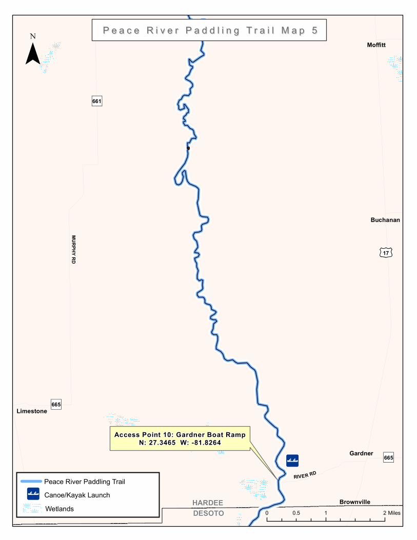
Access Point 10: Gardner Boat RampN: 27.3465 W: -81.8264
0 1 20.5 Miles
¯
!|
P e a c e R i v e r P a d d l i n g T r a i l M a p 5P e a c e R i v e r P a d d l i n g T r a i l M a p 5
Wetlands
Peace River Paddling TrailCanoe/Kayak Launch!|
HARDEEDESOTO
")661
BROWNVILLE ST
£¤17
CUBIT
IS AV
E
¬«70
MASTERS AVE
BISHOP RD
LIVINGSTON AVE
JOHNSON AVE
GIBSON ST
Lansing
Cubitis
Brownville
MorganPark
Arcadia
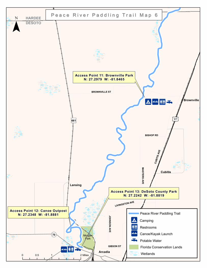
Access Point 11: Brownville ParkN: 27.2979 W: -81.8465
0 1 20.5 Miles
¯
I*Þ!9!|
I*Þ!|
Access Point 13: DeSoto County ParkN: 27.2242 W: -81.8819
WetlandsFlorida Conservation Lands
Peace River Paddling Trail
Canoe/Kayak Launch!|Potable WaterÞ
RestroomsI*Camping!9
P e a c e R i v e r P a d d l i n g T r a i l M a p 6P e a c e R i v e r P a d d l i n g T r a i l M a p 6
Access Point 12: Canoe OutpostN: 27.2348 W: -81.8881
Peace River Paddling Trail Guide
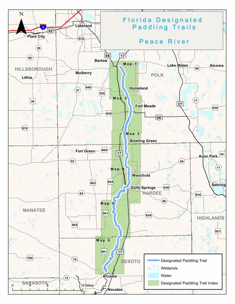
The Waterway Officially, the Peace River Paddling Trail begins at Fort Meade and winds through cypress swamps, shady hammocks and hardwood forests to end 67 miles later, at State Road 70, just west of Arcadia. Above Fort Meade, the river is often too shallow to navigate. After Arcadia, you can continue to the Charlotte Harbor estuary, where it fans out and mingles with the Myakka and Caloosahatchee. The most outstanding feature of the Peace River is its intriguing geology. Large limestone formations frequently emerge from the banks and river bottom, creating shoals and gentle rapids (depending on water levels). The river is also a renowned destination for fossil hunting and people flock to the river searching for ancient relics in the river's depths. It is allowed to collect fossilized sharks teeth, fossilized plants and shells, but to collect fossilized animals you must obtain a permit for a small fee. Fossil collecting is not permitted on State Lands between Bartow and Wauchula. The Paddling Experience This 67-mile long scenic river is perfect for beginners. One can launch a canoe or kayak at one of its many public access points, then paddle upstream a mile or two and drift lazily back to your point of origin. You won’t find a more tranquil and relaxing setting, or a better way to spend an afternoon. But if you’re seeking a little solitude in the wilderness, you might try an overnighter, like the 23-mile trip from Zolfo Springs to Gardner. A number of access points along the river don't have parking and should only be used as drop-off points. Vehicles should not be left overnight in remote locations- contact local outfitters to arrange shuttle service and safe parking.
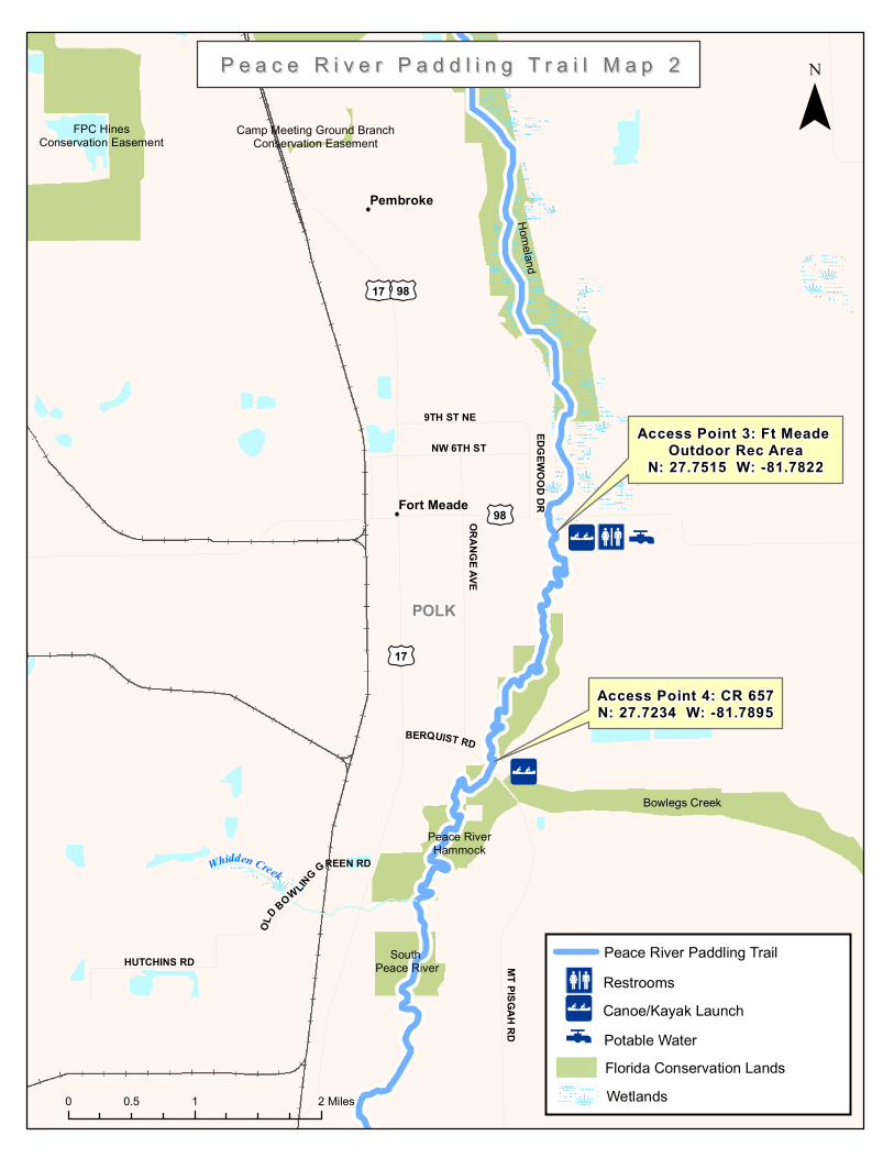
When water is low, paddlers should expect to drag boats regularly. The river becomes shallow in the northern stretches first. For the section from Bartow to the Heritage Peace River Landing, it is advised that the USGS gauge at Bartow should have a flow rate minimum of 30 CFS. From the Heritage Landing to Ft. Meade, it is advised that the USGS gauge level at Fort Meade is a minimum of 72 feet. Day paddling from any of the launch sites can be done even at low water levels. Contact local outfitters listed in the paddling guide to check on water levels when planning a trip. Access Points #1, Start of the Trail, SR 60 Bridge, Bartow Take SR 60 east through Bartow and the Peace River Bridge and launch is on the town’s outskirts. #2, Mile 6.5, Homeland Heritage Landing Overnight parking is not allowed here. There is a floating dock on the south side of the bridge. Take US Hwy 17 south to CR 640 (Homeland-Garfield Road), go east on CR 640 1.5 miles to the entrance just over the Peace River bridge on the south side.
Peace River Paddling Trail Guide
#3, Mile 13, Ft. Mead Recreation Area Retired and active duty military can rent canoes, kayaks, and outdoor equipment here. Located on the southeast side of the US 98 Bridge over the Peace River, just east of the Ft. Meade city limits. #4, Mile 16, CR 657 Bridge (Mt. Pisgah Rd.) Currently this is an unimproved access site with no parking. Use for drop-off only. There are plans to develop this site for recreation in the near future with paddling launch and more amenities.
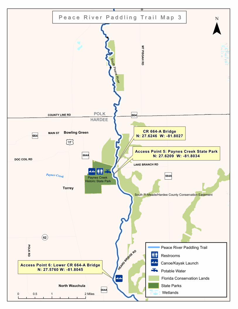
#5, Mile 26, Paynes Creek Historic State Park The Paynes Creek Historic State Park is located just downstream where the Fort Chokonikla was built in the mid-1800s as the first outpost in a chain of forts established to control the Seminoles. It is believed that Indians inhabited the area since about 5,000 B.C. Launch access requires obtaining gate combination from ranger station. There is primitive group camping near the river. Directions: Take US 17 to the town of Bowling Green. At the traffic light, turn east onto Main Street, following the brown park signs, then turn south onto Lake Branch Rd (SR 644A), and follow one mile to the park where there is a canoe/kayak launch. There is also access at the SR 664A Bridge 100 yards beyond the park entrance (vehicles should be left at the park). #6, Mile 30, Lower SR 664-A Bridge, There is no designated parking at this access point and should only be used for drop-offs. From US 17 in Wauchula, turn east onto SR 664A (Rea Road). Go about .5 miles and take a left onto Heard Bridge Road. Follow the road .5 mile to the bridge over the river.
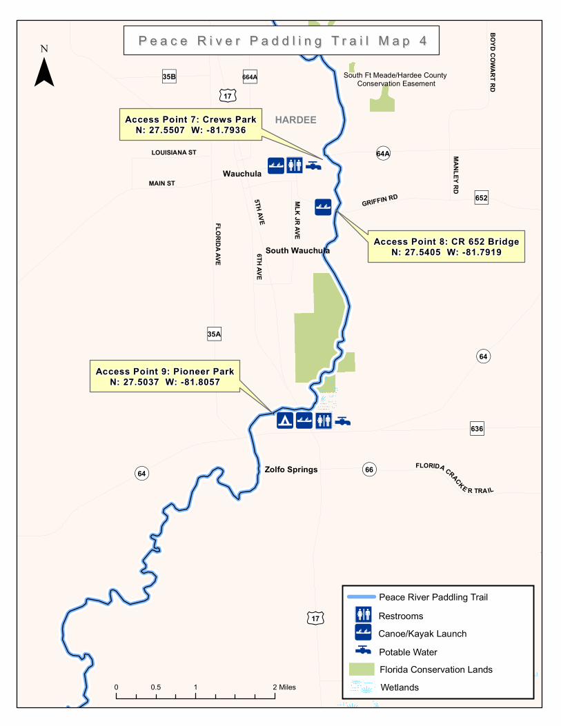
#7, Mile 32.5 Crews Park The park is adjacent to a residential area west of the bridge. Take US 17 to the city of Wauchula, and turn east on Main Street (SR 64A/CR 636). Follow about one mile to the park, located at the Main Street Bridge over the Peace River (look for blue roadside canoeing signs). #8, Mile 33.5, CR 652 Bridge From Wauchula, take SR 64-A .5 mile east to CR 652 (Griffin Road). Turn south on SR 652 and continue about one mile to bridge over Peace River.
#9 Mile 37, Pioneer Park/Zolfo Springs This is the start of the popular overnight Zolfo Springs to Gardner Run (19.5) miles. An outfitter, Peace River Adventures, is located here. Pioneer Park offers 62 grassy campsites, a museum and hiking trails. Corner of U.S. Highway 17 & S.R. 64 in Zolfo Springs.
#10, Mile 56.5 Gardner Boat Ramp This is a remote access so park at your own risk. Parking is available nearby for a fee at Canoe Outpost. From Hwy 17, turn west on River Rd SW (102nd St). Road dead ends at ramp.
#11, Mile 60.5, Brownsville Park This park overs camping and RV hookups. A simple loop nature trail, perfect for small children, can be found on the south side of the park. On the north side are more extensive trails ideal for exploration. From Arcadia, take US 17 north approximately 6 miles to Brownsville Street. Take a left (west) and proceed 1 mile to
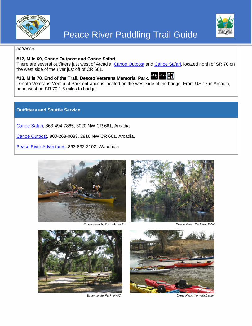
Peace River Paddling Trail Guide
entrance. #12, Mile 69, Canoe Outpost and Canoe Safari There are several outfitters just west of Arcadia, Canoe Outpost and Canoe Safari, located north of SR 70 on the west side of the river just off of CR 661.
#13, Mile 70, End of the Trail, Desoto Veterans Memorial Park, Desoto Veterans Memorial Park entrance is located on the west side of the bridge. From US 17 in Arcadia, head west on SR 70 1.5 miles to bridge. Outfitters and Shuttle Service Canoe Safari, 863-494-7865, 3020 NW CR 661, Arcadia Canoe Outpost, 800-268-0083, 2816 NW CR 661, Arcadia, Peace River Adventures, 863-832-2102, Wauchula
Fossil search, Tom McLaulin Peace River Paddler, FWC
Brownsville Park, FWC Crew Park, Tom McLaulin