Embed Size (px)
Citation preview

AUGUST 2017

WELCOME TO FLAGSTAFF COUNTY 1
SETTLEMENT HISTORY 2
REGIONAL ECONOMIC DEVELOPMENT 3
POPULATION CHARACTERISTICS 5
AGE 6
EDUCATION 7
INCOME 7
HOUSING 7
ECONOMIC BASE 8
ENVIRONMENTAL CHARACTERISTICS 8
HOW THE MDP WORKS 10
BACKGROUND 10
THE ROLE OF A MUNICIPAL DEVELOPMENT PLAN 10
RELATIONSHIP WITH OTHER PLANS & LEGISLATION 11
INTERPRETATION 11
ROLES AND RESPONSIBILITIES 11
PRINCIPLES FOR THE PLAN 13
THE PLAN’S PURPOSE 13
SMART GROWTH 13
GUIDING PRINCIPLES 13
GROWTH MANAGEMENT 15
PATTERN OF GROWTH 15
INTERMUNICIPAL PLANNING 15
FUTURE GROWTH AREAS 17
CULTURAL LANDSCAPES 18
THE ENVIRONMENT 19

ENVIRONMENTAL MANAGEMENT 19
RESERVES AND CONSERVATION EASEMENTS 21
LAKESHORE DEVELOPMENT 23
AGRICULTURE 25
COUNTRY RESIDENTIAL DEVELOPMENT IN THE AGRICULTURE AREA 26
SINGLE PARCEL SEPARATION 29
HAMLETS 31
COUNTRY RESIDENTIAL 33
ECONOMIC DEVELOPMENT 37
COMMERCIAL DEVELOPMENT 37
INDUSTRIAL DEVELOPMENT 38
NATURAL RESOURCES 41
RECREATION & TOURISM 44
RECREATION 44
TOURISM 45
INFRASTRUCTURE 47
EMERGENCY PREPAREDNESS 51
INTERMUNICIPAL COOPERATION 52
PLAN IMPLEMENTATION 53

MAPS 55
1 - REGIONAL LOCATION 556
2 - WATERSHED REGIONS 55
3 - AGRICULTURE 55
4 - ENVIRONMENT 55
5 - NATURAL RESOURCES 60
6 - FUTURE LAND USE 61
Insert Images
Flagstaff County is a community of communities. Within Flagstaff County’s municipal boundaries are four Towns, four
Villages, two Hamlets, and six Localities. Our communities have long been supported by the hard work, innovative talents,
and community-minded spirit of generations of residents.
Flagstaff County is closely connected to the land; in our pursuit of agricultural practices, in our pride in our landscapes, in
our support for responsible resource development + transport, and in our desire to make our unique communities great
places to live.
The Flagstaff County Municipal Development Plan reflects our values as a community. Within this plan, you will find goals,
objectives and policies that support a vision for Flagstaff County as a place where opportunities exist for people to live a
fulfilling rural lifestyle, supported by a diversity of economic opportunities, housing choices, natural and community-

supported recreational amenities, vibrant community culture, conserved natural landscapes, and a strong commitment to
working together.
SETTLEMENT HISTORY
Settlement in Western Canada occurred through a number of related processes. To begin, between 1871 and 1921 the
Canadian government signed a series of treaty agreements with First Nations that gave the government rights to the land
and opened up the West to agricultural settlement. The second important factor was the completion of the Canadian
Pacific Railway in 1885, which eased the Western passage for newcomers as well as facilitated grain exports. Further,
technical innovations in dry land farming and agricultural machinery – in conjunction with a rise in wheat prices in the late
1890s –greatly increased the profitability of farming as a livelihood. Finally, the closing of the American frontier allowed
Canada to attract thousands of new immigrants from the United States and abroad with greater ease.
Between 1896 and 1905 the government of Canada launched a campaign aimed at farmers from the United States, Britain
and Central and Eastern Europe that advertised free or cheap land in the Canadian West. During this time it was common
for government agencies and local businesses to publish promotional material designed to lure settlers to the Canadian
west by extolling the region’s virtues. One such booklet was published in 1910 by a real estate firm in the Killam region.
“This being a new country, naturally some people think they are coming to a wilderness, but such is not the case.
Although only opened for settlement a few years, the roads are mostly graded, the culverts and bridges built where

necessary, schools within easy reach of every child in the country. Churches of different denominations in every
town and village, and throughout the country generally. Flagstaff County is situated west of the Rocky Mountains,
which prove of great benefit in moderating the climate. Our winters are just right. Good, wholesome, healthy, and
even. No hard winds or blizzards. No slushy disagreeable weather, and just enough snow to make traveling a
pleasure, and assure sufficient moisture for the next season’s crop.”
Although the veracity of such promotional material may be disputed, it certainly did the trick – by 1910 the settlement of
the region was already well underway.
Over the last century the name and municipal boundaries of Flagstaff County have shifted numerous times. The Municipal
District of Flagstaff was first incorporated in December of 1912 and the first Council meeting held in January of 1913 in the
Village of Lougheed. In 1943 the minister of Municipal Affairs issued an order that saw the formation of the enlarged
Municipal District of Killam, whose name was changed back to Flagstaff the following year. The Municipal District of
Flagstaff became the County of Flagstaff No. 29 in 1968, and in 1998 the County underwent its final transformation,
dropping its numeric appendage and becoming simply Flagstaff County. The County takes its name from Flagstaff Hill, which
is a translation of the Cree his-ki-wa-or-nis ka-hko-hta-ke or “flag-hanging hill.” Legend has it that Flagstaff Hill was a
gathering place for the Sarcee First Nation.
REGIONAL ECONOMIC DEVELOPMENT
Flagstaff County is located in the Battle River Region Marketplace, which is comprised of the Counties of Wetaskiwin,
Camrose, and Beaver, the Municipal Districts of Wainwright and Provost and the urban municipalities therein.

Large-scale projects can lead to economic growth, an increase in regional population and long-term sustainability.
Developments relating to mining and oil and gas make up the vast majority of projects in the Battle River Region
Marketplace.
In 2014, Flagstaff County adopted Our Common. Wealth. Economic Strategic Pathways for Flagstaff County (2015-2018).
Replacing the Flagstaff County Economic Development Strategic Plan (2009), this Plan contains thematic focus and a short
to intermediate term economic development agenda for the County. This plan also establishes the County’s strategy for
working collaboratively with urban municipalities within the Flagstaff County region for mutually beneficial growth and
development.
The Plan established a County Vision: A safe, caring and vibrant rural "Community of communities" committed to working
with our neighbours to ensure the quality of life for all citizens.
The County Vision is supported by 'pillars' that connect the vision to the policies of the municipality, the business plan and
budget. These pillars are essentially building blocks as to how the vision will be achieved. Each pillar contains a strategic
objective statement describing the outcome/goal of that pillar.
COMMUNITY OF COMMUNITIES
Strategic Objective Statement:
Through strong political and administrative leadership, Flagstaff County is committed to working with the Towns and
Villages to enhance existing partnerships; actively seek new collaborative opportunities; share resources; and build on each
other's expertise to provide programs and services that benefit the citizens of the "Community of communities."
ENVIRONMENTAL RESPONSIBILITY
Strategic Objective Statement:
To demonstrate Flagstaff County's commitment to environmental responsibility by working to minimize our adverse impact
on the natural environment through the adoption of eco-friendly practices, progressive planning and the use of green
technology.
ECONOMIC PROSPERITY
Strategic Objective Statement:
Develop key priorities and a shared vision to create more economic and industry opportunities in the County by engaging
and understanding the opportunities and capacity of our community.
SOCIAL RESPONSIBILITY
Strategic Objective Statement:
Flagstaff County will endeavour to provide support services for seniors, youth and adults in the community, by first
determining the need and then developing long term plans.

RESPONSIBLE LEVEL OF SERVICE
Strategic Objective Statement:
Flagstaff County is committed to provide efficient, effective and equitable municipal services.
POPULATION CHARACTERISTICS
The population of Flagstaff County has been gradually increasing since 2006, after a minor population decrease from 2001
to 2006. From 2011 to 2016, the County’s population has increased 4.1%. A part of this population increase can be
attributed to the dissolution of the former Villages of Strome and Galahad (2011 Canadian Census populations of 228 and
119 respectively), which are now unincorporated Hamlets within the municipal boundaries of Flagstaff County.
2000
2500
3000
3500
4000
2001 2006 2011 2016

AGE
The average age of the population of Flagstaff County is 41.8, which is older than the average age of the population for
Alberta as a whole, at 37.8. Flagstaff County has a higher percentage of residents over the age of 65 (18.0%) than the
provincial average (12.3%).
The population pyramid shows a smaller percentage of residents between the ages of 20 and 39, likely because individuals
in this demographic have relocated to urban areas for education and employment opportunities. It also demonstrates that
the County’s population is aging: a significant proportion of the population is over the age of 55, and the number of children
in the 0 – 9 age cohort is low.
0 30 60 90 120 150 180
0 to 4
10 to 14
20 to 24
30 to 34
40 to 44
50 to 54
60 to 64
70 to 74
80 to 84
90 to 94
100+
FEMALE MALE

EDUCATION
The Battle River Regional School Division #31 serves Flagstaff County, with schools located in Daysland (K-12), Forestburg
(K-12), Hardisty (1-9), Killam (K-9), Lougheed (1-9), Sedgewick (K-12) and Strome (1-9). All of the communities offer
Kindergarten service, some of which are run privately.
The Flagstaff Community Adult Learning Society, located in the Town of Killam, provides the County with non-credit learning
opportunities. The Society sponsors the Flagstaff Literacy Project which provides computer literacy, community issues, and
general interest programming.
INSERT CHART – 2016 DATA COMING NOVEMBER 2017
INCOME
INSERT CHART – 2016 DATA COMING SEPTEMBER 2017
HOUSING
Flagstaff County contains a total of 1,380 dwellings, the overwhelming majority of which are considered single-detached
homes. This accounts for 92.4% of the total housing stock in Flagstaff County. The average household size in Flagstaff
County is 2.5 persons, which is consistent with the provincial average (2.6 persons per household).
SINGLE-DETACHED APARTMENT ATTACHED DWELLING MOVABLE DWELLING

ECONOMIC BASE
Throughout most of the 20th century agriculture was the economic underpinning of Flagstaff County, and this industry
remains the region’s economic backbone. However, the past several decades have witnessed significant economic
diversification into the mining, oil and gas and service sectors.
Established in 2002, the Battle River Alliance for Economic Development (BRAED) is a grass-roots economic development
initiative spearheaded by 35 municipalities in east-central Alberta, including Flagstaff County. BRAED’s purpose is to work
cooperatively with its member municipalities to address community economic development issues from a regional
perspective. The group’s focus areas include information sharing, promotion of new business, economic development,
business retention and expansion.
INSERT CHART – 2016 DATA COMING SEPTEMBER 2017
ENVIRONMENTAL CHARACTERISTICS
Flagstaff County straddles two Natural Regions: the Parkland Natural Region in the northern portion of the County and the
Grassland Natural Region in the far south. Each Natural Region is made up of several subregions – as such, the County is
part of the Central Parkland Natural Subregion in its northern portion and the Northern Fescue Natural Subregion in the
south. The boundaries between the two subregions are not overly rigid, as they both share many climatic, vegetation and
soil characteristics.
The Central Parkland Natural Subregion is known as Alberta’s Fertile Crescent. It is characterized by patches of aspen and
willow shrubland interspersed with native grassland and extensive swaths of cultivated land. The Northern Fescue Natural
Subregion is similar to its neighbouring subregion, but is slightly more arid and does not support agricultural cultivation to
the same extent.
FISH AND WILDLIFE
Species of fish and wildlife are very similar in the Central Parkland Natural Subregion and the Northern Fescue Natural
Subregion. Common avian species in both areas include the Upland Sandpiper, Sprague’s Pipit, Baird’s Sparrow, Red-tailed
hawk, Least Flycatcher, Baltimore Oriole, Red-eyed Vireo, Mourning Dove, Great-horned Owl, Northern Flicker, House
Wren, Northern Oriole and Yellow Warbler. Common mammal species include White-tailed Deer, Mule Deer, antelope,
moose, Snowshoe Hare, Northern Pocket Gopher and American Porcupine. Further, lakes and ponds provide habitat for
diving ducks, grebes, American Bittern, Marsh Wren, Black Tern, Northern Pike, Yellow Perch and White Sucker.
ENVIRONMENTALLY SIGNIFICANT AREAS
Flagstaff County has several areas that are designated Environmentally Significant Areas of provincial or national
significance: Wavy Lake, Bellshill Lake, and the Battle River. Flagstaff County is also in close proximity to Bigknife and Camp
Wainwright. Wavy Lake, Schultz Lake and Bellshill Lake have “Important Bird Area” designations and are critical staging
grounds for ducks and geese. The valley of the Battle River east of Donalda to east of the Bigknife Provincial Park along the
west side of Camp Wainwright is also significant, because it is home to one of the most diverse and intact ecosystems in
the Parkland Natural Region in Canada. Further, the Battle River valley and adjacent tributary streams from Highway 36
downstream to the County of Paintearth is of provincial significance because it is home to one of the most diverse and
intact ecosystems in the Parkland Natural Region in Alberta.
In the cases of Wavy Lake, Schultz Lake and Bellshill Lake, it is recommended that maintaining natural shorelines will keep
the area attractive for a variety of water birds. The Battle River can best be managed by avoiding excessive grazing and land
clearance in its vicinity.
WATERSHEDS
The Iron Creek Watershed Society, Flagstaff County and Cows and Fish Alberta Riparian Habitat Management Society
worked together in 2006 and 2007 to prepare a “state of the environment report” for the Iron Creek area that may be used
to develop and maintain a range management plan to ensure the long-term productivity and ecological health of sensitive
riparian areas throughout the County. The project included data collected in 2001 and again in 2006. The project area
broadly covered that portion of Iron Creek which runs southeasterly through Flagstaff County up to and including where
the creek meets the Battle River.
Overall the project findings indicated that the riparian health of Iron Creek is healthy, but has problems. Historic and current
influences on the riparian health of Iron Creek include grazing animals, cropland cultivation, beavers and the availability and
flow of water. We can safely infer that these influences have and continue to impact riparian areas throughout the County.
From a land use planning perspective the report provides the following findings and conclusions that can be applied to
sensitive riparian areas across the County:
Control of invasive weed species should be encouraged in order to reduce invasive weeds. Land use and
development that encourages weed growth should be discouraged.
The amount of bare land created by livestock or as the result of land development should be limited in order to
help increase and maintain vegetation with deep binding root masses. Vegetation along important riparian areas
including stream banks, coulee systems, wetlands and lakes should be preserved in order to maintain healthy
riparian areas.

BACKGROUND
History of the project, in relation to the current MDP. To be completed prior to adoption.
THE ROLE OF A MUNICIPAL DEVELOPMENT PLAN
The Flagstaff County Municipal Development Plan (the MDP) is a statutory plan adopted by bylaw in accordance with the
provisions of the Municipal Government Act (MGA) and functions as the principal long-range land use planning document
for Flagstaff County. The authority for municipal land use planning is set out in Part 17 of the MGA. Part 17 provides for the
preparation and adoption of plans, subdivision and development approval, and a variety of tools through which
municipalities can achieve land use planning objectives.
The MDP represents the “big picture” concerning the direction and management of growth and sets overall policy direction
for land use activities within our communities, and all planning documents and strategies. The MDP is intended to provide
direction and guidance for the County’s decision making authorities when considering the specific issues relating to a land
use or development proposal.
The MDP is also a comprehensive strategic document that provides Flagstaff County with direction and guidelines on
matters of social, economic and environmental importance. The MDP is designed and intended to be read and used in a
comprehensive manner. Sections and policies are closely connected to each other, and need to be read in context and not
in isolation from one other.
The MDP is a highly integrated plan intended to:
Consider community needs, values, opportunities, and constraints;
Provide policy direction;
Provide a means for residents and adjacent municipalities to contribute to planning decisions that affect our
communities; and
Align land use decision-making processes with the County’s commitment to sustainability.
This plan is organized into sections. The background information within each section is to guide policy interpretation, but is
not meant to be interpreted as policy statements. Each section of the plan is uniformly organized and includes goals, an
introductory statement, and policies. Maps are included with the plan to express the County’s desired land use pattern for
the future, and to provide information about current conditions and features found within Flagstaff County.

RELATIONSHIP WITH OTHER PLANS & LEGISLATION
INTERPRETATION
Policies are written in the active tense using SHALL, MUST, WILL, SHOULD, or MAY statements and are intended to be
interpreted as follows:
Where SHALL, MUST, or WILL is used in a policy, the policy is considered mandatory, usually in relation to a statement of
action, legislative direction, or situation where a desired result is required.
Where SHOULD is used in a policy, the intent is that the policy is strongly encouraged. Alternatives can be proposed where
the policy is not reasonable or practical in a given situation, or where unique or unforeseen circumstances provide for
courses of action that would satisfy the general intent of the policy. However, the general intent is for compliance.
Where MAY is used in a policy, it means there is a choice in applying the policy and denotes discretionary compliance or the
ability to alter the requirements as presented.
ROLES AND RESPONSIBILITIES
FLAGSTAFF COUNTY COUNCIL
1. Flagstaff County Council will adhere to the goals and policies of the Flagstaff County Municipal Development Plan.
2. Flagstaff County Council will be responsible for the following implementation duties:
a. initiate and oversee the planning recommendations, programs, and committees necessary to fulfill the
goals of the Flagstaff County Municipal Development Plan;
Alberta Land
Stewardship Act
Municipal
Government Act
Alberta Land Use
Framework
N. Saskatchewan
Regional Plan
Intermunicipal
Development Plans
Municipal
Development Plan
Area Structure
Plans
Land Use
Bylaw
Subdivision &
Development

b. Consult with all relevant stakeholders in the implementation of the Flagstaff County Municipal
Development Plan;
c. Engage the public in municipal decision making with respect to the goals and policies contained within the
Flagstaff County Municipal Development Plan;
d. Assign specific tasks to various boards, agencies, and committees related to the implementation,
monitoring, and review of specific Flagstaff County Municipal Development Plan policies.
3. Consider possible amendments to the MDP from time to time to respond to changing circumstances.
4. Determine the timing of a comprehensive review and update of this MDP.
COUNTY ADMINISTRATION
1. Implement the policies of the Flagstaff County Municipal Development Plan in the course of day-to-day operation.
2. Have regard for and adhere to the policies of the Flagstaff County Municipal Development Plan in making
development and land use decisions in Flagstaff County.
3. Engage local residents, development proponents, and community stakeholders in the review, amendment, and
updating of the Flagstaff County Municipal Development Plan.
4. Identify inconsistencies between the Municipal Development Plan and new issues not addressed, and provide
recommendations to County Council for possible amendments.
5. Ensure that all statutory plans and documents, including revisions, conform to the Flagstaff County Municipal
Development Plan.
COMMUNITY RESIDENTS & DEVELOPMENT PROPONENTS
1. Review the Flagstaff County Municipal Development Plan and consult with County Administration prior to making
subdivision and development applications.
2. Provide ideas, concerns, and feedback to County Council and Administration at public meetings, public hearings,
and other opportunities when the Flagstaff County Municipal Development Plan is proposed to be reviewed,
amended, or updated.

THE PLAN’S PURPOSE
The purpose of County’s Municipal Development Plan is to establish a clear 25-year vision for land use and development.
The plan establishes a policy framework for implementing the community’s vision for lands use and land management. It
also establishes an evaluation framework for measuring how successfully the plan has been implemented when it is next
reviewed.
SMART GROWTH
To facilitate sound planning and development within the County, the Flagstaff County Municipal Development Plan is
structured around principles of Smart Growth that have been modified slightly to apply more specifically to a rural setting.
These principles emphasize the value of enhancing quality of life for residents and preserving significant natural areas in
order to ensure that new growth and development in the County will be socially, fiscally and environmentally responsible
well into the future. The Smart Growth themes that are evident in this Plan include:
Fostering an identity which is unique, vibrant, diverse, and inclusive.
Nurturing engaged citizens. Community members and volunteers will participate in community life and decision-
making.
Nurturing the redevelopment of existing hamlet areas and residential subdivisions through the provision of
prescriptive land use policies.
Facilitating the provision of diverse housing opportunities. People in different family types, life stages and income
levels will be able to afford a home in the County.
Maximizing the use of existing infrastructure.
Encouraging growth in existing hamlets and in proximity to urban centres with access to municipal and regional
infrastructure, and use investments in infrastructure (such as roads and schools) efficiently.
Preserving open spaces, natural beauty and environmentally sensitive areas by encouraging development with
design features that protect the natural landscape, vegetative cover, and water features.
Encouraging economic development through economic renewal by supporting new and existing economic assets
within the community, traditional regional economic drivers and by identifying growth nodes and corridors.
GUIDING PRINCIPLES
1. Land uses and development activities must respect and maintain the integrity of Flagstaff County’s land base and
ecological resources.
2. Smart growth principles will be applied to maintain the integrity of the land base and to promote sustainable
development such that the needs of the present generation are met without compromising the County’s rural
character or the ability of future generations to meet their own needs.

3. Growth must be managed and directed in a compatible, transparent, equitable manner that recognizes the diverse
needs and aspirations of all County residents.
4. The County will establish land use patterns which make efficient use of land, infrastructure, public services and
public facilities and which contribute to the development of healthy, safe, and viable communities by encouraging
appropriate mixes of all land use types and a wide range of economic opportunities.
5. Planning will be proactive, comprehensive and carried out in a fair, open, consistent, and equitable manner.

PATTERN OF GROWTH
Map 6 - Future Land Use identifies the general long term
pattern of land use within Flagstaff County. The map shows
the general intent for future development, recognizing that
more detailed boundaries and land uses will be determined
or specified through area structure plans and the Land Use
Bylaw. The general land use categories identified on Map 6 -
Future Land Use include:
Areas where agricultural and rural farm site operations are the predominate land use activity
Portions of Flagstaff County where multi-lot country residential developments exist, or where
Country Residential developments will be encouraged to locate in the future
Recognized Hamlets in Flagstaff County where a mix of land uses will be developed to support
the growth and sustainability of the County’s rural communities
Portions of Flagstaff County where major commercial development is encouraged to be
located
Portions of Flagstaff County where major industrial development is encouraged to be located
Additionally, Map 6 - Future Land Use also illustrates three overlay areas: Statutory Plans, Growth Nodes, and
Environmentally Significant Areas. These overlays are intended to bring to the attention of County Council, Administration,
decision making bodies, local residents, and development proponents the existence of significant land use considerations
for these areas. Future development on lands that are covered by each of these overlays are to be further guided by the
policies of this plan that respect each of these overlays.
INTERMUNICIPAL PLANNING
OBJECTIVE: ENSURE URBAN MUNICIPALITIES ARE ABLE TO EXPAND IN AN ORDERLY, EFFICIENT, AND SUSTAINABLE
MANNER.
1. Should urban municipalities within Flagstaff County seek to expand their municipal boundaries to accommodate
growth, Flagstaff County shall encourage these municipalities to avoid areas of Flagstaff County that include:
a. higher capability agricultural land;
b. regionally significant natural resources; and
Facilitate sustainable growth and development in
Flagstaff County by balancing economic growth,
environmental protection, and the preservation of
the County’s rural way of life.

c. environmentally sensitive areas.
2. Flagstaff County may support the annexation of lands for the sustainable growth of urban municipality, if:
a. the lands are immediately adjacent to existing municipal boundaries;
b. the land is suited for or can be economically adapted to urban uses and servicing;
c. the lands are needed for urban growth;
d. the lands are predominantly vacant and suitable for urban development; and
e. the staging of development is in conformity with the urban municipality’s Municipal Development Plan or
any other approved statutory plan.
3. Council will support only those annexation proposals that they feel are required and justified. In forming their
position on an annexation proposal, Council will consider the following.
a. Does the annexation proposal encompass lower capability agricultural land and, if not, is the expansion
onto high capability agricultural land justified in light of existing growth direction options?
b. Has the urban centre planned its future land use and development through a Municipal Development Plan,
Intermunicipal Development Plan or similar planning document?
c. Is the annexation required or does the urban centre have sufficient land within its boundaries to
accommodate anticipated growth and development?
OBJECTIVE: DEVELOPMENT ON LANDS NEAR URBAN MUNICIPALITIES SHOULD NOT CREATE LAND USE CONFLICTS
OR LIMIT THE ABILITY OF URBAN MUNICIPALITIES TO GROW SUSTAINABILITY
1. Flagstaff County and its urban municipal neighbours have historically co-operated in planning future land use,
development, and servicing within fringe areas around these municipalities in the County. The County will continue
to work closely with these urban municipalities in the detailed planning of lands adjacent to urban municipalities,
with the goals being the best utilization of the land and the minimization of long range land use conflicts and
servicing costs for both municipalities.
2. Until lands are incorporated into the urban municipalities, development of lands on the fringes of the urban
municipalities will be allowed by the County provided such development does not unduly interfere with the ability
of the urban municipality to expand in the future or negatively affect development in the urban municipality.
Development will not occur in these areas until the County is satisfied with plans for servicing, access, and the
minimization of any potential land use conflicts.
3. Flagstaff County will work with local urban municipalities to prepare Intermunicipal Developments Plans that
describe:
a. The local of future annexation areas in Flagstaff County;
b. The future use of land the identified plan areas;
c. The provision of municipal infrastructure and servicing;
d. Notification and communication requirements between the partner municipalities for subdivision and
development applications; and
e. Dispute resolution procedures.

FUTURE GROWTH AREAS
The Future Growth Area Overlay identifies areas along provincial highways where the County wishes to encourage more
intensive growth and development. These areas are preferred for more intensive industrial, commercial, recreational &
residential development. They have been identified because of the proximity to transportation and utility infrastructure,
other municipal services and social and community services. By focusing more intensive development to these areas, the
County hopes to mitigate negative impacts on agricultural uses, municipal infrastructure and rural lifestyles throughout the
rest of the County.
1. Flagstaff County will encourage new higher density or higher intensity developments to locate within the Growth
Node Overlay Areas, as identified on Map 6 - Future Land Use.
2. Multi-lot residential, commercial, recreational and industrial developments within the Growth Node Area shall
conform to all relevant specific plan objectives and policies provided for in this Plan, and any policies established in
approved Area Structure Plans affecting the proposed development.
3. Population and employment growth within the growth nodes will be accommodated by directing growth to:
a. areas within the growth nodes that are adjacent to similar existing or approved uses
b. areas that can be reasonably and cost effectively offer municipal water and wastewater services.
4. Recreational and tourism oriented development will be given priority within growth node areas that contain existing
or approved recreation and tourism developments or by virtue of their resource based recreational potential.
5. The County will discourage the development of non-recreational or tourism oriented developments within growth
node areas that contain unique environmental features that would be most conducive to the development of future
recreational or tourism related uses. These features may include: water bodies, water courses and river valleys or
areas where existing substantive recreational developments are located.
6. Concurrently with the submission of an application to amend the County’s land use bylaw to facilitate higher density
or higher intensity development within the growth node areas the County will require the application to provide an
Area Structure Plan or Outline Plan that describes and identifies the appropriate type and scale of development
within the plan area.
7. Growth node areas will be planned and designed to:
a. cumulatively attract a significant portion of population and employment growth
b. provide a diverse and compatible mix of land uses, including residential and employment uses, to support
vibrant communities
c. provide high quality public open spaces that create attractive and vibrant places
d. generally achieve higher densities than the surrounding areas
e. achieve an appropriate transition of built form to adjacent areas.

Flagstaff County includes unique natural features and rich
landscapes. Flagstaff County places value on the County’s
significant cultural landscapes. The County supports the
UNESCO World Heritage Committee definition of Cultural
Landscapes:
“Cultural Landscapes represent the combined works of
nature and man. They are illustrative of the evolution of
human society and settlement over time, under the
influence of physical constraints and/or opportunities presented by their natural environment and of successive social,
economic and cultural forces both external and internal.” (UNESCO/ICMOS, 1995, np).
OBJECTIVE: PRESERVE SIGNIFICANT CULTURAL LANDSCAPES THROUGHOUT THE COUNTY.
1. The County will require Heritage Resource Impact Assessments to be included with proposed subdivision and
development applications in locations where the proposal may impact significant cultural landscapes.
2. The County will encourage the promotion and sensitive use of historic resources to promote tourism, where
appropriate.
3. The County will require that proposed subdivisions and developments on the “main streets” of Hamlets protect
built heritage and enhance the historic significance and character of these areas.
Cultural landscapes in Flagstaff County will
be recognized and celebrated.

ENVIRONMENTAL MANAGEMENT
Flagstaff County includes a range of valuable and unique
environmental features. This natural capital supports not
only the County’s ecosystem but also the economic, social
and cultural systems throughout the County. Recognizing
that a successful and sustainable future is dependent on the
vitality of all of the interconnected systems (built and natural
environment, economic, social and cultural) the County has adopted a strong approach, for environmental management.
The County recognizes that the goal of environmental protection cannot mean total ecological integrity. A municipality
cannot reasonably expect to maintain the full structure of the ecosystem and still have roads and buildings. Rather the goal
must be the achievement of an environment which does not show symptoms of stress such as:
Decreased water quality;
Significant hazards to land users and adjacent land users; and/or
Significantly reduced biodiversity.
Flagstaff County supports a Low Net Negative Environmental Impact approach to environmental management that will help
to ensure that over all, the County’s natural and built heritage and the processes that connect them will prosper well into
the future. The goal is to ensure that the cumulative impact of development decisions affecting the ecological, social and
heritage assets of the County will be mitigated to ensure that any negative environmental impacts are as low as is reasonably
possible. Adopting a low net environmental impact approach to environmental management allows the County to
encourage sustainable development in all areas without unduly impacting ecosystem health, working landscapes or the
County’s cultural landscapes.
The following objectives and policies have been adopted by the County, relating to environmental management:
OBJECTIVE: IDENTIFY AND PRESERVE SIGNIFICANT ECOLOGICAL SITES THROUGHOUT THE COUNTY
1. The County will encourage the protection, of native vegetation and biodiversity in agricultural land management
through support of such programs as ALUS, Cow’s and Fish, Ag Service Board, etc.
2. The County may require a Biophysical Assessment or evaluation to be submitted at time of subdivision or
development application when a proposed development may have an impact on identified natural or
environmentally sensitive features.
Flagstaff County’s rivers, streams, lakes, and
other significant features will be protected
for the benefit of the natural environment
and local residents.

OBJECTIVE: DEVELOPMENT SHOULD ONLY OCCUR ON LANDS THAT DO NOT HAVE CRITICAL DEVELOPMENT
CONSTRAINTS
1. Groundwater of sufficient quantity and quality should be available to support the proposed development.
Development will be discouraged in areas where reserves of potable water are inadequate.
2. Development will be discouraged in areas characterized by wetlands, swamps, muskeg or saturated soils.
Development will also be discouraged in valleys, ravines or seasonal draws. Where development is allowed in areas
exhibiting these characteristics the development must adhere to provincial regulations, guidelines and wetland
mitigation policies.
3. No permanent structures will be allowed within the 1:100 year flood plain of any river, stream or lake shore. A
certificate from a qualified, registered professional engineer or architect will be required by the County to confirm
that the development has been properly flood proofed.
4. The County shall encourage flood plain and flood prone areas to be kept in their natural state, or be used for
agricultural use, where appropriate.
5. Where development is allowed within a flood prone or flood plain area, the County will take measures as required
to ensure that the potential liability to the County through flooding is reduced.
6. On municipal lands within flood areas, new development should be limited to recreational uses.
7. Development shall be prohibited on slopes in excess of 15% or on slopes which are subject to slippage or mass
movement.
8. Development is discouraged from locating on soils which have extremely fast percolation rates and/or which might
result in the possibility of groundwater contamination.
9. Unless unique site requirements determine otherwise, development proposals should conform to the Alberta
Environment Land Conservation Guidelines so far as they pertain to setback requirements from valley breaks,
ravines and watercourses. A copy of the Alberta Environment Land Conservation Guidelines is included as an
appendix to this Plan.
10. The County may require an environmental impact assessment or evaluation related to a proposed development
which may have an impact on an identified natural or environmentally sensitive feature.
11. Development on sandy or unstable soil may only be allowed if measures to control erosion are implemented, to
the satisfaction of the Development Authority.
OBJECTIVE: DISCOURAGE THE FRAGMENTATION OF WORKING LANDSCAPES
1. The County will encourage new pipelines, electrical and transmission lines, rail lines and road developments to be
located adjacent to quarter section or property boundaries and/or within recognized corridor to limit the further
fragmentation of lands within the County.
2. The County will discourage the premature conversion of productive agricultural land to other uses when equally
viable alternatives exist.
3. Developments for non-agricultural uses will be encouraged to locate on lands of lower agricultural capability and
in areas where possible negative impact on agriculture are minimized.

RESERVES AND CONSERVATION EASEMENTS
In certain instances – as outlined in the Municipal Government Act – the subdivision process can involve the dedication of
Reserve lands to the County. Currently the Municipal Government Act identifies four types of reserves which may be taken
during subdivision by a municipality. These reserves include: Municipal Reserves, Community Services Reserves,
Conservation Reserves, and Environmental Reserves. Additionally, the Municipal Government Act also provides for the
establishment of Environmental Reserve Easements and Conservation Easements. These easements cannot be taken by a
municipality at time of subdivision but can be utilized by a private land owner or a Municipality to protect significant
environmental areas.
Municipal Reserves can be used by a municipality as public parks, public recreation areas, for school authority purposes or
as buffers between parcels of land which are used for different purposes. Depending on the circumstances, money may be
taken by the County in lieu of Municipal Reserve dedication.
Community Services Reserves are established when a school board declares that reserve parcel is no longer required for
school purposes, the land where the school building would have been located can be transferred to the municipality and
dedicated as community services reserve. A community services reserve can be used for a public library, a police station, a
fire station, ambulance services, a non-profit day care, senior citizens or special needs facility, affordable housing, or a
municipal facility that provides service directly to the public. A community services reserve differs from other types of
reserve in that the reserve designation does not occur during the subdivision process.
Environmental Reserves, Conservation Reserves, Environmental Reserve Easements and Conservation Easements are tools
municipalities can use to ensure that:
development does not occur on hazard lands;
significant environmental areas are protected; and
the public can access Significant Cultural Landscapes.
Environmentally sensitive ecological features require special attention when being considered for development. Such areas
include lands subject to a flooding hazard, ravines, steep slopes, and areas subject to erosion. Council intends to have regard
for these sensitive areas when making development decisions.
OBJECTIVE: CONSERVE AND PROTECT SIGNIFICANT CULTURAL LANDSCAPES AND ENVIRONMENTALLY SENSITIVE
FEATURES
1. The County shall take the full amount (10%) of Municipal Reserves owing as a result of subdivision, in accordance
with Provincial legislation.
2. Where it is deemed that Municipal Reserve land is not required within a proposed subdivision for the residents of
the area, the County will accept money-in-lieu.
3. Municipal Reserve parcels in the County shall be:
a. concentrated in a few large parcels on suitable sites rather than scattered through subdivisions; and
b. evaluated and inventoried with the aim of making more efficient use of the Reserves through consolidation
and/or sales.
4. Prior to disposing of any Municipal Reserve, Council shall review the applicability and effect of such disposition on
surrounding land uses and the area’s recreational potential.
5. The County may require subdivision and development applications adjacent to water bodies and watercourses to
prepare an engineering and/or geotechnical study to determine an adequate setback based on soil conditions and
slope stability.
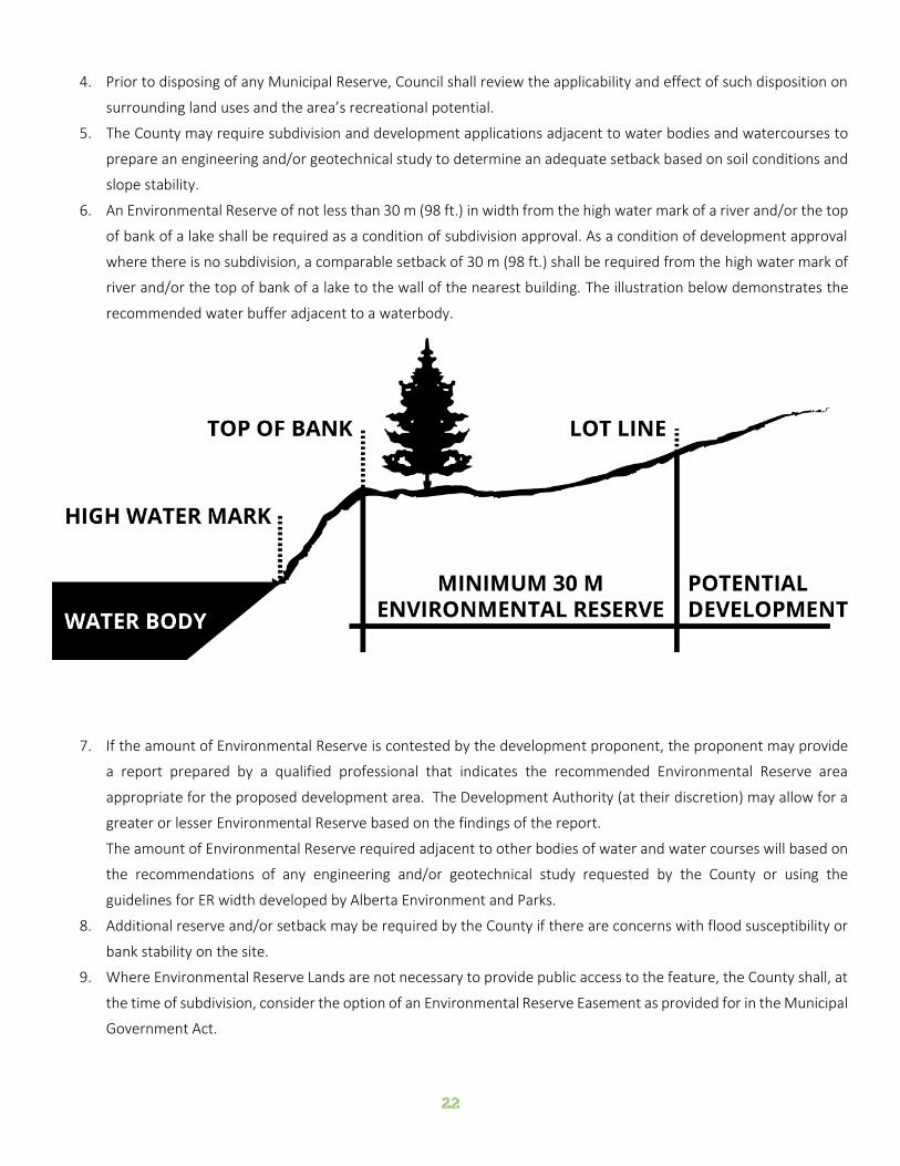
6. An Environmental Reserve of not less than 30 m (98 ft.) in width from the high water mark of a river and/or the top
of bank of a lake shall be required as a condition of subdivision approval. As a condition of development approval
where there is no subdivision, a comparable setback of 30 m (98 ft.) shall be required from the high water mark of
river and/or the top of bank of a lake to the wall of the nearest building. The illustration below demonstrates the
recommended water buffer adjacent to a waterbody.
7. If the amount of Environmental Reserve is contested by the development proponent, the proponent may provide
a report prepared by a qualified professional that indicates the recommended Environmental Reserve area
appropriate for the proposed development area. The Development Authority (at their discretion) may allow for a
greater or lesser Environmental Reserve based on the findings of the report.
The amount of Environmental Reserve required adjacent to other bodies of water and water courses will based on
the recommendations of any engineering and/or geotechnical study requested by the County or using the
guidelines for ER width developed by Alberta Environment and Parks.
8. Additional reserve and/or setback may be required by the County if there are concerns with flood susceptibility or
bank stability on the site.
9. Where Environmental Reserve Lands are not necessary to provide public access to the feature, the County shall, at
the time of subdivision, consider the option of an Environmental Reserve Easement as provided for in the Municipal
Government Act.
10. Municipal Reserves may be required as an open space buffer of sufficient size and composition to act as a noise
and visual barrier where required between disparate land uses. No more than 10% of the land may be taken as a
Municipal Reserve.
11. The County may consider proposals to designate future Conservation Areas.
12. At the discretion of the subdivision approving authority, the use of Conservation Easements may be considered as
an alternative to traditional environmental reserve during the subdivision process. The use and control of these
features and areas shall be clearly stated in the easement agreement. Conservation Easements are provided for
under the Alberta Land Stewardship Act and the Land Stewardship Act.
LAKESHORE DEVELOPMENT
There are several lakes within Flagstaff County that are used for both residential and recreational purposes. Flagstaff County
is also home to a large number of lakes where the shoreline has remained virtually undeveloped.
The County also features unique lake area habitats such as the Wavy Lake, Bellshill Lake and Schultz Lake all of which have
Important Bird Area (IBA) Status.
The purpose of this section of the Flagstaff County Municipal Development Plan is to provide policies which will assist in
maintaining and developing area lakes in a sustainable manner for future generations.
PROTECT SURFACE AND SUBSURFACE WATER QUALITY AND QUANTITY.
1. The conversion of existing seasonal recreational residential developments to permanent year round communities
may be considered at the discretion of Council.
2. The County will ensure that recreational residential developments adhere to the following conservation design
(cluster) based principles:
a. The ecology of the subject site must be considered. Environmentally sensitive lands will be left undisturbed
wherever possible, but incorporated into the overall development. Wildlife corridors or connections
between habitat areas will be maintained wherever possible.
b. Development will be directed to lands that are deemed by the County to be of lesser environmental
significance.
c. The natural landscape and topography will be considered and incorporated into the overall design of the
development.
3. Development which will have an adverse impact on lake water quality will be discouraged.
4. On-site sewage disposal systems other than holding tanks are not recommended on building sites where other
forms of sewage disposal may impact lake water quality.
5. Developments that may result in an impact on lake water levels through excessive use of surface and lake fed
groundwater aquifers will be prohibited.
6. The County will consider the preparation of lake management and/or Area Structure Plans for lake areas which
have been identified for future development.

7. Proponents of new developments adjacent to lakes will be required to prepare, submit, and adhere to a
construction management plan that ensures all silt, sediment, and pollutants will be contained and managed onsite
during construction.
8. New development adjacent to lakes will be restricted within 30 metres of any lake inlets and outlets.
9. Natural vegetative cover will be encouraged to be retained within 30 metres of the bed and shore of any lakes and
rivers within Flagstaff County.

The County’s most enduring resource is its working
landscapes. The agricultural, forestry, and resource lands
generate significant employment, and are central to the
collective history, culture, and sense of place of the County’s
residents.
Working landscapes are irreplaceable and contribute to the
high quality of life enjoyed by all Flagstaff County residents.
Working landscapes within the County must be carefully and
equitably managed in order to retain the integrity and value of these areas for the benefit of future generations while
supporting economic growth within the agricultural community.
In order to encourage the future viability of a diverse range of agricultural operations within the County, the Municipal
Development Plan includes objectives and policies to not only protect, where appropriate, but also enhance the agri-based
economy and rural lifestyle.
The following objectives and policies have been adopted Flagstaff County relating to agricultural areas:
OBJECTIVE: ENSURE WORKING LANDSCAPES REMAIN AN VIABLE COMPONENT OF THE REGIONAL ECONOMY AND
CULTURE
1. Most of the County is designated as the Agriculture Area, as shown on Map 6 - Future Land Use.
2. The Agriculture Area is to be, for the most part, conserved for agricultural and agriculture-related uses.
3. Industrial, commercial and residential uses may be allowed in the Agricultural area where provided for in the
County’s Land Use Bylaw.
4. While the primary use of the Agriculture Area is for extensive agriculture and confined feeding operations involving
the production of feed grains, cereal grains, forage crops, specialty crops, livestock and other animals on a
commercial basis, other uses which, in the opinion of Council, do not adversely affect present or future agricultural
pursuits may also be permitted on a discretionary basis provided that the development will not adversely affect the
agricultural community.
5. Within the Agriculture Area, a wide range of resource utilization uses may also occur provided that such uses do
not negatively impact other surrounding uses.
6. The County will give due consideration to the protection of good quality agricultural land and the location of existing
agricultural operations when applications for Land Use Bylaw amendments or subdivision are being determined.
7. The minimum parcel size for extensive agricultural uses will normally be a half quarter section less any permitted
Country Residential or Agricultural Small Holdings Subdivisions.
Flagstaff County will be a welcoming
community for a wide variety of agricultural
activities and support businesses.

8. Notwithstanding Policy 7 above, extensive agricultural parcels may be less than a half quarter section in area where
the parcel is fragmented by reason of one or more public roadways, railways, rivers, creeks or other natural barrier
which impedes the crossing of cultivation equipment.
OBJECTIVE: MINIMIZE NEGATIVE IMPACTS OF AGRICULTURAL OPERATIONS ON THE ENVIRONMENT & ADJACENT
LAND USES BY ENCOURAGING GOOD LAND STEWARDSHIP PRACTICES
1. The County will provide information to the agricultural community regarding beneficial management practices
(BMPs) and other conservation practices that conserve or enhance the health of soil resources.
2. Input shall be provided to the Natural Resources Conservation Board (NRCB) in responding to application for new
or expanded Confined Feeding Operations (CFOs) based on the technical and locational merits of each application.
The County’s policy is that all such confined feeding operations and manure storage facilities must fully satisfy all
the requirements and regulations adopted under that Act, specifically the minimum distance separation
requirements and the land base requirements.
3. Minimum distance separations for CFOs shall conform to standards set out in the Agricultural Operations Practices
Act.
4. In addition to the minimum distance separation requirements provided through regulations adopted under the
Agricultural Operation Practices Act, the County’s policy is that confined feeding operations requiring registration
or approval and manure storage facilities requiring authorization under that Act shall not be allowed within 2.4 km
(1.5 miles) of the corporate boundaries of any urban municipality within Flagstaff County or within 0.8 km (0.5
miles) of the Growth Node Area Overlay designated on Map 6 - Future Land Use, which areas shall be considered
an urban fringe when calculating the regulations approved under the Agricultural Operation Practices Act.
5. Confined Feeding Operations will be discouraged from locating in environmentally sensitive areas where slope
instability and or groundwater contamination may be of concern.
6. In addition, for the purposes of implementing the regulations adopted under the Agricultural Operation Practices
Act, the policies of Area Structure Plans within Flagstaff County respecting confined feeding operations shall be
applied in addition to the Municipal Development Plan policies.
COUNTRY RESIDENTIAL DEVELOPMENT IN THE AGRICULTURE AREA
Country residential development is the most common form of subdivision requested in Flagstaff County. Demand for
country residential parcels exists throughout the County and is primarily for single parcel developments.
The County recognizes that country residential development in the Agricultural Use area can provide a desirable lifestyle
for people wishing to reside in a rural area and an economic boon to members of the agricultural community wishing to
subdivide their land. This Plan strives to achieve a balance between providing additional opportunities for country
residential development while still supporting the livelihood and quality of life of the existing and future agricultural
community. As such, country residential living will be supported in the agricultural area in a limited way by regulating the
location and number of developments allowed per quarter section in the agricultural area.

Restricting country residential development within agricultural areas in the County will discourage inflation of the price of
agricultural land and minimize the potential for conflicts between the agricultural community and acreage and/or recreation
property owners.
PROVIDE OPPORTUNITIES FOR LOW NET ENVIRONMENTAL IMPACT COUNTRY RESIDENTIAL DEVELOPMENT IN
THE AGRICULTURAL USE AREA WITHOUT UNNECESSARILY FRAGMENTING WORKING LANDSCAPES
1. Country residential development will be allowed within the Agriculture Area shown on Map 6 - Future Land Use,
subject to the policies noted below.
2. Country residential subdivisions should be located in proximity to gas, electrical, and telephone lines which have
existing spare capacity to sustain the additional usage.
3. Country residential development will be cognizant of the need to preserve resource extraction, recreation,
historical, and archaeological features. It is the County’s policy that the effect a country residential development
may have on the environment will be an important consideration in dealing with country residential subdivision
and development proposals and Land Use Bylaw amendments.
4. Where a subdivision for country residential purposes is proposed, the developer shall be required to enter into a
development agreement with the County wherein the developer agrees to be responsible for all the costs
associated with the subdivision and development.
5. Subdivisions shall not be approved where access to existing graded and graveled or paved roads does not exist, or
where construction of roadways and accesses to County standards to the site are not undertaken primarily by the
landowner/developer. Where subdivisions do not have direct access to existing maintained roads, it shall be the
responsibility of the developer to register a new road and construct or pay for construction of roads, to County
standards.
6. Documentation indicating that satisfactory arrangements have been made regarding the development’s sewage
disposal system may be a condition of approval for country residential development and/or subdivisions.
7. The assessment of the suitability of a proposed country residential subdivision will not take into consideration
required setbacks for private sewage disposal systems. Rather, if a subdivision results in the reduction of setbacks
between an existing or proposed private sewage disposal system and a property line then the developer will be
required to ensure that the existing or proposed private sewage disposal system conforms to all relevant provincial
regulations affecting private sewage disposal systems.
8. Spatial buffers or setbacks may be required between country residential uses and adjacent uses which may, in the
opinion of the approving authority, be incompatible.
9. The subdivision of a naturally fragmented parcel shall not be approved for any use, unless the fragmented parcel is
fragmented by reason of one or more public roadways, railways, rivers, or creeks.
10. In addition to the criteria indicated in Policy 9, a natural fragmentation may also be considered to be a barrier to
the crossing of cultivation equipment created by substantial topography, such as a ravine or gulley. The
determination that such a topographic barrier is a natural fragmentation for the purpose of subdivision shall be at
the sole discretion of the Subdivision Authority.
11. The County may refuse to approve an application that proposes to subdivide a fragmented parcel if:

a. in the opinion of the municipality, the construction and maintenance of the roadway adjacent to the parcel
would serve no greater or long-term public interest; and
b. the municipality is responsible for the maintenance of the roadway upon completion of its construction or
upgrading.
12. In the case where another policy of this plan would allow for a subdivision to occur and the subject site also contains
a fragmenting feature as described in Policies 9, 10, and 11, and where the fragmented area contains adequate
developable area, the County will encourage the developer to subdivide the fragmented area, as the first
subdivision from the subject site.
13. Once a farmstead has been subdivided from a quarter section, the subdivided farmstead shall be considered a
country residential use for the purposes of this Plan and the Land Use Bylaw.
14. The maximum number of country residential lots, including fragmented parcels, vacant lots, abandoned farmstead
separations and farmstead separations, permitted per unsubdivided quarter section is three (3).
15. Notwithstanding the policies listed above, lots which include areas described as “pan handles”, that is, lots which
consist of lengthy narrow sections leading to a wider development site, shall not be approved by the Subdivision
Authority. Exceptions to this policy shall be allowed if, in the opinion of the subdivision authority, the proposed
subdivision does not interfere with an existing agricultural operation and:
a. the subdivision is to separate an existing farmstead from the balance of the quarter section; and
b. the lengthy narrow section is directly adjacent to the property line or quarter section line, whichever the
case may be; or
c. the lengthy narrow section is at least 100 m from the property line or quarter section line, whichever the
case may be.
16. In order to limit negative impacts on the agricultural capability of the agricultural parcels. Vacant country residential
parcels shall be located in the corners of the quarter section or on land with lower agricultural capability.
17. Where a subdivision would result in a second country residential parcel, and the proposed parcel is vacant, the
proposed parcel shall be located adjacent to an existing country residential parcel or on land that is not conducive
to agricultural use.
18. The subdivision authority shall not approve vacant country residential parcels that unnecessarily fragment or
otherwise negatively impact the agricultural use of the remnant part quarter section.
19. Country residential development will be prohibited in those areas which are too close to sour gas facilities, in
accordance with Provincial legislation and regulations.
20. Documentation indicating that arrangements satisfactory to the County have been made regarding the
development’s water supply, sewage disposal, and storm water management systems, including access to the
systems for maintenance and any necessary easements, may be conditions of approval for multi-lot country
residential development.
21. The maximum area of a vacant country residential (acreage) use lot shall be 1.2 ha (3.0 ac.).
22. A maximum of one (1) vacant country residential use parcel (acreage) shall be allowed per quarter section.
23. Normally, a maximum of 6 ha (15 ac.) per quarter section will be allowed for country residential subdivisions or for
farmstead separations.

SINGLE PARCEL SEPARATION
1. Normally, subdivision of a quarter section for a country residential use will be allowed without requiring an
amendment to the Land Use Bylaw on the basis of the following:
a. subdivision of the quarter section based on an equal split of the quarter section (commonly called an 80-
ac. split); or
b. subdivision of the quarter section on the basis of a natural or man-made fragmentation by a river, railroad,
or road; or
c. subdivision of one farmstead or one country residential parcel from the quarter section.
2. The maximum number of parcels per quarter section in the agricultural use area is four (4). This includes agricultural
parcels, country residential parcels and fragmented parcels. Additional parcels will not be permitted without a Land
Use Bylaw amendment.
3. Notwithstanding Policies 1 and 2 above, the maximum number of country residential parcels permitted per quarter
section is dependent upon the number of agricultural parcels and fragmented parcels on the subject quarter
section. Conversely, the number of allowable agricultural parcels is dependent upon the number of country
residential parcels and fragmented parcels on the subject quarter section. Figure 4 presents the maximum number
of country residential parcels per quarter section.

Flagstaff County is home two hamlets (both former villages),
Galahad and Strome.
In order to accommodate population growth, optimize the
use of existing services, and to strengthen the long term
viability of the facilities contained in these communities,
each Hamlet will grow within or contiguous to their
boundaries to accommodate a long-term growth scenario.
The further development and intensification of the land uses
within the Hamlets will allow for more efficient use of existing infrastructure and allow the provision of a broader range of
community facilities and services.
OBJECTIVE: PROMOTE THE ORDERLY AND ECONOMIC GROWTH OF ALL HAMLETS.
1. Flagstaff County shall pursue the preparation of Area Structure Plans for each Hamlet within the County, to provide
policy direction for future land use and development in these communities.
2. Flagstaff County supports contiguous development that is adjacent to existing development in order to
accommodate growth in an orderly and economical manner.
3. Council may allow the expansion of hamlets, preferably onto lower capability agricultural land, if additional area is
needed to accommodate growth. Council shall also encourage the development of vacant lots and underdeveloped
opportunity sites and the redevelopment of older buildings within the hamlets, provided that the infill development
or redevelopment will not adversely affect the surrounding areas.
OBJECTIVE: PROVIDE FOR A VARIETY OF HOUSING TYPES AND DENSITIES WITHIN THE HAMLETS.
OBJECTIVE: FACILITATE THE GROWTH OF BUSINESS OPPORTUNITIES IN THE HAMLETS.
1. Flagstaff County shall promote the growth and development of compact, viable business districts for each Hamlet.
a. Flagstaff County shall encourage all commercial and industrial uses in a Hamlet to be located in industrial
parks and shall be buffered from adjacent residential and non-compatible land uses; and:
b. shall require that all industrial developments in Hamlets are adequately serviced; and
c. may require landscaping or screening in order to improve the appearance of industrial areas.
2. Flagstaff County shall ensure that a sufficient supply of commercial and industrial land is available for development
in the Hamlets.
The Hamlets of Flagstaff County will be
developed in an orderly manner and will
serve as important community hubs for
local residents and visitors

OBJECTIVE: PROVIDE A VARIETY OF INSTITUTIONAL, RECREATIONAL, AND CULTURAL OPPORTUNITIES WITHIN THE
HAMLETS.
1. Flagstaff County shall support local initiatives that promote culture and heritage in the Hamlets.
OBJECTIVE: OPTIMIZE THE USE OF EXISTING SERVICES AND INFRASTRUCTURE AND TO STRENGTHEN THE LONG
TERM VIABILITY OF ALL HAMLETS.
1. The County will only allow development in hamlet areas which will be compatible with the current capabilities and
capacities for water supply and sewage disposal systems.
2. Map 6 - Future Land Use illustrates Hamlet areas in Flagstaff County, which are included in the Growth Node Area
Overlay. These areas are characterized by:
a. the proximity to compatible land uses;
b. the proximity to existing or proposed community facilities;
c. accessibility to transportation infrastructure; and
d. municipal servicing that can be provided in an efficient and economical manner.
3. New development in hamlets which does not have access to piped municipal potable water and piped sanitary
sewer service systems should be planned and designed so that the lot size and lot configuration will permit re-
subdivision to a higher density should municipal potable water and piped sanitary sewer service become available.
Flagstaff County has experienced limited multi-lot country
residential development outside of the hamlets. However,
interest in this type of development is expected to increase
with regional growth pressures and increasing demand for
country residential developments. This trend affects the
social, economic, and environmental community of the
County.
Generally, multi-lot country residential developments are
not connected to municipal sewer or water services while the urban residential developments do have access to municipal
water and sewage disposal systems.
This Plan strives to achieve a balance between providing opportunities for country residential development while still
supporting and preserving the livelihood and quality of life of the existing and future agricultural community, the physical
environment, and the existing Hamlet communities.
Multi-lot country residential developments may be allowed in Flagstaff County subject to the following policies:
OBJECTIVE: TO PROVIDE OPPORTUNITIES FOR LOW-IMPACT MULTI-LOT COUNTRY RESIDENTIAL DEVELOPMENT IN
APPROPRIATE LOCATIONS
1. A multi-lot country residential subdivision will be considered to be any subdivision which will create five (5) or more
parcels on a quarter section.
2. Multi-lot country residential subdivisions will be controlled by County Council through the process of Land Use
Bylaw amendment.
3. The County will require an Area Structure Plan or Development Concept be prepared and approved prior to the
approval of any amendment to the Land Use Bylaw to allow a multi-lot country residential subdivision where the
land being proposed for development is greater than 6.06 ha (15 ac.) in size, except that the County may require
the preparation of a conceptual plan or outline plan if:
a. the preparation of an Area Structure Plan is considered by the County to be impractical or inappropriate
given the small scale of the lands proposed for development or the fragmentation of the quarter section in
which the development is located, or
b. the subject lands, at full build out, are equal to or less than 6.06 ha (15 ac.) in size.
4. Country residential subdivision and/or development shall be discouraged:
a. within an area likely to be subjected to high levels of noise from industry, transportation facilities, or other
sources of noise;
b. in close proximity to a resource extraction operation;
Country residential development in will be
located and designed to respect local
agricultural practices, and to preserve the
natural environment.

c. within the minimum distance separation between a single dwelling and a confined feeding operation as
determined through the use of Schedule 1 of the Standards and Administration Regulation adopted
pursuant to the Agricultural Operation Practices Act; or
d. adjacent to river banks, unless the banks are certified as being stable by an engineer prior to development,
or, alternatively, unless the land owner takes all responsibility for the impact of any bank instability
currently or in the future.
5. Country residential subdivision and/or development shall be prohibited within a 1 and 100 year flood plain or flood
fringe areas. If the flood plain or flood fringe area has not been delineated the developer will be responsible for
providing the required information, at no cost to the County, at time of application.
6. Residential subdivisions should be located in proximity to gas, electrical, and telephone lines which have existing
spare capacity to sustain the additional usage.
7. Residential subdivisions shall have direct access to existing maintained roads, at the cost of the developer. Multi-
lot residential subdivisions shall be encouraged to locate in proximity to paved County roads or provincial highways.
If a road needs to be improved to meet current County standards then the costs for required improvements will be
borne by the developer.
8. Documentation indicating that satisfactory arrangements have been made regarding the development’s sewage
disposal system may be a condition of approval for country residential development.
9. Spatial buffers or setbacks shall be maintained between country residential uses and adjacent uses which may be
incompatible for any reason.
10. A multi-lot country residential subdivision shall be considered to be any subdivision which will create five or more
parcels for residential and/or agricultural use on a quarter section.
11. Where provided for in the Land Use Bylaw, the minimum lot size in residential area may be as low as 0.2 ha (0.5
ac.), provided that the entire lot is suitable for residential development.
12. Multi-lot country residential developments will be discouraged, but not prohibited, from locating on good quality
agricultural land, and shall be encouraged, but not required, to locate on poorer quality agricultural land.
13. Council’s consideration of Land Use Bylaw amendments for multi-lot country residential use development will
include the following criteria:
a. The site should possess features such as trees, ravines, hilly terrain or other topographical features which
would provide an attractive residential environment. When the amendment is to allow a currently vacant
parcel from a quarter section, the site should not normally include cultivated land or good quality
agricultural land. Where a site is fully or partially treed, all possible means will be undertaken to retain the
maximum amount of tree cover.
b. The density of development shall be directly related to the development capability of the land resources,
such as potable water supply, topography, vegetation, wetlands, soil and drainage. In this regard,
proponents for multi-lot country residential development may be required to provide the County with an
assessment of environmental constraints on the site and the means whereby negative impacts on the
natural environment may be mitigated.
c. Access to individual country residential lots will be provided by internal roads or service roads developed
to standards acceptable to the County. Direct access onto Provincial Highways or County grid roads will
not be permitted.

d. There shall be an adequate supply of potable water for the development as proposed. The supply may be
provided by wells or by other options, such as by hauling or by communal systems, in accordance with
Provincial regulations. If the well option is to be considered, the Council will ask that the report required
under the Water Act for multi-lot residential subdivisions be provided at the Land Use Bylaw amendment
stage for its consideration. If the communal system is to be considered, Council will require that the
creation or expansion of such systems be undertaken at the developer’s cost, and not at the County’s cost.
e. Sanitary sewage shall be treated and/or disposed of in accordance with Provincial requirements. In this
regard, the Council will ask that information be provided at the Land Use Bylaw amendment stage for its
consideration. If a communal system is to be considered, Council will require that the creation or expansion
of such systems be undertaken at the developer’s cost, and not at the County’s cost.
OBJECTIVE: ENCOURAGE LOW NET MULTI-LOT COUNTRY RESIDENTIAL DEVELOPMENTS IN LOCATIONS WHICH
GENERATE NO OR LOW IMPACTS ON THE COUNTY’S WORKING AND CULTURAL LANDSCAPES
1. Multi-lot country residential developments will adhere to the following conservation design-based principles in
order to mitigate potential negative impacts:
a. The ecology of the subject site must be considered. Environmentally sensitive lands and working
landscapes should be left undisturbed wherever possible, but incorporated into the overall development.
Wildlife corridors or connections between habitat areas should be maintained wherever possible.
b. Development will be directed to lands within the subject site that are deemed by the County to be of lesser
environmental and/or agricultural significance.
c. The natural landscape and topography should be considered and incorporated into the overall design of
the development.
d. Wetlands will be avoided.
2. Multi-lot country residential developments should be clustered or grouped to reduce potential land use conflicts
and minimize servicing costs.
OBJECTIVE: MINIMIZE MUNICIPAL SERVICING COSTS ASSOCIATED WITH MULTI-LOT RESIDENTIAL DEVELOPMENTS
1. The County will require the proponent of country residential developments to identify all municipal servicing costs
associated with the development. The assignment of these costs between the County and the developer will be
the basis of a development agreement to be entered into prior to a subdivision approval or upon the issuance of a
development permit. Normally, however, all development servicing costs associated with the development,
including the provision of internal roadway systems to a high standard and the upgrading of other County roads
leading to the site in order to provide good access to the residential site will be the responsibility of the developer.
2. The development process for multi-lot country residential development shall ensure that storm water is managed
in accordance with good engineering practices and both Provincial and County requirements.
3. The County may consider alternative means of providing municipal services, such as through the use of linear
corridors.
4. The review of country residential development proposals, including the review of Area Structure Plans and
engineering briefs related to country residential development proposals, cost the County both in the County’s staff

resources and finances. The County shall require country residential development proponents to pay for the
County’s review of their proposals.
5. Documentation indicating that arrangements satisfactory to the County have been made regarding the
development’s water supply, sewage disposal, and storm water management systems, including access to the
systems for maintenance and any necessary easements, shall be conditions of approval for country residential
development.

COMMERCIAL DEVELOPMENT
The intent of the Plan is to accommodate commercial
facilities, primarily adjacent to the highway, secondary road
systems, within established hamlets, and in appropriate
locations within multi-lot recreation residential
developments. Commercial development provides a service
to the agricultural community, local residents, highway
traveling public, and tourists to the region.
The County will not support commercial developments that adversely affect the standard of safety or convenience, or the
functional integrity of any highway or road. The Plan also recognizes that specific commercial uses may require unique site
locations in order to serve the rural community.
OBJECTIVE: ENCOURAGE APPROPRIATE COMMERCIAL DEVELOPMENT IN ENVIRONMENTALLY SUITABLE
LOCATIONS.
1. Commercial development will be allowed within the Agriculture Area and Commercial Area, as shown on Map 6 –
Future Land Use.
2. Commercial uses will be encouraged to avoid locating in areas of critical wildlife habitat wherever possible.
3. The County shall consider proposals for commercial development:
a. that will not unnecessarily fragment the working landscape; and
b. that do not conflict with adjacent land uses.
4. Commercial subdivision and development that, in the opinion of Council, could have a significant impact on the
community and environment, shall be controlled by the County Council through the process of a Land Use Bylaw
amendment to an appropriate Commercial District in the Land Use Bylaw and, in areas where there is an
Intermunicipal Development Plan or an Area Structure Plan, by amendment to the appropriate Plan, if required.
5. Commercial uses shall be encouraged to locate on lower capability agricultural land wherever possible.
6. In consideration of a proposal for a Commercial development, an assessment of the proposed development may
be required which:
a. precisely defines the boundaries of the proposal;
b. designates suitable building sites;
c. ensures the functional integrity of the adjacent roads is maintained through the use of service roads and
limited access points;
d. defines standards of development which may include architectural, landscaping and sign controls;
e. identifies methods and facilities for servicing; and
f. includes groundwater and soil permeability tests.
Commercial and industrial businesses that
provide services to the region will be
developed in a safe and efficient manner,
and capitalize on local infrastructure.

7. Highway Commercial uses will be allowed in the Agricultural Use Area, in areas adjacent to Highways in appropriate
locations at the discretion of the Development Authority.
8. Highway commercial uses shall include those uses (primarily established adjacent to highways or secondary roads)
that provide service requirements for the highway traveling public. Such uses include service stations, bulk oil sales,
restaurants, motels and campsites.
9. General commercial uses shall include those uses that primarily serve the agricultural industry, the resource
extraction industry, or County residents. Such uses include retail and wholesale sales, personal and equipment
services, restaurants, offices, and financial and entertainment establishments.
OBJECTIVE: MINIMIZE CONFLICTS WITH ADJACENT LAND USES
1. The County will normally require site design standards be followed and that buffers be located between commercial
developments and other existing and future land uses and transportation routes in order to provide visual or
acoustic screening. The expansion potential of commercial development should be considered in determining the
required buffer.
OBJECTIVE: MINIMIZE MUNICIPAL SERVICING COSTS ASSOCIATED WITH COMMERCIAL DEVELOPMENT
1. Council shall encourage commercial development in hamlets if the resultant servicing requirements do not exceed
the servicing capabilities of the hamlet or negatively impact the character of the hamlet.
2. The Development Authority shall require the developer of a commercial development to identify all municipal
servicing costs associated with the development. The assignment of these costs between the County and the
developer will be the basis of an agreement to be entered into prior to a subdivision approval or upon the issuance
of a development permit. Normally, all development servicing costs associated with the development will be borne
by the developer.
INDUSTRIAL DEVELOPMENT
For the purpose of this Municipal Development Plan, the term "industry" refers to manufacturing or warehousing and
storage, and includes: rural, light, medium and heavy industry as well as natural resource extraction industries. Natural
resource extraction industries, such as gravel pits and oil and gas wells, are addressed in greater detail in Section 3.8.
Most of Flagstaff County’s economic base focuses on the agriculture and resource sectors. Historically, the continuation
and expansion of the County’s industrial base has been limited due to a finite land base and the non-renewable nature of
the mining and petroleum resource sector. The County recognizes that industrial developments can be of benefit to the
County by providing employment, tax dollars and services to County residents. The Plan encourages the clustering together
of compatible industrial uses in rural industrial parks.
This Plan encourages the diversification of the County’s economic base by identifying land and policies to support the
development of a diverse range of industrial developments within the County.

OBJECTIVE: ENCOURAGE INDUSTRIAL DEVELOPMENT IN APPROPRIATE LOCATIONS
1. Industrial development will be allowed in the Agriculture and Commercial Areas, as shown on Map 6 – Future Land
Use.
2. Industrial uses shall be encouraged to locate on lower capability agricultural land, in proximity to paved County
roads or provincial highways, and in areas with access to existing water and three phase power services wherever
possible.
3. Industries will be encouraged to avoid locating in areas of critical wildlife habitat wherever possible.
4. Notwithstanding Policies 2 and 3 above, industrial uses shall be encouraged to locate in areas that are designed
and serviced to accommodate industrial development.
5. Further to Policy 4 above, new industrial developments will be discouraged from locating within 100 metres of
existing residential buildings in the Agriculture Area.
6. Before approving any development proposal for an industrial use, the County may require the provision of a
Cumulative Effects Assessment including environmental impact information and a risk assessment (such as that
provided for by the Major Industrial Accidents Council of Canada (MIACC) to assist the County in assessing the
impact of the proposed development in relation to the natural and human environments, and indicate both if and
how any negative matters can be mitigated. The County may require the implementation of any mitigating actions
indicated in the information and assessment as a condition of any development approval.
7. Industrial uses (including industrial parks) shall not result in any additional costs to the County, unless the County
agrees to share costs.
8. All industrial uses shall obtain the approvals and permits required by provincial legislation and a development
permit from the County.
9. Industrial uses shall be encouraged to locate on land that is physically suited for industrial use, considering factors
such as soil, drainage, slopes and the availability of necessary services.
10. Industrial uses shall not be located in areas where the use is likely to subject residences, hospitals, schools, or other
noise sensitive uses to high levels of noise.
11. The County will normally require that site design standards be followed and that buffers be provided between
industrial development and other land uses and transportation routes in order to provide visual or acoustic
screening. The expansion potential of the industrial development should be considered in determining the required
buffer.
12. Council will consider proposals for the development of lands for industrial uses near a developed urban
municipalities, if the proposal is for a light industrial use, and the industry would not be considered noxious. All
proposals for light industrial development near urban areas will be circulated to the urban municipality for
comment and review.
OBJECTIVE: ENCOURAGE INDUSTRIAL DEVELOPMENT REQUIRING MUNICIPAL SERVICES TO LOCATE WHERE
ACCESS TO SERVICING EXISTS.
1. Council shall only consider proposals for the development of lands for industrial uses in a hamlet if the proposal is
for a light industrial use.

2. Industries that require urban services shall not be permitted except where such services are available from the
County or a joint development/servicing agreement between the County and an adjacent urban municipality has
been finalized.
3. Industrial subdivision and development which, in the opinion of Council, could have a significant impact on the
community and environment, shall be controlled by the County Council through the process of a Land Use Bylaw
amendment to an appropriate Industrial District in the Land Use Bylaw and, in areas where there is an approved
statutory plan, by amendment to the appropriate Plan.
4. The proponent of any new industrial development or expansion of such development shall identify any costs
associated with providing new services and upgrading existing services made necessary by the proposed
development. The apportionment of costs may be negotiated by the County and be settled within a development
agreement which shall be a condition of subdivision or development approval.
5. All proposals for industrial development (including industrial parks) will:
a. not, in the opinion of the County, conflict or jeopardize with surrounding land uses;
b. be considered only in accordance with either an approved outline plan or, an approved Area Structure Plan
and be developed in accordance with the Municipal Government Act. Outline Plans/Area Structure Plans
for industrial uses will address:
i. the impact on adjacent land uses;
ii. transportation;
iii. provision of water and sewer services;
iv. storm drainage;
v. the provision for municipal reserve;
vi. the impact on community services, such as fire protection;
vii. the municipal servicing costs associated with the development;
viii. landscaping;
ix. risk assessment; and
x. any other matters identified by the County.
xi. not be allowed to locate in close proximity, as determined by the County, to a hamlet, an urban
centre or a multi-parcel residential subdivision;
c. be accompanied by an identification of all municipal costs associated with the proposal;
d. meet all provincial requirements and obtain a development permit from the County prior to construction;
and
e. be encouraged to locate near or adjacent to provincial highways.

Sand, gravel, coal, oil, and gas are important non-renewable
natural resources in Flagstaff County. In order to benefit the
County’s and the region’s economy, these resources must
be managed and extracted efficiently and responsibility, and
not at the risk of irreparably damaging the local agricultural
community, residential and urban areas, or the natural
environment. It is the intent of the MDP to encourage the
utilization of extractive natural resources in areas of least
detrimental impact, and to reclaim the land for other productive uses once completed.
Flagstaff County believes that natural resources must be protected from surface developments, particularly if such
development has the effect of making natural resource exploration and processing expensive, difficult, or impossible. On
land where economically-viable deposits of natural resources exist, Flagstaff County will allow subdivision only for farm site
separations or the creation of intensive agricultural parcels. Flagstaff County Council may relax this requirement in areas
where the economic value of a particular natural resource has yet to be established.
OBJECTIVE: ENCOURAGE THE UTILIZATION OF EXTRACTIVE NATURAL RESOURCES IN AREAS OF LEAST
DETRIMENTAL IMPACT
1. The developer of a resource extraction industry or activity will be required at the time of the application for
development permit, to demonstrate to the satisfaction of the County, that any necessary provincial permits and
approvals pertinent to the development have been obtained.
2. Development permits for sand, gravel, clay or marl extraction will not be issued until any necessary approvals are
obtained in accordance with Provincial legislation.
3. Any resource extraction industry that requires a development permit, unless exempted by Provincial legislation,
shall enter into and abide by a development agreement with the County, to deal, among other matters, with road
use and their maintenance.
4. Development permits for gravel extraction should be issued on the basis of whether the proposed use will fully and
efficiently utilize the capability of the deposit. Deposits suitable for construction aggregates should be reserved for
that use.
5. Applicants for commercial aggregate resource extraction development shall be required to submit to the County a
survey prepared by a qualified professional that identifies the total working area of an extraction site. If the site
(taking into consideration expansions to the preliminary working area boundary) is, or would be larger than 2.02 ha
(5.0 acres), the applicant must comply with the requirements for the provincial approval of a Class I pit.
6. The developer of a gas or oil well site will be required to obtain approval from the County regarding the
construction, upgrading and maintenance of access roads.
Resource exploration, extraction, and
transportation will be undertaken safely,
efficiently, and with respect to the natural
environment and agricultural operators.

OBJECTIVE: ENSURE THAT LAND DISTURBED BY RESOURCE EXTRACTION ACTIVITY IS RECLAIMED TO AN
ACCEPTABLE STANDARD.
1. The County shall require development agreements in connection with sand, gravel and other mineral extraction
operations and should make provisions for the:
a. reclamation of the land that was disturbed to its former agricultural capability or to a post-extractive use
whichever Council feels is more beneficial;
b. control of on-site noise, dust and weeds;
c. storage of topsoil;
d. separation of the resource extractive operation from any multi-lot residential subdivision, hamlet, or urban
municipality with a suitable open space buffer;
e. designation of all aggregate haul roads to reduce noise, excessive maintenance costs, and dust problems;
and
f. if required by the County, the provision of security such as an irrevocable letter of credit to ensure
reclamation will be completed.
2. Before a development permit is issued, the County may require the proponent of a resource extraction
development to post a performance bond or similar security for the purpose of ensuring reclamation is completed
where no similar requirement is made by a Provincial agency.
3. Land which is underlain by a commercial deposit of gravel or coal will not be used for purposes which would prevent
subsequent extraction until the deposit has been removed and the land has been reclaimed.
OBJECTIVE: MINIMIZE MUNICIPAL COSTS ASSOCIATED WITH RESOURCE EXTRACTION DEVELOPMENT.
1. The County will not approve a development permit application or approach permit for resource extraction until the
developer enters into a haul road agreement with Flagstaff County.
2. The developer of a natural gas or oil well site shall be required to obtain approval from the County regarding the
construction, upgrading and maintenance of access roads.
3. Resource industries which utilize County infrastructure shall be required to participate in the maintenance and
upgrading of that infrastructure if the need arises, as determined by the County.
OBJECTIVE: ENSURE THAT RESOURCE EXTRACTION AND RESOURCE PROCESSING GENERATE A LOW NET
NEGATIVE IMPACT ON LOCAL CULTURAL AND HERITAGE RESOURCES.
1. The County may not support resource extraction development proposals in areas that are known to possess unique
historical and/or scientific or environmental features that would be disturbed or destroyed by resource extraction.
2. Developers may be required to contact the Heritage Branch of the Alberta Government in order to determine if a
Heritage Impact Assessment (HIA) is required.
3. If an HIA is required and the HIA identifies the presence of heritage resources then the developer will be required
to take appropriate mitigating measures, to the satisfaction of the appropriate provincial agency, prior to
development approval.
OBJECTIVE: LIMIT CONFLICTS BETWEEN USES THAT ARE INCOMPATIBLE WITH RESOURCE EXTRACTION ACTIVITIES.

1. Areas that may have high potential for resource extraction, specifically areas of sand, gravel, and aggregate deposits
are identified for information purposes on Map 5 – Natural Resources.
2. Haul routes for resource extraction developments shall meet the current County road design standards and be
located, to the satisfaction of the County, in such a manner that impacts on agricultural uses and existing residential
developments are minimized.

RECREATION
As the demand for recreational land for both public and
private use increases, so does the need for planned
recreational facilities and areas. This Plan recognizes and
encourages local recreational uses based on the capabilities
of an area to sustain intensive or extensive recreation
development. Recreation development should be located in
areas and under circumstances where it does not adversely affect the agricultural economy and community, or the natural
environment.
Recreation can also form an important component of the tourism potential of the region, and is to be encouraged as much
as possible within the term of this Plan, provided, of course, that the tourist activities or facilities do not threaten the
potential development of additional economic activities, the agricultural economy and community, or the natural
environment.
The following objectives and policies have been adopted by Flagstaff County relating to recreation, and apply to land within
all Future Land Use Areas identified on Map 6 – Future Land Use:
OBJECTIVE: ENSURE THAT THE COUNTY HAS AN ADEQUATE SUPPLY OF LAND AND RESOURCES FOR
RECREATIONAL USES
1. The County will generally take the full amount (10%) of Municipal Reserves owing as a result of subdivision, in
accordance with Provincial legislation. Where it is deemed that Municipal Reserve land is not necessary for the
residents of the area, money-in-lieu (or a combination of land and money-in-lieu) will be taken.
2. Prior to disposing of any Municipal Reserve, Council will review the applicability and effect of such disposition on
surrounding land uses and the area’s recreational potential.
3. School Reserves will be provided at the time of subdivision in accordance with agreements between the County
and the relevant School Divisions.
OBJECTIVE: ENCOURAGE RECREATIONAL DEVELOPMENT IN AREAS THAT WILL NOT IMPACT WORKING
LANDSCAPES.
4. Council shall encourage the development of public serving recreational facilities/uses that are:
a. compatible with the capabilities of a site or surrounding areas;
b. on lower capability agricultural lands, unless Council decides that the benefits to the community justify the
use of higher capability agricultural lands; and/or
c. located near or adjacent to a lake or river if the proponent can demonstrate, to the satisfaction of the
Development Authority, that the proposal is compatible with the lake/river environment.
Flagstaff County will support the
development of recreation and tourism
amenities that accommodate the diverse
needs of local residents and visitors.

OBJECTIVE: ENSURE THAT RECREATIONAL USES ARE COMPATIBLE WITH THE ENVIRONMENT AND SURROUNDING
LAND USES
1. Subdivision and development for recreational purposes shall occur in accordance with the following design
principles:
a. The density of development shall be directly related to the land suitability assessment for the specific site;
b. The design shall be directly related to the site’s topography vegetation, soil, and drainage characteristics.
In this regard, the development proposal shall include a detailed analysis of the environmental constraints
of the site and the means by which the proposal will protect and harmonize with the natural environment;
c. The design shall protect wildlife habitat; and
d. The design shall protect, maintain and re-establish, where necessary, cover, and maximize the quality of
the natural features.
2. Council encourages the development of recreational lands and facilities in appropriate locations such as some areas
adjacent to the Battle River, Fish Lake, Byers Lake, and Sedgewick Lake. In these areas, Council will encourage
recreation agencies to identify land needs and support development opportunities for public use.
MINIMIZE MUNICIPAL COSTS ASSOCIATED WITH RECREATIONAL DEVELOPMENTS.
1. The County shall require the proponent of a recreational activity to identify all municipal costs associated with the
development. The assignment of these costs shall be the basis for an agreement to be entered into as a condition
of subdivision approval or the issuance of a development permit. Normally, however, all development servicing
costs associated with the development will be carried by the proponent.
2. In all instances, any financial involvement in recreational trails by the County will be considered by Council of the
County on a project-by-project basis.
OBJECTIVE: PROTECT AND ENCOURAGE TRAIL DEVELOPMENT WHILE ALSO PROTECTING ADJACENT LAND
OWNERS FROM POTENTIAL NEGATIVE IMPACTS THROUGH THE CAREFUL REGULATION OF THE RECREATIONAL
USE OF RIGHTS-OF-WAY
1. Country residential developments may be required to provide multi-modal trail networks to the satisfaction of the
Subdivision Authority at time of subdivision.
2. Where trails are provided as part of a country residential development, buffering measures within the trail right
of way shall be provided to reduce noise, dust and the potential for trespassing on private property.
TOURISM
Flagstaff County supports tourism initiatives and encourages the development of local hospitality operations, museums,
churches, cultural centers, golf courses, and other special events including special event facilities.
The following objectives and policies have been adopted by Flagstaff County relating to tourism:

OBJECTIVE: SUPPORT AND PROMOTE CULTURAL TOURISM INITIATIVES WITHIN THE COUNTY
1. The County will encourage the utilization and/or development of cultural, historic and recreational resources to
promote tourism, where appropriate.
2. The County will endeavor to assist in the identification and classification of significant heritage and legacy lands.
OBJECTIVE: SUPPORT AND PROMOTE EXISTING TOURISM DESTINATIONS WITHIN THE COUNTY
1. The County will endeavour to promote existing tourism destinations within the County and nearby recreational
tourism opportunities.
2. Flagstaff County will not allow the conversion of recreation facilities to work camps without specific County
permission.
OBJECTIVE: COOPERATE WITH REGIONAL PARTNERS TO ENCOURAGE LOCAL AND REGIONAL TOURISM
1. The County will co-operate with area tourism groups, municipal neighbours, and tourism zones in promoting local
tourism linkages with neighbouring communities.
2. The County shall encourage private sector developers to facilitate tourism development, and may assist in accessing
government funding programs to develop new, or upgrade existing tourism attractions.
3. The County shall work with private sector developers to encourage and facilitate tourism development, and may
assist in accessing any government funding programs to develop new, or upgrade existing, tourism attractions.
4. Flagstaff County will co-operate with area tourism groups, municipal neighbours and tourism zones in promoting
local tourism linkages with neighbouring communities.
5. The County will promote and encourage new developments within Flagstaff County and among its regional partners
that benefit local and regional tourism initiatives.
6. The County will promote guest ranches by creating a separate use category in the Land Use Bylaw to allow such
uses, on a discretionary basis, in the Agricultural District.

The development of transportation and utility systems can
have a significant impact on land use within Flagstaff County.
Although the County does not have the authority to regulate
Provincial Highways, pipelines, transmission lines, and
similar installations that are under provincial control,
Council is given an opportunity to comment on the proposed
locations of these facilities. It is Council’s intention to
encourage the appropriate authorities to have regard for the
policies of this Plan.
Flagstaff County is also responsible for a wide variety of infrastructure assets. This includes everything from rural roads
throughout the County, to sanitary services in local hamlets. As a provider of local infrastructure, Flagstaff County must
ensure that these assets are operating safely and efficiently, and to the benefit of County residents.
The following objectives and policies have been adopted by Flagstaff County to guide the provision and maintenance of
new and existing transportation and municipal servicing infrastructure within the County.
OBJECTIVE: DISCOURAGE THE FRAGMENTATION OF RURAL AGRICULTURAL LANDSCAPES BY BUILT
INFRASTRUCTURE.
1. Council shall encourage transportation, communication, or utility facilities and services to locate so that they:
a. minimize impacts on working landscapes;
b. minimize the fragmentation of land, and/or the creation of fragmented parcels;
c. follow road allowances wherever feasible;
d. use corridors to integrate a number of utilities;
e. minimize disruption of recreation, wildlife, and historic resources; and
f. avoid disruption of existing or future urban centres.
2. Where land is taken for roads, rail lines, pipelines or other transmission lines, the County shall endorse only those
proposals which minimize fragmentation.
OBJECTIVE: MINIMIZE CONFLICTS BETWEEN TRANSPORTATION, COMMUNICATIONS, UTILITY FACILITIES, & OTHER
LAND USES.
1. Council shall encourage high voltage power lines and high pressure pipelines to locate away from residential areas.
2. Council may consider the establishment of a Dangerous Goods Route when Council feels that dangerous goods are
being transported on County roads in sufficient quantity to be a significant hazard to the travelling public.
1. Where proposed transportation and utility lines and facilities may adversely affect adjacent lands or land uses, the
County shall recommend or require as a condition of development of the line or facility such buffering as deemed
appropriate to minimize any negative impacts.
Flagstaff County will develop, support, and
maintain safe, efficient, and effective
transportation and utility systems.

2. The County may require future subdivision or development proposals adjacent to transportation and utility lines
and facilities to provide such buffering as deemed appropriate.
3. The County shall encourage wireless communication facilities to consider good planning and design so as to have
the least impact on the natural environment, and the least visual impact on nearby residents. The County shall also
encourage the developers of wireless communication facilities to provide an opportunity for public consultation.
4. The co-location of multiple devices on wireless communication facilities is preferred. Where appropriate, new
facilities should be built to standards to accommodate multiple devices. Individual facilities are strongly
discouraged. If co-locations do not prove feasible, clustering of wireless communication facilities will be preferred.
5. Direct access from private property onto all County roads shall normally be controlled, following the County’s
approved access and approach design standards.
OBJECTIVE: ENSURE THAT THE CONTINUED OPERATION OF LOCAL AIRPORTS AND AIRSTRIPS IS NOT RESTRICTED
BY ADJACENT FUTURE LAND USE AND DEVELOPMENT ACITIVITIES
1. In order to minimize safety hazards and land use conflicts around airports, the County shall encourage the
regulation of building heights in the areas around all publicly licensed and paved airports in the County.
2. Detailed regulations for developments that may negatively impact the operations of the airport because of height
intrusions will be incorporated into the County's Land Use Bylaw.
OBJECTIVE: ENCOURAGE REGIONAL COOPERATION IN THE PROVISION, OPERATION, & MAINTENANCE OF
INFRASTRUCTURE.
1. The County shall endeavour to cooperate with other municipalities in the upgrading of intermunicipal roadways.
2. The County shall endeavour to cooperate wherever possible with other municipalities and/or the provincial
government with planning, development and operation of sanitary waste disposal facilities and sewage lagoons.
3. The County shall endeavour to cooperate with other municipalities and Alberta Transportation to ensure bridge
infrastructure within the County is maintained.
OBJECTIVE: ENSURE THAT ALL SUBDIVISION & DEVELOPMENT CONFORMS TO MUNICIPAL AND PROVINCIAL ROAD
STANDARDS.
1. Subdivision shall not be allowed where access to graded and graveled or paved roads in good condition does not
exist, or where construction of a roadway and access to then-current County standards to the site is not undertaken
by the landowner/developer.
2. Development shall not be allowed where access to graded and graveled or paved roads in good condition does not
exist, or where construction of a roadway and access to then-current County standards to the site is not undertaken
by the landowner/developer.

ENSURE THAT MUNICIPAL SERVICES AND UTILITIES ARE PROVIDED IN AN ECONOMICAL AND EFFICIENT MANNER
AND ARE REFLECTIVE OF NEED, ENVIRONMENTAL CONSTRAINTS, LAND USE CONSIDERATIONS, AND EXISTING
INFRASTRUCTURE.
1. Service roads adjacent to Provincial Highways in the County shall be considered as local internal subdivision roads
and developed to appropriate standards.
2. The County shall require that land use adjacent to the Provincial Highways and their associated accesses conform
to the Access Management Guidelines as outlined by Alberta Transportation. As well, the County’s system of
collector and arterial roads shall be afforded a similar level of protection from encroachment and proliferation of
direct access.
3. All municipal infrastructure systems, such as new roads, sewage collection and water distribution systems created
as a result of private development, which may include dedication to the County or subdivision, shall only be
assumed by the municipality if the system has been constructed or upgraded to a standard which is acceptable to
the County and which meets or exceeds all appropriate Provincial and Federal standards.
4. The County shall implement a program of maintenance and improvement for local roads designed to enhance
traffic flow. Through the subdivision and development processes, the County shall endeavour to make the most
efficient use of existing roadway facilities. Developments with the potential for substantial road impact (high traffic
volumes or heavy trucks) will be directed to those roads that are designed and constructed to accommodate such
development.
5. Direct access from private property onto Provincial Highways shall be discouraged and limited wherever possible,
especially where access onto local roads is available. Application for subdivision in the Agricultural Use Area will be
specifically designed to minimize accesses onto Provincial Highways and local arterial roads through the use of
service roads or redesigning the subdivision boundaries to redirect accesses onto local roads. The cost of
consolidation or service roads and the costs of resolving all of Alberta Transportation’s concerns with respect to
access to the Provincial Highway will be the responsibility of the developer.
6. Development will be encouraged to utilize identified haul roads and enter into haul route agreements with the
County.
ENCOURAGE ALL LEVELS OF GOVERNMENT AND THEIR AGENCIES TO PROVIDE SAFE, RELIABLE TRANSPORTATION
ROUTES.
1. The County will encourage rail service to future industrial areas to improve industrial developments' accessibility
to markets.
2. The County will encourage the Province of Alberta to improve and maintain highways through Flagstaff County
connecting to major industrial and commercial centres in the province.
3. The County will encourage the federal government, its agencies, and rail operators to improve and maintain existing
corridors to ensure safety, and to encourage economic opportunities for rail-dependent industries within the
County and in the wider region.
4. The County will cooperate wherever appropriate with other municipalities and/or the provincial government with
planning, development, and operation of sanitary waste disposal facilities and sewage lagoons.

5. The County will explore opportunities for increased infrastructure funding at multiple levels of government to
maintain and improve municipal infrastructure.

The County requires that emergency preparedness be a
consideration in the approval of new developments
throughout the County. Requiring emergency preparedness
measures to be a consideration in the design and approval
of new developments will best ensure the safety of all
County residents.
The following objective and policies have been adopted by
Flagstaff County relating to emergency preparedness:
NEW DEVELOPMENTS SHALL BE DESIGNED TO INCLUDE EMERGENCY PREPAREDNESS WITHIN A RURAL CONTEXT
1. The County shall encourage the use of effective wildfire prevention techniques and the development of on-site
firefighting measures to reduce the risk of wildfires resulting from development.
2. The County shall consider the following as conditions for approval for development which is too remote to be
adequately serviced by existing firefighting services:
a. the provision of a suitable on-site water supply for firefighting purposes;
b. the use of fire resistant building methods;
c. the installation of spark arrestors on chimneys; and/ or
d. the removal of trees, shrubs, and fuels in proximity to certain developments.
3. The County may ask developers to provide for appropriate fire protection measures in an application for
development, subdivision or an Area Structure Plan.
4. The County will discourage the development of forested lands in significant wildfire hazard areas.
5. The County may require the provision of an emergency access to multi-parcel developments in forested areas.
6. Residential development will be prohibited in those areas that are too close to sour gas facilities, in accordance
with Provincial legislation and regulations.
7. The County may refer applications for subdivision and development to Alberta Environment and Parks or a local
fire department for comment in evaluating the suitability of a site for development.
Future land use and development in
Flagstaff County will have high regard for
public safety and risk management.

The County supports a proactive approach to fostering
cooperation with its municipal neighbours and other levels
of government, and improving communication on land use
and related issues. The development pressures anticipated
in the County and region makes the need for cooperative
approaches with other jurisdictions increasingly important.
A focus on intergovernmental cooperation will better
connect the County with surrounding municipalities and
ultimately senior levels of government. Benefits should include more coordinated planning efforts, increased
regionalization, regional service provision, and more investment in the County.
WORK WITH NEIGHBOURING MUNICIPALITIES & THE PROVINCE OF ALBERTA TO PURSUE OPPORTUNITIES THAT
BENEFIT THE FLASTAFF COUNTY REGION.
1. Notwithstanding that the use may be listed as a discretionary use in the District affecting the subject lands, the
County shall discourage development within 1.6 km (1 mile) of an urban area that would adversely affect the urban
centre unless, if in the opinion of the County, appropriate measures are taken to mitigate adverse effects and/or
the use is provided for in an approved intermunicipal development plan.
2. Apply a minimum 1.6 (1.0 mi) rural fringe area adjacent to the boundaries of neighbouring rural municipalities.
Refer all applications for rezoning, subdivision and development within the rural fringe area, as well as all proposed
statutory plans and non-statutory documents and amendments.
3. Pursue opportunities to negotiate transportation and utility servicing agreements with adjacent municipalities and
First Nations.
4. Support the continuing use of intermunicipal agreements and regional partnerships as means of delivering services,
such as affordable housing, recreation, and emergency and community services in a co-operative manner.
5. Actively pursue new intergovernmental initiatives that will benefit Flagstaff County residents. These include:
Intermunicipal Collaboration Frameworks and/or Intermunicipal Development Plans, environmental assessments,
and other opportunities.
Flagstaff County will work with
neighbouring municipalities to promote
compatible and complimentary land use
patterns and infrastructure.

Pursuant to the Municipal Government Act, R.S.A., 2000 as
amended, this Plan shall be adopted by Flagstaff County, as
the Flagstaff County Municipal Development Plan.
Subdivision, development and re-development of lands
within Flagstaff County by the municipality and general
public shall be in accordance with the provisions of this Plan.
Council shall encourage the Provincial and Federal
governments to have regard for the provisions of this Plan in
the development and re-development of crown lands, and in the formulation and implementation of Provincial and Federal
policies and programs, within Flagstaff County.
ENSURE THAT ALL COUNTY STATUTORY AND REGULATORY PLANNING DOCUMENTS ARE CONSISTENT AND UP-
TO-DATE, AND TO CONDUCT REVIEWS AND CONSIDER AMENDMENTS TO THE PLAN AS REQUIRED.
1. Pursuant to the Municipal Government Act, R.S.A., 2000, as amended, this Plan will be adopted by Flagstaff County,
as the Flagstaff County Municipal Development Plan.
2. Subdivision, development and re-development of lands within Flagstaff County by the municipality and general
public will be in accordance with the provisions of this Plan.
3. Council will encourage the Provincial and Federal governments to have regard for the provisions of this Plan in the
development and re-development of crown lands, and in the formulation and implementation of Provincial and
Federal policies and programs, within Flagstaff County.
4. When this Plan or any part thereof takes effect, the Land Use Bylaw of Flagstaff County shall be amended, if
necessary, to conform to this Plan.
5. The Municipal Government Act outlines the procedure for an amendment to the Municipal Development Plan.
When reviewing proposals for amendment, Council shall ensure that the change is in agreement with the plan goal
and objectives. Council should require that a request for an amendment be made in writing. The submission should
also address the reasons for the amendment and conformity with the Plan's goals and intent. When reviewing an
amendment, Council should consult with any agencies it feels may be of assistance.
6. Planning is a continuous process and it is important that the Municipal Development Plan be monitored, reviewed
and updated in order to ensure that the planning needs of the County are being met. A review may be appropriate
when:
a. changes in economic, social or technical developments occur,
b. a new Council is elected, or
c. an amendment to the plan is made.
7. A major review should be undertaken at least once every five years.
8. Should changing conditions necessitate an amendment to this Plan, the amendment will be by bylaw.
The Flagstaff County Municipal
Development Plan will responsibly guide
land use and development decisions in
Flagstaff County.

9. In order to ensure that the original intent of the Plan is protected and that a proper evaluation of the impact of a
proposed amendment on the goal, objectives and policies of the Plan may be evaluated, the following criteria will
apply to consideration of an amendment, which is not initiated by Council itself:
a. a formal request for amendment will be submitted to Council;
b. the request will be in the form of a written brief demonstrating the implications and conformity of the
proposed amendment with the goal, intent, objectives and policies of the Plan;
c. during deliberation on the proposed amendment, Council may refer the request to such agencies as it
considers necessary for comment; and
d. Council may request such information as it deems necessary to reach a decision on the proposed
amendment.
10. The planning process is a dynamic process, subject to inevitable change. It is intended that this Plan will be subject
to periodic review. Review of the Plan may be initiated in the following ways:
a. a complete or partial review upon amendment;
b. a review of this document to be conducted by the Council every five years; or
c. a complete or partial review whenever, due to economic, social, technical developments or environmental
considerations, the Plan is considered by Council not to meet the long term goals of the County.
11. The County Administration will develop a method for monitoring, evaluating and analyzing the effectiveness,
viability and relevance of this Plan.
12. The County will encourage communication and consultation with adjacent municipalities either within or
surrounding the County on all land development matters.
13. To that end, the County will work with all adjacent urban and rural municipalities either within or surrounding the
County:
a. in the planning of lands adjacent to those municipalities within the County, and
b. in the planning of those lands adjacent to the County within those municipalities.
14. As well, the County will circulate applications for proposed subdivisions and for proposed major developments to
adjacent municipalities for input into the decision-making process.

1 - REGIONAL LOCATION
2 - WATERSHED REGIONS
3 - AGRICULTURE
4 - ENVIRONMENT
5 - NATURAL RESOURCES
6 - FUTURE LAND USE

Sources: Esri, HERE, DeLorme, Intermap, increment P Corp., GEBCO, USGS,FAO, NPS, NRCAN, GeoBase, IGN, Kadaster NL, Ordnance Survey, Esri Japan,METI, Esri China (Hong Kong), swisstopo, MapmyIndia, © OpenStreetMapcontributors, and the GIS User Community
Digital Information: Geogratis and AltalisProjection: UTM NAD 83 12N 0 10 20 30
KM [NORTH
MAP 1 REGIONAL LOCATION

£¤872
£¤13
£¤856 £¤869
£¤36£¤855
£¤608
£¤861
£¤870
£¤881
£¤53
£¤602
£¤855
£¤855
Digital Information: Geogratis and AltalisProjection: UTM NAD 83 12N 0 5 10 15
KM [NORTH
MAP 2WATERSHED REGIONS
IRON CREEKMIDDLE BATTLE RIVERUPPER VERMILION RIVERBATTLE RIVER AND GRATTAN CREEKDRIEDMEAT CREEK
DAYSLAND
STROMEKILLAM
SEDGEWICK
LOUGHEED
HARDISTY
ALLIANCE
GALAHAD
FORESTBURG
HEISLER

£¤872
£¤13
£¤856 £¤869
£¤36£¤855
£¤608
£¤861
£¤870
£¤881
£¤53
£¤602
£¤855
£¤855
Digital Information: Geogratis and AltalisProjection: UTM NAD 83 12N 0 5 10 15
KM [NORTH
MAP 3 AGRICULTURE
Class 1 SoilsClass 2 SoilsClass 3 SoilsClass 4 SoilsClass 5 SoilsClass 6 SoilsClass 7 Soils
DAYSLAND
STROMEKILLAM
SEDGEWICK
LOUGHEED
HARDISTY
ALLIANCE
GALAHAD
FORESTBURG
HEISLER

£¤872
£¤13
£¤856 £¤869
£¤36£¤855
£¤608
£¤861
£¤870
£¤881
£¤53
£¤602
£¤855
£¤855
Digital Information: Geogratis and AltalisProjection: UTM NAD 83 12N 0 5 10 15
KM [NORTH
MAP 4 ENVIRONMENT
Wetland AreasPiping Polver Setback AreaColonial Nesting Bird AreaWooded AreaHistoric ResourcesGlacial Meltwater ChannelEnvironmentally Siginficant AreaTransfer Sites
DAYSLAND
STROMEKILLAM
SEDGEWICK
LOUGHEED
HARDISTY
ALLIANCE
GALAHAD
FORESTBURG
HEISLER

!!!!!
!
!!
!
! !!!
!!
!
!
!!
!!
!
!
!!
!
!!!
!
!
!
!
!
!
!
!
!!
!
!
!
!
!
!
!
!
!!
!
!
!
!
!
!
! !!
!! !
!
!
!
!
!!
!
!!!
!
!!
!
!
!
!!
!
!
! !!
!
!
!!
!!
!!
!
!
!
!
!
!!!
!
!
!!
!
!!
!!!!
!!!
!
!
! !
!!!!
!!!
!!!!!!
!
!!
!!
!!
!
!
!!!!
!!!
!!!!!!!
!
! !
!
!!
!!
!
!
!
!
! !!
!
!!
!
!!!
! !
!!
!!
!! !
!!
!!!
!
!!
!!! !
!!
!
! !!!
!
!!
!!
!!!
!!!
!!
!!
!!
!! !
!!! !
!!!!!
!!!!!!!
!!!
!
!!!
!
!!!
!
!! !!
!!
!
!
!!
!
!!
!!
!!
!!
!!
!!
!!
!
!!!
!
!
!
!
!
!!
!!
!
!!
!!
!! !
!
!
!
!!
! !!
!!
!
! !
!
!
!! !
!!!
! !
!!!
! !!!
!
!
!!!
!
!
!
!
!
! !!!!
!!
!
!
!!!!
! !
!!!
! !!!!
!
!
! !
!!!!
!
!
!
!!
! !
!!
!
!
!!!
!
!
! !
!
! !
!
!
!
!!
!
!
!
!
!
!
!
!!
!!
!
!
!
!
!!
!!!
!
!
!
!
!!
! !
!!
!!
!
!
!!
! !!!!
!
!
!
!
!
!!
!
!
!!
! !
!!
!
!!!
!
!!
!
!
!!!!!!!!!
!
!!!!
!!
! !!!!!
!!
!!!
!! !!!! !
!!
!!!!
!
!!!
!
!!
!!!
!!!
!!!!!!!! !
!!
!!!!!!
!
!!!!!
!!!!!!
!
!
!
!!!!!!!!!!
!
!!!
!!!!
!! !!!!!!!!!! !! !
!
!
!
!!!
!!!
! !!
!!!!
!!!!
!
!!!!!
!!!!!!!!!!!!
!!!!!! !!!
!!!!!
!
!! !!!!!! !!!!
!
!
!!!!!!!!
!!!!!!!
!
!!!!!!!! !!!! !
!!!!!!!
!!! !!!!!!!
!
!
!
!!
!
!
!!
!!
!
!!
!!!!!!!
!!!!!
!!
!!!!!!!
! !!!!
!!
!
!
!!!
!
!!!!! !
!!
!!!
!
!
! !!!
!!
!
!
!
!!
!
!!!
!
!
!
!
! !
!
!
!
!!
!
!
!
!!
!!
!!
!
!
!
!!!!
!!
!
!
!!
!
!
!
!
!
!!
!
!! !
!
!!
!!
! !
!!
!!
!
!
!
!!
!
!!
!!!!!
!
!
!
! !!! !!!!
!
!
!
!
!!
!
!
!!
!!!!
!!
!!
!!
!
!!
! !!!!!!
!!!!!!
! !! !!!! !
!!!!
!! !!!!
!!
!! !!!
!!
!
!
!
!!!!!!!!
!!!!!
!!!!!!!
!!!
!
!!!!
!!
!!!!!!
!!!!!
! !!!!!
!!!!!!!!!
!
!!!!!
!!
!!!!!!!!! !
!
!!!!
!!! !!!!!! !! !
!!!!!!!!!!
!!!!
!!!
!!!!!!!
!!
!!
!!!!!
!!!!
!
!! !!
!!!!!!
!!!!!!!
!!!!
!!! !!!!!!!!!!!!!!
!!!! !!
!!
!!!!!!!!!!!!
!
!!!!
! ! !!
!!
!!
!!!
!!!!!!!
!!!!
!!!!
!
!!!!!!!!!!!!!!!!!!
!!!
!
!!! !!!
!!!!!!!
!
!!!!
!
!!
!!!!!!!!!
!
!!
!
!!!!
!
!!
!
!
!!!!!!
!!! !!!
!
!
!
!!!!!
!!!!
!!!!
!!!!!!
!
!!!!!!
!!
!!!
!!
!!
!
!!!
!!!!! !
!!!!!!!!! !
!!!
!!
!
!
!
! !
!!!!
!
!
!
!
!
!!
!!!
!!!
! !!
!!
!!!!!
!!!!!
!!!
!!
!!
!!!
!!
!
!
!! ! !!
!
!!!!!!!!
!
!!
!!
!
!! !!!!
!
!! !!!!!!!!
!!
!
!!!
!
!
!!
!!!!!
!!!!!!!!
!!!!!!
!!!!
!!
!
!
!!!!!!
!!!!
!
! !!
!!!!!
!!!
!!
!!
! !
!
!! !
!
!
!!!
! !
!!!!!!
!! !!
!!!!!!!!!
!!!
!!
!!
!!
!
!
!
!
!!
!
!
!
!!!! !!!!!!!!!!!!!
! !!!
!!
!!
!!!
!!
!
!!
!!
!
!!
!!
!
!!!!!
!! !!
!
!!!
!
!
! !!
!
!! !
!! !
!
!
!
!!
!
!!
!!!!!
!!
!
!!
!!
!! !
!!!!!!
! !! !!
!!
!
!!!!
!!!
!!!!!
!!
!
!!
!
!!!!!!!
!
!!
!
!!
!!!
!!
!!!!
!
!!
!!
!! !
!!!! ! !
!!!!!!
!!!!!
!!
!
!!!
!!
!!!!!!
!
!!!!!!!!!
!
!!
!!!!!
!
!!
!
!
!!!!
!!!!!!!!!!
!!! !!!!!!!
!!!!!! !!!!!!
!!
!!!!!!!! !!!
!!!!!
!!!
!!!!!!!!!
!! !!!!!!!
!!!
!!! !!!
!!!!
!
!!!!!!
!!! !
!!!!! !
!
!!!
!!!!
!!!!!
!!
!!!
!!
!!
!
!!!
!
!!!!!!!!!!
!
! !!!
!!
!!!!!!!
!!!
!
!
!!!!!! !!
!!!!!!!!!!!!!!!!!
!!
!!!
! !! !
!
!!
!
!!
! !!
!
!
!
! !
!!
!
!!!
!!
! !!!
!!
!!
!
!! !
!!!
!
!!!!
! !!!!!!!!
!
!
!
!
!
!!
!!
! !!!
!!!!!
!
!
!!! ! !!
!
!
!!
!
!
!! !
!!!!!!!!!!!
!!
! !!!
!
!!!!
!
!!!!!
!
!
!!
!
! !
!
!!
!!
!
!
! !!
!!!!
! !!
!
!
! !! !!
!
!!!!!!!!
!!!!!
!!
!!!!!
!
!
!
!!
!
!!!!
!!!!!!!!!!!
!!!!!!
!
!
!!
!
!!!
!!
!!
!
!
!
!
!!
!!
!
!!
!!
!!
!
!
!
!
!!
!
!!
!!
! !
!!
!
!!
!
!
!!
!
! !
!
!
!
!!!!!!
!
!!
!
!
!
!!!!
!
!!!!
!
!
!
! !
!!
!!!!!!!!!!!!! !
!
!
!!
!
!!
!!
!
!!
!
!
!
!!
!
!!!!!!!!!!!!!!!!!!!!
!!!
!
!
!
!
!
!
!!
!
! !!
!!
!
!
!!
!
!
!
! ! !
!
!
!
!!
!!!
!
!!!
!
!
!!
!
!
!!
!!
!!!
!
!
! !
!
! ! !
!
! !!
!
!
!!!
!
!!
!!
!!
!
! !
!
!!!!!!
!!!!!!!!
!!
!
!!
!
!!!!!!
!!
!!
!
!!!
!!!
!
!!!
!!!!!
!
!!!
!!!!!
!!!!
!!! !!! !!!! !!
!!
!!
!!
!!!!!
!
!!!!!!!!!
!
!
!!!!!
!
!!
!!!!!!
!!!!!!
!!
!
!
!
!
!!!!
!!!
!
!
!!
!
!
!!!!!
!!!
!!
!
!
!!!!!!
!!!!!!!!!
!! !!
!!!
!!
!
!
!
!!
!
!!
!!!!
! !! !!!!!!!
!!
!!!!!!!!
!!
!!!!
!!
!
!!
!!
!!
!!!!!!!!!
!!!!!!!
!!!!!
!!!
!
!!!
!!!!
!!!
!!!!!!!!
!!!!!
!!!!!
!!!!
!!!!!!!!!!!!
!!!
!!
!!!
!!!!!!!!!!!!!!!!!!!
!
!! !
!!!
!
!!!!!!
!!!!!!!!!!!
!!!!!!!
!!!
!! !!!! !! !!
!
!
!
!
!
!! !
!
!
!!!!!!
!
!!!!!!
!!!!!!
!!
!!!!
!
!!!!!!
!!!!!!
!
!
!
!
!
!!!!
!
!!! !!!
!
!!!!!!
!!!
!!!!!
!!!!! !
!
!!
!!!!!
!!! !!!!!!
!!
!!
!
!
!
!
!!!
!!! !!!! !! !!!!
!!!!!!!!!!!!!!
!!
!
!!
!
! !!! !!
!!!!!
!!
!!!!!!
!! !
!!
!
!! !!
!
!
!!
!
!!!
!
!
!!!
!!!
!!!
!!!!!
!!!!
!!!!!!!
!
!!!! !!!!!!!!!
!
!!!
!!!
!!!
!!
!
!!
!!!
!!!!
!!
!!!!!!! !!! !!! !!!!!!!!
!
!!
!!!!!
!!!!!
!! !!!
!!!
!!
!!
!
!
!
!!
!!!!!!!!!!
!!!!!
!!
!!
!!!!!!!!!!!!!!!!
!
!!!
!
!
!
!
!
!
!!!!!!!! ! !!
!!!!
!
!
!!!!
!!!!!
! !! !!!!
!!!! !
!
!!!!!!
!!!!
!!!
!!!!!!!!!!!
!!!
!!
!
!! !!!!
! !!
!!
!
!!!!!! !
!
!
! ! !!
!!!!!!
!!
!!!!!!!!
!! !!!!!!!!!!!!!
!!!!!
! !!
!!!!
!!
!!
!
!
!
!!!!!
!!!!!!!!!
!!!!!!
!! !!!!! !!!!! !!!!!!!!!!!!
!!
!!!!!
!
!!!!!!!!!!!! !!!!!
!!!!!!!
!!!!!!!
! !!!
!!!!
!! !!!!
!
!!!!!!! !!! !!
!
!
!
!!!
!!!!
!
!!!
!!
!
!!!!
!
!
!!!!!!!! !
!!
!
!
!
! !
!! !!
!!
! !
!
! !!
!!
! !!
!
!!
!!!
!
!!
!!
!!
!
!
!
!!
!!
!!
!!!!
!!
!!!!!!
!!
!
!
!
!!!
!
!
!
!!!!!!!
!!
!!
!!!
!
!!!!!
!!
!!!
!!
!
!
!!
!
!!
!!!!
!!
!
!!!
!
! !!
!!
!!
!!!!
!
!
!
!!!! !!!
!
! !!
!!!! !!
!!!! !!
!!!! !!
!!!
!!
!!
!
!
!!
!!
!!!!
!! !
!!
!! !
!
!! !
!!
! !
!
!
!
!!
!!!
!!
!!
!!
!!!
!!
!
!
!!
!
!
!!
!
!!!! !!
!!
!
!!!!!!
!!!!
!!
!
!
!!!!
!
!
!!!!!!!!
!!!!!!!!!!!!
!
!
!!!!!
!
!
!!
!
!!!
! !
!
!
! !
!
!
!
!
!
!
!!
!
!
!
!! !!!!
!
! !
!!
!!!
!!!
!
!! !!
!!!!!
!
!!!!!!!
!!!!
!
!
!!!
!
!!!
!!
!!
!!
!
! ! !!!
!! !!
!!!!!!
!
!!!!!!!!
!!!!!!!!!!!
!!!!!!!! !!! !!!!!!
!!!!!
!!!!!!
!!!
!!
!
!!
!!
!!
!
!!!
!
!!
!
!!!!
!!!!
!!!!!!!!
!!
!!
!!
!!!
!!!!
!
!!
! !!
!
!
!
!!!!
!!
!!!! !!!!!
!
!
!
!!
!
!
!
!
!!
!
!
!
!
!
!
!
!!
!!!!
!
!!
!
!
!!
!
!
!!!!
!!
!!!!!
!!
!!
!!
!!
!
!
!
! !
!
!!
!
!
!
!
!!!!!!
!
!
!
!!
!
!
!!!
!
!
!
!
!
!!
!
!
!
!
!! !
!
!!
!!!
!!
! ! !
!!
!
!
! ! !
!
!
!!
!
!
!
! !
!!
!
!
!
!
!!
!
!
!
!
!
!
!
!!
!
! !
!
!!
!
!
!
! !
!!
!
!
!
!
!!
!
!
!
! ! ! ! ! !
!
!
!!!!!
!!!
!!!!!!!! !
!!
!!!
! !!
!!
!
!
!
!
!
!
! ! ! !
!
!
!!
!
!
!
!
!!
!!
!!
!!
!
!
!!
!
!
!
! !
!
!!
!!!
!!!
!
!!
!!
!
!
!
!
!
!
!
!
!
!
!!
!!!
!!
!
!!
!!
!!
!
!
!!
!
!
!
!!
!
!
!! !!
!!!
!
!!!
! !
!
!
!!
!
!
!
!
!!
!
!
!
!!
!!!
!
!
!!!
!!
!!!
! !
!!
!!
!
!
! ! !!
!!!
!
!!!!
!
!!!
! !!
!
!!
!
!!!
!!
!
! !!
!
!
!
!
!!
!!
!!
!
!!
!
!!!
!!
!!!!
!
!!
! !! ! !
!!
!
!
!
!!
!!
!
!!
!
!
!
!
!
!!!!
!
!
!!! !
!!!!!!
!!
!!!!
!!!
!!
!
!
!
!
!!
!!
!!!
!
!
!
!
!!
!
!!
!
!!! !
!
!!
!
!!
! !
!
!
!!!
!
!
!!
!!!!
!
!!
! !
!!
!!!
!
! !
!
!
!!
!!
!
! !
!
!!
!!
!!
!
!
!
!!
!!
!! !!!!
!!
! !
!
!!
!
!
!
! !
!!!!!
!!!!!
!
! !
!!
!
!!!
! !!!
!!!!!!!!!!!
!!!!!!!!!
!
!
! !
!!!!!!!!!!!!!!
!! !
!!!
!
!
!!!!!! !!!
!!!!! !!
!
!!
!
!!!!!! !
!
!
!
!!
!
!
!
!
!
!
!
!
!
!
!
!!!
!
!
!
!
!!!
!!
!!
!
!
!
!
!!!!!!! !! !!
! !!!
!
!!
!!!!
!!
!
!!
!
!
!
!!
!!
!
!
!
!
!!
!!!
!
!!
!
!
!!
!!
!
!
!
!
!
! !
!
!
!
!
!
!
!
! ! !
!
!
!!
!!
!
! !!
!
!!!
!!!
!
!
!
!!
!
!!!!
!!!
!
!
!
!!!
!!
!
!
!
!
!
!
!
!!!
!
!!
!
!!
!
!
!!
!!
!
!
! !
!!
!!
! !
!
!
!!!
!
!! !!
!
!
! ! !
!!
!
!!
!
!
!
!!
!
!
! !
!
!
!
!!
!!
!
!
!!
!
!!
!
!
!
!!
!
!
!!!
!!
!!
!
!
!
!
!!
!!
!
!
! !!
!
!
!!
!
!!
!!!
!!
!
! !!
!
!
!
!!
!
!!!!
!
!
!
!
!
!
!
!! !!
!!
!!
!!
! !
!
! !
!
!
!
!
!
!!
!!
!
!
!!
!!!!
!!
!!
!
!!
!
!!
!!
!
!
!
!!
!
!
!
!!
!!
!!
!
! ! !
!
! !
!
!
!
!!
!!!
!
!
!
!
! !
!
! !!
!!
!!!!!
!
!
!
!
!!
!!
!
!! !
!!
!
!
!
!
!
!!
!!!
!
!!
!!
!
!!
!!
!
!
!
!
!
!!
!
!
!
!
!
!
!!
!
! !
! !
! !
!
!
!! !
!!
!!
!!
!
!!
! !! ! !
!!!
!
!
!
!!
!
!
! !!
!
!
!!
!
!
!
!
!
!!!
!!!
!
! ! !
!
!
!
!!
!!!
!
!
!!
!
!
!
!
!!
!
!
!!
!!
!!
!
!
!
!
!!!!
!! !!
!
!
!! !
!
!
!
!!!
!
!
!
!!
!
!!!
!
!
!
!
!!
!
!
!
!!!
!
!!!
!
!
!
!
!!
! !
!
!!!
!
!
!
!
!
!
!
!
!
!
!
!
!!
!
! !
!! !
!
!
!
!!
!
!
!
!
!
!
!!
!
!
!!
!
! !
!!
!
!
!
!
!!
!!
!
!
!
!!!
!
!!
!!
!
! !
!
!
!!
!
!!
!
! !!
!
!!
!
!
!
! !
!
! !
!
!
!
!
!
!
!
!
!
! !
!
!!
!
!!
!
!!
!
!!
!! !
!
!!
!
!
!
!
!!
!
!
!!
!
!!!!
!
!
!
!!!
!!!!
!!
!
!
! !
!
! !
! !
!
!
!!
!
!
!
!
!!
!
!
!
! !!!
!
!
!!!
!
!!
!! !
!!
!!!! !!
!!
!!
!!!
!!!
!!!!
! !!
!!!!!
!
!!
!
!
!
!!
! !!
!! !!!
!
!
!
!
!
!
!!
!!
!
!!
!
!
!
!!
!
!
!
!!
!
!
!
!
!
!
!
!!
!!
!
!!
!
!!
!
!
!
!!
!
!
!!
!
!!
!
!!!!
! !
!
!!!
!
!
!
!!
!
!!
!!
!
! ! ! !!
!
!
!!!!!
!
! !
!
! ! !!
! !
!
!!
!
!
!
!!
!
!
!!
!!
!!
!! !!
!!
!
!
!
!
!! !!!
!
!!!!
! ! !
!
!
!
!
!!
!!!
!!
!
!!
!
!
! !!
! !!
!!
!
!!!!!
!
!
!!
!
!
!!!! !
!!!
!
!
!
!
! !
!
!!
!!!!
!!
!
!
!
!! !
!
!
!!
! !
!!
!
!
!
!
!
!
!! !
!
!
!
! !
!
!!!
!
!
!
! !
!
! !!!
!!
!
!
!!!
!
! !!!
!
!
!!
!
!
!
!!
! !
!!
!! !
!
!
!
!!!
!
!
!!!
!!
!!
!
! !
!
!!!!!
!!!
!
!
!
!!!
! !
!!!
! !
!! !
!
!!!
!
!
!
!
!
!
!! !
! ! ! !! !
! !
!
!
!
!!
!
!
!!
!
! !
!
!!
!
! !
!
!!!
!
!
!
!!!!
!
!!!
!!
!!!
!
!
!!
!!
!!!
!
!
!!!!
!
!
! !
!!!!!
!!!!
!
!!
!
!
!
!
!
!
!
!
!
!!
!
!!
!!!! !!!! !
!
!!
!
!
!!
!
!
!
!
!! ! !
!
!!!!
!
!
!
!
!!
!
!!
!
!
!!!
!!
!
!
!
!
!!
!
!
!!
!!!
!!
!!
!!
!!
!
!!
!
!
!
!
!
!
!
!
!
!
!
!
!
!
!
! !
!
!!
!
!
!
!!!!
!
!!!!!
!
!!
! !!!
!!!!!
!! !
! !
!
!
!
!
!
! !
!
!!
! !!!
!
!
!
!!
!
!!
!
!
!
! !
!
!!
!! !!
!!
!
!!!
!
!
!
!
!
!
!!
!!!
!!!
!
!
!!
! !
!
!
!
!
!!!!
!!
!
!
!
! ! !
!
! !
!
!
!
!
!
!
!!
!
!
! !! !
!! !
!
!
!
!
!
!
!
!
!
!
!
! !
!!
! !
!!
!
!
! !!
!!
!
!
! !
!
!
!!
!
!
!
!
!!
!!
!
!
!
!
!
!
!!
! !
!!
!!
!!
!!!!
! !
!
!!
!
!!
!
!
!
!
!
! !
!!
!
!!!
!
!
!
!
!!
!
!
!
!
!!
!
!!
! ! !! !
!!
!!
!
!
!
!
!
!
!!!
!
!
!
!
!
!
!!
!!
!
!!!
!!
!!
!
!
!
!!
!
!
!!
! !!
!
!!
!
!!
!!
!
!
!!
!!
!
!
!!
!!
!!
!
!!!
!
!!
!
!
!
!
!!
!
!!
!!
!
! !
!
!!
!
!
!
!
!
!
!
!
!
!!
!
!
!
!
!
!
! !
!
!
!
!!
!!!
!!!
!!!
!
!
!
!
!
!
!
!!
!
!
!
!!
!!
!
!!
!
!!
!
!! !
!
!
!
!
!! !!
!!!
!
!
!
!
!!!
!
! !!
!
!
!
!
!
!!
!
!
!
!
!
!
!!
!
!!
!
! !!
!
!
!
!
!!
!
!!
!
!
!
!!
!
!
!
!
!
!
!
!
! !
!! !
!
!
£¤872
£¤13
£¤856 £¤869
£¤36£¤855
£¤608
£¤861
£¤870
£¤881
£¤53
£¤602
£¤855
£¤855
Digital Information: Geogratis and AltalisProjection: UTM NAD 83 12N 0 5 10 15
KM [NORTH
MAP 5 NATURAL RESOURCES
Resource Pipeline! Resource Well
Sand and Gravel Deposit with Aggregate Potential
DAYSLAND
STROMEKILLAM
SEDGEWICK
LOUGHEED
HARDISTY
ALLIANCE
GALAHAD
FORESTBURG
HEISLER
!

£¤872
£¤13
£¤856 £¤869
£¤36£¤855
£¤608
£¤861
£¤870
£¤881
£¤53
£¤602
£¤855
£¤855
Digital Information: Geogratis and AltalisProjection: UTM NAD 83 12N 0 5 10 15
KM [NORTH
MAP 6 FUTURE LAND USE
AgricultureResidentialCommercialIndustrialStatutory Plan Area OverlayEnvironmentally Significant Area Overlay
DAYSLAND
STROMEKILLAM
SEDGEWICK
LOUGHEED
HARDISTY
ALLIANCE
GALAHAD
FORESTBURG
HEISLER
Growth Node Area Overlay! Residential
! Commercial/ Light Industrial