Embed Size (px)
Citation preview
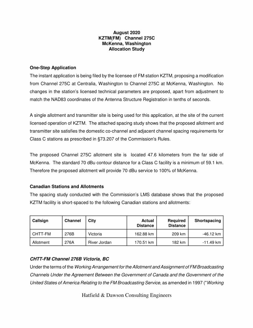
August 2020KZTM(FM) Channel 275C
McKenna, WashingtonAllocation Study
One-Step Application
The instant application is being filed by the licensee of FM station KZTM, proposing a modification
from Channel 275C at Centralia, Washington to Channel 275C at McKenna, Washington. No
changes in the station’s licensed technical parameters are proposed, apart from adjustment to
match the NAD83 coordinates of the Antenna Structure Registration in tenths of seconds.
A single allotment and transmitter site is being used for this application, at the site of the current
licensed operation of KZTM. The attached spacing study shows that the proposed allotment and
transmitter site satisfies the domestic co-channel and adjacent channel spacing requirements for
Class C stations as prescribed in §73.207 of the Commission's Rules.
The proposed Channel 275C allotment site is located 47.6 kilometers from the far side of
McKenna. The standard 70 dBu contour distance for a Class C facility is a minimum of 59.1 km.
Therefore the proposed allotment will provide 70 dBu service to 100% of McKenna.
Canadian Stations and Allotments
The spacing study conducted with the Commission’s LMS database shows that the proposed
KZTM facility is short-spaced to the following Canadian stations and allotments:
Callsign Channel City ActualDistance
RequiredDistance
Shortspacing
CHTT-FM 276B Victoria 162.88 km 209 km -46.12 km
Allotment 276A River Jordan 170.51 km 182 km -11.49 km
CHTT-FM Channel 276B Victoria, BC
Under the terms of the Working Arrangement for the Allotment and Assignment of FM Broadcasting
Channels Under the Agreement Between the Government of Canada and the Government of the
United States of America Relating to the FM Broadcasting Service, as amended in 1997 ("Working
Hatfield & Dawson Consulting Engineers

Arrangement"), the required first-adjacent-channel Class B to Class C spacing is 209 kilometers,
whereas the distance between the proposed site and the CHTT-FM transmitter site is 163
kilometers. Since the instant application does not propose any change in the KZTM technical
facility, there will be no change in the existing short-spacing, which has previously been
demonstrated to be in compliance with the Working Arrangement.
Vacant Channel 276A River Jordan, BC
Under the terms of the Working Arrangement the required first-adjacent-channel Class A to Class
C spacing is 182 kilometers, whereas the distance between the proposed site and the River Jordan
allotment site is 171 kilometers. Since the instant application does not propose any change in the
KZTM technical facility, there will be no change in the existing short-spacing, which has previously
been demonstrated to be in compliance with the Working Arrangement.
In addition, it is noted that the River Jordan Channel 276A allotment does not appear in the current
Canadian FM database. Given the proximity of River Jordan and Victoria (only 34 kilometers apart)
it seems very likely that the River Jordan 276A allotment was deleted in favor of establishment of
CHTT-FM 276B at Victoria.1
1 It is also noted that the LMS database appears to be missing an entry for Channel 274C atVancouver, British Columbia, in use as CKPK-FM. LMS does have an entry for the old Channel 274Boperation at Vancouver, CFRO-FM, but CFRO-FM is not operating on Channel 263C. It is hoped that theCKPK-FM entry in the database can be reinstated or appropriately coded so that it will show up in futurespacing studies, but this does not affect the instant application.
Hatfield & Dawson Consulting Engineers

FMSTUDY.EXE Copyright 2020, Hatfield & Dawson, LLC Version 5.00
==============================================================================
SEARCH PARAMETERS FM Database Date: 20200811
Channel: 275C 102.9 MHz Page 1
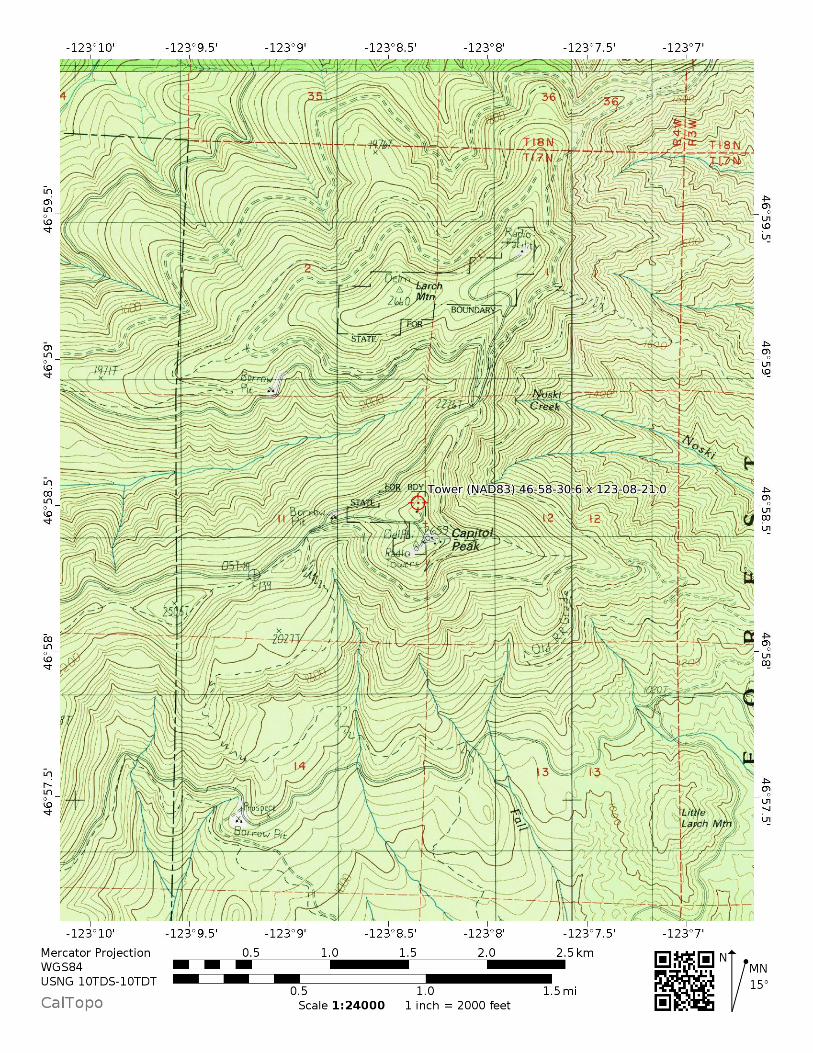
Latitude: 46 58 30.6 (NAD83)
Longitude: 123 8 21.0
Safety Zone: 32 km
Job Title: KZTM 275C
Call City Channel ERP(kW) Latitude Bearing Dist Req
Status St FCC File No. Freq. HAAT(m) Longitude deg-True (km) (km)
==============================================================================
K221FJ TACOMA 221D 0.150 DA 47 14 31.4 59.5 59.02 0
LIC WA BLFT-20100202ABK 92.1 0.0 122 28 1.4 0.00 TRANS
K221BG ABERDEEN 221D 0.125 DA 46 59 17.3 271.9 49.91 0
LIC WA BLFT-20080508ABK 92.1 0.0 123 47 41.5 0.00 TRANS
K221GR LACEY 221D 0.099 DA 47 3 42.3 67.5 25.39 0
CP WA BNPFT-20180418AB 92.1 0.0 122 49 48.5 0.00 TRANS
K221DV KAMILCHE 221D 0.019 47 8 19.3 359.6 18.18 0
LIC WA BLFT-20141008AAW 92.1 0.0 123 8 27.5 0.00 TRANS
KWJD-LP ONALASKA 221L1 0.100 46 35 36.3 136.5 58.39 0
LIC WA BLL-20111013ABG 92.1 26.0 122 36 50.4 0.00 LPFM
K272EP CHEHALIS 272D 0.205 46 40 7.4 158.7 36.56 0
LIC WA BLFT-20120224ABR 102.3 0.0 122 57 54.5 0.00 TRANS
K273AI ARIEL 273D 0.010 46 0 58.4 165.2 110.19 0
LIC WA BLFT-20170118AAM 102.5 0.0 122 46 32.3 0.00 TRANS
KZOK-FM SEATTLE 273C 73.000 47 30 16.7 55.9 106.38 105
LICAPP WA 0000119020 102.5 698.0 121 58 7.8 1.38 CLOSE
KZOK-FM SEATTLE 273C 73.000 47 30 16.4 55.9 106.37 105
LIC WA BMLH-20131203ABJ 102.5 698.0 121 58 8.4 1.37 CLOSE
KYTE INDEPENDENCE 274C0 37.000 44 47 49.4 187.5 244.12 220
LIC OR BLH-20170911AAL 102.7 648.0 123 32 36.3 SS 24.12 CLEAR
K275BW SEQUIM 275D 0.200 DA 48 8 7.3 359.2 129.00 0
LIC WA BLFT-20160208AAL 102.9 0.0 123 9 48.6 0.00 TRANS
K275CV MOUNT VERNON 275D 0.250 48 26 20.3 19.8 173.31 0
LIC WA BLFT-20180911ADD 102.9 0.0 122 20 43.5 0.00 TRANS
K275CH GRESHAM 275D 0.099 45 31 20.4 169.3 164.30 0
LIC OR BLFT-20150918ABX 102.9 0.0 122 44 49.4 0.00 TRANS
K275AI OAK GROVE 275D 0.067 45 42 5.4 138.4 187.83 0
LIC OR BMLFT-20130215AB 102.9 0.0 121 32 9.2 0.00 TRANS
Hatfield & Dawson Consulting Engineers

FMSTUDY.EXE Copyright 2020, Hatfield & Dawson, LLC Version 5.00
==============================================================================
SEARCH PARAMETERS FM Database Date: 20200811
Channel: 275C 102.9 MHz Page 2
Latitude: 46 58 30.6 (NAD83)
Longitude: 123 8 21.0
Safety Zone: 32 km
Job Title: KZTM 275C
Call City Channel ERP(kW) Latitude Bearing Dist Req
Status St FCC File No. Freq. HAAT(m) Longitude deg-True (km) (km)
==============================================================================
KZTM CENTRALIA 275C 70.000 46 58 30.3 131.3 0.01 290
LIC WA BLH-20050126ABD 102.9 668.0 123 8 20.5 -289.99 SHORT
VICTORIA 276D 0.000 48 26 51.3 355.3 164.29 182
CP BC 103.1 0.0 123 19 23.7 -17.71 SHORT
VICTORIA 276B 0.000 48 25 6.3 350.3 162.88 209
ALC BC 103.1 0.0 123 30 40.7 -46.12 SHORT
RIVER JORDAN 276A 0.000 48 24 5.3 338.8 170.51 182
ALC BC 103.1 0.0 123 58 24.7 -11.49 SHORT
KYKV SELAH 276C2 5.400 46 38 26.5 99.1 212.57 188
LIC WA BLED-20090420ACO 103.1 435.0 120 23 50.2 24.57 CLEAR
K277AE SEATTLE 277D 0.250 DA 47 36 20.3 40.7 93.02 0
LIC WA BLFT-20170818AAE 103.3 0.0 122 19 50.4 0.00 TRANS
K277CZ SHELTON 277D 0.250 DA 47 8 19.3 359.6 18.18 0
LIC WA BLFT-20151002ADI 103.3 0.0 123 8 27.5 0.00 TRANS
K277CZ SHELTON 277D 0.250 DA 47 8 19.3 359.6 18.18 0
CP WA BPFT-20171004ABL 103.3 0.0 123 8 27.5 0.00 TRANS
K278CU ABERDEEN 278D 0.250 46 55 54.3 264.1 45.56 0
LIC WA BMPFT-20190125AA 103.5 0.0 123 44 3.5 0.00 TRANS
K278CW ASTORIA 278D 0.250 46 10 55.0 210.2 101.84 0
CP OR BNPFT-20180424AA 103.5 0.0 123 48 14.0 0.00 TRANS
44444 END OF FM SPACING STUDY FOR CHANNEL 275 44444
Hatfield & Dawson Consulting Engineers

Woods Cre
Monroe
Duvall
Cathcart
High Bridge
Cottage Lake
Clearview
Snoqua
Lake Marcel-Still
Carnation
Fall CityKlahanie
Mirrormont
Union Hill-Novelty Hill
SammamishBellevue
Issaquah
Hobart
Ravensdale
Black Diamond
Enumclaw
Maple Heights-Lake Desire
Covington
Lake Morton-Berrydale
Lake Holm
Mill CreekMartha Lake
Bothell East
BothellBrier
Kenmore
Picnic Point
LynnwoodEdmonds
Shoreline
WoodwayKingston
Indianola
Port Gamble Tribal Community
Suquamish
Lofall
Poulsbo
Kirkland
Yarrow PointClyde Hill
Beaux Arts Village
Newcastle
Renton
Mercer Island
Bryn Mawr-Skyway
Seattle
Boulevard Park
Burien
Kent
Auburn
Lake Tapps
Bonney Lake
Algona
Pacific
SumnerEdgewood
SeaTac
Des Moines
Milton
Federal Way
Waller
Bainbridge Island
Southworth
Enetai
Keyport
Silverdale
Tracyton
Manchester
Parkwood
Bethel
Vashon
Tacoma
Ruston
Purdy
Maplewood
Gig Harbor
Burley
WollochetArtondale
Fox Island
Buckley
Wilkeson
Carbonado
South Prairie
Ashford
Alderton
Orting
McMillin
Graham
Kapowsin
Clear Lake
Summit View
Summit
Frederickson
Elk Plain
South Creek
Eatonville
Elbe
Mineral
Alder
La Grande
McChord AFB
Lakewood
Roy
McKenna
Fort LewisDuPont
North Yelm
Yelm
Morton
Mossyrock
Bangor Base
Quilcene
Chico
GorstBremerton
Port Orchard
Seabeck
Brinnon
Belfair
VaughnKey Center
Home
Longbranch
Allyn
Herron Island
Union
Hoodsport
Skokomish
Shelton
Anderson Island
TanglewildeOlympia
Tumwater
Rainier
Tenino
BucodaGrand Mound
Rochester
Fords Prairie
Centralia
Chehalis
OnalaskaNapavine
Toledo
Winlock
Castle Rock
West Side Highway
Vader
Ryderwood
Longview
McCleary
Malone
Porter
Elma
Oakville
SatsopBrady
Central Park
Willapa
Pe Ell
Upper Elochoman
Skamokawa Valley
Lower ElochomanCathlamet
Puget Island
Lebam
Grays River
Altoona
Rosburg
Deep River
Amanda Park
Neilton
Humptulips-nai-elt Village
ntiago
Moclips
acific Beach
Aberdeen Gardens
Cosmopolis
Hoquiam
South Bend
Markham
Tokeland
Copalis Beach
Ocean City
Hogans CornerOyehut
Ocean Shores
Westport
Cohassett Beach
Grayland
Bay Center
Naselle
Astoria
Jeffers Gardens
Chinook
Warrenton
Ocean Park
Long Beach
Ilwaco
Kalama
Kelso
Rainier
Prescott
Deer Island
Clatskanie
Westport
Gearhart
Seaside
KING
PIERCE
CLARK
THURSTON
KITSAP
COWLITZ
LEWIS
GRAYS HARBOR
MASON
COLUMBIA
CLATSOP
JEFFERSON
PACIFIC
SKAMANIA
WAHKIAKUM
70 dBu
60 dBu
KZTM 275C Contour Map0 15 30 45
Kilometers
Hatfield & Dawson 8/2020©2015 CALIPER

August 2020KZTM(FM) Channel 275C
McKenna, WashingtonRF Exposure Study
Facilities Proposed
The proposed operation will be on Channel 275C (102.9 MHz) with an effective radiated power of
70 kilowatts. Operation is proposed with the existing ERI model SHPX-10AC-HW circularly-
polarized half-wave-spaced directional antenna, which is side-mounted on an existing tower atop
Capitol Peak. The FCC Antenna Structure Registration Number is 1231674.
RF Exposure Calculations
The power density calculations shown below were made using the techniques outlined in OET
Bulletin No. 65. "Ground level" calculations in this report have been made at a reference height
of 2 meters above ground to provide a worst-case estimate of exposure for persons standing on
the ground in the vicinity of the tower. The equation shown below was used to calculate the ground
level power density figures from each antenna.
S W cmAdjERP Watts
D( / )
. ( )µ
2
2
3340981=
×
Where: AdjERP(Watts) is the maximum lobe effective radiated power times the elementpattern factor times the array pattern factor.
D is the distance in meters from the center of radiation to the calculation point.
Ground level power densities have been calculated for locations extending from the base of the
tower to a distance of 1000 meters. Values past this point are increasingly negligible.
Calculations of the power density produced by the proposed antenna system assume a Type 3
element pattern, which is the accepted element pattern for the ERI model SHPX-10AC-HW
antenna to be used. The highest calculated ground level power density occurs at a distance of 582
meters from the base of the antenna support structure. At this point the power density is calculated
to be 5.8 µW/cm², which is 2.9% of 200 µW/cm2 (the FCC standard for uncontrolled environments).
Hatfield & Dawson Consulting Engineers

These calculations show that the maximum calculated power density produced at two meters above
ground level by the proposed operation of KZTM alone is less than 5% of the applicable FCC
exposure limit at all locations between 1 and 1000 meters from the base of the antenna support
structure. Section 1.1307(b)(3) of the Commission's Rules excludes applications for new facilities
or modifications to existing facilities from the requirement of preparing an environmental
assessment when the calculated emissions from the applicant’s proposed facility are predicted to
be less than 5% of the applicable FCC exposure limit. Therefore, the proposed facility is in
compliance with Section 1.1301 et seq and no further analysis of RF exposure at this site is
required in this application.
The permittee/licensee in coordination with other users of the site must reduce power or cease
operation as necessary to protect persons having access to the site, tower or antenna from
radiofrequency exposure in excess of FCC guidelines.
Hatfield & Dawson Consulting Engineers

Ground-Level RF Exposure OET FMModel
KZTM 275C McKennaAntenna Type: ERI SHPX-10AC-HW (Type 3)No. of Elements: 10Element Spacing: 0.5 wavelength
Distance: 1000 metersHorizontal ERP: 70 kWVertical ERP: 70 kW
Antenna Height: 60 meters AGL
Maximum Calculated Power Density is 5.8 µW/cm2 at 582 meters from the antenna structure.
Hatfield & Dawson Consulting Engineers
August 2020KZTM(FM) Channel 275C
McKenna, WashingtonSection 307(b) Analysis Engineering
Background
The instant application is being filed by the licensee of FM station KZTM, proposing a modification
from Channel 275C at Centralia, Washington to Channel 275C at McKenna, Washington. No
changes in the station’s licensed technical parameters are proposed.
McKenna Channel 275C Spacing Study
The allocation study exhibit included in this Form 301 application demonstrates that the proposed
McKenna Channel 275C allotment site meets the co-channel and adjacent channel spacing
requirements for Class C stations as prescribed in §73.207 of the Commission's Rules. The
spacing study also demonstrates that this proposal is mutually-exclusive with retention of the
Channel 275C license at Centralia.
First Local Service at McKenna, Washington
The proposed modification will provide the first local service to McKenna, which is a Census
Designated Place with a 2010 Census population of 716 persons, and therefore qualifies as a
community for allotment purposes. The FCC considers a town or city to be a community for
allotment purposes when it is either incorporated or listed in the US Census.
McKenna is located in Pierce County along the Nisqually River, and was founded around 1908 as
a timber company town. The community is home to a variety of business and institutions including
Nisqually Valley Care Center, Nature’s Garden (plant nursery), Walt’s Place (bar), McKenna Park,
McKenna Market and Gas, Oak Tree Judo Dojo, Happy Trails Espresso, BNW Motors (car dealer),
Pet House, County Line Shooting Sports, Jim Bob’s Chuck Wagon, McKenna Elementary School,
Northwest Chevrolet, McKenna Water District, McKenna USPS Post Office, Caliber Collision,
McKenna Child Care and Early Learning, and Varsity Pizza McKenna.
Centralia will retain local service from FM station KCED Channel 217A, as well as AM stations KITI
1420 kHz and KELA 1470 kHz (both of which are licensed to the neighboring communities of
“Centralia-Chehalis”).
Hatfield & Dawson Consulting Engineers
No White or Gray Areas Will Be Created
There will be no change in the KZTM transmitter site, and the 60 dBu contour from the proposed
facility will cover 100% of the licensed KZTM 60 dBu contour. There will be no loss area associated
with this community change, and therefore no white, gray, or underserved areas will be created.
Olympia-Lacey Urbanized Area (Intra-Urbanized Area Modification)
The Second Order on Reconsideration in MB Docket No. 09-52, Policies to Promote Rural Radio
Service and to Streamline Allotment and Assignment Procedures (“Rural Radio Second Order on
Recon”), addresses the evaluation of community of license change proposals where both the
licensed and proposed facilities cover more than 50% of the same urbanized area with a 70 dBu
signal:
We clarify that applicants will not be required to submit Tuck showings where both
the current and proposed communities are located in the same urbanized area, or
the current facilities cover, and the proposed facilities would or could be modified
to cover, more than 50 percent of the same urbanized area with a daytime principal
community signal.
Such proposals are considered to be “intra-urbanized area” modifications. As was explained in
Gearhart2, the concerns expressed in Rural Radio addressing the move from a rural area to an
urbanized area do not exist with respect to intra-Urbanized Area moves because “a first local
2 See Gearhart, Madras, Manzanita, and Seaside, Oregon, Report and Order, 26 FCC Rcd 10259 (MB2011). In Gearhart, the authorized KNRQ (now KLVP) facility was reallotted from Tualatin to Aloha.
See also BPH-20150717AAV, which approved a change in community for KPND from Sandpoint,Idaho, to Deer Park, Washington, with no change in the station’s technical facility, which provides 70 dBuservice to 95% of the Spokane Urbanized Area and 100% of the Coeur d’Alene Urbanized Area.
See also BPH-20181108AAQ, which approved a change in community for KLSY from Montesano,Washington, to Belfair, Washington, with no change in the station’s technical facility, which provides 70 dBuservice to 100% of the Olympia-Lacey Urbanized Area.
Hatfield & Dawson Consulting Engineers
service preference is not being used as a basis to enter the market.”3. The proposal is therefore
evaluated under Priority 4, “other public interest factors”.
Attached is a map exhibit which depicts the licensed and proposed KZTM 70 dBu contour in
relation to the 2010 Census boundaries of the Olympia-Lacey Urbanized Area. The licensed and
proposed KZTM 70 dBu contour encompasses 100% of the Olympia-Lacey UA. Since this figure
is greater than 50% both the licensed and proposed facilities are considered to be providing service
to the entire Olympia-Lacey Urbanized Area.4 Therefore this is an intra-urbanized area
modification.
Seattle Urbanized Area (No Tuck Analysis Required)
Bremerton Urbanized Area (No Tuck Analysis Required)
The licensed and proposed KZTM 70 dBu contour covers, and will continue to cover, 25.4% of the
land area of the Seattle Urbanized Area, and 0.4% of the land area of the Bremerton Urbanized
Area.
It should be noted that the Seattle and Bremerton Urbanized Area files downloaded from the US
Census Bureau include significant portions of the inland waterways of Puget Sound. In performing
this analysis, we have excluded the water areas to arrive at a baseline land area of 2652.84 sq km
for the Seattle UA, and 355.28 sq km for the Bremerton UA.
These urbanized areas are “nearby” the proposed facility, and the Second Report and Order in MB
Docket No. 09-52, Policies to Promote Rural Radio Service and to Streamline Allotment and
Assignment Procedures (“Rural Radio”), sets forth procedures to be used to rebut a presumption
that a proposed change in community of license is intended to serve a nearby urbanized area.
3 See East Los Angeles, Long Beach, and Frazier Park, California, Report and Order, 10 FCC Rcd2864, 2868 (MMB 1995).
4 The Commission has established “...a rebuttable presumption that, when the community proposedis located in an urbanized area or could, through a minor modification application, cover more than 50 percentof an urbanized area, we will treat the application, for Section 307(b) purposes as proposing service to theentire urbanized area rather than the named community of license.” See Policies to Promote Rural RadioService and to Streamline Allotment and Assignment Procedures, Second Report and Order, First Order onReconsideration, and Second Further Notice of Proposed Rule Making, 25 FCC Rcd 2556, 2567, ¶ 20. (2011).
Hatfield & Dawson Consulting Engineers
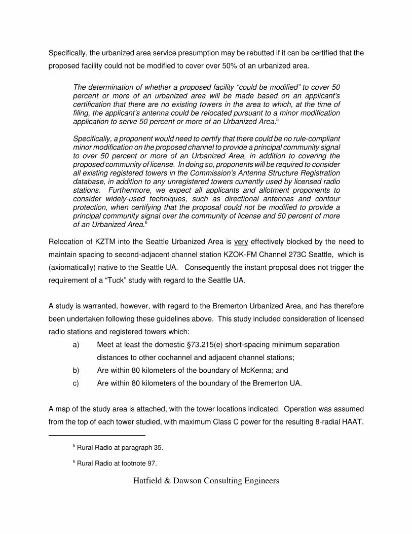
Specifically, the urbanized area service presumption may be rebutted if it can be certified that the
proposed facility could not be modified to cover over 50% of an urbanized area.
The determination of whether a proposed facility “could be modified” to cover 50percent or more of an urbanized area will be made based on an applicant’scertification that there are no existing towers in the area to which, at the time offiling, the applicant’s antenna could be relocated pursuant to a minor modificationapplication to serve 50 percent or more of an Urbanized Area.5
Specifically, a proponent would need to certify that there could be no rule-compliantminor modification on the proposed channel to provide a principal community signalto over 50 percent or more of an Urbanized Area, in addition to covering theproposed community of license. In doing so, proponents will be required to considerall existing registered towers in the Commission’s Antenna Structure Registrationdatabase, in addition to any unregistered towers currently used by licensed radiostations. Furthermore, we expect all applicants and allotment proponents toconsider widely-used techniques, such as directional antennas and contourprotection, when certifying that the proposal could not be modified to provide aprincipal community signal over the community of license and 50 percent of moreof an Urbanized Area.6
Relocation of KZTM into the Seattle Urbanized Area is very effectively blocked by the need to
maintain spacing to second-adjacent channel station KZOK-FM Channel 273C Seattle, which is
(axiomatically) native to the Seattle UA. Consequently the instant proposal does not trigger the
requirement of a “Tuck” study with regard to the Seattle UA.
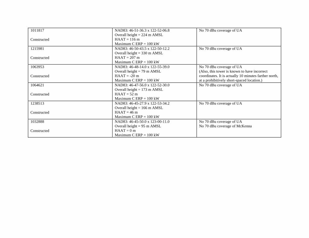
A study is warranted, however, with regard to the Bremerton Urbanized Area, and has therefore
been undertaken following these guidelines above. This study included consideration of licensed
radio stations and registered towers which:
a) Meet at least the domestic §73.215(e) short-spacing minimum separation
distances to other cochannel and adjacent channel stations;
b) Are within 80 kilometers of the boundary of McKenna; and
c) Are within 80 kilometers of the boundary of the Bremerton UA.
A map of the study area is attached, with the tower locations indicated. Operation was assumed
from the top of each tower studied, with maximum Class C power for the resulting 8-radial HAAT.
5 Rural Radio at paragraph 35.
6 Rural Radio at footnote 97.
Hatfield & Dawson Consulting Engineers
For the sake of a worst-case study, and for study efficiency, omnidirectional operation was
assumed even at short-spaced towers.7
Based on the results of this study we conclude that there is a) no existing registered tower and b)
no unregistered tower currently used by a licensed radio station which could be used to provide a
principal community signal over both McKenna and 50 percent or more of the Bremerton Urbanized
Area. Consequently the instant proposal does not trigger the requirement of a “Tuck” study with
regard to the Bremerton UA.
7 It is noted that the Commission’s ASR database includes two registrations for 199 foot towers at “MidMountain”, just northeast of the licensed/proposed KZTM transmitter site, as #1244501 #1251117. TheseASRs (which appear to be for the same structure) have status of Granted, but not Constructed. ASR 1244501relies on a long-expired 2004 FAA Determination, while ASR 1251117 similarly relies on a long-expired 2005FAA Determination. Our search of FAA records does not indicate the filing of any Form 7460-2 to notify theFAA of completion of construction, and a site visit confirms that there is no 199 foot tower at the site. Anyexisting tower is shorter and unregistered, and excluded. Therefore ASR numbers 1244501 and 1251117cannot be considered to be existing structures as defined in Rural Radio, but are nevertheless included in theattached list..
Hatfield & Dawson Consulting Engineers

McKenna
Seattle, WA
Bremerton, WA
Olympia--Lacey, WA
Marysville, WA
KING
PIERCE
SNOHOMISH
THURSTON
KITSAP
ISLAND
LEWIS
GRAYS HARBOR
CLALLAM
MASON
JEFFERSON
PACIFIC
70 dBu
The licensed and proposed 70 dBu contours(identical) encompass:100% of the Olympia-Lacey UA land area25.4% of the Seattle UA land area0.4% of the Bremerton UA land area
KZTM 275C UA Study Map0 10 20 30
Kilometers
Hatfield & Dawson 8/2020©2015 CALIPER

12511171244501
1247912
10118171215981
1064621
1280436
1063953
1238513
12166681031677
1280443
12337891231674
1222655
1270640
12823431301610
1236855
1296267
1032888
1036273
13005191239753
1214831
12078431065972
1032625
1295252
1214975
1218204
KYYO LIC 245C2
C
McKenna
KING
PIERCE
KITSAP
THURSTON
COWLITZ
LEWIS
GRAYS HARBOR
MASON
CLATSOP
JEFFERSON
PACIFIC
WAHKIAKUM
80 km fromMcKenna
KCRX 272C373.215 Spacing
KYTE 274C073.215 Spacing
KYKV 276C273.215 Spacing
KZOK 273C73.215 Spacing
80 km fromBremerton UA
KLSY LIC 229C0KWAO CP 201CKLSY CP 229C0KDDS LIC 257CKJET CP 289C2KOMO LIC 249C
KXXO LIC 241CKZTM LIC 275CKWAO LIC 201CKNBQ LIC 253C2
KZTM 275C Tower Study Map
0 10 20 30
Kilometers
Hatfield & Dawson 8/2020
To Rebut UA Presumption
©2013 CALIPER

Channel 275C at McKenna, Washington
Towers Studied to Rebut Urbanized Area Service Presumption
Study area is the intersection of
a) an 80 km radius from the perimeter of McKenna, and;
b) an 80 km radius from the perimeter of the Bremerton Urbanized Area (see attached map)
Licensed FM Radio Station
Sites Within Search Area
Technical Parameters
Conclusion (Excluded because)
South Mountain (ASR 1247912) KLSY 229C0 Montesano
KLSY 229C0 Belfair (CP)
KWAO 201C Vashon (CP)
KDDS 257C Elma
KOMO 249C Oakville
KJET 289C2 Union (CP)
NAD83: 47-18-45.3 x 123-22-19.6
Overall height = 1043 m AMSL
HAAT = 752 m
Maximum C ERP = 60 kW
No 70 dBu coverage of McKenna
Capitol Peak 1 (ASR 1231674) KZTM 275C Centralia
KWAO 201C
KNBQ 253C2
NAD83: 46-58-30.6 x 123-08-21.0
Overall height = 900 m AMSL
HAAT = 701 m
Maximum C ERP = 73 kW
4% 70 dBu coverage of UA
Capitol Peak 2 (ASR 1282343) KXXO 241C Olympia
NAD83: 46-58-22.4 x 123-08-22.1
Overall height = 929 m AMSL
HAAT = 729 m
Maximum C ERP = 65 kW
4% 70 dBu coverage of UA
KYYO 245C2 McCleary
NAD83: 47-05-08.3 x 123-11-21.5
Overall height = 495 m AMSL
HAAT = 326 m
Maximum C ERP = 100 kW
<1% 70 dBu coverage of UA

Licensed AM Radio Station
Sites Within Search Area
Technical Parameters
Conclusion (Excluded because)
None
ASR Number and Status
Technical Parameters
Conclusion (Excluded because)
1218204
Constructed
NAD83: 46-55-15.9 x 123-19-22.8
Overall height = 68 m AMSL
HAAT = -91 m
Maximum C ERP = 100 kW
No 70 dBu coverage of UA
No 70 dBu coverage of McKenna
1214975
Constructed
NAD83: 46-58-17.6 x 123-26-20.5
Overall height = 213 m AMSL
HAAT = 110 m
Maximum C ERP = 100 kW
No 70 dBu coverage of UA
No 70 dBu coverage of McKenna
1295252
Constructed
NAD83: 47-00-09.4 x 123-24-42.8
Overall height = 42 m AMSL
HAAT = -66 m
Maximum C ERP = 100 kW
No 70 dBu coverage of UA
No 70 dBu coverage of McKenna
1032625
Granted
NAD83: 46-59-21.1 x 123-21-24.0
Overall height = 216 m AMSL
HAAT = 97 m
Maximum C ERP = 100 kW
No 70 dBu coverage of UA
No 70 dBu coverage of McKenna
1065972
Granted
NAD83: 47-00-12.0 x 123-24-12.0
Overall height = 43 m AMSL
HAAT = -64 m
Maximum C ERP = 100 kW
No 70 dBu coverage of UA
No 70 dBu coverage of McKenna
1207843
Granted
NAD83: 47-00-18.3 x 123-24-08.5
Overall height = 21 m AMSL
HAAT = -87 m
Maximum C ERP = 100 kW
No 70 dBu coverage of UA
No 70 dBu coverage of McKenna

1214831
Constructed
NAD83: 47-01-40.2 x 123-19-13.6
Overall height = 270 m AMSL
HAAT = 116 m
Maximum C ERP = 100 kW
No 70 dBu coverage of UA
1239753
Constructed
NAD83: 47-03-16.3 x 123-15-23.2
Overall height = 168 m AMSL
HAAT = -11 m
Maximum C ERP = 100 kW
No 70 dBu coverage of UA
1300519
Constructed
NAD83: 47-03-21.1 x 123-15-16.1
Overall height = 194 m AMSL
HAAT = 12 m
Maximum C ERP = 100 kW
No 70 dBu coverage of UA
1036273
Constructed
NAD83: 46-49-22.0 x 123-05-09.0
Overall height = 54 m AMSL
HAAT = -59 m
Maximum C ERP = 100 kW
No 70 dBu coverage of UA
No 70 dBu coverage of McKenna
1296267
Constructed
NAD83: 46-49-50.3 x 123-04-02.1
Overall height = 91 m AMSL
HAAT = -20 m
Maximum C ERP = 100 kW
No 70 dBu coverage of UA
No 70 dBu coverage of McKenna
1236855
Constructed
NAD83: 46-52-03.2 x 122-59-32.4
Overall height = 159 m AMSL
HAAT = 52 m
Maximum C ERP = 100 kW
No 70 dBu coverage of UA
1301610
Constructed
NAD83: 46-58-20.4 x 123-08-22.0
Overall height = 858 m AMSL
HAAT = 658 m
Maximum C ERP = 85 kW
4% 70 dBu coverage of UA
1270640
Constructed
NAD83: 46-58-29.0 x 123-08-21.6
Overall height = 818 m AMSL
HAAT = 618 m
Maximum C ERP = 97 kW
4% 70 dBu coverage of UA

1222655
Constructed
NAD83: 46-58-30.0 x 123-08-20.8
Overall height = 840 m AMSL
HAAT = 640 m
Maximum C ERP = 90 kW
4% 70 dBu coverage of UA
1233789
Constructed
NAD83: 46-58-23.6 x 123-08-16.4
Overall height = 829 m AMSL
HAAT = 629 m
Maximum C ERP = 95 kW
4% 70 dBu coverage of UA
1280443
Constructed
NAD83: 47-02-49.0 x 123-05-21.0
Overall height = 414 m AMSL
HAAT = 260 m
Maximum C ERP = 100 kW
No 70 dBu coverage of UA
1031677
Constructed
NAD83: 47-04-51.3 x 123-11-07.5
Overall height = 527 m AMSL
HAAT = 359 m
Maximum C ERP = 100 kW
<1% 70 dBu coverage of UA
1216668
Constructed
NAD83: 47-04-51.2 x 123-11-07.2
Overall height = 518 m AMSL
HAAT = 351 m
Maximum C ERP = 100 kW
<1% 70 dBu coverage of UA
1280436
Constructed
NAD83: 46-54-16.0 x 122-56-04.0
Overall height = 144 m AMSL
HAAT = 42 m
Maximum C ERP = 100 kW
No 70 dBu coverage of UA
1244501
Granted
NAD83: 47-18-58.6 x 123-21-27.9
Overall height = 944 m AMSL
HAAT = 662 m
Maximum C ERP = 82 kW
No 70 dBu coverage of McKenna
1251117
Granted
NAD83: 47-18-58.6 x 123-21-27.9
Overall height = 945 m AMSL
HAAT = 663 m
Maximum C ERP = 82 kW
No 70 dBu coverage of McKenna
1011817
Constructed
NAD83: 46-51-36.3 x 122-52-06.8
Overall height = 224 m AMSL
HAAT = 116 m
Maximum C ERP = 100 kW
No 70 dBu coverage of UA
1215981
Constructed
NAD83: 46-50-43.5 x 122-50-12.2
Overall height = 330 m AMSL
HAAT = 207 m
Maximum C ERP = 100 kW
No 70 dBu coverage of UA
1063953
Constructed
NAD83: 46-48-14.0 x 122-55-39.0
Overall height = 79 m AMSL
HAAT = -20 m
Maximum C ERP = 100 kW
No 70 dBu coverage of UA
(Also, this tower is known to have incorrect
coordinates. It is actually 10 minutes farther north,
at a prohibitively short-spaced location.)
1064621
Constructed
NAD83: 46-47-56.0 x 122-52-30.0
Overall height = 173 m AMSL
HAAT = 52 m
Maximum C ERP = 100 kW
No 70 dBu coverage of UA
1238513
Constructed
NAD83: 46-45-27.9 x 122-53-34.2
Overall height = 166 m AMSL
HAAT = 46 m
Maximum C ERP = 100 kW
No 70 dBu coverage of UA
1032888
Constructed
NAD83: 46-45-50.0 x 123-00-11.0
Overall height = 95 m AMSL
HAAT = 0 m
Maximum C ERP = 100 kW
No 70 dBu coverage of UA
No 70 dBu coverage of McKenna