Embed Size (px)
Citation preview

August 9, 2012
Poinciana Parkway Southport
Connector From Florida’s Turnpike to Pleasant Hill Road
PD&E Study
433693-2 I-4 Southport Connector Agency
Project Advisory Group
August 27, 2013
Financial Project No.: 433693-1-22-01

Presentation Outline
2
• Project background
• Purpose and need
• Process and schedule
• Corridor evaluation
• Environmental Considerations
• Public Involvement and agency coordination
• Questions, answers and discussion

Southport Connector Feasibility Study
3

OCX Master Plan
4
Central
Polk
Parkway
Osceola Pkwy Extension
Northeast
Connector
Expwy
Southport Connector
I-4 Poinciana
Parkway
Connector
Poinciana
Parkway(Design Build)
Poinciana
Parkway (PD&E)
Southport
Connector
LRTP, TIP and STIP
• Metroplan Orlando LRTP
– The project is included in Metroplan Orlando’s 2030 Long Range
Transportation Plan (LRTP) policy amendment dated February 2013 and
adopted per resolution number 13-03
• Metroplan Orlando TIP
– The PD&E Study is included in Metroplan Orlando’s FY 2012/13-2016/17
Transportation Improvement Program (TIP)
• FDOT STIP
– The PD&E Study is included in the FY 2013/14 State Transportation
Improvement Program (STIP)
5
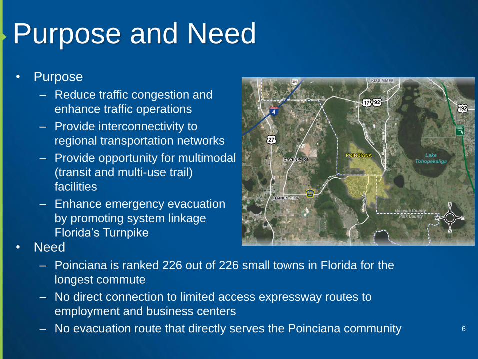
Purpose and Need
6
• Purpose
– Reduce traffic congestion and
enhance traffic operations
– Provide interconnectivity to
regional transportation networks
– Provide opportunity for multimodal
(transit and multi-use trail)
facilities
– Enhance emergency evacuation
by promoting system linkage
Florida’s Turnpike
• Need
– Poinciana is ranked 226 out of 226 small towns in Florida for the
longest commute
– No direct connection to limited access expressway routes to
employment and business centers
– No evacuation route that directly serves the Poinciana community

Traffic Projections
• Previous modeling efforts
– 2009 Feasibility Study and Master Plan
• 50,000 to 65,000 AADT in 2035
– 2012 County Comprehensive Plan
• 55,000 to 95,000 AADT in 2040
• Kittelson & Associates New Traffic Study
– Design Year – 2043
7

Characteristics of Study Area
8
• Large ranches south of Lake Tohopekaliga
• Rural residential east and west of Lake Toho
• Commercial and residential west of Pleasant Hill road
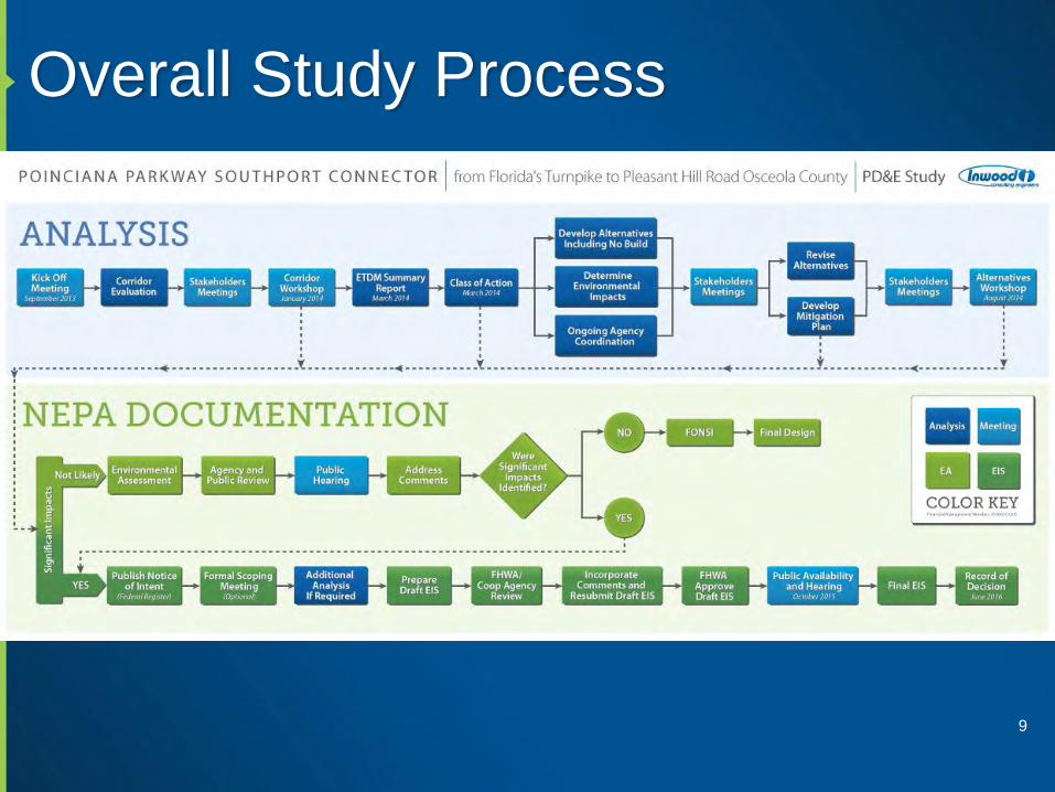
Overall Study Process
9

Corridor Analysis
• Screen out non-viable corridors from further consideration
• Based on Land Suitability Mapping (LSM) Process
STEP 1: Define corridor study area
STEP 2: Screen study area using weighted GIS layers
STEP 3: Eliminate most sensitive areas
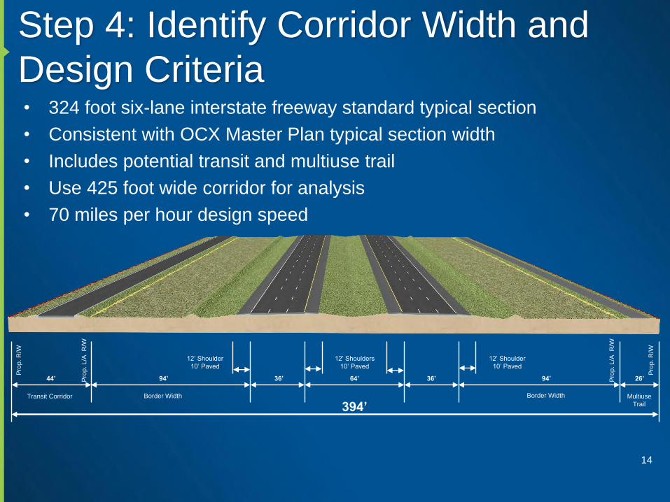
STEP 4: Identify Corridor Width and Design Criteria
STEP 5: Identify corridor alignments
STEP 6: Evaluate corridor alignments
STEP 7: Obtain local government/public input
STEP 8: Prepare and submit Corridor Report to FHWA/ETAT
10

Step 1: Define Study Area
11
Ple
asa
nt H
ill R
oad

Step 2: Screen Study Area
12
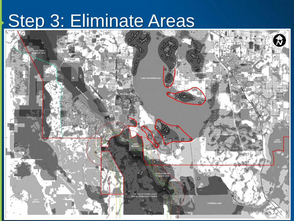
Step 3: Eliminate Areas
13
Step 4: Identify Corridor Width and
Design Criteria• 324 foot six-lane interstate freeway standard typical section
• Consistent with OCX Master Plan typical section width
• Includes potential transit and multiuse trail
• Use 425 foot wide corridor for analysis
• 70 miles per hour design speed
14
94’44’ 36’ 64’ 36’ 94’ 26’
394’
12’ Shoulder
10’ Paved
12’ Shoulders
10’ Paved
12’ Shoulder
10’ Paved
Border WidthBorder WidthTransit Corridor Multiuse
Trail
Pro
p.
R/W
Pro
p.
L/A
R
/W
Pro
p.
L/A
R
/W
Pro
p.
R/W

Step 5: Identify Corridor Alternatives
15

Step 6: Evaluate Corridor Alternatives
• GIS quantification of impacts
• Field review for environmental constraints
• Construction cost estimate
• Right-of-way cost estimate
• Impacts and costs summarized in matrix
16

Step 7: Public Input
• Review corridor alignments evaluation with
Agency Project Advisory Group
• Corridors reviewed by ETAT
• Review with public at corridor workshop
17

Step 8: Corridor Analysis
• Select recommended alternative corridors to be carried forward
• Prepare final Corridor Report
• Submit to Corridor Report to ETAT through ETDM
• Submit to FHWA
18

Existing Utilities
19
Utility
CompanyFacility Description
Master
Agreement
AT&T
Corp/PEA
Communication
s
AT&T Corporation maintains transmission facilities in the eastern portion of the
corridor. There is buried facilities located along the east side of SR 523.X
Bright House
Networks
Coax Cable and
Fiber
Bright House maintains buried CATV located at the intersection of Pleasant Hill
Road and Cypress Parkway. There is also underground facilities located along
Southport Road serving the homes off of Southport Bay Drive.
X
Century LinkCommunication
s
Century Link maintains the majority of their facilities along the west side of
Pleasant Hill Road from Cypress Parkway to north of Southport Road. X
City of St.
Cloud
Water/Sewer
The City of St. Cloud provides water and sewer services to the area east of the
canal interconnecting Lake Tohopekaliga and Cypress Lake. The City currently
has a 12-inch main that services Friar’s Cove to the north of the project and based
on the City’s Master Plan, there are plans for a future water treatment plant and
related pipe systems to service Green Island area just north of the corridor.
Comcast CableCommunication
sComcast Cable maintains facilities in the eastern portion of the corridor. X
Progress
EnergyPower
Progress Energy maintains transmission lines along the west side of Pleasant Hill
Road and distribution facilities throughout the proposed corridor. The majority of
the distribution facilities are located along Pleasant Hill Road, Southport Road, and
SR 523.
X
Sprint NextelCommunication
s
Sprint maintains a buried fiber optic cable along the west side of Pleasant Hill
Road from Cypress Parkway north past Southport Road. X
TOHO Water
AuthorityWater/Sewer
TOHO Water Authority maintains a 20-inch water main & 8-inch reclaimed water
main along the west side of Pleasant Hill Road at the intersection of Pleasant Hill
Road and Southport Road. A 12-inch water main crosses Pleasant Hill Road along
the north side of Southport Drive and crosses to the south side of Southport Road
and continues to just west of Southport Bay Drive, where it stops. There is a 12-
inch force main that crosses Pleasant Hill Road along the south side of Southport
Drive and continues to just west of Southport Bay Drive, where it stops.

Existing Drainage
• Kissimmee River watershed
– Lake Tohopekaliga
– Reedy Creek
– Lake Cypress
– S-63A
• Ultimate discharge to Lake Okeechobee
• Main Water Crossings
– Reedy Creek
• Regulatory Floodway
– Southport Canal
• Navigable Waterway
• Boat survey
• USCG coordination
20
Lake Tohopekaliga
Kissimmee
River
Watershed
Project
Study
Area
Watershed Map
Sub-Basins Map
Lake Tohopekaliga
Reedy
Creek
Lake
Cypress
S-63AProject Study
Area

Drainage and Permitting Criteria
21
AGENCY CRITERIA COMMENTS
SFWMD Presumptive Water Quality• Wet Detention – 1” over Total Basin Area or 2.5” over Imperv. Area
• Dry Retention – 50% of the Wet Detention criteria
Water Quantity
• 10-year/72-hour storm Pre vs. Post (Osceola Co.)
• Lake Toho discharge limitations (0.5 cfs/acre – Rule of Thumb)
• Draft Watershed Model for Lake Toho – Outlines discharges
requirements at certain node locations
Special Criteria• Not in OFW, however; additional 50% water quality requirement
because the ultimate discharge is to Lake Okeechobee
Floodplain Compensation• “Cup for cup” compensation required
• SFWMD will accept floodplain compensation within treatment ponds
• Opportunity to reduce or eliminate need for FPC ponds
DEP
Impaired Water Bodies
• Not impaired per DEP list (WBID 3170A, 3170C, 3170B1, 3173C, 3179)
• Per SFWMD, Lake Toho Nutrient Reduction Plan will require Pre vs.
Post Pollutant Loading Analysis
• UCF Spreadsheet or DEP Stormwater Quality Handbook
FDOT Critical Duration (CH. 14-86 F.A.C.)• Per 2013 FDOT Drainage Manual, only required for closed basins
• Would not apply for Southport Connector Study
Offsite Areas (HB 599)
• Discussed HB 599 with SFWMD
• Different interpretation than previously thought
• Per SFWMD, commingling offsite with onsite will require treatment
21

Floodplains
• Approx. 50% of the corridor traverses the 100-year floodplain
• 25% associated with impacts at Reedy Creek and Southport Canal
– Reedy Creek – Zone AE Floodway (Elev. 63 ft. NAVD)
– Southport Canal – Zone A 2222
Zone A
Zone AESouth Alignment – Option A
KHA Preliminary Alignment &
Feasibility Study (2009)
Lake Tohopekaliga
Lake Russell
Ple
asan
t H
ill R
oa
d Treatment ponds can be used for floodplain compensation

Wetlands and Other Surface Waters
• Natural Wetlands and Drainage Features
– Freshwater forested, scrub-shrub and herbaceous
wetlands throughout the study area
– Lake Tohopekaliga, Lake Russell, Brown Lake,
Cypress Lake, and Lake Gentry
– Reedy Creek Swamp
– SFWMD C-35 Canal
• Direct, secondary and cumulative effects
• Elimination and reduction of impacts
• Regionally significant mitigation
consistent with adjacent mitigation
• Agency coordination – SFWMD,
USACE, USFWS
23
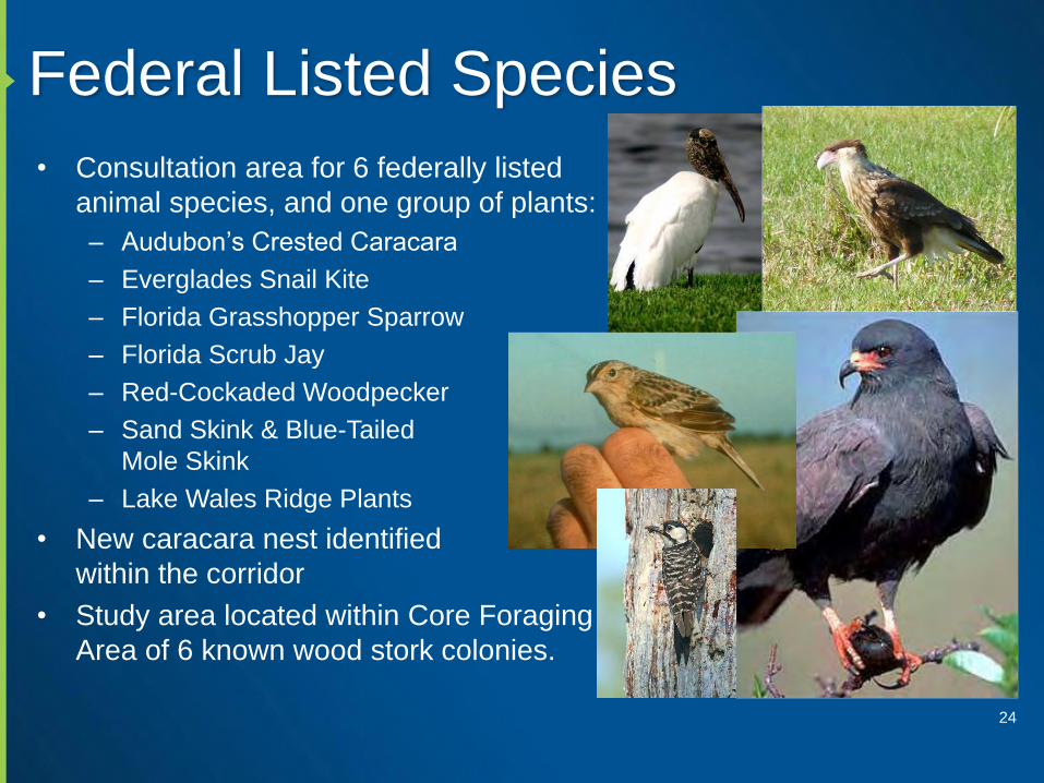
Federal Listed Species
• Consultation area for 6 federally listed
animal species, and one group of plants:
– Audubon’s Crested Caracara
– Everglades Snail Kite
– Florida Grasshopper Sparrow
– Florida Scrub Jay
– Red-Cockaded Woodpecker
– Sand Skink & Blue-Tailed
Mole Skink
– Lake Wales Ridge Plants
• New caracara nest identified
within the corridor
• Study area located within Core Foraging
Area of 6 known wood stork colonies.
24

Audubon’s Crested Caracara
• Caracara nest documented approximately 450 ft south of
Southport Road in 1995, 1996 and 1998
• Inwood Biologists observed 4 individual caracaras during two
monitoring events, conducted in February 2013 along the
existing Southport Road R/W
• Inwood Biologists discovered active caracara nest
approximately 150 ft south of Southport Road on
February 14, 2013. Two adults were observed foraging
in close proximity to nest, and juvenile caracara
was observed in nest tree.
• Caracara nests are afforded “Management Zones”
by USFWS:– Secondary protection zone: 4,920 ft radius
surrounding nest tree
– Primary protection zone: 985 ft radius surrounding nest tree
– Consultation will likely be required for all southern alignment
alternatives
25

Protected Nests – Caracara & Eagles
26

Everglades Snail Kite
• Snail kite “Priority Management Zones”:
– Lakeshore areas that support high concentrations of
snail kite nests
– Delineated annually, following each
nesting season
• Nest protection buffers:
– No-entry Buffer Zones: 425 ft radius surrounding
active nests
– Limited Activity Buffer Zones: 1,640 ft radius
surrounding active nests
• Encompasses the primary foraging area around a
nest
• Permanent modification of habitat within these
areas will likely result in a “may affect”
determination by USFWS
27

Everglades Snail Kite
28

Florida Grasshopper Sparrow
• Described by Audubon Florida as “perhaps the
most endangered bird in the continental United
States” (2012)
• Inhabits frequently-burned, dry prairie habitats in
central and south FL
• Suitable habitat located
throughout southern
alignment alternatives, with
highest potential for occurrence
in southeastern portion of
study area
• Consulted with Reed Noss, PhD
concerning potential occurrence,
surveys were recommended
29

State Listed Species
• Likely involvement of various other state-listed
wildlife species:
– Florida Burrowing Owl
– Florida Sandhill Crane
– Gopher Tortoise
– Sherman’s Fox Squirrel
– Southeastern American Kestrel
– State-listed wading birds
• Several Bald Eagle nests & nesting territories
have potential to affect alignments
– Although available eagle nest data for Osceola
County is typically up-to-date, Inwood biologists
have identified 2-3 active nests that are not included
in latest FWC data
– Early detection of nest/alignment conflicts can
reduce the potential for take of eagles30
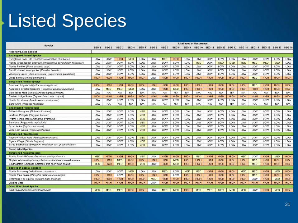
Listed Species
31

Cumulative Effects
• CEE Handbook
• Initiate CEE early – coordinate with agencies
• Identify resources of concern
• Define timeframe
• Potentially affected resources
• Past and present impact
• Foreseeable future actions
• Direct and indirect impacts
• What are the potential cumulative effects?
• Potential mitigation – Regional
mitigation important
• Document results
32

Managed Lands
• Planning consistency with adjacent, managed lands
– Snail Kite “Priority Management Zones”
– Southport Ranch Mitigation Bank
• Mitigation “value” determined by SFWMD permit based on UMAM
calculations utilizing 300 foot undisturbed buffer
• Encroachment into 300 foot buffer likely to result in devaluation of bank
function, and may require permit modification and/or compensation
– The Nature Conservancy’s Disney Wilderness Preserve
• 12,000-acre preserve established to provide mitigation for various
development projects including Walt Disney World and GOAA
• First, large-scale, offsite wetland mitigation project in United States
• Utilizes prescribed on 3-year intervals as a critical management tool
• Sufficient buffers must be provided within
“Critical Smoke Dispersal Areas” (CSDA)
33

Managed Lands
34
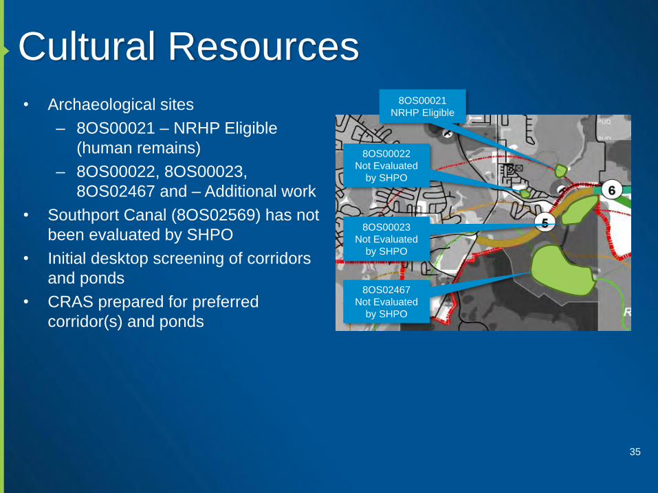
Cultural Resources
• Archaeological sites
– 8OS00021 – NRHP Eligible
(human remains)
– 8OS00022, 8OS00023,
8OS02467 and – Additional work
• Southport Canal (8OS02569) has not
been evaluated by SHPO
• Initial desktop screening of corridors
and ponds
• CRAS prepared for preferred
corridor(s) and ponds
35
8OS00021
NRHP Eligible
8OS00022
Not Evaluated
by SHPO
8OS00023
Not Evaluated
by SHPO
8OS02467
Not Evaluated
by SHPO
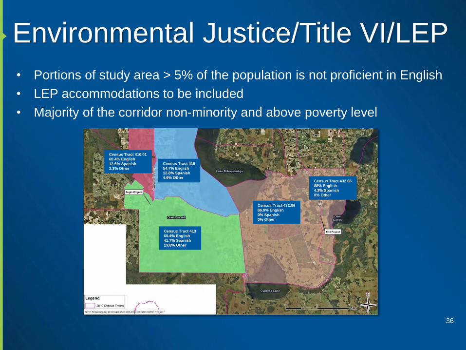
Environmental Justice/Title VI/LEP
• Portions of study area > 5% of the population is not proficient in English
• LEP accommodations to be included
• Majority of the corridor non-minority and above poverty level
36
Census Tract 415
54.7% English
12.8% Spanish
4.6% Other
Census Tract 410.01
60.4% English
12.6% Spanish
2.3% Other
Census Tract 413
60.4% English
41.7% Spanish
13.8% Other
Census Tract 432.06
86.9% English
0% Spanish
0% Other
Census Tract 432.06
88% English
4.2% Spanish
0% Other

Potential 4(f) Summary
37
Resource Type Likely 4(f)Likely
ImpactsExpected
Documentation
Southport Mitigation Bank Wildlife or Waterfowl Refuge N N No Use
Disney Wilderness Preserve Wildlife or Waterfowl Refuge Y N No-Use
SFWMD - Lake Russell
Property
(Osceola County
Environmental Study Center)
Park and Recreation Area Y Y Programmatic
Southport Road Boat Ramp Park and Recreation Area Y N No Use
Archeological Sites
Browns Landing MoundArcheological ?? Y No-Use
Southport Canal Historic ?? Y De Minimis
Mac Overstreet Regional Park Park and Recreation Area Y Y Programmatic

Other Environmental Considerations
• Prime and Unique Farmlands
– GIS Files sent to NCRS (Rick Robbins)
– NCRS Completes Farmland Conversion Rating Form AD 1006
• Noise
• Air Quality
• Contamination
– No known contamination sites within limits of project
– Potential contamination sites
• Farm/agricultural/cattle uses
• Dump sites for rural residential or farms
• Equipment/chemical/pesticide storage and/or maintenance areas
• Cattle dip vats
38

Public Involvement Approach
• Most work will get done in small group and individual meetings
• Four main stakeholder groups– Agencies and governmental staff
– Elected officials
– Property owners
– General public
• Meet with stakeholder groups prior to each public meeting
• Form Agency Project Advisory Group (APAG)
• Newsletters, web page, local media out reach, existing communication
outlets
• Bilingual approach
Page 39
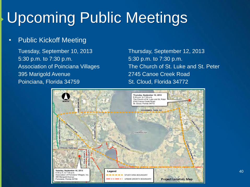
Upcoming Public Meetings
• Public Kickoff Meeting
40
Tuesday, September 10, 2013
5:30 p.m. to 7:30 p.m.
Association of Poinciana Villages
395 Marigold Avenue
Poinciana, Florida 34759
Thursday, September 12, 2013
5:30 p.m. to 7:30 p.m.
The Church of St. Luke and St. Peter
2745 Canoe Creek Road
St. Cloud, Florida 34772
Page 41

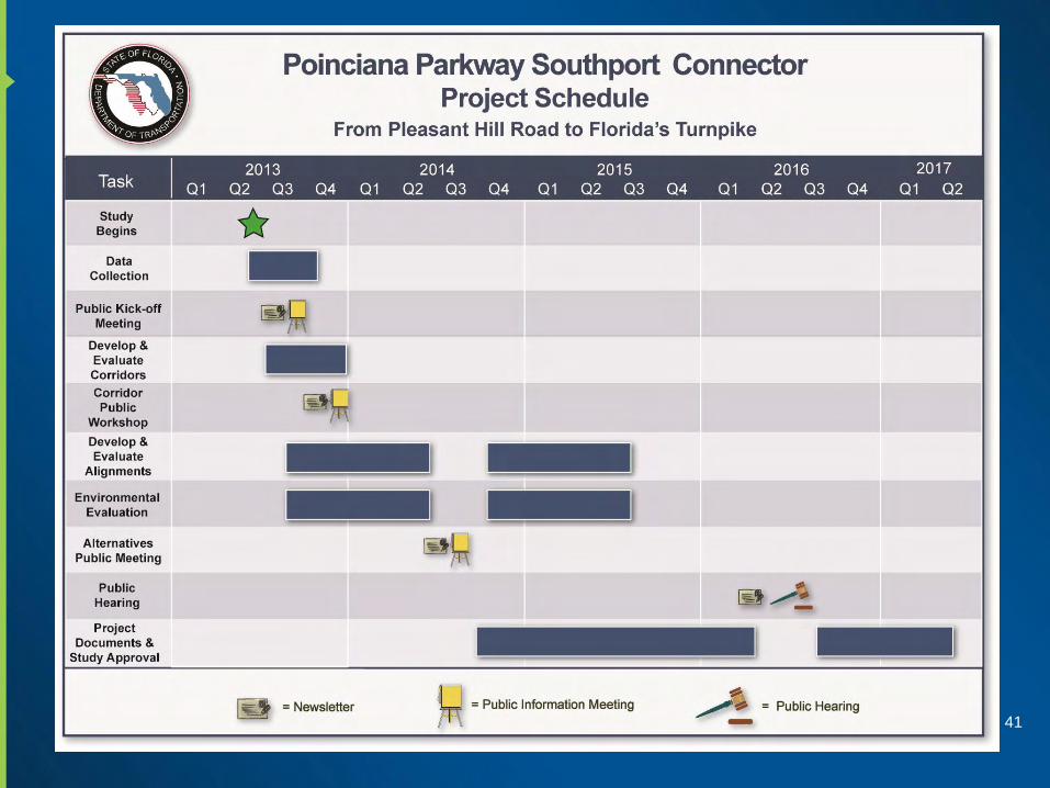
Next Steps
• Evaluate corridor alignments
• Travel demand forecasting
• Finalize project description and purpose and need
• Finalize preliminary environmental discussion
• Public kickoff meeting
• Alternative Corridor Evaluation (ACE) process
• Prepare Corridor Report
• ETDM programming screen
• Determine Class of Action
42

Questions / Answers / Dicussion
43