Embed Size (px)
DESCRIPTION
Journal of the Australian Hydrographers Association
Citation preview
Australasian Hydrographer
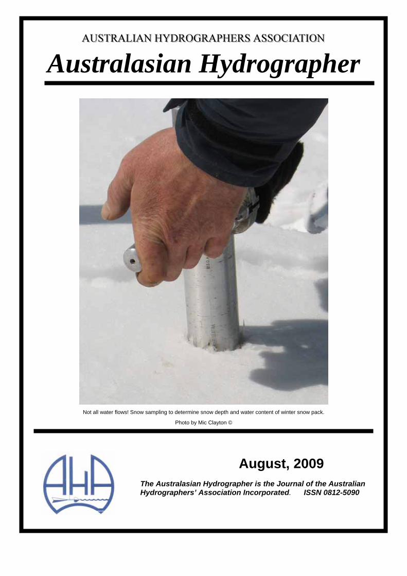
Not all water flows! Snow sampling to determine snow depth and water content of winter snow pack.
Photo by Mic Clayton ©
August, 2009 The Australasian Hydrographer is the Journal of the Australian Hydrographers’ Association Incorporated. ISSN 0812-5090
Visit your site: www.aha.net.au Australasian Hydrographer, August 2009
THIS ISSUE Editorial 1 Announcement - 2010, 15th Australian Hydrographers Association Conference 2 Australian Hydrographers Association, 29th Annual General Meeting 3 Where Did I Leave My Keys? 6 Hydrometric Monitoring Networks, 2008 and Beyond - A New South Wales Department of Water and Energy Manager's perspective- Ray Boyton 7 Education and Training - A Changing World 14 Expression Of lnterest for The Provision of Facilities or Assistance to Provide Face To Face Training in Hydrometric Training 15 lmproving The Accuracy of Acoustic Doppler Current Profiler Measurements !n Small Channels.- Andrew Willsman, NIWA 18 What's in an Epigram? 26 Australian Hydrographers' Association Educational Grant 27 lnaugural Training Program in the Skill Set for Hydrography 28 New Zealand Hydrological Society Conference, 2009 28 Long time hydrographer finally hangs up his current meter. 28
EDITORIAL Hydrographic education and training in Australia has existed since the 1960s. Many senior hydrographic practitioners went through the intensive Snowy Mountains Hydro Electric Authority Hydrographic training course in the 1960s before the course moved into the realm of New South Wales Technical Colleges, primarily based in Sydney, a transition into correspondence course work as it moved towards and through the change of the century.
During this period the training delivery had its ups and downs affected by lack of trainees to undertake it (due to water authorities cutting back severely on intake programs), an east coast bias in the availability of the course, and (as some have felt) a decreasing lack of up to date learning resources.
ln the early 2000s many organisations contributed significant financial resources to upgrade the Certificate lV to be more up to date and relevant learning materials. Then along came competency based requirements from the federal Government for vocational training programs as a perceived way to address skills shortages in many professions!
ln the last couple of years a small band of your hydrographic colleagues from water authorities, hydrographic organisations and even your AHA has worked to assist in the evolution of hydrographic training and education into the new competency based environment.
The transition is now beginning with competency units in place for the new qualification framework, development of learning materials and the AHA developing Memorandums of Understanding with education and training providers in the provision of training facilities and assessors.
At the end of the year enrolments in the current Hydrography Certificate lV will end, though any students currently enrolled will have a further three years to complete the Hydrography Certificate lV in the course work format. A mapping program is currently underway for the old format course into the new competency based
format. Both qualifications will be equal so those completing the course work based qualification are not disadvantaged by the transition to the new qualification.
On a more sobering note though, I have received the sad news that one of our Association's members, Grant van Kampen (also a member of the New Zealand Hydrological Society), was drowned while undertaking hydrographic installation work in the Port of Waikato in New Zealand.
Grant had previously worked for Environment Waikato, Scottech as well as working for periods in New Guinea. ln recent times he worked for with HydroData. The AHA extends our condolences to his family, friends and colleagues.
Mic Clayton - Editor ____________________________________
The Australasian Hydrographer is the Journal of the Australian Hydrographers’ Association Incorporated. The Journal is distributed quarterly to Members. ISSN 0812-5090 ____________________________________________ Visit our Web Site at: http://www.aha.net.au to download a Membership application and to find contact details for your state representative. ____________________________________________ Editorial and advertising enquiries should be directed to the Association’s Publicity Officer, Mic Clayton.
Journal editions are generally produced February, May, August and November. Copy is requested to be with the Publicity Officer by the previous month.
e - mail [email protected] , or PO Box 843, COOMA, NSW, 2630. ____________________________________________ The views expressed in this publication are those of its contributors and do not necessarily represent those of the Australian Hydrographers Association Inc or its office bearers. ____________________________________________
1
Visit your site: www.aha.net.au Australasian Hydrographer, August 2009
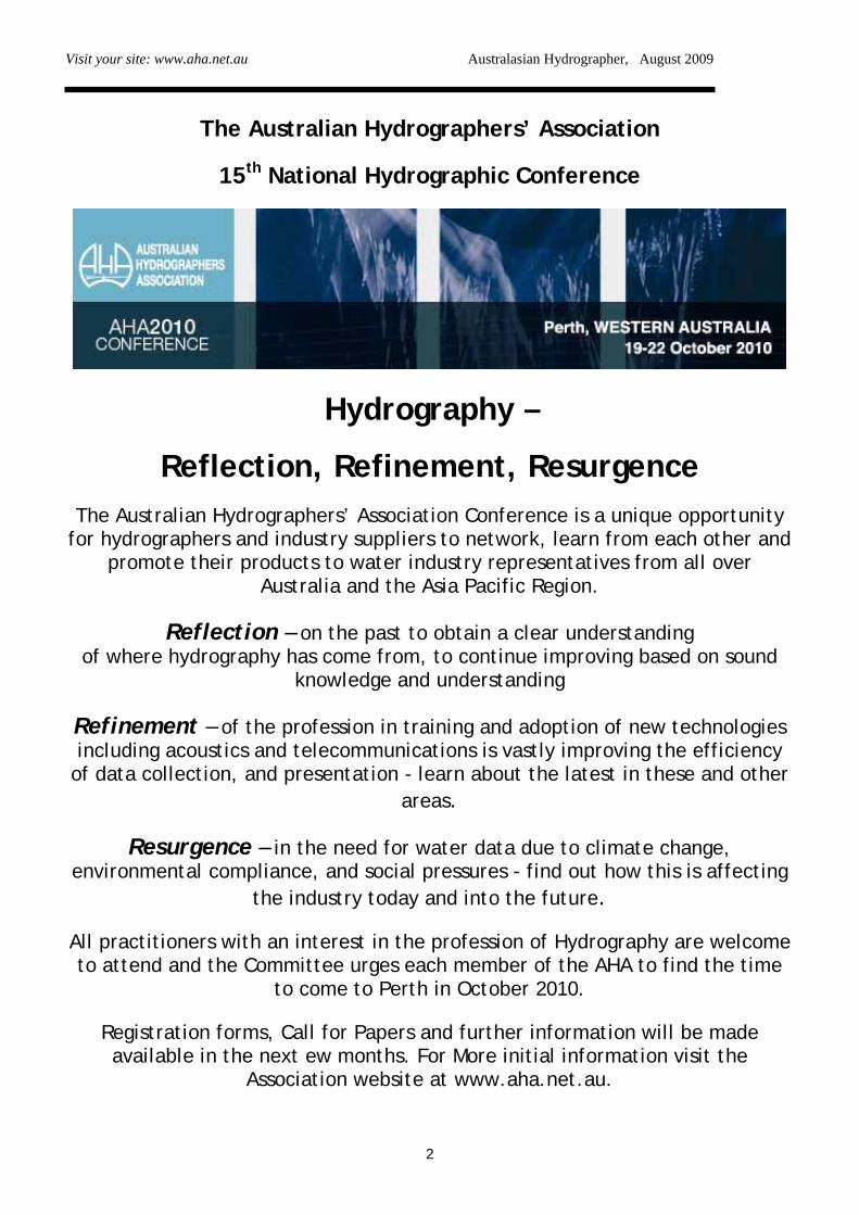
The Australian Hydrographers’ Association
15th National Hydrographic Conference
Hydrography –
Reflection, Refinement, Resurgence The Australian Hydrographers’ Association Conference is a unique opportunity
for hydrographers and industry suppliers to network, learn from each other and promote their products to water industry representatives from all over
Australia and the Asia Pacific Region.
Reflection – on the past to obtain a clear understanding of where hydrography has come from, to continue improving based on sound
knowledge and understanding
Refinement – of the profession in training and adoption of new technologies including acoustics and telecommunications is vastly improving the efficiency
of data collection, and presentation - learn about the latest in these and other areas.
Resurgence – in the need for water data due to climate change, environmental compliance, and social pressures - find out how this is affecting
the industry today and into the future.
All practitioners with an interest in the profession of Hydrography are welcome to attend and the Committee urges each member of the AHA to find the time
to come to Perth in October 2010.
Registration forms, Call for Papers and further information will be made available in the next ew months. For More initial information visit the
Association website at www.aha.net.au.
2
Visit your site: www.aha.net.au Australasian Hydrographer, August 2009
3
THE 29TH ANNUAL GENERAL MEETING OF THE AUSTRALIAN HYDROGRAPHERS’ ASSOCIATION (Incorporated)
Rydges Lakeside - Canberra Tuesday August 11th 2009
Attendees: Members: Alex Springall, Paul Jensen, Glen Terlick, Mat Bryan, Peter Dowland, Tony Polchleb, John Hayes, Marc Schmidt, Mike Lysaght, Todd Lovell, Jason Venables, Michael Whiting (Secretary), Max Hayes (Treasurer), Paul Langshaw (Committee), Mic Clayton (Publicity Officer), Bill Steen (Chairman). Visitors: Garry Newton, Col Mayes. Apologies: Mark Johnston – Hydro Tasmania. Bill Barrett - Committee Mark Wolf – Greenspan Technologies. Judy Swan – Murray Darling Commission. Meeting Opened at 17:45
1. Previous minutes of the 28th Annual General Meeting held in Canberra on the 22nd August 2008. Overview: Structure plan is not a firm document, currently in background for possible future directions.
Training Package now replaced with Competency based framework. Membership Fees increased by 10% to cover increasing operational costs requirements due to Training, and Certification. Moved for acceptance by Alex Springall,
seconded by Tony Polchleb.
2. Chairman’s Report (Summary) – provided verbally by Bill Steen • Thanks to Paul Langshaw for work in
progressing new Training Package. • Signed Memorandum of Understanding
with N.S.W. TAFE/OTEN as Registered Training Organisation of choice for delivery of Hydrography Qualifications.
• Soon to issue Expressions of Interest for • Working on Career Path to Advanced
Diploma Hydrography through to a Graduate Diploma in Hydrology.
• Developing Certification Process modelled on Irrigation Australia.
• Lifting profile including new web page, and logos.
• Becoming involved in the Industry with more involvement from the State Agencies
3. Treasurers Report (Summary) – Max Hayes
January 2007 – December 2008 Main Account Income $42,677
Bank Account: $31,356 Total $74,033
Expenditure: $32,904
Closing Balance: $41,129 Investment Account (Maxi-One)
Bank Account: $66,496 Interest Income: $4,068
Closing Balance: $70,564
Visit your site: www.aha.net.au Australasian Hydrographer, August 2009
1st January 2009 – 30th June 2009
Main Account
Bank Account: $41,129 Income: $34,584
Total $75,714 Expenditure: $55,820
Closing Balance: $19,894 Investment Account
Bank Account: $70,564 Interest/Income: $35,756 (ncludes 2008 Conference)
Closing Balance: $106,320
Certification Account Opening Balance $20.00 Interest Income $0.01 Closing Balance $20.01
Comment – Mic Clayton
Minimal returns, and the Investment Account will be used to fund initiatives. $20,000 maintained as an operational account.
Moved by Mic Clayton, Seconded by Alex Springall, all agreed. 4. Secretaries Report (Summary) – Tabled by
email – Michael Whiting Discussion item about Membership numbers. 2004/05 - 75 Members. 2008/09 - 214 members (Record numbers) 2009/10 – 144 Current members – approximately 120 waiting processing. Corporately sponsored including: 66 – Thiess (Hydrographic Services) 37 – Manly Hydraulics 16 – Kisters 265 Members with as yet outstanding memberships to push it over the 300. Due to not only the efforts of the Association, but also the ground swell of support within the Industry for the Australian Hydrographers’ Association, and the profession of Hydrography. Needed to be sustained, and also capture the entire industry Comment – Bill Steen from surveys approximately 400 Hydrographers / Data Collectors. Now support from Agencies and Private Industry support. Moved by Mic Clayton, seconded Glen Terlick.
5. Publicity Officer ‘s Report (Summary) – Mic Clayton
New website now operating, worked with COL-ACT using Wordpress for Website redevelopment. More interactive, including forum to be trialled in the next few months. Theme adopted from the last AHA Conference, in website and correspondence. Adopting a more professional image. Careers Video is now on ‘YouTube’ with 400 current views. DVD’s now distributed across industry and internationally. Photographic Competition will be released in the next Journal for obtaining images for publicity and conference. Winning image will be awarded Conference Registration. Moved by Mic Clayton, seconded by Bill Steen, all agreed. Questions: John Hayes - “…what is the situation with AWA (Australian Water Association).
4
Visit your site: www.aha.net.au Australasian Hydrographer, August 2009
Mic Clayton - “ Looked at synergies with AWA and Australian Hydrographic Society (AHS), both were considered….however AHA has a subscription to the WATER magazine” – AHS is a loose friendship….”. WATER magazine to be administered through the Membership renewal process Michael Whiting - “….with 300+ Members could be an issue for continued low cost subscription….”.
6. National Hydrographer Training Program –
Paul Langshaw A Lot of activity undertaken in this area.
• Bureau of Meteorology realised they needed to have a look at the quality of the people collecting data.
• BoM realised that the training of hydrographers was fragmented.
• Hydrographic Technical Reference Group established to provide Industry and Stakeholder involvement.
Industry developed program for the members of the Association and Hydrographers across Australia. Elements: 1. Develop nationally accredited course, which
meets industry needs. 2. Expand the Distance delivery methods. 3. Certification process for continued
professional development.
Hydrographic Technical Reference Group has developed the nationally accredited course. As the Peak Industry body, the AHA has been able to build an alliance between AHA, BoM, Government Skills Australia (GSA). Seed Funding from BoM has brought all these things together to deliver:
• Memorandum of Understanding (MOU) signed with OTEN for delivery of course, as low numbers of possible enrolment would be unsustainable with more than one RTO.
• Service Agreement established with NSW TAFE for delivery of Skills Set through ‘Face to Face’ courses – industry driven.
• Formal agreement with GSA to provide early release of the Learning Material to NSW TAFE.
• AHA Negotiating with two major suppliers to enrol in the Skills set followed by the
Diploma Course, and a National Certification process.
• Career path for Hydrographers from Skills set to Graduate Diploma in Hydrology.
• Development of a proposed model for Certification process.
Skills Set provides a good underpinning knowledge for Hydrography – Certificate of Attainment at Certificate IV level (Not a full Certificate IV). Certification will enable each individual to identify skills and qualifications. OTEN Industry trainers - delivery of material week true course. Identifier/skills + qualifications Certification Process for Certification is obtained through an RTO (Registered Training Organisation (RTO) carrying out an assessment through a Recognised Prior Learning process. The process needs to be sustainable to secure membership base. GSA on behalf of AHA seeking to secure funding from National Water Commission (NWC) for completing the Advanced Diploma – Graduate Certificate. Comments: Bill Stein “….What’s it going to cost?...”. Paul Langshaw “…in the order of $400….the face to face course…talking to TAFE about the ‘Face to Face’ course talking with TAFE <$3,000 per student at a Nationally accredited level…”
BoM are very supportive on Certification. At a verbal level BoM are very supportive and will attempt to push Certification from COAG level. Data Customers will be including the need for Certification into Contracts.
Comments:
Mike Lysaght -“…isn’t there a grant through the Federal Government for employers to complete the Diploma…”. Paul Langshaw - “….$10,000 government grant to employer, for an employee to completed at Diploma level. GSA have lobbied for eligibility with the Federal Government…”. Paul Jensen “….when is the Diploma Course available?....what about the previous course?”.
5
Visit your site: www.aha.net.au Australasian Hydrographer, August 2009
Alex Springall ‘….Enrolments to start next year….mapping of old course to new course….best detailed in next AHA Journal….” . 7. 2010 AHA Conference – Michael Whiting Next AHA Conference will be held in October 2010 from Tuesday 19th – Friday 22nd. Field Day on Friday 22nd timed to coincide with a number of facilities being open. Sponsorships sold out in 24 hours, testament to previous Conference that suppliers were supported. Platinum Sponsors - Bureau of Meteorology. Gold + Sponsors - Unidata Gold Sponsors - Kisters, Campbell Scientific, Hydrological Services, Underwater Video Systems, Teledyne RD Instruments. 12 Booths of 24 currently sold. Venue – Burswood Entertainment Complex Theme – Hydrography – Reflection, Refinement, Resurgence. Online booking to be available in November, along with the call for Conference papers. Convening Committee: Michael Whiting – AHA Secretary Kelvin Baldock - Hydrosmart Allan Deane - Water Corporation Russell Marks - Greenbase Pty Ltd General Business Item tabled by John Hayes – Regarding BoM Funded DWE Instrumentation seminar, and facilitation of BoM funding proposals, and National Standards Committee. Response from Mic Clayton regarding items: 1. Until a firm proposal for the DWE
Instrumentation Seminar, the Committee can’t comment at this stage.
2. Communication around Australia regarding BoM funding proposals is managed through the State Water Information Coordinator (SWIC), and the Jurisdictional Reference Group for Water Information (JRGWI).
Need for more timely information regarding Australia wide funding proposals. BoM is
encourage more of a collaborative approach. AHA is seen as a possible conduit for collating this information.
3. Establishing of National Standards Committee is being pursued by the Association, however some Organisations are restricting travel for employers so may need to look at Video Conferencing. Possible option is for Association to approach a Lead Agency to seek funding. At present BoM won’t facilitate National Standards Committee for field procedures, it is being perceived as an Association responsibility! Suggestion of National Standards Committee to be established for development of Rating Curves.
Closing of meeting moved by Mic Clayton seconded Tony Polchleb, all agreed.
Meeting closed 18:30
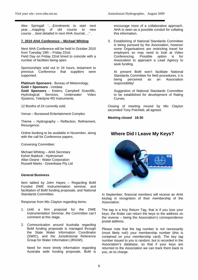
Where Did I Leave My Keys?
In September, financial members will receive an AHA keytag in recognition of their membership of the Association. The tag is a Key Return Tag, that is if you lose your keys, the finder can return the keys to the address on the reverse – being the Association’s correspondence postal address. Please note that the tag number is not necessarily (most likely not!) your membership number (this is contained on your membership card). The key tag number issued to you is random, but is recorded in the Association’s database, so that if your keys are returned to the Association we can track them back to you, at no charge.
6
Visit your site: www.aha.net.au Australasian Hydrographer, August 2009
7
Hydrometric Monitoring Networks, 2008 and Beyond - A New South Wales Department of Water and Energy Manager’s perspective. Presented at the 14th Australian Hydrographers’ Association Conference, 2008 by Ray Boyton Manager Water Monitoring Water Management Division Department of Water and Energy (NSW).
1. Historic Hydrographers in the NSW DWE and its predecessor organisations have over the last 30 years seen a great deal of change. Anecdotally, across Australia there has been a very similar experience to that in NSW. Many Hydrographers work for, or contract to various Government agencies. During this period there has been a gradual yet constant rate of reduction of numbers and skill within the group. Hydrographers have seen more restructures and name changes
within government agencies than they care to remember. In DWE only the 40 year veterans can recall working in a period of rapid hydrometric expansion, and these staff are planning a well earned retirement. During the 1960s and early 1970s there was a significant upgrade of sites from daily read gauges to the then state of art float wells and A35 chart recorders. May agencies used short term charts as a bridge between the two monitoring methods. This period also saw an increase in the number of monitoring sites.
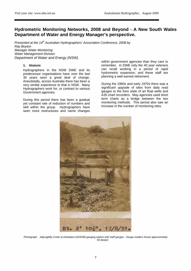
Photograph . Adjungbilly Creek at Darbalara (410038) gauging station with staff gauges. Gauge readers house approximately 50 distant.
Visit your site: www.aha.net.au Australasian Hydrographer, August 2009
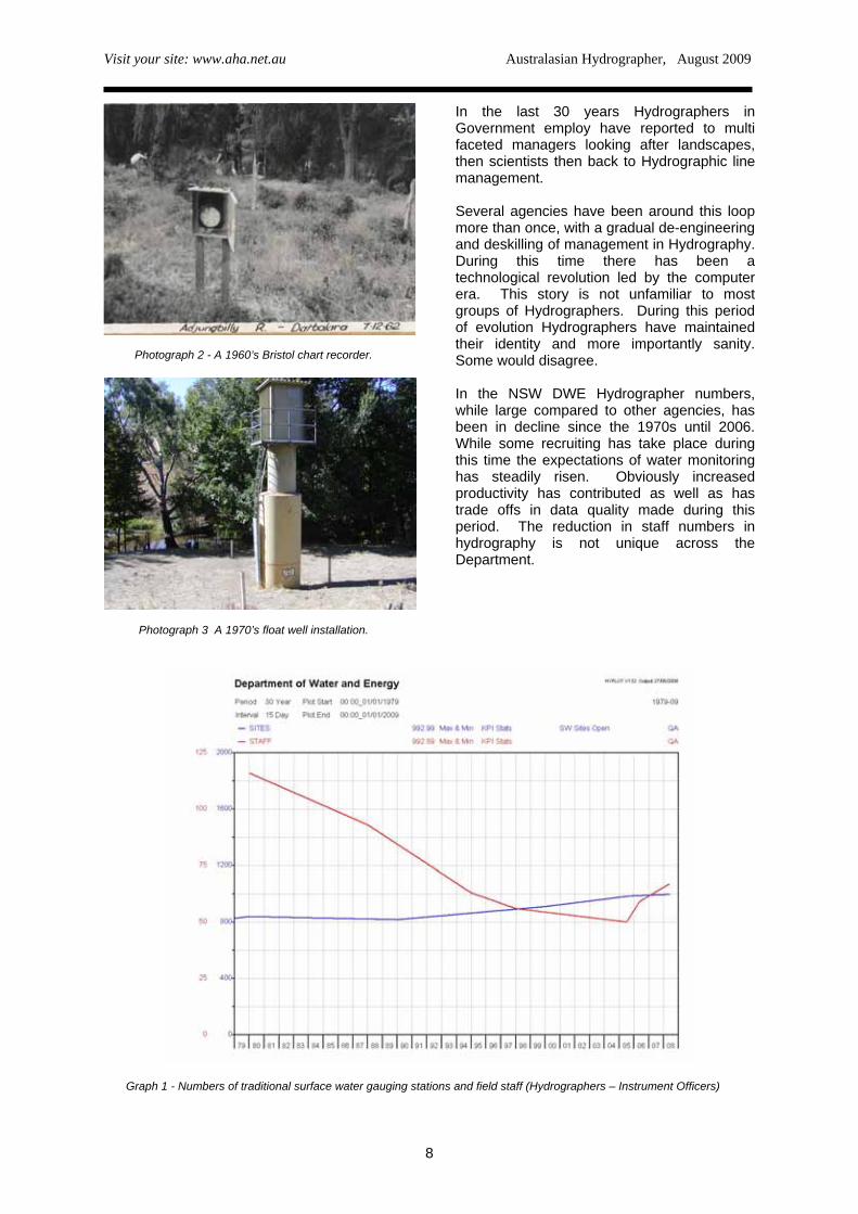
Photograph 2 - A 1960’s Bristol chart recorder.
Photograph 3 A 1970’s float well installation.
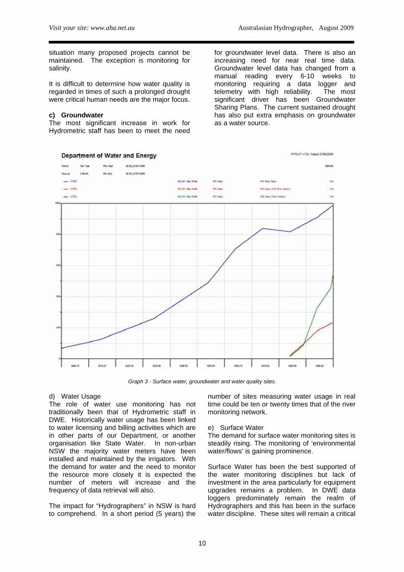
In the last 30 years Hydrographers in Government employ have reported to multi faceted managers looking after landscapes, then scientists then back to Hydrographic line management. Several agencies have been around this loop more than once, with a gradual de-engineering and deskilling of management in Hydrography. During this time there has been a technological revolution led by the computer era. This story is not unfamiliar to most groups of Hydrographers. During this period of evolution Hydrographers have maintained their identity and more importantly sanity. Some would disagree. In the NSW DWE Hydrographer numbers, while large compared to other agencies, has been in decline since the 1970s until 2006. While some recruiting has take place during this time the expectations of water monitoring has steadily risen. Obviously increased productivity has contributed as well as has trade offs in data quality made during this period. The reduction in staff numbers in hydrography is not unique across the Department.
Graph 1 - Numbers of traditional surface water gauging stations and field staff (Hydrographers – Instrument Officers)
8
Visit your site: www.aha.net.au Australasian Hydrographer, August 2009
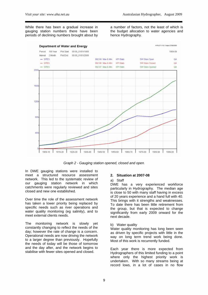
While there has been a gradual increase in gauging station numbers there have been periods of declining numbers brought about by
a number of factors, not the least of which is the budget allocation to water agencies and hence Hydrography.
Graph 2 - Gauging station opened, closed and open.
In DWE gauging stations were installed to meet a structured resource assessment network. This led to the systematic review of our gauging station network in which catchments were regularly reviewed and sites closed and new one established. Over time the role of the assessment network has taken a lower priority being replaced by specific needs such as river operations and water quality monitoring (eg salinity), and to meet external clients needs. The monitoring network is slowly yet constantly changing to reflect the needs of the day; however the rate of change is a concern. Operational needs are now driving the network to a larger degree than previously. Hopefully the needs of today will be those of tomorrow and the day after, and the network begins to stabilise with fewer sites opened and closed.
2. Situation at 2007-08 a) Staff DWE has a very experienced workforce particularly in Hydrography. The median age is close to 50 with many staff having in excess of 20 years experience and a hand full with 40. This brings with it strengths and weaknesses. To date there has been little retirement from the group, but that is expected to change significantly from early 2009 onward for the next decade. b) Water quality Water quality monitoring has long been seen as driven by specific projects with little in the way on long term trend work being done. Most of this work is recurrently funded. Each year there is more expected from Hydrographers of this limited funding to a point where only the highest priority work is undertaken. With so many streams being at record lows, in a lot of cases in no flow
9
Visit your site: www.aha.net.au Australasian Hydrographer, August 2009
situation many proposed projects cannot be maintained. The exception is monitoring for salinity. It is difficult to determine how water quality is regarded in times of such a prolonged drought were critical human needs are the major focus. c) Groundwater The most significant increase in work for Hydrometric staff has been to meet the need
for groundwater level data. There is also an increasing need for near real time data. Groundwater level data has changed from a manual reading every 6-10 weeks to monitoring requiring a data logger and telemetry with high reliability. The most significant driver has been Groundwater Sharing Plans. The current sustained drought has also put extra emphasis on groundwater as a water source.
Graph 3 - Surface water, groundwater and water quality sites.
d) Water Usage The role of water use monitoring has not traditionally been that of Hydrometric staff in DWE. Historically water usage has been linked to water licensing and billing activities which are in other parts of our Department, or another organisation like State Water. In non-urban NSW the majority water meters have been installed and maintained by the irrigators. With the demand for water and the need to monitor the resource more closely it is expected the number of meters will increase and the frequency of data retrieval will also. The impact for “Hydrographers” in NSW is hard to comprehend. In a short period (5 years) the
number of sites measuring water usage in real time could be ten or twenty times that of the river monitoring network. e) Surface Water The demand for surface water monitoring sites is steadily rising. The monitoring of ‘environmental water/flows’ is gaining prominence. Surface Water has been the best supported of the water monitoring disciplines but lack of investment in the area particularly for equipment upgrades remains a problem. In DWE data loggers predominately remain the realm of Hydrographers and this has been in the surface water discipline. These sites will remain a critical
10
Visit your site: www.aha.net.au Australasian Hydrographer, August 2009
part of understanding the water balance, however in terms of numbers they are already being outnumbered by groundwater and water usage both surface water and groundwater. The signs are this will only continue.
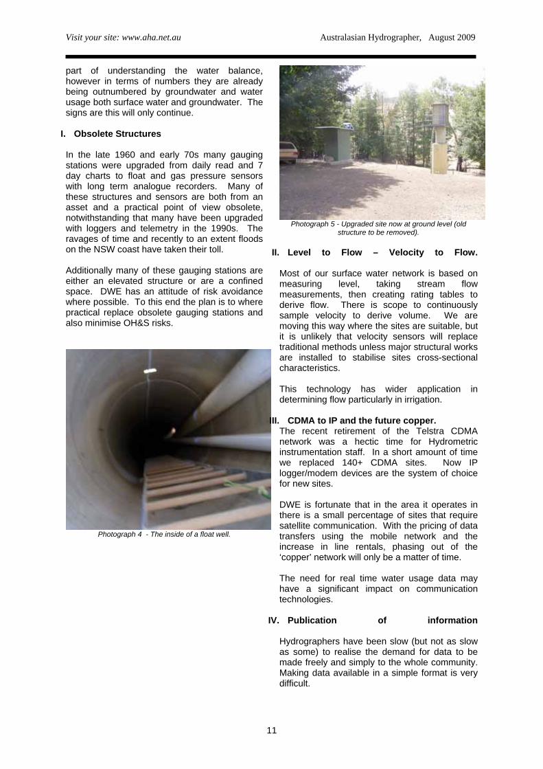
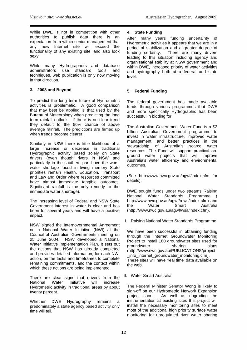
I. Obsolete Structures In the late 1960 and early 70s many gauging stations were upgraded from daily read and 7 day charts to float and gas pressure sensors with long term analogue recorders. Many of these structures and sensors are both from an asset and a practical point of view obsolete, notwithstanding that many have been upgraded with loggers and telemetry in the 1990s. The ravages of time and recently to an extent floods on the NSW coast have taken their toll. Additionally many of these gauging stations are either an elevated structure or are a confined space. DWE has an attitude of risk avoidance where possible. To this end the plan is to where practical replace obsolete gauging stations and also minimise OH&S risks.
Photograph 4 - The inside of a float well.
Photograph 5 - Upgraded site now at ground level (old
structure to be removed).
II. Level to Flow – Velocity to Flow.
Most of our surface water network is based on measuring level, taking stream flow measurements, then creating rating tables to derive flow. There is scope to continuously sample velocity to derive volume. We are moving this way where the sites are suitable, but it is unlikely that velocity sensors will replace traditional methods unless major structural works are installed to stabilise sites cross-sectional characteristics. This technology has wider application in determining flow particularly in irrigation.
III. CDMA to IP and the future copper. The recent retirement of the Telstra CDMA network was a hectic time for Hydrometric instrumentation staff. In a short amount of time we replaced 140+ CDMA sites. Now IP logger/modem devices are the system of choice for new sites. DWE is fortunate that in the area it operates in there is a small percentage of sites that require satellite communication. With the pricing of data transfers using the mobile network and the increase in line rentals, phasing out of the ‘copper’ network will only be a matter of time. The need for real time water usage data may have a significant impact on communication technologies.
IV. Publication of information
Hydrographers have been slow (but not as slow as some) to realise the demand for data to be made freely and simply to the whole community. Making data available in a simple format is very difficult.
11
Visit your site: www.aha.net.au Australasian Hydrographer, August 2009
While DWE is not in competition with other authorities to publish data there is an expectation from within senior management that any new Internet site will exceed the functionality of any existing site, and also look sexy. While many Hydrographers and database administrators use standard tools and techniques, web publication is only now moving in that direction.
3. 2008 and Beyond To predict the long term future of Hydrometric activities is problematic. A good comparison that may best be applied is that used by the Bureau of Meteorology when predicting the long term rainfall outlook. If there is no clear trend they default to the 50% chance of above average rainfall. The predictions are firmed up when trends become clearer. Similarly in NSW there is little likelihood of a large increase or decrease in traditional Hydrographic activity based solely on State drivers (even though rivers in NSW and particularly in the southern part have the worst water shortage faced in living memory State priorities remain Health, Education, Transport and Law and Order where resources committed have almost immediate tangible outcomes. Significant rainfall is the only remedy to the immediate water shortage). The increasing level of Federal and NSW State Government interest in water is clear and has been for several years and will have a positive impact. NSW signed the Intergovernmental Agreement on a National Water Initiative (NWI) at the Council of Australian Governments meeting on 25 June 2004. NSW developed a National Water Initiative Implementation Plan. It sets out the actions that NSW has already completed and provides detailed information, for each NWI action, on the tasks and timeframes to complete remaining commitments, and the context within which these actions are being implemented. There are clear signs that drivers from the National Water Initiative will increase Hydrometric activity in traditional areas by about twenty percent. Whether DWE Hydrography remains a predominately a state agency based activity only time will tell.
4. State Funding After many years funding uncertainty of Hydrometric activities it appears that we are in a period of stabilization and a greater degree of funding certainty. There are many drivers leading to this situation including agency and organisational stability at NSW government and within DWE, increased priority of water activities and hydrography both at a federal and state level.
5. Federal Funding The federal government has made available funds through various programmes that DWE and more specifically Hydrographic has been successful in bidding for.
The Australian Government Water Fund is a $2 billion Australian Government programme to invest in water infrastructure, improved water management, and better practices in the stewardship of Australia’s scarce water resources. The Fund will support practical on-ground water projects that will improve Australia’s water efficiency and environmental outcomes.
(See http://www.nwc.gov.au/agwf/index.cfm for details).
DWE sought funds under two streams Raising National Water Standards Programme ( http://www.nwc.gov.au/agwf/rnws/index.cfm) and the Water Smart Australia (http://www.nwc.gov.au/agwf/wsa/index.cfm).
I. Raising National Water Standards Programme
We have been successful in obtaining funding through the Internet Groundwater Monitoring Project to install 180 groundwater sites used for groundwater sharing plans (http://www.nwc.gov.au/PUBLICATIONS/project_info_internet_groundwater_monitoring.cfm). These sites will have ‘real time’ data available on the web.
II. Water Smart Australia
The Federal Minister Senator Wong is likely to sign-off on our Hydrometric Network Expansion project soon. As well as upgrading the instrumentation at existing sites this project will install the necessary monitoring sites to meet most of the additional high priority surface water monitoring for unregulated river water sharing
12
Visit your site: www.aha.net.au Australasian Hydrographer, August 2009
plans. It also will install additional monitoring to improve understanding of surface water- groundwater interaction and increased wetland knowledge.
Put in very simple terms these funds will provide for the installation of the sites and DWE has committed to maintaining them. While the final analysis is to be done an expansion, of 20% in traditional Hydrometric staff is possible.
Of Hydrographic interest are several of the funding conditions referring to devices installed, part of which follows -“are consistent with all applicable national standards including without limitation:
• Australian Standard 3778 Measurement of Water Flow in Open Channels;
• Murray-Darling Basin Commission BSMS Operational Protocols Appendix 2.2 Hydraulic Conditions for an ideal gauge site for determining stream flow; and
• Murray-Darling Basin Commission BSMS Operational Protocols Appendix 2.3 Recommended minimum standards and protocols for salinity monitoring.” (http://www.mdbc.gov.au/subs/dynamic_reports/bsms_op_protocols/HTML/appendix/2_3.htm)
While DWE is meeting or exceeding many specific requirements several of the Operational Protocols (Appendix 2.3) have created discussion within DWE at a management level;
• A minimum of 6 gaugings shall be taken per annum.
• Each site shall be visited at least once every 8 weeks.
If these protocols were adopted nationally, it would surely impact on many agencies.
III. BOM Modernisation Under the federal Water Act 2007 the Bureau of Meteorology has been given the task of developing a National Water Database. Of particular interest to Hydrography is Part 7 Water Information, and the associated regulations (http://www.comlaw.gov.au/ComLaw/Legislation/LegislativeInstrument1.nsf/asmade/bytitle/3B3AF3E9B64EAED7CA25746C000F5FA3?OpenDocument ).
Water information is defined as: “water information means any raw data, or any value added information product, that relates to: (a) the availability, distribution, quantity, quality, use, trading or cost of water; or (b) water access rights, water delivery rights or irrigation rights; and includes contextual information relating to water (such as land use information, geological information and ecological information)”. DWE (and all other named persons) need to begin providing BOM a copy of most of our water data, some by the end of September 2008, and then updates as data becomes available. We have no objections to provide the data, however we are limited by dated data archival and transfer systems and available staff. Details of data delivery timetables are available at (http://www.bom.gov.au/water/regulations/report.php?personid=91). BOM to assist agencies in meeting the new requirements are offering support. The Modernisation and Extension of Hydrologic Monitoring Systems Programme is the funding stream to facilitate this a nationwide $80 million, 5 year programme. $10 million was offered in the first year (07-08). DWE were successful in purchasing replacements for outdated equipment as well as to begin investigations in replacing water data systems.
6. Priority Directions 2008 The DWE approach is to best fit the various funding streams to the priorities of the day. To this end DWE will work through the NWI requirements and use State resources to maintain the Hydrometric network to a large extent, and use State and Federal resources to modernise and increase the network through projects like Hydrometric Network Expansion and Internet Groundwater Monitoring. Funds will be increasingly directed at meeting the legislative requirements (implemented by BOM) of the water act, particularly Section 7. The demand for increasing publication of data and information will need to be met. This demand is expected to slow with the entry of BOM into this area. It is interesting to note that currently DWE Hydrographers add about 3% each year to our database of stream flows. The current years
13
Visit your site: www.aha.net.au Australasian Hydrographer, August 2009
information is very important for ‘on the day’ operational decisions. Many Hydrographers and water industry managers see little merit in improving the overall quality of the streamflow database. This is an area that requires closer scrutiny as relatively small resources in this area will improve the whole period of record for a site not just the current data. ‘The Australian Government is committed to implementing a truly national water plan, Water for the Future’ (http://www.environment.gov.au/water/index.html) . Many of the initiatives at least in dollar terms ($12.9 billion over 10 years) are yet to be fully articulated. As these funds reach the ground one would expect additional work for Hydrographers. It may change the Hydrographic landscape forever in a way most Hydrographers have not yet realised. This ten year period will be the most exciting ever in Hydrography and will see well over half our current Hydrographers leave the industry. Age will weary them. Undoubtedly some will return to Hydrographic when the joys of retirement fade much to the relief/annoyance of their spouses and the younger generation of Hydrographers. The views expressed in this paper are those of the author and may not represent the past, current or future position of the Department of Water and Energy.
Education and Training
A Changing World. The qualification path for Hydrographers and hydrometric practitioners is evolving as we speak. The existing Course work related qualification we lovingly know as the Hydrographic Certificate IV is evolving into NWP07 (Hydrography). Under Federal funding arrangements for vocational training, state education systems have been required to move from a course
based approach in qualifications to a competency/skills based approach to training and qualifications in this area. The AHA has been deeply involved in recent times in developing a transition into the new qualification/training environment. NWP07 When NWP07 (the Water Industry Training Package) was being reviewed, the AHA became involved in an attempt to ensure that Hydrography would be included in the package. Unfortunately the ‘end’ of the existing Hydrography Certificate IV was approaching and nothing satisfactory was in place for its replacement. Early submissions and involvement into the development of the NWP07 review process were less than satisfactory in the view of the industry with the transition resulting in (extremely) less than adequate training outcomes. Unfortunately the transition process embarked upon by a hard working group of individuals from various organisations was occurring just as the accreditation for the existing Hydrography Certificate IV was nearing its expiration. In the last two years the AHA, with most major state agencies, has supported Government Skills Australia GSA) in a program to solidify the development of the new competency based format which is now nearing its completion for the core competency content. In the meantime, the AHA made submissions to OTEN (New South Wales TAFE) to seek extension of the current accreditation of the existing Hydrography Certificate IV. This was an important step by the AHA on behalf of the profession as there was an identified rapidly developing skills shortage in the hydrographic profession, particularly at a time of increased water programs through the National Water Initiative. The submission has been successful (twice in as many years in fact), but the end of 2009 see the end of the current Hydrography IV Certificate. The AHA continues to support enrolment in the existing course based qualification. At present enrolments can be made until the end of the year in the current course based qualification. Any potential student will then have three years to complete the course based qualification within three years (end 2012) to
14
Visit your site: www.aha.net.au Australasian Hydrographer, August 2009
qualify for the Hydrography Certificate IV qualification. Mapping to the new competency based qualification is being developed at present – no student on the existing course is to be disadvantaged in the transition to the new competency based qualification. While not defined yet – it is also intended that those on course based studies can transfer, without discrimination, into the new competency based framework. HTRG A Hydrographic Technical Reference Group (HTRG) has been assembled by GSA to assist with better definition of the competencies for the updated qualification. Members of the HTRG include Ian White (Queensland DNR), Michael Briggs (Thiess Services, Victoria), Graham Parsons (NSW Office of Water), Mic Clayton (Snowy Hydro Ltd), Kevin Dennis (DLWBC SA), Allan Russ (Northern Territory), Greg May and Frank Davies (Western Australia DoW), and Alex Springall (NSW OTEN). As can be seen the group has a wide range of technical hydrographic experience and will represent our industry well. Paul Langshaw and Wayne Morling, of Government Skills Australia, have been co-ordinating the process. Paul is also a member of the AHA Committee and has been working tirelessly to ensure the best outcome for our profession in this transition process. The Future An Advanced Diploma In Water Operation (Hydrography) has been outlined as the next step in Hydrographic the education and training process. It is expected that that this career path will provide a transiation towards a proposed Graduate Diploma in Physical Hydrology that has been under investigation by the Bureau of Meteorology and GSA. The AHA encourages individuals, entities and organisations to support the hard work of the AHA, GAS and the HTRG by enrolling staff and new trainees in either of the currently available training and education and training paths available for hydrographers.
“Expression Of Interest for The Provision of Facilities or
Assistance to Provide Face To Face Training in Hydrometric
Training.” Expressions of Interest [EOI] are sought to provide assistance with AHA and NSW OTEN to provide face to face training in a variety of hydrometric procedures as described in Appendix A - Units of Competency Skill Set. The learning material plus one OTEN trainer will be provided. The AHA is not looking for a sole supplier as it is recognised that training will be undertaken across Australia and therefore local providers may be better suited than one single supplier. Minimum respondent requirements In addition to any requirements contained in the main body of the EOI document, AHA requires that for a potential Training Provider to be successful in their application for the delivery of training material, the following minimum skills, knowledge and experience are required: 1) Organisational capability to meet
delivery requirements as specified from time to time. These shall include but not be limited too;
• Suitable training room facilities plus
amenities • On site training aids [instrument
workshop, nearby to a river, channel or suitable gauging location, flow tank, gauging structures]
• Past experience in provision of training • Close to suitable accommodation for
trainees • Close to public transportation [train, bus,
airport etc] • Catering [either on site or near by] • Experience in the fields of training to be
delivered; • Registered as a company with an ACN /
ABN number
15
Visit your site: www.aha.net.au Australasian Hydrographer, August 2009
• Understanding of AHA aims and objectives;
• Membership to the AHA 2) The Training Provider must hold,
maintain, and satisfy the AHA that they meet Legislative and statutory compliance, specifically with adequate insurance cover. At a minimum they should hold:
(a) a broad form liability policy of insurance
that includes: public liability insurance; workers’ compensation
insurance in accordance with applicable legislation for all the Training Provider employees;
professional indemnity insurance . The professional indemnity insurance must:
cover the Training Provider liability to the AHA in respect of the services and any products supplied ancillary to the services;
be maintained by the Training Provider for the period specified; and
include a description of the risk covered by the policy; and
such any other insurances that may be deemed necessary.
(b) All policies of insurance must be
effected with an insurer Rated A- or better by AM Best or an equivalent rating organization.
(c) supply proof that all insurance policies
required by the AHA; if required, arrange for its insurer to complete and sign a “Confirmation of Insurances Obtained Form”, and provide this to the AHA within 30 days of the request.
(d) Where the Training Provider is insured under a foreign parent company’s or holding company’s insurance policy, that insurance policy must clearly indicate that it applies to and extends coverage to the Training Provider in accordance with clause 2.
3) Pricing Proposal Minimal Requirements
• Daily rate • Daily facilities hire • Catering costs [if applicable]
• Transport costs [if required to transport students to gauging facilities, example minibus etc]
Occupational Health and Safety The laws protecting the Health and Safety of people at work apply to students who attend training, either part time or full time. These laws emphasise the need to take reasonable steps to eliminate or control risk at work. The suitable learning facility has the responsibility for the control, and where possible, the elimination of health and safety risk at the place of training. The OHS Act 2000 and OHS Regulation 2001 require that trainers and students take reasonable steps to control and monitor risk in the classroom, workshop or workplace. Time Frame for Expressions Of Interest It is expected that prospective service providers will provide sufficient details of their knowledge and experience in their response to enable AHA to effectively evaluate the response. The closing date for Expression Of Interest submissions is October 23, 2009. Further details, competency guidelines and registration forms are available on the Australian Hydrographers Association website at www.aha.net.au.
It’s Your Website!
Visit It!!!
www.aha.net.au
16
Visit your site: www.aha.net.au Australasian Hydrographer, August 2009
17
Visit your site: www.aha.net.au Australasian Hydrographer, August 2009
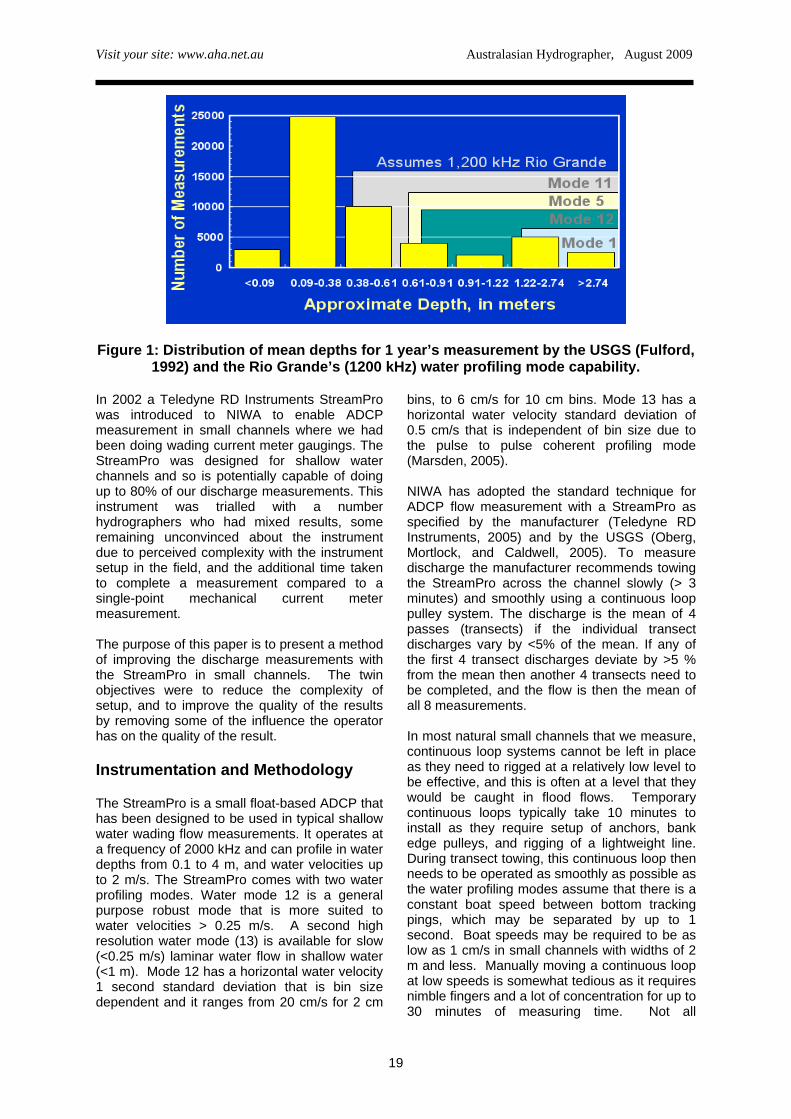
Improving The Accuracy of Acoustic Doppler Current Profiler Measurements In Small Channels. Andrew Willsman, NIWA, New Zealand. [email protected] Abstract Since 2002 the national hydrometric monitoring agency in New Zealand (NIWA) has been using small Acoustic Doppler Current Profilers (ADCPs) to measure flow in open channels. ADCPs measure thousands of water velocities and depths, so can potentially increase the accuracy of flow measurements compared to the mechanical current meter method. These benefits are recognized by most hydrographers in NIWA and many use ADCPs when they are available. Some hydrographers are reluctant to use an ADCP in a small channel due to the complexity of the ADCP instrumentation and the requirements to setup and use a continuous loop to tow the ADCP across the transect. Another apparent barrier is the extra time involved to complete an ADCP measurement compared to a single velocity point current meter gauging. These apparent barriers were considered and we have adopted practices, training, and simple technology to encourage all staff to use ADCPs in small channels. One solution was the development of a lightweight tagline traveller to tow the ADCP across the measurement transect. This device enables smooth, speed adjustable transect float towing which helps the hydrographer to regularly achieve the NIWA standards for ADCP flow measurement. Towing the ADCP with the traveller rather than with a continuous loop means many small channels may be measured in less than 30 minutes. Results from two channels will be presented illustrating flow measurement accuracy and time efficiency gains using the Teledyne RDInstruments StreamPro ADCP with the traveller. A comparison is also presented of low flow measurements using this methodology against a calibrated V notch weir to illustrate how it extends the StreamPro’s low flow capability. Introduction Large rivers in New Zealand have been measured using ADCPs since 1999 by the National Institute of Water and Atmospheric Research (NIWA). The majority of large channel river discharge measurements are now completed using Rio Grande ADCPs mounted on boats or trimarans deployed from cableways or bridges. Most hydrographers in NIWA are fully conversant with using Rio Grande ADCPs and readily use them when they are available. Flow measurements with Rio Grande ADCPs (1200KHz) are usually made in large channels with depths > 1m and mean velocities > 1m/s. These flow conditions are usually experienced in approximately 20% of all discharge
measurements made by NIWA. The higher water velocities and relative turbulence of many of these measurements means that the Rio Grande is usually limited to larger channels with depths > 1m. The results of an analysis of discharge measurements made by the USGS in 1990 (Fulford, 1992) by depth and Rio Grande (1200KHz) profiling range is shown in Figure 1. This illustrates that the New Zealand statistic is similar to measurements made by the USGS, where 80 % of the discharge measurements were in water depths of typical wading depth range (<0.91m), and the remaining 20% were probably done from boats, cableways or bridges .
18
Visit your site: www.aha.net.au Australasian Hydrographer, August 2009
Figure 1: Distribution of mean depths for 1 year’s measurement by the USGS (Fulford, 1992) and the Rio Grande’s (1200 kHz) water profiling mode capability.
In 2002 a Teledyne RD Instruments StreamPro was introduced to NIWA to enable ADCP measurement in small channels where we had been doing wading current meter gaugings. The StreamPro was designed for shallow water channels and so is potentially capable of doing up to 80% of our discharge measurements. This instrument was trialled with a number hydrographers who had mixed results, some remaining unconvinced about the instrument due to perceived complexity with the instrument setup in the field, and the additional time taken to complete a measurement compared to a single-point mechanical current meter measurement. The purpose of this paper is to present a method of improving the discharge measurements with the StreamPro in small channels. The twin objectives were to reduce the complexity of setup, and to improve the quality of the results by removing some of the influence the operator has on the quality of the result. Instrumentation and Methodology The StreamPro is a small float-based ADCP that has been designed to be used in typical shallow water wading flow measurements. It operates at a frequency of 2000 kHz and can profile in water depths from 0.1 to 4 m, and water velocities up to 2 m/s. The StreamPro comes with two water profiling modes. Water mode 12 is a general purpose robust mode that is more suited to water velocities > 0.25 m/s. A second high resolution water mode (13) is available for slow (<0.25 m/s) laminar water flow in shallow water (<1 m). Mode 12 has a horizontal water velocity 1 second standard deviation that is bin size dependent and it ranges from 20 cm/s for 2 cm
bins, to 6 cm/s for 10 cm bins. Mode 13 has a horizontal water velocity standard deviation of 0.5 cm/s that is independent of bin size due to the pulse to pulse coherent profiling mode (Marsden, 2005). NIWA has adopted the standard technique for ADCP flow measurement with a StreamPro as specified by the manufacturer (Teledyne RD Instruments, 2005) and by the USGS (Oberg, Mortlock, and Caldwell, 2005). To measure discharge the manufacturer recommends towing the StreamPro across the channel slowly (> 3 minutes) and smoothly using a continuous loop pulley system. The discharge is the mean of 4 passes (transects) if the individual transect discharges vary by <5% of the mean. If any of the first 4 transect discharges deviate by >5 % from the mean then another 4 transects need to be completed, and the flow is then the mean of all 8 measurements. In most natural small channels that we measure, continuous loop systems cannot be left in place as they need to rigged at a relatively low level to be effective, and this is often at a level that they would be caught in flood flows. Temporary continuous loops typically take 10 minutes to install as they require setup of anchors, bank edge pulleys, and rigging of a lightweight line. During transect towing, this continuous loop then needs to be operated as smoothly as possible as the water profiling modes assume that there is a constant boat speed between bottom tracking pings, which may be separated by up to 1 second. Boat speeds may be required to be as low as 1 cm/s in small channels with widths of 2 m and less. Manually moving a continuous loop at low speeds is somewhat tedious as it requires nimble fingers and a lot of concentration for up to 30 minutes of measuring time. Not all
19
Visit your site: www.aha.net.au Australasian Hydrographer, August 2009
hydrographers were prepared to spend the extra time to rig pulleys, a loop, and then have to concentrate on moving the StreamPro for this length of time. Many of our first small channel measurements with continuous loops required 8 transects as the initial 4 transects were often outside 5% of the mean discharge. Often these measurements had transect times less than the ideal 180 seconds. Research Developments To improve the quality of ADCP measurements some thought has to be made to the sources of uncertainty in the flow measurement. These uncertainties can be classified into 3 categories; instrument, environment, and operator. The instrument uncertainty has a systematic and random component. Some systematic components can be checked in the field (temperature) and the factory (beam matrix), and the random uncertainty can be minimised by the choice of water profiling mode and bin size. The measurement environment uncertainty is difficult to quantify as the main components are turbulence due to channel morphology and flow variability. Flow variability can be monitored by stage recorders over longer time scales (minutes), whereas short term variability, usually from turbulence, can be averaged by increasing sampling times. The operator of an ADCP introduces an uncertainty, firstly by their choice of section as each section will have a different level of turbulence and roughness. Secondly, the operator’s offset measurement, edge measurement, edge type estimation and transect towing method (as water speed is referenced to boat speed) all introduce uncertainty. To reduce the operator uncertainty and we realised that a mechanical device could tow the StreamPro across the channel and that this should be smoother than the human equivalent with a continuous loop. Smoother boat speeds should equate to less noise in the water velocity data. Potentially slower towing speeds are more feasible mechanically, therefore increasing sampling times, which would help average out any turbulence. A mechanical device running on a single line could be quicker to setup as it removes the extra time involved with setting up pulleys and a double line for a continuous loop. After some design and prototype testing we have built a mechanical towing device called the “NIWA tagline traveller”. It has a lightweight 12 volt motor and drive wheel mounted in the centre of a machined aluminum section with guide pulleys on either end. It drives itself along
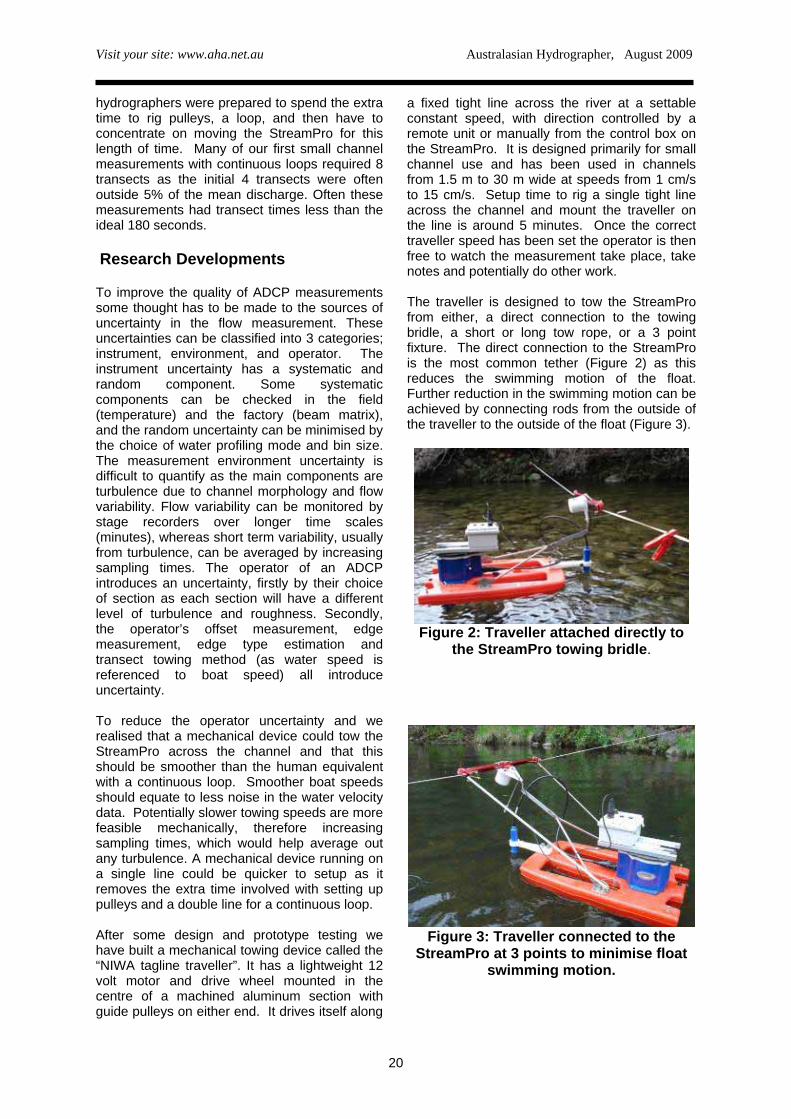
a fixed tight line across the river at a settable constant speed, with direction controlled by a remote unit or manually from the control box on the StreamPro. It is designed primarily for small channel use and has been used in channels from 1.5 m to 30 m wide at speeds from 1 cm/s to 15 cm/s. Setup time to rig a single tight line across the channel and mount the traveller on the line is around 5 minutes. Once the correct traveller speed has been set the operator is then free to watch the measurement take place, take notes and potentially do other work. The traveller is designed to tow the StreamPro from either, a direct connection to the towing bridle, a short or long tow rope, or a 3 point fixture. The direct connection to the StreamPro is the most common tether (Figure 2) as this reduces the swimming motion of the float. Further reduction in the swimming motion can be achieved by connecting rods from the outside of the traveller to the outside of the float (Figure 3).
Figure 2: Traveller attached directly to
the StreamPro towing bridle.
Figure 3: Traveller connected to the
StreamPro at 3 points to minimise float swimming motion.
20
Visit your site: www.aha.net.au Australasian Hydrographer, August 2009
21
Results
a) Transect towing method comparison
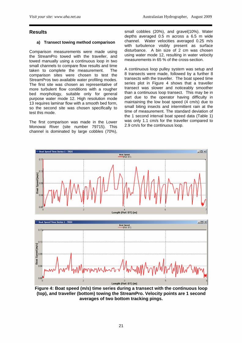
Comparison measurements were made using the StreamPro towed with the traveller, and towed manually using a continuous loop in two small channels to compare flow results and time taken to complete the measurement. The comparison sites were chosen to test the StreamPros two available water profiling modes. The first site was chosen as representative of more turbulent flow conditions with a rougher bed morphology, suitable only for general purpose water mode 12. High resolution mode 13 requires laminar flow with a smooth bed form, so the second site was chosen specifically to test this mode. The first comparison was made in the Lower Monowai River (site number 79715). This channel is dominated by large cobbles (70%),
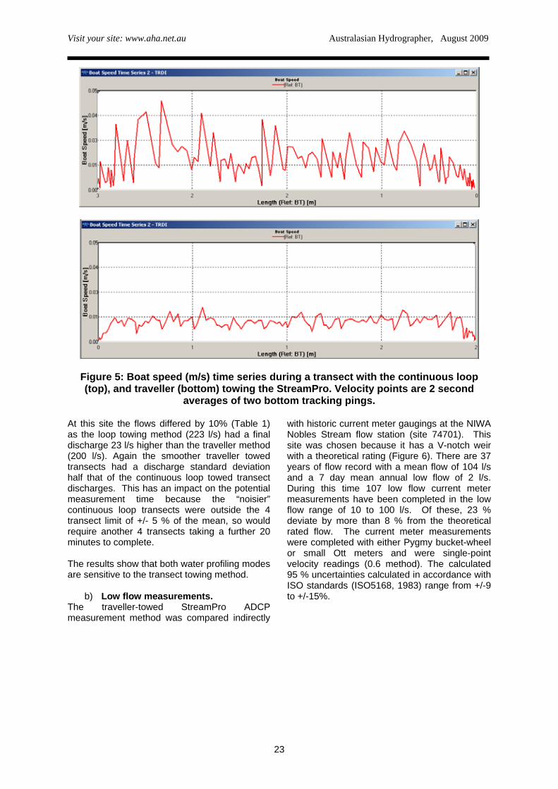
small cobbles (20%), and gravel(10%). Water depths averaged 0.5 m across a 6.5 m wide channel. Water velocities averaged 0.25 m/s with turbulence visibly present as surface disturbance. A bin size of 2 cm was chosen using water mode 12, resulting in water velocity measurements in 65 % of the cross-section. A continuous loop pulley system was setup and 8 transects were made, followed by a further 8 transects with the traveller. The boat speed time series plot in Figure 4 shows that a traveller transect was slower and noticeably smoother than a continuous loop transect. This may be in part due to the operator having difficulty in maintaining the low boat speed (4 cm/s) due to small biting insects and intermittent rain at the time of measurement. The standard deviation of the 1 second interval boat speed data (Table 1) was only 1.1 cm/s for the traveller compared to 2.9 cm/s for the continuous loop.
Figure 4: Boat speed (m/s) time series during a transect with the continuous loop (top), and traveller (bottom) towing the StreamPro. Velocity points are 1 second
averages of two bottom tracking pings.
Visit your site: www.aha.net.au Australasian Hydrographer, August 2009
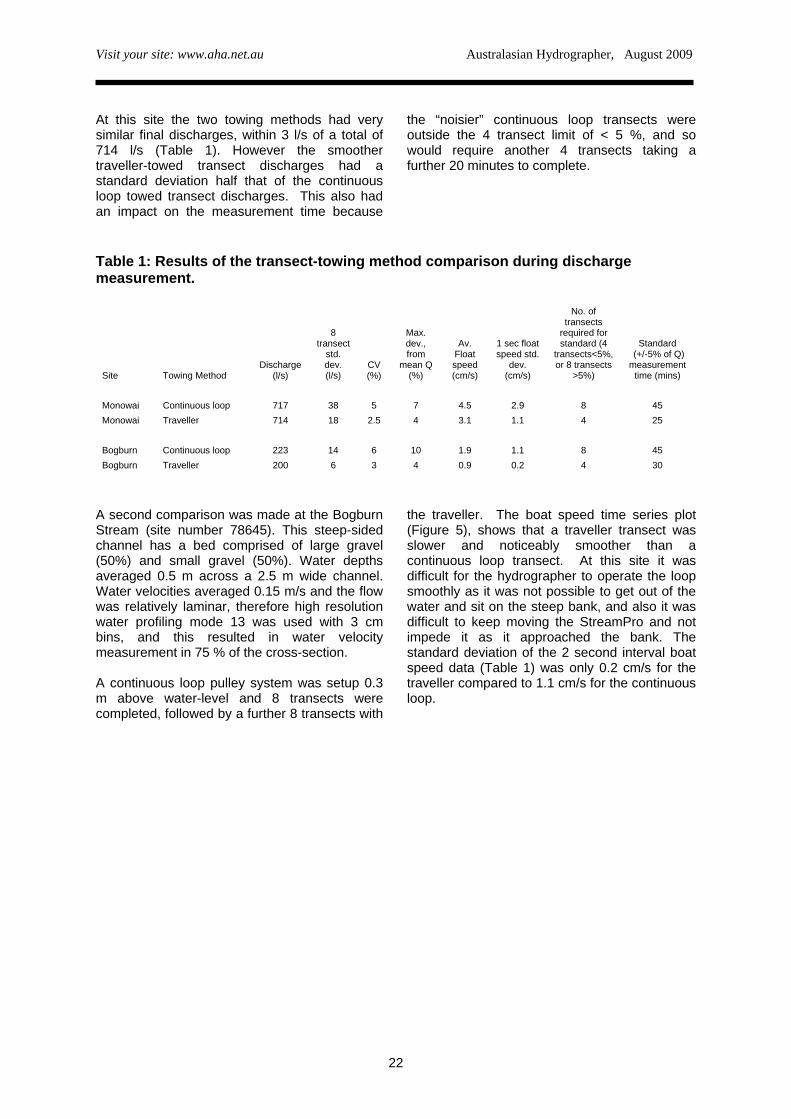
At this site the two towing methods had very similar final discharges, within 3 l/s of a total of 714 l/s (Table 1). However the smoother traveller-towed transect discharges had a standard deviation half that of the continuous loop towed transect discharges. This also had an impact on the measurement time because
the “noisier” continuous loop transects were outside the 4 transect limit of < 5 %, and so would require another 4 transects taking a further 20 minutes to complete.
Table 1: Results of the transect-towing method comparison during discharge measurement.
Site Towing Method Discharge
(l/s)
8 transect
std. dev. (l/s)
CV (%)
Max. dev., from
mean Q (%)
Av. Float speed (cm/s)
1 sec float speed std.
dev. (cm/s)
No. of transects
required for standard (4
transects<5%, or 8 transects
>5%)
Standard (+/-5% of Q) measurement
time (mins) Monowai Continuous loop 717 38 5 7 4.5 2.9 8 45 Monowai Traveller 714 18 2.5 4 3.1 1.1 4 25 Bogburn Continuous loop 223 14 6 10 1.9 1.1 8 45 Bogburn Traveller 200 6 3 4 0.9 0.2 4 30
A second comparison was made at the Bogburn Stream (site number 78645). This steep-sided channel has a bed comprised of large gravel (50%) and small gravel (50%). Water depths averaged 0.5 m across a 2.5 m wide channel. Water velocities averaged 0.15 m/s and the flow was relatively laminar, therefore high resolution water profiling mode 13 was used with 3 cm bins, and this resulted in water velocity measurement in 75 % of the cross-section. A continuous loop pulley system was setup 0.3 m above water-level and 8 transects were completed, followed by a further 8 transects with
the traveller. The boat speed time series plot (Figure 5), shows that a traveller transect was slower and noticeably smoother than a continuous loop transect. At this site it was difficult for the hydrographer to operate the loop smoothly as it was not possible to get out of the water and sit on the steep bank, and also it was difficult to keep moving the StreamPro and not impede it as it approached the bank. The standard deviation of the 2 second interval boat speed data (Table 1) was only 0.2 cm/s for the traveller compared to 1.1 cm/s for the continuous loop.
22
Visit your site: www.aha.net.au Australasian Hydrographer, August 2009
Figure 5: Boat speed (m/s) time series during a transect with the continuous loop (top), and traveller (bottom) towing the StreamPro. Velocity points are 2 second
averages of two bottom tracking pings. At this site the flows differed by 10% (Table 1) as the loop towing method (223 l/s) had a final discharge 23 l/s higher than the traveller method (200 l/s). Again the smoother traveller towed transects had a discharge standard deviation half that of the continuous loop towed transect discharges. This has an impact on the potential measurement time because the “noisier” continuous loop transects were outside the 4 transect limit of +/- 5 % of the mean, so would require another 4 transects taking a further 20 minutes to complete. The results show that both water profiling modes are sensitive to the transect towing method.
b) Low flow measurements. The traveller-towed StreamPro ADCP measurement method was compared indirectly
with historic current meter gaugings at the NIWA Nobles Stream flow station (site 74701). This site was chosen because it has a V-notch weir with a theoretical rating (Figure 6). There are 37 years of flow record with a mean flow of 104 l/s and a 7 day mean annual low flow of 2 l/s. During this time 107 low flow current meter measurements have been completed in the low flow range of 10 to 100 l/s. Of these, 23 % deviate by more than 8 % from the theoretical rated flow. The current meter measurements were completed with either Pygmy bucket-wheel or small Ott meters and were single-point velocity readings (0.6 method). The calculated 95 % uncertainties calculated in accordance with ISO standards (ISO5168, 1983) range from +/-9 to +/-15%.
23
Visit your site: www.aha.net.au Australasian Hydrographer, August 2009
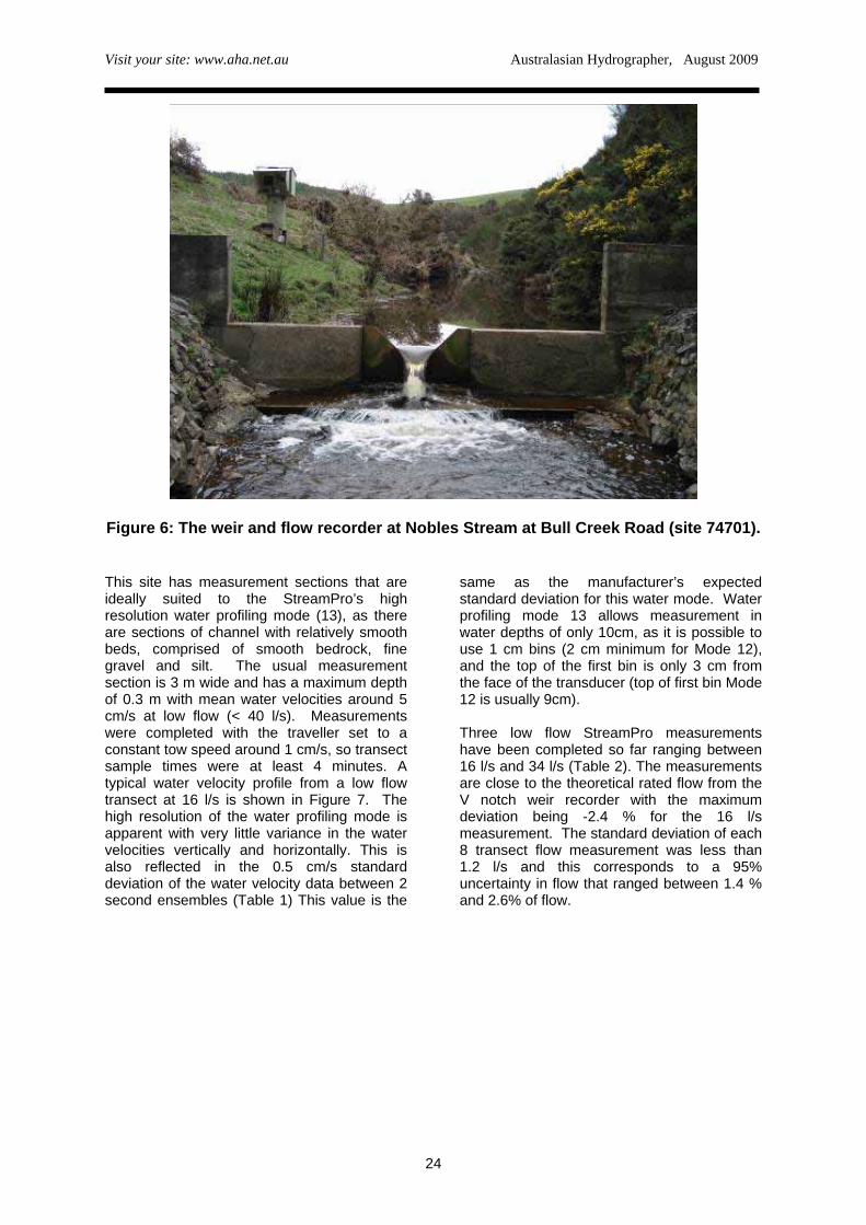
Figure 6: The weir and flow recorder at Nobles Stream at Bull Creek Road (site 74701).
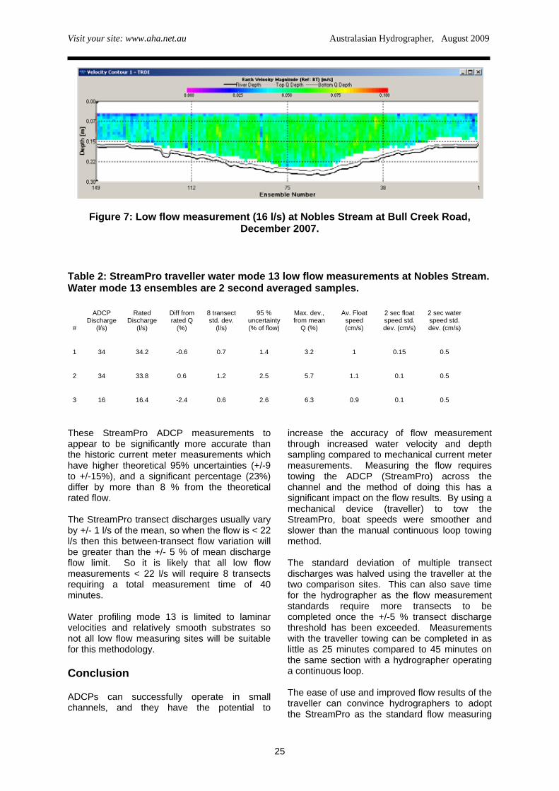
This site has measurement sections that are ideally suited to the StreamPro’s high resolution water profiling mode (13), as there are sections of channel with relatively smooth beds, comprised of smooth bedrock, fine gravel and silt. The usual measurement section is 3 m wide and has a maximum depth of 0.3 m with mean water velocities around 5 cm/s at low flow (< 40 l/s). Measurements were completed with the traveller set to a constant tow speed around 1 cm/s, so transect sample times were at least 4 minutes. A typical water velocity profile from a low flow transect at 16 l/s is shown in Figure 7. The high resolution of the water profiling mode is apparent with very little variance in the water velocities vertically and horizontally. This is also reflected in the 0.5 cm/s standard deviation of the water velocity data between 2 second ensembles (Table 1) This value is the
same as the manufacturer’s expected standard deviation for this water mode. Water profiling mode 13 allows measurement in water depths of only 10cm, as it is possible to use 1 cm bins (2 cm minimum for Mode 12), and the top of the first bin is only 3 cm from the face of the transducer (top of first bin Mode 12 is usually 9cm). Three low flow StreamPro measurements have been completed so far ranging between 16 l/s and 34 l/s (Table 2). The measurements are close to the theoretical rated flow from the V notch weir recorder with the maximum deviation being -2.4 % for the 16 l/s measurement. The standard deviation of each 8 transect flow measurement was less than 1.2 l/s and this corresponds to a 95% uncertainty in flow that ranged between 1.4 % and 2.6% of flow.
24
Visit your site: www.aha.net.au Australasian Hydrographer, August 2009
Figure 7: Low flow measurement (16 l/s) at Nobles Stream at Bull Creek Road, December 2007.
Table 2: StreamPro traveller water mode 13 low flow measurements at Nobles Stream. Water mode 13 ensembles are 2 second averaged samples.
#
ADCP Discharge
(l/s)
Rated Discharge
(l/s)
Diff from rated Q
(%)
8 transect std. dev.
(l/s)
95 % uncertainty (% of flow)
Max. dev., from mean
Q (%)
Av. Float speed (cm/s)
2 sec float speed std. dev. (cm/s)
2 sec water speed std. dev. (cm/s)
1 34 34.2 -0.6 0.7 1.4 3.2 1 0.15 0.5
2 34 33.8 0.6 1.2 2.5 5.7 1.1 0.1 0.5
3 16 16.4 -2.4 0.6 2.6 6.3 0.9 0.1 0.5
These StreamPro ADCP measurements to appear to be significantly more accurate than the historic current meter measurements which have higher theoretical 95% uncertainties (+/-9 to +/-15%), and a significant percentage (23%) differ by more than 8 % from the theoretical rated flow. The StreamPro transect discharges usually vary by +/- 1 l/s of the mean, so when the flow is < 22 l/s then this between-transect flow variation will be greater than the +/- 5 % of mean discharge flow limit. So it is likely that all low flow measurements < 22 l/s will require 8 transects requiring a total measurement time of 40 minutes. Water profiling mode 13 is limited to laminar velocities and relatively smooth substrates so not all low flow measuring sites will be suitable for this methodology. Conclusion ADCPs can successfully operate in small channels, and they have the potential to
increase the accuracy of flow measurement through increased water velocity and depth sampling compared to mechanical current meter measurements. Measuring the flow requires towing the ADCP (StreamPro) across the channel and the method of doing this has a significant impact on the flow results. By using a mechanical device (traveller) to tow the StreamPro, boat speeds were smoother and slower than the manual continuous loop towing method. The standard deviation of multiple transect discharges was halved using the traveller at the two comparison sites. This can also save time for the hydrographer as the flow measurement standards require more transects to be completed once the +/-5 % transect discharge threshold has been exceeded. Measurements with the traveller towing can be completed in as little as 25 minutes compared to 45 minutes on the same section with a hydrographer operating a continuous loop. The ease of use and improved flow results of the traveller can convince hydrographers to adopt the StreamPro as the standard flow measuring
25
Visit your site: www.aha.net.au Australasian Hydrographer, August 2009
device in a small channel. Low flow measurements (16 l/s to 34 l/s) have been completed using the StreamPro with water profiling mode 13 and the traveller, and the ADCP discharge results are very close to the theoretical rated flow station and have uncertainties less than historic current meter measurements. References Fulford, J. M. 1992. “Characteristics of U.S. Geological Survey discharge measurements for water year 1990.” Open-File Rep. No. 92-493, U.S. Geological Survey, Stennis Space Center, Miss. International Organisation for Standardisation, 1983. “Measurement of liquid flow in open
channels”. ISO Standards Handbook 16. International Organisation for Standardisation, Geneva. Marsden, R. 2005. “StreamPro ADCP performance characteristics.” Current Measurement Technology, 2005. Proceedings of the IEEE/OES Eighth Working Conference on. Pp 90-92. Oberg, K.A., Mortlock, S.E., Caldwell, W.S. 2005. “Quality Assurance plan for Discharge measurements using Acoustic Doppler Current Profilers”. USGS Scientific Investigations Report 2005-5183. Teledyne RD Instruments, 2005. “StreamPro ADCP Operation Manual.” P/N 95B-6003-00.
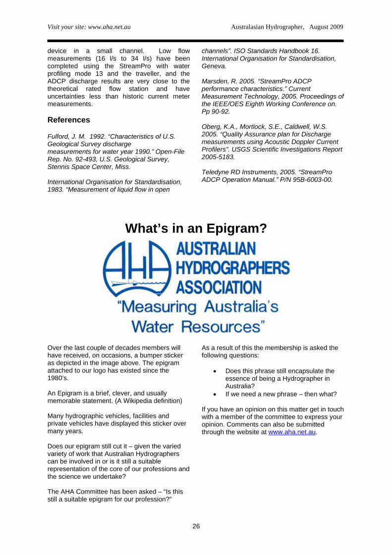
What’s in an Epigram?
Over the last couple of decades members will have received, on occasions, a bumper sticker as depicted in the image above. The epigram attached to our logo has existed since the 1980’s. An Epigram is a brief, clever, and usually memorable statement. (A Wikipedia definition) Many hydrographic vehicles, facilities and private vehicles have displayed this sticker over many years. Does our epigram still cut it – given the varied variety of work that Australian Hydrographers can be involved in or is it still a suitable representation of the core of our professions and the science we undertake? The AHA Committee has been asked – “Is this still a suitable epigram for our profession?”
As a result of this the membership is asked the following questions:
• Does this phrase still encapsulate the essence of being a Hydrographer in Australia?
• If we need a new phrase – then what? If you have an opinion on this matter get in touch with a member of the committee to express your opinion. Comments can also be submitted through the website at www.aha.net.au.
26
Visit your site: www.aha.net.au Australasian Hydrographer, August 2009
Australian Hydrographers’ Association Educational Grant The Committee of the Australian Hydrographers’ Association has instituted a number of awards/grants to encourage younger (and not so young) cadets and hydrographers to undertake studies in the Hydrography Certificate IV. This has been implemented since 2006 and the following information is provided about the AHA Educational Grant.
AHA members are also encouraged to make their employers and others aware of this Educational Grant and that the Association wishes to support the development of cadetships and traineeships within the industry, this grant being one aspect of the Associations support.
The following describes the requirements and conditions for the Educational Grant.
PURPOSE
The purpose of the Educational Grant is to:
• promote the principle objective of the Association to further the development of the science of hydrography/field hydrology and its application to the under-standing monitoring and management of Australia’s water resources, and
• assist students undertaking the Hydrography Certificate IV (accredited under the Australian Qualifications Framework to undertake the final year Project (Subject 8004AA) as required in the course
THE GRANT
The Grant will be of a value of up to $1000 to assist the students undertaking studies in the Hydrography Certificate IV to purchase material/equipment and services necessary to undertake the Project in the final year of the course.
CONDITIONS
• The recipient will supply an initial abstract paper and a final project paper for publication in the Association's Journal “Australasian Hydrographer”, and win advanced consideration for the right to present the Project paper (describing the work undertaken) at the Australian Hydrographers’ Association
Conference (at a future date) upon applying for the Conference Educational Travel Grant.
• The recipient will be a financial member of the Australian Hydrographers’ Association.
• The recipient will normally be enrolled in the Hydrography Certificate IV (AQF).
• The recipient’s project will have been approved by OTEN and/or the recipients employer as an appropriate project activity meeting the requirements of the Project (Subject 8004AA) in the Hydrography Certificate IV.
• Applications will include the approved Project proposal, a budget detailing other sources of financial/material support (for example from the employer/supervisor).
• Application for a Grant does not infer automatic gaining of the grant by the applicant but will be assessed by the Association's Committee who may invite advice from appropriately qualified people. The Committee may liaise with the employer where necessary. More than one grant may be awarded annually, at the Committee's discretion.
• The grant will take the form of a reimbursement to the awarded value, paid to the individual, or may be considered as a rebate to the employer that has initially covered the recipients costs incurred, after presentation of proof of purchase of items/services.
• Items purchased with the Grant will become the property of the recipient's institution/employer or in the case of a stand alone student, the student.
• Proof of purchase of the items/services must be supplied to the Treasurer prior to reimbursement if this grant is awarded.
Further information and application forms can be found on the Associations website at www.aha.net.au
27
Visit your site: www.aha.net.au Australasian Hydrographer, August 2009
28
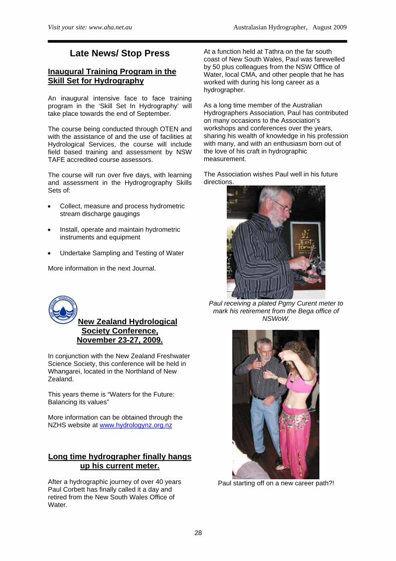
Late News/ Stop Press At a function held at Tathra on the far south coast of New South Wales, Paul was farewelled by 50 plus colleagues from the NSW Offfice of Water, local CMA, and other people that he has worked with during his long career as a hydrographer.
Inaugural Training Program in the Skill Set for Hydrography
An inaugural intensive face to face training program in the ‘Skill Set In Hydrography’ will take place towards the end of September.
As a long time member of the Australian Hydrographers Association, Paul has contributed on many occasions to the Association’s workshops and conferences over the years, sharing his wealth of knowledge in his profession with many, and with an enthusiasm born out of the love of his craft in hydrographic measurement.
The course being conducted through OTEN and with the assistance of and the use of facilities at Hydrological Services, the course will include field based training and assessment by NSW TAFE accredited course assessors.
The Association wishes Paul well in his future directions.
The course will run over five days, with learning and assessment in the Hydrogrography Skills Sets of:
• Collect, measure and process hydrometric
stream discharge gaugings
• Install, operate and maintain hydrometric instruments and equipment
• Undertake Sampling and Testing of Water More information in the next Journal.
New Zealand Hydrological
Paul receiving a plated Pgmy Curent meter to mark his retirement from the Bega office of
NSWoW. Society Conference,
November 23-27, 2009. In conjunction with the New Zealand Freshwater Science Society, this conference will be held in Whangarei, located in the Northland of New Zealand. This years theme is “Waters for the Future: Balancing its values” More information can be obtained through the NZHS website at www.hydrologynz.org.nz Long time hydrographer finally hangs
up his current meter. After a hydrographic journey of over 40 years Paul Corbett has finally called it a day and retired from the New South Wales Office of Water.
Paul starting off on a new career path?!
![AUSTRALASIAN BRYOLOGICAL NEWSLETTER1].pdf · 2014-11-18 · Number 55 Australasian Bryological Newsletter August 2008 At Growling Swallet mosses on the emergent rocks in the stream](https://img.pdfslide.net/doc/110x75/5eccb26da0af283cb576ebee/australasian-bryological-newsletter-1pdf-2014-11-18-number-55-australasian.jpg)